Embed Size (px)
Citation preview
LOWER DUWAMISH WATERWAY
SLIP 4 EARLY ACTION AREA
LONG-TERM MONITORING AND REPORTING PLAN
Submitted to U.S. Environmental Protection Agency
1200 Sixth Avenue Seattle, WA 98101
Submitted by City of Seattle
Prepared by
411 1st Avenue S. Suite 550
Seattle, WA 98104
March 21, 2013
Slip 4 Early Action Area Long-Term Monitoring and Reporting Plan March 21, 2013
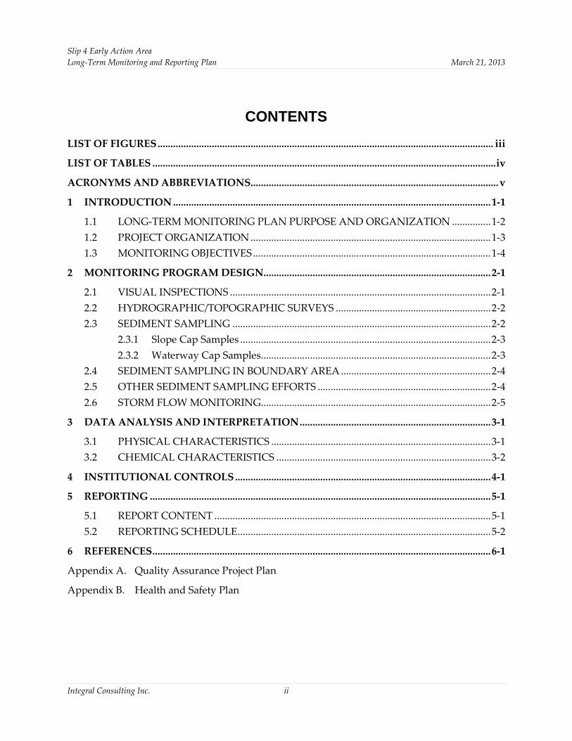
CONTENTS
LIST OF FIGURES.................................................................................................................................. iii
LIST OF TABLES .....................................................................................................................................iv
ACRONYMS AND ABBREVIATIONS................................................................................................v
1 INTRODUCTION ...........................................................................................................................1-1
1.1 LONG-TERM MONITORING PLAN PURPOSE AND ORGANIZATION ...............1-2
1.2 PROJECT ORGANIZATION .............................................................................................1-3
1.3 MONITORING OBJECTIVES ............................................................................................1-4
2 MONITORING PROGRAM DESIGN........................................................................................2-1
2.1 VISUAL INSPECTIONS .....................................................................................................2-1
2.2 HYDROGRAPHIC/TOPOGRAPHIC SURVEYS ............................................................2-2
2.3 SEDIMENT SAMPLING ....................................................................................................2-2
2.3.1 Slope Cap Samples .................................................................................................2-3
2.3.2 Waterway Cap Samples.........................................................................................2-3
2.4 SEDIMENT SAMPLING IN BOUNDARY AREA..........................................................2-4
2.5 OTHER SEDIMENT SAMPLING EFFORTS ...................................................................2-4
2.6 STORM FLOW MONITORING.........................................................................................2-5
3 DATA ANALYSIS AND INTERPRETATION..........................................................................3-1
3.1 PHYSICAL CHARACTERISTICS .....................................................................................3-1
3.2 CHEMICAL CHARACTERISTICS ...................................................................................3-2
4 INSTITUTIONAL CONTROLS...................................................................................................4-1
5 REPORTING ....................................................................................................................................5-1
5.1 REPORT CONTENT ...........................................................................................................5-1
5.2 REPORTING SCHEDULE..................................................................................................5-2
6 REFERENCES...................................................................................................................................6-1
Appendix A. Quality Assurance Project Plan
Appendix B. Health and Safety Plan
Integral Consulting Inc. ii
Slip 4 Early Action Area Long-Term Monitoring and Reporting Plan March 21, 2013
LIST OF FIGURES Figure 1-1. Vicinity Map
Figure 1-2. Post Cap Conditions
Figure 1-3. Sediment Cap and Soil Cover Design
Figure 1-4. Long-Term Monitoring Sampling Locations
Figure 2-1. Boeing Duwamish Sediment Other Area Corrective Measure Project Monitoring Locations within Slip 4 Early Action Area
Integral Consulting Inc. iii

Slip 4 Early Action Area Long-Term Monitoring and Reporting Plan March 21, 2013
LIST OF TABLES Table 1-1. Validated Analytical Results for Slip 4 Early Action Area Cap Confirmation
Samples
Table 1-2. Validated Analytical Results for Slip 4 Early Action Area Post-placement Boundary Area Samples
Table 2-1. Long-Term Monitoring Study Questions
Table 2-2. Long-Term Monitoring Schedule
Table 2-3. Target Analyte List for Slip 4 Early Action Area Long-Term Monitoring
Table 2-4. Boeing Duwamish Sediment Other Area Corrective Measure Project Sampling Schedule and Locations within Slip 4 Early Action Area
Table 4-1. Long-Term Monitoring and Reporting of the Performance of Slip 4 Early Action Area Institutional Controls
Table 5-1. Slip 4 Early Action Area Long-Term Reporting Schedule
Integral Consulting Inc. iv
Slip 4 Early Action Area Long-Term Monitoring and Reporting Plan March 21, 2013
ACRONYMS AND ABBREVIATIONS ASAOC administrative settlement agreement and order on consent
Boeing The Boeing Company
CERCLA Comprehensive Environmental Response, Compensation and Liability Act of 1980
City City of Seattle
CSL cleanup screening level
DAR design analysis report
DSOA Duwamish Sediment Other Area
EAA early action area
EIM environmental information management
EPA U.S. Environmental Protection Agency
HSP health and safety plan
ICIR institutional controls implementation report
Integral Integral Consulting Inc.
LDW Lower Duwamish Waterway
LTMRP long-term monitoring and reporting plan
MLLW mean lower low water
PCB polychlorinated biphenyl
QAPP quality assurance project plan
RACR removal action completion report
RAO removal action objective
RCRA Resource Conservation and Recovery Act
SQS sediment quality standards
SVOC semivolatile organic compound
TOC total organic carbon
Integral Consulting Inc. v
Slip 4 Early Action Area Long-Term Monitoring and Reporting Plan March 21, 2013
1 INTRODUCTION
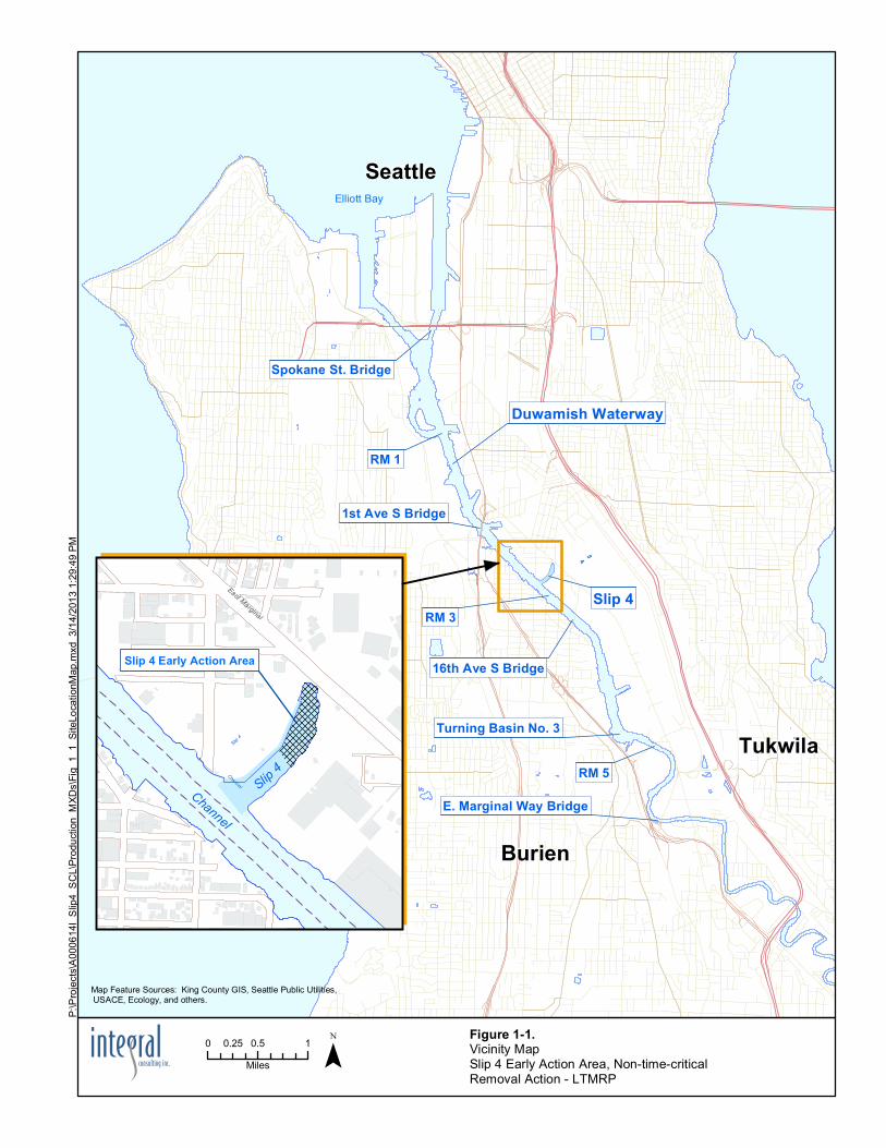
This long-term monitoring and reporting plan (LTMRP) describes program details for monitoring the long-term effectiveness of the Slip 4 Early Action Area (EAA) cleanup within the Lower Duwamish Waterway (LDW) Superfund site in Seattle, Washington (Figure 1-1). This plan was prepared in accordance with the requirements set forth in the Slip 4 EAA Administrative Settlement Agreement and Order on Consent (ASAOC) and associated Scope of Work and Action Memorandum (USEPA 2006).
The City of Seattle (City) completed a non-time-critical removal action to address contaminated sediment at the Slip 4 EAA. Slip 4 is a 6.4-acre navigational slip located 3 miles upstream from the confluence with Elliot Bay and Puget Sound. It is one of five priority early action sites identified within the 5.5-mile long LDW Superfund site. The EAA contains 3.58 acres within the slip in which sediments were contaminated with polychlorinated biphenyls (PCBs), metals, organic compounds, and petroleum products.
The primary design elements included dredging and offsite disposal of contaminated nearshore soil, sediment, and debris; placement of capping materials; demolition of a large pier structure; and habitat improvements along the riverbank and intertidal areas. The primary objective of the Slip 4 removal action was to reduce the concentrations of PCBs and other chemicals in the post-cleanup surface sediments to below the Washington State Sediment Quality Standards (SQS).
The removal action design was prepared by Integral Consulting Inc. (Integral), of Seattle, Washington, in coordination with the City. Removal action construction was performed by General Construction Company, of Federal Way, Washington, under U.S. Environmental Protection Agency (EPA) oversight. The City managed the removal action construction contract; construction quality assurance was provided by Integral. Construction was initiated on October 3, 2011, and was completed on February 7, 2012. Details of the construction activities are summarized in a removal action completion report (RACR; Integral 2012), approved by EPA in July 2012. Post cap conditions for the Slip 4 EAA are shown in Figure 1-2.
The primary construction elements included:
• Dredging and excavation of an estimated 10,256 cubic yards of sediment and soil, based on the removal design
• Transloading and disposal of 17,334 tons of soil, sediment, and debris in a Subtitle D landfill
• Demolition of 20,019 square feet of concrete pier structure
• Recycling of 3,278 tons of concrete and 79 tons of steel
Integral Consulting Inc. 1-1
Slip 4 Early Action Area Long-Term Monitoring and Reporting Plan March 21, 2013
• Importing and placing 53,006 tons of clean material to construct sediment caps and slope caps over 3.43 acres
• Constructing engineered soil covers with habitat enhancements over 0.15 acres in former upland areas.
The construction of sediment and slope caps in conjunction with the engineered soil covers and habitat enhancements resulted in clean material placement over all remaining contaminated soils and sediments within the Slip 4 EAA, as shown in Figures 1-3 and 1-4. Post-construction surface sediment confirmation sampling results from the slope and waterway cap areas verified that surface sediment characteristics within the Slip 4 EAA met the removal action objective after construction. Post-construction confirmation sampling results from the Slip 4 EAA are presented in Table 1-1.
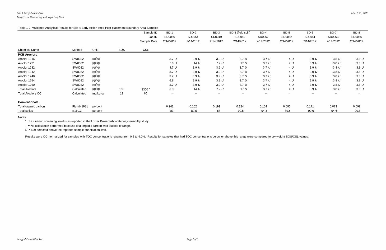
As described in the RACR (Integral 2012), surface sediment samples were also collected from the boundary area prior to initiating and immediately following construction completion, to assess potential impacts of construction activities to surface sediments outside of the Slip 4 EAA. Post-construction sampling within the boundary area revealed that surface sediment PCB concentrations had increased within the boundary area during the course of construction activity. The approved response was the placement of a 9-in. nominal lift of waterway cap material (referred to as “boundary area material”) over the boundary area sediments. Placement of this material covered the 200 ft width of Slip 4 to a distance of 100 ft beyond the boundary berm (Figure 1-3). Subsequent boundary area surface sediment sampling was performed to document surface conditions following boundary area material placement. The results indicated that, after placement of the boundary area material, PCB concentrations within the surface sediment met the removal action objectives. Post-boundary area material placement sampling results are presented in Table 1-2.
The data presented in Tables 1-1 and 1-2 represent the baseline conditions that will be used for the Slip 4 EAA long-term monitoring program.
1.1 LONG-TERM MONITORING PLAN PURPOSE AND ORGANIZATION
Hazardous substances remain onsite in Slip 4 EAA sediments and soils at levels greater than those that allow for unrestricted use or unlimited exposure. These remaining hazardous substances are physically and chemically isolated beneath an engineered sediment cap and soil cap. Long-term monitoring is being performed to verify that the remedy at the Slip 4 EAA remains protective of human health and the environment. The purpose of this LTMRP is to present the approach and methods to be employed to monitor the long-term effectiveness of the Slip 4 EAA cleanup.
This LTMRP is organized as follows:
Integral Consulting Inc. 1-2
Slip 4 Early Action Area Long-Term Monitoring and Reporting Plan March 21, 2013
Section 1. Introduction—Presents an overview of the project background, the LTMRP organization, project team organization and responsibilities, and the monitoring objectives.
Section 2. Monitoring Program Design—Presents an overview of the monitoring approach, sampling locations, and sampling and analysis methods.
Section 3. Data Analysis and Interpretation—Presents a brief description of data interpretation and evaluation procedures.
Section 4. Institutional Controls—Presents a summary of Slip 4 EAA institutional controls and associated long-term monitoring provisions.
Section 5. Reporting—Presents a brief description of the content and schedule requirements for each long-term monitoring report.
Section 6. References.
Appendices—Included as appendices are documents that present supporting details for this LTMRP, including a quality assurance project plan (QAPP, Appendix A), and a health and safety plan (HSP, Appendix B).
1.2 PROJECT ORGANIZATION
This section presents the organizational structure for long-term monitoring and reporting activities including team organization and responsibilities. Changes in team personnel are anticipated from time to time because of the long-term nature of this work. Updates to the project team will be included with the monitoring reports as described in Section 5 of this LTMRP.
The organization and responsibilities of the Slip 4 EAA monitoring team are as follows:
• Ms. Karen Keeley, U.S. EPA Region 10, is EPA’s Remedial Project Manager for the Slip 4 EAA. Ms. Keeley is responsible for the oversight of this LTMRP and any subsequent modifications pursuant to the ASAOC.
• Ms. Ginna Grepo-Grove, U.S. EPA Region 10, is EPA’s Quality Assurance Manager for this project. Ms. Grepo-Grove will review and provide final approval of the QAPP (Appendix A of this LTMRP) and the data quality aspects of the monitoring reports.
• Ms. Allison Crowley is the City’s Project Manager, ensuring that all work is conducted in accordance with the EPA-approved LTMRP and pursuant to the ASAOC.
• Integral is responsible for implementing the monitoring program and preparing the associated reports for U.S. EPA Region 10 on behalf of the City.
Integral Consulting Inc. 1-3
Slip 4 Early Action Area Long-Term Monitoring and Reporting Plan March 21, 2013
1.3 MONITORING OBJECTIVES
The long-term success of the sediment removal action for the Slip 4 EAA will be verified by monitoring endpoints that directly relate to the removal action objective (RAO) for the cleanup. The RAO of the Slip 4 removal action is to reduce the concentration of contaminants in postcleanup surface sediments (biologically active zone [0–10 cm]) to below the Washington State SQS for PCBs and other chemicals of interest, thereby reducing risks to human health and the environment resulting from potential exposure to contaminants in sediments in the Slip 4 EAA (USEPA 2006).
The SQS for PCBs is 12 mg/kg organic carbon when the total organic carbon (TOC) content is between 0.5 and 4.0 percent. Similarly, the cleanup screening level (CSL) for PCBs is 65 mg/kg organic carbon. When TOC is less than 0.5 percent or greater than 4.0 percent, regulatory comparisons are made to the lowest apparent effect threshold concentration (130 µg/kg based on dry weight) and the CSL established for the LDW site-wide cleanup (1,300 µg/kg based on dry weight). The removal boundary for the early action was established to include sediments exceeding the SQS (USEPA 2006).
The Slip 4 removal action design included dredging and excavation to target elevations designed to remove the most highly contaminated sediments, create stable slopes, and improve and expand habitat; the removal action was not designed to completely remove all sediment exceeding the SQS. Accordingly, the design called for placement of engineered sediment and soil caps to physically and chemically isolate contaminants that may have been left behind. Cap material thickness varies from 24 to 33 in. for slope cap and soil cover areas, and from 30 to 60 in. for waterway cap areas. Sediment/soil removal areas and cap placement designs are shown in Figure 1-3.
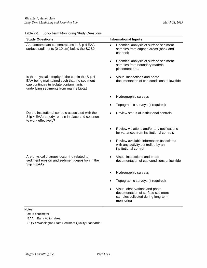
Specific study questions to be answered by the monitoring program are:
• Are contaminant concentrations in Slip 4 EAA surface sediments (0–10 cm) below the SQS?
• Is the physical integrity of the cap in the Slip 4 EAA being maintained such that the sediment cap continues to isolate contaminants in underlying sediments from marine biota?
• Do the institutional controls associated with the Slip 4 EAA remedy remain in place and continue to work effectively?
• Are physical changes occurring related to sediment erosion and sediment deposition in the Slip 4 EAA?
Integral Consulting Inc. 1-4
Slip 4 Early Action Area Long-Term Monitoring and Reporting Plan March 21, 2013
The monitoring described in this LTMRP is designed to identify potential concerns with the long-term performance of the remedy in the Slip 4 EAA. Sediment and soil sampling locations for long-term monitoring in the Slip 4 EAA, shown on Figure 1-4, are the same locations that were sampled to determine post-construction baseline conditions. Should concerns be identified (e.g., elevated chemical concentrations, physical disturbances of the cap, etc.), additional data may be required to fully identify the nature, extent, and cause of the problem such that appropriate corrective actions can be implemented. Additional data needs, should they arise, will be scoped in consultation with EPA and documented in addenda to this LTMRP. Such addenda will be subject to EPA approval.
Other monitoring or construction activities may occur in Slip 4, either within or outside of the Slip 4 EAA, pursuant to projects controlled by others. This LTMRP does not cover possible monitoring requirements associated with those projects; however, data collected by those projects will be reviewed in the monitoring reports for this project to assess any effects on the performance of the Slip 4 remedy. Possible projects could include:
• EPA Resource Conservation and Recovery Act corrective action construction, construction monitoring, and long-term monitoring undertaken by The Boeing Company
• Washington State Model Toxics Control Act investigations undertaken by Crowley Marine Services
• EPA Comprehensive Environmental Response, Compensation and Liability Act of 1980 (CERCLA) remedial design investigations
• EPA CERCLA remedy construction, construction monitoring, and long-term monitoring
• Other unforeseen construction, such as berth deepening outside the Slip 4 EAA.
The City intends to track the progress of any such projects in Slip 4 and comment on appropriate sampling requirements for those projects, as they relate to the Slip 4 EAA remedy.
Integral Consulting Inc. 1-5
Slip 4 Early Action Area Long-Term Monitoring and Reporting Plan March 21, 2013
2 MONITORING PROGRAM DESIGN
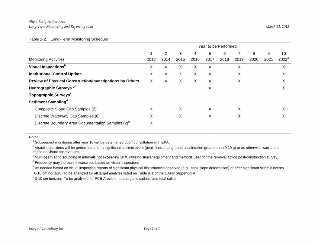
The goal of the long-term monitoring program for the Slip 4 EAA is to obtain sufficient data to evaluate the long-term performance of the cleanup measures with respect to achieving the RAOs. To accomplish this, the design of the long-term monitoring program builds on established baseline data (presented in Tables 1-1 and 1-2) obtained after the implementation of the cleanup measures as documented in the Slip 4 EAA RACR (Integral 2012). This monitoring program includes visual inspections, hydrographic surveys, and sediment sampling to monitor for recontamination. Topographic surveys may also be conducted if bank slope deformation is observed during visual inspections. The schedules detailed below for long-term monitoring are provided for 10 years, and subsequent monitoring after year 10 will be determined upon consultation with EPA. Each of these monitoring program components is related to the four study questions outlined in Section 1, as summarized in Table 2-1, with detailed approaches discussed below. Details concerning the field and laboratory procedures to be utilized are presented in the QAPP included as Appendix A. General health and safety provisions to protect workers from potential hazards during field activities at the Slip 4 EAA are presented in the HSP included as Appendix B.
The City of Seattle will notify EPA at least four weeks prior to all planned monitoring activities, and will schedule such activities to accommodate EPA participation, if requested.
2.1 VISUAL INSPECTIONS
Visual inspections of the cap will be conducted annually for 5 years after completion of the Slip 4 EAA cleanup activities, during sediment sampling events in years 7 and 10, and after significant seismic events (i.e., local peak ground acceleration greater than 0.10 g [gravitational acceleration, 9.8 m/s2]). As presented in the final design analysis report (DAR; Integral 2010), for seismic design of the Slip 4 cap, a maximum peak horizontal ground acceleration of 0.15 g was assumed, representing a 100-year seismic event. For the purpose of the long-term monitoring program, the peak horizontal ground acceleration threshold value was conservatively adjusted downward to 0.10 g.
The purpose of the visual inspections is to document the general condition of the cap, identify any apparent changes in bathymetry/topography resulting from erosion or sedimentation processes, identify any visible breaches of the cap integrity, and note the condition of the constructed habitat features. Photographic documentation of post-capping conditions exposed during low tide immediately following completion of the EAA remedy is included in the RACR (Integral 2012). The visual inspections conducted for the long-term monitoring program will include still color photographs of the Slip 4 EAA sediments exposed during extreme low tides between May and July. The locations of the photographic vantage points will be consistent with the vantage points used to document post-capping conditions and will be documented during
Integral Consulting Inc. 2-1
Slip 4 Early Action Area Long-Term Monitoring and Reporting Plan March 21, 2013
the first visual inspection (conducted in 2013) in accordance with the QAPP. Subsequent visual inspections will utilize these same vantage points during low tide conditions, and may be expanded to include additional vantage points. As described in the QAPP, all monitoring methods will be implemented by qualified field personnel, and qualitative observations will be recorded on appropriate field forms.
2.2 HYDROGRAPHIC/TOPOGRAPHIC SURVEYS
The long-term monitoring program hydrographic surveys will be performed at years 5 and 10 following completion of Slip 4 EAA removal action construction and after significant seismic events or as otherwise warranted based on visual inspections. The purpose of these surveys is to collect data on changes to the surface elevation of the Slip 4 EAA sediments that might indicate potential problems with cap integrity, and possible erosion or accumulation of deposited sediments. Supplemental shoreline topographic surveys may also be conducted if there is evidence of deformation of the bank slopes. Deformation of the bank slopes will be assessed based on visual observations of settlement or tension cracks in the upland area immediately adjacent to the top of the river bank slopes, bank slope movement, erosion of bank armor materials, disturbance from beached vessels, or other causes.
A record document hydrographic and topographic survey was conducted by the construction contractor’s independent professional land surveyor (eTrac Engineering, LLC) to document post–dredge/excavation elevations and cap elevations as part of the acceptance requirements of the Slip 4 removal action. This survey is included in Appendix D of the RACR (Integral 2012) and will serve as the basis for comparison to future surveys. As described in the QAPP (Appendix A), future surveys will be conducted using methods, equipment, and survey control points that are consistent with those used for the 2012 record document survey to ensure comparability of the results. Hydrographic surveys will be conducted during high-tide, with a tidal elevation no lower than 8 ft mean lower low water (MLLW). Topographic surveys (if required) will be conducted during low-tide, with a tidal elevation no higher than 4 ft MLLW.
2.3 SEDIMENT SAMPLING
Sediment sampling will be performed at years 1, 3, 5, 7, and 10 (Table 2-2), and sampling frequency may increase if warranted based on visual inspections and results of previous monitoring activities. Surface (0–10 cm) sediment samples will be collected for chemical analysis from eight stations within the Slip 4 EAA following field procedures described in the QAPP (Appendix A). The station target locations are the same as those used for postconstruction cap verification sampling as described in the RACR (Integral 2012). These locations are shown in Figure 1-4 of this report and the coordinates are listed in Table A-5 of the QAPP. Sample locations include two locations in the slope cap area and six locations within the waterway cap area. Descriptions of the types of samples to be collected, the analyses to be
Integral Consulting Inc. 2-2
Slip 4 Early Action Area Long-Term Monitoring and Reporting Plan March 21, 2013
performed, and the monitoring frequency for each of these areas are presented below. The physical characteristics of each sediment sample will be documented in a sample log sheet, and photo-documentation will be provided for each sample. Any vegetation or debris on the surface of the sediment/soil will be removed prior to sampling and noted in the field logbook. In addition, the presence of aquatic organisms and/or terrestrial wildlife, if observed during monitoring events, will be noted on the sample log sheet or in the field notebook.
2.3.1 Slope Cap Samples
The two bank sediment sampling stations are designated SC-2 and SC-3 as shown on Figure 1-4. Slope cap and soil cover in these locations consist of slope cap material and habitat mix with a cap material thickness ranging from 24 to 33 in. (see Figure 1-3). Locations for bank sediment sample collection may either be accessed using a sampling vessel or by land if the sample location is exposed.
Each bank sediment sample will be a composite of sediment collected from three locations using a stainless steel spoon and bowl as described in the QAPP. At each of the sampling locations, the top 10 cm of bank sediment will be collected. The collected sediment from the three locations will be composited into a single sediment sample for that station. Each location and sample will be photographed to document general observations and the condition of each bank sediment station, as well as the overall sampling techniques used during the sampling event.
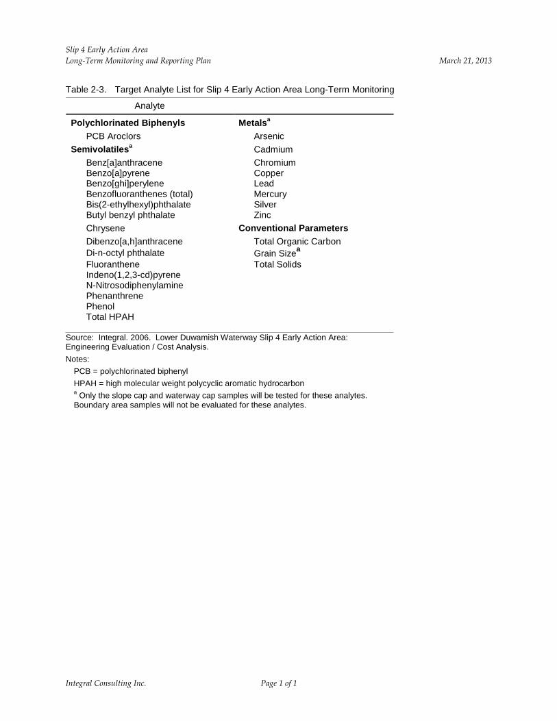
Laboratory analyses will be performed for the primary Slip 4 EAA contaminants of concern which include PCB Aroclors, semivolatile organic compounds (SVOCs), metals, and conventional parameters (TOC, grain size, and total solids; Table 2-3). After monitoring year 5, the City will confer with EPA on the usefulness of the data for all of these analytes. The analyte list may be revised after year 5, subject to EPA approval.
2.3.2 Waterway Cap Samples
The six waterway cap sediment sampling stations are designated WC-1, WC-2, WC-3, WC-4, WC-7, and WC-8 as shown on Figure 1-4. The cap placement design varies among these locations. The waterway cap generally consists of clean sandy gravel (with individual rocks measuring less than 3 in. in diameter), but may be armored or unarmored depending on the location. Figure 1-3 provides details of the cap design for each location. Each waterway cap sediment sample will be a discrete sample of the top 0–10 cm sediment horizon collected using a stainless steel power grab sampler (or van Veen dredge sampler) or a stainless steel spoon and bowl, as described in the QAPP. Locations for waterway cap sample collection may either be accessed using a sampling vessel or by land at low tide if the sample location is exposed.
Integral Consulting Inc. 2-3
Slip 4 Early Action Area Long-Term Monitoring and Reporting Plan March 21, 2013
Laboratory analyses will be performed for the primary contaminants of concern which include PCB Aroclors, SVOCs, metals, and the conventional parameters (TOC, grain size, and total solids; Table 2-3). After monitoring year 5, the City will confer with EPA on the usefulness of the data for all of these analytes. The analyte list may be revised after year 5, subject to EPA approval.
2.4 SEDIMENT SAMPLING IN BOUNDARY AREA
Boundary-area sediment sampling will be performed during year 1 monitoring activities (2013) as indicated in Table 2-2. The two boundary-area sediment samples will be collected to confirm that conditions outside of the Slip 4 EAA removal boundary have not changed substantively since post-construction samples were collected in 2012. The sampling stations are designated BD-2 and BD-7, as shown on Figure 1-4. Each boundary-area sediment sample will be a discrete sample of the top 0–10 cm sediment horizon collected using a stainless steel power grab sampler (or Van Veen dredge sampler) as described in the QAPP. Access to the sampling locations is expected to be from a sampling vessel deployed in the river.
Laboratory analyses will be performed for PCB Aroclors and the conventional parameters TOC and total solids as summarized in Table 2-3.
2.5 OTHER SEDIMENT SAMPLING EFFORTS
As described in Section 1.3, other monitoring or construction activities may occur in Slip 4, either within or outside of the Slip 4 EAA, pursuant to projects controlled by others. Data collected by those projects will be reviewed in the monitoring reports for this project to assess any effects on the performance of the Slip 4 remedy. At this time, the following projects have been identified:
• On October 31, 2012, the City conducted sediment sampling in Slip 4 in an area outside of the Slip 4 EAA, adjacent to the Crowley Maritime 8th Ave Terminal. Five surface sediment samples were collected and analyzed for PCB Aroclors. Data will be available in February 2013 and will be briefly described in the 2013 monitoring report to be submitted pursuant to this LTMRP.
• The Boeing Company (Boeing) is conducting the Duwamish Sediment Other Area (DSOA) Corrective Measure Project pursuant to the Administrative Order [RCRA Docket No 1092-01-22-3008(h)] on Consent (Order) issued to Boeing in 1994 by EPA under authority of the Resource Conservation and Recovery Act (RCRA) Section 3008(h), as amended [42 USC 6928(h)]. A portion of the Boeing sediment cleanup is occurring within Slip 4, adjacent to the Slip 4 EAA sediment cleanup. As a requirement of the RCRA Order, Boeing will be conducting a pre- and post-construction perimeter
Integral Consulting Inc. 2-4
Slip 4 Early Action Area Long-Term Monitoring and Reporting Plan March 21, 2013
sediment monitoring program to determine if there are material increases in concentrations of contaminants of concern in the post remediation perimeter surface sampling areas outside the DSOA relative to their pre-remediation concentrations. Boeing has prepared a Work Plan that has been submitted to EPA for review and approval. The Plan includes sampling three locations on the City of Seattle-owned portion of Slip 4 (Figure 2-1). Surface samples (top 10 cm) will be collected several times during the construction of Boeing’s project as detailed in Table 2-4. At each sampling location, samples will be collected for analysis of contaminants of concern identified by EPA for the Project (i.e., cadmium, chromium, copper, lead, mercury, silver, zinc, and PCB Aroclors). TOC will also be measured in each sample. Results from Boeing’s sampling efforts, when available, will be briefly described in the Slip 4 EAA monitoring reports.
2.6 STORM FLOW MONITORING
Erosion of the Slip 4 cap is not expected as a result of peak river flows or stormwater discharge into the slip. The water level of the Duwamish River is controlled by the Howard A. Hanson Dam, and thus does not flood during high flow events. Further, Slip 4 is an off-channel feature of the Duwamish Waterway, and currents within the EAA are not expected to be significantly affected by changes in river flow. In addition, the cap and associated armoring was conservatively sized to accommodate unimpeded flow from outfalls within the slip from a 100-year storm event, during an extreme low tide.
As a means of verifying and documenting the performance of the cap under storm conditions, the City will summarize storm events equal to or greater than a 100-year storm event that occur within 48 hours prior to low-tide conditions during the monitoring reporting period. For the project site area, the 100-year storm event corresponds to 3.85 in. of rainfall within a 24-hour period. Rainfall measurements from the Seattle Public Utility rain-gauge (Station 45-S016, Metro King County, E. Marginal Way) will be used to determine whether a 100-year storm event occurred. Tidal elevations identified below 5.2 ft MLLW, corresponding to the invert elevation of the largest outfall within Slip 4 (the 72-in. diameter DOT outfall), will be identified for the 48-hour period following the storm event. The 100-year storm event and tidal summary data will be tabulated and included in the monitoring reports. Once a sufficient data set is compiled to confirm the adequacy of the cap for a representative range of major storm events, the City may recommend eliminating this reporting requirement from the monitoring program.
Integral Consulting Inc. 2-5
Slip 4 Early Action Area Long-Term Monitoring and Reporting Plan March 21, 2013
3 DATA ANALYSIS AND INTERPRETATION
Long-term monitoring data for the Slip 4 EAA will be evaluated by analyzing spatial and temporal trends in the physical and chemical characteristics of the sediments and shoreline soils. The post-construction data compiled in the RACR (Integral 2012) provides a baseline for comparison to the temporal trends that will be documented by the long-term monitoring program components described in Section 2. Following is a discussion of the physical and chemical characteristics of concern and how the long-term monitoring data will be used to evaluate the effectiveness of the Slip 4 EAA removal action.
3.1 PHYSICAL CHARACTERISTICS
The Slip 4 EAA long-term monitoring QAPP, found in Appendix A, contains the details of the proposed sampling and analysis program, including visual inspection methods and field forms. The following discussion summarizes the primary elements of the physical monitoring program.
The physical characteristic of concern for the Slip 4 EAA remedy is the integrity of the cap. Mechanisms for potential adverse impacts to the cap include:
• Sloughing of cap material in sloped areas (located onshore and nearshore) caused by erosion or seismic (earthquake) activity
• Erosion of waterway cap material and armoring due to outfall discharge
• Breaching of the sediment cap within the waterway due to erosion by natural river and tidal currents
• Breaching of the sediment cap either onshore or within the waterway caused by manmade events such as vessel groundings, prop-scour, or other unauthorized physical disturbances.
Other physical characteristics and processes of interest at the Slip 4 EAA include:
• Deposition of sediments from offsite sources on the sediment cap in the Slip 4 EAA
• Changes to shoreline development within the Slip 4 EAA
• Changes to constructed habitat features within the Slip 4 EAA.
The visual inspections (Section 2.1) and the hydrographic/topographic surveys (Section 2.2) will be the primary means of assessing cap integrity, sediment deposition, changes in constructed habitat features, and changes to shoreline development. The visual inspections provide an
Integral Consulting Inc. 3-1
Slip 4 Early Action Area Long-Term Monitoring and Reporting Plan March 21, 2013
obvious means of identifying sediment deposition and breaches in the cap caused by either natural or manmade events. Photographic documentation also provides temporal records of the stability, or transiency, of site conditions that will be useful in evaluating whether repairs or maintenance activities are necessary.
Visual inspection, recording, and photo-documentation of samples will be used to assess the physical characteristics of the substrate, including:
• Geologic classifications
• Stratification
• Color
• Odor
• Evidence of pollution (e.g., presence of sheen)
• Organic matter accumulation (e.g., leaf litter, logs, woody debris)
• Presence/description of debris/litter/garbage
• Measurement, using a ruler, of fine sediments deposited on capping material in slope and sediment waterway caps.
These characteristics will allow assessment of the rate of sediment deposition on the cap surface. Sedimentation processes within the Slip 4 EAA may inform future monitoring events or source control needs.
In addition, visual inspections and photographs of surface sediments during low tide monitoring events will be used to assess the condition of the habitat features constructed near the head of the slip as part of the EAA remedy (e.g., integrity of anchored woody debris). In addition, the presence of aquatic organisms and/or terrestrial wildlife, if observed during monitoring events, will be noted. The hydrographic survey will provide quantitative data on changes to sediment elevations that may show erosion and deposition trends, and the means to evaluate the severity of potential erosion or movement of cap material. Due to inherent accuracy limitations, hydrographic surveys cannot distinguish accumulations of a few centimeters, so surveys are not appropriate for assessing deposition on 2-year timescales.
3.2 CHEMICAL CHARACTERISTICS
As discussed in Section 1.3, the RAO within the Slip 4 EAA is to reduce contaminants of concern concentrations in surface sediment to levels that do not exceed the SQS. Mechanisms that could potentially cause exceedances of one or more of the contaminants of concern include:
Integral Consulting Inc. 3-2
Slip 4 Early Action Area Long-Term Monitoring and Reporting Plan March 21, 2013
• Reduction in thickness or breaching of the cap that exposes underlying sediments containing residual contaminants
• Recontamination of Slip 4 EAA sediments by deposition of contaminants from offsite sources
• Migration of contaminants upward through the cap materials.
The sediment sampling and laboratory analyses described in Section 2.3 will be used to assess compliance with the Slip 4 EAA RAO and to document temporal changes in surface sediment chemical characteristics. If evaluation of the long-term monitoring sediment characteristics indicates that significant changes in chemical concentrations are occurring, the physical evidence (discussed in Section 3.1) will be assessed to help identify the cause of the changes and evaluate whether additional investigations or response corrective actions are needed. If PCB concentrations in surface sediments within the Slip 4 EAA cap exceed the cleanup criteria at a future date, the City will coordinate with EPA to determine appropriate follow-up monitoring actions, including considering the collection of recently deposited surface materials, core samples through the cap (which may not be feasible in armored cap areas), or pore water samples within the sediment cap.
The SQS are State standards established to be protective of benthic organisms. As such, EPA’s Action Memorandum does not require a monitoring metric or performance standard for benthic organisms. However, as part of the LTMRP, the presence of aquatic organisms, if observed in surface sediment samples, will be recorded on the field forms during monitoring activities.
Integral Consulting Inc. 3-3
Slip 4 Early Action Area Long-Term Monitoring and Reporting Plan March 21, 2013
4 INSTITUTIONAL CONTROLS
Institutional controls are required at the Slip 4 EAA because some hazardous substances remain onsite at levels that do not allow for unrestricted use of the property (USEPA 2006). An institutional control implementation plan was developed and presented in the final DAR (Integral 2010) and further developed in the RACR (Integral 2012). The institutional controls are summarized in Table 4-1, along with the anticipated monitoring and reporting that will be conducted to ensure that the institutional controls remain in place and continue to function effectively.
Institutional control implementation will be documented in an institutional controls implementation report (ICIR). The ICIR will document the implementation of each institutional control, including copies of all relevant paperwork (i.e., permit application forms, easements, covenants, deed notices, state registries, and public advisories). The ICIR will be submitted to EPA and the Washington State Department of Ecology under requirements of the Slip 4 ASAOC and Action Memorandum (USEPA 2006).
Each monitoring report (see Section 5) will include an update on the performance of the institutional controls, an assessment of their effectiveness, and recommendations for any changes in controls or monitoring of controls. Each report will also summarize each event that required notification to EPA when an institutional control failed or a land use restriction was violated, a description of the entity responsible for addressing the problem, and the actions that were taken to address the failure or violation.
Integral Consulting Inc. 4-1
Slip 4 Early Action Area Long-Term Monitoring and Reporting Plan March 21, 2013
5 REPORTING
5.1 REPORT CONTENT
The results of the monitoring program and data analysis will be provided in monitoring reports that will be submitted to EPA within 120 calendar days after the completion of each field monitoring event. The monitoring report will include the following elements (as applicable based on the monitoring year):
• Description of monitoring activities, and any deviations from the LTMRP, including summaries of field observations from all inspection, survey, and sediment sampling events.
• Photos of current site conditions, including disks with digital images. Photo records will include digital records and photos will be provided (two photos per page) in an attachment to the report.
• Hydrographic survey records, including disks with electronic hydrographic data (e.g., AutoCAD and ASCII-format processed survey data).
• Topographic survey records (if conducted), including disks with electronic topographic data (e.g., AutoCAD and ASCII-format processed survey data).
• Comparison of visual and hydrographic/topographic survey information to postremedy conditions, including conditions documented in 2012 immediately after construction as well as subsequent monitoring events.
• Analytical chemistry data and location confirmation for recently collected sediment samples, including tabulated chemical testing data and data validation results.
• Evaluation of temporal trends in physical (erosion and deposition) and chemical characteristics of Slip 4 EAA sediments.
• Update on institutional controls, an assessment of their effectiveness, and recommendations for any changes in controls or monitoring of controls.
• Assessment of the status of the Slip 4 removal action in complying with the RAO, and where necessary, recommended response actions to address nonconforming conditions.
• Identification of any concerns that require additional data to fully evaluate the nature, extent, and cause of the problem, and whether any corrective actions are warranted.
• Review of other physical construction or investigations in or near the Slip 4 EAA.
• Summary of storm events that occurred (if any) during the monitoring reporting period that were equal to or greater than a 100-year storm event within 48 hours prior to lowtide conditions.
Integral Consulting Inc. 5-1
Slip 4 Early Action Area Long-Term Monitoring and Reporting Plan March 21, 2013
• Modifications (if any) to the proposed monitoring strategy and data needs for the next monitoring event.
• Updates to the Slip 4 EAA long-term monitoring team organization, to accommodate possible staffing changes.
• A signed certification statement from the person responsible for the monitoring event, documenting that the work was conducted in accordance with this plan.
• A description of data management practices utilized for the monitoring data.
• Copies of laboratory analytical reports and electronic copies of all monitoring data.
• Copies of field sampling forms and records.
• Copies of complete laboratory analysis reports.
Field and analytical data will be manually entered into the City’s project database by the City of Seattle or its consultant, consistent with the QAPP. Additionally, the City of Seattle or its consultant will enter environmental records (analytical data and all associated parameters) into the Washington State Department of Ecology environmental information management (EIM) database. Written notification from the City will be provided to EPA once data have been uploaded to the EIM database, and the City will provide EPA with the Ecology project name for the data set. The EPA Project Manager will then notify EPA’s Office of Environmental Assessment staff (currently Matt Gubitosa), who will download the field and analytical data from the EIM database into EPA’s STORET database, consistent with Option 2 of the EDD data format specification document for Superfund (QAPP; Attachment A7).
The QAPP and analytical results will be reviewed every sampling season and an addendum to the QAPP shall be submitted to EPA if major changes/updates are needed with respect to management, organization, contractors, sampling methods, and/or sample analyses. Every fifth year, or before the expiration date of the QAPP, the LTMRP QAPP shall be revised and resubmitted to EPA for review and approval.
5.2 REPORTING SCHEDULE
A preliminary long-term reporting schedule is presented in Table 5-1 (see also Table 2-2 for monitoring frequency). All activities are linked to the completion of removal action construction in February 2012. Monitoring activities will be conducted between May and July to correspond roughly with the daytime occurrences of extreme low tides for shoreline sampling and visual inspections. Hydrographic surveys will be conducted during high-tide, with a tidal elevation no lower than 8 ft MLLW. Topographic surveys (if required) will be conducted during low-tide, with a tidal elevation no higher than 4 ft MLLW.
Integral Consulting Inc. 5-2

Slip 4 Early Action Area Long-Term Monitoring and Reporting Plan March 21, 2013
As discussed in Section 2, visual monitoring will be performed annually for the first 5 years (2013–2017), then in conjunction with other monitoring activities in years 7 and 10 (2019 and 2022), and after significant seismic events, if any. Field sampling will occur every other year from 2013 through 2019 and in 2022. Hydrographic surveys will be conducted in years 5 and 10 (2017 and 2022), and after significant seismic events or as warranted based on visual inspections (Table 2-2).
Draft monitoring data reports will be submitted to EPA within 120 calendar days of completion of long-term monitoring fieldwork. This lead time is necessary for laboratory analysis and validation of sediment samples. Validated data will be made available electronically within 30 calendar days of receipt of final validated results. Final monitoring reports will be revised in response to EPA comments, and will be submitted to EPA within 30 calendar days after receipt of EPA comments on the draft report. The monitoring data report scheduled for 2022 (10 years after construction completion) will include an assessment of the likely permanence of the Slip 4 removal action, and will make recommendations for additional monitoring or response actions, if needed.
If a seismic event greater than 0.10 g is observed, a draft memorandum will be submitted to EPA within 30 calendar days of the event, containing summaries of field observations from any visual inspections. The memorandum will be revised in response to EPA comments, and the final report will be due within 30 calendar days after receipt of EPA comments. If further action is required, such action will be determined in consultation with EPA.
Integral Consulting Inc. 5-3
Slip 4 Early Action Area Long-Term Monitoring and Reporting Plan March 21, 2013
6 REFERENCES
Integral. 2010. Lower Duwamish Waterway Slip 4 Early Action Area: 100% Design Submittal, Design Analysis Report. Prepared for City of Seattle and King County. Integral Consulting Inc., Seattle, WA.
Integral. 2012. Lower Duwamish Waterway Slip 4 Early Action Area: Removal Action Completion Report. Prepared for City of Seattle. Integral Consulting Inc., Seattle, WA. July 26.
USEPA. 2006. Action Memorandum for a Non-Time-Critical Removal Action at the Slip 4 Early Action Area of the Lower Duwamish Waterway Superfund Site, Seattle, Washington. U.S. Environmental Protection Agency, Region 10, Seattle, WA. May 3.
Integral Consulting Inc. 6-1

FIGURES
4 5
Slip 4 Channel
East Marginal
Seattle Elliott Bay
Spokane St. Bridge
Duwamish Waterway
RM 1
1st Ave S Bridge
P:\Pr
ojects
\A00
0614
I_Slip
4_SC
L\Prod
uctio
n_MX
Ds\Fi
g_1_
1_Sit
eLoc
ation
Map.m
xd3/1
4/201
31:29
:49PM
RM 3 Slip 4
16th Ave S Bridge
Burien
RM 5
Turning Basin No. 3
E. Marginal Way Bridge
Tukwila
Slip 4 Early Action Area
Slip 4
Channel
Map Feature Sources: King County GIS, Seattle Public Utilities,USACE, Ecology, and others.
FiV
gure 1-1.0 0.25 0.5 1 icinity MapMiles ¯ Slip 4 Early Action Area, Non-time-critical
Removal Action - LTMRP
N:\G
IS\P
roje
cts\
A00
06_C
ity_o
f_S
eattl
e\14
_Slip
4\Pr
oduc
tion_
MX
Ds\
Mon
itorin
g\Fi
g1_2
_Pos
tCap
Con
ditio
n_02
1920
13.m
xd -
2/28
/201
3 @
11:
32:0
7 AM
0 50 100
Feet
Background imagery is for reference purposes only, is courtesy of Google Earth and is dated 2012.
Slip 4 Early Action Area Tax Parcel Boundary
Crowley Marine Services
The Boeing Company
First South Properties
East Marginal Way S
City of Seattle
Figure 1-2.Post Cap Conditions Slip 4 Early Action Area, Non-time-critical Removal Action - LTMRP
Figure 1-3. Sediment Cap and Soil Cover Design Slip 4 Early Action Area, Non-time-critical Removal Action - LTMRP
BD-7
BD-2
WC-8 WC-7
WC-4 WC-3
WC-2
WC-1
SC-3
SC-2
Figure 1-4.Long-Term Monitoring Sampling Stations Slip 4 Early Action Area, Non-time-critical Removal Action - LTMRP
0 50 100
Feet
Sediment cap and soil cover thicknesses are presented in Figure 1-3.
Background imagery is for reference purposes only, is courtesy of Google Earth and is dated 2012.
Proposed Monitoring Stations Slope Cap (3-point composite, 0-10cm) Waterway Cap (discrete, 0-10cm)
Boundary Area Documentation (discrete, 0-10cm) Slip 4 Early Action Area Tax Parcel Boundary
N:\G
IS\P
roje
cts\
A00
06_C
ity_o
f_S
eattl
e\14
_Slip
4\Pr
oduc
tion_
MX
Ds\
Mon
itorin
g\Fi
g1_4
_Pro
pMon
itorS
tns_
0219
2013
.mxd
- 3/
18/2
013
@ 1
0:25
:21
AM
Crowley Marine Services
The Boeing Company
First South Properties
East Marginal Way S
City of Seattle
Legend
Existing Riprap
Outfall Area Cap - Outfall Scour Protection Material
Slope Cap with Habitat Mix
Waterway Cap - Armored
Waterway Cap
Outfall Area Cap - Armored
Outfall Area Cap - Unarmored
Boundary Berm Cap - Armored
Cap Armor with Habitat Mix
Waterway Cap Material with Beach Sand
Slope Cap Armor with Beach Sand
Boundary Area Material (Non-Cap)

1�?*,6?3URMHFWV?$����B&LW\BRIB6HDWWOH?��B6OLS�?3URGXFWLRQB0;'V?0RQLWRULQJ?)LJ�B�B3ODQW�3UH&RQ0RQ6WQVB���������P[G�������������#����������$0
� �� ���
)HHW
%DFNJURXQG�LPDJHU\�LV�IRU�UHIHUHQFH�SXUSRVHV�RQO\��LV�FRXUWHV\�RI�*RRJOH�(DUWK DQG�LV�GDWHG������
$SSUR[LPDWH�6DPSOH�/RFDWLRQ
6OLS���(DUO\�$FWLRQ�$UHD 7D[�3DUFHO�%RXQGDU\
Crowley Marine Services
SD-PER503
SD-PER502
SD-PER501
The Boeing Company
First South Properties
East Marginal Way S
City of Seattle
Figure 2-1.%RHLQJ�'XZDPLVK�6HGLPHQW�2WKHU�$UHD�&RUUHFWLYH�0HDVXUH 3URMHFW�0RQLWRULQJ�/RFDWLRQV�ZLWKLQ�6OLS���(DUO\�$FWLRQ�$UHD 6OLS���(DUO\�$FWLRQ�$UHD��1RQ�WLPH�FULWLFDO�5HPRYDO�$FWLRQ�±�/7053

TABLES

Slip 4 Early Action Area March 21, 2013 Long-Term Monitoring and Reporting Plan
Table 1-1. Validated Analytical Results for Slip 4 Early Action Area Cap Confirmation Samples Sample ID SC-1 SC-1 SC-2 SC-3 SC-4 SC-5 SC-6 WC-1 WC-2 WC-3 WC-4 WC-5 WC-5 (field split) WC-6 WC-7 WC-8
Lab ID SD0034 SD0035 SD0036 SD0037 SD0038 SD0039 SD0040 SD0025 SD0026 SD0027 SD0028 SD0029 SD0030 SD0031 SD0032 SD0033 Sample Date 1/30/2012 1/30/2012 1/30/2012 1/30/2012 1/30/2012 1/30/2012 1/30/2012 1/30/2012 1/30/2012 1/30/2012 1/30/2012 1/30/2012 1/30/2012 2/1/2012 2/1/2012 2/1/2012
Chemical Name Method Unit SQS CSL PCB Aroclors Aroclor 1016 SW8082 µg/kg 3.7 U 3.7 U 3.7 U 3.8 U 3.7 U 3.7 U 4 U 3.8 U 19 U 20 U 3.8 U 19 U 3.8 U 3.9 U 3.8 U 3.7 U Aroclor 1221 SW8082 µg/kg 3.7 U 3.7 U 3.7 U 3.8 U 3.7 U 3.7 U 4 U 3.8 U 19 U 20 U 3.8 U 19 U 3.8 U 3.9 U 3.8 U 3.7 U Aroclor 1232 SW8082 µg/kg 3.7 U 3.7 U 3.7 U 3.8 U 3.7 U 3.7 U 4 U 3.8 U 19 U 20 U 3.8 U 19 U 3.8 U 3.9 U 3.8 U 3.7 U Aroclor 1242 SW8082 µg/kg 3.7 U 3.7 U 3.7 U 3.8 U 3.7 U 3.7 U 4 U 3.8 U 19 U 20 U 3.8 U 19 U 3.8 U 3.9 U 3.8 U 3.7 U Aroclor 1248 SW8082 µg/kg 3.7 U 3.7 U 3.7 U 3.8 U 3.7 U 3.7 U 4 U 3.8 U 19 U 20 U 3.8 U 19 U 7.6 U 9.6 U 7.5 U 3.7 U Aroclor 1254 SW8082 µg/kg 3.7 U 3.7 U 5.7 3.8 U 3.7 U 3.7 U 4 U 5.5 24 21 3.8 21 14 21 15 3.7 U Aroclor 1260 SW8082 µg/kg 3.7 U 3.7 U 3.7 U 3.8 U 3.7 U 3.7 U 4 U 3.8 U 19 U 20 U 3.8 U 19 U 3.8 U 6.2 5.2 3.7 U Total Aroclors Calculated µg/kg 130 1300 a 3.7 U 3.7 U 5.7 3.8 U 3.7 U 3.7 U 4 U 5.5 24 21 3.8 21 14 27.2 20.2 3.7 U Total Aroclors OC Calculated mg/kg-oc 12 65 - - - - - - - - - - - - - - - --
Conventionals Total organic carbon Plumb1981 percent 0.186 0.112 0.336 0.147 0.461 0.059 0.082 0.242 0.421 0.27 0.111 0.122 0.246 0.474 0.341 0.057 Total solids E160.3 percent 95.5 95.5 94 95 95.5 96.2 97 91.1 87.4 87.9 89.4 85.2 83.2 81.1 84.7 94.4
Metals Arsenic SW6010B mg/kg 57 93 5 U 5 U 5 U 5 U 5 U 5 U 5 U 5 U 5 U 5 U 5 U 6 U 6 U 6 U 6 U 5 U Cadmium SW6010B mg/kg 5.1 6.7 0.2 0.2 0.2 0.2 0.2 U 0.2 0.2 0.2 0.2 0.2 U 0.2 0.2 0.3 0.2 U 0.2 U 0.2 U Chromium SW6010B mg/kg 260 270 16.2 17.2 22.3 18.1 16.5 13.5 17 16.1 18.1 15.5 18.8 14.7 32.1 16.8 16.1 16.3 Copper SW6010B mg/kg 390 390 17.8 16 16.8 15 14.8 15 18.3 15.4 16.6 17 17.3 17.8 20.1 17.4 16.9 14.7 Lead SW6010B mg/kg 450 530 2 2 U 3 2 U 2 U 2 U 2 U 2 3 3 3 2 U 3 4 3 2 U Mercury SW7471 mg/kg 0.41 0.59 0.02 U 0.02 U 0.02 U 0.02 U 0.02 U 0.02 U 0.02 U 0.02 U 0.03 U 0.02 U 0.02 U 0.05 0.02 U 0.02 0.02 U 0.02 U Silver SW6010B mg/kg 6.1 6.1 0.3 U 0.3 U 0.3 U 0.3 U 0.3 U 0.3 U 0.3 U 0.3 U 0.3 U 0.3 U 0.3 U 0.3 U 0.3 U 0.4 U 0.3 U 0.3 U Zinc SW6010B mg/kg 410 960 29 34 36 30 28 27 33 31 34 31 37 31 35 32 36 28
SVOCs 1,2,4-Trichlorobenzene SW8270D µg/kg 0.81 mg/kg-oc / 1.8 mg/kg-oc / 51 19 U 18 U 19 U 18 U 18 U 18 U 18 U 18 U 19 U 20 U 19 U 19 U 18 U 19 U 19 U 19 U
31 µg/kg µg/kg 1,2-Dichlorobenzene SW8270D µg/kg 2.3 mg/kg-oc / 2.3 mg/kg-oc / 50 19 U 18 U 19 U 18 U 18 U 18 U 18 U 18 U 19 U 20 U 19 U 19 U 18 U 19 U 19 U 19 U
35 µg/kg µg/kg 1,3-Dichlorobenzene SW8270D µg/kg 170 170 19 U 18 U 19 U 18 U 18 U 18 U 18 U 18 U 19 U 20 U 19 U 19 U 18 U 19 U 19 U 19 U 1,4-Dichlorobenzene SW8270D µg/kg 3.1 mg/kg-oc / 9 mg/kg-oc / 110 19 U 18 U 19 U 18 U 18 U 18 U 18 U 18 U 19 U 20 U 19 U 19 U 18 U 19 U 19 U 19 U
110 µg/kg µg/kg 1-Methylnaphthalene SW8270D µg/kg NA NA 19 U 18 U 19 U 18 U 18 U 18 U 18 U 18 U 19 U 20 U 19 U 19 U 18 U 11 J 19 U 19 U 2,4-Dimethylphenol SW8270D µg/kg 29 29 19 UJ 18 UJ 19 UJ 18 UJ 18 UJ 18 UJ 18 UJ 18 UJ 19 UJ 19 UJ 19 UJ 19 UJ 18 UJ 19 UJ 19 UJ 19 UJ 2-Methylnaphthalene SW8270D µg/kg 38 mg/kg-oc / 64 mg/kg-oc / 19 U 18 U 19 U 18 U 18 U 18 U 18 U 18 U 19 U 20 U 19 U 19 U 18 U 12 J 19 U 19 U
670 µg/kg 670 µg/kg 2-Methylphenol SW8270D µg/kg 63 63 19 U 18 U 19 U 18 U 18 U 18 UJ 18 U 18 U 19 U 20 U 19 U 19 U 18 U 19 U 19 U 19 U 4-Methylphenol SW8270D µg/kg 670 670 38 U 37 U 37 U 36 U 36 U 36 UJ 37 U 37 U 38 U 39 U 37 U 38 U 36 U 39 U 37 U 38 U Acenaphthene SW8270D µg/kg 16 mg/kg-oc / 57 mg/kg-oc / 19 U 18 U 19 U 18 U 18 U 18 U 18 U 18 U 19 U 20 U 19 U 24 17 J 46 19 U 19 U
500 µg/kg 500 µg/kg Acenaphthylene SW8270D µg/kg 66 mg/kg-oc / 66 mg/kg-oc / 19 U 18 U 19 U 18 U 18 U 18 U 18 U 18 U 19 U 20 U 19 U 19 U 18 U 19 U 19 U 19 U
1300 µg/kg 1300 µg/kg Anthracene SW8270D µg/kg 220 mg/kg-oc / 1200 mg/kg-oc / 19 U 18 U 19 U 18 U 18 U 18 U 18 U 18 U 19 U 20 U 19 U 22 14 J 40 11 J 19 U
960 µg/kg 960 µg/kg Benzo(a)anthracene SW8270D µg/kg 110 mg/kg-oc / 270 mg/kg-oc / 19 U 18 U 20 18 U 18 U 18 U 18 U 18 U 28 20 19 U 25 19 52 28 19 U
1300 µg/kg 1600 µg/kg Benzo(a)pyrene SW8270D µg/kg 99 mg/kg-oc / 210 mg/kg-oc / 19 U 18 U 11 J 18 U 10 J 18 U 18 U 18 U 20 12 J 19 U 11 J 9.9 J 21 14 J 19 U
1600 µg/kg 1600 µg/kg Benzo(g,h,i)perylene SW8270D µg/kg 31 mg/kg-oc / 78 mg/kg-oc / 19 U 18 U 19 U 18 U 18 U 18 U 18 U 18 U 14 J 20 U 19 U 19 U 18 U 12 J 19 U 19 U
670 µg/kg 720 µg/kg Benzofluoranthenes SW8270D µg/kg 230 mg/kg-oc / 450 mg/kg-oc / 9.4 J 12 J 28 18 U 31 18 U 18 U 11 J 49 30 19 U 27 24 53 34 19 U
3200 µg/kg 3600 µg/kg Benzoic acid SW8270D µg/kg 650 650 380 UJ 370 UJ 370 UJ 360 UJ 360 UJ 360 UJ 370 UJ 370 UJ 380 UJ 390 UJ 370 UJ 380 UJ 360 UJ 390 UJ 370 UJ 380 UJ Benzyl alcohol SW8270D µg/kg 57 73 NA R 18 U 19 U 18 U 18 U 18 UJ 18 U 18 U 19 U 20 U 19 U NA R 18 U 19 UJ 19 UJ NA R Bis(2-ethylhexyl) phthalate SW8270D µg/kg 47 mg/kg-oc / 78 mg/kg-oc / 24 U 23 U 100 U 22 U 23 U 22 U 23 U 68 U 120 U 61 U 31 U 39 U 32 U 64 35 24 U
1300 µg/kg 1900 µg/kg Butylbenzyl phthalate SW8270D µg/kg 4.9 mg/kg-oc / 64 mg/kg-oc / 19 U 18 U 19 U 18 U 18 U 18 U 18 U 18 U 19 U 20 U 19 U 19 U 18 U 19 U 19 U 19 U
63 µg/kg 900 µg/kg Chrysene SW8270D µg/kg 110 mg/kg-oc / 460 mg/kg-oc / 19 U 11 J 26 18 U 25 18 U 18 U 10 J 41 27 19 U 27 23 55 33 19 U
1400 µg/kg 2800 µg/kg Di-n-octyl phthalate SW8270D µg/kg 58 mg/kg-oc / 4500 mg/kg-oc / 19 U 18 U 19 18 U 18 U 18 U 18 U 13 J 30 12 J 19 U 19 U 18 U 9.6 J 19 U 19 U
6200 µg/kg 6200 µg/kg Dibenzo(a,h)anthracene SW8270D µg/kg 12 mg/kg-oc / 33 mg/kg-oc / 19 U 18 U 19 U 18 U 18 U 18 U 18 U 18 U 19 U 20 U 19 U 19 U 18 U 19 U 19 U 19 U
230 µg/kg 230 µg/kg Dibenzofuran SW8270D µg/kg 15 mg/kg-oc / 58 mg/kg-oc / 19 U 18 U 19 U 18 U 18 U 18 U 18 U 18 U 19 U 20 U 19 U 21 15 J 45 19 U 19 U
540 µg/kg 540 µg/kg
Integral Consulting Inc. Page 1 of 2
Slip 4 Early Action Area March 21, 2013 Long-Term Monitoring and Reporting Plan
Table 1-1. Validated Analytical Results for Slip 4 Early Action Area Cap Confirmation Samples Sample ID SC-1 SC-1 SC-2 SC-3 SC-4 SC-5 SC-6 WC-1 WC-2 WC-3 WC-4 WC-5 WC-5 (field split) WC-6 WC-7 WC-8
Lab ID SD0034 SD0035 SD0036 SD0037 SD0038 SD0039 SD0040 SD0025 SD0026 SD0027 SD0028 SD0029 SD0030 SD0031 SD0032 SD0033 Sample Date 1/30/2012 1/30/2012 1/30/2012 1/30/2012 1/30/2012 1/30/2012 1/30/2012 1/30/2012 1/30/2012 1/30/2012 1/30/2012 1/30/2012 1/30/2012 2/1/2012 2/1/2012 2/1/2012
Chemical Name Method Unit SQS CSL Dibutyl phthalate SW8270D µg/kg 220 mg/kg-oc / 1700 mg/kg-oc / 19 U 18 U 19 U 18 U 18 U 18 U 18 U 18 U 19 U 20 U 19 U 19 U 18 U 19 U 19 U 19 U
1400 µg/kg 5100 µg/kg Diethyl phthalate SW8270D µg/kg 61 mg/kg-oc / 110 mg/kg-oc / 47 U 46 U 47 U 45 U 46 U 44 U 46 U 46 U 47 U 49 U 47 U 48 U 45 U 48 U 47 U 47 U
200 µg/kg 1200 µg/kg Dimethyl phthalate SW8270D µg/kg 53 mg/kg-oc / 71 53 mg/kg-oc / 19 U 18 U 19 U 18 U 18 U 18 U 18 U 18 U 19 U 20 U 19 U 19 U 18 U 19 U 19 U 19 U
µg/kg 160 µg/kg Fluoranthene SW8270D µg/kg 160 mg/kg-oc / 1200 mg/kg-oc / 11 J 19 53 18 U 35 18 U 18 U 19 67 89 20 140 100 270 120 31 J
1700 µg/kg 2500 µg/kg Fluorene SW8270D µg/kg 23 mg/kg-oc / 79 mg/kg-oc / 19 U 18 U 19 U 18 U 18 U 18 U 18 U 18 U 19 U 20 U 19 U 33 22 65 10 J 19 U
540 µg/kg 540 µg/kg HPAH CALC µg/kg 960 mg/kg-oc / 5300 mg/kg-oc / 20.4 J 53 J 179 J 18 U 137 J 18 U 18 U 52 J 263 J 233 J 29.3 J 318 J 239.9 J 632.6 J 307 J 50 J
12000 µg/kg 17000 µg/kg Hexachlorobenzene SW8270D µg/kg 0.38 mg/kg-oc / 2.3 mg/kg-oc / 70 19 U 18 U 19 U 18 U 18 U 18 U 18 U 18 U 19 U 20 U 19 U 19 U 18 U 19 U 19 U 19 U
22 µg/kg µg/kg Hexachlorobutadiene SW8270D µg/kg 3.9 mg/kg-oc / 6.2 mg/kg-oc / 9.4 UJ 9.2 UJ 9.3 UJ 9 UJ 9.1 UJ 8.9 UJ 9.2 UJ 9.3 UJ 9.5 UJ 9.8 UJ 9.3 UJ 9.6 UJ 9 UJ 9.6 UJ 9.3 UJ 9.5 UJ
11 µg/kg 120 µg/kg Hexachloroethane SW8270D µg/kg NA NA 19 U 18 U 19 U 18 U 18 U 18 U 18 U 18 U 19 U 20 U 19 U 19 U 18 U 19 U 19 U 19 U Indeno(1,2,3-cd)pyrene SW8270D µg/kg 34 mg/kg-oc / 88 mg/kg-oc / 19 U 18 U 19 U 18 U 18 U 18 U 18 U 18 U 10 J 20 U 19 U 19 U 18 U 9.6 J 19 U 19 U
600 µg/kg 690 µg/kg LPAH CALC µg/kg 370 mg/kg-oc / 780 mg/kg-oc / 19 U 18 U 12 J 18 U 18 U 18 U 18 U 18 U 12 J 33 19 U 240 J 148 J 441 64 J 16 J
5200 µg/kg 5200 µg/kg N-Nitrosodiphenylamine SW8270D µg/kg 11 mg/kg-oc / 28 11 mg/kg-oc / 40 19 U 18 U 19 U 18 U 18 U 18 U 18 U 18 U 19 U 20 U 19 U 19 U 18 U 19 U 19 U 19 U
µg/kg µg/kg Naphthalene SW8270D µg/kg 99 mg/kg-oc / 170 mg/kg-oc / 19 U 18 U 19 U 18 U 18 U 18 U 18 U 18 U 19 U 20 U 19 U 11 J 18 U 19 U 19 U 19 U
2100 µg/kg 2100 µg/kg Pentachlorophenol SW8270D µg/kg 360 690 190 U 180 U 190 U 180 U 180 U 180 UJ 180 U 180 U 190 U 200 U 190 U 190 U 180 U 190 U 190 U 190 U Phenanthrene SW8270D µg/kg 100 mg/kg-oc / 480 mg/kg-oc / 19 U 18 U 12 J 18 U 18 U 18 U 18 U 18 U 12 J 33 19 U 150 95 290 43 16 J
1500 µg/kg 1500 µg/kg Phenol SW8270D µg/kg 420 1200 19 U 18 U 19 U 18 U 18 U 18 UJ 18 U 18 U 19 U 20 U 19 U 19 U 18 U 19 U 19 U 19 U Pyrene SW8270D µg/kg 1000 mg/kg-oc / 1400 mg/kg-oc / 19 U 11 J 41 18 U 36 18 U 18 U 12 J 34 55 9.3 J 88 64 160 78 19 J
2600 µg/kg 3300 µg/kg
Notes: a The cleanup screening level is as reported in the Lower Duwamish Waterway feasibility study. -- = No calculation performed because total organic carbon was outside of range. J = The associated numerical value is the approximate concentration. NA = Not available. R = Rejected. U = Not detected above the reported sample quantitation limit. UJ = The analyte was not detected above the reported sample quantitation limit. However, the reported quantitation limit is approximate.
Results were OC-normalized for samples with TOC concentrations ranging from 0.5 to 4.0%. Results for samples that had TOC concentrations below or above this range were compared to SQS/CSL values.
Integral Consulting Inc. Page 2 of 2
Slip 4 Early Action Area March 21, 2013 Long-Term Monitoring and Reporting Plan
Table 1-2. Validated Analytical Results for Slip 4 Early Action Area Post-placement Boundary Area Samples Sample ID BD-1 BD-2 BD-3 BD-3 (field split) BD-4 BD-5 BD-6 BD-7 BD-8
Lab ID SD0056 SD0054 SD0049 SD0050 SD0057 SD0052 SD0051 SD0053 SD0055 Sample Date 2/14/2012 2/14/2012 2/14/2012 2/14/2012 2/14/2012 2/14/2012 2/14/2012 2/14/2012 2/14/2012
Chemical Name Method Unit SQS CSL PCB Aroclors Aroclor 1016 SW8082 µg/kg 3.7 U 3.9 U 3.9 U 3.7 U 3.7 U 4 U 3.9 U 3.8 U 3.8 U Aroclor 1221 SW8082 µg/kg 16 U 14 U 12 U 17 U 3.7 U 4 U 3.9 U 3.8 U 3.8 U Aroclor 1232 SW8082 µg/kg 3.7 U 3.9 U 3.9 U 3.7 U 3.7 U 4 U 3.9 U 3.8 U 3.8 U Aroclor 1242 SW8082 µg/kg 3.7 U 3.9 U 3.9 U 3.7 U 3.7 U 4 U 3.9 U 3.8 U 3.8 U Aroclor 1248 SW8082 µg/kg 3.7 U 3.9 U 3.9 U 3.7 U 3.7 U 4 U 3.9 U 3.8 U 3.8 U Aroclor 1254 SW8082 µg/kg 6.8 3.9 U 3.9 U 3.7 U 3.7 U 4 U 3.9 U 3.8 U 3.8 U Aroclor 1260 SW8082 µg/kg 3.7 U 3.9 U 3.9 U 3.7 U 3.7 U 4 U 3.9 U 3.8 U 3.8 U Total Aroclors Calculated µg/kg 130 1300 a 6.8 14 U 12 U 17 U 3.7 U 4 U 3.9 U 3.8 U 3.8 U Total Aroclors OC Calculated mg/kg-oc 12 65 - - - - - - - - --
Conventionals Total organic carbon Plumb 1981 percent 0.241 0.162 0.191 0.124 0.154 0.085 0.171 0.073 0.099 Total solids E160.3 percent 83 89.5 88 90.5 94.3 89.5 90.6 94.6 90.8
Notes: a The cleanup screening level is as reported in the Lower Duwamish Waterway feasibility study. -- = No calculation performed because total organic carbon was outside of range. U = Not detected above the reported sample quantitation limit.
Results were OC-normalized for samples with TOC concentrations ranging from 0.5 to 4.0%. Results for samples that had TOC concentrations below or above this range were compared to dry weight SQS/CSL values.
Integral Consulting Inc. Page 1 of 1
Slip 4 Early Action Area Long-Term Monitoring and Reporting Plan March 21, 2013
Table 2-1. Long-Term Monitoring Study Questions
Study Questions Informational Inputs Are contaminant concentrations in Slip 4 EAA surface sediments (0-10 cm) below the SQS?
Is the physical integrity of the cap in the Slip 4 EAA being maintained such that the sediment cap continues to isolate contaminants in underlying sediments from marine biota?
Do the institutional controls associated with the Slip 4 EAA remedy remain in place and continue to work effectively?
Are physical changes occurring related to sediment erosion and sediment deposition in the Slip 4 EAA?
• Chemical analysis of surface sediment samples from capped areas (bank and channel)
• Chemical analysis of surface sediment samples from boundary material placement area
• Visual inspections and photodocumentation of cap conditions at low tide
• Hydrographic surveys
• Topographic surveys (if required)
• Review status of institutional controls
• Review violations and/or any notifications for variances from institutional controls
• Review available information associated with any activity controlled by an institutional control
• Visual inspections and photodocumentation of cap conditions at low tide
• Hydrographic surveys
• Topographic surveys (if required)
• Visual observations and photodocumentation of surface sediment samples collected during long-term monitoring
Notes: cm = centimeter EAA = Early Action Area SQS = Washington State Sediment Quality Standards
Integral Consulting Inc. Page 1 of 1
Slip 4 Early Action Area Long-Term Monitoring and Reporting Plan March 21, 2013
Table 2-2. Long-Term Monitoring Schedule
Year to be Performed
1 2 3 4 5 6 7 8 9 10 Monitoring Activities 2013 2014 2015 2016 2017 2018 2019 2020 2021 2022a
Visual Inspectionsb X X X X X X X
Institutional Control Update X X X X X X X
Review of Physical Construction/Investigations by Others
Hydrographic Surveysc,d
Topographic Surveyse
Sediment Samplingd
Composite Slope Cap Samples (2)f
Discrete Waterway Cap Samples (6)f
X
X
X
X X
X
X
X X
X
X
X
X
X
X
X
X
X
X
Discrete Boundary Area Documentation Samples (2)g X
Notes: a Subsequent monitoring after year 10 will be determined upon consultation with EPA. b Visual inspections will be performed after a significant seismic event (peak horizontal ground acceleration greater than 0.10 g) or as otherwise warranted based on visual observations. c Multi-beam echo sounding at intervals not exceeding 20 ft, utilizing similar equipment and methods used for the removal action post-construction survey. d Frequency may increase if warranted based on visual inspection. e As needed based on visual inspection reports of significant physical disturbances observed (e.g., bank slope deformation) or after significant seismic events. f 0-10 cm horizon. To be analyzed for all target analytes listed on Table A-1 of the QAPP (Appendix A). g 0-10 cm horizon. To be analyzed for PCB Aroclors, total organic carbon, and total solids.
Integral Consulting Inc. Page 1 of 1
Slip 4 Early Action Area Long-Term Monitoring and Reporting Plan March 21, 2013
Table 2-3. Target Analyte List for Slip 4 Early Action Area Long-Term Monitoring
Analyte
Polychlorinated Biphenyls Metalsa
PCB Aroclors Arsenic Semivolatilesa Cadmium
Benz[a]anthracene Chromium Benzo[a]pyrene Copper Benzo[ghi]perylene Lead Benzofluoranthenes (total) Mercury Bis(2-ethylhexyl)phthalate Silver Butyl benzyl phthalate Zinc Chrysene Conventional Parameters Dibenzo[a,h]anthracene Total Organic Carbon Di-n-octyl phthalate Grain Sizea
Fluoranthene Total Solids Indeno(1,2,3-cd)pyrene N-Nitrosodiphenylamine Phenanthrene Phenol Total HPAH
Source: Integral. 2006. Lower Duwamish Waterway Slip 4 Early Action Area: Engineering Evaluation / Cost Analysis. Notes:
PCB = polychlorinated biphenyl HPAH = high molecular weight polycyclic aromatic hydrocarbon a Only the slope cap and waterway cap samples will be tested for these analytes. Boundary area samples will not be evaluated for these analytes.
Integral Consulting Inc. Page 1 of 1
Slip 4 Early Action Area Long-Term Monitoring and Reporting Plan March 21, 2013
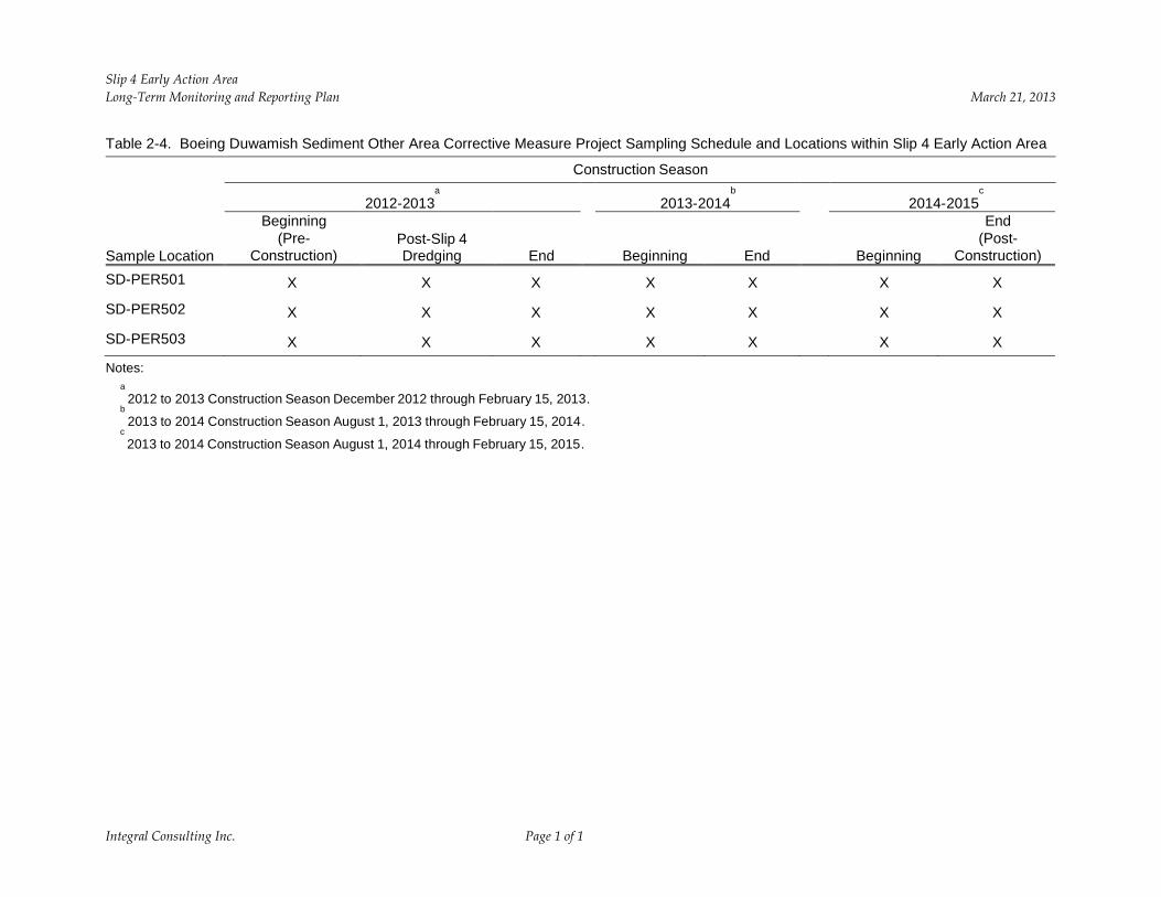
Table 2-4. Boeing Duwamish Sediment Other Area Corrective Measure Project Sampling Schedule and Locations within Slip 4 Early Action Area
Construction Season
Sample Location
Beginning (Pre-
Construction)
2012-2013 a
Post-Slip 4 Dredging End
2013-2014 b
Beginning End
2014-2015 c
Beginning
End (Post-
Construction) SD-PER501 X X X X X X X
SD-PER502 X X X X X X X
SD-PER503 X X X X X X X
Notes: a
2012 to 2013 Construction Season December 2012 through February 15, 2013. b
2013 to 2014 Construction Season August 1, 2013 through February 15, 2014. c 2013 to 2014 Construction Season August 1, 2014 through February 15, 2015.
Integral Consulting Inc. Page 1 of 1
Slip 4 Early Action Area March 21, 2013 Long-Term Monitoring and Reporting Plan
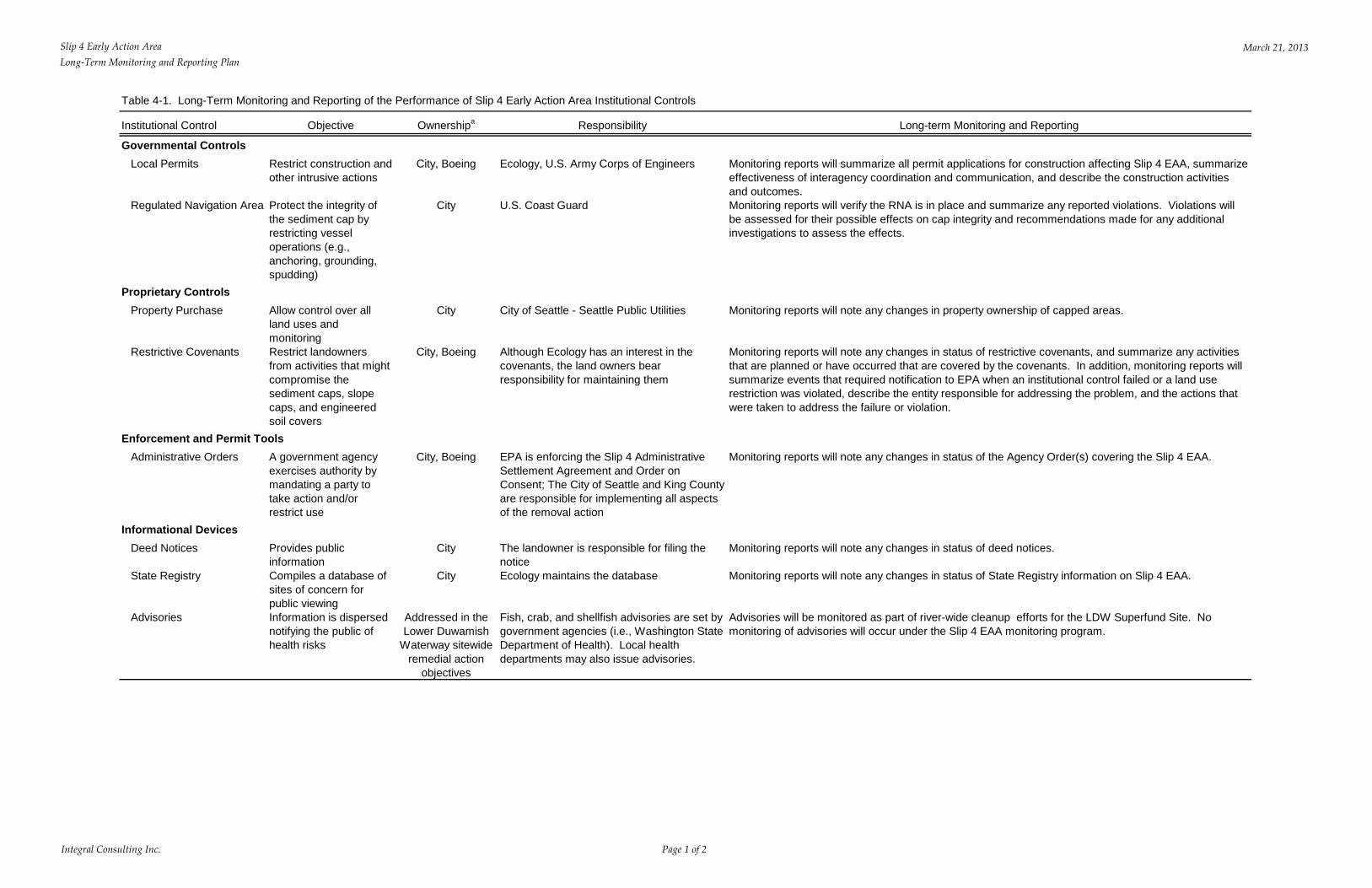
Table 4-1. Long-Term Monitoring and Reporting of the Performance of Slip 4 Early Action Area Institutional Controls
Institutional Control Objective Ownershipa Responsibility Long-term Monitoring and Reporting
Governmental Controls Local Permits Restrict construction and
other intrusive actions
Regulated Navigation Area Protect the integrity of the sediment cap by restricting vessel operations (e.g., anchoring, grounding, spudding)
Proprietary Controls Property Purchase Allow control over all
land uses and monitoring
Restrictive Covenants Restrict landowners from activities that might compromise the sediment caps, slope caps, and engineered soil covers
Enforcement and Permit Tools Administrative Orders A government agency
exercises authority by mandating a party to take action and/or restrict use
Informational Devices Deed Notices Provides public
information State Registry Compiles a database of
sites of concern for public viewing
Advisories Information is dispersed notifying the public of health risks
City, Boeing
City
City
City, Boeing
City, Boeing
City
City
Addressed in the Lower Duwamish
Waterway sitewide remedial action
objectives
Ecology, U.S. Army Corps of Engineers
U.S. Coast Guard
City of Seattle - Seattle Public Utilities
Although Ecology has an interest in the covenants, the land owners bear responsibility for maintaining them
EPA is enforcing the Slip 4 Administrative Settlement Agreement and Order on Consent; The City of Seattle and King County are responsible for implementing all aspects of the removal action
The landowner is responsible for filing the notice Ecology maintains the database
Fish, crab, and shellfish advisories are set by government agencies (i.e., Washington State Department of Health). Local health departments may also issue advisories.
Monitoring reports will summarize all permit applications for construction affecting Slip 4 EAA, summarize effectiveness of interagency coordination and communication, and describe the construction activities and outcomes. Monitoring reports will verify the RNA is in place and summarize any reported violations. Violations will be assessed for their possible effects on cap integrity and recommendations made for any additional investigations to assess the effects.
Monitoring reports will note any changes in property ownership of capped areas.
Monitoring reports will note any changes in status of restrictive covenants, and summarize any activities that are planned or have occurred that are covered by the covenants. In addition, monitoring reports will summarize events that required notification to EPA when an institutional control failed or a land use restriction was violated, describe the entity responsible for addressing the problem, and the actions that were taken to address the failure or violation.
Monitoring reports will note any changes in status of the Agency Order(s) covering the Slip 4 EAA.
Monitoring reports will note any changes in status of deed notices.
Monitoring reports will note any changes in status of State Registry information on Slip 4 EAA.
Advisories will be monitored as part of river-wide cleanup efforts for the LDW Superfund Site. No monitoring of advisories will occur under the Slip 4 EAA monitoring program.
Integral Consulting Inc. Page 1 of 2
Slip 4 Early Action Area Long-Term Monitoring and Reporting Plan
March 21, 2013
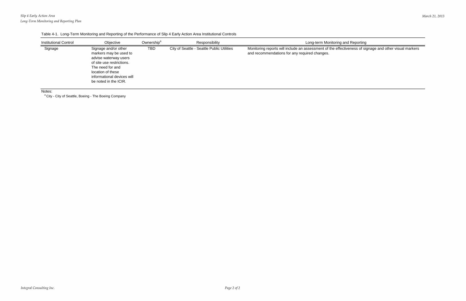
Table 4-1. Long-Term Monitoring and Reporting of the Performance of Slip 4 Early Action Area Institutional Controls
Institutional Control Objective Ownershipa Responsibility Signage Signage and/or other
markers may be used to advise waterway users of site use restrictions. The need for and location of these informational devices will be noted in the ICIR.
TBD City of Seattle - Seattle Public Utilities Long-term Monitoring and Reporting
Monitoring reports will include an assessment of the effectiveness of signage and other visual markers and recommendations for any required changes.
Notes: a City - City of Seattle, Boeing - The Boeing Company
Integral Consulting Inc. Page 2 of 2
Slip 4 Early Action Area Long-Term Monitoring and Reporting Plan March 21, 2013
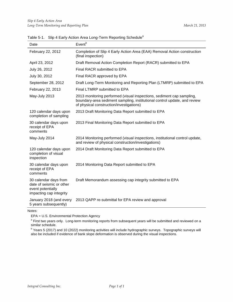
Table 5-1. Slip 4 Early Action Area Long-Term Reporting Schedulea
Date Eventb
February 22, 2012 Completion of Slip 4 Early Action Area (EAA) Removal Action construction (final inspection)
April 23, 2012 Draft Removal Action Completion Report (RACR) submitted to EPA
July 26, 2012 Final RACR submitted to EPA
July 30, 2012 Final RACR approved by EPA
September 28, 2012 Draft Long-Term Monitoring and Reporting Plan (LTMRP) submitted to EPA
February 22, 2013 Final LTMRP submitted to EPA
May-July 2013 2013 monitoring performed (visual inspections, sediment cap sampling, boundary-area sediment sampling, institutional control update, and review of physical construction/investigations)
120 calendar days upon 2013 Draft Monitoring Data Report submitted to EPA completion of sampling
30 calendar days upon 2013 Final Monitoring Data Report submitted to EPA receipt of EPA comments
May-July 2014 2014 Monitoring performed (visual inspections, institutional control update, and review of physical construction/investigations)
120 calendar days upon 2014 Draft Monitoring Data Report submitted to EPA completion of visual inspection
30 calendar days upon 2014 Monitoring Data Report submitted to EPA receipt of EPA comments
30 calendar days from Draft Memorandum assessing cap integrity submitted to EPA date of seismic or other event potentially impacting cap integrity
January 2018 (and every 2013 QAPP re-submittal for EPA review and approval 5 years subsequently)
Notes: EPA = U.S. Environmental Protection Agency a First two years only. Long-term monitoring reports from subsequent years will be submitted and reviewed on a similar schedule. b Years 5 (2017) and 10 (2022) monitoring activities will include hydrographic surveys. Topographic surveys will also be included if evidence of bank slope deformation is observed during the visual inspections.
Integral Consulting Inc. Page 1 of 1