Embed Size (px)
Citation preview

SLADE END FARM, WALLINGFORD OUTLINE PLANNING APPLICATION PUBLIC EXHIBITION - MAY 2011
Wallingford is a town steeped in history. From the medieval bridge over the Thames to the grassy banks of its ancient fortifications, it proclaims a colourful past. It’s a town of surprises with the bustle of the Market Place and the tranquillity of the quiet back-streets - a place to explore.
It was the river that first attracted settlers to the area and in the Bronze and Iron Ages the rich soils encouraged farming communities. The Romans in turn left traces of occupation - burials, roads, coins and pottery, but it was left to the Anglo-Saxons to build the first town under the rule of King Alfred. Since its founding, Wallingford has at different times been the home of William the Conqueror and Queen Matilda. The castle was bound on three sides by earthen walls and on the fourth by the river.
As times changed during the 16th century, the need for strong castles declined. The walls came down and the town was free to expand. The town has since undergone various other stages of expansion, perhaps most notably when the railway came in 1866. Through all these varying stages of expansion, the town has grown away from the heart to the west, north and south, and to this day, the east of the town is still bounded by the River Thames.
WALLINGFORD & SURROUNDING AREAWALLINGFORDPRUPIM
An Outline Planning Application has been submitted on behalf of Prudential Assurance Company Limited (PACL), in respect of proposed residential development at Slade End Farm, Wallingford. PACL are the owners of the Slade End Farm site. PRUPIM is the investment management business owned by Prudential Group charged with overall responsibility for promotion of the site. This statement supports an Outline Planning Application with all matters reserved except access, for development of 32.37 Hectares at the Slade Ende Farm site.
The Slade End Farm planning application seeks outline planning permission for the following:
› Residential development comprising 340 dwellings (C3 Use) and 60 Extra Care units (C2 Use)
› A one form entry primary school› Business and community uses up to a maximum of 375m2 (D1, D2 and
B1 Uses)› Associated landscaping and open spaces› Construction of new access points on the A4130 Calvin Thomas Way
/ Bosley Way and Wantage Road and other supporting infrastructure works and facilities.
We believe that Site B has the potential to become a natural extension of Wallingford that makes a positive contribution to the town: a place with character and identity, that respects its landscape setting and is in harmony with its context.
INTRODUCTION
SITE LOCATION PLAN
OXFORDSHIRE HISTORIC MAP - 1574
OXFORDSHIRE HISTORIC MAP - 1913
TOWN CENTRE & RESIDENTIAL AREAS
BRIGHTWELL CUM SOTWELL
© Based upon the Ordnance Survey mapping with the permission of the Controller of Her Majesty’s Stationery Office. Crown copyright. Unauthorised reproduction infringes Crown copyright and may lead to prosecution or civil proceedings. OS Licence number 100020449 © Crown copyright.

SLADE END FARM, WALLINGFORD OUTLINE PLANNING APPLICATION PUBLIC EXHIBITION - MAY 2011
SITE CONTEXTSITE LOCATIONWALLINGFORD CONTEXT
The River Thames represents an approximate eastern boundary to Wallingford, with the settlement of Crowmarsh Gifford situated a short distance east of the river itself. This historic core of the town remains associated with the river, from where it has developed primarily westwards and northwards. It meets Winterbrook to the south. The town lies centrally within a group of smaller settlements comprising Brightwell-cum-Sotwell to the north-west, Benson to the noth-east, Crowmarsh Gifford immediately to the east, and Cholsey to the south-west.
Today the population of Wallingford is approximately 7,000 people. There are two primary schools and an infant school. The secondary school is situated north/north-west of the historic town centre. In addition to the commercial premises in the town centre, significant employment uses are located on the Hithercroft Industrial Estate, towards the south-west of the town. Adjacent to the industrial / business park on Hithercroft Road lies the Wallingford Sports Park. Wallingford Rowing Club has a base on Thames Street. Other facilities available within the town include a hospital, a museum, a hotel, a library, the Corn Exchange theatre and cinema, and a variety of shops, restaurants and public houses. Various regular markets and annual events are held in the town.
The site is located towards the north-west of the town of Wallingford. It forms part of land known as Slade End Farm – the remainder of which lies beyond the bypass (the A4130 / Calvin Thomas Way / Bosley Way) to its west. At present the site is arable farmland and features only one built structure, that of Fir Tree Cottage situated approximately in the centre of the site. The property is reached by tracks that connect to the bypass and to Queen’s Avenue.
The application site comprises 32.37 hectares / 80 acres – this includes two areas of existing highways on which new or reconfigured junctions will be required by the proposal. Excluding this highways land the site itself comprises 29.74 hectares / 73.49 acres.
At present the site is accessed from Wantage Road at its northernmost point, from Queen’s Avenue on its north-eastern boundary, and by a farm entrance off Calvin Thomas Way / Bosley Way. Pedestrian access on a Public Right of Way exists at a footpath leading from the north-eastern corner of the site towards Wantage Road / Fir Tree Avenue: this public footpath traverses the site, emerging at the bypass, beyond which it heads north-westwards towards Brightwell-cum-Sotwell.
The Slade End Farm site lies at the western extent of Wallingford, beyond which lie open farmland and the villages of Slade End / Brightwell-cum-Sotwell. However, analysis shows that the site is not peripheral: residential development already extends almost entirely along its northern boundary (properties along Wantage Road and Queen’s Avenue), and entirely down its eastern edge (properties along Chiltern Crescent and Fir Tree Avenue). Along its southern edge the site borders existing allotments, and at the south-western corner, the sports pitches at Wallingford Sports Park. Thus if the site is considered conceptually to have four sides, three of those adjoin the uses described – demonstrating that the site can form an effective ‘piece of the jigsaw’ that is the town of Wallingford, rather than be a place that connects only loosely by one edge to the existing form of the town.
The fourth of the four sides is that adjoining the A4130, the road bypassing the town. This route, established in the early 1990s, inevitably forms a line of perimeter around the western edge of the town: the Slade End Farm site to its east effectively sits within the curtilage that it describes. This road will pass the edge of the town, but development of the site should form a positive edge to Wallingford that is not directly shaped by the alignment of the A4130.
THE SITE
© Based upon the Ordnance Survey mapping with the permission of the Controller of Her Majesty’s Stationery Office. Crown copyright. Unauthorised reproduction infringes Crown copyright and may lead to prosecution or civil proceedings. OS Licence number 100020449
© Based upon the Ordnance Survey mapping with the permission of the Controller of Her Majesty’s Stationery Office. Crown copyright. Unauthorised reproduction infringes Crown copyright and may lead to prosecution or civil proceedings. OS Licence number 100020449

SLADE END FARM, WALLINGFORD OUTLINE PLANNING APPLICATION PUBLIC EXHIBITION - MAY 2011
› A historic Roman grid-iron town centre to the west of the Thames› Small hamlets in the surrounding landscape› Roman roads and tracks connecting the settlements› The landscape crossed by drains and ditches leading from the river
› Continued residential expansion within undeveloped areas to the west of the town› Pockets of development in the area between the new bypass and
the river
› A small pocket of infill development south of Wantage Road› Continued farming of the land around Wallingford› The network of drains maintained for farming purposes
› Areas of undeveloped land in-filled to the west of the town centre› Continued growth of Brightwell-cum-Sotwell towards Wallingford› The construction of the A4130 between Sotwell and Wallingford› Slade End Barns demolished but track and path retained
› Very little development during the inter-war years› Expansion of the residential area to the west after the 2nd World War› The area unaffected by large scale industrial activity› The construction of the A4074 bypass to the east
› The potential development of the Slade End Farm site, up to the boundary formed by the bypass to the west of Wallingford: site not yet allocated for development
HISTORIC DEVELOPMENT OF WALLINGFORD
PRE 1883
1960 - 1972
1883 - 1914
1972 - PRESENT
1914 - 1960
LOCATION OF SITE B

SLADE END FARM, WALLINGFORD OUTLINE PLANNING APPLICATION PUBLIC EXHIBITION - MAY 2011
SLADE END FARM (SITE B): CONNECTION & CONTEXT
Station Road
High Street
Slade End Farm
St. John’s Road
daoR
tf
orC
St.Geo
rges Ro
ad
St. Nicholas Road
Fir Tree Aven
ue
yaW r
etra
hC
Kinecroft
Croft Villas
Egerton Road
The Bull Croft
The
Kin
e C
roft
Site B
1
2
3
4
5
78
Bosleyw
ay (A4130)
Wantage Road
Hithercroft Road
Reading Road
6
9
Hithercroftff R
14
15
11
13
12
13
yyaWW
Road
h
0.5km
1 km
wa
y
oadR
10
1
12
2
13
13
3
14
4
15
5
6
78
9
10
11
1
12
2
13
3
14
4
15
5
6
7
8
9
10
11
Pedestrian Routes to Services from Slade End Farm
Public Footpaths
Site Pedestrian / Cycle Access Points
St. John’s Primary School
Hithercroft Industrial Estate
Wallingford Community Hospital
Town Centre / Shopping
Fir Tree School
Londis Supermarket
Wallingford Secondary School
St. Nicholas Infant School
Employment Area
Post Office
Pharmacy
Church
Public House
Allotments
Wallingford Sports Park
KEY

SLADE END FARM, WALLINGFORD OUTLINE PLANNING APPLICATION PUBLIC EXHIBITION - MAY 2011
Site B lies on the north-western edge of Wallingford, and to the south of properties along Wantage Road. To its west runs the town bypass, and to the south are positioned an area of allotments and also the Wallingford Sports Park. The eastern boundary of the site runs along the rear gardens of properties along Fir Tree Avenue and Chiltern Crescent. The site occupies an area of approximately 32.37 hectares (80 acres).
SITE LOCATION & CONTEXT
© Based upon the Ordnance Survey mapping with the permission of the Controller of Her Majesty’s Stationery Office. Crown copyright. Unauthorised reproduction infringes Crown copyright and may lead to prosecution or civil proceedings. OS Licence number 100020449

SLADE END FARM, WALLINGFORD OUTLINE PLANNING APPLICATION PUBLIC EXHIBITION - MAY 2011
SURROUNDING LAND USETOPOGRAPHY, ORIENTATION AND SURFACE WATERROUTES AND CONNECTIONS
This diagram highlights the principal connections leading to and from Site B. Whilst Wantage Road and Hithercroft Road both lead towards the town centre, there are additional pedestrian routes leading eastwards from the corners of the site, and offering the quickest routes into the centre of Wallingford for those on foot. A well-used footpath runs along the northern part of Site B, offering an attractive and direct route for pedestrians to Brightwell-cum-Sotwell, although this requires crossing of the bypass.
The site offers excellent opportunities for new development that responds to the path of the sun. New buildings and open spaces could be designed to maximise solar gain, assisted by the slope of the site - higher to the north, lower to the south. This slope influences surface water drainage patterns, and also enhances the best views from the site, which are in a southerly / south-westerly direction.
Site B is directly adjacent to a variety of existing uses: residential properties to the north and the east, agricultural land beyond the bypass to the west, allotments and sports facilities to the south (and the Hithercroft industrial / employment uses a short distance away to the south-east). Fir Tree School is located a short distance from the eastern boundary of the site.
SITE ANALYSIS
SLADE END FARM, WALLINGFORD OUTLINE PLANNING APPLICATION PUBLIC EXHIBITION - MAY 2011
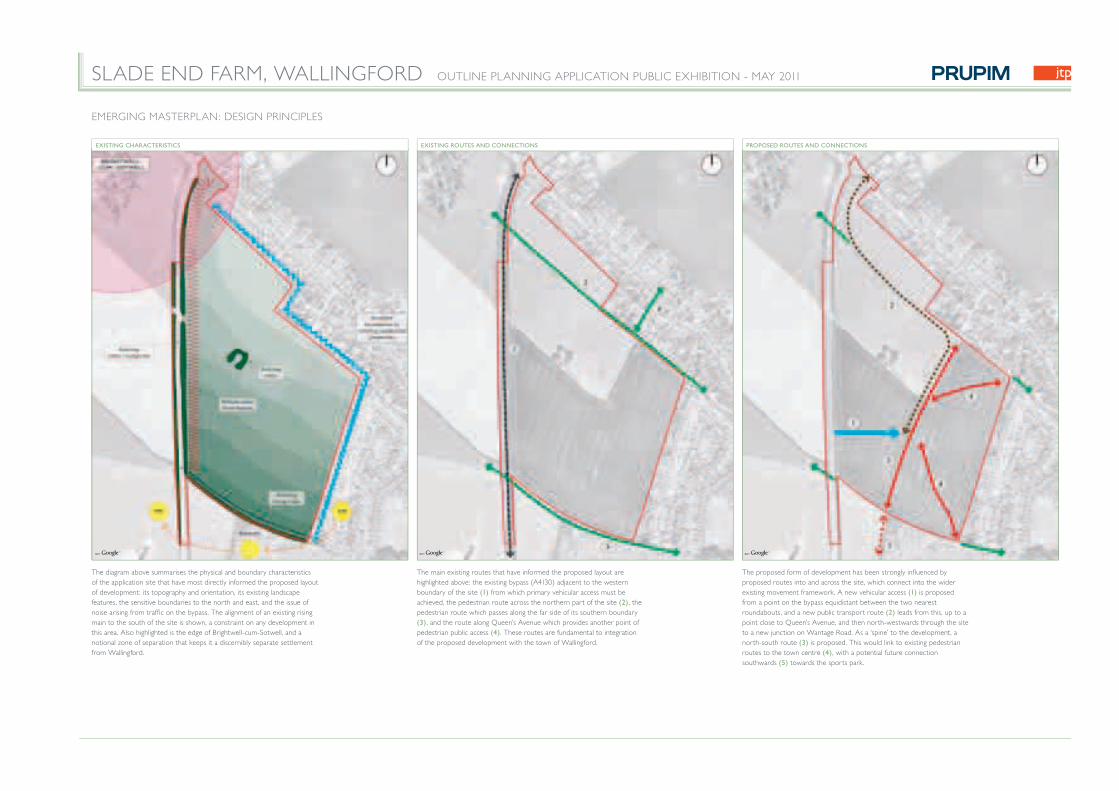
The diagram above summarises the physical and boundary characteristics of the application site that have most directly informed the proposed layout of development: its topography and orientation, its existing landscape features, the sensitive boundaries to the north and east, and the issue of noise arising from traffic on the bypass. The alignment of an existing rising main to the south of the site is shown, a constraint on any development in this area. Also highlighted is the edge of Brightwell-cum-Sotwell, and a notional zone of separation that keeps it a discernibly separate settlement from Wallingford.
The main existing routes that have informed the proposed layout are highlighted above: the existing bypass (A4130) adjacent to the western boundary of the site (1) from which primary vehicular access must be achieved, the pedestrian route across the northern part of the site (2) , the pedestrian route which passes along the far side of its southern boundary (3) , and the route along Queen’s Avenue which provides another point of pedestrian public access (4) . These routes are fundamental to integration of the proposed development with the town of Wallingford.
The proposed form of development has been strongly influenced by proposed routes into and across the site, which connect into the wider existing movement framework. A new vehicular access (1) is proposed from a point on the bypass equidistant between the two nearest roundabouts, and a new public transport route (2) leads from this, up to a point close to Queen’s Avenue, and then north-westwards through the site to a new junction on Wantage Road. As a ‘spine’ to the development, a north-south route (3) is proposed. This would link to existing pedestrian routes to the town centre (4) , with a potential future connection southwards (5) towards the sports park.
EMERGING MASTERPLAN: DESIGN PRINCIPLES
EXISTING CHARACTERISTICS EXISTING ROUTES AND CONNECTIONS PROPOSED ROUTES AND CONNECTIONS

SLADE END FARM, WALLINGFORD OUTLINE PLANNING APPLICATION PUBLIC EXHIBITION - MAY 2011
To the west of the site a generous swathe of green space is proposed. This will serve multiple purposes: additional screen planting to that which already exists along the bypass, wider spaces for informal recreation and play, areas for community orchard planting, and routes / locations for SuDS measures. It demonstrates our approach whereby the edge of the development does not simply reflect the line of the A4130, but that it forms an articulated edge to the town defined by landscaped spaces of varying form and purpose. The southern edge of the site is also proposed as a green buffer. Both areas accommodate surface water drainage routes and basins, connecting to a SuDS framework working with the topography across the site. The existing northern pedestrian route and the proposed north-south route through the site are highlighted as green corridors.
The diagram above layers the existing and proposed aspects of the site and the proposed framework within which development could occur - and then highlights the zones which this combined framework forms. These are considered to be areas within which built development could appropriately be realised. Also highlighted are the proposed location for the primary school (1) adjacent to the heart of the development framework (2) and the focal point at the core of the development around which a cluster of mixed-uses could be arranged (3) . This focal point is on the main access and public transport route into the site, on the main north-south green corridor through its centre, and is directly linked to the pedestrian routes that lead from the north, north-east and south-east of the application site.
Having established this conceptual framework for development, a masterplan structure was developed within the parameters it defines. The development zones establish areas in which built form can appropriately be located, and the main routes and spaces past and adjacent to these zones establish primary frontages to this built form.
EMERGING MASTERPLAN: DESIGN PRINCIPLES
PROPOSED GREEN AND BLUE INFRASTRUCTURE PROPOSED DEVELOPMENT ZONES AND FOCAL POINT CONCEPTUAL MASTERPLAN FRAMEWORK

SLADE END FARM, WALLINGFORD OUTLINE PLANNING APPLICATION PUBLIC EXHIBITION - MAY 2011
PAULS MALT, WALLINGFORD
Mixed-tenure residential development
The redevelopment of Pauls Malt arose from the regeneration of a brownfield industrial site close to the centre of Wallingford. The current use has ceased and the site was allocated for housing provision. Through extensive local neighbourhood, planning and district council consultation, along with an open planning consultation event, we prepared a scheme providing 149 dwellings on the residential part of the site with an overall density of 41 dwellings per hectare.
The scheme offers a mix of housing type, size and tenure across the site, based around a series of squares, mews courts and a new village green integrating with the local cycle and pedestrian network Part of the site was taken up by the Cholsey and Wallingford Railway Preservation Society with an area allocated for a potential commuter link between Cholsey and Wallingford.
FAIR MILE HOSPITAL, SOUTH OXFORDSHIRE
Mixed-Use, Mixed-Tenure Residential Development on Brownfield Land
The proposed redevelopment of the former Fair Mile Hospital is one of the most exciting redevelopment possibilities currently available in the south of England. It presents the opportunity to participate in the delivery of the Government’s Sustainable Communities Agenda and to ensure the future retention and on-going sustainability of an important collection of built heritage and established landscape within the village of Cholsey. HCA has awarded this redevelopment project to Linden Homes who have appointed John Thompson and Partners to be responsible for the provision of infrastructure and masterplanning. Thomas Homes will be responsible for the conversion and refurbishment of existing buildings, whilst The Guinness Trust will manage the affordable housing.
The scheme is based upon the development becoming integrated into the wider community by the creation of a varied mixed-use community with a diverse range of home types. Integration is critical to the success of the project and would be facilitated by a community planning event to understand the issues faced by the local community, and also to engage and involve them in the development proposals. As well as new homes, there would be up to 15 live-work units together with a new village hall, community, sports, social and business unit facilities. An Ecohomes prediction has been completed and Cholsey Park will achieve an ‘Excellent’ standard.
QUEEN ELIZABETH PARK, GUILDFORDHigh density, mixed-use residential development
John Thompson & Partners’ award-winning mixed-use development on the former Queen Elizabeth Barracks in Guildford has been carried out on behalf of Laing and Linden Homes. The project began with a community planning exercise that gave local residents and other stakeholders an opportunity to express their concerns and aspirations for the development. The masterplan responds to the existing trees and natural features of the site and integrates the new housing with the established residential neighbourhoods that surround the site.
More than 525 new homes including private, affordable, rented, and shared equity properties have been arranged into a series of distinct character areas, along with other mixed uses. A new village green gives the development a clear focus, and a network of green routes within the parkland has been provided for pedestrians and cyclists.
Awards: › Building For Life Awards 2004 Gold Standard Award Winner
› Housing Design Awards 2004 Highly Commended
› Your New Home 2004 Best Development for Family Living
› Evening Standard Awards 2003 Best Three Bedroom House Best Home of the Year
THE VILLAGE AT CATERHAM, SURREYMixed-use Development on Brownfield Land
John Thompson & Partners’ award-winning, mixed-use project for Linden Homes is one of the first examples of a private developer using consensus-led masterplanning to create a new sustainable community.
Over 1000 local people were involved in the initial vision-building exercise held on the site, a former army barracks with several Grade II listed buildings. The scheme as built is an economically-integrated, mixed-use neighbourhood that includes residential accommodation, a supermarket, offices, a veterinary hospital, a doctor’s surgery, an indoor skateboard and BMX centre, as well as new landscaping and open space.
Of the 366 new homes created, 28% are affordable units provided by The Guinness Trust, and distributed within each phase of the development alongside those for private sale. A Community Development Trust is managing leisure and business facilities on the site and using its assets to create jobs for local people.
Awards:› Building Awards 2006 Major Housing Project of the Year
› Building for Life Award 2005 Gold Standard Award
› The Deputy Prime Minister’s Award for Sustainable Communities 2003 Commended Finalist
› The European Urban and Regional Planning Awards 2002 Best Conversion (Joint winner)
› RTPI National Awards for Planning Achievement 2000 Planning for the Whole Community Award
› BURA Community Award 2000 Caterham Barracks Community Trust
PRUPIM
Real Estate Investment and owner of Site B
JOHN THOMPSON & PARTNERS
Architects and Masterplanners
ROGER MILES PLANNING LTD
Planning Consultants
RMPL
HORSTONBRIDGE LTD
Development Management
PLACE DESIGN AND PLANNING
Landscape Architects
ODYSSEY CONSULTING
Highways, Transport and Infrastructure Consultants
MEETING PLACE COMMUNICATIONS
Consultation and Engagement
HALCROW YOLLES
Sustainability Consultants
JOHN THOMPSON & PARTNERS - PROJECTS THE PROJECT TEAM

SLADE END FARM, WALLINGFORD OUTLINE PLANNING APPLICATION PUBLIC EXHIBITION - MAY 2011
POTENTIAL CONNECTIONTO EXISTING FOUL SEWEIN WANTAGE ROAD
POTENTIAL CONNECTION TO UPGRADED PUMP STATION
TO CHOLSEY SEWAGETREATMENT WORKS
POTENTIAL DEDICATEDRISING MAIN
FOUL PUMPING SATION
FOUL PUMPING SATION
CONNECTION TO EXISTING 400mm TRUNK MAIN
EXISTING 400mm TRUNKMAIN
INFRASTRUCTURE PROPOSALS
FLOODING & SURFACE WATER DRAINAGEWATER SUPPLYSEWAGE
› Connection to the existing public sewer network may include an upgrade to the existing Fir Tree Foul Pumping Station
› It may be necessary to install a new dedicated rising main to take foul sewage to Cholsey Sewage Treatment Works.
› A small new pumping station may be required in the north western corner of the site to deal with differences in level
› A trunk water main runs close to the north western corner of the site› Thames Water has advised that some local network improvement may be required in order to bring these water supplies directly into the site› The supply of drinking water to development on the site is feasible and achievable, with no impact on services to existing dwellings
› The site is located outside the flood plain › Surface water run-off from dwellings, roads and other hard surfaces
will be controlled to be no greater than the existing run off rate from the farm land. This will ensure that the volume of water falling onto the land during a period of heavy rain does not surge into the surrounding water courses to cause potential capacity problems
› Rain water will be held by means of sustainable drainage techniques, comprising a series of interconnecting ponds or swales to capture the water on site, thereby allowing controlled discharge to the surrounding water courses
© Based upon the Ordnance Survey mapping with the permission of the Controller of Her Majesty’s Stationery Office. Crown copyright. Unauthorised reproduction infringes Crown copyright and may lead to prosecution or civil proceedings. OS Licence number 100020449
© Based upon the Ordnance Survey mapping with the permission of the Controller of Her Majesty’s Stationery Office. Crown copyright. Unauthorised reproduction infringes Crown copyright and may lead to prosecution or civil proceedings. OS Licence number 100020449
© Based upon the Ordnance Survey mapping with the permission of the Controller of Her Majesty’s Stationery Office. Crown copyright. Unauthorised reproduction infringes Crown copyright and may lead to prosecution or civil proceedings. OS Licence number 100020449
POTENTIAL CONNECTIONS TO EXISTING FOUL SEWER IN WANTAGE ROAD

SLADE END FARM, WALLINGFORD OUTLINE PLANNING APPLICATION PUBLIC EXHIBITION - MAY 2011
GREEN INFRASTRUCTURE
Green Infrastructure is defined as the physical environment within and between our cities, towns and villages. It is the network of multi-functional open spaces including formal parks, gardens, woodlands, green corridors, waterways, street trees and open countryside. It comprises all environmental resources, and thus a green infrastructure approach to masterplanning also contributes towards a sustainable resource management. It promotes biodiversity and recreation, encouraging community interaction and a healthy lifestyle. The following components of the Slade End Farm masterplan will contribute to the wider Green Infrastructure of South Oxfordshire.
› Mature trees and hedgerows› Boundary planting› Wildlife corridors› Swales and ponds› Orchard and allotments› Footpaths and cycleways› Amenity open space and play areas
ECOLOGY AND ENVIRONMENT
The illustrative masterplan for the site has been designed to offer a comprehensive, integrated approach to the new development. The built form and the green infrastructure together create a sustainable and welcoming neighbourhood based on traditional place-making and good design; in accordance with South Oxfordshire District Council’s Design Guidance.
A variety of techniques would be used to provide an appropriate green buffer to the bypass and to help avoid any perceived effect of coalescence with Brightwell-cum-Sotwell. There would be a mixture of mounding, planting, acoustic protection, SuDS, productive land and play areas along the western boundary. As well as individual gardens, a network of local green spaces would be created to reflect the rural ambience of the area. As a result the rural settings of Brightwell and Wallingford are maintained and bio-diversity would be significantly enhanced.
LANDSCAPE PROPOSALS
Attractive, high-quality landscaping is essential, both to respect the site and to create an appealing environment for residents and visitors. A key opportunity is the inclusion of techniques to reinforce the existing and maturing site screening along the by-pass and to deal with practical issues such as rainwater run-off. In this way the landscape can be used to create an attractive environment for the new residential neighbourhood.
Sustainable drainage systems (SuDS) will be used, exploiting the natural slope of the land to hold water on site in a network of swales (open drainage channels with grass and planting) and ponds. These will be designed to slow down run-off and also to allow water to percolate into the ground, rather that run on the surface. Even hard-paved areas can be porous, made of materials that allow water to percolate down through the substrate. Soakaways would be based on known infiltration rates, preventing overloading of the drainage system. In some locations, for amenity and ecological reasons, a built-in impervious lining could be used to create more permanent water features which would add to the character of the new neighbourhood and encourage bio-diversity. The combination of all these techniques would mean that even when there are heavy rain storms, the run-off rate from the site would be no more that it is at present.
COMMUNITY ORCHARD
A community orchard is a place where local and other varieties of top fruit are grown by, and for, local people. They provide fruit to share, places to enjoy and show how well we can live with nature. The community orchard can become the equivalent of the local woodland – a communal asset for the whole parish. It can help improve our diet, offer healthy activity and enliven a curriculum.
STRUCTURAL LANDSCAPE
The vegetation that is currently growing along the boundaries will be retained and supplemented with additional native hedgerow and woodland edge species. This will provide a strong green framework within which the development will be set. The existing mature trees around Fir Tree cottage near the centre of the site will also be retained and will help to provide a buffer between the existing and the new properties. New tree and shrub planting will enhance the residential street scene, providing shade and seasonal interest.
LANDSCAPE, ECOLOGY AND OPEN SPACE
LOCAL PARKS AND INFORMAL OPEN SPACE
Areas of open space will be distributed throughout the residential areas to ensure that all residents have access to attractive and seasonally changing spaces in which to walk, socialise and relax. There could be areas with seating and picnic tables. Trees and shrubs would be primarily native but with some more exotic species to add diversity and to lengthen the flowering and fruiting season, thus providing food for a wide range of birds and insects.
ALLOTMENTS
To supplement the provision of growing areas that currently exist nearby, allotments would provide residents with the opportunity to grow their own produce and to share knowledge and social enterprise with neighbours and friends. Allotments also provide valuable wildlife habitats, improving local biodiversity.
CHILDREN’S PLAY AREAS
Younger children’s play areas would be distributed throughout the residential areas to ensure that play and social activities are readily accessible to all residents and their friends, that they are safe and well supervised. Steps would be taken to minimise conflict between different age groups and users. Informal kick about space and opportunities for older children and youths would be accommodated, and as guided by the local planning authority.
FOOTPATHS AND CYCLEWAYS
The existing public rights of way that pass through the site will be retained and the path which crosses the northern part of the site will be given a generous landscape setting with attractive tree and shrub planting. Other pedestrian routes will be created to provide a variety of direct routes to schools, bus stops and play areas, as well as informal leisure routes through the open space network. Cyclists will be able to use clearly defined routes within the development, that link to the National Cycle Network (Sustrans) Route 5 which runs between Wallingford and Brightwell along the Wantage Road.

SLADE END FARM, WALLINGFORD OUTLINE PLANNING APPLICATION PUBLIC EXHIBITION - MAY 2011
1
2
3
4
6
6
6
6
5
LANDSCAPE, ECOLOGY AND OPEN SPACE
COMMUNITY ORCHARD ENVIRONMENTS
GREEN ROUTES PRINCIPAL OPEN SPACES GREEN SPACES NEW PUBLIC SQUARE
ALLOTMENT ENVIRONMENTS MEADOW AND WETLAND ENVIRONMENTS
Sketch plan and section through north-south green route which connects Queens Avenue to the south of the site. Including swale, new cycle footway wildlife habitats and natural play environment
Extract plan
Varies between 11-20m
Informal and naturalplay environment
Equippedplay area
1 2 3
4 5 6

SLADE END FARM, WALLINGFORD OUTLINE PLANNING APPLICATION PUBLIC EXHIBITION - MAY 2011
A
B
B
A
C
C
SECTIONS THROUGH SITE (ILLUSTRATIVE)
PROPOSED SITE SECTION (ILLUSTRATIVE) B B
AOD 48.50 AOD 47.00 FIR TREE AVENUE
A4130
PROPOSED SITE SECTION (ILLUSTRATIVE) C C
AOD 55.30WANTAGE ROAD
AOD 47.30
PROPOSED SITE SECTION (ILLUSTRATIVE) A A
AOD 54.00
A4130
AOD 52.00 CHILTERN CRESCENT