Embed Size (px)
Citation preview
São Paulo, UNESP, Geociências, v. 30, n. 1, p. 63-76, 2011 63
SL INDEX AS INDICATOR OF ANOMALIESIN THE LONGITUDINAL PROFILE OF PIRAPÓ RIVER
SL INDEX AS INDICATOR OF ANOMALIESIN THE LONGITUDINAL PROFILE OF PIRAPÓ RIVER
Maurílio MARTINEZ 1 , Ericson Hideki HAYAKAWA 2 ,José Cândido STEVAUX 1 , Janaína Deffune PROFETA 1
(1) Departamento de Geografia, Universidade Estadual de Maringá. Avenida Colombo, 5790. CEP 87020-900.Maringá, PR. E-mail: [email protected]; [email protected]; [email protected]
(2) Instituto de Ciências da Natureza, Universidade Federal de Alfenas. Rua Gabriel Monteiro da Silva, 700.CEP 37130-000, Alfenas, MG. E-mail: [email protected]
IntroductionLongitudinal Profile and Stream Gradient IndexStudy AreaMaterial and MethodsResults and Discussion
Longitudinal Profile of the Pirapó RiverLongitudinal Profile of the Bandeirantes do Norte RiverLongitudinal Profile of the Pirapó River’s TributariesSL Index for the Pirapó RiverSL Index of the Bandeirantes do Norte RiverDistribution of Anomalous Points on the Drainage Basin
DiscussionConclusionsAcknowledgmentsBibliographic References
ABSTRACT – Drainage morphometric parameters are important to characterization of the drainage basin. Main of this study is theapplication of SL index to analyze the longitudinal profile and to characterize the fluvial valley of Pirapó River basin. These parametersallow the detection of anomalies of drainage that can respond to different factors such as lithology and/or tectonics. The anomalous pointsdetected are located in different areas of drainage basin and show the ungraded river condition. The anomalous points channels are presentin the upper and low Pirapó River. SL index for the tributaries also indicate anomalies in their longitudinal profiles. Field data indicate thatthe areas with anomalous points present asymmetric valleys and terraces, river incision, waterfalls, canyons, among others whichnormally corresponding to subsidence blocks and faults.Keywords: Pirapó River, longitudinal profile, SL index, drainage anomalous.
RESUMO – M. Martinez, E.H. Hayakawa, J.C. Stevaux, J.D. Profeta - Índice RDE como indicador de anomalias no perfil longitudinaldo rio Pirapó. Parâmetros morfométricos de drenagem são importantes para a caracterização da bacia de drenagem. O objetivo principaldeste estudo é a aplicação do índice RDE para analisar o perfil longitudinal e caracterizar o vale fluvial do rio Pirapó. Estes parâmetrospermitem a detecção de anomalias de drenagem que podem estar controladas por diferentes fatores como litologia e/ou tectônicos. Ospontos anômalos detectados estão localizados em diferentes áreas da bacia e mostram a configuração de desequilíbrio (ungraded) do canal.Os pontos anômalos estão presentes no alto e baixo curso do rio Pirapó. O índice RDE para os tributários também indicam anomalias emseus respectivos perfis longitudinais. Dados de campo revelam que os pontos anômalos localizam-se em vales e terraços assimétricos,locais de incisão do canal, presença de cachoeira, canyons, entre outras feições as quais normalmente correspondem a subsidência deblocos e falhas.Palavras-chave: rio Pirapó, perfil longitudinal, índice RDE, anomalias de drenagem.
INTRODUCTION
Drainage network has geometric properties thatcan be quantitatively described (Leopold et al., 1964).Longitudinal profile and the stream gradient indexare parameters that allow the morphometriccharacterization of drainage networks providingsubsidies to the knowledge of the geological, structuraland some cases hydro-sedimentological factors that
control the configuration of drainage basin, as well asits history of evolution (Hack, 1960). The longitudinalprofile of a channel determines the gradient of a riverand their behavior along the channel from theheadwater to mouth (Christofoletti, 1980). The streamgradient index proposed by Hack (1973) allows theidentification of anomalies in the longitudinal profile
São Paulo, UNESP, Geociências, v. 30, n. 1, p. 63-76, 2011 64
of a river. Combination of these parameters facilitatesthe identification of variables that control the drainagenetwork as: i) occurrence of more resistant rocks(Lima, 2009), ii) increased input of sediment load andmore coarse sediments (Chien, 1984), iii) tectonicactivity (Etchebehere, 2000), iv) changes in the baselevel resulting for sea level variations during glaciationsperiod (Tricart, 1977), v) confluence with tributaries(Knighton, 1998; Etchebehere, 2000) and, vi) byhuman activities (Fortes, 2003) which can act aspossible causes of anomalies in longitudinal profile.
Longitudinal profile and stream gradient indexapplied to identify the variables that control the networkof drainage basin are still scarce in Brazil(Etchebehere, 2000; Martinez, 2005; Guedes, 2008;
The longitudinal profile is a curve obtained fromthe relationship between height (H) versus distancedownstream (L) of a channel (Darton, 1950; Hack,1957; Christofoletti, 1980). When the obtained profileis concave, commonly is defined as graded profile.Mackin (1948) defined the graded concept as thedynamic equilibrium between erosion and deposition.According Christofoletti (1980) and Etchebehere(2000) in a graded river or some segments of a gradedriver the rate of degradation and aggradation aresimilar, then, the river only transport the sediment load.Knighton (1998) stated that the greater extent ofchannel, greater the concavity of the longitudinalprofile.
Several discussions about determination of thedifference between a graded and ungraded stream andthe graphic representation of a longitudinal profile wasconducted by Darton (1950) and Hack (1957, 1959).Based on numerical experiments, Snow & Slingerland(1987) suggested three types of equations: exponential,logarithmic and potential for determining the longitudinalprofile according to the controlling variables. Hack(1959) determined that the semilogarithmic graph of aprofile allows analyzing a river, where a graded riverwould appear as a straight inclined line. Thus, anydifference between the straight line and the profile couldreveal how and where the longitudinal profile of theriver would be ungraded. According Hack (1959)conception, the semilogarithimic profile allows theglobal analysis of the river and indicates the differencefrom a graded profile highlighting the main points ofinflection at the gradient line (knick points) and leadingto an interpretation based on geological andgeomorphological factors. Hack (1973) considered thatthe detection of knick points in a longitudinal profile
Fujita, 2009), but are important parameters formorphometric analysis of water courses. In additionrare are the studies in stable tectonic areas. Usuallythis parameters is applied to river systems related toareas of intense tectonic, as the studies developed byMerrits et al. (1994) at rivers located in the State ofCalifornia (USA), Brookfield (1998) at rivers locatedMiddle East, Seeber & Gornitz (1983) at rivers locatedin area with influence of Himalaya Mountains, amongothers.
In this context, this study proposes the use oflongitudinal profile and the index gradient in the drainagebasin of the Pirapó River to characterize the valleyand identify ungraded stretches in the channel and theirpossible causes to ungraded configuration.
LONGITUDINAL PROFILE AND STREAM GRADIENT INDEX
can be quantified from the application of stream gradientindex or called SL index (slope vs. length).
Hack (1973) proposed the stream gradient indexas a practical resource to determine anomalies in thenatural concavity at the longitudinal profile. The indexallows the normalization of the gradient values and theidentification of anomalous points in each section ofthe river from headwaters to mouth. The streamgradient index by stretch of river is calculated by theequation:
LLHSL .
∆∆= (1)
where ∆H is the difference of altitude between twopoints in the watercourse, ∆L is the length of this stretchand L is the total length of the channel.
It is also possible to calculate the SL index of achannel in all of its length. In this case the index iscalled SLtotal which consider the difference of altitudebetween the headwaters and mouth and the naturallogarithm of the total length of the watercourse, as theequation 2:
LHSLtotal ln
∆= (2)
The model proposed by Hack (1973) allows theidentification of anomalous points in longitudinal profilesuggesting ungraded channel. The anomalous points inthe Hack’s proposition are those from the divisionbetween the values of SLsegment by the values of SLtotalto obtain values above 2.
São Paulo, UNESP, Geociências, v. 30, n. 1, p. 63-76, 2011 65
STUDY AREA
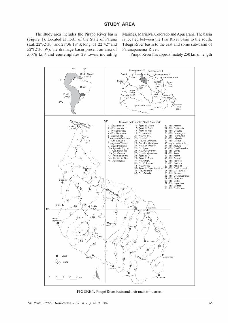
The study area includes the Pirapó River basin(Figure 1). Located at north of the State of Paraná(Lat. 22º32’30” and 23º36’18”S; long. 51º22’42” and52º12’30”W), the drainage basin present an area of5,076 km² and contemplates 29 towns including
Maringá, Marialva, Colorado and Apucarana. The basinis located between the Ivaí River basin to the south,Tibagi River basin to the east and some sub-basin ofParanapanema River.
Pirapó River has approximately 250 km of length
FIGURE 1. Pirapó River basin and their main tributaries.
São Paulo, UNESP, Geociências, v. 30, n. 1, p. 63-76, 2011 66
with headwaters located at Apucarana city (740 m ofaltitude) and mouth located at confluence with theParanapanema River (240 m of altitude). Bandeirantesdo Norte River is the main tributary (149 km of length),which is located at the right margin of the Pirapó River.Climate in this area is Subtropical Humid Mesothermic(Cfa), with rigorous summers (average temperatureover 22ºC), no defined dry season at winter (averagetemperature of 18ºC) and uncommon frost (Maack,1968). The vegetation of the Pirapó River basin isTropical rainforest. Currently is largely replaced byagriculture cultures.
Pirapó River basin is located at Terceiro PlanaltoParanaense and contemplates two main lithologies: i)lava flood basalt of the Serra Geral Formation and, ii)sandstone of the Caiuá and Santo AnastácioFormations (Maack, 1968). Outcrops of basalt with 10to 20 km wide are present continuously in the PirapóRiver valley from the headwaters to mouth. In thelower half of the basin basalt is covered by sandstoneat the watersheds and the headwaters of sometributaries. The unconsolidated materials is restrictedto small patches of Quaternary alluvial depositsassociated with the Pirapó River and a sandy and sand-clay material of contradictory genesis. Some authorsclassify as colluvium-alluvial deposit, know asParanavaí Formation (Popp e Bigarella, 1975), while
others define as pedological origin from the underlyingsandstone (Gasparetto, 1999).
Serra Geral Formation presents small fracturesand joints caused mainly by the cooling of lava andalso by load relief by overlying rock remotion. Insome cases, the fractures have tectonic genesis,probably associated with the activity of the PontaGrossa Arch. Studies developed by PAULIPETRO(1982) in the area noted tectonic lineaments orientedN40-60E and N40-60W.
Drainage basin landscape is formed by gently tiltedplateaus, with rectilinear to convex profiles supportedby layers of vesicular basalt. In the transition betweenthe upper and middle basin these forms change toisolated hills formed by sandstone of the Caiuá andSanto Anastácio Formations. The middle and lowerbasin presents a well-dissected relief formed by smoothhills with large convex tops. In this part of the basinthe Pirapó River shows a small floodplain. The drainageof the Pirapó River is subsequent/obsequent probablydue to epirogenetic movement. Drainage pattern ispredominantly subdendritic to dendritic but it is commonthe occurrence of rectangular to trellis indicatingstructural control. The drainage in general hasrelationship with the bedrock, and river runs in the mostover rock, with frequent occurrence of small canyons,rapids and waterfalls.
MATERIAL AND METHODS
The data used is this investigation came fromgeological maps at 1:100.000 performed byPAULIPETRO (1982), the Geologic Map of the Stateof Paraná at 1:600.000 (MINEROPAR, 1989) andTopographic Charts at 1:50.000 of Teodoro Sampaio,Santo Inácio, Paranacity, Colorado, Centenário do Sul,Nova Esperança, Santa Fé, Astorga, Prado Ferreira,Mandaguaçu, Maringá, Sabáudia, Rolândia, BomSucesso, Mandaguari and Apucarana (IBGE, 1975).
In the construction of the longitudinal profile it wasmeasured (by manual curvimeter) the length of thechannel between two 20 m contours lines attopographic charts (1:50.000). The values measured
were organized in spreadsheets and containedinformations such as: higher elevation, lower elevation,difference in elevation, cumulative length, lengthsection, and total length which were used forcalculation of the SL index (segment and total). SLindex section and total were defined by the equations1 and 2. Graded and ungraded reaches were identifiedand measured by the relation between longitudinalprofile and SL index and plotted in graphic with theapplication of the “Best Fit Line function”. Thisallowed the observation of the knick points in theprofile and the subsident (below the line) and uplifted(above the line) reaches.
RESULTS AND DISCUSSION
LONGITUDINAL PROFILE OF THE PIRAPÓ RIVER
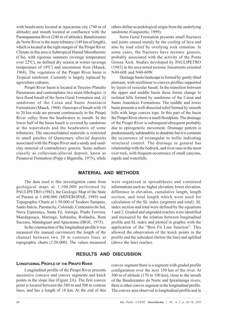
Longitudinal profile of the Pirapó River presentssuccessive concave and convex segments and knickpoints in the slope line (Figure 2A). The first convexpoint is located between the 580 m and 500 m contourlines, and has a length of 18 km. At the end of this
convex segment there is a segment with graded profileconfiguration over the next 150 km of the river. At300 m of altitude (170 to 190 km), close to the mouthof the Bandeirantes do Norte and Ipiratininga rivers,there is other convex segment in the longitudinal profile.The convex area observed in longitudinal profile and in
São Paulo, UNESP, Geociências, v. 30, n. 1, p. 63-76, 2011 67
FIGURE 2. Longitudinal profile (A) and Best Fit Line (B) of the Pirapó River.
the Best Fit Line occurs close to the mouth of theBandeirantes do Norte River and Ipiratininga River(Figure 2B).
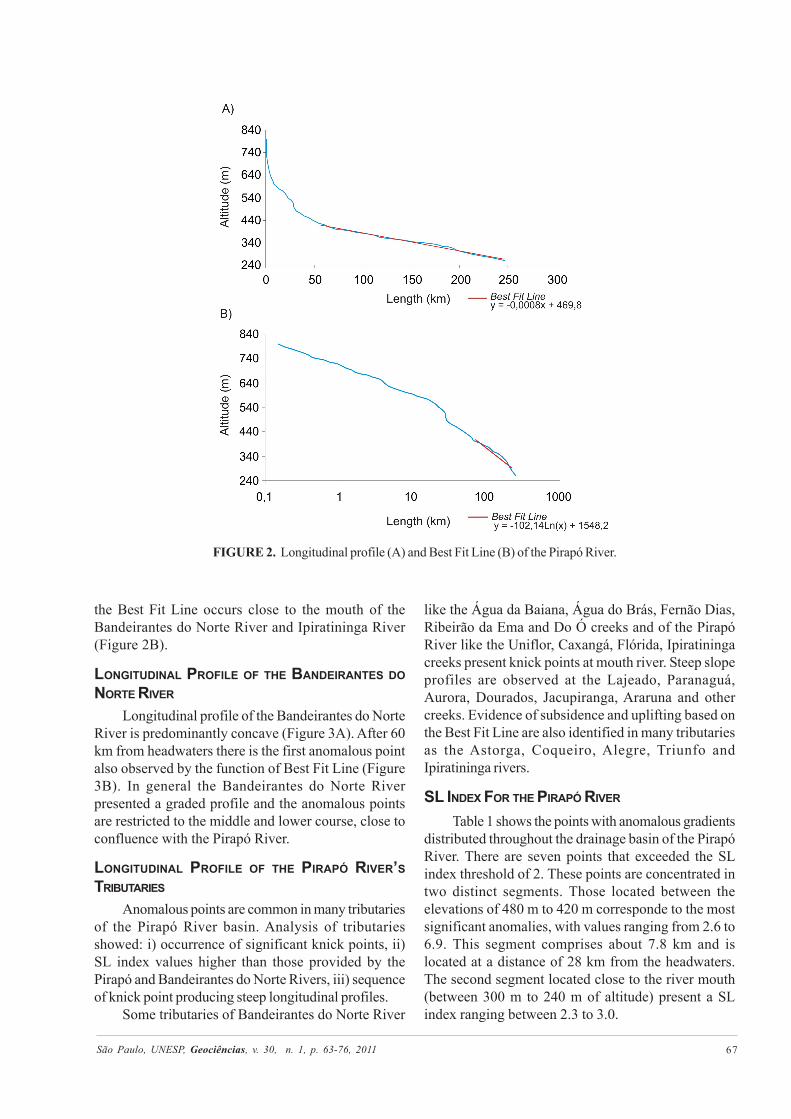
LONGITUDINAL PROFILE OF THE BANDEIRANTES DONORTE RIVER
Longitudinal profile of the Bandeirantes do NorteRiver is predominantly concave (Figure 3A). After 60km from headwaters there is the first anomalous pointalso observed by the function of Best Fit Line (Figure3B). In general the Bandeirantes do Norte Riverpresented a graded profile and the anomalous pointsare restricted to the middle and lower course, close toconfluence with the Pirapó River.
LONGITUDINAL PROFILE OF THE PIRAPÓ RIVER’STRIBUTARIES
Anomalous points are common in many tributariesof the Pirapó River basin. Analysis of tributariesshowed: i) occurrence of significant knick points, ii)SL index values higher than those provided by thePirapó and Bandeirantes do Norte Rivers, iii) sequenceof knick point producing steep longitudinal profiles.
Some tributaries of Bandeirantes do Norte River
like the Água da Baiana, Água do Brás, Fernão Dias,Ribeirão da Ema and Do Ó creeks and of the PirapóRiver like the Uniflor, Caxangá, Flórida, Ipiratiningacreeks present knick points at mouth river. Steep slopeprofiles are observed at the Lajeado, Paranaguá,Aurora, Dourados, Jacupiranga, Araruna and othercreeks. Evidence of subsidence and uplifting based onthe Best Fit Line are also identified in many tributariesas the Astorga, Coqueiro, Alegre, Triunfo andIpiratininga rivers.
SL INDEX FOR THE PIRAPÓ RIVER
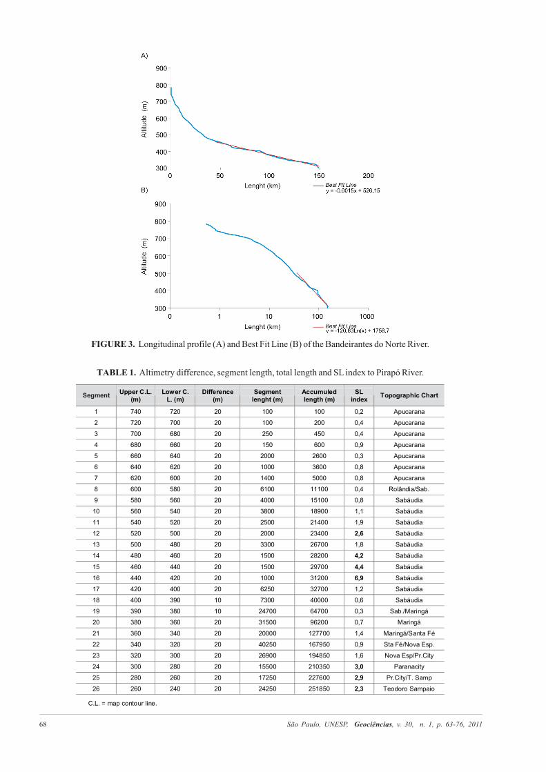
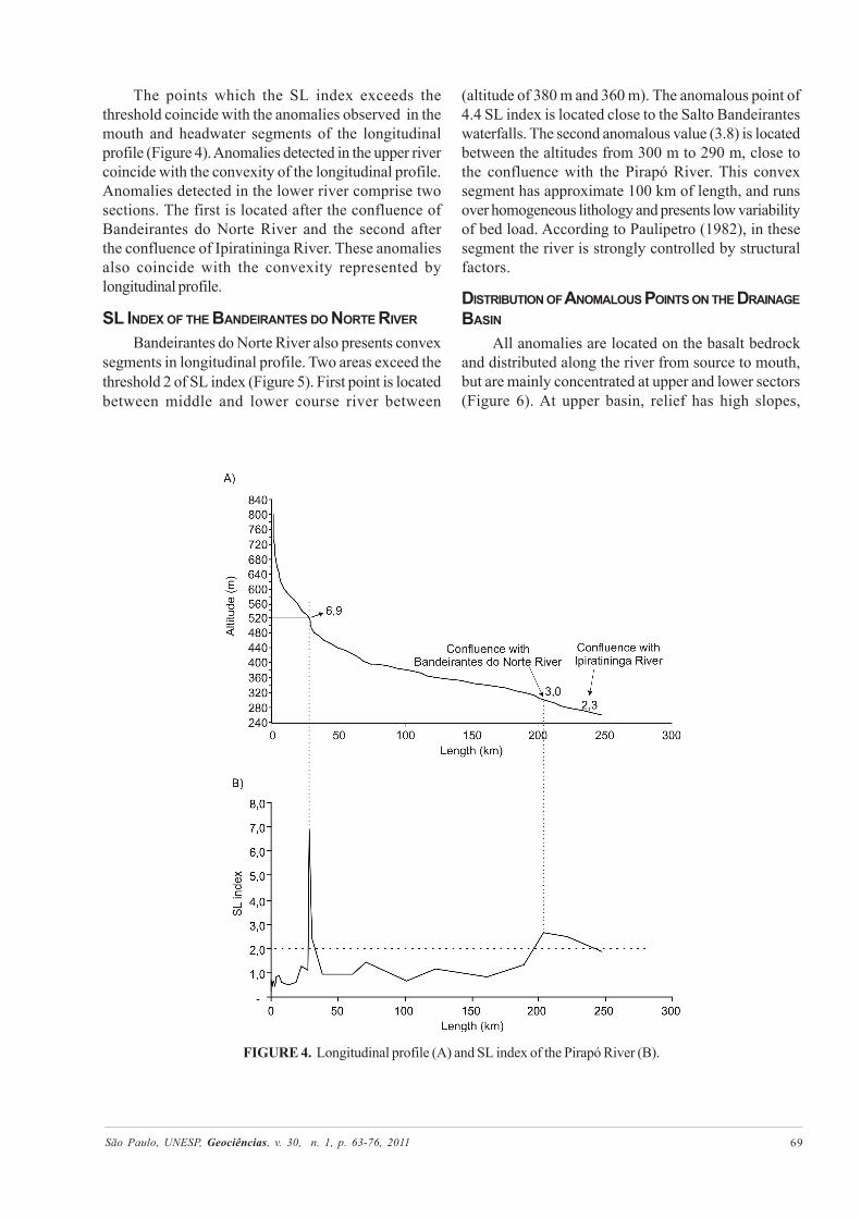
Table 1 shows the points with anomalous gradientsdistributed throughout the drainage basin of the PirapóRiver. There are seven points that exceeded the SLindex threshold of 2. These points are concentrated intwo distinct segments. Those located between theelevations of 480 m to 420 m corresponde to the mostsignificant anomalies, with values ranging from 2.6 to6.9. This segment comprises about 7.8 km and islocated at a distance of 28 km from the headwaters.The second segment located close to the river mouth(between 300 m to 240 m of altitude) present a SLindex ranging between 2.3 to 3.0.
São Paulo, UNESP, Geociências, v. 30, n. 1, p. 63-76, 2011 68
TABLE 1. Altimetry difference, segment length, total length and SL index to Pirapó River.
FIGURE 3. Longitudinal profile (A) and Best Fit Line (B) of the Bandeirantes do Norte River.
São Paulo, UNESP, Geociências, v. 30, n. 1, p. 63-76, 2011 69
The points which the SL index exceeds thethreshold coincide with the anomalies observed in themouth and headwater segments of the longitudinalprofile (Figure 4). Anomalies detected in the upper rivercoincide with the convexity of the longitudinal profile.Anomalies detected in the lower river comprise twosections. The first is located after the confluence ofBandeirantes do Norte River and the second afterthe confluence of Ipiratininga River. These anomaliesalso coincide with the convexity represented bylongitudinal profile.
SL INDEX OF THE BANDEIRANTES DO NORTE RIVER
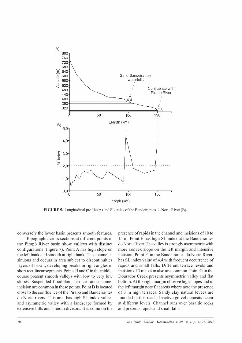
Bandeirantes do Norte River also presents convexsegments in longitudinal profile. Two areas exceed thethreshold 2 of SL index (Figure 5). First point is locatedbetween middle and lower course river between
FIGURE 4. Longitudinal profile (A) and SL index of the Pirapó River (B).
(altitude of 380 m and 360 m). The anomalous point of4.4 SL index is located close to the Salto Bandeiranteswaterfalls. The second anomalous value (3.8) is locatedbetween the altitudes from 300 m to 290 m, close tothe confluence with the Pirapó River. This convexsegment has approximate 100 km of length, and runsover homogeneous lithology and presents low variabilityof bed load. According to Paulipetro (1982), in thesesegment the river is strongly controlled by structuralfactors.
DISTRIBUTION OF ANOMALOUS POINTS ON THE DRAINAGEBASIN
All anomalies are located on the basalt bedrockand distributed along the river from source to mouth,but are mainly concentrated at upper and lower sectors(Figure 6). At upper basin, relief has high slopes,
São Paulo, UNESP, Geociências, v. 30, n. 1, p. 63-76, 2011 70
FIGURE 5. Longitudinal profile (A) and SL index of the Bandeirantes do Norte River (B).
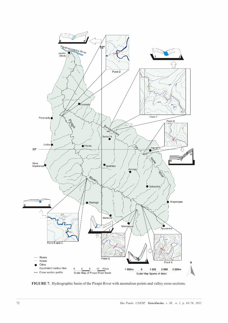
conversely the lower basin presents smooth features.Topographic cross sections at different points in
the Pirapó River basin show valleys with distinctconfigurations (Figure 7). Point A has high slope onthe left bank and smooth at right bank. The channel issinuous and occurs in area subject to discontinuitieslayers of basalt, developing breaks in right angles inshort rectilinear segments. Points B and C in the middlecourse present smooth valleys with low to very lowslopes. Suspended floodplain, terraces and channelincision are common in these points. Point D is locatedclose to the confluence of the Pirapó and Bandeirantesdo Norte rivers. This area has high SL index valuesand asymmetric valley with a landscape formed byextensive hills and smooth divisors. It is common the
presence of rapids in the channel and incisions of 10 to15 m. Point E has high SL index at the Bandeirantesdo Norte River. The valley is strongly asymmetric withmore convex slope on the left margin and intensiveincision. Point F, in the Bandeirantes do Norte River,has SL index value of 4.4 with frequent occurrence ofrapids and small falls. Different terrace levels andincision of 3 m to 4 m also are common. Point G in theDourados Creek presents asymmetric valley and flatbottom. At the right margin observe high slopes and inthe left margin note flat areas where note the presenceof 3 m high terraces. Sandy clay natural levees arefounded in this reach. Inactive gravel deposits occurat different levels. Channel runs over basaltic rocksand presents rapids and small falls.

São Paulo, UNESP, Geociências, v. 30, n. 1, p. 63-76, 2011 71
FIGURE 6. Pirapó River basin: Geologic Map and anomalous points distribution.
São Paulo, UNESP, Geociências, v. 30, n. 1, p. 63-76, 2011 72
FIGURE 7. Hydrographic basin of the Pirapó River with anomalous points and valley cross sections.
São Paulo, UNESP, Geociências, v. 30, n. 1, p. 63-76, 2011 73
DISCUSSION
The SL index and longitudinal profile allows theidentification of anomalous points and the gradedintensity of the Pirapó River drainage. Others featuresas the presence of canyons, waterfalls, rapids, valleysand asymmetric terraces shows the ungraded rivercondition. Considering that the Pirapó River flow totallyon the basalt of the Serra Geral Formation, its possibleto minimizes the lithology effects as a possible variablefor river gradation. Studies made by Iriondo et al. (2000)in rivers over basalt in the Uruguai River basin generallyshow a graded profile in most of their courses. The SerraGeral Formation consists predominantly of layers ofbasalt, apparently homogeneous, with thickness from20 m to 40 m, bounded at top by layers from 1 m to 2 mof vesicular basalt. In some cases, packages of basaltare not massive and homogeneous, but formed by a seriesof “traps” ranging from centimeters to meters inthickness. This fact could produce a drainage channelin steps by differential erosion of each layer of basaltand thus generate a large number of anomalous points.However, this factor would cause a randomly distributionof anomalous points and not well defined concentrationsin drainage basin river. The localized presence ofchalcedony and quarts veins in faults and fractures planesincrease erosion resistance but not explain satisfactorilyextensive segments with anomalous points.
Neotectonics of the area is not well studied,however, studies developed in others Brazilian rivers,as those present in the Amazonas drainage basin(Sternberg, 1950; Mauro et al., 1978; Bemerguy &Costa, 1991; Costa et al., 1995, 1996, 2001; Hasui, 1996;Souza Filho et al., 1999; Latrubesse & Rancy, 2000;Bezerra, 2003; Ab’ Saber, 2004; Silva, 2005; Almeida& Miranda, 2007; Soares, 2007; Rossetti et al., 2008,Hayakawa et al., 2010) report the occurrence ofneotectonic events or even the reactivation of ancientstructures that can control the drainage network.
In the Paraná River basin, Fortes et al. (2005,2007) showed the occurrence of tectonic pulse in theHolocene which was responsible for faults that upliftedblocks close to the Ivinhema River area (Mato Grosso
do Sul - Paraná State border). Studies developed atthe Peixe River basin (left tributary of the Paraná Riverlocated in the westward of State of São Paulo), Fúlfaroet al. (2005) and Etchebehere et al. (2005) suggest theevidence of recent tectonic in the low Peixe River.The former suggest that the anomaly at the PeixeRiver’s mouth is due to block movements caused bytectonic events of approximately 34,000 yr B.P. Thischronology is given to differences of deposits close tomouth of this river, which were attributed to changesin base level due to tectonic events. Although incipient,these studies show that recent tectonic events mayhave contributed to evolution of the Paraná River basin.
Presence of channels with evident morphotectoniccan be showed as an effective “link between thegeometric arrangement of substrate elements and thesurface with synchronous crustal deformations (recenttectonic)” (Etchebehere et al., 2005). Examples oftectonic control as faults and their influence in thechannel pattern of the Pirapó River are frequents. Theseveral faults in the Pirapó River basin directlyinfluences the local flow of the channels and alsocontribute to the presence of rectilinear segments. Inaddition inhibits the formation of sedimentary deposits,that when occurs, are commonly asymmetric. Othersfeatures as the presence of knick points, channels withanomalous condition as break in right angles andpresence of local level bases also support the possibletectonic control.
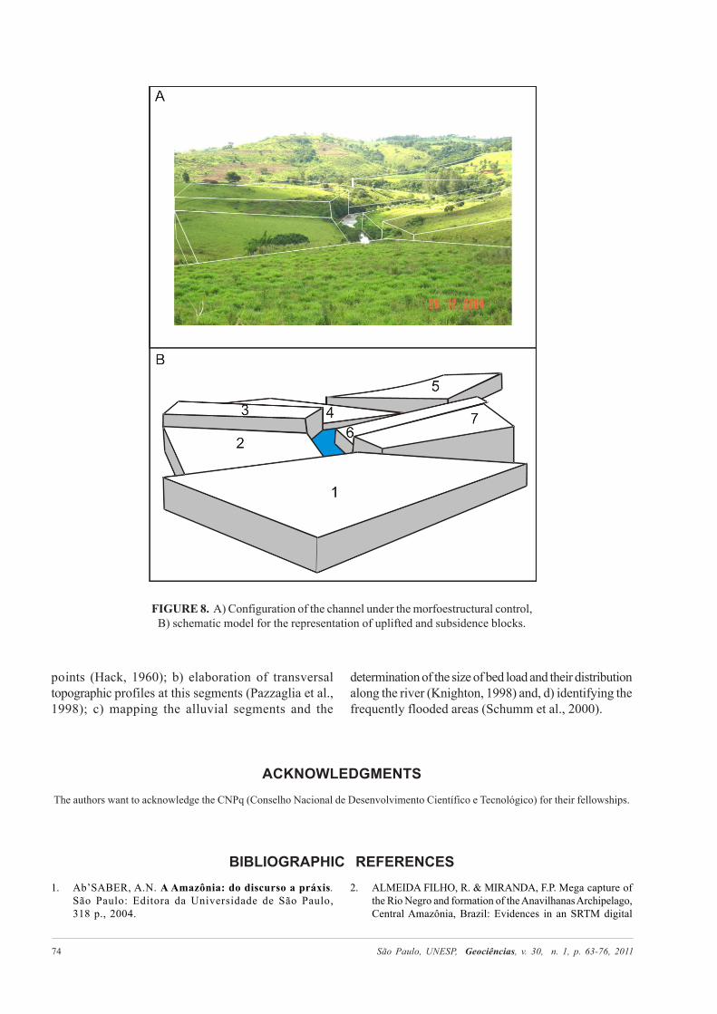
Evidence of tilting block tectonics controllingdrainage can be seen in many places along the river(Figure 8A, B). In this case a series of uplifted andsubsidence tilting blocks control channel sinuosity.Although the use of SL index provided a preciseidentification and quantification of “ungraded” points,the confirmation of genesis – if tectonic, if related tothe internal variability of the packages of basalt orrelated to climatic changes it’s necessary withcomplementary studies. Probably the ungradedbehavior of Pirapó River basin is caused by theconjunction of these factors.
CONCLUSIONSLongitudinal profile and SL index were essentials
to identification of anomalous points at the Pirapó Riverbasin. These morphometric variables allowed thecharacterization of the main channels and valleys ofthe Pirapó River basin and the identification andcharacterization of ungraded areas. Moreover therecognition of these areas enables the discussion about
the factors that promote the ungraded in the PirapóRiver basin, which may be linked to factors alreadymentioned above in “Discussion”.
Some prospects of study can be defined to try todelineate the involvement of these variables in thedevelopment of the drainage basin as: a) detail mappingof segments with highest concentration of anomalous
São Paulo, UNESP, Geociências, v. 30, n. 1, p. 63-76, 2011 74
FIGURE 8. A) Configuration of the channel under the morfoestructural control,B) schematic model for the representation of uplifted and subsidence blocks.
points (Hack, 1960); b) elaboration of transversaltopographic profiles at this segments (Pazzaglia et al.,1998); c) mapping the alluvial segments and the
determination of the size of bed load and their distributionalong the river (Knighton, 1998) and, d) identifying thefrequently flooded areas (Schumm et al., 2000).
ACKNOWLEDGMENTSThe authors want to acknowledge the CNPq (Conselho Nacional de Desenvolvimento Científico e Tecnológico) for their fellowships.
BIBLIOGRAPHIC REFERENCES1. Ab’SABER, A.N. A Amazônia: do discurso a práxis.
São Paulo: Editora da Universidade de São Paulo,318 p., 2004.
2. ALMEIDA FILHO, R. & MIRANDA, F.P. Mega capture ofthe Rio Negro and formation of the Anavilhanas Archipelago,Central Amazônia, Brazil: Evidences in an SRTM digital

São Paulo, UNESP, Geociências, v. 30, n. 1, p. 63-76, 2011 75
elevation model. Remote Sensing of Environment, v. 110,p. 387-392, 2007.
3. BEMERGUY, R.L. & COSTA, J.B.S. Considerações sobre aevolução do sistema de drenagem da Amazônia e sua relaçãocom o arcabouço tectônico-estrutural. Boletim do MuseuParaense Emílio Goeldi, v. 3, p. 77-98, 1991.
4. BEZERRA, P.E.L. Compartimentação morfotectônica dointerflúvio Solimões-Negro. Belém, 2003. 335 p. Tese(Doutorado em Geologia e Geoquímica) – UniversidadeFederal do Pará.
5. BROOKFIELD, M.E. The evolution of the grat river systemsof the southern Asia during the Cenozoic India-Asiacollision: rivers draining southwards. Geomorphology,v. 22, p. 285-312, 1998.
6. CHIEN, N. Changes in river regime after the construction ofupstream reservoirs. Earth Surface Processes andLandscape, v. 10, p. 143-159, 1984.
7. CHRISTOFOLETTI, A. Geomorfologia. 2 ed. São Paulo:Edgard Blucher, 188 p., 1980.
8. COSTA, J.B.S.; HASUI, Y.; BORGES, M.S.; BEMERGUY,R.L. Arcabouço tectônico Mesozóico-Cenozóico da região dacalha do rio Amazonas. Geociências, v. 14, p. 77-103, 1995.
9. COSTA, J.B.S.; BEMERGUY, R.L.; HASUI, Y.; BORGES,M.S.; FERREIRA JUNIOR, C.R.P.; BEZERRA, P.E.L.;COSTA, M.L.; FERNANDES, J.M.G. Neotectônica da regiãoAmazônica: aspectos tectônicos, geomorfológicos edeposicionais. Geonomos, v. 4, p. 23-44, 1996.
10. COSTA, J.B.S.; BEMERGUY, R.L.; HASUI, Y.; BORGES,M.S. Tectonics and paleogeography along the Amazon River.South American Earth Sciences, v. 14, p. 335-347, 2001.
11. DARTON, N.H. Configuration of the bedrock surface of theDistrict of Columbia and vicinity. United States GeologicalSurvay Professional Paper, v. 217, 42 p., 1950.
12. ETCHEBEHERE, M.L.C. Terraços neoquaternários no valedo rio do Peixe, Planalto Ocidental Paulista: implicaçõesestratigráficas e tectônicas. Rio Claro, 2000. 2 v., 264 f. Tese(Doutorado em Geociências) – Instituto de Geociências eCiências Exatas, Universidade Estadual Paulista.
13. ETCHEBEHERE, M.L.; SAAD, A.R.; FULFARO, V.J.;PERINOTTO, J.A.J. Detection of neotectonic deformationsalong the Rio do Peixe Valley, Western São Paulo State, Brazil,base on the distribution of late Quaternary allounits. RevistaBrasileira de Geomorfologia, v. 6, p. 109-114, 2005.
14. FORTES, E. Geomorfologia do baixo curso do rio Ivinhema,MS: uma abordagem morfogenética e morfoestrutural.Rio Claro, 2003. 284 f. Tese (Doutorado em Geociências) –Instituto de Geociências e Ciências Exatas, UniversidadeEstadual Paulista.
15. FORTES, E.; STEVAUX, J.C.; VOLKMER, S. Neotectonicsand channel evolution of the Lower Ivinhema River: A right-bank tributary of the upper Paraná River, Brazil.Geomorphology, v. 70, p. 325-338, 2005.
16. FORTES, E.; VOLKEMER, S.; STEVAUX, J.C.; MARQUES,A.J. Anomalias de drenagem e controles morfotectônicos daevolução dos terraços do Baixo Curso do rio Ivinhema – MS.Geociências, v. 26, p. 249-261, 2007.
17. FUJITA, R.H. O perfil longitudinal do rio Ivaí e sua relaçãocom a dinâmica de fluxos. Maringá, 2009. 98 p. Dissertação(Mestrado) – Programa de Pós-Graduação em Geografia,Universidade Estadual de Maringá.
18. FULFARO, V.J.;ETCHEBEHERE, M.L.; SAAD, A.R.;PERINOTTO, A.J.J. The Araras Escarpament in the UpperParaná River: implications to fluvial neotectonics on the Paranádrainage net evolution. Revista Brasileira de Geomorfologia,v. 6, p. 115-122, 2005.
19. GASPARETTO, N.V.L. As formações superficiais donoroeste do Paraná e sua relação com o Arenito Caiuá.Geonotas, v. 3, n. 3, 1999.
20. GUEDES, I.C. Aplicação de análise flúvio-morfométricana bacia hidrográfica do rio Santo Anastácio – SP paradetecção de deformações neotectônicas. Guarulhos, 2008.158 p. Dissertação (Mestrado) – Programa de Pós-Graduaçãoem Análise Geoambiental, Universidade de Guarulhos.
21. HACK, J.T. Studies of longitudinal stream profiles in Virginiaand Maryland. United States Geological SurveyProfessional Paper, 259-B, p. 45-97, 1957.
22. HACK, J.T. Interpretation of erosional topography in humidtemperate regions. American Journal of Science, Bradley,258-A, p. 80-97, 1960.
23. HACK, J.T. Stream-profile analysis and stream-gradient index.Journal Research of United States Geological Survey,v. 1, p. 421-429, 1973.
24. HACK, J.T. & YOUNG, R.S. Intrenched meanders of the NorthFork of the Shenandoah River, Virginia. United StatesGeological Survey Professional Paper, 354-A, p. 1-10, 1959.
25. HASUI, Y. Evolução geológica da Amazônia. In: SIMPÓSIODE GEOLOGIA DA AMAZÔNIA, 5, 1996, Belém.Resumos Expandidos... Belém: Sociedade Brasileira deGeologia, v. 5, p. 31-34, 1996.
26. HAYAKAWA, E.H.; ROSSETTI, D.F.; VALERIANO, M.M.Applying DEM-SRTM for reconstructing a late Quaternarypaleodrainage in Amazonia. Earth and Planetary ScienceLetters, v. 297, p. 262-270, 2010.
27. IBGE – INSTITUTO BRASILEIRO DE GEOGRAFIA EESTATÍSTICA. Folhas Topográficas em escala 1:50.000.Teodoro Sampaio, Santo Inácio, Paranacity, Colorado,Centenário do Sul, Nova Esperança, Santa Fé, Astorga, PradoFerreira, Mandaguaçu, Maringá, Sabáudia, Rolândia, BomSucesso, Mandaguari, Apucarana. Rio de Janeiro, 1975.
28. IRIONDO, M.E.; STEVAUX, J.C.; ORFEO, O.Caracterização geomorfológica e sedimentológica do arroio LosMuertos: um tributário típico da alta bacia do rio Uruguai.Geociências, v. 19, p. 61-69, 2000.
29. KNIGHTON, D. Fluvial forms & processes. London:Edward Arnold, 383 p., 1998.
30. LATRUBESSE, E.M. & RANCY, A. Neotectonic influence ontropical rivers of southwestern Amazon during the lateQuaternary: the Moa an Ipixuna river basins, Brazil.Quaternary International, v. 72, p. 67-72, 2000.
31. LEOPOLD, L.B.; WOLMAN, M.G.; MILLER, J.P. FluvialProcess en Geomorphology. San Francisco: W. H. Freemam& Co., 319 p., 1964.
32. LIMA, A.G. Controle geológico e hidráulico na morfologiado perfil longitudinal em rio sobre rochas vulcânicas básicasda Formação Serra Geral no Estado do Paraná. Florianópolis,2009. Tese (Doutorado em Geografia) – Programa de Pós-Graduação em Geografia, Universidade Federal de Santa Catarina.
33. MAACK, R. Geografia Física do Estado do Paraná.Curitiba: Badep/UFPR, 350 p., 1968.
34. MACKIN, J.H. Concept of the graded river. Geological Societyof America Bulletin, v. 59, p. 463-512, 1948.
35. MARTINEZ, M. Aplicação de parâmetros morfométricosde drenagem na bacia do rio Pirapó: O perfil longitudinal.Maringá, 2004. 137 f. Dissertação (Mestrado) – Programa dePós-Graduação em Geografia – Departamento de Geografia,Universidade Estadual de Maringá.
36. MAURO, C.A.; NUNES, B.T.A.; FRANCO, M.S.M.Geomorfologia. In: Brasil. Departamento Nacional deProdução Mineral. Projeto RADAMBRASIL. Folha SB.20Purus. Rio de Janeiro.

São Paulo, UNESP, Geociências, v. 30, n. 1, p. 63-76, 2011 76
37. MERRITTS, D.; VICENT, K.R.; WHOL, E.E. Long riverprofiles, tectonism and eustasy: A guide to interpretingfluvial terraces. Journal of Geophysical Research,v. 99-B7, p. 14.031-14.050, 1994.
38. MINEROPAR. Mapa Geológico do Estado do Paraná. Curitiba,MINEROPAR, Mapa Geológico, escala 1:650.000, 1989.
39. PAULIPETRO, CONSÓRCIO CESP/IPT. Mapeamentogeológico do Bloco SF-22-N (ACS. 42). Folha de TeodoroSampaio, Escala 1:100.000. Relatório Interno, v. 1, 1982.
40. PAULIPETRO – CONSÓRCIO CESP/IPT. Mapeamentogeológico do Bloco SF-22-T (ACS-73).Folha de Paranavaí,Escala 1:100.000. Relatório Interno, v. 1, 1982.
41. PAULIPETRO – CONSÓRCIO CESP/IPT. Mapeamentogeológico do Bloco SF-22-U (ACS-74). Folhas de Apucarana,Londrina, Mandaguari, Maringá, Escala 1:100.000.Relatório Interno, 1982.
42. PAZZAGLIA, F.J.; GARDENER T.W.; MERRITTS, D.J.Bedrock fluvial incision and longitudinal profile developmentover geologic time scale determined by fluvial terraces.In: TINKLER, K.J. & WOHL, E.E. (Eds.), River over rocks.Washington: American Geophysical Union, p. 207-235, 1998.
43. POPP, J.H. & BIGARELLA, J.J. Formação cenozoicas donordeste do Paraná. Anais da Academia Brasileira deCiências, Rio de Janeiro, v. 47, p. 465-472, 1975 (suplemento).
44. ROSSETTI, D.F.; GÓES, A.M.; VALERIANO, M.M.;MIRANDA, A.C.C. Quaternary tectonics in a passive margin:Marajó Island, northern Brazil. Journal of QuaternaryScience, v. 23, p. 121-135, 2008.
45. SCHUMM, S.A.; DUMONT, J.F.; HOLBROOK, J.M. Activetectonics alluvial rivers. Cambridge: Cambridge UniversityPress, 276 p., 2000.
46. SEEBER, L. & GORNITZ, V. River Profiles along the Himalayanarc as indicators of active tectonics. Tectonophysics, v. 92,p. 335-367, 1983.
47. SILVA, C.L. Análise da tectônica Cenozóica da região deManaus e adjacências. Rio Claro, 2005. 282 p. Tese(Doutorado) – Instituto de Geociências e Ciências Exatas,Universidade Estadual Paulista.
48. SNOW, R.S. & SLINGERLAND, R.L. Mathematicalmodeling of graded river profiles. Journal of Geology,v. 95, p. 5-33, 1987.
49. SOARES, E.A.A. Depósitos Pleistocenos da Região deConfluência dos Rios Negro e Solimões, Porção Oeste daBacia do Amazonas. São Paulo, 2007. 205 p. Tese (Doutorado)– Instituto de Geociências, Universidade de São Paulo.
50. SOUZA FILHO, P.W.M.; QUADROS, M.L.E.S.;SCANDOLARA, J.E.; FILHO, E.P.S.; REIS, M.R.Compartimentação morfoestrutural e neotectônica do sistemafluvial Guaporé-Mamoré-Alto Madeira, Rondônia, Brasil.Revista Brasileira de Geociências, v. 29, p. 469-476, 1999.
51. STERNBERG, H.O. Vales tectônicos na planície amazônica?Revista Brasileira de Geografia, n. 4, p. 511-531, 1950.
52. TRICART, J.L.F. Tipos de planícies aluviais e leitos fluviais naAmazônia Brasileira. Revista Brasileira de Geografia,Ano 39, n. 2, p. 3-38, 1977.
Manuscrito Recebido em: 23 de novembro de 2009Revisado e Aceito em: 4 de agosto de 2010