Embed Size (px)
Citation preview

SITE VISIT REPORT – DRENSKA RIVER DAM Contents:
1. Introduction
2. Findings from the site visit
3. Conclusion
1. INTRODUCTION
Micro-reservoir on Drenska River is located in Municipality of Demir Kapija and is being operated by the water economy enterprise Tikves. According to the technical description provided in the preliminary report the capacity of the reservoir is 100.000 m3 and the purpose of the reservoir is to provide for irrigation needs of arable land that is located downstream from the dam. The height of the dam is 12.50 m while the useful height is 10.00 m. The length of the crest is 45.00 m. The body of the dam is built from stone and earth materials (without a core).
According to the Manager of the water economy enterprise Tikves, Ljupco Dimitrov, the dam has been destroyed twice in the past. The first time the flood washed out the right side of the dam which was reconstructed after the floods, while the last flood destroyed the left side of the dam. At this moment, the left side of the dam is completely washed out by the river flow and a river bed is formed.
In the minutes from the site visit in 2009 prepared by water economy enterprise Tikves together with water user group Drenska Reka it states that there is a PE pipe free-hanging from the body of the dam. The pipe was not seen during the last visit. In a nutshell, there is no material or artificial structure at the location of the dam apart from the right side of the dam.
Right side of the dam with a length of around 75% of the total length of the crest has not been significantly affected by the last year floods probably because of the reconstruction carried out in 2011 and partially because of the fact that this part of the dam leans against natural rock formation and the actual positioning of the dam.
2. FINDINGS FROM THE SITE VISIT
2.1. Condition of the body of the dam
The body of the dam is completely destroyed at the left side and a river bad is formed 7 – 8 m wide. The river has washed out the entire earth material on that location and the river bed now lays on a natural rock. In immediate vicinity of the dam the width of the river bottom is around 5 – 6 m.
The right section of the dam is in relatively good condition with an exception of the gradient of the upstream slope that is not in line with 1:2.5 suggested in the preliminary design. The upstream slope gradient is large 1:1 to 1:1.5 and the slope is covered in low vegetation since the reservoir has not been used for years.
Right section of the dam partially leans against natural rock formation that is largely fractured. The body of the dam was formed in a way to follow the morphology of the terrain.

Figure 1: A view to the right section of the dam which is still stable, the formed river bed and the left bank that has been formed by the torrents
Figure 2: A photo taken from the crest of the dam that shows the condition of the left bank of the river bed at the location of the connection between the dam and the surrounding terrain
The edge of the left river bank Crest of the dam
Sediments 5-8 m high
Edge of the natural rock mass (rather cracked)
Left bank (layers of sediments)
Cracked rock at the bottom Of the river bed

Figure 3: Natural rock mass incorporated in the body of the dam
2.2. Condition of the reservoir
Figure 4: Reservoir area with sediments
Deposited material in the reservoir (1.5-2 m high)
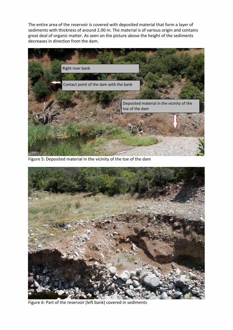
The entire area of the reservoir is covered with deposited material that form a layer of sediments with thickness of around 2.00 m. The material is of various origin and contains great deal of organic matter. As seen on the picture above the height of the sediments decreases in direction from the dam.
Figure 5: Deposited material in the vicinity of the toe of the dam
Figure 6: Part of the reservoir (left bank) covered in sediments
Right river bank
Contact point of the dam with the bank
Deposited material in the vicinity of the toe of the dam
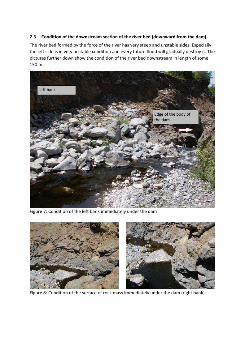
2.3. Condition of the downstream section of the river bed (downward from the dam)
The river bed formed by the force of the river has very steep and unstable sides, Especially the left side is in very unstable condition and every future flood will gradually destroy it. The pictures further down show the condition of the river bed downstream in length of some 150 m.
Figure 7: Condition of the left bank immediately under the dam
-
Figure 8: Condition of the surface of rock mass immediately under the dam (right bank)
Left bank
Edge of the body of the dam

Figure 9: Condition of the banks downstream from the dam
Figure 10: Photo taken in a direction opposite of the direction of the flow
Figure 11: Condition of the left bank downstream form the dam at some 70 m from the axis of the dam
Left bank Right bank
Left bank
Left bank
Right bank
Slope height (around 3 m)

3. CONCLUSION
Since no technical documentation exists for the dam except for the preliminary design prepared in 2009 which makes it obsolete (because, in the meantime, the dam has been further damaged by flood flows), there is a need to design the dam based on the new situation and the afore-mentioned preliminary design. At the dam location the HDPE pipe mentioned in the preliminary design cannot be found. Furthermore, at the dam location there are no structures, i.e. no overflow nor manholes. This means that the Drenska River Dam needs to be a subject to complete reconstruction. The only thing that can be recovered is a section of the body of the dam that has suffered no significant damages. However, that part which comprise 75% of the dam length first needs to pass structural and water impermeability tests. Upstream slope of the dam has a gradient of 1:1 to 1:1.5 which is too steep and with the new design the slopes needs to toned down to a gradient of 1:2.5 (upstream slope) and 1:2 (downstream slope).
The reservoir itself is filled with deposited material which layer is around 2 m thick. The material can be used for construction of the body of the dam and at the same time increase the capacity of the reservoir. Furthermore, the reservoir area needs to be cleared of the various materials brought by the floods.
As you can see from the pictures there is no overflow beam and it needs to be designed with dimensions that correspond to the maximum possible occurrence of flood water. The preliminary design foresees 20 m-wide overflow beam located on the left side of the dam. According to finding from the site visit the overflow beam should be positioned as an extension to the crest of the dam and get incorporated in the left bank of the river bed. This type of construction will not use the entire earth material at disposal and the excess can be used for backfilling the newly-formed river bed. The overflow beam ends with a discharge channel under it. The gradient and width of the discharge channel need to be established in the design. The preliminary design asserts that the width of the discharge channel is 20 m, same as the width of the overflow beam.
The situation with the left bank of the new river bed where the discharge channel should be located requires stabilisation of the slope – during the construction of the channel the excess material and any unstable mass should be removed and the material to be used for backfilling the river bed under the discharge channel.
To secure the water-retention capacity of the body of the dam it is recommended to lay a geomembrane over the entire surface of the upstream slope which should guarantee longer period of exploitation of the dam.
To sum it up, the reconstruction activities of the Drenska Reka reservoir and dam should include:
• Inspection of the structural integrity and water impermeability of the existing section of the dam;
• Removal of the deposited material from the reservoir and using it for backfilling the slopes of the dam to decrease the gradient;
• Placement of geomembrane to the upstream slope to secure water-retention capacity of the dam;
• Prepare a design for the overflow beam and the discharge channel and calculate the balance of masses – excavated earth material to be used for backfilling the newly-formed river bed and the dam slopes, as required;
• Prepare a design for the bottom outlet with entry and exit manholes (the bottom outlet can also be used as an irrigation pipeline);

• The slope on the left bank should be secured against collapsing (failing to do so can lead to the collapse of the slope into the discharge channel that can damage it and render impossible the evacuation of flood flows)
Site visit report took place on 07 July 2016.
Site visit was conducted by:
Ljupco Dimitrov, Manager of water economy enterprise Tikves
Emil Angelov, UNDP
Zoran Kaceski, UNDP
The report was prepared by:
Zoran Kaceski