Embed Size (px)
Citation preview

!!
Site Assessment Methodology Report Final
June 2017 !
Prepared by Adams Hendry Consulting Limited

!
!
!Title
Site Assessment Methodology Report Client
Hart District Council Project Number
HDC/1289 Status
Final Report Number
HDC/1289/F/AMB/20170605 Adams Hendry Consulting Ltd. Sheridan House, 40-43 Jewry Street, Winchester, SO23 8RY T 01962 877414 E [email protected] www.adamshendry.co.uk Author Name: Steven Peck Date: June 2017
Approver Name: Andy Blaxland Date: June 2017
Certified to ISO9001 Standard
ISO 9001 Registration Number Q10324 Registered Office: Sheridan House, 40-43 Jewry Street, Winchester SO23 8RY Registered in England No. 3804753 VAT Registration No. 807 9759 79

!
! 3
Site Assessment Methodology Report
Final
© Adams Hendry Consulting Ltd. June 2017
!
Contents !Contents ............................................................................................................................... 3!1! Introduction ..................................................................................................................... 4!2! Identification of sites to be subject of assessment ......................................................... 5!3! High level site assessments ........................................................................................... 7!4! Sustainability appraisal of high level site assessments .................................................. 9!5! Identification of sites to be subject of detailed assessment .......................................... 10!6! Detailed site assessments ............................................................................................ 12!7! Sustainability appraisal of detailed site assessments .................................................. 13!!

!
! 4
Site Assessment Methodology Report
Final
© Adams Hendry Consulting Ltd. June 2017
!
1 Introduction 1.1 Adams Hendry Consulting Ltd (Adams Hendry) was appointed by Hart District Council
(the Council) to undertake site assessments of potential development sites, to enable the Council to utilise the results to inform its decision making on site allocations for its Local Plan.
1.2 The site assessment project was undertaken over a number of stages, both as a high level and detailed assessment of sites, and the completion of related Sustainability Appraisal matrices for both stages of assessment.
1.3 This report describes the methodology adopted by Adams Hendry in undertaking this work, including the sources of information used as part of the assessment. The report does not describe the Council’s decision making on potential site allocations, as that lay outside the scope of Adams Hendry’s work.
1.4 The report is structured as follows:
Section 2: Identification of sites to be subject of assessment
Section 3: High level site assessments
Section 4: Sustainability appraisal of high level site assessments
Section 5: Identification of sites to be subject of detailed assessment
Section 6: Detailed site assessments
Section 7: Sustainability appraisal of detailed site assessments

!
! 5
Site Assessment Methodology Report
Final
© Adams Hendry Consulting Ltd. June 2017
!
2 Identification of sites to be subject of assessment
2.1 An initial list of SHLAA sites was provided by the Council. The SHLAA sites had been identified over several years through the ‘call for sites’, and, in some cases, through the Council’s work with landowners / developers.
2.2 Adams Hendry worked with the Council to agree a ‘long list’ of sites to undergo high-level assessment (see Section 3). The long list was derived by applying three filters to the initial list of SHLAA sites:
• Filter 1: Sites already benefitting from an implementable residential planning permission were removed – the Council was to undertake its own assessment of the deliverability of such sites as part of the evidence base for the Local Plan.
• Filter 2: Sites wholly or partly within the Thames Basin Heaths SPA 400m ‘Exclusion Zone’ were removed – due to the significance of this constraint upon housing development.
• Filter 3: Sites capable of delivering fewer than 5 dwellings were removed – in accordance with the Planning Practice Guidance for undertaking SHLAAs. The Council would calculate its small site and windfall figures for the Local Plan.
2.3 Work was undertaken to define what constituted a ‘strategic site’ in the Hart context. Based both on experience of other areas and upon on the character of Hart District, a threshold of 400+ dwellings was adopted to define strategic sites. A mapping exercise was undertaken to identify any adjoining SHLAA sites that had the potential to come forward together as a scheme meeting the 400+ dwelling threshold. In other cases, a number of single SHLAA sites were of a scale sufficient to meet the strategic threshold in their own right.
2.4 At the same time as agreeing the sites to be assessed, Adams Hendry agreed the wording of the high-level assessment criteria with the Council (see Section 3 below). Every site that was considered for inclusion in the Hart District Local Plan has had a high level assessment undertaken. Sites were identified and subjected to the high-level assessment to ensure that a common approach for identifying and reviewing the planning issues was applied to every realistic site option, to inform options for the local plan's development strategy.
2.5 Following the 2016 ‘call for sites’ exercise undertaken by the Council, it requested that Adams Hendry undertook a number of additional high-level assessments of sites. The additional sites identified by the Council were capable of delivering 5 residential units or more, and passed the new tests for inclusion in the November 2016 SHLAA. Sites were included by the Council if they were not wholly or largely within a European or National nature conservation site; were not within 400m of the Thames Basin Heaths SPA; were

!
! 6
Site Assessment Methodology Report
Final
© Adams Hendry Consulting Ltd. June 2017
!
not wholly or largely within Flood Zones 2 or 3 / or have access within those Flood Zones; and did not lie wholly within the Farnborough Airport Public Safety Zone.

!
! 7
Site Assessment Methodology Report
Final
© Adams Hendry Consulting Ltd. June 2017
!
3 High level site assessments Methodology for the high-level site assessments
3.1 The high-level assessments were entirely desk-based. Sites were assessed against a set of criteria agreed beforehand with the Council. An example high-level assessment proforma is attached at Appendix 1 to this report. The high-level assessments included the following processes:
• Capacity assessment: The application of an agreed set of assumptions relating to residential densities, dwelling mix and gross to net development ratios. At this stage, no information provided by the landowner/site promoter was used as part of the assessment.
• Housing strategy category: Adams Hendry identified which of the Council’s initial housing strategy categories the site could fall within, e.g. settlement focus, dispersal, urban extension, new settlements, SPA avoidance.
• Land supply category: Adams Hendry identified which of the Council’s housing land supply categories the site would most appropriately be identified within, e.g. land within urban areas, small sites adjoining urban areas, large sites adjoining urban areas, sites not adjoining urban areas, strategic urban extension sites, or new settlement sites.
• Accessibility and infrastructure: Using available evidence and online mapping tools, an assessment was made of the accessibility of the site and the availability and accessibility of key infrastructure and services from each site or combination of sites. Infrastructure providers were not contacted for their views at high-level assessment stage, nor were searches for below ground infrastructure constraints undertaken.
• Planning history: The Council’s online tools and adopted planning policy documents were used to briefly describe the site’s planning history, noting any applications, policies or decisions that could materially affect the suitability of the site for residential development.
• Constraints assessment: Adams Hendry assessed the extent to which residential development at each site, or combination of sites, was materially affected by existing planning constraints. The constraints assessed and the information sources used are set out in Table 1, overleaf.
• Availability assessment: Adams Hendry reviewed evidence from the Council’s SHLAA to make an initial assessment of site availability and the potential lead-in times required to bring the site, or combination of sites, forward for residential development.

!
! 8
Site Assessment Methodology Report
Final
© Adams Hendry Consulting Ltd. June 2017
!
Table 1: High level assessment stage – planning constraints assessed and information sources used
Constraint Information Source
Nature conservation (SPA, SSSIs, SINCs, woodlands and waterbodies)
HDC Local Plan Proposals Map (electronic copy)
Mineral resources Hampshire Minerals and Waste Plan Policies Map
Landscape HDC and HCC Landscape Character Assessments
Agricultural land HDC GIS data (understood to be based on DEFRA (1:250,000) classification maps
Heritage assets (statutorily and locally listed buildings, conservation areas, historic parks and gardens, SAMs)
HDC Local Plan Proposals Map (electronic copy)
Water resources / quality EA Groundwater Protection Zone Maps
Air quality HDC Environmental Health
Flood risk Latest available HDC Strategic Flood Risk Assessment EA fluvial and surface water flood mapping
Location and scale of development Ordnance survey maps HDC Local Plan Proposals Map (electronic copy)
3.2 The outcomes of the above processes were presented in a publicly accessible format, using ‘traffic light’ colours – Red, Amber and Green – to provide a visual summary of the degree of constraint. A summary of the constraints affecting each site was also provided to help inform the Council’s decision making.
3.3 Adams Hendry did not provide a final conclusion or recommendation on the suitability of the site, or its developability. Council Officers and Members subsequently determined those sites to be subject to a detailed assessment, using the high-level assessment matrices as part of the basis for making those decisions, alongside the outcomes of technical discussions amongst Officers within the Council.
Difficulties encountered and action taken as a result
3.4 Two potential difficulties were encountered during this stage of the assessment work:
• Availability was assessed based on information contained in the Council’s SHLAA submission forms. Many of the SHLAA submission forms were over 2 years old – so the information they contained may not have been current at the time of assessment. In cases where the forms were 1 year old or more, Adams Hendry made clear that availability would need to be re-confirmed if they site was taken forward for detailed analysis.
• In relation to agricultural land, it is the presence of Best and Most Versatile (BMV) lands (Grades 1, 2 and 3a) which represents a significant constraint to development. Unfortunately, the DEFRA classification map is only digitized at 1:250,000, and does not differentiate between 3a (BMV) and 3b (non-BMV). Where Adams Hendry identified 3a and 3b lands, a note was included, indicating that further survey work could be required to confirm the presence of BMV lands.
!
! 9
Site Assessment Methodology Report
Final
© Adams Hendry Consulting Ltd. June 2017
!
4 Sustainability appraisal of high level site assessments
Methodology for the sustainability appraisal of the high-level site assessments
4.1 Every high-level site assessment was accompanied by a high-level sustainability appraisal (SA testing).
4.2 The sites were evaluated against the 21 sustainability objectives contained within the HDC Local Plan Sustainability Framework (Appendix 4 to the SA Scoping Report, April 2014).
4.3 Before carrying out the SA testing, Adams Hendry reviewed the SA Framework to consider whether any updates or changes to the Framework were required in light of newly emerging information / evidence. The following information / evidence was taken into account by Adams Hendry when reviewing the SA Framework:
• Consultation responses to the publication of the SA Scoping Report
• The SA (incorporating SEA) of the Housing Development Options (August 2014)
• The Hart, Rushmoor and Surrey Heath Strategic Housing Market Assessment (December 2014)
• The Hart Functional Economic Areas Analysis (August 2014)
• The HBIC Annual Biodiversity Monitoring Report
• The Draft Hart Strategic Flood Risk Assessment
4.4 Adams Hendry concluded that certain changes to the Framework were needed to reflect the latest information / evidence. These changes are set out in Appendix 1 to the Adams Hendry report entitled ‘Sustainability Appraisal of the High Level Site Assessments’ (September 2015). The finalised SA Framework used for the SA testing can be found at Appendix 2 to the same report.
4.5 An assessment matrix for the SA testing was prepared by Adams Hendry and agreed in advance with the Council. The matrix made use of the same scoring mechanism developed by the Council (Figure 1) for use in the assessment of policies or site proposals (see SA Scoping Report).

!
! 10
Site Assessment Methodology Report
Final
© Adams Hendry Consulting Ltd. June 2017
!
Fig. 1: Scoring mechanism developed by the Council for use in the assessment of policies or site proposals (from SA Scoping Report, April 2014)
Scoring Explanation + + + Major positive effect – proposed approach likely to contribute significantly to
meeting this SA objective + + Moderate positive effect – proposed approach likely to contribute moderately
to meeting this SA objective + Minor positive effect – proposed approach likely to contribute slightly to
meeting this SA objective 0 Neutral / No impact – proposed approach unlikely to have any significant
effect on meeting this SA objective - Minor negative effect - proposed approach likely to slightly hinder meeting this
SA objective - - Moderate negative effect – proposed approach likely to moderately hinder
meeting this SA objective - - - Major negative effect – proposed approach likely to significantly hinder
meeting this SA objective ? Uncertain – effects on the SA objective unclear
4.6 The SA assessment for each site included a matrix table applying the scoring mechanism above for each of the 21 Hart SA objectives.
4.7 Adams Hendry provided a reasoned justification based on professional judgement to support the score applied in each case. All judgements were based on the publically available evidence that informed the site assessments – and upon the findings of the site assessments themselves. Any assumptions made in reaching the judgement are explained in the justification.
4.8 Consistent with the purpose of SA, the SA assessment sought to identify the likely significant effects of development at each of the sites and where possible, sought to identify ways in which the harmful effects of development could potentially be avoided or mitigated.
4.9 SA testing enabled an initial measure of the relative performance of each site to be determined. The results were reported to the council in the Adams Hendry report entitled ‘Sustainability Appraisal of the High Level Site Assessments’ (September 2015).
Difficulties encountered and action taken as a result
4.10 Adams Hendry did not encounter any potential difficulties during the high-level SA testing stage of the assessment process. There was no requirement to depart from the agreed methodology.

!
! 11
Site Assessment Methodology Report
Final
© Adams Hendry Consulting Ltd. June 2017
!
5 Identification of sites to be subject of detailed assessment
5.1 The information from the high-level site assessments and SAs were reported to Hart District Council, for it to use as part of its decision making processes.
5.2 AHCL attended a meeting with the Council to answer queries on the findings of the high level assessments.
5.3 Council Officers and Members subsequently determined those sites to be subject to a detailed assessment, using the high-level assessment matrices as part of the basis for making those decisions, alongside the outcomes of technical discussions amongst Officers within the Council..
5.4 As part of its back-checking work when contributing towards the preparation of the Local Plan, Council officers requested additional high level assessments to be undertaken by AHCL. These were completed and provided to the Council. A further detailed assessment was also requested of a single site, which was completed and provided to the Council.
5.5 Detailed assessments have been prepared for all of the sites that were subsequently proposed for housing development in the draft Hart District Local Plan (April 2017).
!
! 12
Site Assessment Methodology Report
Final
© Adams Hendry Consulting Ltd. June 2017
!
6 Detailed site assessments Methodology for the detailed site assessments
6.1 The detailed site assessments were originally prepared with the aim of informing subsequent Council decisions on whether sites should be identified or allocated within the Local Plan. However, in light of results to the high level site assessments, the Council decided that the detailed assessments would generally be more suitable for informing site-specific policy writing, with the high level assessments used to inform the decisions on local plan allocations. For the strategic sites in particular, the additional information from the detailed assessments was used to inform the SA of the local plan's strategic options.
6.2 The detailed site assessments included the following processes:
• Infrastructure: The list of sites agreed by the Council for detailed analysis was supplied to key stakeholders and infrastructure providers, including statutory agencies, neighbouring authorities, Hampshire County Council and major infrastructure providers (such as utility companies, local clinical commissioning groups, bus and rail operators and emergency service providers). Adams Hendry compiled and summarised the responses received.
• Landowner / developer information: Adams Hendry summarised any promotional material produced by or on behalf of developers, reporting information on site availability and nature of development envisaged including phasing and development mix. This information was used in combination with other sources to enable Adams Hendry to make its own assessment of site viability and deliverability.
• Site surveys: Each site was surveyed through a site visit accompanied by Council Officers, to gather a range of information to inform the assessment process. Among other things, the surveys reported: the land use and key features of the site and surroundings; the potential for contaminated land; the potential impacts of planning constraints; and the potential scope to mitigate effects on the environment.
• Landscape assessment: Adams Hendry sub-commissioned Lepus landscape consultants to provide a high-level landscape and visual impact assessment for potential housing sites. Lepus based their assessments upon the site capacities determined by Adams Hendry at high-level assessment stage (see 6.4).
• Ecology: The Hampshire Biodiversity Information Centre (HBIC) provided Phase 1 ecological survey data for four of the 6 strategic sites (see 6.4). Adams Hendry summarised the evidence received.
• Transport and access: The Council commissioned transport consultants WSP to provide a) a high-level assessment of the traffic and transport implications of development at the larger potential housing sites; and b) a public transport
!
! 13
Site Assessment Methodology Report
Final
© Adams Hendry Consulting Ltd. June 2017
!
accessibility map of the district, showing average times to access town centres and rail stations by bus. Adams Hendry summarised the evidence received from WSP for use in its assessments.
• Capacity assessment: Using information gathered from site surveys, infrastructure providers and developers, the housing capacity assumptions made at high-level stage were reviewed and revised where required. Adams Hendry’s site capacity assessments informed and took account of the high-level viability assessments (see below) in an iterative process.
• High-level viability assessment: A high-level assessment was made of the likely economic viability if the level of development envisaged. The assessments drew primarily on published area-based viability work undertaken on behalf of the Council to support the introduction of the Community Infrastructure Levy. The assessments were necessarily broad-brush and, as agreed with the Council, did not involve the production of detailed financial appraisals.
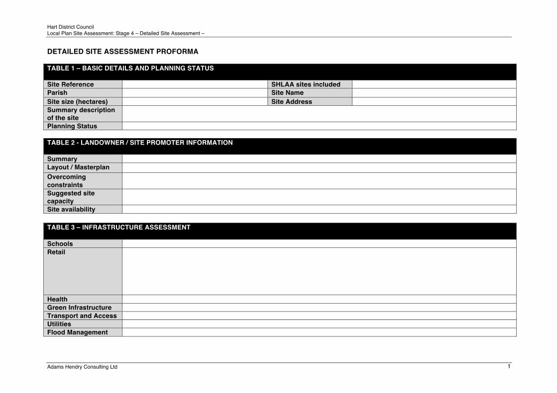
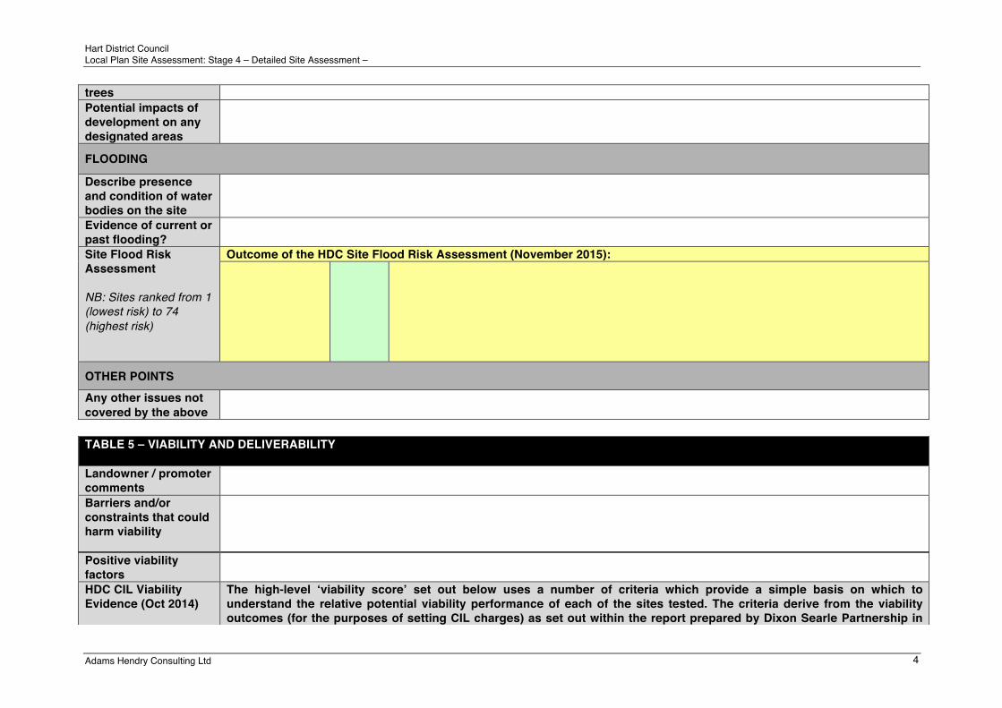
6.3 The outcomes of the above processes were reported to the Council using a standard assessment form. An example detailed site assessment proforma is attached at Appendix 2 to this report.
6.4 As with the previous high level assessments, Adams Hendry did not provide a final conclusion or recommendation on the sites subjected to the detailed assessments. As noted in paragraph 6.1 above, the detailed site assessments were originally prepared with the aim of informing subsequent Council decisions on whether sites should be identified or allocated within the Local Plan. However, Council Officers subsequently considered the detailed site assessments to inform the policies of the draft Hart District Local Plan (April 2017) and to inform aspects of the draft Local Plan's SA.
Difficulties encountered and action taken as a result
6.5 A number of potential difficulties were encountered at detailed assessment stage:
• Access could not be gained to all sites for field survey. In all such cases, adequate visibility of the site could be achieved at close range from the public highway or adjacent SHLAA parcels. Where access could not be gained for field survey, Adams Hendry have made this clear on the assessment forms.
• A single strategic site (SHL197) had been added to the site assessment long-list at a later stage in the assessment process (see 5.4). As a result, infrastructure evidence (utility provider feedback) was absent for this site, and no high-level transport evidence had been commissioned from WSP. Adams Hendry liaised with the Council in this regard, and the Council provided equivalently detailed evidence from various sources on utilities, flood risk and transport.
• As mentioned above (6.1) there were two strategic sites for which HBIC did not provide Phase 1 ecological survey data. In the first case, the site had been surveyed relatively recently and HBIC saw little merit in repeating the survey. In the second case, the site had been added to the site assessment long-list at a later stage in the assessment process (see 5.4). Where up-to-date ecological survey evidence was not available,

!
! 14
Site Assessment Methodology Report
Final
© Adams Hendry Consulting Ltd. June 2017
!
Adams Hendry included a note recommending a Phase 1 survey if the site was to be taken forward for allocation in the Local Plan.
• As mentioned above (6.1), and as agreed with the Council at the time, Lepus based its landscape assessments upon the site capacities determined by Adams Hendry at high-level assessment stage (see 6.4). As the site capacities were generally revised down at detailed assessment stage, this is not considered to be a significant issue. Adams Hendry have stated the capacity on which the Lepus results were based in the assessment forms.
• In relation to Flood Risk, the Council provided information to Adams Hendry to use as part of the detailed assessment. The Councils information sought to identify the ranking of the sites in terms of the extent to which flood risk was or was not a constraint to development. As part of the assessment work, a number of the assessments were updated by the Council which led to changes in the flood risk ranking of sites. This led to additional work, but has not altered the conclusions of the assessment process.

!
! 15
Site Assessment Methodology Report
Final
© Adams Hendry Consulting Ltd. June 2017
!
7 Sustainability appraisal of detailed site assessments
Methodology for the sustainability appraisal of the detailed site assessments
7.1 Every detailed site assessment included a detailed sustainability appraisal (SA testing). SA testing enabled a measure of the relative performance of each site to be determined.
7.2 The sites were evaluated against the 21 sustainability objectives contained within the HDC Local Plan Sustainability Framework (Appendix 4 to the SA Scoping Report (April 2014), as updated by Adams Hendry (September 2015) (See 4.4))
7.3 An assessment matrix for the SA testing was prepared by Adams Hendry and agreed in advance with the Council. The matrix made use of the same scoring mechanism developed by the Council (Figure 1) for use in the assessment of policies or site proposals (see SA Scoping Report).
7.4 Adams Hendry provided a reasoned justification to support the score applied in each case. All judgements were based on the publically available evidence that informed the site assessments – and upon the results of the site assessments themselves. Any assumptions made in reaching the judgement were explained in the justification.
7.5 Consistent with the purpose of SA, the SA assessment identified the likely significant effects of development at each of the sites and where possible, sought to identify ways in which the harmful effects of development could potentially be avoided or mitigated.
Difficulties encountered and action taken as a result
7.6 Adams Hendry did not encounter any potential difficulties during the high-level SA testing stage of the assessment process. There was no requirement to depart from the agreed methodology.
7.7 It should be noted that in several instances the positive and negative aspects of development were considered to partly or entirely counter-balance one another against the relevant sustainability objectives. The SA scoring records such a ‘neutral’ score in the same way as a score of ‘no impact’. In order to differentiate these outcomes, wherever this was the case, Adams Hendry explained the interaction of positive and negative factors clearly within the SA justification.

!
! 16
Site Assessment Methodology Report
Final
© Adams Hendry Consulting Ltd. June 2017
!
Appendix 1: Example High-level Site Assessment matrix !

1"
Hart District Council Local Plan Site Assessment: Stage 2 – High Level Site Assessment Proforma
Adams Hendry Consulting Ltd
High Level Site Assessment Proforma Site Reference Site Name Parish Site Address Capacity Assessment and Categorisation Site Size (ha) Estimated Capacity Comments on capacity Housing Strategy Category(s) Land Supply Category Key to Site Assessments:
Site Assessment Assessment Criteria Assessment comments Coloured
assessment Accessibility to Employment and services
Infrastructure provision
Current Use and Relevant Planning History
Nature Conservation Minerals Resources Landscape Agricultural Land Heritage Assets Water resources and quality
Air Quality Flood risk Location and scale of
No overriding constraint to development of the site" Constraint requiring further detailed assessment" Major constraint undermining suitability of site""

2"
Hart District Council Local Plan Site Assessment: Stage 2 – High Level Site Assessment Proforma
Adams Hendry Consulting Ltd
development Un-neighbourly Uses
Availability Assessment
Site Access
Summary of Constraints
Summary of Opportunities
Focus of further assessment, should the site be shortlisted by the Council
Site Assessment Completed by
Name Date:
HDC Conclusion and recommendation
Shortlist the site:
Do not shortlist the site:
HDC Comments:
"
!
! 17
Site Assessment Methodology Report
Final
© Adams Hendry Consulting Ltd. June 2017
!
Appendix 2: Example Detailed Site Assessment matrix
Hart District Council Local Plan Site Assessment: Stage 4 – Detailed Site Assessment –
Adams Hendry Consulting Ltd 1!
DETAILED SITE ASSESSMENT PROFORMA TABLE 1 – BASIC DETAILS AND PLANNING STATUS Site Reference SHLAA sites included Parish Site Name Site size (hectares) Site Address Summary description of the site
Planning Status TABLE 2 - LANDOWNER / SITE PROMOTER INFORMATION Summary Layout / Masterplan Overcoming constraints
Suggested site capacity
Site availability !TABLE 3 – INFRASTRUCTURE ASSESSMENT Schools Retail
Health Green Infrastructure Transport and Access Utilities Flood Management !

Hart District Council Local Plan Site Assessment: Stage 4 – Detailed Site Assessment –
Adams Hendry Consulting Ltd 2!
TABLE 4 – SITE SURVEY (PLANNING ASSESSMENT)
SITE VISIT DETAILS
Date of visit Time Initials of those visiting
Weather conditions at time of visit
Did visit involve access onto the site?
GENERAL DESCRIPTION OF THE SITE
Existing land uses observed
Greenfield or Brownfield?
Topography Ground conditions Significant features Evidence of contaminated land
SITE SURROUNDINGS AND ACCESS
Surrounding land uses
Description and condition of site’s boundary features
Potential impacts from surrounding uses
Potential impacts to surrounding uses
Site’s existing access arrangements
Barriers to / impacts of providing suitable

Hart District Council Local Plan Site Assessment: Stage 4 – Detailed Site Assessment –
Adams Hendry Consulting Ltd 3!
site access to public highway Description of surrounding access network
LANDSCAPE AND SETTLEMENT COALESENCE LVIA by Lepus? HDC Landscape Capacity Study 2015
Local Landscape Character Area Visual Sensitivity Landscape Sensitivity Landscape Value Overall Landscape capacity
Description of views into the site from surrounding areas
Descriptions of views from the site
Potential for settlement coalescence
HERITAGE
Potential impact on setting of Listed Buildings
Potential Impact on Conservation Areas
Other possible impacts?
NATURE CONSERVATION AND ECOLOGY
Potential features or areas of ecological interest
Tree coverage and observed condition of
Hart District Council Local Plan Site Assessment: Stage 4 – Detailed Site Assessment –
Adams Hendry Consulting Ltd 4!
trees Potential impacts of development on any designated areas
FLOODING
Describe presence and condition of water bodies on the site
Evidence of current or past flooding?
Site Flood Risk Assessment NB: Sites ranked from 1 (lowest risk) to 74 (highest risk)
Outcome of the HDC Site Flood Risk Assessment (November 2015):
OTHER POINTS Any other issues not covered by the above
!TABLE 5 – VIABILITY AND DELIVERABILITY Landowner / promoter comments
Barriers and/or constraints that could harm viability
Positive viability factors
HDC CIL Viability Evidence (Oct 2014)
The high-level ‘viability score’ set out below uses a number of criteria which provide a simple basis on which to understand the relative potential viability performance of each of the sites tested. The criteria derive from the viability outcomes (for the purposes of setting CIL charges) as set out within the report prepared by Dixon Searle Partnership in

Hart District Council Local Plan Site Assessment: Stage 4 – Detailed Site Assessment –
Adams Hendry Consulting Ltd 5!
TABLE 6 – CAPACITY ASSESSMENT Capacity calculation Site size (gross) in hectares
Deductions in hectares Gross-to-net ratio applied (%) Density assumption applied Estimated housing capacity (net) Adjustment for landowner/promoter, infrastructure or viability reasons
October 2014.
Broad Location: 1. Blackwater 2. Yateley 3. Fleet / Church Crookham / Hook & Strategic 4. Small Settlements / Rural Areas (< 5km SPA) 5. Small Settlements / Rural Areas (> 5km SPA)
Site type: 1. Previously developed (within or outside settlement boundaries) 2. Greenfield (within settlement boundaries) 3. Greenfield (outside of settlement boundaries)
Affordable Housing (assumed threshold of 15 dwellings): 1. Yes (indicative capacity >/= 15 dwellings) 2. No (indicative capacity < 15 dwellings)
TOTAL SCORE: The total score is within the range of 3 to 10, with 3 representing the typically least viable sites and 10 representing the most viable in the context of Hart District. Note: This is provided as a simple high-level comparative guide only and it should not be assumed that sites with lower scores are unviable for residential development.
/10
Overall conclusion on viability

Hart District Council Local Plan Site Assessment: Stage 4 – Detailed Site Assessment –
Adams Hendry Consulting Ltd 6!
FINAL CAPACITY ASSESSMENT dwellings Justification for density and capacity assumptions
!TABLE 7 – TRANSPORT AND ACCESS (WSP) TRACC Modelling (Public Transport Access)
Railway station: Town centres:
Comments on site access issues
Comments on local transport infrastructure capacity
!TABLE 8 – LANDSCAPE AND VISUAL IMPACT ASSESSMENT (LEPUS) Overall STR005 Visual impact assessment
Character impact assessment
Pre-mitigation Assessment summary
Mitigation Residual Visual Impact Assessment
Residual Landscape Impact Assessment

Hart District Council Local Plan Site Assessment: Stage 4 – Detailed Site Assessment –
Adams Hendry Consulting Ltd 7!
!TABLE 9 – ECOLOGY ASSESSMENT (HBIC) Phase 1 Ecological Assessment
!TABLE 10 – SUSTAINABILITY APPRAISAL
SA Objective Score Commentary
SA1 To provide all residents with the opportunity to live in a decent home which meets their needs
Significant effects
Mitigation
SA2 To protect and enhance the health and well-being of the population
Significant effects
Mitigation
SA3 To encourage increased engagement in cultural activity, leisure, and recreation across all sections of the community
Significant effects
Mitigation
SA4 To reduce inequality, poverty and social exclusion
Significant effects
Mitigation
SA5 To improve community safety by reducing crime and
Significant effects

Hart District Council Local Plan Site Assessment: Stage 4 – Detailed Site Assessment –
Adams Hendry Consulting Ltd 8!
the fear of crime Mitigation
SA6 To create and sustain vibrant and locally distinctive settlements and communities
Significant effects
Mitigation SA7 To protect and enhance the District’s historic environment
Significant effects
Mitigation
SA8 To protect and enhance biodiversity
Significant effects
Mitigation
SA9 To protect and enhance the District’s countryside and rural landscape
Significant effects
Mitigation
SA10 To maintain and improve the water quality of the District’s rivers and groundwaters and other water bodies
Significant effects
Mitigation !
SA11 To maintain and improve soil quality
Significant effects
Mitigation

Hart District Council Local Plan Site Assessment: Stage 4 – Detailed Site Assessment –
Adams Hendry Consulting Ltd 9!
SA12 To reduce the emissions of greenhouse gases and manage the impacts of climate change
Significant effects
Mitigation
SA13 To reduce the risk of flooding and the resulting detriment to the local community, environment and economy
Significant effects
Mitigation
SA14 To increase energy efficiency, security and diversity of supply and the proportion of energy generated from renewable sources
Significant effects
Mitigation
SA15 To promote the efficient use of land through the appropriate re-use of previously developed land
Significant effects
Mitigation
SA16 To improve the efficiency of resource use and achieve sustainable resource management
Significant effects
Mitigation
SA17 To improve accessibility to all services and facilities
Significant effects
Mitigation

Hart District Council Local Plan Site Assessment: Stage 4 – Detailed Site Assessment –
Adams Hendry Consulting Ltd 10!
SA18 To improve efficiency of transport networks by enhancing the proportion of travel by sustainable modes and promoting policies which reduce the need to travel
Significant effects
Mitigation
SA19 To maintain and improve opportunities for everyone to acquire the education and skills they need to find and remain in work
Significant effects
Mitigation
SA20 To maintain high and stable levels of employment and promote sustainable economic growth and competitiveness
Significant effects
Mitigation
SA21 To stimulate regeneration where appropriate and encourage urban renaissance
Significant effects
Mitigation
Sustainability Appraisal Summary