Embed Size (px)
Citation preview
Enacted cartography: testing a methodology for
making site-specific architecture
Ian Weir1
1University of Western Australia, Perth, Australia
Architectural vernaculars provide models for building in a specific place, but in some recently subdivided areas of Australia such models simply do not exist. Consequently designers immediately import other typologies to fill this void. I argue that given such conditions, the model for inhabitation should be the landscape itself. The paper’s central premise is that sustainable architecture’s main attribute is its ability to connect us in as many ways as possible with local cycles and processes. This attribute transcends the more quantifiable, but nonetheless secondary factors such as energy use and low-toxicity finishes. Buildings which engender such connective-ness are commonly termed “site-specific.” However, it is not the actual site, but representations of the site (for example, topographic maps) that form the ‘ground’ upon which designs are conceived. I argue that if designers are to achieve site-specific architecture, then they must first develop site-specific maps. Designers might achieve such maps through “enacted cartography”: their direct engagement with site and with site-mapping technologies. This hypothesis is tested through a series of mapping experiments outlined in the latter part of the discussion. The paper assumes the audience is familiar with Kenneth Frampton’s theory of “Critical Regionalism,” and has basic knowledge of CAD interfaces. Conference Theme: Architecture and the environment. Keywords: sustainability, site-specificity, landscape, mapping.
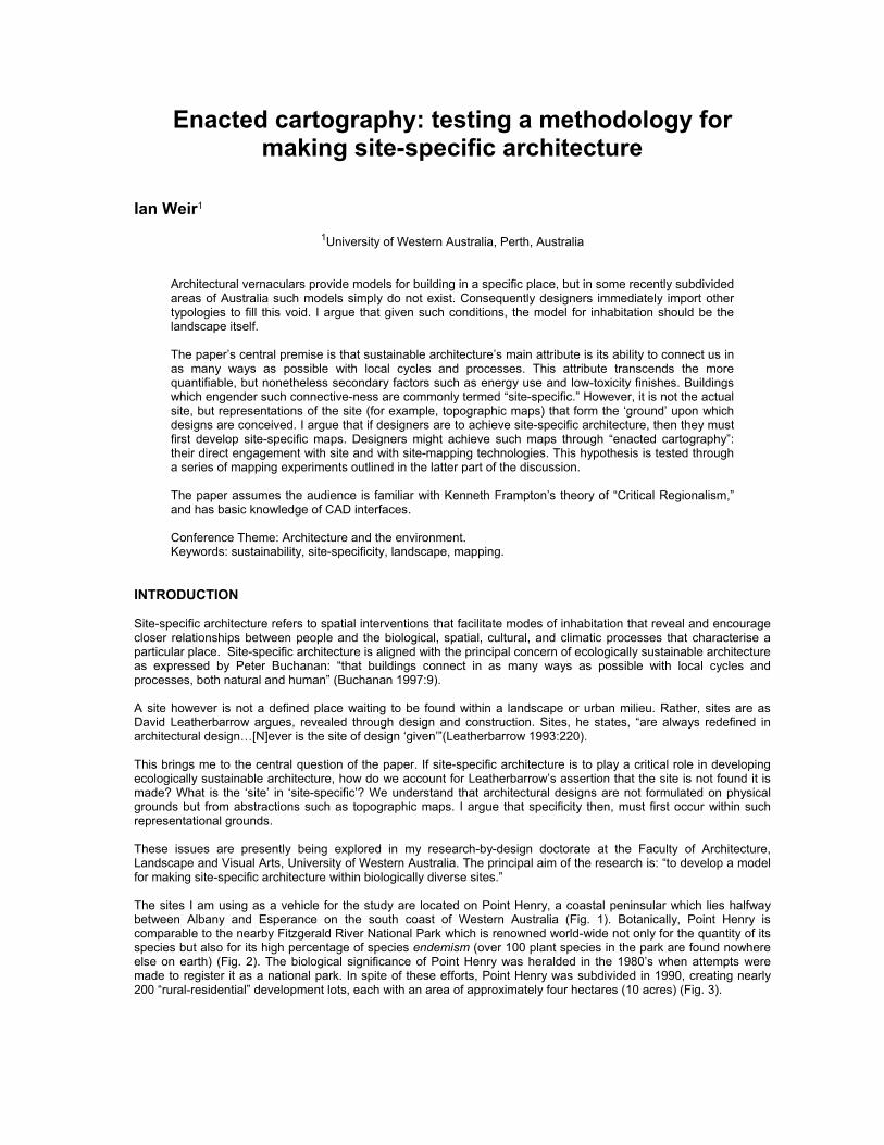
INTRODUCTION Site-specific architecture refers to spatial interventions that facilitate modes of inhabitation that reveal and encourage closer relationships between people and the biological, spatial, cultural, and climatic processes that characterise a particular place. Site-specific architecture is aligned with the principal concern of ecologically sustainable architecture as expressed by Peter Buchanan: “that buildings connect in as many ways as possible with local cycles and processes, both natural and human” (Buchanan 1997:9). A site however is not a defined place waiting to be found within a landscape or urban milieu. Rather, sites are as David Leatherbarrow argues, revealed through design and construction. Sites, he states, “are always redefined in architectural design…[N]ever is the site of design ‘given’”(Leatherbarrow 1993:220). This brings me to the central question of the paper. If site-specific architecture is to play a critical role in developing ecologically sustainable architecture, how do we account for Leatherbarrow’s assertion that the site is not found it is made? What is the ‘site’ in ‘site-specific’? We understand that architectural designs are not formulated on physical grounds but from abstractions such as topographic maps. I argue that specificity then, must first occur within such representational grounds. These issues are presently being explored in my research-by-design doctorate at the Faculty of Architecture, Landscape and Visual Arts, University of Western Australia. The principal aim of the research is: “to develop a model for making site-specific architecture within biologically diverse sites.” The sites I am using as a vehicle for the study are located on Point Henry, a coastal peninsular which lies halfway between Albany and Esperance on the south coast of Western Australia (Fig. 1). Botanically, Point Henry is comparable to the nearby Fitzgerald River National Park which is renowned world-wide not only for the quantity of its species but also for its high percentage of species endemism (over 100 plant species in the park are found nowhere else on earth) (Fig. 2). The biological significance of Point Henry was heralded in the 1980’s when attempts were made to register it as a national park. In spite of these efforts, Point Henry was subdivided in 1990, creating nearly 200 “rural-residential” development lots, each with an area of approximately four hectares (10 acres) (Fig. 3).
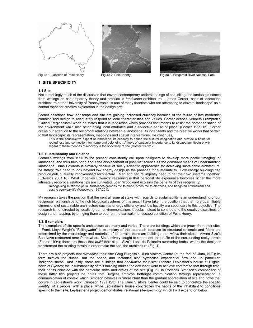
Figure 1. Location of Point Henry Figure 2. Point Henry. Figure 3. Fitzgerald River National Park 1. SITE SPECIFICITY 1.1 Site Not surprisingly much of the discussion that covers contemporary understandings of site, siting and landscape comes from writings on contemporary theory and practice in landscape architecture. James Corner, chair of landscape architecture at the University of Pennsylvania, is one of many theorists who are attempting to elevate ‘landscape’ as a central topos for creative exploration in the design arts. Corner describes how landscape and site are gaining increased currency because of the failure of late modernist planning and design to adequately respond to local characteristics and values. Corner echoes Kenneth Frampton’s “Critical Regionalism” when he states that it is landscape which provides the “means to resist the homogenisation of the environment while also heightening local attributes and a collective sense of place” (Corner 1999:13). Corner draws our attention to the reciprocal relations between a landscape, its inhabitants and the creative works that pertain to that landscape: its representation, mappings and spatial interventions. He continues,
This is the constructive aspect of landscape, its capacity to enrich the cultural imagination and provide a basis for rootedness and connection, for home and belonging…A topic of particular importance to landscape architecture with regard to these theories of recovery is the specificity of site (Corner 1999:12).
1.2. Sustainability and Science Corner’s writings from 1990 to the present consistently call upon designers to develop more poetic “imaging” of landscape, and thus help bring about the displacement of positivist science as the dominant means of understanding landscape. Brian Edwards is similarly derisive of solely scientific approaches for achieving sustainable architecture, he states: “We need to look beyond low energy design as the panacea for sustainability. Low energy buildings can produce dull, culturally impoverished architecture…Man and nature urgently need to get their two systems together” (Edwards 2001:16). What underlies Edwards’ reasoning is that personal life experience becomes richer the more intimately reciprocal relationships are cultivated. Joan Woodward explains the benefits of this reciprocity:
Recognising relationships in landscapes grounds me to place, prods me to alertness, and brings an enthusiasm and zest to everyday life (Woodward 1997:201).
My research takes the position that the central issue at stake with regards to sustainability is an understanding of our reciprocal relationships to the rich biological systems of this area. I have taken the position that the more quantifiable dimensions of sustainable architecture such as energy efficiency and low toxicity are secondary to this objective. The research is not directed by idealist green environmentalism, it seeks instead to contribute to the creative disciplines of design and mapping, by bringing them to bear on the particular landscape condition of Point Henry. 1.3. Exemplars The exemplars of site-specific architecture are many and varied: There are buildings which are grown from their sites – Frank Lloyd Wright’s “Fallingwater” is exemplary of this approach because its structural rationale and fabric are determined by the morphology and materials of its terrain; there are buildings that mimic their sites – Alvaro Siza’s Boa Nova restaurant near Porto where Siza actively sought to re-present the profile of the surrounding rocky terrain (Zaera: 1994); there are those that build their site – Siza’s Leca da Palmeira swimming baths, where the designer transformed the existing terrain in order make the site, the architecture (Fig. 4). There are also projects that symbolise their site: Greg Burgess’s Uluru Visitors Centre (at the foot of Uluru, N.T.); its form mimics the dunes, but the shape and tectonics also symbolise experiential flow and, in particular, ‘indigenousness’. And lastly, there are buildings that habitualise their site: Richard Leplastrier’s house at Bilgola, north of Sydney; the insubstantiality of this building makes the occupant work to achieve comfort so that through time, their habits coincide with the particular shifts and cycles of the site (Fig. 5). In Roderick Simpson’s comparison of these latter two projects he notes that Burgess employs forthright communication through representation; a communication of context which Simpson believes is “more blunt than the gradual appreciation of site and flows that occurs in Leplastrier’s work” (Simpson 1997:123). The Uluru Visitor’s Center could be said to concretize the specific identity, of a people, with a place, while Leplastrier’s house concretizes the habits of the inhabitant to conditions specific to their site. Leplastrier’s project demonstrates ‘relational site-specificity’ which I will expand on below.
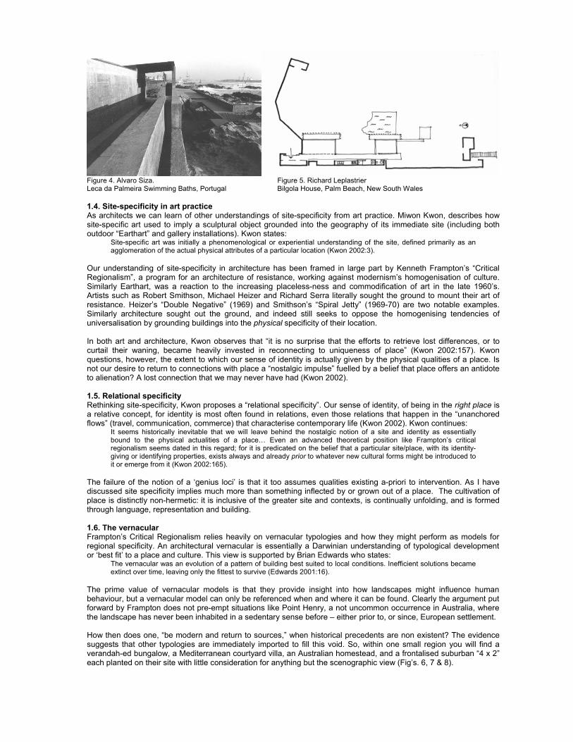
Figure 4. Alvaro Siza. Figure 5. Richard Leplastrier Leca da Palmeira Swimming Baths, Portugal Bilgola House, Palm Beach, New South Wales 1.4. Site-specificity in art practice As architects we can learn of other understandings of site-specificity from art practice. Miwon Kwon, describes how site-specific art used to imply a sculptural object grounded into the geography of its immediate site (including both outdoor “Earthart” and gallery installations). Kwon states:
Site-specific art was initially a phenomenological or experiential understanding of the site, defined primarily as an agglomeration of the actual physical attributes of a particular location (Kwon 2002:3).
Our understanding of site-specificity in architecture has been framed in large part by Kenneth Frampton’s “Critical Regionalism”, a program for an architecture of resistance, working against modernism’s homogenisation of culture. Similarly Earthart, was a reaction to the increasing placeless-ness and commodification of art in the late 1960’s. Artists such as Robert Smithson, Michael Heizer and Richard Serra literally sought the ground to mount their art of resistance. Heizer’s “Double Negative” (1969) and Smithson’s “Spiral Jetty” (1969-70) are two notable examples. Similarly architecture sought out the ground, and indeed still seeks to oppose the homogenising tendencies of universalisation by grounding buildings into the physical specificity of their location. In both art and architecture, Kwon observes that “it is no surprise that the efforts to retrieve lost differences, or to curtail their waning, became heavily invested in reconnecting to uniqueness of place” (Kwon 2002:157). Kwon questions, however, the extent to which our sense of identity is actually given by the physical qualities of a place. Is not our desire to return to connections with place a “nostalgic impulse” fuelled by a belief that place offers an antidote to alienation? A lost connection that we may never have had (Kwon 2002). 1.5. Relational specificity Rethinking site-specificity, Kwon proposes a “relational specificity”. Our sense of identity, of being in the right place is a relative concept, for identity is most often found in relations, even those relations that happen in the “unanchored flows” (travel, communication, commerce) that characterise contemporary life (Kwon 2002). Kwon continues:
It seems historically inevitable that we will leave behind the nostalgic notion of a site and identity as essentially bound to the physical actualities of a place… Even an advanced theoretical position like Frampton’s critical regionalism seems dated in this regard; for it is predicated on the belief that a particular site/place, with its identity-giving or identifying properties, exists always and already prior to whatever new cultural forms might be introduced to it or emerge from it (Kwon 2002:165).
The failure of the notion of a ‘genius loci’ is that it too assumes qualities existing a-priori to intervention. As I have discussed site specificity implies much more than something inflected by or grown out of a place. The cultivation of place is distinctly non-hermetic: it is inclusive of the greater site and contexts, is continually unfolding, and is formed through language, representation and building. 1.6. The vernacular Frampton’s Critical Regionalism relies heavily on vernacular typologies and how they might perform as models for regional specificity. An architectural vernacular is essentially a Darwinian understanding of typological development or ‘best fit’ to a place and culture. This view is supported by Brian Edwards who states:
The vernacular was an evolution of a pattern of building best suited to local conditions. Inefficient solutions became extinct over time, leaving only the fittest to survive (Edwards 2001:16).
The prime value of vernacular models is that they provide insight into how landscapes might influence human behaviour, but a vernacular model can only be referenced when and where it can be found. Clearly the argument put forward by Frampton does not pre-empt situations like Point Henry, a not uncommon occurrence in Australia, where the landscape has never been inhabited in a sedentary sense before – either prior to, or since, European settlement. How then does one, “be modern and return to sources,” when historical precedents are non existent? The evidence suggests that other typologies are immediately imported to fill this void. So, within one small region you will find a verandah-ed bungalow, a Mediterranean courtyard villa, an Australian homestead, and a frontalised suburban “4 x 2” each planted on their site with little consideration for anything but the scenographic view (Fig’s. 6, 7 & 8).
Figure 6. Point Henry. Figure 7. Point Henry. Figure 8. Point Henry. Verandah-ed cottage with ocean views Australian homestead with ocean views Mediterranean villa with ocean views These foreign typologies do nothing to foster understanding of the reciprocities between people and place. Of course one can look to similar places, where typologies do exist, but then by definition these are not site-specific. My argument is that ultimately the only model that can be turned to in this instance is the model of the landscape itself. But landscape is not simply a physical reality as Kwon has pointed out – it is a matrix of relations. If we go to the source of our concept of ‘landscape’ we find that it is an embodied cultural construction, it is a representation of ‘land’ and is, to differing degrees unique to each observer. 1.7. Landcape: landskip and landschaaf The term ‘landscape’ is derived from two divergent meanings: ‘Landskip’, which refers to a pictorial or framed landscape, and ‘landschaaf’ which is a farmed landscape, the idea of a place which accompanies those that work the land (Easterling 2003). Landschaaf (or “landschaft”) is not a graphic picturing, instead it involves eidetic, or vivid mental images, which are formed through memory and habit. Denis Cosgrove, professor of geography at UCLA, associates landschaaf, with an ‘insider’, one who understands a place through their actions and experiences within it. Landskip on the other hand is an ‘outsider’s’ idea of landscape. The tourist, or for that matter the designer is an outsider because their understandings are formed through ‘stepping back’ to view an image or landscape scene (Cosgrove1998). The underlying theme in the writings of Cosgrove and Corner is that in order to fully realise landscape’s hermeneutic potential, the designer must resist scenographic picturing because the outsider’s gaze, cast upon a scenic landscape, cannot encompass the full scope of that environment. We must seek instead the insight or sensibilities of the ‘insider,’ and to achieve this our imaging needs to encompass the eidetic. These issues are particularly salient to my research because Point Henry has only recently been transformed from an immersed landschaaf to a scenographic landskip. A landscape where property values are now proportional to the degrees of picturesque view, where previously value was related to the potential for grazing and fishing. As discussed above, no habituated practices exist in this region that parallel the sedentary mode on inhabitation now occurring on Point Henry. There is, I believe a real danger that an inhabitant’s sense of landscape-as-image will become sedimented through habitual practices of gaze and contemplation, leaving them perpetually separated from deeper knowledge of the relations of that place. This sedimentation occurs when buildings are constructed after cursory site studies that invariably prioritize visual aspects of the site, for example, scenographic ocean views. If the inhabitant is an outsider, and is in danger of remaining so, then the question is, as Christophe Girot asks, “how then can outsider designers acquire an understanding of a place that will enable them to act wisely and knowledgably?” (Girot 1999:60). 2. HYPOTHESES, METHODOLOGY AND EXPERIMENT 2.1. Site-specific Mapping This brings me to the principal hypothesis of my research: “In order to produce architecture which is specific to this site, I must first develop site-specific mappings.” Given that landscapes are constructed through representation – through such mediations as photography, topographic maps, car windshields, buildings and so on – and that there are no typological models through which we can read this particular landscape, mapping techniques may provide the most fecund means by which to found these sites and this landscape. To provide an analogy: in their book “Taking Measures Across the American Landscape,” James Corner and aerial photographer, Alex MacLean posit that the aerial photograph is the most appropriate medium for comprehending the American landscape (Corner & MacLean 1996). My hypothesis is founded on the notion that, in turn we might ask for each landscape, what instruments of measure and what representations have the most correspondence with the scale, dimensions and character of that particular landscape? I suggest that a site can only provide a model for inhabitation when the scope of mapping and designing processes is sufficiently responsive to the diversity of phenomenological, dimensional and relational processes specific to a site. If we accept that the problem with foreign architectural types is that they bear little relation to landscape processes, then I suggest that neither should foreign mapping techniques be brought to bear upon the site. In short, sites such as Point Henry demand more poetic imaging than what the standard topographic survey can offer, imaging which is more commensurate with the rich, heterogeneous character particular to this landscape.
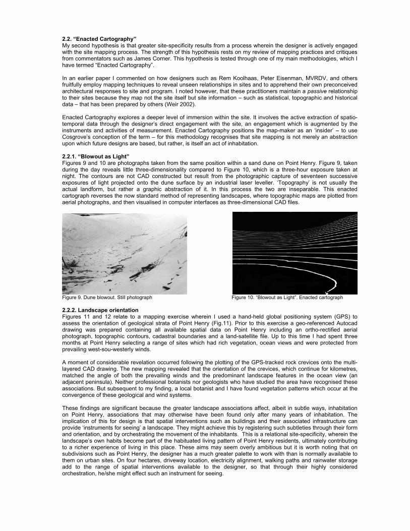
2.2. “Enacted Cartography” My second hypothesis is that greater site-specificity results from a process wherein the designer is actively engaged with the site mapping process. The strength of this hypothesis rests on my review of mapping practices and critiques from commentators such as James Corner. This hypothesis is tested through one of my main methodologies, which I have termed “Enacted Cartography”. In an earlier paper I commented on how designers such as Rem Koolhaas, Peter Eisenman, MVRDV, and others fruitfully employ mapping techniques to reveal unseen relationships in sites and to apprehend their own preconceived architectural responses to site and program. I noted however, that these practitioners maintain a passive relationship to their sites because they map not the site itself but site information – such as statistical, topographic and historical data – that has been prepared by others (Weir 2002). Enacted Cartography explores a deeper level of immersion within the site. It involves the active extraction of spatio-temporal data through the designer’s direct engagement with the site, an engagement which is augmented by the instruments and activities of measurement. Enacted Cartography positions the map-maker as an ‘insider’ – to use Cosgrove’s conception of the term – for this methodology recognises that site mapping is not merely an abstraction upon which future designs are based, but rather, is itself an act of inhabitation. 2.2.1. “Blowout as Light” Figures 9 and 10 are photographs taken from the same position within a sand dune on Point Henry. Figure 9, taken during the day reveals little three-dimensionality compared to Figure 10, which is a three-hour exposure taken at night. The contours are not CAD constructed but result from the photographic capture of seventeen successive exposures of light projected onto the dune surface by an industrial laser leveller. ‘Topography’ is not usually the actual landform, but rather a graphic abstraction of it. In this process the two are inseparable. This enacted cartograph reverses the now standard method of representing landscapes, where topographic maps are plotted from aerial photographs, and then visualised in computer interfaces as three-dimensional CAD files.
Figure 9. Dune blowout. Still photograph Figure 10. “Blowout as Light”. Enacted cartograph 2.2.2. Landscape orientation Figures 11 and 12 relate to a mapping exercise wherein I used a hand-held global positioning system (GPS) to assess the orientation of geological strata of Point Henry (Fig.11). Prior to this exercise a geo-referenced Autocad drawing was prepared containing all available spatial data on Point Henry including an ortho-rectified aerial photograph, topographic contours, cadastral boundaries and a land-satellite file. Up to this time I had spent three months at Point Henry selecting a range of sites which had rich vegetation, ocean views and were protected from prevailing west-sou-westerly winds. A moment of considerable revelation occurred following the plotting of the GPS-tracked rock crevices onto the multi-layered CAD drawing. The new mapping revealed that the orientation of the crevices, which continue for kilometres, matched the angle of both the prevailing winds and the predominant landscape features in the ocean view (an adjacent peninsula). Neither professional botanists nor geologists who have studied the area have recognised these associations. But subsequent to my finding, a local botanist and I have found vegetation patterns which occur at the convergence of these geological and wind systems. These findings are significant because the greater landscape associations affect, albeit in subtle ways, inhabitation on Point Henry, associations that may otherwise have been found only after many years of inhabitation. The implication of this for design is that spatial interventions such as buildings and their associated infrastructure can provide ‘instruments for seeing’ a landscape. They might achieve this by registering such subtleties through their form and orientation, and by orchestrating the movement of the inhabitants. This is a relational site-specificity, wherein the landscape’s own habits become part of the habituated living pattern of Point Henry residents, ultimately contributing to a richer experience of living in this place. These aims may seem overly ambitious but it is worth noting that on subdivisions such as Point Henry, the designer has a much greater palette to work with than is normally available to them on urban sites. On four hectares, driveway location, electricity alignment, walking paths and rainwater storage add to the range of spatial interventions available to the designer, so that through their highly considered orchestration, he/she might effect such an instrument for seeing.
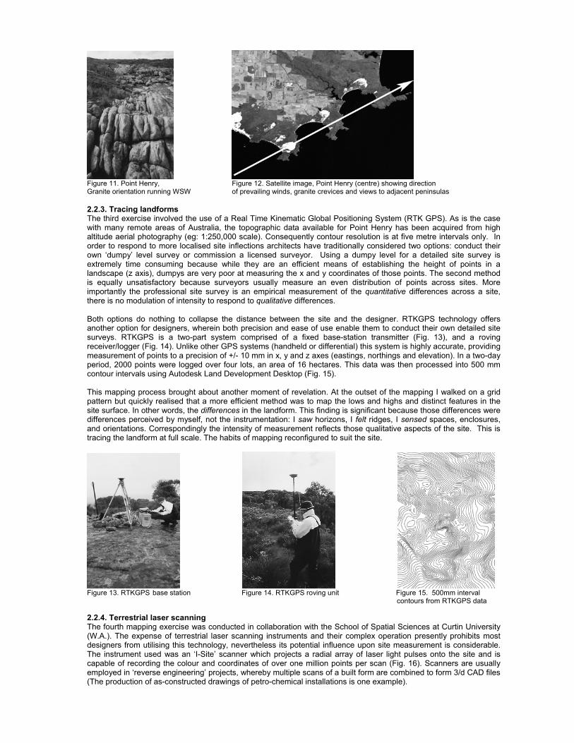
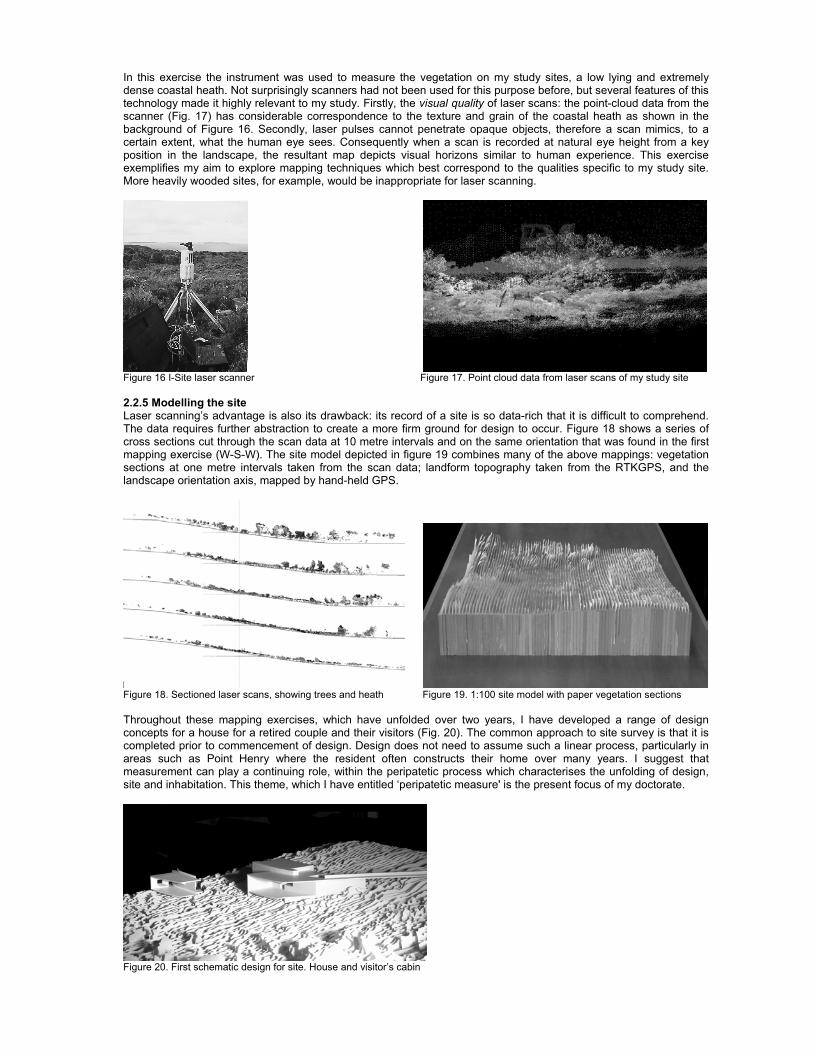
Figure 11. Point Henry, Figure 12. Satellite image, Point Henry (centre) showing direction Granite orientation running WSW of prevailing winds, granite crevices and views to adjacent peninsulas 2.2.3. Tracing landforms The third exercise involved the use of a Real Time Kinematic Global Positioning System (RTK GPS). As is the case with many remote areas of Australia, the topographic data available for Point Henry has been acquired from high altitude aerial photography (eg: 1:250,000 scale). Consequently contour resolution is at five metre intervals only. In order to respond to more localised site inflections architects have traditionally considered two options: conduct their own ‘dumpy’ level survey or commission a licensed surveyor. Using a dumpy level for a detailed site survey is extremely time consuming because while they are an efficient means of establishing the height of points in a landscape (z axis), dumpys are very poor at measuring the x and y coordinates of those points. The second method is equally unsatisfactory because surveyors usually measure an even distribution of points across sites. More importantly the professional site survey is an empirical measurement of the quantitative differences across a site, there is no modulation of intensity to respond to qualitative differences. Both options do nothing to collapse the distance between the site and the designer. RTKGPS technology offers another option for designers, wherein both precision and ease of use enable them to conduct their own detailed site surveys. RTKGPS is a two-part system comprised of a fixed base-station transmitter (Fig. 13), and a roving receiver/logger (Fig. 14). Unlike other GPS systems (handheld or differential) this system is highly accurate, providing measurement of points to a precision of +/- 10 mm in x, y and z axes (eastings, northings and elevation). In a two-day period, 2000 points were logged over four lots, an area of 16 hectares. This data was then processed into 500 mm contour intervals using Autodesk Land Development Desktop (Fig. 15). This mapping process brought about another moment of revelation. At the outset of the mapping I walked on a grid pattern but quickly realised that a more efficient method was to map the lows and highs and distinct features in the site surface. In other words, the differences in the landform. This finding is significant because those differences were differences perceived by myself, not the instrumentation: I saw horizons, I felt ridges, I sensed spaces, enclosures, and orientations. Correspondingly the intensity of measurement reflects those qualitative aspects of the site. This is tracing the landform at full scale. The habits of mapping reconfigured to suit the site.
Figure 13. RTKGPS base station Figure 14. RTKGPS roving unit Figure 15. 500mm interval
contours from RTKGPS data
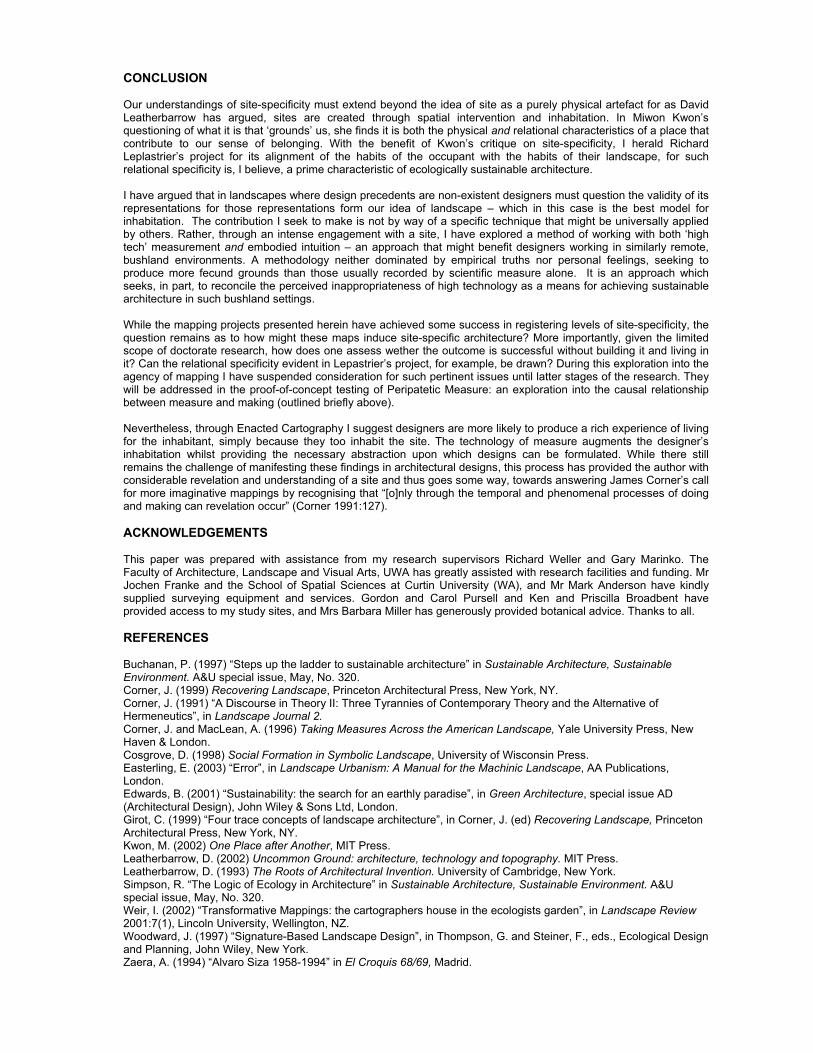
2.2.4. Terrestrial laser scanning The fourth mapping exercise was conducted in collaboration with the School of Spatial Sciences at Curtin University (W.A.). The expense of terrestrial laser scanning instruments and their complex operation presently prohibits most designers from utilising this technology, nevertheless its potential influence upon site measurement is considerable. The instrument used was an ‘I-Site’ scanner which projects a radial array of laser light pulses onto the site and is capable of recording the colour and coordinates of over one million points per scan (Fig. 16). Scanners are usually employed in ‘reverse engineering’ projects, whereby multiple scans of a built form are combined to form 3/d CAD files (The production of as-constructed drawings of petro-chemical installations is one example).
In this exercise the instrument was used to measure the vegetation on my study sites, a low lying and extremely dense coastal heath. Not surprisingly scanners had not been used for this purpose before, but several features of this technology made it highly relevant to my study. Firstly, the visual quality of laser scans: the point-cloud data from the scanner (Fig. 17) has considerable correspondence to the texture and grain of the coastal heath as shown in the background of Figure 16. Secondly, laser pulses cannot penetrate opaque objects, therefore a scan mimics, to a certain extent, what the human eye sees. Consequently when a scan is recorded at natural eye height from a key position in the landscape, the resultant map depicts visual horizons similar to human experience. This exercise exemplifies my aim to explore mapping techniques which best correspond to the qualities specific to my study site. More heavily wooded sites, for example, would be inappropriate for laser scanning.
Figure 16 I-Site laser scanner Figure 17. Point cloud data from laser scans of my study site 2.2.5 Modelling the site Laser scanning’s advantage is also its drawback: its record of a site is so data-rich that it is difficult to comprehend. The data requires further abstraction to create a more firm ground for design to occur. Figure 18 shows a series of cross sections cut through the scan data at 10 metre intervals and on the same orientation that was found in the first mapping exercise (W-S-W). The site model depicted in figure 19 combines many of the above mappings: vegetation sections at one metre intervals taken from the scan data; landform topography taken from the RTKGPS, and the landscape orientation axis, mapped by hand-held GPS.
Figure 18. Sectioned laser scans, showing trees and heath Figure 19. 1:100 site model with paper vegetation sections Throughout these mapping exercises, which have unfolded over two years, I have developed a range of design concepts for a house for a retired couple and their visitors (Fig. 20). The common approach to site survey is that it is completed prior to commencement of design. Design does not need to assume such a linear process, particularly in areas such as Point Henry where the resident often constructs their home over many years. I suggest that measurement can play a continuing role, within the peripatetic process which characterises the unfolding of design, site and inhabitation. This theme, which I have entitled ‘peripatetic measure' is the present focus of my doctorate.
Figure 20. First schematic design for site. House and visitor’s cabin
CONCLUSION Our understandings of site-specificity must extend beyond the idea of site as a purely physical artefact for as David Leatherbarrow has argued, sites are created through spatial intervention and inhabitation. In Miwon Kwon’s questioning of what it is that ‘grounds’ us, she finds it is both the physical and relational characteristics of a place that contribute to our sense of belonging. With the benefit of Kwon’s critique on site-specificity, I herald Richard Leplastrier’s project for its alignment of the habits of the occupant with the habits of their landscape, for such relational specificity is, I believe, a prime characteristic of ecologically sustainable architecture. I have argued that in landscapes where design precedents are non-existent designers must question the validity of its representations for those representations form our idea of landscape – which in this case is the best model for inhabitation. The contribution I seek to make is not by way of a specific technique that might be universally applied by others. Rather, through an intense engagement with a site, I have explored a method of working with both ‘high tech’ measurement and embodied intuition – an approach that might benefit designers working in similarly remote, bushland environments. A methodology neither dominated by empirical truths nor personal feelings, seeking to produce more fecund grounds than those usually recorded by scientific measure alone. It is an approach which seeks, in part, to reconcile the perceived inappropriateness of high technology as a means for achieving sustainable architecture in such bushland settings. While the mapping projects presented herein have achieved some success in registering levels of site-specificity, the question remains as to how might these maps induce site-specific architecture? More importantly, given the limited scope of doctorate research, how does one assess wether the outcome is successful without building it and living in it? Can the relational specificity evident in Lepastrier’s project, for example, be drawn? During this exploration into the agency of mapping I have suspended consideration for such pertinent issues until latter stages of the research. They will be addressed in the proof-of-concept testing of Peripatetic Measure: an exploration into the causal relationship between measure and making (outlined briefly above). Nevertheless, through Enacted Cartography I suggest designers are more likely to produce a rich experience of living for the inhabitant, simply because they too inhabit the site. The technology of measure augments the designer’s inhabitation whilst providing the necessary abstraction upon which designs can be formulated. While there still remains the challenge of manifesting these findings in architectural designs, this process has provided the author with considerable revelation and understanding of a site and thus goes some way, towards answering James Corner’s call for more imaginative mappings by recognising that “[o]nly through the temporal and phenomenal processes of doing and making can revelation occur” (Corner 1991:127). ACKNOWLEDGEMENTS This paper was prepared with assistance from my research supervisors Richard Weller and Gary Marinko. The Faculty of Architecture, Landscape and Visual Arts, UWA has greatly assisted with research facilities and funding. Mr Jochen Franke and the School of Spatial Sciences at Curtin University (WA), and Mr Mark Anderson have kindly supplied surveying equipment and services. Gordon and Carol Pursell and Ken and Priscilla Broadbent have provided access to my study sites, and Mrs Barbara Miller has generously provided botanical advice. Thanks to all. REFERENCES Buchanan, P. (1997) “Steps up the ladder to sustainable architecture” in Sustainable Architecture, Sustainable Environment. A&U special issue, May, No. 320. Corner, J. (1999) Recovering Landscape, Princeton Architectural Press, New York, NY. Corner, J. (1991) “A Discourse in Theory II: Three Tyrannies of Contemporary Theory and the Alternative of Hermeneutics”, in Landscape Journal 2. Corner, J. and MacLean, A. (1996) Taking Measures Across the American Landscape, Yale University Press, New Haven & London. Cosgrove, D. (1998) Social Formation in Symbolic Landscape, University of Wisconsin Press. Easterling, E. (2003) “Error”, in Landscape Urbanism: A Manual for the Machinic Landscape, AA Publications, London. Edwards, B. (2001) “Sustainability: the search for an earthly paradise”, in Green Architecture, special issue AD (Architectural Design), John Wiley & Sons Ltd, London. Girot, C. (1999) “Four trace concepts of landscape architecture”, in Corner, J. (ed) Recovering Landscape, Princeton Architectural Press, New York, NY. Kwon, M. (2002) One Place after Another, MIT Press. Leatherbarrow, D. (2002) Uncommon Ground: architecture, technology and topography. MIT Press. Leatherbarrow, D. (1993) The Roots of Architectural Invention. University of Cambridge, New York. Simpson, R. “The Logic of Ecology in Architecture” in Sustainable Architecture, Sustainable Environment. A&U special issue, May, No. 320. Weir, I. (2002) “Transformative Mappings: the cartographers house in the ecologists garden”, in Landscape Review 2001:7(1), Lincoln University, Wellington, NZ. Woodward, J. (1997) “Signature-Based Landscape Design”, in Thompson, G. and Steiner, F., eds., Ecological Design and Planning, John Wiley, New York. Zaera, A. (1994) “Alvaro Siza 1958-1994” in El Croquis 68/69, Madrid.