Embed Size (px)
Citation preview
MedWet Habitat
Description System
João Carlos Farinha
Paula Rito Araújo
Emília Paula Silva
Sílvia Carvalho
Elizabete Fonseca
Carlota Lavinas
(Version 2005)

Sistema de Classificação de Habitats Medwet60
61Sistema de Classificação de Habitats Medwet
1. Introduction
MedWet habitat description system (Farinha et al., 1996), a hierarchical classification system
which allows describing and defining wetland habitats, was presented during the MedWet 1
(1993-1996) project. This system was based from the one adapted in United States of
America�s Wetlands Inventory (Cowardin, 1979) and since than, it has been adapted many
times, as in the South Africa�s Wetlands Inventory (Dini & Cowan, 2000).
This classification system is based on explicit criteria, trough the presence of specific attributes,
intending to describe ecological units of inventoried sites which have certain homogeneous
natural attributes.
The primary purpose of the MedWet classification system is to assist wetland mapping,
which not only allows data visualization but also provides information for monitoring and
management. With habitat maps, managers and investigators can identify, analyze and locate
problems, quantify its extension and easily access to useful data.
Among the advantages of using a hierarchical habitat description system are:
· to make use of remotely detectable parameters in the habitat description system
process, allowing the achievement of the maximum information amount with a
minimum amount of field work;
· to make a detailed habitat description thought the use of successive levels, making it
possible to produce a map of uniform quality and accuracy;
· to combine different levels of information detail and survey intensity without any loss
of data; and
· to allow the application to a mapping program.
1.1. Boundaries
Through the employment of the MedWet habitat classification system, it is most times
possible to establish the boundaries of the inventorying site (Annex 1). Therefore, according
to these principles, the boundary between wetland and non wetland is designated as:
the boundary between land with predominantly hydrophytic cover and land withmesophytic or xerophytic cover;
· the boundary between soil that is predominantly hydric and soil that is predominantly
non-hydric;
Sistema de Classificação de Habitats Medwet62
· Where there is neither vegetation or soil, the boundary between land that is flooded
or saturated at some time each year and land that is not;
· Wetlands lying below a depth of six meters at low tide shoreward in marine waters
are outside the scope of the MedWet habitat description system.
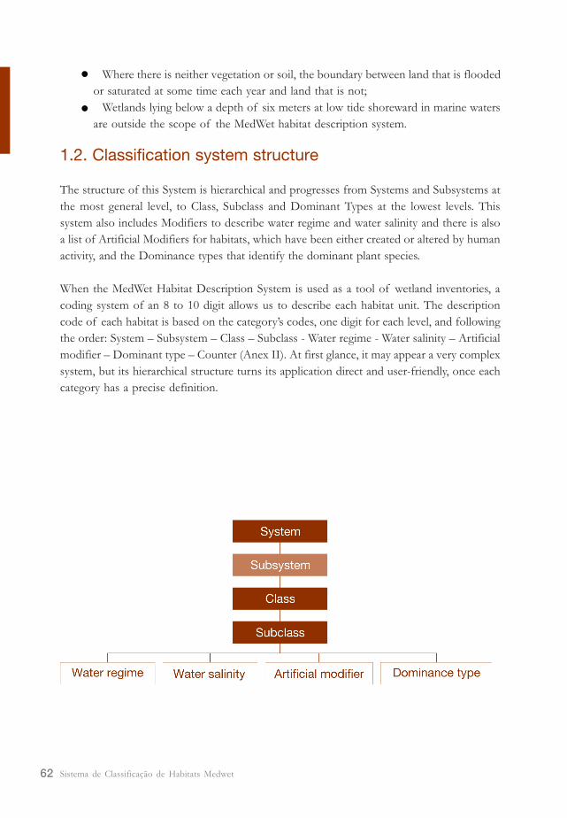
1.2. Classification system structure
The structure of this System is hierarchical and progresses from Systems and Subsystems at
the most general level, to Class, Subclass and Dominant Types at the lowest levels. This
system also includes Modifiers to describe water regime and water salinity and there is also
a list of Artificial Modifiers for habitats, which have been either created or altered by human
activity, and the Dominance types that identify the dominant plant species.
When the MedWet Habitat Description System is used as a tool of wetland inventories, a
coding system of an 8 to 10 digit allows us to describe each habitat unit. The description
code of each habitat is based on the category�s codes, one digit for each level, and following
the order: System � Subsystem � Class � Subclass - Water regime - Water salinity � Artificial
modifier � Dominant type � Counter (Anex II). At first glance, it may appear a very complex
system, but its hierarchical structure turns its application direct and user-friendly, once each
category has a precise definition.
63Sistema de Classificação de Habitats Medwet
(1) In the scope of MW/ SUDOE Project (part of the Community Initiative INTERREG III � B European
Sothwest 200002006 program) it was elaborated an �Aquatic Vegetation Guide� which attempts to make
easier the description of habitat�s structure at Class/Subclass level, supporting the identification of some
aquatic vegetation species (Fonseca et al. 2004).
1.3. Use of the habitat description system
Before attempting to apply the habitat description system, the user should consider the
following points:
· information about the area to be described must be available before the system can
be applied;
· it is important that users pay particular attention to the definitions in the habitat
description system. Attempts to modify these will lead to lack of uniformity in
application.
any attempt to change the described categories must be avoided, because habitat
description will loose uniformity and precision.
· one of the principal uses of this system will be the inventory and mapping of wetland
habitats. The system may be adapted to the chosen mapping scale, with obvious
differences between the minimum habitat area, depending on the scaled used (1:5000,
1:25000 or 1:50000).
· The system is designated for use at varying levels:
a) Systems and Subsystems are more important to data visualization at large
scales, for example, at national or regional levels.
b) Classes and Subclasses are the basic units at each wetland�s map level (1).
c) Dominance types are more important for detailed studies at small scales, and
for habitat�s management and monitoring.

Sistema de Classificação de Habitats Medwet64
65Sistema de Classificação de Habitats Medwet
2. Wetland Systems and Subsystems
The term System refers to a complex of wetland habitats that share the influence of similar
hydrologic, geomorphologic, chemical or biological factors. 5 major Systems are identified:
Marine, Estuarine, Riverine, Lacustrine and Palustrine.
Subsystems are more specific subdivisions, which reflect hydrologic conditions within Systems.
2.1. Marine System
(M) Marine
The Marine System consists of permanent shallow waters less than 6m deep at low tide
(hydrographical zero as referential). The salinity exceeds 30 g/L, with little or no dilution
except outside the mouths of Estuarine Systems.
The Marine system occurs in all zones bordering the mainland and islands of the
Mediterranean Region and includes coastal waters, bays, gulfs and straits, which generally
support typical marine biota.
Boundaries:
This system extends from a depth of 6m at low tide shoreward to:
1. the non-wetland limit of the wetland (in coastlines with weak tides), including the associated splash zone
(Fig. 1A - a);
2. the landward limit of tidal inundation, (in coastlines with high tides) including the splash zone from
breaking waves (Fig. 1B - b);
3. the seaward limit of wetland emergent vegetation, shrubs or trees (Fig. 1B - c);
4. the seaward limit of the Estuarine System where the limit is determined by factors other that
vegetation (Fig. 2B).
Subsystems:The Marine system includes the following subsystems:
(MP) Permanently submerged
The substrate is continuously covered with water.
(MI) Intertidal
The substrate is alternately flooded and exposed by tides. It includes the splash zone.
Sistema de Classificação de Habitats Medwet66
Classes:
Rocky/ unconsolidated substrate, Naked soil, Aquatic vegetation and Reef.
Water regime modifiers:
Permanently flooded, Subtidal, Regularly flooded, Irregularly flooded, Irregularly exposed and Saturated-tidal.
Salinity modifiers:
Euhaline and Hiperhaline.
Please note:
- There is no permanent wetland vegetation in habitats of this system. However, there may be algae,
sea grasses and pioneer vegetation.
- Areas with a narrow tidal range along most of its coastline (for example, the Mediterranean Sea),
water level is major influenced by storms and by wind direction. This situation contrasts with high
energy coastlines (for example, the Mediterranean region bordered by the Atlantic Ocean), which has
an evident intertidal zone.
Changes to previews version (Farinha et al. 1996):
Two subsystems were introduced. At the Mediterranean Sea or other small or null tidal amplitude areas, these
two subsystems will still be valid. Nonetheless, at the western Mediterranean, true typical intertidal wetland
biota are described although the small tidal range (Litophyllum tortuosum �troitoirs�).
Fig.1 - Marine boundaries: A - Mar Mediterrâneo; B - Oceano Atlântico. a - non-wetland limit of the
wetland; b - landward limit of tidal inundation; c - seaward limit of wetland shrubs.
67Sistema de Classificação de Habitats Medwet
Fig.2 - Estuarine boundaries (A, B and C): a - Estuarine - Riverine boundaries; b - Estuarine-Marine
boundaries.
2.2. Estuarine System
(E) Estuarine
The Estuarine System consists of habitats with low energy and variable salinity, in which
seawater is at least occasionally diluted by freshwater runoff from the land. This system
is influenced by the Marine System, is usually semi-closed by landward, having open,
partly obstructed, sporadic or artificial access to the sea.
The Estuarine System habitats include marine areas with low salinity, as coastal lagoons and
estuaries, witch include salt and brackish marshes of halophytic vegetation, mud and sand
flats under tidal influence.
Boundaries:
This system is bounded at:
1. the upstream end to where marine derived salts measure les than 0,5g/l during the period of
average annual low flow (Fig. 2A - a);
2. the landward side by habitats that are not inundated by tides or storm surges;
3. the at the downstream end, in the absence of salinity data, by an imaginary line closing the mouth
of a river or bay (Fig. 2B - b);
4. the seaward limit of wetland emergent vegetation, shrubs or trees where they are not included
within the imaginary line drawn in (Fig. 2C).
Subsystems:The Estuarine system includes the following subsystems:
(EP) Permanently submerged
The substrate is continuously covered with water.
(EI) Intertidal
The substrate is alternately flooded and exposed by tides. Includes the splash zone.
Sistema de Classificação de Habitats Medwet68
Classes:
Rocky/ unconsolidated substrate, Naked soil, Aquatic vegetation, Reef, Emergent vegetation, Shrubs and Trees.
Water regime modifiers:
Permanently flooded, Subtidal, Irregularly exposed, Regularly flooded, Irregularly flooded and Saturated-
tidal. In non-tidal areas (eg. coastal lagoons) it can also be Semi-permanent flooded, seasonally flooded,
Temporary flooded and Saturated.
Salinity modifiers:
Oligohaline, Mesohaline, Polihaline, Mixohaline, Euhaline and Hiperhaline.
Please note:
- This system is strongly influenced by Marine System habitats.
- Estuarine System habitats are often bounded by Marine and by Riverine habitats.
- Coastal areas that are brackish from remnant salinity are considered Palustrine or Lacustrine habitats.
- Salinity may be periodically increased above that of the sea by evaporation.
- Areas with a narrow tidal range along most of its coastline (for example, the Mediterranean Sea), this
system is less present than in areas with high energy coastlines and therefore with an intertidal zone
more evident (for example, the Mediterranean region bordered by the Atlantic ocean). Marine areas
with typical estuarine plants or animals, as salt marshes, mangroves or mollusk banks are included in
the Estuarine system.
- Habitats where tidal influence is partially obstructed by a dike and those where the tidal flow reaches
the area by subsurface seepage are considered Estuarine. However, if the habitat is completed
isolated from tidal action, (for example, totally obstructed by a dike), is should be considered
Lacustrine or Palustrine, independently of its location and salinity.
Changes to preview version (Farinha et al. 1996):
Two subsystems were introduced. At the Mediterranean Sea or other micro or non-tidal areas, these two
subsystems will still be valid. At water regime level, four modifiers were added to Estuarine system, in cases
where a partly obstructed, sporadic or artificial access to the sea exists.
2.3. Riverine System
(R) Riverine
The Riverine System is contained in natural or artificial channels where water is usually
flowing. As an exception, all wetlands within an open channel that are:
- dominated by mosses or lichens, persistent emergent vegetation, shrubs or trees; or
- have sea-derived salinity over 0,5g/l.
69Sistema de Classificação de Habitats Medwet
Fig.3 - Riverine boundaries: a - Non-wetland limit of the wetland; the channel bank including natural and
man-made levées; wetlands dominated by trees, shrubs and emergents; b - downstream end where the
concentration of marine derived salts exceeds 0,5 g/l; or where the channel enters to a natural or artificial
lake; c - at the upstream end where tributary streams orginate or where the channel leaves a lake.
The Riverine System includes fresh water habitats in permanent or intermittent, tidal or
non-tidal rivers and streams.
Boundaries
This system is bounded:
1. on the landward side by: non-wetland areas; or channel banks including natural and man-made
levees (Fig. 3 -a); or wetlands dominated by trees, shrubs, emergent persistent vegetation, emergent
mosses or lichens (Palustrine System);
2. at the downstream end by habitats with sea-derived salinity over 0,5g/l during the period of annual
average flow (Estuarine System), or where the channel enters a natural or artificial lake (Fig. 3 -b);
3. at the upstream end where tributary streams originate or where the channel leaves a lake (Fig. 3 -c).
Subsystems:The Riverine System comprises seven subsystems:
(Z) Ephemeral
The flow occurs as a direct consequence of precipitation and water only flows in the channel
when this is lower to the freatic level. Water does not flow continuously more tan 30 days.
(S) Underground
The channel is located under the soil.
(U) Upper Perennial
The stream gradient is high and the flow is fast. Water flows throughout all the year;
substrate is rocky to sandy; natural dissolved oxygen concentration is normally near
Sistema de Classificação de Habitats Medwet70
saturation; fauna is characteristic of running water and there are few or no planktonic
forms. The floodplain is poorly developed.
(X) Upper non-perennial
the stream gradient and the substrate are similar to the upper perennial. The water flows
for more than 30 days, but only during some seasons of the year. When the water is not
flowing, it may remain in isolated pools or more frequently surface water is absent.
(W) Lower Perennial
The stream gradient is lower than the upper perennial and water velocity is slow: there is
no tidal influence and some water flows throughout all the year; substrate consists mainly
of sand and mud; oxygen deficits may sometimes occur and substrate fauna is typically
composed of species which reach their greatest abundance in still water; true planktonic
organisms are common; the adjacent floodplain is well developed.
(V) Lower non-perennial
Stream gradient and substrate are similar to that of Lower perennial; The water flows for
more than 30 days, but only during some seasons of the year, although isolated pools
may persist when water is not flowing.
(T) Tidal
The stream gradient is low and water velocity fluctuates under tidal influence: The substrate
is usually mud with occasional patches of sand; oxygen deficits may sometimes occur;
benthic fauna is usually similar to the Lower perennial subsystem; floodplain is typically
well developed.
Classes:
Rocky/ unconsolidated substrate, Naked soil, Aquatic vegetation and Non-persistent emergent.
Water regime modifiers:
Permanently flooded, Semi-permanently flooded, Seasonally flooded, Temporarily flooded, Intermittently
flooded, Artificially flooded, Permanently flooded-tidal, Semi-permanently flooded-tidal, Regularly flooded,
Seasonally flooded-tidal and Temporarily flooded-tidal.
Salinity modifiers:
Fresh, Mixosaline, Eusaline and Hipersaline.
Please note:
- Springs discharging into a Riverine channel are considered part of the Riverine System. If springs are
isolated they are considered as Palustrine.
- The Riverine System is usually bordered by emergent persistent vegetation, shrubs, and/or trees and
71Sistema de Classificação de Habitats Medwet
therefore must be classified as Palustrine System.
- Non-wetland islands or islands of Palustrine wetlands may occur in the Riverine channels or on
adjacent flooded plains, but in this case, they are not a part of the Riverine System.
- Oxbow lakes are placed in the Palustrine or Lacustrine Systems unless they are connected to a
Riverine System by an open channel at both ends, either permanently or intermittently.
Changes to preview version (Farinha et al. 1996):
Two subsystems were included: the ephemeral and the underground. The intermittent subsystem was
subdivided into Lower non-perennial and Upper non-perennial.
2.4. Lacustrine System
(L) Lacustrine
The Lacustrine System includes wetland habitats situated in a topographic depression or
a dammed river channel. The total area exceeds 8 ha and the associated exposed or
shallow shore vegetation comprises aquatic bed or non-persistent emergent vegetation.
In this System, areas with emergent vegetation, shrubs and trees with more than 30%
aerial coverage are excluded. Similar wetland habitats totaling less than 8 ha are also
included in the Lacustrine system if they have at least one of the following characteristics:
- the water depth in the deepest part of the depression exceeds 2m at low water; or
- a wave�formed, bedrock (or similar artificial substrate), or non-vegetated substrate
feature make up all or part of the shoreline boundary.
Wetlands which would otherwise be considered Lacustrine, but which possess all of the
following characteristics are not classified within this system:
1. closed drainage/endorheic (lacking any outlet);
2. flat basin floor;
3. less than 2 m deep when fully inundated; and
4. usually circular to oval shape, sometimes kidney-shaped or lobed.
The Lacustrine System habitats include permanently flooded lakes and reservoirs. Typically,
there are extensive areas of deep water and there may be considerable wave action.
Boundaries:
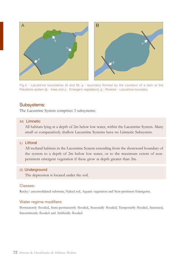
This system is bounded:
1. by non-wetland areas (Fig. 4A -a);
2. by habitats dominated by lichens, emergent mosses, persistent emergent vegetation, shrubs or trees -
Palustrine System (Fig. 4A - b/c); or
3. by a Riverine channel entering or leaving the wetland (Fig. 4B - d).
Sistema de Classificação de Habitats Medwet72
Fig.4 - Lacustrine boundaries (A and B): a - boundary formed by the countour of a dam or the
Palustrine system (b - trees and c - Emergent vegetation); d - Riverine - Lacustrine boundary.
Subsystems:The Lacustrine System comprises 3 subsystems:
(M) Limnetic
All habitats lying at a depth of 2m below low water, within the Lacustrine System. Many
small or comparatively shallow Lacustrine Systems have no Limnetic Subsystem.
(L) Littoral
All wetland habitats in the Lacustrine System extending from the shoreward boundary of
the system to a depth of 2m below low water, or to the maximum extent of non-
persistent emergent vegetation if these grow at depth greater than 2m.
(S) Underground
The depression is located under the soil.
Classes:
Rocky/ unconsolidated substrate, Naked soil, Aquatic vegetation and Non-persistent Emergents.
Water regime modifiers:
Permanently flooded, Semi-permanently flooded, Seasonally flooded, Temporarily flooded, Saturated,
Intermittently flooded and Artificially flooded.
73Sistema de Classificação de Habitats Medwet
Salinity modifiers:
Fresh, Mixosaline, Eusaline and Hipersaline. In cases when the area was former classified as Estuarine
system, the salinity modifier can be Oligohaline, Mesohaline, Polihaline, Mixohaline, Euhaline and Hiperhaline.
Please note:
- The boundary between the Limnetic and Littoral Subsystems at 2m was set because it represents the
maximum depth to which emergent plants normally grow.
- Islands of Palustrine wetland may lie within a Lacustrine habitat.
- Lacustrine habitats formed by the damming of a river are bounded by a contour approximating the
normal spillway elevation or normal pool elevation, except where Palustrine wetlands extend lakeward
of that boundary.
- If a previews classified estuarine habitat become completed isolated from tidal action, (for example,
totally obstructed by a dike), it can be considered Lacustrine, independently of its location and
salinity.
Changes to preview version (Farinha et al. 1996):
One subsystem was included: the underground. This subsystem will allow classifying lagoons and small water
depressions in an underground basin.
2.6. Palustrine System
(P) Palustrine
The Palustrine System includes:
1. all wetlands dominated by emergent mosses or lichens, persistent emergent vegetation,
shrubs or trees (greater than 30% surface area coverage) except habitats liable to be
described as Estuarine System habitats.
2. wetlands lacking any type of the vegetation listed at (1) are also included in this
system, if they exhibit all of the following characteristics:
- the total area is less than 8 ha;
- the water depth is the deepest part of the depression is less than 2m at low
water;
- there is not an active wave-formed, bedrock or non-vegetated soil shoreline
features;
3. wetlands dominated or not by emergent mosses or lichens, persistent emergent
vegetation, shrubs or trees, but which possess all of the following characteristics are
classified within this system:
- closed drainage/endorheic (lacking any outlet);
- flat basin floor;
- less than 2 m deep when fully inundated; and
- usually circular to oval shape, sometimes kidney-shaped or lobed.
Sistema de Classificação de Habitats Medwet74
Palustrine system comprises wetlands where the vegetation is usually dominant. Traditionally,
palustrine habitats occur in ponds, swamps and peat lands. Palustrine wetland habitats may
also be situated shoreward of lakes, adjacent to river channels, inland of estuaries, on river
floodplains in isolated catchments, on slopes, or as islands in lakes or rivers.
Boundaries:
This system is bounded by:
1. non-wetland areas;
2. any of the other four systems.
Subsystems:The Palustrine System includes six subsystems that have been defined, primarily on the basis
of the host landform on which the wetland is situated.
(D) Slope
Wetland occurs on a noticeable slope, including those on sloping valley bottoms.
(E) Pan
Wetland contained in a topographic depression and with all of the following characteristics:
1. closed drainage/endorheic (lacking any outlet);
2. flat basin floor;
3. less than 2 m deep when fully inundated; and
4. usually circular to oval shape, sometimes kidney-shaped or lobed.
(B) Basin
Wetland occurs in a distinct depression (concave landform) or in areas where the water
flow is obstructed by natural or artificial structures. The drainage may be either open
(inflow and outflow), closed (inflow but not outflow) or isolated (not inflow or outflow).
(P) Floodplain
Wetland occurs on a broad, generally flat landform which is currently dominated by
alluvial processes and is adjacent to a well-defined river channel. Distinct morphological
features, such as levees and oxbow lakes may be present and the substrate is dominated
by alluvial or hydric soils.
(L) Flat
Wetland exists on comparatively level land with little or no relief.
(M) Fringe
Wetland occurs within the banks of a river or along the shores of a lake or island; or
forms an island in a river or lake.
75Sistema de Classificação de Habitats Medwet
Classes:
Rocky/ unconsolidated substrate, Naked soil, Aquatic vegetation, Moss, Lichen, Persistent emergent, Scrub-
shrub and Forested.
Water regime modifiers:
Permanently flooded, Semi-permanently flooded, Seasonally flooded, Temporarily flooded, Saturated,
Intermittently flooded, Artificially flooded, Permanently flooded-tidal, Semi-permanently flooded-tidal,
Regularly flooded, Seasonally flooded-tidal and Temporarily flooded-tidal.
Salinity modifiers:
Fresh, Mixosaline, Eusaline, and Hipersaline. In cases when the area was former classified as Estuarine
system, the salinity modifier can be Oligohaline, Mesohaline Polihaline, Mixohaline, Euhaline, or Hiperhaline.
Please note:
- adjacent to salty lakes and/or rivers there may be salty Palustrine habitats.
- adjacent to Tidal Riverine habitats there may be tidal Palustrine habitats.
- coastal areas that are brackish from remnant marine salinity are considered Palustrine habitats.
Changes to previews version (Farinha et al. 1996):
Palustrine system did not comprise any subsystem. However, considering the nature of these wetlands,
important information was being lost. As a result, six subsystems were defined, primarily on the basis of the
host landform on which the wetland is situated. Kotze et al. (1994) considered a hydrogeomorphological
approach to be valuable because of the important influence that geomorphology has on local surface and
groundwater movement patterns and the degree to which wetlands are open to lateral exchanges of
sediments, nutrients and pollutants.

Sistema de Classificação de Habitats Medwet76
77Sistema de Classificação de Habitats Medwet
3. Wetland Classes
The Classes describe the general appearance of the habitat in terms of dominant life
forms or provide a description for non-vegetated wetland. They are easily recognizable
during field surveys or photo-interpretation.
If vegetation covers less than 30% of the surface, Classes are distinguished on the basis of
composition of the substrate (Rocky/ unconsolidated substrate, Naked soil or Reef). If
vegetation covers 30% or more of the substrate, Classes are distinguished on the basis of
the life form of the plants that constitute the uppermost strata or layer of vegetation and
possess an aerial coverage of 30% or greater (aquatic vegetation, moss-lichen, emergent,
scrub-shrub and forested).
The following examples illustrate the definitions presented above:
- An area with 50% aerial coverage of trees over a 60% layer of Scrub-Shrub would be
classified as Forested wetland.
- An area with 20% aerial coverage of trees over the same 60% shrub layer would be
classified as Scrub-Shrub wetland.
- An area where trees and or shrubs both cover less than 30%, but in combination have
an aerial coverage of 30% or more would be classified as Scrub-Shrub wetland.
- An area where trees and shrubs both cover less than 30%, but the total vegetation
cover (except pioneer species) is 30% or greater would be classified according to the
appropriate Class for the predominant life form below the shrub layer.
There are 8 categories of classes:
(O) Rocky/ unconsolidated substrate
This Class can be found in all Systems and includes all rocky/ unconsolidated substrates
with a vegetative cover less than 30%. Rocky/ unconsolidated substrate describes the
permanently flooded and regularly flooded non-vegetated portions of estuaries, deltas,
gulfs, coastal lagoons, rivers, lakes and ponds. For inland wetlands, this Class is also used
for water surfaces that may become dry during some portion of the growing season. If
an area is covered with water for half or more of the growing season, the area is
classified as �rocky/ unconsolidated substrate�. If the surface is uncovered by water for
more than half of the growing season, the area is classified as �Naked soil�.
Sistema de Classificação de Habitats Medwet78
In Marine and Estuarine Systems, the rocky/ unconsolidated substrate class is only applicable
to the permanently submerged subsystem, and only to Permanently flooded or Irregularly
exposed areas. Mud or other non-vegetated areas, regularly or irregularly flooded, are classified
as Naked soil.
Subclasses:
(R) Rock; (C) Cobbles-Gravel; (S) Sand; (M) Mud; (O) Organic; (A) Salt crust.
(S) Naked soil
This Class includes surfaces that have less than 30% aerial cover of vegetation other
than pioneering plants. Common examples include rocky shores, Marine and estuarine
mud and sand flats, exposed shores on the margins of lakes, reservoirs and Riverine
sand bars.
Subclasses:
(R) Rock; (C) Cobbles-Gravel; (S) Sand; (M) Mud; (O) Organic; (A) Salt crust; (V) Vegetated pionner.
(A) Aquatic Bed
This Class includes habitats dominated by plants that grow mainly on or below the water
surface for most of the growing season in most years. These habitats are usually found
in water less than 2 m deep. They represent a diverse group of plant communities that
require surface water for optimum growth and sexual reproduction. They are best
developed in relatively permanent or seasonally flooded water (e.g. lakes and ponds), or
under conditions of repeated flooding such as occurs in tidal areas that are inundated
daily.
Subclasses:
(A) Algal; (M) Aquatic moss; (F) Floating vascular; (L) Floating-leaved; (R) Rooted vascular.
(R) Reef
This Class includes ridge-like or mound-like structures and adjacent flats formed by the
colonization and growth of sedentary invertebrates, shellfish beds or artificial structures.
Reefs are characterized by their elevation above the surrounding substrate and their
interference with normal wave flow.
Subclasses:
(M) Mollusc; (W) Worm; (C) Coral.
(M) Moss-Lichen
This Class includes wetlands where mosses or lichens cover substrates other than rocks,
79Sistema de Classificação de Habitats Medwet
and emergent vegetation make up less than 30% of the aerial coverage. Mosses and
lichens usually form a ground cover under a dominant layer of trees, shrubs or emergent
vegetation. In some instances higher plants are uncommon and mosses and lichens
dominate the flora. They occur only in the Palustrine System.
Subclasses:
(M) Moss; (L) Lichen.
(E) Emergent
This class is characterized by erect, rooted, herbaceous hydrophytes, excluding mosses
and lichens. In relatively stable conditions, emergent wetlands maintain the same appearance
year after year. However, in strongly seasonal conditions they may revert to an open
phase for several years. They are usually dominated by perennial plants. They occur in all
Systems except Marine. Areas colonized by pioneer plants that become established during
long periods of low water are not Emergent wetlands and should be classified as Naked
soil wetland.
Subclasses:
(P) Persistent; (N) Non persistent.
(U) Scrub-Shrub
This Class includes areas dominated by woody vegetation less than 6m tall. It is
characterized by true shrubs, young trees, and trees or shrubs that are small or stunted
because of environmental conditions. Scrub wetlands are most common in riparian
areas that are Temporarily or Seasonally Flooded. They also occur in coastal plains,
inland saline areas and deltas. They occur only in Estuarine and Palustrine Systems and
may be a successional stage leading to Forested woodland.
Subclasses:
(D) Deciduos; (E) Evergreen; (A) Dead.
(F) Forested
This Class is characterized by woody vegetation 6m tall or more. Tree dominated wetlands
occur primarily as Temporarily Flooded forests in the floodplain of rivers, streams and
deltas. They occur only in Estuarine and Palustrine systems.
Subclasses:
(D) Deciduous; (E) Evergreen; (A) Dead
Sistema de Classificação de Habitats Medwet80
Changes to preview version (Farinha et al. 1996):
Previews Open Water and Non vegetated Classes are now designated as Rocky/ unconsolidated
substrate and Naked soil, respectively.
81Sistema de Classificação de Habitats Medwet
4. Wetland Subclasses
The Subclasses describe more detailed differences of the habitats on the basis of:
- finer distinctions in substrate material (Mud, Sand, Cobbles-Gravel, Rock, Organic
and Salt crust);
- predominant life form (Aquatic bed, Moss-lichen, Emergent, Scrub-Shrub and Forested);
- the type of organism that form the reef (Mollusks, Worms or Corals).
There are 22 categories of subclasses:
The Subclass must always be preceded by the Class description.
(M) Mud
This Subclass includes all wetland habitats with unconsolidated substrates where particles
smaller than stones are predominantly clay and silt size (fine mineral sediments less than
0,063 mm in diameter) and have an aerial coverage of 25% or greater. The vegetative
cover is less than 30%. Where unconsolidated shores are not subjected to strong wave
current action, the mud Subclass may take form of extensive flats.
(S) Sand
This Subclass includes all wetland habitats with unconsolidated substrates where particles
smaller than stones are predominantly sand size (size range of particles: 0,063 � 2,00
mm) and have an aerial coverage of 25% or greater. The vegetative cover is less than
30%. This Subclass may take form of shores, sand beaches, bars and flats.
(C) Cobbles-Gravel
In this subclass at least 25% of the substrate is covered by unconsolidated particles
smaller than stones characterized by cobbles and gravel (size range of particles over
2,00 mm). The vegetative cover is less than 30%. Sand, silt and shell fragments often fill
the spaces between the larger particles.
(R) Rock
This Subclass includes all wetland habitats with substrates having an aerial cover of 75%
or more of bedrock. The vegetative cover is less than 30%.
(O) Organic
This Subclass includes all wetlands with unconsolidated substrates are predominantly
organic rather than mineral and have an aerial coverage of 25% or more. The vegetative
Sistema de Classificação de Habitats Medwet82
cover is less than 30%.
(A) Salt crust
This Subclass includes all wetlands with unconsolidated substrates where the particles smaller
than stones are predominantly salt crust and have an aerial coverage of 25% or more. The
vegetative cover is less than 30%.
(V) Vegetated Pioneer
This subclass includes some substrates that are exposed for a sufficient period to be colonized
by herbaceous annuals or seeding herbaceous perennials which are usually killed by rising
water levels and may be removed before the beginning of the next growing season, and has
an aerial cover of at least 30%. Many pioneer species are not hydrophytes but are weedy
mesophytes that cannot tolerate wet soils or flooding.
(M) Mollusk
This Subclass occurs in the Estuarine System with a substrate composed of molluscs. The
aerial cover of vegetation is of 30% or less. Reef molluscs are adapted to great variations in
water level, salinity and temperature, and these same factors control their distribution.
(W) Worm
Worm reefs are constructed by large colonies of Sabellarid worms living in individual tubes
constructed from cemented sand grains. The aerial cover of vegetation is of 30% or less.
(C) Coral
This subclass lies almost entirely within the Permanently Flooded area of the Marine System,
although the upper part of certain reefs may be exposed. the substrate is composed of
corals that are characterized as stable, wee-adapted, highly diverse and highly productive
ecosystems with a great degree of internal symbiosis.
(A) Algal
This Subclass includes wetland habitats with vegetation dominated by macrophytic algae
growing in water or on an associated splash zone. The aerial cover of vegetation is of at least
30%. Algal beds are widespread in the Marine and Estuarine Systems where they occupy
substrates characterized by a wide range of sediments, depths and textures.
(M) Aquatic Moss
This subclass includes wetland habitats with vegetation dominated by aquatic mosses. The
aerial cover of vegetation is of at least 30%. They occur primarily in the Riverine System
and in Permanently Flooded parts of some Lacustrine Systems.
83Sistema de Classificação de Habitats Medwet
(F) Floating Vascular
This subclass includes wetland habitats with vegetation dominated by vascular species which
float freely either in the water or at the surface. The aerial cover of vegetation is of at least
30%. They occur predominantly in sheltered waters. Beds of floating vascular species (e.g.
Salvinia sp., Lemna sp., Azolla sp.) may be moved by wing or water currents.
(R) Rooted Vascular
This subclass includes wetland habitats with vegetation dominated by submerged vascular
species rooted to the substrate. The aerial cover of vegetation is of at least 30%. They occur
in the Marine and Estuarine Systems as sea grass. In the Riverine, Lacustrine and Palustrine
Systems rooted vascular plants occur at all depths in both flowing and standing water.
(L) Floating-leaved
This subclass includes wetland habitats with vegetation dominated by submergent vascular
species with floating leaves. The aerial cover of vegetation is of at least 30%. They occur
predominantly in shallow waters and are characterized by water-lilies (Nymphaea sp.).
(M) Moss
This subclass includes wetland habitats with vegetation dominated by mosses. The aerial
cover of vegetation is of at least 30%. These wetland are uncommon and additional field
information is required on their occurrence.
(L) Lichen
This subclass includes wetland habitats with vegetation dominated by lichens. The aerial
cover of vegetation is of at least 30%. These wetland are uncommon and additional field
information is required on their occurrence.
(N) Non-persistent
This Subclass includes wetlands with vegetation dominated predominantly by vascular
hydrophytes that normally fall to the surface of the substrate or below the surface of the
water at the end of the growing season. The aerial cover of vegetation is of at least 30%. At
certain seasons there may be no obvious signs of emergent vegetation. This Subclass occurs
extensively in the shoreward areas of the Lacustrine and Riverine Systems, and in particularly
small Palustrine wetlands, predominantly in sheltered areas.
(P) Persistent
This Subclass includes wetlands with vegetation dominated predominantly by vascular
hydrophytes that normally remain standing until the beginning of the next growing season.
The aerial cover of vegetation is of at least 30%. This Subclass occurs extensively along the
landward areas of the Estuarine System and on marine plains dominated by marsh
communities such as Spartina maritima, Salicorina sp. and Spergularia sp. Persistent wetlands
Sistema de Classificação de Habitats Medwet84
also occur extensively throughout the Palustrine System where they contain a wide array of
narrow and broad-leaved species such as Phargmites and associated vegetation such as Cyperus
and Scirpus.
(D) Deciduous
This Subclass includes all wetlands with vegetation dominated by woody shrubs or trees
where 50% or more of the species are deciduous. The aerial cover of vegetation is of at
least 30%.
(E) Evergreen
This Subclass includes all wetlands with vegetation dominated by woody shrubs or trees
where 50% or more of the species are evergreen. The aerial cover of vegetation is of at
least 30%. These wetlands are uncommon in the Mediterranean region and additional field
information is required on their occurrence.
(A) Dead
This Subclass includes all wetlands with vegetation dominated by dead woody shrubs or trees.
The aerial cover of vegetation is of at least 30%. These wetlands are usually produces by
prolonged rises in the water table resulting from natural or man-made causes. Such wetlands
may also result from other factors such as fire, salt spray, air pollution, herbicide, etc.
85Sistema de Classificação de Habitats Medwet
5. Modifier definitions
Modifiers aid the attempt of a more complete description of habitats.
There are 3 groups of modifiers:
- Water Regime;
- Salinity;
- Artificial.
The water regime modifier must always be preceded by the System description.
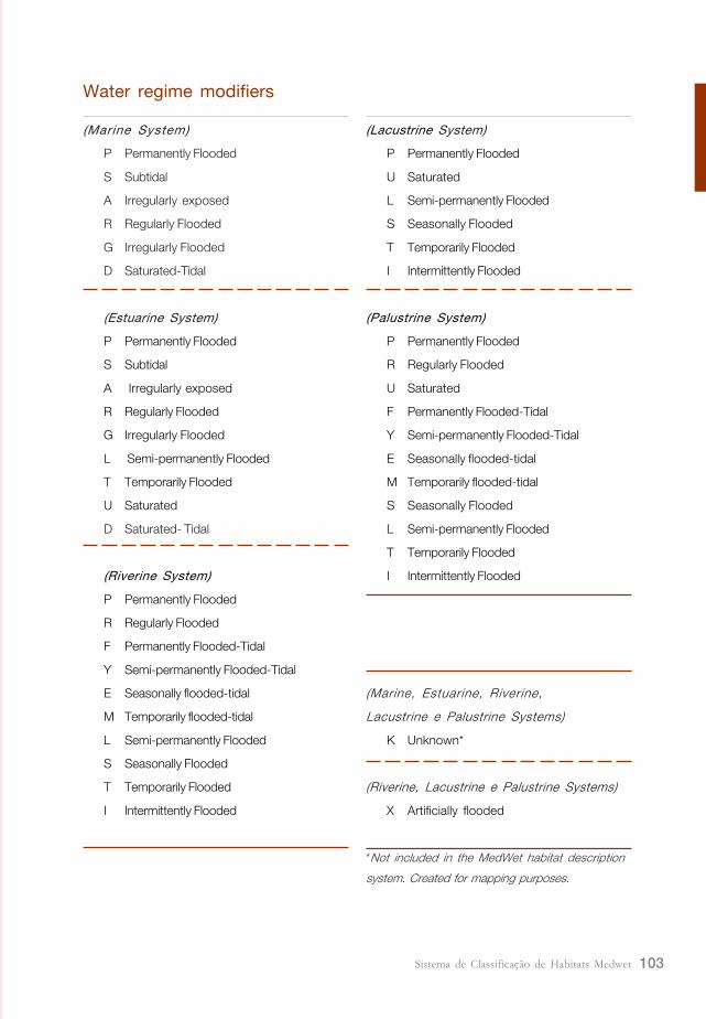
5.1. Water Regime Modifiers
The precise description of hydrological features of the habitat depends on a good knowledge
of duration and timing of surface inundation, both yearly and long term, as well as an
indication of groundwater fluctuations. Once this information is usually difficult to obtain,
water regime modifiers, which constitute general categories of wetland hydrology, were
defined. These categories are easy to use and allow a good habitat characterization.
(P) Permanently Flooded
The substrate is continuously covered with water throughout the year.
In the Marine and Estuarine systems, this modifier describes areas with small tidal variation.
The adjacent intertidal area is determined by the slope of the shore line and the degree of
exposure of the site to wind and waves.
In the Fluvial, Lacustrine and Palustrine systems, this modifier describes the continuously
flooded portions of lakes, river channels and ponds. These include the land surface exposed
by years of extreme drought.
(S) Subtidal
The substrate is continuously covered with water with a large tidal range.
This category applies to Marine and Estuarine systems, describing high energy coastlines,
as the Mediterranean region bordered by the Atlantic Ocean.
Sistema de Classificação de Habitats Medwet86
(A) Irregularly exposed
The land surface is exposed by tides less often than daily.
Water regimes or areas where water is occasionally absent (e.g. extreme low tides due to
spring tides) are considered irregularly exposed.
This modifier applies to the Marine and Estuarine systems.
(R) Regularly Flooded
The substrate is alternately flooded and exposed by tides at least once a day.
Typical Regularly Flooded areas include tidal mud flats, seaward fringes of salt marshes and
fresh water flooding areas under tidal influence.
This modifier applies to the Marine, Estuarine, Riverine and Palustrine systems.
(G) Irregularly Flooded
The substrate is flooded by tides less than daily. The area must be flooded by tides at
least once a year as a result of extreme high tide. The irregular flooding may be due to
normal tidal cycles (e.g. spring tides) or storm surges.
Typical Irregularly Flooded areas include salt marshes above the zone of daily flooding, and
the upper zone of Marine and Estuarine beaches.
(U) Saturated
The substrate is saturated to the surface for extended periods, but surface water is never
or only occasionally present.
This modifier describes non tidal habitats, such as wet grass meadows and shrub areas
(Palustrine and Lacustrine systems). Wetlands with organic soils typically have saturated
water regimes. It also includes wetlands temporary isolated from tidal influence, e.g. coastal
lagoons, which access to the sea occurs naturally or artificially one or more times per year. In
these cases, it can succeed a water level rise and a consequent flood of the bordering land.
These habitats are classified as Estuarine System and are non-tidal.
This modifier applies to the Estuarine, Lacustrine and Palustrine systems.
(D) Saturated- Tidal
The substrate is saturated to the surface for extended periods, but surface water is never
or only occasionally present.
87Sistema de Classificação de Habitats Medwet
It applies to areas where wetness is primarily due to capillary rise or to tidal subsurface
seepage.
This modifier applies to the Marine and Estuarine systems.
(F) Permanently Flooded-Tidal
Fresh tidal waters flood the surface throughout the year. These include the land surface
exposed by years of extreme drought.
This modifier applies to the Riverine and Palustrine systems.
(Y) Semi-permanently Flooded-Tidal
Fresh tidal waters flood the surface throughout all the growing season in most years.
This modifier applies to the Riverine and Palustrine systems.
(E) Seasonally flooded-tidal
Fresh tidal water floods th surface for extended periods during the growing season in most years.
This modifier applies to the Riverine and Palustrine systems.
(M) Temporarily flooded-tidal
Fresh tidal water floods the surface for brief periods of the growing season.
This modifier applies to the Riverine and Palustrine systems.
(L) Semi-permanently Flooded
Surface water persists throughout the growing season in most years. When surface water
is absent, the water table is usually at or very near the soil surface.
This modifier applies to the Estuarine system (at non-tidal areas) and to the Riverine,
Lacustrine and Palustrine systems.
(S) Seasonally Flooded
Surface water is present for extended periods of the growing season. Inundation periods
range from approximately 6 weeks to most of the growing season. When surface water
is absent, the water table is often near the land surface. Common examples of seasonally
flooded wetlands include Phragmites marshes, Typha stands and wet Juncus meadows.
This modifier applies to the Riverine, Lacustrine and Palustrine Systems.
Sistema de Classificação de Habitats Medwet88
(T) Temporarily Flooded
Surface water is present for brief periods (approximately 3 to 6 weeks) of the growing
season. When surface water is absent, the water table usually lies well below the soil
surface.
Examples of Temporarily Flooded wetlands include shrub areas on river and stream floodplains,
and briefly flooded grass meadows.
This modifier applies to the Estuarine system (at non-tidal areas) and to the Riverine,
Lacustrine and Palustrine systems.
(I) Intermittently Flooded
The substrate is usually exposed, but surface water is present for variable periods without
detectable seasonal precocity. Weeks, months or even years may intervene between
periods of flooding.
Examples of Intermittently Flooded wetlands include chotts, wetlands typical of the northern
edge of the Sahara. These salty lakes rarely hold water for longer than four months at a
time, usually during the winter.
This modifier applies to the Riverine, Lacustrine and Palustrine Systems.
5.1.1. Artificial modifierIn the case of habitats where the amount and duration of flooding is controlled by means of
pumbs or siphons in combination with dams we can use another water regime modifier:
(X) Artificially Flooded
The vegetation growing on these areas cannot be considered a reliable indicator of water
regime. Neither wetlands within, or resulting from leakage from, man-made impoundments,
nor irrigated pasture lands supplied by diversion ditches or artesian wells, are included under
this modifier. In cases, where the water regime is known, this Artificial Flooded modifier can
be replaced with any non-tidal water regime.
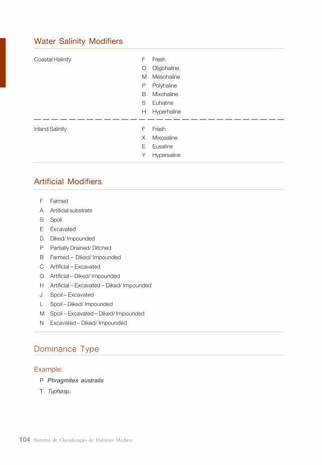
5.2 Salinity Modifiers
The accurate characterization of water salinity of a wetland salinity of a wetland can be
difficult due to problems with measurements and the variation of the values due to changes
89Sistema de Classificação de Habitats Medwet
with season, weather, time of day and other factors. Despite these problems, the differences
in salinity are important, as it determines species composition of habitats and has implications
for utilization and management of wetlands.
The salinity of coastal and inland waters differs as a result of the concentrations of various
salts. The term �haline� is used to describe the sea-derived salinity of coastal waters (NaCl
salts), while �saline� is used for the salinity of inland waters of any origin caused by the
presence of cations (such as calcium, magnesium, sodium and potassium) and anions
(carbonates, sulphates and chlorides).
Seven classes of salinity are considered, expressed in g/l (grams per liter), in order to define
the salinity of the wetland.
Coastal modifiers Inland modifiers Salinity (g/l)
(F) Fresh (F) Fresh < 0,5
(O) Oligohaline 0,5 � 5,0
(M) Mesohaline 5,0 � 18,0
(P) Polyhaline 18,0 � 30,0
(B) Mixohaline (X) Mixosaline 0,5 � 30,0
(S) Euhaline (E) Eusaline 30,0 - 40,0
(H) Hyperhaline (Y) Hypersaline > 40,0
5.3 Artificial Modifiers
Many wetlands man-made, and many natural ones have been modified to some degree by
the activities of humans. The following Artificial Modifiers are used to describe modified
and created wetland environments. The following Artificial modifiers are defined and can be
used singly or in combination wherever they apply to wetlands:
(F) Farmed
The soil surface has been mechanically or physically altered for crop production, but
hydrophytes will become re-established if farming is discontinued (e.g. farmed intermittent
lake bottoms).
(A) Artificial substrate
Substrates placed by humans, using natural or synthetic materials. Jetties and breakwaters
are examples of Non-vegetated Artificial shores.
Sistema de Classificação de Habitats Medwet90
(S) Spoil
Wetland habitat where the substrate is a result of deposition of spoil materials.
(E) Excavated
A wetland lying within a excavated basin or channel (e.g. land cut canals, ditches, earth
tanks and farm ponds).
(D) Diked/Impounded
Created or modified by man-made barrier or dam which obstructs the inflow or outflow
of water. The normal spillway elevation (contour) determines the boundary of the
wetland formed behind a dam.
(P) Partially Drained/Ditched
The water level has been artificially lowered, usually by means of ditches, but the area is
still classified as wetland because soil moisture is sufficient to support hydrophytes. Drained
areas are not considered wetland if they can no longer support hydrophytes. This modifier
is used to indicate extensive ditch networks in wetlands.
The above Artificial modifiers can be used singly or in combination wherever they apply to
wetlands. In the last case, different combinations can be used in the Inventory:
(B) Farmed - Diked/Impounded
(C) Artificial substrate/ Excavated
(G) Artificial substrate/ Diked/Impounded
(H) Artificial substrate/ Excavated/ Diked/Impounded
(J) Spoil/ Excavated
(L) Spoil/ Diked/Impounded
(M) Spoil/ Excavated/ Diked/Impounded
(N) Excavated/ Diked/Impounded
Rio Maior salines, near Candeeiros
mountain (Portugal).
MedWet habitat coding:
1 2 3 4 5 6 7 D C C C
P D YXAO C - ---
Palustrine, Slope (the wetland occurs near a mountainous
area), -, Sal crust, Artificially flooded, Hypersaline, Artificial-
Escavated, - the counter was not used.
91Sistema de Classificação de Habitats Medwet
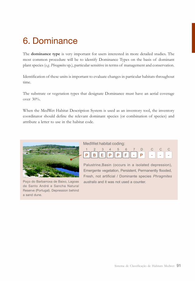
6. Dominance
The dominance type is very important for users interested in more detailed studies. The
most common procedure will be to identify Dominance Types on the basis of dominant
plant species (e.g. Phragmites sp.), particular sensitive in terms of management and conservation.
Identification of these units is important to evaluate changes in particular habitats throughout
time.
The substrate or vegetation types that designate Dominance must have an aerial coverage
over 30%.
When the MedWet Habitat Description System is used as an inventory tool, the inventory
coordinator should define the relevant dominant species (or combination of species) and
attribute a letter to use in the habitat code.
Poço do Barbarroxa de Baixo, Lagoas
de Santo André e Sancha Natural
Reserve (Portugal). Depression behind
a sand dune.
MedWet habitat coding:
1 2 3 4 5 6 7 D C C C
P B FPPE - P ---
Palustrine,Basin (occurs in a isolated depression),
Emergente vegetation, Persistent, Permanently flooded,
Fresh, not artificial / Dominante species Phragmites
australis and it was not used a counter.
Sistema de Classificação de Habitats Medwet92
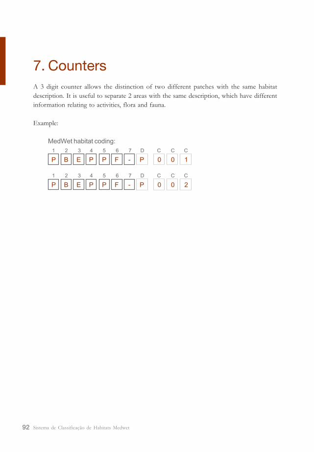
7. Counters
A 3 digit counter allows the distinction of two different patches with the same habitat
description. It is useful to separate 2 areas with the same description, which have different
information relating to activities, flora and fauna.
Example:
MedWet habitat coding:
1 2 3 4 5 6 7 D C C C
P B FPPE - P 100
1 2 3 4 5 6 7 D C C C
P B FPPE - P 200
93Sistema de Classificação de Habitats Medwet
8. References
Cowardin, L.M., V. Carter, F.C. Golet & E.T. LaRose 1979. Classification of wetlands and
deepwater habitats of the United States. US Fish and Wildlife Service FWS/OBS-79/31.
Washington D.C.
Dini, J.A. & G.I. Cowan 2000. Classification system for the South African wetland inventory. Second
Draft. South African Wetlands Conservation Programme. Department of
Environmental Affairs and Tourism.
Farinha, J.C., L. Costa, G. Zalidis, A. Mantzavelas, E. Fitoka, N. Hecker & P. Tomàs 1996.
Mediterranean Wetland Inventory: Habitat Description System. MedWet/Instituto da
Conservação da Natureza(ICN)/Wetlands International/ Greek Biotope/ Wetland
Centre (EKBY) Publication. VolumeIII.
Fonseca, J.P., S. Chozas & A. Paiva 2004. Guia de Plantas Aquáticas. Instituto da Conservação
da Natureza/ Centro de Zonas Húmidas.
Kotze, D.C., C.M. Breen & J.R. Klug 1994. Wetland-use: a management decision support system for
th KwaZulu-Natal midlands. WRC Report No. 501/2/94. Water Research Commission.
Pretoria.

Sistema de Classificação de Habitats Medwet94
95Sistema de Classificação de Habitats Medwet
Annex I
Wetland identification
Frequently, there is a clear perception of what a wetland is, however, in some situations
there can be doubts about if a certain site is or not a wetland or where are its boundaries.
The definition of wetlands adopted by the Ramsar convention, is very general and widely
accepted, however, it is not by itself adequate for the precise identification and delineation
of wetland areas. For this reason, the MedWet inventory methodology identify and delineate
wetlands, based on the presence of essential attributes such as hydrology, soils and vegetation.
These criteria do not need to be applied in order to carry out a simple inventory or for
obvious wetland areas. However, they will be required for precise delineation of wetlands.
A. Hydrology
This criterion can be applied whenever adequate hydrological data are available, according
to which an area is identified as a wetland if:
- It is permanently or periodically flooded for at least two successive weeks during the
growing season and for most of the years of observation, or for at least six years out
of ten years of observation; or
- It presents conditions of soil saturation (ground water close to the soil surface) for at
least two successive weeks during the growing season and for the most of the years
of observation, or for at least six years out of ten years of observation.
B. Vegetation
The vegetation is greatly influenced and determined by the environmental conditions of an
area. The dominance of plant species known as indicators of wetland conditions (e.g. flooded
or soil saturation conditions) allows the identification of an area as a wetland. As such, it
constitutes an important criterion for the identification of wetlands and their boundaries at
the landward side.
A list of flora species indicative of wetland should be established for each country or region
to be covered by the inventory. This list will include hydrophytes which are �species that
have demonstrated an ability (because of morphological and/ or physiological adaptation
and/ or reproductive strategies) to achieve maturity and reproduce in an environment where
Sistema de Classificação de Habitats Medwet96
all or portions of the soils within the root zone become, periodically or continuously, saturated
during the growing season� (Reed, 1988). Amongst this list will be selected the indicator
species which are restricted to wetlands. These indicator species can vary from one region to
another, because of ecotypic variation within species (National Research Council, 1995).
A field survey will then be carried out in each area for which the wetland character needs to
be identified. It is important to conduct this field survey when most of the hydrophytic plant
species are present, which is during the growing season and when the area is flooded. The
dominant plant species of the area will be recorded. The measure of dominance can be
made in terms of frequency, density, percentage of coverage, etc. The most abundant
species is used to determine whether the vegetation as a whole is predominantly (more than
50%) hydrophytic. If these dominant species belong to the list of wetland indicators then
the area will be defined as a wetland.
The criterion has to be used carefully for controversial areas where the vegetation is only
marginally hydrophytic (e.g. on the margin of a wetland area, or when the area is temporarily
invaded by upland plants, etc.). A prevalence index (using fidelity rating system which gives
the wetland affinity of each species) could be used to ascertain the wetland character of the
plant communities of the site (see National Research Council, 1995 for further reading).
The other criteria (hydrology and soils) should also be used to demonstrate the wetland
character of these difficult areas.
C. SoilThe identification of hydric soils by field survey is required. Hydric soils are those usually
found in the vicinity of water bodies (temporarily flooded and/ or high level of ground
water), are poorly drained and under natural and undisturbed circumstances, support wetland
vegetation.
The identification of hydric soils by field survey can be performed by the use of easily
determined indices and it is often done by determining soil color to a standard color chart.
Soil characterized by low chromas of black, grey, or brown and red indicate hydric soils.
They are of two types:
Organic hydric soils
are composed primarily of the remains of plants in various stages of decomposition and
accumulate in wetlands as a result of anaerobic conditions created by standing water or
poorly drained conditions. The organic materials can present different stages of decomposition:
in some soils (called muck) most of the material is decomposed and in some other (peat) it
largely remains. They are generally dark, ranging from dark black soils characteristic of muck to
the dark brown color ofv peat. These dark colors indicate the presence of organic matter.
97Sistema de Classificação de Habitats Medwet
Mineral hydric soils
Have little or no organic matter. Due to their wetness, the iron present in these is reduced.
This leads to the development of a characteristic grey color (or greenish and blue-grey).
Spots with orange to brown color (called mottles) among the grey matrix suggest temporary
flooded soils. These mottles are formed by oxides of iron and manganese during the dry
period, Oxidized iron with an orange color can also be found along the plant roots.
The identification of hydric soils by field survey can be performed by the use of easily
determined indices and it is often done by determining soil color to a standard colors chart.
Soils characterized by low chromas of black, grey, or brown and red indicate hydric soils.
The soil criterion may need to be adapted for each inventory region according to its soil
specificity.

Sistema de Classificação de Habitats Medwet98
99Sistema de Classificação de Habitats Medwet
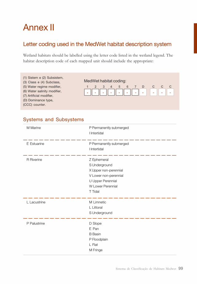
Annex II
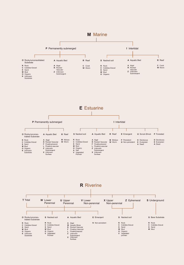
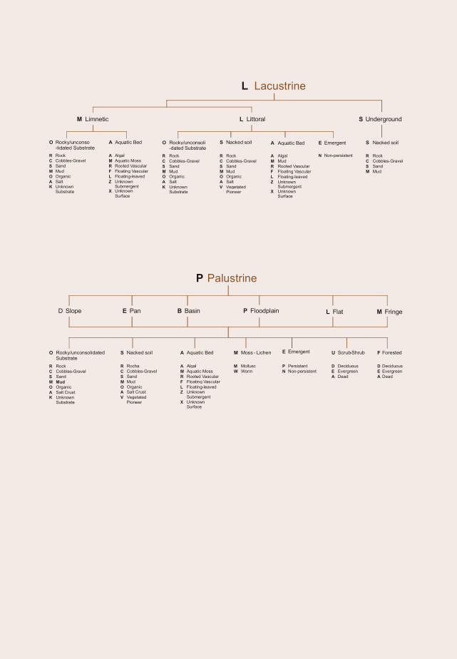
Letter coding used in the MedWet habitat description system
M Marine P Permanently submerged
I Intertidal
E Estuarine P Permanently submerged
I Intertidal
R Riverine Z Ephemeral
S Underground
X Upper non-perennial
V Lower non-perennial
U Upper Perennial
W Lower Perennial
T Tidal
L Lacustrine M Limnetic
L Littoral
S Underground
P Palustrine D Slope
E Pan
B Basin
P Floodplain
L Flat
M Fringe
Systems and Subsystems
MedWet habitat coding:
1 2 3 4 5 6 7 D C C C
- - ---- - - ---
(1) Sistem e (2) Subsistem,
(3) Class e (4) Subclass,
(5) Water regime modifier,
(6) Water salinity modifier,
(7) Artificial modifier,
(D) Dominance type,
(CCC) counter.
Wetland habitats should be labelled using the letter code listed in the wetland legend. The
habitat description code of each mapped unit should include the appropriate:
Sistema de Classificação de Habitats Medwet100
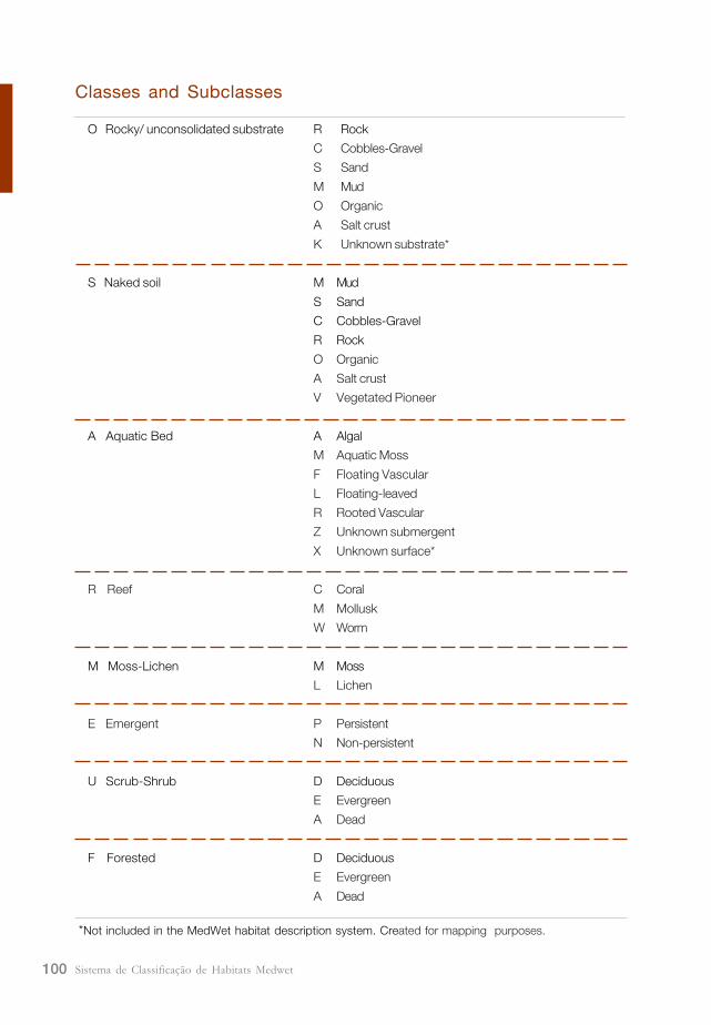
Classes and Subclasses
O Rocky/ unconsolidated substrate R Rock
C Cobbles-Gravel
S Sand
M Mud
O Organic
A Salt crust
K Unknown substrate*
S Naked soil M Mud
S Sand
C Cobbles-Gravel
R Rock
O Organic
A Salt crust
V Vegetated Pioneer
A Aquatic Bed A Algal
M Aquatic Moss
F Floating Vascular
L Floating-leaved
R Rooted Vascular
Z Unknown submergent
X Unknown surface*
R Reef C Coral
M Mollusk
W Worm
M Moss-Lichen M Moss
L Lichen
E Emergent P Persistent
N Non-persistent
U Scrub-Shrub D Deciduous
E Evergreen
A Dead
F Forested D Deciduous
E Evergreen
A Dead
*Not included in the MedWet habitat description system. Created for mapping purposes.
101Sistema de Classificação de Habitats Medwet
M Marine
O Rocky/unconsolidated Substrate
S Nacked soilA Aquatic Bed R Reef A Aquatic Bed R Reef
R Rock
C Cobbles-Gravel
S Sand
M Mud
O Organic
K Unknown Substrate
R Rock
C -Cobbles Gravel
S Sand
M Mud
O Organic
A Algal
R Rooted Vascular
Z Unknown Submergent
C Coral
W Worm
A Algal
R Rooted Vascular
Z Unknown Submergent
C Coral
W Worm
I IntertidalP Permanently submerged
E Estuarine
S Nacked soil A Aquatic Bed R Reef E Emergent U F Forested
R Rock
C Cobbles-Gravel
S Sand
M Mud
O Organic
A Salt
V Vegetated Pionner
A Algal
R Rooted Vascular
F Floating-leaved
L Floating vascular
Z Unknown Submergent
M Mollusc
W Worm
P Persistent
N Non-persistent
D Deciduous
E Evergreen
A Dead
D Deciduous
E Evergreen
A Dead
O Rocky/unconso-lidated Substrate
A Aquatic Bed R Reef
M Molusc
W WormR Rock
C Cobbles-Gravel
S Sand
M Mud
O Organic
K Unknown Substrate
A Algal
Scrub-Shrub
I IntertidalP Permanently submerged
X Unknown Surface
R Rooted Vascular
F Floating-leaved
L Floating vascular
Z Unknown Submergent
X Unknown Surface
R Riverine
S Bare SubstrateS Nacked soilS Nacked soil A Aquatic Bed E EmergentO Rocky/unconso-lidated Substrate
R Rock
C Cobbles-Gravel
S Sand
M Mud
O Organic
K Unknown Substrate
R Rock
C Cobbles-Gravel
S Sand
M Mud
O Organic
V Vegetated Pioneer
A Algal
M Aquatic Moss
R Rooted Vascular
F Floating Vascular
L Floating-leaved
Z Unknown Submergent
N Non-persistent
T Tidal W Lower Perennial
U Upper Perennial
V Lower Non-perennial
X Upper Non-perennial
Z Ephemeral S Underground
R Rock
C Cobbles-Gravel
S Sand
M Mud
O Organic
V Vegetated pioneer
R Rock
C Cobbles-Gravel
S Sand
M Mud
X Unknown Surface
Sistema de Classificação de Habitats Medwet102
L Lacustrine
S UndergroundM Limnetic L Littoral
R Rock
C Cobbles-Gravel
S Sand
M Mud
S Nacked soilA Aquatic Bed A Aquatic BedS Nacked soil E Emergent
R Rock
C Cobbles-Gravel
S Sand
M Mud
O Organic
A Salt
K Unknown Substrate
A Algal
M Aquatic Moss
R Rooted Vascular
F Floating Vascular
L Floating-leaved
Z Unknown Submergent
R Rock
C Cobbles-Gravel
S Sand
M Mud
O Organic
A Salt
K Unknown Substrate
R Rock
C Cobbles-Gravel
S Sand
M Mud
O Organic
A Salt
V Vegetated Pioneer
A Algal
M Mud
R Rooted Vascular
F Floating Vascular
L Floating-leaved
Z Unknown Submergent
N Non-persistent
O Rocky/unconsoli-dated Substrate
O Rocky/unconso-lidated Substrate
X Unknown Surface
X Unknown Surface
P Palustrine
S Nacked soil A Aquatic Bed M Moss - Lichen E Emergent U Scrub-Shrub F Forested
R Rocha
C Cobbles-Gravel
S Sand
M Mud
O Organic
A Salt Crust
V Vegetated Pioneer
R Rock
C Cobbles-Gravel
S Sand
M Mud
O Organic
A Salt Crust
K Unknown Substrate
M Mollusc
W Worm
P Persistent
N Non-persistent
D Deciduous
E Evergreen
A Dead
D Deciduous
E Evergreen
A Dead
A Algal
M Aquatic Moss
R Rooted Vascular
F Floating Vascular
L Floating-leaved
Z Unknown Submergent
D Slope E Pan B Basin P Floodplain L Flat M Fringe
O Rocky/unconsolidated Substrate
X Unknown Surface
103Sistema de Classificação de Habitats Medwet
Water regime modifiers
(Marine System)
P Permanently Flooded
S Subtidal
A Irregularly exposed
R Regularly Flooded
G Irregularly Flooded
D Saturated-Tidal
(Estuarine System)
P Permanently Flooded
S Subtidal
A Irregularly exposed
R Regularly Flooded
G Irregularly Flooded
L Semi-permanently Flooded
T Temporarily Flooded
U Saturated
D Saturated- Tidal
(Riverine System)
P Permanently Flooded
R Regularly Flooded
F Permanently Flooded-Tidal
Y Semi-permanently Flooded-Tidal
E Seasonally flooded-tidal
M Temporarily flooded-tidal
L Semi-permanently Flooded
S Seasonally Flooded
T Temporarily Flooded
I Intermittently Flooded
(Lacustrine System)
P Permanently Flooded
U Saturated
L Semi-permanently Flooded
S Seasonally Flooded
T Temporarily Flooded
I Intermittently Flooded
(Palustrine System)
P Permanently Flooded
R Regularly Flooded
U Saturated
F Permanently Flooded-Tidal
Y Semi-permanently Flooded-Tidal
E Seasonally flooded-tidal
M Temporarily flooded-tidal
S Seasonally Flooded
L Semi-permanently Flooded
T Temporarily Flooded
I Intermittently Flooded
(Marine, Estuarine, Riverine,
Lacustrine e Palustrine Systems)
K Unknown*
(Riverine, Lacustrine e Palustrine Systems)
X Artificially flooded
*Not included in the MedWet habitat description
system. Created for mapping purposes.
Sistema de Classificação de Habitats Medwet104
Water Salinity Modifiers
Coastal Halinity F Fresh
O Oligohaline
M Mesohaline
P Polyhaline
B Mixohaline
S Euhaline
H Hyperhaline
Inland Salinity F Fresh
X Mixosaline
E Eusaline
Y Hypersaline
Artificial Modifiers
F Farmed
A Artificial substrate
S Spoil
E Excavated
D Diked/ Impounded
P Partially Drained/ Ditched
B Farmed � Diked/ Impounded
C Artificial � Excavated
G Artificial � Diked/ Impounded
H Artificial � Excavated � Diked/ Impounded
J Spoil � Excavated
L Spoil � Diked/ Impounded
M Spoil � Excavated � Diked/ Impounded
N Excavated � Diked/ Impounded
Dominance Type
Example:
P Phragmites australis
T Typha sp.