Embed Size (px)
Citation preview
"!
#!
SIERRA CLUB BULLETIN
VOLUME TEN
NUMBER ONE
SAN FRANCISCO JANUARY
1916
A Message and Appreciation From
James Bryce
TO MY FRIENDS AND FELLOW MEMBERS OF THE SIERRA CLUB
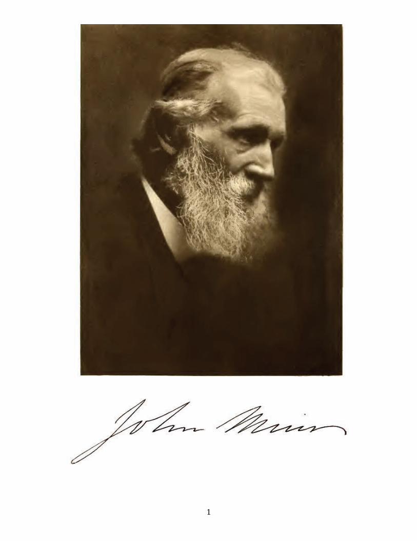
ay I venture to express to you the sorrow with which the news of the death of our friend, the venerable John Muir, has filled me? He was the patriarch of American lovers of mountains,
one who had not only a passion for the splendours of Nature, but a wonderful power of interpreting her to men. The very air of the granite peaks, the very fragrance of the deep and solemn forest, seem to breathe round us and soothe our sense as we read the descriptions of his lonely wanderings in the Sierras when their majesty was first revealed. California may well honour the service of one who did so much to make known her charms and to shield them from desecration. And you of the Club will cherish the memory of a singularly pure and simple character, who was in his life all that a worshipper of nature ought to be.
February 19th, 1915 Hindleap, Forest Row Sussex
M
3
NOTES AND CORRESPONDENCE Edited by WILLIAM E. COLBY
THE JOHN MUIR TRAIL
Sierra Club Bulletin – January 1916
During the 1914 outing of the Sierra Club, a suggestion was made by Mr. Meyer Lissner of Los Angeles that a State appropriation should be secured for building trails with which to make the High Sierra more accessible. After Mr. Muir's death, the happy idea occurred of making this appropriation a State recognition of his inestimable service in bringing the wonderful mountains of California to the attention of the world. Accordingly a bill was drafted by the Sierra Club making an appropriation of $10,000 (to be paid in two equal annual installments) with which to construct a trail from Yosemite to Mount Whitney, to be known as the John Muir Trail. In spite of adverse financial conditions, the State Legislature was persuaded by earnest work of the members of the Sierra Club, aided by several civic organizations, to pass the bill. Governor Johnson's final approval made the construction of the trail possible. It is, indeed, a most appropriate memorial to John Muir, who spent many of the best years of his life exploring the region which it will make accessible. This trail will afford a route for traveling with saddle and pack animals north and south along and near the crest of the entire High Sierra. It will begin the work of making accessible one of the grandest mountain regions on the American continent.
State Engineer Wilbur F. McClure was charged with the selection of the final route and the actual
construction of the trail. Mr. McClure, after considering suggestions from the Sierra Club, from federal officials and others, made two trips over the lower part of the trail before determining its final location as follows:
Beginning at a point on the north floor of the Yosemite Valley and running from thence by the most
practicable route northeasterly to a junction with the Tioga Road at a point near Tenaya Lake; thence northeasterly and easterly along and upon said Tioga Road to a point near the Soda Springs in the Tuolumne Meadows; thence in a general southeasterly direction up Lyell Canon to the headwaters of said canon, to and over Donohue Pass; thence in a general south-easterly direction across Rush Creek and Island Pass to Thousand Island Lake; thence easterly and southeasterly through Agnew Meadows, Pumice Flat, past Devil Post Pile, Reds Meadows, Fish Creek Valley, over Silver Pass, and thence by the most feasible route to the north fork of Mono Creek. Thence in a general southerly direction down the north fork of Mono Creek Valley, and Mono Creek Valley to Vermilion Valley; thence by the way of the present traveled trail southeasterly and southerly to Marie Lake and to and over Seldon Pass; thence continuing southerly and southeasterly along the valley of the south fork of the San Joaquin River to the mouth of Evolution Creek; thence continuing in a general southeasterly direction up Evolution Creek Valley, past Evolution Lake, Wanda Lake, over Muir Pass, down Le Conte Canon to Grouse Meadow and the mouth of Palisade Creek; thence easterly up Palisade Creek Valley and over the pass between the waters of Palisade Creek and the drainage of the south fork of Kings River; thence through the Sequoia National Forest, Upper Basin, and traversing headwaters of the south fork of Kings River to the pass about one and one-half miles southwest of Mount Pinchot; thence southerly and southwesterly along Woods Creek and the south fork of same; thence by the way of Rae Lake, Glenn Pass, Bullfrog Lake and Bubbs Creek to and over an unnamed pass near Junction Peak; thence into the watershed of Tyndall Creek, and over and along the high sandy plateau and to Crabtree Meadows; thence in a general easterly direction to Mount Whitney.
For carrying on construction work, Mr. McClure wisely availed himself of the splendid organization
which the Forest Service had available for supervising the work. Thus neither time nor money was spent in exploration by those unfamiliar with the region. In short, every dollar spent bought the greatest possible value. In addition considerable valuable supervision was given by forest supervisors and rangers without cost from the fund available for the John Muir Trail. The plans for co-operation between the State Department of Engineering and the Forest Service were agreed upon at a meeting held in the rooms of the Sierra Club, June 4, 1915, at which were present Mr. W. F. McClure, State engineer; Mr. Coert Du Bois, district forester; Mr. Roy Headley, assistant district forester; Mr. Paul G. Redington, supervisor of the Sierra National Forest; Mr. A. B.
4
Patterson, superintendent of the Sequoia National Forest; Mr. W. E. Colby, secretary of the Sierra Club, and Mr. Walter L. Huber of the Sierra Club's trail committee.
The appropriation did not become available until August 8, leaving a short field season for work.
However, in this short season much work was accomplished. Progress within the Sierra National Forest is well shown by Supervisor Redington's report to the State Engineer, much of which is here quoted:
REPORT ON JOHN Mum TRAIL WORK, FOR SEASON OF 1915, SIERRA NATIONAL FOREST
Route. The route which this trail will follow was outlined in a memorandum transmitted with the State
Engineer's letter of August 12, 1915, to the District Forester. As a result of the field investigation made this year, it is believed that for the sake of economy, variety and ease of travel, and to obtain greater scenic attractions, the stipulated route should be changed at certain points, which will be discussed in order.
1. From Grouse Meadow, which lies on the Middle Fork of Kings River, near the mouth of Palisade
Creek, the official routing of the trail is specified as: "Thence easterly, up Palisade Creek Valley and over the pass between the waters of Palisade Creek and the drainage of the south fork of Kings River." No old trail exists over the pass in question, although a rough trail ascends Palisade Creek from its mouth to the mouth of Cataract Creek.
Following a conference between the State engineer, Forest Service officials and representatives of the
Sierra Club, when the status of the trail work previously done on the route up the Middle Fork of Kings River from Simpson Meadow, by funds furnished by Fresno County, the Sierra Club and the Forest Service, was explained, no work was planned up Palisade Creek, since it was impracticable to get an outfit there from the Owens River country, and impossible to move the trail crew at work lower down on the Middle Fork, up to the mouth of Palisade Creek. Later, the situation not having apparently been understood, the matter was taken up in detail by correspondence, and the State engineer authorized the continuance of the work on the Middle Fork trail, as preliminary to the work which would finally be undertaken from the mouth of Palisade Creek, east. Eventually the route over the pass at the head of Palisade Creek may be constructed. It has seemed to the Forest officers, however, since a good trail already exists from the South Fork of Kings River up Copper Creek, over Granite Pass, down to Simpson Meadow and thence up the Middle Fork to within 1% miles of the mouth of Palisade Creek, that for the present at least the existing trail spoken of should be improved, and the new trail from Cartridge Creek to Palisade Creek should be finished. It will cost less money, so far as we can ascertain with certainty, to put the trail through to Palisade Creek than to put a trail up Palisade Creek and over the pass at its head at an elevation of 12,500 feet. Granite Pass, on the lower trail, can be crossed earlier in the year than would be possible on Palisade Pass, and the lower trail takes the traveler from Palisade Creek down the magnificent canon of the Middle Fork, across a spectacular gorge near the mouth of Cartridge Creek, and into splendid camping for man and beast at Simpson Meadow. The travel is varied, far more than would be the case if the route over Palisade Pass was followed. With available funds somewhat limited in amount, keeping in mind the comparative maintenance cost, and with the desirability of making a long connected piece of safe trail for the least expenditure of money, it is recommended that the Palisade-South Fork unit be dropped from consideration until the balance of the work has been completed on the entire project.
2. The second material change recommended is toward the northern end of the trail. The present route
from Agnew Meadows to Thousand Island Lake leads through average mountain country. If changed as suggested it will take the traveler by the shores of three of the most picturesque lakes in the entire region (where splendid fishing of golden trout will be possible in 1917), and will give him a close view of the Minarets and Mounts Banner and Ritter. The expense to put this trail through will not exceed that necessary to establish a trail on the other route.
5
METHODS OF WORK
Supervision. The Middle Fork of Kings River unit of this year's work was supervised by District Ranger
Roy Boothe. He went in at the start, visited the project again with the supervisor from August 5 to 9, when the work being done was inspected and a reconnaissance of the proposed route of the trail from Palisade Creek to Muir Pass was made. He went again, in October, to help bring the crew out.
The Muir Pass-French Canon unit was supervised by District Ranger Frank Price, and during a large part
of the work Assistant Ranger Mark Cathey was with the crew. Price was on the job three times, working himself for over a week with the men. The supervisor visited this project in the latter part of July, going over the route from Blaney Meadow to Muir Pass. Later, in September, he inspected the work being done and went over the proposed route of the trail from Blaney Meadow to the head of Fish Creek. He had in previous years gone over the route from Reds Meadows north to Island Pass.
Deputy Supervisor Jordan, in September, went over the proposed route from Reds Meadows to the head of
Fish Creek. With the exception, therefore, of the stretch from the mouth of Palisade Creek to the pass at its head, the entire route of the trail within the Sierra Forest, as outlined by the State Engineer, has been gone over, and the situation ahead is thoroughly known to the supervising officers.
Crews. Two crews were employed, one in the Middle Fork of Kings River, the other on the Muir Pass -
French Canon unit. Number of men in crews was eight, including foreman and cook. Wages paid foreman, $3.00 per day and board; laborers, $2.00 per day and board; cook, $60.00 per month and board. The foremen selected were men of experience in handling crews and in trail work. The foreman of the crew in the Middle Fork of Kings River, Sylvester Dehl, was chosen because of his experience also in rock and powder work.
Transportation. The men walked to the job. Materials and supplies were taken into camp on pack
animals. Informal bids were obtained from packers prior to start of work and lowest price accepted. Prices, $1.00 per day for pack and saddle horses; $2.00 per day for packer, one packer taking care of six animals. Each animal packed a minimum load of 150 pounds. The schedule of travel was determined by Forest officers and the packers were paid for the schedule time.
The proportion of the packing charge on a job of this kind to its total cost will always be high on account
of distance from supply points. Supplies. Formal bids on all supplies and materials needed in connection with the job were obtained prior
to start of work, and supplies were purchased in accordance with the specifications of the accepted bid. The tools, equipment, etc., were, upon completion of the season's work, cached in safe places convenient to the start of work for another year. The food supplies were practically all consumed.
Trail Specifications. Tread, 30 inches minimum width. Plenty of turnouts provided in dangerous places.
Grade in no case except under extraordinary conditions exceeding 15 per cent. The exceptions so far as noted were extremely few.
Where grading work was done, ample clearance for packs was made in cuts, and in timber country six feet
clearance between trees was obtained. Trail was placed, so far as possible, out of the way of slides, in order to decrease cost of upkeep.
Monuments or trail blazes were placed close together, in no case more than the distance of a chain apart.
Generally all prominent trees along the trail were blazed, the standard blaze of the Forest Service, which consists of one long blaze with a notch above it, being used. In the country above timberline, monuments of
6
large size were placed. Boggy ground was avoided as far as possible. Sufficient overhead brushing was done to allow of clearance of rider on horse of average height. Care was taken where trail traversed slick rock to chink crevices closely.
Powder. The powder used on the Middle Fork of Kings River unit was Hercules 40 per cent; that on the
Muir Pass - French Canon unit was Trojan 40 per cent. Next year it is planned to use 60 per cent powder in the hard-rock work.
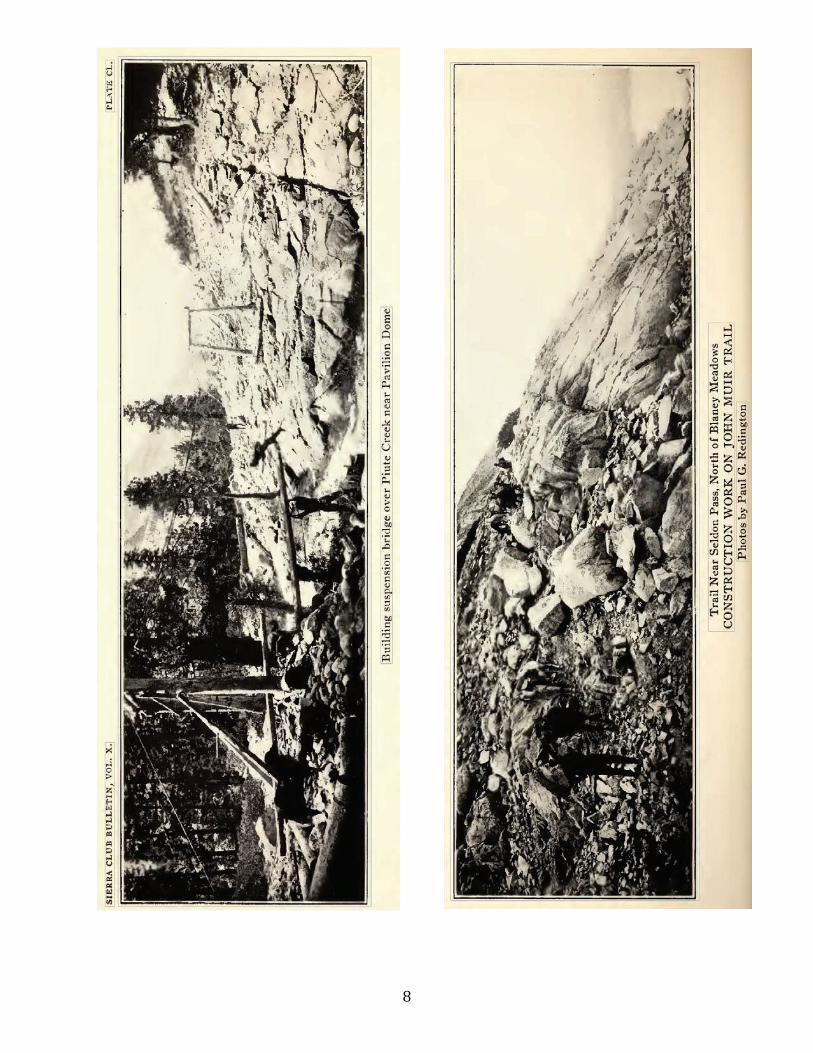
Bridges. One bridge, that across the mouth of French Canon, was built. This bridge is one of the most
important features of the entire project. Recommendations. It is recommended that if we continue to work another year, we be notified at the start
of the work of any overhead to be charged against the season's allotment by the State Engineer's office. It is also recommended that all checks for labor be sent to the addresses of the individuals listed on the
payrolls, or if this is not feasible, to the Forest Supervisor at his official address. This year checks were sent in one instance in care of the man who happened to have signed the payroll as acting supervisor. He was on leave, and delivery of the checks was delayed until the rangers felt it wise to avoid the neighborhood of the men who had money coming to them. In a sense the Forest Service, in having field charge of the work, is looked to for payment, and delay therefore is blamed to the field officers. This is not fair and can be avoided next year by following the above recommendation.
We shall keep in mind the State Engineer's suggestion of obtaining outfits from the east side of the
mountains. The feasibility of this is doubted, since we could not satisfactorily pick our personnel and would have to hire unknown packers. Furthermore, the summit passes cannot usually be crossed by animals in June, when we would want to start work, and could get to the job readily from this side.
Acknowledgment! Desire to place on record my appreciation of the interest taken in the work by the men
engaged in it, with particular reference to Forest Rangers Roy Boothe and Frank Price and Assistant Ranger Mark Cathey. The task of overseeing the packing of powder, steel, supplies, etc., over difficult mountain trails, and of handling men, the best of whom grow sick and tired of the isolation and monotony of camp fifty to seventy miles from civilization, is no small one and requires lots of patience and tact. I am glad to say that the work was so handled that many of the men who worked on the job this summer, and who are experienced, have asked to be considered for employment next season. Respectfully submitted, Paul Redington, Forest Supervisor
7
Northfork, California, November 22, 1915.
REPORT ON JOHN MUIR TRAIL WORK, SEQUOIA NATIONAL FOREST
The route of the trail within the Sequoia National Forest was not definitely determined as early as in the Sierra National Forest, but, in the short period remaining after the final determination was made and before the close of the field season, good progress was made. The following expenditures were made for trail work within the Sequoia National Forest from the appropriation for the John Muir Trail:
Wages $650.50 Subsistence supplies $209.47 Other supplies and equipment $281.50 Freight, express and hauling $104.42 Total $1,245.89
Approximately six miles of the hardest portion of the trail is completed, and a route between Kern and
Kings rivers is opened. A portion of the trail at the head of Shepherd's Creek was completed with cooperative funds (not from John Muir Trail appropriation) at an expense of $200.00. This makes the total cost of the trail $1,445.89. Of the $1,245.89 from the John Muir Trail appropriation, $76.60 was expended for camp equipment and tools, and $1,169.29 for actual trail construction. With the additional $200.00 co-operative funds, the average cost per mile for the six miles, exclusive of camp equipment, was $228.21.
Ranger Parkinson, who was directly in charge of the work, reported on October 8: With the remainder of the appropriation a passable trail for saddle and pack animals will be completed
from Yosemite to Mount Whitney during the field season of 1916. Further appropriations must be secured to construct that part of the official John Muir Trail from Grouse Meadow easterly up Palisade Creek, over the pass from Palisade Creek to the South Fork of Kings River, down the latter and thence via Rae Lake and Glenn Pass to Bubbs Creek. Additional expenditures for the improvement of many places in the trail are also desirable. It is hoped that, after the splendid work accomplished, and with increasing favorable public sentiment, additional appropriations will be secured.
)!