Embed Size (px)
Citation preview
FINAL
Shoreline Restoration Plan for City of Carnation’s Shorelines: Tolt and Snoqualmie Rivers
City of Carnation4621 Tolt AvenueCarnation WA 98014
Prepared for:
June 2011

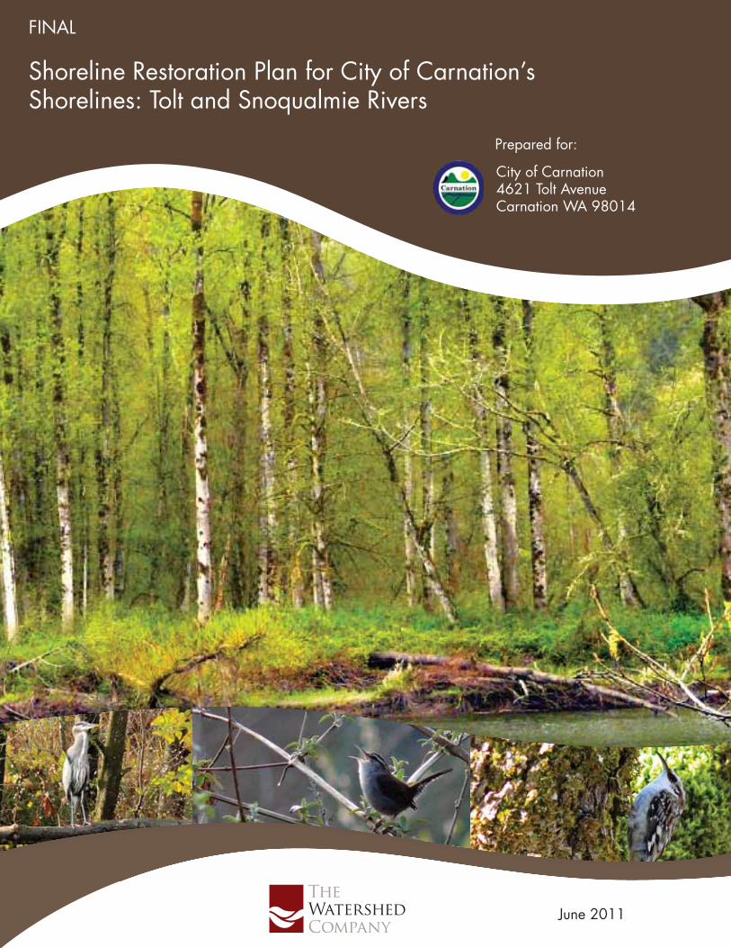
Cover photos by Hugh Jennings of Eastside Audubon.
FINAL CITY OF CARNATION GRANT NO. G1000005
S H O R E L I N E R E S T O R A T I O N P L A N for City of Carnation’s Shorelines: Tolt and Snoqualmie Rivers
Prepared for:
Prepared by:
June 23, 2011
The Watershed Company Reference Number:
090608
The Watershed Company Contact Person:
Amy Summe
City of Carnation 4621 Tolt Avenue Carnation, WA 98014
This report was funded in part through a grant from the Washington Department of Ecology.

Cite this document as: The Watershed Company. June 2011. Final Shoreline Restoration Plan for City of
Carnation’s Shorelines: Tolt and Snoqualmie Rivers. Prepared for the City of Carnation, Carnation, WA.
TA B L E O F C O N T E N T S Page #
1.0 Introduction ....................................................................................... 1
2.0 Shoreline Inventory Summary ......................................................... 2
2.1 Introduction ...................................................................................................... 2 2.2 Shoreline Boundary ......................................................................................... 3 2.3 Inventory and Analysis .................................................................................... 3
2.3.1 Land Use and Physical Conditions ............................................................. 4 2.3.2 Biological Resources and Critical Areas ..................................................... 8
3.0 Restoration Goals and Objectives .................................................. 9
4.0 Ongoing City Plans and Programs ................................................ 10
4.1 Comprehensive Plan ..................................................................................... 10 4.2 City of Carnation Critical Areas Regulations ................................................. 11 4.3 City of Carnation Stormwater Management .................................................. 11 4.4 City of Carnation Floodways and Floodplains Regulations ........................... 11 4.5 Six-Year Transportation Improvement Plan .................................................. 12 4.6 Programmatic Habitat Assessment ............................................................... 12
5.0 Partnerships .................................................................................... 12
5.1 Washington State Department of Ecology ..................................................... 12 5.2 Washington State Conservation Commission ............................................... 12 5.3 Puget Sound Partnership .............................................................................. 13 5.4 Snohomish River Basin Salmon Recovery Forum ........................................ 14 5.5 Snoqualmie Watershed Forum ...................................................................... 16 5.6 King County Department of Natural Resources and Parks ........................... 17
5.6.1 King County Shoreline Master Program ................................................... 17 5.6.2 King County River and Floodplain Management Section ......................... 17 5.6.3 King County Parks .................................................................................... 19 5.6.4 Carnation Wastewater Treatment Facility ................................................. 19
5.7 King Conservation District ............................................................................. 19 5.8 Sound Salmon Solutions ............................................................................... 20 5.9 City of Seattle ................................................................................................ 20 5.10 Stewardship Partners .................................................................................... 21 5.11 Eastside Audubon Society ............................................................................. 21 5.12 Other Environmental Organizations .............................................................. 21
6.0 Potential Projects ........................................................................... 22
7.0 Strategies to Achieve Local Restoration Goals ........................... 22
7.1 City Planning ................................................................................................. 28 7.2 Development Opportunities ........................................................................... 28
Final City of Carnation Shoreline Restoration Plan
7.3 Development Incentives ................................................................................ 29 7.4 Resource Directory ........................................................................................ 29 7.5 Volunteer Coordination .................................................................................. 30 7.6 Regional Coordination ................................................................................... 30
8.0 Proposed Implementation Targets and Monitoring Methods ..... 30
8.1 Project Evaluation .......................................................................................... 30 8.2 Monitoring and Adaptive Management .......................................................... 31 8.3 Reporting ....................................................................................................... 32
9.0 References ...................................................................................... 35
L I S T O F TA B L E S Table 1. Area of shoreline jurisdiction. .......................................................................... 4 Table 2. Impervious surface, shoreline modification, and flood hazard by shoreline
reach. ............................................................................................................... 7 Table 3. Potential site-specific projects in and around the City’s shorelines. Projects
are organized by location relative to the City of Carnation. Locations are mapped in Figure 2. ....................................................................................... 24
Table 4. Examples of ongoing and proposed programs in and around the City of Carnation to protect and restore shorelines. ................................................. 28
Table 5. Implementation Schedule and Funding for Restoration Projects, Programs and Plans. ...................................................................................................... 33
L I S T O F F I G U R E S Figure 1. Map of Shoreline Jurisdiction (hatched area) and Shoreline Assessment Units5 Figure 2. Map of Potential Shoreline Restoration Opportunities Based on Opportunities
Identified in Table 3. Locations are approximate. ......................................... 26
The Watershed Company June 2011
1
SHORELINE RESTORATION PLAN CITY OF CARNATION
1.0 INTRODUCTION The City of Carnation’s Shoreline Master Program applies to activities in the shoreline jurisdiction zone. Activities that have adverse effects on the ecological functions and values of the shoreline must be mitigated. By law, the proponent of that activity is required to return the subject shoreline to a condition equivalent to the baseline level at the time the activity takes place. It is understood that some uses and developments cannot always be mitigated fully, resulting in incremental and unavoidable degradation of the baseline condition. The subsequent challenge is to improve the shoreline over time in areas where the baseline condition is degraded, severely or marginally.
WAC Section 173-26-201(2)(f) of the Shoreline Master Program Guidelines (Guidelines)1 says:
“master programs shall include goals and policies that provide for restoration of such impaired ecological functions. These master program provisions shall identify existing policies and programs that contribute to planned restoration goals and identify any additional policies and programs that local government will implement to achieve its goals. These master program elements regarding restoration should make real and meaningful use of established or funded non-regulatory policies and programs that contribute to restoration of ecological functions, and should appropriately consider the direct or indirect effects of other regulatory or non-regulatory programs under other local, state, and federal laws, as well as any restoration effects that may flow indirectly from shoreline development regulations and mitigation standards.”
Degraded shorelines are not just a result of pre-Shoreline Master Program activities, but also of unregulated activities and exempt development. The new Guidelines also require that “[l]ocal master programs shall include regulations ensuring that exempt development in the aggregate will not cause a net loss of ecological functions of the shoreline.” While some actions within shoreline jurisdiction are exempt from a permit, the Shoreline Master Program should clearly state that those actions are not exempt from compliance with the Shoreline Management Act or the local Shoreline Master Program. Because the shoreline environment is also affected by activities taking place outside of a specific local master program’s jurisdiction (e.g., outside of city limits,
1 The Shoreline Master Program Guidelines were prepared by the Washington Department of Ecology and codified as WAC 173-26. The Guidelines translate the broad policies of the Shoreline Management Act (RCW 90.58.020) into standards for regulation of shoreline uses. See http://www.ecy.wa.gov/programs/sea/sma/guidelines/index.html for more background.
Final City of Carnation Shoreline Restoration Plan
2
outside of the shoreline area within the city), assembly of out-of-jurisdiction actions, programs and policies can be essential for understanding how the City fits into the larger watershed context. The latter is critical when establishing realistic goals and objectives for dynamic and highly inter-connected environments.
Restoration of shoreline areas, in relation to shoreline processes and functions, commonly refers to methods such as re-vegetation, removal of invasive species or toxic materials, and removal of shoreline modifications, such as levees or revetments. Consistent with Ecology’s definition, use of the word “restore,” or any variations, in this document is not intended to encompass actions that reestablish historic conditions. Instead, it encompasses a suite of strategies that can be approximately delineated into four categories:
• Creation (of a new resource)
• Restoration (of a converted or substantially degraded resource)
• Enhancement (of an existing degraded resource)
• Protection (of an existing high-quality resource).
As directed by the Guidelines, the following discussions provide a summary of baseline shoreline conditions, list restoration goals and objectives, and discuss existing or potential programs and projects that positively impact the shoreline environment. In total, implementation of the Shoreline Master Program (with mitigation of project-related impacts) in combination with this Restoration Plan (for restoration of lost ecological functions that occurred prior to a specific project) should result in a net improvement in the City of Carnation’s shoreline environment in the long term.
In addition to meeting the requirements of the Guidelines, this Restoration Plan is also intended to support the City’s or other non-governmental organizations’ applications for grant funding, and to identify the various entities and their roles working within the City to enhance the environment.
2.0 SHORELINE INVENTORY SUMMARY 2.1 Introduction
The City recently completed a comprehensive inventory and analysis of its shorelines (January 2011) as an element of its Shoreline Master Program update. The purpose of the shoreline inventory and analysis was to gain a greater understanding of the existing condition of Carnation’s shoreline environment to ensure the updated Shoreline Master Program policies and regulations will protect local ecological processes and functions. The inventory describes existing physical and biological conditions in shoreline jurisdiction within City limits and the urban growth area and includes
The Watershed Company June 2011
3
recommendations for restoration of ecological functions where they are degraded. The Shoreline Analysis Report for City of Carnation’s Shoreline: Tolt River and Snoqualmie River (TWC 2011) is summarized below.
2.2 Shoreline Boundary
As defined by the Shoreline Management Act of 1971, shorelines include certain waters of the state plus their associated “shorelands.” At a minimum, the waterbodies designated as shorelines of the state are streams whose mean annual flow is 20 cubic feet per second (cfs) or greater and lakes whose area is greater than 20 acres. Shorelands are defined as:
“those lands extending landward for 200 feet in all directions as measured on a horizontal plane from the ordinary high water mark; floodways and contiguous floodplain areas landward 200 feet from such floodways; and all wetlands and river deltas associated with the streams, lakes, and tidal waters which are subject to the provisions of this chapter…Any county or city may determine that portion of a one-hundred-year-floodplain to be included in its master program as long as such portion includes, as a minimum, the floodway and the adjacent land extending landward two hundred feet therefrom… Any city or county may also include in its master program land necessary for buffers for critical areas (RCW 90.58.030)”
The City adopted its first SMP in 1974 and significantly updated the document in 1999, though this latter version was not adopted or implemented. In addition, the City’s Comprehensive Plan Environmental Element contains several goals and policies specific to shoreline protection and enhancement. Other goals and policies located in the Comprehensive Plan also recognize and encourage protection or enhancement of and access to the City’s shorelines.
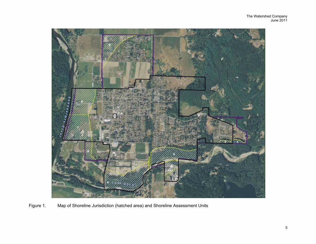
The City’s shoreline management area includes the shorelines of the Tolt River and the Snoqualmie River. The Tolt River runs along the southern edge of the City, and the Snoqualmie River runs along the City’s western edge. Figure 1 provides a map of the City’s shoreline jurisdiction.
2.3 Inventory and Analysis
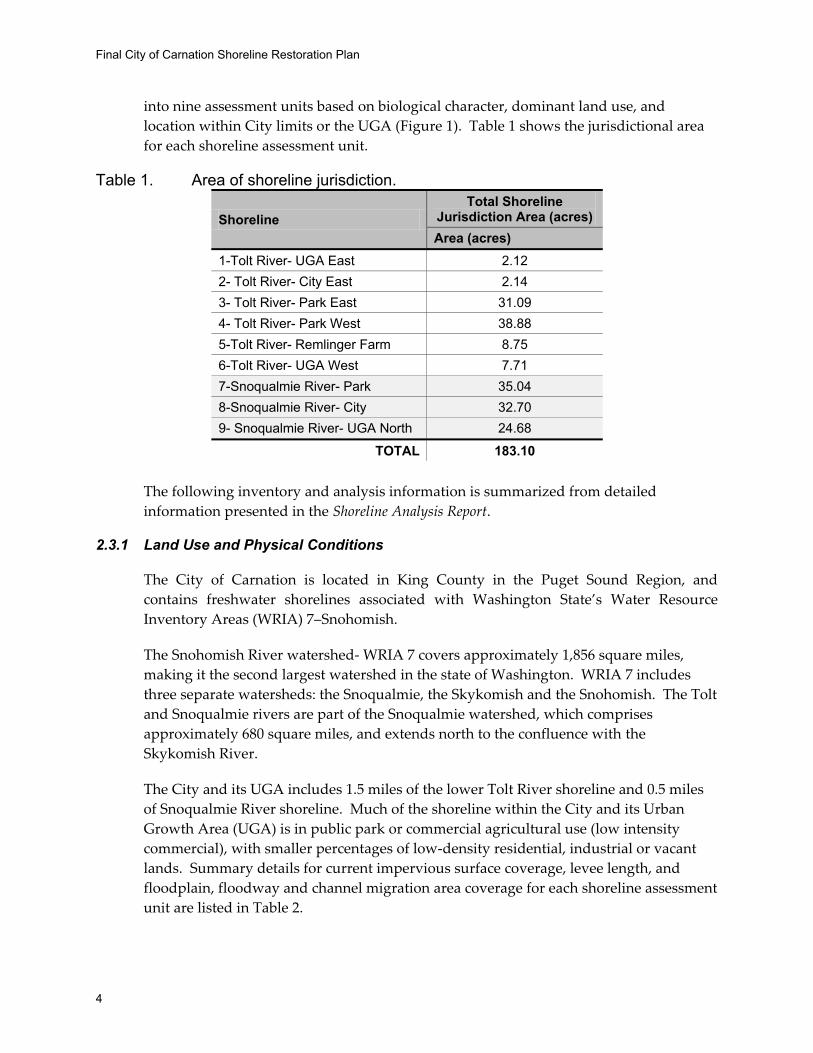
The City of Carnation’s shoreline inventory encompasses shoreline jurisdiction currently within the City and the urban growth area (see the Shoreline Analysis Report –Appendix A (TWC 2011)). The total area subject to the City’s updated SMP, not including aquatic area, is approximately 183.10 acres, and encompasses approximately 10,331 linear feet of shoreline.
In order to break down the shoreline into manageable units and to help evaluate differences between discrete shoreline areas, the City’s shorelines have been divided
Final City of Carnation Shoreline Restoration Plan
4
into nine assessment units based on biological character, dominant land use, and location within City limits or the UGA (Figure 1). Table 1 shows the jurisdictional area for each shoreline assessment unit.
Table 1. Area of shoreline jurisdiction.
Shoreline Total Shoreline
Jurisdiction Area (acres) Area (acres)
1-Tolt River- UGA East 2.12 2- Tolt River- City East 2.14 3- Tolt River- Park East 31.09 4- Tolt River- Park West 38.88 5-Tolt River- Remlinger Farm 8.75 6-Tolt River- UGA West 7.71 7-Snoqualmie River- Park 35.04 8-Snoqualmie River- City 32.70 9- Snoqualmie River- UGA North 24.68
TOTAL 183.10
The following inventory and analysis information is summarized from detailed information presented in the Shoreline Analysis Report.
2.3.1 Land Use and Physical Conditions
The City of Carnation is located in King County in the Puget Sound Region, and contains freshwater shorelines associated with Washington State’s Water Resource Inventory Areas (WRIA) 7–Snohomish.
The Snohomish River watershed- WRIA 7 covers approximately 1,856 square miles, making it the second largest watershed in the state of Washington. WRIA 7 includes three separate watersheds: the Snoqualmie, the Skykomish and the Snohomish. The Tolt and Snoqualmie rivers are part of the Snoqualmie watershed, which comprises approximately 680 square miles, and extends north to the confluence with the Skykomish River.
The City and its UGA includes 1.5 miles of the lower Tolt River shoreline and 0.5 miles of Snoqualmie River shoreline. Much of the shoreline within the City and its Urban Growth Area (UGA) is in public park or commercial agricultural use (low intensity commercial), with smaller percentages of low-density residential, industrial or vacant lands. Summary details for current impervious surface coverage, levee length, and floodplain, floodway and channel migration area coverage for each shoreline assessment unit are listed in Table 2.
The Watershed Company June 2011
5
Figure 1. Map of Shoreline Jurisdiction (hatched area) and Shoreline Assessment Units
Final City of Carnation Shoreline Restoration Plan
6
THIS PAGE INTENTIONALLY LEFT BLANK
The Watershed Company June 2011
7
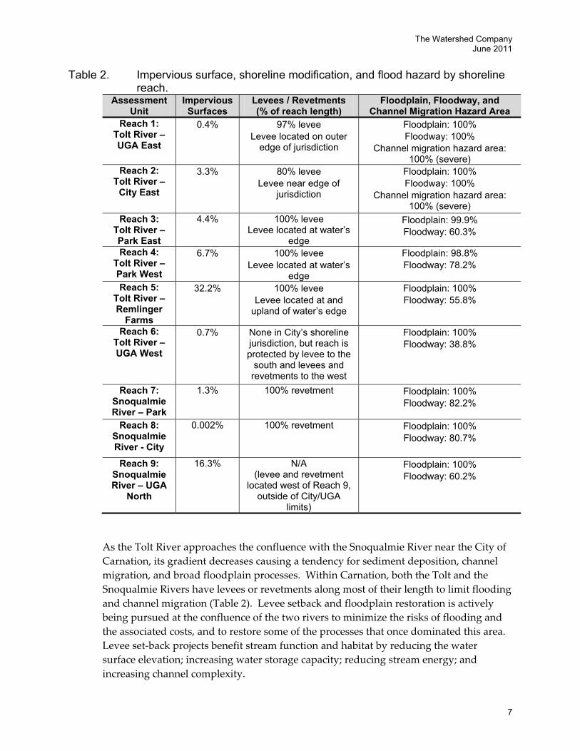
Table 2. Impervious surface, shoreline modification, and flood hazard by shoreline reach.
Assessment Unit
Impervious Surfaces
Levees / Revetments (% of reach length)
Floodplain, Floodway, and Channel Migration Hazard Area
Reach 1: Tolt River – UGA East
0.4% 97% levee Levee located on outer
edge of jurisdiction
Floodplain: 100% Floodway: 100%
Channel migration hazard area: 100% (severe)
Reach 2: Tolt River –
City East
3.3% 80% levee Levee near edge of
jurisdiction
Floodplain: 100% Floodway: 100%
Channel migration hazard area: 100% (severe)
Reach 3: Tolt River – Park East
4.4% 100% levee Levee located at water’s
edge
Floodplain: 99.9% Floodway: 60.3%
Reach 4: Tolt River – Park West
6.7% 100% levee Levee located at water’s
edge
Floodplain: 98.8% Floodway: 78.2%
Reach 5: Tolt River – Remlinger
Farms
32.2% 100% levee Levee located at and
upland of water’s edge
Floodplain: 100% Floodway: 55.8%
Reach 6: Tolt River – UGA West
0.7% None in City’s shoreline jurisdiction, but reach is protected by levee to the
south and levees and revetments to the west
Floodplain: 100% Floodway: 38.8%
Reach 7: Snoqualmie River – Park
1.3% 100% revetment Floodplain: 100% Floodway: 82.2%
Reach 8: Snoqualmie River - City
0.002% 100% revetment Floodplain: 100% Floodway: 80.7%
Reach 9: Snoqualmie River – UGA
North
16.3% N/A (levee and revetment
located west of Reach 9, outside of City/UGA
limits)
Floodplain: 100% Floodway: 60.2%
As the Tolt River approaches the confluence with the Snoqualmie River near the City of Carnation, its gradient decreases causing a tendency for sediment deposition, channel migration, and broad floodplain processes. Within Carnation, both the Tolt and the Snoqualmie Rivers have levees or revetments along most of their length to limit flooding and channel migration (Table 2). Levee setback and floodplain restoration is actively being pursued at the confluence of the two rivers to minimize the risks of flooding and the associated costs, and to restore some of the processes that once dominated this area. Levee set-back projects benefit stream function and habitat by reducing the water surface elevation; increasing water storage capacity; reducing stream energy; and increasing channel complexity.
Final City of Carnation Shoreline Restoration Plan
8
Tourist-based agricultural uses adjacent to the Snoqualmie River are unlikely to change as they are planned for Low Intensity Commercial land uses and zoned Horticultural Commercial. Agricultural uses adjacent to the Tolt MacDonald Park and agri-tourism property south of the Tolt River (Remlinger Farms) are planned for High Intensity Commercial uses.
Future residential uses on undeveloped or vacant lands are planned as Low and Medium Density Residential use. Ten percent of the shoreline jurisdiction is considered vacant and designated for residential uses, and this represents a small portion of the citywide residential capacity. Residential capacity within shoreline jurisdiction is located in Reach 3 and would be part of the Swiftwater neighborhood. The residential capacity in Reach 9 has been reduced by FEMA’s recently revised flood mapping of the Snoqualmie, which identifies much of the area as floodway.
2.3.2 Biological Resources and Critical Areas
Priority species within the City’s jurisdiction on the Tolt and Snoqualmie Rivers include federally threatened Chinook salmon, bull trout, and steelhead trout, as well as state priority species: chum, coho, and pink salmon and resident cutthroat trout. The coarse gravel and cobbles that are deposited by the Tolt River within the City’s shorelines in both the Tolt and the Snoqualmie Rivers provide some of the best spawning habitat in the Snoqualmie River watershed.
The Tolt River Natural Area, Tolt MacDonald Park, and the recently completed Lower Tolt River Floodplain Restoration Project provide significant habitat diversity and area for wildlife. City parks, vacant land, and agricultural land along the Tolt and Snoqualmie Rivers provide habitat corridors for wildlife. The City’s shorelines provide habitat for large and small mammals, as well as songbirds and birds of prey.
The City’s critical areas regulations protect wetlands, geologically hazardous areas (areas susceptible to erosion, landslides, seismic events, liquification, and other geologic events), aquifer recharge areas, and fish and wildlife habitat areas, including streams, creeks, lakes, and other surface water. Flood hazard areas are regulated under the City’s floodplain regulations. The inventory mapping of critical areas, provided as a part of this Shoreline Master Program update, was based on a wide range of information sources, including City GIS, critical area inventories, Washington Department of Fish and Wildlife databases, and other relevant maps and literature obtained from the Washington Department of Natural Resources (DNR), Ecology, National Marine Fisheries Service, and U.S. Fish and Wildlife Service.
Nearly all of the City’s shorelines fall within FEMA’s mapped floodplain, and much of the shoreline land also falls within the floodway (see Table 2 for details).
The Watershed Company June 2011
9
3.0 RESTORATION GOALS AND OBJECTIVES
Goals for restoring the City of Carnation’s shoreline are presented in the Conservation Element of the City’s 2011 Shoreline Master Program. Restoration goals relevant to the City and its SMP are identified below. For each goal, specific objectives were developed based on City policies and existing conditions. Objectives refer to specific actions, ideally measurable, that can be taken to achieve the stated goals. Many goals are interrelated, thus one objective may contribute to achieving several goals; however, for organizational purposes, objectives are only listed with the most relevant goal. Goals and associated objectives are identified below, and not listed in any prioritized order.
Goal 1. Protect and preserve natural areas and shoreline vegetation.
Objective A. Minimize development activities that will interfere with the natural functioning of shoreline ecosystems. Such activities include, but are not limited to, those that alter shoreline stability, drainage, aesthetic values and water quality.
Objective B. Prohibit public access onto areas where the environment, ecology, or ecosystems is likely to be threatened or harmed by human use, activity or development.
Objective C. Maintain and enhance vegetation needed to achieve the full range of ecological functions necessary for the integrity of shoreline ecosystems.
Goal 2. Preserve, protect, enhance, and restore shoreline resources, features, functions. and processes, including forested areas, wetlands, wildlife habitat, and river processes.
Objective A. Develop policies and regulations to ensure that shoreline uses, activities and developments are located, designed, constructed and managed to prevent and minimize adverse impacts on those natural features which are valuable, fragile or unique within Carnation and the Snoqualmie Basin.
Objective B. Protect and preserve the existing diversity of vegetation and habitat functions and values, wetlands, and riparian corridors associated with shoreline areas.
Goal 4. Protect and improve water quality.
Objective A. Develop policies and regulations to ensure that water quality is protected to the greatest extent possible through the use of all
Final City of Carnation Shoreline Restoration Plan
10
reasonably feasible methods and equipment, including, but not limited to, best management practices (BMPs).
Objective B. Protect and restore native plant communities within shoreline areas.
Goal 5 Reclaim and restore biologically and aesthetically degraded areas to the greatest extent possible.
Objective A. Develop policies and regulations to ensure that project proponents restore, replace, or mitigate for all fish or wildlife habitat damaged or degraded as a result of their project.
Objective B. Pursue opportunities to restore currently degraded conditions.
Goal 6 Preserve the scenic aesthetic quality of shoreline areas and vistas to the greatest extent feasible.
Objective A. Encourage public access and recreational activities that preserve shoreline character, scenic quality and shoreline natural functions and values whenever feasible.
These goals and objectives provide direction and guidance for developing and focusing the restoration plan. Objectives help define projects and programs needed to protect and restore natural processes and ecological functions. Measurable performance standards may be developed in the future based on the goals and objectives to quantify ecological change. These performance standards go beyond the scope of this document, but may be developed and monitored as individual projects and programs are implemented.
4.0 ONGOING CITY PLANS AND PROGRAMS The City of Carnation implements elements of the Growth Management Act through the adoption of the City’s Comprehensive Plan and the Carnation Municipal Code, which includes Critical Areas Regulations that apply outside of shoreline jurisdiction. The City also implements stormwater regulations, and is in the process of reviewing flood regulations.
4.1 Comprehensive Plan
The City of Carnation Comprehensive Plan (City of Carnation 2004, as amended) defines goals addressing the environment in its Environmental element. Each goal is accompanied by policies intended to guide progress toward the goal. Several of these goals and policies relate directly to conservation of shoreline resources.
The Watershed Company June 2011
11
4.2 City of Carnation Critical Areas Regulations
The City of Carnation’s critical areas regulations, which apply outside of shoreline jurisdiction, are found in Carnation Municipal Code Chapter 15.88. The regulations are based on best available science, and provide protection to critical areas in the City, including streams, lakes, wetlands, geologically hazardous areas, and fish and wildlife habitat conservation areas. Some of the basic components of the critical areas regulations include adoption of the five-tiered waterways system outlined in WAC 222-16-031, with standard buffers ranging between 25 and 115 feet for Class 2 through 5 waters.
The Tolt and Snoqualmie Rivers are both identified as “Class 1 watercourses” and are regulated by the SMP and the critical areas regulations contained in Appendix A of the SMP. Critical areas regulations also apply to wetlands using Ecology’s four-tiered wetland rating system for Western Washington with standard buffers ranging from 35 to 300 feet depending on the rating of the wetland and the intensity of adjacent land use. Management of the City’s critical areas using these regulations should help ensure that ecological functions and values are not degraded and impacts to critical areas are mitigated. These critical areas regulations are important tools that will help the City meet its restoration goals.
4.3 City of Carnation Stormwater Management
The City of Carnation does not own or operate a stormwater utility to collect, treat, or manage stormwater runoff. Thus, City stormwater management must be accomplished through policies and regulations that promote or require on-site infiltration. The City amended its stormwater management regulations in July 2010 (CMC 15.64, Ordinance 781§2). These regulations require that the rate of stormwater discharge resulting from new development or redevelopment not exceed the predevelopment peak flow rate. The regulations refer to the Washington Department of Ecology’s 2005 Stormwater Management Manual for Western Washington for minimum stormwater management requirements.
4.4 City of Carnation Floodways and Floodplains Regulations
Chapter 15.64.I of the Carnation Municipal Code (outside shoreline jurisdiction) and Section 1.700 of Appendix A of the SMP (for shoreline jurisdiction) addresses floodway and floodplain regulations. The City identified several purposes for developing the new section, including protecting human life and health and minimizing expenditure of public money for costly flood damage repair and flood control projects.
The City is currently evaluating its floodplain regulations to assess compliance with new requirements by FEMA related to federal endangered fish species protection.

Final City of Carnation Shoreline Restoration Plan
12
4.5 Six-Year Transportation Improvement Plan
The City developed and adopted a new Six Year Transportation Improvement Plan in 2010. One project recommendation in the Plan includes storm drainage improvement on NE 40th St between Highway 203 and Tolt MacDonald Park. It is expected that improved storm drainage along this access road would have the potential to improve water quality within the City’s shoreline jurisdiction.
4.6 Programmatic Habitat Assessment
In partnership with King County Department of Natural Resources, the City is preparing a Programmatic Habitat Assessment to identify habitat enhancement opportunities on public lands. Enhancement actions could be used to offset development impacts in the floodplain. The assessment should be completed in late summer to fall 2011.
5.0 PARTNERSHIPS With projected budget and staff limitations, the City of Carnation is limited in implementing restoration projects or programs on its own. However, regional, local agencies and organizations are active in Carnation and the surrounding area. The City’s SMP represents an important vehicle for facilitating and guiding restoration projects and programs in partnership with other government agencies or private and/or non-profit entities. The City can provide cooperation, direction, and leadership to assure that project/program designs meet identified goals. The City’s partners and their local roles in shoreline protection and/or restoration are identified below and generally organized in order by the scope of the organization, from the larger state and watershed scale to the City-scale in the Carnation area.
5.1 Washington State Department of Ecology
The City of Carnation continues to utilize Ecology staff as a resource for technical support and regulatory assistance when needed. The City’s stormwater regulations refer to Ecology’s 2005 Stormwater Management Manual for Western Washington for minimum stormwater standards.
5.2 Washington State Conservation Commission
The completion of the 2002 Salmonid Habitat Limiting Factors Analysis for the Snohomish River Watershed (WRIA) 7 was a collaborative effort of the Washington State Conservation Commission and the Watershed Lead Entities. The document identifies areas and functions in the Snohomish watershed in need of protection and restoration, as well as data gaps.
The Watershed Company June 2011
13
The WRIA 7 report identifies several action recommendations for the lower Snoqualmie River mainstem. The following recommendations are applicable to the shoreline in the City’s vicinity:
Restore riparian function where impaired (with particular consideration to restoring conifer presence) to increase shading of the channel and provide LWD recruitment;
Connect floodplain oxbow ponds and wetlands with the river to provide off-channel rearing habitat;
Restore valley-marginal wetlands that formerly existed in low-elevation areas outside the meander belt;
Restore natural floodplain configuration of tributary creeks; and
Implement agricultural best management practices, including elimination of unrestricted livestock access to the river and associated oxbow ponds and wetlands.
Action recommendations for the Tolt River watershed include: Restore floodplain function in lower 2 miles of the Tolt River by removal or setback
of existing levees; Restore natural floodplain function through acquisition of floodplain properties in
the lower 6 miles of the Tolt River; Assess opportunities in the NF and SF Tolt rivers for restoration of instream habitat
diversity and riparian function; and Prioritize and correct identified fish passage barriers.
5.3 Puget Sound Partnership
The Puget Sound Partnership consists of representatives from a variety of interests from the Puget Sound region, including business, agriculture, the shellfish industry, environmental organizations, local governments, tribal governments, and the Washington state legislature. Some of the Partnership’s key tasks are as follows:
Develop a set of recommendations for the Governor, the Legislature and Congress to preserve the health of Puget Sound by 2020 and ensure that marine and freshwaters support healthy populations of native species as well as water quality and quantity to support both human needs and ecosystem functions.
Engage citizens, watershed groups, local governments, tribes, state and federal agencies, businesses and the environmental community in the development of recommendations.
Review current and potential funding sources for protection and restoration of the ecosystem and, where possible, make recommendations for the priority of expenditures to achieve the desired 2020 outcomes.
Final City of Carnation Shoreline Restoration Plan
14
The Partnership through the Leadership Council released an Action Agenda in December 2008. Implementation of this Action Agenda has resulted in State and Federal funding of restoration and protection initiatives and projects. The Puget Sound Partnership, in coordination with local governments and non-profits, is sponsoring the ‘Puget Sound Starts Here’ campaign to educate the public in the region about non-point source stormwater impacts on water quality. The campaign is focused on simple, clear messaging and marketing to raise awareness and effect behavior change.
5.4 Snohomish River Basin Salmon Recovery Forum
The City is a member of the Snohomish River Basin Salmon Recovery Forum (Forum). The Forum is a cooperative effort to guide protection and restoration actions in the Snohomish River Basin. Members include Snohomish and King Counties, tribes, 14 cities, special purpose districts, interest groups, and citizens. Assisted by a Policy Development Committee and the Snohomish Basin Salmonid Recovery Technical Committee, the group set the recovery priorities for the basin in the Snohomish River Basin Salmon Conservation Plan (Snohomish Basin Salmon Recovery Forum 2005). The Plan is a multi-salmonid strategy emphasizing conservation and recovery of Chinook, bull trout and coho salmon, and using them as proxies for other species as well. Recovery strategies in the Plan are:
1. Protection efforts – this involves acquisitions, regulations, incentives, education and outreach.
2. Restoration efforts – evaluate current/potential fish use, habitat conditions, and watershed conditions; use results to develop an overall basin restoration strategy, identify limiting factors in sub-basins, and develop hypotheses and strategies for each sub-basin group; develop alternatives for focusing efforts, including specific restoration sites; and model Plan alternatives.
3. Harvest and hatchery – this is an ongoing multi-entity effort.
4. Integrated recovery plan – the Plan was developed in a coordinated fashion, addressing habitat, harvest and hatchery together.
5. Adaptive management – governed by monitoring efforts.
In addition to these general strategies, the Plan identifies strategies for the “mainstem- primary restoration” group, which includes the Lower Snoqualmie River and Lower Tolt River. This strategy group contains the core Chinook salmon spawning and rearing habitat, as well as important bull trout habitat for rearing, sub-adult overwintering, and adult foraging. The mainstem-primary restoration group also comprises migratory habitat for all salmonids in the basin. The recommended recovery focus for the mainstem-primary restoration is “Watershed process restoration focused on restoring forests, increasing floodplain connectivity, and increasing channel complexity. The greatly diminished
The Watershed Company June 2011
15
quantity and quality of rearing habitat, particularly along the channel margins, is thought to be the primary bottleneck. Proposed restoration actions will also improve spawning conditions by reducing fine sediment intrusion and redd scouring and increasing the area of holding pools.” The primary ecological actions that would contribute to recovery in this strategy group are listed as:
1. Preserve and protect the remaining and best habitat along critical reaches; prevent further floodplain development or fill; maintain opportunity for rivers to migrate, protect intact riparian forests and off-channel habitats.
2. Protect hydrologic and sediment processes; protect wetlands; minimize increase in impervious surfaces; retain forest cover; and prevent urban sprawl.
3. Remove human-made instream barriers along or adjacent to priority stream reaches.
4. Reconnect off-channel habitats to provide rearing habitat. 5. Restore shorelines by removing riprap and using large woody debris to protect
property where necessary. 6. Restore hydrologic and sediment processes; increase wetland functions;
reconnect floodplains; reduce impervious surfaces; and replant forests. 7. Enhance riparian zones to improve habitat and protect streams from urban
impacts.
The Plan provides more general policy recommendations for floodplain alterations and channel migration zones as follows:
“Floodplain Alterations - Maintaining natural connections between rivers and floodplains helps sustain processes that enhance salmon habitat.
1. Discourage new development in the floodplain through critical areas regulations or other flood hazard management regulations. Development should only be allowed where it can be shown that these activities will not increase flood elevations, decrease storage capacity, or restrict the natural erosion and accretion processes associated with channel migration. Where development is allowed in the floodplain, such as in urban areas, restoration and enhancement of floodplain habitat may be necessary.”
“Channel Migration Zones - Channel migration zones typically refer to the lateral extent of likely movement along a stream reach with evidence of active stream channel movement over the past one hundred years. Some definitions, mapping, and designations of channel migration zones reflect physical constraints from maintained roads, dikes, and levees.
1. Designate channel migration zones as critical areas because they are geologically hazardous and important fish and wildlife conservation areas. Map the location of severe and moderate channel migration hazard areas
Final City of Carnation Shoreline Restoration Plan
16
using most up-to-date criteria of state and local governments and adopt maps by administrative rule or through critical areas regulations.
2. Minimize adverse impacts in existing channel migration zones. Local governments should protect channel migration zones through a variety of tools including, but not limited to, regulations, zoning, purchase or transfer of development rights, purchase, and shoreline designations. This is not intended to prevent modifications of dikes and levees that would enhance floodplain habitat functions and values.
3. Discourage new dwelling units or expansion of existing structures within the channel migration zone. Inform those wishing to build in these areas of the value of natural channel migration for salmon habitat and the hazards it poses for development.
4. Allow no new or expanded channel stabilization projects or other river control structures, unless protecting existing essential facilities, to protect development in the channel migration zone.
5. Avoid the expansion of existing uses or structures that are toward any source of channel migration within channel migration zones.
6. Avoid the construction of new primary dwelling units within channel migration zone hazard areas unless no feasible alternative location is available.”
An Ecosystem Diagnosis and Treatment (EDT) model was used to identify an implementation sequence for stream reaches in the Snoqualmie Watershed. The results ranked the Snoqualmie River from Harris Creek to the Tolt River as the highest priority for restoration because of the high portion of land in public ownership, its restoration potential, and its importance for salmonid spawning habitat. The lower Tolt River also ranked high in the EDT sequencing because of its influence on the mainstem Snoqualmie River at the confluence.
Each year the Forum develops a three-year work plan that highlights the highest priority actions within the watershed. Several projects within the City of Carnation were included in the 2010 WRIA 7 three-year work plan (Table 3).
5.5 Snoqualmie Watershed Forum
The Snoqualmie Watershed Forum is a partnership between the Snoqualmie Tribe, King County, and the cities of Duvall, Carnation, North Bend and Snoqualmie. Formed in 1998, the Watershed Forum provides watershed coordination, as well as a mechanism to implement water resource and habitat projects in the Snoqualmie River Watershed. The Watershed Forum is an active participant in the larger Snohomish Basin Salmon Recovery Forum and was a core contributor to the 2005 Snohomish River Basin Salmon Conservation Plan. The Forum evaluates and provides $675,000 in habitat restoration grant recommendations annually to the KCD Board.
The Watershed Company June 2011
17
In partnership with King County and the King Conservation District, the Forum produced a report “Snoqualmie 2015: Building for Salmon Recovery and Watershed Health,” which outlined a 10-year vision for restoration and protection of the Snoqualmie Watershed (Snoqualmie Watershed Forum 2006). Major goals identified in the report include:
1. Protection of spawning areas; 2. Improvement of juvenile rearing habitat such as complex edge, quality riparian
forests, and connected off-channel areas; and 3. Protection of forest cover across the basin.
Active and proposed projects identified in the Snoqualmie 2015 report are included in Table 3. The Watershed Forum has also sponsored and produced reports and strategy documents, including a watershed synthesis of water quality conditions, a model code for Critical Areas, and restoration strategy work plans.
5.6 King County Department of Natural Resources and Parks
The King County Department of Natural Resources and Parks (DNRP) operates several programs that address restoration goals and recovery plan strategies. King County has completed, active, and proposed habitat restoration projects upstream and downstream of Carnation. The City coordinates with the County on shoreline management through GMA planning, the Snoqualmie Watershed Forum, and other programs. The County has produced watershed analysis reports, in partnership with the Snoqualmie Watershed Forum. These reports have addressed aquatic habitat conditions (Solomon and Boles 2002, King County 2002) and geology (Bethel 2004) in the Snoqualmie Watershed. County programs and entities particularly pertinent to the condition and restoration of the City’s shorelines are described in the following sections.
5.6.1 King County Shoreline Master Program
Similar to the City of Carnation, King County is in the process of updating its shoreline master program (SMP). The County’s SMP generally applies to unincorporated areas within the County. Because the City of Carnation is surrounded by unincorporated County lands, the shoreline policies and regulations of the County could have a significant effect on the City’s shorelines. The County’s draft Shorelines Protection and Restoration Plan (2009) identifies several potential projects and programs in and nearby the shorelines of the City. These projects were primarily derived from salmon plans and the King County Flood Hazard Management Plan, and are included in Table 3.
5.6.2 King County River and Floodplain Management Section
In 2007, King County adopted a countywide Flood Control District. The Flood Control District is a special purpose government that implements Capital Improvement Program projects, operates the regional flood warning center, and facilitates flood hazard
Final City of Carnation Shoreline Restoration Plan
18
planning. The district coordinates with King County cities through Basin Technical Committees.
Together with Seattle Public Utilities, King County completed the lower Tolt floodplain restoration project in Tolt-MacDonald Park in 2009. The project set back the levee, enhanced floodplain wetlands, added large wood, and improved floodplain processes at the confluence of the Tolt and Snoqualmie Rivers. The goals of the project were to:
Restore natural function of lower Tolt River to enhance fish habit; Maintain or improve flood protection in the surrounding community; Enhance recreational access and opportunities.
The continued implementation of capital projects, flood planning, and outreach services provided by the King County Flood Control District are expected to contribute to improved floodplain processes and functions of the City’s shorelines.
The King County Flood Control District is leading the development of a Lower Tolt Corridor Plan for the Tolt River from RM 0.0 to RM 6.0. The Corridor Plan will characterize the geomorphic, hydraulic, and salmonid habitat conditions along this reach. The Plan will include development and evaluation of potential floodplain management actions including levee setbacks or removals, property acquisitions, and road and/or bridge alterations. It will also identify opportunities for high-benefit salmon habitat restoration projects in this important spawning reach. The Corridor Plan will be used by King County to develop a prioritized implementation strategy for near-term and long-term actions for the lower Tolt River to reach flood hazard management and salmon recovery goals and objectives. The draft Corridor Plan reports may be available mid-2011.
The 2006 Flood Hazard Management Plan (FHMP) outlined a series of programmatic and capital programs to reduce flood risk and costs along rivers and streams throughout the County. The FHMP recommended several capital projects ranging from buyout of floodplain properties to floodplain restoration. In addition to flood reduction and safety considerations, these projects are likely to result in significant ecological improvements by reconnecting habitats and improving floodplain functions. Projects identified in the FHMP include the recently completed lower Tolt River floodplain restoration project and a proposed levee setback project on the Tolt River at River Mile 1.1 to reduce flood risks and increase floodplain function within the City of Carnation (King County 2006a).
The Flood Control District, in partnership with the Snoqualmie Watershed Forum, is planning to conduct a Tolt River Supplemental Study beginning in 2011. The study will identify opportunities for flood management and habitat improvement projects along the lower six miles of the Tolt River, including the City of Carnation’s shorelines.

The Watershed Company June 2011
19
5.6.3 King County Parks
King County owns and operates Tolt-MacDonald Park, the Snoqualmie Valley Trail, and the Tolt River trail within the City of Carnation, as well as the Tolt River Natural Area, just east of the City. King County Parks is currently designing two projects at the Tolt Trail Bridge on the Snoqualmie Valley Trail, at the downstream end of Shoreline Assessment Unit 3. Both projects are scheduled to be constructed in 2011. One of the projects will repair scour damage at three mid-channel piers on the existing steel bridge over the Tolt River. The other project will replace the timber trestle approach span on the south side of the Tolt River. The replacement is being designed with deep foundations compatible with future levee setback and potential river channel migration. While these projects are not inherently “restoration” oriented, these actions, and other similar actions offer opportunities for coordination to ensure that public access and restoration goals do not conflict. Coordination among partners and agencies is essential to ensure that restoration opportunities are pursued when opportunities arise, and that present actions do not preclude future restoration opportunities.
The Tolt River Natural Area Management Plan (King County 2006b) identified an objective to maintain and enhance a dynamic floodplain. Recommendations to implement this objective include continued acquisitions, control of non-native plants, planting of native plants, and seeking funds for continued ecological enhancement.
5.6.4 Carnation Wastewater Treatment Facility
King County completed the Carnation Wastewater Treatment Facility in 2008. The facility serves the City of Carnation, which previously relied entirely on septic facilities. The wastewater treatment facility could contribute to improved water quality in the City’s shorelines by reducing septic leakage into surface waters. Treated water from the facility is released into a Category II treatment wetland downstream of the City of Carnation along the Snoqualmie River.
5.7 King Conservation District
The King Conservation District (KCD) provides programs and services to landowners and residents, including natural resource education and technical assistance. KCD offers landowner incentive programs, native bare root plant sales, and farm management services to local residents. In the past, KCD has partnered with private property owners within and nearby the City of Carnation to conduct stream and wetland buffer enhancement projects. Landowners can also request technical assistance in developing land use and restoration plans to qualify for local or federal grant assistance.
The KCD also awards grants to member jurisdictions and WRIA forums for salmon and stream protection and restoration. The City presently has $6,564 of member jurisdiction assessment funds that could be applied to restoration programs or projects. Another
Final City of Carnation Shoreline Restoration Plan
20
$1,246 will be available by the end of 2011. Potential project and program sponsors in the Snoqualmie watershed may also apply for KCD WRIA Forum grant funding through a competitive application and evaluation process. Since 1998, KCD has awarded over $100,000 to the City for programs and projects through the WRIA Forum grants; funded projects and programs included a stormwater program review, a wetland inventory, negotiations for property acquisition along the Tolt River, and riparian enhancement in Tolt-MacDonald Park. Additionally, KCD awarded King County $240,000 toward the recent floodplain and instream habitat enhancement project in Tolt-MacDonald Park, adjacent to the City’s shorelines.
5.8 Sound Salmon Solutions
Sound Salmon Solutions (formerly the Stilly-Snohomish Fisheries Taskforce) is a non-profit organization whose mission is to ensure the future of healthy salmon runs in the Stillaguamish and Snohomish River basins and Island County watersheds. Sound Salmon Solutions partners with agencies, organizations, and local landowners to implement restoration projects and conduct educational outreach or stewardship events. In partnership with Seattle City Light, Sound Salmon Solutions also conducted a riparian restoration project on the Tolt River near Carnation, as well as upstream of the City around River Miles 4 and 5. Sound Salmon Solutions is presently pursuing funding from KCD’s WRIA Forum grants to conduct riparian restoration on the south side of the Tolt River, across from the City, at Camp River Ranch.
In the future, Sound Salmon Solutions hopes to partner with the City, Remlinger Farm, and possibly King County, to remove invasive species and plant native riparian vegetation along the Tolt River. Eventually, the organization hopes to continue riparian restoration, creating a continuous riparian corridor along the Snoqualmie River from the Tolt River confluence, downstream to the Stillwater Wildlife Area; Sound Salmon Solutions has already been working with local residents to improve aquatic and riparian habitat conditions at the Stillwater Wildlife Area. Another future goal is to conduct a feasibility assessment, design, and ultimately implement habitat enhancement features, like large woody debris, along the Tolt River levee south of the City.
5.9 City of Seattle
Seattle Public Utilities and Seattle City Light operate water supply and hydroelectric dam facilities, respectively, in the South Fork Tolt River. Seattle Public Utilities developed the South Fork Tolt Watershed Management Plan (TetraTech 2008) to establish a framework for watershed conservation and restoration in the upper Tolt watershed. Actions in the watershed management plan include forest road decommissioning and forest management and restoration activities. These activities should reduce fine sediment loads from the upper watershed, improving downstream conditions near the City of Carnation.
The Watershed Company June 2011
21
Seattle City Light is also involved in protection and restoration in the Tolt watershed. As noted above, the utility partnered with the Stilly-Snohomish Fisheries Enhancement Taskforce in 2010 to remove invasive plants and restore native vegetation on property owned by the utility along the river near Carnation.
5.10 Stewardship Partners
Stewardship Partners is a non-profit organization that has been an active partner in landowner-based habitat restoration, farm certification, and landowner education in the Snoqualmie Valley. The organization has partnered with 13 private landowners around the Carnation area, both upstream and downstream of the City on the Snoqualmie, as well as on smaller tributaries. Past projects have included riparian enhancement and floodplain rehabilitation. Continued partnerships between Stewardship Partners and local landowners in and around the City of Carnation will help improve shoreline vegetative functions, water quality, and habitat.
5.11 Eastside Audubon Society
The Eastside Audubon Society Chapter, formed in 1982 is dedicated to birds and protecting their habitat and the natural environment. In addition to conducting citizen outreach in the region, the group also conducted a bird survey in portions of the Carnation shoreline jurisdiction. From November 2009 through April 2010, experienced birders conducted field surveys at least monthly (bimonthly in December and March). Results from the survey were included in Appendix C of the Shoreline Analysis Report (TWC and ICF 2011). These surveys may provide a valuable tool to justify and monitor habitat protection and restoration efforts in and around the City.
5.12 Other Environmental Organizations
Several environmental groups maintain offices and/or programs in King County. While these groups have not historically worked in the shoreline jurisdiction of Carnation, this does not preclude involvement in restoration activities in the future. Potentially active groups include:
Adopt-A-Stream Foundation
Cascade Land Conservancy
Trout Unlimited
Ducks Unlimited
The Washington Wildlife and Recreation Coalition

Final City of Carnation Shoreline Restoration Plan
22
6.0 POTENTIAL PROJECTS An analysis of existing shoreline functions and a review of watershed planning documents pertaining to the City’s shorelines, the Shoreline Analysis Report (The Watershed Company and ICF 2011) identified a few restoration priorities recurring through most of the shoreline assessment units. Broadly, these priorities include:
Improving riparian vegetation to provide shade to the rivers and provide a source for future large woody debris recruitment, especially along the river where levees have been setback or revetments improved (applies to all shoreline assessment units);
Increasing the abundance and size of large woody debris in the rivers and along the river banks (applies to shoreline assessment units 1-5, 7 & 8);
Setting-back levees and revetments and rehabilitating floodplain functions, especially in areas where significant flood hazard reduction can be accomplished in conjunction with such work (applies to shoreline assessment units 3, 4, 7, 8, and 9). In many cases, even work outside of the City’s shoreline jurisdiction could benefit ecological functions within the City and its shoreline areas.
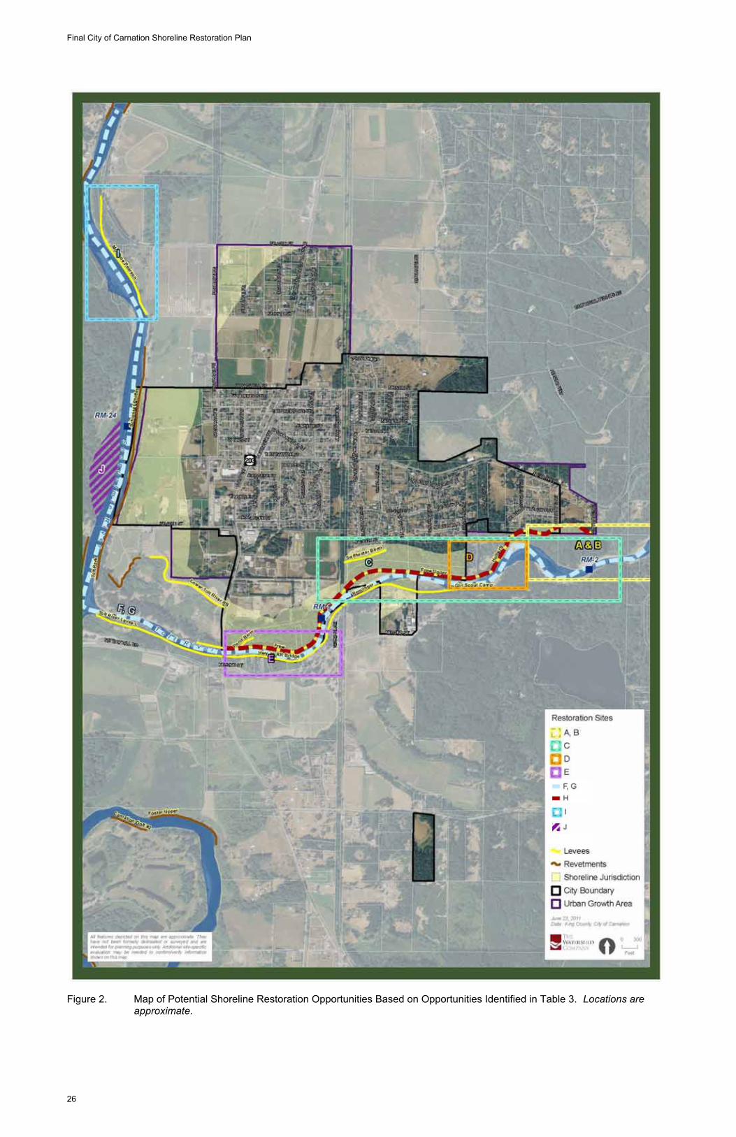
In addition to these general restoration priorities, the following table (Table 3) provides a summary of site-specific project ideas in and around the City of Carnation, with approximate locations indicated on Figure 2. Project ideas were developed in the Snohomish River Basin Salmon Conservation Plan (Snohomish Basin Salmon Recovery Forum 2005), Snoqualmie 2015 (Snoqualmie Watershed Forum 2006), the King County Flood Hazard Management Program (King County 2006), and the draft King County Shorelines Protection and Restoration Plan (King County 2009). Projects that have been completed are not included below.
7.0 STRATEGIES TO ACHIEVE LOCAL RESTORATION GOALS This section discusses programmatic measures for the City of Carnation designed to foster shoreline restoration and achieve a net improvement in shoreline ecological processes, functions, and habitats. With projected budget and staff limitations, the City of Carnation is limited in implementing restoration projects or programs on its own. However, the City’s SMP represents an important vehicle for facilitating and guiding restoration projects and programs in partnerships with other government entities or private and/or non-profit entities. The City can provide direction and leadership to assure that restoration designs meet the identified goals of the various plans. The discussion of restoration mechanisms and strategies below highlights programmatic
The Watershed Company June 2011
23
measures that the City may potentially implement as part of the proposed SMP, as well as parallel activities that would be managed by other governmental and non-governmental organizations. Examples of ongoing and proposed programs in and around the City are provided in Table 4.
Final City of Carnation Shoreline Restoration Plan
24
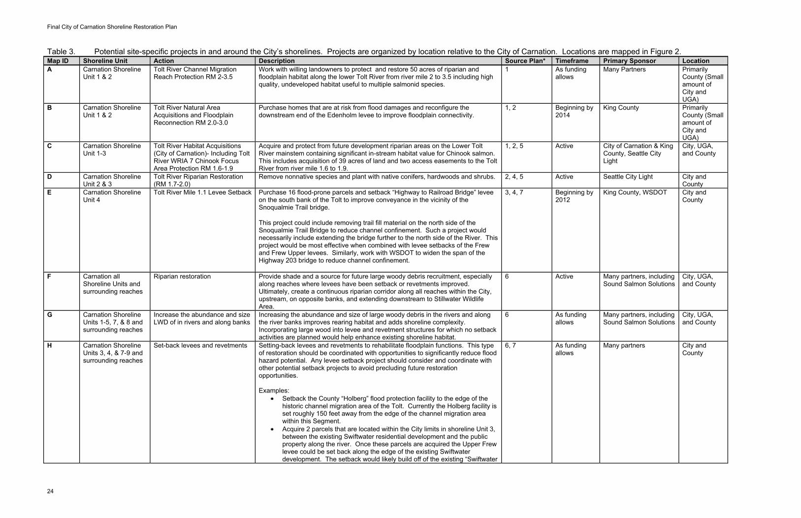
Table 3. Potential site-specific projects in and around the City’s shorelines. Projects are organized by location relative to the City of Carnation. Locations are mapped in Figure 2. Map ID Shoreline Unit Action Description Source Plan* Timeframe Primary Sponsor Location A Carnation Shoreline
Unit 1 & 2 Tolt River Channel Migration Reach Protection RM 2-3.5
Work with willing landowners to protect and restore 50 acres of riparian and floodplain habitat along the lower Tolt River from river mile 2 to 3.5 including high quality, undeveloped habitat useful to multiple salmonid species.
1 As funding allows
Many Partners Primarily County (Small amount of City and UGA)
B Carnation Shoreline Unit 1 & 2
Tolt River Natural Area Acquisitions and Floodplain Reconnection RM 2.0-3.0
Purchase homes that are at risk from flood damages and reconfigure the downstream end of the Edenholm levee to improve floodplain connectivity.
1, 2 Beginning by 2014
King County Primarily County (Small amount of City and UGA)
C Carnation Shoreline Unit 1-3
Tolt River Habitat Acquisitions (City of Carnation)- Including Tolt River WRIA 7 Chinook Focus Area Protection RM 1.6-1.9
Acquire and protect from future development riparian areas on the Lower Tolt River mainstem containing significant in-stream habitat value for Chinook salmon. This includes acquisition of 39 acres of land and two access easements to the Tolt River from river mile 1.6 to 1.9.
1, 2, 5 Active City of Carnation & King County, Seattle City Light
City, UGA, and County
D Carnation Shoreline Unit 2 & 3
Tolt River Riparian Restoration (RM 1.7-2.0)
Remove nonnative species and plant with native conifers, hardwoods and shrubs. 2, 4, 5 Active Seattle City Light City and County
E Carnation Shoreline Unit 4
Tolt River Mile 1.1 Levee Setback Purchase 16 flood-prone parcels and setback “Highway to Railroad Bridge” levee on the south bank of the Tolt to improve conveyance in the vicinity of the Snoqualmie Trail bridge.
This project could include removing trail fill material on the north side of the Snoqualmie Trail Bridge to reduce channel confinement. Such a project would necessarily include extending the bridge further to the north side of the River. This project would be most effective when combined with levee setbacks of the Frew and Frew Upper levees. Similarly, work with WSDOT to widen the span of the Highway 203 bridge to reduce channel confinement.
3, 4, 7 Beginning by 2012
King County, WSDOT City and County
F Carnation all Shoreline Units and surrounding reaches
Riparian restoration Provide shade and a source for future large woody debris recruitment, especially along reaches where levees have been setback or revetments improved. Ultimately, create a continuous riparian corridor along all reaches within the City, upstream, on opposite banks, and extending downstream to Stillwater Wildlife Area.
6 Active Many partners, including Sound Salmon Solutions
City, UGA, and County
G Carnation Shoreline Units 1-5, 7, & 8 and surrounding reaches
Increase the abundance and size LWD of in rivers and along banks
Increasing the abundance and size of large woody debris in the rivers and along the river banks improves rearing habitat and adds shoreline complexity. Incorporating large wood into levee and revetment structures for which no setback activities are planned would help enhance existing shoreline habitat.
6 As funding allows
Many partners, including Sound Salmon Solutions
City, UGA, and County
H Carnation Shoreline Units 3, 4, & 7-9 and surrounding reaches
Set-back levees and revetments Setting-back levees and revetments to rehabilitate floodplain functions. This type of restoration should be coordinated with opportunities to significantly reduce flood hazard potential. Any levee setback project should consider and coordinate with other potential setback projects to avoid precluding future restoration opportunities. Examples:
Setback the County “Holberg” flood protection facility to the edge of the historic channel migration area of the Tolt. Currently the Holberg facility is set roughly 150 feet away from the edge of the channel migration area within this Segment.
Acquire 2 parcels that are located within the City limits in shoreline Unit 3, between the existing Swiftwater residential development and the public property along the river. Once these parcels are acquired the Upper Frew levee could be set back along the edge of the existing Swiftwater development. The setback would likely build off of the existing “Swiftwater
6, 7 As funding allows
Many partners City and County
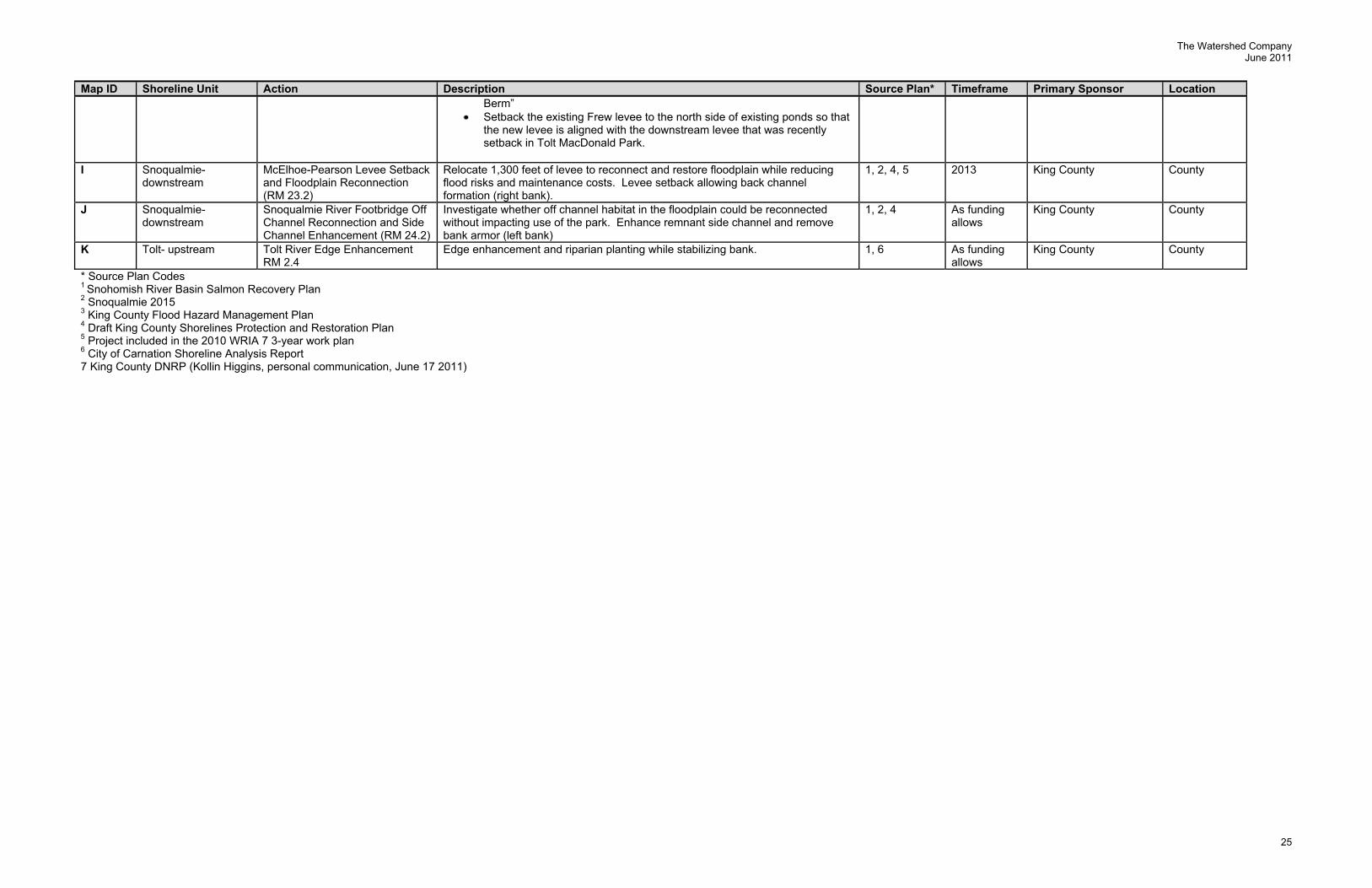
The Watershed Company June 2011
25
Map ID Shoreline Unit Action Description Source Plan* Timeframe Primary Sponsor Location Berm”
Setback the existing Frew levee to the north side of existing ponds so that the new levee is aligned with the downstream levee that was recently setback in Tolt MacDonald Park.
I Snoqualmie-
downstream McElhoe-Pearson Levee Setback and Floodplain Reconnection (RM 23.2)
Relocate 1,300 feet of levee to reconnect and restore floodplain while reducing flood risks and maintenance costs. Levee setback allowing back channel formation (right bank).
1, 2, 4, 5 2013 King County County
J Snoqualmie-downstream
Snoqualmie River Footbridge Off Channel Reconnection and Side Channel Enhancement (RM 24.2)
Investigate whether off channel habitat in the floodplain could be reconnected without impacting use of the park. Enhance remnant side channel and remove bank armor (left bank)
1, 2, 4 As funding allows
King County County
K Tolt- upstream Tolt River Edge Enhancement RM 2.4
Edge enhancement and riparian planting while stabilizing bank. 1, 6 As funding allows
King County County
* Source Plan Codes 1 Snohomish River Basin Salmon Recovery Plan 2 Snoqualmie 2015 3 King County Flood Hazard Management Plan 4 Draft King County Shorelines Protection and Restoration Plan 5 Project included in the 2010 WRIA 7 3-year work plan 6 City of Carnation Shoreline Analysis Report 7 King County DNRP (Kollin Higgins, personal communication, June 17 2011)
Final City of Carnation Shoreline Restoration Plan
26
Figure 2. Map of Potential Shoreline Restoration Opportunities Based on Opportunities Identified in Table 3. Locations are approximate.

The Watershed Company June 2011
27
THIS PAGE INTENTIONALLY LEFT BLANK
Final City of Carnation Shoreline Restoration Plan
28
7.1 City Planning
The City could incorporate shoreline restoration goals and projects into the City’s Capital Facilities Program (CFP), as well as future revisions to the Parks Master Plan and the Six-Year Transportation Improvement Plan to facilitate implementation of restoration within the City. The City could also review the various elements of previously adopted and yet-to-be-adopted plans that apply to shoreline areas and develop a prioritized list of projects.
7.2 Development Opportunities
When shoreline development occurs, the City has the ability to look for opportunities to encourage or facilitate restoration as a companion or parallel to minimum mitigation requirements as part of the SMP. Development may present timing opportunities for restoration that would not otherwise occur and may not be available in the future. Mitigation may also be allowed through the use of a fee-in-lieu-of or exchange of land for “banking” opportunities. In certain cases, on-site mitigation opportunities are limited due to building site constraints, limited potential ecological gains, or other site-specific factors. In these instances, the City Shoreline Administrator could identify an off-site restoration site within the immediate sub-basin that could be contributed to in lieu of on-site mitigation.
The City can also provide coordination of the various non-profit groups or citizen volunteers that can assist with the installation and monitoring of restoration projects. The City should also strongly encourage the participation of citizens to build a strong sense of stewardship that comes through their investment of time, money or materials in the project.
Table 4. Examples of ongoing and proposed programs in and around the City of Carnation to protect and restore shorelines.
Program Description Sponsor Landowner Incentive Program
A competitive grant process administered through the King Conservation District to provide financial assistance to private individual landowners for the protection, enhancement, or restoration of habitat to benefit species-at-risk on privately owned lands
King Conservation District
Conservation Reserve Enhancement Program (CREP)1.2
A program to protect and restore riparian vegetation through reimbursement to farmers.
King Conservation District
Lower Snoqualmie Restoration and Maintenance1.2
A partnership with local landowners to implement restoration projects on private lands. Past work has included riparian habitat and off-channel habitat enhancements, the removal of fish passage barriers, and wetland restoration.
Stewardship Partners
Salmon Safe Certification and Marketing1.2.4
Certification and marketing approach to promote fish-friendly agriculture through certification and marketing.
Stewardship Partners
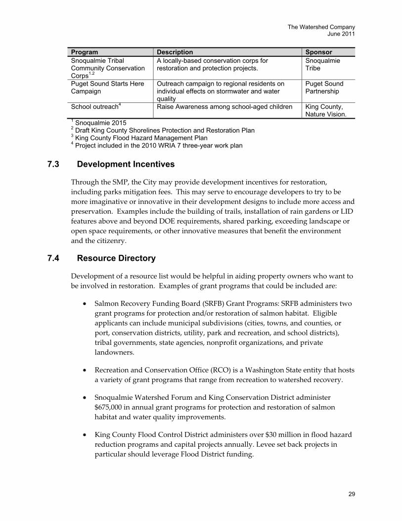
The Watershed Company June 2011
29
Program Description SponsorSnoqualmie Tribal Community Conservation Corps1.2
A locally-based conservation corps for restoration and protection projects.
Snoqualmie Tribe
Puget Sound Starts Here Campaign
Outreach campaign to regional residents on individual effects on stormwater and water quality
Puget Sound Partnership
School outreach4 Raise Awareness among school-aged children King County, Nature Vision.
1 Snoqualmie 2015 2 Draft King County Shorelines Protection and Restoration Plan 3 King County Flood Hazard Management Plan 4 Project included in the 2010 WRIA 7 three-year work plan
7.3 Development Incentives
Through the SMP, the City may provide development incentives for restoration, including parks mitigation fees. This may serve to encourage developers to try to be more imaginative or innovative in their development designs to include more access and preservation. Examples include the building of trails, installation of rain gardens or LID features above and beyond DOE requirements, shared parking, exceeding landscape or open space requirements, or other innovative measures that benefit the environment and the citizenry.
7.4 Resource Directory
Development of a resource list would be helpful in aiding property owners who want to be involved in restoration. Examples of grant programs that could be included are:
Salmon Recovery Funding Board (SRFB) Grant Programs: SRFB administers two grant programs for protection and/or restoration of salmon habitat. Eligible applicants can include municipal subdivisions (cities, towns, and counties, or port, conservation districts, utility, park and recreation, and school districts), tribal governments, state agencies, nonprofit organizations, and private landowners.
Recreation and Conservation Office (RCO) is a Washington State entity that hosts a variety of grant programs that range from recreation to watershed recovery.
Snoqualmie Watershed Forum and King Conservation District administer $675,000 in annual grant programs for protection and restoration of salmon habitat and water quality improvements.
King County Flood Control District administers over $30 million in flood hazard reduction programs and capital projects annually. Levee set back projects in particular should leverage Flood District funding.
Final City of Carnation Shoreline Restoration Plan
30
7.5 Volunteer Coordination
The City could emphasize and accomplish restoration projects by using community volunteers and coordinating with organizations such as the Stilly/Snohomish Fisheries Enhancement Task Force, Snoqualmie Tribe of Indians, King Conservation District, Stewardship Partners, local churches, Kiwanis, Rotary International, Chamber of Commerce, or Carnation School District. Probably the most important volunteer is the landowner that acts as the steward of the land following the completion of a project.
7.6 Regional Coordination
The City will continue its association and involvement with the Snohomish River Basin Salmon Recovery Forum, the Snoqualmie Watershed Forum, Washington State Department of Ecology, Puget Sound Partnership, and King County. The City may also look for other time-sensitive opportunities for involvement in regional restoration planning and implementation.
8.0 PROPOSED IMPLEMENTATION TARGETS AND MONITORING METHODS
8.1 Project Evaluation
When a restoration project is proposed for implementation by the City, other agency, or by a private party, the project should be evaluated to ensure that the project’s objectives are consistent with those of this Restoration Plan of the SMP and, if applicable, that the project warrants implementation above other candidate projects. (It is recognized that due to funding sources or other constraints, the range of any individual project may be narrow.) It is also expected that the list of potential projects may change over time, that new projects will be identified and existing opportunities will become less relevant as restoration occurs and as other environmental conditions, or our knowledge of them, change.
When evaluating potential projects, priority should be given to projects that best meet the following criteria:
Restoration meets the goals and objectives for shoreline restoration. Restoration or protection of processes is generally of greater importance than
restoration of structure to produce specific functions. Restoration avoids residual impacts to other functions or processes. Projects address a known degraded condition or limiting factor for salmon
recovery.
The Watershed Company June 2011
31
Conditions that are progressively worsening are of greater priority. Restoration projects that address multiple functions or processes. Restoration has a high benefit to cost ratio. Restoration has a high probability of success.
Restoration is feasible, such as being located on and accessed by public property or private property that is cooperatively available for restoration.
Restoration project design should consider impacts to adjacent property owners.
There is public support for the project. The project is supported by and consistent with other restoration plans.
The City should consider developing a project “score card” as a tool to evaluate projects consistent with these criteria.
8.2 Monitoring and Adaptive Management
In addition to project monitoring required for individual restoration and mitigation projects, the City should conduct system-wide monitoring of shoreline conditions and development activity, to the degree practical, recognizing that individual project monitoring does not provide an assessment of overall shoreline ecological health. The following approach is suggested:
1. Track information using the City’s permit system as activities occur (development, conservation, restoration and mitigation), such as:
a. New shoreline development
b. Shoreline variances and the nature of the variance
c. Compliance issues
d. New impervious surface areas
e. New and existing Critical Area Protection Easements
f. Removal of fill or armoring
g. Addition of fill or armoring
h. Vegetation retention/loss
The City will require project proponents to monitor as part of project mitigation, which may be incorporated into this process. Regardless, as development and restoration activities occur in the shoreline area, the City should seek to monitor shoreline conditions to determine whether both project-specific and overall SMP goals are being achieved.
Final City of Carnation Shoreline Restoration Plan
32
2. Review status of environmental processes and functions at the time of periodic SMP updates to, at a minimum, validate the effectiveness of the SMP. Review should consider what restoration activities actually occurred compared to stated goals, objectives and priorities, and whether restoration projects resulted in a net improvement of shoreline resources.
Under the Shoreline Management Act, the SMP is required to result in no net loss of shoreline ecological functions. If this standard is found to not be met at the time of review, the City will be required to take corrective actions. The goal for restoration is to achieve a net improvement. The cumulative effect of restoration over time between reviews should be evaluated along with an assessment of impacts of development that is not fully mitigated to determine effectiveness at achieving a net improvement to shoreline ecological functions.
Evaluation of shoreline conditions, permit activity, policy, and regulatory effectiveness should occur at varying levels of detail consistent with the Comprehensive Plan update cycle. A complete reassessment of conditions, policies and regulations should be considered every seven years. To conduct a valid reassessment of the shoreline conditions every seven years, it is necessary to monitor, record and maintain key environmental metrics to allow a comparison with baseline conditions. As monitoring occurs, the City should reassess environmental conditions and restoration objectives. Those ecological processes and functions that are found to be worsening may need to become elevated in priority to prevent loss of critical resources. Alternatively, successful restoration may reduce the importance of some restoration objectives in the future.
8.3 Reporting
Section 6 describes project opportunities to restore shoreline conditions. The restoration opportunities included are based upon a detailed inventory and analysis of shoreline conditions by many sources. Nonetheless, exhaustive scientific information about shoreline conditions and restoration options is cost prohibitive at this stage. Additionally, restoration is at times experimental. Monitoring must be an aspect of all restoration projects, and results from monitoring studies will help inform future restoration practices. Generally, conservation of existing natural areas is the approach least likely to result in failure. Alternatively, local shoreline enhancement, as opposed to restoration of processes and associated functions, has a higher degree of uncertainty.
This Restoration Plan does not provide a comprehensive scientific index of restoration opportunities that allows the City to objectively compare opportunities against each other. If funding was available, restoration opportunities could be ranked by which opportunities are expected to have the highest rates of success, which address the most pressing needs, and other factors. Funding could also support a long-term monitoring program that evaluates restoration over the life of the SMP (as opposed to independent
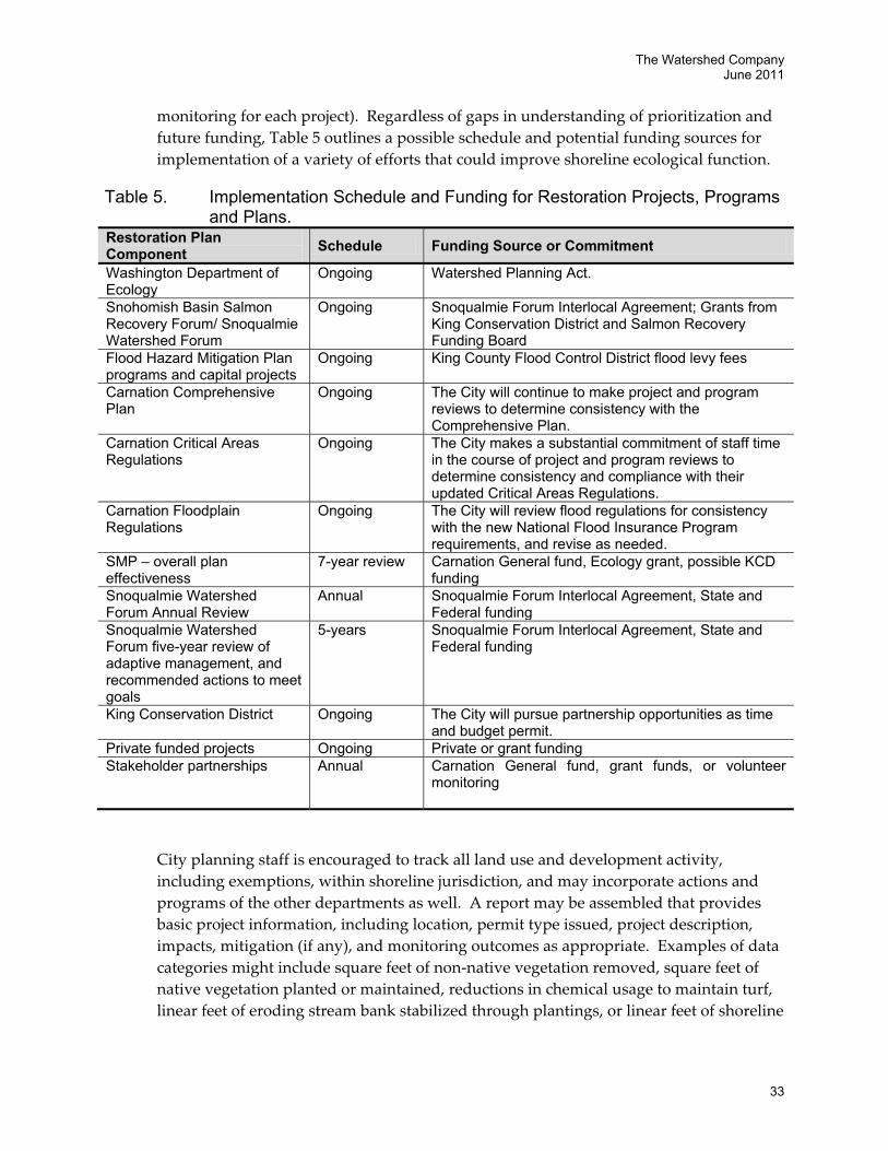
The Watershed Company June 2011
33
monitoring for each project). Regardless of gaps in understanding of prioritization and future funding, Table 5 outlines a possible schedule and potential funding sources for implementation of a variety of efforts that could improve shoreline ecological function.
Table 5. Implementation Schedule and Funding for Restoration Projects, Programs and Plans.
Restoration Plan Component Schedule Funding Source or Commitment
Washington Department of Ecology
Ongoing Watershed Planning Act.
Snohomish Basin Salmon Recovery Forum/ Snoqualmie Watershed Forum
Ongoing Snoqualmie Forum Interlocal Agreement; Grants from King Conservation District and Salmon Recovery Funding Board
Flood Hazard Mitigation Plan programs and capital projects
Ongoing King County Flood Control District flood levy fees
Carnation Comprehensive Plan
Ongoing The City will continue to make project and program reviews to determine consistency with the Comprehensive Plan.
Carnation Critical Areas Regulations
Ongoing The City makes a substantial commitment of staff time in the course of project and program reviews to determine consistency and compliance with their updated Critical Areas Regulations.
Carnation Floodplain Regulations
Ongoing The City will review flood regulations for consistency with the new National Flood Insurance Program requirements, and revise as needed.
SMP – overall plan effectiveness
7-year review Carnation General fund, Ecology grant, possible KCD funding
Snoqualmie Watershed Forum Annual Review
Annual Snoqualmie Forum Interlocal Agreement, State and Federal funding
Snoqualmie Watershed Forum five-year review of adaptive management, and recommended actions to meet goals
5-years Snoqualmie Forum Interlocal Agreement, State and Federal funding
King Conservation District Ongoing The City will pursue partnership opportunities as time and budget permit.
Private funded projects Ongoing Private or grant funding Stakeholder partnerships Annual Carnation General fund, grant funds, or volunteer
monitoring
City planning staff is encouraged to track all land use and development activity, including exemptions, within shoreline jurisdiction, and may incorporate actions and programs of the other departments as well. A report may be assembled that provides basic project information, including location, permit type issued, project description, impacts, mitigation (if any), and monitoring outcomes as appropriate. Examples of data categories might include square feet of non-native vegetation removed, square feet of native vegetation planted or maintained, reductions in chemical usage to maintain turf, linear feet of eroding stream bank stabilized through plantings, or linear feet of shoreline
Final City of Carnation Shoreline Restoration Plan
34
armoring removed. The report would also outline implementation of various programs and restoration actions (by the City or other groups) that relate to watershed health.
The staff report may be assembled to coincide with Comprehensive Plan updates and may be used, in light of the goals and objectives of the Shoreline Master Program, to determine whether implementation of the SMP is meeting the basic goal of no net loss of ecological functions relative to the baseline condition established in the Shoreline Analysis Report. In the long term, the City should be able to demonstrate a net improvement in the City of Carnation’s shoreline environment.
The Watershed Company June 2011
35
9.0 REFERENCES Bethel, J. 2004. Snoqualmie Watershed Geology Report. Prepared for King County Water and
Land Resources Division. Seattle, WA.
City of Carnation. 2004, as amended. City of Carnation’s Comprehensive Plan-Environmental Element.
Haring, D. 2002. Salmonid Habitat Limiting Factors Analysis: Snohomish River Watershed Water Resource Inventory Area (WRIA) 7 Final Report. Prepared for the Washington State Conservation Commission.
King County. 2002. Snoqualmie Watershed Stream Habitat Reconnaissance. King County Department of Natural Resources and Parks. Seattle, WA.
King County. 2006a. Flood Hazard Management Plan: King County, Washington. King County Department of Natural Resources and Parks, Water and Land Resources Division, Seattle, Washington.
King County. 2006b. Tolt River Natural Area Site Management Guidelines. King County Department of Natural Resources and Parks, Water and Land Resources Division, Seattle, Washington.
King County. 2008. Snoqualmie Flood-Farm Taskforce Report. King County Department of Natural Resources and Parks, Water and Land Resources Division, Seattle, Washington.
King County. 2009. Draft Shorelines Protection and Restoration Plan. November 2009. As recommended by the County executive.
Puget Sound Partnership. 2008. Action Agenda. Updated May 27, 2009. Olympia, WA.
Snohomish Basin Salmon Recovery Forum. 2005. Snohomish River Basin Salmon Conservation Plan. Published by Snohomish County Department of Public Works Surface Water Management Division. Everett, WA.
Snohomish Basin Salmon Recovery Forum. 2010. Snohomish Basin 3-year Work Plan 2010 Update.
Snoqualmie Watershed Forum. 2006. Snoqualmie 2015: Building for Salmon Recovery and Watershed Health.
Solomon and Boles. 2002. Snoqualmie Watershed Aquatic Habitat Assessment. King County Department of Natural Resources and Parks, Water and Land Resources Division. Seattle, WA.
Final City of Carnation Shoreline Restoration Plan
36
Tetra Tech. 2008. Draft South Fork Tolt River Watershed Management Plan. Prepared for Seattle Public Utilities.
The Watershed Company and ICF International. January 2011. FINAL Shoreline Analysis Report for the City of Carnation’s Shoreline: Tolt River and Snoqualmie River. Prepared for the City of Carnation, Carnation, WA.