Embed Size (px)
Citation preview
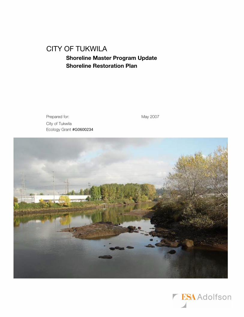
CITY OF TUKWILA Shoreline Master Program Update Shoreline Restoration Plan
Prepared for: May 2007
City of Tukwila
Ecology Grant #G0600234
Tukwila Shoreline Restoration Planning – SMA Grant No. 0600234
May 2007 i
TABLE OF CONTENTS
1.0 Introduction........................................................................................................................1 1.1 Regulatory Background................................................................................................................ 1 1.2 Defining Restoration..................................................................................................................... 3
2.0 Restoration Planning .........................................................................................................4 2.1 Restoration Framework ................................................................................................................ 4 2.2 Assessment of Functions .............................................................................................................. 6
2.2.1 Watershed Context and Shoreline Modifications...................................................................................6 2.2.2 Habitat and Species................................................................................................................................6 2.2.3 Land Use................................................................................................................................................7 2.2.4 Altered Ecosystem Processes.................................................................................................................7
2.3 Existing Plans and Programs ........................................................................................................ 9 2.3.1 Regional .................................................................................................................................................9 2.3.2 City ......................................................................................................................................................10
2.4 Completed Projects..................................................................................................................... 10 3.0 Restoration Opportunities...............................................................................................12
3.1 Potential Projects and Restoration Priorities .............................................................................. 12 4.0 Policy Development..........................................................................................................19
5.0 Implementation ................................................................................................................20 5.1 Funding and Partnership Opportunities ...................................................................................... 21
5.1.1 Puget Sound Action Team ...................................................................................................................21 5.1.2 Salmon Recovery Funding Board (SRFB)...........................................................................................21 5.1.3 King Conservation District ..................................................................................................................21 5.1.4 Natural Resource Damage Assessment Funds.....................................................................................22 5.1.5 King County Flood Control District ....................................................................................................22
5.2 Timelines and Benchmarks......................................................................................................... 22 5.3 Mechanisms and Strategies for Effectiveness ............................................................................ 23
6.0 Conclusions.......................................................................................................................24
7.0 References.........................................................................................................................25
8.0 Attachments......................................................................................................................27
List of Tables
Table 1. Restoration Planning Structure ........................................................................................ 4 Table 2. General Restoration Potential within the Shorelines of Tukwila. ................................... 8 Table 3. Completed Restoration Projects in Tukwila ................................................................... 11 Table 4. Potential Restoration Projects and Initial Project Ranking............................................ 14 List of Figures
Figure 1. Mitigation Versus Restoration in Shoreline Master Programs (Source: Department of Ecology) .................................................................................................................................. 2
Figure 2. Schematic View of Overall Restoration Framework (based on Palmer et al. 2005)...... 5
Tukwila Shoreline Restoration Planning – SMA Grant No. 0600234
May 2007 1
1.0 INTRODUCTION
The Green/Duwamish River is a central feature in the City of Tukwila. The Green/Duwamish River has long been an important nexus between upland freshwater and marine saltwater environments, as well as a focus area for historical land use and urban development. The Shoreline Management Act (SMA or the Act) (RCW 90.58) is charged with balancing how shorelines should be developed, protected, and restored. The Act has three broad policies or mandates; it strives to: 1) encourage water-dependent uses, 2) protect shoreline natural resources, and 3) promote public access. Restoration planning is an important component of the environmental protection policy of the Act.
This report supports the development of a restoration element to the City of Tukwila’s Shoreline Master Program (SMP), originally adopted in 1974. The SMP is being updated to comply with the SMA requirements (RCW 90.58), and the state’s SMP guidelines (Washington Administrative Code [WAC] 173-26, Part III), which went into effect in 2003.
The SMP guidelines require that local governments develop SMP policies that promote "restoration" of impaired shoreline ecological functions and a “real and meaningful” strategy to implement restoration objectives. The City’s shoreline inventory and characterization report (ESA Adolfson, 2006) identifies which shoreline ecological functions and ecosystem processes have been impaired. Local governments are further encouraged to contribute to restoration by planning for and supporting restoration through the SMP and other regulatory and non-regulatory programs.
This report provides a framework to:
1. Identify primary goals for ecological restoration of the Green/Duwamish ecosystem;
2. Identify how restoration of ecological function can be accomplished;
3. Suggest how the SMP update process may accomplish the restoration of impaired shoreline functions associated with the Green/Duwamish ecosystem; and
4. Prioritize restoration projects so that the highest value restoration actions may be accomplished first.
1.1 Regulatory Background
The state has directed local governments to develop SMP provisions “…to achieve overall improvements in shoreline ecological functions over time when compared to the status upon adoption of the master program.” This overarching goal is accomplished primarily through two distinct objectives:
1. Protection of existing shoreline functions through regulations and mitigation requirements to ensure “no net loss” of ecological functions from baseline environmental conditions; and
2. Restoration of shoreline ecological functions that have been impaired from past development practices or alterations.
Tukwila Shoreline Restoration Planning – SMA Grant No. 0600234
May 2007 2
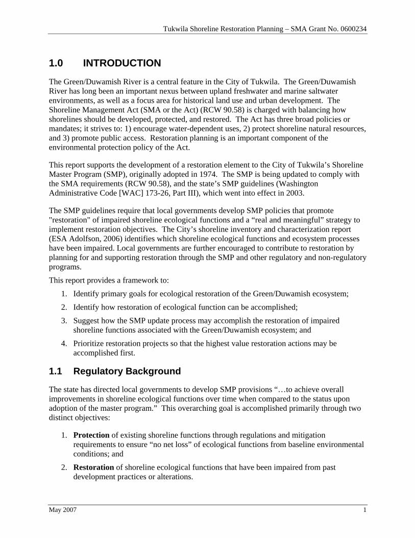
This distinction is illustrated in Figure 1. below.
Figure 1. Mitigation Versus Restoration in Shoreline Master Programs (Source: Department of Ecology)
The concept of no net loss of shoreline ecological function is embedded in the Act and in the goals, policies and governing principles of shoreline guidelines and other federal and state environmental protections (e.g., the Clean Water Act). Washington’s general policy goals for shorelines of the state include the “protection and restoration of ecological functions of shoreline natural resources.” This goal derives from the Act, which states, “permitted uses in the shoreline shall be designed and conducted in a manner that minimizes insofar as practical, any resultant damage to the ecology and environment of the shoreline area.” Furthermore, the governing principles of the guidelines clarify that protection of shoreline ecological functions is accomplished through the following (WAC 173-26-186):
• Meaningful understanding of the current shoreline ecological conditions,
• Regulations and mitigation standards that ensure that permitted developments do not cause a net loss of ecological functions,
• Regulations that ensure exempt developments in the aggregate do not result in net loss of ecological functions,
• Goals and policies for restoring ecologically impaired shorelines,
Tukwila Shoreline Restoration Planning – SMA Grant No. 0600234
May 2007 3
• Regulations and programs that fairly allocate the burden of mitigating cumulative impacts among development opportunities, and
• Incentives or voluntary measures designed to restore and protect ecological functions.
It is important to note that the restoration planning component of the SMP is focused on voluntary mechanisms, not regulatory provisions. Restoration planning is focused on economic incentives, available funding sources, volunteer programs, and other programs that can contribute to a no net loss strategy. However, the restoration framework developed for these non-compensatory mitigation projects can also be applied to compensatory mitigation projects. In this way, all efforts to improve ecosystem functioning are coordinated, and will be designed to work together.
1.2 Defining Restoration
There are numerous definitions for “restoration” in scientific and regulatory publications. Specific elements of these definitions often differ, but the core element of repairing damage to an existing, degraded ecosystem remains consistent. In the SMP context, the WAC defines “restoration” or “ecological restoration” as:
“…the reestablishment or upgrading of impaired ecological shoreline processes or functions. This may be accomplished through measures including, but not limited to, revegetation, removal of intrusive shoreline structures and removal or treatment of toxic materials. Restoration does not imply a requirement for returning the shoreline area to aboriginal or pre-European settlement conditions” (WAC 173-26-020(27)).
Using the WAC definition of restoration in regards to state shorelines, it is clear the effort should be focused on specific shoreline areas where natural ecological functions have been impaired or degraded. The emphasis in the WAC is to achieve overall improvement in existing shoreline processes or functions, where functions are impaired. Therefore, the goal is not to restore the shoreline to historically natural conditions, but rather to improve on existing, degraded conditions. In this context, restoration can be broadly implemented through a combination of programmatic measures (such as surface water management; water quality improvement; public education) and site-specific projects (such as setback levees or riparian plantings). It is important to note that the guidelines do not state that local programs should or could require individual permittees to restore past damages to an ecosystem as a condition of a permit for new development (Ecology, 2004). The restoration planning element therefore focuses on the City as a whole rather than parcel by parcel, or permit by permit.
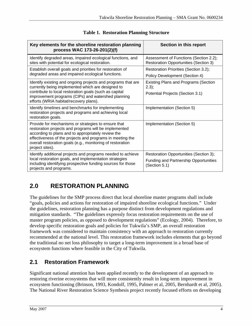
Table 1 below summarizes the key elements included in restoration planning within the context of an SMP update under the state’s current guidelines (WAC 173-26-201(2)(f)). These key elements provide the organization and content for this report.
Tukwila Shoreline Restoration Planning – SMA Grant No. 0600234
May 2007 4
Table 1. Restoration Planning Structure
Key elements for the shoreline restoration planning process WAC 173-26-201(2)(f)
Section in this report
Identify degraded areas, impaired ecological functions, and sites with potential for ecological restoration.
Assessment of Functions (Section 2.2); Restoration Opportunities (Section 3)
Establish overall goals and priorities for restoration of degraded areas and impaired ecological functions.
Restoration Priorities (Section 3.2); Policy Development (Section 4)
Identify existing and ongoing projects and programs that are currently being implemented which are designed to contribute to local restoration goals (such as capital improvement programs (CIPs) and watershed planning efforts (WRIA habitat/recovery plans).
Existing Plans and Programs (Section 2.3); Potential Projects (Section 3.1)
Identify timelines and benchmarks for implementing restoration projects and programs and achieving local restoration goals.
Implementation (Section 5)
Provide for mechanisms or strategies to ensure that restoration projects and programs will be implemented according to plans and to appropriately review the effectiveness of the projects and programs in meeting the overall restoration goals (e.g., monitoring of restoration project sites).
Implementation (Section 5)
Identify additional projects and programs needed to achieve local restoration goals, and implementation strategies including identifying prospective funding sources for those projects and programs.
Restoration Opportunities (Section 3); Funding and Partnership Opportunities (Section 5.1)
2.0 RESTORATION PLANNING
The guidelines for the SMP process direct that local shoreline master programs shall include “goals, policies and actions for restoration of impaired shoreline ecological functions.” Under the guidelines, restoration planning has a purpose distinct from development regulations and mitigation standards. “The guidelines expressly focus restoration requirements on the use of master program policies, as opposed to development regulations” (Ecology, 2004). Therefore, to develop specific restoration goals and policies for Tukwila’s SMP, an overall restoration framework was considered to maintain consistency with an approach to restoration currently recommended at the national level. This restoration framework includes elements that go beyond the traditional no net loss philosophy to target a long-term improvement in a broad base of ecosystem functions where feasible in the City of Tukwila.
2.1 Restoration Framework
Significant national attention has been applied recently to the development of an approach to restoring riverine ecosystems that will more consistently result in long-term improvement in ecosystem functioning (Brinson, 1993, Kondolf, 1995, Palmer et al, 2005, Bernhardt et al, 2005). The National River Restoration Science Synthesis project recently focused efforts on developing
Tukwila Shoreline Restoration Planning – SMA Grant No. 0600234
May 2007 5
both: 1) a database of existing and proposed river restoration projects; and 2) criteria to consistently determine if a restoration is successful (Palmer and Allan, 2006). This work is intended to provide a consistent restoration approach across jurisdictions and to improve the probability of future success by learning from existing river restoration projects.
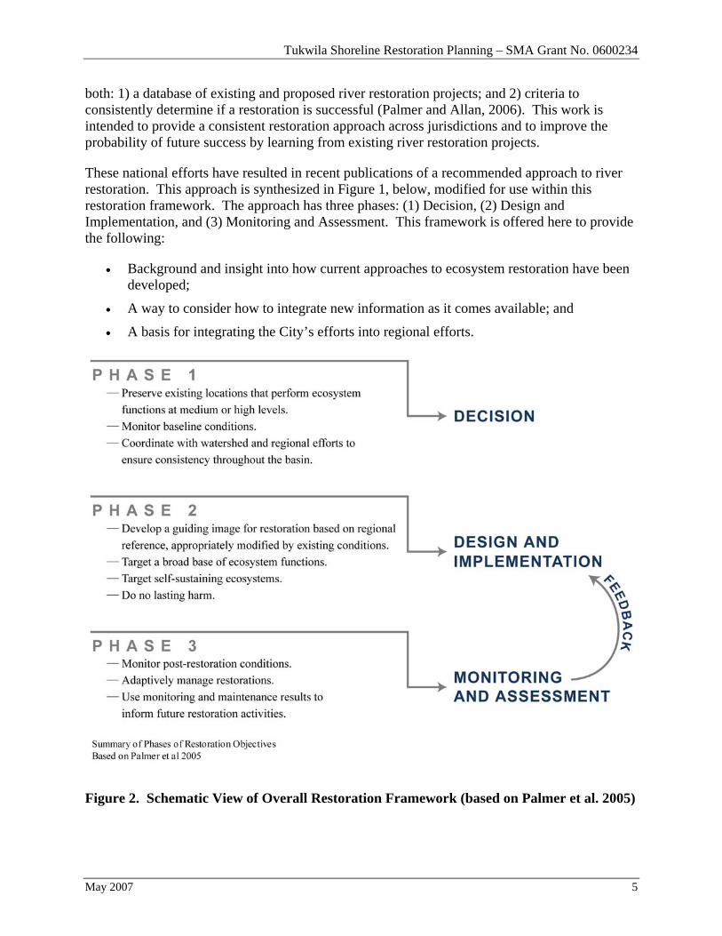
These national efforts have resulted in recent publications of a recommended approach to river restoration. This approach is synthesized in Figure 1, below, modified for use within this restoration framework. The approach has three phases: (1) Decision, (2) Design and Implementation, and (3) Monitoring and Assessment. This framework is offered here to provide the following:
• Background and insight into how current approaches to ecosystem restoration have been developed;
• A way to consider how to integrate new information as it comes available; and
• A basis for integrating the City’s efforts into regional efforts.
Figure 2. Schematic View of Overall Restoration Framework (based on Palmer et al. 2005)
Tukwila Shoreline Restoration Planning – SMA Grant No. 0600234
May 2007 6
2.2 Assessment of Functions
Shoreline restoration planning begins with the identification of “degraded areas” or areas with “impaired ecological functions.” The assessment of existing degraded areas and/or functions relies heavily on the City of Tukwila Draft Shoreline Inventory and Characterization Report (ESA Adolfson, 2006). The City’s inventory and characterization examined riverine and estuarine ecosystem processes that maintain shoreline ecological functions; and identified impaired ecological functions. Key findings of the inventory and characterization are summarized below.
2.2.1 Watershed Context and Shoreline Modifications
The City of Tukwila is situated in the Puget Sound Lowlands at the transition from the fresh water Green River to the tidally influenced Duwamish estuary ecosystem. Tukwila includes approximately 12.5 miles of the Green/Duwamish River. The Green River basin is part of the Green/Duwamish Water Resource Inventory Area (WRIA 9).
Historically, the Green/Duwamish River drained a significantly larger area than it does today. River course changes and major engineering projects in the early part of the 20th century resulted in both the White and Cedar Rivers being diverted to neighboring basins. As a result, the overall freshwater discharge in the Green/Duwamish River has been reduced to around a third of the pre-diversion era. The Green/Duwamish has undergone extensive modifications as part of past river management with the intent of reducing channel migration and limiting the extent and duration of valley flooding.
Levees and/or revetments have been constructed along the majority of the Green/Duwamish River through the City of Tukwila to increase bank strength and reduce flooding. In addition, flows within the Green/Duwamish River have been significantly modified by the construction of the Howard A. Hansen Dam and installation of water diversions. These modifications have significantly reduced the severity of floods that historically covered much of the valley bottom. The condition of the current system of levees and revetments is a growing source of concern for King County and the cities involved, as many of the levees are aging and would not meet current standards for either flood conveyance or stability.
2.2.2 Habitat and Species
The Green/Duwamish River within the City of Tukwila provides important habitat for several fish and some wildlife species, such as osprey. The aquatic environment within the channel is an important corridor located at the transition from the freshwater riverine environment to tidal estuarine environment of Elliot Bay. Almost every species of anadromous fish migrates through this transition zone. The entire length of the Green/Duwamish River within the City of Tukwila has been declared “critical habitat” for the Chinook salmon and bull trout. Both species are listed as threatened under the Federal Endangered Species Act.
Tukwila Shoreline Restoration Planning – SMA Grant No. 0600234
May 2007 7
The transition zone between fresh and salt water has effectively been pushed upstream from its historic location due to: (1) a significant reduction (70%) of fresh water flowing into the Duwamish estuary (owing to the diversion of the White and Cedar/Black Rivers), (2) channel dredging, and (3) reduction of flows as a result of the Howard A. Hanson dam. The establishment of heavy industrial uses in the transition zone has replaced wetlands with impervious surfaces, and the stream banks have been replaced by levees and other armoring, eliminating slow-moving flows through edge habitat and creating unrestrained downstream flows. Spatial structure, residence time, and the habitat available for refugia and rearing functions in the Duwamish estuary have therefore been reduced and constrained. High densities of fish have been observed utilizing what is left of this specific habitat. At the watershed scale, overall increases in salmonid survival rates are dependent on the availability of sufficient transition zone habitat to accommodate fish while they adjust from fresh to salt water (WRIA 9 Steering Committee, 2005).
Modifications to the river system have resulted in reduced levels of ecosystem functioning, including hydrology, water quality, riparian habitat, and in-stream habitat. Changes to hydrology focus on modified flow regime due to dam construction, diversion, and urban development. River management and levees have reduced the connection between the rivers and their floodplains, changing the spatial extent of habitats, and increasing the potential for negative water quality impacts. Disturbances to the channel banks have resulted in areas that are dominated by non-native invasive species. Wood, in the form of riparian trees and in-channel wood, is generally lacking through the system, which negatively impacts riparian and aquatic habitats.
2.2.3 Land Use
The majority of the upper Green/Duwamish watershed, outside of the city limits, is in managed forestland, parkland, or designated wilderness areas. Agricultural land covers much of the higher river within the Green River gorge. The Kent-Auburn Valley is a transitional area between the forest and agricultural activities upstream to the highly developed residential, industrial and commercial development in the cities of Kent, Tukwila, and Seattle downstream in the Lower Green / Duwamish River Valley.
Within the valley, industrial, commercial, and residential land uses dominate the former Green River floodplain in the vicinity of Tukwila. South of the city, commercial and warehouse/industrial land uses dominate on the right bank in the City of Kent, with agricultural fields on the left bank within the Tukwila South annexation area. Commercial development is prevalent between the southern city boundary and I-405. Residential development dominates between I-405 and the I-5 Bridge. North of the I-5 Bridge to the turning basin, residential uses give way to commercial uses. The upper turning basin, located at river mile 5.8, is the southern boundary of the predominantly industrial area that extends to the northern city limit.
2.2.4 Altered Ecosystem Processes
Key findings regarding current levels of ecosystem functioning within the lower Green/Duwamish ecosystem are reported in Chapter 5 of the City of Tukwila Draft Shoreline
Tukwila Shoreline Restoration Planning – SMA Grant No. 0600234
May 2007 8
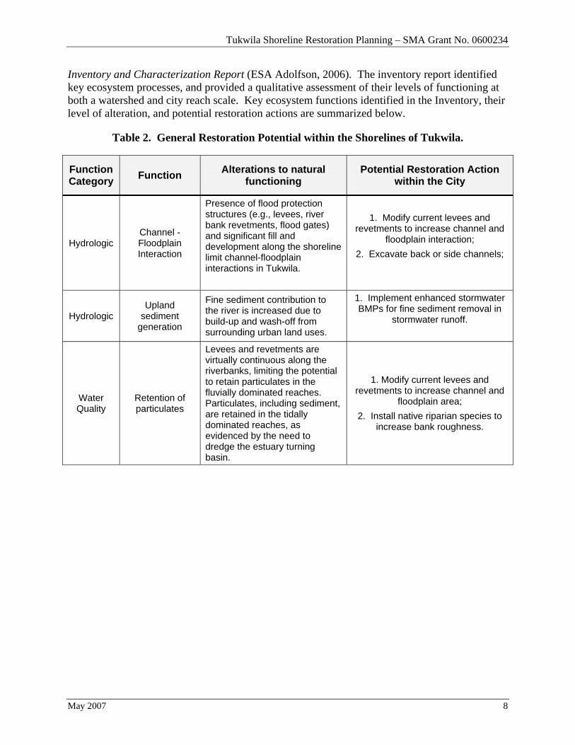
Inventory and Characterization Report (ESA Adolfson, 2006). The inventory report identified key ecosystem processes, and provided a qualitative assessment of their levels of functioning at both a watershed and city reach scale. Key ecosystem functions identified in the Inventory, their level of alteration, and potential restoration actions are summarized below.
Table 2. General Restoration Potential within the Shorelines of Tukwila.
Function Category Function Alterations to natural
functioning Potential Restoration Action
within the City
Hydrologic Channel -Floodplain Interaction
Presence of flood protection structures (e.g., levees, river bank revetments, flood gates) and significant fill and development along the shoreline limit channel-floodplain interactions in Tukwila.
1. Modify current levees and revetments to increase channel and
floodplain interaction; 2. Excavate back or side channels;
Hydrologic Upland
sediment generation
Fine sediment contribution to the river is increased due to build-up and wash-off from surrounding urban land uses.
1. Implement enhanced stormwater BMPs for fine sediment removal in
stormwater runoff.
Water Quality
Retention of particulates
Levees and revetments are virtually continuous along the riverbanks, limiting the potential to retain particulates in the fluvially dominated reaches. Particulates, including sediment, are retained in the tidally dominated reaches, as evidenced by the need to dredge the estuary turning basin.
1. Modify current levees and revetments to increase channel and
floodplain area; 2. Install native riparian species to
increase bank roughness.
Tukwila Shoreline Restoration Planning – SMA Grant No. 0600234
May 2007 9
Function Category Function Alterations to natural
functioning Potential Restoration Action
within the City
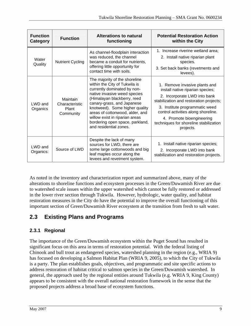
Water Quality Nutrient Cycling
As channel-floodplain interaction was reduced, the channel became a conduit for nutrients, offering little opportunity for contact time with soils.
1. Increase riverine wetland area; 2. Install native riparian plant
species. 3. Set back banks (revetments and
levees).
LWD and Organics
Maintain Characteristic
Plant Community
The majority of the shoreline within the City of Tukwila is currently dominated by non-native invasive weed species (Himalayan blackberry, reed canary-grass, and Japanese knotweed). Some higher quality areas of cottonwood, alder, and willow exist in riparian areas bordering open space, parkland, and residential zones.
1. Remove invasive plants and install native riparian species; 2. Incorporate LWD into bank
stabilization and restoration projects; 3. Institute programmatic weed control activities along shoreline.
4. Promote bioengineering techniques for shoreline stabilization
projects.
LWD and Organics: Source of LWD
Despite the lack of many sources for LWD, there are some large cottonwoods and big leaf maples occur along the levees and revetment system.
1. Install native riparian species; 2. Incorporate LWD into bank
stabilization and restoration projects.
As noted in the inventory and characterization report and summarized above, many of the alterations to shoreline functions and ecosystem processes in the Green/Duwamish River are due to watershed scale issues within the upper watershed which cannot be fully restored or addressed in the lower river section through Tukwila. However, hydrologic, water quality, and habitat restoration measures in the City do have the potential to improve the overall functioning of this important section of Green/Duwamish River ecosystem at the transition from fresh to salt water.
2.3 Existing Plans and Programs
2.3.1 Regional
The importance of the Green/Duwamish ecosystem within the Puget Sound has resulted in significant focus on this area in terms of restoration potential. With the federal listing of Chinook and bull trout as endangered species, watershed planning in the region (e.g., WRIA 9) has focused on developing a Salmon Habitat Plan (WRIA 9, 2005), to which the City of Tukwila is a party. The plan establishes goals, objectives, and programmatic and site specific actions to address restoration of habitat critical to salmon species in the Green/Duwamish watershed. In general, the approach used by the regional entities around Tukwila (e.g. WRIA 9, King County) appears to be consistent with the overall national restoration framework in the sense that the proposed projects address a broad base of ecosystem functions.
Tukwila Shoreline Restoration Planning – SMA Grant No. 0600234
May 2007 10
To allow for the implementation of the restoration goals within a watershed context, it is imperative that the City of Tukwila continue to coordinate its actions with other regional entities. These entities often focus specifically on restoration (e.g., Puget Sound Action Team), or have a broad mandate to address the Green/Duwamish system (e.g., King County, Green River Flood Control Zone District).
2.3.2 City
Tukwila has already engaged in the greater regional restoration effort for the Green/Duwamish River. The City Council has ratified the WRIA 9 Plan and contributes resources to maintain operating staff. Tukwila has worked within the larger Green/Duwamish River Ecosystem restoration project to acquire properties that are either currently functioning (Cecil B. Moses park), or have the potential for restoration (North Winds Weir). WRIA 9 and other regional partners are currently working together to monitor baseline conditions (e.g., Anchor, 2004; Pentec, 2004; Terralogic and Landau, 2004).
2.4 Completed Projects
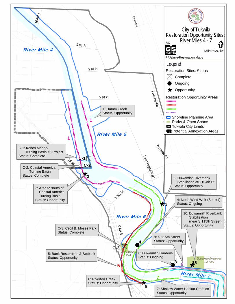
Several projects have already been completed in the Green/Duwamish River. These projects provide an excellent opportunity to learn about what river restoration measures are the most effective. For example, it appears that the back channel that was excavated at Codiga Farm provides important habitat for migrating juvenile fish (Corps Seattle District, 2004). These projects and their current status are shown below in Table 3, listed by river mile (RM). The general location of these projects in Tukwila is shown on Map 1.
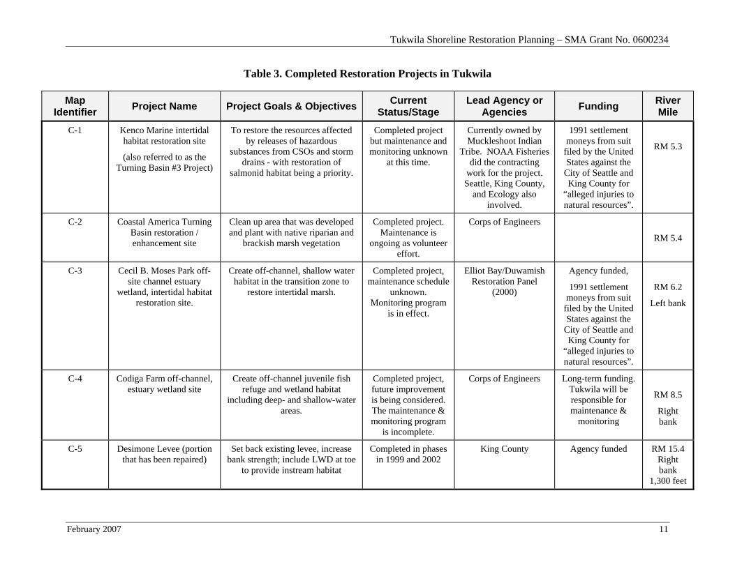
Tukwila Shoreline Restoration Planning – SMA Grant No. 0600234
February 2007 11
Table 3. Completed Restoration Projects in Tukwila
Map Identifier Project Name Project Goals & Objectives Current
Status/Stage Lead Agency or
Agencies Funding River Mile
C-1
Kenco Marine intertidal habitat restoration site
(also referred to as the Turning Basin #3 Project)
To restore the resources affected by releases of hazardous
substances from CSOs and storm drains - with restoration of
salmonid habitat being a priority.
Completed project but maintenance and monitoring unknown
at this time.
Currently owned by Muckleshoot Indian
Tribe. NOAA Fisheries did the contracting
work for the project. Seattle, King County,
and Ecology also involved.
1991 settlement moneys from suit
filed by the United States against the
City of Seattle and King County for
“alleged injuries to natural resources”.
RM 5.3
C-2 Coastal America Turning Basin restoration / enhancement site
Clean up area that was developed and plant with native riparian and
brackish marsh vegetation
Completed project. Maintenance is
ongoing as volunteer effort.
Corps of Engineers
RM 5.4
C-3 Cecil B. Moses Park off-site channel estuary
wetland, intertidal habitat restoration site.
Create off-channel, shallow water habitat in the transition zone to
restore intertidal marsh.
Completed project, maintenance schedule
unknown. Monitoring program
is in effect.
Elliot Bay/Duwamish Restoration Panel
(2000)
Agency funded,
1991 settlement moneys from suit
filed by the United States against the
City of Seattle and King County for
“alleged injuries to natural resources”.
RM 6.2
Left bank
C-4 Codiga Farm off-channel, estuary wetland site
Create off-channel juvenile fish refuge and wetland habitat
including deep- and shallow-water areas.
Completed project, future improvement is being considered. The maintenance & monitoring program
is incomplete.
Corps of Engineers Long-term funding. Tukwila will be responsible for maintenance &
monitoring
RM 8.5
Right bank
C-5 Desimone Levee (portion that has been repaired)
Set back existing levee, increase bank strength; include LWD at toe
to provide instream habitat
Completed in phases in 1999 and 2002
King County Agency funded RM 15.4 Right bank
1,300 feet
Tukwila Shoreline Restoration Planning – SMA Grant No. 0600234
May 2007 12
It is important to note that the monitoring and maintenance aspects of several of these completed projects are not being fully executed. Implementation of effective monitoring and maintenance of these projects is needed to match current national guidance for restoration and to maximize the potential for restoration success.
3.0 RESTORATION OPPORTUNITIES
Based on the key ecosystem functions that are currently altered, there appear to be two specific types of restoration actions that will most benefit the Green/Duwamish ecosystem in Tukwila. These actions are intended to boost the levels of ecosystem functioning as part of a self-sustaining ecosystem that will limit the need for future manipulation. While these projects are intended to restore many ecosystem functions, the restoration activities will occur in the highly-urban valley bottom, and as a result, cannot fully achieve pre-disturbance channel conditions. In addition, some restoration actions must occur at the watershed scale, which will restore ecosystem functions that cannot be addressed solely within Tukwila.
1. Enlarging channel cross-sectional area. This action will increase flood storage, allow for more stable levees, restore floodplain area, provide a larger intertidal zone in this important transitional area, and provide a more natural transition from aquatic to upland habitats. This action could include the use of setback levees and revetments, and the excavation of historic fill or floodplain materials to create back channels.
2. Enhance existing habitats. This action will improve the functioning of the existing aquatic, riverine wetland, and riparian habitats that currently exist along the Green/Duwamish River. These actions could include the removal of non-native invasive vegetation, installation of native riparian vegetation, and installation of LWD below ordinary high water.
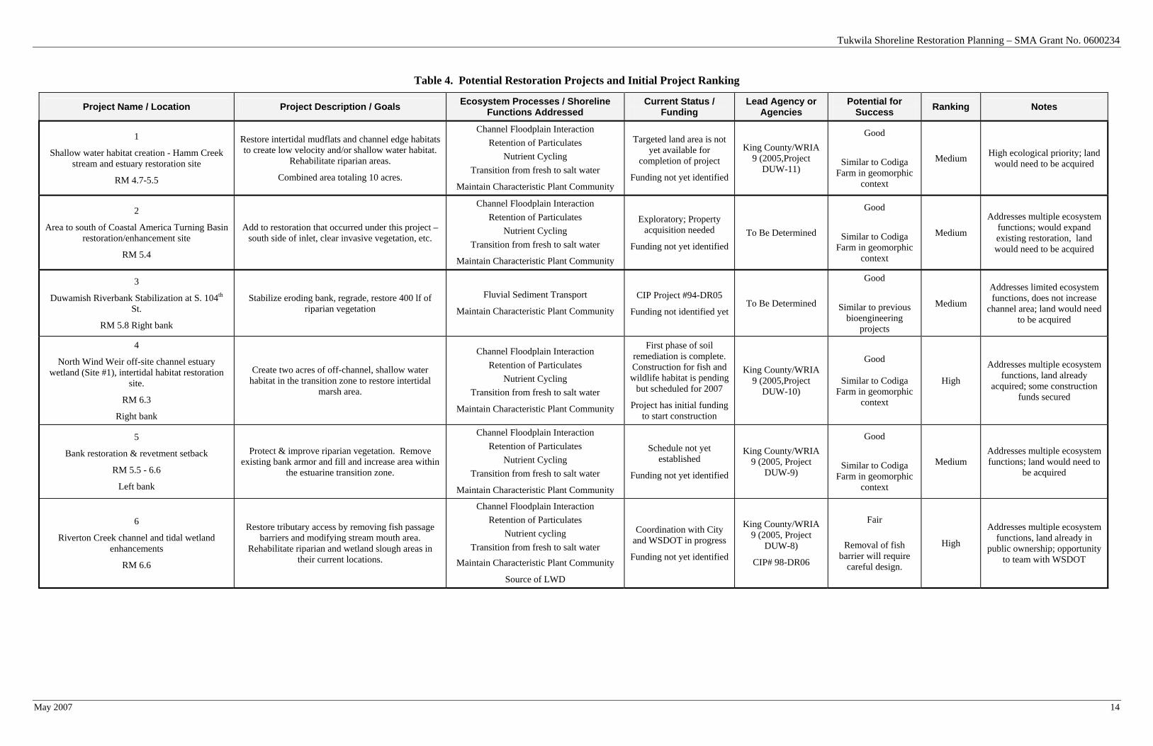
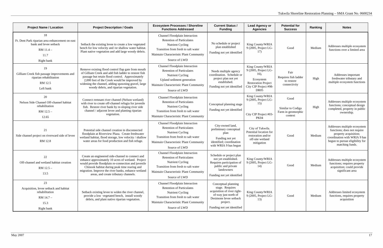
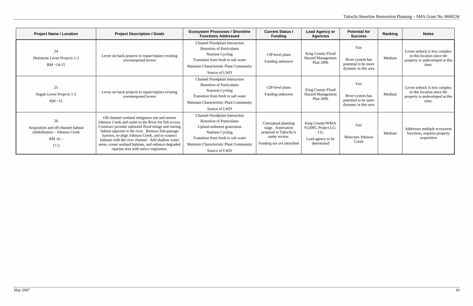
3.1 Potential Projects and Restoration Priorities
Significant past work has occurred to identify specific restoration projects within the shorelines of Tukwila (Pentec, 2004, Anchor 2003, WRIA 9, 2005 etc.). Many of these projects were identified in the Inventory and Characterization Report, and are described below. Most of the restoration projects are part of ongoing restoration planning through the WRIA 9 watershed planning process. Table 4 includes a project description and notes the current status of each project. The project number correlates to those locations shown on Maps 1 through 4 in Section 8., Attachments.
Opportunities exist to enhance riparian vegetation along the majority of the Green/Duwamish River, as mentioned in previous reports (e.g., Anchor 2003). Since these opportunities are so ubiquitous, they are not specifically addressed in Table 4.
To aid the City in developing an internal ranking system, a preliminary qualitative (high, medium, low) project ranking system is employed.
Tukwila Shoreline Restoration Planning – SMA Grant No. 0600234
May 2007 13
High priority projects will typically:
• Address both hydrologic and habitat ecosystem functions;
• Have opportunity for multiple funding sources;
• Include freshwater tributary channels; and/or
• Not require additional property acquisition.
Medium priority projects will typically:
• Address limited ecosystem functions; and
• Be eligible for multiple funding sources, and/or require property acquisition.
Low priority projects will typically:
• Only focus on habitat enhancement;
• Will be used as mitigation to offset impacts elsewhere; or
• Not be eligible for multiple funding sources.
This ranking system is applied to the projects that have been proposed to-date, as described in Table 4.
Tukwila Shoreline Restoration Planning – SMA Grant No. 0600234
May 2007 14
Table 4. Potential Restoration Projects and Initial Project Ranking
Project Name / Location Project Description / Goals Ecosystem Processes / Shoreline Functions Addressed
Current Status / Funding
Lead Agency or Agencies
Potential for Success Ranking Notes
1
Shallow water habitat creation - Hamm Creek stream and estuary restoration site
RM 4.7-5.5
Restore intertidal mudflats and channel edge habitats to create low velocity and/or shallow water habitat.
Rehabilitate riparian areas.
Combined area totaling 10 acres.
Channel Floodplain Interaction Retention of Particulates
Nutrient Cycling Transition from fresh to salt water
Maintain Characteristic Plant Community
Targeted land area is not yet available for
completion of project
Funding not yet identified
King County/WRIA 9 (2005,Project
DUW-11)
Good
Similar to Codiga Farm in geomorphic
context
Medium High ecological priority; land would need to be acquired
2
Area to south of Coastal America Turning Basin restoration/enhancement site
RM 5.4
Add to restoration that occurred under this project – south side of inlet, clear invasive vegetation, etc.
Channel Floodplain Interaction Retention of Particulates
Nutrient Cycling Transition from fresh to salt water
Maintain Characteristic Plant Community
Exploratory; Property acquisition needed
Funding not yet identified To Be Determined
Good
Similar to Codiga Farm in geomorphic
context
Medium
Addresses multiple ecosystem functions; would expand existing restoration, land would need to be acquired
3
Duwamish Riverbank Stabilization at S. 104th St.
RM 5.8 Right bank
Stabilize eroding bank, regrade, restore 400 lf of riparian vegetation
Fluvial Sediment Transport
Maintain Characteristic Plant Community
CIP Project #94-DR05
Funding not identified yet To Be Determined
Good
Similar to previous bioengineering
projects
Medium
Addresses limited ecosystem functions, does not increase
channel area; land would need to be acquired
4
North Wind Weir off-site channel estuary wetland (Site #1), intertidal habitat restoration
site.
RM 6.3
Right bank
Create two acres of off-channel, shallow water habitat in the transition zone to restore intertidal
marsh area.
Channel Floodplain Interaction Retention of Particulates
Nutrient Cycling Transition from fresh to salt water
Maintain Characteristic Plant Community
First phase of soil remediation is complete. Construction for fish and wildlife habitat is pending
but scheduled for 2007
Project has initial funding to start construction
King County/WRIA 9 (2005,Project
DUW-10)
Good
Similar to Codiga Farm in geomorphic
context
High
Addresses multiple ecosystem functions, land already
acquired; some construction funds secured
5
Bank restoration & revetment setback
RM 5.5 - 6.6
Left bank
Protect & improve riparian vegetation. Remove existing bank armor and fill and increase area within
the estuarine transition zone.
Channel Floodplain Interaction Retention of Particulates
Nutrient Cycling Transition from fresh to salt water
Maintain Characteristic Plant Community
Schedule not yet established
Funding not yet identified
King County/WRIA 9 (2005, Project
DUW-9)
Good
Similar to Codiga Farm in geomorphic
context
Medium Addresses multiple ecosystem functions; land would need to
be acquired
6
Riverton Creek channel and tidal wetland enhancements
RM 6.6
Restore tributary access by removing fish passage barriers and modifying stream mouth area.
Rehabilitate riparian and wetland slough areas in their current locations.
Channel Floodplain Interaction Retention of Particulates
Nutrient cycling Transition from fresh to salt water
Maintain Characteristic Plant Community
Source of LWD
Coordination with City and WSDOT in progress
Funding not yet identified
King County/WRIA 9 (2005, Project
DUW-8)
CIP# 98-DR06
Fair
Removal of fish barrier will require
careful design.
High
Addresses multiple ecosystem functions, land already in
public ownership; opportunity to team with WSDOT
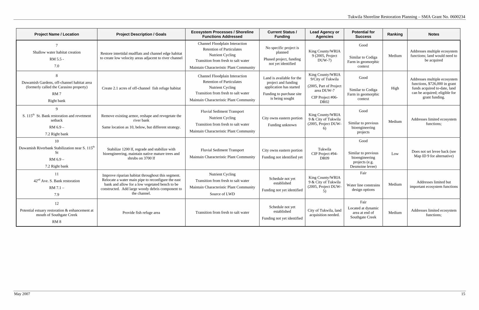
Tukwila Shoreline Restoration Planning – SMA Grant No. 0600234
May 2007 15
Project Name / Location Project Description / Goals Ecosystem Processes / Shoreline Functions Addressed
Current Status / Funding
Lead Agency or Agencies
Potential for Success Ranking Notes
7
Shallow water habitat creation
RM 5.5 -
7.0
Restore intertidal mudflats and channel edge habitat to create low velocity areas adjacent to river channel
Channel Floodplain Interaction Retention of Particulates
Nutrient Cycling Transition from fresh to salt water
Maintain Characteristic Plant Community
No specific project is planned
Phased project, funding not yet identified
King County/WRIA 9 (2005, Project
DUW-7)
Good
Similar to Codiga Farm in geomorphic
context
Medium Addresses multiple ecosystem functions; land would need to
be acquired
8
Duwamish Gardens, off-channel habitat area (formerly called the Carasino property)
RM 7
Right bank
Create 2.1 acres of off-channel fish refuge habitat
Channel Floodplain Interaction Retention of Particulates
Nutrient Cycling Transition from fresh to salt water
Maintain Characteristic Plant Community
Land is available for the project and funding
application has started
Funding to purchase site is being sought
King County/WRIA 9/City of Tukwila
(2005, Part of Project area DUW-7
CIP Project #06-DR02
Good
Similar to Codiga Farm in geomorphic
context
High
Addresses multiple ecosystem functions, $726,000 in grant funds acquired to-date, land can be acquired; eligible for
grant funding.
9
S. 115th St. Bank restoration and revetment setback
RM 6.9 –
7.2 Right bank
Remove existing armor, reshape and revegetate the river bank
Same location as 10, below, but different strategy.
Fluvial Sediment Transport
Nutrient Cycling
Transition from fresh to salt water
Maintain Characteristic Plant Community
City owns eastern portion
Funding unknown
King County/WRIA 9 & City of Tukwila (2005, Project DUW-
6)
Good
Similar to previous bioengineering
projects
Medium Addresses limited ecosystem functions;
10
Duwamish Riverbank Stabilization near S. 115th St
RM 6.9 –
7.2 Right bank
Stabilize 1200 lf, regrade and stabilize with bioengineering, maintain native mature trees and
shrubs on 3700 lf
Fluvial Sediment Transport
Maintain Characteristic Plant Community
City owns eastern portion
Funding not identified yet
Tukwila CIP Project #94-
DR09
Good
Similar to previous bioengineering projects (e.g.
Desmoine levee)
Low Does not set levee back (see Map ID 9 for alternative)
11
42nd Ave. S. Bank restoration
RM 7.1 –
7.9
Improve riparian habitat throughout this segment. Relocate a water main pipe to reconfigure the east
bank and allow for a low vegetated bench to be constructed. Add large woody debris component to
the channel.
Nutrient Cycling
Transition from fresh to salt water
Maintain Characteristic Plant Community
Source of LWD
Schedule not yet established
Funding not yet identified
King County/WRIA 9 & City of Tukwila (2005, Project DUW-
5)
Fair
Water line constrains design options
Medium Addresses limited but important ecosystem functions
12
Potential estuary restoration & enhancement at mouth of Southgate Creek
RM 8
Provide fish refuge area Transition from fresh to salt water Schedule not yet
established
Funding not yet identified
City of Tukwila, land acquisition needed.
Fair Located at dynamic
area at end of Southgate Creek
Medium Addresses limited ecosystem functions;
Tukwila Shoreline Restoration Planning – SMA Grant No. 0600234
May 2007 16
Project Name / Location Project Description / Goals Ecosystem Processes / Shoreline Functions Addressed
Current Status / Funding
Lead Agency or Agencies
Potential for Success Ranking Notes
13
Bank restoration & revetment setback
RM 8.2 – 8.9
Left bank
Reshape existing revetment and relocate Green River Trail to create slow water areas, add native riparian
plants and large woody debris
Channel Floodplain Interaction Retention of Particulates
Nutrient Cycling Transition from fresh to salt water
Maintain Characteristic Plant Community
Source of LWD
Schedule not yet established
Funding not yet identified
King County/WRIA 9 (2005, Project
DUW-3)
Good
Similar to Codiga Farm in geomorphic
context
Medium Addresses multiple important ecosystem functions; funding
not started
14
Shallow water habitat creation
RM 7.0 –
11.0 Both banks
Create a minimum of 15 acres of new off-channel shallow water / marsh habitat with associated
riparian vegetation
Channel Floodplain Interaction Retention of Particulates
Nutrient Cycling Transition from fresh to salt water
Maintain Characteristic Plant Community
Source of LWD
Schedule or project plan not yet established.
Property acquisition may be necessary
Phased project, funding not yet identified
King County/WRIA 9 (2005, Project
DUW-1)
Good
Similar to Codiga Farm in geomorphic
context
Medium Addresses multiple ecosystem functions; requires property
acquisition
15
Create off-channel, estuary wetland on right bank
RM 9.9 -10.3
Enhance riparian areas & create off-channel shallow-water refuge habitat. Side channel construction is
possible.
Channel Floodplain Interaction Retention of Particulates
Nutrient Cycling Transition from fresh to salt water
Maintain Characteristic Plant Community
Source of LWD
Schedule or project plan not yet established. Property acquisition
required.
Funding not yet identified
King County/WRIA 9 (2005, Project
DUW-2)
Good
Medium Addresses multiple ecosystem functions; requires property
acquisition
16
Foster Golf Course Riverbank Improvements
Approximately RM 10
LWD/revegetation along riparian edge as mitigation for USACOE requirement to remove trees from
levees.
Maintain Characteristic Plant Community
Source of LWD
Scheduled for 2007; CIP Project #03-PK06
Funding not identified City of Tukwila
Good
Low
Site intended for use as mitigation, therefore should not be a focus for restoration
efforts
17
Improve confluence of Black River and Green River by restoring riparian corridor and creating
emergent marsh
RM 11
Replace non-native vegetation with native species on the banks of the Green and Black rivers. Create
emergent marsh area and incorporate large woody debris to increase nutrient productivity and improve
salmonid fish refuge and rearing.
Channel Floodplain Interaction Retention of Particulates
Nutrient Cycling Transition from fresh to salt water
Maintain Characteristic Plant Community
Source of LWD
Conceptual plan
Funding not yet identified
King County/WRIA 9 (2005, Project LG-
18), ERP project
Good Medium Addresses multiple ecosystem functions
Tukwila Shoreline Restoration Planning – SMA Grant No. 0600234
May 2007 17
Project Name / Location Project Description / Goals Ecosystem Processes / Shoreline Functions Addressed
Current Status / Funding
Lead Agency or Agencies
Potential for Success Ranking Notes
18
Ft. Dent Park riparian area enhancement on east bank and levee setback
RM 11.4 –
11.7
Right bank
Setback the existing levee to create a low vegetated bench for low velocity and /or shallow water habitat. Plant native vegetation and add large woody debris.
Channel Floodplain Interaction Retention of Particulates
Nutrient Cycling Transition from fresh to salt water
Maintain Characteristic Plant Community
Source of LWD
No schedule or project plan established
Funding not yet identified
King County/WRIA 9 (2005, Project LG-
17) Good Medium Addresses multiple ecosystem
functions over a limited area
19
Gilliam Creek fish passage improvements and riparian rehabilitation
RM 12.5
Left bank
Remove existing flood control flap gate from mouth of Gilliam Creek and add fish ladder to restore fish
passage but retain flood control. Approximately 2,000 feet of the Creek would be improved by
widening the channel, adding spawning gravel, large woody debris, and riparian vegetation.
Channel Floodplain Interaction Retention of Particulates
Nutrient Cycling Upland sediment generation
Maintain Characteristic Plant Community
Source of LWD
Needs multiple agency coordination. Schedule or
project plan not yet established.
Funding not yet identified
King County/WRIA 9 (2005, Project LG-
16),
Ecosystem Restoration Project
City CIP Project #98-DR05
Fair Requires fish ladder
to restore connectivity
High Addresses important
freshwater tributary and multiple ecosystem functions
20
Nelson Side Channel Off-channel habitat rehabilitation
RM 12.5 –
12.65
Connect remnant river channel (Nelson wetland) with river to create off-channel refugia for juvenile
fish. Restore river bank by re-sloping river side channel / adjacent levee and planting riparian
vegetation.
Channel Floodplain Interaction Retention of Particulates
Nutrient Cycling Transition from fresh to salt water
Maintain Characteristic Plant Community
Conceptual planning stage
Funding not yet identified
King County/WRIA 9 (2005, Project LG-
15)
City CIP Project #03-PK04
Good
Similar to Codiga Farm in geomorphic
context
High
Addresses multiple ecosystem functions; conceptual design completed, property in public
ownership.
21
Side channel project on riverward side of levee
RM 12.8
Potential side channel creation in disconnected floodplain at Riverview Plaza. Create freshwater
wetland habitat, flood storage, low velocity / shallow water areas for food production and fish refuge.
Channel Floodplain Interaction Retention of Particulates
Nutrient Cycling Transition from fresh to salt water
Maintain Characteristic Plant Community
Source of LWD
City-owned land, preliminary conceptual
plan
Funding not yet identified; coordination with WRIA 9 has begun
City of Tukwila. Potential location for
restoration and/or off-site wetland
mitigation
Good Medium
Addresses multiple ecosystem functions; does not require
property acquisition; coordination with WRIA 9 has begun to pursue eligibility for
matching funds.
22
Off-channel and wetland habitat creation
RM 12.5 –
13.5
Create an engineered side-channel to connect and enhance approximately 10 acres of wetland. Project would provide floodplain re-connection and juvenile
Chinook habitat during peak time rearing and migration. Improve the river banks, enhance wetland
areas, and create tributary channels.
Channel Floodplain Interaction Retention of Particulates
Nutrient Cycling Transition from fresh to salt water
Maintain Characteristic Plant Community
Source of LWD
Schedule or project plan not yet established.
Requires participation of public and private
landowners
Funding not yet identified
King County/WRIA 9 (2005, Project LG-
14)
Good Medium
Addresses multiple ecosystem functions; requires property acquisition; could provide
significant area
23
Acquisition, levee setback and habitat rehabilitation
RM 14.7 –
15.3
Right bank
Setback existing levee to widen the river channel, provide a low vegetated bench, install woody
debris, and plant native riparian vegetation.
Channel Floodplain Interaction Retention of Particulates
Nutrient Cycling Transition from fresh to salt water
Maintain Characteristic Plant Community
Source of LWD
Conceptual planning stage. Requires
acquisition of river right-of-way just north of
Desimone levee setback project.
Funding not yet identified
King County/WRIA 9 (2005, Project LG-
13) Good Medium
Addresses limited ecosystem functions, requires property
acquisition
Tukwila Shoreline Restoration Planning – SMA Grant No. 0600234
May 2007 18
Project Name / Location Project Description / Goals Ecosystem Processes / Shoreline Functions Addressed
Current Status / Funding
Lead Agency or Agencies
Potential for Success Ranking Notes
24
Desimone Levee Projects 1-3
RM ~14-15
Levee set back projects to repair/replace existing oversteepened levees
Channel Floodplain Interaction Retention of Particulates
Nutrient Cycling Transition from fresh to salt water
Maintain Characteristic Plant Community
Source of LWD
CIP-level plans
Funding unknown
King County Flood Hazard Management
Plan 2006
Fair
River system has potential to be more dynamic in this area
Medium
Levee setback is less complex in this location since the
property is undeveloped at this time;
25
Segale Levee Projects 1-2
RM ~15
Levee set back projects to repair/replace existing oversteepened levees
Channel Floodplain Interaction Retention of Particulates
Nutrient Cycling Transition from fresh to salt water
Maintain Characteristic Plant Community
Source of LWD
CIP-level plans
Funding unknown
King County Flood Hazard Management
Plan 2006
Fair
River system has potential to be more dynamic in this area
Medium
Levee setback is less complex in this location since the
property is undeveloped at this time;
26
Acquisition and off-channel habitat rehabilitation – Johnson Creek
RM 16 –
17.3
Off-channel wetland mitigation site and restore Johnson Creek and outlet to the River for fish access. Construct juvenile salmonid flood refuge and rearing
habitat adjacent to the river. Remove fish passage barriers, re-align Johnson Creek, and re-connect
habitats with the river channel. Add shallow water areas, create wetland habitats, and enhance degraded
riparian area with native vegetation.
Channel Floodplain Interaction Retention of Particulates
Upland sediment generation Nutrient Cycling
Transition from fresh to salt water
Maintain Characteristic Plant Community
Source of LWD
Conceptual planning stage. Annexation
proposal to Tukwila is under review.
Funding not yet identified
King County/WRIA 9 (2005, Project LG-
11),
Lead agency to be determined
Fair
Relocates Johnson Creek
Medium Addresses multiple ecosystem
functions, requires property acquisition
Tukwila Shoreline Restoration Planning – SMA Grant No. 0600234
May 2007 19
4.0 POLICY DEVELOPMENT
The City of Tukwila has been a partner in several projects within the greater Green/Duwamish River Ecosystem Restoration Project (e.g., North Winds Weir and Codiga Farm property acquisitions). Both projects are excellent examples of focusing restoration resources and efforts on projects that address both hydrologic and habitat ecosystem functions.
The initial success of these efforts underscores the importance of the City of Tukwila working with other national or regional entities to pursue significant restoration opportunities. While the City may be able to pursue some restoration or enhancement opportunities without regional partners, these types of projects will typically be smaller scale, lower priority actions (e.g., weed control, native plantings).
Seven general policies have been identified that the city could use to promote the restoration of ecosystem functioning within the Green/Duwamish Ecosystem. The policies are not listed in order or priority.
Policy 1. Identify specific restoration opportunities in or near Tukwila where the City can support another lead agency.
Policy 1 is intended to allow Tukwila to support restoration efforts throughout the basin. As noted in the Inventory and Characterization Report, there are some issues, including water quality, that are better addressed at other points in the watershed. By the time high temperature river water reaches Tukwila, it is not possible to cool the water sufficiently to have a meaningful effect on local habitat conditions.
Policy 2. Identify specific restoration opportunities within Tukwila where the City can take the lead with support from other regional entities.
Policy 2 is intended to continue Tukwila’s support of ecosystem restoration efforts. The restoration framework and goals presented above provides a preliminary method for the City to identify high-priority restoration projects. This method is intended to help the city focus its efforts in an organized way.
Policy 3: Provide incentives to new projects and proposed re-development to preserve additional area behind existing levees to allow for levee setback and back channel projects.
Policy 3 is intended to provide the city a way to preserve area along the river corridor, and to provide additional area for future restoration activities. This policy is an incentive-based approach to preserving the same level of economic development allowed under current zoning while preserving the opportunity to accomplish effective restoration of the river corridor.
Policy 4. Provide stormwater utility rate incentives and/or new stormwater regulations to promote enhanced water quality treatment measures.
Policy 4 is intended to improve water quality within the Green/Duwamish River. This is another incentive-based approach to balance the impacts of new development. If successful, this policy
Tukwila Shoreline Restoration Planning – SMA Grant No. 0600234
May 2007 20
could be expanded to address retro-fitting expanded treatment into existing systems. This policy will also help to acknowledge the connection of areas outside of shoreline jurisdiction to the shoreline. The recently issued Phase 2 NPDES will require changes in the City’s stormwater regulations to meet the new requirements and promote improvements in water quality.
Policy 5. Provide monitoring and adaptive management of restoration projects implemented within the city.
Policy 5 is intended to move the city into a leading role in monitoring and maintaining restoration projects that occur within the City. It is appropriate for the City to take the lead on day-to-day maintenance (e.g., maintenance of irrigation systems) and adaptive management of these restoration sites to ensure that they have the highest potential for success. Monitoring and maintenance are key elements of the restoration framework, and will be essential to the continuous improvement for future restoration projects. However, staffing does not currently exist to support these activities.
Policy 6. Use this restoration framework to integrate compensatory mitigation projects into the broader restoration vision for the city.
Policy 6 is intended to recognize that future development allowed under the SMP may have unavoidable adverse impacts to shoreline functions. In those cases, the restoration planning element of the SMP should help inform development of mitigation.
Policy 7. Continue to work cooperatively with King County, the US Army Corps of Engineers, and the Federal Emergency Management Agency to resolve Green River levee issues in a way that enhances shoreline functions to the extent possible.
Policy 7 is intended to recognize that the levees may not currently meet management standards or flood insurance certification requirements and a variety of other agencies have both jurisdiction and varying objectives with regard to maintenance and management of the levee system.
Policy 8. Encourage public involvement in the restoration of the shoreline.
Policy 8 is intended to provide opportunities for the citizens of Tukwila to take part in, and learn about, the restoration of Tukwila’s shorelines. Example events include: clean-up days, invasive species removal, native plantings, and monitoring projects. This policy also supports types of projects that would not score highly on the priority ranking, above.
5.0 IMPLEMENTATION
The implementation portion of restoration planning typically requires more detailed site-specific information than is available at this time. This section provides an implementation approach consistent with the restoration framework and guidance for SMP development (WAC 173-26-201(2)(f)(vi)).
Tukwila Shoreline Restoration Planning – SMA Grant No. 0600234
May 2007 21
5.1 Funding and Partnership Opportunities
Funding opportunities for restoration projects include both federal and state grants and legislative funds administered by state agencies. For potential projects in Tukwila, the greatest likelihood to obtain funding would result from continued participation in the WRIA 9 forum and/or strategic partnering with King County and state and federal agencies. Targeting funding requests to address levee setback projects would fit well into the scientific and restoration plans/goals of the organizations listed below. A few of these programs and organizations most relevant to Tukwila are described below.
5.1.1 Puget Sound Action Team
The state legislature has appropriated a total of $182 million for state agencies and university education programs for implementing the 2005-2007 Puget Sound Conservation and Recovery Plan (PSAT, 2005). Funding is allocated by both priority area (e.g., habitat restoration (13 percent), stormwater (29 percent)) and state agency (e.g., Ecology, WDFW, WSU Extension, etc.). The habitat restoration funds would be the best fit for opportunities in Tukwila.
5.1.2 Salmon Recovery Funding Board (SRFB)
With the listing of salmonid species under the Endangered Species Act in 1999, the Legislature created the Salmon Recovery Funding Board. Composed of citizens appointed by the Governor and five state agency directors, the Board provides grant funds to protect or restore salmon habitat and assist related activities. It works closely with local watershed groups and has helped finance over 500 projects. The Salmon Recovery Funding Board awarded $7.1 million during the first five funding cycles for salmon habitat protection, restoration, and assessment projects in the Green/Duwamish and Central Puget Sound Watershed (WRIA 9). These grants build on other funding sources such as the King County Conservation District and Waterways 2000. The site-specific opportunities in Tukwila (levee setbacks and off-channel habitat restoration on the Green River) that have been identified in the WRIA 9 Salmon Habitat Plan are good candidates and have the greatest likelihood of receiving SRFB funding.
5.1.3 King Conservation District
The King Conservation District (KCD) is a non-regulatory natural resources assistance agency founded in 1949. The District promotes conservation through demonstration projects, educational events, providing technical assistance, and, in some cases, providing or pointing the way to funds that may be available for projects. The WRIA 9 Forum allocates approximately $634,000 in King Conservation District funds annually to support habitat protection and restoration projects, stewardship projects and programs, and essential technical assessments. As of 2005, the highest priority for WRIA 9 KCD funding became projects and programs that are informed by the strategies identified by the watershed Habitat Plan and the Strategic Assessment.
Tukwila Shoreline Restoration Planning – SMA Grant No. 0600234
May 2007 22
5.1.4 Natural Resource Damage Assessment Funds
The history of industrial land use within the Green/Duwamish River valley has resulted in discharge of pollutants to water and soils in the area. To remediate and mitigate for these impacts, the United States brought litigation against the City of Seattle and King County. The result of the settlement agreement resulted in the availability of National Resource Damage Assessment (NRDA) funds for ecological restoration in the Duwamish. Several projects (e.g., Turning Basin 3, Herring’s House Habitat Restoration) have already been completed in this vicinity. These funds are managed by NOAA, another partner in the Green/Duwamish River Ecosystem Restoration Project.
5.1.5 King County Flood Control District
King County is in the process of developing a new Flood Control District to address flooding issues throughout the county. Current plans call for spending $335 million to implement the recommendations included in the recently adopted Flood Hazard Management Plan (King County, 2006). These plans and projects include the installation of setback levees and inclusion of habitat features as part of the overall flood control project. The plan was adopted by the King County Council January 16, 2007 and on April 16, 2007 the Council adopted one flood control district for the entire county.
5.2 Timelines and Benchmarks
In the context of the SMP update, restoration planning is a long-term effort. As stated earlier, the SMP guidelines include the general goal that local master programs “include planning elements that, when implemented, serve to improve the overall condition of habitat and resources within the shoreline area” (WAC 173-26-201(c)). As a long-range policy plan, it is difficult to establish meaningful timelines and measurable benchmarks in the SMP by which to evaluate the effectiveness of restoration planning or actions. Nonetheless, the legislature has provided an overall timeframe for future amendments to the SMP. In 2003, Substitute Senate Bill 6012 amended the Shoreline Management Act (RCW 90.58.080) to establish an amendment schedule for all jurisdictions in the state. Once the City of Tukwila amends its SMP (on or before December 1, 2009), the City is required to review, and amend if necessary, it’s SMP once every seven years (RCW 90.58.080(4)). During this review period, the City could document progress toward achieving shoreline restoration goals. The review could include:
• Re-evaluating adopted restoration goals, objectives, and policies;
• Summarizing both planning efforts (including application for and securing grant funds) and on-the-ground actions undertaken in the interim to meet those goals; and
• Revising the SMP restoration planning element to reflect changes in priorities or objectives.
Another mechanism that may serve to establish timelines and benchmarks would be establishment of a shoreline restoration program organized like or integrated with the City’s capital improvement program (CIP). Similar to an infrastructure CIP, a shoreline restoration CIP
Tukwila Shoreline Restoration Planning – SMA Grant No. 0600234
May 2007 23
would be evaluated and updated regularly. The CIP would be focused on site-specific projects and would be funded through grants. Further, other CIP projects, such as stormwater facility improvements, could be evaluated to determine if their design could advance shoreline restoration goals.
5.3 Mechanisms and Strategies for Effectiveness
The SMP guidelines for restoration planning state that local programs should “…appropriately review the effectiveness of the projects and programs in meeting the overall restoration goals” (WAC 173-26-201(2)(f)). Phase 3 of the restoration framework described previously (based on Palmer et al, 2005) provides a general roadmap for assessing restoration actions and revising the approach to meeting restoration goals. It includes the following objectives:
• Monitor post-restoration conditions;
• Adaptively manage restoration projects; and
• Use monitoring and maintenance results to inform future restoration activities.
These core objectives have been expanded upon by regional entities focused on restoration such as the WRIA 9 Forum and the Puget Sound Nearshore Project (PNSP). Strategic principles and concepts intended to guide ecosystem recovery are expressed in guidance publications (PSNP, 2004) and the WRIA 9 Salmon Habitat Plan (WRIA 9, 2006). The strategic principles and concepts are very briefly summarized below:
• Purpose and Need. Potential restoration projects should be consistent with overarching goals and objectives. For example, the WRIA 9 Salmon Habitat Plan establishes near-term (the next 10 years) and long-term (50- to 100-year) goals to improve viable salmonid population parameters, such as increased productivity (population growth/abundance), improved genetic diversity, and improved distribution of habitat throughout the watershed (spatial structure).
• Restoration Principles. Restoration planning should be strategic and restoration design should be based on carefully developed goals and objectives. Follow-through, or monitoring, should be employed, including development of performance criteria and use of adaptive management in project development.
• Monitoring Principles. Three types of monitoring are defined: 1) implementation monitoring to track which potential programs and projects are carried out; 2) effectiveness monitoring to determine if habitat objectives of the program or project have been achieved; and validation monitoring to confirm whether proposed restoration actions are achieving the overall objectives for restoration. Monitoring should be driven by specific questions, goals, and objectives and should be used as the basis for determining if restoration goals are being met. Monitoring should be long-term and interdisciplinary. Another component of monitoring is information management; data should be well documented and available to others.
• Adaptive Management Principles. Adaptive management is a process that uses research and monitoring to allow projects to proceed, despite inherent uncertainty and risk regarding its consequences. Adaptive management is best accomplished at a
Tukwila Shoreline Restoration Planning – SMA Grant No. 0600234
May 2007 24
regional or watershed scale, but can be used at a project level to increase knowledge about ecosystems and how they respond to restoration actions.
6.0 CONCLUSIONS
State guidelines require all jurisdictions to address shoreline restoration planning as part of the Shoreline Master Program update process (WAC 173-26-201(2)(f)). This restoration plan presents an overall framework to allow the City of Tukwila to pursue the restoration of ecosystem functioning within the Green/Duwamish River ecosystem. Key alterations to ecosystem functioning were identified in previous inventory and characterization work:
1. The overall area over which key ecosystem functions occur is significantly reduced from historic conditions. This area includes the important zone between fresh and salt water that provides a transition for migrating fish.
2. Aquatic and wetland habitats are largely homogeneous in terms of both hydrology and vegetative structure, and these habitats are typically restricted to the area within levees and revetments within the City of Tukwila.
3. Degradation of water quality, especially water temperature, in the watershed above Tukwila has effects that cannot be fully mitigated within the City.
4. Current levees would likely not meet current engineering standards.
Based on these alterations, we identified two key restoration actions for the aquatic ecosystems within Tukwila:
1. Enlarging channel cross-sectional area. This action will increase flood storage, allow for more stable levees and revetments, restore floodplain area, include the potential for greater intertidal zone, and provide a smoother transition from aquatic to upland habitats. This action could include the use of setback levees and revetments, and the excavation of historic fill or floodplain materials to create back channels.
2. Enhance existing habitat characteristics. This action will improve the functioning of the existing aquatic, riverine wetland, and riparian habitats that currently exist along the Green/Duwamish River.
Based on the review of existing projects, it appears that these goals are at the core of most of the projects being implemented via regional restoration efforts. The City of Tukwila is the lead on at least one of these projects, and is pursuing additional projects. The City will maintain its active role in regional restoration efforts, and continue to focus on improvement of functions in the Green/Duwamish River ecosystem.
Tukwila Shoreline Restoration Planning – SMA Grant No. 0600234
May 2007 25
7.0 REFERENCES
Anchor Environmental, LLC. 2004. Lower Green River Baseline Habitat Report. Prepared for WRIA 9.
Brinson, M.M., 1993. A hydrogeomorphic classification for wetlands. Technical Report WRP-DE-4, U.S. Army Waterways Experiment Station, Vicksburg, MS. NTIS No. AD A270053.
E. S. Bernhardt, M. A. Palmer, J. D. Allan, G. Alexander, K. Barnas, S. Brooks, J. Carr, S. Clayton, C. Dahm, J. Follstad-Shah, D. Galat, S. Gloss, P. Goodwin, D. Hart, B. Hassett, R. Jenkinson, S. Katz, G. M. Kondolf, P. S. Lake, R. Lave, J. L. Meyer, T. K. O'Donnell, L. Pagano, B. Powell, and E. Sudduth. 2005. Synthesizing U.S. River Restoration Efforts. Science. 308(5722) 636-637.
ESA Adolfson. 2006. City of Tukwila Draft Shoreline Inventory and Characterization Report. Prepared for the City of Tukwila. Seattle, Washington.
Green / Duwamish and Central Puget Sound Watershed Water Resource Inventory Area 9 Steering Committee (WRIA 9). August 2005. Salmon Habitat Plan – Making Our Watershed Fit for a King. Prepared for the WRIA 9 Forum. Seattle, Washington.
King County. 2003. Lower Green River Corridor Assessment. Dated November 2003, King County Department of Natural Resources and Parks. 24 pp.
King County. 2006. Draft Flood Hazard Management Plan: King County, Washington. King County Department of Natural Resources and Parks, Water and Land Resources Division, Seattle, Washington.
Kondolf, G.M. 1995. Five elements for effective evaluation of stream restoration. Restoration Ecology 3(2):133-136.
Palmer, M.A., and J.D. Allan. 2006. Restoring Rivers; Policy Recommendations to Enhance Effectiveness of River Restoration. Issues in Science and Technology, Winter 2006. Accessable online at restoringrivers.org
Palmer, M.A., E.S. Bernhardt, J.D. Allan, P.S. Lake, G. Alexander, S. Brooks, J. Carr, S, Clayton, C.N. Dahm, J. Follstad Shah, D.L. Galat, S.G. Loss, P. Goodwin, D.D. Hart, B. Hassett, R. Jenkinson, G.M. Kondolf, R. Lave, J.L. Meyer, T.K. O’Donnell, L. Pagano, and E. Sudduth. Standards for ecologically successful river restoration. Journal of Applied Ecology. 42, 208-217.
Pentec Environmental. 2003. DRAFT Inventory of Shoreline Habitat and Riparian Conditions of the Green/Duwamish River Within the City of Tukwila. Prepared for City of Tukwila. January 7, 2003, Report: 12578-02.
Tukwila Shoreline Restoration Planning – SMA Grant No. 0600234
May 2007 26
Puget Sound Action Team (PSAT). 2005. 2005-2007 Puget Sound Conservation and Recovery Plan. Olympia, Washington.
Puget Sound Nearshore Project (PNSP). 2004. Guiding Restoration Principles. Technical Report 2004-03 available online: www.pugetsoundnearshore.org
Shared Strategy for Puget Sound (Shared Strategy). 2005. Draft Puget Sound Salmon Recovery Plan. Submitted by Shared Strategy Development Committee. Seattle, Washington.
TerraLogic GIS, Inc and Landau Associates. 2004. Final: Lower Duwamish Inventory Report. Technical report prepared for WRIA 9 Steering Committee. Seattle, WA.
United States Army Corps of Engineers (Corps Seattle District). 2004. Memorandum for Record, Subject: Codiga Farms Baseline Monitoring Report. Reference: CENWS-PM-PL-ER. July 23, 2004.
Washington Department of Ecology (Ecology). 2004. Restoration Planning and the 2003 Shoreline Management Guidelines. Ecology Publication No. 04-06-022. Olympia, Washington.
Tukwila Shoreline Restoration Planning – SMA Grant No. 0600234
May 2007 27
8.0 ATTACHMENTS
Map 1. City of Tukwila Restoration Opportunity Sites: River Miles 4-7 Map 2. City of Tukwila Restoration Opportunity Sites: River Miles 7-11 Map 3. City of Tukwila Restoration Opportunity Sites: River Miles 11-15 Map 4. City of Tukwila Restoration Opportunity Sites: River Miles 15-17 Example Project Sheets
S
S
[
S
!
!
[
[
[
Perimeter Road
1
1
5
7
9 108
6
4C-3
3
C-1C-2
2
River Mile 6
River Mile 5
River Mile 4
River Mile 7
11
S 112 St
SR 99
East Marginal Way S
S 102 S
t
27 Ave S
Perimeter Rd
S 94 Pl
S 87 Pl
S 86 Pl
16 A
ve S
Boeing Access Rd
Perimeter Rd
Duwamish Riverbend Hill Park
Cecil Moses Park
S
S
[
S
!
!
[
[
[
Perimeter Road
1
1
5
7
9 108
6
4C-3
3
C-1C-2
2
River Mile 6
River Mile 5
River Mile 4
River Mile 7
11
S 112 St
SR 99
East Marginal Way S
S 102 S
t
27 Ave S
Perimeter Rd
S 94 Pl
S 87 Pl
S 86 Pl
16 A
ve S
Boeing Access Rd
Perimeter Rd
Duwamish Riverbend Hill Park
Cecil Moses Park
City of TukwilaRestoration Opportunity Sites:
River Miles 4 - 75/07
Legend
gScale: 1'=1200 feet
Shoreline Planning AreaParks & Open SpaceTukwila City LimitsPotential Annexation Areas
Restoration Opportunity Areas
CompleteRestoration Sites: Status
Opportunity
Ongoing
1: Hamm CreekStatus: Opportunity
C-1: Kenco Marine/ Turning Basin #3 ProjectStatus: Complete
C-2: Coastal America Turning BasinStatus: Complete
2: Area to south of Coastal America Turning BasinStatus: Opportunity
3: Duwamish Riverbank Stabiliation atS 104th StStatus: Opportunity
4: North Wind Weir (Site #1)Status: Ongoing
C-3: Cecil B. Moses ParkStatus: Complete
5: Bank Restoration & SetbackStatus: Opportunity
6: Riverton CreekStatus: Opportunity
7: Shallow Water Habitat CreationStatus: Opportunity
8: Duwamish GardensStatus: Ongoing
9: S 115th StreetStatus: Opportunity
10: Duwamish Riverbank Stabilization (near S 115th Street)Status: Opportunity
S!
[
P:\Jaimie\Restoration Maps
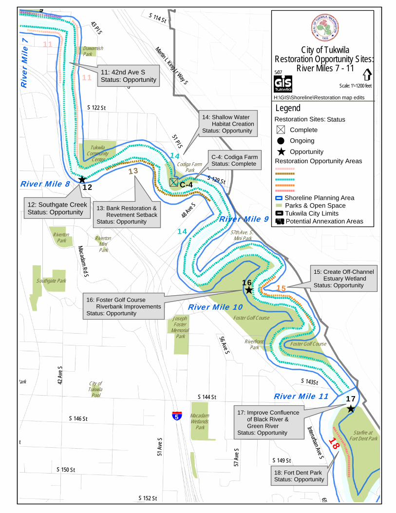
[ S
[
[
[
§̈¦5
11
13
14
15
River Mile 9
River Mile 10
C-412River Mile 8
Riv
er M
ile 7
16
River Mile 11 17
11
14
12: Southgate CreekStatus: Opportunity
42 A
v e S
S 144 St
Interurban Ave S
S 146 St
S 150 St
51 A
ve St
Macadam Rd S
56 Ave S
57 A
ve S
44 Pl S
51 Pl S
S 122 St
48 Ave
S
65S 152 St
Martin L King Jr Way S
S 137 St
S 129 St
S 143St
S 114 St
S 149 St
43 Pl S
9
18
Foster Golf Course
Starfire at Fort Dent Park
Foster Golf Course
Tukwila Community
Center
Macadam Wetlands
Park
Southgate Park
Codiga Farm Park
Riverton Park
Joseph Foster
Memorial Park
Park City of Tukwila
Pool
Riverfront Park
Hazelnut Park
57th Ave. S. Mini ParkRiverton
Mini Park
City of TukwilaRestoration Opportunity Sites:
River Miles 7 - 115/07
Legend
gScale: 1'=1200 feet
Shoreline Planning AreaParks & Open SpaceTukwila City LimitsPotential Annexation Areas
Restoration Opportunity Areas
CompleteRestoration Sites: Status
Opportunity
OngoingS!
[
H:\GIS\Shoreline\Restoration map edits
Duwamish Park
11: 42nd Ave SStatus: Opportunity
13: Bank Restoration & Revetment SetbackStatus: Opportunity
14: Shallow Water Habitat CreationStatus: Opportunity
15: Create Off-Channel Estuary WetlandStatus: Opportunity
16: Foster Golf Course Riverbank ImprovementsStatus: Opportunity
17: Improve Confluence of Black River & Green RiverStatus: Opportunity
C-4: Codiga FarmStatus: Complete
18: Fort Dent ParkStatus: Opportunity
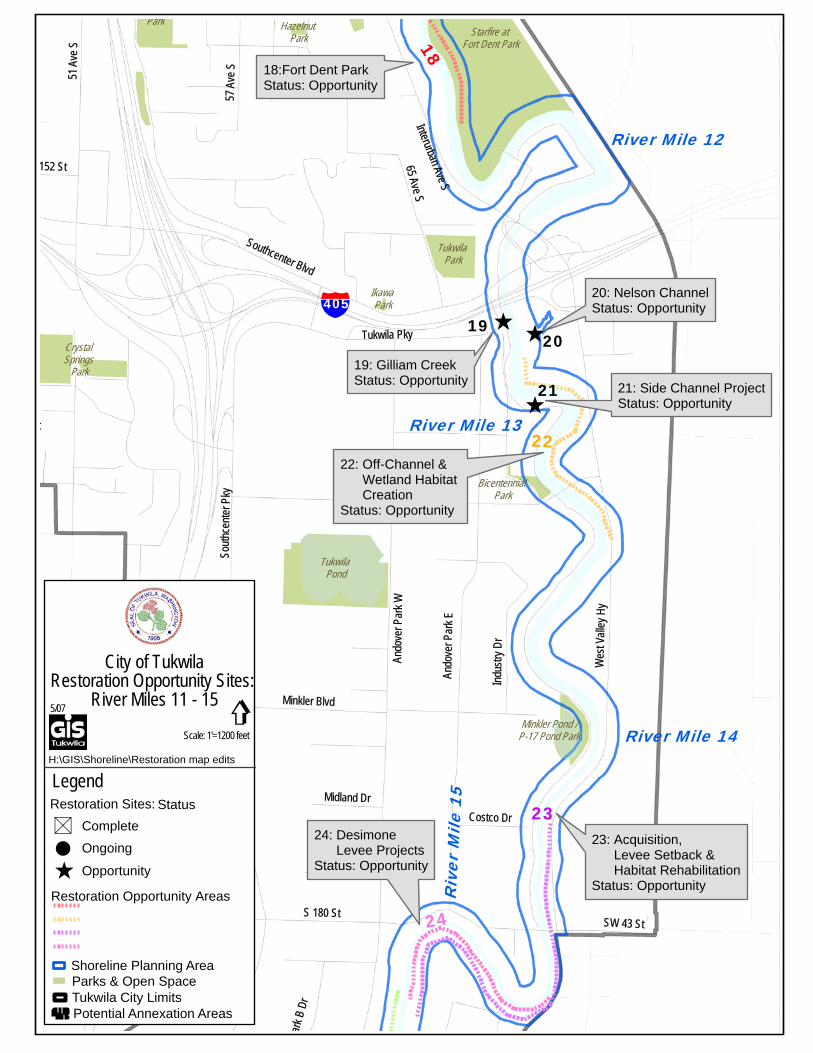
[ [
[
§̈¦40519
20
21
River Mile 12
River Mile 13
River Mile 14
§̈¦5
Riv
er M
ile 1
5
Interurban Ave S
Wes
t Vall
ey H
y
Southcenter Blvd
Sout
hce n
te r P
ky
Ando
ver P
a rk W
5 1 A
ve S
A ndo
ver P
ark E
S 180 St
57 A
ve S
Tukwila Pky
65 Ave S
S 178 St
152 St
Indus
tr y D
r
Minkler Blvd
SW 43 St
t
Costco Dr
ark B
Dr
Midland Dr
S 149 St
23
22
24
18
Starfire at Fort Dent Park
Tukwila Pond
Tukwila Park
Park
Crystal Springs
Park
Bicentennial Park
Minkler Pond /P-17 Pond Park
Hazelnut Park
Ikawa Park
[ [
[
§̈¦40519
20
21
River Mile 12
River Mile 13
River Mile 14
§̈¦5
Riv
er M
ile 1
5
Interurban Ave S
Wes
t Vall
ey H
y
Southcenter Blvd
Sout
hce n
te r P
ky
Ando
ver P
a rk W
51 A
ve S
A ndo
ver P
ark E
S 180 St
57 A
ve S
Tukwila Pky
65 Ave S
S 178 St
152 St
Indus
tr y D
r
Minkler Blvd
SW 43 St
t
Costco Dr
ark B
Dr
Midland Dr
S 149 St
23
22
24
18
Starfire at Fort Dent Park
Tukwila Pond
Tukwila Park
Park
Crystal Springs
Park
Bicentennial Park
Minkler Pond /P-17 Pond Park
Hazelnut Park
Ikawa Park
City of TukwilaRestoration Opportunity Sites:
River Miles 11 - 155/07
Legend
gScale: 1'=1200 feet
Shoreline Planning AreaParks & Open SpaceTukwila City LimitsPotential Annexation Areas
Restoration Opportunity Areas
CompleteRestoration Sites: Status
Opportunity
OngoingS!
[
H:\GIS\Shoreline\Restoration map edits
18:Fort Dent ParkStatus: Opportunity
19: Gilliam CreekStatus: Opportunity
20: Nelson ChannelStatus: Opportunity
21: Side Channel ProjectStatus: Opportunity
22: Off-Channel & Wetland Habitat CreationStatus: Opportunity
23: Acquisition, Levee Setback & Habitat RehabilitationStatus: Opportunity
24: Desimone Levee ProjectsStatus: Opportunity
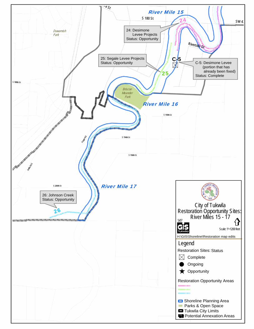
S
Frage
r Rd S 194th St
S 190th St
S 196th St
S 200th St
Orillia
Rd S
S 188th St
River Mile 15
River Mile 16
River Mile 17
24: Desimone Levee ProjectsStatus: Opportunity
C-5: Desimone Levee (portion that has already been fixed)Status: Complete
S 180 St
178 St
SW 43
Riverside Dr
C-5
26
25
24
Briscoe Meander
Park
City of TukwilaRestoration Opportunity Sites:
River Miles 15 - 175/07
Legend
gScale: 1'=1200 feet
Shoreline Planning AreaParks & Open SpaceTukwila City LimitsPotential Annexation Areas
Restoration Opportunity Areas
CompleteRestoration Sites: Status
Opportunity
OngoingS!
[
H:\GIS\Shoreline\Restoration map edits
Duwamish Park
25: Segale Levee ProjectsStatus: Opportunity
26: Johnson CreekStatus: Opportunity
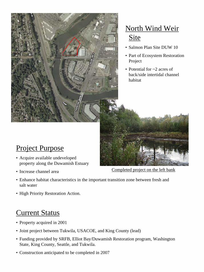
North Wind Weir Site
• Salmon Plan Site DUW 10
• Part of Ecosystem Restoration Project
• Potential for ~2 acres of back/side intertidal channel habitat
Project Purpose• Acquire available undeveloped
property along the Duwamish Estuary
• Increase channel area
• Enhance habitat characteristics in the important transition zone between fresh and salt water
• High Priority Restoration Action.
Completed project on the left bank
Current Status• Property acquired in 2001
• Joint project between Tukwila, USACOE, and King County (lead)
• Funding provided by SRFB, Elliot Bay/Duwamish Restoration program, Washington State, King County, Seattle, and Tukwila.
• Construction anticipated to be completed in 2007
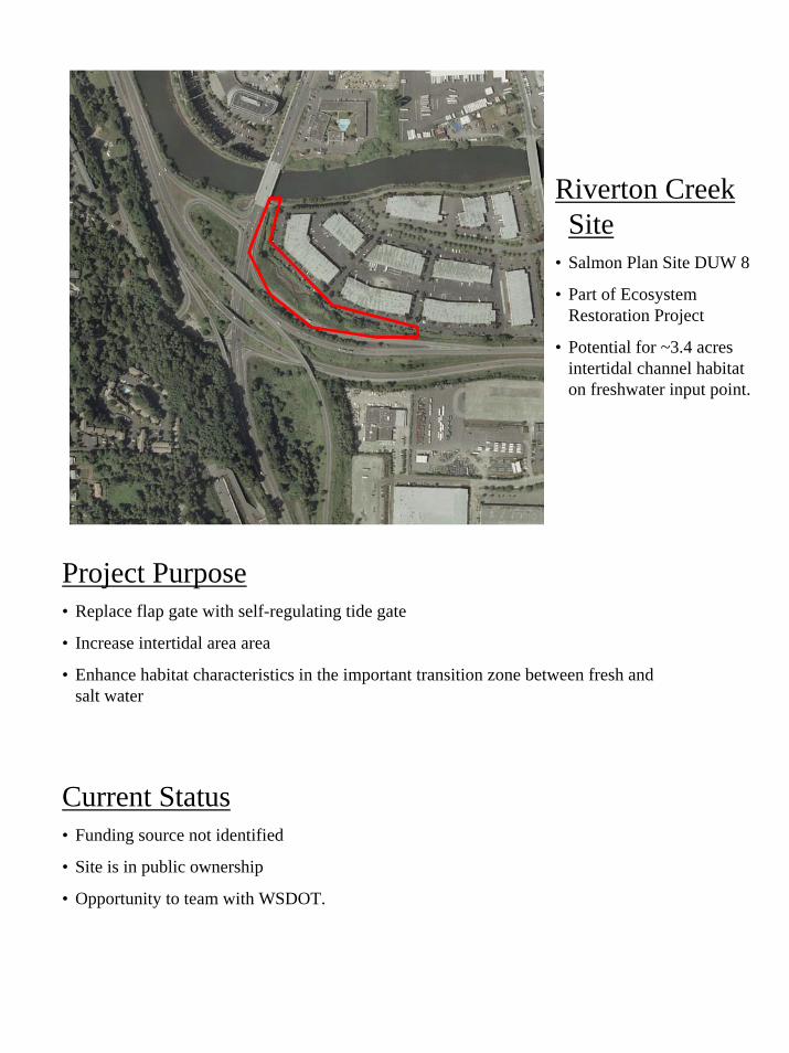
Riverton Creek Site
• Salmon Plan Site DUW 8
• Part of Ecosystem Restoration Project
• Potential for ~3.4 acres intertidal channel habitat on freshwater input point.
Project Purpose• Replace flap gate with self-regulating tide gate
• Increase intertidal area area
• Enhance habitat characteristics in the important transition zone between fresh and salt water
Current Status• Funding source not identified
• Site is in public ownership
• Opportunity to team with WSDOT.
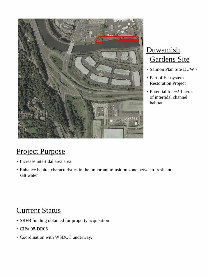
Duwamish Gardens Site
• Salmon Plan Site DUW 7
• Part of Ecosystem Restoration Project
• Potential for ~2.1 acres of intertidal channel habitat.
Project Purpose• Increase intertidal area area
• Enhance habitat characteristics in the important transition zone between fresh and salt water
Current Status• SRFB funding obtained for property acquisition
• CIP# 98-DR06
• Coordination with WSDOT underway.
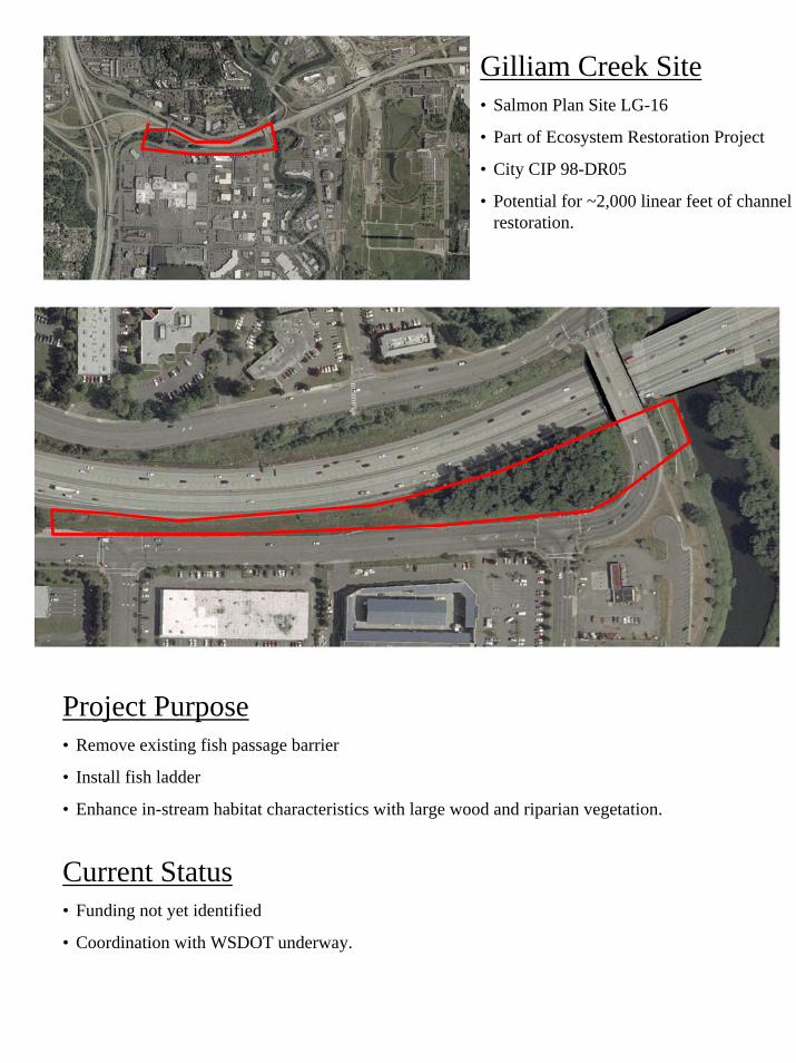
Gilliam Creek Site• Salmon Plan Site LG-16
• Part of Ecosystem Restoration Project
• City CIP 98-DR05
• Potential for ~2,000 linear feet of channel restoration.
Project Purpose• Remove existing fish passage barrier
• Install fish ladder
• Enhance in-stream habitat characteristics with large wood and riparian vegetation.
Current Status• Funding not yet identified
• Coordination with WSDOT underway.
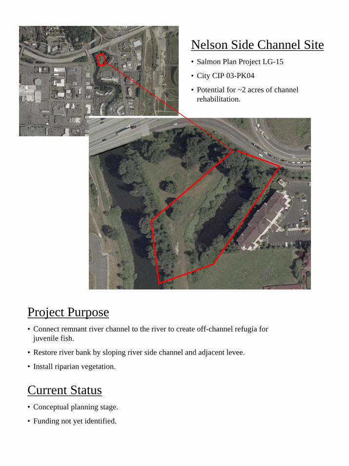
Nelson Side Channel Site• Salmon Plan Project LG-15
• City CIP 03-PK04
• Potential for ~2 acres of channel rehabilitation.
Project Purpose• Connect remnant river channel to the river to create off-channel refugia for
juvenile fish.
• Restore river bank by sloping river side channel and adjacent levee.
• Install riparian vegetation.
Current Status• Conceptual planning stage.
• Funding not yet identified.