Embed Size (px)
Citation preview

Shoalhaven Development Control Plan 2014
Chapter N20: Jerberra Estate
Page | 1
Change Reason
Simplify introduction by referring to website for the Estate’s planning history
To reduce the length of the document
Delete some definitions which are provided in the introduction chapter.
Delete notes under acceptable solution A1.3
The notes contained some incorrect information on the consolidation options for Lots 142 to 146.
Update details on driveway crossings in section 5.7.4.
To ensure consistency with changes that are being made to Council’s Engineering Specifications.
Update information under “financial considerations” heading in Appendix 2.
To reiterate the that infrastructure costs will be borne by benefiting landowners and encourage buyers/sellers to obtain independent valuation advice rather than relying on the indicative valuation prepared by Opteon P/L.
Change Appendix 4 (Jerberra Estate Environmental Management Plan) to a stand-alone guideline document.
The EMP is written as an informative guideline document. Changing it to a supporting document will significantly reduce the length of the EMP.

Shoalhaven Development Control Plan 2014
Chapter N20: Jerberra Estate
Page | 2
Chapter N20 – Jerberra Estate Contents 1 Purpose ........................................................................................................................ 5
2 Application .................................................................................................................... 5
3 Context ......................................................................................................................... 5
3.1 Relationship to other DCP Chapters and Plans ...................................................... 6
3.2 Exempt and Complying Development ..................................................................... 6
3.3 Definitions and Abbreviations ................................................................................. 6
3.4 Submitting a Development Application in Jerberra Estate ...................................... 7
3.4.1 Before you prepare your application ................................................................ 7
3.4.2 How to address the requirements of this Chapter ............................................ 8
3.4.3 Summary of area-based controls ..................................................................... 8
3.4.4 Other Considerations ..................................................................................... 12
3.4.5 Information required with development applications in Jerberra Estate ......... 12
4 Objectives ................................................................................................................... 13
5 Controls ...................................................................................................................... 13
5.1 Consolidation of Lots and Re-Subdivision ............................................................ 13
5.1.1 Introduction .................................................................................................... 13
5.1.2 Allowable variation to the minimum lot size .................................................... 13
5.1.3 Objectives ...................................................................................................... 14
5.1.4 Performance criteria and acceptable solutions ............................................... 14
5.1.5 Supporting information ................................................................................... 15
5.1.6 Other Chapters you must check ..................................................................... 15
5.2 Biodiversity Conservation ..................................................................................... 17
5.2.1 Introduction .................................................................................................... 17
5.2.2 Legal requirements for considering the impact of proposed development ..... 18
5.2.3 Managing biodiversity within APZs ................................................................. 18
5.2.4 Objectives ...................................................................................................... 20
5.2.5 Mandatory Controls ........................................................................................ 20
5.2.6 Performance criteria and acceptable solutions ............................................... 20
5.3 Bushland Conservation Area (BCA) & Bushland Management Area (BMA) ......... 23
5.3.1 Objectives ...................................................................................................... 23
5.3.2 Mandatory controls ......................................................................................... 23
5.3.3 Performance criteria and acceptable solutions ............................................... 24

Shoalhaven Development Control Plan 2014
Chapter N20: Jerberra Estate
Page | 3
5.3.4 Supporting information: Jerberra Estate Environmental Management Plan ... 25
5.4 Bushfire Risk Management ................................................................................... 28
5.4.1 Introduction .................................................................................................... 28
5.4.2 Objectives ...................................................................................................... 28
5.4.3 Mandatory controls ......................................................................................... 29
5.4.4 Performance criteria and acceptable solutions ............................................... 29
5.5 Vehicular access for Lots 156, 166, 92 and 93 ..................................................... 30
5.5.1 Introduction .................................................................................................... 30
5.5.2 Objectives ...................................................................................................... 30
5.5.3 Performance criteria and acceptable solutions ............................................... 30
5.6 On-site Effluent Treatment and Application .......................................................... 31
5.6.1 Introduction .................................................................................................... 31
5.6.2 Objectives ...................................................................................................... 31
5.6.3 Maintenance and inspection of on-site effluent management systems .......... 35
5.6.4 Other DCP Chapters you must check and other relevant information ............ 36
5.7 Stormwater Management ..................................................................................... 36
5.7.1 Introduction .................................................................................................... 36
5.7.2 Objectives ...................................................................................................... 36
5.7.3 Managing stormwater at subdivision scale ..................................................... 36
5.7.4 Managing stormwater on individual lots ......................................................... 39
5.8 Building Envelopes, and Setbacks ........................................................................ 42
5.8.1 Objectives ...................................................................................................... 42
5.8.2 Mandatory controls ......................................................................................... 42
5.8.3 Performance criteria and acceptable solutions ............................................... 42
5.8.4 Other DCP Chapters you must check ............................................................ 43
5.8.5 Other legislation or policies you may need to check ...................................... 45
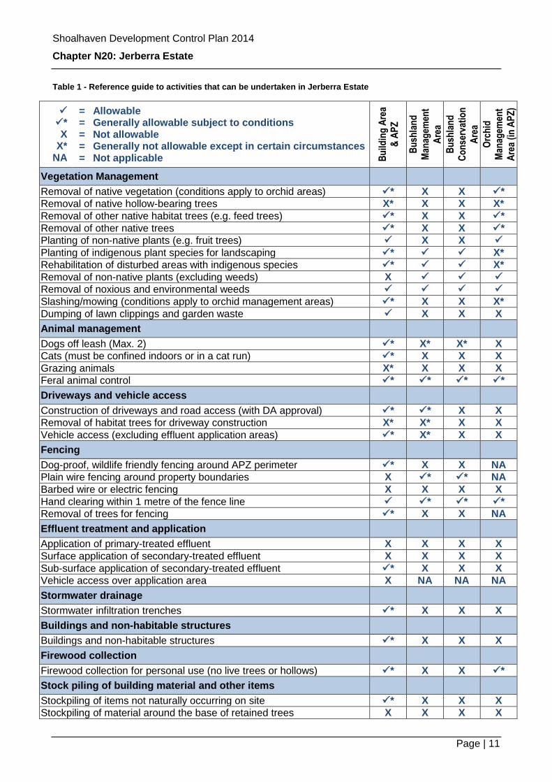
List of Tables Table 1 - Reference guide to activities that can be undertaken in Jerberra Estate ............ 11
Table 2 - Performance criteria and acceptable solutions: consolidation and subdivision ... 14 Table 3 - Properties that will need to be surveyed for Pterostylis ventricosa before development can be approved ........................................................................................... 19 Table 4 - Performance criteria and acceptable solutions: managing biodiversity in APZs . 20 Table 5 - Performance criteria and acceptable solutions: managing biodiversity in the BCA and BMA ............................................................................................................................ 24 Table 6 - Performance criteria and acceptable solutions: bushfire risk management ........ 29 Table 7 - Performance criteria and acceptable solutions: vehicle access for Lots 156,166, 92 & 93 .............................................................................................................................. 30

Shoalhaven Development Control Plan 2014
Chapter N20: Jerberra Estate
Page | 4
Table 8 - Performance criteria and acceptable solutions: on-site effluent management .... 31 Table 9 - Subdivision scale performance criteria and acceptable solutions: managing stormwater ......................................................................................................................... 37
Table 10 - Performance criteria and acceptable solutions: managing stormwater on individual lots ..................................................................................................................... 39 Table 11 - Performance criteria and acceptable solutions: locations of dwellings and ancillary structures ............................................................................................................. 42
List of Figures Figure 1 Subject Land .......................................................................................................... 5 Figure 2 - Suggested subdivision layout and bushfire management information ................. 9
Figure 3 - Bushland management and conservation areas, and orchid (Pterostylis ventricosa) management areas ......................................................................................... 10 Figure 4 - Subdivision and consolidation details for Lots 41 to 43 in DP 11629 ................. 16
Figure 5 - Subdivision and consolidation details for Lots 142 to 146 in DP 11629 ............. 17 Figure 6 - Types and locations of acceptable fencing ........................................................ 27
Figure 7 - Cross section of upslope diversion drain (Source: SCA, 2012) ......................... 35 Figure 8 - Typical vegetated roadside swale section ......................................................... 38
Figure 9 - Location of check dams (Source SEQ WSUD Technical Guidelines) ................ 38 Figure 10 - Stormwater infiltration trench detail ................................................................. 41 Figure 11 - Potential building and conservation area dimensions. ..................................... 44

Shoalhaven Development Control Plan 2014
Chapter N20: Jerberra Estate
Page | 5
1 Purpose
2 Application
This DCP Chapter (N20 – Jerberra Estate) applies to land within Jerberra Estate (“the Estate”) identified in Figure 1. The land is located 20 km south of Nowra and 1.5 km east of Tomerong.
Figure 1 Subject Land
3 Context
The Estate is a 152 lot ‘paper subdivision’ originally created in 1922 without any infrastructure to support its development. Until 22 February 2014, the land had very limited development potential due to the relevant planning controls. The land has generally remained undeveloped and un-serviced bushland apart from numerous unauthorised structures.
A detailed account of the Estate’s planning history is provided on Council’s website at:
http://shoalhaven.nsw.gov.au/Planningamp;Building/Strategicplanning/PaperSubdivisions/JerberraEstate.aspx
The Shoalhaven Local Environmental Plan (Jerberra Estate) 2014, the ‘Jerberra LEP’, commenced on 22 February 2014. Not every existing lot can accommodate a dwelling due to the need to conserve sensitive environmental areas that are protected by legislation, manage bushfire risk, and provide services and infrastructure.

Shoalhaven Development Control Plan 2014
Chapter N20: Jerberra Estate
Page | 6
The Jerberra LEP enables some residential development to potentially be approved within the Estate. Development Control Plan Chapter N20 – Jerberra Estate (the “Jerberra DCP Chapter”) has been prepared to achieve the development and environmental outcomes described in the Planning Proposal, whilst managing bushfire risk in accordance with current standards.
3.1 Relationship to other DCP Chapters and Plans
This Chapter should be read in conjunction with the Jerberra LEP and other relevant Chapters and policies listed in the relevant sections. In the event of any inconsistency between the provisions of this Chapter and other DCP Chapters which apply to the land, this Chapter shall prevail. The Jerberra LEP contains the statutory definitions, aims, land use zones and objectives, principal development standards (e.g. minimum lot size) and associated controls. This Chapter provides detailed guidelines and controls to supplement and support the Jerberra LEP. In the event of any inconsistency between the provisions of the Jerberra LEP and this DCP Chapter, the provisions of the LEP shall prevail.
3.2 Exempt and Complying Development
To achieve the development, environmental, bushfire risk management and equity objectives, the provisions of State Environmental Planning Policy (SEPP) - Exempt and Complying Codes that relate to external structures do not apply to the land. Essentially this means that a development application will be required for any proposed structures such as dwellings, sheds, garages, pergolas and the like. The reason for this is that such structures could adversely impact on or compromise the onsite effluent application system.
To avoid having to submit separate development applications for any proposed ancillary structures you should combine with the development application for your dwelling.
SEPP (Exempt and Complying Development Codes) 2008 can be viewed online at: http://www.legislation.nsw.gov.au
3.3 Definitions and Abbreviations
BAL-29: This is a construction standard under “AS3959 – Construction of buildings in bushfire prone areas”. ‘BAL’ stands for bushfire attack level and ‘29’ means the building is designed to withstand ember attack and radiant heat of up to 29kW/m2.
Bushland Conservation Area (BCA): An area in which no development is allowed must be fenced and retained as native bushland. If the land is currently cleared, it must be allowed to regenerate and/or be rehabilitated.
Bushland Management Area (BMA): The same controls apply as for the BCA except that driveways are allowed.
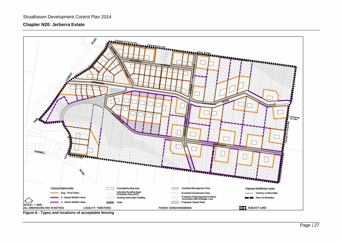
Dog-proof fencing: Fencing provided around the perimeter of the APZ on each property, to prevent dogs from escaping.

Shoalhaven Development Control Plan 2014
Chapter N20: Jerberra Estate
Page | 7
Important habitat trees: Hollow-bearing trees (including Yellow-bellied Glider den trees and Gang-gang Cockatoo nest trees), Glossy-Black Cockatoo feed trees (Allocasuarina littoralis) and Yellow-bellied Glider feed trees.
Orchid Management Area: Areas where the threatened orchid Pterostylis ventricosa occur within APZs that require specific management to ensure they are not harmed.
Potential Building Area: The area identified on Figure 4 where dwellings and associated structures should be located so that your property and neighbouring properties can be safely and appropriately developed.
Some flexibility is provided within the bushfire asset protection zones (APZs), however locating your dwelling and associated structures within the potential building area will make the development approval process more straightforward.
Stormwater Infiltration Trench / Bioretention System: A purpose built absorption trench designed to store and filter stormwater runoff from dwelling and associated structures.
Variation statement: A written statement accompanying a development application demonstrating how the objectives and relevant performance criteria will be achieved if an alternative to the ‘acceptable solutions’ is proposed.
Wildlife friendly fencing: Fencing provided in the BMA/BCA to limit disturbance whilst not impeding the movement of wildlife, comprising posts and plain wires.
3.4 Submitting a Development Application in Jerberra Estate
3.4.1 Before you prepare your application
It is important that you read through this Chapter and seek clarification from Council if you have any questions. Call Council on (02) 4429 3111 so that an appointment can be made for a staff member to answer any questions that you might have and give you information you need to prepare your development application.
The ability for dwellings to be approved on land is controlled in Part 4 of the Jerberra LEP and the accompanying minimum lot size map. Appendix 1 to this Chapter identifies development opportunities in this regard for each existing lot in the Estate.
Dwellings are not able to be approved on all existing allotments within the original Jerberra Estate subdivision. In a number of instances, a dwelling may potentially be able to be approved if two or more allotments are consolidated. In order to assist you in identifying whether a dwelling is able to be approved on your land, either with or without it being consolidated with other lots, Appendix 1 to this Chapter lists all properties currently within the Estate, and identifies whether a dwelling is potentially able to be approved, and if not, the desired lot amalgamation arrangements in order to meet the minimum lot size required by the Jerberra LEP. Appendix 2 to this Chapter provides further guidance on the options that are available to you if lot amalgamation and/or subdivision is required to enable development. It may be necessary to liaise with your neighbours when preparing your development application, for example, where arrangements need to be put in place to manage bushfire

Shoalhaven Development Control Plan 2014
Chapter N20: Jerberra Estate
Page | 8
risk in accordance with legal requirements. Appendix 1 also identifies lots where additional requirements may apply.
Further information including various strategic planning assessments is available on Council’s website at:
http://shoalhaven.nsw.gov.au/PlanningampBuilding/Strategicplanning/PaperSubdivisions/JerberraEstate.aspx
3.4.2 How to address the requirements of this Chapter
Any application for development in the Estate under the Jerberra LEP will need to address the provisions contained in this Chapter. Section 3 of this Chapter covers the following matters:
Consolidation and subdivision;
Biodiversity Conservation;
Bushfire Risk Management;
Vehicular access;
On-site Effluent Treatment and
Stormwater Management; and
Building Envelopes.
3.4.3 Summary of area-based controls
Different controls apply to different parts of the Estate that are identified in Figure 2 and Figure 3. A quick reference guide on activities that may or may not be undertaken in each of the above areas is provided in Table 1.

Shoalhaven Development Control Plan 2014
Chapter N20: Jerberra Estate
Page | 9
Figure 2 - Suggested subdivision layout and bushfire management information

Shoalhaven Development Control Plan 2014
Chapter N20: Jerberra Estate
Page | 10
Figure 3 - Bushland management and conservation areas, and orchid (Pterostylis ventricosa) management areas
Shoalhaven Development Control Plan 2014
Chapter N20: Jerberra Estate
Page | 11
Table 1 - Reference guide to activities that can be undertaken in Jerberra Estate
* X
X* NA
= = = = =
Allowable Generally allowable subject to conditions Not allowable Generally not allowable except in certain circumstances Not applicable B
uild
ing
Are
a
& A
PZ
Bu
shla
nd
Man
agem
ent
Are
a
Bu
shla
nd
Co
nse
rvat
ion
Are
a
Orc
hid
Man
agem
ent
Are
a (i
n A
PZ
)
Vegetation Management
Removal of native vegetation (conditions apply to orchid areas) * X X *
Removal of native hollow-bearing trees X* X X X*
Removal of other native habitat trees (e.g. feed trees) * X X *
Removal of other native trees * X X *
Planting of non-native plants (e.g. fruit trees) X X
Planting of indigenous plant species for landscaping * X*
Rehabilitation of disturbed areas with indigenous species * X*
Removal of non-native plants (excluding weeds) X
Removal of noxious and environmental weeds
Slashing/mowing (conditions apply to orchid management areas) * X X X*
Dumping of lawn clippings and garden waste X X X
Animal management
Dogs off leash (Max. 2) * X* X* X
Cats (must be confined indoors or in a cat run) * X X X
Grazing animals X* X X X
Feral animal control * * * *
Driveways and vehicle access
Construction of driveways and road access (with DA approval) * * X X
Removal of habitat trees for driveway construction X* X* X X
Vehicle access (excluding effluent application areas) * X* X X
Fencing
Dog-proof, wildlife friendly fencing around APZ perimeter * X X NA
Plain wire fencing around property boundaries X * * NA
Barbed wire or electric fencing X X X X
Hand clearing within 1 metre of the fence line * * *
Removal of trees for fencing * X X NA
Effluent treatment and application
Application of primary-treated effluent X X X X
Surface application of secondary-treated effluent X X X X
Sub-surface application of secondary-treated effluent * X X X
Vehicle access over application area X NA NA NA
Stormwater drainage
Stormwater infiltration trenches * X X X
Buildings and non-habitable structures
Buildings and non-habitable structures * X X X
Firewood collection
Firewood collection for personal use (no live trees or hollows) * X X *
Stock piling of building material and other items
Stockpiling of items not naturally occurring on site * X X X
Stockpiling of material around the base of retained trees X X X X

Shoalhaven Development Control Plan 2014
Chapter N20: Jerberra Estate
Page | 12
3.4.4 Other Considerations
Applications may also need to address other relevant DCP Chapters, policies, Australian Standards and other documentation referred to relevant sections and are listed in Section 5.8.5.
3.4.5 Information required with development applications in Jerberra Estate
In preparing a development application for development within the Estate, your application must include:
Plans of the proposed development including:
o Site Analysis Plan showing relevant attributes of the site in relation to adjoining land;
o All necessary building plans including floor plans, elevations, and sections;
o BASIX Certification where a new dwelling or alterations and additions, are proposed;
o A tree and vegetation plan showing trees (and where relevant, Orchid Management Areas) within or adjacent to the APZ, and shows which trees will be retained and which will be removed or lopped;
o Details of driveways and hardstand areas;
o Fencing details; and,
o Appendix of external finishes.
A combined drainage application for the onsite effluent treatment and application system and the stormwater infiltration system. The application will need to include a detailed layout plan plus various other details.
A Bushfire Assessment.
An Erosion and Sediment Control Plan.
Statement of Environmental Effects (SEE) detailing compliance with the requirements of this and any other relevant DCP Chapters. The SEE is to include a Variation Statement if any variation to the requirements is sought. A Jerberra-specific SEE form is available for landowners to assist landowners in this regard.
A Threatened Species Assessment may be required under certain circumstances outlined in Section 5.2.
In some cases, ‘section 88B restrictions-as-user’ will need to be placed on property titles either prior to (e.g. for bushfire perimeter fire trails), or in conjunction with the development application process. This will require the services of a registered surveyor (as will lot amalgamation or subdivision). Further guidance on circumstances where this may apply is provided in Section 3 of this Chapter.

Shoalhaven Development Control Plan 2014
Chapter N20: Jerberra Estate
Page | 13
4 Objectives
a) To facilitate the development of land in the Estate with appropriate acknowledgement of environmental constraints in accordance with the provisions of Shoalhaven Local Environmental Plan (Jerberra) 2014 (referred to herein as the Jerberra LEP) and the Jerberra Estate Planning Proposal.
b) To facilitate the protection and rehabilitation of habitat for the range of threatened species known to occur on the land.
c) To facilitate amalgamation of lots where this is necessary to enable development.
d) To manage risks associated with bushfire.
e) To apply best practice on-site effluent and stormwater management principles during and following construction so that natural flow and water quality regimes are maintained and sensitive downstream environments, including Moona Moona Creek and the Jervis Bay Marine Park, are protected.
f) To enable all existing unauthorised structures to either be regularised, if this can be achieved, or removed.
5 Controls
5.1 Consolidation of Lots and Re-Subdivision
5.1.1 Introduction
In a number of cases (see Appendix 1) residential development of land in the Estate will only be possible if lots within the original subdivision are combined and amalgamated (i.e. consolidated). This involves the preparation of a ‘plan of consolidation’ by a registered surveyor and registration of the plan by NSW Land and Property Information (LPI). This will result in a new property description (Lot and Deposited Plan numbers) being issued by LPI. A suggested subdivision layout has been designed to avoid sterilising lots that might otherwise have some development potential – see Figure 2. Four of the identified potential development areas will only be able to occur if three or more lots are consolidated and subdivided. The Lots in question are listed in Table 2. (See also Appendix 1.) This section of DCP Chapter N20 - Jerberra Estate, provides guidance to landowners on how and when consolidation (and where relevant, subdivision) should occur. Refer to Appendix 1 to determine if this applies to you.
5.1.2 Allowable variation to the minimum lot size
This section only applies to Lots 132 to 141 in DP 11629.
Shoalhaven Development Control Plan 2014
Chapter N20: Jerberra Estate
Page | 14
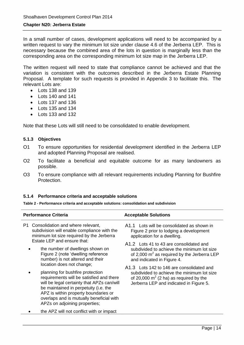
In a small number of cases, development applications will need to be accompanied by a written request to vary the minimum lot size under clause 4.6 of the Jerberra LEP. This is necessary because the combined area of the lots in question is marginally less than the corresponding area on the corresponding minimum lot size map in the Jerberra LEP. The written request will need to state that compliance cannot be achieved and that the variation is consistent with the outcomes described in the Jerberra Estate Planning Proposal. A template for such requests is provided in Appendix 3 to facilitate this. The relevant Lots are:
Lots 138 and 139
Lots 140 and 141
Lots 137 and 136
Lots 135 and 134
Lots 133 and 132 Note that these Lots will still need to be consolidated to enable development.
5.1.3 Objectives
O1 To ensure opportunities for residential development identified in the Jerberra LEP and adopted Planning Proposal are realised.
O2 To facilitate a beneficial and equitable outcome for as many landowners as possible.
O3 To ensure compliance with all relevant requirements including Planning for Bushfire Protection.
5.1.4 Performance criteria and acceptable solutions
Table 2 - Performance criteria and acceptable solutions: consolidation and subdivision
Performance Criteria Acceptable Solutions
P1 Consolidation and where relevant, subdivision will enable compliance with the minimum lot size required by the Jerberra Estate LEP and ensure that:
the number of dwellings shown on Figure 2 (note ‘dwelling reference number) is not altered and their location does not change;
planning for bushfire protection requirements will be satisfied and there will be legal certainty that APZs can/will be maintained in perpetuity (i.e. the APZ is within property boundaries or overlaps and is mutually beneficial with APZs on adjoining properties;
the APZ will not conflict with or impact
A1.1 Lots will be consolidated as shown in Figure 2 prior to lodging a development application for a dwelling.
A1.2 Lots 41 to 43 are consolidated and subdivided to achieve the minimum lot size of 2,000 m2 as required by the Jerberra LEP and indicated in Figure 4.
A1.3 Lots 142 to 146 are consolidated and subdivided to achieve the minimum lot size of 20,000 m2 (2 ha) as required by the Jerberra LEP and indicated in Figure 5.
Shoalhaven Development Control Plan 2014
Chapter N20: Jerberra Estate
Page | 15
Performance Criteria Acceptable Solutions
on bushland conservation areas or other restrictions on the lot in question or adjoining lots; and
no other lots will be orphaned or sterilised from development and amalgamation opportunities as a result of the proposed development.
P2 Consolidation occurs prior to or in conjunction with the development application process.
5.1.5 Supporting information
Refer to Appendices 1 and 2 to this Chapter.
5.1.6 Other Chapters you must check
Chapter G11 – Subdivision

Shoalhaven Development Control Plan 2014
Chapter N20: Jerberra Estate
Page | 16
Figure 4 - Subdivision and consolidation details for Lots 41 to 43 in DP 11629
Notes: New lots ‘A’ and ‘B’ to equal or greater than 2,000 m2. Boundary between Lots ‘A’ and ‘B’ is indicative.

Shoalhaven Development Control Plan 2014
Chapter N20: Jerberra Estate
Page | 17
Figure 5 - Subdivision and consolidation details for Lots 142 to 146 in DP 11629
Notes: New lots ‘A’ and ‘B’ to equal or greater than 2 ha. Boundary between Lots ‘A’ and ‘B’ is indicative.
5.2 Biodiversity Conservation
5.2.1 Introduction
Detailed flora and fauna investigations undertaken from 2005 to 2007 identified a range of threatened animals such as Glossy-black Cockatoos, Yellow-bellied Gliders, Owls, Eastern Bristlebirds and Micro bats. Protected vegetation including the Biconvex Paperbark and Swamp Sclerophyll Forest (which is an Endangered Ecological Community in NSW) also occurs within the riparian areas along the main drainage lines. The Eastern Bristlebird and Biconvex Paperbark, both of which occur in the areas zoned ‘E2 – Environmental Conservation’ are protected under Federal as well as NSW Environmental law. Approval is required under the Environment Protection and Biodiversity Conservation Act (EPBC Act) for any activities that could impact on these biodiversity values. Further information is available at the following website: http://www.environment.gov.au/cgi-bin/epbc/epbc_ap.pl?name=current_referral_detail&proposal_id=6415
Habitat for most of the threatened animals in the Estate will largely be retained in the Bushland Conservation Area (BCA) and the Bushland Management Area (BMA). The location of the areas has been designed to contain most of the important habitat trees and provide habitat linkages. Important habitat trees also occur within a number of the identified APZs. A species of threatened orchid (Pterostylis ventricosa) also occurs in a small number of the identified APZs.
Shoalhaven Development Control Plan 2014
Chapter N20: Jerberra Estate
Page | 18
The areas described above are identified on Figure 3 and different provisions apply to each.
Notes: 1. Under clause 5.9 of the Jerberra LEP, you must not ringbark, cut down, top, lop, remove,
injure or wilfully destroy any tree within the Estate without Council’s consent (issued either via development consent or a tree removal permit).
2. Council’s Tree Policy does not apply to the Estate.
Biodiversity-related provisions that apply to the APZ are set out in Section 5.2.3 of this DCP Chapter. Provisions that apply to the BCA and BMA are set out in Section 5.3.
5.2.2 Legal requirements for considering the impact of proposed development
The NSW Threatened Species Conservation Act 1995 (TSC Act) provides for the conservation of threatened species, populations and ecological communities of animals and plants. Section 5A of the Environmental Planning and Assessment Act 1979 (The EP&A Act) sets out a ‘seven-part test’ for considering the potential impact of a proposed development on critical habitat, threatened species, populations or endangered ecological communities, and their habitats. As development of land in the Estate will potentially impact on known threatened species habitat, an assessment known as a ‘seven-part test’ will be legally required as part of the development assessment process. The landowner/applicant normally engages a consultant to prepare a seven part test for their proposal. In this case however, Council has engaged consultants to undertake an overall seven part test to streamline the development assessment process. The seven part test was based on the full suite of planning controls and measures in the LEP and DCP Chapter N20 - Jerberra Estate. Any development proposal that does not conform to these measures will need to be supported by a separate seven part test. Where there is any doubt regarding the likely impact or where detailed information is not available, supplementary information may need to be provided by the applicant. A Species Impact Statement (SIS) will need to be prepared if the seven-part test concludes that there will be a significant impact.
5.2.3 Managing biodiversity within APZs
Important habitat trees
While most of the important habitat trees are located within the BMA/BCA (refer to Section 5.3) some are also located within the areas proposed for development (i.e. potential building areas and APZs). Council has detailed records of important habitat trees from the 2005-2007 flora and fauna assessment. You need to contact Council on (02) 4429 3111 before you prepare your development application to see if there are any such trees within your building footprint and APZ.

Shoalhaven Development Control Plan 2014
Chapter N20: Jerberra Estate
Page | 19
Your site plans will need to show all existing trees within the APZ and building area, and identify those that will be removed and those that will be retained. As far as possible, important habitat trees should be retained within the APZ. If this is not possible or appropriate due to safety or onsite effluent management issues, priority should be given to retaining trees with hollows above feed trees for the Glossy Black-cockatoo and/or the Yellow-bellied Glider. This is because a wide range of native animals shelter and/or breed in tree hollows. Nocturnal and diurnal animals can use tree hollows making it difficult to detect if a hollow is being used. Council’s Threatened Species Officer will need to inspect any trees proposed to be removed and further assessment may be required if the tree(s) contain any visible hollows. If a hollow-bearing tree is too tall to be retained, it may be possible to lop the tree, leaving the hollow(s) in place. In some circumstances it may be possible to position the proposed dwelling to avoid having to remove the tree.
Threatened orchid (Pterostylis ventricosa) management areas In May 2013, Council commissioned a survey for the threatened orchid Pterostylis ventricosa. The survey was limited to the potential development areas (i.e. potential building areas, APZs and the BMA). The results of the survey are shown Figure 3. Approximately forty six (46) individuals of Pterostylis ventricosa were identified in four small clusters, as outlined below.
Approximately twenty (20) plants within 5 m2 on the southern verge or the unmaintained vehicle track on Invermay Avenue, adjacent to Lot 72.
Approximately twenty (20) plants within 15 m2 of a previously cleared area north of Invermay Avenue on Lot 68.
A single plant north of Invermay Avenue on Lot 67.
Approximately five (5) plants within 2 m2 on a previously disturbed area south of Inglewood Crescent on Lot 146.
All of the orchids were found in the Blackbutt-Spotted Gum Open Forest community that occurs on the eastern side of the Estate (refer to the Jerberra Estate Environmental Management Plan that supports this Chapter).
The properties not surveyed due to either the landowner’s request (not to enter) or safety concerns with entering the property, and which will need to be surveyed before development can be approved, are listed in Table 3.
Table 3 - Properties that will need to be surveyed for Pterostylis ventricosa before development can be approved
Property description Property description
Lot 104 DP 9699, Jerberra Road Lot 133 DP 9699, Inglewood Crescent
Lot 132 DP 9699, Inglewood Crescent Lot 161 DP 9699, Inglewood Crescent
Lot 162 DP 9699, Inglewood Crescent
Shoalhaven Development Control Plan 2014
Chapter N20: Jerberra Estate
Page | 20
These areas are also shown on Figure 3. With appropriate controls and mitigation measures, the orchids can potentially be retained within an APZ. Refer to the relevant performance criteria and acceptable solutions below. Alternatively, if the orchids have to be removed or are likely to be adversely impacted, a species impact statement (SIS) is likely to be required.
5.2.4 Objectives
O1 To encourage the retention of important habitat trees within the identified APZs and to clarify information needed if it is proposed to remove or lop any such trees.
O2 To ensure any known sites of the threatened orchid, Pterostylis ventricosa are managed to ensure no individuals are harmed or removed without the required assessment and approval.
O3 To ensure any residential development is sensitively designed and managed to protect the integrity of surrounding bushland areas.
O4 Ensure any development is consistent with the conditions associated with the Federal Government’s determination under the Environment Protection and Biodiversity Conservation Act (EPBC Act).
5.2.5 Mandatory Controls
C1 Cats will only be kept within the dwelling or a secure cat run connected to the dwelling.
C2 A maximum of two dogs will be kept on the property at any one time and they will be confined to the dwelling and APZ.
C3 Dog proof fencing will be provided around the perimeter of the APZ – see Notes below and Figure 6.
C4 Barbed wire or electrified fencing is not allowed.
C5 Grazing animals will not be kept on the property.
C6 Noxious and/or environmental weeds will be removed from the APZ.
Notes: 1. Dog proof fencing may consist of post and rail fencing with wire mesh (to render it ‘dog proof’)
or open metal or timber picket fence (with minimum 50% open structure). See also Chapter G12 - Single dwellings, additions and ancillary structures.
2. ‘Colourbond’ fencing between dwellings and the road frontage is not supported.
5.2.6 Performance criteria and acceptable solutions
Table 4 - Performance criteria and acceptable solutions: managing biodiversity in APZs
Performance Criteria Acceptable Solutions
P1 Important habitat trees are retained within the APZ subject to compliance with the
A1.1 Separation of two (2) to five (5) metres will be provided between tree canopies and tree canopies

Shoalhaven Development Control Plan 2014
Chapter N20: Jerberra Estate
Page | 21
Performance Criteria Acceptable Solutions
NSW RFS’s specifications for APZ maintenance.
will not overhang within (2) to five (5) metres of the dwelling. Priority should be given to retaining hollow-bearing trees, and feed trees for the Yellow-bellied Glider and the Glossy-black Cockatoo.
Notes
1. Consent is required to remove any trees greater than five (5) metres under clause 5.9 of the LEP.
2. You will need to engage an appropriately qualified consultant to do a targeted survey of any hollow-bearing trees that you propose to remove from the APZ and a qualified wildlife handler must be present on site during removal to rescue any fauna residing in the tree.
P2 Any areas identified on Figure 3 that need to be surveyed for the threatened orchid Pterostylis ventricosa, are surveyed at during the flowering season so that potential impacts of the development can be assessed.
A2.1 A survey for the orchid has been undertaken by an appropriately qualified consultant when the orchid is known to be flowering (generally April to May).
Notes
1. If the orchid was not found no further assessment is required.
2. If the orchid was found, refer to the following performance criteria and acceptable solutions.
P3 All known individuals of the threatened orchid Pterostylis ventricosa will be retained and protected. Alternatively, a ‘seven-part test’ and if necessary, a Species Impact Statement (SIS) is provided by the applicant.
A3.1 The applicant demonstrates that the Orchid Management Area will be managed in perpetuity as follows:
Before any building work commences, a physical barrier using fencing, logs or large rocks will be provided five (5) to ten (10) metres around the orchids, to exclude vehicles, domestic animals and other potentially damaging activities.
Vegetation will only be managed between the months of October and February (inclusive) when the orchid is dormant
Understorey vegetation will be thinned with hand tools only.
Weeds and exotic grasses will be removed by hand.
Herbicides and fertilisers will not be applied.
Stormwater will be diverted around the Orchid Management Area.
Household effluent will not be applied within the Orchid Management Area.
Domestic animals will be excluded from the Orchid Management Area.

Shoalhaven Development Control Plan 2014
Chapter N20: Jerberra Estate
Page | 22
Performance Criteria Acceptable Solutions
A3.2 The Orchid Management Area will be monitored annually so that the above measures can be evaluated and adjusted if necessary.
P4 Trees that will be retained will be protected from potentially damaging activities during construction.
A4.1 Trees that will be retained will be protected in accordance with AS4970 (Protection of trees on development sites) from the impacts of:
machine excavation including trenching;
excavation for silt fencing;
cultivation;
storage;
preparation of chemicals, including preparation of cement products;
parking of vehicles and plant;
refueling;
dumping of waste;
wash down and cleaning of equipment;
placement of fill;
lighting of fires;
soil level changes;
temporary or permanent installation of utilities and signs; and
physical damage to the tree.
A4.2 Building material and other items will not be stockpiled within the root zones of any important habitat trees or vegetation that have been retained within the APZ.
P5 Location and construction of driveways and/or access roads minimise the impact on biodiversity within the APZ.
A5.1 The driveway/access road avoids the need to remove or damage any hollow-bearing trees and Orchid Management Areas.
A5.2 The driveway/access road minimises the need to remove or damage Yellow-bellied Glider feed trees and/or Glossy Black-cockatoo feed trees.
Notes: 1. Contact Council prior to submitting your
development application to assist in determining the best location for the driveway/access road.
2. Refer also to Section 5.7 for other requirements relating to driveway design.

Shoalhaven Development Control Plan 2014
Chapter N20: Jerberra Estate
Page | 23
Performance Criteria Acceptable Solutions
P6 Management of effluent and stormwater does not impact on important habitat trees and vegetation that will be retained within the APZ.
A6.1 Treated effluent is not applied beyond the APZ. The effluent application area does not require the soil under the crowns of any retained trees to be disturbed.
A6.2 Treated effluent is not applied to Orchid Management Areas (refer to Figure 3).
A6.3 The location of stormwater infiltration trenches is not located within the root zones of retained trees. Stormwater is to be managed in accordance with Section 5.7 of this Chapter.
Notes: 1. The effluent application area and stormwater
infiltration trench must be shown on your plans. Refer to Sections 5.6 and 5.7 for details on on-site effluent and stormwater management respectively.
5.3 Bushland Conservation Area (BCA) & Bushland Management Area (BMA)
This section of DCP Chapter N20 provides guidance on management of the BMA and BCA. Further information is also provided in the Jerberra Estate Environmental Management Plan (see Appendix 1 of this Chapter).
5.3.1 Objectives
O1 To restore, protect and enhance biodiversity value of the strategically identified bushland conservation areas, including any areas which are currently cleared or degraded.
O2 To ensure any known sites of the threatened orchid, Pterostylis ventricosa are managed to ensure no individuals are harmed or removed without the required assessment and approval.
O3 To ensure any residential development is sensitively designed and managed to protect the integrity of surrounding bushland areas.
O4 Ensure any development is consistent with the conditions associated with the Federal Government’s determination under the Environment Protection and Biodiversity Conservation Act (EPBC Act).
5.3.2 Mandatory controls
C1 Driveways are permitted within the BMA (refer to Table 5 for further detail).
C2 Driveways are not permitted within the BCA.
Other than driveways, the same controls apply to the BMA and BCA, as outlined below:
C3 Both the BMA and BCA must be fenced and protected from development. Any land that is currently cleared or degraded must be restored to a natural condition.
Shoalhaven Development Control Plan 2014
Chapter N20: Jerberra Estate
Page | 24
C4 No trees or native vegetation is to be removed, slashed or mowed from the BMA/BCA unless:
authorised under the State Emergency and Rescue Management Act 1989;
authorised under the Rural Fires Act 1997;
in accordance with a bushfire management plan; or
approved by Council under Clause 5.9 of Shoalhaven LEP (Jerberra) 2014 (see notes below); or
authorised under the Native Vegetation Act (if applicable).
C5 No barbed wire or electrified wire is used.
C6 Any non-native vegetation must be removed.
C7 The use of vehicles and/or bikes (including 4WD, cars, trail bikes, motorcycles and pushbikes) is not allowed.
C8 Treated effluent is not to be applied.
C9 Stormwater infiltration trenches are not allowed.
C10 Buildings or non-habitable structures or their APZs are not allowed.
C11 Firewood collection is not permitted.
C12 Building material and/or other items that do not occur naturally on the site must not be stockpiled.
C13 Cats, domestic animals or grazing animals are not allowed.
C14 Dogs are only allowed within the BCA and BMA during daylight hours if on a leash.
Notes: 1. Lopping or removal of trees or vegetation from the BCA/BMA will only be considered if a risk
assessment has been undertaken in accordance with Part 2 of Council’s Tree Policy.
2. Where the tree is assessed as likely to provide habitat for threatened species, you will need to submit an assessment of significance pursuant to section 5A of the EP&A Act (i.e. a ‘7-part test’).
3. In all instances the cost of such additional information must be borne by the applicant.
5.3.3 Performance criteria and acceptable solutions
Table 5 - Performance criteria and acceptable solutions: managing biodiversity in the BCA and BMA
Performance Criteria Acceptable Solutions
P1 Wildlife friendly fencing is provided in the BMA/BCA to prevent disturbance whilst not impeding the movement of wildlife.
A1.1 Wildlife friendly fencing comprising posts and up to five (5) plain wires or post and rail fencing will be provided around the perimeter of the BMA/BCA, except for areas containing protected vegetation, as shown in Figure 6.
A1.2 Wildlife friendly fencing comprising posts and up to two (2) plain wires will be provided along property boundaries within the BMA/BCA, except

Shoalhaven Development Control Plan 2014
Chapter N20: Jerberra Estate
Page | 25
Performance Criteria Acceptable Solutions
for areas containing protected vegetation, as shown in Figure 6.
Notes: 1. The maximum height of the uppermost wire/rail is
1.2 metres. 2. The bottom wire/rail is at least 0.4 metres off the
ground. 3. Trees are not to be removed and hand clearing
only is permitted within one (1) metre of fencing.
4. Any clearing land of vegetation within the BCA/BMA (which would include clearing of vegetation for fencing) requires Council consent. If a development application is lodged to fence boundaries within these areas, Council may request a targeted survey to assess the impact on the EEC and potential threatened species habitat. (If a fence is constructed unlawfully, enforcement action will be taken). For further details refer to the EMP.
P2 Driveways within the BMA are located/aligned to have minimal impact on biodiversity values.
A2.1 A maximum of one driveway per dwelling is constructed through the BMA.
A2.2 Driveway width in the BMA generally does not exceed three (3) metres unless wider access is required to comply with Planning for Bushfire Protection.
A2.3 Each driveway through the BMA avoids the removal of or damage to, any threatened orchids or important habitat trees, such as hollow-bearing trees, Yellow-bellied Glider feed trees and/or Glossy Black-cockatoo feed trees.
Notes: 1. Contact Council prior to submitting your
development application to assist in determining the best location for the driveway/access road.
2. Refer to requirements for driveway design in Section 5.7.
3. Driveways are not permitted in the BCA.
5.3.4 Supporting information: Jerberra Estate Environmental Management Plan
The Jerberra Estate Environmental Management Plan provides additional information on ways to minimise impacts, both direct and indirect, from the development of land. It provides specific guidance on the following matters:
Minimising the impact of development and associated land maintenance activities.
Managing bushland on your property.

Shoalhaven Development Control Plan 2014
Chapter N20: Jerberra Estate
Page | 26
Protection and removal of trees and other native vegetation.
Feral animal control and keeping of domestic animals.
Fencing.
Shoalhaven Development Control Plan 2014
Chapter N20: Jerberra Estate
Page | 27
Figure 6 - Types and locations of acceptable fencing

Shoalhaven Development Control Plan 2014
Chapter N20: Jerberra Estate
Page | 28
5.4 Bushfire Risk Management
5.4.1 Introduction
The Estate is identified as Bushfire Prone Land on mapping endorsed by the NSW Rural Fire Service. The landuse planning controls for the Estate have been designed to enable bushfire risk to be managed in accordance with requirements under the NSW Rural Fire Service’s Planning for Bushfire Protection guideline (or equivalent) and the Australian Standard for building and construction in bushfire prone areas (AS3959) or equivalent. Refer to Figure 2.
The following bushfire protection measures need to be incorporated into development to minimise bushfire risk.
Separating development from bushfire prone vegetation with asset protection zones (APZs) around dwellings.
Designing and constructing dwellings and other structures to the required standard under AS3959.
Providing access for fire fighting vehicles including perimeter fire trails in certain locations.
Ensuring the development provides an adequate dedicated water supply for fire fighting purposes.
Landscaping to limit the spread of fire.
Emergency management arrangements for protection of property and/or evacuation.
Individual development applications for development on bush fire prone land are required to be assessed in accordance with Section 79BA of the Environmental Planning and Assessment Act, or where relevant (i.e. subdivision or a “special fire protection purpose”) in accordance with Section 100B of the Rural Fires Act.
The matters outlined above will need to be addressed in detail at the development application stage. In some cases it is also essential that appropriate legal arrangements are in place to ensure that any such measures will be in place in perpetuity, such as where an APZ for a proposed dwelling overlaps onto an adjoining property.
Except where shown on Figure 2, APZs will not be considered on public land.
5.4.2 Objectives
O1 To ensure that any dwellings meet the relevant standards for building in bushfire prone areas.
O2 To ensure that appropriate asset protection zones (APZs) are provided and maintained to separate development from potential bush fire hazards.
O3 To ensure that all bush fire protection measures, including the maintenance of fuel loads in APZs and perimeter fire trails are able to be maintained in perpetuity.
O4 To ensure that appropriate vehicular access is provided to cater for fire fighting trucks and other emergency vehicles.
Shoalhaven Development Control Plan 2014
Chapter N20: Jerberra Estate
Page | 29
O5 To ensure that bushfire mitigation measures are undertaken in a manner consistent with the known environmental constraints.
5.4.3 Mandatory controls
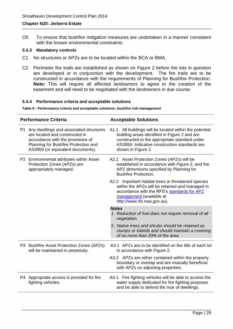
C1 No structures or APZs are to be located within the BCA or BMA.
C2 Perimeter fire trails are established as shown on Figure 2 before the lots in question are developed or in conjunction with the development. The fire trails are to be constructed in accordance with the requirements of Planning for Bushfire Protection. Note: This will require all affected landowners to agree to the creation of the easement and will need to be negotiated with the landowners in due course.
5.4.4 Performance criteria and acceptable solutions
Table 6 - Performance criteria and acceptable solutions: bushfire risk management
Performance Criteria Acceptable Solutions
P1 Any dwellings and associated structures are located and constructed in accordance with the provisions of Planning for Bushfire Protection and AS3959 (or equivalent documents).
A1.1 All buildings will be located within the potential building areas identified in Figure 2 and are constructed to the appropriate standard under AS3959. Indicative construction standards are shown in Figure 2.
P2 Environmental attributes within Asset Protection Zones (APZs) are appropriately managed.
A2.1 Asset Protection Zones (APZs) will be established in accordance with Figure 2, and the APZ dimensions specified by Planning for Bushfire Protection.
A2.2 Important habitat trees or threatened species within the APZs will be retained and managed in accordance with the RFS’s standards for APZ management (available at http://www.rfs.nsw.gov.au).
Notes 1. Reduction of fuel does not require removal of all
vegetation.
2. Native trees and shrubs should be retained as clumps or islands and should maintain a covering of no more than 20% of the area.
P3 Bushfire Asset Protection Zones (APZs) will be maintained in perpetuity.
A3.1 APZs are to be identified on the title of each lot in accordance with Figure 2.
A3.2 APZs are either contained within the property boundary or overlap and are mutually beneficial with APZs on adjoining properties.
P4 Appropriate access is provided for fire fighting vehicles.
A4.1 Fire fighting vehicles will be able to access the water supply dedicated for fire fighting purposes and be able to defend the rear of dwellings.
Shoalhaven Development Control Plan 2014
Chapter N20: Jerberra Estate
Page | 30
Performance Criteria Acceptable Solutions
P5 Bushfire mitigation measures are to be implemented in accordance with Planning for Bushfire Protection.
A5.1 The development application is accompanied by a bushfire assessment which addresses all relevant aspects of Planning for Bushfire Protection including:
APZs
Construction standards and design
Access
Water supply
Emergency management arrangements
Landscaping
5.5 Vehicular access for Lots 156, 166, 92 and 93
5.5.1 Introduction
Due to ecological constraints, some allotments do not have suitable direct access to the identified building area from an existing public road. This requires the creation of a right-of-way or similar arrangement. This section only affects Lots 156, 166, 92 and 93.
Rights-of-way need to be created over Lots 166 and 92, to provide access for Lots 156 and 93 respectively. This will be a mutually beneficial arrangement because it will also reduce the bushfire risk for Lots 166 and 92. Note: This will require negotiation and agreement with the relevant landowners.
5.5.2 Objectives
O1 To ensure that lawful and practical vehicular access is provided to all lots.
O2 To ensure that vehicular access has minimal environmental impact.
5.5.3 Performance criteria and acceptable solutions
Table 7 - Performance criteria and acceptable solutions: vehicle access for Lots 156,166, 92 & 93
Performance Criteria Acceptable Solutions
P1 Coincidental legal and practical access is to be provided for Lot 156 and Lot 93 in a manner that minimises ecological impacts associated with its construction including clearing.
A1.1 Access is provided via:
A six (6) metre wide right of way is to be established adjacent to the southern boundary of Lot 166 to provide access to Lot 156.
A six (6) metre wide right of way is to be established adjacent to the northern boundary of Lot 92 to provide access to Lot 93.

Shoalhaven Development Control Plan 2014
Chapter N20: Jerberra Estate
Page | 31
5.6 On-site Effluent Treatment and Application
5.6.1 Introduction
It is unlikely that the Estate will be serviced by reticulated sewerage in the foreseeable future. Consequently, it will be necessary for effluent wastewater to be treated and applied for on-site.
This section contains planning controls based on a Strategic On-site Effluent Disposal Assessment that was completed as part of the Jerberra Estate rezoning investigations. Development potential in the Estate is limited by the site and soil constraints. It is imperative that any development incorporates the site specific measures provided in this section.
A number of recommendations from a Sydney Catchment Authority (SCA) document titled “Designing and Installing On-Site Wastewater Systems” (SCA, 2012) have also been included. Although the Estate is not in the jurisdiction of the SCA, the recommendations that have been included from the above document are pertinent to on-site effluent management in Jerberra Estate.
5.6.2 Objectives
O1 To protect local watercourses and ground water systems and associated ecosystems from impacts associated with on-site effluent treatment and application.
O2 To minimise the risk to public health by minimising or eliminating contact with effluent, particularly by children, the elderly and immune-compromised members of our community; and carefully managing the application of effluent and its by-products.
O3 To prevent the deterioration of land and protect vegetation quality through soil structure degradation, salinisation, waterlogging, chemical contamination or soil erosion.
O4 Conserve water resources, reuse domestic wastewater (including nutrients, organic matter and water) where possible and within the constraints of other performance objectives.
O5 Protect community amenity by not unreasonably interfering with quality of life and by giving consideration to aesthetics, odours, dust, vectors and excessive noise which may impact on the local amenity.
Table 8 - Performance criteria and acceptable solutions: on-site effluent management
Performance Criteria Acceptable Solutions
P1 Effluent is treated to at least a secondary standard before land application.
A1.1 Treatment is provided by aerated wastewater treatment system (AWTS) or equivalent.
A1.2 The sewage management facility is constructed in accordance with AS/NZS 1546.1 – “On-Site Domestic Wastewater

Shoalhaven Development Control Plan 2014
Chapter N20: Jerberra Estate
Page | 32
Performance Criteria Acceptable Solutions
Treatment Units”.
A1.3 The size of septic tanks and holding tanks complies with AS/NZS 1547 – “On-site domestic wastewater management”.
P2 Treated effluent is applied to an appropriately sized and located sub-surface application area to prevent adverse health and environmental
impacts.
A2.1 Treated effluent is disposed of via subsurface pressurised irrigation and the on-site effluent application area should be no smaller than the following:
Number of Bedrooms1
Minimum Effluent Application Area (m2)
3 583
4 777
5 972 1
Including sunrooms, studies etc which could
potentially be used as a bedroom.
A2.2 The effluent application area will be consistent with buffer distances and setbacks in Chapter G8.
A2.3 A reserve (secondary) area of 100% of the design area is identified upon the site for expansion and contingencies. The reserve area is protected from any development that would prevent its use in the future.
Notes:
1. The designer of the effluent application areas must have appropriate professional indemnity insurance for the system design.
2. The system must be installed by contractor(s) licensed by NSW Fair Trading. That could be a licensed plumber or a licensed irrigation contractor (or both).
3. Reserve area is based upon hydraulic calculations.
4. On small allotments it may not be possible to provide a reserve area. The designer, in consultation with Council, has assessed the options available for the site and selected an appropriate design to provide security in the case of unsatisfactory performance.
5. Alternative subsurface application methods such as sand mounds or amended earth mounds will be considered provided these meet appropriate “NSW Environment and

Shoalhaven Development Control Plan 2014
Chapter N20: Jerberra Estate
Page | 33
Performance Criteria Acceptable Solutions
Health Guidelines” and subject to provision of an assessment and design details (prepared by an appropriately qualified professional) at development application stage. Any sand or amended earth mounds should be installed appropriately and in particular, the base of the mound should not extend below the ‘B’ horizon (subsoil).
P3 All components of the sub-surface application system are correctly sized and configured to provide for adequate effluent pumping and even distribution of effluent, effluent filtration, line flushing and maintenance of the effluent application system.
A3.1 The pump will adequately service the effluent application area.
A3.2 The effluent application area will be split into two or more areas via a distribution or sequencing valve. Individual areas will typically be 250-300 m2.
A3.3 Irrigation system components are specifically designed for subsurface irrigation. Note: Standard irrigation kits provided with AWTS are generally designed for surface irrigation and are not suitable for sub-surface irrigation.
A3.4 The distribution pipe will consist of a 25 mm uPVC or polyethylene pipe, buried at a depth of 300 mm.
A3.5 The sub-surface drip line will be specifically designed for effluent.
Pressure-compensating drip line with emitters and laterals spaced at 600-800 mm.
A pressure regulator will be used if a wick system is proposed.
A3.6 Adequate filtration will be provided before the distribution or sequencing valve. A filter flush will be fitted below the filter and the filter will be cleaned at least every three months.
A3.7 Appropriate technology will be used to protect the drip line from root ingress.
A3.8 Air vacuum valves, pressure reducing valves and non-return valves are incorporated into the design as appropriate.
A3.9 The system will have the capacity to enable flushing to remove any suspended solids and organic growth that may accumulate. Flushed effluent must be directed back to the secondary treatment system or to an absorption trench.

Shoalhaven Development Control Plan 2014
Chapter N20: Jerberra Estate
Page | 34
Performance Criteria Acceptable Solutions
P4 Devices are to be installed in conjunction with development to reduce water consumption and the quantity of waste-water being generated.
A4.1 Full water reduction fixtures are to be installed in each dwelling as an added factor of safety.
Notes:
1. Full water reduction fixtures is defined as: 3/6 litre dual flush toilets, shower flow restrictors, aerator taps, “front load washing machines”, and flow/pressure control valves on all water use outlets.
2. Additionally, full water reduction may be achieved by treatment of greywater and recycling for toilet flushing and washing machines.
P5 The soil profile in the effluent application area is to be improved to better enable on–site application.
A5.1 An organic soil mix conforming to AS4419 (“Soils for landscaping and garden use – Organic soil” or equivalent) will be spread over the effluent application area to a minimum depth of 100 mm. The imported soil will be spread uniformly over the effluent application area and can be blended into the upper 50 mm of native soil.
A5.2 Gypsum will be applied to the effluent application area at a rate of 0.5 to 1 kg per m2 prior to the addition of the organic soil mix.
P6 The effluent application area is planted with species suited to regular application of treated effluent before the system is commissioned.
A6.1 The effluent application area will be established with plant species listed in the NSW Environment and Health Protection Guidelines “On-site Sewage Management for Single Households”.
http://www.dlg.nsw.gov.au/DLG/Documents/information/onsite.pdf
P7 The effluent application area is protected from stormwater and groundwater ingress.
A7.1 A diversion drain will be provided immediately above the effluent application areas. Refer to Figure 7.
Shoalhaven Development Control Plan 2014
Chapter N20: Jerberra Estate
Page | 35
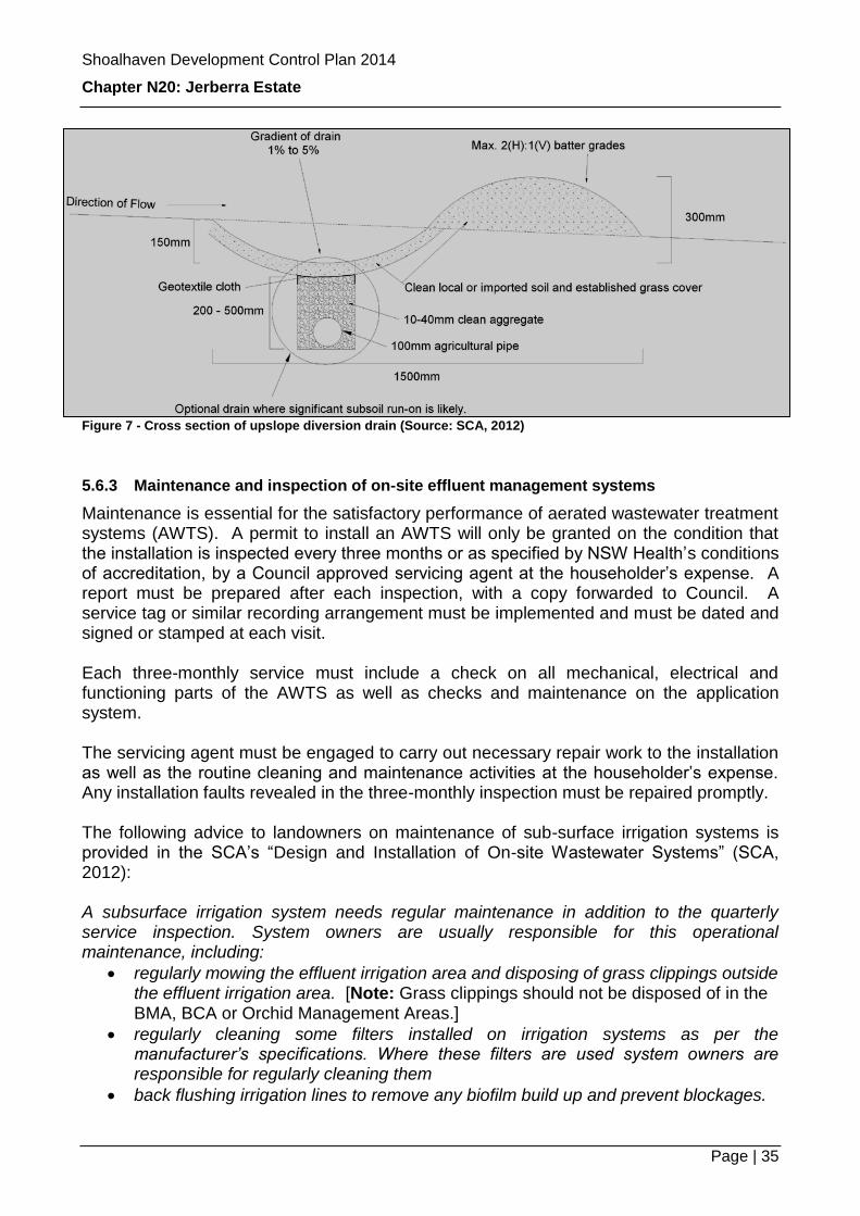
Figure 7 - Cross section of upslope diversion drain (Source: SCA, 2012)
5.6.3 Maintenance and inspection of on-site effluent management systems
Maintenance is essential for the satisfactory performance of aerated wastewater treatment systems (AWTS). A permit to install an AWTS will only be granted on the condition that the installation is inspected every three months or as specified by NSW Health’s conditions of accreditation, by a Council approved servicing agent at the householder’s expense. A report must be prepared after each inspection, with a copy forwarded to Council. A service tag or similar recording arrangement must be implemented and must be dated and signed or stamped at each visit. Each three-monthly service must include a check on all mechanical, electrical and functioning parts of the AWTS as well as checks and maintenance on the application system. The servicing agent must be engaged to carry out necessary repair work to the installation as well as the routine cleaning and maintenance activities at the householder’s expense. Any installation faults revealed in the three-monthly inspection must be repaired promptly. The following advice to landowners on maintenance of sub-surface irrigation systems is provided in the SCA’s “Design and Installation of On-site Wastewater Systems” (SCA, 2012): A subsurface irrigation system needs regular maintenance in addition to the quarterly service inspection. System owners are usually responsible for this operational maintenance, including:
regularly mowing the effluent irrigation area and disposing of grass clippings outside the effluent irrigation area. [Note: Grass clippings should not be disposed of in the BMA, BCA or Orchid Management Areas.]
regularly cleaning some filters installed on irrigation systems as per the manufacturer’s specifications. Where these filters are used system owners are responsible for regularly cleaning them
back flushing irrigation lines to remove any biofilm build up and prevent blockages.

Shoalhaven Development Control Plan 2014
Chapter N20: Jerberra Estate
Page | 36
5.6.4 Other DCP Chapters you must check and other relevant information
Chapter G8 – On-site Sewage Management
Chapter G8 also includes information on inspection, monitoring and maintenance of on-site effluent management systems. An excellent guide to designing and installing onsite wastewater systems has been prepared by the Sydney Catchment Authority and can be accessed from the SCA’s website at: http://www.sca.nsw.gov.au The following chapters are pertinent to the effluent requirements for Jerberra: Section 4 - Aerated Wastewater Treatment Systems Section 13 - Subsurface Irrigation Another source of useful information is the document titled On-site Sewage Management for Single Households published by the Department of Local Government in 1998. It can be accessed from DLG’s website at: http://www.dlg.nsw.gov.au Relevant Australian Standards include: AS/NZS 1546.1 – “On-Site Domestic Wastewater Treatment Units” and AS/NZS 1547 – “On-site domestic wastewater management”.
5.7 Stormwater Management
5.7.1 Introduction
The Estate is located within the hydrologic catchment of Jervis Bay, flowing through Moona Moona Creek and an extensive coastal wetland system. The sensitive hydrologic environment requires consideration of stormwater management measures at both a local scale, when individual developments are undertaken, and also at a broader subdivision scale, generally when larger infrastructure works are undertaken, principally by Council in servicing the land.
5.7.2 Objectives
O1 To ensure that stormwater runoff from development does not adversely impact on the environment, maintains or improves water quality and maintains the natural flow regime.
O2 To ensure compliance with Water Sensitive Urban Design principles including:
protection of the natural hydrological and ecological processes;
maintenance of the natural hydrological behaviour of catchments;
protection of water quality of surface and ground waters; and,
enhancement of visual, social, cultural and ecological values.
5.7.3 Managing stormwater at subdivision scale
Performance criteria and acceptable solutions for management of stormwater in conjunction with the road network (i.e. at subdivision scale) are set out in Table 9.

Shoalhaven Development Control Plan 2014
Chapter N20: Jerberra Estate
Page | 37
Table 9 - Subdivision scale performance criteria and acceptable solutions: managing stormwater
Performance Criteria Acceptable Solutions
P1 Roads are to be designed, constructed and maintained in a manner that:
Avoids impact on water quality by minimising erosion and appropriately controlling sediment.
Minimises impact on flow.
A1.1 Roads are to be constructed using imported material of low-erodibility potential and shall be constructed in accordance with the following:
o Longitudinal gradient not exceeding 10% where unsealed.
o Clearing width for road construction shall be limited to a maximum width of 2 metres from the edge of any construction activity.
o Road batter slopes shall not exceed 1 in 4.
o Cut and fill shall be minimised to limit the duration and extent of disturbance and the need for stockpiling of material.
o Vegetated swales in accordance with Figure 8 shall be incorporated on both sides of all public roads in accordance with the following:
minimum base width of 0.5 m;
maximum batter slopes of 1 in 4;
where the longitudinal gradient exceeds 4%, rock check dams shall be incorporated into the construction to help reduce velocities and potential for scour (refer to Figure 9);
shall be lined with biodegradable jute mat and seeded with drought tolerant native seeds which will not invade native plant communities in the downstream receiving environment; and
shall be maintained and regularly watered for at least 3 months following seeding until a good cover of grass is established.
o Pipe culverts shall incorporate suitable outlet scour protection in accordance with the requirements of Managing Urban Stormwater: Soils and Constructions Volume 1 (Landcom, 2004).
o All outlets, other than those discharging directly to roadside swales shall incorporate shallow sediment basins to maximise the

Shoalhaven Development Control Plan 2014
Chapter N20: Jerberra Estate
Page | 38
Performance Criteria Acceptable Solutions
retention of sediments. The sediment basins shall incorporate overflow weirs of sufficient length to uniformly disperse flows to the surrounding environment with a maximum flow velocity of 1.0 m/s for the 1 in 5 year ARI design storm event.
P2 Fire trails, where required, are to be designed, constructed and maintained in a manner that avoids impact on water quality by minimising erosion and appropriately controlling sediment.
A2.1 Fire trails are to constructed flush with the existing surface so as not to obstruct or divert the natural flow of surface water. Suitable rock material shall be incorporated into the top 200 mm of soil to provide all weather access whilst allowing a groundcover or appropriate non-invasive species to be established and maintained.
P3 The land form is stabilised and erosion is controlled during the construction of roads and fire trails.
A3.1 An Erosion and Sediment Control Plan (ESCP) is to be prepared prior to the commencement of construction. The Erosion and Sediment Control Plan must be designed, installed and maintained in accordance with requirements of Managing Urban Stormwater: Soils & Constructions Volume 1 (Landcom, 2004) Vol 1&2c.
A3.2 Temporary structures including drainage structures and sediment control devices must be designed for a 5 year ARI design storm event.
A3.3 Permanent drainage works are to be installed as early as practicable in the construction sequence.
Figure 8 - Typical vegetated roadside swale section
Figure 9 - Location of check dams (Source SEQ WSUD Technical Guidelines)

Shoalhaven Development Control Plan 2014
Chapter N20: Jerberra Estate
Page | 39
5.7.4 Managing stormwater on individual lots
Performance criteria and acceptable solutions for management of stormwater on individual lots are set out in Table 10.
Table 10 - Performance criteria and acceptable solutions: managing stormwater on individual lots
Performance Criteria Acceptable Solutions
P1.1 Stormwater is to be managed in order to avoid negative impacts on the environment and in accordance with Water Sensitive Urban Design (WSUD) principles.
P1.2 Stormwater management is to be considered on a holistic level mindful of all aspects of a development including site disturbances, excavations, vehicular access and sediment and soil erosion controls.
A1.1 Impervious areas (i.e. roofs and paving) will not be directly connected to the roadside drainage network. Excess roof runoff will be directed to an on-site stormwater infiltration trench (refer to Figure 10) or bioretention system before being discharged to the roadside drainage network.
Note: this is not part of the on-site effluent application system.
A1.2 Rainwater collection tanks with a minimum capacity of 20,000 litres are provided for each dwelling. This is in addition to any water storage requirements needed to satisfy bush fire fighting requirements.
A1.3 Stormwater infiltration trenches or bioretention systems will be provided in conjunction with the development of any building. Refer to Figure 10. Development applications will need to be accompanied by appropriate plans to show how stormwater pollution will be prevented during the construction phase. Where less than 2,500 m2 of disturbance is proposed, applications will need to be accompanied by an erosion and sediment control plan (ESCP). Where more than 2,500 m2 is proposed, applications will need to be accompanied by a soil and water management plan (SWMP) as per the ‘Blue Book’ (Landcom, 2004). The trench is to have:
a surface area of 5 % of the total roof area;
one (1) metre deep subsurface storage filled with gravel which has a void ratio of 0.35:1;
200 mm deep surface storage;
a minimum length to width ratio of 5:1;
a rectangular shape with the long axis parallel to the contour of the land;
a hard landscaped edge (such as treated pine sleepers or concrete edging) on the upper edge in to protect the integrity of the surface storage component;

Shoalhaven Development Control Plan 2014
Chapter N20: Jerberra Estate
Page | 40
Performance Criteria Acceptable Solutions
a downslope edge that is level to evenly disperse overflows onto the adjacent ground surface.
Notes:
1. The bed of the trench is to be level.
2. Top soil removed can be used for landscaping.
3. Clay subsoil not to be spread over the top soil.
P2.1 Driveways are designed and constructed to minimise impact on hydrology and water quality.
P2.2 Details of the driveway are submitted with any dwelling applications (for new or existing) including:
Location of the driveway on the site plan.
A design for the driveway from the roadway seal to the property boundary providing both a plan and longitudinal section showing compliance with AS2890.1 – “Parking facilities - Off-street car parking” in particular, Appendix C Ground Clearance Templates.
A2.1 The driveway crossing is designed generally in accordance with Council’s Engineering Design Specifications using:
A dish crossing where the swale is shallow enough.
A pipe, only where the depth and grade of the swale are suitable.
Notes: 1. Longitudinal grade of the swale must be 3%
to 4% to allow inlet and outlet erosion control works.
2. Inlet and outlet works must be no flatter than 1% unless suitably lined to control siltation (a grade of 0.5% may be permitted).
3. A swale longitudinal section will also be required where a pipe crossing is requested.
4. A pipe is to be sized for the 20% AEP storm flow (1:5 year ARI) for the swale at the location of the driveway or be a minimum of 375mm diameter (whichever is the greater). Calculations by a qualified drainage engineer (or suitably experienced surveyor) are to be provided with the application.
5. The design is to be approved by the Development Services Manager or delegate prior to any works within the road reserve being carried out. All construction works will require inspection prior to relevant stages of construction.
6. Compliance with AS2890.1 will not guarantee that the driveway crossing suits all makes and models of vehicles.
7. An approval under section 138 of the Roads Act will be required from Council prior to any work commencing.
A2.2 Within the property boundary, the driveway will:

Shoalhaven Development Control Plan 2014
Chapter N20: Jerberra Estate
Page | 41
Performance Criteria Acceptable Solutions
Generally have a maximum width of three (3) metres, unless required to be wider to accommodate fire fighting vehicles.
Have a minimum cross fall of the driveway will be 3% to facilitate drainage and prevent longitudinal flow.
Be constructed with a minimum depth of 100 mm of compacted gravel (DGB 20 or equivalent) from an imported source.
Be aligned by grassed swales along its full length with a small sediment basin (located within the property boundary) prior to discharging into the road drainage system.
P3 Measures are employed during the construction phase to minimise soil erosion and protect water quality.
A3.1 An erosion and sediment control plan (ESCP) has been prepared in accordance with Managing Urban Stormwater; Soils and Construction (Landcom, 2004).
A3.2 The site will be managed in accordance with the ESCP throughout the construction phase.
A3.3 All stormwater devices will not be connected until after all development is complete. This will ensure that stormwater devices are not clogged prior to the finalisation of development.
Figure 10 - Stormwater infiltration trench detail

Shoalhaven Development Control Plan 2014
Chapter N20: Jerberra Estate
Page | 42
5.8 Building Envelopes, and Setbacks
5.8.1 Objectives
O1 To ensure buildings are appropriately sited in order to:
Manage bushfire risk in accordance with Planning for Bushfire Protection requirements;
Achieve biodiversity outcomes; and
Preserve the bushland character, local amenity and maximise privacy for individual dwellings.
5.8.2 Mandatory controls
C1 Buildings and associated asset protection zones are located outside of the Bushland Management Area (BMA) and Bushland Conservation Area (BCA) and in accordance with Planning for Bushfire Protection requirements.
5.8.3 Performance criteria and acceptable solutions
Performance criteria and acceptable solutions for building envelopes and setbacks are set out in Table 11. Table 11 - Performance criteria and acceptable solutions: locations of dwellings and ancillary structures
Performance Criteria Acceptable Solutions
P1 The location and position of all structures:
maintains privacy and amenity of adjoining and nearby dwellings; and
minimises impact on biodiversity.
A1.1 The dwelling and associated structures are located within the Potential Building Area. Relevant dimensions are shown on Figure 11.
A1.2 Unless otherwise shown on Figure 9 minimum building setbacks from walls of any buildings to side boundaries will be:
1.5 metres for properties less than 5,000 m2
3.0 metres for properties greater than 5,000 m2.
Notes:
Any alternative building location will need to demonstrate that the variation: 1. is consistent with the requirements of Planning
for Bushfire Protection;
2. better enables preservation of important habitat trees and threatened species within the Potential Building Area and/or APZ;
3. does not require any removal of vegetation within the BCA/BMA;
4. is consistent with DCP Chapter G12 (Single

Shoalhaven Development Control Plan 2014
Chapter N20: Jerberra Estate
Page | 43
Dwellings, Additions and Ancillary Structures).
P2 The size and position of the dwelling and associated structures provides sufficient area for on-site effluent application and outdoor recreation.
A2.1 The site plan demonstrates that the minimum area required for effluent application (refer to Table 8) is provided and provision is made for all necessary buffers, as well as the outdoor recreation needs of the occupants.
5.8.4 Other DCP Chapters you must check
DCP Chapter G12 (Single Dwellings, Additions and Ancillary Structures) contains controls
on:
Design and appearance of dwellings.
Design and appearance of ancillary structures, including residential fences, privacy screens.
Energy efficiency and solar access for dwellings and dwelling alterations.
Notes:
1. In addition to the requirements of Chapter G11, the scale and height of dwellings should minimise overshadowing of land that is or will be used for effluent application.
2. In the case of any inconsistency between Chapter G11 and this Chapter, this Chapter will prevail.

Shoalhaven Development Control Plan 2014
Chapter N20: Jerberra Estate
Page | 44
Figure 11 - Potential building and conservation area dimensions.

Shoalhaven Development Control Plan 2014
Chapter N20: Jerberra Estate
Page | 45
5.8.5 Other legislation or policies you may need to check
Other legislation that may have implications for your proposal includes:
Title Issue Link to Legislation
NSW Legislation
Environmental Planning and Assessment Act 1979
General environmental planning requirements
http://www.legislation.nsw.gov.au/maintop/view/inforce/act+203+1979+cd+0+N
National Parks and Wildlife Act 1974
Aboriginal cultural heritage http://www.legislation.nsw.gov.au/maintop/view/inforce/act+80+1974+cd+0+N
Native Vegetation Act 2003 Protection of native vegetation http://www.legislation.nsw.gov.au/maintop/view/inforce/act+103+2003+cd+0+N
Rural Fires Act 1997 Bushfire protection and mitigation
http://www.legislation.nsw.gov.au/maintop/view/inforce/act+65+1997+cd+0+N
State Emergency and Rescue Management Act 1989
Definition of emergency in relation to vegetation clearing
http://www.legislation.nsw.gov.au/maintop/view/inforce/act+164+1989+cd+0+N
Threatened Species Conservation Act 1995
Protection of biological diversity and threatened species preservation
http://www.legislation.nsw.gov.au/maintop/view/inforce/act+101+1995+cd+0+N
Water Management Act 2003 Protection and management of water and water quality
http://www.legislation.nsw.gov.au/maintop/view/inforce/act+92+2000+cd+0+N
State Environmental Planning Policies
State Environmental Planning Policy No 14—Coastal Wetlands
Preservation and protection of coastal wetlands - water quality
http://www.legislation.nsw.gov.au/maintop/view/inforce/epi+532+1985+cd+0+N
Jervis Bay Regional Environmental Plan 1996
Protection of the natural and cultural values of Jervis Bay
http://www.legislation.nsw.gov.au/maintop/view/inforce/epi+13+1997+cd+0+N
Local Environmental Plans
Shoalhaven LEP (Jerberra) 2014
LEP requirements associated with the Jerberra Estate
TO INSERT WHEN LEP COMMENCES
Other Policies
Planning for Bushfire Protection Bushfire mitigation and protection
http://www.rfs.nsw.gov.au/file_system/attachments/State08/Attachment_20070301_0A17F845.pdf
Australian Standards
AS1547 On-site domestic wastewater management
AS1546 On-site domestic wastewater treatment units - Septic tanks
AS3959 Construction of buildings in bushfire-prone areas
AS4419 Soils for landscaping and garden use
It is noted that legislative changes are made from time to time, and to that end, NSW legislation can be found at http://www.legislation.nsw.gov.au/.

Shoalhaven Development Control Plan 2014
Chapter N20: Jerberra Estate
Page | 46
Appendix 1 - Development Opportunities for Existing Lots
Legal ability for development of a dwelling
The planning controls for the Estate have been designed to benefit as many lots as possible whilst protecting the environment and managing risks associated with bushfire and effluent disposal. Not all lots in the original subdivision plan are able to be developed. In many cases however, some development will be possible if lots are consolidated and/or re-subdivided.
It is critical to ensure that the development opportunities identified in Shoalhaven LEP (Jerberra) 2014 are fully realised. Compliance with the minimum lot size requirement can be achieved by implementing the proposed subdivision layout shown in Figure 2 of the Chapter N20 – Jerberra Estate. Any variation from the proposed subdivision layout shown in Chapter N20 must ensure that no allotments are sterilised or orphaned.
How to use this table
Table A-1 lists all existing lots covered by Chapter N20 in numerical order and identifies whether the land has separate legal ability for a dwelling-house to be approved.
If a dwelling can potentially be approved you are able to lodge a development application.
In a number of cases, a dwelling may be able to be approved if two or more lots are consolidated. Table A-1 identifies those lots which are recommended for amalgamation in order to achieve the equity objectives and environmental constraints of Chapter N20.
Appendix 2 provides a range of options to assist you in your considerations in the development of land requiring amalgamation.

Shoalhaven Development Control Plan 2014
Chapter N20: Jerberra Estate
Page | 47
Table A-1 Development opportunities for existing lots within Jerberra Estate
Property Description
Street
Can a dwelling be approved?
Suggested amalgamation, if relevant
Areas to be identified on title of developable properties
Additional issues that need to be resolved prior to development
On its own If combined with other
lots
Asset Protection
Zone (APZ)
includes effluent
application area
Bushland Cons’n Area
(BCA)
Bushland Manag’t
Area (BMA)
Orchid Manag’t
Area (OMA)
Lots 1-11 DP 1088096 Pine Forest Rd X Consolidate Lots 1-11 in DP 1088096 and Lots 23, 31 and 32 in DP 11629.
Identification of APZ on title of adjoining land as per Chapter N20.
Lot 23 DP 11629 Jerberra Rd X Consolidate Lots 1-11 in DP 1088096 and Lots 23, 31 and 32 in DP 11629.
Identification of APZ on title of adjoining land as per Chapter N20.
Lot 24 DP 11629 Jerberra Rd X Consolidate Lots 24 and 30 Identification of APZ on title of adjoining land as per Chapter N20. Lot 25 DP 11629 Jerberra Rd X Consolidate Lots 25 and 29 Identification of APZ on title of adjoining land as per Chapter N20. Lot 26 DP 11629 Jerberra Rd Identification of APZ on title of adjoining land as per Chapter N20. Lot 27 DP 11629 Jerberra Rd Identification of APZ on title of adjoining land as per Chapter N20. Lot 28 DP 11629 Jerberra Rd Identification of APZ on title of adjoining land as per Chapter N20. Lot 29 DP 11629 Inglewood Cres X Consolidate Lots 25 and 29 Identification of APZ on title of adjoining land as per Chapter N20. Lot 30 DP 11629 Inglewood Cres X Consolidate Lots 24 and 30 Identification of APZ on title of adjoining land as per Chapter N20.
Lot 31 DP 11629 Inglewood Cres X Consolidate Lots 1-11 in DP 1088096 and Lots 23, 31 and 32 in DP 11629.
Identification of APZ on title of adjoining land as per Chapter N20.
Lot 32 DP 11629 Inglewood Cres X Consolidate Lots 1-11 in DP 1088096 and Lots 23, 31 and 32 in DP 11629.
Identification of APZ on title of adjoining land as per Chapter N20.
Lot 33 DP 11629 Inglewood Cres X X Minimum lot size remains at 40 ha. Refer to options outlined in the EMP.
Lot 34 DP 11629 Inglewood Cres X X Minimum lot size remains at 40 ha. Refer to options outlined in the EMP.
Lot 35 DP 11629 Inglewood Cres X X Minimum lot size remains at 40 ha. Refer to options outlined in the EMP.
Lot 36 DP 11629 Inglewood Cres X X Minimum lot size remains at 40 ha. Refer to options outlined in the EMP.
Lot 39 DP 11629 Pine Forest Rd X Consolidate Lots 39 and 40 Identification of APZ on title of adjoining land as per Chapter N20. Lot 40 DP 11629 Pine Forest Rd X Consolidate Lots 39 and 40 Identification of APZ on title of adjoining land as per Chapter N20.
Lot 41 DP 11629 Pine Forest Rd X
Consolidate Lots 41, 42 and 43 and subdivide into two lots at least 2,000 m2.
Identification of APZ on title of adjoining land as per Chapter N20.

Shoalhaven Development Control Plan 2014
Chapter N20: Jerberra Estate
Page | 48
Property Description
Street
Can a dwelling be approved?
Suggested amalgamation, if relevant
Areas to be identified on title of developable properties
Additional issues that need to be resolved prior to development
On its own If combined with other
lots
Asset Protection
Zone (APZ)
includes effluent
application area
Bushland Cons’n Area
(BCA)
Bushland Manag’t
Area (BMA)
Orchid Manag’t
Area (OMA)
Lot 42 DP 11629 Pine Forest Rd X
Consolidate Lots 41, 42 and 43 and subdivide into two lots at least 2,000 m2.
Identification of APZ on title of adjoining land as per Chapter N20.
Lot 43 DP 11629 Pine Forest Rd X
Consolidate Lots 41, 42 and 43 and subdivide into two lots at least 2,000 m2.
Identification of APZ on title of adjoining land as per Chapter N20.
Lot 44 DP 11629 Pine Forest Rd X Consolidate Lots 44 and 45 Identification of APZ on title of adjoining land as per Chapter N20. Lot 45 DP 11629 Pine Forest Rd X Consolidate Lots 44 and 45 Identification of APZ on title of adjoining land as per Chapter N20. Lot 46 DP 11629 Pine Forest Rd Identification of APZ on title of adjoining land as per Chapter N20.
Lot 47 DP 11629 Bowen St Identification of APZ on title of adjoining land as per Chapter N20.
Lot 48 DP 11629 Bowen St Identification of APZ on title of adjoining land as per Chapter N20.
Lot 49 DP 11629 Bowen St Identification of APZ on title of adjoining land as per Chapter N20.
Lot 52 DP 11629 Jerberra Rd X Consolidate Lots 52 and 53 Identification of APZ on title of adjoining land as per Chapter N20.
Lot 53 DP 11629 Jerberra Rd X Consolidate Lots 52 and 53 Identification of APZ on title of adjoining land as per Chapter N20.
Lot 54 DP 11629 Jerberra Rd Identification of APZ on title of adjoining land as per Chapter N20.
Lot 55 DP 11629 Bowen St X Consolidate Lots 55 and 56. Identification of APZ on title of adjoining land as per Chapter N20. Firetrail required over Lots 55-62 as per Chapter N20.
Lot 56 DP 11629 Invermay Ave X Consolidate Lots 55 and 56. Identification of APZ on title of adjoining land as per Chapter N20. Firetrail required over Lots 55-62 as per Chapter N20.
Lot 57 DP 11629 Invermay Ave Identification of APZ on title of adjoining land as per Chapter N20. Firetrail required over Lots 55-62 as per Chapter N20.
Lot 58 DP 11629 Invermay Ave Identification of APZ on title of adjoining land as per Chapter N20. Firetrail required over Lots 55-62 as per Chapter N20.
Lot 59 DP 11629 Invermay Ave Identification of APZ on title of adjoining land as per Chapter N20. Firetrail required over Lots 55-62 as per Chapter N20.
Lot 60 DP 11629 Invermay Ave Identification of APZ on title of adjoining land as per Chapter N20. Firetrail required over Lots 55-62 as per Chapter N20.
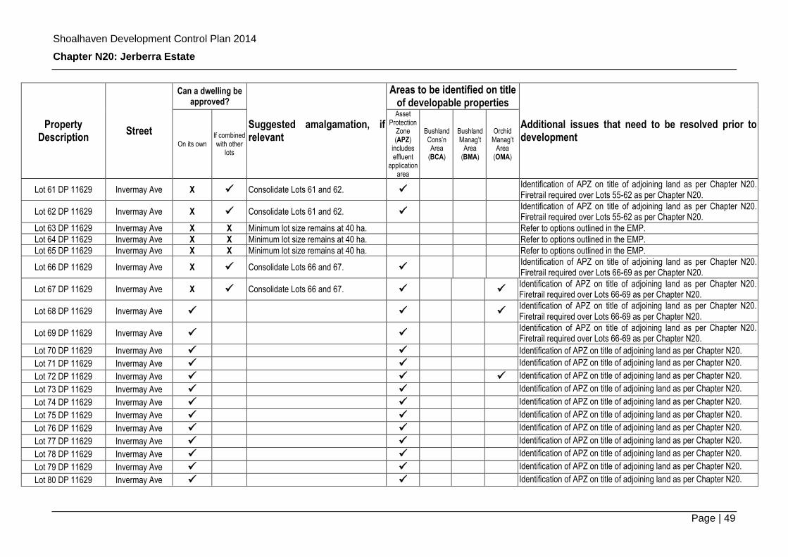
Shoalhaven Development Control Plan 2014
Chapter N20: Jerberra Estate
Page | 49
Property Description
Street
Can a dwelling be approved?
Suggested amalgamation, if relevant
Areas to be identified on title of developable properties
Additional issues that need to be resolved prior to development
On its own If combined with other
lots
Asset Protection
Zone (APZ)
includes effluent
application area
Bushland Cons’n Area
(BCA)
Bushland Manag’t
Area (BMA)
Orchid Manag’t
Area (OMA)
Lot 61 DP 11629 Invermay Ave X Consolidate Lots 61 and 62. Identification of APZ on title of adjoining land as per Chapter N20. Firetrail required over Lots 55-62 as per Chapter N20.
Lot 62 DP 11629 Invermay Ave X Consolidate Lots 61 and 62. Identification of APZ on title of adjoining land as per Chapter N20. Firetrail required over Lots 55-62 as per Chapter N20.
Lot 63 DP 11629 Invermay Ave X X Minimum lot size remains at 40 ha. Refer to options outlined in the EMP.
Lot 64 DP 11629 Invermay Ave X X Minimum lot size remains at 40 ha. Refer to options outlined in the EMP.
Lot 65 DP 11629 Invermay Ave X X Minimum lot size remains at 40 ha. Refer to options outlined in the EMP.
Lot 66 DP 11629 Invermay Ave X Consolidate Lots 66 and 67. Identification of APZ on title of adjoining land as per Chapter N20. Firetrail required over Lots 66-69 as per Chapter N20.
Lot 67 DP 11629 Invermay Ave X Consolidate Lots 66 and 67. Identification of APZ on title of adjoining land as per Chapter N20. Firetrail required over Lots 66-69 as per Chapter N20.
Lot 68 DP 11629 Invermay Ave Identification of APZ on title of adjoining land as per Chapter N20. Firetrail required over Lots 66-69 as per Chapter N20.
Lot 69 DP 11629 Invermay Ave Identification of APZ on title of adjoining land as per Chapter N20. Firetrail required over Lots 66-69 as per Chapter N20.
Lot 70 DP 11629 Invermay Ave Identification of APZ on title of adjoining land as per Chapter N20. Lot 71 DP 11629 Invermay Ave Identification of APZ on title of adjoining land as per Chapter N20.
Lot 72 DP 11629 Invermay Ave Identification of APZ on title of adjoining land as per Chapter N20.
Lot 73 DP 11629 Invermay Ave Identification of APZ on title of adjoining land as per Chapter N20.
Lot 74 DP 11629 Invermay Ave Identification of APZ on title of adjoining land as per Chapter N20.
Lot 75 DP 11629 Invermay Ave Identification of APZ on title of adjoining land as per Chapter N20.
Lot 76 DP 11629 Invermay Ave Identification of APZ on title of adjoining land as per Chapter N20.
Lot 77 DP 11629 Invermay Ave Identification of APZ on title of adjoining land as per Chapter N20.
Lot 78 DP 11629 Invermay Ave Identification of APZ on title of adjoining land as per Chapter N20.
Lot 79 DP 11629 Invermay Ave Identification of APZ on title of adjoining land as per Chapter N20.
Lot 80 DP 11629 Invermay Ave Identification of APZ on title of adjoining land as per Chapter N20.

Shoalhaven Development Control Plan 2014
Chapter N20: Jerberra Estate
Page | 50
Property Description
Street
Can a dwelling be approved?
Suggested amalgamation, if relevant
Areas to be identified on title of developable properties
Additional issues that need to be resolved prior to development
On its own If combined with other
lots
Asset Protection
Zone (APZ)
includes effluent
application area
Bushland Cons’n Area
(BCA)
Bushland Manag’t
Area (BMA)
Orchid Manag’t
Area (OMA)
Lot 81 DP 11629 Jerberra Rd Identification of APZ on title of adjoining land as per Chapter N20.
Lot 82 DP 11629 Jerberra Rd Identification of APZ on title of adjoining land as per Chapter N20.
Lot 83 DP 11629 Jerberra Rd Identification of APZ on title of adjoining land as per Chapter N20.
Lot 84 DP 11629 Jerberra Rd Identification of APZ on title of adjoining land as per Chapter N20.
Lot 85 DP 11629 Jerberra Rd Identification of APZ on title of adjoining land as per Chapter N20.
Lot 86 DP 11629 Jerberra Rd Identification of APZ on title of adjoining land as per Chapter N20.
Lot 87 DP 11629 Jerberra Rd Identification of APZ on title of adjoining land as per Chapter N20.
Lot 88 DP 11629 Jerberra Rd Identification of APZ on title of adjoining land as per Chapter N20.
Lot 89 DP 11629 Jerberra Rd Identification of APZ on title of adjoining land as per Chapter N20.
Lot 90 DP 11629 Jerberra Rd Identification of APZ on title of adjoining land as per Chapter N20. Lot 91 DP 11629 Jerberra Rd
Lot 92 DP 11629 Greenslopes Ave Identification of APZ and right of way on title of Lot 92 as per Chapter N20.
Lot 93 DP 11629 Jerberra Rd Identification of APZ and right of way on title of Lot 92 as per Chapter N20.
Lot 94 DP 11629 Jerberra Rd Identification of APZ on title of adjoining land as per Chapter N20. Lot 95 DP 11629 Jerberra Rd Identification of APZ on title of adjoining land as per Chapter N20.
Lot 96 DP 11629 Jerberra Rd Identification of APZ on title of adjoining land as per Chapter N20.
Lot 97 DP 11629 Jerberra Rd X Consolidate Lots 97, 98, 99 and 100
Lot 98 DP 11629 Jerberra Rd X Consolidate Lots 97, 98, 99 and 100
Lot 99 DP 11629 Jerberra Rd X Consolidate Lots 97, 98, 99 and 100
Lot 100 DP 11629 Jerberra Rd X Consolidate Lots 97, 98, 99 and 100
Lot 101 DP 11629 Jerberra Rd X Consolidate Lots 101 and 102.
Lot 102 DP 11629 Jerberra Rd X Consolidate Lots 101 and 102.
Lot 103 DP 11629 Jerberra Rd X Consolidate Lots 103 and 104.

Shoalhaven Development Control Plan 2014
Chapter N20: Jerberra Estate
Page | 51
Property Description
Street
Can a dwelling be approved?
Suggested amalgamation, if relevant
Areas to be identified on title of developable properties
Additional issues that need to be resolved prior to development
On its own If combined with other
lots
Asset Protection
Zone (APZ)
includes effluent
application area
Bushland Cons’n Area
(BCA)
Bushland Manag’t
Area (BMA)
Orchid Manag’t
Area (OMA)
Lot 104 DP 11629 Jerberra Rd X Consolidate Lots 103 and 104. To be
surveyed Surveys for Pterostylis ventricosa to be undertaken at owners’ cost.
Lot 105 DP 11629 Jerberra Rd X Consolidate Lots 105 and 106.
Lot 106 DP 11629 Jerberra Rd X Consolidate Lots 105 and 106.
Lot 107 DP 11629 Jerberra Rd X Consolidate Lots 107 and 131.
Lot 108 DP 11629 Jerberra Rd X Consolidate Lots 108 and 109.
Lot 109 DP 11629 Jerberra Rd X Consolidate Lots 108 and 109.
Lot 110 DP 11629 Jerberra Rd X Consolidate Lots 110 and 111.
Lot 111 DP 11629 Jerberra Rd X Consolidate Lots 110 and 111.
Lot 112 DP 11629 Jerberra Rd X Consolidate Lots 112 and 126.
Lot 113 DP 11629 Jerberra Rd
Lot 114 DP 11629 Jerberra Rd
Lot 115 DP 11629 Jerberra Rd
Lot 116 DP 11629 Jerberra Rd
Lot 117 DP 11629 Glen St
Lot 118 DP 11629 Glen St
Lot 119 DP 11629 Glen St
Lot 120 DP 11629 Inglewood Cres
Lot 121 DP 11629 Inglewood Cres
Lot 122 DP 11629 Inglewood Cres
Lot 123 DP 11629 Inglewood Cres
Lot 124 DP 11629 Inglewood Cres
Lot 125 DP 11629 Inglewood Cres
Lot 126 DP 11629 Inglewood Cres X Consolidate Lots 112 and 126.
Lot 127 DP 11629 Inglewood Cres X Consolidate Lots 127 and 128.

Shoalhaven Development Control Plan 2014
Chapter N20: Jerberra Estate
Page | 52
Property Description
Street
Can a dwelling be approved?
Suggested amalgamation, if relevant
Areas to be identified on title of developable properties
Additional issues that need to be resolved prior to development
On its own If combined with other
lots
Asset Protection
Zone (APZ)
includes effluent
application area
Bushland Cons’n Area
(BCA)
Bushland Manag’t
Area (BMA)
Orchid Manag’t
Area (OMA)
Lot 128 DP 11629 Inglewood Cres X Consolidate Lots 127 and 128.
Lot 129 DP 11629 Inglewood Cres X Consolidate Lots 129 and 130.
Lot 130 DP 11629 Inglewood Cres X Consolidate Lots 129 and 130.
Lot 131 DP 11629 Inglewood Cres X Consolidate Lots 107 and 131.
Lot 132 DP 11629 Inglewood Cres X Consolidate Lots 132 and 133. To be
surveyed Surveys for Pterostylis ventricosa to be undertaken at owners’ cost.
Lot 133 DP 11629 Inglewood Cres X Consolidate Lots 132 and 133. To be
surveyed Surveys for Pterostylis ventricosa to be undertaken at owners’ cost.
Lot 134 DP 11629 Inglewood Cres X Consolidate Lots 134 and 135.
Lot 135 DP 11629 Inglewood Cres X Consolidate Lots 134 and 135.
Lot 136 DP 11629 Inglewood Cres X Consolidate Lots 136 and 137.
Lot 137 DP 11629 Inglewood Cres X Consolidate Lots 136 and 137.
Lot 138 DP 11629 Inglewood Cres X Consolidate Lots 138 and 139.
Lot 139 DP 11629 Inglewood Cres X Consolidate Lots 138 and 139.
Lot 140 DP 11629 Inglewood Cres X Consolidate Lots 140 and 141.
Lot 141 DP 11629 Inglewood Cres X Consolidate Lots 140 and 141.
Lot 142 DP 11629 Inglewood Cres X Consolidate Lots 142, 143, 144, 145 and 146 and subdivide into two lots at least 2 ha.
Lot 143 DP 11629 Inglewood Cres X Consolidate Lots 142, 143, 144, 145 and 146 and subdivide into two lots at least 2 ha.
Lot 144 DP 11629 Inglewood Cres X Consolidate Lots 142, 143, 144, 145 and 146 and subdivide into two lots at least 2 ha.
Lot 145 DP 11629 Greenslopes Ave X Consolidate Lots 142, 143, 144, 145 and 146 and subdivide into two lots at

Shoalhaven Development Control Plan 2014
Chapter N20: Jerberra Estate
Page | 53
Property Description
Street
Can a dwelling be approved?
Suggested amalgamation, if relevant
Areas to be identified on title of developable properties
Additional issues that need to be resolved prior to development
On its own If combined with other
lots
Asset Protection
Zone (APZ)
includes effluent
application area
Bushland Cons’n Area
(BCA)
Bushland Manag’t
Area (BMA)
Orchid Manag’t
Area (OMA)
least 2 ha.
Lot 146 DP 11629 Inglewood Cres X Consolidate Lots 142, 143, 144, 145 and 146 and subdivide into two lots at least 2 ha.
Lot 147 DP 11629 Greenslopes Ave X Consolidate Lots 147, 148 and 149. To be
surveyed Surveys for Pterostylis ventricosa to be undertaken at owners’ cost.
Lot 148 DP 11629 Greenslopes Ave X Consolidate Lots 147, 148 and 149.
Lot 149 DP 11629 Inglewood Cres X Consolidate Lots 147, 148 and 149.
Lot 150 DP 11629 Inglewood Cres X Minimum lot size remains at 40 ha. Refer to options outlined in the EMP.
Lot 151 DP 11629 Inglewood Cres X Minimum lot size remains at 40 ha. Refer to options outlined in the EMP.
Lot 152 DP 11629 Inglewood Cres X Minimum lot size remains at 40 ha. Refer to options outlined in the EMP.
Lot 153 DP 11629 Inglewood Cres X Minimum lot size remains at 40 ha. Refer to options outlined in the EMP.
Lot 154 DP 11629 Inglewood Cres X Minimum lot size remains at 40 ha. Refer to options outlined in the EMP.
Lot 155 DP 11629 Inglewood Cres X Minimum lot size remains at 40 ha. Refer to options outlined in the EMP.
Lot 156 DP 11629 Inglewood Cres
Lot 157 DP 11629 Inglewood Cres X Minimum lot size remains at 40 ha. Refer to options outlined in the EMP.
Lot 158 DP 11629 Inglewood Cres X Minimum lot size remains at 40 ha. Refer to options outlined in the EMP.
Lot 159 DP 11629 Inglewood Cres X Minimum lot size remains at 40 ha. Refer to options outlined in the EMP.
Lot 160 DP 11629 Inglewood Cres X Minimum lot size remains at 40 ha. Refer to options outlined in the EMP.
Lot 161 DP 11629 Inglewood Cres X Minimum lot size remains at 40 ha. Refer to options outlined in the EMP.
Lot 162 DP 11629 Inglewood Cres X Consolidate Lots 162 and 163. To be
surveyed Surveys for Pterostylis ventricosa to be undertaken at owners’ cost.
Lot 163 DP 11629 Inglewood Cres X Consolidate Lots 162 and 163. To be
surveyed Surveys for Pterostylis ventricosa to be undertaken at owners’ cost.
Lot 164 DP 11629 Inglewood Cres
Lot 165 DP 11629 Inglewood Cres X Consolidate Lots 165 and 166.
Lot 166 DP 11629 Inglewood Cres X Consolidate Lots 165 and 166.
Lot 501 DP 1122469 Jerberra Rd N/A Existing authorised dwelling. No further N/A
Shoalhaven Development Control Plan 2014
Chapter N20: Jerberra Estate
Page | 54
Property Description
Street
Can a dwelling be approved?
Suggested amalgamation, if relevant
Areas to be identified on title of developable properties
Additional issues that need to be resolved prior to development
On its own If combined with other
lots
Asset Protection
Zone (APZ)
includes effluent
application area
Bushland Cons’n Area
(BCA)
Bushland Manag’t
Area (BMA)
Orchid Manag’t
Area (OMA)
potential.
Shoalhaven Development Control Plan 2014
Chapter N20: Jerberra Estate
Page | 55
Appendix 2 - Consolidation Options
(for Lots that are potentially able to be developed if consolidated with one or more other Lots)
Appendix 1 identifies Lots that need to be consolidated to enable development. This Appendix provides guidance on the available options for landowners where amalgamation is required to enable development. The information provided is a guide only. Contact Council if you need clarification.
When the land for amalgamation has been identified, the following is provided as a guide to the various options that are available to you in proceeding with the further development of land. In two cases (one involving three lots and one involving five lots - refer to Appendix 1) consolidation and resubdivision will be necessary. In these cases it is recommended that you discuss the options outlined below with the relevant landowners and seek advice from a registered surveyor.
You will need to consider the potential value of the land once it is consolidated and the cost of providing infrastructure and meeting the requirements of DCP Chapter N20 – Jerberra Estate (including the cost of preparing the development application and removing/upgrading existing unauthorised structures). Refer to information under “Financial Considerations”.
Option 1 – Pool your land with your neighbours’ and prepare/submit Development Application with all owners’ consent
Prepare a Development Application over ALL land that is required to ensure compliance with the provisions of Shoalhaven LEP (Jerberra) 2014 and DCP Chapter N20. Your development application should propose the building of the dwelling and the consolidation of the land to form one allotment.
ALL registered property owners must consent to the lodging of the development application by endorsing either the development application form, separate owners consent form, or other appropriate authority.
Council will require that the land be consolidated as a condition of consent before the occupation of the dwelling. This will require that you engage a Registered Surveyor to prepare a Plan of Consolidation, which you will be required to register with NSW Land and Property Information.
Option 2 – Buy your neighbours’ land
Purchase your neighbours’ land so that you can meet the minimum area requirement and prepare a development application to build a dwelling (or use an existing structure as a dwelling) and consolidate the land. Eventually, you will need to engage a registered surveyor to prepare a Plan of Consolidation and have it registered with Land and Property Information before an occupation certificate can be issued.
To minimise unnecessary surveying and registration expenses, it is recommended that you do not submit the Plan of Consolidation for registration until your development application has been approved and any restrictions required by Council have been

Shoalhaven Development Control Plan 2014
Chapter N20: Jerberra Estate
Page | 56
identified on the Plan. This is because Council may require that certain restrictions be identified on the title (such as the location of the effluent disposal area) as a condition of approval.
Option 3 – Sell your land
Your neighbour(s) may be interested in buying your land so that they can develop the land. If other lots are needed to comply with the minimum lot size requirement, they will need to acquire those before seeking development approval.
If your neighbour(s) are not able to buy your land, it may be in your best interests to collectively sell the land as a developable parcel. Private investors/developers may be interested in purchasing land that is able to be developed. In other words, if two or more lots need to be consolidated to enable a dwelling to be approved, the land will be more saleable if the required lots are sold together.
Financial Considerations
A Land Valuation report was prepared by Opteon Pty Ltd in 2012 and updated on 10 July 2013 to reflect changes to the Planning Proposal that were adopted in December 2012. The updated valuation report of 10 July 2013 and related information are available on Council’s website at:
http://shoalhaven.nsw.gov.au/Planningamp;Building/Strategicplanning/PaperSubdivisions/JerberraEstate.aspx
The report identified the potential land values of the developable lots shown on the lot layout (refer to Figure 2). The valuation assessment has a number of assumptions and limitations. For example, it assumes the infrastructure has been provided and paid for. The valuations are a guide only and should be considered in context of the assumptions outlined in the report. Independent valuation advice should be obtained by persons considering buying or selling.
Information on estimated infrastructure costs will be made available on the above website in due course. As the costs will be borne by the benefiting landowners, it is also recommended that you contact Council for any updated information on costs associated with provision of infrastructure.

Shoalhaven Development Control Plan 2014
Chapter N20: Jerberra Estate
Page | 57
Appendix 3 – Template request to vary minimum lot size for certain lots under Clause 4.6 of the Jerberra LEP
Introduction
This Appendix is relevant to a small number of properties in Jerberra Estate. There are five (5) pairs of properties that when combined, are slightly smaller (within 10%) than the minimum lot size required under the Jerberra LEP. Despite this, it is clearly intended that a dwelling be permitted on each lot subject to consistency with the DCP Chapter N20 - Jerberra Estate and other elements of the Jerberra LEP. Given the small number of properties to which this applies, it has been agreed with the Department of Planning and Infrastructure that applicants will need to request a variation to the minimum lot size requirement under Clause 4.6 of the LEP rather than amending the LEP mapping via a Planning Proposal.
Applying for a variation under Clause 4.6 of the LEP
Clause 4.6 of the LEP provides an avenue for development consent to be granted despite contravening a ‘development standard’ providing that development standard is not expressly excluded from operation. A ‘development standard’ is a numerical planning control in the LEP usually expressed as a minimum or maximum, e.g. minimum lot size, minimum setback, or maximum height. The development standard in this case is the minimum lot size as shown in Table A-3. A written request must be submitted by the applicant. Council will need to be satisfied that the request has adequately addressed the following:
That compliance with the development standard is unreasonable or unnecessary in the circumstances of the case.
That there are sufficient environmental planning grounds to justify contravening the development standard.
The concurrence of the Director General of the Department of Planning and Infrastructure will also be required. In deciding whether to grant concurrence, the Director General must consider:
Whether contravention of the development standard raises any matter of significance for State or regional environmental planning.
The public benefit of maintaining the development standard.
Any other matters required to be taken into consideration by the Director General before granting consent.
The properties identified as being in this situation are listed in Table A-3.
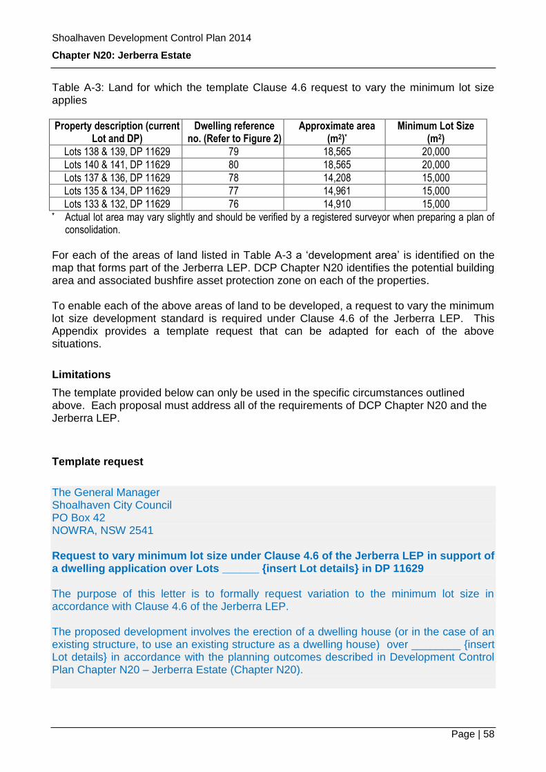
Shoalhaven Development Control Plan 2014
Chapter N20: Jerberra Estate
Page | 58
Table A-3: Land for which the template Clause 4.6 request to vary the minimum lot size applies
Property description (current Lot and DP)
Dwelling reference no. (Refer to Figure 2)
Approximate area (m2)*
Minimum Lot Size (m2)
Lots 138 & 139, DP 11629 79 18,565 20,000
Lots 140 & 141, DP 11629 80 18,565 20,000
Lots 137 & 136, DP 11629 78 14,208 15,000
Lots 135 & 134, DP 11629 77 14,961 15,000
Lots 133 & 132, DP 11629 76 14,910 15,000 * Actual lot area may vary slightly and should be verified by a registered surveyor when preparing a plan of
consolidation. For each of the areas of land listed in Table A-3 a ‘development area’ is identified on the map that forms part of the Jerberra LEP. DCP Chapter N20 identifies the potential building area and associated bushfire asset protection zone on each of the properties. To enable each of the above areas of land to be developed, a request to vary the minimum lot size development standard is required under Clause 4.6 of the Jerberra LEP. This Appendix provides a template request that can be adapted for each of the above situations.
Limitations
The template provided below can only be used in the specific circumstances outlined above. Each proposal must address all of the requirements of DCP Chapter N20 and the Jerberra LEP.
Template request
The General Manager Shoalhaven City Council PO Box 42 NOWRA, NSW 2541 Request to vary minimum lot size under Clause 4.6 of the Jerberra LEP in support of a dwelling application over Lots ______ {insert Lot details} in DP 11629 The purpose of this letter is to formally request variation to the minimum lot size in accordance with Clause 4.6 of the Jerberra LEP. The proposed development involves the erection of a dwelling house (or in the case of an existing structure, to use an existing structure as a dwelling house) over ________ {insert Lot details} in accordance with the planning outcomes described in Development Control Plan Chapter N20 – Jerberra Estate (Chapter N20).

Shoalhaven Development Control Plan 2014
Chapter N20: Jerberra Estate
Page | 59
Compliance with the minimum lot size as shown on the Minimum Lot Size map is unreasonable because the proposed development:
Is identified as “dwelling reference no. ___” on Figure 2 of Chapter N20.
Is consistent with the objectives, mandatory controls, performance criteria and acceptable solutions contained within Chapter N20.
Is contained within the “development area” identified on the Jerberra LEP mapping.
Includes a plan of consolidation and any Section 88 restrictions “as to user” deemed necessary by Council.
Will facilitate protection of the area identified as “bushland conservation area” on Figure 3 of Chapter N20.
Note to applicants: You will need to prepare and submit a Statement of Environmental Effects (SEE) with your development application and demonstrate that your proposal complies with the requirements of Chapter N20. A Jerberra SEE template is available at Council’s administrative building, Bridge Road, Nowra.
It is has been Council’s clear intention to allow a single dwelling to be erected on the combined area of Lots _____________ {insert Lot details} within the “development area” shown on the Jerberra LEP, subject to amalgamation of the Lots and protection of the area identified as the bushland conservation area on Figure 3 of Chapter N20. If the Clause 4.6 request is not approved, it will not be possible to achieve the planning outcomes negotiated with the relevant Government agencies and landowners over a number of years. In turn, this would require a Planning Proposal to be prepared to enable the minimum lot size map to be varied.