Embed Size (px)
Citation preview
4. SITE 5991
Shipboard Scientific Party2
HOLE 599
Date occupied: 20 March 1983
Date departed: 21 March 1983
Time on hole: 18 hr., 12 min.
Position: 19°27.09'S, 119°52.88'W
Water depth (sea level; corrected m, echo-sounding): 3654
Water depth (rig floor; corrected m, echo-sounding): 3664
Bottom felt (m, drill pipe): 3643.7
Penetration (m): 40.8
Number of cores: 5
Total length of cored section (m): 40.8
Total core recovered (m): 34.76
Core recovery (%): 85.2
Oldest sediment cored:Depth sub-bottom (m): 40.8Nature: Clayey nannofossil oozeAge: late MioceneMeasured velocity (km/s): 1.52
Basement:Depth sub-bottom (m): 40.8Nature: Basalt
HOLE 599A
Date occupied: 21 March 1983
Date departed: 21 March 1983
Time on hole: 3 hr., 40 min.
Position: 19°27.09'S; 119°52.88'W
Water depth (sea level; corrected m, echo-sounding): 3654
Water depth (rig floor; corrected m, echo-sounding): 3664
Bottom felt (m, drill pipe): 3643.7
Penetration (m): 22.6
Number of cores: None3
Leinen^M., Rea, D. K., et al., Init Repts. DSDP, 92: Washington (U.S. Govt. PrintingOffice).
2 Margaret Leinen (Co-Chief Scientist), The University of Rhode Island, Narragansett,Rhode Island; David K. Rea (Co-Chief Scientist), The University of Michigan, Ann Arbor,Michigan; Keir Becker, Scripps Institution of Oceanography, La Jolla, California (present ad-dress: University of Miami, Miami, Florida); Jacques J. Boulègue, University of Paris, Paris,France; Jörg Erzinger, Justus-Liebig University, Giessen, Federal Republic of Germany; JorisM. Gieskes, Scripps Institution of Oceanography, La Jolla, California; Marjorie S. Goldfarb,Scripps Institution of Oceanography, La Jolla, California (present address: University ofWashington, Seattle, Washington); Michael A. Hobart, Lamont-Doherty Geological Observ-atory, Palisades, New York; Miriam Kastner, Scripps Institution of Oceanography, La Jolla,California; Stephen Knüttel, Florida State University, Tallahassee, Florida; Mitchell W. Lyle,Oregon State University, Corvallis, Oregon; Tadashi Nishitani, Akita University, Akita, Ja-pan; Robert M. Owen, The University of Michigan, Ann Arbor, Michigan; Julian A. Pearce,The Open University, Milton Keynes, United Kingdom (present address: The University, New-castle-upon-Tyne, United Kingdom); Karen Romine, The University of Rhode Island, Kings-ton, Rhode Island (present address: Exxon Production Research Company, Houston, Texas).
3 Experimental hole. Two heat flow shoe lowerings, one Barnes/Uyeda pore water/heatflow sampler lowering.
HOLE 599B
Date occupied: 21 March 1983
Date departed: 22 March 1983
Time on hole: 1 day, 12 hr., 57 min.
Position: 19°27.09'S, 119°52.88'W
Water depth (sea level; corrected m, echo-sounding): 3654
Water depth (rig floor; corrected m, echo-sounding): 3664
Bottom felt (m, drill pipe): 3643.7
Penetration (m): 49.8
Number of cores: 44
Total length of cored section (m): 23.6
Total core recovered (m): 11.57
Core recovery (°7o): 49.0
Oldest sediment cored:Depth sub-bottom (m): 40.8Nature: Clayey nannofossil oozeAge: late Miocene
Basement:Depth sub-bottom (m): 40.8Nature: Basalt
Principal results: Site 599 is the third site drilled in the Leg 92 hydro-geology transect of the East Pacific Rise at 19°S. At Hole 599 werecovered four hydraulic piston corer (HPC) cores of sediment andone of clay and nannofossil-bearing water and a few basalt glasschips. Hole 599A was devoted to heat flow and in situ pore waterexperiments, as was Core 1 of Hole 599B. All experiments weresuccessful. Core 2 of Hole 599B recovered the lowermost nanno-fossil clays, and Cores 3 and 4 were drilled into basalt with the ex-tension core barrel (XCB).
Sedimentary Unit I is 40.8 m of very dark clayey nannofossilooze with abundant red brown to yellow brown semiopaque oxides(RSO) in the clay fraction. Carbonate turbidites and reworked in-tervals occur in the lower 20 m. The sediments range in age fromPleistocene to late Miocene; the basal nannofossil zone is CN8B.We penetrated 9 m into basalt, recovering 2.1 m of rounded pillowfragments and drilling breccia. The larger pieces show alterationrims and contain minor amounts of iron oxides and brown smec-tites. Bit torquing and sticking and hole carving forced us to aban-don Hole 599B after about 20 hr. of basalt drilling. Heat flow mea-surements gave a flux of 101 mW/m2 .
BACKGROUND AND OBJECTIVESSite 599 is about 275 km east of Site 598 and 1700 km
east of Tahiti. It lies in about 3650 m of water 650 kmwest of the axis of the East Pacific Rise (EPR) on crustof middle to late Miocene age.
The exact age of the seafloor at Site 599 was unclear,because the seafloor magnetic anomalies from both the
One for pore water sampling and heat flow measurement only, three for samples ofsediment or rock.
117
SITE 599
Conrad-13 and Ariadne II cruises are ambiguous. Theage estimates range from 9 to 7 Ma and indicate west-flank seafloor spreading rates of from 72.4 to 93.1 mm/yr. For the past 2.4 m.y., west-flank EPR spreading rateshave been 70.4 mm/yr. (Rea, 1978).
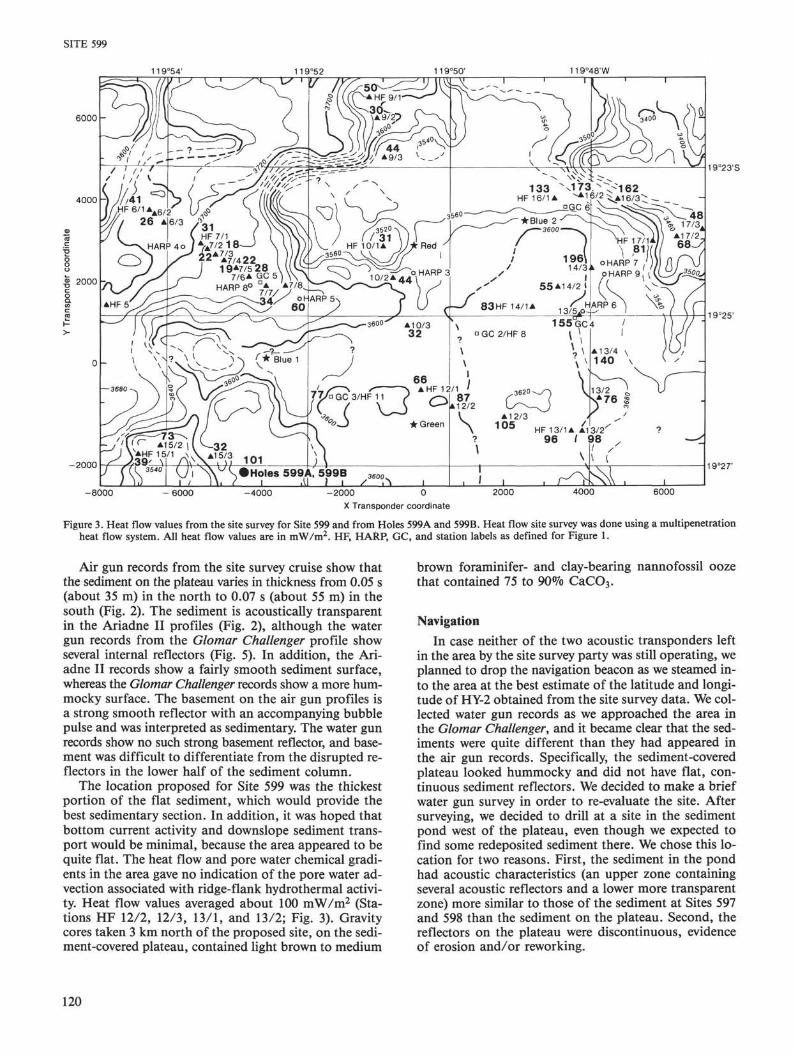
The region surveyed for the site was chosen from Con-rad-13 and Conrad-ll air gun records, which showedsmooth basement and continuous sediment cover. A de-tailed survey was completed by the Thomas Washington(cruise Ariadne II) in early 1982. Seabeam data fromthat cruise show linear abyssal hills that trend north-northeast and have about 200 to 300 m of relief. A broad-er region of low relief 8 km wide and 10 km long occu-pies the east central portion of the survey area (Fig. 1).The proposed location for Site HY-2 was near the south-ern end of this flat area, where sediment cover is thick-est.
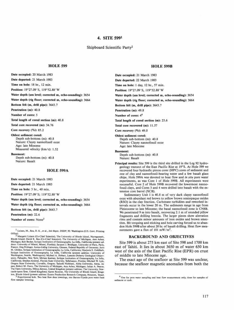
Air gun records show approximately 0.06 s (45 m) ofsediment over acoustic basement in the flat areas be-tween the ridges but patchy sediment cover on the slopesof both the abyssal-hill ridges and the valleys (Fig. 2).Acoustic basement is a strong smooth reflector in theflat areas and may be sedimentary or igneous.
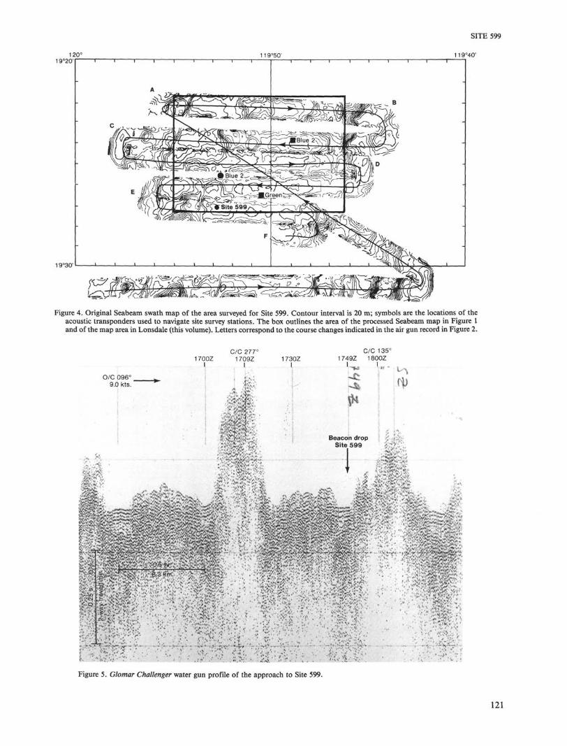
Heat flow measurements made during the site surveyshow low values of heat flow (18 to 41 mW/m2) in the
valley at the western margin of the area and moderatevalues (31 to 196 mW/m2) in the flat area covered bysediments (Fig. 3). None of the heat flow gradients showedcurvature indicative of the hydrothermal advection ofpore water through the sediments. Similarly, the porewater chemistry from the site survey cores showed no ev-idence of advection. Gravity cores from the area recov-ered calcareous oozes with sedimentation rates of about5 mm/103 yr. Since there were no indications of verticaladvection, the location chosen for Site 599 was the thick-est part of the flattest and widest portion of the sedi-ment-covered area.
Our specific objectives were to recover a continuoussedimentary section that would include late Miocene toRecent biogenic and hydrothermal sediments. We want-ed to study a site of intermediate age in our evaluationof hydrothermal sediment deposition and alteration withtime and the general paleoclimatic and paleoceanograph-ic history of the southeastern Pacific Ocean. We alsoplanned to continue our studies of heat flow and porewater chemistry to verify that hydrothermal advectionwas not occurring at the site and to determine whetherthere was pore water evidence of sediment diagenesis atthe site. Finally, we hoped to recover basalt basement atthis site to compare its petrology, chemistry, and degree
11 9°54' 11 9°52 11 9°50' 119°48'W
6000
4000 -
2000
-2000
19°23'S
19°25•
19°27'
-8000 - 6000 -4000 -2000 0X transponder coordinate
2000 4000 6000
Figure 1. Bathymetric map of HY-2 (Site 599) survey area based on Seabeam bathymetry. Contour interval is 20 m. Positions marked with stars andlabeled as colors are the locations of transponders used to position site survey stations. Seabeam swaths did not cover the entire area, and dashedcontours are inferred. Site survey stations are as follows: HF, multipenetration heat flow station; HARP, in situ pore water harpoon sample; GC,gravity core. Station labels (e.g., 9/2) refer to heat flow run and penetration number.
118
SITE 599
B
| : ? - : * ; ~ f • • ' ; : ' • • - • •• ••• ' " ! '
-4.0
Φ
f• -
§-5.0 |>,CO
6
—6.0
Figure 2. Ariadne II seismic reflection profile near Site 599 made during site survey using single-channel 40-in.3 air gun system. Turning points andtrack lines shown on Figure 4. A. Northern portion. B. Southern portion.
of alteration with that of the older basalts recovered atSite 597, which were generated at the Mendoza Rise.
To meet these objectives, we planned to recover hy-draulic piston cores of the sedimentary column at onelocation. We planned to make a series of heat flow mea-surements in an adjacent hole and to recover two in situpore water samples from the sediment column. After com-pleting the experimental work we planned to drill intobasement rock long enough to allow 25 m of penetration.
OPERATIONS
Site Survey
The area in which Site 599 is located was consideredappropriate for detailed surveys and as a potential drill
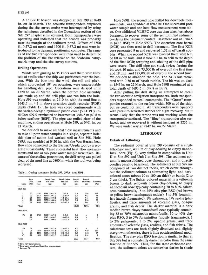
site because it met three criteria: the crust was 8 to 9 Main age; the basement was generally smooth, with fewlarge escarpments or seamounts; and the sediment coverwas continuous. The site itself was selected from theAriadne II survey of the area that lies between 119°44'Wand 119°58'W and 19°28'S and 19°22'S (Fig. 4). Thissurvey showed a sediment-covered plateau roughly 15 kmacross with an average relief of 40 to 60 m. Northeast ofthe site there is an abyssal-hill ridge with a maximum re-lief of 250 m. West of the site there is a flat-flooredtrough about 100 m deeper than the plateau. Figure 4shows the Seabeam bathymetric swath map of the sur-veyed area. A somewhat more interpretive map that in-cludes the locations of all the site survey stations is shownin Figure 1.
119
SITE 599
119°54' 119°52 11 9°50' 119°48'W
6000 -
19°23'S
4000
2000 -j
-2000
A7/4 2219*7/5 28
7/6A QC 5HARP 8°
19°27'
-8000 - 6 0 0 0 -4000 -2000 0X Transponder coordinate
2000 4000 6000
Figure 3. Heat flow values from the site survey for Site 599 and from Holes 599A and 599B. Heat flow site survey was done using a multipenetrationheat flow system. All heat flow values are in mW/m2. HF, HARP, GC, and station labels as defined for Figure 1.
Air gun records from the site survey cruise show thatthe sediment on the plateau varies in thickness from 0.05 s(about 35 m) in the north to 0.07 s (about 55 m) in thesouth (Fig. 2). The sediment is acoustically transparentin the Ariadne II profiles (Fig. 2), although the watergun records from the Glomar Challenger profile showseveral internal reflectors (Fig. 5). In addition, the Ari-adne II records show a fairly smooth sediment surface,whereas the Glomar Challenger records show a more hum-mocky surface. The basement on the air gun profiles isa strong smooth reflector with an accompanying bubblepulse and was interpreted as sedimentary. The water gunrecords show no such strong basement reflector, and base-ment was difficult to differentiate from the disrupted re-flectors in the lower half of the sediment column.
The location proposed for Site 599 was the thickestportion of the flat sediment, which would provide thebest sedimentary section. In addition, it was hoped thatbottom current activity and downslope sediment trans-port would be minimal, because the area appeared to bequite flat. The heat flow and pore water chemical gradi-ents in the area gave no indication of the pore water ad-vection associated with ridge-flank hydrothermal activi-ty. Heat flow values averaged about 100 mW/m2 (Sta-tions HF 12/2, 12/3, 13/1, and 13/2; Fig. 3). Gravitycores taken 3 km north of the proposed site, on the sedi-ment-covered plateau, contained light brown to medium
brown foraminifer- and clay-bearing nannofossil oozethat contained 75 to 90% CaCO3.
Navigation
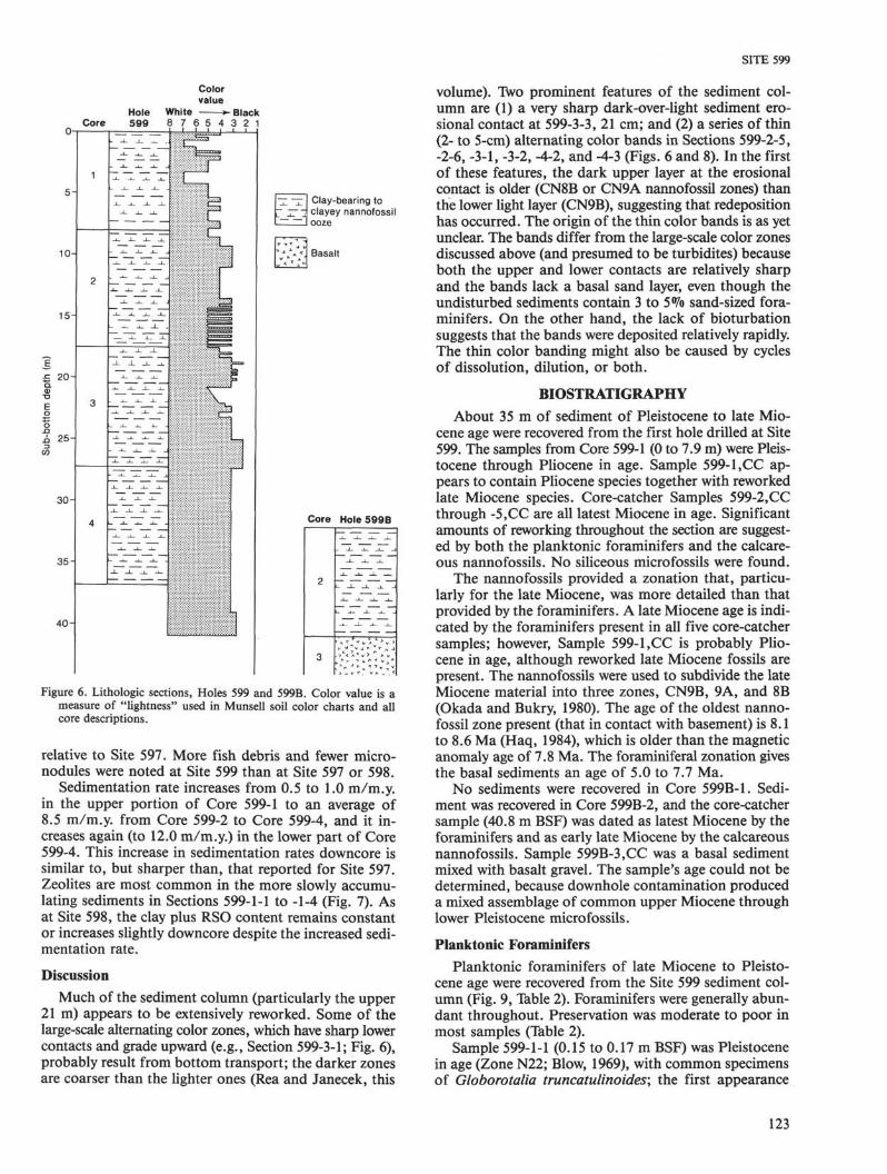
In case neither of the two acoustic transponders leftin the area by the site survey party was still operating, weplanned to drop the navigation beacon as we steamed in-to the area at the best estimate of the latitude and longi-tude of HY-2 obtained from the site survey data. We col-lected water gun records as we approached the area inthe Glomar Challenger, and it became clear that the sed-iments were quite different than they had appeared inthe air gun records. Specifically, the sediment-coveredplateau looked hummocky and did not have flat, con-tinuous sediment reflectors. We decided to make a briefwater gun survey in order to re-evaluate the site. Aftersurveying, we decided to drill at a site in the sedimentpond west of the plateau, even though we expected tofind some redeposited sediment there. We chose this lo-cation for two reasons. First, the sediment in the pondhad acoustic characteristics (an upper zone containingseveral acoustic reflectors and a lower more transparentzone) more similar to those of the sediment at Sites 597and 598 than the sediment on the plateau. Second, thereflectors on the plateau were discontinuous, evidenceof erosion and/or reworking.
120
19°30'
Figure 4. Original Seabeam swath map of the area surveyed for Site 599. Contour interval is 20 m; symbols are the locations of theacoustic transponders used to navigate site survey stations. The box outlines the area of the processed Seabeam map in Figure 1and of the map area in Lonsdale (this volume). Letters correspond to the course changes indicated in the air gun record in Figure 2.
1700Z
I
C/C 277°1709ZI
1730Z
I1749Z
C/C 135°1800Z
I
Figure 5. Glomαr Challenger water gun profile of the approach to Site 599.
121
SITE 599
A 16.0-kHz beacon was dropped at Site 599 at 0949hr. on 20 March. The acoustic transponders emplacedduring the site survey cruise were interrogated by usingthe techniques described in the Operations section of theSite 597 chapter (this volume). Both transponders wereoperating and indicated that the beacon was probablynear the margin of the sediment pond. Offsets of 1500ft. (457.2 m) north and 1500 ft. (457.2 m) east were in-troduced to the dynamic positioning computer. The rang-es of the two transponders were then used to determinethe position of the site relative to the Seabeam bathy-metric map and the site survey stations.
Drilling Operations
Winds were gusting to 35 knots and there were threesets of swells when the ship was positioned over the bea-con. With the bow into the wind, the roll and pitch,which approached 10° on occasion, were unacceptablefor handling drill pipe. Operations were delayed until1320 hr. on 20 March, when the bottom hole assemblywas made up and the drill pipe was run into the hole.Hole 599 was spudded at 2110 hr. with the mud line at3643.7 m, 4.3 m above precision depth recorder (PDR)depth (Table 1). The hole was cored continuously withthe variable-length hydraulic piston corer (VLHPC) un-til Core 599-5 terminated on basement at 3684.5 m (40.8 mbelow seafloor [BSF]). The pipe was pulled clear of themud line, ending operations at Hole 599, at 0401 hr. on21 March.
We decided to make all heat flow measurements andto take all pore water samples in a single, separate hole;this plan of action had worked well at Site 598. Hole599A was spudded at 0420 hr. with the Von Herzen heatflow shoe connected to the Barnes/Uyeda tool by a sep-arate subassembly. Three successful heat flow measure-ments and one in situ pore water sample were taken. Be-cause of the shallow penetration, the drill string was pulledclear of the mud line at 0800 hr. while the tool was beingredressed.
Table 1. Coring summary, Holes 599, 599A, and 599B.
Core
Hole 599
12345
Total
Hole 599A
1W
Hole 599B
1W234C
Total
Date(Mar.1983)
2020212121
212121
21212122
Time(hr.)
21422315003502030330
0740
135022401020
Depth fromdrill floor
(m)
3643.7-3651.63651.6-3661.23661.2-3670.83670.8-3680.43680.4-3684.5
3643.7-3647.13647.1-3656.73656.7-3666.3
3643.7-3675.93675.9-3684.53684.5-3693.53687.5-3693.5
Depth belowseafloor
(m)
0-7.97.9-17.9
17.5-27.127.1-36.736.7-40.8
0-3.43.4-13.0
13.0-22.6
23.6-32.232.2-40.840.8-49.843.8-49.8
Lengthcored(m)
7.99.69.69.64.1
40.80
3.49.69.6
8.78.69.06.0
23.6
Lengthrecovered
(m)
7.899.439.138.300.01
34.76
abc
b9.491.520.56
11.57
Recovery(%)
1009895860.2
85.2
000
0110179
49.0
a Heat flow measurement.Pore water sample and heat flow measurement.
c Re-cored fill.
Hole 599B, the second hole drilled for downhole mea-surements, was spudded at 0945 hr. One successful porewater sample and one heat flow measurement were tak-en. One additional VLHPC core was then taken just abovebasement to recover some of the semilithified sedimentoverlying the basement contact. Basement was at 3684.5m (40.8 BSF) in Hole 599B. The extension core barrel(XCB) was then used to drill basement. The first XCBcore penetrated 9 m and recovered 1.52 m of basalt cob-bles. When the second XCB was lowered there were 6 mof fill in the hole, and it took 8.2 hr. to drill to the depthof the first XCB; torquing and sticking of the drill pipewere severe. The drill pipe got stuck twice; freeing thebit took 10 min. and 75,000 lb of overpull the first timeand 18 min. and 125,000 lb of overpull the second time.We decided to abandon the hole. The XCB was recov-ered with 0.56 m of basalt rubble. The bit was on deckat 1545 hr. on 22 March, and Hole 599B terminated at atotal depth of 3693.5 m (49.8 m BSF).
After pulling the drill string we attempted to recallthe two acoustic navigation transponders. Both transpon-ders responded to recall commands. The "Green" trans-ponder returned to the surface within 300 m of the ship,but we could not find it. All transponders were equippedwith pressure-activated strobes for night recovery, but itseems likely that the strobe was not working when thetransponder surfaced. The "Blue" transponder also sur-faced, and we recovered it without incident at 2235 hr.We were under way at 2242 hr. on 22 March.
LITHOLOGY
Details of Lithology
The sediment cover at Site 599 consists of a singlelithologic unit, 40.8 m of clay-bearing to clayey nanno-fossil ooze (Fig. 6), very similar in composition to UnitII at Site 597 and Unit I at Site 598. The sediment col-umn is unconsolidated ooze throughout, and it directlyoverlies basaltic basement. The sediments at Site 599 arecomposed of two distinct facies, which occur through-out the sediment column as alternating light- and dark-colored zones (about 10 to 100 cm thick) or bands (2 to5 cm thick). The lighter colored material is a yellowishbrown to dark yellowish brown clay-bearing to clayeynannofossil ooze typically containing 70 to 80% calcar-eous nannofossils, 15 to 25% clay plus RSO (red brownto yellow brown semiopaque oxides), 3 to 5% foramini-fers (mostly fragmented), 1% palagonite, 1% zeolite (phil-lipsite), and trace amounts of volcanic glass, opaquegrains, and fish debris. The darker material is a darkreddish brown clayey nannofossil ooze typically contain-ing 55 to 70% calcareous nannofossils, 30 to 40% clayplus RSO, 3 to 5% foraminifers (mostly fragmented), 1to 2% palagonite, 1 to 2% opaque grains, and traceamounts of volcanic glass, zeolites, and fish debris. Thecalcareous tests are both slightly dissolved and slightlyovergrown; otherwise, there is little postdepositional modi-fication. The clay plus RSO fraction is similar to that atSite 598 but is consistently darker in color than the samefraction at Site 597. Thus, for the same carbonate con-tent, the sediment colors are somewhat darker in shade
122
SITE 599
Colorvalue
Hole White BlackCore 599 8 7 6 5 4 3 2 1
0-
5-
10-
15-
£ 20-αα>
Su
b-b
ott
om
d
i
30-
35-
40-
1
2
3
4
-~L I I ,
1 _ " J ; ~^ •*- ~*
- -i_ -i_ _L
— -i_ _i_ ~
_1_ _1_ _L
-L -L _L j .
""*" ~*" ""*" ^
-i- _L _1_ -i_
....'...J^JLJ ' '
|
Li
111I!
i
Clay-bearing toclayey nannofossilooze
Basalt
Core Hole 599 B
2
3
Figure 6. Lithologic sections, Holes 599 and 599B. Color value is ameasure of "lightness" used in Munsell soil color charts and allcore descriptions.
relative to Site 597. More fish debris and fewer micro-nodules were noted at Site 599 than at Site 597 or 598.
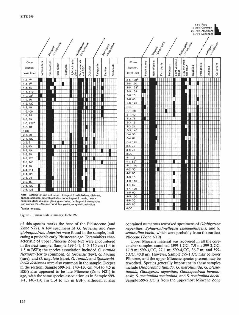
Sedimentation rate increases from 0.5 to 1.0 m/m.y.in the upper portion of Core 599-1 to an average of8.5 m/m.y. from Core 599-2 to Core 599-4, and it in-creases again (to 12.0 m/m.y.) in the lower part of Core599-4. This increase in sedimentation rates downcore issimilar to, but sharper than, that reported for Site 597.Zeolites are most common in the more slowly accumu-lating sediments in Sections 599-1-1 to -1-4 (Fig. 7). Asat Site 598, the clay plus RSO content remains constantor increases slightly downcore despite the increased sedi-mentation rate.
Discussion
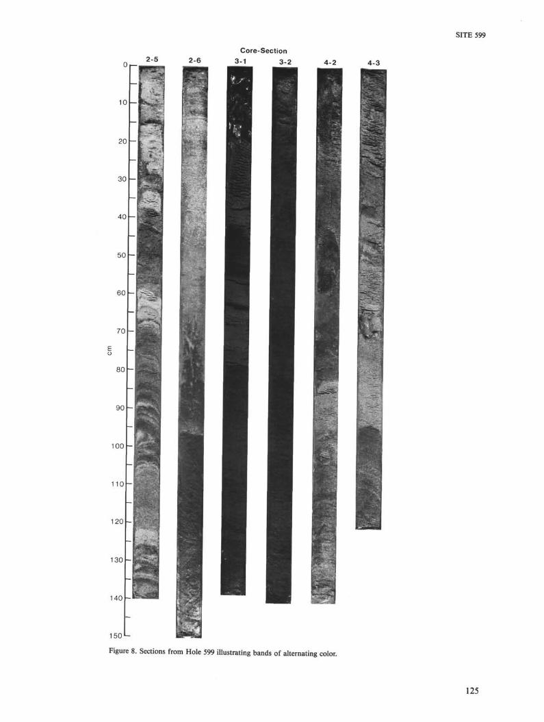
Much of the sediment column (particularly the upper21 m) appears to be extensively reworked. Some of thelarge-scale alternating color zones, which have sharp lowercontacts and grade upward (e.g., Section 599-3-1; Fig. 6),probably result from bottom transport; the darker zonesare coarser than the lighter ones (Rea and Janecek, this
volume). Two prominent features of the sediment col-umn are (1) a very sharp dark-over-light sediment ero-sional contact at 599-3-3, 21 cm; and (2) a series of thin(2- to 5-cm) alternating color bands in Sections 599-2-5,-2-6, -3-1, -3-2, -4-2, and -4-3 (Figs. 6 and 8). In the firstof these features, the dark upper layer at the erosionalcontact is older (CN8B or CN9A nannofossil zones) thanthe lower light layer (CN9B), suggesting that redepositionhas occurred. The origin of the thin color bands is as yetunclear. The bands differ from the large-scale color zonesdiscussed above (and presumed to be turbidites) becauseboth the upper and lower contacts are relatively sharpand the bands lack a basal sand layer, even though theundisturbed sediments contain 3 to 5°7o sand-sized fora-minifers. On the other hand, the lack of bioturbationsuggests that the bands were deposited relatively rapidly.The thin color banding might also be caused by cyclesof dissolution, dilution, or both.
BIOSTRATIGRAPHY
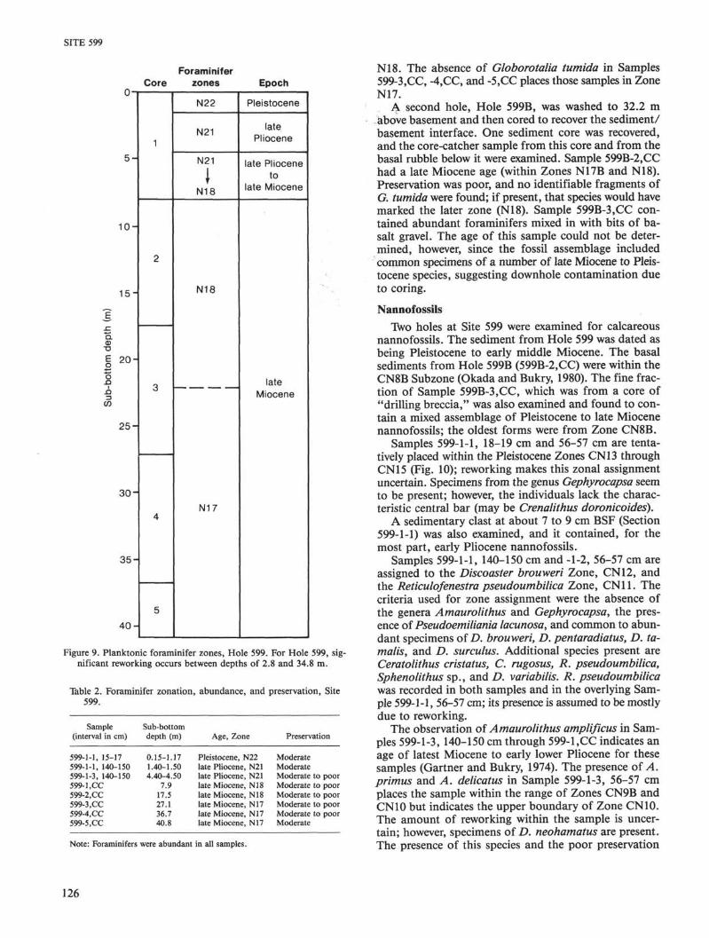
About 35 m of sediment of Pleistocene to late Mio-cene age were recovered from the first hole drilled at Site599. The samples from Core 599-1 (0 to 7.9 m) were Pleis-tocene through Pliocene in age. Sample 599-l,CC ap-pears to contain Pliocene species together with reworkedlate Miocene species. Core-catcher Samples 599-2,CCthrough -5,CC are all latest Miocene in age. Significantamounts of reworking throughout the section are suggest-ed by both the planktonic foraminifers and the calcare-ous nannofossils. No siliceous microfossils were found.
The nannofossils provided a zonation that, particu-larly for the late Miocene, was more detailed than thatprovided by the foraminifers. A late Miocene age is indi-cated by the foraminifers present in all five core-catchersamples; however, Sample 599-l,CC is probably Plio-cene in age, although reworked late Miocene fossils arepresent. The nannofossils were used to subdivide the lateMiocene material into three zones, CN9B, 9A, and 8B(Okada and Bukry, 1980). The age of the oldest nanno-fossil zone present (that in contact with basement) is 8.1to 8.6 Ma (Haq, 1984), which is older than the magneticanomaly age of 7.8 Ma. The foraminiferal zonation givesthe basal sediments an age of 5.0 to 7.7 Ma.
No sediments were recovered in Core 599B-1. Sedi-ment was recovered in Core 599B-2, and the core-catchersample (40.8 m BSF) was dated as latest Miocene by theforaminifers and as early late Miocene by the calcareousnannofossils. Sample 599B-3,CC was a basal sedimentmixed with basalt gravel. The sample's age could not bedetermined, because downhole contamination produceda mixed assemblage of common upper Miocene throughlower Pleistocene microfossils.
Planktonic Foraminifers
Planktonic foraminifers of late Miocene to Pleisto-cene age were recovered from the Site 599 sediment col-umn (Fig. 9, Table 2). Foraminifers were generally abun-dant throughout. Preservation was moderate to poor inmost samples (Table 2).
Sample 599-1-1 (0.15 to 0.17 m BSF) was Pleistocenein age (Zone N22; Blow, 1969), with common specimensof Globorotalia truncatulinoides', the first appearance
123
SITE 599
<5% Rare5-25% Common
25-75% Abundant>75% Dominant
Note: Looked for and not found: (biogenic) radiolarians, diatoms,sponge spicules, silicoflagellates; (nonbiogenic) quartz, heavyminerals, dark volcanic glass, glauconite; (authigenic) amorphousiron oxides, Fe—Mn micronodules, pyrite, recrystallized silica.aMinor lithology.
Figure 7. Smear slide summary, Hole 599.
of this species marks the base of the Pleistocene (andZone N22). A few specimens of G. tosaensis and Neo-globoquadrina dutertrei were found in the sample, indi-cating a probable early Pleistocene age. Foraminifers char-acteristic of upper Pliocene Zone N21 were encounteredin the next sample, Sample 599-1-1, 140-150 cm (1.4 to1.5 m BSF); the species association included G. tumidaßexuosa (few to common), G. tosaensis (few), G. hirsuta(rare), and G. ungulata (rare). G. tumida and Sphaeroid-inella dehiscens were also common in the sample. Deeperin the section, Sample 599-1-3, 140-150 cm (4.4 to 4.5 mBSF) also appeared to be late Pliocene (Zone N21) inage, with the same species association as in Sample 599-1-1, 140-150 cm (1.4 to 1.5 m BSF), although it also
contained numerous reworked specimens of Globigerinanepenthes, Sphaeroidinellopsis paenedehiscens, and S.seminulina kochi, which were probably from the earliestPliocene (Zone N19).
Upper Miocene material was recovered in all the core-catcher samples examined (599-1,CC, 7.9 m; 599-2,CC,17.9 m; 599-3,CC, 27.1 m; 599-4,CC, 36.7 m; and 599-5,CC, 40.8 m). However, Sample 599-1,CC may be lowerPliocene, and the upper Miocene species present may bereworked. Species generally important in these samplesinclude Globorotalia tumida, G. merotumida, G. plesio-tumida, Globigerina nepenthes, Globoquadrina baramo-ensis, S. seminulina seminulina, and 5. seminulina kochi.Sample 599-2,CC is from the uppermost Miocene Zone
124
SITE 599
2-5 2-6
2(
30
40
50
60
70
80
90
100
110
120
130
140
150
Core-Section3-1 3-2 4-2 4-3
re
Figure 8. Sections from Hole 599 illustrating bands of alternating color.
125
SITE 599
ForaminiferCore zones Epoch
5 -
1 0 -
1 5 -
Q.
| 2 0
n
2 5 -
3 0 -
3 5 -
4 0 -
N22
N21
N21
JN18
N18
N17
Pleistocene
latePliocene
late Plioceneto
late Miocene
lateMiocene
Figure 9. Planktonic foraminifer zones, Hole 599. For Hole 599, sig-nificant reworking occurs between depths of 2.8 and 34.8 m.
Table 2. Foraminifer zonation, abundance, and preservation, Site599.
Sample(interval in cm)
599-1-1, 15-17599-1-1, 140-150599-1-3, 140-150599-l.CC599-2.CC599-3 ,CC599-4.CC599-5,CC
Sub-bottomdepth (m)
0.15-1.171.40-1.504.40-4.50
7.917.527.136.740.8
Age, Zone
Pleistocene, N22late Pliocene, N21late Pliocene, N21late Miocene, N18late Miocene, N18late Miocene, N17late Miocene, N17late Miocene, N17
Preservation
ModerateModerateModerate to poorModerate to poorModerate to poorModerate to poorModerate to poorModerate
Note: Foraminifers were abundant in all samples.
N18. The absence of Globorotalia tumida in Samples599-3.CC, -4,CC, and -5,CC places those samples in ZoneN17.
A second hole, Hole 599B, was washed to 32.2 mabove basement and then cored to recover the sediment/basement interface. One sediment core was recovered,and the core-catcher sample from this core and from thebasal rubble below it were examined. Sample 599B-2,CChad a late Miocene age (within Zones N17B and N18).Preservation was poor, and no identifiable fragments ofG. tumida were found; if present, that species would havemarked the later zone (N18). Sample 599B-3,CC con-tained abundant foraminifers mixed in with bits of ba-salt gravel. The age of this sample could not be deter-mined, however, since the fossil assemblage includedcommon specimens of a number of late Miocene to Pleis-tocene species, suggesting downhole contamination dueto coring.
NannofossilsTwo holes at Site 599 were examined for calcareous
nannofossils. The sediment from Hole 599 was dated asbeing Pleistocene to early middle Miocene. The basalsediments from Hole 599B (599B-2,CC) were within theCN8B Subzone (Okada and Bukry, 1980). The fine frac-tion of Sample 599B-3,CC, which was from a core of"drilling breccia," was also examined and found to con-tain a mixed assemblage of Pleistocene to late Miocenenannofossils; the oldest forms were from Zone CN8B.
Samples 599-1-1, 18-19 cm and 56-57 cm are tenta-tively placed within the Pleistocene Zones CN13 throughCN15 (Fig. 10); reworking makes this zonal assignmentuncertain. Specimens from the genus Gephyrocapsa seemto be present; however, the individuals lack the charac-teristic central bar (may be Crenalithus doronicoides).
A sedimentary clast at about 7 to 9 cm BSF (Section599-1-1) was also examined, and it contained, for themost part, early Pliocene nannofossils.
Samples 599-1-1, 140-150 cm and -1-2, 56-57 cm areassigned to the Discoaster brouweri Zone, CN12, andthe Reticulofenestra pseudoumbilica Zone, CN11. Thecriteria used for zone assignment were the absence ofthe genera Amaurolithus and Gephyrocapsa, the pres-ence of Pseudoemiliania lacunosa, and common to abun-dant specimens of D. brouweri, D. pentaradiatus, D. ta-malis, and D. surculus. Additional species present areCeratolithus cristatus, C. rugosus, R. pseudoumbilica,Sphenolithus sp., and D. variabilis. R. pseudoumbilicawas recorded in both samples and in the overlying Sam-ple 599-1-1, 56-57 cm; its presence is assumed to be mostlydue to reworking.
The observation of Amaurolithus amplificus in Sam-ples 599-1-3, 140-150 cm through 599-l,CC indicates anage of latest Miocene to early lower Pliocene for thesesamples (Gartner and Bukry, 1974). The presence of A.primus and A. delicatus in Sample 599-1-3, 56-57 cmplaces the sample within the range of Zones CN9B andCN10 but indicates the upper boundary of Zone CN10.The amount of reworking within the sample is uncer-tain; however, specimens of D. neohamatus are present.The presence of this species and the poor preservation
126

SITE 599
•o _ Nannofossil{[ 5 zonesE Φ (Okada and
Core v> .£ Bukry, 1980)
5 -
1 0 -
1 5 -
-
2 0 -
-
2 5 -
3 0 -
-
-
3 5 -
-
_
4 0 -
1
2
3
_ _ _
4
5
• • •
n••••
• • a
» •
•a••
CN13-15
CN12
CN117-12
CN9B—10B
ON9B—10B
CN9B
CN9A
CN9A
CN9A
CN9A
— —— — ~— —
CN8B
CN8B
Ceratolithus and Pseudoemilianialacunosa (very rare)
Seems to be highly reworked;Discoaster neohamatus isfew to common, and no specimensof Amaurolithus primusare found.
First occurrence ofAmaurolithus primus
First occurrence of• Discoaster surculusand Discoaster berggrenii
Figure 10. Nannofossil zones, Hole 599. The first occurrence of Amau-rolithus primus takes place in Sample 599-3-3, 27-28 cm, whichlies directly below a sharp lithologic break. No specimens of Dis-coaster neohamatus were found in that sample, and reworking wasassumed to be minimal. For Hole 599, significant reworking oc-curs between depths of 2.8 and 34.8 m.
of D. quinqueramus made the placement of the Mio-cene/Pliocene boundary difficult. The boundary has beenplaced tentatively between Samples 599-2-1, 56-57 cmand 599-2-2, 56-57 cm. C. rugosus, which indicates theupper CN10C Subzone, is recorded only in Samples 599-1-3, 56-57 cm and 140-150 cm.
Samples examined between 599-2-2, 140-150 cm and-3-3, 18-20 cm were originally thought to be below theCN9B/CN9A boundary because of the absence of A.primus in all samples examined and the occurrence ofD. neohamatus. Specimens of A. primus, however, werefound to be present in Sample 599-3-3, 21-23 cm. This
sample was obtained in a light brown layer directly un-derlying a dark brown layer; the contact between thetwo was sharp. No specimens of D. neohamatus were re-corded within the sample (599-3-3, 21-23 cm); and there-fore, those materials are assumed to be deposited with-out significant reworking. The interval (599-2-2, 56-57 cmthrough -4-3, 56-57 cm) is assigned to the D. quinquera-mus Zone, A. primus Subzone, CN9B. The species pres-ent include D. surculus, D. quinqueramus, D. variabilis,D. challengeri, D. brouweri, D. pentaradiatus, Cyclo-coccolithina macintyrei, C. leptopora, Coccolithuspela-gicus, and Triquetrorhabdulus rugosus. Preservation ismoderate; some discoasters are overgrown, and the restof the assemblage shows signs of dissolution. Specimensof A. primus below Sample 599-3-3, 18-20 cm are rareand heavily overgrown; positive identification was diffi-cult.
Samples 599-4-4, 56-57 cm and 140-150 cm are with-in the D. berggrenii Subzone, CN9A. Zone assignmentwas based on the absence of A. primus and the presenceof both D. berggrenii and D. surculus. Specimens of D.surculus were easier to identify, because the assemblagewas overgrown, and it was difficult to verify the identifi-cation of D. berggrenii in the lower samples. Other spe-cies present were similar to those listed for Sample 599-3-3, 21-23 cm. D. neohamatus was also present.
The oldest sediments recovered from Hole 599 (599-4,CC and -5,CC) were assigned to upper subzone of theD. neohamatus Zone, CN8B. This zone assignment wasbased on the presence of D. neohamatus and the absenceof both D. surculus and Catinaster coalitus. D. bellusalso becomes few to common. Preservation was moder-ate, with most discoasters showing slight overgrowth.
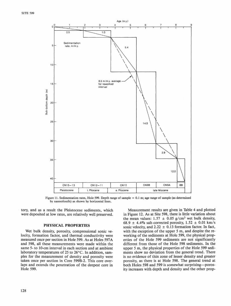
SEDIMENTATION RATES
Sedimentation rates were calculated by using nanno-fossil zone boundaries (Table 3; Fig. 11).
The rate of sediment accumulation is relatively highin the oldest sediment (approximately 8.1 to 8.6 Ma;nannofossil age determination), 12.0 m/m.y. A decreaseto 2.9 m/m.y. occurs between 6.7 and 8.1 Ma; it is fol-lowed by a large increase in rates to 14.5 m/m.y. The in-terval of high rates (5.4 to 6.7 Ma) also appears to be ex-tensively reworked; lateral influx of sediment appears tobe the cause of the high rate.
The calcium carbonate compensation depth (CCD)in the Pacific Ocean shoals in the Miocene. However,the basement depth at Site 599 (3695 m) has apparentlybeen shallower than the CCD throughout the site's his-
Table 3. Sedimentation rates, Site 599.
Depthinterval (m)
0-1.01.0-2.82.8-11.9a
11.9-30.8a
30.8-34.8a
34.8-40.8
Age(Ma)
0-1.881.88-3.703.7-5.45.4-6.76.7-8.18.1-8.6
Sedimentationrate (m/m.y.)
0.530.995.35
14.542.86
12.00
Depths where reworking occurred.
127
SITE 599
Age (m.y.)
4 5
5 -
10 -
15 -
2 0 -
25 -
30 -
35 -
40 -
- 1 '
0.5
Sedimentation~ rate, m/m.y.
-
_
-
CN15-13
Pleistocene
I ' I '
^ I Λ ^
8.5 m/m.y.
I ' I
V\\ 4V\
\ \\ \\ \
\ \\Aaverage — ' \
for reworkedinterval
CN12-11
I. Pliocene
CN10
e. Pliocene
1 I ' I ' I '
y\\
\\\\
\\\ \\ \\ \
14.5 \
\
\
\
\
\
\
\
^ v \
2 . 9 S s S s \
12.0
CN9B CN9A
\
8B
late Miocene
Figure 11. Sedimentation rates, Hole 599. Depth range of sample = 0.1 m; age range of sample (as determinedby nannofossils) as shown by horizontal lines.
tory, and as a result the Pleistocene sediments, whichwere deposited at low rates, are relatively well preserved.
PHYSICAL PROPERTIES
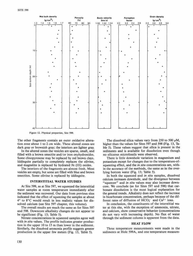
Wet bulk density, porosity, compressional sonic ve-locity, formation factor, and thermal conductivity weremeasured once per section in Hole 599. As at Holes 597Aand 598, all these measurements were made within thesame 5- to 10-cm interval in each section and at ambientlaboratory temperatures of 25 to 26°C. In addition, sam-ples for the measurement of density and porosity weretaken once per section in Core 599B-2. This core over-laps and extends the penetration of the deepest core inHole 599.
Measurement results are given in Table 4 and plottedin Figure 12. As at Site 598, there is little variation aboutthe mean values: 1.57 ± 0.05 g/cm3 wet bulk density,68.9 ± 4.4% salt-corrected porosity, 1.52 ± 0.01 km/ssonic velocity, and 2.22 ±0.13 formation factor. In fact,with the exception of the upper 5 m, and despite the re-working of the sediments at Hole 599, the physical prop-erties of the Hole 599 sediments are not significantlydifferent from those of the Hole 598 sediments. In theupper 5 m, the physical properties of the Hole 599 sedi-ments show no deviation from the general trend. Thereis no evidence of thin zone of lesser density and greaterporosity, as there is at Hole 598. The general trend atboth Holes 598 and 599 is somewhat surprising—poros-ity increases with depth and density and the other prop-
128

SITE 599
Table 4. Sediment physical properties, Site 599.
Core-Section
Hole 599
1-11-21-31-41-52-12-22-32-42-52-63-13-23-33-43-53-64-14-24-34-44-5
Hole 599B
2-12-22-32-42-52-6
Sub-bottomdepth(m)
0.772.273.775.276.778.67
10.1711.6713.1714.6716.1718.2719.7721.2722.7724.2725.7727.8729.3730.8732.3733.87
32.9734.4735.9737.4738.9740.47
Wet bulkdensity(g/cm3)
1.54.65.64.63.65.59.53.54.60.56.58.49.50.63.54.52.54.52
1.561.591.531.581.57
±0.05
1.541.541.641.521.411.41
Uncorrectedfor salt
Porosity(%)
62.663.360.763.661.464.172.869.964.267.669.074.772.865.369.372.870.572.571.066.873.369.7
71.272.562.571.876.979.8
Graindensity(g/cm3)
2.462.762.622.742.692.652.932.802.662.732.872.922.842.812.772.892.822.882.932.772.972.91
2.892.962.712.832.783.00
Correctedfor salt
Porosity(%)
63.364.061.464.362.164.873.670.765.068.469.875.673.766.070.173.671.373.471.867.674.170.568.9
±4.4
73.775.164.874.479.782.7
Graindensity(g/cm3)
2.442.752.612.732.692.642.932.792.652.722.862.922.832.802.762.892.812.872.922.762.972.902.78
±0.13
3.173.282.893.123.163.50
Sonicvelocity(km/s)
:
.532
.530
.536
.522
.537
.526
.508
.509
.5241.519.509.505.510.524.512.501.520.501.508.514.508.510.517
±0.011
Acousticimpedance(Gg/m2 s)
2.362.522.522.482.542.432.312.322.442.372.382.242.272.482.332.282.342.282.352.412.312.39
Formationfactor
2.332.502.282.282.422.332.052.152.372.262.232.121.992.292.072.082.112.182.112.292.122.212.22
±0.13
erties decrease, showing no evidence of increasing com-paction with depth.
IGNEOUS PETROLOGY
Recovery
Igneous basement rocks were recovered from Holes599 and 599B. A few small altered glassy basalt chipswere recovered from Hole 599, and 2.08 m were recov-ered from Hole 599B (0.75 m of drilling breccia and1.33 m of rounded basalt fragments).
Hole 599Core 599-5 contained watery sediment and a few glassy
basalt chips. The highly altered basalt glass fragmentshave an outer rim of palagonite, red brown smectite,iron oxyhydroxides, and some calcite. The total amountof glass is about 50 cm3; the largest fragments are about1 cm across.
Hole 599BCores 599B-3 and -4, which were drilled with the ex-
tended core barrel, penetrated 9 m into basement. Sec-tion 599B-3-1 contains 0.75 m of drilling breccia; Sec-tion 599B-3-2 contains 0.77 m of round basalt fragments;and Section 599B-4-1 contains 0.52 m of basalt and pil-
low fragments. All pieces are unoriented. In total, 2.08 mwere recovered.
LithologyThe main rock type is a glassy to fine-grained, gray,
slightly altered, almost nonvesicular basalt. Two pieceshave a glassy margin about 1 mm in thickness and repre-sent pillow fragments. Some pieces show radial fractures.Almost all fragments contain outer oxidative alterationzones 1 to 2 cm wide. The drilling breccia ("gravel") con-tains about 5% basaltic glass and palagonite.
MineralogyAll rocks are olivine-poor tholeiites containing 40 to
50% plagioclase, 45 to 55% clinopyroxene, about 5%magnetite, and less than 1% olivine. All the rocks re-covered are aphyric, and their texture is subspheruliticto intergranular. The spherulites consist of acicular crys-tals of plagioclase and granular to dendritic clinopyrox-ene; magnetite is disseminated mainly within and aroundthe clinopyroxene grains. The grain size ranges from lessthan 0.05 to 0.1 mm for olivine, 0.1 to 0.4 mm for pla-gioclase and clinopyroxene, and less than 0.01 mm formagnetite.
Piece 3 in Section 599-3-2 has an outer rim of palago-nite and thin calcite veins in contact with fresh glass.
129
SITE 599
Wet bulk density _ .. _ . _ Grain density_ Porosity Sonic velocity Formation *
(g/cmJ) (%) (km/s) factor (g/cm3)1.3 1.4 1.5 1.6 1.7 60 70 80 90 1.50 1.52 1.54 2.0 2.2 2.4 2.6 2.4 2.6 2.8 3.00
Figure 12. Physical properties, Site 599.
The other fragments contain an outer oxidative altera-tion zone about 1 to 2 cm wide. These altered zones aredark gray or brownish gray; the interiors are lighter gray.
In the altered zones the vesicles are sparse, small, andfilled with a brown smectite and/or iron oxyhydroxides.Some clinopyroxene may be replaced by red brown clays.Iddingsite partially to completely replaces the olivine,and magnetite is replaced by hydrated Fe (III) oxides.
The interiors of the fragments are almost fresh. Mostvesicles are empty, but some are filled with blue and brownsmectites. Some olivine is replaced by iddingsite.
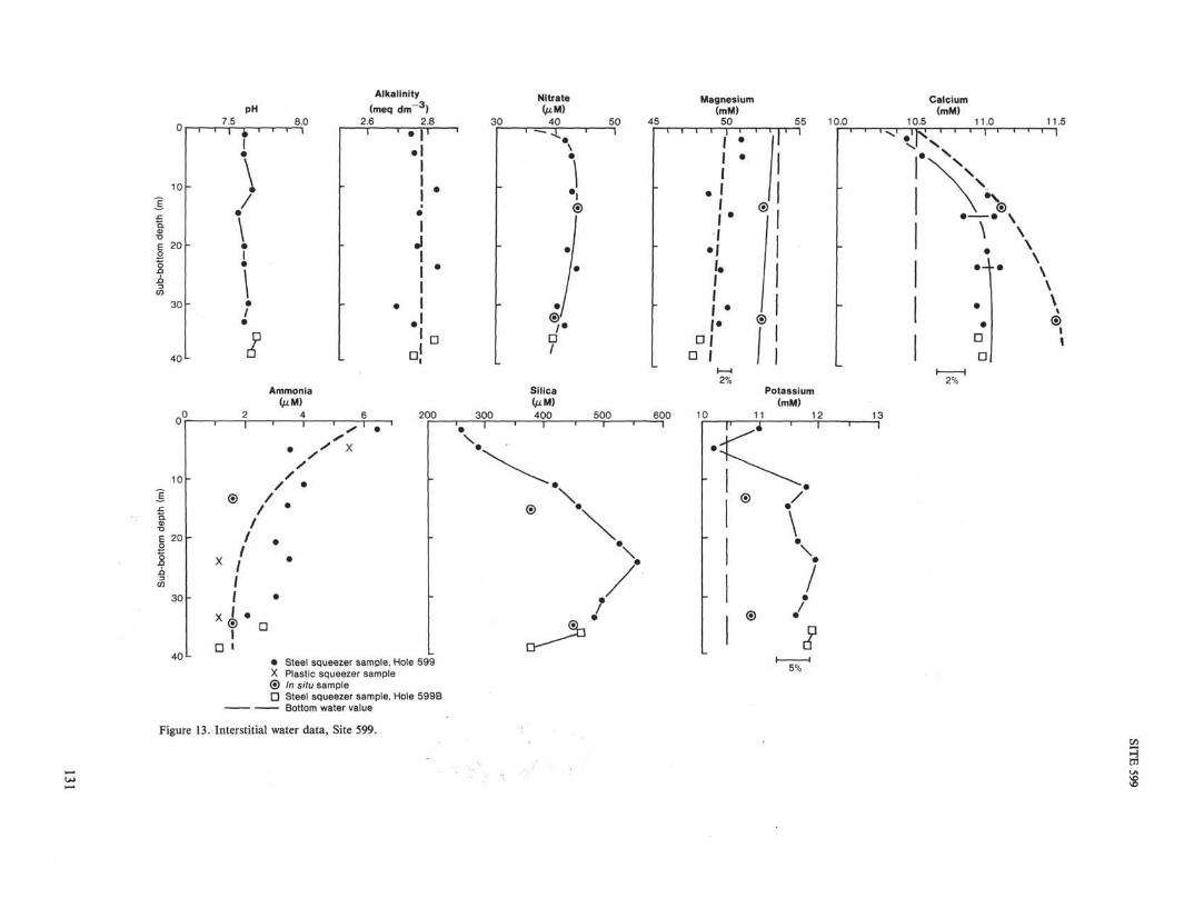
INTERSTITIAL WATER STUDIES
At Site 599, as at Site 597, we squeezed the interstitialwater samples at room temperature immediately afterthe sediment was recovered. Our data from previous sitesindicated that the effect of squeezing the samples at about4° to 8°C would result in less realistic values for dis-solved calcium (see Site 597 chapter, this volume).
The overall results are much the same as for Sites 597and 598. Downcore alkalinity changes do not appear tobe significant (Fig. 13; Table 5).
Nitrate concentrations in squeezed samples agree wellwith in situ values. The profile indicates greater produc-tion in the upper 10 to 15 m than lower in the sediment.Similarly, the dissolved ammonia profile suggests greaterproduction in the upper few meters (Fig. 13, Table 5).
The dissolved silica values vary from 250 to 500 µM,higher than the values for Sites 597 and 598 (Fig. 13, Ta-ble 5). These values suggest that silica is present in thesediments and is available for dissolution even thoughno siliceous microfossils were observed.
There is little downhole variation in magnesium andpotassium except for changes due to the temperature-of-squeezing effect, and the in situ concentrations are, with-in the accuracy of the methods, the same as in the over-lying bottom water (Fig. 13; Table 5).
In both the squeezed and in situ samples, dissolvedcalcium increases downhole, and the divergence between"squeezer" and in situ values may also increase down-core. We conclude (as for Sites 597 and 598) that car-bonate dissolution is the most logical explanation forthe general trends. Alkalinity does not reflect the increasein bicarbonate concentration, perhaps because of the dif-ferent rates of diffusion of HCO3~ and Ca2+ ions.
In conclusion, the constituents of the interstitial wa-ter at this site, with the exception of ammonia, nitrate,and calcium, show conservative behavior (concentrationsdo not vary with increasing depth). No flux of waterthrough the sediment column is apparent from the data.
HEAT FLOW
Three temperature measurements were made in thesediments at Hole 599A, and one temperature measure-
130
10
ε 20
30
40
10 -
ε 2 0 -
30 -
40 L
PH7.5 8.0
Alkalinity
(meq dm )2.6 2.8 30
1 • ė ^
s DD
Ammonia(µM)
2 4
-
X
X
D
l
/
/
/
il
1 ' s '
V ×
/
D
200 300
Steel squeezer sample, Hole 599X Plastic squeezer sample© In situ sampleD Steel squeezer sample, Hole 599B
— Bottom water value
Nitrate(µM)
40 50 45
Silica(µM)400 500
Magnesium(mM)
50 55 10.0
-
rL
α
•
11
•1
ii1!•
1
i
1i
1
•
»
•
••
•
©
2%
600 10
Potassium(mM)
11 12
5%
Calcium(mM)
10.5 11.0 11.5
CIV
13
•f-
®
©
1 1
/•
\
/
/*•
ππ
D
D
2%
©
Figure 13. Interstitial water data, Site 599.

SITE 599
Table 5. Interstitial water chemistry, Site 599.
Sample(interval in cm)
Hole 599
1-1, 140-1501-3, 140-1502-2, 140-1502-5, 140-1503-2, 140-1503-4, 140-1504-2, 140-1504-4, 140-150
Hole 599A
In situ 1
Hole 599B
In situ 22-2, 140-1502-4, 140-150
Sub-bottomdepth(m)
1.54.5
10.914.420.523.530.133.1
15.0
34.335.238.2
pH
7.617.607.667.567.617.607.637.60
7.687.65
Alkalinity(meq dm )
2.752.762.842.782.772.842.692.76
2.832.76
Ca(mM)
10.4910.5711.0310.8511.0311.1110.9511.00
11.11
11.5010.9510.99
Mg(mM)
51.151.248.8550.449.049.850.249.7
52.6
52.648.147.8
K(mM)
11.010.211.811.511.712.011.811.6
10.8
10.912.011.8
Cl(mM)
552550558556557559556557
558
556559553
SO4
(mM)
26.227.627.628.028.327.627.526.7
29.3
29.227.127.1
NO3
(µM)
424343
42.54441.542
44
40.540
NH 4
(µM)
6.53.54.03.53.03.53.02.0
1.5
1.52.51.0
SiO2
(µM)
259286420456525556497487
376
451459375
ment was made in the adjacent Hole 599B (Fig. 14). Themeasurements were made with the Von Herzen VLHPCtemperature tool. The Barnes/Uyeda/Kinoshita pore wa-ter/heat flow sampler was used simultaneously with theVLHPC tool by using a special connecting subassembly.The pore water /heat flow device failed to obtain a tem-perature value because of mechanical damage.
The temperature measurements were made at depthsof 3.4, 13.0, 22.6, and 32.4 m BSE The record at 3.4 mindicated that the probe started to sink farther into themud after about 5 min. at the 3.4-m depth, so we usedonly the first portion of the record to extrapolate a tem-perature. Nevertheless, the temperature measured at thisdepth lies above the slope of the line that best fits thedeeper temperature measurements, as at Hole 598A. Veryshallow DSDP temperature measurements are often high,a behavior that is not well understood. All of the mea-surements were good, with little sign of disturbance dueto drill pipe motion. A temperature gradient of 106 m°C/m was calculated from the bottom water temperatureand the three deepest temperature measurements.
0 1 2 3 4Temperature (°C)
Figure 14. Temperature versus depth, Holes 599A and 599B. The cho-sen temperature gradient of 106 m°C/m is shown by the line.
Thermal conductivity was measured on every sectionof core recovered from Hole 599, but the data were notreduced at sea. If we use the value of 0.95 W/m-K ob-tained during the site survey, the heat flow resulting fromour measured gradient is 101 raW/m2. The theoreticalvalue is 171 mW/m2 for crust of 8-Ma age.
The heat flow results from Holes 599A and 599B andthe site survey results are shown in Figure 3. The valueof 101 mW/m2 from Holes 599A and 599B is higherthan the other values in the holes' immediate vicinity, al-though the value is not very different from the values of77 and 73 mW/m2 found not far away. The average ofthe site survey values was 70 mW/m2, with a standarddeviation of 47 mW/m2.
The temperature gradient of 106 m°C/m (Fig. 14) andthe sediment thickness of about 41 m extrapolate to abasement temperature of 6.2°C, if thermal conductivityis assumed to be constant with increasing depth.
SUMMARY AND CONCLUSIONSSite 599 was drilled to provide a continuous record of
late Miocene to Recent sedimentation for the evaluationof past hydrothermal activity, paleoceanography, and pa-leoclimate, to obtain data appropriate for the constraintof models of ridge-flank hydrothermal convection, andto collect basalt generated at the fast-spreading East Pa-cific Rise for comparison with basalt collected at Site597, which was generated at the Mendoza Rise. Mag-netic anomalies from Conrad-13, Ariadne II, and Leg92 underway magnetics indicate a basement age of about7.8 Ma (Anomaly 4A) for Site 599, about 0.5 Ma youn-ger than the age of the basal nannofossil zone. Three holeswere drilled. Hole 599 was cored to a depth of 40.8 musing the VLHPC, and 34.76 m of sediment were recov-ered. Hole 599A was drilled solely to obtain heat flowmeasurements and in situ pore water samples; three heatflow measurements and one pore water sample were ac-quired. Hole 599B was washed to 23.6 m, where a tem-perature measurement was made for heat flow determi-nation and an in situ pore water sample was taken. We
132
SITE 599
recovered one VLHPC core between 32.2 and 40.8 m sowe could examine the basal sediments at the site. Thenthe XCB was used to drill basement rock to a total depthof 49.8 m.
Sediment Studies
The sediments recovered in Holes 599 and 599B areclayey and clay-bearing nannofossil oozes. Only one lith-ologic unit is present. The sediments show alternatinglight- and dark-colored zones (generally 10 cm to 1 mthick) and bands (2 to 5 cm thick). The color variationsare the result of differences in the sediment's calciumcarbonate content (70 to 80% in the light-colored sedi-ments, 55 to 70% in the dark sediments). The noncar-bonate fraction is made up primarily of clays and RSO.The sediments are significantly darker than those of equalcarbonate content at Site 597 and are similar to thosefrom Site 598.
Most of the sediment column, particularly the upper21 m, appears to be extensively reworked. Some of thecolor zones have sharp lower contacts, and at one level(599-3-3, 21 cm), the nannofossils in the upper, darkersediments are 1 to 2 m.y. older than those in the under-lying lighter material. In addition, the changes in grainsize across the contacts are indicative of turbidity cur-rent deposition. The extensive mottling of the sedimentsabove the contact at 599-3-3, 21 cm suggests that the re-deposition of these sediments was complex and proba-bly intermittent, however. Many parts of the sedimentcolumn (e.g., Sections 599-2-5, -2-6, -3-1, -3-2, -4-2, and-4-3) have many alternating color bands with fairly sharpupper and lower contacts. The bands may be caused bycycles of redeposition, dissolution, dilution, or some com-bination of the three.
Foraminifers were abundant in the sedimentary sec-tion, but the age indicated by the foraminifer zonationwas substantially different from that indicated by the nan-nofossil zonation, probably because the nannofossils werebetter preserved. A basement age of 5.2 to 6.4 Ma is in-dicated by the foraminifers, whereas a basement age of8.1 to 8.6 Ma is indicated by the nannofossils. Becauseof the approximate agreement between the latter and themagnetic anomaly age and because the nannofossils werewell enough preserved to permit a fairly detailed zona-tion, we based our sediment ages and deposition rateson the nannofossils.
The upper 1.0 m of sediment was dated as Pleisto-cene and was deposited at a rate of 0.5 m/m.y. Plioceneage (CN12 and CN11) was assigned to the sediments be-low 1.0 m in Core 599-1 (for a sedimentation rate of1.0 m/m.y.). The Miocene/Pliocene boundary is at about11.9m BSF. The sediments at the base of the sectionwere of late Miocene age, and sedimentation rate rangedfrom 2.9 to 12.0 m/m.y.
The physical properties of the sediments showed littlevariation from mean values of 1.57 g/cm3 for wet bulk
density, 69% for porosity, 2.78 g/cm3 for grain density,1.52 km/s for sonic velocity, and 2.22 for formation fac-tor. By using dry bulk densities calculated from the wetbulk densities and porosities, we calculated mass accu-mulation rates for the sediments. They ranged from 0.05g/(cm2 × 103 yr.) in the Pleistocene sediments near thesurface to 0.93 g/(cm2 × 103 yr.) in the clayey nannofos-sil ooze near the sediment/basalt contact. The mass ac-cumulation rate of the hydrothermal component, claysand RSO, varies from 250 to 500 mg/(cm2 x 103 yr.) inthe lower half of the core and decreases toward the top.
Igneous RocksIgneous basement rocks were recovered from Holes
599 and 599B. Only a few small, altered, glassy basaltchips were recovered from Hole 599, but 2.08 m of drill-ing breccia and basalt cobbles were recovered from Hole599B. The basalt cobbles may all be fragments of pil-lows, but only two pieces have glassy rims. All the piec-es have an altered outer zone and a relatively fresh inte-rior. They are almost nonvesicular, spherulitic to inter-granular basalts that are olivine-poor tholeiites.
Experimental StudiesTwo interstitial water samples were squeezed from each
core, and two in situ water samples were taken, one eachfrom Holes 599A and 599B. Only Ca2+ showed any de-viation from conservative behavior downcore, and theCa2+ profile appear to reflect the dissolution of carbon-ate in the sediments. There was no evidence of advectivepore water flux at the site.
Three temperature measurements were made with theVLHPC heat flow shoe at Hole 599A; one was made atHole 599B. The temperature gradient measured at Hole599A was 106 m°C/m. If the value of sediment thermalconductivity recovered during the site survey cruise isused, the heat flow is 101 mW/m2, a value about halfthe theoretical heat flow for 8-Ma crust.
REFERENCES
Blow, W. H., 1969. Late middle Eocene to Recent planktonic forami-niferal biostratigraphy. In Brönnimann, P., and Renz, H. H. (Eds.),Proc. First Int. Conf. Planktonic Microfossils (Geneva 1967): Lei-den (E. J. Brill), pp. 199-421.
Gartner, S., and Bukry, D., 1974. C. acustus Gartner & Bukry, n. sp.and C. amplificus Bukry & Percival—nomenclatural clarification.TUlaneStud. Geol. PaleontoL, 11:115-118.
Haq, B. U., 1984. Jurassic to Recent nannofossil biochronology: anupdate. In Haq, B. U. (Ed.), Nannofossil Biostratigraphy: Strouds-burg, PA (Hutchinson Ross Publ. Co.), pp. 358-378.
Okada, H., and Bukry, D., 1980. Supplementary modification and in-troduction of code numbers to the low-latitude coccolith biostrati-graphic zonation (Bukry 1973; 1975). Mar. Micropaleontol., 5:321-325.
Rea, D. K., 1978. Asymmetric seafloor spreading and a nontransformaxis offset: the East Pacific Rise 20°S survey area. Geol. Soc. Am.Bull., 89:836-844.
133
SITE 599 HOLE CORED INTERVAL 0.0-7.9 m SITE 599 HOLE
LITHOLOGIC DESCRIPTION
Section 1: CLAY-BEARING NANNO OOZE0-60 cm: Yellowish brown (10YR 5/4)60-120 cm: Yellow (10YR 7/6)120-140 cm: Light yellowish brown (10YR5-7 cm: Turbidite
Section 2: CLAYEY NANNO OOZE0-19 cm: Brown (7.5YR 4/4)19-24 cm: Reddish yellow (7.5YR 6/6), po
turbidite24-70 cm: Strong brown (7.5YR 4/6)70-117 cm: Strong brown (7.5YR 5/6)117-158 cm: Strong brown (7.5YR 6/8)
Section 3: CLAY-BEARING NANNO OOZE0-20 cm: Yellowish brown (10YR 5/8)20-128 cm: Very pale brown (10YR 7/4)128-140 cm: Yellowish brown (10YR 5/6)
Section 4: CLAY-BEARING NANNO OOZE0-88 cm: Yellowish brown (10YR 5/6)88-120 cm: Dark yellowish brown (10YR 4/4)120-150 cm: Yellowish brown (10YR 5/4)
Section 5: CLAY-BEARING NANNO OOZE0-19 cm: 10YR 4/419-119 cm: 10YR5/4119-150 cm: 10YR4/3
Section 6: CLAY-BEARING NANNO OOZE0-21 cm: Dark yellowish brown (10YR 4/4)
1 . 0 - J - •
CORED INTERVAL 7.9-17.5 m
LITHOLOGIC DESCRIPTION
Section 1: CLAY-BEARING NANNO OOZE0-80 cm: Light olive brown (2.5Y 6/4)80-150 cm: Olive brown (2.5Y4/4)
Section 2: CLAYEY NANNO OOZE0-12 cm: Dark yellowish brown (10YR 4/4)12-52 cm: Dark reddish brown (6YR 3/3)52-56 cm: Dark yellowish brown (10YR 4/4)56-101 cm: Dark reddish brown (5YR 3/3)101-104 and 108-113 cm: Dark yellowish brown
(10YR4/4)104-108 and 113-125 cm: Dark reddish brown (SYR
3/3).
Section 3: CLAY-BEARING TO CLAYEY NANNO OOZE0-22 cm: Dark reddish brown (5YR 3/3)22-150 cm: Dark yellowish brown (10YR 4/4)
Section 4: CLAY-BEARING TO CLAYEY NANNO OOZE0-118 cm: Dark yellowish brown I10YR4/4)118-130 cm: Dark reddish brown (5YR 3/3)130-150 cm: Same as 0-118 cm
Section 5: CLAY-BEARING TO CLAYEY NANNO OOZEAlternate bands: Dark yellowish brown (10YR 5/4)
and dark reddish brown I5YR 3/3), see core sheetfor detail
Section 6: CLAYEY NANNO OOZEAlternate bands: Dark yellowish brown (10YR 5/4) and
Section 7: CLAYEY NANNO OOZE
Core Catcher: CLAYEY NANNO OOZE
SMEAR SLIDE SUMMARY (%):
ClayComposition:FeldsparClay
30
TR25-30
25
—25
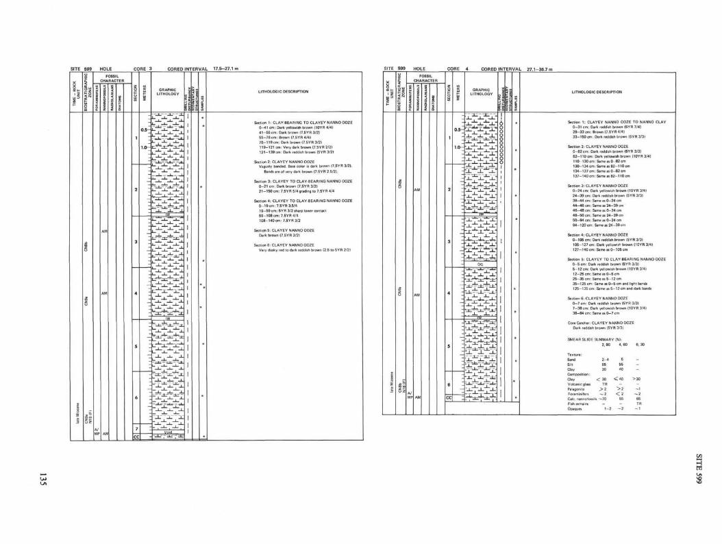
SITE 599 HOLE CORED INTERVAL 17.5-27.1 i
IIIill
LITHOLOGIC DESCRIPTION
Section 1: CLAY-BEARING TO CLAYEY NANNO OOZE
0-41 cm: Dark yellowish brown (10YR 4/4)
41-55 cm: Dark brown (7.5YR 3/2)
55-78 cm: Brown (7.5YR 4/4)
78-119 cm: Dark brown (7.BYR 3/2)
119-121 cm: Very dark brown (7.5YR 2/21
121-139 cm: Dark reddish brown (5YR 3/2)
Section 2: CLAYEY NANNO OOZE
Vaguely banded. Base color is dark brown (7.5YR 3/2).
Sands are of very dark brown (7.5YR 2.5/2).
Section 3: CLAYEY TO CLAY-BEARING NANNO OOZE
0-21 cm: Dark brown (7.5YR 3/2)
21 -150 cm: 7.5YR 5/4 grading to 7.5YR 4/4
Section 4: CLAYEY TO CLAY-BEARING NANNO OOZE
0-19cm: 7.5YR3.5/4
19-69 cm: 5YR 3/2 sharp lower contact
59-108 cm: 7.5YR 4/4
108-140cm:7.5YR3/2
Section 5: CLAYEY NANNO OOZE
Dark brown (7.5YR 3/2)
Section 6: CLAYEY NANNO OOZE
Very dusky red to dark reddish brown (2.5 to 5YR 2/2)
SITE
ME
- R
OC
UN
IT
E
i
999o
1
TR
AT
IGR
>Z
ON
EB
IOS
I
sβ
_a ~•
I S
HOLE
FOSSIL
CHARACTER
2z
|FO
R/I
A/MP
§
z
AM
AM
AM
4
1i
CORE
SE
CT
ION
1
2
4
5
6
CC
ME
TE
RS
z
-03—-
1.0-
I-
-I-z—-
-z-_—--z-
—-_—-
--_-
z--_-I
—
:
4 CORED INTERVAL 27.1-36.7 m
GRAPHICLITHOLOGY
1
- * - I ~ 1 - 1 -*-
1 < _ L ~• I —*— 1 - * — l _ -
, -L— — - 1 _ ~ -1 1 ~ "I I
~ ^ ~ 4- ~ ^ - l • ^ ^
' I I I "
•_i_ _ i _ _ i _ "
- -r -~^η ' ,—. _ 1 _ JL. .
^QT X .
•_L" I~_L~'~_L•"XL _L . 1 ^
"_!__!_ _!_'
~--hi-^Kt=KOG
"J_ _1_ _L"
_ 1 _ —L µ .^ " i ^ ~ 1 —^
I | i÷ 7 - * - i -*— i •»_ - i=. - 1 — ÷ •. . JL. . J- ,~.
=-t-^J--^Lr
>L~KL^-L •
"JL J_ _L'• i ••*" t ^~ i ": 7 ^ ^ • ~ I ~ - ^ - ~ I ~ •. - — *" ^ i " ~ ;
~^ 1 ~^ 1
- 1 I I '
^ = • = f • • ^ I 1
ll
ll\OooQooo8o1
11
z =
OS
an
LES
I
*
*
•
•
*
LITHOLOGIC DESCRIPTION
Section 1: CLAYEY NANNO OOZE TO NANNO CLAY0-31 cm: Dark reddish brown (5YR 7/4)
29-33 cm: Brown (7.5YR 4/4)
33-150 cm: Dark reddish brown (5YR 3/3)
Section 2: CLAYEY NANNO OOZE
0-82 cm: Dark reddish brown (5YR 3/3)82-110cm: Dark yellowish brown (10YR 3/4)
110-130 cm: Same as 0-82 cm
130-134 cm: Same as 82-110cm
134-137 cm: Same as 0-82 cm
137-140 cm: Same as 82-110 cm
Section 3: CLAYEY NANNO OOZE
0-24 cm: Dark yellowish brown (10YR 3/4)
24-39 cm: Dark reddish brown (5YR 3/3)
39-44 cm: Same as 0-24 cm
44-46 cm: Same as 24-39 cm
46-48 cm: Same as 0-24 cm
50-94 cm: Same as 0-24 cm
94-120 cm: Same as 24-39 cm
Section 4: CLAYEY NANNO OOZE0-105 cm: Dark reddish brown (5YR 3/3)
105-127 cm: Dark yellowish brown (10YR 3/41127-140 cm: Same as 0-105 cm
Section 5: CLAYEY TO CLAY-BEARING NANNO OOZE0-5 cm: Dark reddish brown (5YR 3/31
5-12 cm: Dark yellowish brown (10YR 3/4)12-25 cm: Same as 0-5 cm
25-35 cm: Same as 5-12 cm
35-125 cm: Same as 0-5 cm and light bands
125-135 cm: Same as 5-12 cm and dark bands
Section 6: CLAYEY NANNO OOZE0-7 cm: Dark reddish brown (5YR 3/3)
7-38 cm: Dark yellowish brown (10YR 3/4)
38-64 cm: Same as 0-7 cm
Core Catcher: CLAYEY NANNO OOZE
Dark reddish brown (5YR 3/3)
SMEAR SLIDE SUMMARY (%):
2, 90 4, 60 6, 30
Texture:Sand 2-4 5 -
Silt 65 55Clay 30 40
Composition:
Clay < 30 < 40 >30
Volcanic glass TR
Palagonite > 2 > 2 - 1
Calc. nannofossils ~-70 55 65
Fish remains — — TROpaques 1-2 ~2 ~ 1

SITE 599 HOLE B CORE 2 CORED INTERVAL 32.2-40.8 m
σ\
úLITHOLOGIC DESCRIPTION
:ion 1: CLAYEY NANNO OOZE1-150 cm: Dark reddish brown I5YR 3/3)
tion 2: CLAYEY NANNO OOZE1-140 cm: Dark reddish brown (5YR 3/3)
tion 3: CLAY BEARING TO CLAYEY NANNO OOZEAlternating color bands:1-7, 32-37, and 82-150 cm: Dark reddish brown
(5YR 3/3) with occasional faint light bands' -32 and 37-82 cm: Oliua brown (2.5YR 4/4) with
occasional faint dark bands
on 6: CLAYEY NANNO OOZE-150 cm: Dark reddish brown (5YR 2.5/4)
40-45 40-45 40-45
Calc. nannofossils 50-55 50-55 50-55Opaques TR TR TR
5
'fi « -2..2 "E
!1E OK O w <
I I 1 k §E S g - α c E 2 %
I 11 1 I I * 11 1l O I O I < ü QC o
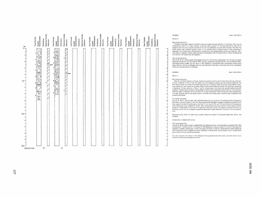
I ε •2 "s gz j | 5 S j
92-599B-3 Depth: 40.8-49.8 m
Section 2:
Macroscopic descriptionRounded unorientated fragments of basalt ranging from glassy through aphanitic to fine-grained. Color: gray to
brownish-gray. Piece 3 is a pillow fragment containing a glassy selvage (-~1 mm fresh glass with an outer rim ofpalagonite and thin veins of zeolite and calcite) with an inner spherulitic zone and radial fractures. The other frag-
plagioclase and clinopyroxene (Pclinopyroxene microphyritic} and psβudomorphed olivine and magnetite. Alter-
Piece 6, 48-51 cm: Aphyric basalt. Groundmass consists of 1-5% olivine in equant grains-^0.1 mm square, acicularplagioclase crystals 0.1-0.2 mm long (45-50%), granular and feathery clinopyroxene 0.1-0.2 mm long (45-50%),and magnetite grains 0.005-0.01 mm across (1-5%). Magnetite is disseminated within and between clinopyroxene
replaced and pseudomorphed by iddingsite.
92-599B-4 Depth: 43.8-49.8 m
Section 1:
Macroscopic description
ish gray. Fragments in Piece 5 have thin glassy rims with palagonite coatings, and may be pillow fragments. The
is plagioclase (forming spherules in Pieces 1 and 3), clinopyroxene, and altered and pseudomorphed olivine and
magnetite. Vesicles sparse and small, most abundant in Pieces 2 and 6, sometimes filled with blue or brown smectite.
long, magnetite in possibly skeletal grains less than 0.1 mm long (1-5%), and < 1 % olivine. Some of the plagioclase
iddingsite.
Piece 8, 64-68 cm: Aphyric basalt, subspherulitic to intergranular texture. The groundmass is composed of 50-55%
clinopyroxene. in grains about 0.1 mm across, 40-45% plagioclase in acicular crystals 0.1-0.15 mm long, about 5%
magnetite in possibly skeletal grains < 0 . 0 1 mm across, and about 1% olivine in grains 0.05 mm across. Plagioclase
grains. Olivine is mostly replaced by iddingsite.
CORE-SECTION

SITE 599 (HOLE 599)
1-1 19 1 1cm 1.CC 2-1 2-2 2-3 2-4 2-5
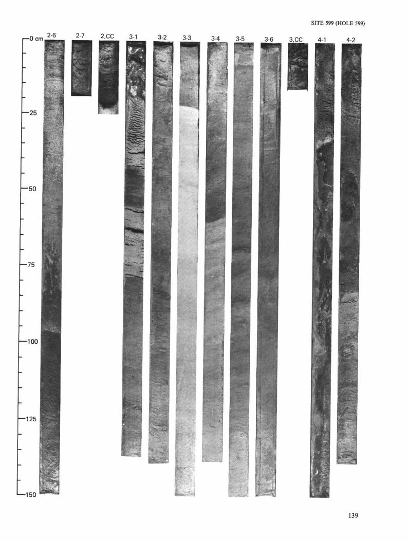
r-0 cm |2-6 2_7 2 £ C 3-1 3-2 3-3 3-4 3-5
- 2 5
SITE 599 (HOLE 599)
3-6 3,CC 4-1 4-2
— 50
—75
•
—100
—125
1—150 - - ;
139
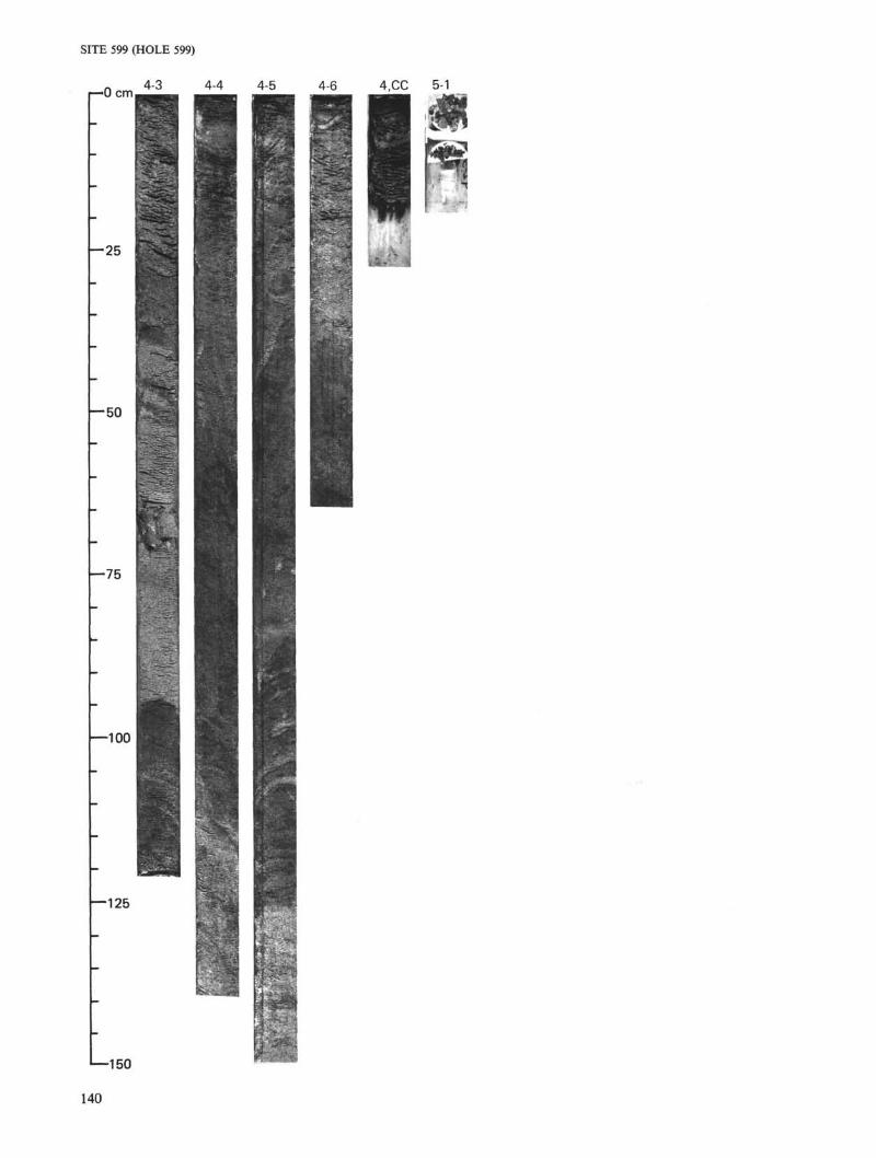
SITE 599 (HOLE 599)
—>O cm. 4-3 4-4 4-5 4-6 4,CC 5-1
— 25
— 50
—75
—100
-125
1—150
140
SITE 599 (HOLE 599B)
r-0 cm 2 ± _ 2-2 2-3 2-4 2-5
- 2 5
•50
—75
ccUJ>OoUJ
cc
2-6 _ 2 I 7 _ 3-1 3-2 Φ1
2,CC
V
Q
—100
—125
1—150
?»
141