Embed Size (px)
Citation preview
SHERMAN COUNTY
ZONING, SUBDIVISION, PARTITIONING, AND LAND DEVELOPMENT ORDINANCE OF 1994
June 2003 revision to incorporateTransportation System Plan
THIS PROJECT IS PARTIALLY FUNDED BY A GRANT FROM THE TRANSPORTATION AND GROWTH MANAGEMENT (TGM) PROGRAM, A JOINT PROGRAM OF THE OREGON DEPARTMENT OF TRANSPORTATION AND THE OREGON DEPARTMENT OF LAND CONSERVATION AND DEVELOPMENT. THIS TGM GRANT IS FINANCED, IN PART, BY FEDERAL TRANSPORTATION EQUITY ACT FOR THE 21ST CENTURY (TEA-21), LOCAL GOVERNMENT, AND THE STATE OF OREGON FUNDS.
THE CONTENTS OF THE DOCUMENT DO NOT NECESSARILY REFLECT VIEWS OR POLICIES OF THE STATE OF OREGON.
SHERMAN COUNTY ZONING, SUBDIVISION,PARTITIONING AND LAND DEVELOPMENT
ORDINANCE OF 1994
June 1,1994
Amended June and July 2003 byOrdinances 22-05-2003 and 24-06-2003
Prepared by the Sherman County Planning CommissionWith assistance from the Bend Field Office of the
Oregon Department of Land Conservation and Development andThe Sherman County Planning Department
Preparation of this document was financially aided by a grantFrom the Oregon Department of Land Conservation and Development
Codified Version

TABLE OF CONTENTS
SECTION PAGE
ARTICLE 1. GENERAL PROVISIONS
1.1 Title 11.2 Purpose 11.3 Construction & Terminology 11.4 Definitions 1
ARTICLE 2. CLASSIFICATION OF ZONES – BASIC PROVISIONS
2.1 Compliance with Ordinance Provisions 172.2 Interpretation 172.3 Classification of Zones 172.4 Location of Zones 172.5 Zoning Map & Amendments 172.6 Zone Boundaries 17
ARTICLE 3. USE ZONES
3.1 Exclusive Farm Use, F-1 Zone 183.2 General Residential, R-1 Zone 243.3 General Commercial, C-1 Zone 273.4 Light Industrial, M-1 Zone. 293.5 Agricultural Airport, A-1 Zone 333.6 Significant Resource Combining, SR Zone 363.7 Natural Hazards Combining, NH Zone 453.8 Rural Industrial, R-I Zone 493.9 Limited Use Combining, LU Zone 54
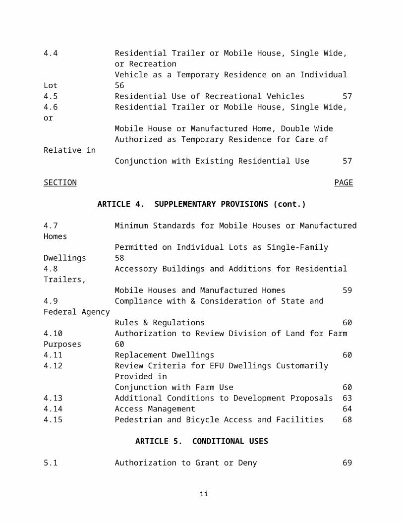
ARTICLE 4. SUPPLEMENTARY PROVISIONS
4.1 Authorization of Similar Uses 564.2 Projections from Buildings 564.3 Off-Street Parking 564.4 Residential Trailer or Mobile House, Single Wide, or Recreation
Vehicle as a Temporary Residence on an Individual Lot 564.5 Residential Use of Recreational Vehicles 574.6 Residential Trailer or Mobile House, Single Wide, or
Mobile House or Manufactured Home, Double WideAuthorized as Temporary Residence for Care of Relative in Conjunction with Existing Residential Use 57
i

SECTION PAGE
ARTICLE 4. SUPPLEMENTARY PROVISIONS (cont.)
4.7 Minimum Standards for Mobile Houses or Manufactured HomesPermitted on Individual Lots as Single-Family Dwellings 58
4.8 Accessory Buildings and Additions for Residential Trailers, Mobile Houses and Manufactured Homes 59
4.9 Compliance with & Consideration of State and Federal Agency Rules & Regulations 60
4.10 Authorization to Review Division of Land for Farm Purposes 604.11 Replacement Dwellings 604.12 Review Criteria for EFU Dwellings Customarily Provided in
Conjunction with Farm Use 604.13 Additional Conditions to Development Proposals 634.14 Access Management 644.15 Pedestrian and Bicycle Access and Facilities 68
ARTICLE 5. CONDITIONAL USES
5.1 Authorization to Grant or Deny 695.2 General Criteria 695.3 General Conditions 695.4 Application for Conditional Use 705.5 Processing 715.6 Public Hearing Requirements 715.7 Notification of Action 715.8 Standards Governing Specific Conditional Uses 715.9 Time Limit on a Conditional Use Permits &/or Design Review Plan 86
ARTICLE 6. EXCEPTIONS & NONCONFORMING USES
6.1 Continuation of Nonconforming Uses 886.2 Discontinuance of Nonconforming Uses 886.3 Change of Nonconforming Uses 886.4 Destruction of Nonconforming Uses 886.5 Completion of Structure 886.6 General Exceptions to Lot Requirements 886.7 General Exceptions Yard Requirements 886.8 General Exceptions to Building Height Limitations 896.9 Exception for Minor Repair & Rehabilitation 896.10 Exception for Public Street & Highway Improvements 896.11 Exception for Public Facilities Improvement or Reconstruction 90
ii
SECTION PAGE
ARTICLE 7. VARIANCES
7.1 Authorization to Grant or Deny 917.2 Circumstances of Granting Variances 917.3 Application for Variance 917.4 Public Hearing of Variance 917.5 Notification of Decision 91
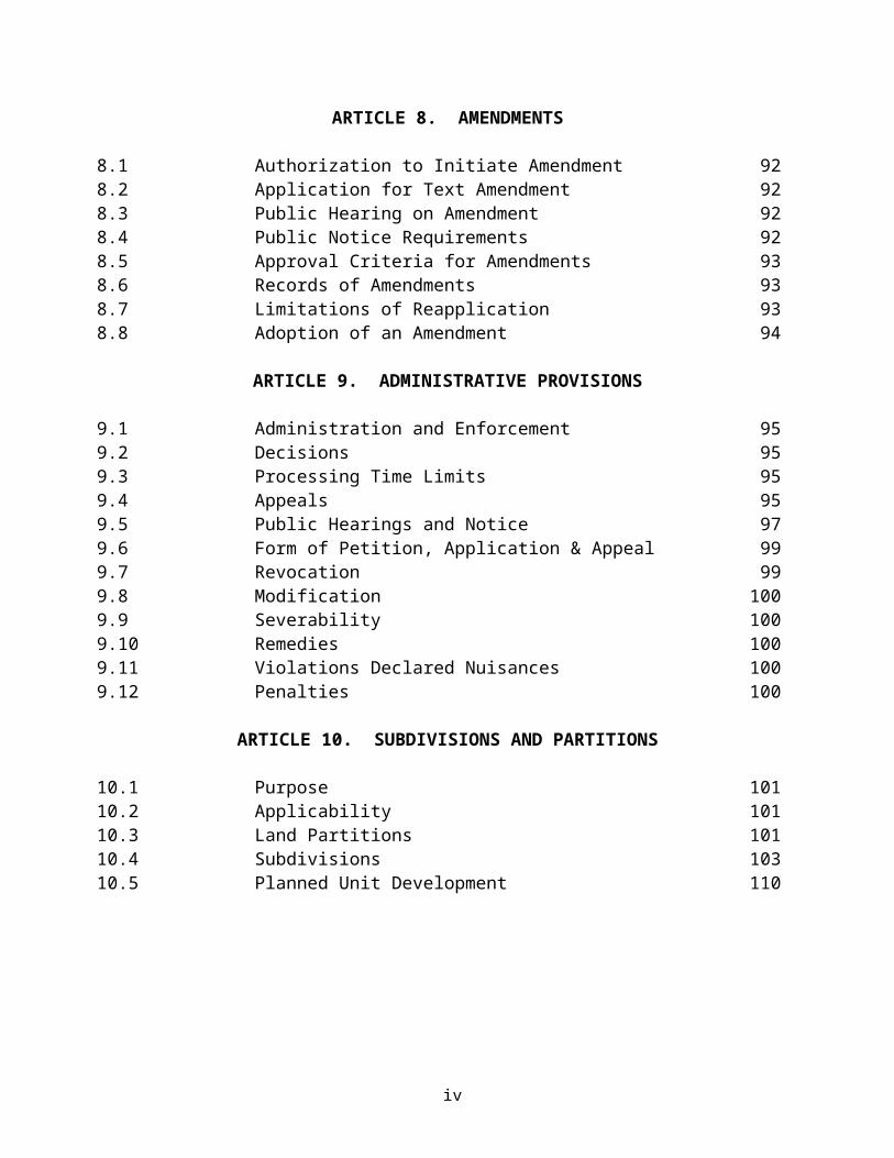
ARTICLE 8. AMENDMENTS
8.1 Authorization to Initiate Amendment 928.2 Application for Text Amendment 928.3 Public Hearing on Amendment 928.4 Public Notice Requirements 928.5 Approval Criteria for Amendments 938.6 Records of Amendments 938.7 Limitations of Reapplication 938.8 Adoption of an Amendment 94
ARTICLE 9. ADMINISTRATIVE PROVISIONS
9.1 Administration and Enforcement 959.2 Decisions 959.3 Processing Time Limits 959.4 Appeals 959.5 Public Hearings and Notice 979.6 Form of Petition, Application & Appeal 999.7 Revocation 999.8 Modification 1009.9 Severability 1009.10 Remedies 1009.11 Violations Declared Nuisances 1009.12 Penalties 100
ARTICLE 10. SUBDIVISIONS AND PARTITIONS
10.1 Purpose 10110.2 Applicability 10110.3 Land Partitions 10110.4 Subdivisions 10310.5 Planned Unit Development 110
iii

SECTION PAGE
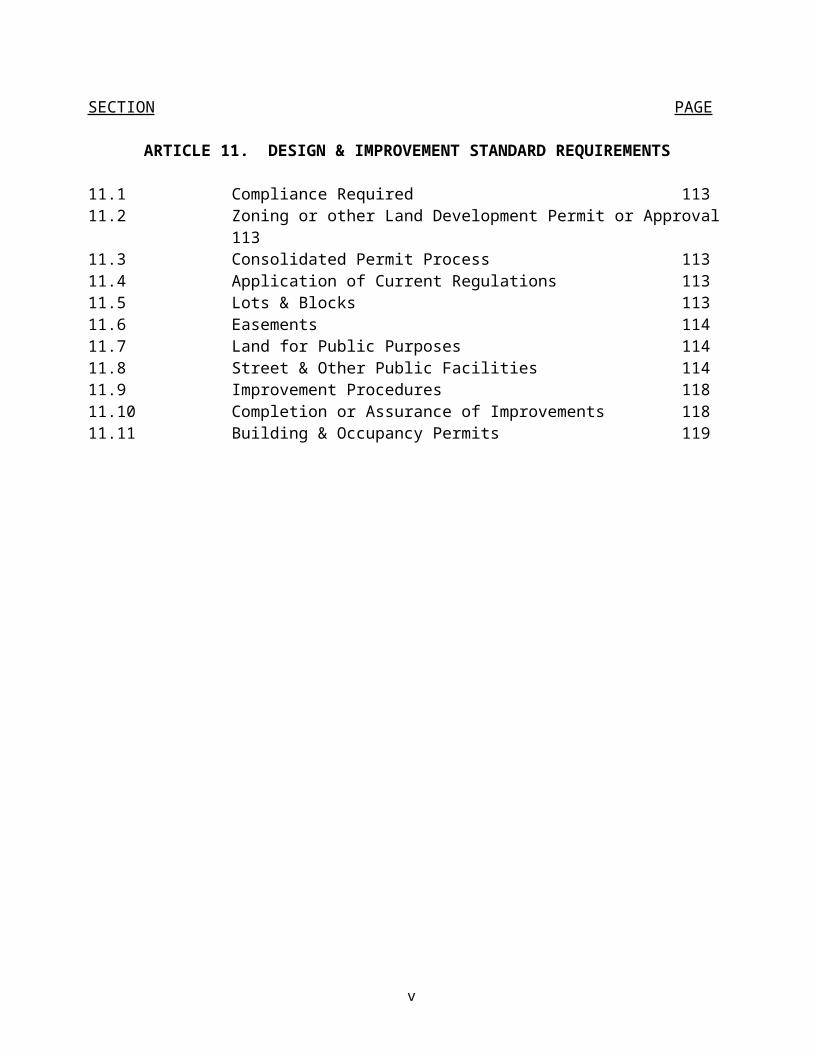
ARTICLE 11. DESIGN & IMPROVEMENT STANDARD REQUIREMENTS
11.1 Compliance Required 11311.2 Zoning or other Land Development Permit or Approval 11311.3 Consolidated Permit Process 11311.4 Application of Current Regulations 11311.5 Lots & Blocks 11311.6 Easements 11411.7 Land for Public Purposes 11411.8 Street & Other Public Facilities 11411.9 Improvement Procedures 11811.10 Completion or Assurance of Improvements 11811.11 Building & Occupancy Permits 119
iv
IN THE COUNTY COURT OF THE STATEOF OREGON FOR SHERMAN COUNTY
AN ORDINANCE PROVIDING FOR THE ESTABLISHMENT OF ZONING, SUBDIVISION, PARTITIONING AND OTHER LAND DEVELOPMENT REGULATIONS FOR SHERMAN COUNTY, OREGON; REPEALING SHERMAN COUNTY ZONING ORDINANCE OF FEBRUARY 1979 AND COUNTY SUBDIVISION AND LAND DEVELOPMENT ORDINANCE OF JANUARY 1976 AND FEBRUARY 1979.
THE COUNTY OF SHERMAN, OREGON, ORDAINS AS FOLLOWS:
ARTICLE 1. GENERAL PROVISIONS
SECTION 1.1 TITLE This Ordinance shall be known as the "Sherman County Zoning, Subdivision, Partitioning and Land Development Ordinance of 1994".
SECTION 1.2 PURPOSE The purposes of this Ordinance are: To implement the applicable provisions of ORS Chapters 92, 197, 215 other related state statutes, relevant state administrative rules (OAR's) and Statewide Planning Goals 1-14; To encourage the most appropriate use of land; To conserve and stabilize the value of property; To aid in the provision of County services; To provide for adequate light and air; To encourage the orderly growth of the County; and, In general to promote the public health, safety, convenience and general welfare through the implementation of the County's Comprehensive Plan.
SECTION 1.3. CONSTRUCTION AND TERMINOLOGY
1. Construction - Words used in the present tense include the future tense; words used in the singular include the plural, and words used in the plural include the singular; the word "may" is permissive, and the word "shall" is mandatory; and the masculine shall include the feminine and the neuter.
2. Terminology - The word "County" shall mean Sherman County, Oregon. The words "County Court" and "Court" shall mean the County Court of Sherman County. The words "Planning Commission" and "Commission" shall mean the County Planning Commission for Sherman County as duly appointed by the County Court. The words "County Clerk, " "County Planning Official or Director," "County Sheriff, " "County Legal Counsel, Counselor Attorney, " and "County Road and/or Public Works Superintendent, Roadmaster or Supervisor," shall mean such respective positions for Sherman County as applicable.
SECTION 1.4 DEFINITIONS As used in this Ordinance, the following words and phrases, unless the context of this Ordinance requires or provides otherwise, shall have the meaning set forth herein. Words and phrases not defined herein shall have the meaning set forth in state statutes, administrative rules, planning goals, policies and other relevant regulations in effect on the effective date of this Ordinance.
Page 1 of 119
Section 1.4 Definitions continued
Note: ORS's or OAR's set forth herein in parenthesis"()" are for reference information relative to the basis and/or source of the relevant definition.
1. Accepted Farming Practices - A current or future mode of operation that is common to farms and ranches of a similar nature, necessary for the operation of such farms and with the intent to obtain a profit in money, and customarily utilized in conjunction with farm use as defined in ORS 215.203(2)(a).
2. Access - The way or means of approach to provide pedestrian, bicycle, or motor vehicular entrance or exit to a property.
3. Access Classification - A ranking system for roadways used to determine the appropriate degree of access management. Factors considered include functional classification, the appropriate local government’s adopted plan for the roadway, subdivision of abutting properties, and existing level of access control.
4. Access Connection - Any driveway, street, turnout or other means of providing for the movement of vehicles to or from the public roadway system.
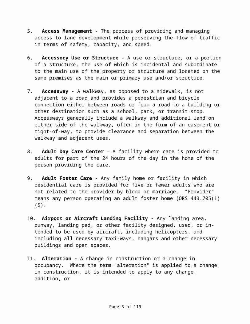
5. Access Management - The process of providing and managing access to land development while preserving the flow of traffic in terms of safety, capacity, and speed.
6. Accessory Use or Structure - A use or structure, or a portion of a structure, the use of which is incidental and subordinate to the main use of the property or structure and located on the same premises as the main or primary use and/or structure.
7. Accessway - A walkway, as opposed to a sidewalk, is not adjacent to a road and provides a pedestrian and bicycle connection either between roads or from a road to a building or other destination such as a school, park, or transit stop. Accessways generally include a walkway and additional land on either side of the walkway, often in the form of an easement or right-of-way, to provide clearance and separation between the walkway and adjacent uses.
8. Adult Day Care Center - A facility where care is provided to adults for part of the 24 hours of the day in the home of the person providing the care.
9. Adult Foster Care - Any family home or facility in which residential care is provided for five or fewer adults who are not related to the provider by blood or marriage. "Provider" means any person operating an adult foster home (ORS 443.705(1)(5).
10. Airport or Aircraft Landing Facility - Any landing area, runway, landing pad, or other facility designed, used, or in- tended to be used by aircraft, including helicopters, and including all necessary taxi-ways, hangars and other necessary buildings and open spaces.
11. Alteration - A change in construction or a change in occupancy. Where the term "alteration" is applied to a change in construction, it is intended to apply to any change, addition, or
Page 2 of 119

Section 1.4 Definitions continued
modification. Where the term is used in connection with a change in occupancy, it is intended to apply to changes in occupancy from one use to another.
12. Alteration, Structural - A change or repair which would tend to prolong the life of the supporting members of a building or structure, such as alteration of bearing walls, foundation, columns, beams or girders. A change in the external dimensions of a building shall also be considered a structural alteration.
13. Automobile Service Station - A retail place of business engaged primarily in the sale of motor fuels, but also supplying goods and services required in the operation and maintenance of automotive vehicles; Such may include petroleum products, tires, batteries, automotive accessories and replacement parts and items, washing and lubrication services, the performance of minor automotive maintenance and repair, and the supplying of other incidental customer services and products.
14. Automobile Wrecking Yard - A premises used for the storage and/or sale of used automobile or truck parts, and/or for the storage, dismantling or abandonment of junk, obsolete automobiles, trailers, trucks, machinery or parts thereof (ORS 822.100).
15. Automobile and/or Trailer Sales Area - An open area, other than a street, used for the display, sale or rental of new and/or used automobiles or trailers, and where no repair work is done except minor incidental repair of units to be displayed, sold or rented on the premises.
16. Basement - A story partly underground. A basement shall be counted as a story in building height measurement, when the floor level directly above is more than 6 feet above the average level of the adjoining ground.
17. Bed and Breakfast Facility - Means any establishment located in a structure designed for a single family residence, where the owner of the establishment resides in such structure, which: (a) Has more than two rooms for rent on a daily basis to the public; (b) Offers a breakfast meal as a part of the cost of the room; and (c) Serves one breakfast Meal a day to guests, staff and owners only. Breakfast Meal is the meal served to guests during the a.m. or morning hours each day (OAR 333-17).
18. Billboard - A sign which has a surface space upon which advertising may be posted, painted or affixed, and which is primarily designed for the rental or lease of such sign space for advertising not relating to the use of the property upon which the sign exists r is located.
19. Boarding or Rooming House - A building or portion thereof, other than a motel, restaurant or hotel, where meals or lodging or both are provided for compensation for more than 5 but not more then 10 persons.
20. Building - A structure built for the support, shelter or enclosure of persons, animals, chattels or property of any kind.
Page 3 of 119

21. Building Official - The building official is that person or official who s responsible for the enforcement of the building codes, ordinances and regulations within the County.
Section 1.4 Definitions continued
22. Business - Any commercial or non-commercial activity, service, institution or governmental unit.
23. Camping Vehicle - Either a vacation trailer or self-propelled vehicle or structure equipped with wheels for highway use and which is intended for human occupancy and is being used for vacation and recreational purposes, but not for residential purposes, and is equipped with plumbing, sink or toilet.
24. Chemical Processing - A mining and processing operation for metal-bearing ores that uses chemicals to dissolve metals from ore. (ORS 5i7).
25. Child caring Facility - A residence or building used by an agency to provide substitute residential care for children. ORS 418.950(3).
26. Church - A building or edifice used primarily for religious worship.
27. Clinic - A place where professional services are provided, including but not limited to medical, dental, counseling, optometry, veterinarian and other medical and social type service.
28. Commercial Activities in Conjunction with Farm Use: The processing, packaging, treatment and wholesale distribution and storage of a product primarily derived from farm activities on the premises. Also, retail sale of agricultural products, supplies and services directly related to the production and harvesting of agricultural products. Such uses include the following:
(a) Storage, distribution and sale of feed, fertilizer, seed, chemicals, and other products used for commercial agriculture.
(b) Farm product-receiving plants, including processing, packaging and reshipment facilities.
(c) Livestock feed or sales yards operated in conjunction with a farm as a secondary use thereof.
(d) Storage, repair, or sale of fencing, irrigation, pipe, pumps, and other commercial farm-related equipment and implements operated in conjunction with and as a secondary use to an existing farm or ranch operation.
(e) Farm Equipment storage and repair facilities.(f) Bulk storage and distribution facilities for fuels, pesticides, and fertilizers.(g) Veterinarian Clinic and/or Supply Outlet.(h) Horticultural specialties such as nurseries or greenhouses for retail sales of plants and
products.(i) Slaughtering of animals, including attendant retail and wholesale sales, which may be
conducted outside an enclosed building, and is operated in conjunction with and as a secondary use to an existing farm or ranch operation.
(j) Wineries for production from fruits, a portion of which are grown on the property, including retail sales.
Page 4 of 119
(k) Other such uses, which may be construed as similar to the uses, listed above, and are operated in conjunction with and as a secondary use to an existing farm or ranch operation.
Section 1.4 Definitions continued
29. Contiguous - Lots, parcels or lots and parcels that are in a single ownership that have a common boundary, including but not limited to, lots, parcels or lots and parcels separated only by a public road. Only one lot or parcel exists if:
(a) A lot or parcel i~; contiguous to one or more lots or parcels; and (b) On July 1, 1983, greater than possessors interests are held in those contiguous lots,
parcels or lots and parcels by the same person, spouses or a single partnership or business entity, separately or in tenancy-in-common.
30. Corner Clearance - The distance from a public or private road intersection to the nearest access connection, measured from the closest edge of the pavement of the intersecting road to the closest edge of the pavement of the connection along the traveled way.
31. Cross Access - A service drive providing vehicular access between two or more contiguous sites so the driver need not enter the public street system.
32. Current Employment of Land for Farm Use - Includes:
(a) Farmland, the operation or use of which is subject to any farm-related government program;
(b) Land lying fallow for one year as a normal and regular requirement of good agricultural husbandry;
(c) Land planted in orchards or other perennials, other than land specified in paragraph (d) hereof, prior to maturity;
(d) Land not in an EFU zone which has not been eligible for assessment at special farm use value in the year prior to planting the current crop and has been planted in orchards, cultured Christmas trees or vineyards for at least 3 years;
(e) Wasteland, in an EFU zone, dry or covered with water, neither economically tillable or grazeable, lying in or adjacent to and in common ownership with a farm use land and which is not currently being used for any economic farm use;
(f) Land under buildings supporting accepted farm practices;(g) Water impoundments lying in or adjacent to and in common ownership with farm use
land;(h) Land lying idle for no more than one year where the absence of farming activity is due
to the illness of the farmer or member of the farmer's immediate fami1y.
33. Custom Slaughtering Establishment or Slaughtering House - A mobile or stationary establishment wherein meat animals, caused to be delivered by the owners thereof, are slaughtered for compensation, payment or remuneration of any kind, and are thereafter returned to the owner thereof or to the order of the owners. ORS 603.010(2).
34. Day Care - The care, supervision and guidance on a regular basis of a child, unaccompanied by a parent, guardian or custodian, provided to a child during a part of the 24
Page 5 of 119

hours of the day, in a place other than the child's home, with or without compensation. Does not include care provided:
(a) In the home of the child;Section 1.4 Definitions continued
(b) By the child's parent, guardian or person acting in place of a parent;(c) By a per on related to the child by blood or marriage within the fourth degree as
determined by civil law;(d) On an occasional basis by a person not ordinarily engaged in providing day care;(e) By provide s of medical services; or(f) By a babysitter. (ORS 418.805(3).
35. Day Care Facility - Any facility that provides day care to children, including a day nursery, nursery school group, home of a family day care provider or similar unit operating under any name, but not including any:
(a) Facility providing care that is primarily education I, unless provided to a preschool child for more t an four hours a day.
(b) Facility providing care that is primarily supervised training in a specific subject, including but not limited to dancing, drama, music or religion.
(c) Facility providing care that is primarily an incident of group athletic or social activities sponsored by or under the supervision of an organized club or hobby group.
(d) Facility operated by a school district, political subdivision of this state or a governmental agency.
(e) Residentia1 facility licensed under ORS 443.400 to 443.455.(f) Babysitters. (ORS 418.805(4)).
36. Dude or Guest Ranch - A resort or ranch furnishing food and lodging for a fee with which horseback riding, tours, and related ranch and farm activities are also usually included. May be conducted in conjunction with a working farm or ranch as a commercial activity in conjunction with farm use.
37. Dwelling, Multi-Family or Apartment - A building or portion thereof, designed for occupancy by 3 or more families or households living independently of each other.
38. Dwelling, Single-family - A detached building containing one dwelling unit designed for occupancy by one family or one household only.
39. Dwelling, Two-Family or Duplex - A detached or semi-detached building containing 2 dwelling units and designed for occupancy for 2 families or 2 households.
40. Dwelling Unit - A building, or portion thereof, consisting of one or more rooms including a bathroom and kitchen facilities, which are arranged, designed or used as living quarters for one family or one household.
41. Easement - A grant of one or more property rights by a property owner to or for use by the public, or another person or entity.
Page 6 of 119

42. Erosion Flood Repair - Riprap or any other work necessary to preserve existing facilities and land from flood and high stream flows.
Section 1.4 Definitions continued
43. Family Day Care Center - A day care facility where care is provided in the home of the provider to fewer than 13 children including children of the provider, regardless of full or part-time status. ORS 418.
44. Family Day Care Provider - A day care provider who regularly provides day care in the provider's home in the family living quarters. ORS 418.805(5)
45. Farm Use - The current employment of land for the primary purpose of obtaining a profit in money by raising, harvesting, or selling crops, or for feeding, breeding, management and sale of, or the produce of livestock, poultry, fur-bearing animals or honeybees, or for dairying and the sale of dairy products, or any other agricultural or horticultural use or animal husbandry or any combination thereof. Includes the preparation and storage of products raised, on such land for human and animal use and disposal by marketing or otherwise. Also includes the propagation, cultivation, maintenance and harvesting of aquatic species. "Farm Use" also includes the current employment of land for the primary purpose of obtaining a profit in money by stabling or training equines. (ORS 215.203).
46. Fence - A protective or confining barrier constructed of wood, masonry, or wire mesh. Fence does not include hedges or other plantings.
47. Fence, Sight-Obscuring - A fence constructed, arranged and maintained in such a manner as to obscure vision.
48. Frontage - All property fronting on one side of a street and measured along the street line, between intersecting and intercepting streets, or between a street and a right-of-way, waterway, end of dead-end street, alley, or boundary of a city, special district or the county.
49. Frontage Road - A public or private drive which generally parallels a public street between the right-of-way and the front building setback line. The frontage road provides access to private properties while separating them from the arterial street.
50. Functional Area (Intersection) - That area beyond the physical intersection of two roads that comprises decision and maneuver distance, plus any required vehicle storage length.
51. Functional Classification - A system used to group public roadways into classes according to their purpose in moving vehicles and providing access.
52. Government Assisted Housing - Housing that is financed in whole or part by either a federal or state housing agency or a local housing authority as defined in ORS 456, or housing that is occupied by a tenant or tenants who benefit from rent supplements or housing vouchers provided by either a federal or state housing agency or local housing authority.
Page 7 of 119

53. Grazing - The use of land for pasture of horses, cattle, sheep, goats and/or other domestic herbivorous animals, alone or in conjunction with agricultural pursuits.
Section 1.4 Definitions continued
54. Guest House - A structure of no more than 450 square feet of site area used in conjunction with the main building for the temporary housing of non-paying visitors and guests and containing no cooking facilities.
55. Height of Buildings - The vertical distance from the grade to the highest point of the coping of a flat roof, to the deck line of a mansard roof, or to the average height of the highest gable of a pitch or hip roof.
56. Historical and Archaeological Buildings and Sites - Land and/or buildings which have a special historical or archaeological interest and have at least local significance, and represent one or more periods of time in the history of the County and adjoining areas.
57. Historic Cemetery - Any land that has been used as a cemetery at any time between 1810 to 1950, contains fewer than 50 marked graves, is less than one acre in size, and was issued a patent, whether recorded or unrecorded, before 1900. (HB 2602, OR Law 1991)
58. Home Occupation - A lawful activity or occupation carried on by the resident of a dwelling or accessory structures, or by members of the resident family occupying the dwelling, as an accessory use to the main use of the same. 0, dwelling being utilized as a residence for said family.
59. Hospital - An establishment, publicly or privately operated, which provides sleeping and eating facilities to persons receiving medical, obstetrical or surgical care and nursing service on a continuous basis.
60. Joint Access (or Shared Access) - A driveway connecting two or more contiguous sites to the public street system.
61. Kennel - A lot, building or premise in or on which 4 or more dogs, cats or other animals at least 4 months of age are kept commercially for board, propagation, training or sale.
62. Land Development - Any subdivision or partition of land, or other division of land provided for in this Document. The division of land into 2 or more lots, parcels or other interests for the purpose of disposition shall constitute a land development.
63. Livestock - Domestic animals of types customarily raised or kept on farm for profit or other purposes, including horses, mules, asses, cattle, sheep, swine, goats, llamas and poultry, including turkeys, of any age or sex. ORS 599.205.
64. Livestock Feeding Yard or Feedlot - An enclosure or group of enclosures, or structure or group of structures, of 1,000 square feet or more, or such enclosures or structures of less than 1,000 square feet involving five or more head of livestock, designed for the purpose of the
Page 8 of 119

concentrated feeding or fattening of livestock for commercial marketing and/or slaughter, excluding those areas involving 4-H, FFA or other recognized youth projects.
Section 1.4 Definitions continued
65. Living History Museum - A facility designed to depict and interpret everyday life and culture of some specific historic period using authentic buildings, tools, equipment and people to simulate past activities and events. (HE 2795, OR Law 1991 [ORS 215 amendment]).
66. Loading Space - An off-street space within a building or on the same lot with a building, for the temporary parking of a commercial vehicle or truck while loading or unloading merchandise or materials, and which space has direct access to a street or alley.
67. Lot - A parcel, tract, or area of land whose boundaries have been established by some, legal instrument, which is recognized as a separate legal entity for purposes of transfer of title, has frontage upon a public or private street, and complies with the dimensional requirements of this code.
68. Lot Area - The total horizontal net area within the lot lines of a lot to mean that square footage of a lot that is free from public and private road right-of-ways or easements for access, river or stream channels.
69. Lot, Corner - Any lot having at least two (2) contiguous sides abutting upon one or more streets, provided that the interior angle at the intersection of such two sides is less than one hundred thirty-five (135) degrees.
70. Lot Coverage - The percentage of the total lot area covered by buildings, including covered parking areas.
71. Lot, Depth - The average distance measured from the front lot line to the rear lot line.
72. Lot, Flag - A lot not meeting minimum frontage requirements and where access to the public road is by a narrow, private right-of-way line.
73. Lot Frontage - That portion of a lot extending along a street right-of-way.
74. Lot, Interior - A lot other than a corner lot.
75. Lot Line - The property line bounding a lot.
76. Lot Line, Front - The lot line separating a lot from a street other than an alley, and in the case of a corner lot, the shortest lot line along such a street.
77. Lot Line, Rear - The lot line, which is opposite and most distant from the front lot line. In the case of an irregular, triangular or other odd shaped lot, a line 10 feet in length within the lot, parallel to, and at a maxi- mum distance from the front lot line.
Page 9 of 119

78. Lot Line, Side - Any lot line other than a front or rear lot 1ine bounding a lot.
79. Lot, Through (or Double Frontage) - A lot that fronts upon two parallel streets or that fronts upon two streets that do not intersect at the boundaries of the lots.
Section 1.4 Definitions continued
80. Lot, Width - The average horizontal distance between the side lot lines, measured at right angles to the lot depth at a point midway between the front & rear lot lines.
81. Maintain - Means to allow to exist. (ORS 377.605(7)).
82. Manufactured Home - Means a structure constructed for movement on the public highways, that has sleeping, cooking and plumbing facilities, that is intended for human occupancy, that is being used for residential purposes and was constructed in accordance with Federal Manufactured Housing Construction and Safety Standards regulations in effect at the time of construction. Does not mean any building or structure subject to Structural Specialty Code adopted pursuant to ORS 455.100 450, or any unit identified as a recreational vehicle by the manufacturer.
83. Manufactured Home Park - Any place where two or more manufactured homes are parked within 500 feet of one another on a lot, tract or parcel of land under the same ownership, the primary purpose of which is to rent space or keep space for rent to any person for a charge or fee to be paid for rental or use of facilities or to offer space free in connection with securing the trade or patronage of such person(s); Except that for a construction company, timber company, or for farm laborers, four or more such units shall constitute a manufactured home park. "Manufactured Home Park" does not include a lot or lots located within a subdivision being rented or leased for occupancy by no more than one manufactured home per lot if the subdivision was approved as a manufactured home subdivision at the time of platting and approval by the County, or if an amendment to the approval of such subdivision for manufactured home or manufactured home use is subsequently granted by the County, (ORS 446.003(20), ORS 197.295(4) & OAR 814-28-020, 660-07-005 & 660-08-005).
84. Mining - Includes all or any part of the process of mining by the removal of overburden and the extraction of natural mineral deposits thereby exposed by any method including open-pit mining operations, auger mining operations, processing, surface impacts of underground mining, production of surface mining refuse and the construction of adjacent or off-site borrow pits except those constructed for use as access roads. Minerals includes soil, coal, clay, stone, sand, gravel, metallic ore and any other solid material or substance excavated for commercial, industrial or construction use from natural deposits situated within or upon lands in the state. Processing includes, but is not limited to, crushing, washing, milling and screening as well as the batching and blending of mineral aggregate into asphalt and Portland cement concrete located within the operating permit area. "Mining" does not include excavations of sand, gravel, clay, rock or other similar materials conducted by a landowner or tenant on the landowner or tenant's property for the primary purpose of reconstruction or maintenance of access roads and excavation or grading operations conducted in the process of farming or cemetery operations, onsite road construction or other onsite construction or non-surface impacts of underground mines; and also does not include rock, gravel, sand, silt or other similar
Page 10 of 119
substances removed from the beds or banks of any waters of the state pursuant 1:0 permit issued under ORS 541.605 to 541.625 and 541.627 to 541.660. (ORS 215 & 517).
85. Modular Home or Housing - A prefabricated or other dwelling unit manufactured off-site, normally constructed in two or more sections or components for assembly on a permanent foundation as a permanent residential structure, and when completed is essentially
Section 1.4 Definitions continued
indistinguishable from a conventionally constructed home and conforms to the state of Oregon One and Two Family Dwelling Code, 1990 Edition.
86. Motel - A building or group of buildings on the same lot or parcel containing motel rental units for rental to transients and consisting of individual sleeping quarters with or without cooking facilities, which are designed, intended, or used primarily for the accommodation of transients and travelers, and shall include hotels and inns.
87. Multiple Family Housing - Attached housing where each dwelling unit is not located on a separate lot or parcel. (OAR 660-07-005 & 660-08-005).
88. Museum - Includes any collection of archeological specimens, artifacts, pioneer relics, articles, documents and other things of historical, scientific or artistic import that are assembled, displayed, preserved and protected for the benefit of the public, for educational and scientific purposes or to commemorate the occupation and development of the area or the Pacific Northwest region, and the structure or structures housing such collection(s). (ORS 358.310(2).
89. Nonconforming Access Features - Features of the property access that existed prior to the date of ordinance adoption and do not conform to the requirements of this ordinance.
90. Nonconforming Use or Structure - A lawful existing use or structure at the time this Ordinance or any amendments that become effective, which does not conform to the requirements of the zone in which it is located.
91. Nursery, Day - An institution, establishment or place in which are commonly received at one time 3 or more children not of common parentage under the age of 14 years for a period or periods not exceeding 12 hours for the purpose of being given board, care and training apart from parents or guardians for compensation or reward.
92. Nursing Home - Any home, institution or other structure maintained or operating for the nursing and care of 16 or more ill or infirm adults not requiring hospitalization.
93. Outdoor Merchandising - The sale or display for sale of merchandise outside of an enclosed building space, including sales, which are transacted through an open window or door.
94. Owner - The owner of the title to real property, the authorized agent or the contract purchaser of real property of record as shown on the last available complete tax assessment roll, County Clerk's records or City Recorder's records. (ORS 308.740(3)).
95. Parcel - A division of land comprised of one or more lots in contiguous ownership.
Page 11 of 119
96. Person - Every natural person, firm, partnership, association, social or fraternal organization, corporation, trust, estate, receiver, syndicate, branch of government, or any group or combination acting as a unit.
97. Personal Use Airport - Airstrips, airports or helicopter pads, including associated hangar, maintenance and service facilities, restricted to use by the owner, and, on an infrequent and
Section 1.4 Definitions continued
occasional basis, by invited guests and by commercial aviation activities in connection with agricultural operations. No aircraft may be based on a personal use airport other than those owned or controlled by the owner of the airstrip. (ORS 215.213[2][h]).
98. Plat - An exact and detailed map of the subdivision of land.
99. Primary Principal or Main Use - The first use to which property is or may be devoted, and to which all other uses on the premises are derive as accessory or secondary uses. As used relative to dwelling units, the primary dwelling shall be the first dwelling unit to be located on a specific lot or parcel.
100. Private Road - A road not under the jurisdiction of a public body that provides the principal means of access to an abutting property.
101. Property Line - The division line between 2 units of land. (SB 548, OR Law 191, amending ORS 92.010)
102. Property Line Adjustment - The relocation of a common property line between 2 abutting properties. (SB 548, OR Law 1991, amending ORS 92.010)
103. Public or Semi-Public Use - A use owned and operated by a public, governmental or nonprofit organization for the benefit of the public in general. This does not include landfill sites, solid waste disposal sites, garbage dumps, recycling facilities, or utility facilities.
104. Public Road - A road under the jurisdiction of a public body that provides the principal means of access to an abutting property.
105. Public Use Airport - An airport that is open to use by the flying public.
106. Reasonable Access - The minimum number of access connections, direct or indirect, necessary to provide safe access to and from the roadway, as consistent with the purpose and intent of this ordinance and any applicable plans and policies of Sherman County.
107. Recreation Camps, Resorts & Parks - An area devoted to facilities and equipment for recreational purposes, including swimming pools, tennis courts, playgrounds and other similar uses, whether the use of such area is limited to private membership or whether open to the public upon payment of a fee, or an area designated by the landowner for picnicking or overnight camping and offered to the general public, whether or not a fee or charge is made for such accommodations. (ORS 446).
Page 12 of 119
108. Recreation Vehicle - A vehicle with or without motive power, which is designed for human occupancy and is to be used temporarily for recreational, seasonal or emergency purposes, and has a gross floor space not exceeding 400 square feet in the set-up mode. For the purposes of this Ordinance, such includes camping trailers, camping vehicles, motor homes, park trailers, bus conversions, van conversions, tent trailers, travel trailers, folding or collapsible trailers or truck campers and any vehicle manufactured or converted for use or partial use as a recreational vehicle. (ORS 446.003(24) & ORS 446.321(3)).
Section 1.4 Definitions continued
109. Recreation Vehicle Park Recreation Park or Campground - Any area designated by the person establishing, operating, managing or maintaining the same for picnicking or overnight camping by the general public or any segment of the public. Includes, but is not limited to, areas open to use free of charge or through payment of a tax or fee or by virtue of rental, lease, license, membership, association or common ownership, and further includes, but is not limited to, those areas divided into two or more lots, parcels, units, spaces or other interests or designations for purposes of such use. Includes such facilities and s aces for tents, tent vehicles, camping vehicles or recreation vehicles of any type.
110. Recycling Facility - A place and equipment for collecting source separated recyclable material located either at a solid waste disposal site or at another location.
111. Replat - The act of platting the lots, parcels and easements in a d subdivision or partition plat to achieve a reconfiguration of the existing subdivision or partition plat or to increase or decrease the number of lots in the subdivision. ORS 92.010.
112. Residential Care - Means service such as supervision; protection; assistance while bathing, dressing, grooming or eating; management of money; transportation; recreation; and the providing of room and board. ORS 443.400(4).
113. Residential Facility - Means a facility that provides for 6 to 15 physically handicapped or socially handicapped individuals, residential care in one or more buildings on contiguous properties. ORS 197.660(1).
114. Residential Home - Means a residence for 5 or fewer unrelated physically or mentally handicapped persons and for staff persons who need not be related to each other or to any other home resident. ORS 197.660(2).
115. Right-of-Way - Land reserved, used, or to be used for a highway, street, alley, walkway, drainage facility or other public purpose.
116. Riparian - Means of, or pertaining to, or situated on the edge of the bank of a river, stream or other body of water. Riparian Vegetation or Habitat means the aquatic and non-aquatic vegetation adjacent to waterways, which is dependent upon freely available water or is at least water-tolerant.
117. Road or Street - A public or private way that is created to provide ingress and egress for persons to one or more lots, parcels, areas or tracts of land, excluding a private way that is created to provide ingress or egress to such land in conjunction with the use of such land for agricultural, forestry or mining purposes. Such includes the entire width of every right-of-way,
Page 13 of 119

which provides for public or private use for the purpose of vehicular and pedestrian traffic and includes the terms highway, lane, place, avenue, alley, or other similar designations.
118. Seasonal Farm Worker - Any person who, for an agreed remuneration or rate of pay, performs temporary labor for another to work in production of farm products or planting, cultivating or harvesting of seasonal agricultural crops or in forestation or reforestation of lands, including but not limited to, the planting, transplanting, tubing, pre-commercial thinning
Section 1.4 Definitions continued
and thinning of trees and seedlings, the clearing of piling and disposal of brush and slash and other related activities. (ORS 197.675)
119. Seasonal Farm Worker Housing - Housing limited to occupancy by seasonal farm workers and their immediate families, which is occupied no more than 9 months a year.
120. Series Partition - A series of partitions of land located within the county resulting in the creation of 4 or more parcels over a period of more than one calendar year.
121. School: Kindergarten, Primary, Elementary, Junior or High School - Including public, private or parochial schools, but not a nursery or day nursery school.
122. Sign - An identification, description, illustration or device which is affixed to or represented, directly or indirectly upon a building, structure or land, and which directs attention to a product, place, activity, person, institution, business or service, excluding house numbers.
123. Significant Change in Trip Generation - A change in the use of the property, including land, structures or facilities, or an expansion of the size of the structures or facilities causing an increase in the trip generation of the property exceeding: (1) local 10 percent more trip generation (either peak or daily) and 100 vehicles per day more than the existing use for all roads under local jurisdiction; or (2) State exceeding 25 percent more trip generation (either peak or daily) and 100 vehicles per day more than the existing use for all roads under state jurisdiction.
124. Skirting - Weather resistant material that is required to be used to enclose the space below a manufactured home, residential trailer or manufactured home.
125. Solid Wastes - All putrescible and non-putrescible wastes, including but not limited to garbage, rubbish, refuse, ashes, waste paper and cardboard; sewage sludge, septic tank and cesspool pumping or other sludge; commercial, industrial, demolition and construction wastes; discarded or abandoned vehicles o parts thereof; discarded home and industrial appliances; manure, vegetable or animal solid and semisolid wastes, dead animals and other wastes; but does not include:
(a) Hazard us wastes as defined in ORS 466,005, and(b) Materials used for fertilizer or other productive purposes or which are salvageable as
such materials are used on agricultural lands.
126. Solid Waste Disposal Site - Land and facilities used for the disposal, handling or transfer of, or resource recovery from solid wastes, including but not limited to dumps, landfills, sludge
Page 14 of 119

lagoon, sludge treatment facilities, disposal sites for septic tank pumping or cesspool cleaning service, transfer stations, resource recovery facilities, incinerators for solid waste delivered by the public or by a solid waste collection service, composting plants and land and facilities previously used for solid waste disposal at a land disposal site, (ORS 459.005)
127. Start of Construction - The first placement of permanent construction of a structure (other than a manufactured home) on a site, such as the pouring of slabs or footings or any work
Section 1.4 Definitions continued
beyond the preparation, such as clearing, grading and filling, nor does it include excavation for a basement, footings, piers or foundations or the erection of temporary forms; nor does it include the installation on the property of accessory buildings such as garages or sheds not occupied as dwelling units or not a part of the main structure. For a structure (other than a manufactured home or a manufactured dwelling) without a basement or poured footings, the Start of Construction includes the first permanent framing or assembly of the structure or any part thereof on its piling or foundation. For manufactured homes or manufactured homes not within a manufactured home/manufactured home subdivision or manufactured home/manufactured home park, the start of Construction means the date on which construction of facilities for servicing the site on which the manufactured home or manufactured dwelling is to be affixed (including, at a minimum, the construction of streets, either final site grading or the pouring of concrete pads, and installation of utilities) is completed.
128. Structure - That which is built or constructed. An edifice or building of any kind or any piece of work artificially built up or composed of parts joined together in some definite manner and which requires location on the ground or which is attached to something having a ground location.
129. Structural Alteration - Any change to the supporting members of a building including foundations, bearing walls or partitions, columns, beams, girders or any structural change in the roof or in exterior walls.
130. Stub-out (Stub-street) - A portion of a street or cross access drive used as an extension to an abutting property that may be developed in the future.
131. Substantial Enlargements or Improvements - An increase in existing square footage or increase in assessed valuation of the structure of 25% or more in the square footage or assessed value.
132. Tract - One or more contiguous lots or parcels under the same ownership.
133. Transfer Station - A fixed or mobile facility normally used, as an adjunct of a solid waste collection and disposal system or resource recovery system, between a collection route and a disposal site, including but not limited to a large hopper, railroad gondola or barge. (ORS 459.005(22)).
134. Travel Trailer or Recreational Vehicle Park or Campground - A lot or parcel upon which two or more travel trailers, recreational vehicles, motor homes, tent trailers, tent sites, campers, or similar vehicles or devices are located or permitted on an overnight basis (except as
Page 15 of 119

used for storage purposes, or otherwise approved as a temporary use), regardless of whether a fee is charged for such accommodations. (ORB 446.310(9)).
135. Use - The purpose, for which land or a structure is designed, arranged or intended, or for which it is occupied or maintained.
Section 1.4 Definitions continued
136. Utility Facility - Any major structure owned or operated by a public, private or cooperative electric, fuel, communication, sewage or water company for the generation, transmission, distribution or processing of its products or for the disposal of cooling water, waste or by-products, but excluding local sewer, water, gas, telephone and power distribution lines, and similar minor facilities.
137. Waterway - Natural waterways including all tidal and non-tidal bays, intermittent streams, constantly flowing streams, lakes and other bodies of water in the state (wetlands) navigable and non-navigable; "wetlands" were clarified as waters of the state in AG Opinion #7755, May 9, 1979.
138. Wetlands - Those areas that are inundated or saturated by surface or ground water at a frequency and duration that are sufficient to support, and that under normal circumstances do support, a prevalence of vegetation typically adapted for life in saturated soil conditions. (ORS 196 & 197).
139. Wrecking Yard - Any property or establishment where a person(s) is engaged in breaking up, dismantling, sorting, storing, distributing, buying or selling scrap or waste materials, or any establishment or place of business where there is accumulated on the premises 8 or more motor vehicles or an equivalent volume of junk that is maintained, operated or used for storing, keeping, buying or selling of junk, and the term includes automobile graveyards, garbage dumps and scrap metal processing facilities. (ORS 377.605(6)).
140. Yard (Setback) - An open space on a lot, which is unobstructed from the ground upward, except as otherwise provided in this Ordinance. (ORS 227.290).
141. Yard, Front - A yard (setback) between side lot lines and measured horizontally at right angles to the front lot line to the nearest point of a building.
142. Yard, Rear - A yard (setback) between side lot lines and measured horizontally at right angles to the rear lot line from the rear lot line to the nearest point of a building.
143. Yard, Side - A yard (setback) between the front and rear yards measured horizontally and at right angles to the side lot line from the side lot line to the nearest point of a building.
Page 16 of 119
ARTICLE 2. CLASSIFICATION OF ZONES-BASIC PROVISIONS
SECTION 2.1 COMPLIANCE WITH ORDINANCE PROVISIONS A lot or parcel may only be used and a structure, or part of a structure, may only be constructed, reconstructed, altered, occupied or used as permitted by this Ordinance. No lot or parcel area, yard or other open space existing on or after the effective date of this Ordinance shall be reduced below the minimum required by the pro- visions set forth in this Ordinance.
SECTION 2.2 INTERPRETATION Where the provisions of this Ordinance and other county ordinances or resolutions conflict, the provisions of said ordinance or resolution with the more restrictive language shall apply.
SECTION 2.3 CLASSIFICATION OF ZONES For the purpose of this Ordinance, the County is divided into Zones designated as follows:
ABBREVIATEDZONE TITLE DESIGNATION
Exclusive Farm Use F-lAgricultural Airport A-lResidential R-1Commercial C-1Industrial M-1Significant Resource Combining (SR)Natural Hazards Combining (NH)Rural Industrial (RI)Limited Use Combining (LU)
SECTION 2.4 LOCATION OF ZONES The boundaries of the Zones listed in this Ordinance are indicated on the Sherman County Zoning Map, which is hereby adopted by reference.
SECTION 2.5 ZONING MAP AND AMENDMENTS A Zoning Map or Zoning Map Amendment shall be dated with the effective date of the adoption by the County Court and shall be signed by the County Judge and the County Clerk. The signed original, together with a copy thereof, shall be maintained on file in the office of the County Clerk.
SECTION 2.6 ZONE BOUNDARIES Unless otherwise specified, Zone boundaries are section lines, subdivision lines, lot lines, centerlines of streets and other rights-of-way or utilities, watercourses, ridges or rimrocks, or such lines extended. If a zone boundary as shown on the map divides a lot between two zones, the entire lot shall be deemed to be in the zone in which the greater area of the lot lies, provided that this adjustment involves a distance not to exceed 20 feet from the mapped zone boundary line. If distances exceed 20 feet, but less than 200 feet, then the matter shall be heard by the Planning Commission at a public hearing.
Page 17 of 119
ARTICLE 3. USE ZONES
SECTION 3.1 EXCLUSIVE FARM USE, F-l ZONE In an F-l Zone, the following regulations shall apply:
1. General Purpose - To protect agricultural uses from encroachment by other incompatible uses and to provide tax incentives to assure that a maximum amount of agricultural land is retained in agricultural uses.
2. Uses Permitted - In the F-l Zone, the following uses and their accessory uses are permitted:
(a) Farm use as described in the definition portion of this document. This subsection is intended to include nonresidential buildings and structures customarily provided in conjunction with farm use (e.g. corrals, pens, barns, sheds, maintenance buildings, personal use grain elevators or bins, chemical storage, etc.).
(b) One single family dwelling, including a manufactured dwelling or manufactured home, customarily provided in conjunction with farm use if it meets the criteria in Section 4.12 of this Ordinance.
(c) A dwelling, including a manufactured home, on property used for farm use if the dwelling is:
1) Located on the same lot or parcel as the dwelling of the farm operator; and2) Occupied by a relative, which means grandparent, grandchild, parent, child, brother
or sister of the farm operator or the farm operator's spouse, whose assistance in the management of the farm use is or will be required by the farm operator.
(d) Operations for the exploration for and production of geothermal resources as defined by ORS 522.005 and oil and gas as defined by ORS 520.005, including the placement and operation of compressors, separators and other customary production equipment for an individual well adjacent to the wellhead. Any activities or construction relating to such operation shall not be a basis for an exception under ORS 197.732(1)(a) or (b).
(e) Operations for the exploration for minerals as defined by ORS 517.750 and as provided for in ORS 215.298. Any activities or construction relating to such operation shall not be a basis for an exception under ORS 197.732(1)(a) or (b).
(f) Climbing and passing lanes within a right of way existing as of July 1, 1987.(g) Reconstruction or modification of public roads and highways, not including the addition
of travel lanes, where no removal or displacement of buildings will occur, or new land parcels result.
(h) Temporary public road and highway detours that will be abandoned and restored to original condition or use at such time as no longer needed.
(i) Minor betterment of existing public roads and highway related facilities such as maintenance yards, weigh stations and rest areas, within right of way existing as of July 1, 1987, and contiguous public-owned property utilized to support the operation and maintenance of public roads and highways.
(j) A replacement dwelling, including a manufactured home to be used in conjunction with farm use if the existing dwelling has been listed in a state or county inventory as historic property and on the national register of Historic Places.
Page 18 of 119
Section 3.1 Exclusive Farm Use continued
(k) Public schools more than 3 miles from an Urban Growth Boundary, including all buildings essential to the operation of a school.
(l) One manufactured home in conjunction with an existing dwelling as a temporary use for the term of a hardship suffered by the existing resident or a relative of the resident.
(m)Non-Commercial utility facilities necessary for private service or public service.(n) Alteration, restoration or replacement of a lawfully established dwelling. See standards
in ORS 215.283 (1) (s).(o) Creation of, restoration of enhancement of wetlands.(p) A winery as described in ORS 215.452.(q) Farm stands as set forth in ORS 215.283 (1) (r).(r) A site for model aircraft as set forth in ORS 215.283 (1) (t).(s) A facility for processing of farm crops as set forth in ORS 215.283 (1) (u).(t) Irrigation canals, delivery lines and those structures and accessory operational facilities
associated with a district as defined in ORS 540.505.(u) Fire service facilities providing rural fire protection services.(v) Utility Facility services lines as set forth in ORS215.283 (1) (x).(w)Land application of reclaimed water as set forth in ORS 215.283 (1) (y).(x) Transportation improvements. (Ord No. 22-05-2003)
1) Normal operation, maintenance, repair, and preservation activities of existing transportation facilities.
2) Installation of culverts, pathways, medians, fencing, guardrails, lighting, and similar types of improvements within the existing right-of-way.
3) Projects specifically identified in the Transportation System Plan as not requiring further land use regulation.
4) Landscaping as part of a transportation facility.5) Emergency measures necessary for the safety and protection of property6) Acquisition of right-of-way for public roads, highways, and other transportation
improvements designated in the Transportation System Plan or the Statewide Transportation Improvement Plan adopted by the Oregon Transportation Commission except for those that are located in exclusive farm use zones.
7) Construction of a street or road as part of an approved subdivision or land partition approved consistent with the applicable land division ordinance.
3. Conditional Uses Permitted - In an F-l Zone, the following uses and their accessory uses are permitted when authorized in accordance with the requirements of Article 5 of this Ordinance and this Section:
(a) Churches and cemeteries in conjunction with churches more than 3 miles from an Urban Growth Boundary.
(b) Seasonal farm-worker housing as defined in ORS 197.675 and Subsection 1.4(103) of this Ordinance.
(c) Commercial activities that are in conjunction with farm use.(d) Home occupations as provided in ORS 215.448 and as defined in Subsection 1.4 of this
Ordinance.(e) Operations conducted for the following uses:
Page 19 of 119
Section 3.1 Exclusive Farm Use continued
1) Mining and processing of geothermal resources as defined by ORS 522.005 and oil and gas as defined by ORS 520.005, not otherwise permitted under paragraph (d) of Subsection (1) of this Section.
2) Mining of aggregate and other mineral and other subsurface resources subject to ORS 215.298 and as defined in Section 1.4 of this Ordinance.
3) Processing, as defined in Section 1.4 of this Ordinance and ORS 517.750, of aggregate into asphalt or Portland cement; and
4) Processing of other mineral resources and other subsurface resources. (As provided at ORS 215.283(2)(A)(B)(C) & (D)).
5) Crushing and stockpiling of aggregate and other minerals.
(f) Community centers owned and operated by a governmental agency or a nonprofit community organization, hunting and fishing preserves, public parks, playgrounds and campgrounds.
(g) Golf courses as defined in OAR 660-33-130-(20).(h) Residential homes and facilities as defined in ORS 197.660 and in Section 1.4 of this
Ordinance, in existing dwellings.(i) The propagation, cultivation, maintenance and harvesting of aquatic species.(j) Construction of additional passing and travel lanes requiring the acquisition of right of
way but not resulting in the creation of new land parcels and/or the removal or displacement of buildings.
(k) Improvement of public roads and highway related facilities such as maintenance yards, weigh stations and rest areas, where additional property or right of way is required but not resulting in the creation of new land parcels and/or the removal or displacement of buildings.
(l) Room and board arrangements for a maximum of 5 unrelated persons in existing residences.
(m)A single family dwelling on a lot of record where the following circumstances apply:
A. The lot/parcel on which the dwelling will be sited:
1) Was lawfully created and was acquired by the present owner prior to January 1,1985, or by devise or by intestate succession from a person who acquired the lot/parcel prior to January 1, 1985.
2) Is not high value farmland as defined by Oregon statute.3) Lies within an area designated in the Sherman County Comprehensive Plan as
habitat for big game, the siting of the dwelling is consistent with the limitations on density upon which the protection of big game habitat is based.
4) Is part of a tract, the remaining portions of the tract are consolidated into a single lot or parcel when the swelling is allowed. A tract is defined for purposes of this section as one or more contiguous lots or parcels under the same ownership.
B. The tract on which the dwelling will be sited does not include a dwelling.C. The proposed dwelling complies with the Sherman County Comprehensive Plan, all
other county land use regulations, and other provisions of law.
Page 20 of 119

Section 3.1 Exclusive Farm Use continued
D. A single-family dwelling on a lot of record may be sited on high value farmland if approved by a hearings officer of the State Department of Agriculture as provided for in Oregon statutes.
(n) A single family residential dwelling, including a manufactured home, not provided in conjunction with farm use, may be established on a lot or parcel, i.e., non-farm dwellings, subject to approval in accordance with the applicable provisions set forth in ORS 215.184.
(o) Public or private parks, playgrounds, and campgrounds, as defined in OAR 660-33-(10).(p) Private schools more than 3 miles from an Urban Growth Boundary, including all
buildings essential to the operation of a school.(q) Commercial utility facilities.(r) Personal-use airports for airplanes and helicopter pads, including associated hangar
maintenance and service facilities, as defined by ORS 215.213 (2)(h) and in Section 1.4 of this Ordinance.
(s) A site for the disposal and/or transfer of solid waste approved by the governing body of a city or county or both and for which a permit has been granted under ORS 459.245 by the Department of Environmental Quality together with equipment, facilities or buildings necessary for its operation.
(t) Construction of additional passing and travel lanes requiring the acquisition of right of way and resulting in the creation of new land parcels and/or the removal or displacement of buildings.
(u) Improvement of public roads and highway related facilities such as maintenance yards, weigh stations and rest areas, where additional property or right of way is required resulting in the creation of new land parcels and/or the removal or displacement of buildings.
(v) Reconstruction or modification of public roads and high- ways involving the removal or displacement of buildings and/or resulting in the creation of new land parcels.
(w)Commercial livestock feedlot or sales yards, hog or mink farm located within one-half mile of a residence not owned by the owner and/or applicant, or a lot or residence in a non-EFU Zone or Urban Growth Boundary.
(x) Transmission towers over 200 feet in height.(y) Wireless telecommunications facilities.(z) Construction, reconstruction, or widening of highways, roads, bridges or other
transportation projects that are in the Sherman County Transportation system plan.(aa) Guest Ranches
(1) Notwithstanding ORS 215.283, a guest ranch may be established in conjunction with an existing and continuing livestock operation, using accepted livestock practices, that qualifies as a farm use under ORS 215.203 in any area zoned for exclusive farm use in eastern Oregon.
(2) A guest ranch established under this section shall meet the following conditions:
(a) Except as provided in paragraph (d) of this subsection, the lodge, bunkhouses or cottages cumulatively shall:
Page 21 of 119
Section 3.1 Exclusive Farm Use continued
(A) Include not less than four nor more than 10 overnight guest rooms exclusive of kitchen areas, rest rooms, storage and other shared indoor facilities; and
(B) Not exceed a total of 12,000 square feet in floor area.
(b) The guest ranch shall be located on a lawfully created parcel:
(A) That is at least 160 acres;(B) That is the parcel containing the dwelling of the person conducting the
livestock operation; and(C) That is not classified as high-value farmland as defined in ORS 215.710.
(c) The guest ranch may be sited on any portion of a lot or parcel if the majority of the lot or parcel is more than 10 air miles from an urban growth boundary containing a population greater than 5,000, regardless of whether any other portion of the lot or parcel is within 10 miles of the urban growth boundary. The guest ranch shall be deemed to comply with this paragraph if it is located within the range set by the standard margin of error on the county’s map used to determine the distance from an urban growth boundary.
(d) For each doubling of the initial 160 acres required under paragraph (b) of this subsection, up to five additional overnight guest rooms and 3,000 square feet of floor area may be added to the guest ranch for a total of not more than 25 guest rooms and 21,000 square feet of floor area.
(3) A guest ranch may provide recreational activities that can be provided in conjunction with the livestock operation’s natural setting, including but not limited to hunting, fishing, hiking, biking, horseback riding, camping or swimming. Intensively developed recreational facilities, such as golf courses as identified in ORS 215.283, shall not be allowed. A campground as described in ORS 215.283 (2)(c) shall not be allowed in conjunction with a guest ranch, and a guest ranch shall not be allowed in conjunction with an existing golf course under ORS 215.283 (2)(f) or with an existing campground under ORS 215.283 (2)(c).
(4) Food services shall be incidental to the operation of the guest ranch and shall be provided only for the guests of the guest ranch. The cost of meals provided to the guests shall be included as part of the fee to visit or stay at the guest ranch. The sale of individual meals to persons who are not guests of the guest ranch shall not be allowed.
(5) Approval of a guest ranch shall be subject to the provisions of ORS 215.296 (1) and (2) and other approval or sitting standards of the county.
(6) As used in this section:
(a) "Eastern Oregon" shall have the meaning provided in ORS 321.405.(b) "Guest ranch" means a facility for overnight lodging incidental and accessory to
an existing livestock operation that qualifies as a farm use under ORS 215.203. Guest ranch facilities may include a lodge, bunkhouse or cottage accommodations as well as passive recreational activities and food services as set forth in subsections (2) to (4) of this section.
(c) "Livestock" means cattle, sheep, horses and bison.
Page 22 of 119
Section 3.1 Exclusive Farm Use continued
Sec. 2.(1) Notwithstanding ORS 215.263, the governing body of a county or its designee shall not approve a proposed division of land in an exclusive farm use zone for a guest ranch as defined in Section 1 of this 1997 Act.
(7) The governing body of a county or its designee shall not approve any proposed division of a lot or parcel that separates a guest ranch described in section 1 of this 1997 Act from the dwelling of the person conducting the livestock operation. [1997 c.728 §2]
(bb) Destination Resorts. Destination Resort siting requires a detailed planning process and the establishment of a program. Destination Resort programs include the establishment of a map of eligible lands as well as comprehensive plan and zoning ordinance revisions.
(cc) Room and board arrangements for a maximum of five unrelated persons in existing residences.
(dd) Operations for the extraction and bottling of water(ee) Expansion of existing county fairgrounds and activities directly relating to county
fairgrounds governed by county fair boards establish pursuant to ORS 565.210.(ff) A living history museum as set forth in ORS 215.283 (2) (x).(gg) Transportation Improvements. (Ord No. 22-05-2003)
1) Construction, reconstruction, or widening of highways, roads, bridges or other transportation projects that are: (1) not improvements designated in the Transportation System Plan; or (2) not designed and constructed as part of a subdivision or planned development subject to site plan and/or conditional use review. Transportation projects shall comply with the Transportation System Plan and applicable standards, and shall address the following criteria. For State projects that require an Environmental Impact Statement (EIS) or Environmental Assessment (EA), the draft EIS or EA shall be reviewed and used as the basis for findings to comply with the following criteria:
A. The project is designed to be compatible with existing land use and social patterns, including noise generation, safety, and zoning.
B. The project is designed to minimize unavoidable environmental impacts to identified wetlands, wildlife habitat, air and water quality, cultural resources, and scenic qualities.
C. The project preserves or improves the safety and function of the facility through access management, traffic calming, or other design features.
D. The project includes provision for bicycle and pedestrian circulation as consistent with the comprehensive plan and other requirements of this ordinance.
2) Construction of rest areas and weigh stations.3) If review under this Section indicates that the use or activity is inconsistent with the
Transportation System Plan, the procedure for a plan amendment shall be undertaken prior to or in conjunction with the conditional permit review.
Page 23 of 119

Section 3.1 Exclusive Farm Use continued
4) Authorization of a conditional use shall be void after a period specified by the applicant as reasonable and necessary based on season, right-of-way acquisition, and other pertinent factors. This period shall not exceed three years.
4. Dimensional Standards - In an F-1 (EFU) Zone, the following dimensional standards shall apply:
(a) New farm parcels shall be a minimum of 80 acres.(b) MINIMUM LOT SIZE-NON-FARM PARCELS. Non-farm parcels allowed pursuant
to the provisions of this Ordinance and more specifically this Section, shall meet the following standards:
1) Shall be of adequate size and dimensions to meet applicable setback requirements.2) Shall be of the minimum size necessary to accommodate the intended use and
provide for subsurface sewage disposal thereof.3) Each such parcel shall contain a minimum of I Net Buildable Acre as defined in
section 1.4 of this Ordinance.
(c) SETBACK (YARD) REQUIREMENTS. In an F-l (EFU) Zone, the minimum setback requirements shall be as follows:
1) The front and rear yard setbacks from the property line shall be 30 feet, except that the front yard setback from the right-of-way line of an arterial or major collector road or street shall be 50 feet unless approved otherwise by the Planning Commission.
2) Each side yard setback from a property line shall be a minimum of 25 feet, and for parcels or lots involving a non-farm residential use with side yard(s) adjacent to farm lands, said adjacent side yards shall be a minimum of 50 feet unless approved otherwise by the Planning Commission.
SECTION 3.2 GENERAL RESIDENTIAL, R-l ZONE In an R-l Zone, the following regulations shall apply:
1. Uses Permitted Outright - In an R-l Zone, the following uses and their accessory uses are permitted outright:
(a) Single-Family Residential Dwelling, including Modular and Prefabricated Homes.(b) Two-Family Dwelling or Duplex, or Tri-Plex.(c) Multi-Family Dwelling complex of 4 units.(d) Residential Home as defined by ORS 443.580(3).(e) Family Day Care Center as defined in ORS 418.(f) Utility lines and service facilities necessary for local(g) Or community public service.(h) Transportation Improvements. (Ord No. 22-05-2003)
1) Normal operation, maintenance, repair, and preservation activities of existing transportation facilities.
Page 24 of 119
Section 3.2 General Residential continued
2) Installation of culverts, pathways, medians, fencing, guardrails, lighting, and similar types of improvements within the existing right-of-way.
3) Projects specifically identified in the Transportation System Plan as not requiring further land use regulation.
4) Landscaping as part of a transportation facility.5) Emergency measures necessary for the safety and protection of property6) Acquisition of right-of-way for public roads, highways, and other transportation
improvements designated in the Transportation System Plan or the Statewide Transportation Improvement Plan adopted by the Oregon Transportation Commission except for those that are located in exclusive farm use zones.
7) Construction of a street or road as part of an approved subdivision or land partition approved consistent with the applicable land division ordinance.
2. Conditional Uses Permitted - In an R-l Zone, the following uses and their accessory uses are permitted when authorized in accordance with the provisions of this Section and Article 5 of this Ordinance:
(a) Public or Private School or Church, including buildings essential to the operation thereof.
(b) Governmental structure or land use including, but not limited to, a public park, playground, recreation building, fire station, library or museum, including a living history museum.
(c) Home Occupation or Cottage Industry.(d) Boarding, lodging or rooming house, or Bed & Breakfast facility.(e) Bed and Breakfast Facility.(f) Guest House.(g) Residential Trailer as a single-family residential dwelling.(h) Temporary residential dwellings as permitted in Article 4 of this Ordinance.(i) Community building owned and operated by a governmental agency or a nonprofit,
social or fraternal organization.(j) Hospital and other medical service facilities such as clinics, sanitariums, rest homes,
home for the aged, nursing or convalescent home.(k) Telephone exchanges, radio and television facilities, electrical substations, and other
public or private utility facilities.(l) Residential Facility or Adult Foster Home.
(m) Planned Unit Development.(n) Manufactured Home or Manufactured Home Park, including Temporary Parks.(o) Multi-family dwelling complex of more than 4 dwelling units. Recycling Center and/or
Solid Waste Transfer Station.(p) Transportation Improvements. (Ord No. 22-05-2003)
1) Construction, reconstruction, or widening of highways, roads, bridges or other transportation projects that are: (1) not improvements designated in the Transportation System Plan; or (2) not designed and constructed as part of a subdivision or planned development subject to site plan and/or conditional use review. Transportation projects shall comply with the Transportation System Plan and applicable standards,
Page 25 of 119

Section 3.2 General Residential continued
and shall address the following criteria. For State projects that require an Environmental Impact Statement (EIS) or Environmental Assessment (EA), the draft EIS or EA shall be reviewed and used as the basis for findings to comply with the following criteria:
A. The project is designed to be compatible with existing land use and social patterns, including noise generation, safety, and zoning.
B. The project is designed to minimize unavoidable environmental impacts to identified wetlands, wildlife habitat, air and water quality, cultural resources, and scenic qualities.
C. The project preserves or improves the safety and function of the facility through access management, traffic calming, or other design features.
D. The project includes provision for bicycle and pedestrian circulation as consistent with the comprehensive plan and other requirements of this ordinance.
2) Construction of rest areas and weigh stations.3) If review under this Section indicates that the use or activity is inconsistent with the
Transportation System Plan, the procedure for a plan amendment shall be undertaken prior to or in conjunction with the conditional permit review.
4) Authorization of a conditional use shall be void after a period specified by the applicant as reasonable and necessary based on season, right-of-way acquisition, and other pertinent factors. This period shall not exceed three years.
3. Dimensional Standards - In an R-1 Zone, the following Dimensional Standards shall apply:
(a) Minimum lot size shall conform to the requirements of the County Health Department and the Department of Environmental Quality, but for a residential use the lot size shall not be less than 20,000 square feet; except if either a community water supply or sewer system is available for use, the minimum lot area may be 10,000 square feet; or if a community water supply and sewer system are available for use, the minimum lot area may be 7,000 square feet.
(b) Front yard shall be a minimum of 20 feet, and each side yard shall be a minimum of 5 feet except that on corner lots the side yard on the street side shall be a minimum of 15 feet, and the rear yard shall be a minimum of 10 feet.
(c) No building shall exceed a height of 35 feet measured from grade.(d) Buildings shall not cover more than 60 percent of the total lot area.(e) Front yard shall be a minimum of 20 feet.(f) Each side yard shall be a minimum of 5 feet except that on corner lots the side yard on
the street side shall be a minimum of 15 feet.
4. Off-Street Parking and Loading - In an R-1 Zone, off- street parking and loading facilities shall be provided as set forth in Article 4 of this Ordinance.
Page 26 of 119

SECTION 3.3 GENERAL COMMERCIAL, C-l ZONE In a C-l Zone, the following regulations shall apply:
1. Purpose - The General Commercial Zoning District is intended to provide a variety of commercial uses, which enhance a rural communities viability and livability. The C-1 District is also intended to provide for development that results in rural employment opportunities. Commercial uses and activities allowed in the District generally consist of uses, which serve the community, the surrounding rural area, and the traveling public.
2. Uses Permitted Outright - In C-1 Zone, the following uses and their accessory uses are permitted outright:
a. Retail trade establishments such as food store, drug store, hardware store, furniture store, or automotive sales.
b. Financial institutions.c. Businesses, governmental or professional offices.d. Service commercial establishments such as a motel, gasoline service station, or a
restaurant. e. Manufactured home parks meeting the requirements described in Section 5.8(6) of
this Ordinance.f. Personal and business services such as a barbershop, tailoring shop, printing shop,
funeral home, and a laundry or dry cleaning establishment.g. Recreational vehicle park meeting the requirements described in Section 5.8(12) of
this Ordinance.h. Transportation Improvements. (ORD No. 22-05-2003)
1) Normal operation, maintenance, repair, and preservation activities of existing transportation facilities.
2) Installation of culverts, pathways, medians, fencing, guardrails, lighting, and similar types of improvements within the existing right-of-way.
3) Projects specifically identified in the Transportation System Plan as not requiring further land use regulation.
4) Landscaping as part of a transportation facility.5) Emergency measures necessary for the safety and protection of property.6) Acquisition of right-of-way for public roads, highways, and other
transportation improvements designated in the Transportation System Plan or the Statewide Transportation Improvement Plan adopted by the Oregon Transportation Commission, except this that are located in exclusive farm zones.
7) Construction of a street or road as part of an approved subdivision or land partition approved consistent with the applicable land division ordinance.
3. Conditional Use Permitted - In a C-1 Zone, the following uses and their accessory uses permitted when authorized in accordance with the provisions of this Section and Article 5 of this Ordinance.
a. Residential use in conjunction with a use permitted outright in this Section.b. Kennel or veterinary clinic.c. Automobile wrecking yard.
Page 27 of 119

Section 3.3 General Commercial continued
d. Commercial amusement establishment such as a bowling alley or dance hall.e. Utility facilities necessary for public service.f. Transportation Improvements. (ORD No. 22-05-2003)
1) Construction, reconstruction, or widening of highways, roads, bridges, or other transportation projects that are: 1) not improvements designated in the Transportation System Plan; or 2) not designated and constructed as part of a subdivision or planned development subject to site plan and/or conditional use review. Transportation projects shall comply with the Transportation System Plan and applicable standards, and shall address the following criteria. For State projects that require an Environmental Impact Statement (EIS) or Environmental Assessment (EA), the draft EIS or EA shall be reviewed and used as the basis for findings to comply with the following criteria:
A) The project is designed to be compatible with existing land use and social patterns, including noise generation, safety, and zoning.
B) The project is designed to minimize unavoidable environmental impacts to identified wetlands, wildlife habitat, air and water quality, cultural resources, and scenic qualities.
C) The project preserves or improves that safety and function of the facility through access management, traffic calming, or other design features.
D) The project includes provision for bicycle and pedestrian circulation as consistent with the Comprehensive Plan and other requirements of this ordinance.
2) Construction of rest areas and weigh stations.3) If review under this section indicates that the use or activity is inconsistent with
the Transportation System Plan, the procedure for a plan amendment shall be undertaken prior to or in conjunction with the conditional permit review.
4) Authorization of a conditional use shall be void after a period specified by the applicant as reasonable and necessary based on season, right-of-way acquisition, and other pertinent factors. This period shall not exceed three years.
4. Yards - Except as provided to the contrary by this Ordinance in a C-1 Zone:
a. The front yard shall be a minimum of 15 feet.b. The side and rear yard shall be a minimum of 15 feet.
5. Use Limitations - In a C-1 Zone, allowed uses shall be subject to the following limitations and standards:
a. New motels up to 35 units may be allowed if the community in which the motel or hotel is served by a community sewer system, as that term is defined in OAR 660-22-01C(2). The limitation on the number of units does not apply to land zoned C-1 in the Rural Service Center of Biggs Junction.
Page 28 of 119

Section 3.3 General Commercial continued
b. All parking demand created by the use accommodated on the subject premises except as otherwise approved by the County.
c. No use permitted in the Zone shall require the backing of traffic onto a public street right-of-way to accommodate ingress and egress to any use or the subject premises thereof, except as otherwise approved by the Planning Commission.
d. All non-residential uses permitted in this Zone may be required to be screened from abutting properties in a residential zone by site obscuring fence and/or by vegetation landscaping.
6. Off Street Parking and Loading - In a C-1 Zone, off street parking and loading facilities shall be provided in accordance with the provisions set forth by Article 4 of this Ordinance.
7. Signs - The following signs are permitted in the C-1 Zone:
a. Signs advertising only the name and nature of business being constructed on, or the products, facilities, goods or services being sold or supplied or distributed on or from the premises on which the signs are located and comply with ORS 377.
b. Signs erected and maintained by a public utility for the purpose of giving warning of the location of an underground cable or installation; and
c. Signs advertising the sale or lease of the property upon which they are located.d. Signs erected and maintained to direct the public to areas serving a community
interest or building housing institutional, governmental or other non-commercial activities. Community interest is defined as a temporary or permanent event or exhibition that is sponsored by a local non-profit, governmental or civic organization. Such signs shall promote, but are not limited to the promotion of: community events, public parks, museums, and points of interest that serve a substantial public purpose.
e. Signs as defined by this section shall have a maximum of 48 square feet and, shall not have a vertical or horizontal dimension of more than eight feet in height as per ORS 377.757, Requirements for Signs authorized by 377.756. Said community signs shall not be illuminated nor include lighting as a part of the sign and shall meet the requirements of ORS 377.727, requirements for directional signs. All signs shall be required to obtain a permit through ODOT as required under the requirements for cultural of historical signs OAR 734-62-005 through 050.
Section 3.4 Light Industrial, M-1 Zone
1. Purpose - The Light Industrial Zoning District is intended to preserve and enhance areas containing a range of small-scale low impact manufacturing and related establishments. It provides for a variety of rural resources related industrial uses, which support and enhance rural communities viability and livability. It is intended to provide for development that results in rural employment opportunities. The industrial uses and activities allowed in the zoning district are intended to have a limited impact on services and surrounding land uses.
2. Uses Permitted Outright - In an M-1 Zone the following uses are their accessory uses are permitted upon review for conformance with the ordinance:
Page 29 of 119
Section 3.4 Light Industrial continued
a. Manufacturing, repairing, compounding, processing, storage, research, assembly, or fabricating activities, except those specifically listed in Section 3.620.
b. Wholesale distribution facilities.c. Railroad trackage and related facilities.d. Transportation Improvements. (ORD No. 22-05-2003)
1) Normal operation, maintenance, repair, and preservation activities of existing transportation facilities.
2) Installation of culverts, pathways, medians, fencing, guardrails, lighting, and similar types of improvements within the existing right-of-way.
3) Projects specifically identified in the Transportation System Plan as not requiring further land use regulation.
4) Landscaping as part of a transportation facility.5) Emergency measures necessary for the safety and protection of property.6) Acquisition of right-of-way for public roads, highways, and other
transportation improvements designated in the Transportation System Plan or the Statewide Transportation Improvement Plan adopted by the Oregon Transportation Commission except for those that are located in exclusive farm use zones.
7) Construction of a street or road as part of an approved subdivision or land partition approved consistent with the applicable land division ordinance.
3. Conditional Use Permitted - In an M-1 Zone the following limitations and conditions shall apply:
a. Operations conducted for the exploration, mining, and processing of geothermal resources, aggregate and other mineral resources or other sub-surfaces resources.
b. Utility services necessary for public use.c. Transportation Improvements. (ORD No. 22-05-2003)
1) Construction, reconstruction, or widening of highways, roads, bridges, or other transportation projects that are: 1) not improvements designated in the Transportation System Plan; or 2) not designated and constructed as part of a subdivision or planned development subject to site plan and/or conditional use review. Transportation projects shall comply with the Transportation System Plan and applicable standards, and shall address the following criteria. For State projects that require an Environmental Impact Statement (EIS) or Environmental Assessment (EA), the draft EIS or EA shall be reviewed and used as the basis for findings to comply with the following criteria:
A) The project is designed to be compatible with existing land use and social patterns, including noise generation, safety, and zoning.
B) The project is designed to minimize unavoidable environmental impacts to identified wetlands, wildlife habitat, air and water quality, cultural resources, and scenic qualities.
Page 30 of 119

Section 3.4 Light Industrial continued
C) The project preserves or improves that safety and function of the facility through access management, traffic calming, or other design features.
D) The project includes provision for bicycle and pedestrian circulation as consistent with the Comprehensive Plan and other requirements of this ordinance.
2) Construction of rest areas and weigh stations.3) If review under this section indicates that the use or activity is inconsistent with
the Transportation System Plan, the procedure for a plan amendment shall be undertaken prior to or in conjunction with the conditional permit review.
4) Authorization of a conditional use shall be void after a period specified by the applicant as reasonable and necessary based on season, right-of-way acquisition, and other pertinent factors. This period shall not exceed three years.
4. Limitations on Use - In an M-1 Zone the following limitations and conditions shall apply:
a. If the use permitted in the M-1 Zone is to occur in a building or buildings, the building(s) shall not exceed 10,000 square feet of floor space. Expansion of and use existing on or before December 5, 1994, are not subject to the 10,000 square foot floor area limitation.
b. A use, which has been declared a nuisance by statute, by action of the County, or by a court of competent jurisdiction, is prohibited and shall be processed as a Conditional Use.
c. Materials shall be stored and grounds shall be maintained in a manner, which will not attract or aid in the propagation of insects, rodents, or otherwise create a health hazard.
d. Points of access from a public street or way to properties and uses in this Zone shall be so located, constructed, maintained, and controlled as to minimize traffic congestion, noise, and dust pollution, and avoid directing traffic into residential streets or onto streets passing directly through residential, school, hospital, or other noise sensitive use areas and safety zones.
e. All parking demand created by any use permitted in this Zone shall be accommodated entirely on-premises or off-street on other areas or adjoining premises shared by one or more uses permitted in this Zone. In no case shall the location of the off-premises area require pedestrian crossing of an arterial or collector street or highway to obtain access to the subject use except as approved by the County.
f. No use permitted in this Zone shall require the backing of traffic onto a public right-of-way to accommodate ingress and egress to the subject use except as otherwise approved by the Planning Commission.
Page 31 of 119

Section 3.4 Light Industrial continued
5. Yards - Except as otherwise provided in this Ordinance, in M-1 Zone yards shall be as follows:
a. The front yard shall be a minimum of 30 feet.b. The side yard shall be a minimum of 15 feet.c. The rear yard shall be a minimum of 15 feet.
6. Signs - The following signs are permitted in the M-1 Zone:
a. Signs advertising only the name and nature of the business being conducted on, or the products, facilities, goods or services being sold, supplied, or distributed on or from the premises on which the signs are located and comply with ORS 377.
b. Signs erected and maintained by a public utility for the purpose of giving warning of the location of an underground cable or other installation.
c. Signs advertising the sale or lease of the property upon which they are located.d. Signs erected and maintained to direct the public to areas serving a community
interest or to buildings housing institutional, governmental, or other non-commercial activities. Community interest is defined as a temporary or permanent event or exhibition that is sponsored by a local non-profit, governmental, or civic organization. Such signs shall promote, but are not limited to, the promotion of: community events, public parks, museums, and points of interest that serve a substantial public purpose.
e. Signs as defined by this section shall have a maximum of 48 square feet and shall not have a vertical or horizontal dimension of more than eight feet in height, as per ORS 377.757, Requirements for Signs, authorized by 377.756. Said community signs shall not be illuminated not include lighting as a part of the signs. All signs shall be required to obtain a permit through ODOT as required under the requirements for cultural and historical signs OAR 734-62-0005 through 050.
7. Industrial Use Characteristics - In the M-1 Zone, uses must conform to the following:
a. Employment impacts must be consistent with the expressed population growth policies as set forth in the Sherman County Comprehensive Land Use Plan.
b. 50 percent of the total labor force would be drafted from the local labor market (Mid-Columbia Area).
c. Would have negligible impacts upon water and air quality and would not negatively impact the health and welfare of the County citizenry.
d. Comply with conditions believed necessary by the Planning Commission to adequately assure that adjoining non-industrial uses will not be negatively impacted by the industrial use. Special consideration will be given to those industries which directly utilize or provide utilization of solar or wind resources, are especially sensitive to transportation resources, will provide significant opportunities for seasonal employment during the agricultural industries off-season, will provide a product which will be utilized by the local agricultural industry and/or will consume a locally grown agricultural product.
SECTION 3.5 AGRICULTURAL AIRPORT, A-l ZONE
Page 32 of 119

In an A-l Zone, the following regulations shall apply:
1. General Purpose - The purpose of this zone is to prevent the establishment of air space obstructions in airport approaches and surrounding areas through height restrictions and other land use controls as deemed essential to protect the health, safety and welfare of users of public airports in the County and the people of the County.
2. Application - This zone, delineated by Airport Imaginary Surfaces, applies to properties within the airspace surrounding the Wasco state Airport.
3. Compliance Requirements - In addition to compliance with the provisions of the provisions of the primary underlying zone designation, uses and activities shall comply with the provisions of this combining zone. In the event of any conflict between the provisions of this zone and the primary zone, the more restrictive provision shall apply.
4. Special Definitions - For the purposes of this Section, the following special definitions are set forth:
(a) Airport Imaginary Surfaces means those imaginary areas in space, which are defined by the Airport Approach Safety Zone, Transitional Zone, Clear Zone and Conical Surface and in which any object extending above these imaginary surfaces is an obstruction.
(b) Airport Approach Safety Zone means a fan-shaped area centered on the extended runway centerline and extending 20 feet outward for each foot upward (20:1), 250 feet wide beginning 200 feet beyond the end of and at the same elevation as the runway and extending to a horizontal distance of 5,000 feet along the extended runway centerline to a width of 1,250 feet.
(c) Transitional Zones: Extended one foot upward for each 7 feet outward (7:1) beginning 125 feet on each side of the runway centerline (primary surface) which point is the same elevation as the runway surface, and from the sides of the approach surface thus extending upward to a height of 150 feet above the airport elevation (horizontal surface).
(d) Horizontal Zone: A horizontal plane 150 feet above the established airport elevation, the perimeter of which is constructed by swinging arcs of 5,000 feet from the center of each of the primary surface of each end of the Primary Surface of each runway and connecting the adjacent arcs by lines tangent to those arcs.
(e) Clear Zone: Extended from the primary surface to a point where the approach surface is 50 feet above the runway end elevation.
(f) Conical Surface: Extends one foot upward for each 20 feet outward (20:1) for 4,000 feet beginning at the edge of the horizontal surface (5,000 feet from the end of the runway at 150 feet above the airport elevation) and upward extending to a height of 350 feet above the airport elevation.
(g) Airport Hazard means any structure, tree or use of land which exceeds height limits established by the Air- port Imaginary Surfaces.
(h) Place of Public Assembly means a structure or place, which the public may enter for such purposes as deliberation, education, worship, shopping, entertainment, amusement, or similar activity.
Section 3.5 Agricultural Airport continued
Page 33 of 119
5. Uses Permitted Outright - In an (A1) combining zone as also permitted by the primary zone, the following uses and their accessory uses are permitted Outright:
(a) Farm use, excluding the concentrated feeding of livestock which would be adversely affected by aircraft passing overhead, or intensive agricultural uses, which created a hazard through extensive bird attraction.
(b) Landscape nursery, cemetery or- recreation areas, which do not include buildings or structures.
(c) Roadways, parking areas and storage yards located in such a manner that vehicle lights will not make it difficult for pilots to distinguish between landing lights and vehicle lights or result in glare, or in any way impair visibility in the vicinity of the landing approach. Approach surfaces must clear these areas by a minimum of 25 feet.
(d) Underground pipelines and utility lines.(e) Transportation Improvements. (Ord No. 22-05-2003)
1) Normal operation, maintenance, repair, and preservation activities of existing transportation facilities.
2) Installation of culverts, pathways, medians, fencing, guardrails, lighting, and similar types of improvements within the existing right-of-way.
3) Projects specifically identified in the Transportation System Plan as not requiring further land use regulation.
4) Landscaping as part of a transportation facility.5) Emergency measures necessary for the safety and protection of property6) Acquisition of right-of-way for public roads, highways, and other transportation
improvements designated in the Transportation System Plan or the Statewide Transportation Improvement Plan adopted by the Oregon Transportation Commission except for those that are located in exclusive farm use zones.
7) Construction of a street or road as part of an approved subdivision or land partition approved consistent with the applicable land division ordinance.
6. Conditional Uses - The following uses and their accessory uses are permitted when authorized in accordance with the provisions of this Section and Article 5 as applicable:
(a) A structure or building accessory to an existing permitted use.(b) A single family dwelling unit provided the landowner signs and records in the deed and
mortgage records of the County a Hold Harmless Agreement and Aviation and Hazard Easement and submits them to the airport sponsor and County Planning Department as a condition of final approval.
(c) Buildings and uses of a public works, public service or public utility nature.(d) Airport related commercial and industrial uses provided the use does not result in the
following:
1) Creates electrical interference with navigational signals or radio communications between the airport and aircraft.
2) Makes it difficult for pilots to distinguish between airport lights or others.3) Impairs visibility for airport users.4) Creates excessive, uncommon or unnecessary bird strike hazards.
Section 3.5 Agricultural Airport continued
Page 34 of 119
5) Endangers or interferes with the landing, taking off or maneuvering of aircraft intending to use the airport.
6) Attracts large numbers of people.
(e) Transportation Improvements. (Ord No. 22-05-2003)
1) Construction, reconstruction, or widening of highways, roads, bridges or other transportation projects that are: (1) not improvements designated in the Transportation System Plan; or (2) not designed and constructed as part of a subdivision or planned development subject to site plan and/or conditional use review. Transportation projects shall comply with the Transportation System Plan and applicable standards, and shall address the following criteria. For State projects that require an Environmental Impact Statement (EIS) or Environmental Assessment (EA), the draft EIS or EA shall be reviewed and used as the basis for findings to comply with the following criteria:
A. The project is designed to be compatible with existing land use and social patterns, including noise generation, safety, and zoning.
B. The project is designed to minimize unavoidable environmental impacts to identified wetlands, wildlife habitat, air and water quality, cultural resources, and scenic qualities.
C. The project preserves or improves the safety and function of the facility through access management, traffic calming, or other design features.
D. The project includes provision for bicycle and pedestrian circulation as consistent with the comprehensive plan and other requirements of this ordinance.
2) Construction of rest areas and weigh stations.3) If review under this Section indicates that the use or activity is inconsistent with the
Transportation System Plan, the procedure for a plan amendment shall be undertaken prior to or in conjunction with the conditional permit review.
4) Authorization of a conditional use shall be void after a period specified by the applicant as reasonable and necessary based on season, right-of-way acquisition, and other pertinent factors. This period shall not exceed three years.
7. Use Limitations - The following limitations shall apply to all uses proposed and permitted within an A-l zone:
(a) To meet the standards and reporting requirements established in FAA Regulations, Part 77, no structure shall penetrate into the Airport Imaginary Surfaces as defined in Subsection (4) of this section.
(b) No place of public assembly shall be permitted in Airport Approach Safety Zones.(c) No structure or building shall be permitted within the Clear Zones.(d) Whenever there is a conflict in height limitations prescribed by this combining zone and
the primary zone, the lowest height limitation shall govern; provided, however, that the height limitations here imposed shall not apply to such structures customarily employed for aero-nautical purposes and are recommended for approval by the Oregon Aeronautics Division.
Section 3.5 Agricultural Airport continued
Page 35 of 119

(e) No glare producing materials shall be used on the exterior or any structure located within the Airport Approach Safety Zones.
(f) Noise insulation in accordance with Oregon DEQ standards and recommendations shall be required for all noise sensitive uses, particularly residential uses, within the 55 Ldn or higher noise contour areas.
SECTION 3.6 SIGNIFICANT RESOURCE COMBINING ZONE (SR) In a (SR) Combining Zone, the following regulations shall apply:
1. Purpose - The purpose of this Zone is to protect significant mineral, geothermal, scenic, natural, unique, archaeological and historical resources identified and so designated by the County's Comprehensive Plan, and to permit development which is compatible with such resources and the applicable protection measures.
2. Application - This Zone shall be applied to those sites and resources designated as Significant Resource Sites in the County's Comprehensive Plan Goal 5 Significant Resource Inventory and determined by said Plan to be worthy of full protection (i.e. a 3A Site), or a limited protection site (i.e. a 3C Site) against identified conflicting uses. Such resources identified for ongoing inventories as potential resources shall not be subject to this Zone until, as a result of such inventory(s), said resources are officially designated as a significant resource.
3. Permitted Uses - If a use or activity permitted Outright in the underlying Zone is listed herein as a Conflicting Use or Activity it shall become a Conditional Use subject to the provisions of this Zone. If a use or activity permitted as a Conditional Use in the underlying Zone is listed herein as a Conflicting Use or Activity it shall be reviewed for compliance with the provisions of this Zone as an integral part of the overall Conditional Use Permit process as well as the approval requirements of the underlying Zone and Article 6 of this Ordinance.
4. Review Process and Procedures
(a) When a 3A decision (i.e. To fully protect the subject resource) has been made for the significant resource as designated by the County's Plan, any application for a conflicting use or activity listed herein shall be denied unless the applicant can clearly demonstrate that the proposed use or activity will have no significant negative impacts on the resource, or that such impacts can be effectively mitigated, and findings to that effect are established by the designated County Official or the Planning Commission. Findings to this effect shall be based, at a minimum, on consultation with the responsible agency(s) listed within the provisions of this Zone applicable to the subject impacted resource.
(b) When a 3C decision (i.e. Partial Resource Protection) has been made for the significant resource as designated by the County's Plan, any application for a conflicting use or activity shall be reviewed according to the requirements set forth below:
Section 3.6 Significant Resource Combining Zone continued
Page 36 of 119

1) The applicant shall submit a map(s) of the location of the resource site affected by the proposed use or activity, and a written description of the resource type and the potential impacts, positive or negative, of the proposed use or activity.
2) The applicant shall submit a written statement stipulating to the proposed mitigation measures to be provided for to minimize or eliminate any potential adverse impacts on the subject resource.
3) The applicant shall consult with the responsible resource agency(s) listed in this Zone for the purpose of identifying any limitations on the sitting, construction, operation or maintenance of the proposed use or activity, which would effectively reduce or eliminate any negative impacts to the subject resource site.
4) In addition to other applicable requirements of this and other County Ordinances, the subject application shall only be approved if it is clearly demonstrated that the proposed use or activity will have no significant negative impact on the subject resource site, or that the reduced preservation review criteria set forth in Subsection 5 are met.
5. Reduced Preservation Review Criteria - The environmental, social, economic and energy consequences of allowing the proposed use or activity shall be described in sufficient detail to provide a clear demonstration that the applicable criteria below are met:
(a) All Significant Resource Sites.
1) The resource site shall not be altered or impacted to the point where it no longer has any significant resource value.
2) The amount of alteration of or impact to the significant resource shall be the minimum necessary to accomplish the purpose of the proposed use or activity.
3) An alternative site for the proposed use or activity, which would have less impact on the resource value of the site, does not exist on the applicant's lot or parcel or on contiguous lots or parcels that are reasonably available for the proposed use.
(b) Riparian Habitat.
1) The criteria of this subsection shall apply within an area of 100-feet measured horizontally from the ordinary high-water line on both sides of Class I and II Streams as designated by the Oregon Department of Fish & Wildlife and/or State Department of Water Resources.
2) Roadways and structures shall not be located within the riparian area defined above unless:
A. For a bridge or other stream crossing; orB. Direct water access is required in conjunction with a water-dependent use; orC. Because of natural features such as topography, a narrower riparian area protects
equivalent riparian habitat values; orD. The established riparian area as designated by ODFW is less than 100 feet; orE. No significant amount of riparian vegetation or habitat exists naturally; orF. Roadway access is required for an otherwise approved use.
Section 3.6 Significant Resource Combining Zone continued
Page 37 of 119

3) All trees and at least 50 percent of the under-story shall be retained within areas listed in paragraph (1) of this subsection, with the following exceptions:
A. Removal of dead, diseased or dying trees or leaning trees which pose an erosion, fire or safety hazard;
B. The mowing, harvesting, planting or maintenance of existing lawn, pasture or agricultural crops, including the control of noxious weeds;
C. Vegetation removal necessary to provide direct access for a water-dependent use, or an otherwise approved use.
D. Structural shoreline stabilization; andE. Vegetation removal necessary in conjunction with an approved in-water project,
such as a bridge, riprapping, stream bank stabilization, etc.
(c) Mineral and Aggregate Resource Sites.
1) A conflicting use listed under Subsection (6) of this Section within 1,320 feet from a significant mineral or aggregate resource site (active or potential) may be required to establish setbacks in excess of those required in the underlying primary zone. The required setback shall be determined by the County after consultation with the applicant and the owner/operator of the mineral resource land (or vice versus) to insure visual and sound screening between present and future resource uses and the conflicting use or activity. Such setbacks shall be no less than that set forth by the primary zone.
(d) Big Game Critical Habitat Restrictions.
1) New structures shall be located as close as possible and reasonable to existing adjacent structures.
2) Structures and uses shall share a common access road wherever possible. Where it is impractical or unreasonable to share a common access road, the structure or use shall be located as close as possible to the nearest existing or planned public road in order to minimize the length of access from said public road.
3) In areas identified as Crucial, Critical or Sensitive Winter Habitat, no non-farm dwelling shall be authorized where the overall density exceeds one dwelling for each 160 acres applicable to each single-contiguous ownership existing on or before the effective date of this Ordinance.
4) If the County finds, after consultation with ODFW, that a proposed development or dwelling at a higher density than 1:160 would not significantly impact the resource negatively, that standards of paragraph (3) above may be waived accordingly. In no instance, however, shall a lot size or dwelling density exceed those set -forth by the applicable primary zone.
(e) Threatened and Endangered Species Habitat.
1) No use shall be permitted which will effectively result in the significant loss of habitat for threatened and endangered species of animals or plants as listed by the
Section 3.6 Significant Resource Combining Zone continued
Page 38 of 119
U.S. Fish & Wildlife, the Oregon Department of Fish & Wildlife, or other appropriate state or federal agency.
(f) Sensitive Eagle or Other Bird Nesting Habitat.
1) The proposed use or activity shall not destroy or cause abandonment of the nesting or roosting trees or sites.
2) Within 600 feet of an eagle nesting site or 300 feet of other critical bird nesting sites, no tree removal or other conflicting use shall be allowed unless the County, after consultation with ODFW, and in consideration of critical nesting periods, buffer areas and necessary trees for nesting and roosting, finds that the conflicting use will not destroy or will not reasonably be expected to cause the abandonment of the site.
6. Conflicting Uses and Activities
(a) Wetlands.
1) Ditching, draining or diking, usually but not necessarily in conjunction with farm use, building and road construction.
2) Fill for any purpose, usually but not necessarily in conjunction with building and road and roadway construction and siting.
3) Water withdrawals or impoundments.
(b) Archaeological Resources.
1) Any activity requiring excavation.2) Construction activities.3) Activities resulting in permanent coverage of an identified resource or site.
(c) Scenic Resources.
1) Any permanent use screening, inhibiting or detracting from public view of the subject resource.
2) Any activity directly altering the scenic value of the resource.3) Wrecking, junkyard, or solid waste disposal site.4) Alteration of the scenic resource site.5) Exploration, mining and processing of geothermal, mineral or aggregate resources.
(d) Unique Resources.
1) Any use identified as having an adverse impact on such designated uses.
(e) Historic Resources (General).
1) Demolition or alteration.
Section 3.6 Significant Resource Combining Zone continued
Page 39 of 119

(f) Historical Resources (Oregon Trail).
1) Onsite structural development.2) Land use actions and building construction within 300 feet.3) Any land use or construction that is found to damage or destroy Trail values.
(g) Mineral and Aggregate Resources.
1) Any permanent use, which reasonably precludes the development and use of such resource for the use designated or intended.
2) Residential, church, schools, medical care facilities and other noise or dust sensitive uses.
3) Public recreation use or development.4) Wildlife habitat area or scenic waterway.5) Tourist or travelers accommodations.6) Dude or guest ranch, or resort facility.7) Manufactured Home Park or RV campground.
(h) Fish and Wildlife Habitat.
1) Removal of riparian vegetation except when associated with habitat improvement.2) Removal of critical habitat except when associated with habitat improvement.3) Non-farm residential uses urban and suburban development within critical habitat
areas.4) Any land use action that threatens habitat of a threatened or endangered species.5) Any activity involving in-water blasting.
(i) Critical Big Game Habitat.
1) Non-farm residential dwellings and uses.2) Campgrounds, community and other recreational facilities.3) Highways and roads.4) Schools and churches.5) Exploration, mining or processing of geothermal, aggregate or mineral resources.
(j) Sensitive Bird Habitat.
1) Tree removal.2) Residential dwellings or uses.3) Solid waste disposal sites or facilities.4) Commercial uses.5) Mineral and aggregate extraction and processing.6) Parks, playgrounds, campgrounds, community or recreation centers or facilities.7) Highways and roads.8) Commercial processing of farm products.9) Commercial utility facilities.
Section 3.6 Significant Resource Combining Zone continued
Page 40 of 119

(k) Groundwater Resources.
1) Development in areas when the aquifer may be depleted.2) Development that may pollute groundwater.3) Development in areas of high groundwater tables.
(l) Natural Areas.
1) Utility facilities including power lines and transmission towers.2) Dwellings and other residential uses.3) Solid waste disposal sites and facilities.4) Exploration, mining or processing of geothermal, aggregate or mineral resources.
7. Responsible Agency List Resource
(a) Wetlands: Div. State Lands;State Dept. of Water Resources; State Dept. of Fish & Wildlife; and Applicable Federal Agencies
(b) Archaeological Resources: County Historical Society; State Historic Preservation Office;Indian Tribes; and Applicable Federal Agencies.
(c) Scenic Resources: State Parks & Recreation Depart.; Div. State Lands; Dept. of Trans.; and Applicable Federal Agencies.
(d) Unique Resources: Sherman County; and Applicable State and Federal Agencies.
(e) Historic Resources: County Historical Society; State Historic Preservation Office;Bureau of Land Management; and Oregon Trail Advisory Council.
(f) Mineral/Aggregate Resources: County Road Dept.; Oregon Department of Transportation;State Dept. of Geo/Mineral Industries;Bureau of Land Management.
(g) Fish & Wildlife Habitat: State Dept. of Fish/Wildlife (includingBig Game U.S. Dept. Fish/Wildlife &Sensitive Bird) Bureau of Land Management.
(h) Groundwater Resources: State Health Div.; State Dept. of Env. Quality; State Dept. of Water Resources.
(i) Natural Areas: State Parks & Rec. Dept.; Oregon Dept. of Trans.; and Applicable Federal Agencies.
Section 3.6 Significant Resource Combining Zone continued
Page 41 of 119

8. Historic Buildings and Sites
(a) Alteration/Demolition Permit. A permit is required for alteration or demolition of any structure listed in the County's Plan Inventory of Historic Resources as a significant historic resource.
1) Alteration means any addition to, removal of, or change in the exterior part of a structure, and shall include modification of the surface texture, material, or architectural detail of the exterior part of the structure, but shall not include paint color.
2) Nothing in this Subsection shall be construed to prevent the ordinary maintenance or repair of any exterior architectural feature on any property covered herein that does not involve a change in design, material, or external appearance thereof.
3) Nor does this Subsection prevent the construction, reconstruction, alteration, restoration, demolition, or removal of any such feature when a Building Official determines that such emergency action is required for public safety due to an unsafe or dangerous condition.
(b) Review Procedure.
1) Application. A property owner or his authorized agent may initiate a request for a permit for alteration or demolition of a historic structure by, filing an application with both the appropriate Building Official and the County's designated Planning Official.
2) Public Review Process. The County's designated Planning Official shall initiate a public review process on the subject permit, request within 10 days of receipt thereof as follows:
A. Provide individual written notice of such application to the following:
1) Property owners within 250 feet.2) Planning Commission members.3) County Historical Review Committee and/or County Historical Society as
such may be applicable.4) State Historic Preservation Office.5) Other identifiable potentially affected person or parties.
B. Such notice shall provide for a minimum of 10, but not more than 20, days for all persons or parties to respond relative to the subject application.
C. If no objection is received within said response period; the County's Planning Official may take action on the subject application for approval, approval with amendments or conditions, denial, or referral to the County Planning Commission or County Historical Review Committee as applicable for public hearing.
D. If one or more objections are received, referral for public hearing shall be mandatory.
Section 3.6 Significant Resource Combining Zone continued
Page 42 of 119
3) Decision. If not referred for public hearing, the County's Planning Official shall render a decision on an application within 10 days of closure of the public response period. A copy of such decision shall be mailed to the applicant, the owners of the affected property, the County Planning Commission, the State Historic Preservation Office, and other persons specifically requesting such notification. Said mailing shall be within 5 working days following the date of the decision.
4) Planning Official Action.
A. Alteration. In the case of an application for alteration of a historic structure, the Planning Official shall:
1. Approve the request as submitted;2. Approve the request with modifications or conditions; or3. Deny the request.4. As shall be applicable, the Planning Official shall refer the application to the
County Historical Society and to the State Historical Preservation Office for review and written recommendation prior to taking action on the application.
B. Demolition. In the case of an application for demolition of a historic structure, the Planning Official shall authorize either:
1. Immediate issuance of the permit; or2. Delay issuance of the permit for a period up to 90 days. During this period,
the Planning Official, in conjunction with the County Court, the County Historical Committee, the County Historical Society and SHPO, shall attempt to determine if public or private acquisition and preservation is feasible or if other alternatives are possible which could be carried out to prevent demolition of the structure.
3. The Planning Official shall authorize immediate issuance of a demolition. 0, permit if it is found that all of the following is evident:
a) Structure cannot be economically rehabilitated;b) A program or project does not exist which may reasonably result in
preservation of the structure;c) Delay of the permit would result in unnecessary and substantial hardship
to the applicant and/or property owner; andd) Issuance will not act to the substantial detriment of the public interest
and welfare considering the significance of the structure and the economic, cultural and energy consequences of demolition.
e) Criteria: Exterior Alteration. The County Planning Official shall approve an application for exterior alteration if the proposed alteration is determined to be harmonious and compatible with the appearance and character of the historical building and shall disapprove any application if found detrimental as being unsightly, grotesque, or adversely affecting the architectural significance, the integrity or historical appearance, the
Section 3.6 Significant Resource Combining Zone continued
Page 43 of 119

educational or historical value of the building. The following guidelines apply to exterior alterations to historical buildings:
1. Retention of original construction so far as practicable, and the preservation of original exterior materials and details.
2. Height: Additional stories may be added to historical buildings provided that:
A. Zoning height limitations are met.B. Does not exceed that which was traditional for the style of the
building.C. Added height does not alter the traditional scale and proportions
of the building style.D. Added height is visually compatible with adjacent historic
buildings.
3. Bulk: Horizontal additions may be added to historical buildings provided that:
A. The bulk of the addition does not exceed that which was traditional for the building style.
B. The addition maintains the traditional scale and proportion of the building style.
C. The addition is visually compatible with adjacent historic buildings.
D. Visual integrity of Structure: The lines of columns, piers, spandrels, and other primary structural elements shall be maintained so far as practicable.
E. Scale and Proportion: The scale and pro- proportion of altered or added building elements, the relationships of voids to solids (windows to walls) shall be visually compatible with the traditional architectural character of the historic buildings in the area.
F. Materials, Color and Texture: The materials, colors and textures used in the alteration or addition shall be visually compatible with the traditional architectural character of the historic buildings of the area.
G. Signs, Lighting and other Appurtenances: Signs, exterior lighting, and other appurtenances such as walls, fences, awnings and landscaping shall be visually compatible with the traditional architectural character of the historic buildings of the area.
9. Historical Resource: Oregon Trail.
(a) New structural development will not be permitted to locate on the primary route of the Oregon Trail where visible ruts exist unless it is imprudent or infeasible to avoid impacting the Trail. If impacts cannot be avoided, the permit shall be reviewed
Section 3.6 Significant Resource Combining Zone continued
Page 44 of 119

pursuant to the review procedures set forth in Subsection (8) of this Section relating to Historic Buildings and Sites.
(b) A decision to permit a development proposal that would impact the Trail shall be based on the economic, social, environmental, and energy consequences of allowing the conflicting use. Reasonable clear and objective sitting standards may be applied to the permit as necessary to limit conflicts so as to protect Trail values.
(c) The County Planning Official shall review all land use actions and building permits on or within 300 feet of the Trail ruts located near Biggs Junction and McDonald Ford sites in accordance with the review procedures set forth in Subsection (8) of this Section to determine whether the proposed use impacts Trail values. The applicant shall provide the Planning Official with a plot plan of the subject property showing the location of the proposed development and the visible Trail ruts. Notice of the proposed development shall be provided to all Responsible Agencies listed in Subsection (7)(e) of this Section.
(d) The proposed land use or building permit may be approved if the Planning Official finds that the proposed use will not impact or damage Trail values.
(e) Reasonable, clear and objective conditions or standards may be applied to the issuance of such permits as deemed necessary to protect Trail values.
(f) Any proposed land use or building permit that is found to damage or destroy Trail values shall be denied or forwarded to the Planning Commission and County Court as a plan amendment to allow the conflicting use. Such plan amendment shall be subject to post acknowledgement procedures and as an exception to Goal 5. The County may delay action on such an amendment for an additional 45 days beyond the 45 day notice period requirement to LCDC for such an amendment to allow cognizant agencies to explore alternatives to allowing a use that would destroy or damage Trail values. The Planning Official, prior to making such referral, may request additional information as necessary in order to make a recommendation to the Planning Commission and/or County Court.
SECTION 3.7 NATURAL HAZARDS COMBINING ZONE (NU) In any Zone that is combined with the (NH) Combining Zone, the requirements and standards of this Section shall apply in addition to those set forth in the primary zone, provided that if a conflict occurs, the more restrictive provisions shall govern.
1. Purpose - The purpose of the (NH) Combining Zone is to promote and protect the public health, safety and general welfare and to minimize potential losses by providing guidelines for development in hazard areas. Development limitations are applicable to developments in areas of surface water accumulations and high groundwater, unstable or fragile soils, geological hazards, and steep slopes, generally those of 30 percent or greater.
2. Uses Permitted Outright - In a Zone with which the (NH) Zone is combined, the following uses are the only uses permitted outright, and these uses are permitted as such if so permitted by the underlying primary zone.
(a) Agricultural uses conducted without locating a structure, except for boundary fences, and, so restricted as to prevent destruction of vegetation sufficient to cause or increase erosion hazards, and so restricted as to prevent the contamination of surface or ground waters.
Section 3.7 Natural Hazards Combining Zone continued
Page 45 of 119
(b) Industrial or commercial uses that do not require a structure other than surfacing at ground level such as a loading and/or parking area, or that requires only temporary structures that will not necessitate ground excavation for placement or impede surface water flows.
(c) Recreational uses that require no permanent structures, alteration of natural geology, or vegetation removal without immediate replacement.
(d) Portions of a residential use that do not contain buildings such as a lawn, garden, parking or play area, or a related use thereof that does not require excavation or alteration of the natural geology, or vegetation removal without immediate replacement.
3. Conditional Uses - In any Zone with which the (NH) Zone is combined, all uses permitted by the primary Zone, except those set forth in Subsection (2) above, shall be permitted only as Conditional Uses and subject to the provisions of this Zone and the primary Zone. Said permits shall be processed in accordance with the provisions set forth for a Conditional Use, or as set for by this Ordinance.
4. Permit for Use or Development in a (NH) Zone - No person shall construct, reconstruct, or install a use or development unless a permit therefore has been received, except for those uses permitted as Outright by Subsection (2) of this Section. Except for the improvement of an existing structure which is less than substantial as determined by a Certified Building Official or the County upon appeal, no permit shall be issued unless the use or development will be determined to be reasonably safe from the applicable hazard, and otherwise in compliance with the provisions of this Section, the ~ Zone, this Ordinance and other applicable regulations.
5. Application Requirements for a Use in a (NH) Zone - An application for a use or development in a Zone with which the (NH) Zone is combined, shall be accompanied by the following:
(a) Site Investigation Report: An application for a use or development in a (NH) Zone requires a site investigation report for the subject-affected area. The site investigation report shall provide information on the site of the proposed use or development and surrounding and adjacent lands that are most likely to be affected thereby. Unless the County determines that specific items are not required, the report shall include the information described in this Subsection, together with appropriate identification of information sources and the date of the information. The approved site investigation report may be required to be referenced in the deed and other documents of sale, and may be required to be recorded with the deed of record.
(b) Background Data in Report. At a minimum, the Site Investigation Report shall contain the following background information:
1) A general analysis of the affected site and general area's topography and geology, including faults, folds, geologic and engineering geologic units, and any soils, rock and structural details important to the engineering or geological interpretations and the their relative activity.
2) Location and approximate depths of seasonal surface water accumulations and groundwater tables, and location and direction of all watercourses, including intermittent flows.
Section 3.7 Natural Hazards Combining Zone continued
Page 46 of 119

3) A history of soil and water related problems on the site and adjacent lands, which may be derived from discussions with local residents and officials and the study of old photographs, reports and newspaper files.
4) The extent of the surface soil formation and its relationship to the vegetation of the site, the activity of the landform, and the locations on the site and surrounding areas.
5) The following ground photographs of the site and surrounding areas with information showing the scale and date of photographs and their relationship to the topographic map and profiles:
A. A view of the general area.B. The site of the proposed development.C. Any features which are important to the interpretation of the hazard potential of
the site, including all sites of erosion, surface or groundwater accumulations, or accretion.
(c) Topography Map. A topography base map at a scale of not more than 1:100 with a contour interval of 2 feet shall be prepared identifying the following features and accompanied by references to the source(s) and date(s) of information used.
1) Position of lot lines.2) Boundaries of the property.3) Each geological feature classification type.4) Areas of open ground and the boundaries and species identification of major plant
communities.5) Any springs, streams, marshy areas, standing bodies of water, intermittent
waterways, drainage ways, and high groundwater areas with highest annual levels.6) Cut terraces, erosion scarps, and areas exhibiting significant surface erosion due to
improper drainage and runoff concentration.7) Geological information, including lithologic and structural details important to
engineering and geologic interpretations.
(d) Subsurface Analysis. If upon initial investigation if it appears there are critical areas where the establishment of geologic conditions at specific depths is required, a subsurface analysis obtained by drilling holes, well logs, and other geophysical techniques shall be conducted, or caused to be conducted by a qualified expert, by the person responsible for the site, and investigation report to include the following data as appropriate:
1) The lithology and compaction of all subsurface horizons to bedrock.2) The depth, width, slope and bearing of all horizons containing significant amounts
of silt and clay and any other subsurface layers which could reduce the infiltration of surface waters.
(e) Development Proposal. The site investigation report shall include the following information on the proposed development as applicable:
Section 3.7 Natural Hazards Combining Zone continued
Page 47 of 119

1) Plans and profiles showing the position and height of each structure, paved areas, and areas where cut and fill is required for construction.
2) The percent and location of the surface of the site, which will be covered by impermeable surfaces.
3) A stabilization program for the development describing:
A. How much of the site will be exposed during construction and what measures will be taken to reduce erosion and soil movement during construction.
B. A revegetation plan designed to return open soil areas, both preexisting and newly created, to a stable condition as soon as possible following construction and the period of time during which revegetated areas will receive revegetation maintenance.
C. Areas to be protected from vegetation loss or ground water pollution shall be identified and means for protection described.
(f) Conclusions in the Site Investigation:
1) The site investigation report shall contain conclusions stating the following:
A. How the intended use of the land is compatible with the natural conditions; andB. Any existing or potential hazards noted during the investigation.
2) Mitigating recommendations for specific areas of concern shall be included.3) Conclusions shall be based on data included in the report, and the sources of
information and facts relied upon shall be specifically referenced.
6. Standards for Building Construction in NH Zone
(a) Building construction shall only be approved under conditions that do not adversely affect geological stability, surface or ground waters, or vegetation.
(b) The grading of land and the orientation and design of buildings shall avoid creating conditions that will cause erosion or accretion of soil, or surface and ground water contamination. Where there is some risk of these conditions occurring, a Qualified Geological or Hydrological Expert, whichever is applicable, shall certify that the design and control measures will comply with this standard.
(c) Construction work shall be scheduled and conducted to avoid erosion, and temporary stabilization measures may be needed until permanent installations are accomplished.
7. Standards for an Access Route in a NH Zone - An access route within a (NH) Zone shall comply with the following provisions:
(a) A road or street shall be stabilized by planking, gravel or pavement as deemed necessary; and
(b) Roadways shall be built without installation of excessive fill, diversion of water, or excessive cuts unless the site investigation determines that such conditions will not be detrimental to the area or create unwarranted maintenance problems or additional hazards.
Section 3.7 Natural Hazards Combining Zone continued
Page 48 of 119
8. Regulations Not a Guarantee - The degree of natural hazard protection afforded by the provisions of this Section or this Ordinance is considered reasonable for regulatory purposes and is based upon engineering and scientific methods of study. Greater hazards than those anticipated by these provisions may occur on occasion, or the natural hazard may be increased by human or natural causes. The identification of areas subject to natural hazards pursuant to the provisions of this Section does not imply that lands outside such areas will be free from such hazards. This Section, nor this Ordinance, shall not create liability on the part of the County or any officer or employee thereof for any damages that result from reliance on the provisions or designations of this Section or this Ordinance, or any administrative decisions lawfully made thereunder.
SECTION 3.8 RURAL INDUSTRIAL (R-I ZONE) In an R-I Zone, the following regulations shall apply:
1. General Purpose - The purpose of the Rural Industrial Zone is to accommodate employment opportunities and business development outside the urban growth boundaries or in unincorporated areas of the county when location of a particular use in or adjacent to an urban area is not feasible or the use is best sited away from an urban area. The R-I Zone is designed to encourage diversification and enhancement of long-term employment opportunities throughout the county. Creation of an R-I Zone is a recognition of the limited development opportunities inside current urban growth boundaries and that some uses due to objectionable features or incompatibility with urban residential living and commercial services and activities may not be suited for location in urban areas. It is not the County's intent that this zone be used as a means to create housing or commercial developments outside urban growth boundaries or the boundaries of rural service centers (communities). It is the County's intent that residential and commercial uses remain primarily within urban growth and rural center (community) boundaries.
2. Uses Permitted Outright - In an R-I Zone, the following uses and their accessory uses are permitted outright except as limited by 3.8(4) below, by the necessity to take an exception to the Exclusive Farm Use goal through application of the Limited Use Combining Zone.
(a) Residence for caretaker, caregiver or night watchman on property.(b) Freight and/or transportation depot or hub.(c) Ice or cold storage plant.(d) Welding, sheet metal or machine shop provided such is wholly enclosed within a
building or all outside storage is enclosed by sight-obscuring fencing.(e) Processing, packaging and storage of food and beverages provided no outside storage is
involved.(f) Transportation Improvements. (Ord No. 22-05-2003)
1) Normal operation, maintenance, repair, and preservation activities of existing transportation facilities.
2) Installation of culverts, pathways, medians, fencing, guardrails, lighting, and similar types of improvements within the existing right-of-way.
3) Projects specifically identified in the Transportation System Plan as not requiring further land use regulation.
Section 3.8 Rural Industrial continued
Page 49 of 119

4) Landscaping as part of a transportation facility.5) Emergency measures necessary for the safety and protection of property6) Acquisition of right-of-way for public roads, highways, and other transportation
improvements designated in the Transportation System Plan or the Statewide Transportation Improvement Plan adopted by the Oregon Transportation Commission except for those that are located in exclusive farm use zones.
7) Construction of a street or road as part of an approved subdivision or land partition approved consistent with the applicable land division ordinance.
3. Conditional Uses - The following uses may be allowed except as limited by 3.8(4) below and subject to Article 5 (Conditional Uses) of this Zoning Ordinance:
(a) Any use permitted by Section 3.8(2), above, which is located within 300 feet of a residential dwelling, a lot within a platted subdivision or a residential zone.
(b) Any use permitted by Section 3.8(2), above, which involves open storage.(c) Concrete or ready-mix plant.(d) Petroleum products storage and distribution.(e) Storage, crushing and processing of minerals, including the processing of aggregate into
asphaltic concrete or Portland cement concrete.(f) Laboratory for experiment, research or testing.(g) Compounding, packaging and storage of cosmetics, drugs, perfumes, pharmaceuticals,
soap or toiletries excluding all processes involving refining or rendering of fats and oils.(h) Government buildings, including armories and maintenance, repair or storage facilities
provided all outside storage is enclosed by sight-obscuring fencing.(i) Public local or regional social service facilities including schools, colleges, training
facilities, correctional institutions and hospitals, including on site housing necessary to serve the recipients of the services.
(j) Manufacture, repair, servicing or storage of ceramic products, musical instruments, novelties, rubber or metal stamps, toys, optical goods, scientific or electronic supplies and equipment, business machines, machinery implements equipment, trailers, pleasure boats, travel trailers and vehicles, manufactured homes, furniture, signs, and similar operations provided no outside storage is involved unless enclosed by sight obscuring fencing.
(k) Commercial feedlot, stockyard, animal sales yard, slaughterhouse and rendering plant.(l) Veterinary clinic or kennel.
(m) Any use permitted by Section 3.8(2) above, which involves refining or rendering of fats and oils.
(n) Railroad trackage and related facilities.(o) Lumber manufacturing and wood processing including pulp and paper manufacturing.(p) Agricultural product storage and processing plants.(q) Any use permitted by Section 3.8(2) above, which is expected to exceed the following
standards:
1) Lot coverage in excess of 70 percent2) Generation of any odor, dust or fumes which is perceptible without instruments 500
feet from the property line of the subject use.
Section 3.8 Rural Industrial continued
Page 50 of 119
(r) Manufacture, repair or storage of articles manufactured from bone, cellophane, cloth, cork, feathers, felt, fiber, glass, stone, paper, plastic, precious or semi-precious stones or metals, wax, wire, wood, rubber, yarn or similar materials provided such uses do not create a disturbance because of odor, noise, dust, smoke, gas or traffic.
(s) Contractor's or building materials business or other construction-related business including plumbing, electrical, roof, siding, etc, provided such use is wholly enclosed within a building or no outside storage is permitted unless enclosed by sight-obscuring fencing.
(t) Wholesale distribution outlet including warehousing, but excluding open outside storage.
(u) Plant nursery or greenhouse.(v) Landfill when a written tentative approval by DEQ of the site is submitted with the
conditional use application.(w) Hydro, gas, coal, solar or wind powered electrical generating facility.(x) Mini-storage facility.(y) Automotive wrecking yard totally enclosed by a sight-obscuring fence.(z) Excavation, grading, and fill and removal within the bed and banks of stream or river or
in a wetland. (aa) Transportation Improvements. (Ord No. 22-05-2003)
1) Construction, reconstruction, or widening of highways, roads, bridges or other transportation projects that are: (1) not improvements designated in the Transportation System Plan; or (2) not designed and constructed as part of a subdivision or planned development subject to site plan and/or conditional use review. Transportation projects shall comply with the Transportation System Plan and applicable standards, and shall address the following criteria. For State projects that require an Environmental Impact Statement (EIS) or Environmental Assessment (EA), the draft EIS or EA shall be reviewed and used as the basis for findings to comply with the following criteria:
A. The project is designed to be compatible with existing land use and social patterns, including noise generation, safety, and zoning.
B. The project is designed to minimize unavoidable environmental impacts to identified wetlands, wildlife habitat, air and water quality, cultural resources, and scenic qualities.
C. The project preserves or improves the safety and function of the facility through access management, traffic calming, or other design features.
D. The project includes provision for bicycle and pedestrian circulation as consistent with the comprehensive plan and other requirements of this ordinance.
2) Construction of rest areas and weigh stations.3) If review under this Section indicates that the use or activity is inconsistent with the
Transportation System Plan, the procedure for a plan amendment shall be undertaken prior to or in conjunction with the conditional permit review.
4) Authorization of a conditional use shall be void after a period specified by the applicant as reasonable and necessary based on season, right-of-way acquisition, and other pertinent factors. This period shall not exceed three years.
Section 3.8 Rural Industrial continued
Page 51 of 119
4. Use Limitations - In an R-I Zone, the following limitations and standards shall apply to all permitted and conditional uses.
(a) Any use that requires a lot area exceeding 20,000 square feet located adjacent to an existing residential dwelling, a lot in a platted subdivision or a lot in a residential zone, shall be set back a minimum of 100 feet.
(b) No use expected to generate more than 40 truck-trailer or other heavy equipment trips per day to and from the subject property shall be permitted to locate on a lot adjacent to or across a street from a residential dwelling, a lot in a platted subdivision or a residential zone.
(c) No use shall be permitted that generates more than 30 auto or truck trips during the busiest hour of the day to and from the premises unless served directly by an arterial or collector or other improved street or road designed to serve the use which does not pass through or adjacent to residential lots in a platted subdivision or a residential zone.
(d) All parking demand created by any use permitted by this section shall be accommodated on the applicant's premises entirely off street.
(e) No residential housing or commercial facilities designed to serve off-duty personnel from a permitted or conditional use in this zone shall be allowed in this zone.
(f) All uses permitted by this section shall be screened from adjoining residential uses or zones by a sight- obscuring fence or other approved method designed to achieve the same result.
(g) No use shall be permitted to operate for business between the hours of 11:00 p.m. and 7:00 a.m. if located adjacent to or across the street from a residential dwelling, a lot in a platted subdivision or a residential zone without prior approval by the County Court.
(h) No use requiring contaminant discharge permits shall be approved by the Planning Commission or County Court prior to review by the applicable state or federal permit-reviewing authority, nor shall such uses be permitted adjacent to or across a street from a residential use or lot.
5. Dimensional Standards - In an R-I Zone, the following dimensional standards shall apply:
(a) The minimum lot size shall be determined subject to the provisions of this section relative to setback requirements, off street parking and loading, access, reasonable needs of the proposed user and as deemed necessary by the County Court to maintain air, water and land resource quality and to protect adjoining and area land uses.
(b) No use permitted by this section that is located adjacent to or across the street from a residential use or lot in a platted subdivision residential zone shall exceed 70 percent lot coverage by all buildings, storage areas or facilities and required off-street parking and loading area.
(c) The minimum building setback between structure and a street, road or railroad right-of-way line shall be 30 feet unless a greater setback is required for compliance with Comprehensive plan policies or section 3.9(4).
(d) The minimum setback between a structure and a property line adjoining a residential lot or use shall be 40 feet. This distance can be reduced by 10 feet with use of screening devices as approved by the County Court.
Section 3.8 Rural Industrial continued
Page 52 of 119

(e) The maximum building height for any structure on any lot adjacent to or across a street from a residential use or lot shall be 45 feet. There shall be no other height limitations in this zone.
(f) The minimum lot frontage shall be 30 feet.
6. Stream Setbacks - To permit better light, air, vision, stream pollution control, protect fish and wildlife areas, and preserve the natural scenic amenities and vistas along streams, rivers and lakes, the following setback shall apply:
(a) All sewage disposal installations, such as septic tanks and septic drainfields shall be set back from the ordinary high water mark along all streams, rivers or lakes a minimum of 100 feet, measured at right angles to the ordinary high water mark. In those cases where practical difficulties preclude the location of the facilities at a distance of 100 feet and the County Sanitarian finds that closer location will not endanger health, the County Court may permit location of these facilities closer to the stream, river or lake, but in no case closer than 25 feet.
(b) All structures, buildings or similar permanent fixtures shall be set back from the ordinary high water mark along all streams or lakes a minimum of 100 feet measured at right angles to the ordinary high water mark.
7. Site Design - The design of any use shall take into consideration and make reasonable professionally supportable efforts to incorporate the site topography, area topography and adjacent uses into the site design to preserve existing trees, natural features, vistas and views of the site improvements from public ways, minimize visibility of parking, loading and storage areas from public ways and neighboring residential uses and minimize intrusion into the character of existing development and surrounding land uses in the immediate vicinity of the proposed use.
8. Design and Use Criteria - In consideration of an application for a proposed use in an R-I Zone, the County shall take into account the positive and negative impacts of the proposed use on the economy of the County and, if applicable, neighboring incorporated cities, the creation of new job opportunities for existing and future residents of the County, the impact on adjacent uses and the capacity of public facilities and services. To approve a proposed use, the County shall find that:
(a) The proposed use is in compliance with the Comprehensive Plan or with the terms of Section 3.10.
(b) The proposal is in compliance with the intent and provisions of this title.(c) That any identified adverse social, economic, physical or environmental impacts are
addressed and reasonable efforts made and reasonable conditions imposed that will minimize the adverse impacts. This paragraph (c) shall not be used as the sole reason for denying a use proposal.
9. Additional Requirements - As a condition of approval of any use proposed within an R-I Zone, the County Court may require:
(a) An increase in required setbacks.Section 3.8 Rural Industrial continued
Page 53 of 119

(b) Additional off-street parking and loading facilities.(c) Limitations on signs or lighting, hours of operation and points of ingress and egress.(d) Additional landscaping, screening and other improvements.(e) Assure that the proposed use is consistent or can be made consistent with the identified
function, capacity and level of service of the transportation system in the area.
SECTION 3.9 LIMITED USE COMBINING ZONE (LU ZONE) In any Limited Use Combining Zone (LU), the requirements and standards of this section shall apply in addition to those specified in this title for the underlying zone and any other applicable combining zones. In the event of a conflict between the requirements and standards of this section and those of the underlying zone or other applicable combining zones, the provisions of this section shall govern.
1. Purpose
(a) The purpose of the LU Zone is to limit the list of permitted uses and general activities allowed in the underlying zone, when a plan amendment and zone change rezones a parcel of land to that underlying zone through the taking of an exception to a statewide land use planning goal under ORS 197.732. It is further the purpose of the LU Zone to aid in achieving the goal of economic diversification and increased employment opportunities for existing and future residents of the County.
(b) The LU Zone is an overlay zone, which may be applied, where appropriate, to plan amendments/zone changes effected under ORS 197.732(1)(a), 197.732(1)(b) and 197.732(1)(c).
(c) The LU Zone, when adopted, shall carry out the requirement of Oregon Administrative Rule 660-04-018 which indicates that where a goal exception is taken, permitted uses shall be limited to those uses justified by the exception statement.
2. Combining Zone Requirements - When the LU Zone is applied, the uses permitted in the underlying zone shall be limited to those uses and general activities specifically set forth in the ordinance adopting the underlying zone and the LU Zone. Any change in those uses and general activities must be made through the plan/land use regulation amendment process.
3. Use Limitations - The following limitations shall apply to the underlying zone when the LU Zone is applied:
(a) In all cases, the County Court shall establish that:
1) The uses and general activities subject to the rezoning are required to be limited to those uses and general activities justified in the goal exception taken.
2) A review of all existing appropriately zoned property in the County demonstrates that such property does not adequately accommodate the requested use or sufficiently limit the proposed use and general activities.
3) The LU Zone, when applied to the underlying zone, is consistent with the Comprehensive Plan and other applicable policies of the County.
4) Adoption. The ordinance adopting the underlying zone and the LU Zone shall set forth those specific uses and general activities, which will be permitted. The
Section 3.9 Limited Use Combining Zone continued
Page 54 of 119

description of the permitted and conditional uses may be qualified as necessary to achieve the purpose of the LU Zone.
5) Official Plan/Zoning Map. The official plan/zoning map shall be amended to show an LU suffix on any parcel where the LU Zone has been applied and the exception will be included in the Sherman County Comprehensive Plan.
6) Site Plan Requirement.
A. In addition to limiting the uses in the underlying zone where the LU Zone is applied, the County may also require approval of the location of buildings, access, parking, screening and other site planning considerations in order to reasonably reduce the impact of the new use on existing permitted uses within the area.
B. The process of reviewing the site plan shall be described at the time of the LU Zone application. Site plan requirements may be added by specific reference in the LU adopting ordinance. Specifications and standards of the underlying zone remain in effect unless specifically altered by the site plan required under the LU adopting ordinance.
Page 55 of 119

ARTICLE 4. SUPPLEMENTARY PROVISIONS
SECTION 4.1 AUTHORIZATION OF SIMILAR USES The Planning Commission may permit in a particular zone, except in the F-1 Zone, a use not listed in this ordinance, provided that the use is of the same general type as the uses permitted in this ordinance.
SECTION 4.2 PROJECTIONS FROM BUILDINGS Architectural features such as cornices, eaves, canopies, sunshades, gutters, chimneys and flues shall not project more than 2 feet into a required yard.
SECTION 4.3 OFF-STREET PARKING At the time a new structure is erected, an existing structure is enlarged, or the use of an existing structure is changed in an R-1, C-1, or M-1 or zone, off-street parking spaces shall be provided as follows, unless greater requirements are otherwise established. Where square feet are specified, the area measured shall be the gross floor area primary to the functioning of the particular use of the property.
1. Residential Uses: One space per dwelling unit
2. Commercial Accommodations: One space per guest room
3. Institutional Uses: One space per bed
4. Places of Assembly: One space per 4 seats or 8 feet of bench length in the main auditorium. If no permanent seats are provided, one space per 35 square feet of floor area used for meeting rooms
5. Commercial Uses: One space per 600 square feet of floor area
6. Industrial Uses: One space per 2000 square feet of floor area
SECTION 4.4 RESIDENTIAL TRAILER OR MOBILE HOUSE, SINGLEWIDE RECREATION VEHICLE AS A TEMPORARY RESIDENCE ON AN INDIVIDUAL LOT A single-wide residential trailer or mobile house, or recreation vehicle may be authorized as a temporary residence on an individual lot if found to comply with the following conditions:
1. The unit shall only be occupied by the owner of the lot on which the unit is located.
2. The unit shall only be placed upon a lot and occupied by the owner for which a building permit for a conventional housing unit or a placement permit for a manufactured home meeting the standards of the applicable Zone has been obtained.
Page 56 of 119
Section 4.4 Residential Trailer or Mobile House – temp placement continued
3. The unit shall only be occupied during a period in which satisfactory progress is being made towards the completion of the conventional housing unit or placement of the manufactured home for which a permit has been obtained, and in no case shall such time period exceed 18 months involving a conventional dwelling or 6 months involving a manufactured home.
4. Electric, sewer and water connections shall be made to the unit, and in the case of onsite subsurface sewage disposal, such system shall be completed as approved for the ultimate use of the intended permanent dwelling unit.
5. The owner of the lot agrees in writing to remove said unit from the lot no later than the applicable time period set forth in Subsection (3) above, or not later than one month following the completion of the housing unit or placement of the manufactured home, whichever occurs first.
6. The County Planning Official may review permits issued under this section at any time and revoke such permits when found to not be in compliance, including evidence of unsatisfactory progress on construction or placement of the in- tended housing unit.
SECTION 4.5 RESIDENTIAL USE OF RECREATIONAL VEHICLES Recreational vehicles may not be occupied for residential purposes or other purposes on any lot in the County except as follows:
1. As permitted as a Temporary Residence by Section 4.4.
2. In an approved Recreational Vehicle Park or in an approved Mobile or Manufactured Home Park on spaces specifically approved for RV Vehicle use.
3. As a temporary residence by guests of the owner for a period not to exceed 7-days out of any 30-day period, particularly during major local events such as rodeos, fairs, races, school and community events, adult and youth athletic events, and similar events.
SECTION 4.6 RESIDENTIAL TRAILER OR MOBILE HOUSE, SINGLE-WIDE, OR MOBILE HOUSE OR MANUFACTURED HOME, DOUBLE-WIDE, AUTHORIZED AS TEMPORARY RESIDENCE FOR CARE OF A RELATIVE IN CONJUNCTION WITH AN EXISTING RESIDENTIAL USE It is the intent of this Temporary Use permit Section to provide a set of procedures and standards for the temporary placement and use of certain structures which, because of personal hardship and special needs, require special consideration for such temporary usage after a demonstration of temporary special need, and a findings of no adverse impact on the welfare of adjacent properties and the County as a whole, nor of detriment to the overall intent of this Ordinance and the applicable Zone designation.
1. No such temporary permit shall be granted which would have the effect of creating a permanent rezoning, non-conforming use or variance, or result in a hardship when the use is not permitted to continue at the expiration of the permit period. Further, no such permit shall be granted which has the effect of conferring a special privilege for which other property within the same Zone would not be equally eligible under the same applicable provisions.
Page 57 of 119
Section 4.6 Residential Trailer or Mobile House continued
2. As a temporary special use permit in every Zone in which residential uses are permitted, farm or non-farm, the County Planning Official, as a Conditional Use Permit, may approve one accessory Manufactured Home dwelling unit in conjunction with a pre-existing primary dwelling unit with the following findings and limitations:
(a) That such a unit is necessary to give care for or provide custody of an elderly, handicapped, or infirm relative whom a medical doctor certifies is in need of this special kind of care or custody; and
(b) That no additions, except handicapped accessibility, to the Manufactured Home unit shall be permitted, nor shall such unit be connected in any way except for a covered walkway to the main dwelling unit; and
(c) That all Common utilities and facilities can be provided, including electricity, domestic water and sewage disposal; and
(d) That all setback requirements of the applicable Zone designation can be met; and(e) That the subject Manufactured Home unit is not of such condition as to constitute a
visual nuisance or is a safety hazard to the occupant thereof.
3. A temporary special use permit granted under this Section shall be null and void when the elderly, handicapped or infirm relative who is the subject of the permit moves to another residence, or is absent from the residence for more than 120 days, or leaves the residence with no likelihood of returning. Exception to the 120-day limit may be approved because of extraordinary circumstances such as extended hospitalization, but in any case, the subject unit shall not be occupied by any other person(s) than originally intended and approved for.
4. Within 30 days of the permit becoming void or revoked, the owner, of the real property, shall remove the unit unless otherwise approved by the County.
5. The County may review permits issued under this Section at any time, and revocation thereof shall be effected upon a findings of noncompliance with the provisions of this Section or with any other conditions set forth at the time of issuance of the permit. Such permits shall be issued on a one-year basis and renewable on an annual basis without reapplication or additional fees provided compliance with the conditions applicable to such permit are maintained.
6. A unit placed under a permit authorized by this Section shall be located as close as possible to the primary dwelling, and, unless there are physical limitations of the property, this should be within 300 feet.
SECTION 4.7 MINIMUM STANDARDS FOR MOBILE HOUSES OR MANUFACTURED HOMES PERMITTED ON INDIVIDUAL LOTS AS SINGLE-FAMILY DWELLINGS A Mobile House or Manufactured Home permitted as a single-family dwelling on an individual lot as an Outright Use shall be in compliance with the following standards as a minimum.
1. All pre-owned and pre-occupied units (i.e. used) shall be inspected by a certified Building Official and/or by the County Planning Official prior to installation and occupancy to insure that such units are in such condition as to not be detrimental to the public health, safety and
Page 58 of 119

Section 4.7 Minimum Standards continued
general welfare of the occupants or to the adjoining properties. The costs of such inspection shall be borne by the applicant. In lieu of an actual inspection of such units, which are not readily available for such inspection, the applicant may submit "current" color photographs of the unit, both exterior and interior, and a certification by the current owner as to the condition of said unit.
2. The unit shall be placed upon a foundation having permanence and strength equal to that provided by a concrete or masonry block foundation, and such foundation shall be installed according to the manufacturer's instructions and as approved by the State Building Codes Agency or other approving agency. All road and transient lights, wheels, axles and the hitch shall be removed.
3. The unit shall have a continuous perimeter of skirting that shall be composed of the same material and finish as the exterior of the unit, or shall be of brick, concrete or masonry block. Such skirting shall be secure against the entrance of animals, but there shall be provisions for ventilation and access to the space under the unit.
4. All plumbing, electrical, and other public service and utility connections shall be approved by the state Building Codes Agency or other approving agency, and a placement permit shall be issued by the appropriate agency.
SECTION 4.8 ACCESSORY BUILDINGS AND ADDITIONS FOR RESIDENTIAL TRAILERS, MOBILE HOUSES AND MANUFACTURED HOMES
1. All accessory buildings, structures and additions to Residential Trailers, Mobile Houses and Manufactured Homes shall comply with the provisions of this Ordinance, this Section and with all applicable state and local construction and installation standards.
2. Accessory structures include porches and steps, awnings, cabanas, carports, or any other structure or addition that depends in part on the residential trailer, mobile house or manufactured home unit for its structural support, or in any manner is immediately adjacent to or attached to the unit.
3. Such, structures and/or additions shall not total more than 30 percent of the total living space of the original unit and such structures or additions combined.
4. Roofing and siding materials shall be of similar material and color, and complimentary to the original unit.
5. Manufactured Home units shall not be interconnected in any manner for utilization as 2 or more family dwelling units.
6. In no case shall any structures or additions to such units be constructed in such a manner as to fully enclose the original unit, nor may any such unit be fully enclosed by additional walls or roof structures.
Page 59 of 119
SECTION 4.9 COMPLIANCE WITH AND CONSIDERATION OF STATE AND FEDERAL AGENCY RULES AND REGULATIONSApproval of any use or development proposal pursuant to the provisions of this Ordinance shall require compliance with and consideration of all applicable State and Federal agency rules and regulations.
SECTION 4.10 AUTHORIZATION TTO REVIEW DIVISION OF LAND FOR FARM PURPOSES It is the intent of this ordinance to preserve and reserve farmlands for farm purposes. The Planning Commission shall review divisions of land within the F-l zone as set forth in other sections of this ordinance for consistency.
SECTION 4.11 REPLACEMENT DWELLINGS The alteration, restoration or replacement of a lawfully established dwelling that:
1. Has intact exterior walls and roof structure;
2. Has indoor plumbing consisting of a kitchen sink, toilet and bathing facilities connected to a sanitary waste disposal system;
3. Has interior wiring for interior lights;
4. Has a heating system; and
5. In the case of replacement, is removed, demolished or converted to an allowable nonresidential use within 3 months of the completion of the replacement dwelling.
SECTION 4.12 REVIEW CRITERIA FOR EFU DWELLINGS CUSTOMARILY PROVIDED IN CONJUNCTION WITH FARM USE
1. All of the following conditions must be satisfied for dwelling applications in Exclusive Farm use zone (F-l) to be approved.
(a) The dwelling complies with policies of the Comprehensive Plan.(b) The dwelling and its placement are in conformance with all other required standards and
criteria of County code.(c) The Planning Official shall check the National Wetlands Inventory maps located in -the
Planning Department to determine if the site proposed for development may have a wetland located on it. If it is determined that a wetland may be located on a site proposed for development, the planning official shall notify the Division of State Lands on a form provided. A copy of the letter shall be sent to the applicant. Final decision for the application cannot be rendered until the 30 day comment period which begins on the day the notification letter is sent, has expired; and
(d) The proposed dwelling site can obtain approval for onsite sewage disposal and will be adequately served by road access, water, utilities and fire protection; and
(e) The lot or parcel upon which the dwelling will be placed was legally created.(f) The County Planning Department shall notify the County Tax Assessor that it intends to
allow the dwelling. The Planning Department shall not provide final planning approval until the County Tax Assessor provides proof that any tax liability has been paid.
Page 60 of 119

Section 4.12 Review Criteria continued
(g) Approval of any dwelling application in the F-l Zone shall be void two years from the date of approval unless evidence is provided to the Planning Department that substantial development has occurred. A request for an extension of time for permit validity shall be reviewed in accordance with Section 5.9.
2. For the purpose of this section, the following definitions shall apply:
Tract: One or more contiguous lots or parcels in the same ownership. Contiguous means connected in such a manner as to form a single block of land.
Agricultural Land:
(a) Lands classified by the U.S. Soil Conservation Service (SCS) as predominately Class I-VI soils.
(b) Land in other soil classes that is suitable for farm use as defined in ORS 215.203(2)(a), taking into consideration soil fertility; suitability for grazing; climatic conditions; existing and future availability of water for farm irrigation purposes; existing land use patterns; technological and energy inputs required; and accepted farming practices; and
(c) Land that is necessary to permit farm practices to be undertaken on adjacent or nearby agricultural lands. High-Value Farmland: Land in a tract composed predominantly (51% or more) of soils that, at the time the dwelling is approved for the tract are:
1) Irrigated and classified prime, unique, Class I or Class II; or2) Not irrigated and classified prime, unique, Class I or Class II; or3) Shown to have grown specified perennials as demonstrated by the most recent aerial
photography of the Agricultural Stabilization and Conservation Service of the United States Department of Agriculture taken prior to November 4, 1993. For the purpose of this section "specified perennials" means perennials grown for market or research purposes including, but not limited to nursery stock, berries, fruits, nuts, Christmas trees or vineyards, but not including seed crops, pasture or alfalfa.
Farm Dwellings:
(a) REVIEW PROCESS: Review of the applications for farm dwelling permits shall be by the planning official and subject to all applicable standards, criteria, rules and statutes governing dwelling placement.
(b) REVIEW CRITERIA: All applications for farm dwelling will be reviewed according to the criteria in Section 3.1 as well as the following criteria:
1) At the time an application is made for a farm dwelling building permit, the applicant shall provide documentation showing that the dwelling is in conjunction with farm use of the property. A dwelling is considered to be customarily provided in conjunction with farm use, and satisfies the requirements of this Section when all of the following conditions (1.A through 1.E) are met:
Page 61 of 119

Section 4.12 Review Criteria continued
A. A new parcel upon which a dwelling will be placed meets the minimum lot size of the F-1 zone, or an existing parcel upon which a dwelling will be placed meets the requirements of this section;
B. The parcel is currently employed for farm use as defined in ORS 215.203; C. There is no other dwelling on the subject tract, except that permitted for seasonal
farm-worker housing by ORS 215.283(1)(q) and defined in ORS 197.675; D. The dwelling will be occupied by a person or persons who will be principally
engaged in the farm use of the land at a commercial scale, and in the case of item (2) below produced the commodities, which earned the income necessary to meet the relevant requirement;
E. There are no other dwellings located on the parcel or on contiguous parcels under the same ownership that are vacant or currently occupied by persons not working on the subject farm or ranch and could reasonably be used as the requested farm or ranch dwelling.
2) The tract in which the parcel is located qualifies as one of the following three tests:
TEST ONE. The tract on which the farm is located is at least 160 acres, and is not high-value farmland.
TEST TWO. A farm shall meet this test if either:
A. The tract, which includes the farm, is not high-value farmland, and the farm produced in the last two years or three of the last five years the following:
1. At least $40,000 (1994 dollars) in gross annual income from the sale of farm products; or
2. Gross annual income of at least the midpoint of the median income range or gross annual sales for farms in the county with gross annual sales of $10,000 or more according to the 1992 Census of Agriculture, Oregon; or
B. The tract, which includes the farm, is high-value farmland, and the farm produced in the last two years or three of the last five years at least $80,000 (1994 dollars) of gross annual income from the sale of farm products. Gross annual income in (2.A) and (2.B) above shall not include the value (cost) of livestock purchased during that year.
TEST THREE. A farm meets this test if all of the following criteria are met (2.C through 2.G):
C. SOILS: The tract on which the farm is located is not high-value farmland; and
D. FARM SIZE: The subject tract, which includes the farm, is at least as large as the median size of those commercial farm or ranch tracts capable of generating at least $10,000 in annual gross sales that are located within a study area which include all tracts wholly or partially within one mile from
Page 62 of 119

Section 4.12 Review Criteria continued
the perimeter of the subject tract (see below for method of computing annual gross sales capability); and
E. CAPABILITY: The subject tract is capable of producing at least the median level of annual gross sales of the county indicator crops (defined below) as the same commercial farm or ranch tracts included in the study area described immediately above; and
F. USE: The subject tract is employed in a farm use, at scale, capable of producing the equivalent of the median level of annual gross sales of the county indicator crops. (If at the time of application, farm use is of an insufficient scale as to meet these requirements, approval may be given subject to a condition that no building permit may be issued prior to the establishment of farm use at the required scale.); and
G. LOT SIZE: The subject lot or parcel on which the dwelling is proposed is not less than 20 acres.
NOTE: Annual gross sales capability for a single tract shall be computed by first determining the land classes present on the tract and their acreage (obtained from the County Assessor); next multiplying the number of acres in each land class in the tract by the gross sales per acre for the land (this data proved by the County) and subsequently adding them together.
(c) ADDITIONAL FARM DWELLINGS: Additional dwelling(s) for a farm operator's relative or farm help may be allowed if the dwelling meets the following criteria:
1. The proposed dwelling will be located on the same parcel as the dwelling of the farm operator; and
2. The proposed dwelling will be occupied by a relative, meaning a grandparent; grandchild; parent, child; brother or sister of the farm operator, or the farm operator's spouse, whose assistance in the management of the farm is or will be required by the farm operator. The farm operator is the person who does the work and makes the day to day decisions; or
3. The operation of the farm or ranch, based on accepted agricultural practices, requires farm help to reside on the property.
SECTION 4.13 ADDITIONAL CONDITIONS TO DEVELOPMENT PROPOSALS The County may require additional conditions for development proposals. (Ord No. 22-05-2003)
1. The proposed use shall not reduce the level of service (LOS) below a D rating for the public transportation system. For developments that are likely to generate more than a V/C ratio of 75 or greater, the applicant shall provide adequate information, such as a traffic impact study or traffic counts, to demonstrate the level of impact to the surrounding road system. The developer shall be required to mitigate impacts attributable to the project.
2. The determination of the scope, area, and content of the traffic impact study shall be coordinated with the provider of the affected transportation facility, i.e. city, county, or state.
Page 63 of 119
Section 4.13 Additional Conditions continued
3. Dedication of land for roads, transit facilities, sidewalks, bikeways, paths, or accessways shall be required where necessary to mitigate the impacts to the existing transportation system caused by the proposed use.
4. Construction of improvements such as paving, curbing, installation or contribution to traffic signals, construction of sidewalks, bikeways, accessways, paths, or roads that serve the proposed use where necessary to mitigate the impacts to the existing transportation system caused by the proposed use.
SECTION 4.14 ACCESS MANAGEMENT (Ord No. 22-05-2003)
1. General - The intent of this section is to manage access to land development to preserve the transportation system in terms of safety, capacity, and function. This ordinance shall apply to all arterials and collectors within Sherman County and to all properties that abut these roadways. This ordinance is adopted to implement the access management policies of Sherman County as set forth in the Transportation System Plan.
2. Corner Clearance
(a) Corner clearance for connections shall meet or exceed the minimum connection spacing requirements for that roadway.
CORNER SPACING
Functional Classification
Access Category
Urban/Rural
IntersectionSignal
SpacingMedian ControlPublic Road Private Drive
Type Spacing Type SpacingArterial1 Urban/
OtherU At grade 770 ft NA NA
Collector NA R At grade 1/4 mi. Lt./Rt. Turns 1,200 ft. NA NALocal Street NA R At grade 200-400 ft Lt./Rt. Turns Vary NA NA
It should be noted that existing developments and legal accesses on the transportation network would not be affected by the recommended access management standards until one or more of the following actions is taken:
1) Either a land use action is proposed,2) A safety or capacity deficiency is identified that requires specific mitigation,3) A specific access management strategy/plan is developed,4) Redevelopment of existing properties along the highway occurs, or5) A major construction project is begun on the street.
(b) New connections shall not be permitted within the functional area of an intersection or interchange as defined in paragraph 1 above, unless no other reasonable access to the property is available.
1 Management of access to State Highway is controlled by Oregon Department of Transportation. The 1999 Highway Plan and OAR 734.051. Deviations to access standards may be granted following the processes outlined in the Oregon Administrative Rules.
Page 64 of 119

Section 4.14 Access Management continued
(c) Where no other alternatives exist, the County may allow construction of an access connection along the property line farthest from the intersection. In such cases, directional connections (i.e. right in/out, right in only, or right out only) may be required.
3. Joint and Cross Access
(a) Adjacent commercial or office shall provide a cross access drive and pedestrian access to allow circulation between sites.
(b) A system of joint use driveways and cross access easements shall be established wherever feasible.
(c) Shared parking areas shall be permitted a reduction in required parking spaces if peak demands do not occur at the same time periods.
(d) Pursuant to this section, property owners shall:
1) Record an easement with the deed allowing cross access to and from other properties served by the joint use driveways and cross access or service drive;
2) Record an agreement with the deed that remaining access rights along the roadway will be dedicated to the County and pre-existing driveways will be closed and eliminated after construction of the joint-use driveway;
3) Record a joint maintenance agreement with the deed defining maintenance responsibilities of property owners.
(e) The County may reduce required separation distance of access points on streets under the County’s jurisdiction where they prove impractical, provided all of the following requirements are met:
1) Joint access driveways and cross access easements are provided in accordance with this section.
2) The site plan incorporates a unified access and circulation system in accordance with this section.
3) The property owner enters into a written agreement with the County, recorded with the deed, that pre-existing connections on the site will be closed and eliminated after construction of each side of the joint use driveway.
(f) The County may modify or waive the requirements of this section where the characteristics or layout of abutting properties would make a development of a unified or shared access and circulation system impractical.
4. Access Connection and Driveway Design
(a) Driveways shall meet the following standards:
1) If the driveway is a one way in or one way out drive, then the driveway shall be a minimum width of 10 feet and a maximum width of 12 feet and shall have appropriate signage designating the driveway as a one way connection.
Page 65 of 119
Section 4.14 Access Management continued
2) For two-way access, each lane shall have a minimum width of 16 feet and a maximum width of 24 feet.
(b) Driveway approaches must be designed and located to provide an exiting vehicle with an unobstructed view of the street for a distance based on the stopping distance of a vehicle traveling at the posted speed of the street. Construction of driveways along acceleration or deceleration lanes and tapers shall be avoided due to the potential for vehicular weaving conflicts.
(c) The length of driveways shall be designed in accordance with the anticipated storage length needed for entering and exiting vehicles to prevent vehicles from backing into the flow of traffic on the public road or causing unsafe conflicts with on-site circulation.
5. Requirements for Phased Development Plans
(a) In the interest of promoting unified access and circulation systems, development sites under the same ownership or consolidated for the purposes of development and comprised of more than one building site shall be reviewed as single properties in relation to the access standards of this ordinance. The number of access points permitted shall be the minimum number necessary to provide reasonable access to these properties, not the maximum available for that frontage. All necessary easements, agreements, and stipulations shall be met. This shall also apply to phased development plans. The owner and all lessees within the affected area are responsible for compliance with the requirements of this ordinance and both shall be cited for any violation.
(b) All access must be internal to the development using the shared circulation system of the principal development or retail center. Driveways shall be designed to avoid queuing across surrounding parking and driving aisles.
6. Reverse Frontage
(a) Lots that front on more than one road shall be required to locate motor vehicle accesses on the road with the lower functional classification.
(b) When a residential subdivision is proposed that would abut an arterial, it shall be designed to provide through lots along the arterial with access from a frontage road or interior local road. Access rights of these lots to the arterial shall be dedicated to the appropriate local jurisdiction or state agency and recorded with the deed. A berm or buffer yard may be required at the rear of through lots to buffer residences from traffic on the arterial. The berm or buffer yard shall not be located with the public right-of-way.
7. Shared Access
(a) Subdivisions with frontage on the state highway system with no reasonable alternate means of access shall be designed into shared access points to and from the highway. If access off of a secondary road is possible, then direct access may not be allowed onto the state highway. If access off of a secondary road becomes available, then conversion to that access is required, along with closing the state highway access.
Page 66 of 119
Section 4.14 Access Management continued
8. Lot Width-to-Depth Ratios
(a) To provide for proper site design and prevent the creation of irregularly shaped parcels, the depth of any lot or parcel shall not exceed 3 times its width (or 4 times its width in rural areas) unless there is a topographical or environmental constraint or an existing man-made feature.
9. Connectivity
(a) The road system of proposed subdivisions shall be designed to connect with existing, proposed, and planned roads outside of the subdivision as provided in this section.
(b) Wherever a proposed development abuts unplatted land or a future development phase of the same development, road stubs shall be provided to provide access to abutting properties or to logically extend the road system into the surrounding area. All road stubs shall be provided with a temporary turn-around unless specifically exempted by the Roadmaster, and the restoration and extension of the road shall be the responsibility of any future developer of the abutting land.
(c) Minor collector and local residential access roads shall connect with surrounding roads to permit the convenient movement of traffic between residential neighborhoods or facilitate emergency access and evacuation. Connections shall be designed to avoid or minimize through traffic on local roads. Appropriate design and traffic control such as four-way stops and traffic calming measures are the preferred means of discouraging through traffic.
(d) Cul-de-sacs or permanent dead-end roads may be used as part of a development plan. However, through roads are encouraged except where topographical, environmental, or existing adjacent land use constraints make connecting roads infeasible. Where cul-de-sacs are planned, accessways shall be provided connecting the ends of cul-de-sacs to each other, to other roads, or to neighborhood activity centers.
10. Variances to Access Management Standards
(a) The granting of the variance shall meet the purpose and intent of these regulations and shall not be considered until every feasible option for meeting access standards is explored.
(b) Applicants for a variance from these standards must provide proof of unique or special conditions that make strict application of the provisions impractical. Applicants shall include proof that:
1) Indirect or restricted access cannot be obtained;2) No engineering or construction solutions can be applied to mitigate the condition;
and3) No alternative access is available from a road with a lower functional classification
than the primary roadway.
(c) No variance shall be granted where such hardship is self-created.
Page 67 of 119
Section 4.14 Access Management continued
11. Nonconforming Access Features
(a) Legal access connections in place as of (date of adoption) that do not conform with the standards herein are considered nonconforming features and shall be brought into compliance with applicable standards under the following conditions:
1) When new access connection permits are requested;2) Change in use or enlargements or improvements that will increase trip generation by
more than 10%.
SECTION 4.15 PEDESTRIAN AND BICYCLE ACCESS AND FACILITIES (Ord No. 22-05-2003)
1. GeneralThe purpose of this section is to provide for safe and convenient pedestrian, bicycle and vehicular circulation consistent with access management standards and the function of affected streets
2. On-site facilities should be provided, where appropriate, to accommodate safe and convenient pedestrian and bicycle access.
(a) Pedestrian Access and Circulation
1) Single family residential developments shall include either public or private streets and accessways to all residential dwellings within the development.
2) Sidewalks shall be required along arterials, collectors, and on local streets should, based on the average daily traffic on the street preclude the safe use of the street by pedestrians.
3) Pedestrian circulation should be provided in new commercial, office, and multi-family residential developments.
(b) Bicycle Parking
1) New development should consider providing bicycle parking facilities as appropriate.
(c) Commercial Development Standards
1) New commercial buildings, particularly retail shopping and offices, should be orientated to the road where possible.
2) Off-street vehicle parking for new commercial developments should, where possible, be located at the side or behind the building(s).
3) Site plans for industrial and commercial developments should show pedestrian and bicycle facilities.
3. Cul-de-sacs should provide through connections where possible.
Page 68 of 119

ARTICLE 5. CONDITIONAL USES
SECTION 5.1 AUTHORIZATION TO GRANT OR DENY CONDITIONAL USES Uses designated in this Ordinance as Conditional Uses may be permitted, enlarged or otherwise altered when authorized in accordance with the standards and procedures set forth in this Ordinance. In the case of a use existing prior to the effective date of this Ordinance, a change in use, enlargement or alteration of such use shall conform to the provisions of a conditional use if so classified. An application for a Conditional Use may be approved, modified, approved with conditions, or denied by the designated authority.
SECTION 5.2 GENERAL CRITERIAIn determining whether or not a Conditional Use proposal shall be approved or denied, it shall be determined that the following criteria are either met or can be met through compliance with specific conditions of approval.
1. The proposal is compatible with the County Comprehensive Plan and applicable Policies.
2. The proposal is in compliance with the requirements set forth by the applicable primary Zone, by any applicable combining zone, and other provisions of this Ordinance that are determined applicable to the subject use.
3. That, for a proposal requiring approvals or permits from other local, state and/or federal agencies, evidence of such approval or permit compliance is established or can be assured prior to final approval.
4. The proposal is in compliance with specific standards, conditions and limitations set forth for the subject use in this Article and other specific relative standards required by this or other County Ordinance.
5. That no approval be granted for any use which is or expected to be found to exceed resource or public facility carrying capacities, or for any use which is found to not be in compliance with air, water, land, and solid waste or noise pollution standards.
6. That no approval be granted for any use violation of this Ordinance.
SECTION 5.3 GENERAL CONDITIONSIn addition to the standards and conditions set forth in a specific Zone, this Article, this Ordinance, and other applicable local, county, state and/or federal regulations, additional conditions may be imposed which are found to be necessary to avoid a detrimental impact on adjoining properties, the general area, or the County as a whole, and to otherwise protect the general welfare and interests of the surrounding area, the County as a whole and the general public. Such conditions may include, but are not limited to, the following:
1. Limiting the manner in which the use is conducted, including restricting the time an activity may take place, and restrictions to minimize environmental impacts such as noise, vibration, air or water pollution, glare and odor.
Page 69 of 119
Section 5.3 General Conditions continued
2. Establishing a special setback or other open space requirements, and increasing the required lot size or other dimensional standards.
3. Limiting the height, size or location of a building or other structure or use.
4. Increasing street width and/or requiring improvements to public streets and other public facilities serving the proposed use, even including those off-site but necessary to serve the subject proposal.
5. Designating the size, number, improvements, location and nature of vehicle access points and routes, and requiring pedestrian and/or bicycle ways.
6. Limiting or otherwise designating the number, size, location, height, and lighting of signs and outdoor or security lighting, and the intensity and/or direction thereof.
7. Requiring diking, screening, fencing, or other improvements or facilities deemed necessary to protect adjacent or nearby properties, and establishing requirements or standards for the installation and maintenance thereof.
8. Protecting and/or preserving existing trees, other vegetation, and water, scenic, historic, archaeological, unique, landmark, or other natural or manmade significant resources.
SECTION 5.4 APPLICATION FOR A CONDITIONAL USE A property owner or duly authorized agent may initiate a request for conditional Use or the modification of an existing Conditional Use by filing an application with the County using forms prescribed by the County.
1. The standard application form shall be completed in its entirety and shall be accompanied by a site plan, drawn to scale, and showing the dimensions, arrangement and intended use of the proposed development.
2. Said application shall also be accompanied by a vicinity map showing the subject property, all properties within 250 feet, and the names and addresses of all property owners within 250 feet in an R-l, C-l and M-I Zone and within 500 feet in all other Zones as reported by the current County Assessor's records.
3. If an application is submitted by any person or persons other than the property owner or authorized agent thereof, the application shall be jointly signed by said owner or agent, or there shall be submitted an accompanying certified statement from the owner or agent attesting to the knowledge and approval of such submittal.
4. In addition to the foregoing requirements, the County may require any additional information or documentation deemed necessary as a part of the application in order to render a proper decision on the subject proposal as related to environmental, social, economic, resource or public facility carrying capacities, or other factors.
Page 70 of 119
Section 5.4 Application for Conditional Use continued
5. An application shall not be deemed complete unless it contains all of the information set forth by Subsections (1) to (4) of this Section and is accompanied by the required filing fee established by the County Court by ordinance or court order.
SECTION 5.5 PROCESSING Conditional Uses set forth by this Ordinance shall be subject to review by the Planning Commission in accordance with the public hearing requirements set forth in this Ordinance.
SECTION 5.6 PUBLIC HEARING REQUIREMENTS ON CONDITIONAL USES Before the Planning Commission may act on any request for a Conditional Use subject to review, the Commission shall conduct a public hearing. The hearing shall be held within 60 days after an application has been received and deemed complete. Notice of such hearings shall be given in the following manner:
1. Notice of the hearing shall be published in a newspaper of general circulation in the County not less than 20 days prior to the date of said hearing.
2. Not less than 20 days prior to the date of the hearing, individual notices shall be mailed or otherwise delivered to the applicant and to owners of record of property on the most recent property tax assessment roll.
3. The notice of a public hearing before the Planning Commission shall be in compliance with the provisions set forth in ORS 197.763.
SECTION 5.7 NOTIFICATION OF ACTIONWithin 10 working days after a decision has been rendered on an application for a Conditional Use, the County Planning Official and/or Secretary of the Planning Commission, shall provide the applicant, the property owner if different than the applicant, persons or parties participating in the proceedings leading up to the decision, and those specifically requesting such information, with written notice of the decision taken on the subject request. Such notice shall clearly set forth the procedures and conditions for appeal of such decision.
SECTION 5.8 STANDARDS GOVERNING SPECIFIC CONDITIONAL USESA Conditional Use set forth by this Ordinance shall be subject to review by the Planning Commission in accordance with the public hearing requirements set forth in this Ordinance.
1. Adult Foster Home, Residential Care Facility or Residential Home - When permitted as a Conditional Use, such facilities shall be subject to the following conditions and limitations: (UBC Ch.13 and ORS 413).
(a) A provider must live in the home that is to be used for such purpose and must be certified for the intended care, or must hire a certified resident care manager whom shall reside in the subject home.
(b) Such facilities shall only be permitted in an existing residential structure.(c) Off-street parking shall be provided for all needs generated by the proposed use unless
approved otherwise by the County.
Page 71 of 119
Section 5.8 Governing Standards continued
(d) Such facilities shall be maintained in compliance with applicable State regulations, shall maintain compliance with such annual licensing requirements as may be applicable, and a copy of all state inspection reports shall be provided to the County within 10 days of the receipt of said reports by the owner/operator.
(e) Failure to comply with these requirements shall constitute grounds for permit denial and/or revocation.
2. Automobile Wrecking Yard or Junkyard - In considering an application for an Automobile Wrecking Yard or Junk Yard, the following factors, conditions and limitations shall be applicable: (ORS 377 & ORS 822).
(a) No such facility shall be permitted within 1,000 feet of the right-of-way of a State Highway or other arterial or major collector unless hidden or adequately screened by terrain or other natural objects, or by plantings, fences or other appropriate means so as not to be visible from the main traveled way of such ROW.
(b) As applicable, applicant has been issued a Wrecker Certificate from the Department of Motor Vehicles or that such certificate of issuance be a condition of final approval, and that continued possession and compliance therewith be a Condition of Approval.
(c) A building and/or enclosure or other sight-obscuring barrier at least 6 feet in height shall be constructed and maintained, and that the subject use shall be contained totally within such building and/or enclosure.
(d) Premises on the outside of the establishment shall be maintained in a clear and clean condition at all times.
(e) No activity involving any wrecking, dismantling or altering of vehicles shall be permitted outside the building, enclosure or barrier at any time.
(f) In an industrial zone, the display and offer for sale of vehicle parts or vehicles outside the building, enclosure or barrier may be permitted, but shall be limited to a single defined area comprising not more than 5 percent of the total area of the business and to not more than 8 vehicles at anyone time.
(g) In any zone except an industrial zone, such outside display shall be limited to 5 percent of the total area and not more than 4 vehicles.
(h) Special consideration shall be given to the following factors, and additional setbacks, screening and other conditions and limitations may be established relative hereto:
1) Extent of development of surrounding property as a residential area;2) Proximity of churches, schools, hospitals, public buildings or other places of public
gatherings, particularly recreational facilities;3) Impacts on scenic and other significant resources; and4) The health, safety and general welfare of the County and the general public. .
3. Bed and Breakfast Facility - In the review and approval of such a facility as a Conditional Use, the following conditions and limitations shall apply (OAR 333-170):
(a) Compliance with applicable state regulations shall be established or assured, and continued compliance therewith shall be a Condition of Approval.
(b) Subject facility shall be inspected by a Deputy State Fire Marshal and a certified Building Official relative to structural and fire safety conditions and hazards. A report
Page 72 of 119
Section 5.8 Governing Standards continued
and recommendation therefrom shall be received and considered prior to final action on a proposed facility. The costs of such inspection, as applicable, shall be borne by the applicant.
(c) No exterior structural alterations except those necessary to install handicap access facilities shall be allowed to accommodate the proposed use unless approved otherwise by the reviewing authority.
(d) The owner and/or manager of the facility shall reside on the premises.(e) All parking demands shall be accommodated totally off-street on the premises, except as
approved otherwise by the reviewing authority.(f) Total occupancy load shall be limited to the number of available private bedroom
facilities, but in no case shall the number of rental units exceed 6.(g) Inspection reports of the subject facility required by the appropriate local, county or
state official(s) shall be provided to the County within 10 days of the receipt thereof, and the costs of such inspection shall be borne by the applicant/owner.
(h) As applicable, State licensing requirements shall be complied with on a continuing basis, and failure to comply therewith shall constitute grounds for immediate revocation.
4. Dog Pounds or Kennels - The reviewing authority may authorize dog pounds or kennels as a Conditional Use as permitted by the primary zone, and upon a findings that such use would not be detrimental to the adjoining properties and surrounding area because of noise, odor and other associated nuisances. In the review of an application for such a use, the following factors shall be considered, and the following standards shall apply:
(a) Building and site design shall be adequate to minimize noise and odor.(b) A sight obscuring and sound reducing fence or hedge or vegetative screening may be
required.(c) Holding cages and facilities may be restricted to being totally located within a building,
and sound-insulating construction may be required.(d) Vehicular access and loading/unloading facilities may be restricted as to number,
location and improvement requirements.(e) The types and numbers of animals permitted may be specified.(f) Receipt of a complaint concerning odor, sanitary conditions and/or noise shall constitute
grounds for immediate permit review and possible revocation.(g) A public need shall be established.(h) No onsite disposal of animals shall be permitted.
5. Home Occupations - When permitted as a Conditional Use and conducted as an accessory use to the primary use, a home occupation may be permitted subject to the following standards and limitations:
(a) Will be operated by a resident of the property on which the business is located.(b) The home occupation is secondary to the main use of the property as a residence, and
shall be conducted within the residence or in an existing accessory building on the same property.
(c) The home occupation shall be limited to either an accessory structure or to not more than 25 percent of the floor area of the main floor of the primary dwelling.
Page 73 of 119
Section 5.8 Governing Standards continued
(d) No structural alterations or additions shall be permitted to accommodate the home occupation except as approved otherwise by the County or as otherwise required by law, and in no case shall such alterations or additions detract from the outward appearance of the property as a residential use.
(e) Total employment shall not exceed 5 persons.(f) No use shall be permitted that is found to be detrimental to the residential use of the
subject property or adjoining or area properties because of noise, vibration, dust, smoke, odor, traffic, interference with radio or television reception, or other factors, and no use shall be permitted that will interfere with existing uses on nearby land or with other uses permitted in the zone in which the property is located.
(g) Retail sales shall be limited to those commodities and/or materials used in conjunction with the home occupation.
(h) No materials or commodities shall be delivered to and from the premises at a time, or of such bulk or quantity, as to create undesirable traffic, noise, congestion, or hazards.
(i) The existence of a home occupation shall not be used as justification for a zone change.(j) All parking shall be accommodated totally off-street on the subject premises except as
approved otherwise by the County.(k) A permit issued for a home occupation shall be reviewed annually following the initial
approval to determine continued compliance with these standards and any conditions set forth for said approval, and for any identifiable adverse impacts on the residential uses or other permitted uses in the surrounding area.
6. Manufactured Home Park - In addition to the standards and conditions set forth herein, such a facility shall be in compliance with applicable State regulations, and compliance with the standards and conditions set forth herein, with State regulations, and with any additional conditions set forth in the approval thereof, may be required prior to occupancy of such a facility (ORS 446 & OAR 814-28).
(a) Each access road intersecting a public street shall have a surface width of not less than 30 feet, and driveways with the park shall be at least 20 feet in width, or if parking is permitted thereon shall be at least 30 feet in width.
(b) All roads and driveways shall be well drained and hard surfaced as approved by the County Roadmaster in accordance with county standards.
(c) Walkways, bicycle paths or other pedestrian ways may be required, and if required, shall not be less than 3 in width.
(d) Each space within the park shall be serviced with approved water and sewer facilities and electrical power, receptacles for solid wastes shall be provided, and fire hydrants shall be installed as deemed necessary.
(e) At a minimum, the park shall be provided with at least one box for outgoing mail and another box for incoming mail, however the preferred mail facilities consist of a U.S. Postal Service approved block of individual mailboxes with one for each unit in the park.
(f) There shall be constructed on each unit space, adjacent and parallel thereto, one or more wooden decks or slabs or patios of concrete, asphalt, flagstone or the equivalent, which singularly or in combination total at least 120 square feet.
(g) When possible and reasonable, the park shall have a public or private telephone available to the tenants, including service for emergency calls on a 24-hour basis.
Page 74 of 119

Section 5.8 Governing Standards continued
(h) In no case shall an individual unit space be permitted that is less than 30 feet in width or less than 40 feet in length.
(i) In no case shall such a park be established on a lot or parcel less than one acre, and except as provided otherwise herein, in no case shall the overall density exceed 12 units per acre. An increase in density may be approved by the County in accordance with the following standards:
1) If dedicated open space equals 30 percent or more of the total area of the park, and a program is established and approved for its improvement and maintenance, a maximum increase of 10 percent may be approved.
2) If, in addition to (i.1) above, an approved recreation and/or community use building is provided, an additional increase of 10 percent in density may be approved.
3) If not otherwise required, and if in addition to (i.1) and (i.2) above, a developed and maintained playground area with approved equipment and facilities such as swings, slides, basketball and/or tennis court, picnic tables, etc. is provided, an additional increase of 5 percent in density may be approved.
(j) For any park accommodating or permitting children under 14 years of age and proposing to have any unit spaces less than 4,000 sq. ft., a separate general play area (i.e. playground as described in (i)(3) above) shall be provided. No such play area shall be less than 2,500-sq. ft. and shall contain not less than 100-sq. ft. of play area for each unit space occupied by or permitted to be occupied by children.
(k) No dwelling unit in the park shall be located closer than 15 feet from another unit or from a general use building in the park. No dwelling unit, other building or structure shall be located within 25 feet of a public street right-of-way line, or within 10 feet of any other property boundary line.
(l) A unit permitted in a park shall be provided with continuous skirting within 30 days of placement.
(m) The total land area used for park purposes may be required to be surrounded, except at entry and exit places, by a sight-obscuring fence or hedge not less than 6 feet in height.
(n) If a park provides spaces for 50 or more units, each vehicular way in the park shall be named and marked with signs, which are similar in appearance and location to those used to identify public roads and streets in the County. A map of the entire development showing named vehicular ways shall be provided to the serving Fire Protection Agency, other emergency service agencies, the County Sheriff's Department, the County Planning Official and the County Clerk.
(o) An updated listing of the names and addresses of the occupants of each space in the park shall be maintained at all times and a copy provided to the County within 5 working days upon request.
7. Temporary Manufactured Home Park - With the exception of standards concerning access and driveway improvements, mail service, telephone, playground areas, patios, and overall density set forth by Subsection (6) of this Section, the County may approve a Temporary Manufactured Home Park for the establishment of such a facility for a construction company, timber company or farm, or by exclusive use by such companies by a party independent thereof. Such approval may only be granted if (ORS 446.105):
Page 75 of 119

Section 5.8 Governing Standards continued
(a) There is no available space, or inadequate space available in existing or planned manufactured home parks for which construction has commenced within a reasonable distance; and
(b) A manufactured home park is necessary for the proper housing of the subject company's employees until the construction, farm or logging project is finished; and
(c) The subject facility will not be occupied by any parties not employed by the subject company or sub-contractors; and
(d) There is an identified housing shortage in the area due to the size of the subject project to be served; and
(e) Such a facility shall not be permitted for a period to exceed the time required to provide temporary housing for the special use or project to be served, or for a period of 18 months, whichever is less; and
(f) If such facility is converted or conversion proposed to a permanent facility at the end of such period, full compliance with the standards and requirements set forth by Subsection (6) of this Section shall be required prior to conversion and occupancy as a result thereof.
8. Multi-Family Dwelling Complex - A multi-family dwelling complex permitted as a Conditional Use shall comply with the following standards and conditions, and such compliance shall be evident prior to occupancy except as may otherwise be approved by the County:
(a) All such complexes with more than 20 dwelling units shall be so located as to have direct access onto an improved arterial or collector street unless approved otherwise by the County.
(b) All such complexes shall provide both an improved ingress and egress.(c) Each access road permitting two-way traffic and intersecting a public street shall have a
minimum surface width of not less than 30 feet, and not less than 16 feet in width for single-lane, one-way traffic. Interior complex driveways shall not be less than 24 feet in width for two-way traffic, and not less than 12 feet in width for single-lane traffic.
(d) All access roads, driveways and parking facilities shall be improved and maintained with Durable and Dustless Surfaces as defined by Section 4 of this Ordinance.
(e) Sidewalks, walkways, bicycle paths and other pedestrian ways may be required. Such walks, paths and ways shall not be less than 3 feet in width and shall be surfaced as required by said Section 4.
(f) Such complexes may be required to provide storage facilities and/or extra parking spaces as deemed necessary to provide for tenant storage of household goods, equipment, extra furnishings, and/or recreation vehicles.
(g) Each such complex and each individual unit contained therein shall be serviced with water and sewer, electrical power, receptacles for garbage and garbage collection service, and fire hydrants shall be installed as deemed necessary.
(h) Facilities for incoming and outgoing mail shall be installed in accordance with the requirements of the U.S. Postal Service.
(i) When possible and reasonable, each such complex shall have a public or private telephone available to the tenants, including such service for emergency calls at night.
Page 76 of 119

Section 5.8 Governing Standards continued
(j) The overall density of such a complex shall not exceed the dimensional standards set forth by the applicable Zone, except as approved otherwise by the County in accordance with the following factors:
1) An increase of 5 percent in the maximum allowable density for dedicated and improved open space equaling 25 percent or more of the total land area of the development; and
2) An increase of 5 percent in the maximum allowable density for the development and maintenance of an approved recreation and/or community use building or other indoor Community use type facility; and
3) An increase of 5 percent for a developed playground area, picnic facilities including a covered picnic area, basketball and/or tennis court facilities, etc.
(k) For any complex permitting or accommodating children under the age of 14 years, a separate play area shall be provided. No such play area shall be less than 2,500 square feet and shall contain at least 100 square feet of play area for each unit in the complex occupied by or permitted to be occupied by children. Such playground area shall be improved; a minimum of facilities and equipment installed and shall secured from driveways and parking areas.
(l) For any complex permitting tenants to have recreation vehicles, camp trailers, boats and similar recreational equipment, there shall be provided a separate, designated parking area for such uses at a ratio of one space per each 3 units in the complex.
(m) If each unit in the complex is not provided with clothes washer and dryer hook-ups and there is not a private commercial coin-operated laundry facility within a reasonable walking distance, then there shall be provided within the complex a separate laundry facility providing not less than one washer and one dryer for each 4 units in the complex.
(n) The total land area of such a complex may be required to be surrounded, except at entry and exit locations, by a sight-obscuring fence or hedge not less than 6 feet in height.
9. Planned Unit (PUD) or Cluster Development - In any Zone, a Planned Unit or Cluster Development may be permitted when authorized as a Conditional Use in accordance with the standards set forth in this Ordinance.
(a) PUD Defined : A Planned Unit Development (PUD) is a development technique where the development of an area of land is developed as a single entity for a number and/or mixture of housing types, or a mixture of other types of uses, or a combination thereof, according to a specific development plan which does not necessarily correspond relative to lot sizes, bulk or types of dwelling units, density, lot coverages, or required open space as required by the standard provisions set forth by this Ordinance and the specific applicable Zoning designation.
(b) Dimensional and Bulk Standards :
1) The minimum lot area, width, frontage and yard requirements otherwise applying to individual building lots in the applicable Zone may be waived for a PUD.
Page 77 of 119

Section 5.8 Governing Standards continued
2) The maximum building height of the applicable Zone shall not be exceeded for a PUD except that greater heights may be approved if surrounding open space, open space within the development, building setbacks and other design features are used to avoid any adverse impacts from the greater heights.
3) The building coverage for any PUD shall not exceed 40 percent of the total land area being developed.
4) Common open space and other amenities, exclusive of streets, shall constitute at least 30 percent of the total land area.
(c) Project Density Approval : If the Planning commission or other County reviewing authority finds that any of the following conditions would be created by an increase in density for a PUD design, it may either prohibit such increase or limit the increase by the amount deemed necessary to avoid the creation of any of these conditions:
1) Inconvenient or unsafe access to the PUD or adjoining areas; or2) Traffic congestion in the streets which adjoin or provide the primary access to the
PUD and to the overall street system in the area of the PUD; or3) An excessive burden on sewage disposal and water supply facilities, parks and
recreational facilities, schools or other public facilities, which serve or are, proposed to serve the PUD.
(d) Common Open Space: No open area may be accepted as common open space within a PUD unless it meets the following requirements:
1) The common open space is for amenity or recreational purposes, and the uses authorized are appropriate to the scale and character of the PUD; and
2) The common open space will be suitably improved and maintained for its -intended use, except that common open space containing natural features worthy of preservation may be left unimproved, but plans and provisions for its continued preservation shall be submitted and approved; and
3) The buildings, structures and other improvements to be permitted in the common open space are appropriate to the uses which are authorized for such open space; and
4) No common open space may be put to an alternate use in the future not specified in the originally approved development plans unless an amendment to such plans are approved by the County to permit such use.
(e) Accessory Uses in a PUD: In addition to the accessory uses of the primary uses authorized by the applicable Zoning designation, accessory uses approved as part of a PUD may include the following:
1) Golf Course.2) Related commercial uses not to exceed 3 percent of the total development land area
and/or building square footage.3) Private park, lake or waterway.4) Recreation area, building, clubhouse or social hall.
Page 78 of 119

Section 5.8 Governing Standards continued
5) Other accessory uses or structures, which the Commission or reviewing authority finds are designed to serve primarily the residents of the PUD, and are compatible to the design and other uses of the PUD.
(f) Cluster Development : A development technique wherein structures or lots are grouped together around access courts or cul-de-sacs, or where lot sizes surrounding structures are reduced while maintaining the overall density permitted by the applicable Zoning designation.
1) A cluster development may be permitted to maintain open space, reduce street and utility construction, and to increase attractiveness of a development and the surrounding area.
2) Clustering may be carried out within the context of subdivision, partitioning, PUD, replatting of existing lots, or other reviews provided for by this Ordinance.
3) Single-family attached dwellings may be permitted by the Commission or reviewing authority so long as the density of the applicable Zone is not exceeded, provided the overall design is considered to be in the best public interest and in the best interest of the County.
4) The Commission or reviewing authority may permit reduction in the minimum lot size or dimensional standards, setbacks, or other standards of the applicable Zone so long as the density requirements of the Zone are maintained, and provided the overall design is considered to be beneficial to the residents of the development and to the County as a whole.
10. Radio or Television Transmitter Tower, Utility Station or Substation - When authorized as a Conditional Use, the following standards and limitations shall apply:
(a) In a residential zone or area, all equipment storage on the site shall be enclosed within a building.
(b) The use may be required to be fenced and provided with landscaping.(c) Coloring of structures, buildings and other permanent installations shall be of neutral
colors or as otherwise required by the Commission or reviewing authority.
11. Recreation Vehicle Parks - A recreation vehicle park shall be constructed, maintained and operated in accordance with applicable State standards and regulations, and shall also comply with the following standards and conditions. (ORS 446 & OAR 333-31).
(a) Water supply service to each camping space is not required, but at least one water supply service on-site shall be provided.
(b) In lieu of individual sewer connections, at least one sewage disposal station shall be provided on-site for the park.
(c) All solid waste shall be stored in individual garbage containers, storage bins or storage vehicles. All such containers shall have tight-fitting lids, covers or closable tops, and shall be durable, rust-resistant, watertight, rodent-proof and be readily washable. All solid waste shall be collected for disposal at regular intervals not to exceed 7 days.
(d) Liquefied petroleum gas storage tanks onsite shall be approved by the state Fire Marshall and serving fire protection agency as applicable.
Page 79 of 119
Section 5.8 Governing Standards continued
(e) Toilet, hand washing and bathing facilities shall be maintained to meet the requirements set forth by the Building Official and the State Health Division.
(f) Eating and drinking establishments, commissaries, mobile units, and vending machines operated in conjunction with the park shall be approved in accordance with applicable provisions of this Ordinance and in accordance with applicable regulations administered by the State Health Division.
(g) All swimming pools, spa pools and wading pools located at or operated in a recreation park shall comply with the applicable rules of the state Health Division.
(h) The owner and/or management of a recreation park shall maintain all buildings, grounds, rental units, spaces, and furnishings in good repair and appearance, and in clean condition at all times.
(i) Either the owner, an operator, resident manager, or other such supervisor shall be available on the premises of a recreation park at all time while it is open for use, except as otherwise approved by the City.
(j) Each camping space shall be identified by number, letter or name. (k) Each camping space shall be large enough to accommodate the parked camping vehicle,
tent vehicle or tent as the case may be and for which the space was intended or designed, and to maintain at least 10 feet separation from any other camping vehicle or tent, 10 feet from any building, 20 feet from a boundary line abutting a public street or highway, and 10 feet from any other boundary line. Only one camping vehicle, tent vehicle or tent is permitted per space.
(l) Each recreation park shall have direct access to either an arterial or major collector street or highway. Each access road intersecting a public street or highway shall have a surface width of not less than 30 feet, and driveways within the park shall be at 20 feet in width, or if parking is permitted thereon, 30 feet in width. All roads and driveways shall be well drained and hard-surfaced as approved by the County Planning Official and the County Roadmaster.
(m) Each space in the park shall have direct access to a park driveway or road.(n) Toilet facilities shall be provided in all recreation vehicle parks in the following ratios
for both men and women:
Number of Spaces Number of Toilets1- 15 216- 30 331- 60 561- 100 7
(o) The density of RV parks shall not exceed 15 campsites per acre; the County may adjust the density downward in the case of limitations necessary by steep slopes, geologic or natural features, or impacts on adjacent areas.
(p) Each recreation vehicle space shall be a minimum of 1,200 square feet.(q) Each RV space shall contain no more than 33 percent paving or concrete.(r) Landscaped or open space areas shall be a minimum of 20 percent of the project site,
and may include nature trails, buffers, landscaping, common picnic or recreation areas, wetlands, or streams.
(s) Accessory uses may include an owners/managers office/residence, restroom and bathing facilities, laundry, mini-market with limited gasoline and propane gas services,
Page 80 of 119
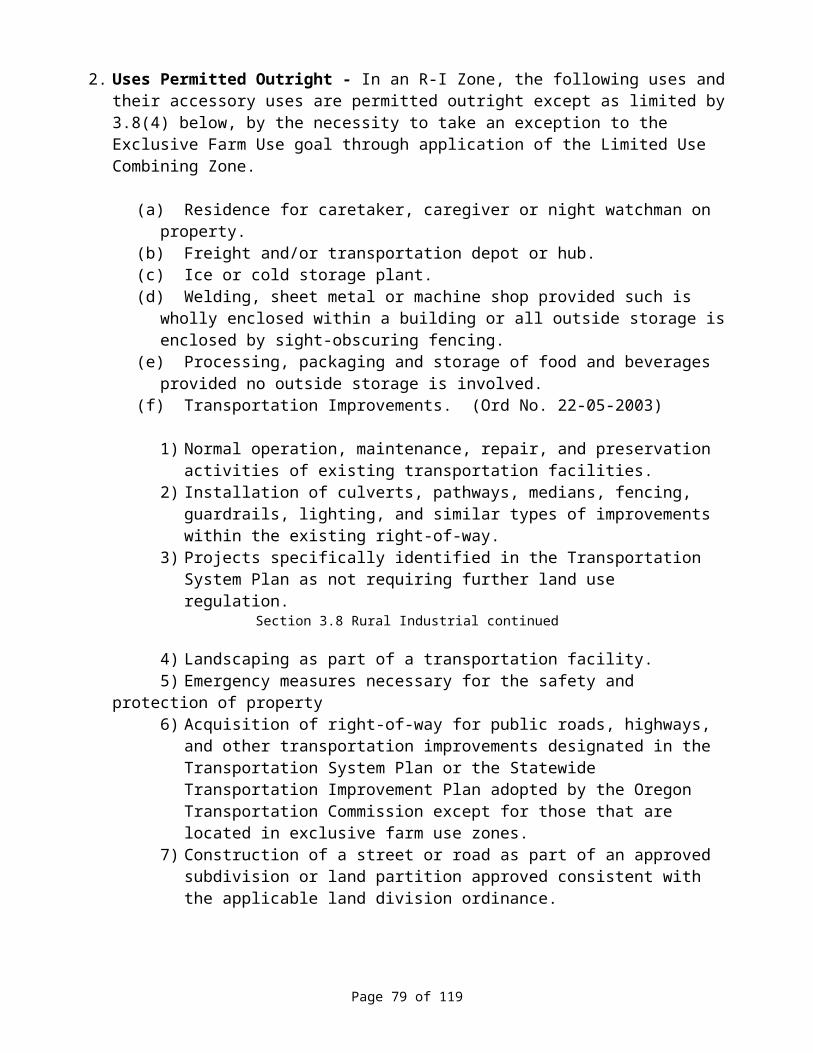
Section 5.8 Governing Standards continued
swimming pool and other small-scale recreational facilities such as tennis courts, miniature golf and playgrounds for the use of park customers only.
(t) One additional parking space for each four campsites shall be provided in clusters of 4-6 at convenient locations throughout the park.
12. Temporary Facilities - The County may exempt certain temporary facilities from the onsite improvement requirements, requirements for toilets, water supply, sewage disposal and spacing if such temporary facilities are for the purpose of accommodating a camping vehicle rally or other groups of camping vehicles assembled for the purpose of traveling together or for special events such as fairs, rodeos, races, derbies, community event celebrations, etc. and the reviewing authority finds that the public health will not be endangered. The period of operation shall be designated by the reviewing authority, as shall other conditions such as solid waste collection and disposal found necessary to protect the public health and general welfare. In no case shall such temporary facilities be approved in conjunction with private commercial activities, except as temporary RV locations for highway or building construction, farm or forestry projects, and in no case shall a temporary facility for such projects be approved if other alternatives for housing the employees associated with such projects is found to be available.
13. Camping Vehicle Building, Boat Building, Cabinet, Carpentry, or Other Contractor's Shops, Machine Shops, Vehicle Repair or Storage, or Similar Uses
(a) For such uses located within a C-1 Zone, adjacent to a residential area or visible from an public highway or road classified as a arterial or collector, materials, vehicles or parts shall be stored in an enclosed structure, or where impractical, behind fences or vegetative or other natural buffers.
(b) Odors, fumes, sawdust or other emissions shall be controlled so as not to affect adjacent properties.
(c) Noise and other pollution standards of the Department of Environmental Quality shall be adhered to.
14. Public Facilities and Services
(a) Public facilities including, but not limited to, utility substations, sewage treatment plants, storm water and water lines, water storage tanks, radio and television transmitters, electrical generation and transmission devices, fire stations and other public facilities shall be located so as to best serve the County or area with a minimum impact on neighborhoods, and with consideration for natural or aesthetic values.
(b) Structures shall be designed to be as unobtrusive as possible. Wherever feasible, all utility components shall be placed underground.
(c) Public facilities and services proposed within a wetland or riparian area shall provide findings that: Such a location is required and a public need exists; and Dredge, fill and adverse impacts are avoided or minimized.
15. Mineral or Aggregate Resource Extraction and/or Processing, and Surface Mining - When permitted as a Conditional Use, the application for and operation of such activities shall comply with the following standards, conditions and limitations:
Page 81 of 119
Section 5.8 Governing Standards continued
(a) Operations Requiring a Permit in an F-1 an area subject to a Combining Zone: In an F-1 Zone or an area subject to a Combining Zone, a permit is required for mining (as defined by Section 1.4 of this Ordinance) more than 1,000 cubic yards of material or excavation preparatory to mining of a surface area of more than one acre.
(b) Operations Requiring a Permit in Other Zones: In all zones except F-1 and Combining Zones, a permit is required for those activities regulated by DOGAMI pursuant to ORS 517.
(c) Operations in F-1 Zone Limited to Inventoried Sites: In an F-1 Zone, a permit for mining of aggregate shall be issued only for a site included on the County's acknowledged Plan aggregate site inventory.
(d) Blending Materials Prohibited Near Vineyards: No application shall be approved to allow batching and blending of mineral and aggregate into asphalt cement within 2 miles of a planted vineyard; such limitation shall not apply to such operations approved on or before October 3, 1989, or to the subsequent renewal of an existing approval.
(e) An application for a use or activities subject to review pursuant to this Subsection shall contain the following information and whatever additional information the applicant deems relevant or whatever additional information the reviewing authority deems necessary:
1) Name and address of the landowner and site operator.2) Legal description and map of the property to be mined and included as the property
base for the proposed use.3) Identification of existing or proposed roads providing access to the site that lead
from a public thoroughfare to the property, and a description of the existing conditions and proposed improvement/maintenance standards for such access.
4) A list of known materials for which the use and/or operation is to be conducted, and qualified evidence that specifications applicable to intended uses can be met by materials onsite.
5) If the use and/or operation is intended for a specific project, evidence that materials on-site will meet project specifications; identification of the specific project and the responsible agency or party; the estimated beginning and completion dates of said project; and the estimated materials/quantities required.
6) A site development and operation plan showing:
A. Areas to be mined or excavated.B. Areas for settling ponds and washing plants.C. Areas for processing and stockpiling.D. Location of building and other structures.
7) A site and vicinity map showing:
A. Location and names of all streams, roads, railroads and utility facilities within or adjacent to the site.
B. An area land use map showing adjoining and area land uses and structures by use type.
C. Identification of any other significant resources within or in the general area of the site.
Page 82 of 119

Section 5.8 Governing Standards continued
D. Topographical and vegetative conditions of the general area.
8) A general description of the modes of excavation, the types of equipment to be used, and the disposition of overburden.
9) A starting and ending date for the operation.10) An estimate of the total volume of material to be excavated and processed.11) A reclamation plan meeting the requirements of DOGAMI and providing the
following information:
A. Rehabilitation of stream channels and banks to prevent erosion, sedimentation, and other water polluting effects.
B. Sloping and other controls to stabilize final surfaces and minimize public hazards.
C. Proposed vegetating of disturbed areas in a manner conducive to restoring them to natural state or to a state consistent with the future use of the site.
D. Methods of preventing pools of water from becoming public nuisances or health hazards.
E. Proposals for the removing of structures and equipment that otherwise would be abandoned after termination of the operation.
12) Proposed methods of controlling contaminants and disposing of wastes and refuse.13) Provisions where applicable or feasible for visual screening by use of native plants
and trees, or other plants and trees with a demonstrated or known ability to thrive under natural conditions, and/or use of natural topographical features or man-made berms for such visual screening.
14) In the case where the applicant does not own the land on which the mining is to take place, the written consent of the owner for the operation to take place, and the owner's written acknowledgement of the owner's obligation to insure that the site is reclaimed after the mining ceases if the operator fails to do so, and the owner's written consent for the County to impose on the land, if necessary as security, a lien for expense the County may necessarily incur in reclaiming the land.
15) Any or all of the information required for applications for the same operation to DOGAMI that meets any of the foregoing requirements may be submitted in the same format as required for DOGAMI as a part of the application to the County; i.e. duplications of such information in a different format is not intended, necessary or required by these provisions.
(f) No processing shall be permitted within a Commercial C-l or Residential R-l Zone, nor on a site within 200 feet from a lot or parcel within said Zones.
(g) Equipment and access roads shall be constructed, maintained and operated in such a manner as to eliminate, as far as practicable, noise, vibration or dust which is injurious or substantially annoying to persons living in the vicinity, or to crops or livestock being raised in the vicinity; an access or service road, while being used for mining and/or processing operations shall be maintained dust-free for 300 feet from public thoroughfares and from residences, crops or livestock substantially impacted.
(h) Permanent asphalt, mineral/aggregate processing, concrete products manufacturing, and cement batch plants shall not be permitted in A-l or (SR) Zoned areas.
Page 83 of 119

Section 5.8 Governing Standards continued
(i) Screening of mining sites may be required to obscure the view or minimize dust and other annoyances from adjoining occupied properties and from public thoroughfares.
(j) All such operations shall be maintained in compliance with applicable noise, air and water pollution standards administered by DEQ.
(k) All vehicular and equipment parking, loading and maneuvering areas for such uses shall be maintained off public thoroughfares, and such areas shall be maintained for all employees, customers, visitors and associated operations.
(l) An entire perimeter fence may be required to control access to a mining site to minimize public safety hazards.
(m) Compliance with applicable standards and regulations administered by DOGAMI and other state and federal agencies shall be a continuing condition of permit holders under this Subsection.
(n) In addition to the bonds or other assurances that may be required by DOGAMI and other state or federal agencies for such operations, the County may require a bond; property lien or other security assurance to assure permits compliance and site reclamation.
16. Wireless Telecommunications Facilities
(a) Application Requirements. An application for a wireless telecommunications facility shall comply with the following meeting, notice and submittal requirements.
1) Pre-Application Conference. The applicant shall attend a scheduled pre-application conference prior to submission of a land use application. An application for a wireless telecommunications facility permit will not be deemed complete until the applicant has had a pre-application conference with the Planning Department staff.
2) Submittal Requirements. An application for a conditional use permit for a wireless telecommunications facility shall include:
A. A copy of the blank lease form. B. A copy of the applicant’s Federal Communications Commission license.C. A map that shows the applicant’s search ring for the proposed site and the
properties within the search ring, including locations of existing telecommunications towers or monopoles.
D. A site plan showing the location of the proposed facility and its components. The site plan shall also identify the location of existing and proposed landscaping, and any equipment shelter, utility connections, and any fencing proposed to enclose the facility.
E. A copy of the design specifications including proposed colors and elevation of an antenna array proposed with the facility.
F. An elevation drawing of the facility and a photographic simulation of the facility showing how it would fit into the landscape.
G. A copy of a letter of determination from the Federal Aviation Administration (FAA) or the Oregon Department of Aviation (ODA) whether or not aviation lighting would be required for the proposed facility.
Page 84 of 119
Section 5.8 Governing Standards continued
3) For the purpose of a Telecommunication facility for a governmental unit for public use, the Planning Director shall conduct a review that does constitute a land use decision pursuant to ORS 197.015(10). Notice and an opportunity of comment must be provided in the manner set forth in this ordinance. The Planning Director may refer any matter under this review to the Planning Commission.
(b) Approval Criteria: An application for a wireless telecommunication facility will be approved upon findings that:
1) The facility will not be located on irrigated land.2) The applicant has considered other sites in its search area that would have less visual
impact as viewed from nearby residences than the site proposed and has determined that any less intrusive sites are either unavailable or do not provide the communications coverage necessary. To meet this criterion, the applicant must demonstrate that it has made a good faith effort to co-locate its antenna on existing monopoles in the area to be served. The applicant can demonstrate this be submitting a statement from a qualified engineer that indicates whether the necessary service can or cannot be provided by co-location within the area to be served.
3) The facility is sited using trees, vegetation, and topography to the maximum extent practicable to screen the facility from view of nearby residents.
4) The applicant shall site the facility in a manner to minimize its impact on scenic views and shall site the facility using trees, vegetation and topography in order to screen it to the maximum extent practicable from view from protected roadways. Towers or monopoles shall not be sited in locations where there is no vegetative, structural or topographic screening available approved by the Planning Commission.
5) A tower or monopole is finished with natural wood colors or other colors approved by the Planning Commission.
6) A required aviation lighting is shielded to the maximum extent allowed by FAA and/or ODA.
7) The form of lease for the site does not prevent the possibility of co-location of additional wireless telecommunication facilities at the site.
8) Any tower or monopole shall be designed in a manner that it can carry the antennas of at least one additional wireless carrier. This criterion may be satisfied by submitting that statement of a licensed structural engineer licensed in Oregon that the monopole or tower has been designed with sufficient strength to carry such an additional antenna array and by elevation drawings of the proposed tower or monopole that identifies an area designed to provide the required spacing between antenna arrays of different carriers.
9) An approval of a wireless telecommunication facility shall include a condition that if the facility is left unused or is abandoned by all wireless providers located on the facility for more than one year the facility shall be removed by the landowner, or as set forth in the lease between the landowner and the applicant.
17. Commercial Slaughtering Facility - Commercial Slaughtering Facilities or slaughterhouses may only be approved upon a finding that each such use is licensed pursuant to and is maintained in compliance with the provisions of ORS 603.
Page 85 of 119

Section 5.8 Governing Standards continued
18. Airports. Aircraft Landing Fields - Heliports, Aircraft Rental, Service and Maintenance Facilities: The County reviewing authority may approve such uses upon a findings that the location and site design of the proposed use will not be hazardous to the safety and general welfare of surrounding properties and uses, that the location will not unnecessarily restrict existing and future uses or developments of surrounding lands as designated by the County's Plan and implementing Zoning, and, that such use is approved by the state Aeronautics Division and FAA.
19. Livestock Feeding or Sales Yard - In considering an application for such a use, the reviewing authority shall require:
(a) That the facility not be located closer than one-quarter mile to a resident structure not owned by the applicant, to a non-farm zone boundary, or to the incorporated limits of a City;
(b) That adequate provisions are provided for drainage and pest control; and(c) In addition to any other requirements of the applicable Zone, an applicable combining
zone or this Ordinance in general, the reviewing authority may consider and impose requirements deemed necessary to protect the health, safety and welfare of the surrounding area and the County as a whole including, but not limited to, location of the use with respect to prevailing wind patterns, conditions related to other existing or potential environmental impacts on surrounding and area land uses and limitation on the number of animals to be kept at the use at any specific time.
20. Non-farm Uses in an F-1 Zone - Non-farm uses, excluding farm related, farm accessory uses, or uses conducted in conjunction with a farm use as a secondary use thereof, may be approved upon a finding that each such use:
1. Is compatible with farm uses described in ORD 215.203(2);2. Does not interfere seriously with accepted farming practices on adjacent lands devoted to
farm use;3. Does not materially alter the overall land use pattern of the area;4. Is situated upon generally unsuitable land for the production of farm crops and livestock,
considering the terrain, adverse soil or land conditions, drainage and flooding, vegetation, location and size of the tract, and the availability of necessary support resources for agriculture;
5. Complies with other applicable significant resource provisions; and6. Complies with such other conditions as deemed necessary.
SECTION 5.9 TIME LIMIT ON A CONDITIONAL USE PERMIT AND/OR DESIGN REVIEW PLAN
1. Final Approval Expiration. Unless otherwise approved in the initial approval by the reviewing authority, the authorization and approval of a Conditional Use Permit and/or a Design Review Plan shall be null and void after one year or such other time as may be specified from the date of final approval unless a building permit has been obtained and construction and/or site improvements have commenced, or other evidence of substantial development, compliance
Page 86 of 119
Section 5.9 Time Limit continued
and/or investment is clearly evident. No extensions to such time periods shall be approved unless the applicant posts a performance assurance as provided for by this Ordinance for all affected plan/development elements as approved by the County Court.
2. Issuance of a Conditional Use Permit and/or approval of Design Review Plan shall confer no right to the applicant beyond the time period for which it was issued or approved.
3. If the conditions applicable to a Conditional Use Permit and/or a Design Review Plan are not fulfilled within a reasonable time, and specifically within time limits set forth in the approval or by Subsection (1) of this Section in lieu thereof, the Planning Commission may revoke said Permit and/or Plan approval after giving notice to the applicant, affected property owners, and other "affected" persons or parties, and upon holding a public hearing to make a determination of non-compliance.
4. If a permit approval is revoked for such noncompliance, or if the permit is declared null and void as set forth in Subsection (I) of this Section, renewal of such permit may only be achieved by submittal of a new application, payment of the applicable filing fee, and processing of such application as an original application pursuant to the pro1lisions of this Article. Such application shall be subject to any and all regulations in effect on the date of receipt of new application.
Page 87 of 119

ARTICLE 6. EXCEPTIONS AND NONCONFORMING USES
SECTION 6.1 CONTINUATION OF NONCONFORMING USESSubject to the provisions of ORS 215.130 and the provisions of this article, a nonconforming use may be continued and alterations made to conform with other laws. Such alterations shall be the minimum necessary to comply with the regulations or law.
SECTION 6.2 DISCONTINUANCE OF NONCONFORMING USE If a nonconforming use is discontinued for a period of one year, further use of the property shall conform to this ordinance.
SECTION 6.3 CHANGE OF NONCONFORMING USE If a nonconforming use is replaced by another use, the new use shall conform to this ordinance.
SECTION 6.4 DESTRUCTION OF NONCONFORMING USEIf a nonconforming use or structure containing a nonconforming use is destroyed by any cause to an extent exceeding 80 percent of its fair market value as indicated by the records of the County Assessor, and is not returned to use within one year from the date of destruction, a future use on the site shall conform to this ordinance.
SECTION 6.5 COMPLETION OF STRUCTURE Nothing contained in this ordinance shall require any change in the plans, construction, alteration or designated use of a structure on which substantial construction work has commenced prior to the adoption of this ordinance, provided the building, if nonconforming or intended for a nonconforming use, is completed and in use within 2 years from the time this ordinance is adopted.
SECTION 6.6 GENERAL EXCEPTIONS TO LOT SIZE REQUIREMENTSThe following minimum lot size exceptions shall apply:
1. A duly platted lot contiguous to other lands under the control and ownership of the same owner shall be aggregated with such other lands as necessary to meet the standards of this Ordinance and more specifically the applicable Zone.
2. Any parcel of land or portion thereof which is to be dedicated to a public, semi-public, or public utility for a park, school, road, canal, railroad, utility or other public use shall be exempt from the minimum lot size requirements of this Ordinance and the applicable Zone.
3. Whereas land sections in the County are affected by survey adjustments creating sections of less than 640 acres, minimum requirements relative to lot sizes where applicable shall be considered as standard metes and bounds land section divisions; i.e. 160, 80, 40, 20, etc. Lot size may be reasonably smaller than required if a total section acreage reduction is due to a survey adjustment or other man-made barrier or acreage adjustment, such as public roads, over which the applicant has had no control.
Page 88 of 119

SECTION 6.7 GENERAL EXCEPTIONS TO YARD REQUIREMENTS The following exceptions to the front yard requirements are authorized for a lot in any zone:
1. If there is a building on one abutting lot with a front yard of less depth than the required depth for the zone, the front yard for the lot need not exceed a depth one-half way between the depth of the abutting lot and the required front yard depth;
2. If there are buildings on both abutting lots with front yards of depths less than the required depth for the zone, the depth of the front yard for the intervening lot need not exceed the average depth of the front yards of the abutting lots; and
3. In determining the depth of a front yard, the required depth shall be measured from a line parallel to and 30 feet distant from the centerline of the road on all roads with less than 60 feet of right-of-way.
SECTION 6.8 GENERAL EXCEPTIONS TO BUILDING: HEIGHT LIMITATIONSExcept in an A-1 Combining Zone area, the following types of structures or structural parts are not subject to the building height limitations of this Ordinance: Chimneys, cupolas, tanks, church spires, belfries, domes, derricks, monuments; fire and hose towers, observation towers, transmission towers, smokestacks, flagpoles, radio and television towers, masts, aerials, cooling towers, water towers, elevator shafts, windmills, conveyors, grain elevators and other similar projections.
SECTION 6.9 EXCEPTION FOR MINOR REPAIR AND REHABILITATIONExcept for nonconforming uses and historic structures, activities involving rehabilitation, replacement, minor betterment, repairs and maintenance, improvements and other similar construction activities involving a lawful use permitted within a specific Zone are exempt from the permit requirements of this Ordinance unless specifically regulated and provided such activities do not change the use or expand the capacity or use level.
SECTION 6.10 EXCEPTION FOR PUBLIC STREET AND HIGHWAY IMPROVEMENTSExcepting for those activities specifically regulated by this Ordinance or by a specific Zone, the following public street and highway improvement activities are exempt from the permit requirements of this Ordinance.
1. Installation of additional and/or passing lanes, including pedestrian and/or bike ways, within a street or highway right-of-way existing as of July 1987, unless such adversely impacts on-street parking capacities and patterns.
2. Reconstruction or modification of public roads and highways, not including the addition of travel lanes, where no removal or displacement of buildings would occur, or no new land parcels result.
3. Temporary public road and highway detours that will be abandoned and restored to original condition or use at such time as no longer needed.
4. Minor betterment of existing public roads and highway related facilities such as maintenance yards, weight stations and rest areas, within right-of-way existing as of July 1, 1987 and contiguous public-owned property utilized to support the operation and maintenance of public
Page 89 of 119

Section 6.10 Exception for Public Street continued
roads and highways provided such is not located within a duly designated Residential Zone, or adjacent or across the street from a lot or parcel within such a Zone.
SECTION 6.11 EXCEPTION FOR PUBLIC FACILITIES IMPROVEMENT OR RECONSTRUCTIONMinor betterment, improvements, replacement or reconstruction of existing public facilities such as sewer and water lines, stormwater drainage facilities, sidewalks, and similar public facilities within rights-of-ways and easements for said purposes existing on or before the effective date of this Ordinance, or on contiguous publicly-owned property designated, intended or utilized to support such facilities is exempt from the permit requirements of this Ordinance unless specifically set forth otherwise.
Page 90 of 119
ARTICLE 7. VARIANCES
SECTION 7.1 AUTHORIZATION TO GRANT OR DENY VARIANCESThe Planning Commission may authorize variances from the requirements of this ordinance where it can be shown that, owing to special and unusual circumstances related to a specific piece of property, strict application of the ordinance would cause an undue or unnecessary hardship, except that no variance shall be granted to allow the use of property not authorized within the zone in which the proposed use would be located. In granting a variance, the Planning Commission may attach conditions, which it finds necessary to protect the best interests of the surrounding property or neighborhood and otherwise achieve the purposes of this ordinance.
SECTION 7.2 CIRCUMSTANCES OF GRANTING VARIANCEA variance may be granted only in the event that the applicant can prove all of the following circumstances:
1. Exceptional or extraordinary circumstances apply to the property, which do not apply generally to other properties in the same zone or vicinity, and result from lot size or shape legally existing prior to the date of this ordinance, topography or other circumstances over which the applicant has no control.
2. The variance is necessary for the preservation of property rights of the applicant substantially the same as owners of other property in the same zone or vicinity possesses.
3. The variance would not be materially detrimental to the purposes of this ordinance, or to property in the zone or vicinity in which the property is located or otherwise conflict with objectives of any County plan or policy.
4. The variance requested is the minimum variance, which would alleviate the hardship.
SECTION 7.3 APPLICATION FOR A VARIANCEA property owner may initiate a request for a variance by filing an application with the Planning Official of the Planning Commission, using forms prescribed pursuant to this ordinance.
SECTION 7.4 PUBLIC HEARING OF A VARIANCEBefore the Planning Commission may act on a request for a variance, it shall hold a public hearing.
SECTION 7.5 NOTIFICATION OF DECISIONWithin 10 days after a decision has been rendered, the Planning Official shall provide the applicant and parties with the notice of the decision.
Page 91 of 119

ARTICLE 8. AMENDMENTS
SECTION 8.1 AUTHORIZATION TO INITIATE AMENDMENTSAn amendment to the text of this Ordinance or to a Zoning Map may be initiated by the County Count, by the County Planning Commission, or by all application of a property owner or the authorized agent of the owner.
SECTION 8.2 APPLICATION FOR A TEXT AMENDMENT OR ZONE CHANGEAn application for an amendment to the text of this Ordinance or for a Zone Change initiated y anyone other than the County, shall be filed with the County Planning Official on forms prescribed by the County and shall be accompanied by the required filing fee as established by the County Court. The applicant shall provide reasons for the requested change, and shall present facts showing that the amendment will substantially be in compliance with the goals, objectives and policies of the County Comprehensive Plan and applicable statewide planning goals and implementing administrative rules.
SECTION 8.3 PUBLIC HEARINGS ON AMENDMENTSThe County Planning Commission shall, at its earliest practical meeting date, duly advertise and conduct a public hearing on the application, and shall, within 30 working days of the conclusion of such hearing, recommend to the County Court approval, disapproval or modified approval of the proposed amendment. Within 45 days of receipt of the Commission's recommendations, the County Court shall duly advertise and conduct a public hearing on the proposed amendment. The County Court shall approve, approve with modifications, or disapprove the proposed amendment. The Commission or County Court may recess or continue a hearing in order to obtain additional information and input on the proposed amendment.
SECTION 8.4 PUBLIC NOTICE REQUIREMENTSThe following public notice requirements shall apply to applications for an amendment to the text of this Ordinance or to an application for a zoning amendment provided for by this Article:
1. Each notice of a public hearing regarding an amendment to this Ordinance shall be published once a week for the two successive weeks with the first notice appearing 21 days prior to the date of the hearing in a newspaper of general circulation in the County.
2. In addition to the notice requirements set forth by Subsection (1) above, for an amendment that proposes to rezone specific identifiable properties, or such rezoning is for a single lot or parcel, individual notice shall be mailed or otherwise delivered to the owner of each lot or parcel of property that is proposed to be rezoned and to all affected property owners as set forth in Section 9.5 of this Ordinance.
3. Notice of an application for a zone change shall be provided to the owner of a public use airport if the property subject to the zone change is: (a) Within 5,000 feet of the side or end of a runway of a Visual Airport; or (b) Within 10,000 feet of the side or end of the runway of a Instrument Airport; and, (c) If the zone change would allow a structure greater than 35 feet in height on property located inside the runway Approach Surface.
4. Notice of an application for a zone change of property which includes all or part of a manufactured home park shall be given by first class mail to each existing mailing address for
Page 92 of 119

Section 8.4 Public Notice Requirements continued
tenants of the manufactured home park at least 20 days but not more than 40 days before the date of the first hearing.
5. Notice of an application for a proposed zoning amendment, together with a copy or description of the proposed amendment shall be provided to the state Land Conservation and Development Commission (LCDC) at least 45 days prior to date of the final hearing. (ORS 197)
SECTION 8.5 APPROVAL CRITERIA FOR AMENDMENTS (Ord No. 22-05-2003)
1. The applicant must show that the proposed change conforms with the Comprehensive Plan.
2. A zoning map or zoning text amendment significantly affects a transportation facility if it:
(a) Changes the functional classification of an existing or planned transportation facility;(b) Changes standards implementing a functional classification system;(c) Allows types or intensities of land use that would result in either the type or quantity or
traffic, or access that would be inconsistent with the functional classification of a transportation facility as established in the adopted Transportation System Plan; or
(d) Would reduce the level of service of the facility below the minimum acceptable level for that facility established in the adopted Transportation System Plan.
3. Amendments to the zoning map and text, which significantly affects a transportation facility, shall include mitigation measures that result in allowed land uses being consistent with the function, capacity, and level of service of the facility identified in the Transportation System Plan. This shall be accomplished by one of the following:
(a) Limiting allowed land uses to be consistent with the planned function of the transportation facility;
(b) Amending the Transportation System Plan to ensure that existing, improved, or new transportation facilities are adequate to support the proposed land uses consistent with the requirement of the Transportation Planning Rule; or,
(c) Altering land use designations, densities, or design requirements to reduce demand for automobile travel and meet travel needs through other modes.
SECTION 8.6 RECORDS OF AMENDMENTSThe duly approved and signed original and a copy of an amendment to the text or zoning map(s) of this Ordinance shall be maintained on file in the office of the County Clerk. Copies of such amendments shall be available for public review and information.
SECTION 8.7 LIMITATIONS ON REAPPLICATIONNo reapplication for an amendment to the text of this Ordinance or to a Zoning Map by a property owner shall be considered by the Planning Commission or County Court within a 6 month period immediately following a previous denial of such application. However, if in the opinion of the Planning Commission, new evidence or a change in circumstances warrants such reapplication in a lesser time, the Commission may permit a new application.
Page 93 of 119
SECTION 8.8 ADOPTION OF AN AMENDMENTAn Amendment to the text of this Ordinance or a Zoning Map shall be approved by Ordinance only.
Page 94 of 119

ARTICLE 9. ADMINISTRATIVE PROVISIONS
SECTION 9.1 ADMINISTRATION AND ENFORCEMENT
1. The County Planning Official shall have the powers and the duties to enforce the provisions of this Ordinance. In addition, the Planning Commission and/or County Court may initiate action to enforce any provision of this Ordinance, including any violation of any restriction or condition established under the provisions of this Ordinance.
2. Failure to comply with any order or decision as above provided will subject the violator to any legal remedy provided under law, including but not limited to the following:
(a) A complaint filed with the Justice or Circuit Court, or other court of competent jurisdiction whereupon-conviction the court may fine the violator up to the maximum allowed by law, or imprison the violator in jail for up to the maximum time allowed by law, or both. Each day a violation occurs may be considered a separate offense.
(b) The County Planning Official and/or a certified Building Official may order the stoppage of work of any type, which is in violation of any of the provisions of this Ordinance or a granted permit. A copy of such stop Work Order shall be posted at the site of construction or use and a copy shall be served upon the property owner and/or the permitee. Upon such posting of said order, all work shall cease forthwith, and the property owner, permitee or permitee's agents or employees who thereafter continue to work shall be in violation of this Document. The stop Work Order shall not be removed until satisfactory evidence that said violation has or will be corrected has been provided.
SECTION 9.2 DECISIONSAll decisions made pursuant to the provisions of this Ordinance for the approval or denial of an application authorized or required for a use permitted by this Ordinance shall be based upon and accompanied by a statement that explains the criteria and standards relied upon and considered relevant to the decision, that states the facts relied upon I rendering the decision, and explains the justification for the decision based on the criteria, standards, facts and conclusions set forth. Written notice of the decision shall be given to all parties to the proceedings within 10 -working days, or as otherwise required by a specific provision in this Ordinance.
SECTION 9.3 PROCESSING TIME LIMITSExcept as otherwise provided for in ORS 215.428, the County shall take final action on an application for a permit or zoning amendment, including resolution of appeals, within 120 days after the application is deemed complete. The 120-day period may be extended for a reasonable period of time at the request of the applicant.
SECTION 9.4 APPEALSA person may appeal a decision or requirement made by the County Planning Commission to the County Court, or a person may appeal a decision or requirement made pursuant to this Ordinance by the County Planning Official or other County Official to the County Planning Commission. The appellate authority, on its own motion, may review the action of a lower reviewing authority. A person or party aggrieved by a decision made pursuant to this Ordinance may appeal such decision if the person or party:
Page 95 of 119
Section 9.4 Appeals continued
1. Files a notice of intent appeal as provided in Sub-section (4) of this Section.
2. Appeared or participated in the proceedings leading to the decision, either orally or in writing.
3. Meets one or more of the following criteria:
(a) Was entitled to right of notice and hearing prior to the decision to be reviewed; or(b) Was a person who would have had a right to notice if a hearing had been scheduled; or(c) Is aggrieved, or has interests adversely affected by the decision.
4. Written notice of an appeal must be filed with the County Clerk and/or Planning Official on forms prescribed by the County within 15 days after the decision was mailed to parties to the proceedings.
5. The notice of appeal required by Subsection (4) of this Section shall state the nature of the decision or requirement being appealed, have attached a copy of the decision or requirement being appealed, state the grounds for appeal, and shall specifically state the following:
(a) The facts that establish that the petitioner has standing; and(b) The date of the decision or requirement; and(c) The specific issues the petitioner seeks to have reviewed stated in sufficient specificity
to afford the decision makers an opportunity to respond to the issue; Note: As provided for in subsection (1) of section 9.5 of this Ordinance, failure of the appellants to have raised a specific issue, in person or in writing, at the final level of review by the decision making County review authority, or during the 7-day comment period of any continued final evidentiary hearing before said review authority, or failure to have provided sufficient specificity on such issue as to afford the decision makers an opportunity to respond to the issue, precludes an appeal based n that issue.
6. The appeal shall not be deemed complete until the required filing fee as established by the County Court has been submitted with the notice to appeal.
7. The County Court or Planning Commission shall hold a public hearing on the appeal within 45 days from the date the appeal is filed and deemed complete by the receiving County official. A hearing on an appeal may be recessed or continued for good cause.
8. The County Court or Planning Commission may review a lower decision or requirement upon its own motion as provided for in this Section after giving not less than 10 days advance notice to the parties involved in the decision or requirement, and if such review is initiated within the 15 day appeal period required by Subsection (4) of this Section.
9. An appeal or review proceedings shall be based upon but not limited to the record of the decision being appealed or reviewed.
Page 96 of 119
10. All appeal or review proceedings shall require a public hearing by the reviewing authority. Notice of such hearing shall be published at least one time not less than 21 days prior to such hearing in a newspaper of general circulation in the County. In addition, individual notice shall
Section 9.4 Appeals continued
be mailed or otherwise delivered to all parties affected, by the decision or requirement being reviewed; such notice shall be mailed or otherwise delivered no less than 20 days prior to the date of the hearing.
11. Following the hearing, the reviewing authority may up-hold, overrule, modify, or remand any decision or requirement subject to appeal in accordance with the provisions of this Section, and shall set forth findings and conclusions for such decision.
12. A hearing on an appeal may be continued by the reviewing authority, but only o le such continuance is allowed except as may be necessary to accommodate scheduling and other needs of the hearing body, and he continued hearing shall not be held sooner than 20 days from the date on which the continuance was granted or set forth.
13. During the first 7 days of the continuance period, participants may sub it new issues related to the subject matter, or may rebut evidence presented in the hearing prior to the continuance, A 1 such submissions shall be in writing.
SECTION 9.5 PUBLIC HEARINGS AND NOTICEThe following procedures shall govern the conduct of quasi-judicial land use hearings conducted before a local governing body, planning commission, hearings body or hearings officer on application for a land use decision and shall be incorporated into the comprehensive plan and land use regulations:
1. An issue, which may be the basis for an appeal to the board, shall be raised not later than the close of the record at or following the final evidentiary hearing on the proposal before the local government. Such issues shall be raised with sufficient specificity so as to afford the governing body, planning commission, hearing body or hearings officer, and the parties an adequate opportunity to respond to each issue.
2. Public Notice Requirement.
(a) Notice of the hearings governed by this section shall be provided to the applicant and to owners of record of property on the most recent property tax assessment roll where such property is located:
1) Within 100 feet of the property which is the subject of the notice where the subject property is wholly or in part within an urban growth boundary;
2) Within 250 feet of the property which is the subject of the notice where the subject property is outside an urban growth boundary and not within a farm or forest zone; or
3) Within 500 feet of the property which is the subject of the notice where the subject property is within a farm or forest zone.
Page 97 of 119
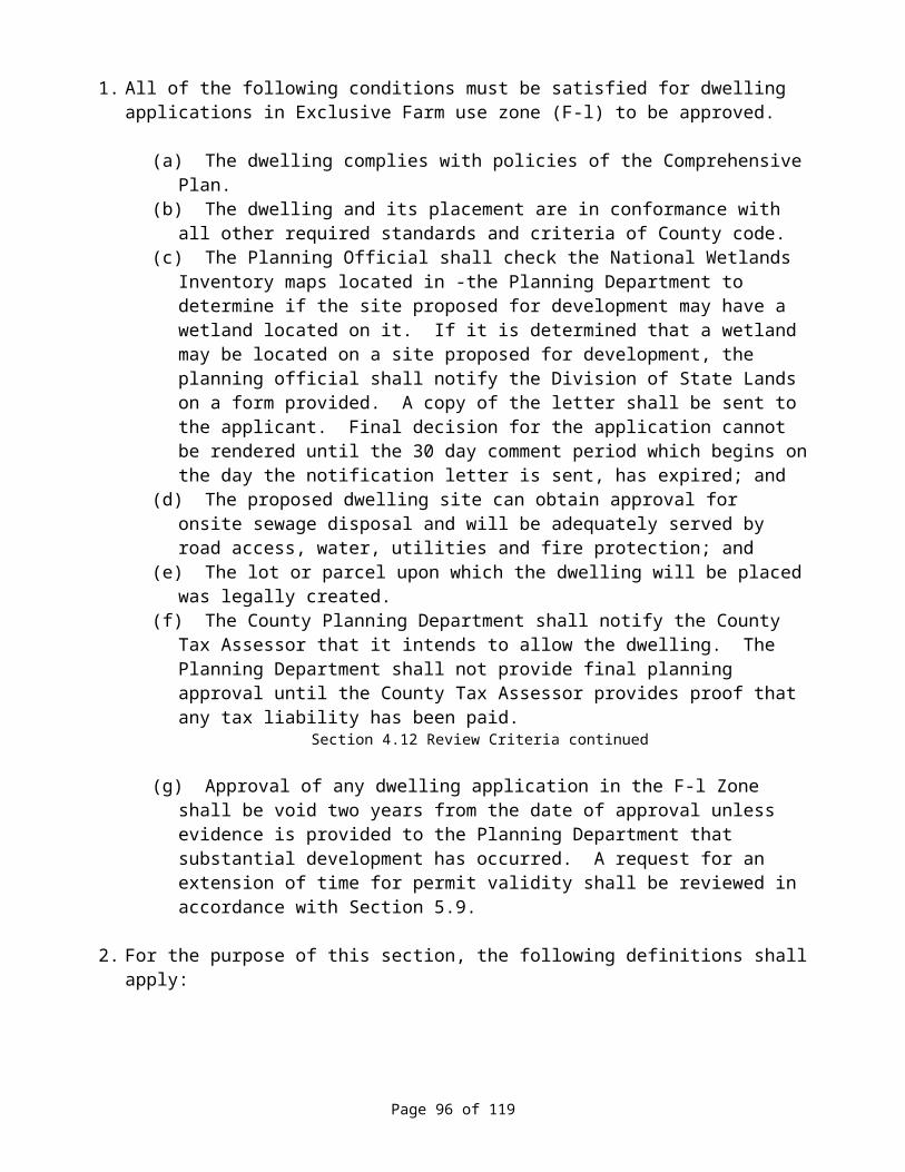
(b) Notice shall also be provided to any neighborhood or community organization recognized by the governing body and whose boundaries include the site.
Section 9.5 Public Hearings and Notice continued
3. The notice provided by the jurisdiction shall:
(a) Explain the nature of the application and the proposed use or uses which could be authorized;
(b) List the applicable criteria from the ordinance and the plan that apply to the application at issue;
(c) Set forth the street address or other easily understood geographical reference to the subject property;
(d) State the date, time and location of the hearing;(e) State that failure of an issue to be raised in a hearing, in person or by letter, or failure to
provide sufficient specificity to afford the decision maker an opportunity to respond to the issue precludes appeal to the board based on that issue;
(f) Be mailed at least 20 days before the evidentiary hearing;(g) Include the name of a local government representative to contact and the telephone
number where additional information may be obtained;(h) State that a copy of the application, all documents and evidence relied upon by the
applicant and applicable criteria are available for inspection at no cost and will be provided at reasonable cost;
(i) State that a copy of the staff report will be available for inspection at no cost at least 7 days prior to the hearing and will be provided at reasonable cost; and
(j) Include a general explanation of the requirements for submission of testimony and the procedure for conduct of hearings.
4. Submission of Documents.
(a) All documents or evidence relied upon by the applicant shall be submitted to the local government and be made available to the public at the time notice provided in subsection (c) of this section is provided.
(b) Any staff report used at the hearing shall be available at least 7 days prior to the hearing. If additional documents or evidence is provided in support of the application, any party shall be entitled to a continuance of the hearing. Such a continuance shall not be subject to the limitations of Section 9.3 of this Ordinance.
5. At the commencement of a hearing under a comprehensive plan or land use regulation, a statement shall be made to those in attendance that:
(a) Lists the applicable substantive criteria;(b) States that testimony and evidence must be directed toward the criteria described in
paragraph (5.a) of this subsection or other criteria in the plan or land use regulation which the person believes to apply to the decision; and
(c) States that failure to raise an issue with sufficient specificity to afford the decision-maker and the parties an opportunity to respond to the issue precludes appeal to the board based on that issue.
Page 98 of 119
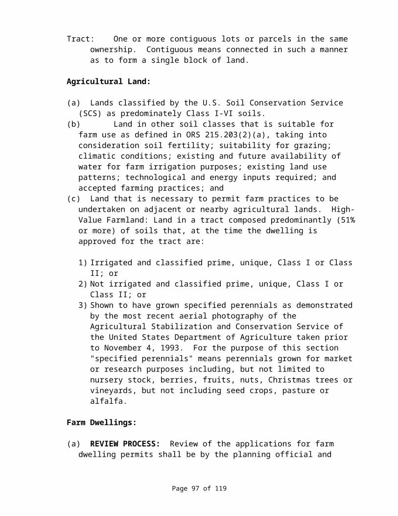
6. Unless there is a continuance, if a participant so requests before the conclusion of the initial evidentiary hearing, the record shall remain open for at least 7 days after the hearing. Such an extension shall not be subject to the limitations of ORS 215.428 or 227.178.
Section 9.5 Public Hearings and Notice continued
7. When a local governing body, planning commission, hearings body or hearings officer reopens a record to admit new evidence or testimony, any person may raise new issues which relate to the new evidence, testimony or criteria for decision-making which apply to the matter at issue.
8. The failure of the property owner to receive notice as provided in this section shall not invalidate such proceedings if the local government can demonstrate by affidavit that such notice was given. The notice provisions of this section shall not restrict the giving of notice by other means, including posting, newspaper publication, radio and television.
SECTION 9.6 FORM OF PETITIONS, APPLICATIONS AND APPEALSPetitions, applications and appeals provided for in this Ordinance shall be made on forms provided for such purpose or as otherwise prescribed by the County. Where accompanying plans and specifications must be submitted, such plans shall be legibly drawn to scale showing the actual shape and dimensions of the subject lot, parcel or site and its relationship to adjacent and surrounding properties, the sizes and locations of all existing and proposed structures, public or private facilities, and such other information as is needed to sufficiently determine conformance with this Ordinance.
SECTION 9.7 REVOCATIONThe County Planning Official or Planning Commission may revoke any permit granted under the provisions of this Ordinance on anyone or more of the following grounds:
1. A permit may be revoked on the basis of fraud, concealment, or misrepresentation, by the applicant, to the approving authority during the application process.
2. A permit may be revoked on the basis that the use for which such permit was issued is not exercised within the time limits set forth by this Ordinance or by the approving authority.
3. A permit shall be revoked on the basis that the use for which a permit was granted has ceased to exist or has been suspended for one year or more unless otherwise provided for in this Ordinance or in the approval of such use.
4. A permit may be revoked on the basis that the permit granted is being, or recently has been, exercised contrary to the terms or conditions of such approval, or in violation of any state or local statute, code, resolution, law or regulation.
5. A permit may be revoked on the basis that the use for which the approval was granted is so exercised as to be detrimental to the public health, safety or general welfare, or in such a manner as to constitute a nuisance.
6. Any permit granted pursuant to this Ordinance shall become null and void if not exercised within the time period specified in such permit or as specified by this Ordinance; If no time
Page 99 of 119
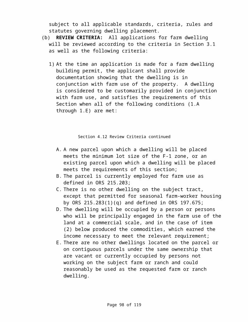
period is specified in the permit or by this Ordinance, such time period shall be construed to not exceed one year from the date of approval of said permit.
7. Any permitee may appeal the Planning Official's decision as provided for in Section 9.4 of this Ordinance.
SECTION 9.8 MODIFICATIONThe County Planning Commission or County Court may modify any permit granted under the provisions of this Ordinance on anyone or more of the following grounds:
1. A permit may be modified on the basis that the permit granted is being, or recently has been, exercised contrary to the terms or conditions of such approval, or in violation of any state or local statute, code, resolution, law or regulation.
2. A permit may be modified on the basis that the use for which the approval was granted is so exercised as to be detrimental to the public health, safety or general welfare or in such a manner as to constitute a nuisance.
3. A permit may be modified after receiving an application to modify an existing permit by a permitee.
4. The County Planning Commission or County Court shall hold a public hearing on any proposed modification after giving written notice to the permitee and other affected persons. The reviewing authority shall render its decision within 10 days after the conclusion of the hearing. Appeals of the decision shall be as provided for in Section 9.4 of this Ordinance or as otherwise provided by law.
SECTION 9.9 SEVERABILITYThe provisions of this Ordinance are hereby declared to be severable. If any section, sentence, clause, or phrase of this Ordinance is adjudged by a court of competent jurisdiction to be invalid, such decision shall not affect the validity of the remaining portions of this Ordinance.
SECTION 9.10 REMEDIESIn case a building or other structure is, or is proposed to be, located, constructed, maintained, repaired, altered, or used, or any land is or is proposed to be used in violation of this Ordinance, the County Court or a person whose interest in real property in the County is or may be affected by the violation, may, in addition to other remedies provided for by law, institute injunction, mandamus, abatement, or other appropriate proceedings to, temporarily or permanently, prevent, enjoin, abate, or remove the unlawful location, construction, maintenance, repair, alteration, or use.
SECTION 9.11 VIOLATIONS DECLARED NUISANCESThe location, erection, construction, maintenance, repair, alteration or use o a building or structure, or the use of land in violation of this Ordinance is hereby declared a nuisance and may be abated accordingly.
SECTION 9.12 PENALTIESAny person, firm or corporation who violates or refuses to comply with any provision of: this Ordinance is punishable upon conviction by a fine up to the maximum amount allowable by state law, or by imprisonment up to the maximum period allowed by state law, or both such fine and
Page 100 of 119
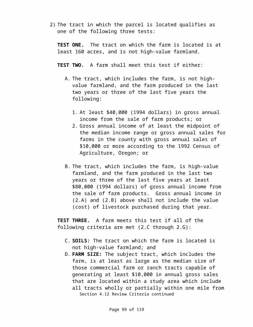
imprisonment for each provision violated. It shall be the responsibility of the offender to abate the violation, and each day that such violation is permitted to exist shall constitute a separate offense.
Page 101 of 119
ARTICLE 10. SUBDIVISIONS AND PARTITIONS
SECTION 10.1 PURPOSEIt is the purpose of this Article, in accordance with the provisions of ORS Chapters 92 and 215, to provide for minimum standards governing the approval of land divisions within the County, including subdivision and land partitionings, as necessary to carry out the County's needs and policies for adequate traffic movement, water supply, sewage disposal, drainage, and other facilities and services, to improve land records and boundary monumentation, and to ensure equitable processing of subdivision, partitioning and other land division activities.
SECTION 10.2 APPLICABILITYNo person may subdivide, partition or otherwise divide land, or create a planned unit or cluster development, or create a street for the purpose of developing land except in accordance with the provisions of this Article, this Ordinance and ORS Chapters 92 and 215. (ORS 92.012)
SECTION 10.3 LAND PARTITIONINGS
1. APPLICABILITY OF REGULATIONS - As defined in this Section and this Ordinance, all Land Partitioning within the County except as set forth in Subsection (2) of this Section must be approved by the County as provided for in this Section and this Article.
2. EXEMPTIONS - The following land divisions shall be exempt from the land partitioning requirements set forth by this Section and this Ordinance:
(a) A division of land resulting from a lie foreclosure, foreclosure of a recorded contract for the sale of real property or the creation of cemetery lots;
(b) An adjustment of a property line by the relocation of a common boundary where an additional unit of land is not created and where the existing unit of land reduced in size by the adjustment complies with any applicable zoning ordinance; or
(c) A sale or grant by a person to a public agency or public body for state highway, county road, city street or other right-of-way purposes provided that such road or right-of-way complies with Sections 3.1(2)(f) to (i) and Section 3.1(3)(u) to (w) of this Ordinance. However, any property divided by the sale or grant of property for state highway, county road, city street or other right-of-way purposes shall continue to be considered a single unit of land until such time as the property is further subdivided or partitioned.
3. FILING PROCEDURES AND REQUIREMENTS - Any person proposing a Land Partitioning, or the authorized agent or representative thereof, shall prepare and submit 10 copies of the Tentative Plan for the proposed partitioning, together with the prescribed application form and required filing fee, to the County Planning Official.
(a) The Tentative Plan of a proposed partitioning shall be drawn on a sheet 18 x 24 inches in size or multiples thereof at a scale of one inch equals 50 feet or multiples thereof.
(b) The Plan shall include the following:
1) A vicinity map locating the proposed partitioning in relation to adjacent subdivisions, roadways, properties, and land use patterns.
Page 102 of 119
Section 10.3 Land Partitionings continued
2) A plan of the proposed partitioning showing tract boundaries and dimensions, the area of each tract or parcel, and the names, right-of-way widths and improvement standards of existing roads.
3) Names and addresses of the landowner, the partitioner, the mortgagee if applicable, and the land surveyor employed (or to be employed) to make necessary surveys and prepare the final partitioning map.
4) A statement regarding provisions for water supply, sewage disposal, solid waste disposal, fire protection, access, utilities, etc.
5) North point, scale and date of map, and the property identification by tax lot, map number, section, township and range, subdivision lot and block or other legal description.
6) Statement regarding past, present and proposed use of the parcel(s) to be created, or the use for which the parcel(s) is intended or to be offered.
4. PROCESSING PROCEDURED – Except as provided for in paragraph (a) of this Subsection, an application for a Land Partitioning shall be processed as follows: Within 10 working-days of the receipt of an application and tentative plan for a partitioning, the County Planning Official shall take action to process the subject application and shall either approve the application as submitted, approve with modifications or conditions, or deny the application; or, in lieu thereof, the Planning Official may refer the subject application to the Planning Commission for review and action as set forth in Section 9.5 of this Ordinance.
(a) Any division of land resulting in a Series Partitioning shall be approved by the Planning Commission as a subdivision.
5. REQUIREMENTS FOR APPROVAL-PARTITIONINGS - No partitioning shall be approved unless the following requirements are met (ORS 92.090):
(a) Proposal is in compliance with the County's Comprehensive Plan and the applicable Zoning regulations.
(b) Each parcel is suited for the use intended or to be offered, including but not limited to sewage disposal, water supply, guaranteed access, and utilities.
(c) All public services deemed necessary are reasonably available or are proposed to be provided by the partitioned and/or developer.
(d) Proposal will not have any identifiable adverse impacts on adjoining or area land uses, public services and facilities, resource carrying capacities, or on any significant resources.
(e) A statement of water rights, a water rights certificate number and a water rights division plan, as applicable.
(f) The streets and roads are laid out so as to conform to the plats of subdivisions and partitioning already approved for adjoining property as to width, general direction and in all other respects unless the reviewing authority determines it is in the public interest to modify the street or road pattern.
(g) Streets and roads held for private use and all reservations and restrictions relating to such private roads and streets are clearly indicated on the tentative plan.
Page 103 of 119

Section 10.3 Land Partitionings continued
6. SURVEY AND IMPROVEMENT REQUIREMENTS - In the approval of any Land Partitioning, the survey and monumentation requirements shall in compliance with the applicable provisions of ORS Chapter 92, and the need for street and other public facility improvements shall be considered, and such may be required as a condition of approval. Any survey and/or improvement requirements that may be required for subdivision or other land development may be required for a partitioning, including bonding or other assurance of compliance.
7. FINAL PLAT REQUIREMENTS - Except as provided otherwise in paragraph (d) of this subsection, within 45 days or other time period as may be set forth by the reviewing authority of the approval of a partitioning, the partitioned shall have prepared and submitted to the County Planning Official a Final Partitioning Map prepared by a licensed surveyor and any other materials or documents required by the reviewing authority.
(a) Said Final Map shall be in compliance with the applicable provisions of ORS Chapter 92 and shall provide a certificate for approval by the County Planning Official.
(b) Upon such approval, the Petitioner shall file a copy of said Final Map with the County Clerk, the County Surveyor, and he County Assessor.
SECTION 10.4 SUBDIVISIONS
1. APPLICATION - Any person proposing a Subdivision, or their authorized agent or representative, shall submit an application for a Su division to the County Planning Official. Said application s all be accompanied with 10 copies of a Tentative Plan as set forth in this Section, together with improvement plans a d other supplementary material as may be required, and the appropriate filing fee. The time of filing shall be construed o be the time when all of the foregoing materials are received by the County Planning Official and are certified as being complete.
2. TENTATIVE PLAN REQUIRED - Any person proposing a subdivision shall submit a Tentative Plan, together with the required application, accompanying information and supplemental data, and required filing fee, prepared and submitted in accordance with the provisions of this Subsection.
(a) Scale of Tentative Plan. The Tentative Plan of a proposed subdivision shall be drawn on a sheet(s) 18 x 24 inches in size at a scale of one inch equals 100 feet as approved by the County Planning Official.
(b) Information Requirements. The following information shall b shown on the Tentative Plan or provided in accompanying materials. No Tentative Plan submittal shall be considered complete unless all such information is provided, unless approved otherwise by the Planning Official.
1) General Information Required.
A. Proposed name of the subdivision.B. Names, addresses and phone numbers of owner of record and subdivider,
authorized agents or representatives, surveyor, and any assumed business names
Page 104 of 119

Section 10.4 Subdivisions continued
filed or to be filed by the owner or subdivider in connection with the development.
C. Date of preparation, north point, scale and gross area of the development.D. Identification of the drawing as a Tentative Plan for a subdivision.E. Location and tract designation sufficient to define its location and boundaries,
and a legal description of the tract boundaries in relation to existing plats and streets.
2) Information Concerning Existing Conditions.
A. Location, names and widths of existing improved and unimproved streets and roads within and adjacent to the proposed development.
B. Location of any existing features such as section lines, section corners, City and special district boundaries, and survey monuments.
C. Location of existing structures fences irrigation canals and ditches, pipelines, waterways, railroads, and natural features such as rock outcroppings, marshes, geological features and natural hazards.
D. Location and direction of watercourses, and the location of areas subject to erosion, high water tables, storm water runoff, and flooding.
E. Location, width and use or purpose of any existing easements or right--of-ways within and adjacent to the proposed development.
F. Existing and proposed sewer lines, water mains, culverts, and underground or over-head utilities within and adjacent to the proposed development, together with pipe sizes, grades and locations.
G. Contour lines related to some established bench mark or other acceptable datum and having minimum intervals of one foot for slopes less than 3 percent, 5 feet for slopes between 3 percent and 15 percent, 10 feet for slopes between 15 and 40 percent, and 20 feet for slopes greater than 40 percent. Requirements may be modified by the Planning Official.
3) Information Concerning Proposed Subdivision.
A. Location, names, width, typical improvements, cross-sections, approximate grades, curve radii, and length of all proposed streets, and the relationship to all existing and projected streets.
B. Location, width and purpose of all proposed easements or right-of-ways, and the relationship to all existing easements or right-of-ways.
C. Location of at least one temporary benchmark within the proposed subdivision boundary.
D. Location, approximate area and dimensions of each lot, and proposed lot and block numbers.
E. Location, approximate area and dimensions of any lot or area proposed for public, community or common use, the use proposed and plans for improvements or development.
F. Proposed use, location, area and dimensions of any lot, which is intended for nonresidential use.
Page 105 of 119
Section 10.4 Subdivisions continued
G. An outline of the area proposed for partial recording on a final plat if phased development and recording is contemplated or proposed.
H. Source, method and preliminary plans for domestic water supply, sewage disposal, solid waste collection and disposal, and all utilities.
I. Storm water and other drainage plans.
3. MASTER DEVELOPMENT PLAN - An overall Master Development Plan shall be submitted for all developments planning to utilize phase or unit development. Said plan shall include, but not be limited to the following elements:
(a) Overall Development Plan, including 1 phase or unit sequences.(b) Schedule of improvements initiation and completion.(c) Sales program timetable projection.(d) Development plans of any common elements or facilities.(e) Financing plan for all improvements.
4. SUPPLEMENTAL INFORMATION REQUIRED - The following supplemental information shall be submitted with the Tentative Plan for a subdivision.
(a) Proposed Deed Restrictions or protective covenants, if such is proposed to be utilized for the proposed development.
(b) Reasons and justifications for any variances or exceptions proposed or requested to the provisions of this Ordinance, this Article, the applicable Zoning designation, or any other applicable local, state or federal Document, Ordinance or Regulation.
5. TENTATIVE PLAN REVIEW PROCEDURES
(a) Tentative Plan Review.
1) Within 10 working days of the receipt of a completed Tentative Plan filing, the County Planning Official shall provide each Planning Commission member with a copy of the subject plan for review.
2) Within 5 working days of the receipt of a completed Tentative Plan filing, the County Planning Official shall notify representatives of any affected special district, utilities and school district, the County Roadmaster, and any other identifiable public or private agency persons that the Plan has been filed and provide an opportunity for each such person or party to review the Plan. Such persons or parties shall be provided not less than 10 days nor more than 20 days to prepare and submit written reviews and recommendations regarding the subject proposed Plan.
3) Within 45 days of receipt of notification of such filing by the Planning Official, the Planning Commission shall conduct a public clearing on the proposed development plan. Within 15 days of such hearing the Commission shall either approve, approve with modifications, conditionally approve, or disapprove the subject development plan, and set forth the findings, conclusions and reasoning for the decision. The Commission may recess or continue the hearing for good causes for a period not to exceed 35 days. Upon agreement of the applicant and/or developer the 120-day limitation described in Section 9.3 may be extended.
Page 106 of 119
Section 10.4 Subdivisions continued
4) Following Commission approval of a Tentative Plan, said Plan, together with the Commission's written decision and; all accompanying information, shall be forwarded to the County Court for informational review.
5) The decision of the Commission shall be final unless the Court, on its own motion, calls the decision up for formal review and action. The Commission's decision shall be set forth in a written decision, and in the case of approval, shall be noted on not less than 2 copies of the Tentative Plan, including references to any attached documents setting forth specific conditions.
6. TENTATIVE PLAN APPROVAL RELATIVE TO FINAL PLAT - Approval of the Tentative Plan shall not constitute final acceptance of the final plat of the proposed subdivision for recording. However, approval of the Tentative Plan shall, be binding upon the County for preparation of the final plat, and the County may require only such changes as are necessary for compliance with the terms of its approval of the Tentative Plan.
7. RESUBMISSION OF DENIED TENTATIVE PLAN - If the Tentative Plan for a subdivision is denied, resubmittal of an application for a subdivision of the subject property thereof shall not be accepted by the County for a period of 6 months after the date of the final action denying said Plan. Resubmittal shall be considered a new filing, but shall require the applicant to consider all items for which the prior denial was based, in addition to the other filing requirements set forth by this Ordinance.
8. REQUIREMENTS FOR APPROVAL - The Commission shall not approve a Tentative Plan for a subdivision unless the Commission finds, in addition to other requirements and standards set forth by this Ordinance, and other applicable County regulations, that:
(a) The proposed development is consistent with applicable Goals, Objectives and Policies set forth by the County's Comprehensive Plan;
(b) The proposal is in compliance with the applicable Zoning regulations;(c) The subdivision will not create an excessive demand on public facilities and services
required to serve the proposed development, or that the developer has proposed adequate and equitable improvements and expansions to such facilities with corresponding approved financing to bring such facilities and services up to an acceptable capacity level;
(d) The development provides for the preservation of significant scenic, archaeological, natural, historic and unique resources;
(e) The proposed name of the subdivision is not the same as, similar to or pronounced the same as the name of any other subdivision in the County or within a City within a 6 mile radius, unless the land is platted as an extension to a contiguous subdivision;
(f) On or after January 1, 1992, any subdivision submitted for final approval shall not use block numbers or letters unless such subdivision is a continued phase of a previously recorded subdivision, bearing the same name, that has previously used block numbers or letters;
(g) The streets and roads are laid out So as to conform to the plats of subdivisions and maps of major partitions already approved for adjoining property as to width, general direction and in all other respects unless the County determines it is in the public interest to modify the street or road pattern;
Page 107 of 119

Section 10.4 Subdivisions continued
(h) Streets and roads for public use are to be dedicated to the public without any reservation or restriction;
(i) Street and roads for private use are approved by the County as a variance to public access requirements;
(j) Adequate mitigation measures are provided for any identified adverse impacts on or by neighboring properties or on the natural environment;
(k) Provisions are made for access to abutting properties that will likely need such access in the future, including access for vehicular and pedestrian traffic, public facilities and services, and utilities;
(l) Provisions of the proposed development to provide for a range of housing needs, particularly those types identified needed or being in demand; and.
(m) Where public water and/or sewer service is not available, such services are to be provided as approved by the appropriate regulating agency.
9. FINAL PLAT FOR A SUBDIVISION
(a) Submission of Final Plat.
1) Time Requirement. Within 2 years after the date of approval of the Tentative Plan, the subdivider shall prepare and submit the Final Plat that is in conformance with the Tentative Plan as approved and as may be conditioned. The subdivider shall submit not less than 10 prints of the original drawing and any supplemental information or material required by this Ordinance, by the Tentative Plan approval, and by ORS Chapter 92. Said filing shall be to the County Planning Official. If the subdivider fails to file the Final Plat before the expiration of the 2-year period, the Tentative Plan approval shall be declared null and void and a new submittal required if the subdivider wishes to proceed with the development. A maximum of one year extension may be granted by the Planning Commission when applied for in writing at least 30 days prior to the expiration date showing the applicant has attempted in good faith to submit a final plat within the 2 year period.
2) Form of Final Plat. The Final Plat shall be made in permanent black India type ink or silver halide permanent photocopy, upon material 18 x 24 inches in size, that is suitable for binding and copying, and that has acceptable characteristics of strength and permanency. Applicable standards set forth by State Statute shall be con1plied with.
(b) Requirements of Survey and Plat of Subdivision.
1) The survey for the plat of a subdivision shall be done with reference to Federal Geodetic Control Committee guidelines for third order Class II.
2) The survey and plat shall be made by a registered professional land surveyor.3) The plat shall be of such scale that all survey and mathematical information, and all
other details may be clearly and legibly shown thereon.4) The locations and descriptions of all monuments shall be recorded upon all plats and
the proper courses and distances of all boundary lines shown.5) No person shall submit a plat of a subdivision for record until all the requirements of
this Ordinance and the plat requirements of the subdivision have been met.
Page 108 of 119
Section 10.4 Subdivisions continued
(c) Monumentation Requirements. Monumentation of all subdivisions and partitions shall be in compliance with the provisions of ORS Chapters 92.060 and 92.065.
(d) Information Required on Final Plat. In addition to that required by the Tentative Plan approval or by this Ordinance, all of that information required by law (ORS Chapter 92) shall be shown on the Final Plat.
(e) Certificates Required on Final Plat. In addition to those certificates required by ORS 92.070 and 92.120, the following certificates are required on the Final Plat:
1) Certificate signed and acknowledged by all parties having record title interest in the land, consenting to the preparation and recording of the plat.
2) Certificate signed and acknowledged as above dedicating all land intended for public use.
3) Certificate for execution by the Chairman of the County Planning Commission. 4) Certificate for approval for execution by the County Court.
(f) Supplemental Information with Final Plat. The following data, in addition to any other data required as a part of the Tentative Plan approval, shall be submitted with the Final Plat:
1) Title Report: A preliminary title report issued by a title insurance company in the name of the owner of the land, showing all parties whose consent is necessary, and evidence of a clear and marketable title.
2) A copy of any deed restrictions or protective covenants applicable to the subdivision.
3) A copy of any dedication requiring separate documents such as for parks, playgrounds, etc.
4) A copy of any homeowner's association agreements proposed or required for the development.
5) Improvements: For any and all improvements such as streets, sewer, water, utilities, etc., that are required or proposed as a part of the Tentative Plan approval, the following shall be required to be submitted with the Final Plat, prepared by a licensed surveyor or engineer:
A. Cross-sections of proposed streets, widths of roadways, types of surfacing, curb locations and specifications, width and location of sidewalks, other pedestrian ways and/or bikeways.
B. Plans and profiles of proposed sanitary sewers, location of manholes, and proposed drainage facilities.
C. Plans and profiles of proposed water distribution systems showing pipe sizes, location of valves and fire hydrants as applicable.
D. Specifications for the construction of all proposed utilities.E. Proof of guaranteed access to the primary serving street or highway; State
County or City Street or highway.
(g) Technical Review of Final Plat. Within 10 working days of receipt of the Final Pla1: submittal, the County Planning Official shall initiate a Technical Review of the submittal.
Page 109 of 119
Section 10.4 Subdivisions continued
1) Notification of the receipt of and opportunity for review shall be given to the County Roadmaster, County Surveyor and District Attorney or County Counsel, representatives of any special districts, utility companies and any other affected local, state or federal agencies.
2) Said parties shall complete such Technical Plat Review within 10 working days of such notice and shall submit findings to the County Planning Official.
3) Based on such review, should the Planning Official determine that full conformity has not been made, the subdivider shall be advised of the needed changes or additions and shall be afforded a reasonable opportunity (not to exceed 30 days) to make such changes or additions.
(h) Commission Review & Approval of Final Plat. Within 30 days following the receipt of the Final Plat with the results of the Technical Plat Review, the Commission shall determine whether or not the submittal complies with this Ordinance, the Tentative Plat approval and applicable provisions of ORS 92. If the Commission does not approve the final plat, it shall advise the subdivider of the reasons it was not approved, and shall provide an opportunity to make corrections. If the Commission approves the final plat, approval shall be indicated by the signature of the Chairman of the Commission on said plat.
(i) County Court Approval of Final Plat. Within 10 working days of Commission approval of the Plat, it shall be submitted to the County Court for final action. The County Court shall take action on the subject Plat at its first regular meeting following receipt of the same
(j) Final Plat Approval Requirements. No Final Plat for a proposed subdivision shall be approved unless it is found to comply with the following minimum standards:
1) The Final Plat is found to be in strict compliance with the Tentative Plan approval and all its conditions.
2) Streets and roads for public use are dedicated without any reservation or restriction.3) Streets and roads held for private use are clearly indicated.4) The Plat contains a donation to the public of all common improvements and public
uses proposed or required as a condition of approval of: the Tentative Plan.5) All proposed or required improvements have either been completed and approved
by the County, or that a surety bond, contract or other assurance has been provided for and approved by the County Court.
6) Survey and monumentation requirements set forth by ORS 92 have been complied with.
7) Approval requirements of ORS 92 have been complied with.
(k) Recording of Final Plat. The subdivider shall, without delay, submit the final plat for the approval and signatures of other public officials required by law. Approval of the Final Plat shall be null and void if the Plat is not recorded within 45 days after the date of approval of the County Court. After obtaining all required approvals and signatures, the subdivider shall file the plat and an exact copy of the same in the County Clerk's office. Not less than 5 copies of the recorded plat shall be provided to the County Planning Official at the developer's expense.
Page 110 of 119

Section 10.4 Subdivisions continued
1) No plat shall be recorded unless all ad valorem taxes and special assessments fees or other charges required by law to be placed upon the tax rolls, which have become a lien or which will become a lien during the calendar year on the subdivision, have been paid.
2) No plat shall be recorded without a statement of water rights noted on the plat together with the water rights certificate number, if applicable, as required by ORS 92.120.
SECTION 10.5 PLANNED UNIT DEVELOPMENT
1. Authorization - When a Planned Unit Development that is authorized pursuant to the provisions of the applicable Zoning or other provisions of this Ordinance, involves the division of land constituting a subdivision, such a, development may only be approved by the County in accordance with the provisions of this Section, the applicable Zoning designation, Article 5, and this Ordinance.
2. Applicability of Regulations - The requirements for a Planned Unit Development set forth in this Section are in addition to the requirements set forth for a standard subdivision by Article 10 of this Ordinance.
3. Purpose - The purpose of the Planned Unit Development provisions are to permit the application of innovative designs and to allow greater freedom in land development than may be possible under the strict application of the applicable zoning provisions and this Ordinance. In permitting such design and development freedom, the intent is to encourage more efficient uses of land and public facilities and services, and to maximize community needs for a variety of housing, commercial and recreational needs.
4. Principal and Accessory Uses
(a) The principal uses permitted within a Planned Unit Development may include any use permitted, Outright or Conditional, in the Zone in which the subject proposed development is located
(b) Accessory uses shall not occupy more than 25 percent of the total area of the development, must be approved as part of the initial development approval, and may include the following uses:
1) Golf Course.2) Related Commercial uses not to exceed 5 percent of the total land area of the
development.3) Private park, lake or waterway.4) Tourist accommodations including convention or destination resort facilities.5) Recreation areas, buildings, clubhouse or other facilities.6) Other uses which the County finds are designed to serve primarily the residents of
the proposed development or are open to and of benefit to the general public, and are compatible to the overall design of the proposed development and with the County's Comprehensive Plan and the applicable Zoning designation.
Page 111 of 119

Section 10.5 Planned Unit Development continued
5. Dimensional Standards
(a) The minimum lot area, width, depth, frontage and yard (setback) requirements otherwise applying to individual lots in the applicable zone may be altered for a Planned Unit Development provided that the overall density factor calculated for the applicable zone is not exceeded by more than 30 percent.
(b) The maximum building height shall not exceed those prescribed for by the applicable zone, except that a greater height may be approved if surrounding open space, building setbacks and other design features are used to avoid any adverse impacts due to the greater height. In general, setback requirements may be required to be at least two-thirds of the height of a building.
(c) The building coverage for any Planned Unit Development shall not exceed 40 percent of the total land area of the proposed development.
(d) Common open space and other such amenities, exclusive of streets, shall constitute at least 30 percent of the total land area of the development.
(e) No Planned Unit Development in a residential zone may be approved on a site with a total land area less than 5 acres, and in a commercial zone on a site less than 2 acres, except as approved otherwise by the County.
6. Project Density Approval - If the Planning Commission finds that any of the following conditions would be created by an increase in density permitted by this Section for a Planned Unit Development, it may either prohibit any increase or may limit such increase as deemed necessary to avoid the creation of any of these conditions:
(a) Inconvenient or unsafe access to the proposed development or adjoining developments or properties.
(b) Traffic congestion in the streets, which adjoin or will serve the proposed development and in the overall street system in the area of the development.
(c) An excessive burden on sewage, water supply, parks, recreational facilities, areas or programs, schools, and other public facilities, which serve or are proposed to serve the proposed development.
7. Common Open Space - No open area may be accepted as Common Open Space within a Planned Unit Development unless it meets the following requirements:
(a) The common open space is for an identified and designated amenity or recreational purpose(s), and the uses proposed or authorized are appropriate to the scale and character of the proposed development.
(b) The common open space will be suitably improved for its intended use, except that such open space containing significant natural features worthy of preservation in the natural state may be left unimproved.
(c) The buildings, structures and improvements to be permitted in such open space are determined to be appropriate and accessory to the uses, which are authorized for such open space.
(d) No Common Open Space may be put to a use not authorized and approved in the final development plan of the subject development unless an amendment is duly approved by the County as provided for in this ordinance.
Page 112 of 119
Section 10.5 Planned Unit Development continued
8. Application and Procedures - The application for a Planned Unit Development, and the procedures for the processing of such applications, shall be the same as set forth for a standard subdivision in this Ordinance.
Page 113 of 119
ARTICLE 11. DESIGN & IMPROVEMENT STANDARDS & REQUIREMENTS.
SECTION 11.1 COMPLIANCE REQUIRED Any land division or development and the improvements required, whether by subdivision, partitioning, creation of a street or other right-of-way, zoning approval, or other land development requiring approval pursuant to the provisions of this Ordinance, shall be in compliance with the design and improvement standards and requirements set forth in this Article, in any other applicable provisions of this Ordinance, in any other provisions of any other applicable County or affected City ordinance, and in any applicable provisions of State statutes or administrative rules.
SECTION 11.2 ZONING OR OTHER LAND DEVELOPMENT PERMIT OR APPROVALPrior to the construction, alteration, reconstruction, expansion or change of use of any structure, lot or parcel for which a permit or other land development approvals required by this Ordinance, a permit or approval shall be obtained from the County or the designated official.
SECTION 11.3 CONSOLIDATED PERMIT PROCEDUREAll applications or permit processes required by this and other County Planning Ordinances may be consolidated into a single permit processing procedure, including the public hearings, public notices, and all required County action requirements.
SECTION 11.4 APPLICATION OF CURRENT REGULATIONAn application shall be processed and reviewed in accordance with the standards and criteria effective at the time the application was submitted, providing that the initial application was complete or completion was accomplished in a timely manner.
SECTION 11.5 LOTS AND BLOCKS
1. The resulting or proposed length, width and shape of blocks shall take into account the requirements for adequate building lot sizes, street widths, access needs for vehicular, pedestrian and bicycle traffic, and topographical limitations. A standard block should not be more than 600 feet in length.
2. The resulting or proposed size, width, shape and orientation of building lots shall be appropriate for the type of development, and consistent with the applicable Zoning and topographical conditions.
3. Each resulting or proposed lot or parcel shall abut upon a public street, other than an alley, for a width of at least 25 feet except as otherwise approved by the County or affected City.
4. The lines of lots and parcels, as far as practicable, shall run at right angles to the street upon which they front; except that on curved streets they shall be radial to the curve.
5. No lot or parcel shall be divided by the boundary line of the City, County or other taxing or service district, or by the right-of-way of a street, utility line or drainage way, or by an easement for utilities or other services, except as approved otherwise by the County.
6. Grading of building lots or sites shall conform to the following standards unless physical conditions warrant other standards as demonstrated by a licensed engineer:
Page 114 of 119

Section 11.5 Lots and Blocks continued
(a) Cut slopes shall not exceed one foot vertically to one and one-half feet horizontally.(b) Fill slopes shall not exceed one foot vertically to 2 feet horizontally.
SECTION 11.6 EASEMENTS
1. Utility Lines - Easements for sewer lines, water mains, electric lines or other public utilities shall be as required by the serving entity, but in no case be less than 12 feet wide and centered on a rear and/or side lot line. Utility pole tieback easements may be reduced to 6 feet in width.
2. Water Courses - If a tract is traversed by a watercourse, such as a drainage way, channel or stream, there shall be provided a storm water easement or drainage right-of-way conforming substantially with the lines of the watercourse, and such further widths as deemed necessary.
3. Pedestrian and Bicycle Ways - When desirable for public convenience, a pedestrian and/or bicycle way up to 10 feet in width, but not less than 4 feet, may be required.
SECTION 11.7 LAND FOR PUBLIC PURPOSESIf the County has an interest in acquiring a portion of a proposed development for a public purpose, or if the County has been advised of such interest by a school district or other public agency, and there is reasonable assurance that steps will be taken to acquire such land, then the County may require that portion of the development be reserved for public acquisition for a period not to exceed one year.
SECTION 11.8 STREETS AND OTHER PUBLIC FACILITIES
1. It shall be the responsibility of the developer to construct all streets, curbs, sidewalks, sanitary sewers, storm sewers, water mains, and electric and telephone lines, necessary to serve the use or development in accordance with the specifications of the County and/or the serving entity.
2. Electrical lines and telephone lines shall be encouraged to be underground. Other utility lines shall be underground, unless otherwise approved by the County.
3. The location, width and grade of streets shall be considered in their relationship to existing and planned streets, to topographical conditions, to public convenience and safety, and to the proposed use or development to be reserved.
4. All streets, as far as is practicable, shall be in alignment with existing streets by continuations of the centerlines. Necessary staggered street alignment resulting in "T" intersections shall, wherever possible, leave a minimum distance of 200 feet between the center lines of streets of approximately the same direction, and in no case shall such offset be less than 100 feet.
5. Where necessary to give access to or permit future subdivision or development of adjoining land, streets shall be extended to the boundary of the proposed development or subdivision.
6. Streets shall be laid out to intersect at angles as near to right angles as practicable, and in no case shall an acute angle be less than 80 degrees unless there is a special intersection design
Page 115 of 119
approved by the County Roadmaster and the Superintendent of Public Works and/or the City Engineer of an affected City.
Section 11.8 Streets and Other Public Facilities continued
7. Whenever existing streets, adjacent to or within a tract, are of inadequate width and/or improvement standards additional right-of-way shall be provided and additional improvements may be required.
8. A cul-de-sac shall terminate with a circular turn-a-round with a minimum radius of 45 feet of paved driving surface and a 60 feet right-of-way unless approved otherwise by the County.
9. Except for the extension of existing streets, no street names shall be used which will duplicate or be confused with the name of an existing street in the County or within a City within a radius of 6 miles or within the boundaries of a special district such as school or fire.
10. Street grades shall not exceed 8 percent: on arterials, 10 percent on collectors, and 12 percent on all other streets including private driveways entering upon a public street or highway.
11. Center Line radii of curves shall not be less than 500 feet on arterials, 250 feet on collectors, or 100 feet on all others. Lesser or greater standards may be permitted or required by the County.
12. Curbs, Sidewalks and/or Bikeways may be required in all developments, and if so required, shall be installed by the developer in accordance with standards set forth by the County or an affected City.
13. Streetlights may be required and, if so required, shall be installed by the developer.
14. Utilities: The developer shall make necessary arrangements with the serving utility companies for the installation of all proposed or required utilities.
15. Drainage facilities shall be provided as required by the County.
16. Street Standards (Ord No. 22-05-2003)
STREET DESIGN STANDARDS
PAVEMENT ROW Width
TRAVEL LANES No./Lane Width
PARKING LANES No./Width
BIKE LANES No./Width
PLANTING, UTILITY, SIDEWALKS
(each side)Classification Width Arterial 36 70 2/12 None 2/6 12
Major Collector 28 44 2/10 1/8 2/4 2/8Minor Collector 26 44 2/10 2/9 2/4 2/9Residential Street 17 40 2/8.5 2/11.5 None 2/11.5Local Residential Street 15 40 2/7.5 2/12.5 None 2/12.5Accessway 10 20 1/10 None None None
Page 116 of 119

Section 11.8 Streets and Other Public Facilities continued
RECOMMENDED RURAL ROADWAY DESIGN STANDARDS
RIGHT-OF-WAY
ROADWAY SHOULDER
Width1 Surface Width2 SurfaceArterial Street1 80-120 ft. 32-403 ft. Paved 4-8 ft PavedCollector Street 60-80 ft. 24-324 ft. Paved/Gravel 2-4 ft. Paved/GravelLocal Street 60 ft. 20-244 ft. Paved/Gravel 2-4 ft. Paved/GravelRadius for cul-de-sac 50 ft. 40 ft. Paved/Gravel 2-4 ft. Paved/Gravel
1. ODOT has overall jurisdiction regarding pavement width and roadway design of state highways.2. Shoulder width is included in pavement width.3. Pavement width can vary to accommodate passing lanes and/or left-turn refuge lanes.4. Pavement width can vary depending on ADT and need for left-turn lanes.
RECOMMENDED SHOULDER WIDTHS ON RURAL ROADSROAD USE LOCAL STREETS MAJOR AND MINOR ARTERIAL
ADT under 400 2 ft. 2 ft. 4 ft.ADT over 400 andDHV* under 100 2 ft. 4 ft. 6 ft.DHV 100-200 4 ft. 6 ft. 6 ft.DHV 200-400 6 ft. 8 ft. 8 ft.DHV over 400 8 ft. 8 ft. 8 ft.
*DHV (Design Hour Volume) is the expected two-way traffic volume in the peak design hour (usually at commuter times), usually 13 to 25% of ADT.
Page 117 of 119
Page 118 of 119
SECTION 11.9 IMPROVEMENT PROCEDURESImprovements to be installed by the subdivider or developer, either as a requirement of this Ordinance, conditions of approval, or at the developer's option as proposed as a part of the subject development proposal, shall conform to the following requirements:
1. Improvement work shall not be commenced until plans have been reviewed and approved by the County or its designated representative. Such review and approval shall be at the expense of .the developer.
2. Improvement work shall be constructed under the inspection and approval of an inspector designated by, the County, and the expenses incurred shall be borne by the developer.
3. As Built Plans for all public improvements shall be prepared and completed by a licensed engineer, and filed with the County upon the completion of all such improvements. A copy of said, As Built Plans shall be filed with the Final Plat of a subdivision by the developer. Such Plans shall be completed and duly filed within 30 days of the completion of such improvements.
4. A certificate shall be set forth on the Final Plat of subdivisions and PUD's by the developer's Engineer certifying that all improvements design standards have been met as approved by the County.
SECTION 11.10 COMPLETION OR ASSURANCE OF IMPROVEMENTSPrior to Final Plat approval for a subdivision, partitioning or PUD, or the final approval of a land use or development pursuant to applicable zoning provisions, the owner and/or developer shall either install required improvements and repair Existing streets and other public facilities damaged in the development of the property, or shall execute and file with the County an agreement between him or herself and the County specifying the period in which improvements and repairs shall be completed and providing that, if the work is not completed within the period specified, that the County may complete the work and recover the full costs together with court costs and attorney costs necessary to collect said amounts from the developer. The agreement shall also provide for payment to the County for the cost of inspection and other engineer and/or consultant services directly attributed to the project. The developer shall file with the agreement, to assure his full and faithful performance, one of the following, pursuant to approval and acceptance by the County Court:
1. A surety bond executed by a surety company authorized to transact business in the State of Oregon in a form approved by the District Attorney or County Legal Counsel.
2. A personal bond co-signed by at least one additional person together with evidence of financial responsibility and resources of those signing the bond sufficient to provide reasonable assurance of the ability to proceed in accordance with the agreement.
3. Cash deposit.
4. Such other security as may be deemed necessary by the County Court to adequately assure completion of the required improvements.
Page 119 of 119

Section 11.10 Completion or Assurance of Improvements continued
5. Amount of Security Required. Such assurance of full and faithful performance shall be for a sum approved by the County as sufficient to cover the cost of the improvements and repairs, including related engineering, inspection and other incidental expenses, plus an additional 1:5 percent for contingencies.
SECTION 11.11 BUILDING AND OCCUPANCY PERMITS No building permits shall be issued upon lots to receive and be, served by sewer and water service and streets, as improvements required pursuant to the provisions of this Ordinance unless such improvements are in place, serviceable and approved by the County, or are bonded for or otherwise assured as set forth by Section 11.7 above and accepted by the County Court. All improvements required pursuant to this Ordinance and other applicable regulations or approval conditions shall be completed, in service and approved by the County prior to sale or occupancy of any lot, parcel or building until erected upon a lot within the subdivision, partitioning, PUD, or other development. Prior to sale and occupancy, and as a condition of acceptance of improvements, the County Court may require a one-year.
ARTICLE 11; SECTION 11.11Maintenance Surety Bond in an amount not less than 10 percent nor more than 25 percent of the value of all improvements to guarantee maintenance and performance for a period of not less than one year from the date of acceptance
APPROVED AND ENACTED BY THE SHERMAN COUNTY COURT ON THIS____ DAY OF _______________, 20____.
SHERMAN COUNTY COURT
By: _________________________ JUDGE
By: _________________________COMMISSIONER
By: _________________________COMMISSIONER
ATTEST:
_______________________________________COUNTY CLERK
Page 120 of 119