Embed Size (px)
Citation preview
SETTLEMENTS ON THE TAMIŠ RIVER
- New tourism product
SETTLEMENTS ON THE TAMIŠ RIVER

2SETTLEMENTS ON THE TAMIŠ RIVER
- New tourism product
3SETTLEMENTS ON THE TAMIŠ RIVER
- New tourism product
SETTLEMENTS ON THE TAMIŠ RIVER
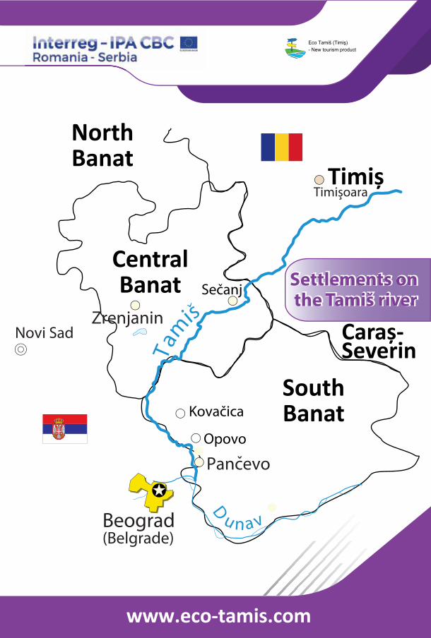
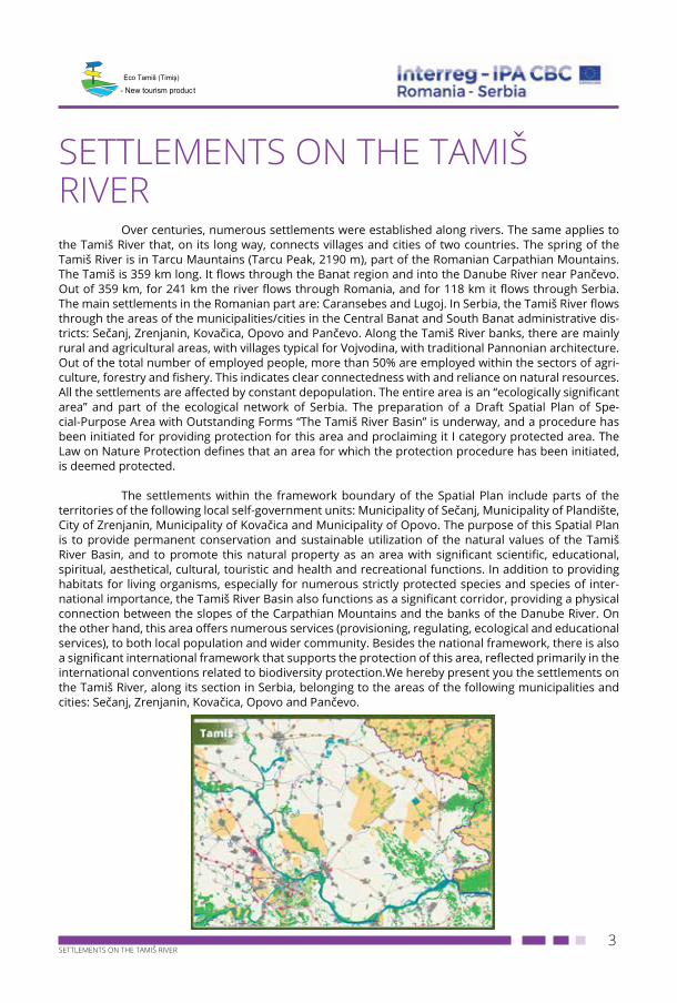
Over centuries, numerous settlements were established along rivers. The same applies to the Tamiš River that, on its long way, connects villages and cities of two countries. The spring of the Tamiš River is in Tarcu Mauntains (Tarcu Peak, 2190 m), part of the Romanian Carpathian Mountains. The Tamiš is 359 km long. It flows through the Banat region and into the Danube River near Pančevo. Out of 359 km, for 241 km the river flows through Romania, and for 118 km it flows through Serbia. The main settlements in the Romanian part are: Caransebes and Lugoj. In Serbia, the Tamiš River flows through the areas of the municipalities/cities in the Central Banat and South Banat administrative dis-tricts: Sečanj, Zrenjanin, Kovačica, Opovo and Pančevo. Along the Tamiš River banks, there are mainly rural and agricultural areas, with villages typical for Vojvodina, with traditional Pannonian architecture. Out of the total number of employed people, more than 50% are employed within the sectors of agri-culture, forestry and fishery. This indicates clear connectedness with and reliance on natural resources. All the settlements are affected by constant depopulation. The entire area is an “ecologically significant area” and part of the ecological network of Serbia. The preparation of a Draft Spatial Plan of Spe-cial-Purpose Area with Outstanding Forms “The Tamiš River Basin” is underway, and a procedure has been initiated for providing protection for this area and proclaiming it I category protected area. The Law on Nature Protection defines that an area for which the protection procedure has been initiated, is deemed protected.
The settlements within the framework boundary of the Spatial Plan include parts of the territories of the following local self-government units: Municipality of Sečanj, Municipality of Plandište, City of Zrenjanin, Municipality of Kovačica and Municipality of Opovo. The purpose of this Spatial Plan is to provide permanent conservation and sustainable utilization of the natural values of the Tamiš River Basin, and to promote this natural property as an area with significant scientific, educational, spiritual, aesthetical, cultural, touristic and health and recreational functions. In addition to providing habitats for living organisms, especially for numerous strictly protected species and species of inter-national importance, the Tamiš River Basin also functions as a significant corridor, providing a physical connection between the slopes of the Carpathian Mountains and the banks of the Danube River. On the other hand, this area offers numerous services (provisioning, regulating, ecological and educational services), to both local population and wider community. Besides the national framework, there is also a significant international framework that supports the protection of this area, reflected primarily in the international conventions related to biodiversity protection.We hereby present you the settlements on the Tamiš River, along its section in Serbia, belonging to the areas of the following municipalities and cities: Sečanj, Zrenjanin, Kovačica, Opovo and Pančevo.
4SETTLEMENTS ON THE TAMIŠ RIVER
- New tourism product
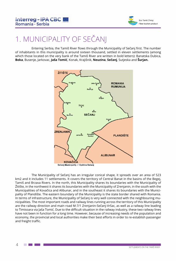
1. MUNICIPALITY OF SEČANJEntering Serbia, the Tamiš River flows through the Municipality of Sečanj first. The number
of inhabitants in this municipality is around sixteen thousand, settled in eleven settlements (among which those located on the very bank of the Tamiš River are written in bold letters): Banatska Dubica, Boka, Busenje, Jarkovac, Jaša Tomić, Konak, Krajišnik, Neuzina, Sečanj, Sutjeska and Šurjan.
The Municipality of Sečanj has an irregular conical shape, it spreads over an area of 523
km2 and it includes 11 settlements. It covers the territory of Central Banat in the basins of the Begej, Tamiš and Brzava Rivers. In the north, this Municipality shares its boundaries with the Municipality of Žitište, in the northwest it shares its boundaries with the Municipality of Zrenjanin, in the south with the Municipalities of Kovačica and Alibunar, and in the southeast it shares its boundaries with the Munici-pality of Plandište. The eastern boundary of the Municipality is the state border shared with Romania. In terms of infrastructure, the Municipality of Sečanj is very well connected with the neighbouring mu-nicipalities. The most important roads and railway lines running across the territory of this Municipality are the railway direction and main road M-7/1 Zrenjanin-Sečanj-Vršac, as well as a railway line leading to Timisoara via Jaša Tomić. Due to the difficult situation in the railway industry, these two railway lines have not been in function for a long time. However, because of increasing needs of the population and economy, the provincial and local authorities make their best efforts in order to re-establish passenger and freight traffic.
5SETTLEMENTS ON THE TAMIŠ RIVER
- New tourism product
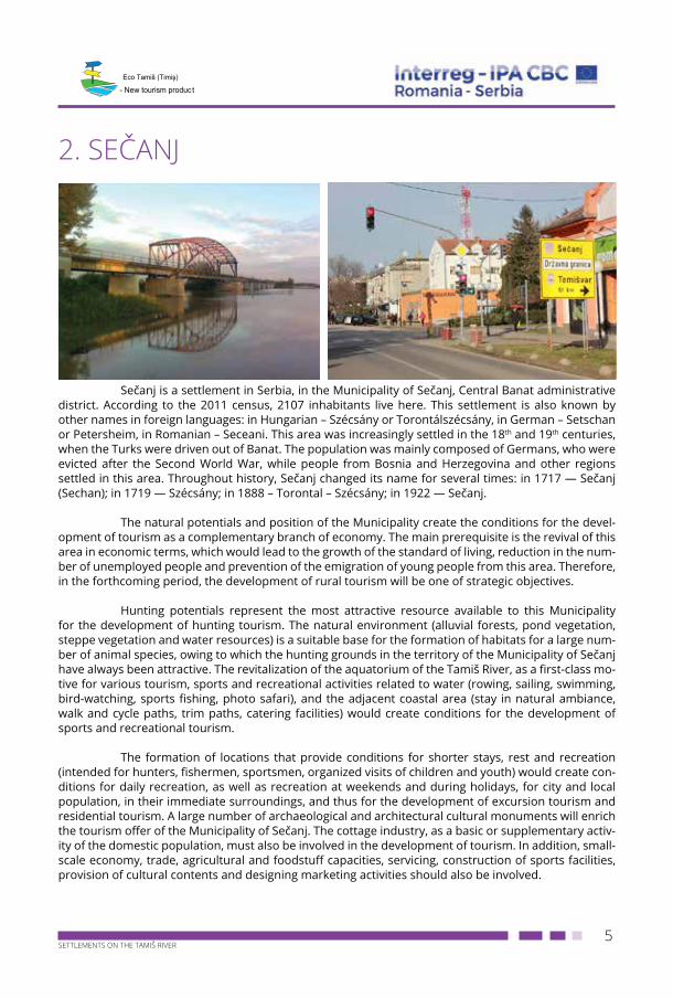
2. SEČANJ
Sečanj is a settlement in Serbia, in the Municipality of Sečanj, Central Banat administrative district. According to the 2011 census, 2107 inhabitants live here. This settlement is also known by other names in foreign languages: in Hungarian – Szécsány or Torontálszécsány, in German – Setschan or Petersheim, in Romanian – Seceani. This area was increasingly settled in the 18th and 19th centuries, when the Turks were driven out of Banat. The population was mainly composed of Germans, who were evicted after the Second World War, while people from Bosnia and Herzegovina and other regions settled in this area. Throughout history, Sečanj changed its name for several times: in 1717 — Sečanj (Sechan); in 1719 — Szécsány; in 1888 – Torontal – Szécsány; in 1922 — Sečanj.
The natural potentials and position of the Municipality create the conditions for the devel-opment of tourism as a complementary branch of economy. The main prerequisite is the revival of this area in economic terms, which would lead to the growth of the standard of living, reduction in the num-ber of unemployed people and prevention of the emigration of young people from this area. Therefore, in the forthcoming period, the development of rural tourism will be one of strategic objectives.
Hunting potentials represent the most attractive resource available to this Municipality for the development of hunting tourism. The natural environment (alluvial forests, pond vegetation, steppe vegetation and water resources) is a suitable base for the formation of habitats for a large num-ber of animal species, owing to which the hunting grounds in the territory of the Municipality of Sečanj have always been attractive. The revitalization of the aquatorium of the Tamiš River, as a first-class mo-tive for various tourism, sports and recreational activities related to water (rowing, sailing, swimming, bird-watching, sports fishing, photo safari), and the adjacent coastal area (stay in natural ambiance, walk and cycle paths, trim paths, catering facilities) would create conditions for the development of sports and recreational tourism.
The formation of locations that provide conditions for shorter stays, rest and recreation (intended for hunters, fishermen, sportsmen, organized visits of children and youth) would create con-ditions for daily recreation, as well as recreation at weekends and during holidays, for city and local population, in their immediate surroundings, and thus for the development of excursion tourism and residential tourism. A large number of archaeological and architectural cultural monuments will enrich the tourism offer of the Municipality of Sečanj. The cottage industry, as a basic or supplementary activ-ity of the domestic population, must also be involved in the development of tourism. In addition, small-scale economy, trade, agricultural and foodstuff capacities, servicing, construction of sports facilities, provision of cultural contents and designing marketing activities should also be involved.
6SETTLEMENTS ON THE TAMIŠ RIVER
- New tourism product
Within its competence, the Municipality must encourage the development of tourism by assigning or leasing attractive locations, by strengthening the service of tourism organization and pro-viding local infrastructure conditions for normal functioning of business facilities. The current state of tourism in the Municipality of Sečanj may be described as insufficient utilization of tourism resources mainly due to a lack of reception capacities and contents accompanying board and lodging, as well as due to a lack of meaningful continuous advertising and information activity. Tourism flows take place in an unorganized way and partially, with insufficient stationary visits, short stay and insufficient tourism consumption. Traditional cultural, sports and other events give their contributions to the development of cultural life:
• Provincial Festival of Recitation “You, the Poet of My People”, in Sečanj – in the middle of April,
• Festival of Folklore Traditions of Vojvodina, in Sečanj – at the beginning of May,• Festival of Music Associations of Vojvidina, in Sečanj – the second half of May,• “Sirijada” (“Cheese Festival”), in Boka – June,• Festival of Traditional Theatre Forms “Fetra”, in Jaša Tomić – September,• Reencounters on Mitrovdan (St. Demetrius Day), in Sečanj – anniversary of the settlement in
Banat – 8 November,• “Pančevo Regatta on the Tamiš River” starts from Jaša Tomić – at the beginning of July,• “Fish Days”, organized in 2008 for the first time.
In order to create prerequisites for the development of tourism, the Municipality is planning to implement the following projects:
• Construction of a fishing centre with a swimming place in Krajišnik• Construction of a footpath with a length of 1000 m, on the embankment of the Tamiš River
near Sečanj• Arrangement of beaches on the Tamiš River.
The natural environment is a suitable base for the formation of habitats for a large number of animal species, owing to which the hunting grounds in the territory of the Municipality of Sečanj have always been attractive. These hunting grounds are inhabited by small game and roebuck. The richest hunting ground is in Konak, inhabited by deer and wild boars. The Hunting Association of the Munici-pality of Sečanj manages around 52,220 ha and has 10 organisational units – hunting societies. As far as fishery is concerned, there are 6 fishing associations in this Municipality, and our watercourses (the Tamiš, Brzava, Stari Tamiš and Danube-Tisa-Danube (DTD) Canal) are very rich in fish.
In the territory of the Municipality of Sečanj, there are a very large number of valuable cultural and historical, religious, and architectural and archaeological monuments. Among the architec-tural monuments, the following ones are worth mentioning: Holy Ascension Serbian Orthodox Church in Jarkovac, dating from the second half of the 18th century, Saint Nicholas Serbian Orthodox Church in Jaša Tomić, built in the Romanesque style in 1746, Roman Catholic Church in Jaša Tomić, dating from 1911, Serbian Orthodox Church in Banatska Dubica dating from 1789, Serbian Orthodox Church in Šurjan, built in 1940 in the location in which an older church dating from 1835 used to stand, Romanian Orthodox Church in Neuzina, dating from 1815, Roman Catholic Church, dating from 1834 and Military Frontier Building built in Boka, in the second half of the 19th century, Serbian Orthodox Church in Konak dating from 1804, Daniel Ladislav Castle dating from 1884 (a primary school today) with a large park and centuries-old oak and gingko trees (protected natural property) in Konak.
7SETTLEMENTS ON THE TAMIŠ RIVER
- New tourism product
In this Municipality, a large number of valuable archaeological monuments have also been recorded:
• “Stara Barda” site – between Šurjan and Boka, on the left bank of the Tamiš River; through-out the entire section, there are many prehistoric sites and mounds from the Neolithic period;
• “Govedareva humka” site in Šurjan – the settlement is from the Neolithic period; • “Šibova humka” site in Šurjan – a prehistoric settlement where fragments of the Vatin ce-
ramics have been found; • “Stari vinogradi” site in Banatska Dubica where fragments of ceramics, baked soil, animal
bones, stone axes and a grave with human bones have been found. The findings belong to the Starčevo, Vinča-Tordos and Baden cultural groups;
• A pre-historic copper axe, found in the common grazing land of Sutjeska, is exhibited in the National Museum of Zrenjanin;
• Numerous mounds from the Prehistoric and Medieval Periods have been found in Jarkovac; • Sites in Jaša Tomić: “Bavsanište”, “Vekerlov budžak”, “Janjin budžak”, “Mundžerov budžak”,
“Belište”; • Site in Krajišnik, a settlement dating from the Late Medieval Period; • Site “Kremenjak” from the Neolithic period in Boka.
A number of monuments from early history have also been recorded: Memorial to Volun-teers Fallen in the First World War dating from 1920 and Memorial to Priests Murdered in 1848, erected in Jarkovac, in 1929; gravestones from the churchyard in Jaša Tomić; two gravestones in the shape of a cross, with Serbian inscriptions dating from 1792 and 1793, in Konak. Cultural monuments from the recent past are mainly dedicated to the National Liberation War and they can be found in almost all the settlements of this Municipality.
3. JAŠA TOMIĆ
Jaša Tomić, formerly known as Modoš (Hungarian: Modos), is a settlement in Serbia, in the Municipality of Sečanj, Central Banat administrative district. According to the 2011 census, 2373 inhab-itants live here. Jaša Tomić is a border place. The Romanian border is around one kilometre east of the village. The settlement is located in the close vicinity of the Tamiš River. The village has been named after Jaša Tomić, a politician from the 19th century. The former name of the village was Modoš.
The village is also known for a flood that happened in 2005 when the Tamiš River burst its banks and flooded a large part of the settlement. This was the largest flood in Banat in the last hundred years. In addition to an Orthodox Church, there is also a Roman Catholic Church in the village, built in 1911, which is in poor condition due to its old age. Jaša Tomić is located at the height of 81 m above the sea level. The village of Krajišnik is around 10 kilometres west of this village, while Sečanj and Šurjan are 12 and 7 kilometres south of this village respectively. The nearest large city is Zrenjanin, 41 kilometres far from Jaša Tomić. This is a lowland area, of alluvial origin, consisting of sandstone, sand, loess and loam. The surface layer of the land mainly consists of Banat chernozem (around 75%), but alluvial soil,
8SETTLEMENTS ON THE TAMIŠ RIVER
- New tourism product
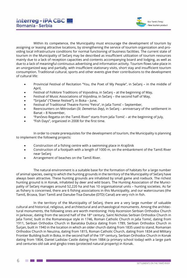
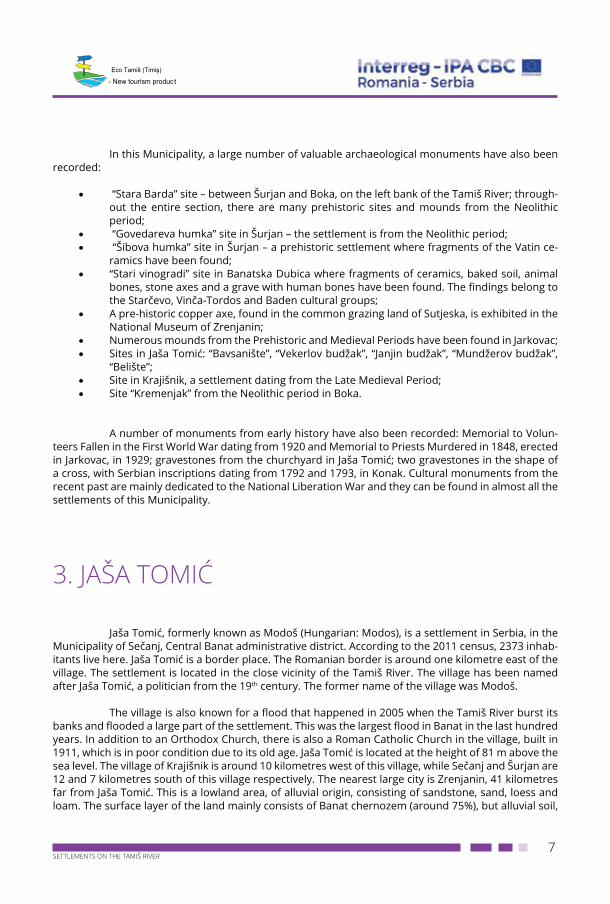
saline soil and smonitza are also represented. Two most significant cultural and historical monuments are the Saint Nicholas Orthodox Church and the Roman Catholic Church of the Assumption of the Blessed Virgin Mary.
The Saint Nicholas Church was built in 1746, in the Baroque style. This single-nave church building is vaulted with a barrel vault, while the choirs form a transept giving an impression of a cross-shaped base. The altar apse spans the width of the nave, while the massive tower on the west front emerges from the façade plane and rests upon two massive columns. On its exterior, the church build-ing has belt courses, blind arcades and niches divided into two zones. The tower staircase is located outside, along the west façade.
The Church of the Assumption of the Blessed Virgin Mary was built in 1911. It was construct-ed as a monumental, single-nave church, with a three-sided apse, two five-sided sacristies and a bell tower emerging from the west front. The structural system consists of massive perimeter walls, broken arches and Gothic vaults executed as reinforced concrete shells. The Church is decorated with stained-glass windows in all larger window openings, depicting six scenes from the life of Christ. The Church represents a valuable architectural, engineering and artistic work. Its erection in a small community such as Jaša Tomić bears witness to the former economic power of this settlement.
4. ŠURJANŠurjan (Hungarian: Surján) is a settlement in the Municipality of Sečanj, Central Banat ad-
ministrative district. According to the 2011 census, 253 inhabitants live here. Šurjan is a border place, near the Serbia-Romania border. The village of Šurjan, in the close vicinity of Jaša Tomić, is less than 2 km far from the Serbia-Romania border.
The name of Šerjen (Serjen) was first recorded in 1470. The place was named after Squire Šerjen. In 1717, the name of the place was changed into Šurjan, but inhabitants left this place and only 32 houses remained there. In the first half of the 15th century, Serb population moved to this area and in 1783, they settled in the villages of the Military Frontier, in particular, they settled in Samoš, Šurjan and Boka. They came from the border village of Csavos on the Romanian side. At that time, the number of houses in Šurjan was increased to 69. In the 18th century, the church was built and 484 Orthodox inhabitants and 20 Catholic inhabitants lived in this village. When the railway line Sečanj – Pardanj was put into operation (in 1889), Šurjan got a railway station, and in 1902, a school was built in this village.
9SETTLEMENTS ON THE TAMIŠ RIVER
- New tourism product
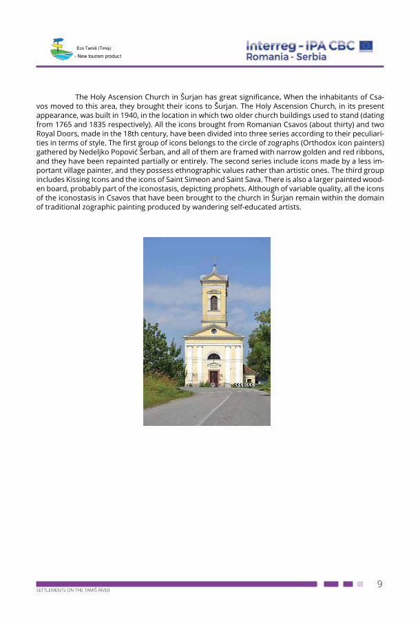
The Holy Ascension Church in Šurjan has great significance. When the inhabitants of Csa-vos moved to this area, they brought their icons to Šurjan. The Holy Ascension Church, in its present appearance, was built in 1940, in the location in which two older church buildings used to stand (dating from 1765 and 1835 respectively). All the icons brought from Romanian Csavos (about thirty) and two Royal Doors, made in the 18th century, have been divided into three series according to their peculiari-ties in terms of style. The first group of icons belongs to the circle of zographs (Orthodox icon painters) gathered by Nedeljko Popović Šerban, and all of them are framed with narrow golden and red ribbons, and they have been repainted partially or entirely. The second series include icons made by a less im-portant village painter, and they possess ethnographic values rather than artistic ones. The third group includes Kissing Icons and the icons of Saint Simeon and Saint Sava. There is also a larger painted wood-en board, probably part of the iconostasis, depicting prophets. Although of variable quality, all the icons of the iconostasis in Csavos that have been brought to the church in Šurjan remain within the domain of traditional zographic painting produced by wandering self-educated artists.
10SETTLEMENTS ON THE TAMIŠ RIVER
- New tourism product
5. BOKABoka (Hungarian: Bóka) is a settlement in the Municipality of Sečanj, Central Banat admin-
istrative district. According to the 2011 census, 1412 inhabitants live here. Boka is situated in Central Banat. The railway line Zrenjanin – Vršac runs along the southeast side of the place, the railway line Čot – Alibunar used to run along the south side of the place, and the main road Zrenjanin – Vršac runs through Boka. Boka has large common grazing land spreading north to the Tamiš River, west to the Danube – Tisa – Danube Canal, south to the Brzava Canal, and in the east it shares the boundaries with the common grazing land of Šurjan and Konak. The common grazing land shares boundaries with the following places: Neuzina, Banatska Dubica, Sečanj, Jarkovac, Konak and Šurjan. According to the maps of Count F. K. Mersi, dating from 1723 — 1725, the Igan stream, as a tributary, used to join the Tamiš River between Boka and Neuzina.
Over history, Boka changed its name for several times: 1334 – Boka, 1338 – Borzatö Báka, 1717 — Boka, 1801 – Srpska i Hrvatska Boka (Serbian and Croatian Boka), and 1898 – Boka (Bóka). As early as 1334, Boka was recorded as a parish belonging to the County of Kovin. In 1338, this place was given a Hungarian name, Borzatö-Baka, as it was situated at the mouth of the Brzava River. In the pe-riod from 1361 to 1362, the settlement was named Boka again. By a Decision of Maria Theresa dated 1778, a significant part of the estate of Bishop of Zagreb and the nobles of Turopolje was intended for assignment to the Military Administration. After years-long negotiations, an agreement was reached in 1801, by which the affected nobles were given estates in Banat, and among these estates was Hrvatska Boka (Croatian Boka) as well.
In 1854, both municipalities (Serbian and Croatian) had a total of 2725 inhabitants. A newly constructed railway line was put into operation on 21 December 1895, leading to Bečkerek and Čako-vo. The Hungarian Ministry of the Interior (No. 105820-IVa 1898) joined Serbian and Croatian Boka. According to the census dated 31 January 1921, Boka had 2794 inhabitants, among whom there were: Serbs and Croats – 1829, other Slavs - 1; Romanians – 13; Germans – 232; Hungarians – 672, and other inhabitants - 72.
11SETTLEMENTS ON THE TAMIŠ RIVER
- New tourism product
6. NEUZINA
Neuzina (Hungarian: Nezsény) is a settlement in Serbia, Municipality of Sečanj, Central
Banat administrative district. According to the 2011 census, 1256 inhabitants live here.
Over history, Neuzina changed its name for several times:
• • 1116 — Neuzina• • 1801 — Srpska Neuzina (Serbian Neuzina) (Hungarian: Nezsény)• • 1801 — Hrvatska Neuzina (Croatian Neuzina)• • 1912 — (Hungarian: Nagynezsény)• • 1922 — Srpska Neuzina (Serbian Neuzina)
From the historical point of view, there used to be two places named Neuzina that were united afterwards: Srpska Neuzina (Serbian Neuzina) and Hrvatska Neuzina (Croatian Neuzina). The Croats from this place moved here from the area of Pokuplje (Croatia) after the administrative reorgan-isation that followed the liberation of large regions obtained by the Treaty of Karlowitz signed in 1699 between the Habsburg Monarchy and the Ottoman Empire. They moved to this area because the new government in their original country did not recognize their former privileges.
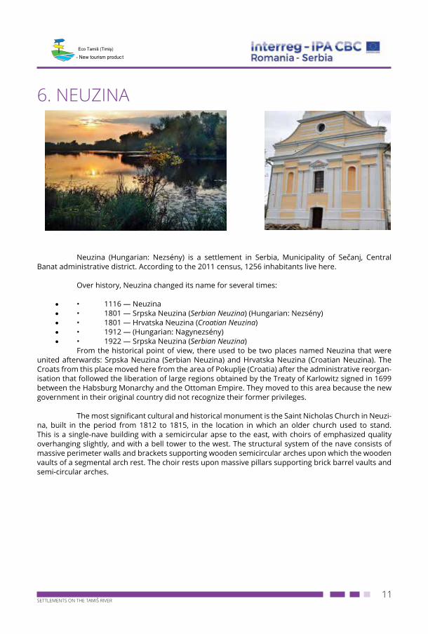
The most significant cultural and historical monument is the Saint Nicholas Church in Neuzi-na, built in the period from 1812 to 1815, in the location in which an older church used to stand. This is a single-nave building with a semicircular apse to the east, with choirs of emphasized quality overhanging slightly, and with a bell tower to the west. The structural system of the nave consists of massive perimeter walls and brackets supporting wooden semicircular arches upon which the wooden vaults of a segmental arch rest. The choir rests upon massive pillars supporting brick barrel vaults and semi-circular arches.
12SETTLEMENTS ON THE TAMIŠ RIVER
- New tourism product
7. CITY OF ZRENJANIN
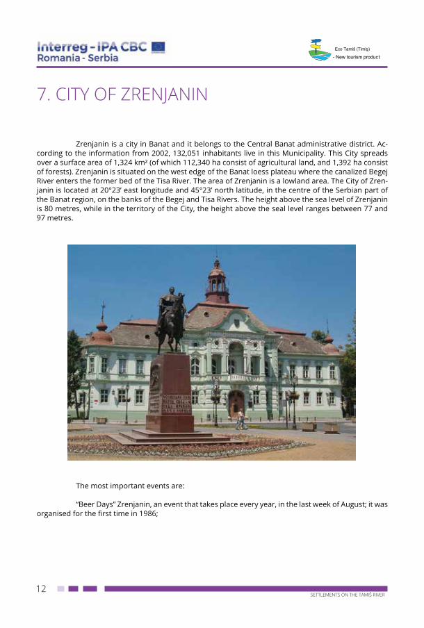
Zrenjanin is a city in Banat and it belongs to the Central Banat administrative district. Ac-cording to the information from 2002, 132,051 inhabitants live in this Municipality. This City spreads over a surface area of 1,324 km² (of which 112,340 ha consist of agricultural land, and 1,392 ha consist of forests). Zrenjanin is situated on the west edge of the Banat loess plateau where the canalized Begej River enters the former bed of the Tisa River. The area of Zrenjanin is a lowland area. The City of Zren-janin is located at 20°23’ east longitude and 45°23’ north latitude, in the centre of the Serbian part of the Banat region, on the banks of the Begej and Tisa Rivers. The height above the sea level of Zrenjanin is 80 metres, while in the territory of the City, the height above the seal level ranges between 77 and 97 metres.
The most important events are:
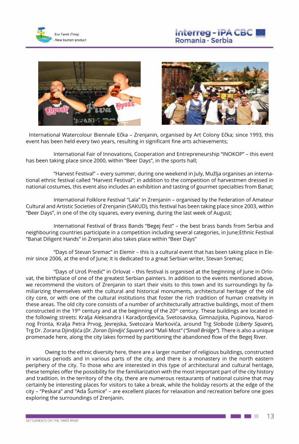
“Beer Days” Zrenjanin, an event that takes place every year, in the last week of August; it was organised for the first time in 1986;
13SETTLEMENTS ON THE TAMIŠ RIVER
- New tourism product
International Watercolour Biennale Ečka – Zrenjanin, organised by Art Colony Ečka; since 1993, this event has been held every two years, resulting in significant fine arts achievements;
International Fair of Innovations, Cooperation and Entrepreneurship “INOKOP” – this event has been taking place since 2000, within “Beer Days”, in the sports hall;
“Harvest Festival” – every summer, during one weekend in July, Mužlјa organises an interna-tional ethnic festival called “Harvest Festival”; in addition to the competition of harvestmen dressed in national costumes, this event also includes an exhibition and tasting of gourmet specialties from Banat;
International Folklore Festival “Lala” in Zrenjanin – organised by the Federation of Amateur Cultural and Artistic Societies of Zrenjanin (SAKUD), this festival has been taking place since 2003, within “Beer Days”, in one of the city squares, every evening, during the last week of August;
International Festival of Brass Bands “Begej Fest” – the best brass bands from Serbia and neighbouring countries participate in a competition including several categories, in June;Ethnic Festival “Banat Diligent Hands” in Zrenjanin also takes place within “Beer Days”
“Days of Stevan Sremac” in Elemir – this is a cultural event that has been taking place in Ele-mir since 2006, at the end of June; it is dedicated to a great Serbian writer, Stevan Sremac;
“Days of Uroš Predić” in Orlovat – this festival is organised at the beginning of June in Orlo-vat, the birthplace of one of the greatest Serbian painters. In addition to the events mentioned above, we recommend the visitors of Zrenjanin to start their visits to this town and its surroundings by fa-miliarizing themselves with the cultural and historical monuments, architectural heritage of the old city core, or with one of the cultural institutions that foster the rich tradition of human creativity in these areas. The old city core consists of a number of architecturally attractive buildings, most of them constructed in the 19th century and at the beginning of the 20th century. These buildings are located in the following streets: Kralja Aleksandra I Karadjordjevića, Svetosavska, Gimnazijska, Pupinova, Narod-nog Fronta, Kralja Petra Prvog, Jevrejska, Svetozara Markovića, around Trg Slobode (Liberty Square), Trg Dr. Zorana Djindjića (Dr. Zoran Djindjić Square) and “Mali Most” (“Small Bridge”). There is also a unique promenade here, along the city lakes formed by partitioning the abandoned flow of the Begej River.
Owing to the ethnic diversity here, there are a larger number of religious buildings, constructed in various periods and in various parts of the city, and there is a monastery in the north eastern periphery of the city. To those who are interested in this type of architectural and cultural heritage, these temples offer the possibility for the familiarization with the most important part of the city history and tradition. In the territory of the city, there are numerous restaurants of national cuisine that may certainly be interesting places for visitors to take a break, while the holiday resorts at the edge of the city – “Peskara” and “Ada Šumice” – are excellent places for relaxation and recreation before one goes exploring the surroundings of Zrenjanin.
14SETTLEMENTS ON THE TAMIŠ RIVER
- New tourism product
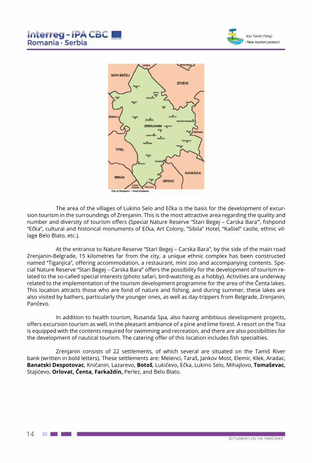
The area of the villages of Lukino Selo and Ečka is the basis for the development of excur-
sion tourism in the surroundings of Zrenjanin. This is the most attractive area regarding the quality and number and diversity of tourism offers (Special Nature Reserve “Stari Begej – Carska Bara’”, fishpond “Ečka”, cultural and historical monuments of Ečka, Art Colony, “Sibila” Hotel, “Kaštel” castle, ethnic vil-lage Belo Blato, etc.).
At the entrance to Nature Reserve “Stari Begej – Carska Bara”, by the side of the main road Zrenjanin-Belgrade, 15 kilometres far from the city, a unique ethnic complex has been constructed named “Tiganjica”, offering accommodation, a restaurant, mini zoo and accompanying contents. Spe-cial Nature Reserve “Stari Begej – Carska Bara” offers the possibility for the development of tourism re-lated to the so-called special interests (photo safari, bird-watching as a hobby). Activities are underway related to the implementation of the tourism development programme for the area of the Čenta lakes. This location attracts those who are fond of nature and fishing, and during summer, these lakes are also visited by bathers, particularly the younger ones, as well as day-trippers from Belgrade, Zrenjanin, Pančevo.
In addition to health tourism, Rusanda Spa, also having ambitious development projects, offers excursion tourism as well, in the pleasant ambiance of a pine and lime forest. A resort on the Tisa is equipped with the contents required for swimming and recreation, and there are also possibilities for the development of nautical tourism. The catering offer of this location includes fish specialties.
Zrenjanin consists of 22 settlements, of which several are situated on the Tamiš River bank (written in bold letters). These settlements are: Melenci, Taraš, Jankov Most, Elemir, Klek, Aradac, Banatski Despotovac, Knićanin, Lazarevo, Botoš, Lukićevo, Ečka, Lukino Selo, Mihajlovo, Tomaševac, Stajićevo, Orlovat, Čenta, Farkaždin, Perlez, and Belo Blato.
15SETTLEMENTS ON THE TAMIŠ RIVER
- New tourism product
8. BANATSKI DESPOTOVAC
Banatski Despotovac (Hungarian: Ernőháza, German: Ernsthausen) is a settlement belong-ing to the Municipality of Zrenjanin in the Central Banat District. It is 22 km far from Zrenjanin, and around 13 km far from Sečanj. The Tamiš River flows at a distance of 2 km from Banatski Despotovac. The height above the sea level is 83 m. According to the 2011 census, 1291 inhabitants live here.
The settlement was established in 1822, by Kiš Erne, an owner of a large estate, of Armenian origin. At that time, the Kiš family owned the largest area of land in the Torontal County. The inhabitants emigrated from parts of Austria and Germany. They were mainly Roman Catholics, although there were some Evangelists as well. Then Romanian, Croatian and Romany families moved here. The names of this village were Ernehaza, Ernesthaza, Ernestovac, Banatski Despotovac and Ernsthauzen, and after 1945, it was named Banatski Despotovac.
The village got its present name after the proclamation of the Kingdom of Yugoslavia. By the end of 1944, most inhabitants of the village escaped because of the advance of the Red Army and took refuge in Germany, and only a small number of villagers remained, mainly older people and children. In 1945, Banatski Despotovac was settled by Serbs from Mrkonjić Grad, Šipovo, Kupres, Glamoč and Livno. The immigrants were given houses and holdings of the former inhabitants. In 2005, part of the common grazing land of the village was flooded together with the part of Banat in the surroundings of Sečanj. Banatski Despotovac has 1379 inhabitants of full age, and the median age of the population is 45.2 years (43.7 for males, and 46.7 for females). The settlement has 604 households, and the average number of household members is 2.68. As the population mainly moved from Bosnia, a tourism and gastronomic event called “Pitijada” (“Pie Festival”) traditionally takes place in this village.
9. BOTOŠBotoš is a settlement in the Municipality of Zrenjanin, in the Central Banat District. Accord-
ing to the 2011 census, 1860 inhabitants live here. Botoš is one of the well-known villages in this area along the Tamiš River. Botoš has good economic relations with other surrounding places, as well as with Zrenjanin.
The Neolithic man lived in Botoš and left his traces here. Many peoples have passed through this village since prehistoric time, throughout recorded history, to the present day. Peoples followed each other, and habits and cultures intertwined. In the common grazing land of Botoš, there are many valuable archaeological findings. The area of this village was settled as early as between 3000 and 2000 BC and it belongs to the Vinča Group, which is evidenced by numerous archaeological findings from this site.
16SETTLEMENTS ON THE TAMIŠ RIVER
- New tourism product
Botoš has not always been situated in its present location. The village used to be situated on the Tamiš River bank, in a location named Taladj that is now a neighbourhood of Botoš. As this is a very old settlement, its first inhabitants made their houses near the river so that they could have drinking water. Undoubtedly, Botoš is a very old Slavic settlement. In written testimonials, Botoš was mentioned under this name as early as 1347, and at the beginning of the 17th century, it was included in the list of places recorded in the book titled “Kruševski Pomenik” (“Kruševo Chronicle”). In the Medieval Period, Botoš belonged to the County of Kovin that was an integral part of the Hungarian territory. This was a purely Serbian settlement, whose inhabitants were Orthodox Christians.
The Orthodox Church of Saint John the Forerunner, an old Serbian place of worship, “Namastir”, dedicated to the birth of Saint John the Forerunner, is a cultural monument of great importance. It is assumed that it was built between 1768 and 1770, when Serbian frontiersmen set-tled in this area. Tradition says that newcomer priests made a turf church whose traces are still visible today, on the altar wall and along a half of the entire length of the south wall. It was covered with shingle that was later replaced with crown roof tiles, but it cannot be accurately determined when this reconstruction was made. Today, this is a modest single-nave rectangular building, with no dome, with a disproportionally large alter apse and with only indicated spaces for choirs. Above the altar, the roof is arched, while on the west side, the roof is set back. The massive, 75 cm thick walls are underpinned with bricks.
17SETTLEMENTS ON THE TAMIŠ RIVER
- New tourism product
10. TOMAŠEVAC
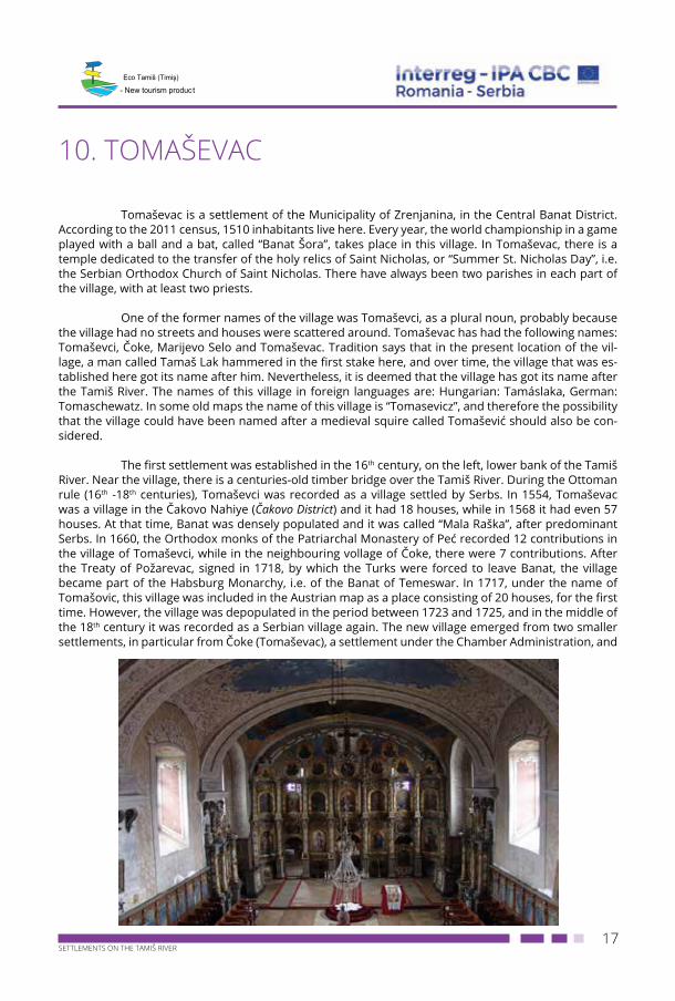
Tomaševac is a settlement of the Municipality of Zrenjanina, in the Central Banat District. According to the 2011 census, 1510 inhabitants live here. Every year, the world championship in a game played with a ball and a bat, called “Banat Šora”, takes place in this village. In Tomaševac, there is a temple dedicated to the transfer of the holy relics of Saint Nicholas, or “Summer St. Nicholas Day”, i.e. the Serbian Orthodox Church of Saint Nicholas. There have always been two parishes in each part of the village, with at least two priests.
One of the former names of the village was Tomaševci, as a plural noun, probably because the village had no streets and houses were scattered around. Tomaševac has had the following names: Tomaševci, Čoke, Marijevo Selo and Tomaševac. Tradition says that in the present location of the vil-lage, a man called Tamaš Lak hammered in the first stake here, and over time, the village that was es-tablished here got its name after him. Nevertheless, it is deemed that the village has got its name after the Tamiš River. The names of this village in foreign languages are: Hungarian: Tamáslaka, German: Tomaschewatz. In some old maps the name of this village is “Tomasevicz”, and therefore the possibility that the village could have been named after a medieval squire called Tomašević should also be con-sidered.
The first settlement was established in the 16th century, on the left, lower bank of the Tamiš River. Near the village, there is a centuries-old timber bridge over the Tamiš River. During the Ottoman rule (16th -18th centuries), Tomaševci was recorded as a village settled by Serbs. In 1554, Tomaševac was a village in the Čakovo Nahiye (Čakovo District) and it had 18 houses, while in 1568 it had even 57 houses. At that time, Banat was densely populated and it was called “Mala Raška”, after predominant Serbs. In 1660, the Orthodox monks of the Patriarchal Monastery of Peć recorded 12 contributions in the village of Tomaševci, while in the neighbouring vollage of Čoke, there were 7 contributions. After the Treaty of Požarevac, signed in 1718, by which the Turks were forced to leave Banat, the village became part of the Habsburg Monarchy, i.e. of the Banat of Temeswar. In 1717, under the name of Tomašovic, this village was included in the Austrian map as a place consisting of 20 houses, for the first time. However, the village was depopulated in the period between 1723 and 1725, and in the middle of the 18th century it was recorded as a Serbian village again. The new village emerged from two smaller settlements, in particular from Čoke (Tomaševac), a settlement under the Chamber Administration, and
18SETTLEMENTS ON THE TAMIŠ RIVER
- New tourism product
Marijevo (Marijino Selo) that belonged to the Military Frontier. These are the names that people still use today for the two halves of the village. In administrative terms, the two settlements were united in 1776. During the 1860s, Tomaševac was included in the Military Frontier and it became the headquarters of the Company (Troop). Besides Tomaševac, subordinated platoons, Botoš and Orlovat, were also includ-ed in the Military Frontier. At that time, Serbs from the areas of the Tisa and Mureş Rivers settled in this military village and they became frontiersmen of the Habsburg Monarchy.
During the First World War, the majority of the male population of Tomaševac fought as Austro-Hungarian soldiers at the fronts of Dobrudža. Many of them deserted and joined either the Russian Army or the Serbian Army as volunteers. A Memorial to Heroes Fallen in the First World War has been erected in the centre of the village. In the period between the two World Wars, Tomaševac got everything that a village of that time needed. The town hall and the building of the present local office were built at that time, and in a school intended for six grades, pupils attended classes in the Serbian language. Immediately before the Second World War, Tomaševac had around 2,700 inhabitants, mainly Serbs, mostly engaged in agriculture.
The Serbian Orthodox Church of St. Nicholas in Tomaševac was built in 1814, in classical style, and it was refurbished in 1938. The high altar partition has been skilfully constructed and carved in Neo-Baroque style. The icons were started by Јоvаn Pоpоvić, but he died before their completion. After long negotiations, during which an offer by Kоnstаntin Dаnilo was rejected, the work was com-pleted by Kаrl Guc, a Viennese painter of Czech origin, who also painted the icon on the throne of the Mother of God.
19SETTLEMENTS ON THE TAMIŠ RIVER
- New tourism product
11. ORLOVATOrlovat is a settlement of the Municipality of Zrenjanin and it is situated on the right bank of
the Tamiš River, on a lower loess terrace. Throughout history, the settlement changed its location and name for several times. Today, Orlovat is situated in a location in which three branch railway lines inter-connect making the so-called triangle. According to the 2011 census, 1516 inhabitants live here. Orlovat can be included in the group of the oldest settlements of Banat. The high right bank of the Tamiš River has always been densely populated, which is evidenced by numerous archaeological findings. In the common grazing land of the village, traces of the Neolithic cultural layer dominate. The most famous archaeological site is Umka, at the highest elevation in the area, with remains of the Bronze Age, related to the Verbičuar Culture.
In its past, in 1471, it was recorded as a town named Borlod entitled to organise fairs, and it belonged to the County of Kovin. Borlod Square was an intersection of roads running from three di-rections: Bečkerek (and Bečej), Titel and Pančevo. Because of frequent Ottoman invasions, the number of inhabitants of Orolvat decreased and as early as 1506, it became an ordinary village named Barlat. Throughout history, the name of the village changed and in addition to the mentioned ones, the fol-lowing names were also recorded: Horlebath, Orloat, Orlovath and other names, depending on rulers and administrators of these areas. In 1911, while pursuing a policy of aggressive Magyarization, the Hungarian authorities changed the name of the village into Orlod, and this name was only officially recorded until 1921. Orlovat has got its name after an eagle habitat where eagles (in Serbian: “orlovi”) used to nest in high crowns of ancient oak trees on a coastal beam around which the Tamiš River flew, making eventually an island, a sandbank.
The most famous inhabitant of Orlovat was born in 1857 - Uroš Predić, an academic painter. Along with Paja Jovanović, he is the most important Serbian painter. The painter spent a great part of his life working in Orlovat, and his numerous paintings depict many details from the life of Orlovat at that time. The house of Uroš Predić in Orlovat has not been preserved, but there is a modest Memorial Room dedicated to preserving the memory of this artist, opened in 2007.
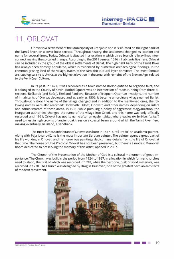
The Church of the Presentation of the Mother of God is a cultural monument of great im-portance. The Church was built in the period from 1924 to 1927, in a location in which former churches used to stand, the first of which was recorded in 1748, while the next one, built of solid materials, was recorded in 1770. The Church was designed by Drаgišа Brаšоvаn, one of the greatest Serbian architects of modern movement.
20SETTLEMENTS ON THE TAMIŠ RIVER
- New tourism product
12. FARKAŽDIN
Farkaždin is a settlement of the Municipality of Zrenjanin, in the Central Banat District. Ac-cording to the 2011 census, 1179 inhabitants live here. Farkaždin is an old Serbian place, on the right bank of the Tamiš River, also known as Kurjakovo (Wolf Village) among people, as its original name was magyarized long ago. The name Farkaždin includes a Hungarian word “farkas” meaning a wolf or he-wolf. The Kurjački family used to be the richest family here, and its members were engaged in trade. In the 18th century, there were several hamlets in the common grazing land of this village, but they lasted only a short time. In 1737, the map of Banat included Variak as a place in the closest vicinity of the present position of the village, and Mikolak, as a farther place in the direction of Čenta. It is supposed that Farkaždin was founded by an authorized army officer called Andreja Grunić, around 1750. In 1773, the village was included in the Illyrian Infantry Regiment, and three years later it was included in the German-Banat Regiment with the headquarters in Pančevo.
It is known that there were several Orthodox churches in Farkaždin. The present Orthodox Church was built in the period from 1847 to 1850, and like all previous churches, it was dedicated to the holiday called The Holy Belt of the Most Holy Mother of God. It cannot be reliably established who painted the iconostasis in the Church of Farkaždin. The Serbian national school with classes held in the Serbian language has existed since 1772. In the first half of the 19th century, owing to the engagement of priests from the Jovanović family and merchants from the Ivković family, Farkaždin was a prominent subscription point for the procurement of newspapers and books.
The Church Choral Society was founded in 1880, and the Volunteer Fire Department was officially registered in 1889. The Post Office was opened in 1907. The railway station by the new railway line Titel – Orlovat has been in operation since 1925.
13. ČENTA
Čenta is a settlement of the Municipality of Zrenjanin and it represents a typical village of Banat. The greatest specificity is the geographic position of the village, as the centres such as Belgrade, Zrenjanin and Pančevo are almost equally far from it. According to the 2011 census, 3050 inhabitants live here.
Čenta was recorded in 1549 for the first time, in a Turkish account book, included in a description of the Sanjak of Szeged. At that time, 22 households were recorded (by the names and sur-names of household members), as well as Voja the Orthodox monk. Čenta was settled almost through-out the period of the Ottoman rule over today’s Banat. The settlement of Ječin was also recorded, located northeast of the present village of Čenta. Ječin was settled in 1717, when the Turks were forced to leave Banat and when this settlement had 13 houses and Priest Petar. A certain number of the inhab-itants of Ječin moved to Čenta, where Priest Petar was buried. A monument dedicated to him, erected by the Old Church, has been preserved to the present day.
21SETTLEMENTS ON THE TAMIŠ RIVER
- New tourism product
Čenta suffered a lot during the Ottoman invasion in 1736/1737, and of 22 households only 7 remained. The main reason for the decrease in the number of inhabitants was plague. These house-holds were recorded by the names and surnames of their members. According to the 1748 census, Čenta had 58 houses. In 1750/1753, the village was included in Banat Ground Police, and afterwards it belonged to XII German-Banat Regiment. In 1873, the Military Frontier was abolished and Čenta be-longed to the Torontal County. The name of the village probably originates from an Old Slavic word “Čantra” (bag), because in the medieval times the village was surrounded by ponds and marshes and it was practically situated on an island and its inhabitants were hidden, like in a bag, from undesirable visitors and tax collectors. When Čenta was included in the Military Frontier in 1753, the village got a new name, Leopoldovo, and this name was retained until 1883 when the old name was returned to this village.
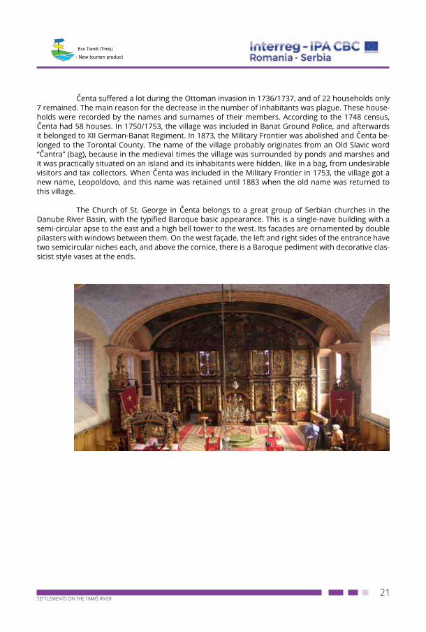
The Church of St. George in Čеnta belongs to a great group of Serbian churches in the Danube River Basin, with the typified Baroque basic appearance. This is a single-nave building with a semi-circular apse to the east and a high bell tower to the west. Its facades are ornamented by double pilasters with windows between them. On the west façade, the left and right sides of the entrance have two semicircular niches each, and above the cornice, there is a Baroque pediment with decorative clas-sicist style vases at the ends.
22SETTLEMENTS ON THE TAMIŠ RIVER
- New tourism product
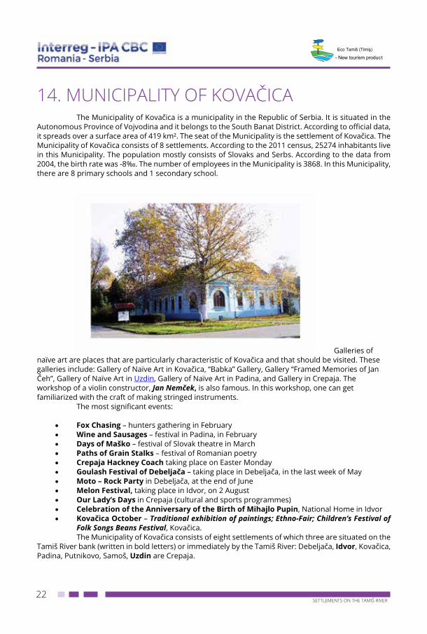
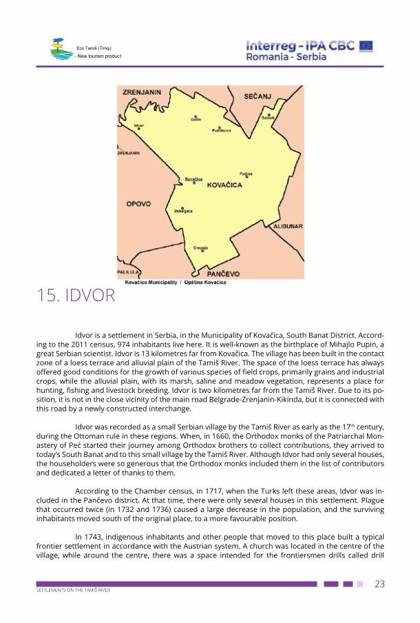
14. MUNICIPALITY OF KOVAČICAThe Municipality of Kovačica is a municipality in the Republic of Serbia. It is situated in the
Autonomous Province of Vojvodina and it belongs to the South Banat District. According to official data, it spreads over a surface area of 419 km². The seat of the Municipality is the settlement of Kovačica. The Municipality of Kovačica consists of 8 settlements. According to the 2011 census, 25274 inhabitants live in this Municipality. The population mostly consists of Slovaks and Serbs. According to the data from 2004, the birth rate was -8‰. The number of employees in the Municipality is 3868. In this Municipality, there are 8 primary schools and 1 secondary school.
Galleries of naïve art are places that are particularly characteristic of Kovačica and that should be visited. These galleries include: Gallery of Naïve Art in Kovačica, “Babka” Gallery, Gallery “Framed Memories of Jan Čeh”, Gallery of Naïve Art in Uzdin, Gallery of Naïve Art in Padina, and Gallery in Crepaja. The workshop of a violin constructor, Jan Nemček, is also famous. In this workshop, one can get familiarized with the craft of making stringed instruments.
The most significant events:
• Fox Chasing – hunters gathering in February • Wine and Sausages – festival in Padina, in February• Days of Maško – festival of Slovak theatre in March• Paths of Grain Stalks – festival of Romanian poetry • Crepaja Hackney Coach taking place on Easter Monday • Goulash Festival of Debeljača – taking place in Debeljača, in the last week of May• Moto – Rock Party in Debeljača, at the end of June • Melon Festival, taking place in Idvor, on 2 August• Our Lady’s Days in Crepaja (cultural and sports programmes)• Celebration of the Anniversary of the Birth of Mihajlo Pupin, National Home in Idvor• Kovačica October – Traditional exhibition of paintings; Ethno-Fair; Children’s Festival of
Folk Songs Beans Festival, Kovačica.The Municipality of Kovačica consists of eight settlements of which three are situated on the
Tamiš River bank (written in bold letters) or immediately by the Tamiš River: Debeljača, Idvor, Kovačica, Padina, Putnikovo, Samoš, Uzdin are Crepaja.
23SETTLEMENTS ON THE TAMIŠ RIVER
- New tourism product
15. IDVOR
Idvor is a settlement in Serbia, in the Municipality of Kovačica, South Banat District. Accord-ing to the 2011 census, 974 inhabitants live here. It is well-known as the birthplace of Mihajlo Pupin, a great Serbian scientist. Idvor is 13 kilometres far from Kovačica. The village has been built in the contact zone of a loess terrace and alluvial plain of the Tamiš River. The space of the loess terrace has always offered good conditions for the growth of various species of field crops, primarily grains and industrial crops, while the alluvial plain, with its marsh, saline and meadow vegetation, represents a place for hunting, fishing and livestock breeding. Idvor is two kilometres far from the Tamiš River. Due to its po-sition, it is not in the close vicinity of the main road Belgrade-Zrenjanin-Kikinda, but it is connected with this road by a newly constructed interchange.
Idvor was recorded as a small Serbian village by the Tamiš River as early as the 17th century, during the Ottoman rule in these regions. When, in 1660, the Orthodox monks of the Patriarchal Mon-astery of Peć started their journey among Orthodox brothers to collect contributions, they arrived to today’s South Banat and to this small village by the Tamiš River. Although Idvor had only several houses, the householders were so generous that the Orthodox monks included them in the list of contributors and dedicated a letter of thanks to them.
According to the Chamber census, in 1717, when the Turks left these areas, Idvor was in-cluded in the Pančevo district. At that time, there were only several houses in this settlement. Plague that occurred twice (in 1732 and 1736) caused a large decrease in the population, and the surviving inhabitants moved south of the original place, to a more favourable position.
In 1743, indigenous inhabitants and other people that moved to this place built a typical frontier settlement in accordance with the Austrian system. A church was located in the centre of the village, while around the centre, there was a space intended for the frontiersmen drills called drill
24SETTLEMENTS ON THE TAMIŠ RIVER
- New tourism product
ground. Behind the drill ground, there was an Administrative Building, while frontiersmen built their family houses in locations towards the periphery of the settlement, on sites with square bases.
Owing to their military services, frontiersmen had significant privileges: personal freedom, freedom of religion, the right to educate their children in their mother tongue, they were also given certain areas of arable land and pasture, they were entitled to distil brandy, go hunting and fishing. In 1848, the year of revolution, the frontiersmen entered into armed conflict with the units of Hungarian revolutionaries and Idvor was burnt down. After the abolition of the Military Frontier, the soldiers had no obligations any more and they were deprived of their former rights, and this area fell under the rule of the Hungarian Monarchy. In 1872, along with other places, Idvor was included in the Torontal County whose seat was in Veliki Bečkerek (today’s Zrenjanin). According to available information, during the 20th century, Idvor had 403 houses with 2177 inhabitants living in them.
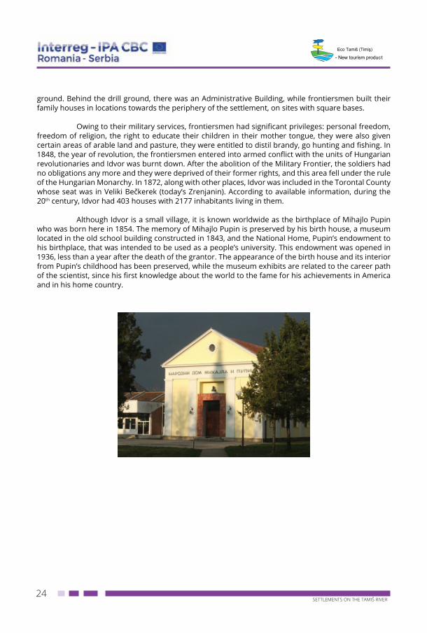
Although Idvor is a small village, it is known worldwide as the birthplace of Mihajlo Pupin who was born here in 1854. The memory of Mihajlo Pupin is preserved by his birth house, a museum located in the old school building constructed in 1843, and the National Home, Pupin’s endowment to his birthplace, that was intended to be used as a people’s university. This endowment was opened in 1936, less than a year after the death of the grantor. The appearance of the birth house and its interior from Pupin’s childhood has been preserved, while the museum exhibits are related to the career path of the scientist, since his first knowledge about the world to the fame for his achievements in America and in his home country.
25SETTLEMENTS ON THE TAMIŠ RIVER
- New tourism product
16. UZDIN
Uzdin is a settlement in the Municipality of Kovačica, South Banat District. According to the 2011 census, 2029 inhabitants live here. Uzdin is located north of Kovačica, at a distance of 10 km. This village belongs to the Tamiš River Basin settlements and it is only 5 km far from the river. The village has been built on higher parts of the loess plateau.
The foundation of the new settlement of Uzdin was closely related to the foundation of the Military Frontier that defended Banat, with the Danube River as the frontier, from Titel to Orsova and Karansebes, which served as protection against further advances of the Turks. In 1724, in addition to Serbs, Austrian Marshal Francesco enabled also Romanians to settle here. Running away from the oppression of the Ottoman Empire, these Romanians descended the Transylvanian Alps and came to the fertile Banat plain. The Romanian population first settled in the location of today’s Padina (a deso-late stretch of land at that time) around 1767. In 1776, due to unfavourable living conditions (a lack of water), these people moved to the present location of the village of Uzdin.
Uzdin is a typical settlement of Vojvodina, in which the population is primarily engaged in crop farming and livestock breeding. In addition to crop and livestock production, the inhabitants of Uzdin are successfully engaged in freshwater fish farming owing to the construction of a fish pond. The great expanse of forest and gentle Tamiš River offer favourable natural conditions for the further development of hunting and fishing, as well as for the development of hunting tourism, fishing tourism, excursion and transit tourism.
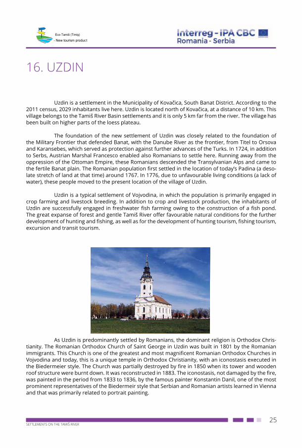
As Uzdin is predominantly settled by Romanians, the dominant religion is Orthodox Chris-
tianity. The Romanian Orthodox Church of Saint George in Uzdin was built in 1801 by the Romanian immigrants. This Church is one of the greatest and most magnificent Romanian Orthodox Churches in Vojvodina and today, this is a unique temple in Orthodox Christianity, with an iconostasis executed in the Biedermeier style. The Church was partially destroyed by fire in 1850 when its tower and wooden roof structure were burnt down. It was reconstructed in 1883. The iconostasis, not damaged by the fire, was painted in the period from 1833 to 1836, by the famous painter Konstantin Danil, one of the most prominent representatives of the Biedermeir style that Serbian and Romanian artists learned in Vienna and that was primarily related to portrait painting.
26SETTLEMENTS ON THE TAMIŠ RIVER
- New tourism product
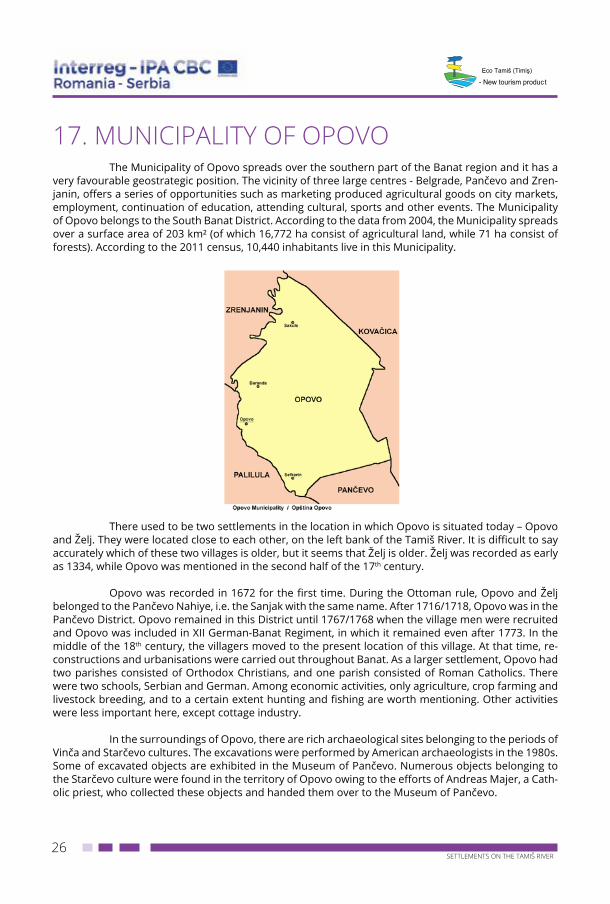
17. MUNICIPALITY OF OPOVOThe Municipality of Opovo spreads over the southern part of the Banat region and it has a
very favourable geostrategic position. The vicinity of three large centres - Belgrade, Pančevo and Zren-janin, offers a series of opportunities such as marketing produced agricultural goods on city markets, employment, continuation of education, attending cultural, sports and other events. The Municipality of Opovo belongs to the South Banat District. According to the data from 2004, the Municipality spreads over a surface area of 203 km² (of which 16,772 ha consist of agricultural land, while 71 ha consist of forests). According to the 2011 census, 10,440 inhabitants live in this Municipality.
There used to be two settlements in the location in which Opovo is situated today – Opovo
and Želj. They were located close to each other, on the left bank of the Tamiš River. It is difficult to say accurately which of these two villages is older, but it seems that Želj is older. Želj was recorded as early as 1334, while Opovo was mentioned in the second half of the 17th century.
Opovo was recorded in 1672 for the first time. During the Ottoman rule, Opovo and Želj belonged to the Pančevo Nahiye, i.e. the Sanjak with the same name. After 1716/1718, Opovo was in the Pančevo District. Opovo remained in this District until 1767/1768 when the village men were recruited and Opovo was included in XII German-Banat Regiment, in which it remained even after 1773. In the middle of the 18th century, the villagers moved to the present location of this village. At that time, re-constructions and urbanisations were carried out throughout Banat. As a larger settlement, Opovo had two parishes consisted of Orthodox Christians, and one parish consisted of Roman Catholics. There were two schools, Serbian and German. Among economic activities, only agriculture, crop farming and livestock breeding, and to a certain extent hunting and fishing are worth mentioning. Other activities were less important here, except cottage industry.
In the surroundings of Opovo, there are rich archaeological sites belonging to the periods of Vinča and Starčevo cultures. The excavations were performed by American archaeologists in the 1980s. Some of excavated objects are exhibited in the Museum of Pančevo. Numerous objects belonging to the Starčevo culture were found in the territory of Opovo owing to the efforts of Andreas Majer, a Cath-olic priest, who collected these objects and handed them over to the Museum of Pančevo.
27SETTLEMENTS ON THE TAMIŠ RIVER
- New tourism product
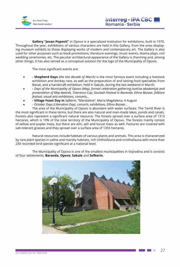
Gallery “Jovan Popović” in Opovo is a specialized institution for exhibitions, built in 1970. Throughout the year, exhibitions of various characters are held in this Gallery, from the ones display-ing museum exhibits to those displaying works of modern and contemporary art. The Gallery is also used for other purposes such as book promotions, literature evenings, music events, drama plays, civil wedding ceremonies, etc. The peculiar architectural appearance of the Gallery is charming and, among other things, it has also served as a conceptual solution for the logo of the Municipality of Opovo.
The most significant events are:
• - Shepherd Days (the last decade of March) is the most famous event including a livestock exhibition and donkey race, as well as the preparation of and tasting food specialties from Banat, and a handicraft exhibition, held in Sakule, during the last weekend in March.
• - Days of the Municipality of Opovo (May), formal celebration gathering (svečna akademija) and presentation of May Awards, Tolerance Cup, Goulash Festival in Baranda, Ethno Bazaar, folklore festival, visual arts exhibitions, concerts…
• - Village Feast Day in Sefkerin, “Mandalina“, Maria Magdalena, 4 August• - October Days (Liberation Day), concerts, exhibitions, Ethno Bazaar…
The area of the Municipality of Opovo is abundant with water surfaces. The Tamiš River is the most significant in these terms, but there are also natural and man-made lakes, ponds and canals. Forests also represent a significant natural resource. The forests spread over a surface area of 1313 hectares, which is 10% of the total territory of the Municipality of Opovo. The forests mainly consist of willow and poplar trees, but there are elm, ash and locust trees as well. Pastures are covered with salt-tolerant grasses and they spread over a surface area of 1355 hectares.
Natural resources include habitats of various plants and animals. This area is characterized by rare plant species in saline and marshy habitats, rich ichthiofauna and ornithofauna with more than 230 recorded bird species significant at a national level.
The Municipality of Opovo is one of the smallest municipalities in Vojvodina and it consists of four settlements: Baranda, Opovo, Sakule and Sefkerin.
28SETTLEMENTS ON THE TAMIŠ RIVER
- New tourism product
18. BARANDA
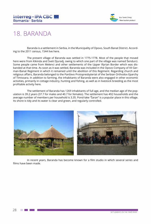
Baranda is a settlement in Serbia, in the Municipality of Opovo, South Banat District. Accord-ing to the 2011 census, 1544 live here.
The present village of Baranda was settled in 1775-1778. Most of the people that moved here were from Kikinda and Sveti Djuradj, owing to which one part of the village was named Šendurci. Some people came from Melenci and other settlements of the Upper Illyrian Border which was dis-banded at that time. As soon as it was settled, Baranda was included in the Opovo Company of XII Ger-man-Banat Regiment in which it remained until the abolition of this Regiment. Regarding church and religious affairs, Baranda belonged to the Pančevo Protopresbyteriat of the Serbian Orthodox Eparchy of Timisoara. In addition to farming, the inhabitants of Baranda were also engaged in other economic activities, primarily in cottage industry, hunting and fishing, as well as in livestock breeding as the most profitable activity here.
The settlement of Baranda has 1269 inhabitants of full age, and the median age of the pop-ulation is 39.2 years (37.7 for males and 40.7 for females). The settlement has 492 households and the average number of members per household is 3.35. Pond-lake “Šaran” is a popular place in this village. Its shore is tidy and its water is clear and green, and regularly controlled.
In recent years, Baranda has become known for a film studio in which several series and films have been made.
29SETTLEMENTS ON THE TAMIŠ RIVER
- New tourism product
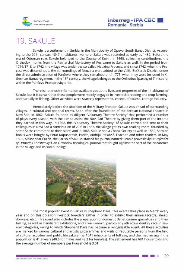
19. SAKULESakule is a settlement in Serbia, in the Municipality of Opovo, South Banat District. Accord-
ing to the 2011 census, 1847 inhabitants live here. Sakule was recorded as early as 1432. Before the era of Ottoman rule, Sakule belonged to the County of Kovin. In 1660, collecting contributions, the Orthodox monks from the Patriarchal Monastery of Peć came to Sakule as well. In the period from 1716/1718 to 1742, the village was under the so-called Neuzina Process, and since 1742, when the Pro-cess was discontinued, the surroundings of Neuzina were added to the Veliki Bečkerek District, under the direct administration of Pančevo, where they remained until 1773, when they were included in XII German-Banat regiment. In the 18th century, the village belonged to the Orthodox Eparchy of Timisoara, within the Pančevo Protopresbyteriat.
There is not much information available about the lives and properties of the inhabitants of Sakule, but it is certain that these people were mainly engaged in livestock breeding and crop farming, and partially in fishing. Other activities were scarcely represented, except, of course, cottage industry.
Immediately before the abolition of the Military Frontier, Sakule was ahead of surrounding villages, in cultural and national terms. Soon after the foundation of the Serbian National Theatre in Novi Sad, in 1862, Sakule founded its diligent “Voluntary Theatre Society” that performed a number of plays every season, with the aim to assist the Novi Sad Theatre by giving them part of the income they earned in this way. In 1862, this “Voluntary Theatre Society” of Sakule earned and sent to their colleagues in Novi Sad a contribution of 20 f. In 1867, the village got its own reading-room, founded by some Serbs committed to their place, and in 1868, Sakule had a Choral Society as well. In 1862, Serbian books were bought by Petar Kupusarević, Parish, Andrija Petković, Teacher, and other readers. In May 1895, Aleksandar Ćurčić, the Parish of Sakule, started his journal named “Branič pravoslavlja” (“Defender of Orthodox Christianity”), an Orthodox theological journal that fought against the sect of the Nazarenes in the village and its surroundings.
The most popular event in Sakule is Shepherd Days. This event takes place in March every
year and on this occasion livestock breeders gather in order to exhibit their animals (cattle, sheep, donkeys, etc.). This event also includes the preparation of domestic Banat cuisine specialities and their tasting, as well as handicraft exhibitions, and a well-known, particularly attractive donkey race in sev-eral categories, owing to which Shepherd Days has become a recognizable event. All these activities are marked by various cultural and artistic programmes and visits of reputable persons from the field of cultural activities and public life.Sakule has 1641 inhabitants of full age, and the median age if the population is 41.9 years (40.6 for males and 43.2 for females). The settlement has 681 households and the average number of members per household is 3.01.
30SETTLEMENTS ON THE TAMIŠ RIVER
- New tourism product
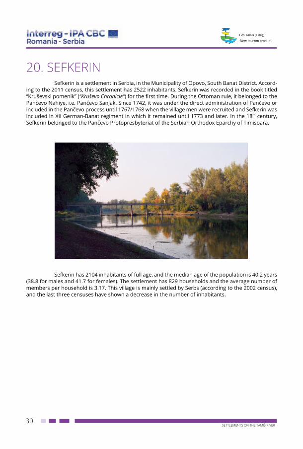
20. SEFKERINSefkerin is a settlement in Serbia, in the Municipality of Opovo, South Banat District. Accord-
ing to the 2011 census, this settlement has 2522 inhabitants. Sefkerin was recorded in the book titled “Kruševski pomenik” (“Kruševo Chronicle”) for the first time. During the Ottoman rule, it belonged to the Pančevo Nahiye, i.e. Pančevo Sanjak. Since 1742, it was under the direct administration of Pančevo or included in the Pančevo process until 1767/1768 when the village men were recruited and Sefkerin was included in XII German-Banat regiment in which it remained until 1773 and later. In the 18th century, Sefkerin belonged to the Pančevo Protopresbyteriat of the Serbian Orthodox Eparchy of Timisoara.
Sefkerin has 2104 inhabitants of full age, and the median age of the population is 40.2 years (38.8 for males and 41.7 for females). The settlement has 829 households and the average number of members per household is 3.17. This village is mainly settled by Serbs (according to the 2002 census), and the last three censuses have shown a decrease in the number of inhabitants.
31SETTLEMENTS ON THE TAMIŠ RIVER
- New tourism product
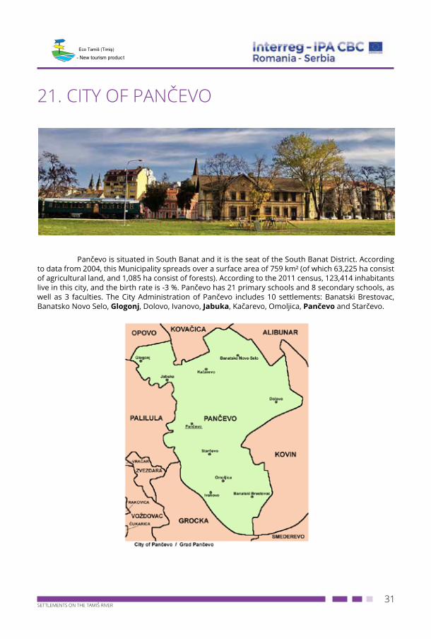
21. CITY OF PANČEVO
Pančevo is situated in South Banat and it is the seat of the South Banat District. According to data from 2004, this Municipality spreads over a surface area of 759 km² (of which 63,225 ha consist of agricultural land, and 1,085 ha consist of forests). According to the 2011 census, 123,414 inhabitants live in this city, and the birth rate is -3 %. Pančevo has 21 primary schools and 8 secondary schools, as well as 3 faculties. The City Administration of Pančevo includes 10 settlements: Banatski Brestovac, Banatsko Novo Selo, Glogonj, Dolovo, Ivanovo, Jabuka, Kačarevo, Omoljica, Pančevo and Starčevo.
32SETTLEMENTS ON THE TAMIŠ RIVER
- New tourism product
The most significant events are:
• Bacon Festival in Kačarevo, an economic and tourism event, in February• Wine Festival in Dolovo, in March• Weifert Days in Pančevo, in June• International Carnival of Pančevo, in June• Ilinden (Saint Elia’s Day) in Jabuka, in August• Paprika Festival in Banatski Brestovac, in August• Family Days, a film, theatre, literature and folklore festival and art colony, in August• Strudel Festival in Dolovo, in September.
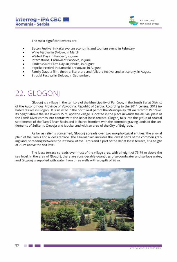
22. GLOGONJGlogonj is a village in the territory of the Municipality of Pančevo, in the South Banat District
of the Autonomous Province of Vojvodina, Republic of Serbia. According to the 2011 census, 3012 in-habitants live in Glogonj. It is situated in the northwest part of the Municipality, 20 km far from Pančevo. Its height above the sea level is 75 m, and the village is located in the place in which the alluvial plain of the Tamiš River comes into contact with the Banat loess terrace. Glogonj falls into the group of coastal settlements of the Tamiš River Basin and it shares frontiers with the common grazing lands of the set-tlements of Sefkerin, Crepaja and Jabuka, and with an area of the City of Belgrade.
As far as relief is concerned, Glogonj spreads over two morphological entities: the alluvial plain of the Tamiš and a loess terrace. The alluvial plain includes the lowest parts of the common graz-ing land, spreading between the left bank of the Tamiš and a part of the Banat loess terrace, at a height of 73 m above the sea level.
The loess terrace spreads over most of the village area, with a height of 75-79 m above the sea level. In the area of Glogonj, there are considerable quantities of groundwater and surface water, and Glogonj is supplied with water from three wells with a depth of 96 m.
33SETTLEMENTS ON THE TAMIŠ RIVER
- New tourism product
In the territory of Glogonj, the Tamiš has a small inclination which causes the formation of meanders, bends and oxbow lakes. Its high water level poses a threat of floods. In the common graz-ing land of Glogonj, the soil is mainly composed of chernozem with carbonates, marshy black soil and smonitza salinized or with salinized spots, as well as of saline solonetz soil by the Tamiš River.
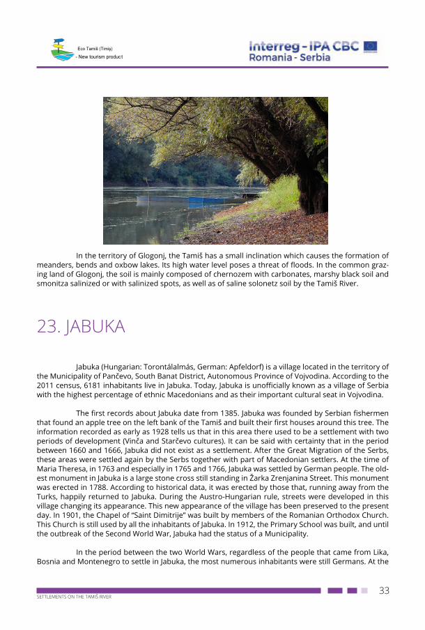
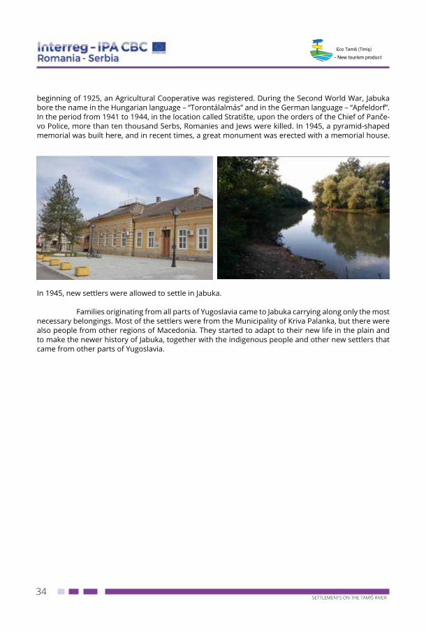
23. JABUKA
Jabuka (Hungarian: Torontálalmás, German: Apfeldorf) is a village located in the territory of the Municipality of Pančevo, South Banat District, Autonomous Province of Vojvodina. According to the 2011 census, 6181 inhabitants live in Jabuka. Today, Jabuka is unofficially known as a village of Serbia with the highest percentage of ethnic Macedonians and as their important cultural seat in Vojvodina.
The first records about Jabuka date from 1385. Jabuka was founded by Serbian fishermen that found an apple tree on the left bank of the Tamiš and built their first houses around this tree. The information recorded as early as 1928 tells us that in this area there used to be a settlement with two periods of development (Vinča and Starčevo cultures). It can be said with certainty that in the period between 1660 and 1666, Jabuka did not exist as a settlement. After the Great Migration of the Serbs, these areas were settled again by the Serbs together with part of Macedonian settlers. At the time of Maria Theresa, in 1763 and especially in 1765 and 1766, Jabuka was settled by German people. The old-est monument in Jabuka is a large stone cross still standing in Žarka Zrenjanina Street. This monument was erected in 1788. According to historical data, it was erected by those that, running away from the Turks, happily returned to Jabuka. During the Austro-Hungarian rule, streets were developed in this village changing its appearance. This new appearance of the village has been preserved to the present day. In 1901, the Chapel of “Saint Dimitrije” was built by members of the Romanian Orthodox Church. This Church is still used by all the inhabitants of Jabuka. In 1912, the Primary School was built, and until the outbreak of the Second World War, Jabuka had the status of a Municipality.
In the period between the two World Wars, regardless of the people that came from Lika, Bosnia and Montenegro to settle in Jabuka, the most numerous inhabitants were still Germans. At the
34SETTLEMENTS ON THE TAMIŠ RIVER
- New tourism product
beginning of 1925, an Agricultural Cooperative was registered. During the Second World War, Jabuka bore the name in the Hungarian language – “Torontálalmás” and in the German language – “Apfeldorf”. In the period from 1941 to 1944, in the location called Stratište, upon the orders of the Chief of Panče-vo Police, more than ten thousand Serbs, Romanies and Jews were killed. In 1945, a pyramid-shaped memorial was built here, and in recent times, a great monument was erected with a memorial house.
In 1945, new settlers were allowed to settle in Jabuka.
Families originating from all parts of Yugoslavia came to Jabuka carrying along only the most necessary belongings. Most of the settlers were from the Municipality of Kriva Palanka, but there were also people from other regions of Macedonia. They started to adapt to their new life in the plain and to make the newer history of Jabuka, together with the indigenous people and other new settlers that came from other parts of Yugoslavia.
35SETTLEMENTS ON THE TAMIŠ RIVER
- New tourism product
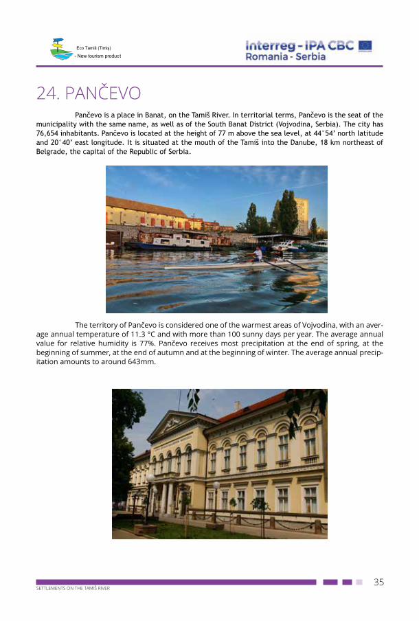
24. PANČEVOPančevo is a place in Banat, on the Tamiš River. In territorial terms, Pančevo is the seat of the
municipality with the same name, as well as of the South Banat District (Vojvodina, Serbia). The city has 76,654 inhabitants. Pančevo is located at the height of 77 m above the sea level, at 44°54’ north latitude and 20°40’ east longitude. It is situated at the mouth of the Tamiš into the Danube, 18 km northeast of Belgrade, the capital of the Republic of Serbia.
The territory of Pančevo is considered one of the warmest areas of Vojvodina, with an aver-
age annual temperature of 11.3 °C and with more than 100 sunny days per year. The average annual value for relative humidity is 77%. Pančevo receives most precipitation at the end of spring, at the beginning of summer, at the end of autumn and at the beginning of winter. The average annual precip-itation amounts to around 643mm.
36SETTLEMENTS ON THE TAMIŠ RIVER
- New tourism product
Pančevo has a humid continental climate, with four seasons, characterized by long and hot summers, warm autumns, mild winters and short springs. A peculiarity of the climate is košava, a strong and dry south or southeast wind that may last up to three weeks. In addition to košava, southwest, west and north winds also blow here. The number of windy days per year is 45. Relative humidity is at its highest in the months with the lowest temperatures (November, December, January and February).
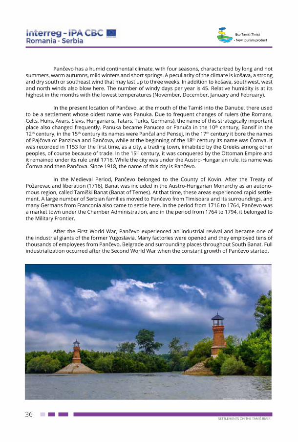
In the present location of Pančevo, at the mouth of the Tamiš into the Danube, there used to be a settlement whose oldest name was Panuka. Due to frequent changes of rulers (the Romans, Celts, Huns, Avars, Slavs, Hungarians, Tatars, Turks, Germans), the name of this strategically important place also changed frequently. Panuka became Panucea or Panuča in the 10th century, Bansif in the 12th century, in the 15th century its names were Pančal and Pensej, in the 17th century it bore the names of Pajčova or Panziova and Bančova, while at the beginning of the 18th century its name was Čomva. It was recorded in 1153 for the first time, as a city, a trading town, inhabited by the Greeks among other peoples, of course because of trade. In the 15th century, it was conquered by the Ottoman Empire and it remained under its rule until 1716. While the city was under the Austro-Hungarian rule, its name was Čomva and then Pančova. Since 1918, the name of this city is Pančevo.
In the Medieval Period, Pančevo belonged to the County of Kovin. After the Treaty of Požarevac and liberation (1716), Banat was included in the Austro-Hungarian Monarchy as an autono-mous region, called Tamiški Banat (Banat of Temes). At that time, these areas experienced rapid settle-ment. A large number of Serbian families moved to Pančevo from Timisoara and its surroundings, and many Germans from Franconia also came to settle here. In the period from 1716 to 1764, Pančevo was a market town under the Chamber Administration, and in the period from 1764 to 1794, it belonged to the Military Frontier.
After the First World War, Pančevo experienced an industrial revival and became one of the industrial giants of the former Yugoslavia. Many factories were opened and they employed tens of thousands of employees from Pančevo, Belgrade and surrounding places throughout South Banat. Full industrialization occurred after the Second World War when the constant growth of Pančevo started.
37SETTLEMENTS ON THE TAMIŠ RIVER
- New tourism product
The most significant events in the City of Pančevo take place mainly in summer, and the following events that have been held in recent years should particularly be mentioned: “Weifert Days”, “International Carnival of Pančevo” and “The Danube Day”. In the close vicinity of Pančevo, there are Nature Reserve Deliblatska Peščara (Deliblato Sands) and Nature Park Ponjavica.
The information on the history of the city is kept and processed in professional institutions: the National Museum, City Library, Historical Archives and Institute for the Protection of Cultural Mon-uments. The National Museum, founded in 1923, includes departments of archaeology, history, art his-tory and ethnology, as well as a permanent exhibition and an exhibition hall. The collections of the Mu-seum include the bequests of Olga Smederevac, Zoran Petrović, Slavko Pavlov and Stojan Trumić, while one of the most valuable art exhibits is the great painting “Seoba Srba” (“The Migration of the Serbs”) by Paja Jovanović. In the 19th century, a large number of reading rooms were opened in Pančevo. Today, the City Library keeps publications at the lending departments for children and adults, within scientific and regional holdings, and in its reading room. This institution has more than 135,000 books, and the oldest one is the book titled “On Duties”, by Cicero, printed in 1561. The Historical Archives of Pančevo keeps 795 holdings. One of the most orderly arranged holdings is the holding of the Town Hall that includes written materials on everyday affairs from the period from 1794 to 1872. The Archives keeps nine kilometres of archival shelving and it is one of the largest institutions of this type in the country. The Institute for the Protection of Cultural Monuments takes care of immovable cultural property in the territory of eight municipalities of South Banat. In the Municipality of Pančevo, three cultural mon-uments have been proclaimed immovable cultural property of great importance. These are the Church of Holy Transfiguration, Vojlovica Monastery and archaeological site “Starčevo Grad” in Starčevo.