Embed Size (px)
Citation preview

jtiSfti•fmd L̂II Section F
Selected Theories tion
- 1 . " I *" " .,- ' :i
• . • o | f l i . , , i i , l , ^:
•m, ,...

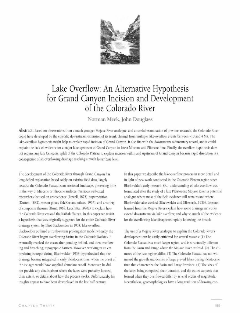
Lake Overflow: An Alternative Hypothesis for Grand Canyon Incision and Development
of the Colorado River Norman Meek, John Douglass
Abstract: Based on observations from a much younger Mojave River analogue, and a careful examination of previous research, the Colorado River
could have developed by the episodic downstream extension of its trunk channel from multiple lake-overflow events between -10 and 4 Ma. The
lake-overflow hypothesis might help to explain rapid incision of Grand Canyon. It also fits with the downstream sedimentary record, and it could
explain the lack of evidence for a major lake upstream of Grand Canyon in latest Miocene and Phocene time. Finally the overflow hypothesis does
not require any late Cenozoic uplift of the Colorado Plateau to explain incision within and upstream of Grand Canyon because rapid dissection is a
consequence of an overflowing drainage reaching a much lower base level.
The development of the Colorado River through Grand Canyon has In this paper we describe the lake-overflow process in more detail and
long defied explanation based solely on existing field data, largely in light of new work conducted in the Colorado Plateau region since
because the Colorado Plateau is an erosional landscape, preserving little Blackwelder's early research. Our understanding of lake overflow was
in the way of Miocene or Pliocene surfaces. Previous well-cited formulated after the study of a late Pleistocene Mojave River, a potential
researchers focused on antecedence (Powell, 1875), superposition analogue where most of the field evidence still remains and where
(Dutton, 1882), stream piracy (McKee and others, 1967), and a variety Blackwelder also worked (Blackwelder and Ellsworth, 1936). Lessons
of composite theories (Hunt, 1969; Lucchitta, 1990a) to explain how learned from the Mojave River explain how some drainage networks
the Colorado River crossed the Kaibab Plateau. In this paper we revisit extend downstream via lake overflow, and why so much of the evidence
a hypothesis that was originally suggested for the entire Colorado River for the overflowing lake disappears rapidly following the breach.
drainage system by Eliot Blackwelder m 1934: lake overflow
Blackwelder outlined a trunk-stream prolongation model whereby the The use of a Mojave River analogue to explain the Colorado Rivers
Colorado River began overflowing basins in the Colorado Rockies. It development can be easily criticized for several reasons: (1) The
eventually reached the ocean after ponding behind, and then overflow Colorado Plateau is a much larger region, and is structurally different
ing and breaching, topographic barriers. However, working in an era from the Basin and Range where the Mojave River evolved. (2) The cli
predating isotopic dating, Blackwelder (1934) hypothesized that the mates of the two regions differ. (3) The Colorado Plateau has not wit
drainage became integrated in early Pleistocene time, when the onset of nessed the growth and demise of large pluvial lakes during Pleistocene
the ice ages would have supplied abundant runoff. Moreover, he did time that characterize the Basin and Range Province. (4) The sizes of
not provide any details about where the lakes were probably located, the lakes being compared, their duration, and the oudet canyons that
their extent, or details about how the process works. Unfortunately his formed when they overflowed differ by several orders of magnitude.
insights appear to have been downplayed in the last half century. Nevertheless, geomorphologists have a long tradition of drawing con-
C H A P T E R T H I R T Y
elusions from evidence viewed at different scales, and the Mojave River
system reveals important clues about lake-overflow processes and the
preservation of the sedimentary record—insights that justifiably warrant a
reexamination of the lake-overflow model at this time.
The lake-overflow model is consistent with much field evidence in the
Colorado River drainage network (Spencer and Pearlhree, this volume). In
addition, the deductive approach has the advantage of predicting what
should be found through additional field studies both upstream and
downstream of Grand Canyon, and suggests new avenues for future
research where scientists can test predictions.
The Mojave River Analogue
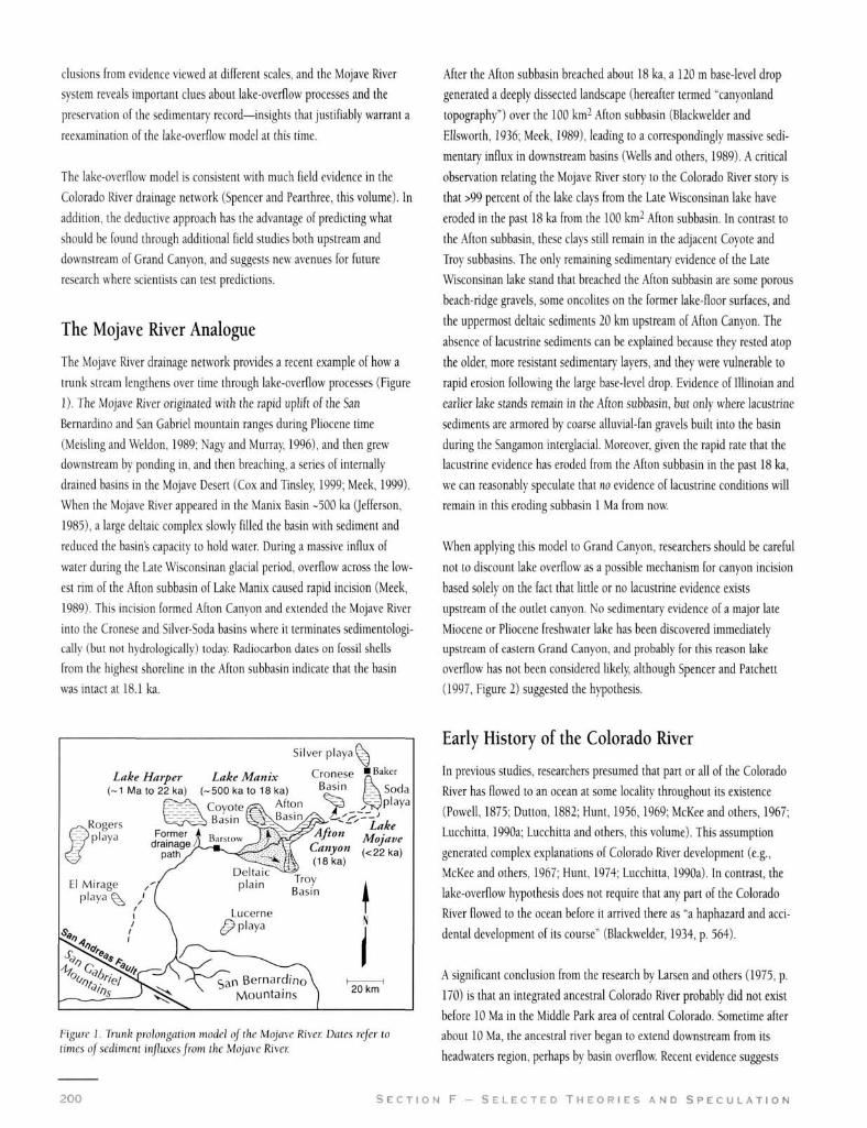
The Mojave River drainage network provides a recent example of how a
trunk stream lengthens over time through lake-overnow processes (Figure
1). The Mojave River originated with the rapid uphft of the San
Bernardino and San Gabriel mountain ranges during Pliocene time
(Meisling and Weldon, 1989; Nagy and Murray 1996), and then grew
downstream by ponding in, and then breaching, a series of internally
drained basins in the Mojave Desert (Cox and Tinsley 1999; Meek, 1999).
When the Mojave River appeared in the Manix Basin -500 ka (Jefferson,
1985), a large deltaic complex slowly filled the basin with sediment and
reduced the basin's capacity to hold water. During a massive influx of
water during the Late Wisconsinan glacial period, overflow across the low
est rim of the Afton subbasin of Lake Manix caused rapid incision (Meek,
1989). This incision formed Afton Canyon and extended the Mojave River
into the Cronese and Silver-Soda basins where it terminates sedimentologi
cally (but not hydrologically) today Radiocarbon dates on fossil shells
from the highest shoreline in the Ahon subbasin indicate that the basin
was intact at 18.1 ka.
Silver p laya\ \
Lake Harper Lake Manix Cronese RBaker (~1Mato22ka) (~500kato 18ka) ^̂ f̂ " K \ Soda
Afton ^ JS^playa
y . „ ^ Lake ^Afton ., •
•'"ty"" ka)
Mojave (<22ka)
t
20 km
Figure I. Tinnk prolongation model ojthe Mojave Rivcc Dales refer to times oj sediment infltaesjrom the Mojave Rivec
200 S E C T I O N
After the Afton subbasin breached about 18 ka, a 120 m base-level drop
generated a deeply dissected landscape (hereafter termed "canyonland
topography") over the 100 km- Afton subbasin (Blackwelder and
Ellsworth, 1936; Meek, 1989), leading to a correspondingly massive sedi
mentary influx in downstream basins (Wells and others, 1989). A cridcal
observation relating the Mojave River ston' to the Colorado River story is
that >99 percent of the lake clays from the Late Wisconsinan lake have
eroded in the past 18 ka from the 100 km^ Afton subbasin. In contrast to
the Afton subbasin, these clays still remain in the adjacent Coyote and
Troy subbasins. The only remaining sedimentary evidence of the Late
Wisconsinan lake stand that breached the Afton subbasin are some porous
beach-ridge gravels, some oncolites on the former lake-floor surfaces, and
the uppermost deltaic sediments 20 km upstream of Afton Canyon. The
absence of lacustrine sediments can be explained because they rested atop
the older, more resistant sedimentary layers, and they were vulnerable to
rapid erosion following the large base-level drop. Evidence of lllinoian and
earlier lake stands remain in the Afton subbasin, but only where lacustrine
sediments are armored by coarse alluvial-fan gravels built into the basin
during the Sangamon interglacial. Moreover, given the rapid rate that the
lacustrine evidence has eroded from the Afton subbasin in the past 18 ka,
we can reasonably speculate that no evidence of lacustrine conditions will
remain in this eroding subbasin 1 Ma from now.
When applying this model to Grand Canyon, researchers should be careful
not to discount lake overflow as a possible mechanism for canyon incision
based solely on the fact that httle or no lacustrine evidence exists
upstream of the outlet canyon. No sedimentary evidence of a major late
Miocene or Pliocene freshwater lake has been discovered immediately
upstream of eastern Grand Canyon, and probably for this reason lake
overflow has not been considered likely although Spencer and Patchett
(1997, Figure 2) suggested the hypothesis.
Early History of the Colorado River
In previous studies, researchers presumed that part or all of the Colorado
River has flowed to an ocean at some locality throughout its existence
(Powell, 1875; Dutton, 1882; Hunt, 1956,1969; McKee and others, 1967;
Lucchitta, 1990a; Lucchitta and others, this volume). This assumption
generated complex explanations of Colorado River development (e.g.,
McKee and others, 1967; Hunt, 1974; Lucchitta, 1990a). In contrast, the
lake-overflow hypothesis does not require that any part of the Colorado
River flowed to the ocean before it arrived there as "a haphazard and acci
dental development of its course" (Blackwelder, 1934, p. 564).
A significant conclusion from the research by Larsen and others (1975, p.
170) is that an integrated ancestral Colorado River probably did not exist
before 10 Ma in the Middle Park area of central Colorado. Sometime after
about 10 Ma, the ancestral river began to extend downstream from its
headwaters region, perhaps by basin overflow. Recent evidence suggests
F - S E L E C T E D T H E O R I E S A N D S P E C U L A T I O N
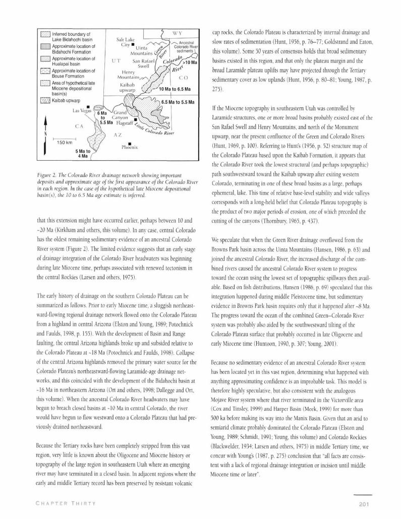
Inferred boundary of cap rocks, the Colorado Plateau is characterized by internal drainage and
Lake Bidahochi basin Salt Lake Approximate location of C i t y " , . n Bidahochi Formation ' Uinta jrt/^
Mountains Ci/\'s'' kx-.w I Approximate location of
I ' T San Rafael Hualapai basin
Swell / r^'^, ^B*. Approximate location of Henry )C/A^''Bouse Formation Mountains,/7^\/'' y / ' C O Area of hypothetical late Kaibab / ' J i" Miocene depositional upwarp l,/^,—'10 Ma to 6.5 Ma basin(s) Kaibab upwarp
• Las Vegas
Figure 2. Tlie CaXoxaAo River (ficiiiiiigc iiclvvork showing impoiitiiil de'fw.sil.s m\A approximale age oj the first appemwicc oflhe Colorado River in each region. In the ease of the hypothetical late Miocene dcpositioiwl kisin(s), (lie JO to 6.5 Ma age cslimutt' Is inferred.
that this extension might have occurred earlier, perhaps between 10 and
-20 Ma (Kirkham and others, this volume). In any case, central Colorado
has the oldest remaining sedimentary evidence of an ancestral Colorado
River system (Figure 2). The limited evidence suggests that an early stage
of drainage integration of the Colorado River headwaters was beginning
during late Miocene time, perhaps associated with renewed teclonism in
the central Rockies (Larsen and others, 1975).
The early histor)' of drainage on the southern Colorado Plateau can be
summarized as follows. Prior to early Miocene time, a sluggish northeast
ward-flowing regional drainage network flowed onto the Colorado Plateau
from a highland in central Arizona (Elston and Young, 1989; Potochnick
and Faulds, 1998, p. 155). With the development of Basin and Range
faulting, the central Arizona highlands broke up and subsided relative to
the Colorado Plateau at -18 Ma (Potochnick and Faulds, 1998). Collapse
of the central Arizona highlands removed the primar)- water source for the
Colorado Plateau's northeastward-flowing Laramide-age drainage net
works, and this coincided with the development of the Bidahochi basin at
-16 Ma in northeastern Arizona (Ort and others, 1998; Dallegge and Ort,
this volume). When the ancestral Colorado River headwaters may have
begun to breach closed basins at -10 Ma in central Colorado, the river
would have begun to flow westward onto a Colorado Plateau that had pre
viously drained northeastward.
Because the Tertiary rocks have been completely stripped from this vast
region, very little is known about the Oligocene and Miocene history or
topography of the large region in southeastern Utah where an emerging
river may have terminated in a closed basin. In adjacent regions where the
earl)- and middle Tertiary- record has been preserved by resistant volcanic
slow rates of sedimentation (Hunt, 1956, p. 76-77; Goldstrand and Eaton,
this volume). Some 50 years of consensus holds that broad sedimentary
basins existed in this region, and that only the plateau margin and the
broad Laramide plateau uplifts may have projected through the Tertiar)'
sedimentar)- cover as low uplands (Hunt, 1956, p. 80-81; Young, 1987, p.
275).
If the Miocene topography in southeastern Utah was controlled by
Laramide structures, one or more broad basins probably existed east of the
San Rafael Swell and Henry Mountains, and north of the Monument
upwarp, near the present confluence of the Green and Colorado Rivers
(Hunt, 1969, p. 100). Referring to Hunt's (1956, p. 52) structure map of
the Colorado Plateau based upon the Kaibab Formation, it appears that
the Colorado River took the lowest structural (and perhaps topographic)
path southwestward toward the Kaibab upwarp after exiting western
Colorado, terminating in one of these broad basins as a large, perhaps
ephemeral, lake. This time of relative base-level stability and wide valleys
corresponds with a long-held belief that Colorado Plateau topography is
the product of two major periods of erosion, one of which preceded the
cutting of the canyons (Thornbur)-. 1965, p. 437).
We speculate that when the Green River drainage overflowed from the
Browns Park basin across the Uinta Mountains (Hansen, 1986, p. 63) and
joined the ancestral Colorado River, the increased discharge of the com
bined rivers caused the ancestral Colorado River system to progress
toward the ocean using the lowest set of topographic spillways then avail
able. Based on fish distributions, Hansen (1986, p. 69) speculated that this
integration happened during middle Pleistocene time, but sedimentary
evidence in Browns Park basin requires only that it happened after -8 Ma.
The progress toward the ocean of the combined Green-Colorado River
system was probably also aided by the southwestw-ard tilting of the
Colorado Plateau surface that probably occurred in late Oligocene and
early Miocene time (Huntoon, 1990, p. 307; Young, 2001).
Because no sedimentary evidence of an ancestral Colorado River system
has been located yet in this vast region, determining what happened with
anything approximating confidence is an improbable task. This model is
therefore highly speculative, but also consistent with the analogous
Mojave River system where that river terminated in the Victorville area
(Cox and Tinslcy, 1999) and Harper Basin (Meek, 1999) lor more than
500 ka before making its way into the Manix Basin. Given that an arid to
semiarid climate probably dominated the Colorado Plateau (Elston and
Young, 1989; Schmidt, 1991; Young, this volume) and Colorado Rockies
(Blackwelder, 1934; Larsen and others, 1975) in middle Tertiary- time, we
concur with Young's (1987, p. 275) conclusion that "all facts are consis
tent with a lack of regional drainage integration or incision until middle
Miocene time or later".
C H A P T E R T H I R T Y 201
1
Skeptics of the overflow hypothesis may point to the lack of evidence for -7 Ma pre-Colorado River -5.5 Ma Lake Bidahochi overflows
Oligocene or early Miocene sediments in southeastern Utah as being "con
venient" for the model. Although it seems improbable that such a record
could be completely eroded, there are at least three arguments for why
such a sequence could have existed and has been lost: (1) Unlike central
Utah, central Arizona, and southwestern Colorado, there were no Tertiar)'
lavas in southeastern Utah that might have protected the Oligocene-early
Miocene section from erosion. (2) After the subsidence of the central
Arizona highlands in early Miocene time, there were no major sources of
alluvial gravels for the northeast flowing drainages that might have formed
a thick, resistant cap rock layer on an elevated Miocene surface in this
region. (3) Dumitru and others (1994, p. 502) report apatite fission-track
data that show between 2 and 3 km of Tertiar)' burial in the adjacent
Waterpocket Fold region of south-central Utah, which corresponds with
Hunts (1956) belief that the Henry Mountains may have been almost
buried by Tertiary sediments before the region was exhumed.
The Lake-overflow Hypothesis and Grand Canyon Incision
Just as a large lake overspilled the Manix Basin and initiated the incision
of Afton Canyon, we propose that a large lake spilled westward across the
Kaibab Plateau, initiating Grand Canyon incision. The deep-water lake
that would have spilled over the Kaibab Plateau could be called Lake
Bidahochi after the Bidahochi Formation of northeastern Arizona.
However, this hypothetical lake probably existed after most of the remain
ing deposits of the Bidahochi Formation were laid down, just as the Late
Wisconsinan Lake Manix postdates the older Pleistocene strata that still
remain in the Afton subbasin.
The Bidahochi Formation consists of volcanic (Hopi Buttes), lacustrine,
eolian, and fluvial facies (Scarborough. 1989; Ort and others 1998).
During the depositiona! time frame of the formation (-16 Ma to -6.5 Ma),
the sedimentology supports the existence of a large closed basin (White,
1980) with some lacustrine horizons. The Bidahochi basin was integrated
with the Colorado River sometime after 6.5 Ma (Ort and others, 1998),
and western Grand Canyon probably began to incise sometime after 6 Ma
(Lucchilta, 1990a). Thus, there is an apparent temporal sequence of the
apparent demise of a basin that persisted for 10 Ma (On and others, 1998;
Dallegge and Ort, this volume), followed by incision of a large canyon
along the basin's western boundar)-. A key issue is whether this evidence
can be explained easily in terms of lake-overflow creating canyon incision.
A hypothetical paleogeographic time series (Figure 3) was constructed
using scarp-retreat rates for the Vermilion and Echo Cliffs, estimated from
Schmidt (1988). Scarp-retreat rates vary depending on numerous factors
(Young, 1985), including cliff height and whether the scarp is retreating
up or down a structural slope. These and other factors were taken into
\ N
w^
^ ^ ^ ^ ^; '
Present landscape
20 km ^ , /.;
^^P • 'y'-y 1 }. :';••): •; • '.'•;
/MarbleVICejar ^^^1 •1 CanyonJ\|,jdge
Eastern V ̂ *^ / K ̂ lillle \s Grand -"'^ ^_ _ y K\ I Colorado j
Canyon •l^/;;^ ^ ; ̂ (River gorge/
I I Lakes [ I Reconstructed plateaus
Y/^/\ Kaibab upwarp (Vermilion and Echo Cliffs)
[->r-:j Internal drainage [ j Reconstructed Red Butte scarp
Figure .3. Luiidscupf evolution time series o\ the eastern Crand Canyon region (ajtcr Douglass, 1999). The reconstructed plateaus are based on average scarp retreat rates of the Veniiiiio?! Clijjfs, Echo Clijjs and Red Bu((e scarp. The suijace elevation and extent of the hypothetical 5.5 Ma Lake Bidalioclii is unknown, and some cliffs may have projected through the lake to form linear islands within the area shown. The estimated timeline is only approximate.
account when tr)'ing to reconstruct the paleogeography of the eastern
Grand Canyon region (Douglass, 1999). Also, the existence of a hypothet
ical Red Butte scarp (Lucchitta, 1990a) explains the curved course of the
Colorado River across the Kaibab Plateau.
The reconstructed scarp model is critical because it illustrates that the
Kaibab upwarp would have been the lowest spillway in late Miocene time
(Lucchitta, 1990a), rather than a more northerly route through the Virgin
River drainage basin. Secondly if the reconstructed scarp positions are
continued further back in time than the latest Miocene, much of the
Kaibab Plateau and surrounding landscape might have been covered with
a sequence of younger strata. The possible presence of such layers argues
against a dual phase Laramide-Pliocene origin of Grand Canyon
(Scarborough, this volume) with a h)'pothetical Laramide valley within the
modern canyon. Either scarps such as Red Butte did not begin to retreat
from the hypothetical Laramide-age river valley until the late Miocene, or
their rates of retreat have been overestimated by Lucchitta (1990a) by at
least an order of magnitude.
S E C T I O N F - S E L E C T E D T H E O R I E S A N D S P E C U L A T I O N 202
The paleogeographic time series begins ~7 Ma (see Figure 3a) and esti
mates positions of the Vermilion Cliffs, Echo Cliffs, Red Butte scarp, and
an undissected Bidahochi basin in relation to the Kaibab upwarp. Based on
the Bidahochi Formation's stratigraphy, the Colorado River probably did
not flow into the region at this time (Scarborough, 1989; Ort and others
1998), but instead ponded somewhere in eastern Utah.
Our hypothesis is that the Colorado River arrived and ponded in the
Bidahochi basin sometime after 6.5 Ma. The deep-water Lake Bidahochi
that eventually overtopped the Kaibab Plateau (Figure 3b) probably dis
charged water through, and then downstream of, the Grand Canyon
region using an assortment of lowest spillovers and preexisting topograph
ic pathways that probably already existed in the western Grand Canyon
region (Spencer and Pearthree, this volume). Evidence for this spillover
event includes Spencer and Patchett's (1997) and Patchett and Spencer's
(this volume) analysis of strontium concentrations in the Bouse Formation
along the lower Colorado River corridor. The strontium concentrations are
consistent with inOow of Colorado River water, and the event occurred
after 6 Ma (Spencer and Pearthree, this volume).
Because lake-outlet water Oowed to a base level in the Lake Mead area that
was -1500 m lower than the spillover point (near Grandview Point on the
South Rim of Grand Canyon), the channel slope was sufficiently steep to
initiate Grand Canyon incision, which probably then created knickpoints
that rapidly worked their way upstream. The rate of incision must have
been very high, as Hamblin's (1994, p. lU) study of lava-dam erosion in
the canyon demonstrates.
As portrayed in the next time series map (Figure 3c), the lake elevation
may have decreased until it separated into two lakes across Cedar Ridge.
Marble Canyon and the Little Colorado River gorge currently dissect the
northern portion of the Bidahochi basin adjacent to the Kaibab upwarp.
The subtle anticlinal upwarp of Cedar Ridge extends from the confluence
of the two canyons northeastward to the base of the Echo Cliffs.
Longitudinal profiles comparing the difference in elevation between the
Colorado and Little Colorado Rivers and the rims of Marble Canyon and
the Little Colorado River gorge illustrate that both rivers now flow against
the north and south structural slopes of Cedar Ridge respectively These
relationships cannot be explained easily by a headward-eroding Colorado
River system. Rather, current longitudinal profiles make better sense if
these rivers were superimposed onto the anticline from untoniformable
Strata such as the Bidahochi Formation, or if Lake Bidahochi split into two
lakes as it drained.
The first appearance of Colorado River gravels downstream of Grand
Canyon indicate that through flow definitely occurred by ~4 Ma (Buising,
1990). The last map in the time series (Figure 3d) illustrates the present
landscape of the eastern Grand Canyon region.
C H A P T E R T H I R T Y
Field Evidence and the Lake-overflow Hypothesis
Because of the erosional nature of the Colorado Plateau within and
upstream of Grand Canyon, no deposits are known to exist in that region
that inform on the late Miocene or Pliocene development of the Colorado
River However, new research on several formations and deposits down
stream of Grand Canyon shed light on the initial arrival of the Colorado
River there (Figure 2).
Prior to the first arrival of Colorado River water in latest Miocene time,
interior drainage dominated the region immediately west of Grand
Canyon (Blackwelder, 1934; Longwell, 1946). The sedimentar)' evidence
includes fluvial and lacustrine deposits of the Muddy Creek Formation
deposited between 10.6 and -6 Ma (Bohannon, 1984). In several areas the
uppermost unit in the Muddy Creek Formation is the Hualapai Limestone
(Blair and Armstrong, 1979). Lucchitta (1990a) and Spencer and others
(1998) showed that a large river did not empty into the Hualapai basin
before 6 Ma, indicating that the Colorado River had not yet arrived west of
Grand Canyon during Muddy Creek time.
The presence of the fossils of large freshwater fish in the White Narrows
Formation of southern Nevada deposited about 4.7 Ma (Reynolds and
Lindsay, 1999) provides evidence for the appearance of the Colorado River
dovrastream of Grand Canyon. The large fish (suckers and perch) indicate
a ihroughflowing drainage system dissecting the Muddy Creek Formation
and a connection with a major river system, presumably the Colorado
River (Reynolds and Lindsay 1999).
The Colorado River extended along the lower Colorado River corridor and
deposited the Bouse Formation downstream of the Hualapai basin. The
mostly lacustrine Bouse Formation (Spencer and Patchett, 1997; Patchett
and Spencer, this volume) indicates that at least two, and perhaps four,
lake basins were filled and then breached following the arrival of the
Colorado River (Spencer and Patchett, 1997). These lakes were contained
by the four paleodams (Lakes Mohave, Topock, Havasu, and Chocolate-
Trigo) that are depicted by Spencer and Patchett (1977, fig. 3). However,
the interpretation of the Bouse Formation as a freshwater deposit remains
controversial (see Lucchitta and others, this volume).
Farther downstream and upsection from the Bouse Formation, the Palm
Springs and imperial Formations arc partially composed of Colorado River
fluvial and deltaic deposits (Crowell and Baca, 1979; Fleming 1994).
Included in the Imperial and Palm Springs Formations is the sequential
deposition of Cretaceous pollen from the Colorado Plateau. The pollen
record indicates that massive erosion of Cretaceous rocks of the southern
Colorado Plateau began before 4.5 Ma, and that rapid erosion of the
Cretaceous rocks of the northern part of the plateau began -3.9 Ma
(Fleming, 1994; Remeika, 1998). Previously, researchers accounted for
203
the upstream proliferation of Pliocene degradation from the Grand
Canyon region by demonstrating that the climate was possibly wetter and
cooler during this time period (Fleming, 1994). However, climate alone
does nol explain why the degradation was localized to the Grand Canyon
region originally and then proliferated upstream dramatically Because the
degradation radiated from a specific region, a dramatic base-level reduc
tion in the Grand Canyon region initiated by lake overflow and incision
plausibly explains this degradation sequence also.
Presently it appears that the Colorado River ma\' have extended its trunk
channel via lake overflow in three separate localities: (1) during its incep
tion in the central Rocky Mountains, (2) in the Hualapai basin, (3) and in
the Bouse Formation basins. The predominance of the episodic extension
of the Colorado River by lake-overflow events coupled with the down
stream progression of dates associated with the first arrival of the
Colorado River suggests that the lake-overflow hypothesis might apply to
the entire Colorado River system, including the Grand Canyon reach—a
notion proposed almost seventy years ago (Blackwelder, 1934).
Implications for Timing of Colorado Plateau Uplift
The overflow hypothesis, if valid, may shed light on a controversy
regarding the timing of Colorado Plateau uphft. Hunt (1956), McKee
and McKee (1972), Lucchitta (1984), Lucchitta and others (this vol
ume), and several others have claimed that the rapid incision of the
Colorado Plateau rellects, and is probably a consequence of the late
Cenozoic uplift of the Colorado Plateau. Moreover, geomorphologists
have long believed that epeirogenic uplift of the Colorado Plateau start
ing during middle Tertiary time (Thornbury, 1965, p. 436) may be part
ly responsible for some unusual river features on the Colorado Plateau
such as the entrenched meanders of the San Juan River (Moore, 1926,
p. 55). The controversy exists because there is no compelling evidence
for any significant late Miocene or Pliocene uplift of the southwestern
margin of the Colorado Plateau (Lovejoy 1973; Young, 2001).
However, it is also possible that the large base-level difference between
the Basin and Range and Colorado Plateau was caused mostly by the
extension and subsidence of the adjacent Basin and Range during
Miocene lime when much of the Colorado Plateau may have remained
comparatively stable at or near its present elevation (Young, 2001;
Naeser and others, this volume). If a large ancestral Colorado River sys
tem spilled over the Kaibab Plateau in latest Miocene or Pliocene time
as we have proposed, the resultant base-level drop of -1500 m could
easily explain the development of canyonland topography in the
Colorado Plateau as the trunk stream and its tributaries began to rapid
ly adjust to the much lower base level in the Basin and Range. Thus,
the lake-overflow hypothesis does not require any young uplift of the
Colorado Plateau, and the principle, "no uplift, no canyons" (Lucchitta
and others, this volume), might be edited to read, "no base-level
change, no canyons."
Conclusion
Based on a large number of possible parallels between drainage histo
ries and canyonland landscapes of the Mojave and Colorado Rivers, the
lake-overflow hypothesis is a simple deductive explanation for the initi
ation of Grand Canyon incision and Colorado River development.
Following their inception, both drainage networks may have encoun
tered successive interior-drained basins downstream from mountainous
sources and grew longer through the episodic downstream extension of
their trunk channels from lake-overflow processes. Both the Colorado
and Mojave River drainage networks incised bedrock canyons at the
boundaries of large topographic basins. After incision began, the result
ant base-level drop caused the vulnerable lacustrine sediments to be
rapidly eroded, thereby removing evidence of the lakes that probably
overflowed to start the incision. Finally, the lake-overflow model
accounts for the sudden appearance of Colorado River water, seen in its
associated sedimentary evidence, downstream from Grand Canyon.
Considering the multiple lines of evidence, future research should con
sider lake overflow as a possible mechanism for the development of the
Colorado River across the Kaibab Plateau.
In conclusion, we reiterate Blackwelder's (1934) conclusion, because
much of it could also apply today:
"The foregoing sketch of the origin and history of the Colorado River
is frankly theoretical. Science advances not only by the discovery of
facts but also by the proposal and consideration of hypotheses, provid
ed always that they are not disguised as facts. This view will not meet
with general acceptance. There are doubtless many facts unknown to
me that will be brought forward in opposition. Perhaps their impact
will prove fatal to the hypothesis. In any event, the situation will be
more wholesome, now that we have two notably different explanations,
than it was when it was assumed by all that the river had existed con
tinuously since middle or early Tertiary time. It seems to me that the
new hypothesis is harmonious with most of the important facts now
known about the geology and history not only of the Colorado basin
but of the Western States in general."
Acknowledgments
The lake-overflow hypothesis for Grand Canyon was reinvented in
1992 without knowledge of Blackwelder's paper Our thanks are
extended to Richard Young, Ronald Dom, Jon Spencer, Michael On,
and several anonymous reviewers.
204 S E C T I O N F - S E L E C T E D T H E O R I E S A N D S P E C U L A T I O N

C H A P T E R T H I R T Y 205