Embed Size (px)
Citation preview

13th World Conference on Earthquake Engineering Vancouver, B.C., Canada
August 1-6, 2004 Paper No. 2043
SEISMIC MICROZONATION OF DELHI REGION IN INDIA
Mukat Lal Sharma1, J. P. Narayan1 and K.S. Rao1
SUMMARY An endeavor is made to propose seismic microzonation map for Delhi region, the capital of India. The seismic zonation map for strong ground motion in terms of peak ground acceleration (PGA) values at the bed rock level have been taken as the input to the microzonation purpose. These maps are prepared in a different study after taking into consideration the seismogenic sources around Delhi. The seismic hazard is taken in terms of 20% exceedance value of magnitude in 50 years for estimation of PGA values using relevant attenuation relationships. The geotechnical data in terms of shear wave velocity, density and soil thickness of different layers have been compiled at various grid points in Delhi region for estimation of site dependent spectral amplification factors. The surface ground motion is worked out in terms of PGA values for different frequency ranges using the PGA values at bed-rock level and site dependent spectral amplification factors. The southern parts of Delhi are found to be having higher hazard than the northern part. The soil conditions have changed the scenario drastically and the regions where the PGA values seem to be relatively lesser at bed-rock level are at higher values because of the soil conditions. Various maps with regard to microzonation, i.e., predominant periods, amplification factors in different frequency ranges and maximum PGA at surface are proposed for Delhi region. These maps may be used for land use planning, preparedness purposes and retrofitting requirements of the area.
INTRODUCTION The recent disastrous earthquakes in India have amply demonstrated large concentrations of damage and consequent loss of life in specific pockets due to site-dependent factors related to local ground conditions. Severe damage at large epicentral distances have occurred due to the local site effects, during past earthquakes. For example, during 2001 Bhuj earthquake, severe damage occurred to multistory buildings in Ahmedabad city, 350 km away from the epicenter and also during 1985 Michoacan earthquake, the greatest damage occurred in Mexico City, over 200 miles from the epicenter [1]. The number of persons affected by earthquakes catastrophes around the world has been increasing regularly every year and calls
1 Department of Earthquake Engineering, IIT Roorkee, Roorkee – 247 667 INDIA, e-mail : [email protected]

for serious thinking on the part of urban planners, scientists and engineers to look for the measures to counteract and mitigate the disastrous effects of earthquakes.
Fig. 1 The Index map of Delhi showing the study area.
The Delhi region, sprawling over approximately 1500 sq. km between latitude 28.400 – 28.880 N and longitude 76.840 – 77.340 E (Fig. 1) mainly consists of rocky terrain of the ridge, the plains with varying thickness of alluvium overburden. Due to recent fast phase of development low lying areas considered to be unsuitable are being increasingly occupied. The accelerated and uncontrolled growth has led to their bursting out of the historical confines spreading over rather unsuitable and hazard-vulnerable areas. Much of the Delhi area has experienced strongly amplified shaking and consequent building damage during past earthquakes. Delhi is one of the most rapidly growing metropolitan areas of the country and so can potentially make use of earthquake hazard zoning in land-use planning, sitting of critical facilities, planning new utility/lifeline corridors, and emergency response. The purpose of this paper is to produce ground motion amplification maps for the Delhi area that will delineate areas subject to strong ground shaking, during impending earthquakes.
DELHI REGION
Delhi, the capital of India is bounded by the Ganga-Yammuna alluvial plains in the North and East, by Thar Desert in the West and by Aravalli hill ranges in the south. The terrain of Delhi is flat in general except for a low NE-SW trending Delhi-Hardwar ridge, which is considered as an extension of the Aravalli hill ranges of Rajasthan. The region around Delhi which is considered for seismic hazard estimations encompass several active tectonic features such as the Himalayan Main Boundary Thrust and Main Central Thrust, the Delhi-Hardwar ridge, the Delhi-Lahore ridge, the Aravalli-Delhi fold, the Sohna fault, the Mathura fault, the Rajasthan Great Boundary Fault and the Moradabad fault in addition to
several minor lineaments2. Tectonic activities on these features have been rocking Delhi with minor and major earthquakes since historical times. Mostly, the seismicity around Delhi appears to be associates with the Delhi-Hardwar Ridge. The seismotectonics of the region around Delhi has been presented by Sharma [2] for carrying seismic hazard estimation in Delhi region. Delhi has different physiographic units such as Ridge area, Older Alluvium (west of ridge), newer alluvium (east of Ridge) and the recent Yamuna flood plains. Because of the different strata each of these units will experience different ground motion due to an earthquake. Central Ground Water Board (CGWB) studies [3] have shown that the bedrock in Delhi is overlain by Aeolian deposits, which are further overlain by alluvial deposits [4]. The Alwar-Quartzite is the basement rock exposed in the area and belongs to the Delhi system of Precambrain age [3]. The Aeolian deposits are generally finer in grain size having rainy and tarnished brown flakes and dissemination of kankar nodules, which is generally hard, compact and irregular. The occurrence of Aeolian deposits directly over the bedrock suggests that river Yamuna has possibly come into existence in this area after the deposition of the Aeolian soils. The older alluvium (Pleistocene age) occurs extensively in the area, generally consists of inter-bedded, lenticular and inter-fingering deposits of clay, silt and sand, raging in size from very fine to very coarse, with occasional gravels. The bed-rock topography and thickness of Alluvium has been reported by Gupta [4] based on the reports from various agencies. Due to the presence of Delhi Hardwar Ridge the bedrock topography in Delhi region is undulating with several humps and depressions. The depth of bedrock varies from near surface to beyond 200 m deep from place to place. The buried Delhi-Hardwar ridge is passing through the center of the study area from Chanakya Puri to Connaught Place (CP) where bedrock is at very shallow depth varying from 5 – 20 m. The thickness of soil cover around east of the ridge in North Delhi, varies from 0 – 30 m, with a gradual easterly slope towards the river Yamuna. Towards west of the ridge, the thickness also varies from 0 – 30 m (Fig. 2).
Fig. 2. Thickness of the soil layer in the area under study

In the central part of the city area (NW of the study area) the bedrock occurs within 30m depth. Such sharp and sudden changes in thickness of alluvium may be due to faulting. On the east of ridge up to New Delhi Railway Station, the thickness of alluvium is about 30m. In the Irwin Hospital, Delhi Gate, Daryaganj, Vijay Chowk and Pusa Road areas, the depth to bedrock varies from 5 - 10 m. In Red Fort and Rajghat areas, the depth to bedrock varies between 40 - 60 m. The thickness of alluvium is 90-100 m around India Gate and on the western bank of river Yamuna and it is about 150 m in the river Yamuna. For this study the soil data have been collected from several agencies who have carried out geophysical and geotechnical surveys in Delhi for various purposes [4, 5, 6 &7]. The Borehole data has been obtained from RITES Pvt. Ltd., Central Building Research Institute (CBRI), Roorkee and other private agencies for preparation of different maps [6]. The data included SPT values and classification of soil along depth. Fig. 2 depicts the thickness of sediments at different locations. The correction factors i.e., correction due to over burden and correction due to dilatancy, are applied for N values obtained from the data [8]. After applying these correction factors, N values have been used for calculation of shear wave velocity from the graphs given by Okamoto [9]. Where the data for density of soil has been not available appropriate values have been assumed. The equivalent shear wave velocities (Vseq) for the study area are presented in form of contour plots as shown in the fig. 3 (See eqn. 3). The variation of equivalent shear wave velocity is from 150 m/s to more than 600 m/s in the soil deposits. Very loose soil layers are present in the Narayana region where Vseq is ranging from 150 m/s -200 m/s. While harder soil layers are present in the Boat Club area with Vseq ranging from 400 m/s -600 m/s. In general, the variation of Vseq is ranging between 200 m/s to 300 m/s.
Fig. 3 Equivalent shear wave velocity for further estimation of amplification factors

METHODOLOGY In the present study, empirical equations have been used for estimation of amplification factors in terms of fundamental period based on equivalent soil layer properties. Kanai [10] recommended an empirical formula for computation of amplification factor (µ) by combining the results of actual measurements with theoretical responses, for a single surface layer system of predominant period (Tg).
22
2
2 3.01
11
11
⎥⎥
⎦
⎤
⎢⎢
⎣
⎡×+
⎥⎥⎦
⎤
⎢⎢⎣
⎡
⎟⎟
⎠
⎞
⎜⎜
⎝
⎛−×⎟
⎠
⎞⎜⎝
⎛
−+
+=
ggg T
T
TT
T
k
k
µ (1)
Where T is the period of component vibration of shear wave, Tg is predominant period of soil
)4( sg VHT = , k is impedance ratio )( bbss VVk ρρ= . ρs and ρb are density and Vs and Vb are the velocity
of shear wave in soil and basement, respectively. Okamoto [9] has given a table in which the value of amplification is given for various T/Tg ratios. Kanai [10] proposed equivalent depth (Heq), equivalent shear wave velocity (Vseq) and equivalent density (ρeq) for soil since Eqn. (1) is valid for single layer resting on basement.
∑=
=n
iieq HH
1
(2)
∑∑==
=n
ii
n
iisieq HHVsVs
11
(3)
∑∑==
=n
ii
n
iieq HH
111ρρ (4)
Fig. 4. Map showing predominant frequency of soil

Further, Kanai [10] proposed following equation for computation of Tg for a combination of layers instead of single layer equivalent
∑ ∑=
==n
i i
igig Vs
HTT
1
4, (5)
Fundamental Period of Soil The fundamental period of soil has been estimated with the help of Eqn. (5) using the thickness and shear wave velocity of each layer. Variation in natural frequency (inverse of the fundamental period) of soil cover shown in fig. 4 reveals lowest natural frequency range (0-1.0 Hz) in south of the study area i.e, IIT Delhi and 2.0 km north-west of ISBT. Very large natural frequency value was obtained in Model town, Mall Road and Civil Lines area due to smaller thickness of the soil cover. Small patches of high natural frequency of soil are also present sporadically in the study area. Figure 4 may be useful to assess the suitability for construction of structures. The structure may be suitably designed to avoid occurrence of resonance and quasi-response as far as possible. The pattern of the contours in the figure reveals higher resonance frequency near to the ridge as compared to the areas lying closer to Yamuna river and lower portion of the study area i.e, south Delhi region. Amplification Factor The amplification factors at resonance frequency estimated using Eqn. (1) are shown in fig. 5. The amplification factors of 4 to 5 were found in three different locations namely, IIT Delhi, 2.0 km west of Chandani Chauk and Punjabi Bagh area. In most of the studied area, the amplification factors at resonance are ranging between 3 to 4. Smaller amplification factors of the order of 2 to 3 and even less than 2 at higher natural frequency of soil obtained in Mall Road, Civil Lines and east of Naraya area. One of the straight forward conclusion drawn is that single story buildings are safer in this area.
Fig. 5 Map showing amplification factor at predominant frequency

For the use by the earthquake engineers the amplification factors in different frequency zones are also presented in form of contour maps. Figure 6 depicts the average amplification factor in the frequency band 0 - 1.0 Hz. In most of the study area, it is less than 1.5 except in west of the IIT Delhi region where it is more than 2.0. In the IIT Delhi region the amplification factor at resonance is also on the higher side i.e., 4-5 in the same band.
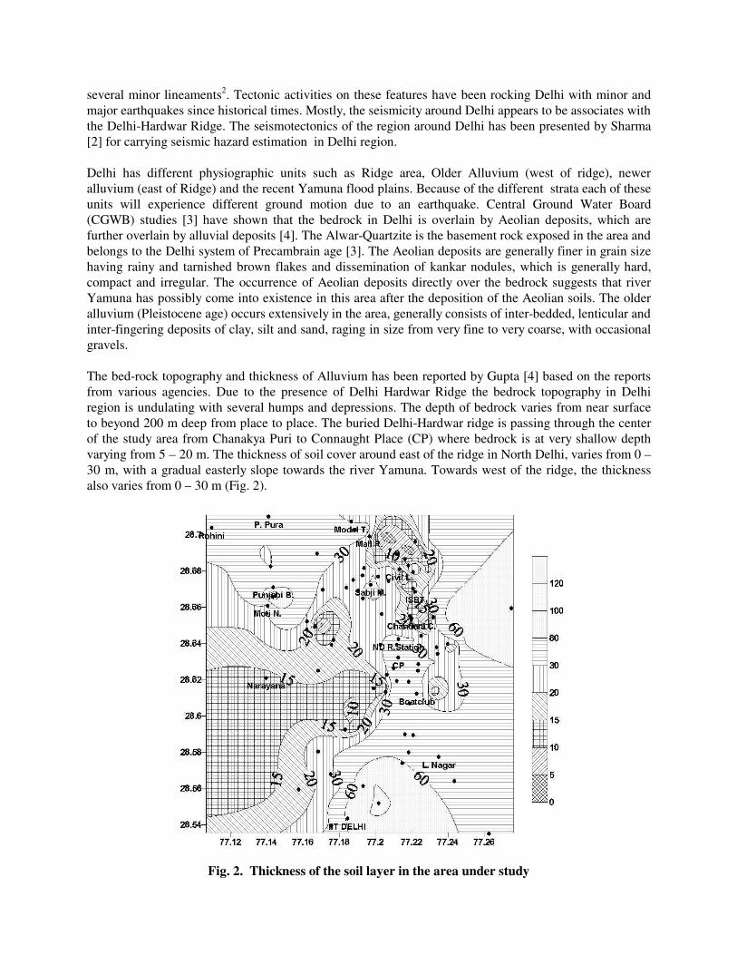
Fig. 6 Map showing average amplification factor at frequency band 0-1 Hz. The average amplification factors in the frequency band 1.0- 3.0 Hz are shown in fig. 7. The lowest average amplification factors (1-1.5) were obtained in Mall Road area and 2.0 km east of the Boat Club area. In more than 60 % of the study area average amplification factors are found to be between 2.0 to 2.5 in the frequency range 3-6 Hz (Fig. 8). Again, it is lowest in the Mall Road, Model Town and Civil Lines area. Average amplification factors of the order of 1.5 to 2.0 have been obtained in the south-west corner of the study area.
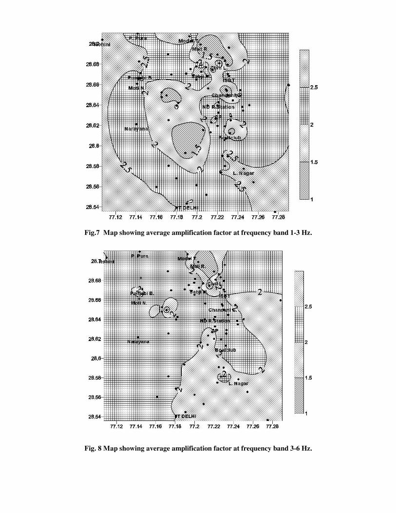
Fig.7 Map showing average amplification factor at frequency band 1-3 Hz.
Fig. 8 Map showing average amplification factor at frequency band 3-6 Hz.

In most of the region (>90%), the average amplification factor varies between 1.8 to 2.2 in the frequency band 6-10 Hz as shown in Fig. 9. The amplification factors are found to be lowest in this range of frequency for the same areas (as in case of other frequency bands) viz., Mall Road, Model Town and Civil Lines area.
Fig.9 Map showing average amplification factor at frequency band 6-10 Hz
PGA LEVELS AT THE SURFACE
The horizontal peak ground acceleration has been worked out for the Delhi region using the amplification factors worked out for different frequency ranges and the bed rock horizontal ground motion as worked out by Sharma [2]. The maximum levels of PGA is ahown in Fig. 10 giving the value of PGA in terms of ‘g’ for the dominant period of the ground. Similarly the PGA levels are shown in Fig. 11 for the amplification factors in the frequency range 6 to 10 Hz.

Fig. 10 PGA levels at the ground surface.
Fig. 11 PGA levels at the surface in the frequency range of 6 – 10 HZ

CONCLUSIONS Delhi, being the socio-political and economic nerve centre of the country, demands much more attention from planners, engineers and decision-makers from the angle of earthquake disaster preparedness. It is situated in highly earthquake prone belt Zone IV of IS Code (IS 1893:2002) [11]. The heavily populated city with large number of man-made structures is prone to severe damage due to moderate earthquake. Large amplification factors at resonance as well as average amplification in frequency range 0-1 Hz were obtained in the IIT Delhi area and west of it. Further, unexpected damage may occur during future earthquakes if double resonance takes place i.e., interaction of periods of ground motion, soil cover and the structure. Low average amplification factors were obtained in Mall Road, Model Town and Civil Lines area for all considered frequency bands as well as at resonance. The maximum average amplification factors observed in the frequency band 1-3Hz reveal that multistory buildings (3-10 story) having their first natural frequency in the same range are prone to experience relatively higher level of seismic forces in comparison with shorter buildings. Prepared maps of resonance frequency, soil thickness, maximum ground motion amplification factors at resonance, average ground motion amplification factors and the PGA levels at the surface in different frequency bands are useful for variety of end-user of communities, including structural and geotechnical engineers, building officials, emergency managers, land-use planners, private businesses, and the general public. These maps can be directly used for microzonation of this region.
REFERENCES
1. Narayan J.P., Sharma M.L., Ashwani Kumar (2002), A seismological Report on the 26 January 2001 Bhuj, India Earthquake, Seismological Research Letters, 73, 343-355.
2. Sharma, M. L., H. R. Wason and R. Dhimri (2003), Seismic zonation of Delhi for bed rock strong ground motion, Jour. of Pure and App. Geophysics, (PAGEOPH) Vol . 160, 2381-2398.
3. CGWB (1989), Hydrological conditions and ground water development potential of union territory of Delhi, Borehole investigation, Central Ground Water Board, Delhi (unpublished report)
4. Gupta, V, H. G. Poulos and S. G. Reid (1999), Engineering Geology of Delhi: An Overview, Indian Geotech. Jour. , 29(3), 262-274
5. RITES (1994), Geotechnical Reports for Mass Rapid Transport System, An (Unpublished Project Report) RITES, Delhi.
6. Sambasivarao, K. (2003), Seismic microzonation of Delhi, Department of Earthquake Engineering, Indian Institute of Technology Roorkee (unpublished M. Tech. Thesis).
7. Rao,K.S.,(1996), Proc. Sem. on Geotech. Aspects of Metro Railways New Delhi, Indian Geotech., Society, Delhi Chapter, pp.1151-1160.
8. Gibbs, H.J. and Holtz, W.G. (1957), Research on determining the density of sand by spoon penetration testing, Proc. of the 4th International Conference SMFE, London
9. Okamoto, S. (1973), Introduction to earthquake engineering, University of Tokyo Press. 10. Kanai, K (1951), Relation between the nature of the surface layer and the amplitude of earthquake
motions, Bulletin of the Tokyo Earthquake Res. Institute, R51-03 11. IS:1893-1984 (2002), Indian Standard Criteria for Earthquake Resistant Design of Structures,
Bureau of Indian Standards, New Delhi.


![Method for Seismic Microzonation with Geotechnical - [email protected]](https://img.pdfslide.us/doc/110x75/623fce8598fa641075792a57/method-for-seismic-microzonation-with-geotechnical-emailprotected.jpg)