Embed Size (px)
Citation preview

SEISMIC MICROZONATION OF LIMA CITY
GEOTECHNICAL LABORATORY – CISMID
UNIVERSIDAD NACIONAL DE INGENIERÍA LIMA-PERÚFacultad de Ingeniería Civil
CENTRO PERUANO JAPONÉS DE INVESTIGACIONESSÍSMICAS Y MITIGACIÓN DE DESASTRES - CISMID
CENTRO PERUANO JAPONÉS DE INVESTIGACIONES SÍSMICAS Y MITIGACIÓN DE DESASTRES - CISMID
GRUPO DE INVESTIGADORES DEL LABORATORIO GEOTGRUPO DE INVESTIGADORES DEL LABORATORIO GEOTÉÉCNICOCNICO
ASESORES:Dr. Jorge Alva HurtadoM.I. Alberto Martinez VargasJEFE DE PROYECTO:Dr. Zenón Aguilar BardalesINGENIEROS:Ing. David Luna DuránIng. Milagro Castro Cuba ValenciaIng. Luis Chang ChangIng. Martín Rodriguez TrujilloIng. Fernando Lázares La RosaIng. Ronald Macazana EriqueIng. Roberth Aguilar Chuquimuni
BACHILLERESBach. Ramilo Piedra RubioBach. Doris VenerosBach. Juan Franco ZenozaínBach. César Luna FarahBach. Diana Calderón CahuanaBach. Marlene LimaymantaBach. Yeseña CantoralBach. Juan Pablo AldabaBach. Jorge Chávez ObregónBach. José Castro MitacBach. Alexei NájarBach. Juan Eduardo VelardeBach. Erick Bedriñana
TÉCNICOS:Víctor Valenzuela PalominoJulio Olavarría OlavarríaTomás Guerrero AsencioMarco Antonio RiveraJosé Bonifacio PérezPilar Ramos Aguilar

CENTRO PERUANO JAPONÉS DE INVESTIGACIONES SÍSMICAS Y MITIGACIÓN DE DESASTRES - CISMID
INTRODUCTIONINTRODUCTION
- This study has been developed by CISMID – FIC – UNI, under the requirement of the APESEG (Peruvian Association of Insurance Companies).
- Basic information of topography, geology, geomorphology and soil mechanic has been compiled from former studies. A field exploration campaign was carried out to verify and complement the soil mechanic information. It included tests of both, single and array microtremor measurements to determine the dynamics behavior of soils.
- Based on this information a preliminary five zone microzonation map of Lima city is proposed, which is in accordance with the type of soils defined by the seismic design code.

CENTRO PERUANO JAPONÉS DE INVESTIGACIONES SÍSMICAS Y MITIGACIÓN DE DESASTRES - CISMID
TOPOGRAPHIC MAP OF LIMA CITY
• Area: 3,924 Km2
• Shore Line of 65 Km.
• Gradient of 4% to 5% in the NE-SW direction
200
200
400
400
400
600
400
800
600
800
1000
1200
14001600
400
600
800
1200
1 400
1000
600800
1000
1200
800 600
1200
1000
14001600
1800
800
600
800
1000
1200
800
1000
1400
600
400
200
600
800
1000
800
1000
1200
800
1000
120
01400
1000
1200
1200
1000
1200
1400
1000
1200
1400
1600
1800
14001600
1800
180020
00
220
0
1600
1800
1800160014001
200
800
800600
800
600
600400
600
800
1000
600
800
400
600
800
1000
1200
600
800
600
800
1000
1000
1200
1400
1600
1800
1000
1200
600800
600
800 10 00
12 0 0
800
1000
1200
1400
1600
100080
0
600
1800
1200
14 0 0
160
0
1400
16 00
1800
2200
20001800
1600
2600
2400
2200
1600
1800
2000
600
600
600
600
600
600
600
600
600
600
800
800
800
800
800
800
800
800
800
800
800
800
1000
1000
1000
1000
1000
1000
1000
1000
1000
12 00
120 0
1200
1200
1200
1200
1400
1400
1400
1600
1600
400
400
400
400
600
600
400
400
200
200
200
600
600
400
400
800
1000
400
400
140
0
1400
160
0
18
00
LA HERRADURA
MORRO SOLAR
CALLAO
CAMOTAL
A
A'
0
5
10
15
M A
Callao 1 Km
NIVEL DEL MAR A'
LA PUNTA
ANCÓN
CHORRILLOS
N
OCÉANO PACÍFICO
2560
00
8720000
8712000
8704000
8696000
8688000
8680000
8672000
8664000
8656000
8648000
2640
00
2720
00
2800
00
2880
00
2960
00
3040
00
3120
00
3200
00
8640000
SAN LORENZOISLA
San Miguel
M agdalena del Mar
San Isidro
Lince
Jesus Maria
Pueblo Libre
La VictoriaSan Luis
La Molina
La Perla
Cieneguilla
Lima (Cercado)
CallaoSan Martin de Porres
Independencia
Los Olivos
San Juan de Lurigancho
Santa Anita
RímacAte Vitarte
Chaclacayo
Lurigancho (Chosica)
Ventanilla
Comas
Puente Piedra
Carabayllo
Carmen de la Legua Reynoso
Bellavista Breña
San Borja
Surquillo
M iraflores
Barranco Santiago de Surco
San Juan de M iraflores
Villa Maria del Triunfo
Chorrillos Villa El Salvador
Lurin
Pachacamac
PUNTA HERMOSA
Río Chil
lón
Río
Lurin
Río L
urin
Río Rimac
Río Rimac
80
90
100
5
10
2 0
3 0
40
50
60
70
80
90
100110
120
130
140
150
160
170
5
10
20
30
40
50
60
70 80
90 100 110
120
130
140
150
160 170
180
190
200 210
220
230240
250
260
270
280
290300
310
320
330
340
350
360
370
380
390
400
70
60
50
40
20
10
10
50
190
200
210
220
OCEANO PACIFICO
5
0 4 8 Km
Instituto Geográfico Nacional (1999)Dolfus (1965) y A. Martínez Vargas (1975)
60CURVAS DE NIVEL
CONTORNOS BATIMÉTRICOS
DEPÓSITOS MARINOS
ANTIGUOS CANALES
CARRETERA
RIOS
LEYENDA

CENTRO PERUANO JAPONÉS DE INVESTIGACIONES SÍSMICAS Y MITIGACIÓN DE DESASTRES - CISMID
GEOLOGIC MAP OF LIMA CITY• Lima is located in the dejection
cone of Rimac and ChillonRivers.
• The alluvial deposits have a thickness of 400 to 600 m.
INGEMMET (1992) Ing. A. Martínez Vargas (1975)

CENTRO PERUANO JAPONÉS DE INVESTIGACIONES SÍSMICAS Y MITIGACIÓN DE DESASTRES - CISMID
GEOMORPHOLOGIC MAP OF LIMA CITY
Ing. A. Martínez Vargas (1975)

CENTRO PERUANO JAPONÉS DE INVESTIGACIONES SÍSMICAS Y MITIGACIÓN DE DESASTRES - CISMID
UNDERGROUND WATER TABLE IN LIMA CITY
• In the Rimac basin the ground-water table depth ranges from 5 to 70 m.
• In the Chillon basin the ground water table depth ranges from 5 to 40 m.
Ing. A. Martínez Vargas (1971)

CENTRO PERUANO JAPONÉS DE INVESTIGACIONES SÍSMICAS Y MITIGACIÓN DE DESASTRES - CISMID
GEOTECHNICAL EXPLORATIONGEOTECHNICAL EXPLORATION
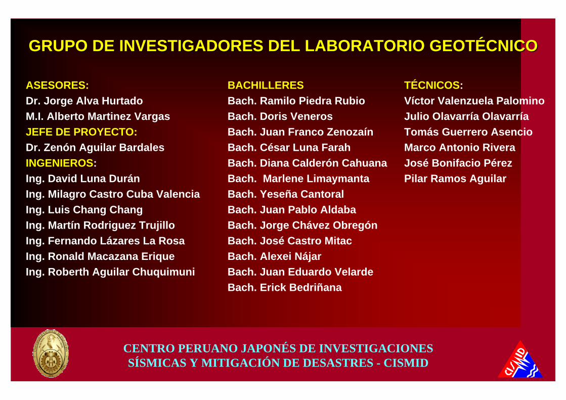
A large number of soil mechanic studies were compiled to evaluate the mechanical behavior of the different types of soils. Furthermore, to verify and complement the compiled information, a geotechnical exploration program was carried out in each of the 42 district that were studied.
Manhole pits, SPT and DPL tests were carried out according to the type of soil and the quality of the available information.

CENTRO PERUANO JAPONÉS DE INVESTIGACIONES SÍSMICAS Y MITIGACIÓN DE DESASTRES - CISMID
GEOTECHNICAL EXPLORATION INGEOTECHNICAL EXPLORATION INSAN MARTSAN MARTÍÍN DE PORRES DISTRICTN DE PORRES DISTRICT
CENTRO PERUANO JAPONÉS DE INVESTIGACIONES SÍSMICAS Y MITIGACIÓN DE DESASTRES - CISMID
GEOTECHNICAL EXPLORATION INGEOTECHNICAL EXPLORATION INSAN JUAN DE LURIGANCHO SAN JUAN DE LURIGANCHO –– CHOSICA DISTRICTCHOSICA DISTRICT

CENTRO PERUANO JAPONÉS DE INVESTIGACIONES SÍSMICAS Y MITIGACIÓN DE DESASTRES - CISMID
GEOTECHNICAL EXPLORATION INGEOTECHNICAL EXPLORATION INANCANCÓÓN DISTRICTN DISTRICT

CENTRO PERUANO JAPONÉS DE INVESTIGACIONES SÍSMICAS Y MITIGACIÓN DE DESASTRES - CISMID
GEOTECHNICAL EXPLORATION INGEOTECHNICAL EXPLORATION INBARRANCO DISTRICTBARRANCO DISTRICT

CENTRO PERUANO JAPONÉS DE INVESTIGACIONES SÍSMICAS Y MITIGACIÓN DE DESASTRES - CISMID
GEOTECHNICAL CHARACTERISTICS OF SOILSGEOTECHNICAL CHARACTERISTICS OF SOILSTo define the geotechnical characteristics of the soils a Type of Soil Map was developed, zoning the study area according to the following criteria:
This zone is conformed by thick alluvial deposits of the Rimac basin and of some sector of Chillon and Lurin basins. This type of soil covers a large portion of the study area, and present a good geomechanic behavior.
ALLUVIAL GRAVEL :
This zone is conformed by colluvial gravel that covers the hills slopes and the lower part of the outcropping rock that surrounds the city. These soil deposits present similar behavior than the alluvial gravel, however, in some sector they are cemented by soluble salts that make them collapsibles.
COLLUVIAL GRAVEL:
CENTRO PERUANO JAPONÉS DE INVESTIGACIONES SÍSMICAS Y MITIGACIÓN DE DESASTRES - CISMID
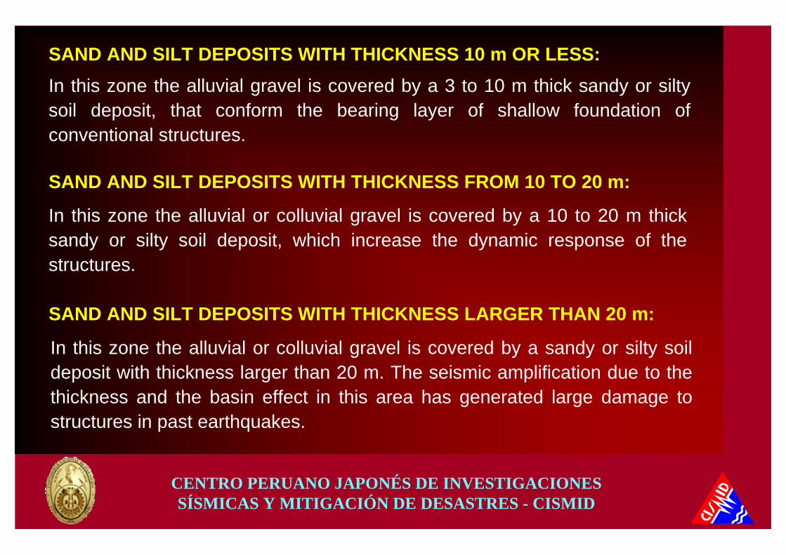
In this zone the alluvial gravel is covered by a 3 to 10 m thick sandy or siltysoil deposit, that conform the bearing layer of shallow foundation of conventional structures.
SAND AND SILT DEPOSITS WITH THICKNESS 10 m OR LESS:
SAND AND SILT DEPOSITS WITH THICKNESS FROM 10 TO 20 m:
In this zone the alluvial or colluvial gravel is covered by a 10 to 20 m thick sandy or silty soil deposit, which increase the dynamic response of the structures.
SAND AND SILT DEPOSITS WITH THICKNESS LARGER THAN 20 m:
In this zone the alluvial or colluvial gravel is covered by a sandy or silty soil deposit with thickness larger than 20 m. The seismic amplification due to the thickness and the basin effect in this area has generated large damage to structures in past earthquakes.

CENTRO PERUANO JAPONÉS DE INVESTIGACIONES SÍSMICAS Y MITIGACIÓN DE DESASTRES - CISMID
This zone is conformed by a sandy silt or clay with highly organic soils and peat, which thickness is less than 10 m, and the groundwater table is 1 to 3 m depth. Underlying are the alluvial gravel of the Rimac and Chillon basin.
CLAY AND ORGANIC SOIL DEPOSITS WITH THICKNESS 10 m 0R LESS:
This zone is conformed by a thick layer of gravel (10 to 20 m) that overlies a thick layer of clay. The gravel and clay layers alternate in depth. The groundwater table is 1 to 3 m depth.
THICK LAYERS OF GRAVEL AND CLAY:
This zone is conformed by a 5 to 15 m thick layer of soft saturated clay and organic soils. The groundwater table is 1 to 2 m depth. Underlying are the thick layers of gravel and clay that alternate in depth.
SOFT CLAY:

CENTRO PERUANO JAPONÉS DE INVESTIGACIONES SÍSMICAS Y MITIGACIÓN DE DESASTRES - CISMID
This zone is conformed by loose sandy soils of variable thickness, transported by the wind and deposited on the hills slopes. In several places they are cemented by soluble salts and present collapsible behavior.
EOLIC SAND:
This zone is conformed by clayish and organic soils where the groundwater table is at the surface. This soils present high compressibility and very low bearing capacity.
SWAMPY SOILS:
This zone is conformed by a 100.0 m width stripe along the shore, that constitute a discontinuity with 70 m high slopes. Besides it is conformed by firm alluvial gravel, seismic amplification and permanent deformation are expected during large earthquakes.
CLIFFS OF LIMA:

CENTRO PERUANO JAPONÉS DE INVESTIGACIONES SÍSMICAS Y MITIGACIÓN DE DESASTRES - CISMID
Stripe of beach conformed by saturated loose sand, that are potentially licuefactable under ground shaking.
MARINE SAND DEPOSITS:
This zone is conformed by solid waste deposits with thickness of 5 to 15 m, that formerly were located outside the urban area and at the present were urbanized. They present an erratic behavior and should not be used as ground foundation without treatment.
SOLID WASTE DEPOSITS:

CENTRO PERUANO JAPONÉS DE INVESTIGACIONES SÍSMICAS Y MITIGACIÓN DE DESASTRES - CISMID
MAP OF TYPE OF SOILS IN LIMA CITY
Ing A. Martínez Vargas (1975)CISMID (2003)

CENTRO PERUANO JAPONÉS DE INVESTIGACIONES SÍSMICAS Y MITIGACIÓN DE DESASTRES - CISMID
DYNAMIC BEHAVIOR OF SOILSDYNAMIC BEHAVIOR OF SOILS
The dynamic behavior of soils was evaluated using microtremor measurements and SPAC analysis of array microtremor measurements. One-dimensional and two-dimensional response analysis were performed in places were soil profile information was available.

CENTRO PERUANO JAPONÉS DE INVESTIGACIONES SÍSMICAS Y MITIGACIÓN DE DESASTRES - CISMID
MICROTREMOR MEASURMENT EQUIPMENT

CENTRO PERUANO JAPONÉS DE INVESTIGACIONES SÍSMICAS Y MITIGACIÓN DE DESASTRES - CISMID
MICROTREMOR ARRAY MEASUREMENTSPAC METHOD
CENTRO PERUANO JAPONÉS DE INVESTIGACIONES SÍSMICAS Y MITIGACIÓN DE DESASTRES - CISMID
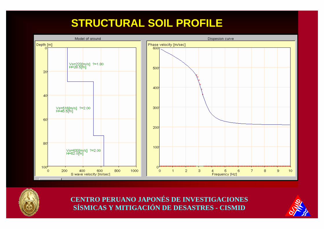
STRUCTURAL SOIL PROFILE

CENTRO PERUANO JAPONÉS DE INVESTIGACIONES SÍSMICAS Y MITIGACIÓN DE DESASTRES - CISMID
ONE DIMENSIONAL RESPONSE ANALYSIS
Vs = 239 m/s
Vs = 567 m/s
Vs = 833 m/s
Vs = 1000 m/s
p = 18 KN/m3
p = 20 KN/m3
p = 22 KN/m3
p = 25 KN/m3

CENTRO PERUANO JAPONÉS DE INVESTIGACIONES SÍSMICAS Y MITIGACIÓN DE DESASTRES - CISMID
RESPONSE SPECTRA
AT LA MOLINADISTRICT

CENTRO PERUANO JAPONÉS DE INVESTIGACIONES SÍSMICAS Y MITIGACIÓN DE DESASTRES - CISMID
NORMALIZED SPECTRAL RATIONORMALIZED SPECTRAL RATIOONE DIMENSIONAL ANALYSIS ONE DIMENSIONAL ANALYSIS –– LA PUNTA CALLAOLA PUNTA CALLAO
ENVOLVENTE DE COCIENTES ESPECTRALES NORMALIZADOS LA PUNTA-CALLAO
0
0.5
1
1.5
2
2.5
3
0 0.5 1 1.5 2 2.5 3Periodo(s)
Fact
or d
e A
mpl
ifica
ción
sismo 66(0.1g) sismo 70(01g) sismo 74(0.1g) sismo 66(0.2g) sismo 70(0.2g) sismo 74(0.2g)
ENVOLVENTE DE COCIENTES ESPECTRALES NORMALIZADOS LA PUNTA-CALLAO
0
0.5
1
1.5
2
2.5
3
0 0.5 1 1.5 2 2.5 3Periodo(s)
Fact
or d
e A
mpl
ifica
ción
sismo 66(0.3g) sismo 70(0.3g) sismo 74(0.3g) sismo 66(0.4g) sismo 70(0.4g) sismo 74(0.4g)

CENTRO PERUANO JAPONÉS DE INVESTIGACIONES SÍSMICAS Y MITIGACIÓN DE DESASTRES - CISMID
TWO DIMENSIONAL ANALYSIS
STRATIGRAPHIC SOIL PROFILE AT LAS LAGUNAS, LA MOLINA DISTRICT

CENTRO PERUANO JAPONÉS DE INVESTIGACIONES SÍSMICAS Y MITIGACIÓN DE DESASTRES - CISMID
FEM MESHUrb. Las Lagunas, La Molina

CENTRO PERUANO JAPONÉS DE INVESTIGACIONES SÍSMICAS Y MITIGACIÓN DE DESASTRES - CISMID
SPECTRAL RATIO AT LAS LAGUNAS, LA MOLINA
CENTRO PERUANO JAPONÉS DE INVESTIGACIONES SÍSMICAS Y MITIGACIÓN DE DESASTRES - CISMID
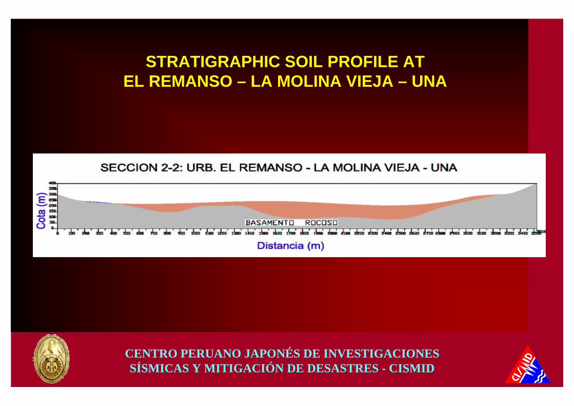
STRATIGRAPHIC SOIL PROFILE ATEL REMANSO – LA MOLINA VIEJA – UNA

CENTRO PERUANO JAPONÉS DE INVESTIGACIONES SÍSMICAS Y MITIGACIÓN DE DESASTRES - CISMID
SPECTRAL RATIO: El Remanso – La Molina Vieja – UNA

CENTRO PERUANO JAPONÉS DE INVESTIGACIONES SÍSMICAS Y MITIGACIÓN DE DESASTRES - CISMID
LA PUNTA
ANCÓN
CHORRILLOS
OCÉANO PACÍFICO
SAN LORENZOISLA
PUNTA HERMOSA
HUAROCHIRÍ
Cieneguilla
Villa M aria del Triunfo
San Juande
M iraflores PachacamacChorrillos
Villa El Salvador
Lurín
CallaoSan M artin de Porres
Independencia
Los O livos
San Juan de Lurigancho
Rímac
Ate V itarte
Chaclacayo
Lurigancho (Chosica)
Ventanilla
Comas
Puente Piedra
Carabayllo
Río Chillón
Río Rímac
Río Lur
ín
Río
Lurín
San M iguel
M agdalena del Mar
San Isidro
Lince
Jesus M aria
Pueblo Libre
La VictoriaSan Luis
SurquilloM iraflores
Santiago de Surco
La Molina
Barranco
La Perla
Lima (Cercado)
Santa Anita
Carmen de la Legua Reynoso
Bellavista Breña
San Borja
0 4 8 Km
Gráfico reducido del 1/100000
SIMBOLO
LEYENDA
0.4-0.5
0.5-0.6
0.6-0.7
>0.7
ZONA I
ZONA II
ZONA III
ZONA IV
(s)ZONAS
0.1-0.2
0.2-0.3
0.3-0.4
PERIODO
CISMID (2004)
MAP OF DYNAMIC BEHAVIOR OF SOILS OF
LIMA
CENTRO PERUANO JAPONÉS DE INVESTIGACIONES SÍSMICAS Y MITIGACIÓN DE DESASTRES - CISMID
GEOTECHNICALGEOTECHNICAL SEISMICSEISMIC MICROZONATIONMICROZONATION OFOF LIMA LIMA CITYCITY
ZONE I: It is conformed by outcropping rock and thick alluvial gravel deposits of the Rímac y Chillón basin. The predominant period ranges from 0.1 to 0.3 sec. classifying as Type I Soil of the seismic code. This zone covers a large area of Lima city.
ZONE II: It is conformed by a layer of 3 to 10 m thick sandy and silty soil, that overlies the alluvial and colluvial gravel . The predominant period ranges from 0.3 to 0.5 sec. classifying as Type II Soil of the seismic code.
ZONE III: It is conformed by thick and loose sandy and silty soil deposits, mostly of eolic origin, that cover the northern and the southern part of the metropolitan area. The predominant period ranges from 0.5 to 0.7 sec. classifying as Type III Soil of the seismic code.
CENTRO PERUANO JAPONÉS DE INVESTIGACIONES SÍSMICAS Y MITIGACIÓN DE DESASTRES - CISMID
GEOTECHNICALGEOTECHNICAL SEISMICSEISMIC MICROZONATIONMICROZONATION OFOF LIMA LIMA CITYCITY
ZONE IV: It is conformed by thick deposits of loose eolic sand, saturated marine sand and swampy soils. In this zone were also included the deposits of thick gravel and clay layers located in La Punta and Callao districts, that present large amplification factors. The predominant period is larger than 0.7 sec. classifying as Type IV Soil of the seismic code.
ZONE V: It is conformed by localized solid waste deposits with thickness of 5 to 15 m that were used as foundation soils, and where several problems have been reported. In this zone a specific study is required to evaluate its dynamic behavior, therefore it was classified as Type V Soil, which is not considered in the seismic code.
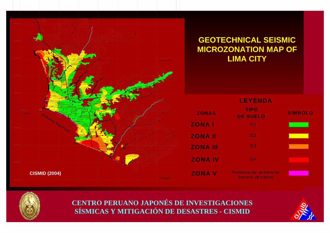
CENTRO PERUANO JAPONÉS DE INVESTIGACIONES SÍSMICAS Y MITIGACIÓN DE DESASTRES - CISMID
LA PUNTA
ANCÓN
CHORRILLOS
HUAROCHIRÍ
SAN LORENZOISLA
OCÉANO PACÍFICO
1
34
5
6
2
Ventanilla
Rimac
San Martin de Porres
Lurigancho (Chosica)
M agdalena del Mar
SurquilloM iraflores
Santiago de Surco
La Molina
Barranco
Cieneguilla
Villa Maria del Triunfo
San Juande
Miraflores PachacamacChorrillos
Villa El Salvador
Lurín
Chaclacayo
Carabayllo
Río Chi
llón
Río Lurí
n
Río
Lurín
Puente Piedra
0 4 8 Km
Gráfico reducido del 1/100000
Pueblo Libre
Callao
Comas
IndependenciaSan Juan de Lurigancho
San Miguel
San Isidro
Lince
Jesus Maria
Breña
Lima (Cercado)
La VictoriaSan Luis
San Borja
La Perla
Bellavista
Carmen de la Legua Santa Anita
Ate VitarteRío Rímac
Río Rímac
Los Olivos
CISMID (2004)
LEYENDA
1
ZONA IV
ZONA V
S4
Rellenos de desmontebasura ubicados
TIPODE SUELO
ZONA I S1
ZONA II S2
ZONA III S3
ZONAS SIMBOLO
GEOTECHNICAL SEISMIC MICROZONATION MAP OF
LIMA CITY