Embed Size (px)
Citation preview

67
堆 積 学 研 究,48号,67-84,1998
J.Sed.Soc.Japan.No.48,67-84,1998
Sedimentary environments based on textures of surface sediments and sedimentation rates in the South Yatsushiro Kai (Sea),
southwest Kyushu, Japan
Rifardi*, Kimihiko Oki** and Takashi Tomiyasu**
The main purpose of this study is to clarify the relation between characteristics of sedi-
ments and environmental conditions, based on the analysis of core samples from the South
Yatsushiro Kai (Sea) which is located off the west coast of central Kyushu Island, Japan. Bottom sediment samples were collected at 74 stations in the southern part of the
Yatsushiro Kai using gravity corers in March 1996. 62 core samples were used for the
mechanical analysis by the settling-tube method, and Q-mode cluster analysis was carried
out based on the proportion of grain size distribution (Wentworth size classes) . 61 core sam-
ples were available to estimate the sedimentation rates (during c. 50 years) which were rec-ognized from the first appearance of high mercury contents of cores. On the other hand, the topmost one centimeter of 73 core samples, which is approximately 10 cc of wet sediments,
was utilized for foraminifera) study.
The general trend of the bottom current system in the area was discussed, based on the
mechanical analysis data of bottom sediments, the distribution of sedimentation rates and
the distributions of the number of individuals of planktic and living benthic foraminifera. Based on the results mentioned above, the South Yatsushiro Kai is subdivided into the follow-
ing five areas:1) the area near the straits characterized by coarse sediments under the influ-
ence of strong tidal and bottom currents; 2) the southern part and the area off the mouth of
the Minamata River, both of which are characterized by relatively coarse sediments under
the influence of longshore currents and poorly sorted sediments supplied by the Komenotsu and Minamata Rivers; 3) the northwestern and eastern parts characterized by fine-grained
sediments accumulated under conditions of rather stagnant water masses; 4) the central
area, characterized by relatively fine sediments and a large number of planktic empty tests
deposited on the sea bottom under the condition of rather weak tidal current systems; 5) the
northern part characterized by gravels or gravelly sands which were derived from shallow coastal areas.
Judging from the distribution pattern of the maximum mercury content at some horizons
of each core, the fine-grained sediments polluted by mercury were transported northeast-
ward and southward by weak longshore currents and spread toward north and west across
the northern and southern parts of the South Yatsushiro Kai.
Received: June 29, 1998, Accepted : July 21, 1998 * Science of Marine Resources
, United Graduate School
of Agricultural Sciences, Doctoral Course, Kagoshima
University, Korimoto 1-21-24, Kagoshima City 890-0065,
Japan. **Department of Earth and Environmental Sciences
,
Faculty of Science, Kagoshima University, Korimoto 1-
21-35, Kagoshima City 890-0065, Japan.
Key words: Yatsushiro Kai, bottom sedim-
ents, sedimentation rates, foraminifera, dis-
charged mercury
68 Rifardi, Kimihiko Oki and Takashi Tomiyasu 1998
INTRODUCTION
Since the outbreak of Minamata disease, the Yatsushiro Kai (Sea) has become one of the are-
as most intensively studied in relation to the pol-
lution of water, sediments and marine fauna. Sig-
nificant studies in ecological and oceanographical
aspects of the area have been carried out by Hy-drographic Department, Maritime Safety Agency
(1974), Hirota and Hara (1975), Hydrographic Department, Maritime Safety Agency (1978),
Kikuchi and Tanaka (1978), Geographical Survey Institute (1982, 1984), Kikuchi (1983), Tsuruta
et al. (1986, 1987) and Tanaka et al. (1987).
However, only a few papers among them are
concerned with bottom sediments from the sedi-
mentological point of view.
The main purpose of this study is to clarify the
relation between characteristics of sediments and
environmental conditions, based on analysis of core samples from the South Yatsushiro Kai.
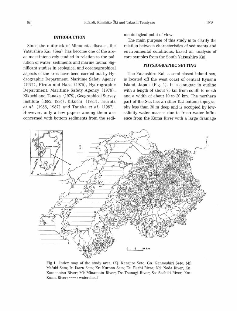
PHYSIOG1IAPHIC SETTING
The Yatsushiro Kai, a semi-closed inland sea, is located off the west coast of central Kyushu
Island, Japan (Fig. 1). It is elongate in outline
with a length of about 75 km from south to north
and a width of about 10 to 20km. The northern
part of the Sea has a rather flat bottom topogra-
phy less than 30m deep and is occupied by low-salinity water masses due to fresh water influ-
ence from the Kuma River with a large drainage
Fig.1 Index map of the study area (Kj: Karajiro Seto; Gn: Gannoshiri Seto; Mf: Mefuki Seto; Ir: Ikara Seto; Kr: Kurono Seto; Ec: Euchi River; Nd: Noda River; Kn: Komenotsu River; Mi: Minamata River; Ts: Tsunagi River; Ss: Sashiki River; Km: Kuma River; ----: watershed).

69J. Sed. Soc. Japan, No. 48 Sedimentary emvironments in the South Yatsushiro Kai
area (Fig. 1).
Climatologically, the Yatsushiro Kai is referable
to the region of the humid mesothermal (sub-
tropical) climate (Finch and Trewartha, 1949).
According to temperature data for 30 years
(1961-1990) in Kumamoto City near the Yatsu-
shiro Kai, annual mean temperature is 16.2•Ž,
mean temperature in winter is 6.0•Ž and that in
summer is 25.8•Ž. The highest annual mean pre-
cipitation during the past 30 years (1961-1990) is
1967.7 mm, the monthly mean precipitation being
lowest in December (49.1mm) and highest in
June (392.8 mm). The rainy season is from early
June to middle July in the Kumamoto area.
The area studied is restricted to the southern
part of the Yatsushiro Kai, being about 39 km
long and about 14 km wide. It is located between
Fig.2 Bathymetric map showing the sampling stations (contour interval 10m; Ak: Amakusa-kamishima; As: Amakusa-shimoshima; flu: Hino-shima; Sb: Shiba-shima; Go: Goshonoura-
jima; Sh: Shishi-jima; Ik: Ikara-jima; Na: Naga-shima; Iz: Izumi City; Mc: Minamata City; tc: Tsunagi-cho; at: Ashikita-cho; tn: Tanoura-cho; Mw: Minamata Wan).
the lines of 32•‹08'00" N and 32•‹ 23' 00" N Lat.
and between 130•‹12'00" E and 130•‹29'00" E
Long. This inland sea has five outlets or straits
(Karajiro Seto, Gannoshiri Seto, Mefuki Seto,
Ikara Seto and Kurono Seto) leading to the East
China Sea (Fig. 2) . The studied area is rather
flat in bottom topography and gets gradually
shallower eastwards (Fig. 2) . The Sashiki,
Tsunagi, Minamata and Komenotsu Rivers flow
into the eastern part, all of which have rather
large drainage areas as shown in Figure 1. On
the other hand, rivers with small drainage areas
flow into the southern part of the study area,
which consist of the Euchi and Noda Rivers, and
a few small rivers on the islands to the west,
which separate the Yatsushiro Kai from the East
China Sea (Fig. 1).
Strong tidal currents flow through the straits of
the western and southern parts of the area.
According to the Hydrographic Department,
Maritime Safety Agency (1978), the velocity of
the flood current coming into the Yatsushiro Kai
reaches 1.1 knots in the Gannoshiri Seto, 0.8
knots in the Mefuki Seto, and 4.9 knots in the
Kurono Seto.
On the contrary, the velocity of the ebb current
reaches 1.5 knots, 2.0 knots, and 4.8 knots at each
strait, respectively. The velocity and direction of
tidal currents in the Yatsushiro Kai were report-
ed by the Geographical Survey Institute (1984).
The areas with more than 0.5 knots are shown in
Figure 3 based on the map of Geographical Sur-
vey Institute (1984).
Except for the Izumi plain, the coastal area
shows rocky beaches around the southern part of
the Yatsushiro Kai. The northeastern (Tanoura-
cho and Ashikita-cho) , northwestern (Goshono-
ura-jima and Shishi jima) and southern (Izumi
City) parts of the studied area have a hinterland
of Carboniferous to Cretaceous sedimentary
rocks mainly composed of slate, chert, limestone,
sandstone and shale. Eastern (mainly Minamata
City) and southwestern (Naga-shima) parts of
the area are occupied by Pliocene to Pleistocene
volcanic rocks mainly of andesite. The Izumi

70 Rifardi,Kimihiko Oki and Takashi Tomiyasu 1998
Fig.3 Velocity and direction of tidal currents (after the Geographical Survey Institute, 1984); left: the flood current; right: the ebb current.
plain consists of Pliocene to Pleistocene terrace and pyroclastic deposits.
MATERIAL AND METHODS
The bottom samples used for this study were collected at 74 stations in the southern part of the
Yatsushiro Kai with depths from 14 to 54 m in
March 1996 (Fig. 2) . Positioning for the sampling
sites was determined with the Furuno GPS
Plotter GP-1500 (FCV-663 Model) installed on the research vessel of the Fisheries Reseach Labora-
tory, Kagoshima University. All the bottom sam-
ples were collected by using the gravity corer made by Hisanaga Co., Ltd, Kagoshima. The 1 to
2 cm (about 10cc in volume) of 62 core samples
was used for mechanical analysis and 61 core samples were used for estimation of sedimenta-
tion rates. The top one centimeter of 73 core sam-
ples was analysed for foraminiferal study.
1. Bottom sediment analyses
a) Mechanical analysis
Gravels were collected by sieving and were
weighed in dry condition. The Emery settling-
tube method was utilized for determining the rel-
ative proportion of sand. The mud proportion
was calculated by using Hiranuma Particle Size
Analyser PSA-2. Median diameter (MdƒÓ) , sort-
ing coefficient (ƒÐi) , and skewness (Ski) were
obtained with the graphical method of Folk and
Ward (1957). The textural proportions of sand,
silt and clay were plotted on the Shepard's trian-
gle (Shepard, 1954) for all the samples.
b) Cluster analysis
Based on the proportion (%) of grain size dis-
tribution excluding gravels (Wentworth size
classes), a dendrogram was obtained by the Q-
mode cluster analysis that is made up by average
linkage method (Norusis, 1993). The samples
were grouped according to similarity indicated by
the cosine similarity coefficient *.
The cosine similarity coefficient is computed by
* Similarity(X,Y)=(ΣiXiYi)/√(ΣXi2)(ΣYi2)

71J.Sed.Soc.Japan,No.48 Sedimentary emvironments in the South Yatsushiro Kai
2. Analysis of mercury contents and sedimenta-
tion rates Mercury contents at 12 horizons of 2-3, 5-6, 8-9,
13-14,18-19, 23-24, 28-29, 33-34, 38-39, 43-44, 48-49
and 53-54 cm* of core samples were measured in
laboratory. The Sansou Automatic mercury ana-
lyser Model Hg-3500 was used. The procedure for determination of total mercury (Akagi and
Nishimura, 1991) was as follows: a known a-
mount of sample was placed in a 50 ml volumet-
ric flask, to which 2 ml of 1:1 nitric acid-perchlo-
ric acid solution and 5 ml of concentrated sulfuric acid were added, and heated on a hot plate at
230°C for 30 min. After cooling, the digested sam-
* Below the surface of a core in cm.
ple was made up to 50 ml with water and the
mercury in a suitable aliquot of the resulting
solution (<20ml) was analysed by CVAAS.
Since 1946, methyl mercury had been dis-
charged into the Yatsushiro Kai through the
drainpipes from the Minamata factory of Shin-
nihon Chisso Hiryo Co., Ltd. The mercury con-
tents of less than 0.1ppm (0.036•`0.094 ppm) in
the deepest part of the cores have been regarded
as the chemical situation of the Yatsu-shiro Kai.
On the contrary, samples of more than 0.1 ppm
(maximum value: 3.457ppm at Station 19) are
discovered in the relatively upper part of the
cores (Fig. 4). The first appearance of high mer-
cury contents at each core sample indicates the
arrival time of pollutants at the points. Each sam-
Fig.4 Vertical distribution of mercury contents in core samples.
72 Rifardi,Kimihiko Oki and Takashi Tomiyasu 1998
pling point has a time-lag depending on the dis-
tance from the drainage of the factory and cur-
rent systems in the area. The high mercury con-
tents (0.31•`0.55 ppm) in the bottom surface
sediments in the northern part of the Sea, off the
east coast of Goshonoura-jima, were known
(Kitamura et al., 1960) . These facts suggest that
the time-lag between the eastern and western
parts of the area, may have been a few years,
and a rough estimate of sedimentation rates is
inferable from the core length above the first
appearance of high mercury contents (>0.1
ppm), and this length is roughly equivalent to the
period for about 50 years from 1946 to 1996.
3. Foraminiferal analysis
The topmost one centimeter of core samples,
which is approximately 10cc of wet sediments,
was preserved in alcohol and stained with Rose
Bengal for discriminating the living foraminifera.
Each sample was washed through a 200-mesh
(0.0074mm opening) sieve, and ovendried after
Fig.5 Distribution of the median diameter
(MdƒÓ) of bottom surface sediments.
removal of dye stuff (Rose Bengal) . All the speci-
mens were then picked out from the aliquot.
Aliquots containing less than 200 individuals of
benthic foraminifera were supplemented by addi-
tional splits. Specimens were spread on a tray,
and all the specimens of benthic species were
identified and counted. Specimens of planktic
foraminifera within each aliquot were also count-
ed.
RESULTS
1. Bottom sediments analyses
a) mechanical analysis
The results of mechanical analysis of the 62
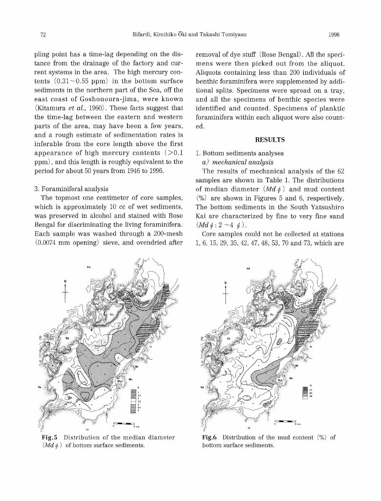
samples are shown in Table 1. The distributions
of median diameter (MdƒÓ) and mud content
(%) are shown in Figures 5 and 6, respectively.
The bottom sediments in the South Yatsushiro
Kai are characterized by fine to very fine sand
(MdƒÓ:2•`4ƒÓ).•
Core samples could not be collected at stations
1, 6, 15, 29, 35, 42, 47, 48, 53, 70 and 73, which are
Fig.6 Distribution of the mud content (%) of
bottom surface sediments.

73J.Sed.Soc.Japan,No.48 Sedimentary emvironments in the South Yatsushiro Kai
1able 1 Results of mechanical analysis of the bottom sediments.
74 Rifardi,Kimihiko Okiand Takashi Tomiyasu 1998
all located near the straits (Gannoshiri Seto,
Mefuki Seto, Ikara Seto and Kurono Seto) and in
the northern part of the studied area. The surface
sediments collected for foraminiferal analysis at
these stations contain shell fragments, granule
and coarse sand grains. These samples indicate
that the bottom character in the areas must be
gravel and/or sand. The Geographical Survey
Institute (1982, 1984) reported a bottom surface
character showing medium sand to gravel near
the straits of Gannoshiri Seto> Mefuki Seto, Ikara
Seto and Kurono Seto. Stations 65 (gravel con-
tent: 5.8%), 68 (gravel content: 12.4%) and 74
(gravel content: 41.9%) with relatively low medi-
an diameters (MdƒÓ: about 1ƒÓ) are located in
the northern part of the studied area.
The areas with high median diameters (Md ƒÓ
:>4ƒÓ) can be seen in the northeastern (Stn.
40, 46, 51, 52, 56, 57, 63, 67 and 72) and north-
western (Stn. 64 and 69) parts, where all the
stations have high mud contents more than 50%
(Figs. 5 and 6).
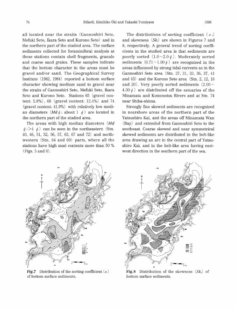
Fig.7 Distribution of the sorting coefficient (ƒÐi)
of bottom surface sediments.
The distributions of sorting coefficient (ƒÐi)
and skewness (Ski) are shown in Figures 7 and
8, respectively. A general trend of sorting coeffi-
cients in the studied area is that sediments are
poorly sorted (1.0•`2.0ƒÓ). Moderately sorted
sediments (0.71•`1.00ƒÓ) are recognized in the
areas influenced by strong tidal currents as in the
Gannoshiri Seto area (Stn. 27, 31, 32, 36, 37, 41
and 43) and the Kurono Seto area (Stn. 2, 12, 16
and 20) . Very poorly sorted sediments (2.00•`
4.00ƒÓ) are distributed off the estuaries of the
Minamata and Komenotsu Rivers and at Stn. 74
near Shiba-shima.
Strongly fine skewed sediments are recognized
in nearshore areas of the northern part of the
Yatsushiro Kai, and the areas off Minamata Wan
(Bay) and extended from Gannoshiri Seto to the
southeast. Coarse skewed and near symmetrical
skewed sediments are distributed in the belt-like
area drawing an arc in the central part of Yatsu-
shiro Kai, and in the belt-like area having east-
west direction in the southern part of the sea.
Fig.8 Distribution of the skewness (Ski) of bottom surface sediments.
75J.Sed.Soc.Japan,No.48 Sedimentary emvironments in the South Yatsushiro Kai
b) cluster analysis
The sediment samples can largely be classified
by the cluster analysis into five clusters (I to V)
at the level of 0.83 similarity coefficient in den-
drogram (Fig. 9) . Among the five clusters,
Cluster II is subdivided into four subclusters;
Cluster III into two subclusters; and Cluster IV
into three subclusters at 0.90 level. Geographical
distribution of these sediment clusters is shown
in Figure 10. The character of each cluster is
shown in Table 2, and the relationship between
clusters and three parameters; median diameter
(MdƒÓ) , sorting coefficient (ƒÐi) and skewness
(Ski), is shown in Figure 11.
Cluster I (23 stations) is characterized by pre-
dominantly fine sand to coarse silt sediments (56
-81%), and median diameter (MdƒÓ) ranging
from 3.0 to 3.75ƒÓ except for Station 21 (MdƒÓ:
2.4) which have high gravel content (21.2%). In
the central and southern parts of the sea, Cluster
I is distributed in the elongate area extending
from northeast to southwest in the middle part
between the east and west coastlines, and in the
Fig.9 Dendrogram for the bottom surface sedi-
ments.
elongate areas extending from northwest to
southeast in the southwestern part of the sea
(Fig. 10).
Subclusters IIa (6 stations) and IIb (14 sta-
tions) are characterized by fine-grained sedi-
ments (MdƒÓ: 3.4•`4.3; mud contents: 33.0•`
65.2%) and are mainly distributed in the north-
ern and eastern parts in the studied area.
Table 2 Results of cluster analysis of the
grain-size composition of sediment samples.
Fig.10 Distribution of the sediment clusters
recognized by cluster analysis.

76 Rifardi,Kimihiko Oki and Takashi Tomiyasu 1998
Subcluster IIb differs from the ha in showing a
very fine skewed nature (0.33•`0.6) .
Subcluster IIc is only recognized at Station 74
located in the northernmost part of the area, and
is characterized by very coarse median diameter
(0.7ƒÓ) , high gravel content, and a trimodal dis-
tribution of grain size; granule (41.9%), coarse
sand (10.1%) and very fine sand (18.2%).
Fig.11 The relationship between
clusters and three parameters;
median diameter (MdƒÓ), sorting
coefficient (ƒÐz) and skewness
(Ski), Stn. 21; gravel content
21.2%.
Subcluster lid is mostly of fine-grained sedi-
ments in the area (MdƒÓ: 4.5ƒÓ;mud content:
73.4%). This subcluster is shown only at Station
64.
Cluster III (8 stations) is characterized by pre-
dominantly medium to very fine sand sediments
(77•`88%) , median diameter (MdƒÓ) ranging
from 2.2 to 2.85ƒÓ, and fine to very fine skewed.
Subcluster IIIb (Stn. 54) shows a bimodal distri-
bution of grain size; one is fine sand (47.2%)
and the other is coarse silt (9.7%) . Cluster III is
distributed in the nearshore areas off Goshono-
ura-jima and in the southern part of the area
(Stn. 2, 9 and 25).
Subclusters IVa (5 stations) and IVb (2 sta-
tions) are characterized by fine sand-grained
median diameter (MdƒÓ) ranging from 1.9 to 2.9
ƒÓ,relatively symmetrical skewed (-0.11•`0.16),
and poorly and very poorly sorted (1.23•`3.04).
All of the stations include gravel (1.1•`25.6%).
These subclusters are distributed in the shore
area off the estuaries of the Komenotsu (Stn. 5,
10 and 14) and the Minamata (Stn. 33) Rivers,
and in the southernmost part of Yatsushiro Kai
(Stn. 3 and 7) near the Kurono Seto except for
Stn. 17.
Subcluster IVc (Stn. 65) shows a trimodal dis-
tribution of grain size; granule (5.8%) , medium
sand (44.8%) and coarse silt (7.8%) , with a
medium sand-grained median diameter (1.4ƒÓ).
Station 65 is located in the northern part of the
area off Hino-shima.
Cluster V (Stn. 68) shows a trimodal distribu-
tion of grain size; granule (12.4%), coarse sand
(46.9%) and very fine sand (11.7%), with a
coarse sand-grained median diameter (0.8ƒÓ) .
Gravel is approximately composed of shell frag-
ments. Station 68 is located in the Karajiro Seto.
2. Sedimentation rates based on mercury con-
tents
The mercury contents of less than 0.1 ppm
(0.036•`0.094 ppm) are regarded as a chemical
condition of the Yatsushiro Kai as mentioned
above. The horizon of core showing the first
77J.Sed.Soc.Japan,No.48 Sedimentary emvironments in the South Yatsushiro Kai
appearance of high mercury contents are shown
in Table 3.
Table 3 Horizon of core length showing the
first appearance of high mercury contents.
* Below the surface of a core in centimeter .
> Low mercury contents (less than 0.1ppm) cannot be detected in the core.
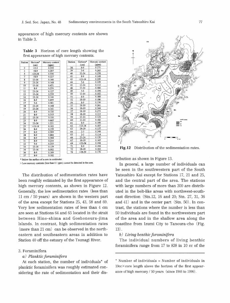
The distribution of sedimentation rates have
been roughly estimated by the first appearance of high mercury contents, as shown in Figure 12.
Generally, the low sedimentation rates (less than
11cm / 50 years) are shown in the western part
of the area except for Stations 25, 43, 58 and 69.
Very low sedimentation rates of less than 4 cm are seen at Stations 64 and 65 located in the strait
between Hino-shima and Goshonoura-jima
lslands. In contrast, high sedimentation rates
(more than 21cm) can be observed in the north-eastern and southeastern areas in addition to Station 40 off the estuary of the Tsunagi River.
3. Foraminifera
a) Planktic foraminifera
At each station, the number of individuals* of
planktic foraminifera was roughly estimated con-sidering the rate of sedimentation and their dis-
Fig.12 Distribution of the sedimentation rates.
tribution as shown in Figure 13.
In general, a large number of individuals can
be seen in the southwestern part of the South
Yatsushiro Kai except for Stations 17, 21 and 25,
and the central part of the area. The stations
with large numbers of more than 300 are distrib-
uted in the belt-like areas with northwest-south-
east direction (Stn.12, 16 and 20; Stn. 27, 31, 36
and 41) and in the center part (Stn. 50) . In con-
trast, the stations where the number is less than
50 individuals are found in the northwestern part
of the area and in the shallow area along the
coastline from Izumi City to Tanoura-cho (Fig.
13).
b) Living benthic foraminifera
The individual numbers of living benthic
foraminifera range from 17 to 838 in 10cc of the
* Number of individuals =Number of individuals in
10cc•~core length above the horizon of the first appear-
ance of high mercury / 50 years (since 1946 to 1996).

78 Rifardi, Kimihiko Oki and Takashi Tomiyasu 1998
Fig.13 Distribution of the number of individu-als of planktic foraminifera.
surface sediments in the South Yatsushiro Kai,
and their distribution is shown in Figure 14. In general, a large number of individuals, more
than 200, is found at the stations in the central
part of the South Yatsushiro Kai (Stn. 27, 28, 31, 32, 33, 36, 37, 38, 39, 41, 43, 44) , and Station 11 in
the southern part of the area. On the other hand, a small number of individuals, less than 100, is
seen at the stations in the northern and south-
eastern parts.
DISCUSSION
The South Yatsushiro Kai is divided into the
following five areas according to the character of
the bottom sediments: 1) areas near the straits
characterized by coarse-grained sediments
(Cluster III) ; 2) the southern part of the Sea and off the mouth of the Minamata River (Clusters IVa and b) ; 3) the northern and eastern parts of
the Sea characterized by fine-grained sediments
(Clusters ha, b and d); 4) the area mainly in the central part of the Sea (Cluster I); 5) the north-
Fig.14 Distribution of the number of individu-
als of living benthic foraminifera.
emn part of the Sea characterized by gravel or
gravelly sand sediments (Clusters IIc, IVc and
V) . The relationship between the characters of
bottom sediments and the depositional environ-
ments in these five areas is discussed below.
1. Areas near the straits characterized by coarse-
grained sediments (Cluster III)
Strong main currents are seen in the
Gannoshiri Seto and Kurono Seto (Hydrographic
Department, Maritime Safety Agency, 1978; Geo-
graphical Survey Institute, 1984; Fig. 3) . Core
samples at Stations 1, 6, 42, 47, 48 and 53 near
both the straits could not be collected, but a small
amount of surface sediments mainly composed of
shell fragments and gravels was recovered at the
same stations. These facts indicate that strong
tidal currents as rapid as more than 1 knot influ-
ence the bottom sediments in spite of the com-
paratively deep water depths (32.5•`54.3 m) at
the stations. Tidal currents flowing through the
Mefuki Seto and Ikara Seto are also strong at

79J. Sed. Soc. Japan, No. 48 Sedimentary emvironments in the South Yatsushiro Kai
Stations 15, 29 and 35 near the straits.
Cluster III is characterized by fine sand-
grained median diameter (2.2 to 2.85ƒÓ) and
relatively well sorted sediments (less than 1.35
ƒÓ) . The seven stations which belong to Cluster
III except for Station 9 are distributed in the
areas that extend from the straits to the South
Yatsushiro Kai. Stations 37, 43, 49, 54 and 58 are
distributed particularly in the elongate area off
the southeast coast of Goshonoura-jima. The fea-
tures described above suggest that strong bottom
currents constantly occur in and near the straits.
The grain-size composition of sediments at
Station 9 is rather similar to that at Stations 5, 10
and 14 (Cluster IVa) in the shore area off the
estuary of the Komenotsu River, but differs
slightly from the latter by its in well sorted and
fine skewed nature (0.23) .This situation may be
explained by the location of Station 9 in the vicin-
ity of sea mounds.
2. The southern part of the Sea and off the mouth
of the Minamata River (Clusters IVa and b)
All the stations included in Clusters III and IV
show the character of bottom sediments (MdƒÓ:
1.9•`2.9) which are influenced by rather strong
bottom current (Figs. 3, 5 and 6) . Five stations
which belong to Cluster IVa and b except for two
stations (Stn. 17 and 33) are located in the
coastal area off Izumi City (Fig. 10) . Judging
from the distribution pattern of sorting coeffi-
cients (ƒÐi; Fig. 7) , the bottom sediments sup-
plied by the Komenotsu River are assumed to
have spread toward the north. The feature sug-
gests that the counterclockwise longshore cur-
rents occur along the coast of Izumi City. The
Geographical Survey Institute (1984) reported
that the velocities of flood and ebb currents are
relatively strong in this area and the former is
stronger than the latter (Fig. 3) .These facts sup-
port the existence of longshore currents men-
tioned above.
Station 33 is located off the mouth of the
Minamata River. The poorly sorted sediments
supplied by the Minamata River were deposited
in the area (Fig. 7) , but the deposition of mostly
mud sediments was prevented by the flood cur-
rents which flow across the South Yatsushiro Kai
from the Gannoshiri Seto (Fig. 3) . Judging from
the distributions of median diameter (MdƒÓ; Fig.
5) and mud content (Fig. 6) , the mud part of the
sediments must have been transported from the
mouth of the Minamata River northeastward and
southwestward by very weak bottom currents,
and was accumulated in the areas off Minamata
Wan and off Tsunagi-cho where the high sedi-
mentation rates are seen (Fig. 12).
Station 17 is isolated from the stations which
are grouped into Clusters I and IIb. This may be
explained by the fact that Station 17 is located in
the vicinity of sea mounds with irregular subma-
rine topography.
3. The northern and eastern parts of the area
characterized by fine-grained sediments
(Clusters ha, b and d)
Fine-grained sediments, which belong to
Clusters ha, b and d, are distributed in the north-
ern and eastern parts of the South Yatsushiro Kai
(Figs. 5 and 6) . These sediments show the medi-
an diameter ranging from 3.4 to 4.5ƒÓ and the
near symmetrical to strongly fine skewed nature
(Ski: 0.0•`0.63) . All the sediments belonging to
Cluster IIb show the strongly fine skewed nature
of Ski 0.33 to 0.63 (Fig. 11) . Judging from the
high mud contents (33.0•`73.4%) at every sta-
tion, suspended sediments accumulate on the sea
bottom in the areas, and rather high sedimenta-
tion rates in the areas support the accumulation
of mud (Fig.12).
According to the Hydrographic Department,
Maritime Safety Agency (1978) and the Geo-
graphical Survey Institute (1984) , velocities of
the flood and ebb currents are relatively strong,
more than 0.5 knots in the northeastern part of
the South Yatsushiro Kai. However, bottom cur-
rents in the area must be very weak in spite of
the strong surface tidal currents, and this area is
occupied by rather stagnant water mass through-
out the year. Suspended sediments are assumed
80 Rifardi, Kimihiko Oki and Takashi Tomiyasu 1998
to be supplied by the ebb current flows south-
ward from the North Yatsushiro Kai where a
great amount of sediment derived from the hin-terland through the Kuma River, has been deposited.
The Sashiki and Tsunagi Rivers flow down into
the northern part of the area, but coarse-grained
sediments could not be seen in the area. The rea-
sons for deficiency of such sediments may be inferred as follows: 1) the Sashiki River has a
comparatively large drainage area, but this area
is mainly occupied by Paleozoic and Mesozoic
hard sedimentary rocks which are very resistant
against weathering; 2) the Tsunagi River has a small drainage area; 3) both rivers flow down
into small bays, respectively Nosakano-ura and
Tsunagi Wan, and the coarse sediments were
deposited in those bays (Geographical Survey
Institute, 1984). On the other hand, very fine sediments sup-
plied mainly by the Minamata River, seem to spread southwestward by very weak bottom cur-
rents and have accumulated in the area off
Minamata Wan (Figs. 5, 6 and 8) . The feature mentioned above is supported by high sedimen-
tation rates of more than 24 cm at Stations 18, 19
and 24 as well as by the presence of stagnant
water masses off Minamata through the spring
and neap tides (Hydrographic Department, Maritime Safety Agency, 1978).
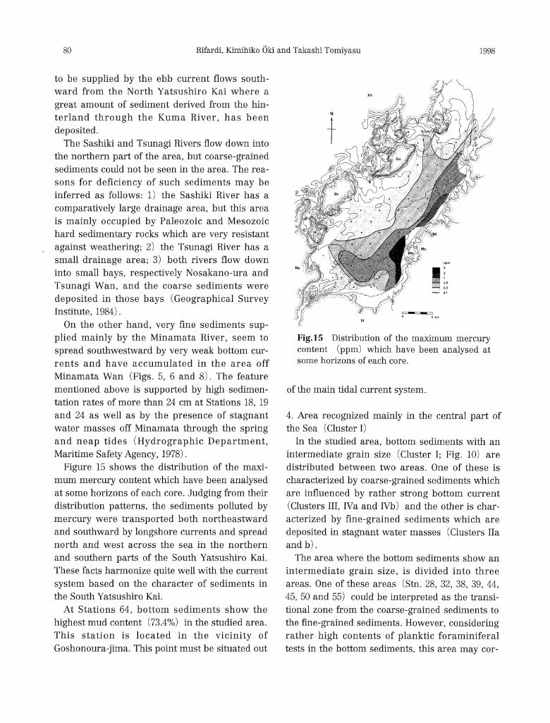
Figure 15 shows the distribution of the maxi-
mum mercury content which have been analysed
at some horizons of each core. Judging from their
distribution patterns, the sediments polluted by mercury were transported both northeastward
and southward by longshore currents and spread
north and west across the sea in the northern
and southern parts of the South Yatsushiro Kai.
These facts harmonize quite well with the current
system based on the character of sediments in the South Yatsushiro Kai.
At Stations 64, bottom sediments show the
highest mud content (73.4%) in the studied area.
This station is located in the vicinity of
Goshonoura-jima. This point must be situated out
Fig.15 Distribution of the maximum mercury content (ppm) which have been analysed at some horizons of each core.
of the main tidal current system.
4. Area recognized mainly in the central part of
the Sea (Cluster I)
In the studied area, bottom sediments with an
intermediate grain size (Cluster I; Fig. 10) are distributed between two areas. One of these is
characterized by coarse-grained sediments which
are influenced by rather strong bottom current
(Clusters III, IVa and IVb) and the other is char-acterized by fine-grained sediments which are
deposited in stagnant water masses (Clusters ha and b) .
The area where the bottom sediments show an
intermediate grain size, is divided into three
areas. One of these areas (Stn. 28, 32, 38, 39, 44,
45, 50 and 55) could be interpreted as the transi-tional zone from the coarse-grained sediments to
the fine-grained sediments. However, considering
rather high contents of planktic foraminiferal
tests in the bottom sediments, this area may cor-
81J. Sed. Soc. Japan, No. 48 Sedimentary emvironments in the South Yatsushiro Kai
respond to the boundary between the water
masses which enter into the South Yatsushiro Kai
through the Gannoshiri Seto and which flow
northward as the flood current along the east coast of the northern part of the sea, and the
rather stable surface water masses off the south-
east coast of Goshonoura-jima. Planktic forami-
niferal tests may be accumulated by a down
stream along the frontal interface which occurs in a current rip area (Sakamoto, 1982; Oki,
1989).
The other two areas extend across the South
Yatsushiro Kai; one extends from off the south-
east coast of Shishi-jima to the southeast (Stn. 22, 26, 27, 30, 31, 36 and 41) and the other
extends from off the east coast of Ikara-jima to
the southeast (Stn. 8, 11, and 20) . Both
the areas are sandwiched between areas where
strong tidal currents flow into and out through
the straits; Gannoshiri, Mefuki and Kurono Seto
(Fig. 3) . These areas must be out of the strong tidal current system, and suspended matters
accumulate on the sea bottom. This may best be
explained by the high contents of planktic
foraminiferal tests in the bottom sediments (Fig. 13).
Large number of individuals of living benthic
foraminifera (Fig. 14) in the bottom sediments
can be seen in the central part of the South
Yatsushiro Kai (Stn. 31, 32, 36, 37, 38, 41 and 44). The abundance of living benthic foraminifera
may be related to the supply of detritus by tidal
current systems, but further studies are needed
on the ecology of living benthic foraminifera.
5. The northern part of the sea characterized by
gravel or gravelly sand sediments (Clusters IIc, IVc and V)
The bottom sediment (Cluster IIc) at Station
74 located in the vicinity of a small island, Shiba-
shima, is characterized by a trimodal distribution
of grain size; granule (41.9%), coarse sand
(10.1%) and very fine sand (18.2%) . The high
gravel content may have resulted from the direct supply from the coastal area of Shiba-shima dur-
ing storms.
The area around Hino-shima shows rather
complex submarine topography with steep slopes and many small caldrons. Off the east coast of
Hino-shima, there is a depression more than 40
m deep (Fig. 2) . Core samples at the two stations
(Stn. 70 and 73) situated in this depression, could not be collected. According to the Geographical Survey Institute (1974), bottom
sediments in this area are characterized by
almost medium-grained sand. At Station 65 locat-
ed in the southernmost part of this depression,
bottom sediments show a trimodal distribution of
grain size; granule (5.8%), medium sand (44.8%) and coarse silt (7.8%) . These facts suggest that
the bottom currents are not so weak in the
depression area and gravels are derived from the
coastal area of Hino-shima.
Station 68 is located in the caldron near a nar-row channel. Bottom sediments at the station
show a trimodal distribution of grain size; gran-
ule (12.4%) , coarse sand (46.9%) and very fine
sand (11.7%) , and this character harmonizes
with the strength of current which flows through the narrow channel (Geographical Survey In-
stitute, 1984; Fig. 3).
The Karajiro Seto can be described as a small
inner bay which is surrounded on three sides by the islands of Hino-shima, Amakusa-kamishima
and Goshonoura-jima. Bottom sediments at two
stations (Stn. 64 and 69) , located in the Karajiro
Seto, are characterized by high mud contents of
more than 55%. The Geographical Survey Insti-
tute (1974) also reported that bottom sediments in the Karajiro Seto are characterized by silt at
almost all the points. These data indicate that the
area is occupied by rather stagnant water mass
except for the areas near the small channels, and
fine-grained sediments were accumulated in the Karajiro Seto area. The abnormal mercury con-
tents were found in the muddy sediments at
Station 69 (Fig. 15) . It is of particular interest
that the sediments polluted by mercury migrated
across the South Yatsushiro Kai off Minamata to

82 Rifardi, Kimihiko Oki and Takashi Tomiyasu 1998
this area, but this is not enough to explain the
process of sediment migration only by bottom
current system, based on the mechanical analysis
of bottom sediments. Owing to a lack of biological
evidence, a definite conclusion must be reserved.
CONCLUSIONS
The results of the present study are summa-
rized as follows:
1. General feature of the bottom sediments in the
South Yatsushiro Kai is characterized by one to
very fine sand (Figs. 5 and 11) . High mud con-
tents of more than 50% are found in the north-
eastern and northwestern parts of the Sea.
2. The South Yatsushiro Kai is divided into the
following five areas according to bottom sedi-
ment characters:
1) Areas near the straits characterized by
coarse-grained sediments (Cluster III).
2) The southern part of the Sea and off the
mouth of the Minamata River character-
ized by rather poorly sorted coarse-
grained sediments (Clusters IVa and b).
3) The northern and eastern parts of the Sea
characterized by fine-grained sediments
(Clusters ha, b and d).
4) Areas mainly in the central part of the
Sea characterized by the bottom sedi-
ments with an intermediate grain size
and the high contents of planktic forami-
niferal empty tests (Cluster I).
5) The northern part of the Sea character-
ized by gravel or gravelly sand sediments
(Clusters IIc, IVc and V).
3. The strong tidal currents flowing through the
straits (Gannoshiri, Mefuki and Kurono Seto)
influence the bottom sediments in spite of deep
water depth (32.5•`54.3 m) near the straits
(Area 1 mentioned above).
4. The poorly sorted sediments supplied by the
Komenotsu River spread northwards by the
counterclockwise longshore current which
occurs along the coast of Izumi City (Area 2).
5. Judging from the high mud contents and
rather high sedimentation rates, the northeast-
ern and northwestern (the Karajiro Seto area)
parts of the Sea and the area off Minamata Wan are occupied by rather stagnant water
masses throughout the year (Area 3).
6. Judging from the distribution pattern of the maximum mercury content at some horizons of
each core, the fine-grained sediments polluted
by mercury were transported northeastward
and southward by weak longshore currents and
spread toward north and west across the north-
ern and southern parts of the South Yatsushiro Kai.
7. Bottom sediments with an intermediate grain
size (Cluster I) and high contents of planktic
foraminiferal empty tests are distributed in the areas which are situated at the boundary
between different water masses.
ACKNOWLEDGEMENTS
We wish to express our deep gratitude to Dr.
Hakuyu Okada, former Professor of Kyushu
University, for critical reading of the manuscript and valuable suggestions concerning sedimen-
tology. Particular thanks are due to Professor
Hiroshi Ujiie of Takushoku University who was
an advisor to Rifardi during his M. Sc. study at Department of Marine Sciences, College of Sci-
ence, University of the Ryukyus, Okinawa, for
encouragements and reading of the manuscript;
Professor Johann Hohenegger of the Institute of
Paleontology, University of Vienna, for his
encouragement and valuable suggestions con-cerning the relationship between bottom sedi-
ments and benthic foraminifera; Mr. Teruo
Kasedo, the captain of R.V. Azuma and the crew,
the Fisheries Research Laboratory, Faculty of
Fisheries, Kagoshima University, for their kind help in on-board work, and Ms Hiroko Ijiri, tech-
nical official of the Kagoshima University Infor-
mation Processing Center, for her technical assis-
tance with the computer work. We also thank
Professor Hiroyuki Otsuka of the Department of Earth and Environmental Sciences, Faculty of
Science, and Professor Gunzo Kawamura of the
Department of Fisheries Science and Technology,

83J. Sed. Soc. Japan, No. 48 Sedimentary emvironments in the South Yatsushiro Kai
Faculty of Fisheries, Kagoshima University, for
their encouragement.
REFERENCES
Akagi, H. and Nishimura, H., 1991: Speciation of
mercury in the environment. In Suzuki, T.,
Imura, N. and Clarkson, T. W., eds., Ad-
vances in Mercury Toxicology, Plenum Press,
New York, 53-76. Finch, V.C. and Trewartha, G.T., 1949: Elements
of geography, physical and culture. McGraw-
Hill Book Co. Inc., 711p.
Folk, R. L, and Ward, W. C., 1957: Brazos River
bar: a study in the significance of grain size
parameter. Jour. Sed. Pet., 27, 3-26. Geographical Survey Institute, 1974: The 1:25, 000
topographic and land condition maps of the
coastal sea and land areas "Kyoragi" (in
Japanese). Geographical Survey Institute, Tsukuba, Japan.
Geographical Survey Institute, 1982: Reports of
fundamental survey of the coastal sea areas "Mi
namata" (in Japanese). Geographical
Survey Institute, Tsukuba, Japan, 119p.
Geographical Survey Institute, 1984: Ibid. "Izumi"
(in Japanese). Geographical Survey Institute, Tsukuba, Japan, 97p.
Hirota, R. and Hara, M., 1975: Zooplankton inves-
tigation in Yatsushiro Kai, Western Kyushu,
I. Regional and seasonal occurrences of the important zooplankton. J. Oceanogr. Soc.
Japan, 31,115-123.
Hydrographic Department, Maritime Safety
Agency, 1974: Report on oceanographic sur-
vey in Ariake-Kai and Yatsushiro Kai (in
Japanese). Maritime Safety Agency, Tokyo, Japan, 39p.
Hydrographic Department, Maritime Safety
Agency, 1978: Charts of tidal currents in
Simabara Wan and Yatsushiro Kai (in
Japanese). No.6217, Maritime Safety Agency, Tokyo, Japan.
Kikuchi, T., 1983: The composition and distribu-
tion of macrobenthos communities in
Shiranuhi Kai (in Japanese). In Yamagata,
N., Doi, R., Saishu, S. and Taguchi, T., eds., "Endeavour against environme
ntal pollution-biological effect of heavy metals", Koseisha-
ku Ltd., 71-84, Tokyo.
Kikuchi, T. and Tanaka, M., 1978: Studies on ben-
thos of polluted water: I. Benthic communi-ties of Ariake Sea and Yatsushiro Sea. In
Irie, H., ed., Fundamental study on the cy-
cling of pollutants and long term variation of
fauna in embayment waters, Reseach Rep.,
1975-1977, 75-80. Kitamura, S., Ueda, K., Niino, J., Ujioka, T.,
Misumi, H. and Kakita, T., 1960: Minamata-
byo ni kansuru Kagaku-dokubutsu Kensaku
Seiseki (in Japanese). Jour. Kumamoto Medi-
cal Society, 34, 593-601. Norusis, M.J., 1993: SPSS for UNIX, professional
statistics release 5.0. SPSS Inc., 345p.
Oki, K., 1989: Ecological analysis of benthonic
foraminifera in Kagoshima Bay, South
Kyushu, Japan. South Pacific Study., 10 (1), 1-191.
Sakamoto, W., 1982: Detritus-roles of suspended
and bottom sediment on coastal marine
ecosystem (in Japanese). Marine Sci. Month-
ly, 14 (8), 482-489.
Shepard, F.P., 1954: Nomenclature based on sand-silt-clay ratio. Jour. Sed. Pet., 24, 151-
158.
Tanaka, M., Kikuchi, T., Tsutsumi, H., Nojima, S.,
Mori, K., Tamaki, A., Asakura, A., Yun, S. G.,
Nishihama, S., Soliman, F. E., Suzuki, H., Rodrigues, C. L., Aoki, M., Fischer, S. and
Aryuthaka, C., 1987: Ecological studies on the
benthic ecosystem in Yatsushiro Kai, West
Kyushu: I. Physico-chemical measurement of
bottom sediment. Publ. Amakusa Mar. Biol. Lab., 9 (1),1-45.
Tsuruta, A., Ueno, S., Ohgai, M. and Yamada, M.,
1986: Study on the seasonal and horizontal
distribution of phytoplankton communities in
Yatsushiro Sea, using a cluster analysis (in
Japanese with English summary). Bull. Japan. Soc. Sci. Fish. (Nippon Suisan
Gakkaishi), 52,1947-1955.

84 Rifardi, Kimihiko Oki and Takashi Tomiyasu 1998
Tsuruta, A., Ueno, S., Ohgai, M. and Yamada, M.,
1987: Seasonal and horizontal distribution of
phytoplanktonic diatom Skeletonema costa-
turn (Grey.) Cleve in Yatsushiro Sea. Ibid., 53,
141-144.
表 層 堆 積 物 の組 成 と堆 積 速 度 か らみ た南 八 代 海 の堆 積 環 境
Rifardi・大木 公彦 ・冨安 卓滋,1998,堆 積学研究,No,48,67-84
Rifardi, Oki, K, and Tomiyasu, T., 1998: Sedimentary environments based on textures of
surface sediments and sedimentation rates in the South Yatsushiro Kai (Sea), southwest
Kyushu, Japan. Jour. Sed. Soc. Japan, No. 48, 67-84.
九州西部の,天 草の島々によって外洋 と分けられている南八代海の表層堆積物 と海洋環境 と
の関係 を明 らかにすることを目的 として,1996年3月 に74点 のコア試料を採取 した.62の コア
の試料 は,settling-tube methodに よって粒度分析 に使われ,61の 試料は,コ ア中の水銀含有
量の異常値の初出現層準から堆積速度(cm/約50年)を 見積 もるために使われた.一 方、73の
コア試料 の最上部1cm(10ccに 相当)は,底 生 ・浮遊性有孔虫殻の個体数の地理的分布,底 生
有孔虫生体殻の生息分布を知 るために使われた.
それらの研究結果から,南 八代海は次の5つ の海域にまとめることがで きる:1)西 側 の海
峡近 くの海域は,強 い潮流 ・底層流 を反映 して粗い堆積物で特徴づ けられる;2)南 部 と水俣
川河口沖の浅海域は,沿 岸流の影響 と米ノ津川 ・水俣川か ら供給 される堆積物から,比 較的粗
粒 な,淘 汰の悪い堆積物で特徴づけられる;3)北 西部 と東部海域は,比 較的停滞 した水塊 の
存在か ら細粒堆積物で特徴づけられ,堆 積速度 も一般に早い;4)中 央部では,弱 い潮流 と異
なる水塊の潮目付近に位置することを反映 して,比 較的細粒 な,浮 遊性有孔虫遺骸殻を多 く含
んだ堆積物によって特徴づけられる;5)北 部の島に近い海域では,沿 岸浅海域か らもたらさ
れた礫あるいは礫質砂によって特徴づけられる.
各 コアで測定された水銀含有量最大値の地理的分布から,水 銀 に汚染 された細粒堆積物は水
俣湾沖か ら沿岸流によって北東 と南へ移動 し、南八代海の北部では北へ,南 部では西へ,海 域
を横切 って拡散 していることが明らかになった.