Embed Size (px)
Citation preview
Sedimentary Structures and Environments -Sean Tvelia-
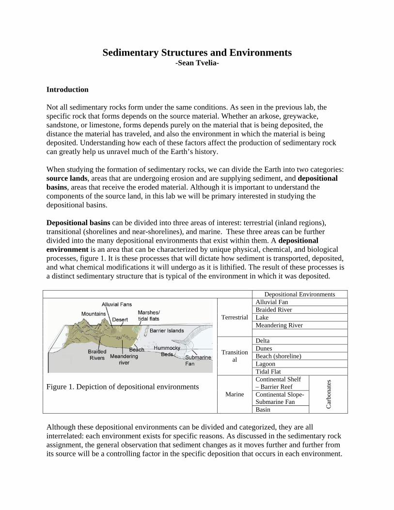
Introduction Not all sedimentary rocks form under the same conditions. As seen in the previous lab, the specific rock that forms depends on the source material. Whether an arkose, greywacke, sandstone, or limestone, forms depends purely on the material that is being deposited, the distance the material has traveled, and also the environment in which the material is being deposited. Understanding how each of these factors affect the production of sedimentary rock can greatly help us unravel much of the Earth’s history. When studying the formation of sedimentary rocks, we can divide the Earth into two categories: source lands, areas that are undergoing erosion and are supplying sediment, and depositional basins, areas that receive the eroded material. Although it is important to understand the components of the source land, in this lab we will be primary interested in studying the depositional basins. Depositional basins can be divided into three areas of interest: terrestrial (inland regions), transitional (shorelines and near-shorelines), and marine. These three areas can be further divided into the many depositional environments that exist within them. A depositional environment is an area that can be characterized by unique physical, chemical, and biological processes, figure 1. It is these processes that will dictate how sediment is transported, deposited, and what chemical modifications it will undergo as it is lithified. The result of these processes is a distinct sedimentary structure that is typical of the environment in which it was deposited.
Depositional Environments Alluvial Fan Braided River Lake Meandering River
Terrestrial
Delta Dunes Beach (shoreline) Lagoon
Transitional
Tidal Flat Continental Shelf – Barrier Reef Continental Slope- Submarine Fan
Figure 1. Depiction of depositional environments Marine
Basin Car
bona
tes
Although these depositional environments can be divided and categorized, they are all interrelated: each environment exists for specific reasons. As discussed in the sedimentary rock assignment, the general observation that sediment changes as it moves further and further from its source will be a controlling factor in the specific deposition that occurs in each environment.
For example, in areas close to the source, such as an alluvial fan or a braided river, the material deposited will have a much larger particle size than those deposited further from the source in an ocean basin. The sequence of depositional environments that occurs between the source land, or mountain region, and the ocean basin is called a system. In areas where the distance between the source and the ocean basin is great, the system is considered a long system. When these distances are relatively short, the system is considered a short system. In a long system, sediments at the beginning or source are mechanically and chemically unstable in composition. Furthermore, the manner in which the sediments are deposited will often lead to the development of poorly sorted, immature gravels. However, since in the long system the distance between the source material and the ocean basin is great, sediment that has been transported to the ocean has undergone sufficient weathering and sorting. Therefore this sediment typically consists of chemically and mechanically stable, well sorted sands and clays. Question 1 Based on composition and particle size, describe how a beach situated along side an eroding mountain range might differ from one located one hundred miles from the nearest mountain. Question 2 Describe the different depositional environments that a particle might encounter as it travels from the source land to its final deposition in the ocean one hundred miles away. Question 3 Describe a situation that would result in a short system.
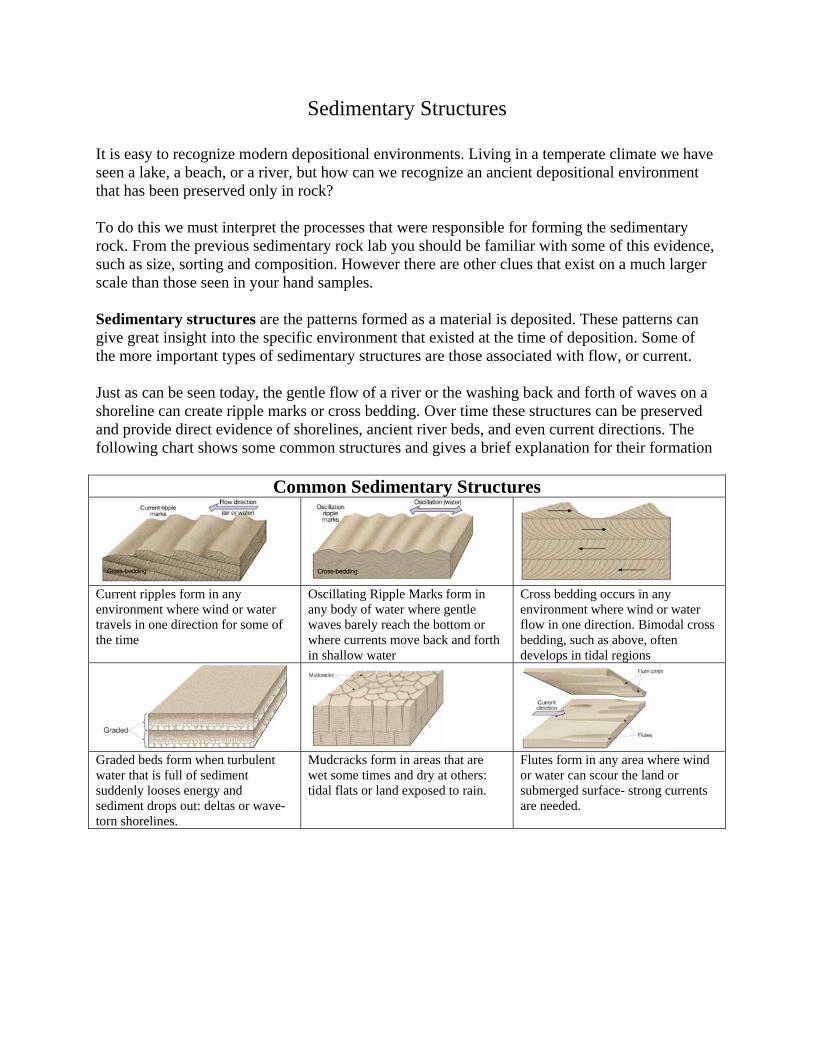
Sedimentary Structures
It is easy to recognize modern depositional environments. Living in a temperate climate we have seen a lake, a beach, or a river, but how can we recognize an ancient depositional environment that has been preserved only in rock? To do this we must interpret the processes that were responsible for forming the sedimentary rock. From the previous sedimentary rock lab you should be familiar with some of this evidence, such as size, sorting and composition. However there are other clues that exist on a much larger scale than those seen in your hand samples. Sedimentary structures are the patterns formed as a material is deposited. These patterns can give great insight into the specific environment that existed at the time of deposition. Some of the more important types of sedimentary structures are those associated with flow, or current. Just as can be seen today, the gentle flow of a river or the washing back and forth of waves on a shoreline can create ripple marks or cross bedding. Over time these structures can be preserved and provide direct evidence of shorelines, ancient river beds, and even current directions. The following chart shows some common structures and gives a brief explanation for their formation
Common Sedimentary Structures
Current ripples form in any environment where wind or water travels in one direction for some of the time
Oscillating Ripple Marks form in any body of water where gentle waves barely reach the bottom or where currents move back and forth in shallow water
Cross bedding occurs in any environment where wind or water flow in one direction. Bimodal cross bedding, such as above, often develops in tidal regions
Graded beds form when turbulent water that is full of sediment suddenly looses energy and sediment drops out: deltas or wave-torn shorelines.
Mudcracks form in areas that are wet some times and dry at others: tidal flats or land exposed to rain.
Flutes form in any area where wind or water can scour the land or submerged surface- strong currents are needed.
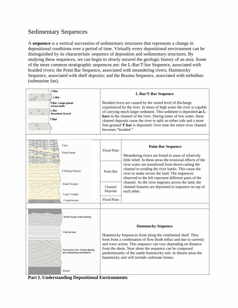
Sedimentary Sequences A sequence is a vertical succession of sedimentary structures that represents a change in depositional conditions over a period of time. Virtually every depositional environment can be distinguished by its characteristic sequence of deposition and sedimentary structures. By studying these sequences, we can begin to slowly unravel the geologic history of an area. Some of the more common stratigraphic sequences are: the L-Bar/T-bar Sequence, associated with braided rivers; the Point Bar Sequence, associated with meandering rivers; Hummocky Sequence, associated with shelf deposits; and the Bouma Sequence, associated with turbidites (submarine fan).
L-Bar/T-Bar Sequence
Braided rivers are caused by the varied level of discharge experienced by the river. In times of high water the river is capable of carrying much larger sediment. This sediment is deposited as L-bars in the channel of the river. During times of low water, these channel deposits cause the river to split on either side and a more fine-grained T-bar is deposited. Over time the entire river channel becomes “braided.”
Flood Plain
Point Bar
Channel Deposits
Flood Plain
Point Bar Sequence Meandering rivers are found in areas of relatively little relief. In these areas the erosional effects of the river water are transferred from down-cutting the channel to eroding the river banks. This cause the river to snake across the land. The sequences observed to the left represent different parts of the channel. As the river migrates across the land, the channel features are deposited in sequence on top of each other.
Hummocky Sequence
Hummocky Sequences form along the continental shelf. They form from a combination of flow (both influx and due to current) and wave action. This sequence can vary depending on distance from the shore. Near shore the sequence can be composed predominantly of the sandy hummocky unit. In distant areas the hummocky unit will include carbonate lenses.
Part I. Understanding Depositional Environments

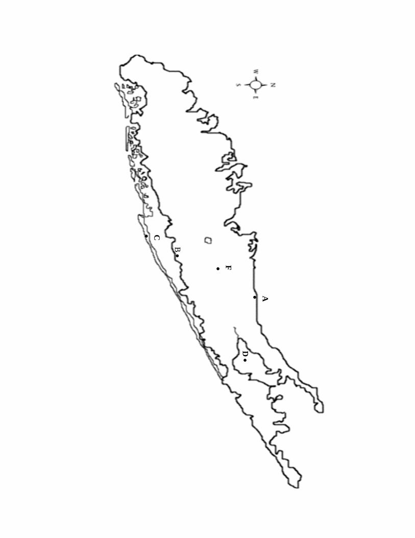
A. On the following map of Long Island, label the areas where one might find terrestrial, transitional, and marine depositional environments. B. Once you have labeled the depositional environments identify areas in which you might find the following
Beach Dunes Lagoon Tidal Flat Lake Rivers Alluvial Fan Continental Shelf
C. Are there any areas on Long Island that represent a short system? If so mark these areas with a small arrow pointing in the direction of sediment movement.
C
•
B •
F •
A•
D
•
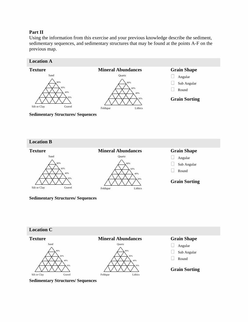
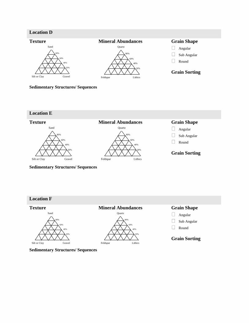
Part II Using the information from this exercise and your previous knowledge describe the sediment, sedimentary sequences, and sedimentary structures that may be found at the points A-F on the previous map. Location A
Grain Shape Angular
Sub Angular
Round
Texture
Mineral Abundances
Grain Sorting 40%
60%
Sand
Silt or Clay Gravel
20%
80%
40%
60%
Quartz
Feldspar Lithics
20%
80%
Sedimentary Structures/ Sequences
Location B
Grain Shape Angular
Sub Angular
Round
Texture
Mineral Abundances
Grain Sorting
40%
60%
Sand
Silt or Clay Gravel
20%
80%
40%
60%
Quartz
Feldspar Lithics
20%
80%
Sedimentary Structures/ Sequences Location C
Grain Shape Angular
Sub Angular
Round
Texture
Mineral Abundances
Grain Sorting
40%
60%
Sand
Silt or Clay Gravel
20%
80%
40%
60%
Quartz
Feldspar Lithics
20%
80%
Sedimentary Structures/ Sequences
Location D
Grain Shape Angular
Sub Angular
Round
Texture
Mineral Abundances
Grain Sorting
40%
60%
Sand
Silt or Clay Gravel
20%
80%
40%
60%
Quartz
Feldspar Lithics
20%
80%
Sedimentary Structures/ Sequences Location E
Grain Shape Angular
Sub Angular
Round
Texture
Mineral Abundances
Grain Sorting
40%
60%
Sand
Silt or Clay Gravel
20%
80%
40%
60%
Quartz
Feldspar Lithics
20%
80%
Sedimentary Structures/ Sequences
Location F
Grain Shape Angular
Sub Angular
Round
Texture
Mineral Abundances
Grain Sorting
40%
60%
Sand
Silt or Clay Gravel
20%
80%
40%
60%
Quartz
Feldspar Lithics
20%
80%
Sedimentary Structures/ Sequences
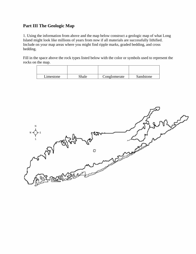
Part III The Geologic Map 1. Using the information from above and the map below construct a geologic map of what Long Island might look like millions of years from now if all materials are successfully lithified. Include on your map areas where you might find ripple marks, graded bedding, and cross bedding. Fill in the space above the rock types listed below with the color or symbols used to represent the rocks on the map.
Limestone Shale Conglomerate Sandstone
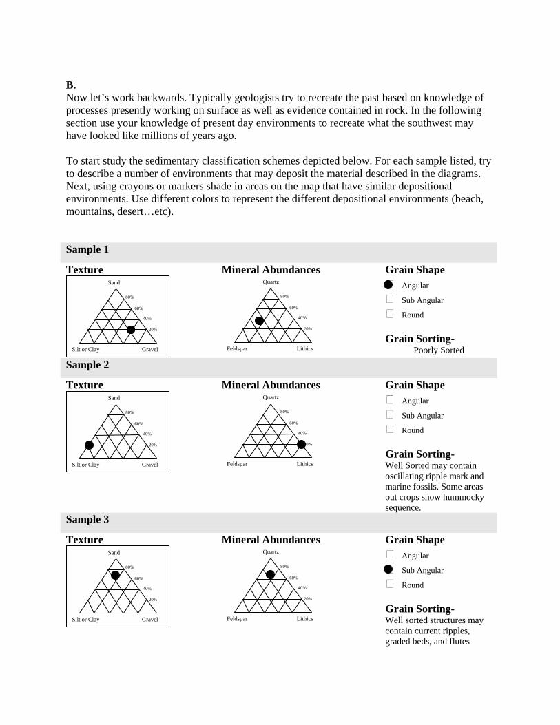
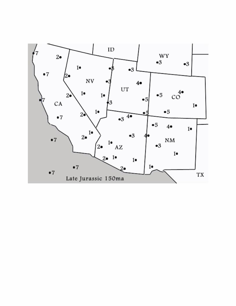
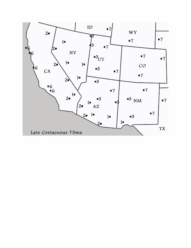
B. Now let’s work backwards. Typically geologists try to recreate the past based on knowledge of processes presently working on surface as well as evidence contained in rock. In the following section use your knowledge of present day environments to recreate what the southwest may have looked like millions of years ago. To start study the sedimentary classification schemes depicted below. For each sample listed, try to describe a number of environments that may deposit the material described in the diagrams. Next, using crayons or markers shade in areas on the map that have similar depositional environments. Use different colors to represent the different depositional environments (beach, mountains, desert…etc). Sample 1
Grain Shape Angular
Sub Angular
Round
Texture
Mineral Abundances
Grain Sorting-
Poorly Sorted
Sample 2
Grain Shape Angular
Sub Angular
Round
Texture
Mineral Abundances
Grain Sorting- Well Sorted may contain oscillating ripple mark and marine fossils. Some areas out crops show hummocky sequence.
Sample 3
Grain Shape Angular
Sub Angular
Round
Texture
Mineral Abundances
Grain Sorting- Well sorted structures may contain current ripples, graded beds, and flutes
40%
60%
Quartz
Feldspar Lithics
20%
80%
40%
60%
Sand
Silt or Clay Gravel
20%
80%
40%
60%
Quartz
Feldspar Lithics
20%
80%
40%
60%
Sand
Silt or Clay Gravel
20%
80%
40%
60%
Sand
Silt or Clay Gravel
20%
40%
60%
Quartz
Feldspar Lithics
20%
80% 80%
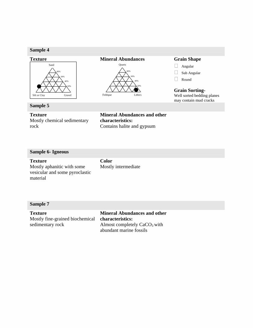
Sample 4
Grain Shape Angular
Sub Angular
Round
Texture
Mineral Abundances
Grain Sorting- Well sorted bedding planes may contain mud cracks
Sample 5
Texture Mostly chemical sedimentary rock
Mineral Abundances and other characteristics: Contains halite and gypsum
Sample 6- Igneous
Texture Mostly aphanitic with some vesicular and some pyroclastic material
Color Mostly intermediate
Sample 7
Texture Mostly fine-grained biochemical sedimentary rock
Mineral Abundances and other characteristics: Almost completely CaCO3 with abundant marine fossils
40%
60%
Sand
Silt or Clay Gravel
20%
80%
40%
60%
Quartz
Feldspar Lithics
20%
80%