Embed Size (px)
Citation preview
Alamosa River Watershed Restoration Master Plan and Environmental Assessment Page 4-1
Section 4.0 - Alternatives and Preferred PlanThis section of the Master Plan presents the transition from evaluating projects on an individual basis tocombining projects into groups referred to as alternatives. This section also discusses the expectedenvironmental consequences of implementing each of the alternatives.
4.1 Development of Watershed Restoration AlternativesThe following three approaches were used to develop watershed restoration alternatives:
• Project rank alternative• Watershed objectives alternative• Trustee priorities
The approach for formulating each alternative, or comprehensive package of projects, and the individualprojects that best fit the approach are described below.
4.1.1 Project Rank Alternative
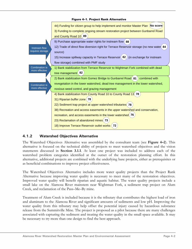
The first alternative was assembled based on the project ranking established in Section 3.15. Projectranking was determined by ordering projects according to their total project score from highest tolowest. The highest ranked projects are shown in Figure 4–1 along with the overall project scores.Project numbers are also included to assist with correlation to project descriptions in Section 3. Someprojects were included out of rank order because they are either prerequisites for other highly rankedprojects (shown in purple) or because they are logical combinations with other highly ranked alternatives(shown in green).
Funding for a citizen group to help implement and monitor the Master Plan, Project 44, was included inall three alternatives. Funding the Alamosa River Foundation will facilitate implementation of thepreferred alternative. This project does not have a score because studies and administrative activitieswere not ranked on the same scale as physical projects.
Purchase instream flow water rights, Project 9, was the second highest ranked project with a total scoreof 88. The instream flow water rights project requires a storage project. Project 12, trade of direct flowdiversion right for storage in Terrace Reservoir, was the highest ranked storage project and is includedas a prerequisite. In most years, Project 12 is not expected to provide enough storage for the entireinstream flow water right. Therefore, the second highest ranked storage project, increase spillwaycapacity, Project 15, is also included.
The stream restoration projects are combined with related projects such as revegetation, dead treemanagement, weed management, and grazing management. The combination of projects will improvethe performance of stream restoration and will reduce the total project cost compared toimplementation of each project independently.
This alternative includes the reclamation of abandoned mines, Project 23, at a funding level that wouldfacilitate water quality treatment at both the Pass–Me–By and Miser Mines as well as provide funds forsome other cleanup activities.
Alamosa River Watershed Restoration Master Plan and Environmental Assessment Page 4-2
Figure 4–1. Project Rank Alternative
44) Funding for citizen group to help implement and monitor Master Plan
3) Funding to complete ongoing stream restoration project between Gunbarrel Road
and County Road 10
9) Purchase appropriate water rights for instream flow
12) Trade of direct flow diversion right for Terrace Reservoir storage (no new water
source)
15) Increase spillway capacity in Terrace Reservoir (in exchange for instream
flow storage) combined with PMF study
1) Bank stabilization from Terrace Reservoir to Wightman Fork combined with dead
tree management
2) Bank stabilization from Gomez Bridge to Gunbarrel Road combined with
revegetation in the lower watershed, dead tree management in the lower watershed,
noxious weed control, and grazing management
4) Bank stabilization from County Road 10 to County Road 13
31) Riparian buffer zone
22) Sediment trap project at upper watershed tributaries
38) Recreation and access easements in the upper watershed and conservation,
recreation, and access easements in the lower watershed
23) Reclamation of abandoned mines
18) Improve Terrace Reservoir outlet works
Instream flowrequires storage
Combination ismore effective
Combination ismore effective
89
78
78
81
82
82
84
88
72
73
76
78
No score
4.1.2 Watershed Objectives Alternative
The Watershed Objectives Alternative was assembled by the consultant team (see Figure 4–2). Thisalternative is focused on the technical ability of projects to meet watershed objectives and the visionstatements discussed in Section 3.1.1. At least one project was included to address each of thewatershed problem categories identified at the outset of the restoration planning effort. In thisalternative, additional projects are combined with the underlying base projects, either as prerequisites oras beneficial combinations to improve project effectiveness.
The Watershed Objectives Alternative includes more water quality projects than the Project RankAlternative because improving water quality is necessary to meet many of the restoration objectives.Improved water quality will benefit riparian and aquatic habitat. The water quality projects include asmall lake on the Alamosa River mainstem near Wightman Fork, a sediment trap project on AlumCreek, and reclamation of the Pass–Me–By mine.
Treatment of Alum Creek is included because it is the tributary that contributes the highest load of ironand aluminum to the Alamosa River and significant amounts of sediments and low pH. Improving thewater quality from this tributary may help offset the potential injury caused by hazardous substancerelease from the Summitville Mine. The project is proposed as a pilot because there are many challengesassociated with capturing the sediment and treating the water quality in the small space available. It maybe necessary to try more than one design to find the best approach.

Alamosa River Watershed Restoration Master Plan and Environmental Assessment Page 4-3
Abandoned mines contribute to water quality problems, but to a much smaller degree than WightmanFork and other altered tributaries. The abandoned mines contribute less than 5 percent of the watershedload for each metal of concern (as discussed in Section 2.4.9). Therefore, only the largest mine, thePass–Me–By mine, is proposed for inclusion in this alternative. The Pass–Me–By Mine has the lowestpH and contributes the highest loads of copper, iron, and aluminum of any of the mining sites.
The instream flow project is included to restore some of the natural river function downstream ofTerrace Reservoir.
Finally, the Terrace Reservoir dewatering management plan was proposed in combination with asediment quality study. The sediment quality study will provide more information on how to bestmanage sediments if it is necessary to drain the reservoir.
Figure 4–2. Watershed Objectives Alternative
Instream flowrequires storage
Combination ismore effective
Combination ismore effective
Logical projectcombination
44) Funding for citizen group to help implement and monitor Master Plan
9) Purchase appropriate water rights for instream flow
12) Trade of direct flow diversion right for Terrace Reservoir storage (no new water
source)
15) Increase spillway capacity in Terrace Reservoir (in exchange for instream flow
storage) combined with PMF study
2) Bank stabilization from Gomez Bridge to Gunbarrel Road combined with
revegetation in the lower watershed, dead tree management in the lower watershed,
noxious weed control, and grazing management.
3) Funding to complete ongoing stream restoration project between Gunbarrel Road
and County Road 10
22) Sediment trap pilot project with water quality BMPs on Alum Creek
23) Reclamation of abandoned mines (Pass-Me-By mine only)
1) Bank stabilization from Terrace Reservoir to Wightman Fork combined with dead
tree management
41) Increased access to Terrace Reservoir (include public education signage)
38) Recreation and access easements in the upper watershed and conservation,
recreation, and access easements in the lower watershed
24) Mainstem lake for water quality (small size option)
20) Lower watershed sediment deposition locations
35) Fish stocking at Terrace Reservoir
48) Terrace reservoir dewatering management plan / sediment quality study
4.1.3 No Action Alternative
The No Action Alternative is mute because the consent decree requires the Trustees to take action anduse the NRD funds for watershed restoration activities.

Alamosa River Watershed Restoration Master Plan and Environmental Assessment Page 4-4
4.1.4 Trustee Preferences Alternative
The Trustee Preferences Alternative was developed by the Trustees based on their natural resourcerestoration goals for the Alamosa River watershed. Their alternative is similar to the other twoalternatives (see Figure 4–3). The Trustees included Project 32, acquisition of equivalent resource in theSan Luis Valley for high quality habitat and recreation. This project would involve the acquisition ofequivalent resources in the neighboring Conejos River watershed for high quality habitat and recreation.This project was important to the federal Trustees as it would provide immediate restoration, by theprotection from residential development, of wildlife and recreation resources deemed important to thestate and federal Trustees.
Figure 4–3. Trustee Preferences Alternative
Instream flowrequires storage
Combination ismore effective
44) Funding for citizen group to help implement and monitor Master Plan
3) Funding to complete ongoing stream restoration project between Gunbarrel Road
and County Road 10
32) Acquisition of equivalent resource in San Luis Valley for high quality habitat and
recreation
9) Purchase appropriate water rights for instream flow
12) Trade of direct flow diversion right for Terrace Reservoir storage (no new water
source)
15) Increase spillway capacity in Terrace Reservoir (in exchange for instream flow
storage) combined with PMF study
1) Bank stabilization from Terrace Reservoir to Wightman Fork combined with dead
tree management
2) Bank stabilization from Gomez Bridge to Gunbarrel Road combined with
revegetation in the lower watershed, dead tree management in the lower watershed,
noxious weed control, and grazing management.
38) Recreation and access easements in the upper watershed and conservation,
recreation, and access easements in the lower watershed
31) Riparian buffer zone
24) Mainstem lake for water quality (small size option)
23) Reclamation of abandoned mines (Pass-Me-By mine only)
41) Increased access to Terrace Reservoir (include public education signage)
20) Lower watershed sediment deposition locations
Combination ismore effective
4.2 Evaluation of Impacts of Watershed AlternativesThis section compares the prioritization of projects between the three alternatives and discusses thebenefits and uncertainties of the projects.
4.2.1 Project Priority Comparison
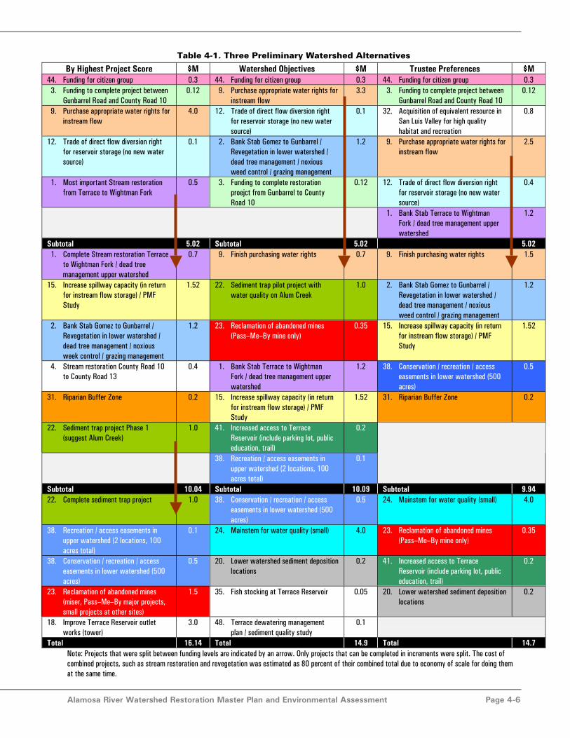
The three watershed alternatives were each organized into three alternative funding levels, $5, $10, and$15 million. The first funding level is what is already available through the Summitville settlement. Theother two funding levels are discussed because the Foundation and Trustees plan to seek additional
Alamosa River Watershed Restoration Master Plan and Environmental Assessment Page 4-5
funding sources to leverage the funds that are already available. The different funding levels requiredthat projects be prioritized and evenly divided into parts as needed to fit into three tiers. Prioritizedalternatives are shown in Table 4-1. Projects that are the same amongst the alternatives are shown in thesame color. The table shows that the alternatives are almost the same in terms of content. The majordifference is the order that projects are listed.
4.2.2 Project Benefits and Uncertainties
At this stage of the restoration planning process, the draft Master Plan describes project concepts andgeneral plans with cost estimates, but not specific, detailed project proposals with itemizedimplementation costs. Submission of such detailed plans will be the next step toward the ultimateimplementation of selected restoration actions. Thus, it is not possible to do a quantitative benefit/costanalysis at this preliminary stage of project development.
The benefits and uncertainties of the different projects included in the three alternatives can bediscussed qualitatively. The benefits of all of the projects are discussed in Section 3. The projects withthe most uncertainty are discussed here to reiterate the significant obstacles that may exist forimplementing these projects. The projects with the most uncertainty are instream flow, the sedimenttrap, the mainstem lake, and reclamation of abandoned mines. The uncertainty in each of these projectsis discussed below. Despite the significant uncertainty, these projects are included in restorationalternatives because the stakeholders feel that their benefits are important and that they may be possibleto implement.
9) Purchase Appropriate Water Rights for Instream FlowThis project will help meet many of the Master Plan objectives and will lead to benefits in manyresource categories. However, there is considerable uncertainty in its implementation as discussedbelow:
• The project requires a willing seller of an appropriate water right at a reasonable price.Only the most senior water rights are able to provide a reliable flow. There may not be awilling seller in the near future.
• The project will require a change of water right, which must be approved in water court.By law, a change in water right cannot negatively impact other water users, particularlydownstream users who have historically relied upon agricultural return flows. Theinstream flow water right may not be able to claim the entire historical diversion right.Under the worst case scenario, only the historical consumptive use could be transferred.The exact ruling of a water court case cannot yet be predicted.
• Storage must be obtained to hold the water from the time it is in priority in spring andsummer, to when it is beneficial in the stream, fall, winter, and early spring.
• CWCB is the only entity in Colorado legally entitled to hold instream flow water rightsand must agree to accept the water right.
• The water right seller does not have to sell the land associated with the water right.However, if land is included as part of the sale, a new owner for the land will have to bedetermined. The subsequent disposition of that land in a non–irrigated status could alsopose management issues.
• The final plan for storage and delivery of an instream flow should be based on the mosteconomically efficient methodology. Therefore, although a framework has beensuggested, the most economical methodology to achieve an instream flow is uncertainuntil negotiations are entered into for storage and delivery options.
Alamosa River Watershed Restoration Master Plan and Environmental Assessment Page 4-6
Table 4-1. Three Preliminary Watershed Alternatives
By Highest Project Score $M Watershed Objectives $M Trustee Preferences $M44. Funding for citizen group 0.3 44. Funding for citizen group 0.3 44. Funding for citizen group 0.3 3. Funding to complete project between
Gunbarrel Road and County Road 100.12 9. Purchase appropriate water rights for
instream flow3.3 3. Funding to complete project between
Gunbarrel Road and County Road 100.12
9. Purchase appropriate water rights forinstream flow
4.0 12. Trade of direct flow diversion rightfor reservoir storage (no new watersource)
0.1 32. Acquisition of equivalent resource inSan Luis Valley for high qualityhabitat and recreation
0.8
12. Trade of direct flow diversion rightfor reservoir storage (no new watersource)
0.1 2. Bank Stab Gomez to Gunbarrel /Revegetation in lower watershed /dead tree management / noxiousweed control / grazing management
1.2 9. Purchase appropriate water rights forinstream flow
2.5
1. Most important Stream restorationfrom Terrace to Wightman Fork
0.5 3. Funding to complete restorationproejct from Gunbarrel to CountyRoad 10
0.12 12. Trade of direct flow diversion rightfor reservoir storage (no new watersource)
0.4
1. Bank Stab Terrace to WightmanFork / dead tree management upperwatershed
1.2
Subtotal 5.02 Subtotal 5.02 5.02 1. Complete Stream restoration Terrace
to Wightman Fork / dead treemanagement upper watershed
0.7 9. Finish purchasing water rights 0.7 9. Finish purchasing water rights 1.5
15. Increase spillway capacity (in returnfor instream flow storage) / PMFStudy
1.52 22. Sediment trap pilot project withwater quality on Alum Creek
1.0 2. Bank Stab Gomez to Gunbarrel /Revegetation in lower watershed /dead tree management / noxiousweed control / grazing management
1.2
2. Bank Stab Gomez to Gunbarrel /Revegetation in lower watershed /dead tree management / noxiousweek control / grazing management
1.2 23. Reclamation of abandoned mines(Pass–Me–By mine only)
0.35 15. Increase spillway capacity (in returnfor instream flow storage) / PMFStudy
1.52
4. Stream restoration County Road 10to County Road 13
0.4 1. Bank Stab Terrace to WightmanFork / dead tree management upperwatershed
1.2 38. Conservation / recreation / accesseasements in lower watershed (500acres)
0.5
31. Riparian Buffer Zone 0.2 15. Increase spillway capacity (in returnfor instream flow storage) / PMFStudy
1.52 31. Riparian Buffer Zone 0.2
22. Sediment trap project Phase 1(suggest Alum Creek)
1.0 41. Increased access to TerraceReservoir (include parking lot, publiceducation, trail)
0.2
38. Recreation / access easements inupper watershed (2 locations, 100acres total)
0.1
Subtotal 10.04 Subtotal 10.09 Subtotal 9.9422. Complete sediment trap project 1.0 38. Conservation / recreation / access
easements in lower watershed (500acres)
0.5 24. Mainstem for water quality (small) 4.0
38. Recreation / access easements inupper watershed (2 locations, 100acres total)
0.1 24. Mainstem for water quality (small) 4.0 23. Reclamation of abandoned mines(Pass–Me–By mine only)
0.35
38. Conservation / recreation / accesseasements in lower watershed (500acres)
0.5 20. Lower watershed sediment depositionlocations
0.2 41. Increased access to TerraceReservoir (include parking lot, publiceducation, trail)
0.2
23. Reclamation of abandoned mines(miser, Pass–Me–By major projects,small projects at other sites)
1.5 35. Fish stocking at Terrace Reservoir 0.05 20. Lower watershed sediment depositionlocations
0.2
18. Improve Terrace Reservoir outletworks (tower)
3.0 48. Terrace dewatering managementplan / sediment quality study
0.1
Total 16.14 Total 14.9 Total 14.7Note: Projects that were split between funding levels are indicated by an arrow. Only projects that can be completed in increments were split. The cost ofcombined projects, such as stream restoration and revegetation was estimated as 80 percent of their combined total due to economy of scale for doing themat the same time.
Alamosa River Watershed Restoration Master Plan and Environmental Assessment Page 4-7
The uncertainties listed above are significant. However, the project benefits are important enough to thestakeholders and Trustees such that further research into the project and the availability of a willingseller is at least warranted. If after some period of time, such as 5 years, there is no willing seller, theTrustees and stakeholders can decide to reallocate funds reserved for the instream flow project to otherrestoration projects.
22) Sediment Traps at Upper Tributary ConfluencesThere were few water quality projects expected to have significant benefits with reasonable cost. Thesediment trap at upper tributary confluences project could improve the water quality of the AlamosaRiver. Tributaries such as Alum Creek contain a very high load of sediment contaminated with metals.However, there is uncertainty over how effective a sediment trap project would be because there is littlespace at the tributary confluences to construct a project. The water quality impacts of the project areexpected to be positive, but it is possible that removing easily settled metals such as aluminum and ironcould actually increase the downstream concentration of other metals such as copper and zinc. Resultsof the pilot study will determine the overall impact of the project on water quality.
In addition, the project will need permission from the USDA Forest Service to construct in the NationalForest.
24) Mainstem LakeThe mainstem lake could remove the majority of suspended sediments and particulate iron, copper, andaluminum from the Alamosa River. It has the potential to make the most significant water qualityimprovement of any restoration project. However, there is substantial uncertainty in the implementationof the project. There are considerable permitting obstacles to creating a lake on the mainstem of a riverdue to environmental impacts, and these obstacles may even be sufficient to preclude the project.Permission would be needed for construction on National Forest lands. In addition, a water court actionwill be needed to initially fill the lake and account for additional evaporation from the reservoir surface.
23) Reclamation of Abandoned MinesThe reclamation of abandoned mines project will have limited water quality benefits. The majoruncertainty in this project is obtaining permission to do water quality activities on private lands. Workon abandoned mines would require permission from landowners who may not be interested in waterquality projects.
4.3 Preparation of Preferred AlternativeThis section provides background information on the cost estimates for the projects and their majorcost items that are common to the three alternatives in preparation for assembling a preferredalternative.
44) Funding for a Citizen Group to Help Implement and Monitor the Master PlanThe Alamosa River Foundation would assist the Trustee Council in locally overseeing and monitoringrestoration. The total cost of this project, $300,000 was based on $30,000 for 10 years to fund a part–time worker.
The Trustees will have the flexibility to provide more than $30,000 per year for the first three to fiveyears if they determine it would be beneficial. Additional funds could allow the Foundation to hire amore qualified person with engineering and grant writing experience, or they could hire someone formore than half time. Much of the Foundation’s work can be done or planned for during the first five
Alamosa River Watershed Restoration Master Plan and Environmental Assessment Page 4-8
years of Master Plan implementation and then the funds could taper off. The Foundation could alsoapply for funds from different sources to help cover the cost of their work.
9) Purchase Appropriate Water Rights for Instream FlowThis project is estimated to cost between $1 and $4 million. The large cost range is due to the lack ofbasis for the cost of such a project within the watershed. The cost estimate is based on the cost ofirrigated land within the Alamosa River watershed, which could range from $500 to $2,000 an acre. It isassumed that approximately 2,000 acres of irrigated land would be needed to obtain enoughconsumptive use water to meet the flow goal in the Alamosa River. The project will also incursignificant legal costs for the transfer of use to instream flow. It is assumed that the $4 million estimateis conservative enough to cover all legal costs.
12) Trade of Direct Flow Diversion Right for Terrace Reservoir StorageThe cost of this project, estimated at $100,000 is based purely on legal costs to establish an agreementbetween Terrace Irrigation Company and the holder of the instream water right for storage and releaseof instream flow waters. There is no physical construction included in this project.
1 to 4) Stream Restoration ProjectsCost estimates for each stream restoration project were developed using the same method. The costswere based on a unit cost of $100,000 per mile with a 20 percent contingency added for design,planning, and permitting costs. For the stream restoration projects between Terrace Reservoir andWightman Fork, where only isolated banks would need attention, only half the length of the reach wasused to calculate the project cost.
23) Reclamation of Abandoned MinesCost estimates for reclaiming abandoned mines to improve water quality were based on $325,000 eachfor building typical structures such as limestone trenches and wetlands for the Pass–Me–By and Misermines. These two mines have the largest flow and estimated metals load on an annual basis. It wasestimated that for an additional $50,000, improvement could be made at some of the other mines thatare smaller and would require less extensive engineering and construction. It was estimated that theentire project would cost $750,000 total. The cost estimates are based on the consultant team’sexperience with private mine reclamation companies in southwest Colorado.
The entire mine reclamation project was included in the Highest Project Score alternative. In the othertwo alternatives, only treatment of the Pass–Me–By Mine was included, for a total cost of $325,000.
15) Increase Terrace Reservoir Spillway CapacityA study should be conducted to determine the most cost–effective method of increasing the TerraceReservoir spillway capacity in order to increase the water storage capacity of the reservoir. There arenumerous options, as discussed in Section 3. It is likely that either a concrete labyrinth or rollercompacted concrete spillway will be the most efficient. However, because each spillway is unique, thereare no rules of thumb that can be applied to estimate the cost of a spillway. A total cost of $1.5 millionfor studies, engineering and design is the best conceptual estimate.
38) Conservation/Recreation/Access EasementsThe cost of this project was assumed to be $1,000 per acre for an estimated 500 acres of lands along theAlamosa River, approximately half the estimated cost of property with river access.
Alamosa River Watershed Restoration Master Plan and Environmental Assessment Page 4-9
22) Sediment Trap Pilot ProjectThe cost to implement the sediment trap pilot project could vary based on the extent to which pilotwater quality improvement options are explored and the degree to which future maintenance is funded.Installation of the containment berm, redirection of Alum Creek, and removal of downstream sedimentswould probably cost on the order of $500,000. However, funds will have to be reserved for futureremoval of sediments from the sediment detention area, as well as for future lime addition if that optionproves favorable. A number of different water quality improvement processes could also be explored atthe site. Therefore, a total cost of $1 million was estimated. The scope and funding of research projectscould potentially rely on groups such as the U.S. E.P.A., the National Science Foundation, oruniversities, possibly reducing the NRD share of the cost.
24) Small Mainstem Lake for Water QualityIt is likely that a roller compacted concrete dam with an integrated spillway may be the most costeffective design for a small mainstem lake. However, the cost and most appropriate design for the damis uncertain until geotechnical investigations can be conducted at the suggested dam location and atother potential locations. There is also uncertainty in the efforts that would be needed for studies andenvironmental permitting. The current best estimate for engineering and construction of a small dam atthe suggested location is $4 million as long as permitting obstacles are not insurmountable.
4.4 Preferred Restoration AlternativeThe preferred alternative was determined in a stakeholder meeting held in La Jara on December 13,2004. Stakeholders were presented with the three alternatives shown in Table 4-1. The three alternativesinclude many of the same projects. The benefits and constraints of some of the projects were discussedand the preferred projects were added to the preferred alternative with the consensus of the group.
Project 32, Acquisition of equivalent resources outside of the watershed, was strongly supported by thestakeholders and Trustees as a project with important benefits that should be implemented. However,the stakeholders were opposed to using Natural Resource Damage funds to purchase land outside of thewatershed. Furthermore, the Trustees’ agreed that although the project was a high priority, it did notmeet the intent of the consent decree.
The preferred alternative is listed in Table 4-2 for funding levels of $5, $10, and $15 million. Some ofthe projects described individually in Section 3 have been combined into one logical combination. Forinstance, the stream restoration projects are combined with revegetation and noxious weed control.
Table 4-2 depicts the location of the proposed projects in the watershed. The location of easements isshown only to represent the suggested sizes of easement, not their physical location. Easements can onlybe implemented with the consent of the landowner.

Alamosa River Watershed Restoration Master Plan and Environmental Assessment Page 4-10
Table 4-2. List of Projects in the Preferred Alternative
Project Cost44. Funding for a citizen group to help implement and monitor Master Plan $300,000
3. Funding to complete ongoing streambank project between Gunbarrel Road and County Road 10 $120,000
2. Stream restoration from Gomez Bridge to Gunbarrel Road; Revegetation, dead tree management, noxious weed management, andgrazing management in lower watershed
$1,200,000
9. Purchase appropriate water rights for instream flow downstream of Terrace Reservoir $3,300,000
12. Trade of direct flow diversion right for storage of instream flow water rights in Terrace Reservoir (no new water source) $100,000
Subtotal $5,000,000
9. Finish purchasing water rights $700,000
1. Stream restoration from Wightman Fork to Terrace Reservoir; dead tree management in upper watershed $1,200,000
15. Increase Terrace Reservoir spillway capacity to remove storage restriction (in return for instream flow storage); PMF Study $1,520,000
31. Riparian buffer zone $200,000
22. Sediment trap pilot project with water quality best management practices on Alum Creek $1,000,000
23. Reclamation of abandoned mines (Pass–Me–By mine only) $325,000
Subtotal $10,000,000
38. Recreation or access easements in upper watershed (2 locations, approximately 100 acres total) $100,000
38. Conservation / recreation / access easements in lower watershed (approximately 500 acres total) $500,000
20/4. Lower watershed sediment deposition locations combined with stream restoration from County Road 10 to County Road 13 $300,000
24. Mainstem lake for water quality (small size option) $4,000,000
41. Increased access to Terrace Reservoir (include parking lot, public education, trail) $100,000
Total $15,000,000
Note: Arrow indicates that Project 9 is split into two phases. The cost of combined projects, such as stream restoration and revegetation was estimated as 80percent of their combined total due to economy of scale for doing them at the same time.
Figure 4–4 depicts the location of the proposed projects in the watershed. The location of easements isshown only to represent the suggested sizes of easement, not their physical location. Easements can onlybe implemented with the consent of the landowner.

Figure 4-4. Preferred Alternative ProjectLocations
Note: Projects without a location, such as funding for the citizen group, arenot shown. Riparian buffer zone would cover the entire riparian corridor of
the Alamosa River.

Alamosa River Watershed Restoration Master Plan and Environmental Assessment Page 4-12
4.4.1 Funding for Alamosa River Foundation to Help Implement and Monitor theMaster Plan
Several citizens groups have formed to promote the health of the watershed and represent the interestsof its residents. However, these groups are volunteer organizations. The Alamosa River Foundation wasinvolved in the development of the Master Plan from its inception. The Alamosa River Foundationcould be provided with funding for a part–time staff person or persons to assist the Trustee Council byperforming the following tasks:
• Act as watershed coordinator to facilitate community meetings.• Assist in restoration project monitoring activities. Coordinate professionals and
volunteers for restoration project monitoring as described in Section 5.5.• Act as a restoration project sponsor/manager to submit proposals to Trustee Council for
NRD funding.• Assist in the implementation of restoration projects listed in the Master Plan but not
receiving NRD funding.• Seek additional funding from other sources for restoration projects to increase the
funding available for watershed efforts well beyond the NRD funding.• Seek additional funds for operating the citizen group to increase the scope and scale of
activities they are able to perform.• Work with the Colorado Tourism Office and other agencies and non–profit groups to
promote tourism and recreation in the Alamosa River watershed.• Conduct a public relations campaign to publicize watershed improvement projects,
increased recreational opportunities in the watershed, and success stories.• Communicate potential work opportunities to local businesses by publicizing RFPs,
contracting, and project management opportunities. Using local project managers andcontractors may help maximize cost savings and increase local ownership of thewatershed restoration effort.
• Strive to manage and complete projects in the most cost–effective way in order tomaximize the goals that can be achieved with available funding.
4.4.2 Instream Flow Projects
The instream flow project requires four projects discussed independently in Section 3:
• Purchase appropriate water rights for instream flow.• Trade of direct flow diversion right for Terrace Reservoir storage.• Increase Terrace Reservoir spillway capacity in return for instream flow storage.• Probable maximum flood study.
Instream Flow Water RightsThis project would acquire water rights to maintain streamflow during periods when the river is dryunder existing conditions. The minimum release from Terrace Reservoir needed to significantly improvewater quantity conditions below Terrace Reservoir is not known for certain. It has been assumed thatreasonable targets are a 10 cfs flow from Terrace Reservoir to Gunbarrel Road and a 5 cfs flow fromGunbarrel Road to County Road 10. A senior priority water right would be purchased from one or morewilling sellers to provide prolonged instream flows in virtually every year. A senior right could becombined with other lower priority rights until the target flow is established.
Alamosa River Watershed Restoration Master Plan and Environmental Assessment Page 4-13
If willing water right sellers are identified, there are still several challenges to implementing this projectincluding:
• Acquiring a water right to establish a more sustainable instream flow lasting longer thanthe current flow management will only be successful if storage is available for that flow.
• Negotiations with the CWCB will be required to create an instream flow donation orlease agreement.
• Applications to change the water right to instream flow uses must be formulated by anattorney and filed with the water court.
• The water right may be obtained with or without the associated land. If land is acquiredas part of the transfer, a plan for long term management of the property will have to bedeveloped.
Trade of Direct Flow Diversion Right for Reservoir StorageStorage of the acquired water rights would be needed to capture spring and summer runoff for releasethroughout fall and winter. Assuming storage could fill over 6 months and release over 6 months, about3,600 acre–feet of storage would be needed.
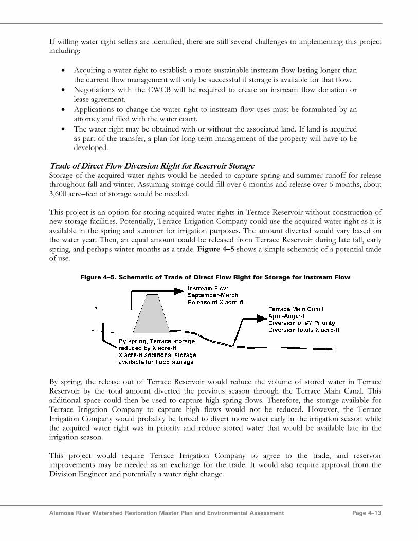
This project is an option for storing acquired water rights in Terrace Reservoir without construction ofnew storage facilities. Potentially, Terrace Irrigation Company could use the acquired water right as it isavailable in the spring and summer for irrigation purposes. The amount diverted would vary based onthe water year. Then, an equal amount could be released from Terrace Reservoir during late fall, earlyspring, and perhaps winter months as a trade. Figure 4–5 shows a simple schematic of a potential tradeof use.
Figure 4–5. Schematic of Trade of Direct Flow Right for Storage for Instream Flow
By spring, the release out of Terrace Reservoir would reduce the volume of stored water in TerraceReservoir by the total amount diverted the previous season through the Terrace Main Canal. Thisadditional space could then be used to capture high spring flows. Therefore, the storage available forTerrace Irrigation Company to capture high flows would not be reduced. However, the TerraceIrrigation Company would probably be forced to divert more water early in the irrigation season whilethe acquired water right was in priority and reduce stored water that would be available late in theirrigation season.
This project would require Terrace Irrigation Company to agree to the trade, and reservoirimprovements may be needed as an exchange for the trade. It would also require approval from theDivision Engineer and potentially a water right change.
Alamosa River Watershed Restoration Master Plan and Environmental Assessment Page 4-14
Increase Spillway Capacity in Return for Instream Flow StorageIncreasing the Terrace Reservoir spillway capacity, thus allowing for the removal of the State Engineer–imposed filling restriction is the most economical way to increase the physical storage capacity availablein Terrace Reservoir. Removing the filling restriction would recover about 2,200 acre–feet of storagecapacity. This project could potentially be done in place of or in addition to Project 12, Trade of DirectFlow Diversion Right for Reservoir Storage. There are many options for increasing the spillway capacitythat should be investigated through a feasibility study prior to design and construction. Section 3.7.1describes several spillway improvement options.
Probable Maximum Flood (PMF) StudyConducting a site–specific PMF study for the basin could potentially reduce the cost of increasing thespillway capacity. Site–specific PMF studies are frequently successful in reducing the anticipated amountof flow that structures are required to pass. A more specifically calculated anticipated flood event couldreduce the cost required to improve the spillway and remove part or all of the State Engineer’srestriction on the reservoir. This project would be done in conjunction with Project 15, Increase TerraceReservoir Spillway Capacity.
4.4.3 Stream Restoration and Vegetation Projects
The stream restoration projects will stabilize the channel and banks, thereby decreasing the amount ofsediment entering the river, promoting native streambank vegetation, and enhancing fish and migratorybird habitat. The main focus of the proposed stabilization and restoration projects is to limit the amountof sediment entering the river due to stream bank erosion caused by human impacts. Mitigatingsediment supply will improve channel stability at irrigation diversions and bridges, and will help maintainchannel capacity. All stream restoration projects will require detailed designs that are location–specificand account for natural processes and appropriate stream type.
The four channel stabilization projects included in the preferred alternative are:
• Terrace Reservoir to Wightman Fork• Gunbarrel Road to Gomez Bridge• County Road 10 to Gunbarrel Road• County Road 13 to County Road 10
In addition to these four restoration projects, three vegetation projects are included:
• Dead tree management• Revegetation• Noxious weed management
Stream Restoration Terrace Reservoir to Wightman ForkBank stabilization efforts in this reach should focus on small areas of the river channel impacted byhuman influences or with high rates of erosion. It will also repair areas where the river is encroaching onthe access road. Fish habitat enhancement features could be incorporated into the design to provideareas for fish if the water quality improves.

Alamosa River Watershed Restoration Master Plan and Environmental Assessment Page 4-15
Stream Restoration Gunbarrel Road to Gomez BridgeIn the reach from Gunbarrel Road to Gomez Bridge there are steep eroded banks with the potential tointroduce significant sediment load to the channel. During periods of high flow, this sediment istransported downstream of Gunbarrel Road where the sediment drops out and clogs the channel.Stream restoration to protect these banks would improve habitat in the downstream area most benefitedby the instream flow project.
County Road 10 to Gunbarrel RoadThere is currently a channel stabilization project underway between County Road 10 and GunbarrelRoad. Although construction started on the project in 2004, there are not enough funds available tocomplete the implementation. Completion of this restoration project will minimize the amount ofsediment transported to downstream reaches and improve the efficiency of diversion structures.
County Road 10 to County Road 13 – Combined with Sediment DepositionThe main focus in this reach will be to stabilize the few isolated, eroded banks and manage sedimentsthat tend to accumulate in the channel. Creation of sediment storage and deposition sites isrecommended to manage existing and anticipated sediment load. Figure 4–6 shows an artificial cutoffchannel. This feature creates a location off of the main channel for excess sediment to drop out, thuspromoting channel stability. The artificial channel is created by excavating material parallel to the mainriver channel and connecting the upstream end of the cutoff channel to the river.
Figure 4–6. Artificial Cutoff Channel
Dead Tree ManagementThere are areas near Jasper where trees have fallen in the river causing water to backup, potentiallycausing flooding. The trees should be removed from the river.
Downstream of Capulin, there is a stretch of cottonwood trees that are dead and will eventually fall intothe river. These trees should be selectively removed if they are in danger of falling into the river ordamaging river structures. Trees not in danger of falling should be left for wildlife habitat. Larger areas

Alamosa River Watershed Restoration Master Plan and Environmental Assessment Page 4-16
of dead trees could be removed when combined with revegetation efforts. The removed trees could beused as material for stream restoration and aquatic habitat projects.
RevegetationAfter instream flow and any recontouring projects are completed, portions of the lower watershedshould be revegetated with native plants. Riparian revegetation should be concentrated on the river fromCounty Road 10 upstream to Terrace Reservoir. The dead cottonwood trees, combined with a lack ofunderstory shrubs and saplings, results in a virtual lack of riparian corridor. Revegetation should focuson creating multistory layers of cottonwoods and willows. Cottonwood trees require overbank floodingand shallow groundwater levels to flourish.. Although revegetation has been shown to be possiblewithout instream flow, revegetation efforts must consider the amount of water available so that projectshave a high likelihood of success.
Noxious Weed ManagementThe primary focus envisioned for this effort is to control noxious weeds in riparian areas that arerestored or protected by stream restoration, revegetation, and riparian buffer projects. The aim ofstream restoration is to eventually restore a vegetative cover that will stabilize banks and provide habitat.Noxious weed management will be a component of restoring healthy native vegetation to stream banksand riparian areas.
Currently, there are existing groups attempting to control weeds in the lower watershed primarily inagricultural areas. The existing weed management control district could be funded to control weeds inthe riparian area of the Alamosa River or in the specific project areas.
4.4.4 Riparian Buffer Zone
A riparian buffer is an area adjacent to a water body that has been set aside for conservation andmaintenance to protect stream and riparian habitat quality. Activities such as farming and developmentare limited in the buffer zone. The typical width of a buffer zone is 100 feet on either side of the channelwith additional space in wetland areas or areas with significant streambank erosion. Buffers can becreated through a combination of ordinances and easements, or can be implemented on a voluntarybasis. In the Alamosa River where development pressure is minimal, a voluntary stream bufferimplemented through education and easements may be the preferred option. A number of financialincentives for agricultural landowners to establish riparian buffers exist from government and privatesector programs such as the Conservation Reserve Program.
4.4.5 Sediment Trap Pilot Project with Water Quality BMPs on Alum Creek
During high flows, Alum Creek carries a tremendous bedload of sediments derived from hydrothermallyaltered rocks to the Alamosa River. These rocks typically contain sulfide–rich accessory minerals, whichwhen oxidized contribute metal loading as well as low pH runoff and acidic conditions in the AlamosaRiver. Following spring runoff, a large fan of materials is deposited at the terminus of the creek, andthese sediments are then progressively eroded and carried downstream by the Alamosa River. Figure 4–7 shows a photo of the sediment fan looking upstream as it was being eroded during summer of 2004.

Alamosa River Watershed Restoration Master Plan and Environmental Assessment Page 4-17
Figure 4–7. Photo of Alum Creek Sediment Fan Being Eroded by Alamosa River
A sediment trap and water quality project would consist of regrading the fan area, stabilizing theadjacent river bank with limestone rock, constructing limestone rock check dams within the Alum Creekchannel to trap a portion of the annual bedload, and directing the lower portion of Alum Creek to aflow–through pond. There are several options for water quality improvements that could be tested onAlum Creek as pilot projects and potentially implemented if successful and if funds are available.However, any sediment trap and water quality project would require significant, regular maintenance.
4.4.6 Reclamation of Pass–Me–By Mine
Contaminant loads from smaller historical mining sites are less significant on a watershed scale thanloads from the Summitville site and loads from natural sources. These smaller mine sites represent lessthan one percent of the watershed contaminant load for copper, zinc, and magnesium, and less than 3percent of the contaminant load for iron and aluminum. However, as point sources the mines are morereadily treatable than non–point sources. The Pass–Me–By Mine produces the highest contaminantloads of all of the smaller sites and is the only abandoned mine included in the Preferred Alternative.The project could include a combination of an anoxic limestone drain at the collapsed mine portalfollowed by a sulfate reducing wetland or settling basin as well as capping and diversion of drainagearound the mine tailings dump. The Pass–Me–By Mine is located on private property and an agreementwould be needed from the landowner to implement the project.
4.4.7 Easements
Easements may be negotiated with willing landowners along the Alamosa River for various purposessuch as conservation, recreation and access to the Alamosa River. Conservation easements are a tool toprotect and enhance existing quality habitat and areas that can be improved through restoration projectssuch as those in the riparian corridor. Conservation easements are legal agreements between alandowner and a public agency or conservation group, in which the parties agree to protect certainnatural resource values of the land or provide access to the public. Due to the extensive private
Alamosa River Watershed Restoration Master Plan and Environmental Assessment Page 4-18
ownership along the river, access and recreation easements are proposed to allow the public to benefitfrom the restoration projects.
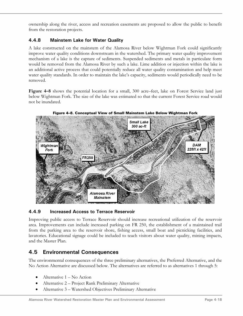
4.4.8 Mainstem Lake for Water Quality
A lake constructed on the mainstem of the Alamosa River below Wightman Fork could significantlyimprove water quality conditions downstream in the watershed. The primary water quality improvementmechanism of a lake is the capture of sediments. Suspended sediments and metals in particulate formwould be removed from the Alamosa River by such a lake. Lime addition or injection within the lake isan additional active process that could potentially reduce all water quality contamination and help meetwater quality standards. In order to maintain the lake’s capacity, sediments would periodically need to beremoved.
Figure 4–8 shows the potential location for a small, 300 acre–feet, lake on Forest Service land justbelow Wightman Fork. The size of the lake was estimated so that the current Forest Service road wouldnot be inundated.
Figure 4–8. Conceptual View of Small Mainstem Lake Below Wightman Fork
4.4.9 Increased Access to Terrace Reservoir
Improving public access to Terrace Reservoir should increase recreational utilization of the reservoirarea. Improvements can include increased parking on FR 250, the establishment of a maintained trailfrom the parking area to the reservoir shore, fishing access, small boat and picnicking facilities, andlavatories. Educational signage could be included to teach visitors about water quality, mining impacts,and the Master Plan.
4.5 Environmental ConsequencesThe environmental consequences of the three preliminary alternatives, the Preferred Alternative, and theNo Action Alternative are discussed below. The alternatives are referred to as alternatives 1 through 5:
• Alternative 1 – No Action• Alternative 2 – Project Rank Preliminary Alternative• Alternative 3 – Watershed Objectives Preliminary Alternative

Alamosa River Watershed Restoration Master Plan and Environmental Assessment Page 4-19
• Alternative 4 – Trustee Preferences Preliminary Alternative• Alternative 5 – Preferred Alternative / Proposed Action
This section is based on the assumption that all actions identified under each alternative would beimplemented successfully.
The environmental consequences of Alternative 1, the No Action Alternative, are what would happen ifnone of the Master Plan projects were implemented. Consideration of this alternative is a requirement ofthe National Environmental Policy Act (NEPA). These consequences are discussed in Section 4.5.1.Alternatives 2 through 5 are considered the action alternatives. Most of the projects included in theaction alternatives are the same for all alternatives. Therefore, the similar environmental consequencesof the action alternatives are discussed together in Section 4.5.2. Then, in Sections 4.5.3 through 4.5.6,each action alternative is discussed independently to cover the different environmental consequencesthat would occur as a result of the varying projects implemented in each alternative. Section 4.5.7summarizes the environmental consequences of all of the alternatives.
4.5.1 Alternative 1 – No Action
NEPA requires that a No Action Alternative be considered. The No Action Alternative consists of theexpected conditions under current programs pursued outside the NRDAR process. These currentprograms include management of the Rio Grande National Forest, efforts of the Alamosa RiverFoundation, and CDPHE’s cleanup programs at Summitville, all at current funding levels. It is assumedthat the stream restoration project currently in progress between Gunbarrel Road and County Road 10would be completed and that the Summitville Treatment Plant and other water quality mitigationmeasures would continue to operate at their current capacity. The No Action Alternative is the baselineagainst which the other actions are compared. If this alternative were implemented, the Trustees wouldnot initiate specific actions to restore natural resources potentially injured by Summitville releases to theenvironment.
The No Action alternative is moot in that restoration is a court ordered action required by thesettlement described in Section 1.3. The No Action Alternative is described here as a basis ofcomparison for the other alternatives.
Surface Water ImpactsThe lower Alamosa River would continue to be dry between late fall and early spring. Water qualitybetween Wightman Fork and Terrace Reservoir would continue to be degraded from high metals load,high sediment transport, and low pH.
Groundwater ImpactsRegional groundwater levels will continue to decline.
Habitat ImpactsThe riparian habitat and aquatic habitat of the lower Alamosa River would continue to degrade due tolack of sustained flow. Poor water quality would continue to impact the aquatic and riparian habitat inthe watershed due to high metals loading and low pH.
Biological ImpactsThe degrading riparian habitat would lead to fewer riparian dependent species in the watershed. Therewould be no sustainable fish populations in water quality impacted reaches upstream of TerraceReservoir and the flow impacted reaches downstream of Terrace Reservoir.
Alamosa River Watershed Restoration Master Plan and Environmental Assessment Page 4-20
Listed, Proposed and Candidate SpeciesThe southwestern willow flycatcher, bald eagle, and Canada lynx are endangered species with potentialto inhabit the Alamosa River watershed. In the current condition of degraded wildlife habitat along theAlamosa River, there have been no documented occurrences of these species in the watershed (asdiscussed in Section 2.9). Therefore, no change to listed, proposed, or candidate threatened orendangered species or their critical habitats are expected.
Cultural ResourcesThere would be no change in cultural resources.
Environmental Justice IssuesUnder the No Action Alternative, recreational opportunities would not be improved and environmentalquality would not be enhanced. Commonly available recreation such as fishing, hiking, hunting andother activities would continue to be largely unavailable along the Alamosa River.
Socioeconomic IssuesUnder the No Action Alternative, the image of the watershed as a “dead watershed” would continueand visitors would be discouraged from visiting and enjoying the natural resources. The Master Planwould not be implemented and would not provide opportunities for jobs in the watershed.
Land Use IssuesThere would be no change to the current land use and traffic patterns. Channel instability wouldcontinue to pose problems for irrigators.
Cumulative ImpactsIf the No Action Alternative were chosen, riparian and aquatic habitat would continue to be in adegraded condition due to natural and human–induced factors. Species dependent on riparian andaquatic habitat may also be further harmed due to continued degradation of existing habitat. The imageof the watershed would still be of damaged natural resources and poor water quality. Channel instabilitywould continue to pose problems for irrigators and no additional jobs would come to the watershed forrestoration projects.
4.5.2 Environmental Consequences Common to Alternatives 2 through 5 (ActionAlternatives)
The following projects are common to each of the action alternatives:
• Funding for the Alamosa River Foundation to help implement and monitor the MasterPlan
• Funding to complete ongoing streambank project between Gunbarrel Road and CountyRoad 10
• Stream restoration from Gomez Bridge to Gunbarrel Road• Stream restoration from Wightman Fork to Terrace Reservoir• Purchase appropriate water rights for instream flow downstream of Terrace Reservoir• Trade of direct flow diversion right for storage of instream flow water rights in Terrace
Reservoir• Increase Terrace Reservoir spillway capacity and complete probable maximum flood
study• Reclamation of Pass–Me–By Mine
Alamosa River Watershed Restoration Master Plan and Environmental Assessment Page 4-21
• Conservation / recreation / access easements in the lower watershed (approximately 500acres)
• Revegetation• Dead tree management• Noxious weed management• Grazing management
The common environmental consequences of these projects are discussed below.
Groundwater ImpactsLocal groundwater levels would increase, or decline at a slower rate, due to infiltration of surface waterinto the groundwater in the channel downstream of Terrace Reservoir.
Surface Water ImpactsSurface water quantity downstream of Terrace Reservoir would be improved due to longer sustainedflows. Water quality would be slightly improved due to abandoned mine reclamation and reductions insediment loading from mine banks and other sources.
Habitat ImpactsGenerally, upland conifer forests, which are the dominant habitats in the upper watershed, appear to bein good condition and would not be impacted by the action alternatives.
Available habitat in the riparian corridor was impacted by placer mining and excessive sedimentation.Abandoned mine reclamation and stream restoration in the action alternatives would reduce theseimpacts. In–stream aquatic habitat and riparian habitat would be improved by the action alternativesthrough improved water quality and a more sustained flow in the river downstream of TerraceReservoir. Improved surface water conditions would lead to enhanced riparian vegetation conditions.
There would be short–term impacts to habitat due to needed earth moving for stream restoration.However, these projects would eventually improve the habitat quality due to the associated revegetationand channel stabilization.
Biological ImpactsThe action alternatives would benefit many different species of fish and wildlife found in the AlamosaRiver watershed. Preservation and improvement of riparian areas, stream restoration, and instream flowwould benefit waterfowl, sparrows, warblers, raptors, beaver and other species known to inhabit thesehabitats. Water quality improvements and establishment of an instream flow would benefit fish directlyand would improve riparian habitat quality and those species dependent upon the riparian zone. Streamrestoration projects would create localized scour pools, provide instream cover, and encouragedevelopment of small gravel bars for fish habitat. Revegetation would provide additional locations forforage and cover for riparian dependent species. The riparian buffer zone and grazing managementwould reduce disturbance of the riparian zone.
There would be minimal negative impacts to biological resources from human disturbance caused byincreased public access to the river and riparian areas. Public use projects would also protect andpotentially minimize human disturbance to fish and wildlife by minimizing human impacts on thoseresources.
Alamosa River Watershed Restoration Master Plan and Environmental Assessment Page 4-22
Cultural ResourcesCultural resources were not investigated in the Master Plan. However, the four action alternatives wouldeither avoid or mitigate any archeological and historic resources or resources that have appreciablecultural value to the Indian tribes of the area. The projects in the action alternatives involvingconstruction would be conducted in a manner complying with the following regulations:
• The National Historic Preservation Act of 1966 (P.L. 89–665 as amended).• Native American Grave Protection and Repatriation Act (NAGPRA), (P.L. 101–601)• Archeological Resources Protection Act of 1979 (P.L. 96–95)
Environmental JusticeLand, easement, and water right purchases would involve transactions with willing landowners paid fairmarket value. No minority or low–income populations would be displaced or negatively affected in anyway. Some of the implemented projects would provide access to low income watershed residents forhiking, fishing, and wildlife viewing.
Socioeconomic ImpactsHabitat improvements, access, and recreation easements would provide more opportunities for publicuse and enjoyment of natural resources. Improving natural resource recreation facilities would increasethe number of visitors to the Alamosa River watershed, bringing increased business to surroundingcommunities. Local businesses are likely to be awarded business through the competitive biddingprocess that would be used to implement the action alternatives. Farmers using irrigation water from theAlamosa River are likely to benefit from improved water quality and channel stability.
Land Use ImpactsThere would be a decrease in the area of agricultural land irrigated by Alamosa River water due to thetransfer of water rights to instream flow. This land may or may not be in the natural watershed due toirrigation diversions that currently transport water outside of the watershed. If the land is sold inconjunction with a water right transfer, a management plan for the land would be implemented.
Conservation, recreation, or access easements would be obtained for approximately 500 acres in thelower watershed. This would provide more recreational opportunities for watershed residents andvisitors in the lower watershed. The added recreational and access opportunities may lead to more trafficon State Highway 15 and other routes providing access to the river downstream of Terrace Reservoir.
4.5.3 Alternative 2 – Project Rank Alternative
The projects that are in the Project Rank Alernative but not all of the action alternatives are:
• Stream restoration County Road 10 to County Road 13• Riparian buffer zone• Sediment trap pilot project on Alum Creek• Recreation / access easements in upper watershed• Improve Terrace Reservoir outlet works• Reclamation of abandoned mines including Miser Mine and other smaller projects (in
addition to Pass–Me–By Mine)

Alamosa River Watershed Restoration Master Plan and Environmental Assessment Page 4-23
Surface Water ImpactsSurface water quality in the Alamosa River mainstem downstream of Alum Creek would be improveddue to removal of suspended sediment and associated pollutants. Surface water quality will be slightlyimproved due to reclamation of additional abandoned mines.
Improvements to the Terrace Reservoir outlet works would allow operators to release water of higherquality to downstream uses. Improved outlet works would have less chance of releasing large sedimentloads downstream.
Listed, Proposed and Candidate SpeciesThe southwestern willow flycatcher, bald eagle, and Canada lynx are endangered species with potentialto inhabit the Alamosa River watershed. Riparian habitat enhancements would eventually promote useby these species. Current programs to establish target populations of southwestern willow flycatcherwould be supported through these actions.
Land Use ImpactsNew recreation and access easements in the upper watershed would provide recreational opportunitiesto watershed residents and visitors. This may cause additional traffic on Forest Road 250.
Cumulative ImpactsThe instream flow and stream restoration projects would improve riparian and aquatic habitat andincrease populations of dependent species. Water quality associated with suspended pollutants would besomewhat improved due the sediment trap on Alum Creek and mine reclamation.
There would be an increase in recreational opportunities in the watershed. Visitors to the watershed andjob opportunities for implementing the Master Plan would improve the local economy. Improvedchannel stability and control over water released from Terrace Reservoir would benefit irrigators. Therewould be a decrease in the amount of irrigated land due to a transfer of water rights to instream flow.There could be an increase in traffic on roads providing access to the river.
4.5.4 Alternative 3 – Watershed Objectives Alternative
The projects that are in the watershed objectives alternative but not all of the action alternatives are:
• Sediment trap pilot project with water quality on Alum Creek• Increased access to Terrace Reservoir• Recreation / access easements in upper watershed• Mainstem lake for water quality• Lower watershed sediment deposition locations• Fish stocking at Terrace Reservoir• Terrace Reservoir dewatering management plan / sediment quality study
Surface Water ImpactsSurface water quality in the Alamosa River mainstem downstream of Alum Creek would be improveddue to removal of suspended sediment and associated pollutants. Water quality downstream ofWightman Fork would be greatly improved due to the mainstem lake. Suspended sediments andparticulate metals would be reduced and low pH winter flows and untreated releases from theSummitville site would potentially be buffered.

Alamosa River Watershed Restoration Master Plan and Environmental Assessment Page 4-24
Habitat ImpactsAdditional aquatic habitat would be created by the mainstem lake. Some areas of riparian habitat wouldbe displaced to construct and fill the mainstem lake. Aquatic habitat downstream of mainstem lakewould be improved due to improved water quality.
Biological ImpactsWater quality improvements due to the mainstem lake and the sediment trap on Alum Creek may besignificant enough that fish populations could be sustained between Wightman Fork and TerraceReservoir. Fish stocked in Terrace Reservoir would increase the number of fish in the vicinity of theReservoir.
Listed, Proposed and Candidate SpeciesThe southwestern willow flycatcher, bald eagle, and Canada lynx are endangered species with potentialto inhabit the Alamosa River watershed. Riparian habitat enhancements would eventually promote useby these species. Current programs to establish target populations of southwestern willow flycatcherwould be supported through these actions.
Land Use ImpactsNew recreation and access easements in the upper watershed and new facilities and fish stocking atTerrace Reservoir would provide recreational opportunities and environmental education to watershedresidents and visitors. This may cause additional traffic on Forest Road 250.
Cumulative ImpactsThe instream flow and stream restoration projects would improve riparian and aquatic habitat andincrease populations of dependent species. Water quality associated with suspended pollutants would begreatly improved due the sediment trap on Alum Creek and the mainstem lake. Riparian habitat wouldbe displaced in the footprint of the mainstem lake, but could be replaced at the upstream margins of thelake.
There would be an increase in recreational opportunities in the watershed. Visitors to the watershed andjob opportunities for implementing the Master Plan would improve the local economy. Improvedchannel stability and water quality would benefit irrigators. There would be a decrease in the amount ofirrigated land due to a transfer of water rights to instream flow. There could be an increase in traffic onroads providing access to the river.
4.5.5 Alternative 4 – Trustee Preferences Alternative
The projects that are in the trustee preferences alternative but not all of the action alternatives are:
• Acquisition of equivalent resource in San Luis Valley for high quality habitat andrecreation
• Riparian buffer zone• Mainstem lake for water quality• Increased access to Terrace Reservoir• Lower watershed sediment deposition locations
Surface Water ImpactsWater quality downstream of Wightman Fork would be greatly improved due to the mainstem lake.Suspended sediments and particulate metals would be reduced and low pH winter flows and untreatedreleases from the Summitville site would potentially be buffered.

Alamosa River Watershed Restoration Master Plan and Environmental Assessment Page 4-25
Habitat ImpactsAdditional aquatic habitat would be created by the mainstem lake. Some areas of riparian habitat wouldbe displaced to construct and fill the mainstem lake. Aquatic habitat downstream of mainstem lakewould be improved due to improved water quality. Acquisition of the Crowther property wouldimmediately preserve a large area of high quality riparian and endangered species habitat in the ConejosRiver watershed.
Biological ImpactsWater quality improvements due to the mainstem lake may be significant enough that fish populationscould be sustained between Wightman Fork and Terrace Reservoir. Acquisition of the Crowtherproperty would immediately benefit fish, birds, and wildlife through the preservation of 420 acres ofhigh quality habitat.
Listed, Proposed and Candidate SpeciesNo negative impacts to listed, proposed, or candidate threatened or endangered species or their criticalhabitats are expected in the Alamosa River watershed. The acquisition of the Crowther property wouldpreserve 60 acres of endangered southwest willow flycatcher habitat in the Conejos River watershed.
Land Use ImpactsNew facilities at Terrace Reservoir would provide recreational opportunities and environmentaleducation to watershed residents and visitors. Purchasing the Crowther property would preserve fishingareas and increase access on 1½ miles (both sides) of the Conejos River, adjacent to the Alamosa Riverwatershed.
Cumulative ImpactsThe instream flow and stream restoration projects would improve riparian and aquatic habitat andincrease populations of dependent species. Water quality associated with suspended pollutants would besomewhat improved due the sediment trap on Alum Creek and mine reclamation. A large area of highquality habitat in the neighboring Conejos River watershed, including habitat for the endangeredsouthwest willow flycatcher, would be preserved. Riparian habitat would be displaced in the footprint ofthe mainstem lake, but could be replaced at the upstream margins of the lake.
There would be an increase in recreational opportunities in the watershed and in the Conejos Riverwatershed. Visitors to the watershed and job opportunities for implementing the Master Plan wouldimprove the local economy. Improved channel stability and water quality would benefit irrigators. Therewould be a decrease in the amount of irrigated land due to a transfer of water rights to instream flow.There could be an increase in traffic on roads providing access to the river.
4.5.6 Alternative 5 – Preferred Alternative / Proposed Action
The projects that are in the preferred alternative but not all of the action alternatives are:
• Riparian buffer zone• Sediment trap pilot project with water quality best management practices on Alum Creek• Recreation or access easements in upper watershed• Lower watershed sediment deposition locations combined with stream restoration from
County Road 10 to County Road 13.• Mainstem lake for water quality• Increased access to Terrace Reservoir

Alamosa River Watershed Restoration Master Plan and Environmental Assessment Page 4-26
Surface Water ImpactsSurface water quality in the Alamosa River mainstem downstream of Alum Creek would be improveddue to removal of suspended sediment and associated pollutants. Water quality downstream ofWightman Fork would be greatly improved due to the mainstem lake. Suspended sediments andparticulate metals would be reduced and low pH winter flows and untreated releases from theSummitville site would potentially be buffered.
Habitat ImpactsAdditional aquatic habitat would be created by the mainstem lake. Some areas of riparian habitat wouldbe displaced to construct and fill the mainstem lake. Aquatic habitat downstream of mainstem lakewould be improved due to improved water quality.
Biological ImpactsWater quality improvements due to the mainstem lake and the sediment trap on Alum Creek may besignificant enough that fish populations could be sustained between Wightman Fork and TerraceReservoir.
Listed, Proposed and Candidate SpeciesThe southwestern willow flycatcher, bald eagle, and Canada lynx are endangered species with potentialto inhabit the Alamosa River watershed. Riparian habitat enhancements would eventually promote useby these species. Current programs to establish target populations of southwestern willow flycatcherwould be supported through these actions.
Land Use ImpactsNew recreation and access easements in the upper watershed and new facilities at Terrace Reservoirwould provide recreational opportunities and environmental education to watershed residents andvisitors. This may cause additional traffic on Forest Road 250.
Cumulative ImpactsThe instream flow and stream restoration projects would improve riparian and aquatic habitat andincrease populations of dependent species. Water quality associated with suspended pollutants would begreatly improved due the sediment trap on Alum Creek and the mainstem lake. Riparian habitat wouldbe displaced in the footprint of the mainstem lake, but could be replaced at the upstream margins of thelake.
There would be an increase in recreational opportunities in the watershed. Visitors to the watershed andjob opportunities for implementing the Master Plan would improve the local economy. Improvedchannel stability and water quality would benefit irrigators. There would be a decrease in the amount ofirrigated land due to a transfer of water rights to instream flow. There could be an increase in traffic onroads providing access to the river.
Alamosa River Watershed Restoration Master Plan and Environmental Assessment Page 4-27
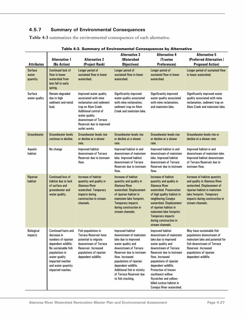
4.5.7 Summary of Environmental Consequences
Table 4-3 summarizes the environmental consequences of each alternative.
Table 4-3. Summary of Environmental Consequences by Alternative
AttributesAlternative 1(No Action)
Alternative 2(Project Rank)
Alternative 3(WatershedObjectives)
Alternative 4(Trustee
Preferences)
Alternative 5(Preferred Alternative /
Proposed Action)Surfacewaterquantity
Continued lack offlow in lowerwatershed fromlate fall to earlyspring.
Longer period ofsustained flow in lowerwatershed.
Longer period ofsustained flow in lowerwatershed.
Longer period ofsustained flow in lowerwatershed.
Longer period of sustained flowin lower watershed.
Surfacewater quality
Remain degradeddue to highsediment and metalload.
Improved water qualityassociated with minereclamation and sedimenttrap on Alum Creek.Additional control ofwater qualitydownstream of TerraceReservoir due to improvedoutlet works.
Significantly improvedwater quality associatedwith mine reclamation,sediment trap on AlumCreek and mainstem lake.
Significantly improvedwater quality associatedwith mine reclamation,and mainstem lake.
Significantly improved waterquality associated with minereclamation, sediment trap onAlum Creek and mainstem lake.
Groundwater Groundwater levelscontinue to decline.
Groundwater levels riseor decline at a slowerrate.
Groundwater levels riseor decline at a slowerrate.
Groundwater levels riseor decline at a slowerrate.
Groundwater levels rise ordecline at a slower rate.
Aquatichabitat
No change Improved habitatdownstream of TerraceReservoir due to instreamflow.
Improved habitat in anddownstream of mainstemlake. Improved habitatdownstream of TerraceReservoir due to instreamflow.
Improved habitat in anddownstream of mainstemlake. Improved habitatdownstream of TerraceReservoir due to instreamflow.
Improved habitat in anddownstream of mainstem lake.Improved habitat downstreamof Terrace Reservoir due toinstream flow.
Riparianhabitat
Continued loss ofhabitat due to lackof surface andgroundwater andwater quality.
Increase of habitatquantity and quality inAlamosa Riverwatershed. Temporaryimpacts duringconstruction in streamchannels.
Increase of habitatquantity and quality inAlamosa Riverwatershed. Displacementof riparian habitat inmainstem lake footprint.Temporary impactsduring construction instream channels.
Increase of habitatquantity and quality inAlamosa Riverwatershed. Preservationof high quality habitat inneighboring Conejoswatershed. Displacementof riparian habitat inmainstem lake footprint.Temporary impactsduring construction instream channels.
Increase of habitat quantityand quality in Alamosa Riverwatershed. Displacement ofriparian habitat in mainstemlake footprint. Temporaryimpacts during construction instream channels.
Biologicalimpacts
Continued harm anddecrease innumbers of ripariandependent wildlife.No sustainable fishpopulations inwater qualityimpacted reachesand water quantityimpacted reaches.
Fish populations inTerrace Reservoir havepotential to migratedownstream of TerraceReservoir. Increasedpopulations of ripariandependent wildlife.
Improved habitatdownstream of mainstemlake due to improvedwater quality anddownstream of TerraceReservoir due to instreamflow. Increasedpopulations of ripariandependent wildlife.Additional fish in vicinityof Terrace Reservoir dueto fish stocking.
Improved habitatdownstream of mainstemlake due to improvedwater quality anddownstream of TerraceReservoir due to instreamflow. Increasedpopulations of ripariandependent wildlife.Protection of knownsouthwest willowflycatcher and yellow–billed cuckoo habitat inConejos River watershed.
May have sustainable fishpopulations downstream ofmainstem lake and potential forfish downstream of TerraceReservoir. Increasedpopulations of ripariandependent wildlife.
Alamosa River Watershed Restoration Master Plan and Environmental Assessment Page 4-28
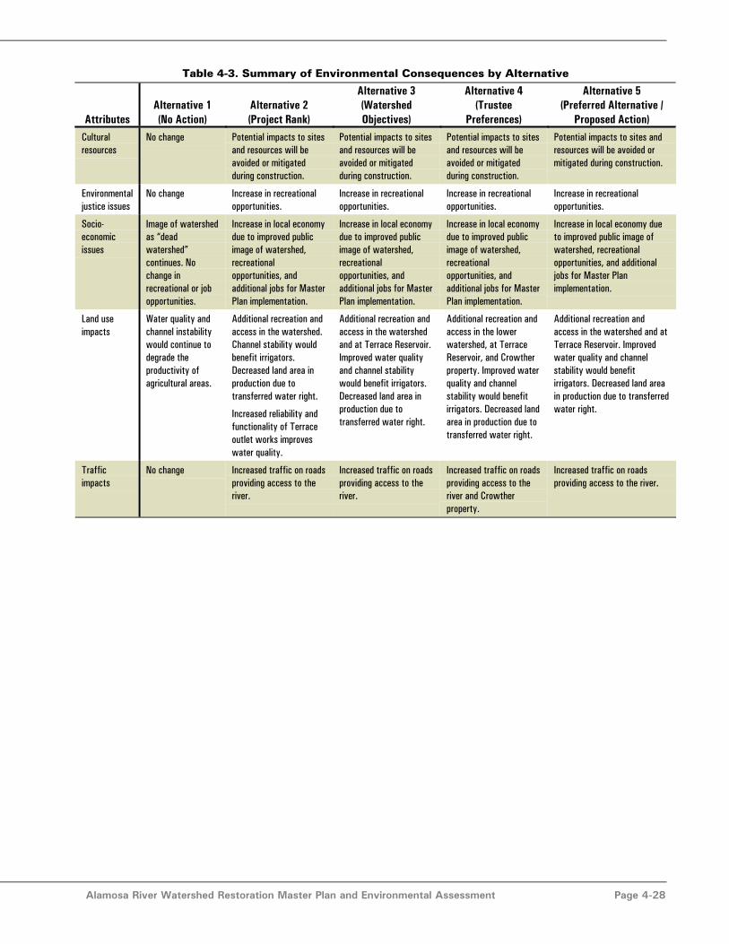
Table 4-3. Summary of Environmental Consequences by Alternative
AttributesAlternative 1(No Action)
Alternative 2(Project Rank)
Alternative 3(WatershedObjectives)
Alternative 4(Trustee
Preferences)
Alternative 5(Preferred Alternative /
Proposed Action)Culturalresources
No change Potential impacts to sitesand resources will beavoided or mitigatedduring construction.
Potential impacts to sitesand resources will beavoided or mitigatedduring construction.
Potential impacts to sitesand resources will beavoided or mitigatedduring construction.
Potential impacts to sites andresources will be avoided ormitigated during construction.
Environmentaljustice issues
No change Increase in recreationalopportunities.
Increase in recreationalopportunities.
Increase in recreationalopportunities.
Increase in recreationalopportunities.
Socio-economicissues
Image of watershedas “deadwatershed”continues. Nochange inrecreational or jobopportunities.
Increase in local economydue to improved publicimage of watershed,recreationalopportunities, andadditional jobs for MasterPlan implementation.
Increase in local economydue to improved publicimage of watershed,recreationalopportunities, andadditional jobs for MasterPlan implementation.
Increase in local economydue to improved publicimage of watershed,recreationalopportunities, andadditional jobs for MasterPlan implementation.
Increase in local economy dueto improved public image ofwatershed, recreationalopportunities, and additionaljobs for Master Planimplementation.
Land useimpacts
Water quality andchannel instabilitywould continue todegrade theproductivity ofagricultural areas.
Additional recreation andaccess in the watershed.Channel stability wouldbenefit irrigators.Decreased land area inproduction due totransferred water right.
Increased reliability andfunctionality of Terraceoutlet works improveswater quality.
Additional recreation andaccess in the watershedand at Terrace Reservoir.Improved water qualityand channel stabilitywould benefit irrigators.Decreased land area inproduction due totransferred water right.
Additional recreation andaccess in the lowerwatershed, at TerraceReservoir, and Crowtherproperty. Improved waterquality and channelstability would benefitirrigators. Decreased landarea in production due totransferred water right.
Additional recreation andaccess in the watershed and atTerrace Reservoir. Improvedwater quality and channelstability would benefitirrigators. Decreased land areain production due to transferredwater right.
Trafficimpacts
No change Increased traffic on roadsproviding access to theriver.
Increased traffic on roadsproviding access to theriver.
Increased traffic on roadsproviding access to theriver and Crowtherproperty.
Increased traffic on roadsproviding access to the river.

Alamosa River Watershed Restoration Master Plan and Environmental Assessment Page 5-1
Section 5.0 - Implementation of PreferredAlternative
5.1 Implementation of Actions Under the Preferred AlternativeThe idea of opportunistic implementation will be important to making the most of the Master Plan.Opportunistic implementation means that projects should be implemented according to the followingconditions:
• As the specific project proposals are submitted and approved by the Trustee Council andAlamosa River Foundation,
• As outside project proponents or “passionate advocates” are identified,• As the appropriate mix of sufficient funding becomes available to complete the project,
and• As a specific project’s implementation is required by or coincides with another related
project that is being implemented.
It may mean that projects are implemented out of their proposed order. The Trustee Council andFoundation will receive specific project proposals in accordance with the projects described in the finallyapproved Master Plan preferred alternative, and will approve acceptable proposals and allocate whateverfunds are available and appropriate for their implementation.
Master Plan implementation will be managed partially by the state and federal Trustee Council,particularly to oversee the expenditure of the NRD settlement funds. However, the Foundation shouldprovide essential local management of Master Plan implementation. The efforts of the Foundation maybe spearheaded by the proposed paid watershed coordinator / project manager. The Foundation couldtake the lead role in coordinating work on multiple projects. The Foundation will also head up many ofthe funding tasks, and will be in charge of writing grant applications. The state and federal TrusteeCouncil, the Foundation, and stakeholders will meet regularly to coordinate implementation and shareknowledge.
Each project should be coordinated by a project manager. The project manager could be either thewatershed coordinator, or another party such as a knowledgeable advocate for the project, a federal orstate trustee, a non–paid foundation member, or a consultant. For many projects, there is an obviouschoice for project manager, an individual or group with a majority stake in the project or directexperience with the type of project. For instance, completion of the project between County Road 10and Gunbarrel Road would most logically be conducted by Alamosa River Foundation, Black CreekHydrology, and CWCB, the groups currently undertaking the project.
5.2 Possible Implementation ScheduleCertain projects should be implemented only after the implementation of others has begun. Thefollowing projects are best implemented after other projects:
• The trade of direct flow diversion right for reservoir storage and increase spillwaycapacity projects should not be initiated until there is a willing water right seller. Oncethere is a seller, these projects should all be coordinated together because the water
Alamosa River Watershed Restoration Master Plan and Environmental Assessment Page 5-2
rights change case will involve changes to the use, place of diversion, and transfer fromdirect use to storage.
• If more than one water right is transferred, it is recommended that the second transferdoes not occur until the first transfer is completed. With the number of uncertaintiesregarding the transfers, it would be beneficial to have the experience of the first transferprior to the second. However, because water rights must be obtained when they becomeavailable, purchasing must be done when the opportunity presents itself.
• If after some period of time, such as 5 years, there is no willing water rights seller, theTrustees and Foundation can decide to reallocate those funds to implement anotherproject.
• Bank work between County Road 10 and County Road 13 should not begin until afterthe upstream stream restoration projects. The upstream projects are likely to change thesediment balance in the river and could change the design necessary for the downstreamreaches.
Stream restoration work between Gunbarrel Road and County Road 10 should be completed as soon aspossible. Completing the stream restoration upstream of Gunbarrel Road should occur soon after.Stabilizing banks upstream of Gunbarrel Road will be important to maintain the benefits of the projectbetween Gunbarrel Road and County Road 10.
Some of the restoration projects will occur on an ongoing basis. This includes the work of theFoundation and obtaining easements. The Foundation should be funded immediately to begin work onimplementing the Master Plan. Easements can be obtained only when a willing landowner comesforward and can be established at any time if funds are available to complete the transaction.
Table 5-1 summarizes one logical option for project sequencing and duration for the preferredalternative. The duration of design and implementation is listed in the table. Project phasing allows formore even distribution of cash flow. Figure 5–1 shows one possible implementation schedule. As notedabove, many factors will influence the actual order that projects are implemented. The Trustees andFoundation will chose to implement projects in an order that is appropriate for available funding andother factors. The actual order may be different from that shown below.
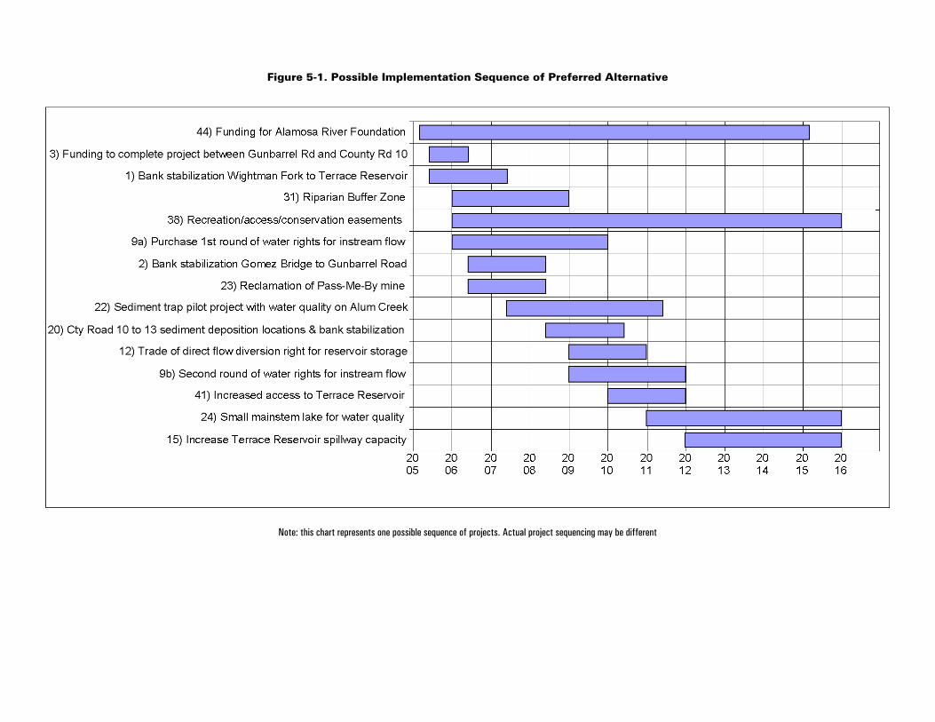
Figure 5-1. Possible Implementation Sequence of Preferred Alternative
Note: this chart represents one possible sequence of projects. Actual project sequencing may be different

Alamosa River Watershed Restoration Master Plan and Environmental Assessment Page 5-4
Table 5-1. Possible Project Sequencing and Duration of Preferred Alternative
ProjectNumber Project
PredecessorProjects Start Date
ApproximateDuration(Years)
44 Funding for Alamosa River Foundation to help implement and monitor themaster plan
– Mar 2005 10
3 Funding to complete ongoing streambank project between GunbarrelRoad and County Road 10
– Jun 2005 1
1 Stream restoration from Wightman Fork to Terrace Reservoir; dead treemanagement in upper watershed
– Jun 2005 2
31 Riparian Buffer Zone – Jan 2006 3
38 Recreation/access/conservation easements – Jan 2006 10
9a Purchase 1st round of water rights for instream flow – Jan 2006 4
2 Stream restoration from Gomez Bridge to Gunbarrel Road; Revegetation,dead tree management, noxious weed management, and grazingmanagement in lower watershed
– Jun 2006 2
23 Reclamation of abandoned mines (Pass–Me–By mine only) – Jun 2006 2
22 Sediment trap pilot project with water quality best managementpractices on Alum Creek
– Jun 2007 4
20 Lower watershed sediment deposition locations combined with streamrestoration from County Road 10 to County Road 13
2, 3 Jun 2008 2
12 Trade of direct flow diversion right for storage of instream flow waterrights in Terrace Reservoir (no new water source)
9a Jan 2009 2
9b Second round of water rights for instream flow 9a Jan 2009 3
41 Increased access to Terrace Reservoir Jan 2010 2
24 Small mainstem lake for water quality – Jan 2011 5
15 Increase Terrace Reservoir spillway capacity to remove storagerestriction (in return for instream flow storage); PMF Study
9a & 9b Jan 2012 4
5.2.1 Options for Variation
There are several options for variation in the project implementation schedule. Also, it is important tokeep in mind that projects should be attempted on an opportunistic basis. Projects that are particularlyflexible are those without predecessors listed in Table 5-1. Projects that are independent of otherprojects and can be implemented at any time are:
• Small mainstem lake for water quality• Reclamation of Pass–Me–By mine• Sediment trap pilot project with water quality on Alum Creek• Easements• Riparian buffer zone
It is conceivable that one or more of the suggested restoration projects will not be feasible toimplement. If this occurs, the Master Plan should be implemented without the project. However, allprojects dependent on the missing project must also be neglected, unless a replacement project is found.Two such scenarios are discussed below:

Alamosa River Watershed Restoration Master Plan and Environmental Assessment Page 5-5
Trade of Direct Flow Diversion Right for Reservoir Storage Infeasible ScenarioIf water rights are acquired but the trade of direct flow for reservoir storage project is not possible, otherstorage options can be pursued. Buying storage in Terrace Reservoir and changing the flow right to astorage right is a more conventional approach that may move through water court more easily. Anotheroption would be to further investigate aquifer storage of the water right using an augmentation plan (asdiscussed in Section 3). A groundwater augmentation plan may allow the entire historical water right,not just the consumptive use, to be recharged to the groundwater and then a portion of that water couldbe pumped out for instream use.
Instream Flow Project Infeasible ScenarioIf a water right cannot be acquired, the following projects will need to be removed from theimplementation schedule, or modified:
• Instream flow storage projects including increase capacity of Terrace Reservoir Spillway• Easements in the lower watershed• Revegetation downstream of Terrace Reservoir may have to be scaled back based on less
water in the stream and potentially decreased groundwater levels. The design ofrevegetation projects must consider the amount of water available.
There is no substitute project to provide the benefits of instream flow in the lower watershed if thisproject is not implemented.
Mainstem Lake Infeasible ScenarioIf the mainstem lake project is infeasible, there are not any projects that need to be removed from theMaster Plan. If this project is not constructed but funding is available, other proposed water qualityprojects could be implemented or expanded. Funds could be used to do additional sediment trapprojects at tributary confluences, passive lime addition, or reclaim additional abandoned mines.
5.3 Funding OpportunitiesNatural Resource Damage (NRD) funds and other sources of funding are discussed below.
5.3.1 NRD Funding
The NRD funds are a major source of funding for those projects that fit the NRD requirements. TheNRD funds from the Summitville settlement total $5 million, but can only be used for projects meetingthe NRD criteria. As stated in Section 1, NRD–funded projects are intended to restore, rehabilitate,replace, or acquire the equivalent of natural resources that have been injured or lost as a result ofreleases of hazardous substances at the Summitville site. The Trustees reviewed the proposed projectsand determined which projects would be eligible for NRD funds. Several of the projects qualify forNRD funding by addressing indirect impacts of releases from Summitville. An example of this type ofproject is a revegetation project that restores riparian vegetation damaged by poor water quality. Thosedeterminations are summarized in Table 5-2.

Alamosa River Watershed Restoration Master Plan and Environmental Assessment Page 5-6
Table 5-2. Project Potential for NRD Funding
# Project DescriptionPotential forNRD Funding
Potential forOther Funding
1 Stream restoration Terrace Reservoir to Wightman Fork x x
2 Stream restoration Gomez Bridge to Gunbarrel Road x x
3 Funding to complete project between Gunbarrel Rd and County Rd 10 x x
4 Stream restoration County Rd 10 to County Rd 13 x ?
5 Dead Tree Management Upstream of Terrace Reservoir ?
6 Dead Tree Management Downstream of Terrace Reservoir ? x
7 Modify Land Use Regulations for Flood Control x
8 Setback Levees at Capulin for Flood Control x
9 Purchase appropriate water rights for instream flow x x
10 Controlled Releases from Terrace Reservoir with Supplemental Water Source x x
11 Aquifer storage for instream flow x x
12 Trade of direct flow diversion right for reservoir storage (no new source) x x
13 New reservoir to store instream flow x x
14 New reservoir to store existing agriculture water rights ?
15 Increase spillway capacity ? x
16 Raise crest of dam ? x
17 Sediment removal to increase capacity ? x
18 Improve outlet works (tower) x x
19 Power generation at Terrace Reservoir x
20 Lower watershed sediment deposition locations ?
21 Road management in upper watershed x x
22 Sediment traps at tributary confluences x ?
23 Reclamation of abandoned mines x x
24 Mainstem lake or reservoir below Wightman Fork x x
25 Sulfate reducing wetland on Wightman Fork or other tributaries x x
26 Active water quality improvement on tributaries upstream of Wightman Fork x x
27 Noxious weed management in the upper watershed ? x
28 Noxious weed management in the lower watershed ? x
29 Revegetation in the lower watershed x x
30 Grazing management x x
31 Riparian Buffer Zone x x
32 Acquisition of equivalent resource in San Luis Valley for high quality habitat and recreation x x
33 Purchase land DS of Wightman Fork for recreation and habitat x x
34 Fish–stocking above Terrace x x
35 Fish–stocking at Terrace x x
36 Fish–stocking below Terrace x x
37 Construction of fish barriers x x
38 Establishing conservation easements x x
39 Ditch headgate consolidation x
40 Replace headgates with corrosion resistant materials ?
41 Improve public access to Terrace Reservoir x x
42 Improved access to main stem of the river above Terrace x
43 Improved access to main stem of the river below Terrace x x
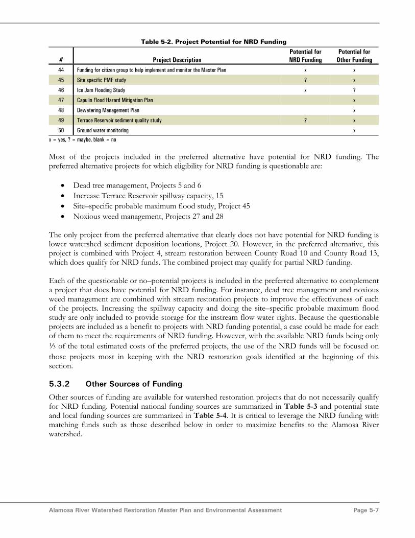
Alamosa River Watershed Restoration Master Plan and Environmental Assessment Page 5-7
Table 5-2. Project Potential for NRD Funding
# Project DescriptionPotential forNRD Funding
Potential forOther Funding
44 Funding for citizen group to help implement and monitor the Master Plan x x
45 Site specific PMF study ? x
46 Ice Jam Flooding Study x ?
47 Capulin Flood Hazard Mitigation Plan x
48 Dewatering Management Plan x
49 Terrace Reservoir sediment quality study ? x
50 Ground water monitoring x
x = yes, ? = maybe, blank = no
Most of the projects included in the preferred alternative have potential for NRD funding. Thepreferred alternative projects for which eligibility for NRD funding is questionable are:
• Dead tree management, Projects 5 and 6• Increase Terrace Reservoir spillway capacity, 15• Site–specific probable maximum flood study, Project 45• Noxious weed management, Projects 27 and 28
The only project from the preferred alternative that clearly does not have potential for NRD funding islower watershed sediment deposition locations, Project 20. However, in the preferred alternative, thisproject is combined with Project 4, stream restoration between County Road 10 and County Road 13,which does qualify for NRD funds. The combined project may qualify for partial NRD funding.
Each of the questionable or no–potential projects is included in the preferred alternative to complementa project that does have potential for NRD funding. For instance, dead tree management and noxiousweed management are combined with stream restoration projects to improve the effectiveness of eachof the projects. Increasing the spillway capacity and doing the site–specific probable maximum floodstudy are only included to provide storage for the instream flow water rights. Because the questionableprojects are included as a benefit to projects with NRD funding potential, a case could be made for eachof them to meet the requirements of NRD funding. However, with the available NRD funds being only3 of the total estimated costs of the preferred projects, the use of the NRD funds will be focused onthose projects most in keeping with the NRD restoration goals identified at the beginning of thissection.
5.3.2 Other Sources of Funding
Other sources of funding are available for watershed restoration projects that do not necessarily qualifyfor NRD funding. Potential national funding sources are summarized in Table 5-3 and potential stateand local funding sources are summarized in Table 5-4. It is critical to leverage the NRD funding withmatching funds such as those described below in order to maximize benefits to the Alamosa Riverwatershed.
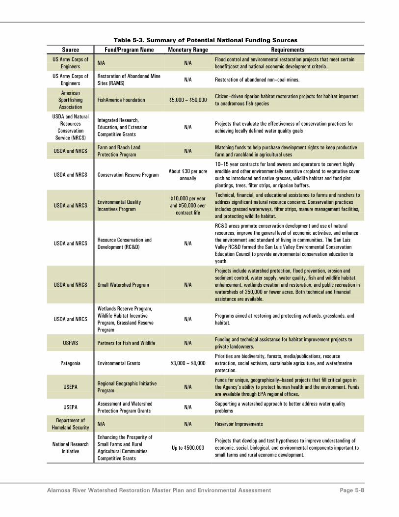
Alamosa River Watershed Restoration Master Plan and Environmental Assessment Page 5-8
Table 5-3. Summary of Potential National Funding Sources
Source Fund/Program Name Monetary Range RequirementsUS Army Corps of
EngineersN/A N/A
Flood control and environmental restoration projects that meet certainbenefit/cost and national economic development criteria.
US Army Corps ofEngineers
Restoration of Abandoned MineSites (RAMS)
N/A Restoration of abandoned non–coal mines.
AmericanSportfishingAssociation
FishAmerica Foundation $5,000 – $50,000Citizen–driven riparian habitat restoration projects for habitat importantto anadromous fish species
USDA and NaturalResources
ConservationService (NRCS)
Integrated Research,Education, and ExtensionCompetitive Grants
N/AProjects that evaluate the effectiveness of conservation practices forachieving locally defined water quality goals
USDA and NRCSFarm and Ranch LandProtection Program
N/AMatching funds to help purchase development rights to keep productivefarm and ranchland in agricultural uses
USDA and NRCS Conservation Reserve ProgramAbout $30 per acre
annually
10–15 year contracts for land owners and operators to convert highlyerodible and other environmentally sensitive cropland to vegetative coversuch as introduced and native grasses, wildlife habitat and food plotplantings, trees, filter strips, or riparian buffers.
USDA and NRCSEnvironmental QualityIncentives Program
$10,000 per yearand $50,000 over
contract life
Technical, financial, and educational assistance to farms and ranchers toaddress significant natural resource concerns. Conservation practicesincludes grassed waterways, filter strips, manure management facilities,and protecting wildlife habitat.
USDA and NRCSResource Conservation andDevelopment (RC&D)
N/A
RC&D areas promote conservation development and use of naturalresources, improve the general level of economic activities, and enhancethe environment and standard of living in communities. The San LuisValley RC&D formed the San Luis Valley Environmental ConservationEducation Council to provide environmental conservation education toyouth.
USDA and NRCS Small Watershed Program N/A
Projects include watershed protection, flood prevention, erosion andsediment control, water supply, water quality, fish and wildlife habitatenhancement, wetlands creation and restoration, and public recreation inwatersheds of 250,000 or fewer acres. Both technical and financialassistance are available.
USDA and NRCS
Wetlands Reserve Program,Wildlife Habitat IncentiveProgram, Grassland ReserveProgram
N/APrograms aimed at restoring and protecting wetlands, grasslands, andhabitat.
USFWS Partners for Fish and Wildlife N/AFunding and technical assistance for habitat improvement projects toprivate landowners.
Patagonia Environmental Grants $3,000 – $8,000Priorities are biodiversity, forests, media/publications, resourceextraction, social activism, sustainable agriculture, and water/marineprotection.
USEPARegional Geographic InitiativeProgram
N/AFunds for unique, geographically–based projects that fill critical gaps inthe Agency’s ability to protect human health and the environment. Fundsare available through EPA regional offices.
USEPAAssessment and WatershedProtection Program Grants
N/ASupporting a watershed approach to better address water qualityproblems
Department ofHomeland Security
N/A N/A Reservoir Improvements
National ResearchInitiative
Enhancing the Prosperity ofSmall Farms and RuralAgricultural CommunitiesCompetitive Grants
Up to $500,000Projects that develop and test hypotheses to improve understanding ofeconomic, social, biological, and environmental components important tosmall farms and rural economic development.
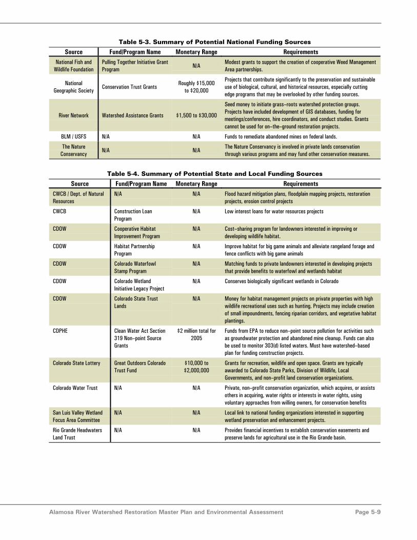
Alamosa River Watershed Restoration Master Plan and Environmental Assessment Page 5-9
Table 5-3. Summary of Potential National Funding Sources
Source Fund/Program Name Monetary Range RequirementsNational Fish and
Wildlife FoundationPulling Together Initiative GrantProgram
N/AModest grants to support the creation of cooperative Weed ManagementArea partnerships.
NationalGeographic Society
Conservation Trust GrantsRoughly $15,000
to $20,000
Projects that contribute significantly to the preservation and sustainableuse of biological, cultural, and historical resources, especially cuttingedge programs that may be overlooked by other funding sources.
River Network Watershed Assistance Grants $1,500 to $30,000
Seed money to initiate grass–roots watershed protection groups.Projects have included development of GIS databases, funding formeetings/conferences, hire coordinators, and conduct studies. Grantscannot be used for on–the–ground restoration projects.
BLM / USFS N/A N/A Funds to remediate abandoned mines on federal lands.
The NatureConservancy
N/A N/AThe Nature Conservancy is involved in private lands conservationthrough various programs and may fund other conservation measures.
Table 5-4. Summary of Potential State and Local Funding Sources
Source Fund/Program Name Monetary Range RequirementsCWCB / Dept. of NaturalResources
N/A N/A Flood hazard mitigation plans, floodplain mapping projects, restorationprojects, erosion control projects
CWCB Construction LoanProgram
N/A Low interest loans for water resources projects
CDOW Cooperative HabitatImprovement Program
N/A Cost–sharing program for landowners interested in improving ordeveloping wildlife habitat.
CDOW Habitat PartnershipProgram
N/A Improve habitat for big game animals and alleviate rangeland forage andfence conflicts with big game animals
CDOW Colorado WaterfowlStamp Program
N/A Matching funds to private landowners interested in developing projectsthat provide benefits to waterfowl and wetlands habitat
CDOW Colorado WetlandInitiative Legacy Project
N/A Conserves biologically significant wetlands in Colorado
CDOW Colorado State TrustLands
N/A Money for habitat management projects on private properties with highwildlife recreational uses such as hunting. Projects may include creationof small impoundments, fencing riparian corridors, and vegetative habitatplantings.
CDPHE Clean Water Act Section319 Non–point SourceGrants
$2 million total for2005
Funds from EPA to reduce non–point source pollution for activities suchas groundwater protection and abandoned mine cleanup. Funds can alsobe used to monitor 303(d) listed waters. Must have watershed–basedplan for funding construction projects.
Colorado State Lottery Great Outdoors ColoradoTrust Fund
$10,000 to$2,000,000
Grants for recreation, wildlife and open space. Grants are typicallyawarded to Colorado State Parks, Division of Wildlife, LocalGovernments, and non–profit land conservation organizations.
Colorado Water Trust N/A N/A Private, non–profit conservation organization, which acquires, or assistsothers in acquiring, water rights or interests in water rights, usingvoluntary approaches from willing owners, for conservation benefits
San Luis Valley WetlandFocus Area Committee
N/A N/A Local link to national funding organizations interested in supportingwetland preservation and enhancement projects.
Rio Grande HeadwatersLand Trust
N/A N/A Provides financial incentives to establish conservation easements andpreserve lands for agricultural use in the Rio Grande basin.
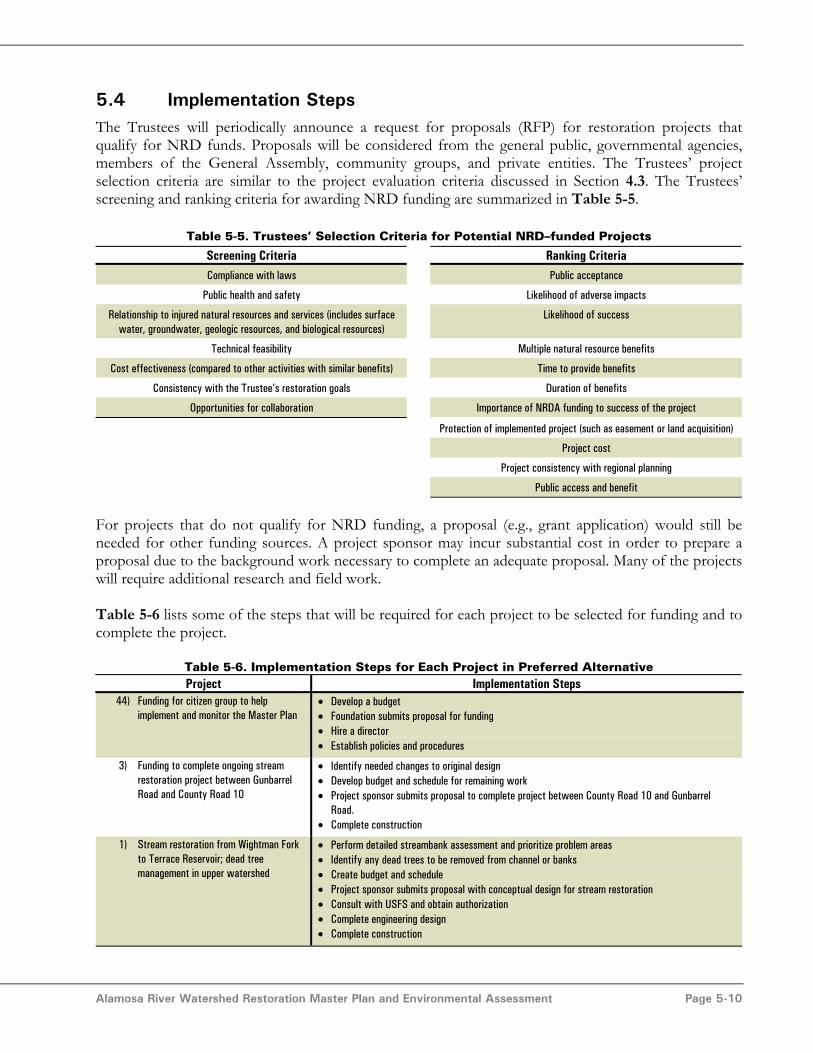
Alamosa River Watershed Restoration Master Plan and Environmental Assessment Page 5-10
5.4 Implementation StepsThe Trustees will periodically announce a request for proposals (RFP) for restoration projects thatqualify for NRD funds. Proposals will be considered from the general public, governmental agencies,members of the General Assembly, community groups, and private entities. The Trustees’ projectselection criteria are similar to the project evaluation criteria discussed in Section 4.3. The Trustees’screening and ranking criteria for awarding NRD funding are summarized in Table 5-5.
Table 5-5. Trustees’ Selection Criteria for Potential NRD–funded Projects
Screening Criteria Ranking CriteriaCompliance with laws Public acceptance
Public health and safety Likelihood of adverse impacts
Relationship to injured natural resources and services (includes surfacewater, groundwater, geologic resources, and biological resources)
Likelihood of success
Technical feasibility Multiple natural resource benefits
Cost effectiveness (compared to other activities with similar benefits) Time to provide benefits
Consistency with the Trustee’s restoration goals Duration of benefits
Opportunities for collaboration Importance of NRDA funding to success of the project
Protection of implemented project (such as easement or land acquisition)
Project cost
Project consistency with regional planning
Public access and benefit
For projects that do not qualify for NRD funding, a proposal (e.g., grant application) would still beneeded for other funding sources. A project sponsor may incur substantial cost in order to prepare aproposal due to the background work necessary to complete an adequate proposal. Many of the projectswill require additional research and field work.
Table 5-6 lists some of the steps that will be required for each project to be selected for funding and tocomplete the project.
Table 5-6. Implementation Steps for Each Project in Preferred AlternativeProject Implementation Steps
44) Funding for citizen group to helpimplement and monitor the Master Plan
• Develop a budget• Foundation submits proposal for funding• Hire a director• Establish policies and procedures
3) Funding to complete ongoing streamrestoration project between GunbarrelRoad and County Road 10
• Identify needed changes to original design• Develop budget and schedule for remaining work• Project sponsor submits proposal to complete project between County Road 10 and Gunbarrel
Road.• Complete construction
1) Stream restoration from Wightman Forkto Terrace Reservoir; dead treemanagement in upper watershed
• Perform detailed streambank assessment and prioritize problem areas• Identify any dead trees to be removed from channel or banks• Create budget and schedule• Project sponsor submits proposal with conceptual design for stream restoration• Consult with USFS and obtain authorization• Complete engineering design• Complete construction

Alamosa River Watershed Restoration Master Plan and Environmental Assessment Page 5-11
Table 5-6. Implementation Steps for Each Project in Preferred AlternativeProject Implementation Steps
31) Riparian buffer zone • Make contacts with major landowners to determine level of support and preferences for bufferzone
• Develop general criteria for the buffer zone such as width, allowed activities and prohibitedactivities
• Make contacts with local governments to determine level of support for projects and process forestablishing regulations
• Create budget and schedule• Project sponsor submits proposal including plan for creating buffer zone• Plan is implemented
38) Recreation/access/conservationeasements
• Prioritize locations for each type of easement• Initial discussions with property owners to gage level of interest• Real estate analysis to estimate cost per acre• Create budget and schedule• Project sponsor submits proposal including plan for obtaining and managing easements• Plan is implemented
9) Purchase water rights for instream flow • Determine if there are any willing sellers• Examine historical usage including quantity and type of crop• If land is to be sold, determine a management approach for the land• Determine storage location for the water right• Create budget and schedule• Project sponsor submits proposal with plan for obtaining and utilizing an identified water right• Plan is implemented
2) Stream restoration from Gomez Bridgeto Gunbarrel Road; Revegetation, deadtree management, noxious weedmanagement, and grazing managementin lower watershed
• Evaluate the existing Rosgen conceptual design and determine any necessary changes to thatdesign
• Create budget and schedule• Project sponsor submits proposal with conceptual design of stream restoration• Complete engineering design• Complete construction
23) Reclamation of abandoned mines (Pass–Me–By Mine only)
• Determine landowner interest in project• Create budget and schedule• Project sponsor submits proposal with conceptual design of project elements• Complete engineering design• Complete construction
22) Sediment trap pilot project with waterquality best management practices onAlum Creek
• Conduct feasibility study/alternatives analysis to determine best construction techniques,materials, and sediment disposal locations
• Create budget and schedule• Project sponsor submits proposal including conceptual plan of structural and water quality
elements• Consult with USFS and obtain authorization• Complete engineering design• Complete construction• Schedule sediment removal• Evaluate monitoring results and determine if design should be modified
20/4) Lower watershed sediment depositionlocations combined with streamrestoration from County Road 10 toCounty Road 13
• Perform detailed channel assessment and determine problem areas• Prepare conceptual design• Create budget and schedule• Project sponsor submits proposal• Complete engineering design• Complete construction
12) Trade of direct flow diversion right forstorage of instream flow water rights inTerrace Reservoir (no new water source)
• Determine Terrace Irrigation Company interest and preferences• Determine legal requirements of project• Create budget and schedule• Project sponsor creates plan for implementing project• Project sponsor submits proposal for project
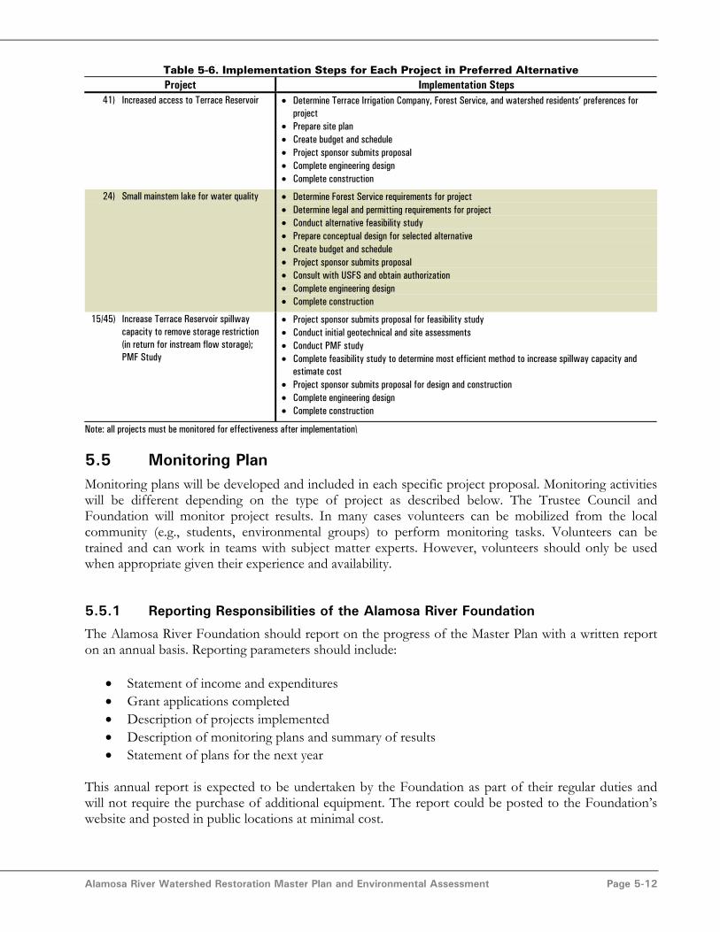
Alamosa River Watershed Restoration Master Plan and Environmental Assessment Page 5-12
Table 5-6. Implementation Steps for Each Project in Preferred AlternativeProject Implementation Steps
41) Increased access to Terrace Reservoir • Determine Terrace Irrigation Company, Forest Service, and watershed residents’ preferences forproject
• Prepare site plan• Create budget and schedule• Project sponsor submits proposal• Complete engineering design• Complete construction
24) Small mainstem lake for water quality • Determine Forest Service requirements for project• Determine legal and permitting requirements for project• Conduct alternative feasibility study• Prepare conceptual design for selected alternative• Create budget and schedule• Project sponsor submits proposal• Consult with USFS and obtain authorization• Complete engineering design• Complete construction
15/45) Increase Terrace Reservoir spillwaycapacity to remove storage restriction(in return for instream flow storage);PMF Study
• Project sponsor submits proposal for feasibility study• Conduct initial geotechnical and site assessments• Conduct PMF study• Complete feasibility study to determine most efficient method to increase spillway capacity and
estimate cost• Project sponsor submits proposal for design and construction• Complete engineering design• Complete construction
Note: all projects must be monitored for effectiveness after implementation\
5.5 Monitoring PlanMonitoring plans will be developed and included in each specific project proposal. Monitoring activitieswill be different depending on the type of project as described below. The Trustee Council andFoundation will monitor project results. In many cases volunteers can be mobilized from the localcommunity (e.g., students, environmental groups) to perform monitoring tasks. Volunteers can betrained and can work in teams with subject matter experts. However, volunteers should only be usedwhen appropriate given their experience and availability.
5.5.1 Reporting Responsibilities of the Alamosa River Foundation
The Alamosa River Foundation should report on the progress of the Master Plan with a written reporton an annual basis. Reporting parameters should include:
• Statement of income and expenditures• Grant applications completed• Description of projects implemented• Description of monitoring plans and summary of results• Statement of plans for the next year
This annual report is expected to be undertaken by the Foundation as part of their regular duties andwill not require the purchase of additional equipment. The report could be posted to the Foundation’swebsite and posted in public locations at minimal cost.

Alamosa River Watershed Restoration Master Plan and Environmental Assessment Page 5-13
Additionally, the Foundation should schedule a mid–year meeting or conference call with the TrusteeCouncil to report on progress.
5.5.2 Stream Restoration Monitoring
Stream restoration project success, comparing conditions prior to the project, during implementation,and after project completion, can be monitored using established reference cross sections. The crosssections can be evaluated periodically using surveys, photo records, and aerial photos. Cross sectionspacing is dependent on specific characteristics of the reference reach, and would vary from 1,000 to5,000 feet.
5.5.3 Vegetation Monitoring
The status of revegetation areas and the riparian zone can be monitored by comparing conditions priorto the project, during implementation, and after project completion. A combination of the followingmethods can be used:
• Photograph documentation of the present condition of the existing environment.Photographs will be taken from established locations on a yearly basis for monitoringpurposes. Fixed-point photograph stations would be established inrestoration/enhancement areas as well as in reference, or baseline, locations forcomparison.
• Monitoring of randomly placed transects established within or across the river corridor,as appropriate to provide an accurate representation of riparian zones. Transects wouldbe permanently established in revegatation/enhancement areas as well as in reference, orbaseline, locations for comparison. The start and end points of the transects would bestaked in the field and mapped using a global positioning system (GPS) unit so that theycan be repeated. Along each transect, quadrats would be placed at suitable intervals.Vegetation analysis, including species composition and percent areal cover by speciesand stratum, would be surveyed within each quadrat. Species composition is calculatedby identifying all species within a quadrat, then categorizing them as desirable versusundesirable. Percent areal cover is calculated by individual species within each vegetativestratum (i.e., tree layer, shrub layer, herbaceous/grass layer). This data would provideinformation on nuisance/noxious weeds as well.
• Surveying plantings for survivability. Plantings will be inventoried, then surveyed after anestablished period of time to track survival. The inventory would determine individualspecies survival, and overall survival of plantings.
A specific plan would be necessary for each individual revegetation project.
5.5.4 Water Quality Monitoring
The approach to water quality monitoring should balance the needs of data gathering with cost. Anybest management practice (BMP) implemented in the watershed should be monitored for effectiveness.BMP monitoring usually includes water quality sampling of the inflow and outflow of the structure.
Due to their experimental nature, pilot projects should be monitored more extensively than abandonedmine reclamation projects, which are likely to follow well–documented procedures.

Alamosa River Watershed Restoration Master Plan and Environmental Assessment Page 5-14
The most important water quality parameters in the Alamosa River are metals and pH. Metals analysis islabor intensive and lab cost intensive, whereas, pH can be measured continuously using a meter or canbe measured using low–cost methods. Conductivity and pH meters are often installed concurrently.Conductivity is directly related to dissolved metals concentration and can be used as an indication ofchanges in dissolved metals. It is recommended that both the sediment trap pilot project and mainstemlake project be implemented with a continuous pH meter immediately upstream and downstream tomeasure the effectiveness of the project. If funds are available, conductivity meters should also beinstalled. Both projects should also utilize periodic metals analysis to directly determine theireffectiveness in removing metals.
Data collected by CDPHE as part of the Summitville project should be used whenever possible tocompare conditions before, during, and after implementation of restoration projects. However, it will beimportant to isolate changes due to restoration projects from changes due to progress at the Summitvillesite as well as natural variation in water quality.
5.5.5 Water Quantity Monitoring
The success of the instream flow project can be monitored through the following activities:
• CDWR diversion records• Stream gage records for the “Alamosa River Below Terrace Reservoir” gage• Periodic analysis of stream stage at selected locations such as Gunbarrel Road and
County Road 10 in the lower Alamosa River to estimate streamflow.
These activities can be completed at minimal cost. Trained volunteers may be capable of doing some ofthe monitoring tasks such as summarizing diversion and stream gage records, surveying the stream stage,and estimating streamflow.
5.5.6 Recreation Monitoring
Recreation can be challenging to monitor. A typical way to monitor recreation is to track user–days atcampgrounds and facilities, such as the proposed new facilities at Terrace Reservoir.

Alamosa River Watershed Restoration Master Plan and Environmental Assessment Page 6-1
Section 6.0 - BibliographyAgro Engineering. 2000. 1998 Irrigated Lands Assessment Using Satellite Imagery in the Rio
Grande Basin of Colorado for Rio Grande Decision Support System.
Agro Engineering. 2003 Alamosa River Channel Conditions and Historical Channel ChangesAlamosa River Below Gunbarrel Road
Agro Engineering. 2004. 2002 Irrigated Lands Assessment Refresh Using Satellite Imagery in theRio Grande Basin of Colorado for Rio Grande Decision Support System.
Alamosa River Watershed Restoration Foundation (ARWRF). 2003. Water Quality PlummetsDuring Summer. Prepared for Alamosa River Watershed Restoration Project NewsletterIssue 6 by Derek Fritz.
Alves, J. 1998. Status of the Rio Grande cutthroat trout in Colorado. Colorado Division of Wildlife.Denver, Colorado.
Behnke, R.J. 2002. Trout and salmon of North America. The Free Press. New York. 359 pp.
Bestgen, K.R., and S.P. Platania. 1990. Extirpation of Notropis simus simus (Cope) and Notropisorca (Woolman) (Pisces: Cyprinidae) from the Rio Grande in New Mexico, with notes ontheir life history. In: Occasional papers, the Museum of Southwestern Biology. No. 6, pp.1–8. February 16, 1990.
Black Creek Hydrology. 2002. Assessment Report on the Alamosa River Between Terrace Reservoirand Gunbarrel Road.
Black Creek Hydrology. 2003. Re–survey of Monitoring Cross Sections on the Alamosa River.
Bove, D.J., T. Barry, J. Kurtz, K. Hon, A.B. Wilson, R.E. Van Loenen, and R.M. Kirkham. 1995.Geology of Hydrothermally Altered Areas within the Upper Alamosa River Basin, Colorado,and Probable Effects on Water Quality. In Posey, H.H., J.A. Pendleton and D. Van Zyl (eds.)Proceedings: Summitville Forum ‘95. Colorado Geological Survey Special Publication 38.
Brown, A.G., 1995. Geomorphology and Groundwater.
Buckingham, A., CDPHE, 2004. Oral communication with T. Wilcox, MWH.
California Department of Water Resources. 2004. Schaeffer Fish Barrier. Available at:http://wwwdoe.water.ca.gov/projects/schaeffer/images/index1.htm
Calamusso, B., and J.N. Rinne. 2004. Distribution and abundance of Rio Grande cutthroat trout(Oncorhynchus clarki virginalis), relative to an introduced salmonid, in northern NewMexico. Pages 31–37 in G.J. Scrimgeour, G. Eisler, B. McCulloch, U. Silins, and M. Monita.Editors. Forest Land–Fish Conference II – Ecosystem Stewardship through Collaboration.Proc. Forest– Land–Fish Conf. II, April 26–28, 2004, Edmonton, Alberta.
Cancalosi, J.J. 1980. Fishes of the Republican River Basin in Colorado. M.S. Thesis, Colo. St. Univ.,Ft. Collins, CO. 87 pp.
Cardon, G.E., A.Y. Ali, J. McCann, and A. Lorenz. 1995. Metal Content of Wheat and Potato Tissueand Associated Soils Irrigated with Alamosa River Water. In Posey, H.H., J.A. Pendleton andD. Van Zyl (eds.) Proceedings: Summitville Forum ‘95. Colorado Geological Survey SpecialPublication 38.

Alamosa River Watershed Restoration Master Plan and Environmental Assessment Page 6-2
Cardon, G.E., J. McCann, and A. Lorenz. 1995. Survey of Irrigation Structure Condition in theAlamosa River Basin. In Posey, H.H., J.A. Pendleton and D. Van Zyl (eds.) Proceedings:Summitville Forum ‘95. Colorado Geological Survey Special Publication 38.
Cardon, G.E., and E.F. Kelly. 1998. Impact of Acidic Irrigation Water on the Acid BufferingCapacity of Alamosa River Basin Soils.
Chaney, E.; W. Elmore; and W.S. Platts. 1990. Livestock grazing on western riparian areas. U.S.Environmental Protection Agency, Washington, D.C.
Colorado Department of Health and Environment (CDPHE). 2001. Regulation No. 31, The BasicStandards and Methodologies for Surface Water. Amended September 10, 2001 effectedOctober 30, 2001.
Colorado Department of Public Health and the Environment (CDPHE). 2003. Regulation No. 36 –Classifications and Numeric Standards for Rio Grande Basin. Amended September 9, 2002,Effective January 20, 2003.
Colorado Department of Public Health and the Environment (CDPHE). 2003b. Summitville Update– New and Information About the Summitville Superfund Site.
Colorado Department of Public Health and the Environment (CDPHE). 2004. HMWMD MeetingHandout from Austin Buckingham.
Colorado Division of Minerals and Geology (CDMG). 2002. Best Practices in Abandoned MineLand Reclamation: the Remediation of Past Mining Activities. Denver. Available:http://www.mining.state.co.us/bmp.pdf.
Colorado Division of Wildlife (CDOW). 2001. Correspondence from J. Alves of CDOW to A.Buckingham of the Colorado Department of Public Health and Environment. Dated October3, 2001.
Colorado Division of Wildlife (CDOW). 2003. Terrace Reservoir fish data for 2001 provided byJohn Alves during a meeting on April 11, 2003.
Colorado Division of Wildlife (CDOW). 2004. News release: 4/2/2004. Available:http://wildlife.state.co.us/news/press.asp?pressid=2690.
Colorado Division of Wildlife (CDOW). 2004a. Big game hunting season recap summaries andharvest surveys statistics. Available: http://wildlife.state.co.us/huntrecap/.
Colorado Division of Wildlife (CDOW). 2004b. State wildlife areas. Available:http://wildlife.state.co.us/swa/view.asp.
Colorado Geological Survey (CGS). 1995. Sources of acidity and heavy metals in the Alamosa RiverBasin outside of the Summitville Mining Area. Special Publication 38.
Colorado Geological Survey (CGS). 2003. Division of Minerals and Geology, Department ofNatural Resources, Ground Water Atlas of Colorado, Special Publication 53.
Colorado Geological Survey (CGS). 2004. Artificial Recharge of Ground Water in Colorado – AStatewide Assessment. By Ralf Topper, Peter Barkmann, David R. Bird, and Matthew A.Sares. Environmental Geology 13.
Colorado Natural Heritage Program (CNHP). 2004. List of imperiled species by County. Available:http://www.cnhp.colostate.edu/list.html.

Alamosa River Watershed Restoration Master Plan and Environmental Assessment Page 6-3
Colorado Water Conservation Board (CWCB). 2000. Memorandum from John Van Sciver toColorado Water Conservation Board Members, Agenda 12b–La Jara Water ConservationDistrict.
Colorado Water Conservation Board (CWCB). 2001. CWCB Memorandum, Flood HydrologySummary for Alamosa River, December 6, 2001.
Colorado Water Conservation Board (CWCB). 2004. Memo to Board Members from Tim Feenanand Mike Serlet regarding Terrace Irrigation Company dated March 4, 2004.
Colorado Water Resources Division 3 (CWRD). 2004. Division 3 Stream Administration List –Stream #1 Alamosa River, dated 4/1/97 with recent abandonment numbers noted. Fax toKelley Thompson on April 28, 2004.
Conejos County Soil Conservation District (CCSCD). 1997. Management Plan for the AlamosaRiver Watershed. By Jeff Stern, Watershed Coordinator. December 31, 1997.
Danielson, L.J., and L. Alms. 1995. The Summitville Legacy: Where Do We Go From Here? InPosey, H.H., J.A. Pendleton and D. Van Zyl (eds.) Proceedings: Summitville Forum ‘95.Colorado Geological Survey Special Publication 38.
Denver Urban Drainage and Flood Control District (DUDFCD). 1999. Urban Storm DrainageCriteria Manual, Volume 3 – Best Management Practices.
Ellis, M.M. 1914. Fishes of Colorado. Univ. of Colorado Studies. Boulder, CO. II(1):1–136
Erdman, J.A., K.S. Smith, and M. ter Kuile. 1996. Impact of the Lower Alamosa River Water onAlfalfa, Southwestern San Luis Valley, Colorado – 1995 Follow–up Study of Effects Fromthe Summitville Mine. U.S. Geological Survey Open–File Report 96–034.
Ferguson, S., and P. Edelmann. 1996. Assessment of Metal Transport Into and Out of TerraceReservoir, Conejos County, Colorado, April 1994 Through March 1995. US GeologicalSurvey, Denver.
Fitzgerald, J.P., C.A. Meaney, and D.M. Armstrong. 1994. Mammals of Colorado. Denver Museumof Natural History and University Press of Colorado. Niwot, Colorado.
Hammerson, G.A. 1999. Amphibians and reptiles in Colorado. Second Edition. University Press ofColorado and Colorado Division of Wildlife. Niwot, Colorado.
Hanley, J., EPA, 2004. Oral communication with K. Thompson, Agro Engineering.
Harig, A.L., and K.D. Fausch. 1996. Compilation of data on Colorado waters containing Rio Grandecutthroat trout. MOU Project No. 904–96, Colorado Division of Wildlife, Montrose, CO.
Horn, B.J. 1988. Biological assessment of Wightman Fork. Colorado Division of Wildlife. 15 pp.
Information from Colorado database. Reference(s) not available. Coordinator in Colorado is DonaldSchrupp. 6060 North Broadway, Denver, CO 80216.
Jordan, D.S. 1891. Report of explorations in Colorado and Utah during the summer of 1889, with anaccount of the fish found in each of the river basins examined. U.S. Fish CommissionBulletin 89: 1–40.
Kingery, H.E., ed. 1998. Colorado breeding bird atlas. Colorado Wildlife Heritage Foundation.Denver, Colorado.
Alamosa River Watershed Restoration Master Plan and Environmental Assessment Page 6-4
Kirkham, R.M., J.R. Lovekin, and M.A. Sares. 1995. Sources of Acidity and Heavy Metals in theAlamosa River Basin Outside of the Summitville Mining Area, Colorado. In Posey, H.H.,J.A. Pendleton and D. Van Zyl (eds.) Proceedings: Summitville Forum ‘95. ColoradoGeological Survey Special Publication 38.
Lee, D.S., and C.R. Gilbert. 1978. Culae inconstans (Kirtland), brook stickleback. N.C. Biol. Surv.Pub. 1980–12:562; Nelson, J.S. 1969. Geographic variation in the brook stickleback, Culaeinconstans, and notes on nomenclature and distribution. J. Fish. Res. Board Canada 26:2431–2447.
Leopold, L.B, Wolman, M.G., and Miller, J.P. (Leopold, et al.). 1964. Fluvial Processes inGeomorphology. W.H. Freeman and Company, San Francisco.
Lipman, P.W., Steven, T.A., and Mehnert, H.H. (Lipman et al.). 1970. Volcanic history of the SanJuan Mountains, Colorado, as indicated by potassium–argon dating. Geol. Soc., AmericaBull. v. 81.
Lipman, P.W., and Mehnert, H.H. (Lipman and Mehnert). 1975. Late Cenozoic basaltic volcanismand development of the Rio Grande depression in the southern Rocky Mountains. Geol. Soc.,America Memoir 144.
Martin, L.M. 1994. Fish community of the headwater streams in the Summitville area; emphasizingthe Alamosa River drainage. Colorado Division of Wildlife. Denver, Colorado. 20 pp.
McCann, Joe, Colorado State Engineer’s Office. 2004. Comments on the Alamosa River RestorationWatershed Master Plan Draft Tech Memo 1. July 30, 2004.
Medine, A.J. 1997. Technical Assessment of Pre–Mining and Pre–Galactic Water Quality forWightman Fork and the Alamosa River. Use Attainability Analysis for the Alamosa RiverWatershed through 1997 – Appendix D: Prepared for U.S. Environmental Protection Agency.April 1998.
Miller, Dennis. 2004. Memorandum of Inspection of Terrace Reservoir dated February 5, 2004.
Mueller, M, T. Mueller, and T. Gilmer. 1996. Progress report of water quality testing results for theAlamosa River and tributaries and other water sources, potentially under the influence of theSummitville mining and cleanup activities for 1994 and 1995. Alamosa–La Jara ConservancyDistrict. Alamosa, Colorado.
National Weather Service (NWS). 2004. Climate Information Alamosa. Available:http://www.crh.noaa.gov/pub/climate/Accessed: June 1, 2004
Natural Diversity Information Source. 2004. Conejos County known or likely species occurrence.Available: http://ndis.nrel.colostate.edu/aspresponse/spxbycnty_res.asp
Neubert, J. 2001. Geology of the upper Alamosa River Area. Colorado Geological Survey RocktalkVolume 4, Number 2. April 2001.
New Mexico Department of Game and Fish (NMDGF). 1988. Handbook of species endangered inNew Mexico, C–187: 1–2. Santa Fe, NM.
New Mexico Department of Game and Fish (NMDGF). 1994. Endangered species of New Mexico:1994 biennial review and recommendations. Authority: New Mexico Wildlife ConservationAct (NMSA 17–2–37, 1978).
Alamosa River Watershed Restoration Master Plan and Environmental Assessment Page 6-5
New Mexico Department of Fish and Game. 2001. Biota Information Systems of New Mexico(BISON–M). Available: http://fwie.fw.vt.edu/states/nm.htm.
Ortiz, R., P. Edelmann, S. Ferguson, and R. Stogner. 2002. Sources of Metal Loads to the AlamosaRiver and Estimation of Seasonal and Annual Metal Loads for the Alamosa River Basin,Colorado, 1995–97. U.S. Geological Survey, Denver, 2002.
Ortiz, R.F. and S.A. Ferguson. 2001. Characterization of Water Quality in Selected Tributaries of theAlamosa River, Southwestern Colorado, Including Comparisons to Instream Water–QualityStandards and Toxicological Reference Values, 1995–97. U.S. Geological Survey, Denver,2001.
Personal communication from Craig Cotton at Colorado Division of Water Resources. Rating Tablesfor Gages Above and Below Terrace Reservoir 1965–2004. (CDWR Rating Tables)
Personal communication from Rick Crowfoot United States Geological Survey. Rating Tables forGages Above and Below Terrace Reseroir 1934–1988. (USGS Rating Tables)
Platania, S.P. 1991. Fishes of the Rio Chama and upper Rio Grande, New Mexico, with preliminarycomments on their longitudinal distribution. Southwestern Naturalist 36(2): 186–193.
Plumlee, G.S., J.E. Gray, M.M. Roeber, M. Coolbaugh, M. Flohr and G. Whitney. 1995. TheImportance of Geology in Understanding and Remediating Environmental Problems atSummitville. In Posey, H.H., J.A. Pendleton and D. Van Zyl (eds.) Proceedings: SummitvilleForum ‘95. Colorado Geological Survey Special Publication 38.
Posey, H.H and J.D. Woodling. 1998. Use Attainability Analysis for the Alamosa River Watershedthrough 1997. Prepared for U.S. Environmental Protection Agency. April 1998.
Propst, D.L. 1982. Warmwater fishes of the Platte River Basin, Colorado; distribution, ecology, andcommunity dynamics. PhD Dissertation, Colo. St. Univ., Ft. Collins, CO. 283 pp.
Ramsdell, H.S. 1998. Summitville Mine Site CERCLA Investigation: Livestock and Waterfowl RiskAssessment. Dept of Environmental Health and Center for Environmental Toxicology andTechnology. Colorado State University
Ramsdell, H.S. and S. Zylstra. 1999. Summitville Mine / Alamosa River: Livestock ExposureInvestigation. Dept of Environmental Health and Center for Environmental Toxicology andTechnology. Colorado State University
Reinhardt, Rod, 2004. Terrace Reservoir Capacity Table. Faxed to Mike Miller of MWH onFebruary 21, 2004.
Rocky Mountain Consultants (RMC). 2000a. Summitville Mine Superfund Site RI/FS 2000 DataSummary Report Surface Water and Groundwater Sampling. Prepared for ColoradoDepartment of Public Helath and Environment.
Rocky Mountain Consultants (RMC). 2000b. Summitville Mine Superfund Site RI/FS 2000 DataGap Study Report. Prepared for Colorado Department of Public Helath and Environment.
Rocky Mountain Consultants (RMC). 2001. Preliminary Terrace Water Quality Results. Facsimile toAustin Buckingham, CDPHE HMWMD. June 5, 2001
Rosgen, D. (Rosgen). 1996. Applied River Morphology. Illustrations by Hilton Lee Silvey. WildlandHydrology Group, Pagosa Springs, CO.
Ross, A. 2004. Oral communication with Kelley Thompson, Agro Engineering.

Alamosa River Watershed Restoration Master Plan and Environmental Assessment Page 6-6
Rupert, M.G. 2001. Relations Among Rainstorm Runoff, Streamflow, pH, and MetalConcentrations, Summitville Mine Area, Upper Alamosa River Basin, Southwest Colorado,1995–97. U.S. Geological Survey, Denver, 2001
Schuum, S.A., Mosley, M.P., and Weaver, W.E. (Schumm et al.). 1987. Experimental FluvialGeomorphology. John Wiley & Sons, Inc., New York.
Scott, W.B., and E.J. Crossman. 1973. Freshwater fishes of Canada. Fisheries Research Board ofCanada, Ottawa. 966 pp.
Sound Native Plants, 2004. Before and After Photos of Nisqually bluff residence 1997 and 1999.Available at: http://www.soundnativeplants.com/beforeandafters.htm
Stern, Jeff. 1997. Management Plan for the Alamosa River Watershed, dated December, 1997
Steven, T.A. (Steven). 1975. Middle Tertiary volcanic field in the southern Rocky Mountains. GSAmemoir 144.
Steven, T.A., and Epis, R.C. (Steven and Epis). 1968. Oligocene volcanism in south–centralColorado: in Cenozoic volcanism in the southern Rocky Mountains. Epis R.C. (ed), ColoradoSchool of Mines Quart. v. 63.
Stogner, R.W., P. Edelmann, and K. Walton–Day. 1997. Physical and Chemical Characteristics ofTerrace Reservoir, Conejos County, Colorado, May 1994 Through May 1995. US GeologicalSurvey, Denver.
Stout, P.R., and J.C. Emerick. 1995. Metal Uptake by Moravian III Barley Irrigated with WaterAffected by Acid Mine Discharge in San Luis Valley, Colorado. In Posey, H.H., J.A.Pendleton and D. Van Zyl (eds.) Proceedings: Summitville Forum ‘95. Colorado GeologicalSurvey Special Publication 38.
Stumpff, W.K., and J. Cooper. 1996. Rio Grande cutthroat trout, Oncorhynchus clarki virginalis. In:Conservation Assessment for Inland Cutthroat Trout. Edited by Duff, D.E. United StatesDepartment of Agriculture, Forest Service, Intermountain Region, Ogden, Utah.
Sublette, J.E., M.D. Hatch, and M. Sublette. 1990. The fishes of New Mexico. University of NewMexico Press. Albuquerque, New Mexico.
Terrace Irrigation Company (TIC). 2004. Terrace Reservoir Data Sheet. Rod Reinhardt transmittedto RMR Consulting April 16, 2003.
Tetra Tech RMC. 2004. Summitville Mine Superfund Site Operable Unit 5 Annual MonitoringReport Volume 1. Prepared for Colorado department of Public Health and Environment.
Topper, R. 2001. History of Summitville Mine Reclamation. Colorado Geological Survey RocktalkVolume 4, Number 2. April 2001.
U.S. Bureau of Reclamation. 1987. Design of Small Dams
U.S. Department of Agriculture (USDA) – Natural Resource Conservation Service (NRCS). 1997.Riparian corridor assessment: Alamosa River below Terrace main diversion, ConejosCounty, Colorado. Prepared by: USDA, NRCS, and Intermountain Area Riparian/WetlandResource Technical Team.
U.S. Department of Agriculture (USDA), U.S. Environmental Protection Agency, Tennessee ValleyAuthroity, Federal Emergency Management Agency, U.S. Department of Defense, U.S.Department of Housing and Urban Development, U.S. Department of the Interior. 1998.Stream Corridor Restoration: Principles, Processes, and Practices.
Alamosa River Watershed Restoration Master Plan and Environmental Assessment Page 6-7
U.S. Department of Agriculture (USDA). 2001. National visitor use monitoring results. USDAForest Service Region 2, Rio Grande National Forest.
U.S. Department of Agriculture (USDA). 2002. Forest plan implementation: A five–year review1997–2001. Rio Grande National Forest, Rocky Mountain Region, Region 2, Monte Vista,Colorado.
U.S. Environmental Protection Agency (EPA). 2001. EPA Superfund record of decision forSummitville Mine final site–wide remedy, operable unit 5. Summitville Mine Superfund Site,Rio Grande County, Colorado.
U.S Environmental Protection Agency (EPA). 1999. Review of the Integrated Approach forPredicting Metals Toxicity in Surface Waters and Sediments. U.S. EPA Science AdvisoryBoard Ecological Processes and Effects Committee. Available:http://www.epa.gov/sab/pdf/epec0005.pdf
U.S. Fish and Wildlife Service (USFWS). 2003. Federally listed species in Conejos County.Available: http://mountain–prairie.fws.gov/endspp/CountyLists/COLORADO082003.htm.
U.S. Forest Service (USFS). 2003. Monitoring and evaluation report FY 2002, Rio Grande NationalForest, Colorado, Rocky Mountain Region.
U.S. Geological Survey (USGS). 1998. Birds as indicators of riparian vegetation condition in thewestern U.S.: riparian obligate and dependent species. Available:http://www.npwrc.usgs.gov/resource/1998/ripveg/obligate.htm
U.S. Geological Survey (USGS). 2001. Water–Resources Investigations Report 01–4027, RelationsAmong Rainstorm Runoff, Streamflow, pH, and Metal Concentrations, Summitville MineArea, Upper Alamosa River Basin, Southwest Colorado, 1995–97, Prepared by Michael G.Rupert in Cooperation with the U.S. Environmental Protection Agency
U.S. Geological Survey (USGS). 2004. Birds as indicators of riparian vegetation condition in thewestern U.S. Northern Prairie Wildlife Research Center. Available:http://www.npwrc.usgs.gov/resource/1998/ripveg/dependnt.htm.
Valle del Sol Community Center (VSCC). 2003. Alamosa River Watershed Project Literature andWatershed Assessment – Final EPA Report. By RMR Consultants, Art Hirsch.
Vandiver, Steven E., Division Engineer, Divison 3. 2002. Personal Communication with TracyWilcox, MWH on August 31, 2004.
Vandiver, Steven E., Division Engineer, Division 3. 2002. Letter to Ken Salazar re: Alamosa RiverRestoration Project Hydrology Issues. Dated June 24, 2002.
Vandiver, Steven E., Division Engineer, Division 3. 2000. How Colorado Meets its ObligationUnder the Compact. The Rio Grande Compact: It’s the Law! WRRI Report No 312, June2000.
Walker, P. 1993. A list of the endemic and introduced fishes of Colorado. Colorado Division ofWildlife, Aquatic Resources Unit. Unpublished manuscript. 16 pp.
Walsh, W.A. 1997. Toxicity Effects of Selected Metals on Aquatic Biology in the Alamosa RiverWatershed. Prepared by Walsh Aquatic Consultants for Restore Our Alamosa River, Valledel Sol Community Center, Capulin, Colorado.

Alamosa River Watershed Restoration Master Plan and Environmental Assessment Page 6-8
Weather.com. 2004. Averages and Records for Capulin, CO. Available:http://www.weather.com/weather/climatology/monthly/USCO0055?from=search Accessed:June 1, 2004.
Western Region Climate Center (WRCC). 2004a. Colorado Climate Summaries. Platoro, CO –Station 056559. Period of Record 1949 to 1991. Available:http://www.wrcc.dri.edu/summary/climsmco.htmlAccessed: June 1, 2004.
Western Regional Climate Center (WRCC). 2004b. Pan Evaporation Data for Alamosa WSO AP for1948 to 2002. Available at: http://www.wrcc.dri.edu/CLIMATEDATA.html. Accessed: May 18,2004.
Wildland Hydrology, (Rosgen). 1999. Conceptual Design for the Alamosa River.
Witte. Steve, Assistant Division Engineer. Date Unknown. File notes including history of eventsrelating to channel straightening. Delivered to Joe McCann.
Wood, B. 2001. Alamosa River Mining History. Colorado Geological Survey Rocktalk Volume 4,Number 2. April 2001.
Woodling, J.D. 1985. Colorado’s little fish. A guide to the minnows and other lesser known fishes inthe State of Colorado. Colorado Division of Wildlife. 77 pp.
Woodling, J.D. 1993. Preliminary observations regarding fishery data of the Summitville area.Colorado Division of Wildlife. Denver, Colorado, 8 pp.
Woodling, J.D. 1995. Historic fisheries records – Alamosa River, in Posey, H.H., Pendleton, J.A.,and Van Zyl, D., eds., Proceedings, Summitville Forum ‘95: Colorado Geological Survey,Special Publication 38, p. 228–235.
Woodling, J.D. Date unknown. Physical habitat assessment and biological assessment. DMG/WQUAA, Exhibit 1, Appendix B.