Embed Size (px)
Citation preview
Final Environmental Impact Statement
Chapter 2 – Alternatives Considered
S o u t h e a s t C o r r i d o r January 2007 2-1
2. ALTERNATIVES CONSIDERED This chapter describes the alternatives considered for the Southeast Corridor and the process used to select them. The alternatives under consideration in this Final Environmental Impact Statement (FEIS)1 consist of a No Build Alternative, which serves as a basis for the evaluation of transportation and environmental impacts, and the Locally Preferred Alternative (LPA) providing for the implementation of Bus Rapid Transit (BRT) services in the Southeast Corridor. This chapter also describes the alternatives development and screening process that resulted in the build alternatives evaluated in the Draft Environmental Impact Statement (DEIS).
The Metropolitan Transit Authority of Harris County (METRO) has followed a prescribed process, including seeking input from the public, corridor stakeholders, and other affected parties, to identify the range of alternatives and issues for study in this document. A full range of possible build alternatives meeting the goals and objectives described in Chapter 1 – Purpose and Need were evaluated in the DEIS. After review of comments on the DEIS, the METRO Board of Directors selected the BRT Convertible Alternative with the Wheeler-MLK alignment option described in the DEIS as the LPA. The LPA was chosen based on its effectiveness in meeting the purpose and need of the project and because it would result in fewer negative impacts to the community.
2.1 Development and Screening of Alternatives in the Alternatives Analysis
This section provides background information for the proposed Southeast Corridor fixed-guideway transit project and summarizes the planning process that led to the development of the build alternatives presented in this FEIS. The process began with the initiation of the Southeast-Universities-Hobby Corridor Planning Study Alternatives Analysis (AA). The data collection, analyses, and results of the AA process are incorporated by reference into this FEIS.2 A summary of the conclusions of the AA follows.
2.1.1 Scoping and Public Involvement
Scoping is the process by which the lead agency preparing the DEIS solicits input from the public and other agencies regarding the breadth and depth of alternatives and issues to be addressed and the significant issues related to the proposed action. Scoping for the project was accomplished as part of the Southeast-Universities-Hobby Corridor Planning Study AA. The scoping process was officially initiated on January 9, 2002, with publication in the Federal Register of a Notice of Intent (NOI) to study advanced high capacity transit (AHCT) alignments and station locations, to prepare an environmental impact statement (EIS), and to conduct public scoping meetings. Scoping provided the
1 Acronyms and abbreviations are defined at their first use in the chapter. A complete list of acronyms
and abbreviations used in the FEIS is contained in Appendix A. 2 This FEIS incorporates by reference all technical information, studies, and other public documents
produced for the Southeast-Universities-Hobby Corridor AA and the METRO Solutions Transit System Plan that support the FEIS. These documents are considered part of the environmental compliance record and can be requested for review at the METRO offices.
Final Environmental Impact Statement Chapter 2 – Alternatives Considered
S o u t h e a s t C o r r i d o r 2-2 January 2007
opportunity for the community and for individual stakeholders to review alternatives being considered, to participate in the development of alternatives, and to suggest planning or environmental issues that should be addressed as the study proceeds.
Three scoping meetings were held, consisting of one agency and two public meetings. Affected local, state, and federal agencies were invited to and participated in the agency scoping meeting held on February 27, 2002 for the Southeast-Universities-Hobby Corridor Planning Study and two other regional corridor studies. The two public meetings were held on February 19 and 21, 2002. The Scoping Results Report for the Southeast-Universities-Hobby Planning Study AA documents the results of the scoping meetings.3
The AA was conducted in close coordination with stakeholders, a Community Involvement Committee (CIC), and an Interagency Steering Committee. Meetings with stakeholders were an on-going activity throughout the AA process and continued through preparation of the DEIS and FEIS. Initial stakeholder meetings were used to identify members of the community that represented significant constituencies in the corridor. Representatives of these stakeholder groups were invited to participate on the CIC. The CIC met regularly and reviewed study progress, provided input to the development of the study milestones, reviewed the products of the study, and disseminated information to their respective groups.
The Interagency Steering Committee was established to provide technical direction to the project. The committee consisted of staff from METRO, the Houston-Galveston Area Council (H-GAC); Harris County Public Infrastructure Department; Texas Department of Transportation (TxDOT); City of Houston Planning and Development Department; City of Spring Valley; Harris County Toll Road Authority (HCTRA); the Federal Transit Administration (FTA), Region VI; and the Houston Airport System. The Interagency Steering Committee met at critical milestones in the study process to discuss the AA progress and keep the regional public agencies involved.
2.1.2 Alternatives Screening and Selection Process
Title 49 of the United States Code (USC) 5309(e)(1)(A) establishes the process for the planning and development of New Starts projects4 consisting of Alternatives Analysis and Preliminary Engineering. Under this process, an agency is allowed to prepare a DEIS to satisfy National Environmental Policy Act (NEPA) requirements as part of the AA or to use the AA for the subsequent preparation of a DEIS within the preliminary engineering phase of project development. After consulting with FTA, METRO chose to prepare the DEIS as part of the AA process.
NEPA requires that the DEIS include an analysis of all reasonable alternatives. The Southeast-Universities-Hobby Corridor Planning Study AA was the process used to select the build alternatives from among several alternatives considered. The
3 Parsons Brinckerhoff, Southeast-Universities-Hobby Planning Study, Scoping Results Report,
March 2002. 4 The FTA’s discretionary New Starts program is the Federal government’s primary financial
resource for supporting locally-planned, implemented, and operated fixed-guideway capital investments.
Final Environmental Impact Statement
Chapter 2 – Alternatives Considered
S o u t h e a s t C o r r i d o r January 2007 2-3
Southeast-Universities-Hobby Corridor Planning Study Alternatives Analysis Report documents the results of the analysis of all alternatives considered.5
The AA identified and evaluated alternatives through a two-step process. The first step consisted of the identification and screening of a long list of potential alignment segments. The alignment segments consisted of rights of way that could conceivably accommodate AHCT (defined as high-capacity, high-speed two-direction all-day transit). The CIC participated in the screening of alignment segments by reviewing and commenting on the results of the analysis. The results of the screening were then reviewed in meetings with the stakeholders. Based on input from the stakeholders, a list of alignment segments was selected to carry forward to detailed evaluation.
The AA also screened a long list of transit technologies capable of providing AHCT, narrowing to the consideration of light rail transit (LRT) and BRT with input from the CIC and general public. The technologies of LRT and BRT were selected for detailed evaluation with the corridor alignment alternatives.
The second step involved the development of full-length corridor alternatives from the list of remaining alignment segments. The corridor alternatives were then subjected to more detailed evaluation of the benefits and the environmental, transportation, and economic impacts against the stated goals and objectives for the project as set forth in the purpose and need. Capital and operations and maintenance (O&M) cost estimates were also developed for use in the evaluation.
The alternatives and results of the evaluation were presented to the stakeholders and public in a series of meetings and comments were solicited. Following the meetings, comments from the general public and cooperating agencies were assessed and a recommended locally preferred investment strategy (LPIS) for the Southeast-Universities-Hobby Corridor was selected and subsequently approved for inclusion in the METRO Solutions plan. The plan was subjected to a referendum and approved by voters in November 2003. Following an extensive public involvement process, the METRO Board adopted the LPIS and minimum operable segment (MOS) in November 2003. This previously adopted LPIS and MOS are described in Section 2.1.2.4.
This next section describes the alternatives considered in the AA and the results of the screening and evaluation process that led to the selection and adoption of the LPIS and MOS.
2.1.2.1 Identification and Screening of Preliminary Alternatives
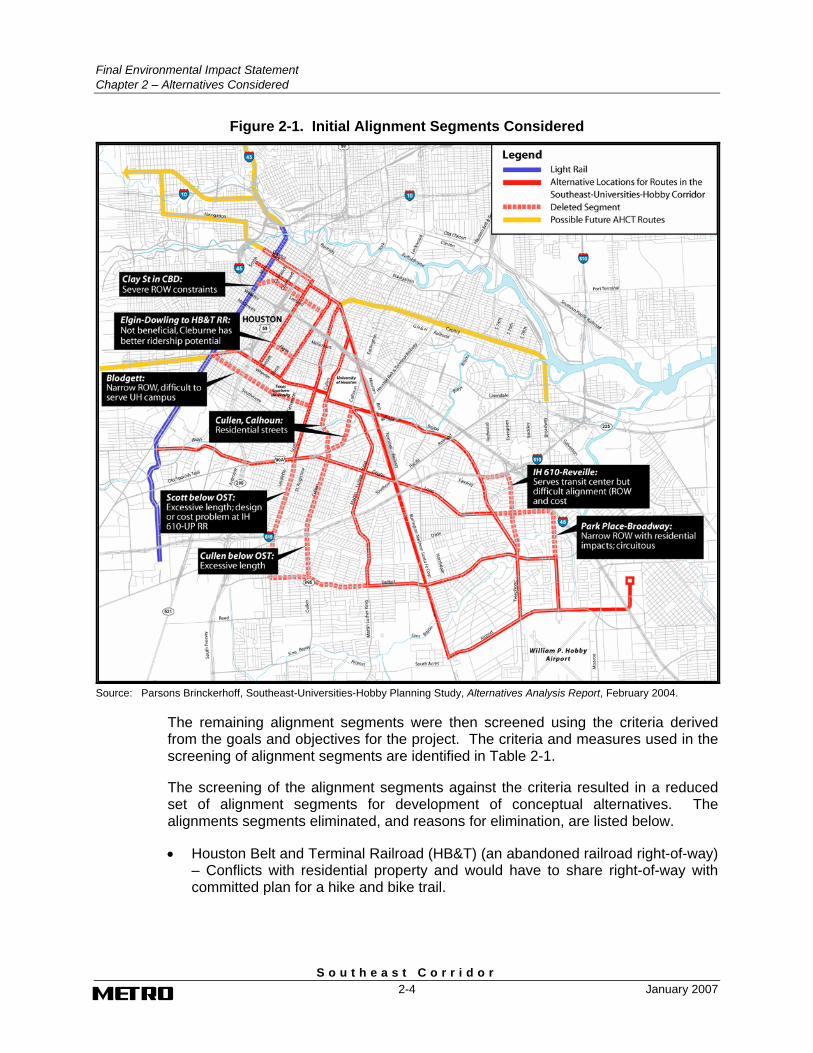
The development of alternatives was initiated with the identification and mapping of all potential rights of way conceivable for fixed-guideway transit, including arterial streets and active or abandoned railroad rights of way. In the initial step, alignment segments having “fatal flaws” that made them clearly inferior for further consideration were eliminated. Figure 2-1 identifies the alignment segments initially considered, including the segments that were eliminated and the reasons for their elimination.
5 Parsons Brinckerhoff, Southeast-Universities-Hobby Planning Study, Alternatives Analysis Report,
February 2004.
Final Environmental Impact Statement Chapter 2 – Alternatives Considered
S o u t h e a s t C o r r i d o r 2-4 January 2007
Figure 2-1. Initial Alignment Segments Considered
Source: Parsons Brinckerhoff, Southeast-Universities-Hobby Planning Study, Alternatives Analysis Report, February 2004.
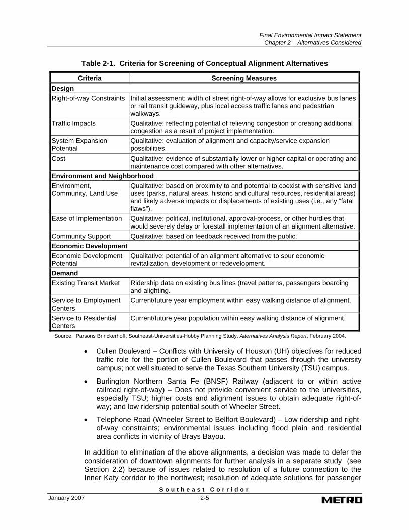
The remaining alignment segments were then screened using the criteria derived from the goals and objectives for the project. The criteria and measures used in the screening of alignment segments are identified in Table 2-1.
The screening of the alignment segments against the criteria resulted in a reduced set of alignment segments for development of conceptual alternatives. The alignments segments eliminated, and reasons for elimination, are listed below.
• Houston Belt and Terminal Railroad (HB&T) (an abandoned railroad right-of-way) – Conflicts with residential property and would have to share right-of-way with committed plan for a hike and bike trail.
Final Environmental Impact Statement
Chapter 2 – Alternatives Considered
S o u t h e a s t C o r r i d o r January 2007 2-5
Table 2-1. Criteria for Screening of Conceptual Alignment Alternatives
Criteria Screening Measures Design Right-of-way Constraints Initial assessment: width of street right-of-way allows for exclusive bus lanes
or rail transit guideway, plus local access traffic lanes and pedestrian walkways.
Traffic Impacts Qualitative: reflecting potential of relieving congestion or creating additional congestion as a result of project implementation.
System Expansion Potential
Qualitative: evaluation of alignment and capacity/service expansion possibilities.
Cost Qualitative: evidence of substantially lower or higher capital or operating and maintenance cost compared with other alternatives.
Environment and Neighborhood Environment, Community, Land Use
Qualitative: based on proximity to and potential to coexist with sensitive land uses (parks, natural areas, historic and cultural resources, residential areas) and likely adverse impacts or displacements of existing uses (i.e., any “fatal flaws”).
Ease of Implementation Qualitative: political, institutional, approval-process, or other hurdles that would severely delay or forestall implementation of an alignment alternative.
Community Support Qualitative: based on feedback received from the public. Economic Development Economic Development Potential
Qualitative: potential of an alignment alternative to spur economic revitalization, development or redevelopment.
Demand Existing Transit Market Ridership data on existing bus lines (travel patterns, passengers boarding
and alighting. Service to Employment Centers
Current/future year employment within easy walking distance of alignment.
Service to Residential Centers
Current/future year population within easy walking distance of alignment.
Source: Parsons Brinckerhoff, Southeast-Universities-Hobby Planning Study, Alternatives Analysis Report, February 2004.
• Cullen Boulevard – Conflicts with University of Houston (UH) objectives for reduced traffic role for the portion of Cullen Boulevard that passes through the university campus; not well situated to serve the Texas Southern University (TSU) campus.
• Burlington Northern Santa Fe (BNSF) Railway (adjacent to or within active railroad right-of-way) – Does not provide convenient service to the universities, especially TSU; higher costs and alignment issues to obtain adequate right-of-way; and low ridership potential south of Wheeler Street.
• Telephone Road (Wheeler Street to Bellfort Boulevard) – Low ridership and right-of-way constraints; environmental issues including flood plain and residential area conflicts in vicinity of Brays Bayou.
In addition to elimination of the above alignments, a decision was made to defer the consideration of downtown alignments for further analysis in a separate study (see Section 2.2) because of issues related to resolution of a future connection to the Inner Katy corridor to the northwest; resolution of adequate solutions for passenger
Final Environmental Impact Statement Chapter 2 – Alternatives Considered
S o u t h e a s t C o r r i d o r 2-6 January 2007
interchange with other downtown AHCT route(s) and service to activity centers in the southeastern portion of downtown; and limitations posed by streets closed off by US 59, the Convention Center, Minute Maid Park, and the Toyota Arena.
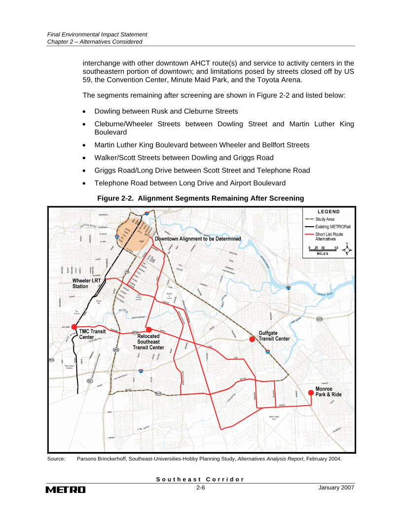
The segments remaining after screening are shown in Figure 2-2 and listed below:
• Dowling between Rusk and Cleburne Streets
• Cleburne/Wheeler Streets between Dowling Street and Martin Luther King Boulevard
• Martin Luther King Boulevard between Wheeler and Bellfort Streets
• Walker/Scott Streets between Dowling and Griggs Road
• Griggs Road/Long Drive between Scott Street and Telephone Road
• Telephone Road between Long Drive and Airport Boulevard
Figure 2-2. Alignment Segments Remaining After Screening
Source: Parsons Brinckerhoff, Southeast-Universities-Hobby Planning Study, Alternatives Analysis Report, February 2004.
Final Environmental Impact Statement
Chapter 2 – Alternatives Considered
S o u t h e a s t C o r r i d o r January 2007 2-7
• Holcombe Boulevard/Old Spanish Trail from the Texas Medical Center (TMC) Transit Center to Southeast Transit Center
• Bellfort Street between Martin Luther King Boulevard and Broadway Street
• Airport Boulevard between BNSF railroad and Monroe Road
• Broadway Street between Bellfort Street and Hobby Airport
• Private Right-of-way/Mosley Road between Monroe Road and the Monroe Park-and-Ride
The results of the screening of the alignment segments were presented at two public meetings. Among the comments received was a suggestion to include an alternative providing for an enhanced travel time between Hobby Airport and downtown Houston, and to use the BNSF railroad alignment. Consequently, despite the negative factors seen in the screening-level evaluation, the BNSF railroad segment between Wheeler Street and Airport Boulevard was retained.
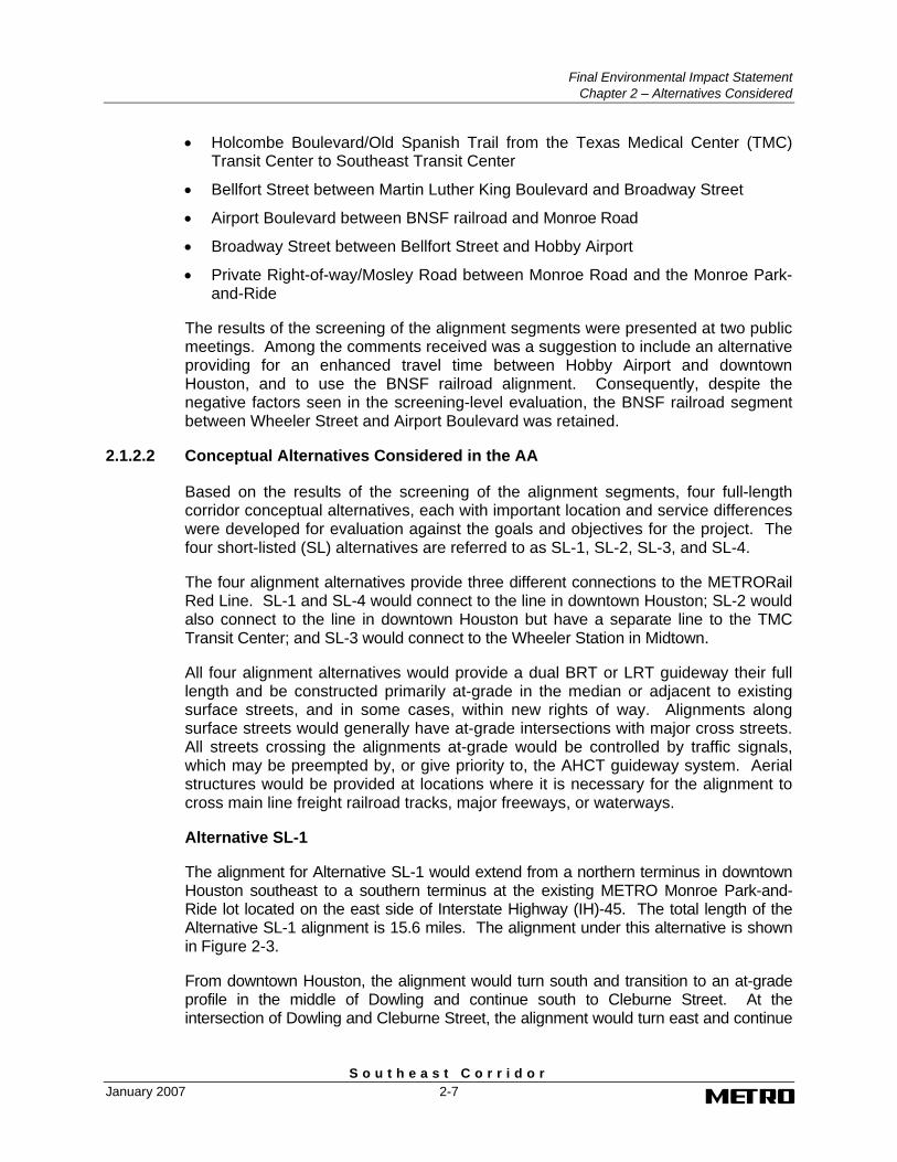
2.1.2.2 Conceptual Alternatives Considered in the AA
Based on the results of the screening of the alignment segments, four full-length corridor conceptual alternatives, each with important location and service differences were developed for evaluation against the goals and objectives for the project. The four short-listed (SL) alternatives are referred to as SL-1, SL-2, SL-3, and SL-4.
The four alignment alternatives provide three different connections to the METRORail Red Line. SL-1 and SL-4 would connect to the line in downtown Houston; SL-2 would also connect to the line in downtown Houston but have a separate line to the TMC Transit Center; and SL-3 would connect to the Wheeler Station in Midtown.
All four alignment alternatives would provide a dual BRT or LRT guideway their full length and be constructed primarily at-grade in the median or adjacent to existing surface streets, and in some cases, within new rights of way. Alignments along surface streets would generally have at-grade intersections with major cross streets. All streets crossing the alignments at-grade would be controlled by traffic signals, which may be preempted by, or give priority to, the AHCT guideway system. Aerial structures would be provided at locations where it is necessary for the alignment to cross main line freight railroad tracks, major freeways, or waterways.
Alternative SL-1
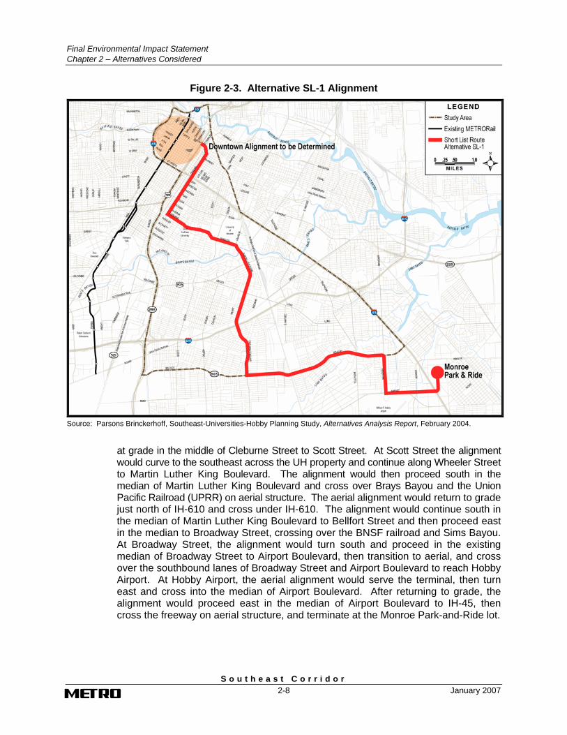
The alignment for Alternative SL-1 would extend from a northern terminus in downtown Houston southeast to a southern terminus at the existing METRO Monroe Park-and-Ride lot located on the east side of Interstate Highway (IH)-45. The total length of the Alternative SL-1 alignment is 15.6 miles. The alignment under this alternative is shown in Figure 2-3.
From downtown Houston, the alignment would turn south and transition to an at-grade profile in the middle of Dowling and continue south to Cleburne Street. At the intersection of Dowling and Cleburne Street, the alignment would turn east and continue
Final Environmental Impact Statement Chapter 2 – Alternatives Considered
S o u t h e a s t C o r r i d o r 2-8 January 2007
Figure 2-3. Alternative SL-1 Alignment
Source: Parsons Brinckerhoff, Southeast-Universities-Hobby Planning Study, Alternatives Analysis Report, February 2004.
at grade in the middle of Cleburne Street to Scott Street. At Scott Street the alignment would curve to the southeast across the UH property and continue along Wheeler Street to Martin Luther King Boulevard. The alignment would then proceed south in the median of Martin Luther King Boulevard and cross over Brays Bayou and the Union Pacific Railroad (UPRR) on aerial structure. The aerial alignment would return to grade just north of IH-610 and cross under IH-610. The alignment would continue south in the median of Martin Luther King Boulevard to Bellfort Street and then proceed east in the median to Broadway Street, crossing over the BNSF railroad and Sims Bayou. At Broadway Street, the alignment would turn south and proceed in the existing median of Broadway Street to Airport Boulevard, then transition to aerial, and cross over the southbound lanes of Broadway Street and Airport Boulevard to reach Hobby Airport. At Hobby Airport, the aerial alignment would serve the terminal, then turn east and cross into the median of Airport Boulevard. After returning to grade, the alignment would proceed east in the median of Airport Boulevard to IH-45, then cross the freeway on aerial structure, and terminate at the Monroe Park-and-Ride lot.
Final Environmental Impact Statement
Chapter 2 – Alternatives Considered
S o u t h e a s t C o r r i d o r January 2007 2-9
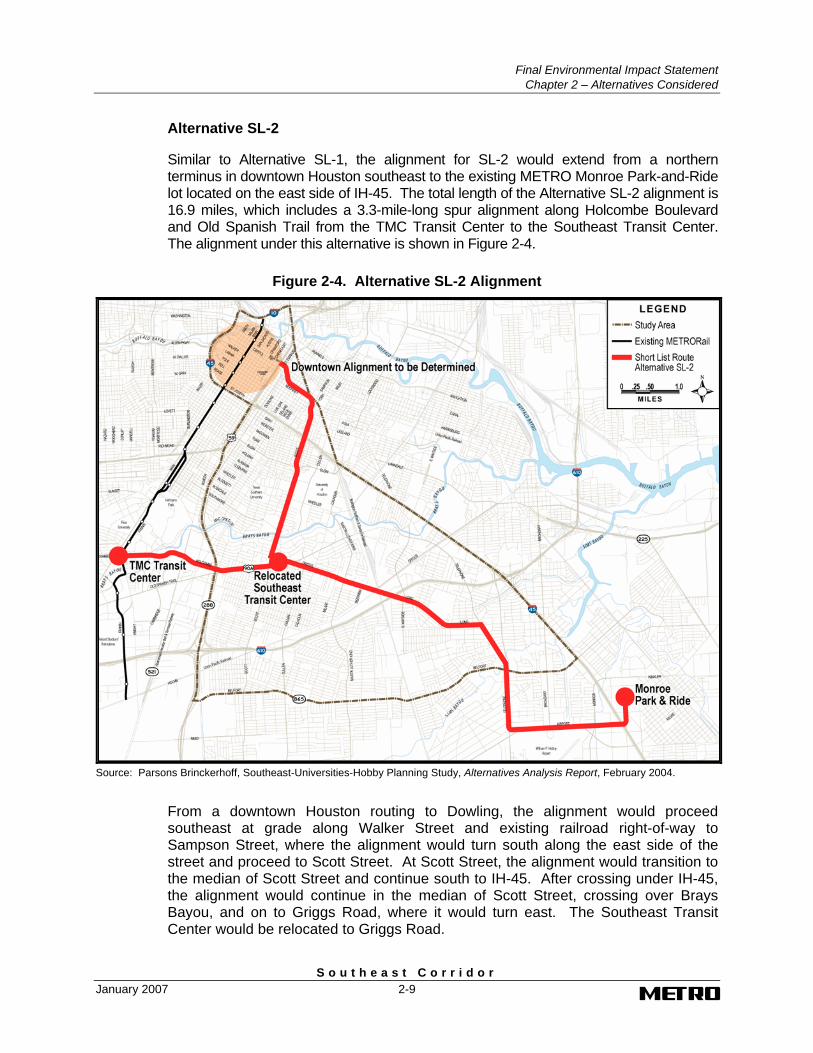
Alternative SL-2
Similar to Alternative SL-1, the alignment for SL-2 would extend from a northern terminus in downtown Houston southeast to the existing METRO Monroe Park-and-Ride lot located on the east side of IH-45. The total length of the Alternative SL-2 alignment is 16.9 miles, which includes a 3.3-mile-long spur alignment along Holcombe Boulevard and Old Spanish Trail from the TMC Transit Center to the Southeast Transit Center. The alignment under this alternative is shown in Figure 2-4.
Figure 2-4. Alternative SL-2 Alignment
Source: Parsons Brinckerhoff, Southeast-Universities-Hobby Planning Study, Alternatives Analysis Report, February 2004.
From a downtown Houston routing to Dowling, the alignment would proceed southeast at grade along Walker Street and existing railroad right-of-way to Sampson Street, where the alignment would turn south along the east side of the street and proceed to Scott Street. At Scott Street, the alignment would transition to the median of Scott Street and continue south to IH-45. After crossing under IH-45, the alignment would continue in the median of Scott Street, crossing over Brays Bayou, and on to Griggs Road, where it would turn east. The Southeast Transit Center would be relocated to Griggs Road.
Final Environmental Impact Statement Chapter 2 – Alternatives Considered
S o u t h e a s t C o r r i d o r 2-10 January 2007
After turning onto Griggs Road, the alignment would proceed east at grade in the existing median of Griggs Road and Long Drive to Telephone Road, crossing over the BNSF and UPRR railroads on aerial structure and under IH-610. At Telephone Road, the alignment would turn south and proceed at grade in the median of Telephone Road to Airport Boulevard, crossing over Sims Bayou. At Airport Boulevard, the at-grade alignment would turn east, then cross over to the south side of Airport Boulevard on aerial structure, and proceed to Hobby Airport. At Hobby Airport, the aerial alignment would serve the terminal, then turn east and cross into the median of Airport Boulevard. After returning to grade, the alignment would proceed east in the median of Airport Boulevard to IH-45, then cross the freeway on aerial structure, and terminate at the Monroe Park-and-Ride lot.
This alternative also includes a connection from the Southeast Transit Center to the TMC Transit Center. The alignment for this connection would follow Old Spanish Trail and Holcombe Boulevard west to the TMC Transit Center. The alignment would be located at grade in the existing street median.
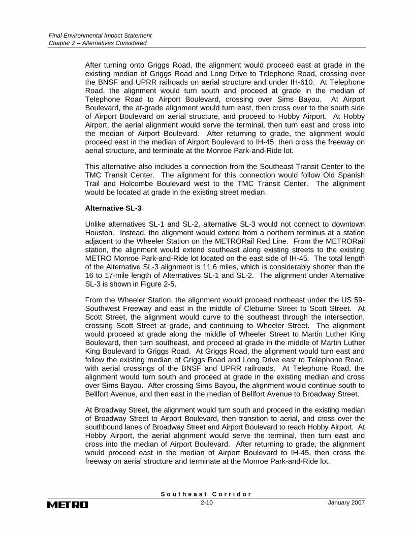
Alternative SL-3
Unlike alternatives SL-1 and SL-2, alternative SL-3 would not connect to downtown Houston. Instead, the alignment would extend from a northern terminus at a station adjacent to the Wheeler Station on the METRORail Red Line. From the METRORail station, the alignment would extend southeast along existing streets to the existing METRO Monroe Park-and-Ride lot located on the east side of IH-45. The total length of the Alternative SL-3 alignment is 11.6 miles, which is considerably shorter than the 16 to 17-mile length of Alternatives SL-1 and SL-2. The alignment under Alternative SL-3 is shown in Figure 2-5.
From the Wheeler Station, the alignment would proceed northeast under the US 59-Southwest Freeway and east in the middle of Cleburne Street to Scott Street. At Scott Street, the alignment would curve to the southeast through the intersection, crossing Scott Street at grade, and continuing to Wheeler Street. The alignment would proceed at grade along the middle of Wheeler Street to Martin Luther King Boulevard, then turn southeast, and proceed at grade in the middle of Martin Luther King Boulevard to Griggs Road. At Griggs Road, the alignment would turn east and follow the existing median of Griggs Road and Long Drive east to Telephone Road, with aerial crossings of the BNSF and UPRR railroads. At Telephone Road, the alignment would turn south and proceed at grade in the existing median and cross over Sims Bayou. After crossing Sims Bayou, the alignment would continue south to Bellfort Avenue, and then east in the median of Bellfort Avenue to Broadway Street.
At Broadway Street, the alignment would turn south and proceed in the existing median of Broadway Street to Airport Boulevard, then transition to aerial, and cross over the southbound lanes of Broadway Street and Airport Boulevard to reach Hobby Airport. At Hobby Airport, the aerial alignment would serve the terminal, then turn east and cross into the median of Airport Boulevard. After returning to grade, the alignment would proceed east in the median of Airport Boulevard to IH-45, then cross the freeway on aerial structure and terminate at the Monroe Park-and-Ride lot.
Final Environmental Impact Statement
Chapter 2 – Alternatives Considered
S o u t h e a s t C o r r i d o r January 2007 2-11
Figure 2-5. Alternative SL-3 Alignment
Source: Parsons Brinckerhoff, Southeast-Universities-Hobby Planning Study, Alternatives Analysis Report, February 2004.
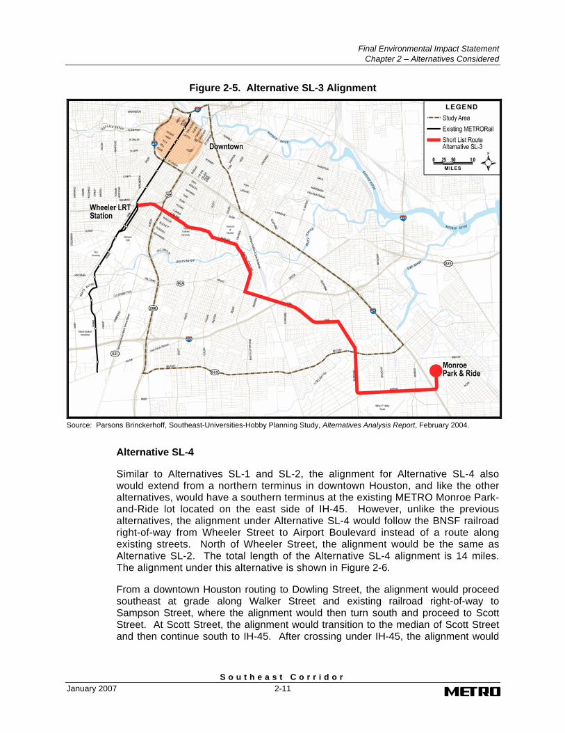
Alternative SL-4
Similar to Alternatives SL-1 and SL-2, the alignment for Alternative SL-4 also would extend from a northern terminus in downtown Houston, and like the other alternatives, would have a southern terminus at the existing METRO Monroe Park-and-Ride lot located on the east side of IH-45. However, unlike the previous alternatives, the alignment under Alternative SL-4 would follow the BNSF railroad right-of-way from Wheeler Street to Airport Boulevard instead of a route along existing streets. North of Wheeler Street, the alignment would be the same as Alternative SL-2. The total length of the Alternative SL-4 alignment is 14 miles. The alignment under this alternative is shown in Figure 2-6.
From a downtown Houston routing to Dowling Street, the alignment would proceed southeast at grade along Walker Street and existing railroad right-of-way to Sampson Street, where the alignment would then turn south and proceed to Scott Street. At Scott Street, the alignment would transition to the median of Scott Street and then continue south to IH-45. After crossing under IH-45, the alignment would
Final Environmental Impact Statement Chapter 2 – Alternatives Considered
S o u t h e a s t C o r r i d o r 2-12 January 2007
Figure 2-6. Alternative SL-4 Alignment
Source: Parsons Brinckerhoff, Southeast-Universities-Hobby Planning Study, Alternatives Analysis Report, February 2004.
continue in the median of Scott Street to Cleburne Street, where the alignment would turn east to Wheeler Street. The alignment would continue along the middle of Wheeler Street to the BNSF Railway right-of-way, then curve to the south and enter the railroad right-of-way parallel to the existing freight railroad tracks. The alignment would continue south in the BNSF Railway right-of-way to Airport Boulevard, with an aerial crossing at Brays Bayou and Old Spanish Trail and another crossing at the UPRR, Griggs Road, and Long Drive just north of IH-610.
North of Airport Boulevard, the alignment would curve to the east, fly over the BNSF railroad, and transition to grade in the median of Airport Boulevard. The alignment would proceed east at-grade in the median and then cross over to the south side of Airport Boulevard, where it would proceed east along the south side of Airport Boulevard to Hobby Airport. At Hobby Airport, the aerial alignment would serve the terminal, then turn east and cross into the median of Airport Boulevard. After returning to grade, the alignment would proceed east in the median of Airport Boulevard, then cross IH-45 on aerial structure and terminate at the Monroe Park-and-Ride lot.
Final Environmental Impact Statement
Chapter 2 – Alternatives Considered
S o u t h e a s t C o r r i d o r January 2007 2-13
2.1.2.3 Results of Evaluation of Conceptual Alternatives in the AA
This section presents the results of the evaluation of the four conceptual alignment alternatives developed for the Southeast-Universities-Hobby Corridor in the AA. A technical evaluation of the four alternatives was conducted, focusing on transportation impacts, environmental impacts, neighborhood and community impacts, economic impacts, and costs, as well as ease of implementation. These results, and an evaluation of how each alternative performed against the project goals and objectives, are presented in this section.
Technical Evaluation
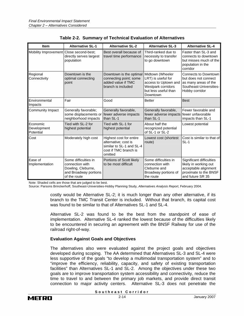
Table 2-2 presents a summary of the results of the technical evaluation of the alternatives from the AA. The results of the evaluation found that Alternatives SL-1 and SL-2 performed the best among the alternatives evaluated. Both alternatives ranked higher in mobility benefits because the greater population and employment served under these alternatives would produce higher ridership than Alternatives SL-3 and SL-4. Alternative SL-3 ranked lower because it would require a transfer to travel to downtown. Although Alternative SL-4 was found to have faster travel times, the alignment in the BNSF Railway right-of-way would not serve as many residents as the other alternatives.
While none of the alternatives were found to have any environmental impacts that were considered “fatal flaws”, Alternatives SL-3 and SL-4 were considered to have fewer environmental impacts. Specifically, the number of potential historic and cultural resources and sensitive noise and vibration sites were less than Alternatives SL-1 and SL-2.
Neighborhood and community impacts were found to be potentially greater under Alternative SL-1 than the other alternatives. The alignment of Alternative SL-1 would run through the Greater Third Ward and multi-family development on Broadway Street. In addition, the alignment under this alternative is adjacent to Alcott Elementary and the Bellfort Academy. Alternative SL-3 also was found to result in a potential community disruption impact since this alternative also traverses the Greater Third Ward and multi-family development on Broadway and is adjacent to Peck Elementary and the Bellfort Academy. Alternative SL-2 also traverses the Greater Third Ward as well as the MacGregor neighborhood, while Alternative SL-4 traverses only the Greater Third Ward. Each of these alternatives could potentially disrupt the surrounding neighborhood or community, but the impact was found to be less than those in Alternative SL-1.
Economic development, or revitalization potential, ranked highest under Alternatives SL-1 and SL-2. The studied conceptual station locations under these two alternatives were found to have more attractive station sites and land uses compatible to transit-oriented development.
The lowest cost alternative was found to be Alternative SL-3, primarily because it is substantially shorter in overall length than any of the other alternatives. The most
Final Environmental Impact Statement Chapter 2 – Alternatives Considered
S o u t h e a s t C o r r i d o r 2-14 January 2007
Table 2-2. Summary of Technical Evaluation of Alternatives
Item Alternative SL-1 Alternative SL-2 Alternative SL-3 Alternative SL-4 Mobility Improvement Close second-best;
directly serves largest population
Best overall because of travel time performance
Third-ranked due to necessity to transfer to go downtown
Faster than SL-3 and connects to downtown but misses much of the population in the corridor
Regional Connectivity
Downtown is the optimal connecting point
Downtown is the optimal connecting point; some added value if TMC branch is included
Midtown (Wheeler LRT) is useful for access to Uptown and Westpark corridors but less useful than Downtown
Connects to Downtown but does not connect as many areas of the Southeast-Universities-Hobby corridor
Environmental Impacts
Fair Good Better Best
Community Impact Generally favorable; some displacements or neighborhood impacts
Generally favorable, fewer adverse impacts than SL-1
Generally favorable, fewer adverse impacts than SL-1
Fewer favorable and fewer unfavorable impacts than SL-1
Economic Development Potential
Tied with SL-2 for highest potential
Tied with SL-1 for highest potential
About half the recognized potential of SL-1 or SL-2
Lowest potential
Cost Moderately high cost Highest cost for entire alternative; cost is similar to SL-1 and SL-4 cost if TMC branch is omitted
Lowest cost (shortest route)
Cost is similar to that of SL-1
Ease of Implementation
Some difficulties in connection with Dowling, Cleburne, and Broadway portions of the route
Portions of Scott likely to be most difficult
Some difficulties in connection with Cleburne and Broadway portions of the route
Significant difficulties likely in working out acceptable alignment proximate to the BNSF and future SR 35
Note: Shaded cells are those that are judged to be best. Source: Parsons Brinckerhoff, Southeast-Universities-Hobby Planning Study, Alternatives Analysis Report, February 2004.
costly would be Alternative SL-2; it is much longer than any other alternative, if its branch to the TMC Transit Center is included. Without that branch, its capital cost was found to be similar to that of Alternatives SL-1 and SL-4.
Alternative SL-2 was found to be the best from the standpoint of ease of implementation. Alternative SL-4 ranked the lowest because of the difficulties likely to be encountered in securing an agreement with the BNSF Railway for use of the railroad right-of-way.
Evaluation Against Goals and Objectives
The alternatives also were evaluated against the project goals and objectives developed during scoping. The AA determined that Alternatives SL-3 and SL-4 were less supportive of the goals “to develop a multimodal transportation system” and to “improve the efficiency, reliability, capacity, and safety of existing transportation facilities” than Alternatives SL-1 and SL-2. Among the objectives under these two goals are to improve transportation system accessibility and connectivity, reduce the time to travel to and between the primary job markets, and provide direct transit connection to major activity centers. Alternative SL-3 does not penetrate the
Final Environmental Impact Statement
Chapter 2 – Alternatives Considered
S o u t h e a s t C o r r i d o r January 2007 2-15
downtown Houston area, and the existing travel market patterns clearly indicate the importance of a direct connection from the Southeast Corridor to downtown Houston. The alternative also does not connect to the Southeast Transit Center. Although Alternative SL-4 would provide a more direct and faster connection between downtown Houston and Hobby Airport, the market it would serve is considerably smaller than that served by Alternatives SL-1 and SL-2. With an alignment in the BNSF railroad right-of-way, access to residential populations is reduced. Alternative SL-4 also would not maximize the economic benefits to be gained from transit capital investments, which is one of the objectives of the project under the goal “to define a sound funding base”.
In comparing Alternatives SL-1 and SL-2, the AA determined that Alternative SL-2 performs better than Alternative SL-1 because of its more direct service to downtown, faster travel time, and lower cost. The TMC connection as an enhanced bus route could be included with either of these two alternatives. Thus, Alternative SL-2 can be considered to be more supportive of the goals “to develop a multimodal transportation system” and to “improve the efficiency, reliability, capacity, and safety of existing transportation facilities” than Alternative SL-1 because of Alternative SL-2’s connection to the Southeast Transit Center.
Based on comments from the community, the AA also determined that Alternative SL-1 would have a potential negative impact on a historic neighborhood along Dowling and Cleburne Street. One of the objectives of the project under the goal “to plan for transportation projects that enhance the quality of the environment” is to protect sensitive areas. Thus, Alternative SL-2 can be considered to be more supportive of the goal because of its potential for reduced impacts on historic and cultural resources.
Another goal of the project is “to preserve social integrity and support of urban communities”. TSU and UH preferred the Alternative SL-2 alignment, which could adequately serve the campuses from stations on Scott Street, supplemented by shuttle buses. Other Scott Street stakeholders also favored Alternative SL-2. Given these findings, Alternative SL-2 could be considered to be more supportive of this goal than Alternative SL-1.
2.1.2.4 Adoption of the LPIS and MOS
The results of the evaluation conducted in the AA determined that Alternative SL-2 performed the best on a technical basis, and was most supportive of the project goals and objectives. Based on these results, this alternative was selected by METRO for inclusion in the METRO Solutions plan.
METRO also concluded in the AA that LRT rather than BRT should be the preferred AHCT technology, considering system capacity and system operability needs in light of interconnected AHCT routes envisioned by the long range plan. The plan envisions two AHCT lines – the Southeast line and the Harrisburg line, joining together east of downtown Houston. The route would cross downtown and extend westward through the Inner Katy corridor to the Northwest Transit Center. At that location, it is proposed the route would split, with one line serving the Uptown-Galleria area and connecting to the planned Westpark line, while a second line would
Final Environmental Impact Statement Chapter 2 – Alternatives Considered
S o u t h e a s t C o r r i d o r 2-16 January 2007
continue westward along the Katy Freeway corridor. METRO concluded that a common technology would best serve this portion of the overall transit network.
The fixed-guideway component of the LPIS for the Southeast Corridor provided for a 14.8-mile line extending from Bagby in downtown Houston to Hinman Road, east of Hobby Airport.6 This line represents a refinement of Alternative SL-2 from the AA. Provision of a park-and-ride station at Hinman Road would perform the same function as continuing to the existing Monroe Park-and-Ride, but would be more effective in attracting transit riders, and with lower capital and O&M costs. The LPIS also included replacing one portion of the Alternative SL-2 route with a limited-stop bus route connecting the Southeast Transit Center in the corridor with the TMC Transit Center, 3.3 miles to the west, rather than employing LRT or BRT for this service. The Southeast Corridor LPIS was subsequently incorporated in the METRO Solutions plan, the fiscally constrained long-range transit plan for the Houston region.
The development of METRO Solutions plan included the evaluation of transit service improvements and investments throughout the region, and the setting of priorities for implementation over a 22-year horizon. During the development of the plan, rail improvements were phased to break the LPIS for each corridor into minimum operable segments. The phasing of the transit improvements over the life of the plan was based on:
• Independent utility
• Cost
• Available financial resources on a year-by-year basis
• Expected ridership
• Regional connectivity
• Readiness for implementation
The phasing considered the need to provide for equitable investment within the service area, while ensuring that the initial segment of the line provided utility to existing and new riders between logical termini. Based on this evaluation, the MOS for the Southeast Corridor was identified as beginning at Bagby in downtown Houston and extending to the vicinity of Griggs Road and IH-610.
2.2 Development and Screening of Alternatives in the Downtown Connector Study This section summarizes the planning process that led to the development of the build alternative alignments for the downtown Houston portion of the Southeast Corridor. As stated previously, a decision was made during the AA to defer consideration of downtown alignments to a separate study. In the spring of 2004,
6 Streets in downtown Houston are commonly referred to by street name only, without street type (i.e.,
street, avenue, road, boulevard, etc.) in the reference. Therefore, the DEIS refers to streets in the downtown by name only. The only exception is Main Street, where street type is used in the reference to name. Outside of downtown, street type is used in the reference to street name.
Final Environmental Impact Statement
Chapter 2 – Alternatives Considered
S o u t h e a s t C o r r i d o r January 2007 2-17
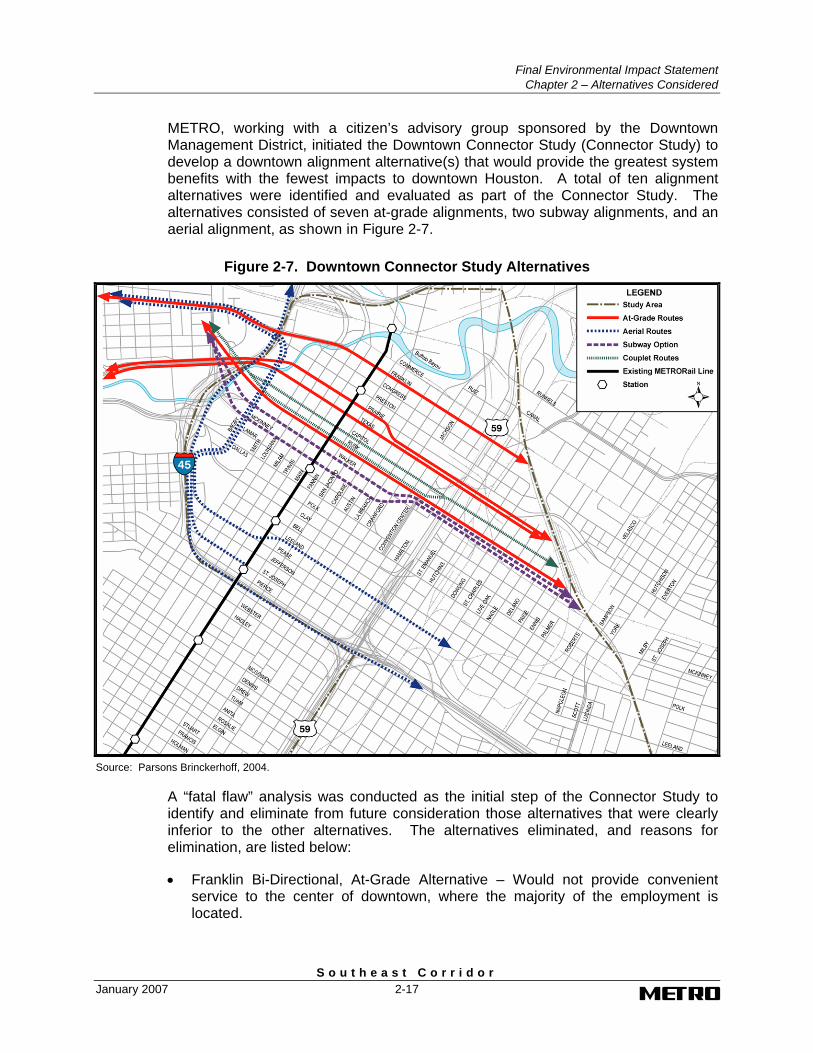
METRO, working with a citizen’s advisory group sponsored by the Downtown Management District, initiated the Downtown Connector Study (Connector Study) to develop a downtown alignment alternative(s) that would provide the greatest system benefits with the fewest impacts to downtown Houston. A total of ten alignment alternatives were identified and evaluated as part of the Connector Study. The alternatives consisted of seven at-grade alignments, two subway alignments, and an aerial alignment, as shown in Figure 2-7.
Figure 2-7. Downtown Connector Study Alternatives
Source: Parsons Brinckerhoff, 2004.
A “fatal flaw” analysis was conducted as the initial step of the Connector Study to identify and eliminate from future consideration those alternatives that were clearly inferior to the other alternatives. The alternatives eliminated, and reasons for elimination, are listed below:
• Franklin Bi-Directional, At-Grade Alternative – Would not provide convenient service to the center of downtown, where the majority of the employment is located.
Final Environmental Impact Statement Chapter 2 – Alternatives Considered
S o u t h e a s t C o r r i d o r 2-18 January 2007
• Texas/Prairie Bi-Directional, At-grade Alternative – Would not provide convenient service to the center of the downtown. Also, concern with flooding and underground utilities.
• Leeland/Pierce Bi-Directional, Aerial Alternative – Would not provide convenient service to the center of the downtown, would be difficult to construct as the line would have to go over or under US 59 on the east side of downtown and IH-45 on the west side, and there were potential visual impacts.
2.2.1 Alternatives Evaluated in the Downtown Connector Study
Based on the results of the screening of fatal flaws, five at-grade alternatives and two subway alternatives were carried forward into more detailed development and evaluation.
2.2.1.1 Rusk Two-Way, At-Grade Alternative
Rusk currently operates as a one-way, eastbound street with the number of lanes varying between three and five lanes. The right-of-way width is typically 80 feet, but between Fannin and San Jacinto the street narrows to less than 80 feet. For this alternative, the street would be converted to two-way traffic, and the street would be reconfigured to one lane of traffic in each direction. The bi-directional alignment would be located in the middle of Rusk with three split platform stations designed to serve the Convention Center in the east side of downtown, Main Street, and the Theater District in the northwest side of downtown.
2.2.1.2 Rusk One-Way, At-Grade Alternative
This alternative is a refinement of the Rusk two-way alternative. From Bagby to Austin, traffic flow would be two-way with the bi-directional alignment located in the center of Rusk, and one lane of traffic to each side. To provide for additional eastbound traffic lanes on Rusk adjacent to the Convention Center, the alignment would transition from the center to the north side of Rusk beginning at La Branch. The two-way traffic flow would change to one-way at La Branch with two eastbound lanes to Avenida de las Americas. At Avenida de las Americas, a third eastbound lane would be added to provide three travel lanes adjacent to the Convention Center. At Chartres, traffic flow would change back to two-way, with one lane in each direction. The split platform station locations would be similar to the previous Rusk alternative.
2.2.1.3 Rusk and Capitol One-Way Couplet, At-Grade Alternative
Capitol is located one block north of Rusk. It has a right-of-way width of 80 feet, and currently operates as a one-way, westbound street, with the number of lanes varying between three and five. Under this alternative, both streets would maintain their one-way operation but the number of lanes would be reduced to three on each street. This alternative would operate as a single-track alignment on each street with the trackway located in the lanes adjacent to the curb lanes. Three single platform stations on each street would serve the Convention Center, Main Street, and the Theater District.
Final Environmental Impact Statement
Chapter 2 – Alternatives Considered
S o u t h e a s t C o r r i d o r January 2007 2-19
2.2.1.4 Texas At-Grade Alternative
Texas currently operates as a one-way, eastbound street with the number of lanes varying between three and five lanes. The right-of-way width is 100 feet. Under this alternative, the street would be converted to two-way operation, two lanes in each direction, with the double-track alignment in the center of the street. Three split platform stations would serve the Convention Center, Main Street, and the Theater District.
2.2.1.5 Capitol At-Grade Alternative
Under this alternative, the bi-directional alignment would be located on the north side of Capitol between Bagby and Milam. Capitol would operate as a one-way street with one travel lane on the south side of the trackway. At Milam Street, the alignment would transition to the center of the street and both westbound traffic lanes would be located on the each side of the street. Beginning at Austin Street, a third travel lane would be provided on the north side of the street. To provide for the additional lane, 10 feet of right-of-way would be acquired on the south side of Capitol between Caroline and Chartres. From Chartres to Dowling, the alignment remains along the south side of the street and two travel lanes are provided on the north side. Three split platform stations would be provided to serve the Convention Center, Main Street, and the Theater District.
2.2.1.6 McKinney Subway Alternative
Under this alternative, the at-grade alignment on Rusk east of US 59 would begin to transition to subway at Dowling using a portal that would span approximately 2.5 blocks from Dowling to a mid-point between Hutchins and Emanuel. Rusk would maintain one travel lane in each direction on either side of the portal. The subway alignment would transition from Rusk to McKinney, and an underground station would be located at the transition point between Avenida de las Americas and Crawford. The alignment would continue under McKinney with a second subway station located between Main Street and Milam. The subway terminus would be located between Louisiana and Smith, or if the alignment does not transition back up to grade, design provisions would be made to connect with the future Inner Katy line and the western portal would be part of the future alignment.
2.2.1.7 Walker Subway Alternative
Similar to the previous alternative at-grade alignment on Rusk, this alternative would begin the transition to subway at Dowling using a portal that would span approximately 2.5 blocks from Dowling to a mid-point between Hutchins and Emanuel. Rusk would maintain one travel lane in each direction on either side of the portal. The subway alignment would transition from Rusk to Walker and a subway station would be located at the transition point between Avenida de las Americas and Crawford. The alignment would continue under Walker with a second subway station between Main Street and Milam. The subway terminus would be located between Louisiana and Smith, or if the alignment does not transition back up to grade, design provisions would be made to connect with the future Inner Katy line and the western portal would be part of the future alignment.
Final Environmental Impact Statement Chapter 2 – Alternatives Considered
S o u t h e a s t C o r r i d o r 2-20 January 2007
2.2.2 Results of Evaluation of Alternatives in the Connector Study
This section presents the results of the evaluation of the downtown alternatives developed for the Southeast Corridor in the Connector Study. The evaluation assessed the at-grade alternatives and the subway alternatives separately so that the results of the evaluation could conclude with the selection of a preferred at-grade alternative and/or a preferred subway for evaluation in the DEIS. Similar to the process used during the AA, the evaluation included both a technical evaluation and an evaluation of how each alternative performed against the goals and objectives developed for the AA.
2.2.2.1 Evaluation of At-Grade Alternatives
Following are the results of the evaluation of the five at-grade alternatives considered in the Connector Study.
Technical Evaluation
The technical evaluation criteria addressed impacts to traffic, transit operations, connectivity, downtown mobility, and existing developments, as well as costs. The results of the technical evaluation found that the Rusk two-way and Capitol alternatives performed the best among the at-grade alternatives. Both alternatives ranked higher in terms of connectivity to major destinations, transit operations, and traffic impacts.
Traffic impacts were found to be potentially greater under the Rusk and Capitol one-way couplet alternative as a result of impacting vehicle operations and disrupting signal timing on two streets instead one street under all other alternatives. Additionally, the Rusk one-way alternative ranked lower than the Rusk two-way alternative as a result of the traffic safety issue associated with the conversion of a one-way street to a two-way street in the middle of downtown.
Similar to traffic impacts, the Rusk and Capitol one-way couplet alternative was ranked lowest for transit operations as a result of introducing two at-grade crossings with the Main Street METRORail Red Line. The Texas alternative also ranked low as a result of the high volume of pedestrian crossings on Texas associated with activities at the adjacent Minute Maid Park. The pedestrian crossings could disrupt train operations and schedules.
The alternatives on Capitol and Rusk were found to have the closest connections to the major downtown activity centers (i.e., Main Street METRORail Station, Convention Center, Toyota Center, and the Theater District).
In assessing potential impacts to existing developments, accessibility to a number of driveways, loading docks, and parking garages along Rusk would be impacted as a result of the double-track alignment in the center of the street. This is a particular concern to the George R. Brown Convention Center, where impacts to loading dock operations could occur. The Rusk single-/bi-directional alternative would reduce the accessibility impact to the convention center, but there would still be a large number of impacts to driveways, garages, and loading docks west of Austin.
Final Environmental Impact Statement
Chapter 2 – Alternatives Considered
S o u t h e a s t C o r r i d o r January 2007 2-21
The Capitol alternative may require the acquisition of right-of-way from properties that are currently undeveloped; however, the acquisitions under this alternative would not impact existing accessibility or loading dock activities. However, during evening events, entry to the Tranquility Park garage on Capitol would be reduced to one lane, and valet parking for theater venues facing Capitol would be either eliminated or relocated.
The most costly at-grade alternative would be the Texas alternative as a result of the need to relocate a major telecommunication duct bank. The alternatives on Rusk would have mitigation costs associated with the impacts to garages and loading docks, while the Capitol alternative would require only a few right-of-way acquisitions.
Evaluation Against Goals and Objectives
The at-grade alternatives considered in the Connector Study were evaluated against the goals and objectives established during the AA. The Connector Study determined that the Texas alternative, the Rusk and Capitol one-way couplet alternative, and the Rusk one-way alternative are less supportive of the goals “to develop a multimodal transportation system”, to “improve the efficiency, reliability, capacity, and safety of existing transportation facilities”, and to “preserve social integrity and support urban communities" than the Rusk two-way and the Capitol alternatives. Among the objectives under these three goals are to improve transportation system accessibility, provide direct transit connection to major activity centers, and minimize traffic impacts on local streets within the study area. The Texas alternative does not serve the majority of the major activity centers in downtown. The Rusk and Capitol one-way couplet alternative would impact traffic on more streets in the study area, and although the Rusk one-way alternative would reduce the impact on loading zones at the Convention Center, it would introduce a new safety issue on a local street with the conversion of a one-way street to two-way in the middle of downtown.
In comparing the Rusk two-way and the Capitol alternatives, the Connector Study determined the Capitol alternative performs the best because of proximity to more major activity and high volume pedestrian activity centers, and fewer traffic impacts on local streets especially related to the accessibility of garages and loading docks.
As a result of the Connector Study, the Capitol at-grade alternative was selected for evaluation in the DEIS.
2.2.2.2 Evaluation of Subway Alternatives
Following are the results of the evaluation of the two subway alternatives considered in the Connector Study.
Technical Evaluation
In addition to the criteria used in the technical evaluation of the at-grade alternatives, the subway alternatives were evaluated based on constructability, construction impacts, location and impacts of surface penetrations, and pedestrian accessibility and connectivity. The results of the technical evaluation of the two subway alternatives found that the Walker subway alternative performed better than the McKinney subway alternative.
Final Environmental Impact Statement Chapter 2 – Alternatives Considered
S o u t h e a s t C o r r i d o r 2-22 January 2007
The McKinney subway alternative rated slightly higher in terms of accessibility to the existing and future areas of dense employment and minimal impacts to existing residential developments. The Walker subway alternative rated higher in terms of constructability, both in terms of length and depth of tunnel and the potential to either add a third station in the Theatre District or tie into the pedestrian tunnel system serving the Theater District; lower construction costs as there would be fewer underground utility disruptions; and access to existing residential developments and areas with greater joint or new development opportunities.
Evaluation Against Goals and Objectives
The evaluation against the goals and objectives from the AA determined that the Walker subway alternative is more supportive of the goals of “to develop a multimodal transportation system, to improve the efficiency, reliability, capacity, and safety of existing transportation facilities”, and “to preserve social integrity and support urban communities”. Among the objectives under these goals are to improve transportation system accessibility and connectivity, provide a direct transit connection to major activity centers, serve existing and high-density residential populations, provide transit investment supportive of redevelopment/development and land use plans; and minimize impacts during construction. The Walker subway alternative provides closer access to existing residential developments, areas with greater joint or new development opportunities, and the pedestrian tunnel system and would have fewer construction impacts as a result of fewer underground utility relocations. Finally, since McKinney was recently completely reconstructed as part of the Downtown Transit Street Project, business and property owners would be impacted again as a result of construction of underground station.
Based on results of the evaluation and input from the community, the Walker subway alternative was identified as the preferred subway alignment alternative to the Capitol at-grade alignment alternative. However, as a result of the substantially higher capital cost of the subway as compared to its benefits and local funding availability, the Walker subway alternative was eliminated as a reasonable alternative for detailed evaluation in the DEIS.
2.3 Definition of Alternatives Evaluated in the DEIS
This section describes the alternatives evaluated in the DEIS. The alternatives consist of a No Build Alternative and three build alternatives – an LRT Alternative, a BRT Convertible Alternative, and a BRT Alternative.
2.3.1 No Build Alternative
The No Build Alternative serves as a basis for the evaluation of transportation and environmental impacts of the build alternatives presented in the DEIS. The No Build Alternative includes the highway and roadway improvements from the H-GAC 2025 Regional Transportation Plan (RTP) and the METRO transit services and transit facilities programmed through 2007.
Final Environmental Impact Statement
Chapter 2 – Alternatives Considered
S o u t h e a s t C o r r i d o r January 2007 2-23
2.3.1.1 Highway and Roadway Improvements
The regional highway and roadway system is comprised of interstate and other federal highways, state highways, county roads, toll roads, and arterial roadways in the eight-county metropolitan area. In 2000, the regional roadway system totaled over 20,000 lane miles of major highways and roads. In addition, the regional highway network incorporates a system of freeway high occupancy vehicle (HOV) lanes, most of which have been constructed with METRO funding and are used by METRO bus services.
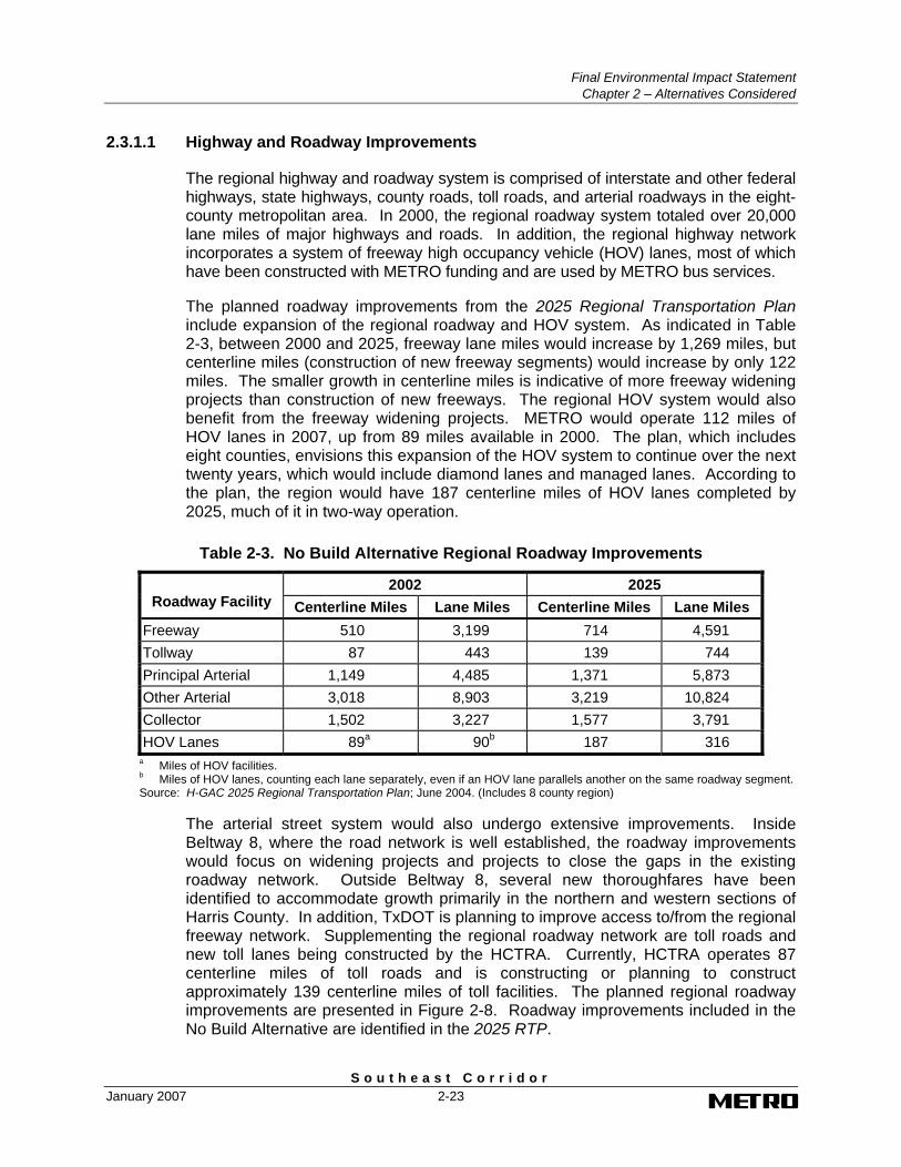
The planned roadway improvements from the 2025 Regional Transportation Plan include expansion of the regional roadway and HOV system. As indicated in Table 2-3, between 2000 and 2025, freeway lane miles would increase by 1,269 miles, but centerline miles (construction of new freeway segments) would increase by only 122 miles. The smaller growth in centerline miles is indicative of more freeway widening projects than construction of new freeways. The regional HOV system would also benefit from the freeway widening projects. METRO would operate 112 miles of HOV lanes in 2007, up from 89 miles available in 2000. The plan, which includes eight counties, envisions this expansion of the HOV system to continue over the next twenty years, which would include diamond lanes and managed lanes. According to the plan, the region would have 187 centerline miles of HOV lanes completed by 2025, much of it in two-way operation.
Table 2-3. No Build Alternative Regional Roadway Improvements
2002 2025 Roadway Facility Centerline Miles Lane Miles Centerline Miles Lane Miles
Freeway 510 3,199 714 4,591 Tollway 87 443 139 744 Principal Arterial 1,149 4,485 1,371 5,873 Other Arterial 3,018 8,903 3,219 10,824 Collector 1,502 3,227 1,577 3,791 HOV Lanes 89a 90b 187 316
a Miles of HOV facilities. b Miles of HOV lanes, counting each lane separately, even if an HOV lane parallels another on the same roadway segment. Source: H-GAC 2025 Regional Transportation Plan; June 2004. (Includes 8 county region)
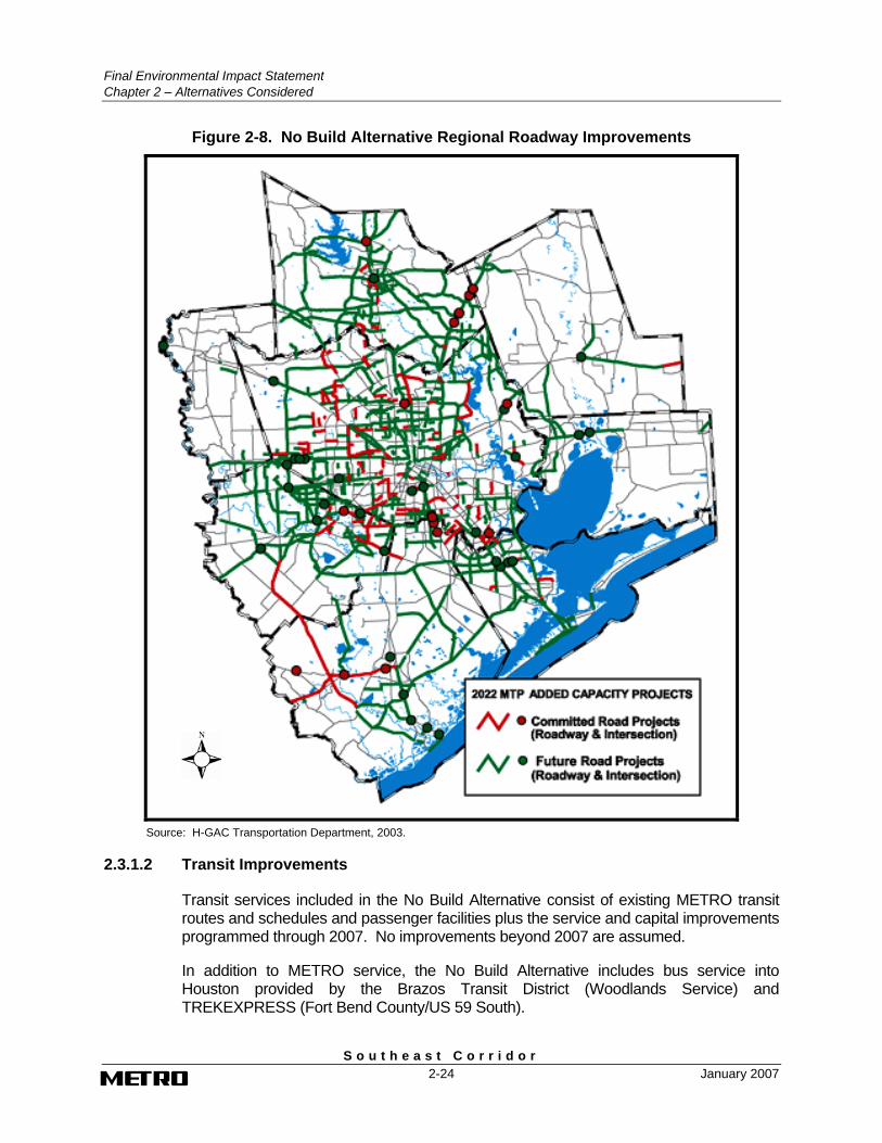
The arterial street system would also undergo extensive improvements. Inside Beltway 8, where the road network is well established, the roadway improvements would focus on widening projects and projects to close the gaps in the existing roadway network. Outside Beltway 8, several new thoroughfares have been identified to accommodate growth primarily in the northern and western sections of Harris County. In addition, TxDOT is planning to improve access to/from the regional freeway network. Supplementing the regional roadway network are toll roads and new toll lanes being constructed by the HCTRA. Currently, HCTRA operates 87 centerline miles of toll roads and is constructing or planning to construct approximately 139 centerline miles of toll facilities. The planned regional roadway improvements are presented in Figure 2-8. Roadway improvements included in the No Build Alternative are identified in the 2025 RTP.
Final Environmental Impact Statement Chapter 2 – Alternatives Considered
S o u t h e a s t C o r r i d o r 2-24 January 2007
Figure 2-8. No Build Alternative Regional Roadway Improvements
Source: H-GAC Transportation Department, 2003.
2.3.1.2 Transit Improvements
Transit services included in the No Build Alternative consist of existing METRO transit routes and schedules and passenger facilities plus the service and capital improvements programmed through 2007. No improvements beyond 2007 are assumed.
In addition to METRO service, the No Build Alternative includes bus service into Houston provided by the Brazos Transit District (Woodlands Service) and TREKEXPRESS (Fort Bend County/US 59 South).
Final Environmental Impact Statement
Chapter 2 – Alternatives Considered
S o u t h e a s t C o r r i d o r January 2007 2-25
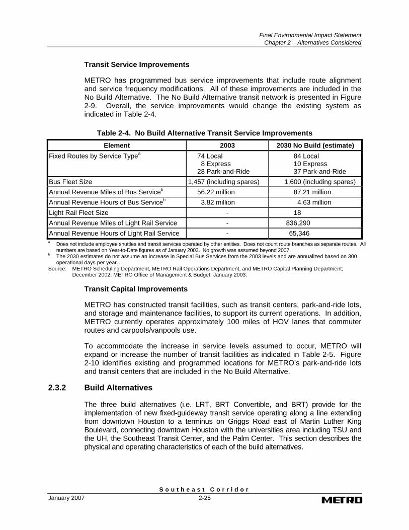
Transit Service Improvements
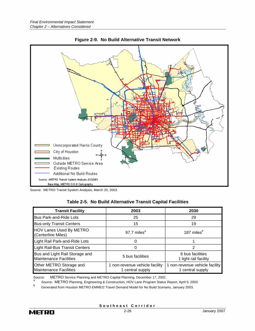
METRO has programmed bus service improvements that include route alignment and service frequency modifications. All of these improvements are included in the No Build Alternative. The No Build Alternative transit network is presented in Figure 2-9. Overall, the service improvements would change the existing system as indicated in Table 2-4.
Table 2-4. No Build Alternative Transit Service Improvements Element 2003 2030 No Build (estimate)
Fixed Routes by Service Typea 74 Local 8 Express
28 Park-and-Ride
84 Local 10 Express 37 Park-and-Ride
Bus Fleet Size 1,457 (including spares) 1,600 (including spares) Annual Revenue Miles of Bus Serviceb 56.22 million 87.21 million Annual Revenue Hours of Bus Serviceb 3.82 million 4.63 million Light Rail Fleet Size - 18 Annual Revenue Miles of Light Rail Service - 836,290 Annual Revenue Hours of Light Rail Service - 65,346 a Does not include employee shuttles and transit services operated by other entities. Does not count route branches as separate routes. All
numbers are based on Year-to-Date figures as of January 2003. No growth was assumed beyond 2007. b The 2030 estimates do not assume an increase in Special Bus Services from the 2003 levels and are annualized based on 300
operational days per year. Source: METRO Scheduling Department, METRO Rail Operations Department, and METRO Capital Planning Department;
December 2002; METRO Office of Management & Budget; January 2003.
Transit Capital Improvements
METRO has constructed transit facilities, such as transit centers, park-and-ride lots, and storage and maintenance facilities, to support its current operations. In addition, METRO currently operates approximately 100 miles of HOV lanes that commuter routes and carpools/vanpools use.
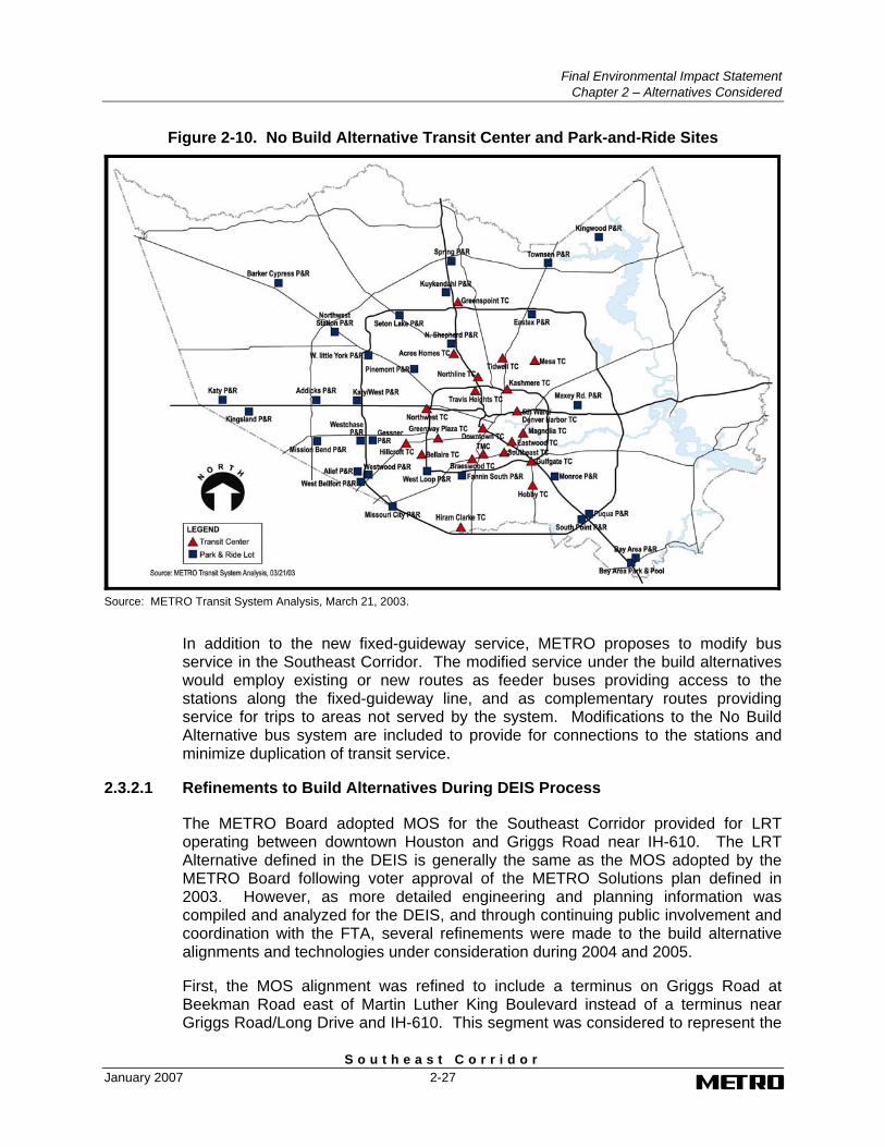
To accommodate the increase in service levels assumed to occur, METRO will expand or increase the number of transit facilities as indicated in Table 2-5. Figure 2-10 identifies existing and programmed locations for METRO’s park-and-ride lots and transit centers that are included in the No Build Alternative.
2.3.2 Build Alternatives
The three build alternatives (i.e. LRT, BRT Convertible, and BRT) provide for the implementation of new fixed-guideway transit service operating along a line extending from downtown Houston to a terminus on Griggs Road east of Martin Luther King Boulevard, connecting downtown Houston with the universities area including TSU and the UH, the Southeast Transit Center, and the Palm Center. This section describes the physical and operating characteristics of each of the build alternatives.
Final Environmental Impact Statement Chapter 2 – Alternatives Considered
S o u t h e a s t C o r r i d o r 2-26 January 2007
Figure 2-9. No Build Alternative Transit Network
Source: METRO Transit System Analysis, March 20, 2003.
Table 2-5. No Build Alternative Transit Capital Facilities
Transit Facility 2003 2030 Bus Park-and-Ride Lots 25 29 Bus-only Transit Centers 15 19 HOV Lanes Used By METRO (Centerline Miles) 97.7 milesa 187 milesb
Light Rail Park-and-Ride Lots 0 1 Light Rail-Bus Transit Centers 0 2 Bus and Light Rail Storage and Maintenance Facilities 5 bus facilities 6 bus facilities
1 light rail facility Other METRO Storage and Maintenance Facilities
1 non-revenue vehicle facility 1 central supply
1 non-revenue vehicle facility1 central supply
Source: METRO Service Planning and METRO Capital Planning, December 17, 2002. a Source: METRO Planning, Engineering & Construction, HOV Lane Program Status Report, April 9, 2003. b Generated from Houston METRO EMME/2 Travel Demand Model for No Build Scenario, January 2003.
Final Environmental Impact Statement
Chapter 2 – Alternatives Considered
S o u t h e a s t C o r r i d o r January 2007 2-27
Figure 2-10. No Build Alternative Transit Center and Park-and-Ride Sites
Source: METRO Transit System Analysis, March 21, 2003.
In addition to the new fixed-guideway service, METRO proposes to modify bus service in the Southeast Corridor. The modified service under the build alternatives would employ existing or new routes as feeder buses providing access to the stations along the fixed-guideway line, and as complementary routes providing service for trips to areas not served by the system. Modifications to the No Build Alternative bus system are included to provide for connections to the stations and minimize duplication of transit service.
2.3.2.1 Refinements to Build Alternatives During DEIS Process
The METRO Board adopted MOS for the Southeast Corridor provided for LRT operating between downtown Houston and Griggs Road near IH-610. The LRT Alternative defined in the DEIS is generally the same as the MOS adopted by the METRO Board following voter approval of the METRO Solutions plan defined in 2003. However, as more detailed engineering and planning information was compiled and analyzed for the DEIS, and through continuing public involvement and coordination with the FTA, several refinements were made to the build alternative alignments and technologies under consideration during 2004 and 2005.
First, the MOS alignment was refined to include a terminus on Griggs Road at Beekman Road east of Martin Luther King Boulevard instead of a terminus near Griggs Road/Long Drive and IH-610. This segment was considered to represent the
Final Environmental Impact Statement Chapter 2 – Alternatives Considered
S o u t h e a s t C o r r i d o r 2-28 January 2007
shortest length of the LPIS that is cost effective and would attract enough ridership to have a substantial effect on the transportation problems in the corridor.
Second, in February 2005 METRO requested approval from the FTA to enter preliminary engineering (PE) for LRT in the Southeast Corridor. In April 2005, FTA approved initiation of PE in the corridor. Subsequent to this approval, METRO in an attempt to improve the cost effectiveness of the transit project for federal funding, introduced the technology of Convertible BRT as an alternative to LRT for study in the Southeast Corridor. This new alternative provided for the initial implementation of a BRT system that could be converted to LRT in the future. To ensure that a reasonable range of alternatives are evaluated in the DEIS, BRT as a transit technology without conversion to LRT in the future was also added to the build alternatives under evaluation.
Finally, based on concerns identified by the public regarding impacts to abutting residences and businesses along Scott Street, community leaders requested that an alignment option avoiding Scott Street south of Wheeler Street be studied. Under the base MOS, the fixed-guideway alignment would follow Scott Street south to the Southeast Transit Center and then turn east along Old Spanish Trail and Griggs Road to a terminus at Beekman Road. The proposed option to the base MOS alignment would turn east from Scott Street to Wheeler Street and follow Wheeler past UH to Martin Luther King Boulevard and southeast to connect with the base MOS alignment at Griggs Road, where it would turn east to the terminus at Beekman Road.
The Wheeler Street and Martin Luther King Boulevard segment was originally evaluated during the AA as part of SL-3; the alternative was eliminated because it generated fewer riders than the Scott Street alignment and did not connect to the Southeast Transit Center. However upon further review, it was found to be a reasonable alternative because it avoids impacts to residences and businesses along south Scott Street and better serves the UH campus with stations on both Scott and Wheeler Streets. Thus, this new alignment option is evaluated in the DEIS along with the Southeast Transit Center alignment under the base MOS.
2.3.2.2 Light Rail Transit Alternative
The LRT Alternative provides for new fixed-guideway transit service in the Southeast Corridor operated by low-floor articulated vehicles electrically powered by an overhead wire and combined into units of up to three cars in length operating along a new bi-directional, fixed guideway located in a combination of exclusive and semi-exclusive rights of way. The new fixed-guideway system includes up to 11 stations, a park-and-ride lot, bus transit transfer locations, a vehicle maintenance and storage facility, and traction power substations.
LRT Alignment and Station Locations
This section describes the fixed-guideway alignment and station locations proposed under the LRT Alternative. As shown in Figure 2-11, the base MOS alignment extends from Bagby in downtown Houston east along Capitol to Scott Street and south to Wheeler Street. From Wheeler Street southeast to the terminus on Griggs
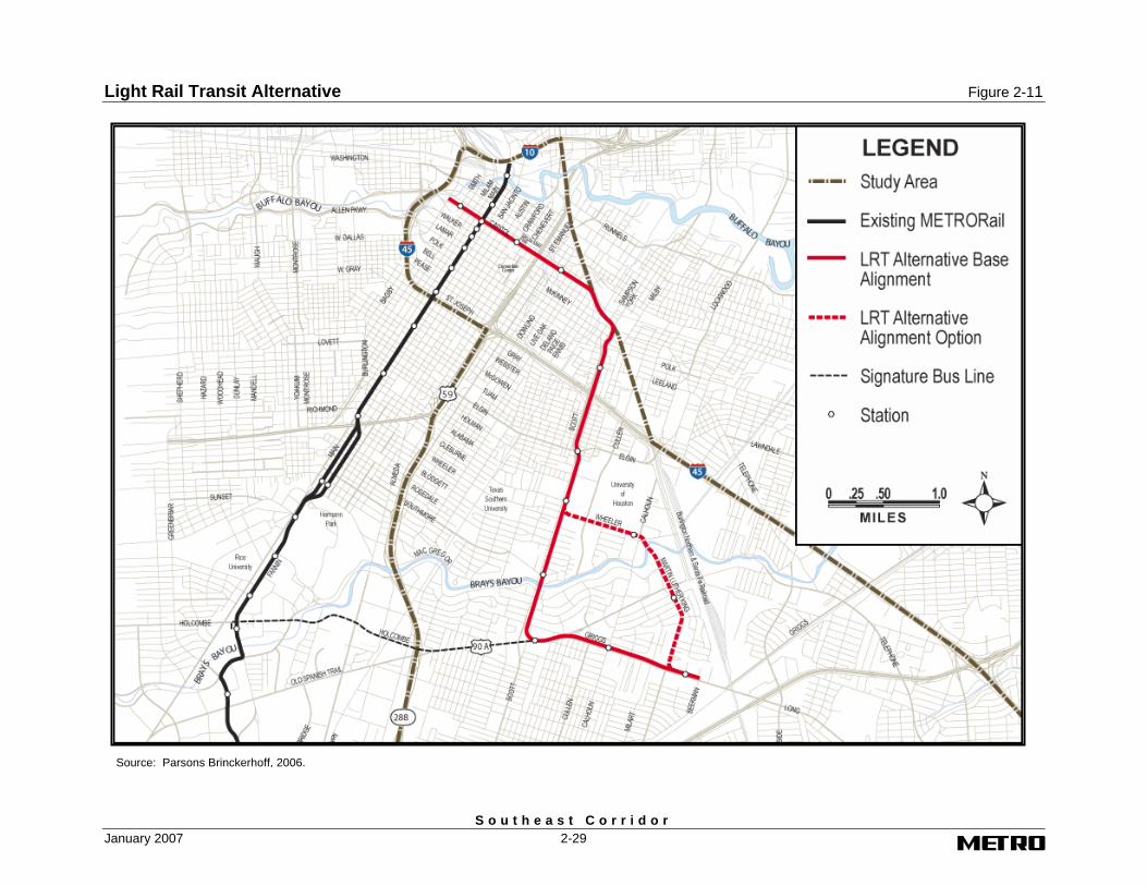
Light Rail Transit Alternative Figure 2-11
S o u t h e a s t C o r r i d o r January 2007 2-29
Figure 2-11. Light Rail Transit Alternative
Source: Parsons Brinckerhoff, 2006.
Final Environmental Impact Statement Chapter 2 – Alternatives Considered
S o u t h e a s t C o r r i d o r 2-30 January 2007
Road at Beekman Road, the proposed LRT alignments under consideration consists of the base alignment continuing south on Scott Street to the Southeast Transit Center and then east on Griggs Road to Beekman Road, and alignment option which turns east from Scott Street to Wheeler Street and follows Wheeler Street and Martin Luther King Boulevard southeast to connect with the base alignment at Griggs Road. The total length of the LRT Alternative with the base MOS alignment is 6.84 miles. The alternative would be slightly shorter in length with the Wheeler-MLK alignment option – 6.03 miles.
Base Alignment on Capitol between Bagby and St. Emanuel The proposed LRT alignment would begin at mid-block on Capitol between Bagby and Smith. The trackway would be located on the center of the street in order to maintain one lane of westbound traffic on each side of the alignment. As the alignment proceeds east, it would remain in the center of Capitol until transitioning to the south side of the street in the block between Milam and Travis. East of Travis, two westbound traffic lanes would be maintained, both on the north side of the street. Beginning at Austin, a third travel lane would be provided on the north side of Capitol. To provide for the additional lane, 10 feet of right-of-way would be acquired on the south side of Capitol between Caroline and Chartres and the tracks would be along the new south curb. The alignment would remain along the south side of the street from Chartres to St. Emanuel and two travel lanes would be provided on the north side of the trackway.
There are three stations proposed for this segment of the LRT alignment. The stations would be located at Smith, Main, and Crawford. These stations would be designed for bus and pedestrian access only.
Base Alignment on Capitol between St. Emanuel and Scott Street The LRT alignment would continue along the south side of the Capitol from St. Emanuel to Paige in the vicinity of the BNSF tracks. Two travel lanes would be provided on the north side of the alignment. The alignment would then turn southeast at grade and would cross diagonally through several city blocks to Sampson and Scott Streets. Right-of-way would be required from the blocks consisting of: 1) Capitol, Nagle, Rusk, and Delano Streets; 2) Capitol, Delano, Rusk, and Paige Streets; 3) Rusk, Paige, Walker, and Ennis Streets; 4) Rusk, Ennis, Walker Streets and the Burlington Northern Santa Fe Railway right-of-way; 5) McKinney, Roberts, Lamar, and Sampson Streets; 6) Lamar, Sampson, York, and Dallas Streets; and 7) Dallas, York, and Sampson Streets. There would be one station in this segment on Capitol at Dowling.
Base Alignment on Scott Street between BNSF and Wheeler Street At the intersection where Sampson Street turns into Scott Street, the LRT alignment would turn south and continue at grade in the middle of Scott Street to IH-45. The existing median width of 30 feet in this section is of sufficient width to accommodate the double-track LRT line, while maintaining the existing two lanes of traffic in each direction. Because of the inadequate clearance under IH-45, Scott Street would have to be lowered at the freeway bridge crossing, or over-height vehicles re-routed around the interchange to accommodate the LRT trackway and overhead contact system.
Final Environmental Impact Statement
Chapter 2 – Alternatives Considered
S o u t h e a s t C o r r i d o r January 2007 2-31
After crossing under IH-45, the LRT alignment would continue in the middle of Scott Street to Wheeler Street. The existing right-of-way width of 80 feet in this section is insufficient to accommodate the existing six lanes of traffic and the fixed-guideway alignment. To accommodate the fixed guideway, and maintain two travel lanes in each direction required for traffic, protected left turn lanes, and local access needs, additional rights of way would be acquired and some residents and businesses relocated. The rights of way would typically be acquired from one side of the street exhibiting the most vacant land, or the side avoiding or minimizing impacts on cultural resources or other important structures.
There are three stations proposed for this segment of the LRT alignment. The stations would be located along Scott Street at Leeland, Elgin, and Cleburne Streets. These stations would be designed for bus and pedestrian access only. No METRO developed parking areas would be provided for park-and-ride and kiss-and-ride access.
Base Alignment on Scott Street, Griggs Road between Wheeler Street and Beekman Road Under the base MOS, the LRT alignment would continue south at-grade in the median of Scott Street to Griggs Road. The existing right-of-way width in this segment is the same as on Scott Street between Wheeler and Elgin Streets. It is insufficient to accommodate the existing four lanes of traffic and the fixed-guideway line. Additional rights of way would be acquired and some residents and businesses would be relocated.
At the Griggs Road intersection, the base MOS alignment would curve to the east, and cross the properties on the east side of the street to the Scottcrest Drive and Old Spanish Trail intersection. The alignment would then cross through the intersection and turn east to a position parallel to the south side of the Old Spanish Trail right-of-way and across from the existing Southeast Transit Center. The station platform would be located on the north side of the transit center property. The existing bridge over Bray’s Bayou would be reconstructed or a new bridge constructed to accommodate the fixed guideway.
From the station, the alignment would proceed northeast along newly acquired properties south of Old Spanish Trail and enter the median of Griggs Road east of Old Spanish Trail. The alignment and station platform would require acquisition of additional right-of way and relocations along Scott Street and on the south side of the Old Spanish Trail right-of-way from Scottcrest Drive to Griggs Road.
After entering the median of Griggs Road, the alignment would continue east on Griggs Road to a point east of the Martin Luther King Boulevard near Beekman Road, where the MOS would terminate about 500 feet east of the station platform. A turn-back and storage track would be provided east of the platform.
Any future extension of the LRT alignment from this point would be the subject of future studies. However, it has been determined that the MOS terminus does allow for a future overpass of the two main line railroad tracks about a third of a mile east of the proposed terminus.
Final Environmental Impact Statement Chapter 2 – Alternatives Considered
S o u t h e a s t C o r r i d o r 2-32 January 2007
There are four stations proposed for this segment of the alignment. The stations would be located along Scott Street at Southmore Street, at the Southeast Transit Center, and on Griggs Road at Calhoun Street and Palm Center east of Martin Luther King Boulevard. The Palm Center Station would include parking facilities for about 325 vehicles. The other stations would be designed for bus, kiss-and-ride and pedestrian access only.
Alignment Option on Wheeler Street and Martin Luther King Boulevard between Scott Street and Griggs Road Under this option to the MOS, the LRT alignment would curve to the east at Wheeler Street and continue east at-grade in the median of Wheeler Street to Martin Luther King Boulevard. The existing right-of-way width in this segment is insufficient to accommodate the existing two lanes of traffic and the fixed-guideway line. Right-of-way would be acquired from the University of Houston along north side of Wheeler for this segment. Additionally, rights of way would be acquired and residents relocated along the south side of Wheeler Street between University Oaks Boulevard and Calhoun Road in order to accommodate the University Station platform.
From the station, the alignment would turn south on Martin Luther King Boulevard and continue south at-grade in the median of Martin Luther King Boulevard. Also just south of this intersection, the existing bridge over Bray’s Bayou would be reconstructed or a new fixed-guideway bridge constructed to accommodate the fixed-guideway alignment.
The alignment would continue south, crossing Old Spanish Trail, to just north of the intersection with Griggs Road. Prior to the Griggs Road intersection, the alignment variation would curve to the east, and cross the properties on the north east side of the intersection of Martin Luther King Boulevard and Griggs Road, which would require rights of way to be acquired and businesses relocated. Additionally, this alignment would require gates or a pre-signal just north and just east of the intersection to allow the fixed guideway to safely cross the existing travel lanes in order to make this turn. The alignment would then enter Griggs Road east of the intersection and continue east at-grade in the median to near Beekman Road, where the MOS would terminate about 500 feet east of the station platform. A turn-back and storage track would be provided east of the platform.
Any future extension of the LRT alignment from this point would be the subject of future studies. However, it has been determined that the MOS terminus does allow for a future overpass of the two main line railroad tracks about a third of a mile east of the proposed terminus.
A station would be located on Wheeler Street east of Calhoun Road/Martin Luther King Boulevard. Another station would be located at Martin Luther King Boulevard and Old Spanish Trail. The existing Southeast Transit Center at Scott Street and Griggs Road would be relocated to the Palm Center Station, which would also include parking facilities for about 325 vehicles. The other stations would be designed for bus, kiss-and-ride, and pedestrian access only.
Final Environmental Impact Statement
Chapter 2 – Alternatives Considered
S o u t h e a s t C o r r i d o r January 2007 2-33
LRT Stations
The stations along the downtown LRT alignment would use center platforms for passenger loading. The center platform type design has two platforms located within the dual tracks that would be staggered, with one platform on each side of an adjacent
Many of the new LRT stations located outside the downtown area will be at-grade with center platforms for passenger loading. Where turning traffic or spatial requirements warrant, a side platform type station design would be used. This station type has two platforms that flank the dual tracks. The platforms may be parallel or staggered, with one platform on each side of an adjacent intersection. Staggered platforms are typically configured as far-side stations so that the near-side space can be used as a left-turn lane. Other station configurations are possible and may be found to be preferable as design progresses through preliminary engineering.
In addition to the station platforms for passenger loading, the LRT stations would include a number of passenger amenities, such as canopies for weather protection and shading and ticketing equipment. While the specifics of the architectural design elements of stations will continue to be developed during preliminary engineering and final design of the project, each fixed-guideway station would include the following features:
• Passenger platform to accommodate up to a three-car train;
• Benches and trash receptacles;
• Artwork;
• Canopies;
• Ticket vending machines;
• Information kiosks;
• Closed circuit television system;
• Alarms with intercoms;
• Public address system;
• Lighting;
• Public and emergency telephones;
• Parking (Palm Center Station only); and
• Other amenities, as needed.
All aspects of station design would conform to the Americans with Disabilities Act (ADA) guidelines.
LRT Support Facilities
Construction of the LRT Alternative would include the installation of trackwork, an overhead contact system for the distribution of electricity to LRT vehicles, traction power substations located about one mile apart, and signaling and communication
Final Environmental Impact Statement Chapter 2 – Alternatives Considered
S o u t h e a s t C o r r i d o r 2-34 January 2007
systems. The LRT fixed guideway would consist of tracks formed of continuously welded rails. The rails would be embedded in a concrete slab or installed on crossties and ballast.
The LRT overhead contact system (OCS) would consist of either steel or concrete poles or span wires from buildings installed along the operating right-of-way to support the electrical power line, which would supply a nominal 750 volts of direct current (dc) for LRT trains. The poles would be approximately 25 feet tall. The poles or span wires would be installed at intervals from 90 to 170 feet. The poles would generally be located in the center of the two tracks, wherever possible. In some locations, the poles may be located on the side of the LRT trackway with the overhead electrical power line suspended over the LRT tracks.
Electricity for LRT operations would be supplied to the OCS from traction power substations located along the proposed LRT alignment. These electrical substations would be enclosed structures approximately 20-by-40 feet (maximum of 80-by-100 feet including the grounding mat around the substation) located proximally to the LRT alignment. Development of the substations, in some cases, would require an access roadway for maintenance vehicles. Electrical substations would be required for approximately each mile of track. Sites for six substations required by the MOS are listed below.
• Existing substation in downtown near Capitol and Main Street or a new substation to be located within a parking garage along Capitol.
• Southeast of Paige and Rusk at site of proposed LRT vehicle maintenance and storage facility.
• Southeast of Scott Street and IH-45 interchange.
• UH parking lot at Scott and Cleburne Streets.
• Southeast Transit Center (Base alignment option).
• South side of Griggs Road between Calhoun and Wayland Roads (Base alignment option).
• Parking lot on northwest corner of intersection at Wheeler Street and Calhoun Road (Wheeler-MLK alignment option).
• Parking lot on south side of Griggs Road between Martin Luther King Boulevard and Cavanaugh Street (Base alignment and Wheeler-MLK alignment options).
A photograph of an existing substation on the METRORail Red Line is shown in Figure 2-12.
Vehicle Maintenance and Storage Facilities
The LRT Alternative would require a new light maintenance and storage facility. The proposed vehicle maintenance and storage facility would be used for running repairs for the LRT vehicles and as a storage area for vehicles that are not in service. The new center also would ultimately be large enough to support approximately 20 vehicles.
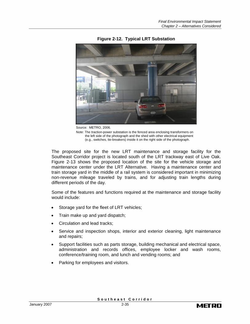
Final Environmental Impact Statement
Chapter 2 – Alternatives Considered
S o u t h e a s t C o r r i d o r January 2007 2-35
Figure 2-12. Typical LRT Substation
Source: METRO, 2006. Note: The traction-power substation is the fenced area enclosing transformers on
the left side of the photograph and the shed with other electrical equipment (e.g., switches, tie-breakers) inside it on the right side of the photograph.
The proposed site for the new LRT maintenance and storage facility for the Southeast Corridor project is located south of the LRT trackway east of Live Oak. Figure 2-13 shows the proposed location of the site for the vehicle storage and maintenance center under the LRT Alternative. Having a maintenance center and train storage yard in the middle of a rail system is considered important in minimizing non-revenue mileage traveled by trains, and for adjusting train lengths during different periods of the day.
Some of the features and functions required at the maintenance and storage facility would include:
• Storage yard for the fleet of LRT vehicles;
• Train make up and yard dispatch;
• Circulation and lead tracks;
• Service and inspection shops, interior and exterior cleaning, light maintenance and repairs;
• Support facilities such as parts storage, building mechanical and electrical space, administration and records offices, employee locker and wash rooms, conference/training room, and lunch and vending rooms; and
• Parking for employees and visitors.
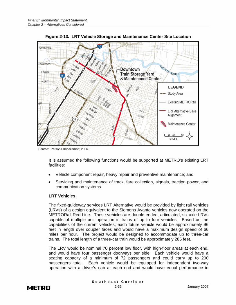
Final Environmental Impact Statement Chapter 2 – Alternatives Considered
S o u t h e a s t C o r r i d o r 2-36 January 2007
Figure 2-13. LRT Vehicle Storage and Maintenance Center Site Location
Source: Parsons Brinckerhoff, 2006.
It is assumed the following functions would be supported at METRO’s existing LRT facilities:
• Vehicle component repair, heavy repair and preventive maintenance; and
• Servicing and maintenance of track, fare collection, signals, traction power, and communication systems.
LRT Vehicles
The fixed-guideway services LRT Alternative would be provided by light rail vehicles (LRVs) of a design equivalent to the Siemens Avanto vehicles now operated on the METRORail Red Line. These vehicles are double-ended, articulated, six-axle LRVs capable of multiple unit operation in trains of up to four vehicles. Based on the capabilities of the current vehicles, each future vehicle would be approximately 96 feet in length over coupler faces and would have a maximum design speed of 66 miles per hour. The project would be designed to accommodate up to three-car trains. The total length of a three-car train would be approximately 285 feet.
The LRV would be nominal 70 percent low floor, with high-floor areas at each end, and would have four passenger doorways per side. Each vehicle would have a seating capacity of a minimum of 72 passengers and could carry up to 200 passengers total. Each vehicle would be equipped for independent two-way operation with a driver’s cab at each end and would have equal performance in
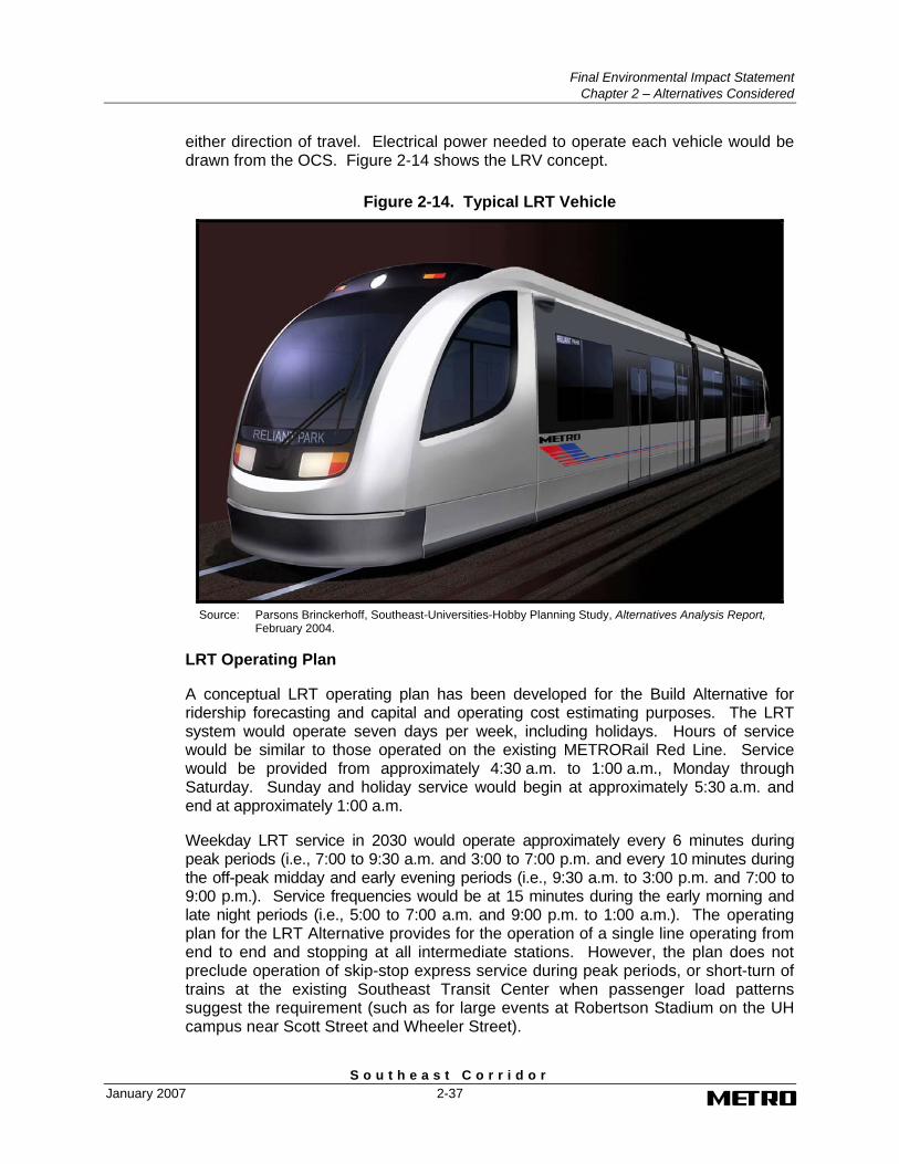
Final Environmental Impact Statement
Chapter 2 – Alternatives Considered
S o u t h e a s t C o r r i d o r January 2007 2-37
either direction of travel. Electrical power needed to operate each vehicle would be drawn from the OCS. Figure 2-14 shows the LRV concept.
Figure 2-14. Typical LRT Vehicle
Source: Parsons Brinckerhoff, Southeast-Universities-Hobby Planning Study, Alternatives Analysis Report,
February 2004.
LRT Operating Plan
A conceptual LRT operating plan has been developed for the Build Alternative for ridership forecasting and capital and operating cost estimating purposes. The LRT system would operate seven days per week, including holidays. Hours of service would be similar to those operated on the existing METRORail Red Line. Service would be provided from approximately 4:30 a.m. to 1:00 a.m., Monday through Saturday. Sunday and holiday service would begin at approximately 5:30 a.m. and end at approximately 1:00 a.m.
Weekday LRT service in 2030 would operate approximately every 6 minutes during peak periods (i.e., 7:00 to 9:30 a.m. and 3:00 to 7:00 p.m. and every 10 minutes during the off-peak midday and early evening periods (i.e., 9:30 a.m. to 3:00 p.m. and 7:00 to 9:00 p.m.). Service frequencies would be at 15 minutes during the early morning and late night periods (i.e., 5:00 to 7:00 a.m. and 9:00 p.m. to 1:00 a.m.). The operating plan for the LRT Alternative provides for the operation of a single line operating from end to end and stopping at all intermediate stations. However, the plan does not preclude operation of skip-stop express service during peak periods, or short-turn of trains at the existing Southeast Transit Center when passenger load patterns suggest the requirement (such as for large events at Robertson Stadium on the UH campus near Scott Street and Wheeler Street).
Final Environmental Impact Statement Chapter 2 – Alternatives Considered
S o u t h e a s t C o r r i d o r 2-38 January 2007
Background and Feeder Bus Service
The bus system would consist of a feeder bus and background bus system. The feeder bus system would consist of a network of bus routes serving the stations along the LRT alignment. The background bus system would consist of routes that provide local or express bus service throughout the corridor and region but do not specifically feed the fixed-guideway stations. The background bus system would be provided to ensure connections within and between communities not directly served by the fixed-guideway system.
With the introduction of LRT service in the Southeast Corridor, existing bus service in the corridor would be restructured to improve access to the fixed-guideway system. The restructuring of service would include modification of some existing routes to serve stations and revision of headways and schedule of service to improve the transfer of passengers between the fixed guideway and bus systems.
While METRO has conducted financial feasibility studies to show it can afford the entire METRO Solutions plan, the financial analysis for this corridor assumes that the future bus operating plan for the Southeast Corridor only implements bus service changes from the METRO Solutions plan which affect the Southeast Corridor. In addition, some routes will have reduced headways if they are operating parallel to the proposed LRT/BRT alignment. Specific details of the service changes are described in the New Starts Baseline report for the Southeast Corridor, March 2005.
2.3.2.3 Bus Rapid Transit Convertible Alternative
The BRT Convertible Alternative evaluated in the DEIS provides for new fixed-guideway transit service in the Southeast Corridor that would be initially operated by low-floor diesel-powered articulated vehicles traveling in reserved lanes in downtown Houston between Bagby and St. Emanuel and along a new bi-directional, fixed guideway outside of downtown between St. Emanuel and Griggs Road at Beekman Road. The fixed-guideway system outside downtown would be constructed so that it can be converted to LRT in the future with minimal disruption of service. The physical features of the LRT conversion will be clarified during preliminary engineering; such features could include embedded trackwork and electrical ductwork for the LRT OCS. Stations would be constructed so as to not preclude use by LRT vehicles. The BRT system would be converted to LRT in the future when justified by ridership. However, before the system could be converted, the fixed-guideway line would have to be extended to connect with the METRORail Red Line. The alignment for the connection between St. Emanuel and the METRORail Red Line would be the subject of a separate environmental review. Conversion elements to be undertaken in the future may include the installation of OCS, power cables from the OCS, communication and signal systems, and special trackwork.
The BRT Convertible fixed-guideway system includes six BRT stops in downtown Houston, up to eight fixed-guideway stations outside downtown, a park-and-ride lot, and bus transit transfer locations. No new vehicle maintenance and storage facility would be required for the BRT vehicles.
Final Environmental Impact Statement
Chapter 2 – Alternatives Considered
S o u t h e a s t C o r r i d o r January 2007 2-39
BRT Alignment and Station Locations
This section describes the alignment and station locations proposed under the BRT Convertible Alternative. As shown in Figure 2-15, the alternative provides for BRT operating in reserved lanes on Capitol and Rusk between Bagby and St. Emanuel in downtown Houston and in exclusive transit-only lanes from St. Emanuel southeast along Capitol and Scott Street to Wheeler Street. From Wheeler Street southeast to the terminus on Griggs Road at Beekman Road, the proposed Convertible BRT alignments under consideration consists of the base alignment continuing south on Scott Street to the Southeast Transit Center and then east on Griggs Road to Beekman Road, and the alignment option which turns east from Scott Street to Wheeler Street and follows Wheeler Street and Martin Luther King Boulevard southeast to connect with the base alignment at Griggs Road. The total length of the base MOS alignment is 6.84 miles. The total length of the alignment with the Wheeler-MLK alignment option is 6.03 miles.
Downtown BRT Alignment between Bagby and St. Emanuel The downtown BRT alignment would be located on Capitol and Rusk between Bagby and St. Emanuel. BRT vehicles would operate within reserved lanes for buses, HOVs, and right turning traffic. On Capitol, the alignment would transition from the south curb lane to the north curb lane at St. Emanuel and continue west on Capitol to Bagby. At Bagby, the alignment would make a U-turn and transition to the south curb lane of Rusk and continue east to St. Emanuel. The alignment would turn north from St. Emanuel and enter the east curb lane where it would continue to Capitol. At Capitol, the alignment would turn east onto Capitol. The remaining two westbound traffic lanes on Capitol and two eastbound lanes on Rusk would be maintained and no improvements would be made to the downtown intersections. Most traffic signals would remain unchanged with the exception of Capitol at St. Emanuel and Capitol and Rusk at Bagby which would have a change in signal phasing.
There are four stations proposed for this segment of the BRT alignment. The stations would be located at Louisiana, Main, Austin, and Crawford. These stations would consist of shelters located on the sidewalk and would be designed for bus and pedestrian access only.
BRT Alignment between St. Emanuel and Beekman Road From St. Emanuel to the end of the line on Griggs Road at Beekman Road, the BRT alignment would consist of a bi-directional fixed guideway located in semi-exclusive rights of way. The fixed guideway would provide for one exclusive transit-only lane in each direction. The guideway would be configured in accordance with LRT grade and curvature requirements.
The alignment and station locations for the fixed-guideway BRT system from St. Emanuel to Beekman Road would be the same as defined under the LRT Alternative. The street modifications would also be the same, except at the IH-45 bridge crossing on Scott Street. Under the BRT Convertible Alternative, the street would not be lowered for BRT vehicles.
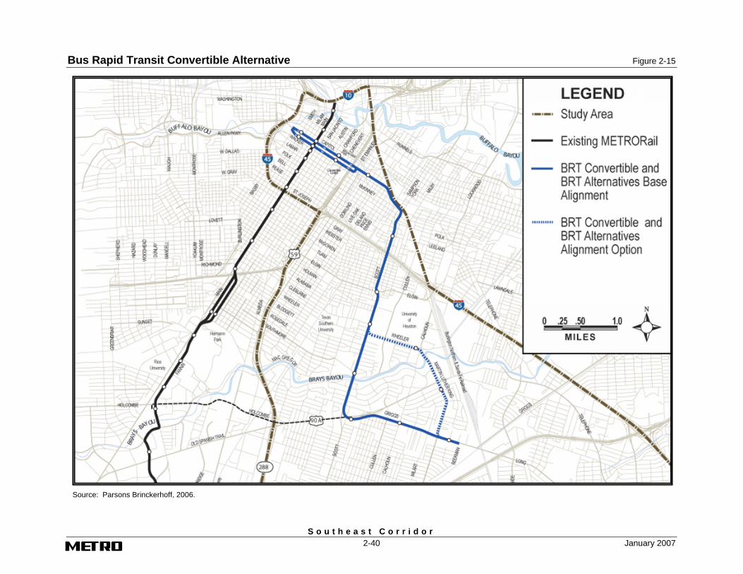
Bus Rapid Transit Convertible Alternative Figure 2-15
S o u t h e a s t C o r r i d o r 2-40 January 2007
Figure 2-15. Bus Rapid Transit-Convertible Alternative
Source: Parsons Brinckerhoff, 2006.
Final Environmental Impact Statement
Chapter 2 – Alternatives Considered
S o u t h e a s t C o r r i d o r January 2007 2-41
BRT Stations
The BRT stations along the downtown alignment on Capitol and Rusk would use shelters placed within the sidewalk. The stations on the BRT fixed-guideway alignment outside of the downtown area east of St. Emanuel would be the same as described under the LRT Alternative.
Fixed-Guideway Support Facilities
The BRT Convertible and BRT Alternatives assume that eight BRT vehicles would be required. These vehicles would be stored and maintained at the following METRO Bus Operating Facilities (BOF), both of which are capable of absorbing the BRT vehicles proposed under the BRT Alternative:
• Polk BOF – This facility is located at 5709 Polk Street just north of IH-45. This facility has capacity for 260 buses and currently has approximately 183 buses assigned to it. The Polk BOF is currently operating at 70 percent of capacity and has the capacity necessary to store 77 BRT vehicles.
• Kashmere BOF – This facility is located off of US 59 and is currently operating at 56 percent of capacity and has the capacity to store 109 BRT vehicles.
Construction of the BRT Convertible Alternative would include signaling and communication systems. The alternative may also include the following physical features for future conversion to LRT:
• Track embedded in the BRT guideway;
• Stations built to not preclude future conversion to LRT;
• Utility relocations from beneath the BRT roadways to permit reasonable mutual exclusivity between LRT service and in-street utility work;
• Ductbanks to accommodate future LRT signal and communications system;
• Traction electrification and OCS foundations;
• Land acquisition, where required, for future LRT components; and
• Corrosion control features.
BRT Vehicles
The BRT services described under the BRT Convertible Alternative would be provided by articulated buses similar in design to the existing METRORail Red Line LRVs. (Figure 2-16). The BRT vehicles would be low floor, allow passenger boarding from the curb, and would have passenger doorways on each side of the bus. The exact propulsion technology of the BRT is yet to be determined. Some possible options are Compressed Natural Gas engines, clean diesel engines, or diesel/electric dual mode technology.
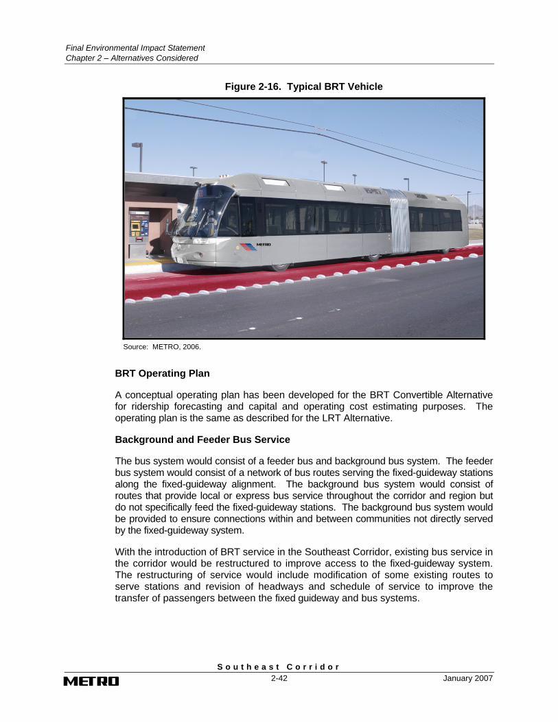
Final Environmental Impact Statement Chapter 2 – Alternatives Considered
S o u t h e a s t C o r r i d o r 2-42 January 2007
Figure 2-16. Typical BRT Vehicle
Source: METRO, 2006.
BRT Operating Plan
A conceptual operating plan has been developed for the BRT Convertible Alternative for ridership forecasting and capital and operating cost estimating purposes. The operating plan is the same as described for the LRT Alternative.
Background and Feeder Bus Service
The bus system would consist of a feeder bus and background bus system. The feeder bus system would consist of a network of bus routes serving the fixed-guideway stations along the fixed-guideway alignment. The background bus system would consist of routes that provide local or express bus service throughout the corridor and region but do not specifically feed the fixed-guideway stations. The background bus system would be provided to ensure connections within and between communities not directly served by the fixed-guideway system.
With the introduction of BRT service in the Southeast Corridor, existing bus service in the corridor would be restructured to improve access to the fixed-guideway system. The restructuring of service would include modification of some existing routes to serve stations and revision of headways and schedule of service to improve the transfer of passengers between the fixed guideway and bus systems.
Final Environmental Impact Statement
Chapter 2 – Alternatives Considered
S o u t h e a s t C o r r i d o r January 2007 2-43
2.3.2.4 Bus Rapid Transit Alternative
The BRT Alternative evaluated in the DEIS provides for new fixed-guideway transit service in the Southeast Corridor that would be operated by low-floor diesel-powered articulated vehicles traveling in reserved lanes in downtown Houston between Bagby and St. Emanuel and along a new bi-directional, fixed guideway outside of downtown between St. Emanuel and Griggs Road at Beekman Road. The physical and operating characteristics of the BRT Alternative would be the same as described for the BRT Convertible Alternative except that the BRT fixed guideway would not be constructed so that it can be converted to LRT in the future. It would not include such convertible features as embedded trackwork, utility relocations from beneath the BRT guideway, and ductbanks to accommodate the LRT signal and communications system. The land acquisition for traction power substations for future conversion to LRT would also not be included.
2.4 Definition of the Locally Preferred Alternative
The BRT Convertible Alternative with the Wheeler-MLK alignment was selected by the METRO Board of Directors as the LPA. The LPA provides for new BRT service operating along a line extending from downtown Houston to a terminus on Griggs Road at Beekman Road east of Martin Luther King Boulevard, connecting downtown Houston with the universities area including TSU and the UH, and the Palm Center. The service would operate in diamond lanes in downtown from Louisiana to Polk Street and in exclusive lanes along a fixed guideway alignment on Scott Street, Wheeler Street, Martin Luther King Boulevard, and Griggs Road to the terminus at Beekman Road. The fixed guideway would be constructed for future conversion to light rail transit when warranted by ridership. FTA will not participate in any features of the LPA that are needed solely for the future conversion from BRT to LRT. When METRO decides that it is time to convert the BRT to LRT, if FTA is asked to participate financially in that conversion, METRO will prepare the appropriate level of documentation as determined by FTA, to address impacts and identify any needed mitigation.
The BRT Convertible Alternative was selected as the LPA following the public comment period as a result of community input and analysis of potential benefits and impacts. The LPA would serve the growing travel demands of UH as the university expands better than the other build alternatives evaluated in the DEIS due to the locations of stations on and near the campus. In addition, the number of residential and commercial relocations is less under the LPA than the other DEIS build alternatives, minimizing potential adverse impacts to the community. In part because fewer relocations would be necessary, capital, operating, and maintenance costs would be lower under the LPA compared to the DEIS build alternatives.
2.4.1 Refinements to the BRT Convertible Alternative
The LPA is generally the same as the BRT Convertible Alternative with the Wheeler-MLK alignment option, which was evaluated in the DEIS and described in Section 2.3. Figure 2-17 shows the alignment and station locations for the LPA. Several
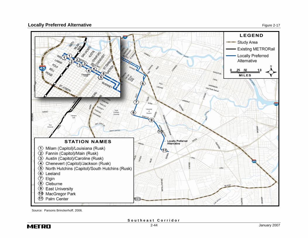
Locally Preferred Alternative Figure 2-17
S o u t h e a s t C o r r i d o r 2-44 January 2007
Figure 2-17. Locally Preferred Alternative
Source: Parsons Brinckerhoff, 2006.
Final Environmental Impact Statement
Chapter 2 – Alternatives Considered
S o u t h e a s t C o r r i d o r January 2007 2-45
refinements to the definition of the BRT Convertible Alternative were developed subsequent to the release of the DEIS as a result of preliminary engineering, public and agency comment on the DEIS, continuing public and agency involvement, and through efforts to avoid or minimize environmental and community impacts. The refinements to the BRT Convertible Alternative that are included in the LPA are described below:
• The western terminus of the diamond lanes for the BRT services operating on Capitol/Rusk in downtown Houston was changed from Bagby to Louisiana, or two blocks to the east. This refinement was made because of geometric issues affecting the bus turning movements on Bagby.
• The portion of the BRT alignment from St. Emanuel to Scott Street has been changed from fixed-guideway to diamond lanes. This refinement was made in response to comments from the HB&T Railway Company in opposition to acquisition of the railroad right-of-way between Paige and Walker Streets7. The diamond lanes for the BRT vehicles will follow Capitol and Rusk east to Delano and Paige Streets. Diamond lanes will be located on Delano and Paige between Capitol and McKinney Streets. Delano will be used for southbound BRT operations and Paige will be used for northbound BRT operations. From Delano and Paige, BRT vehicles will operate in diamond lanes on McKinney east to Sampson and York Streets. Sampson will be used for southbound BRT operations and York will be used for northbound BRT operations. The BRT vehicles will operate in the diamond lanes on Sampson and York to Polk Street, where the fixed-guideway alignment will begin. The only station between St. Emanuel and Polk Streets will be on Capitol and Rusk at Hutchins Street. In the DEIS, the station was on Capitol at Dowling Street. The only street improvements will be resurfacing and striping.
• BRT stations for the downtown westbound BRT alignment on Capitol are proposed at Milam, Fannin, Austin, and Chenevert. The BRT stations for the downtown eastbound alignment on Rusk are proposed at Louisiana, Main, Caroline, and Jackson. In the DEIS, stations were proposed at Louisiana, Main, Austin, and Crawford on both Capitol and Rusk. The difference in impacts is considered minimal because the stations would be shelters located on the sidewalk.
• On Wheeler Street from east of Cullen Street to Calhoun Road, the fixed-guideway has been changed from a location in the median to the south side of the street. This refinement was made in response to comments from UH. Shifting the alignment to the south side of the street will avoid relocation of the utilities on the north side of the street; however, additional displacements will be required on Wheeler Street.
• The station on Wheeler Street at Calhoun Road has been renamed to East University Station and changed from a center platform to a side platform station for ease of passenger access.
7 Letter dated September 6, 2006 from Crady, Jewett & McCulley L.L.P on behalf of Houston Belt &
Terminal Railway Company.

Final Environmental Impact Statement Chapter 2 – Alternatives Considered
S o u t h e a s t C o r r i d o r 2-46 January 2007
• The existing Southeast Transit Center on Old Spanish Trail will not be relocated to the Palm Center Station as described in the DEIS. Local buses will instead connect to the BRT services at the Elgin and Palm Center Stations. This refinement reduces impacts on bus operations and passengers transferring between routes and saves substantial bus O&M costs.
2.4.2 Alignment and Station Locations
Plan drawings of the alignment and station locations are contained in Volume 2 of this FEIS. Locations of the electrical substations for conversion to LRT in the future are also shown on the plans. These preliminary engineering drawings were developed for the purposes of preparing cost estimates and identifying environmental impacts. Following is a description of the LPA alignment and station locations.
Downtown LPA Alignment between Louisiana and Polk
The downtown segment of the LPA alignment would be located primarily on Capitol and Rusk between Louisiana on the west and Delano on the east, but would use local streets to connect with the fixed-guideway alignment on Scott Street at Polk Street. In downtown, BRT vehicles would operate mostly in diamond lanes reserved for buses, HOVs, and vehicles turning into cross streets and driveways.
The diamond lanes for the BRT vehicles will follow Capitol and Rusk east to Delano and Paige Streets. Diamond lanes will be located on Delano and Paige between Capitol and Rusk/McKinney Streets. From Delano and Paige, BRT vehicles will operate in diamond lanes on McKinney east to Sampson and York Streets. The BRT vehicles will operate in the diamond lanes on Sampson and York to Polk Street, where the fixed-guideway alignment will begin. The west curb lane of York between Polk and McKinney, the north curb lane of McKinney between York and Paige, and the east curb lane of Paige between McKinney and Capitol would be signed and marked as diamond lanes.
On Capitol between Dowling and Louisiana the second lane from the north curb would be signed and marked as a diamond lane and the curb lane would remain available for parking/loading or other curbside enhancements, except where it would be occupied by station platforms east of Hutchins, east of Chenevert, west of Austin, west of Fannin and west of Milam. At Louisiana, the inbound BRT vehicles would leave the diamond lane and maneuver in general traffic lanes west on Capitol, south on Smith, and east on Rusk to reach the beginning of the outbound reserved lane series.
On Rusk, the second lane from the south curb would be signed and marked as a diamond lane between Louisiana and Avenue de las Americas and between St. Emanuel and Dowling. In these segments, the south curb lane would be available for parking/loading or other curbside enhancements, except east of Louisiana, east of Caroline and east of Jackson where station platforms would be located. Between Avenue de las Americas and St. Emanuel and between Dowling and Delano the south curb lane of Rusk would be designated as a diamond lane. Beyond Rusk the south curb lane of McKinney, the east curb lane of Sampson and the east curb lane of Scott would be signed and marked as diamond lane. No exclusive lane would be
Final Environmental Impact Statement
Chapter 2 – Alternatives Considered
S o u t h e a s t C o r r i d o r January 2007 2-47
established on Delano because physical conditions at the Rusk and McKinney intersections would essentially require buses to travel in the single, general traffic lane next to the centerline.
Ten stations are proposed in this segment. Five would be on Capitol (from east to west) at north Hutchins, Chenevert, Austin, Fannin, and Milam and five would be on Rusk (from west to east) at Louisiana, Main, Caroline, Jackson, and south Hutchins.
LPA Alignment between Polk and Beekman Road
From Polk Street to the end of the line on Griggs Road at Beekman Road, the LPA alignment would consist of a bi-directional fixed guideway located within or along the side of a public roadway. The fixed guideway would comprise one exclusive transit-only lane in each direction and would be configured in accordance with LRT grade and curvature requirements for future conversion to LRT.
On Scott Street between Polk and Wheeler Streets and on Martin Luther King Boulevard and Griggs Road between Wheeler Street and Beekman Road, the alignment and station locations would be the same as defined under the BRT Convertible Alternative. The street modifications in these two segments would also be the same, except at the IH-45 bridge crossing on Scott Street. Under the LPA the street would not be lowered to accommodate future overhead traction power wiring. On Wheeler Street, between Scott Street and Calhoun Road, the guideway would be located in an exclusive right-of-way along the north side of the street from east of Scott Street to a point between Cullen Boulevard and Rockwood Street. There it would transition across Wheeler Street into an exclusive right-of-way along the south side of the street and would continue east to Calhoun Road where it would turn south at-grade into the median of Martin Luther King Boulevard and follow the alignment defined under the LRT Alternative to the end of the line at Beekman Road.
Six stations are proposed for this segment of the LPA alignment. All but one would be the same as that described for the BRT Convertible Alternative. As a consequence of the relocation of the guideway from the center to the south side of Wheeler Street, the East University Station would be shifted southward and would have two side platforms, rather than a single center platform.
2.4.3 Stations
The LPA stations along Capitol and Rusk in downtown Houston would be constructed in the parking lane on the right-hand side of the street. They would be basically bus stop shelters located on an extension of the sidewalk. The stations on the fixed guideway south of Polk would be constructed with the same features as those described under the BRT Convertible Alternative and LRT Alternative. The stations would be accessed primarily by walking and bus. The only station with parking facilities for access by auto is the Palm Center Station. Appendix I contains land use maps of each station location showing station platform and facilities.
Final Environmental Impact Statement Chapter 2 – Alternatives Considered
S o u t h e a s t C o r r i d o r 2-48 January 2007
2.4.4 Support Facilities
As described under the BRT Convertible Alternative, the BRT vehicles would be stored and maintained at the Polk and Kashmere METRO Bus Operating Facilities. No new maintenance and storage facilities would be required for the LPA.
Construction of the LPA would include signaling and communication systems. The fixed-guideway portion of the LPA from Polk to Beekman Road will also include all physical features for future conversion to LRT as described under the BRT Convertible Alternative.
2.4.5 Vehicles
The vehicle used in the operation of the BRT services will, at a minimum, be a 60-foot, low-floor vehicle with a seating for 35 passengers, and articulated with a predominantly level floor throughout the vehicle. It will be powered by a diesel electric hybrid system. The vehicle will have a precision docking system that meets ADA requirements for level boarding at station platforms. The vehicle exterior and interior will be an aesthetically appealing design giving a railcar appearance and be visually distinguished from other METRO bus services. The operator’s position will be located forward of the front entrance door and over the front axle. The vehicle will have a minimum of three passenger doorways each side utilized for ingress and egress.
2.4.6 Operating Plan
A conceptual operating plan has been developed for the LPA for ridership forecasting and capital and operating cost estimating purposes. The operating plan is the same as described for the build alternatives. Service would be provided from approximately 4:30 a.m. to 1:00 a.m., Monday through Saturday. Sunday and holiday service would begin at approximately 5:30 a.m. and end at approximately 1:00 a.m.
Weekday BRT service in 2025 would operate approximately every 6 minutes during peak periods (i.e., 7:00 to 9:30 a.m. and 3:00 to 7:00 p.m. and every 10 minutes during the off-peak midday and early evening periods (i.e., 9:30 a.m. to 3:00 p.m. and 7:00 to 9:00 p.m.). Service frequencies would be at 15 minutes during the early morning and late night periods (i.e., 5:00 to 7:00 a.m. and 9:00 p.m. to 1:00 a.m.).
2.5 Capital Cost Estimates
The capital cost estimate prepared for the LPA and build alternatives evaluated in the DEIS and the methodology used to develop the estimate is presented in this section.
2.5.1 Methodology
The capital cost estimate for the LPA is based on the preliminary engineering plans contained in Volume 2 of the FEIS and corresponding unit costs. The cost estimates for the build alternatives represent cost estimates from the DEIS that were updated
Final Environmental Impact Statement
Chapter 2 – Alternatives Considered
S o u t h e a s t C o r r i d o r January 2007 2-49
to 2006 dollars. The cost estimate was prepared using the FTA standardized cost categories and reflect total capital costs.
The unit costs used to prepare the estimate were derived from historical data from comparable transit system applications, including the METRORail Red Line. They are based on actual in-place costs including labor, permanent materials, construction and permanent equipment, and consumable supplies.
Financial models have been utilized to translate 2006 base-year dollars into year-of-expenditure dollars for the financial analysis. The results of the financial analysis are presented in Chapter 8, Financial Analysis of this FEIS.
2.5.2 Cost Estimate Results
The capital cost estimates (in constant 2006 dollars) prepared for the LPA and build alternatives are presented in Table 2-6.
The capital costs presented are preliminary and are based on standardized unit costs and categories that are customary for projects at this stage of development. METRO has established project budgets for each element of the METRO Solutions Phase 2 plan and will continue to refine the design and costs of each element in final design with the goal of substantially reducing the capital cost as more detailed design is completed.
2.6 Operating and Maintenance Cost Estimates The O&M cost estimate prepared for the LPA and build alternatives evaluated in the DEIS and the methodology used to develop the estimates are presented in this section.
2.6.1 Methodology
O&M cost estimates were prepared for the fixed-guideway and bus operations for the No Build Alternative, build alternatives in the DEIS, and the LPA using a fully allocated cost methodology. The methodology uses unit costs to translate transit service operated to total system- operating costs. Actual O&M cost information from the existing METRO bus services and from the METRORail Red Line were used to prepare the estimates. The bus cost model assigns costs through a similar process that allocates costs on the basis of revenue hours, total vehicle miles, and peak vehicles required. The basic bus cost model was modified as needed to reflect the specific types of service provided.
O&M costs for the BRT alternatives in the DEIS and the LPA were estimated as a hybrid of the local bus and LRT service, reflective of its service characteristics. The BRT service is operated with buses and provides two-directional, all–day service—similar to the service profile of local bus service. However, the BRT vehicles are larger and more complex to maintain than local buses. The detailed BRT O&M cost factors are documented in the August 2006 New Starts Financial Plan.
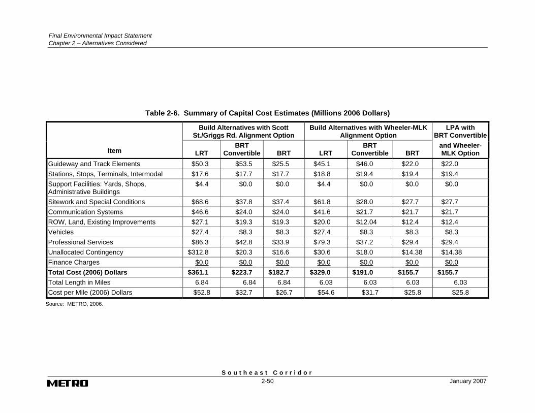
Final Environmental Impact Statement Chapter 2 – Alternatives Considered
S o u t h e a s t C o r r i d o r 2-50 January 2007
Table 2-6. Summary of Capital Cost Estimates (Millions 2006 Dollars)
Build Alternatives with Scott St./Griggs Rd. Alignment Option
Build Alternatives with Wheeler-MLK Alignment Option
LPA with BRT Convertible
Item LRT BRT
Convertible BRT LRT BRT
Convertible BRT and Wheeler-MLK Option
Guideway and Track Elements $50.3 $53.5 $25.5 $45.1 $46.0 $22.0 $22.0 Stations, Stops, Terminals, Intermodal $17.6 $17.7 $17.7 $18.8 $19.4 $19.4 $19.4 Support Facilities: Yards, Shops, Administrative Buildings
$4.4 $0.0 $0.0 $4.4 $0.0 $0.0 $0.0
Sitework and Special Conditions $68.6 $37.8 $37.4 $61.8 $28.0 $27.7 $27.7 Communication Systems $46.6 $24.0 $24.0 $41.6 $21.7 $21.7 $21.7 ROW, Land, Existing Improvements $27.1 $19.3 $19.3 $20.0 $12.04 $12.4 $12.4 Vehicles $27.4 $8.3 $8.3 $27.4 $8.3 $8.3 $8.3 Professional Services $86.3 $42.8 $33.9 $79.3 $37.2 $29.4 $29.4 Unallocated Contingency $312.8 $20.3 $16.6 $30.6 $18.0 $14.38 $14.38 Finance Charges $0.0 $0.0 $0.0 $0.0 $0.0 $0.0 $0.0 Total Cost (2006) Dollars $361.1 $223.7 $182.7 $329.0 $191.0 $155.7 $155.7 Total Length in Miles 6.84 6.84 6.84 6.03 6.03 6.03 6.03 Cost per Mile (2006) Dollars $52.8 $32.7 $26.7 $54.6 $31.7 $25.8 $25.8
Source: METRO, 2006.

Final Environmental Impact Statement
Chapter 2 – Alternatives Considered
S o u t h e a s t C o r r i d o r January 2007 2-51
2.6.2 Cost Estimate Results
The O&M cost estimates for the build alternatives and LPA were prepared in 2006 dollars and reflect total annual costs. Financial models have been utilized to translate 2006 base-year dollars into year-of-expenditure dollars for the financial analysis. The results of the financial analysis are presented in Chapter 8, Financial Analysis of this FEIS.
Based on the O&M cost methodology and proposed BRT operating plan, the annual O&M cost of the LPA is estimated to be approximately $639,000 in 2006. As the Southeast Corridor project proceeds into final design, the supporting transit operating plan will be refined. These refinements will consider other proposed and planned transportation projects in the vicinity of the corridor and their proposed operations. As a result, the final operating assumptions for the Southeast Corridor project may affect how many vehicles would operate in the corridor.
2.7 Build Alternative Schedule
Following circulation of the FEIS, a Record of Decision (ROD) may be issued by FTA. The ROD is a requirement by the FTA to enter final design and begin right-of-way acquisition. With the commencement of final design and construction, financing arrangements involving METRO and FTA would be formally defined and established. Based on the adopted financing arrangement, METRO would enter into a Full Funding Grant Agreement (FFGA) with the FTA. The entire process involving the LPA, from project planning, through final design and construction, to the start of operation, would take approximately three years. The current project schedule is shown in Table 2-7.
Table 2-7. Project Schedule
Activity Estimated Start Date
Estimated Completion Date
Final Design Feb 2007 Sept 2007
Right-of-Way Acquisition Feb 2007 Sept 2007
Vehicle Design/Manufacture/Delivery/Acceptance Testing 2007 2010
Construct BRT Line and Stations 2007 2010
Install Operating and Control Systems 2009 2010
Start-Up and Testing 2010 2010
Source: METRO, 2006.

S o u t h e a s t C o r r i d o r
CHAPTER 3 AFFECTED ENVIRONMENT