Embed Size (px)
Citation preview

Section 4: Environmental Inventory and Analysis
Geology, Topography and Soils The geology and topography of Holliston help to define the landscape as well as the land’s ability to support various uses. For example, steep slopes can be a limiting factor in developing a parcel of land. Bedrock outcrops or bedrock just beneath the surface can also be a deterrent to development by increasing the potential cost of construction. However, with modern technology, and increased demand for the shrinking supply of undeveloped land, many such areas are now considered buildable. Geology The last major geological event to affect Holliston was the Wisconsin Ice Age that ended approximately 12,000 years ago. The glacier spread from the north and slowly retreated back
Figure 4 1 – Surficial Geology
Holliston Open Space and Recreation Plan 6/2/2006

to the Arctic. Surficial geology as affected by the action of the glacier, is the underlying basis for both natural systems and human use and provides important information about an area’s environmental potentials and vulnerabilities. The glaciers that covered New England more than 20,000 years ago left their mark on Holliston. As the two-mile thick layer of ice moved south it scraped the solid rock beneath it and carried along rocks and soil. A mixture of material ranging from clay to boulders (glacial till) was deposited at the base of the glacier as it passed over the area. About 19,000 years ago, the temperature began to rise and the ice slowly retreated. As the ice melted, the moving water deposited sand and gravel, referred to as outwash. As a result of this glacial invasion Holliston was left with till from the glacier’s advance and sand and gravel from the glacier’s retreat. Additionally, the north-south direction of the glacier's movement is responsible for the general north-south alignment of Holliston’s major geological and topographic features such as Chicken Brook, Dopping Brook, Broad Hill, and Cedar Swamp. Finally, floodplain alluvium has been deposited by ongoing erosion along many streams and in wetlands in the time since the glacier’s retreat. Holliston’s surficial geology contributes to making many areas prime targets for new development. However, large amounts of land in Town are also considered undesirable for development because of constraints to septic systems caused by the soils left behind by the glacier. Topography The topography of Holliston is characterized by relatively low, rolling hills, stream corridors, swamps and ponds. The majority of Holliston is relatively flat with slopes less than 8%. The hills are all fairly low with the largest being Bald Hill at approximately 450 feet. There are few slopes greater than 20% within the Town. The steepest areas are located east of Jennings Road above Dopping
Holliston Open Space and Recreation Plan 4.2
Figure 4.2 - Topography
6/2/2006

Brook and the adjacent wetlands; the east side of Bald Hill west of Winter Street; and east of Highland Street. Mt. Hollis rises steeply to the east of Hollis Street in the center of Town. Due to the relatively flat topography of the Town, steep slopes are not often a limiting constraint for development. Soils Soils play a role as diverse as nourishing our agricultural crops to supporting the buildings that we live and work in. Soils that drain poorly and/or have a high water table may restrict development options of a parcel of land because of an inability to provide on-site sewage disposal or support structures, or because of other environmental constraints such as wetlands. Soils will continue to be a development constraint for many areas of Town. A sewer system would make it possible to develop properties that previously were considered undevelopable because they did not pass a percolation test. Muck soils are frequently found in wetlands; because of stringent regulation these soils are rarely subject to new development. As mentioned above, steep slopes (greater than 15%) or bedrock close to or at the surface may also deter development. Identification and delineation of the soils in the Town of Holliston provide a basis for sound land use planning decisions in the future. Physical characteristics and management of soil impact many environmental factors such as wetlands, drainage characteristics, permeability, and depth to water table. Several of these factors have been evaluated for the purpose of identifying limitations for specific uses such as active and passive recreation and urban growth, and for highlighting areas of concern. Permeability/Drainage Characteristics All soils have permeability and drainage characteristics that affect their management and potential land use. Permeability is defined as the quality that enables the soil to transmit water or air, and is measured as the speed water moves through the soil (in inches per hour). Soils with slow permeability will have to be modified through artificial drainage when land is used for development. Homes will be adversely affected by water in soils with slow permeability and perched high water tables. Soils with slow permeability rates limit the use of land unless they are modified—a costly option. Where appropriate, these areas should be encouraged for conservation, recreation, or open space. The permeability of a soil is an important factor in determining the risk of groundwater contamination. The faster water and dissolved pollutants can flow through soil, the higher the risk for groundwater contamination because the pollutants have less time to be filtered out by adhering to soil particles. Soils with the highest permeability in Holliston correspond closely to the areas shown on Figure 1 as sand and gravel deposits. These soils are also located near aquifer recharge areas and Wellhead Protection Areas (Zone IIs). The protection of land with high permeability, within recharge or well protection areas, is essential to ensure continued high quality drinking water. Prime Farmland Prime farmland soils have the best combination of physical and chemical characteristics for agricultural production. They have qualities such as proper growing season and moisture
Holliston Open Space and Recreation Plan 6/2/2006 4.3
supply to economically produce sustained high-yield crops when treated and managed, according to acceptable methods. Unfortunately, these soils may also have few limitations for development. Agricultural soils are generally found in flat, non-forested areas that have been readily developed in many communities. During the 30 years after World War II, Massachusetts experienced a 30% loss of its agricultural land. Therefore, many areas that were prime farmland are no longer available for food production. Prime farmland soils should be protected for agricultural and open space activities. Holliston’s largest agricultural area is ideally situated on prime agricultural soils, as defined by the U.S. Department of Agriculture. Offering tax incentives, such as Chapter 61A designations, to local farmers has helped to reduce but not stop the loss of farmland. As one sign of the recognition that preservation of farmland will help Holliston maintain its rural atmosphere into the future the Town has recently formed an Agricultural Committee.
Landscape Character and Scenic Resources Low rolling hills; north to south running valley streams; ponds; farmland, especially along Highland Street; church steeples and historic structures; cemeteries; and open and wooded wetlands are landscape features that give Holliston a special character.
Holliston Open Space and Recreation Plan 6/2/2006 4.4

Scenic resources are not limited to a specific view or location, but may be a combination of features that together create an aesthetically pleasing situation, such as a tree-lined street, a rolling meadow, a hilltop, or an old farmhouse and its outbuildings. Participants in a public workshop held for the 1998 Open Space and Recreation Plan identified the following areas as treasured scenic resources:
Farmland/forest vista on Highland Street Miller Hill Quarry Aqueduct Winthrop Canal Town Forests Lake Winthrop Metcalf Fire House Natural cranberry bogs Cemeteries The walk between Pleasure Point and cemeteries Engine House #3 Topiary and Glacial Erratics on Washington Street (now being developed)
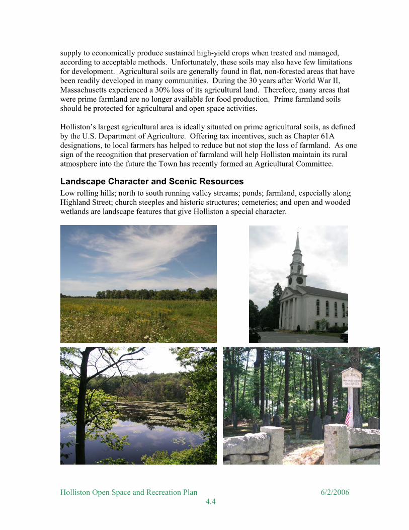
It was noted at the time that a significant part of the scenic vista on Highland Street had been lost due to construction of single-family homes and the associated mounded leaching fields along the western side of the Street. Still, Highland Street remains the strongest reminder of Holliston’s agricultural heritage. These farmland views have long been identified as a favorite scenic area; historic districts and structures demonstrate the Town’s heritage; the Town’s many ponds provide visual relief and recreation opportunities; and historic cemeteries offer peaceful reminders of other generations of Holliston residents. New development can have dramatic impacts on some of these features. For example, recent construction to provide housing at the Balancing Rock Village on Washington Street has eliminated the topiaries that were identified as a favorite scenic feature in the 1998 Open Space and Recreation Plan. As noted above farmland soils may have few limitations for development and frequently are lost to new subdivisions. On the other hand, historic cemeteries and many of the Town’s historic structures are more likely to remain as features of the landscape’s character in the future. In other parts of Town, open space has been acquired that will maintain scenic quality of the area. Future land acquisitions can serve to protect scenic resources throughout the Town. The Scenic Roads Act (M.G.L. Chapter 40, section 15C) allows a municipality to designate any non-numbered route or state highway as a “scenic road”. Once designated, any proposed repair, maintenance, reconstruction or paving work that involves the cutting of trees or destruction of stonewalls needs prior approval of the Planning Board. Designating a road as scenic will allow for the preservation of existing rural and natural aesthetic qualities, and thereby contribute to the overall rural character of a community. The Town of Holliston has designated twenty-seven (27) roadways as Scenic Roads. The following roads have been designated as Scenic Roads in Holliston and are shown on the Scenic Resources Map:
Holliston Open Space and Recreation Plan 6/2/2006 4.5
Adams Street Granite Street Mellen Street Brook Street Hanlon Road Mill Street Bullard Lane Highland Street Norfolk Street Bullard Street High Street Oak Street Central Street Hill Street Prentice Street Courtland Street Jennings Road Rockland Street Fisher Street Linden Street Underwood Street Fiske Street Locust Street Wilson Street Gorwin Drive Marshall Street Winter Street
Figure 4.3- Unique Features & Scenic Resources
Holliston Open Space and Recreation Plan 6/2/2006 4.6
Water Resources Nearly 100 ponds scattered throughout the Town enhance Holliston’s aesthetic character; but in order to appreciate the true value of the Town’s water resources they need to be viewed through a regional perspective. Holliston is located within the Charles River Drainage Basin. Within the Town’s boundaries are located three major headwater tributaries to the Charles River: Beaver Brook-Hopping Brook system, Chicken Brook system and Jar Brook-Bogastow Brook system. Controlling the human activities within the headwaters of a watershed is often the easiest and most effective way to prevent downstream flooding and preserve water quality. The Army Corps of Engineers recognized this fact in the 1970s and purchased or obtained conservation restrictions on much of the Charles River headwaters including approximately 400 acres in Holliston. Holliston has approximately 211 acres of surface water and approximately 2,443 acres (5.6 square miles or 20% of the Town) of wetlands. Figure 4 illustrates Holliston’s water resources. The Town's surface water resources are a combination of rivers, streams and ponds and their associated wetlands. Ground water resources are also evident in Town at the locations of the Town wells and Zone II areas. The water resources serve eight important functions, as identified under the Massachusetts Wetlands Protection Act, including:
• Public and private water supply; • Ground water supply; • Flood control; • Storm damage prevention; • Prevention of pollution; • Fisheries; and • Wildlife habitat.
In addition, these areas also provide open space and passive and active recreation for various public uses such as nature study, photography, boating, and swimming. Surface Waters A watershed is the area of land that drains all its water to a common point—often a lake, ocean, or larger stream system. Holliston is divided into nine watersheds (see Figure 4). Identifying the boundaries of watersheds is an important step for securing future water quality. Knowing what areas contribute water to a water body can help identify potential pollution sources. When examining the likelihood of a water body becoming polluted, the land use, soil type, groundwater level, and percolation rate of the watershed should be considered. High ground water and rapid percolation rates are two soil characteristics that affect how fast and how much pollution reaches the water supplies. Current land use should be evaluated as possible pollution sources. Zoning can be used to estimate future land use and to predict future water conditions. Zoning can also be used to protect water supplies by limiting high pollutant risk uses within aquifer recharge areas or other significant watershed areas. The following table summarizes several landscape conditions that are related to water quality for each sub-basin within the Town. Highlighted areas are most likely to face water quality problems. They have a combination of relatively more development, little open
Holliston Open Space and Recreation Plan 6/2/2006 4.7
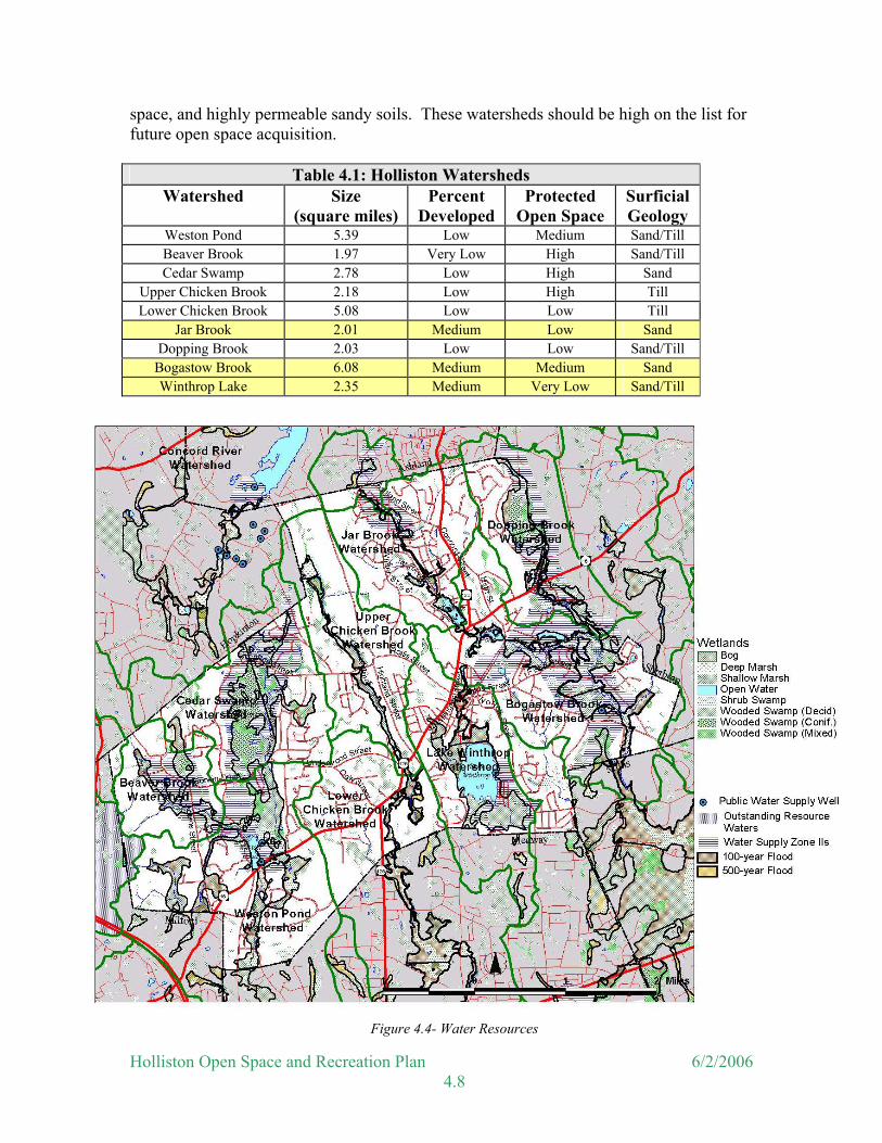
space, and highly permeable sandy soils. These watersheds should be high on the list for future open space acquisition.
Table 4.1: Holliston Watersheds Watershed Size
(square miles) Percent
Developed Protected
Open Space Surficial Geology
Weston Pond 5.39 Low Medium Sand/Till Beaver Brook 1.97 Very Low High Sand/Till Cedar Swamp 2.78 Low High Sand
Upper Chicken Brook 2.18 Low High Till Lower Chicken Brook 5.08 Low Low Till
Jar Brook 2.01 Medium Low Sand Dopping Brook 2.03 Low Low Sand/Till
Bogastow Brook 6.08 Medium Medium Sand Winthrop Lake 2.35 Medium Very Low Sand/Till
Figure 4.4- Water Resources
Holliston Open Space and Recreation Plan 6/2/2006 4.8
Lake Winthrop Holliston’s surface water also creates recreational activities for the residents. Holliston’s only “Great Pond”, Lake Winthrop (150 acres), provides key recreational opportunities for boating, and swimming. Surrounding land use is a mix of residential and forested open space. There are a number of year round homes along the shoreline that have on site septic systems. The public beach at the Lake was closed once because of bacterial contamination. Some attribute this closure to a water sampling error; however, it was the opinion of the Lake Winthrop Watershed Association that failing septic tanks from homes surrounding the Lake caused the contamination. Nutrient enrichment of Lake Winthrop remains a concern. Maintenance of on-site septic systems is essential toward minimizing the effect of shoreline development on further eutrophication of the lake. Requirements under the strengthened Title V will help reduce problems from failing systems as they are eventually replaced. Lake Winthrop was sampled in 1983 as part of a six-pond dioxin study. At that time, dioxin was found in brown bullhead and a fishing advisory was issued by the Department of Environmental Protection (DEP). In 1997, fish were resampled. Dioxin concentrations in yellow bullhead, yellow perch, and largemouth bass appeared to be much lower than those found in the early 1980s. It is unclear if these data are indicative of a decrease in available dioxin within lake food webs, or, if this is a result in differences in analytical methodology or sampling error. DEP’s Office of Research and Standards and the Massachusetts Department of Public Health (MDPH) are in the process of reviewing the Lake Winthrop dioxin data and performing a health risk assessment as well as addressing data quality issues. Yellow bullhead and largemouth bass samples collected in 1996 also contained mercury concentrations that exceeded the MDPH’s trigger level of 0.5 mg/Kg. As a result, it does not appear that the fish consumption advisory for Lake Winthrop will be lifted, however, it may be modified. The presence of these levels of mercury and dioxin poses no risk for swimming or boating. See the 1997 Fish Toxics Monitoring report by the Department of Environmental Protection (www.assabetriver.org/streamwatch/Fish%20Toxics%201997.pdf) by Robert J. Maietta. Groundwater/Aquifer Recharge Areas Groundwater, the source of drinking water for the Town, is one of its most important natural resources. See Section 3 for a description of the Town’s water supply infrastructure. The same factors that contribute to surface water contamination also affect groundwater. The amount of protected open space and development, the type of development, and highly permeable soils are related to the likelihood of contamination. For example, the Maple Street Well (Well #2), which was built in the 1940s, has now been surrounded by dense residential development and is now vulnerable to some kinds of pollution. More protected open space in the surrounding area would decrease the likelihood of contamination. On the western border of Town is an area designated to have “Outstanding Resource Waters”. The Department of Environmental Protection has given this designation to water resources with “outstanding socioeconomic, recreational, ecological and/or aesthetic values”. Such areas receive a high level of attention under provisions of the Massachusetts Clean Waters Act. Most of this particular area is in Milford and has been the focus of recent joint efforts by Milford, Hopkinton, and Holliston to protect this important headwater area of the
Holliston Open Space and Recreation Plan 6/2/2006 4.9

Charles River because of its importance as a water resource and wildlife habitat. As mentioned in the section on water supply infrastructure, the Town has adopted a Groundwater Protection District to provide some protection for its water supply Zone IIs, because of their high vulnerability to contamination due to the absence of hydro-geologic barriers, such as clay or ledge, which can prevent migration of pollutants. Flood Hazard Areas Because of Holliston’s extensive waterway system, many flood hazard areas are found throughout the Town. These areas are delineated on the Water Resources Map and on official Floodway Maps and Flood Insurance Rate Maps (FIRM). These mapped areas are generally protected from development due to the likelihood of flooding and the potential for destruction of any structures built within these zones. Wetlands A wetland is an area that, in its undisturbed condition, is saturated, flooded or ponded long enough during the growing season to develop anaerobic conditions that favor the growth and regeneration of hydrophytic or water-tolerant vegetation. Generally, wetlands can be found in low elevations in the landscape including floodplains, upland depressions, and bordering bodies of water such as lakes, ponds, and rivers. They are valuable areas because they provide habitat and food for wildlife, areas for floodwater storage, control erosion, replenish aquifers, offer opportunities for recreation and education, enhance biodiversity, and filter pollutants out of water. Wetland areas offer important visual resources and wildlife habitats to Holliston. The predominant type of vegetated wetland is the red maple swamp (deciduous wooded swamp). There are several large red maple swamps in Town including: the Town Forest north of Adams Street, Rocky Woods Conservation land, and the land bordering Dopping Brook. Holliston’s largest wetland system is Cedar Swamp. It is comprised of Atlantic White Cedar, Hemlock, Yellow Birch, and other species. A large part of the swamp has been protected as part of the Brentwood Conservation Land or as important flood control lands by the Army Corps of Engineers. There are also cranberry bogs scattered through out Town, remnants of when Holliston was a major producer of cranberries, extending as far back as the first commercial production in 1854. One indicator of wetlands is the presence of hydric soils. The importance of hydric soils in open space planning relates to wetland enhancement and protection. Delineation and identification of hydric soils can assist in identifying wetland boundaries within the Town. Urban growth development should be restricted in areas of hydric soils for several reasons including tendency to flood, high water table, slow permeability rates, and water quality protection. Land comprising hydric soils should generally be restricted to conservation, wetland wildlife habitat, and recreational uses.
Holliston Open Space and Recreation Plan 6/2/2006 4.10
Summary
Wetland and water resources are important for the protection of water supplies, for flood control and for wildlife protection. These are just a few of the reasons why it is important to protect the aquifer recharge areas, wetlands, waterways and water bodies from the effects of future development. The use and enforcement of Best Management Practices (BMPs) is one way that the Town can help to protect these areas. BMPs are structural (such as water quality basins) and nonstructural (such as street sweeping) practices that reduce pollutants from entering downstream water bodies and control the quantity of storm-water runoff and infiltration on a developed site. The Town can also identify future sources of water and acquire lands around the sources now, before they are developed.
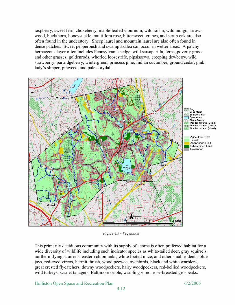
Vegetation The value of vegetation is often overlooked or taken for granted in many communities. The usefulness of vegetation extends beyond its traditional role of providing aesthetically pleasing views and variety in the landscape. Holliston's woodlands, wetlands, abandoned fields and orchards:
• Protect surface and groundwater by stabilizing soils and preventing erosion; • Act as a visual and noise buffer between incompatible uses; • Provide wildlife habitat; • Provide recreational opportunities; and • Improve air quality.
The natural vegetation of Holliston can be divided into three distinct groups: forest areas, wetlands and fields. Forest In the 1800s, much of Holliston’s forests had been cleared to provide farmlands. As the fields were abandoned, the forests regenerated. Therefore, much of Holliston’s existing forested uplands are second growth oak-pine forests. Other forested areas in Town include the planted coniferous forest of the Henrich Town Forest, the predominantly oak Town Forest, managed tree farms, mature beech forests (as in Brentwood Conservation Land) and other stands of various species of trees scattered through Town. Oak-Pine Forest The oak-pine forest typically consists of a variable mix of oak species that dominate the canopy including black oak, red oak, and white oak. A variety of other species can reach into the canopy including white pine, hickory, gray birch, paper birch, black cherry, tupelo, American elm, white ash, pitch pine, and red cedar. The understory consists of saplings of the canopy species as well as gray birch, aspen, sassafras, big-toothed aspen, black birch, red maple, and chestnut is sometimes in dense patches. Blueberries, huckleberry, witch hazel,
Holliston Open Space and Recreation Plan 6/2/2006 4.11
raspberry, sweet fern, chokeberry, maple-leafed viburnum, wild raisin, wild indigo, arrow-wood, buckthorn, honeysuckle, multiflora rose, bittersweet, grapes, and scrub oak are also often found in the understory. Sheep laurel and mountain laurel are also often found in dense patches. Sweet pepperbush and swamp azalea can occur in wetter areas. A patchy herbaceous layer often includes Pennsylvania sedge, wild sarsaparilla, ferns, poverty grass and other grasses, goldenrods, whorled loosestrife, pipsissewa, creeping dewberry, wild strawberry, partridgeberry, wintergreen, princess pine, Indian cucumber, ground cedar, pink lady’s slipper, pinweed, and pale corydalis.
Figure 4.5 - Vegetation
This primarily deciduous community with its supply of acorns is often preferred habitat for a wide diversity of wildlife including such indicator species as white-tailed deer, gray squirrels, northern flying squirrels, eastern chipmunks, white footed mice, and other small rodents, blue jays, red-eyed vireos, hermit thrush, wood peewee, ovenbirds, black and white warblers, great crested flycatchers, downy woodpeckers, hairy woodpeckers, red-bellied woodpeckers, wild turkeys, scarlet tanagers, Baltimore oriole, warbling vireo, rose-breasted grosbeaks.
Holliston Open Space and Recreation Plan 6/2/2006 4.12

Typical amphibians include northern redback salamanders and spotted salamanders. Ringneck snake and garter snake would also be expected. Cavities in dead trees or dead limbs are especially valuable for wildlife. More generalist species such as black-capped chickadees, American robin, northern cardinal, goldfinches, and white-breasted nuthatches are also likely to occur here along with a large variety of other birds and mammals such as coyotes, raccoons and skunks that will occasionally pass through this and neighboring habitats. American chestnuts would have made up a significant portion of the canopy of this type of forest prior to the arrival of the chestnut blight fungus in 1906. The fungus kills the above ground portion of the tree while the roots continue to sprout. These sprouts may reach 20 feet or so before they are attacked by the blight and killed. White oaks, with their rounded leaf lobes, produce huge numbers of acorns every 4 to 10 years. In a good year a single tree may produce 2,000 to 7,000 acorns. However, an individual tree may go several years with virtually no acorn production. Acorns and other nuts and fruits provide a rich resource for roving flocks of blue jays as well as for gray squirrels and chipmunks. Wild turkeys are becoming more common and also use this resource. Local variations in the abundance of these species are clearly tied to acorn production. White oaks can reach 150 feet in height (though 100 feet is more common) and four feet in diameter, living to an age of 600 years. Northern red oak, black oak and scarlet oak have leaves with sharply pointed lobes. Red oak and black oak can hybridize and be confusing to identify. Northern red oak is less shade tolerant than white oak but more tolerant than either black or scarlet oak. Consequently, both black and scarlet oak are generally more abundant in more open woodlands. Black oak can often occur in pure stands on drier, more exposed sites, where both northern red oak and white oak are at a disadvantage. White Pine Forest The majority of the Town’s coniferous forests are White Pine Forest, also known as Successional White Pine Forest and Old-field White Pine Forest. This community type develops on abandoned agricultural land, usually pasture. The forest floor in is typically carpeted with needles, often with only a sparse layer of herbaceous plants. White pine dominates the canopy but a variety of other scattered species can include white oak, red oak, tupelo, black cherry, pitch pine, gray birch, big-toothed aspen, and red maple. The shrub layer can vary in density from sparse to thick. It may include saplings of the canopy species and huckleberry, blueberries, witch hazel, sheep laurel, bayberry, sweet fern, elderberry, maple leaved viburnum, and often non-native species such as buckthorn, honeysuckle, and/or multiflora rose. A variety of blackberry vines (often forming thickets), and poison ivy often covers the ground near openings or in formerly open disturbed areas. The herbaceous layer is variable; large patches of Canada mayflower, and starflower with clubmosses or princess pine are particularly common on formerly plowed soil. Bracken fern is often common on drier sites. Partidgeberry, wintergreen, ferns, fringed polygala, grasses, and pink lady’s slipper grow in many longer established sites.
Holliston Open Space and Recreation Plan 6/2/2006 4.13
This community type, if large enough, is often a preferred habitat for blackburnian warblers, ovenbirds, yellow warblers, and Cooper’s hawks. American crows, a variety of hawks, and great-horned owls are likely to use large white pines as roosting perches or nesting sites. More generalist species such as black-capped chickadees, pine warblers, and red-breasted nuthatches are also likely to occur here along with a large variety of other birds and mammals that will occasionally pass through this habitat. Fields Fields also provide a variety of vegetation in Holliston. While forests have succeeded many of Holliston’s fields, there are still several hundred acres of farmlands with associated fields located in Town. Some of these farmlands are not visible from the street due to vegetation lining the streets. An example of this is much of the Bullard Memorial Farm from Bullard Street. Agricultural fields include croplands that are actively farmed and pastures. There are also a number of abandoned fields and utility line rights of way that provide early successional habitat. Some owls may hunt the fields at night. Meadow voles, meadow jumping mice, and northern short-tailed shrews may also frequent these open areas and they would be hunted by garter snakes and long-tailed weasels. The abandoned fields and utility lines are in varying stages of the Successional Northern Hardwoods community. Young gray birch, black cherry, red maple, mixed oaks, quaking aspen, red cedar, and white pine dominate. The understory is light and may include honeysuckle, blackberry, buckthorn, autumn olive, white mulberry, sweet fern, bittersweet, grapes, silky dogwood, smooth sumac, common mullein, birdsfoot trefoil, common stitchwort, cow-vetch, wild madder, pigweed, mugwort, rough-fruited cinquefoil, tower-mustard, white campion, goldenrods, common ragweed, milkweed, raspberry, dandelion, bittersweet nightshade, tall buttercup, clammy ground cherry, red clover, yarrow, alfalfa, common wintercress, and grasses. The structure of successional communities changes quickly and the animals that use them change as the vegetation grows. For the first 10 years trees may be dense but small with an understory of blackberry. Chestnut-sided warblers and mourning warblers prefer these early stages. Grouse and woodcock are also often found in this community type. New England cottontail is a mammal that is often found in this community. More generalist species such as black-capped chickadees are also likely to occur here along with a large variety of other birds and mammals that will occasionally pass through this habitat. Urban Open Land This area includes school grounds, the golf course, parks, and other maintained areas. While these areas are generally accessible to the public, they offer little in the way of cover or food for wildlife.
Holliston Open Space and Recreation Plan 6/2/2006 4.14

Wetlands Holliston has a diversity of wetlands that not only serve a role as important water resources, but also provide critical habitat for wildlife and variety for views. The types of Holliston’s wetlands are briefly described below and are shown on the vegetation map. Bog A mixture of shrubs that are predominately members of the heath family characterizes this community type. They include sheep laurel and rhodora. Labrador tea, cranberry, and leatherleaf may also be present. Sphagnum moss makes up much of the surface and there are often sundews and other specialized bog plants. There are also cranberry bogs scattered through out Town, remnants of when Holliston was a major producer of cranberries, extending as far back as the first commercial production in 1854. The high acidity and low oxygen content of the water in bogs make them inhospitable to most reptiles, fish, and amphibians. However, several state-listed rare animals, such as the four-toed salamander, can be found in bogs. Deep Marsh Deep marshes border many open water areas. Water depth averages between 6 inches and 3 feet. Broad-leaved cattail and phragmites or common reeds can form extensive stands. Other characteristic plants include common arrowhead and several grasses, sedges, and rushes. Deep marshes are excellent waterfowl habitat and also provide important habitat for frogs and newts, especially leopard, pickerel, green and bull frogs. Shallow Marsh Shallow marshes occur in similar settings to deep marshes like pond and stream edges. Water depth averages less than 6 inches. Grasses, sedges and rushes dominate. Cattails, phragmites, and wool-grass can occur but are never dominant. Other characteristic plants include duckweed, water lilies, and pondweeds. Shallow marshes are excellent habitat for muskrats and also provide important habitat for a variety of frogs and newts. Rare animals that use this habitat include spotted turtles and Blanding’s turtle. Shrub Swamp Shrub swamps are often found in the transition zone between marsh and wooded swamps. At Carver Pond they are found along some of the pond edges and in extensive areas to the west of the pond. Shrub swamps have a mixture of speckled alder, silky dogwood, northern arrow-wood, smooth alder, buttonbush, high-bush blueberry, winterberry, and scattered red maples. There may also be sedges, rushes, grasses, ferns, sphagnum moss, and skunk cabbage. These shrub swamp areas may serve as breeding habitat for a variety of salamanders and other amphibians if fish are not present.
Holliston Open Space and Recreation Plan 6/2/2006 4.15

Red Maple Swamp Red Maple Swamp is the most common forested wetland in Massachusetts. It occurs in a variety of hydro-geologic settings, including areas along streams or lakes, areas with high ground water, hillside seeps, and areas of overland water flow. Red maple is usually strongly dominant in the canopy often providing more than 90% of the cover. Other canopy trees include a mix of oaks; especially swamp white oak, tupelo, white ash, white pine, pitch pine, gray birch, sassafras, and American elm. The understory is often dense and consists of saplings of the canopy species as well as sweet pepperbush, swamp azalea, common winterberry, spicebush, arrow-wood, high-bush and low-bush blueberry, huckleberry, elderberry, buckthorn, Japanese barberry, poison ivy, chokeberry, alternate-leaved dogwood, wild raisin, grapes, sheep laurel, speckled alder, nannyberry, and poison sumac. Sedges, ferns, skunk cabbage, princess pine, swamp dewberry, false hellebore, spotted touch-me-not, marsh marigold, and grasses occur in the herbaceous layer. Yellow warblers, Louisiana waterthrushes, alder flycatchers, blue-gray gnatcatchers, and barred owls are typical of this forest type. More generalist species such as red-winged blackbirds, black-capped chickadees, common grackle, and tufted titmouse are also likely to occur here along with a large variety of other birds and mammals that will occasionally pass through this habitat. Atlantic White Cedar Swamp A large stand of Atlantic White Cedar exists in the Cedar Swamp, and is possibly the largest stand in Middlesex County, as noted in the Final Report submitted by Glen Motskin (University of Massachusetts) to the Massachusetts Natural Heritage and Endangered Species Program, July 1990. This forest is an excellent example of the mixed hemlock-Atlantic white cedar-red maple-yellow birch vegetation association. Other plants located in the Cedar Swamp wetland system include wetland species such as tupelo, white pine, tamarack, winterberry, swamp azalea, sweet pepperbush, high-bush blueberry, cinnamon fern, cranberry, sphagnum moss and others.
Figure 4.6 - Atlantic White Cedar Swamp
Holliston Open Space and Recreation Plan 6/2/2006 4.16
This habitat provides excellent cover for deer, rabbits and birds. Atlantic white cedar foliage and twigs are preferred winter browse for white-tailed deer. Red-breasted nuthatch, brown creeper, black-and-white warbler, and blacked-capped chickadee have typically been observed nesting in Atlantic white cedar swamps. Blue-spotted salamander, spotted turtle, and four-toed salamander are also known to use Atlantic white cedar swamps. Portions of the Cedar Swamp forest are within the Brentwood Conservation land, which also includes a mature beech forest along the sand and gravel deposits on the eastern portions of the property, with good public access trails throughout the upland islands. Rare Species At the last update by the Massachusetts Natural Heritage and Endangered Species Program, in March 2003, Holliston had 18 state-listed species of rare animals. Listing by the state means that these animals are thought to be declining and are threatened primarily due to habitat loss or degradation. Species are listed as endangered, threatened, or species of special concern.
• Endangered species are in danger of extinction throughout all or a significant portion of their range or are in danger of extirpation from Massachusetts.
• Threatened species are likely to become endangered in Massachusetts in the foreseeable future throughout all or a significant portion of their range.
• Special Concern species have suffered a decline that could threaten the species if allowed to continue unchecked or occur in such small numbers or with such restricted distribution or specialized habitat requirements that they could easily become threatened in Massachusetts.
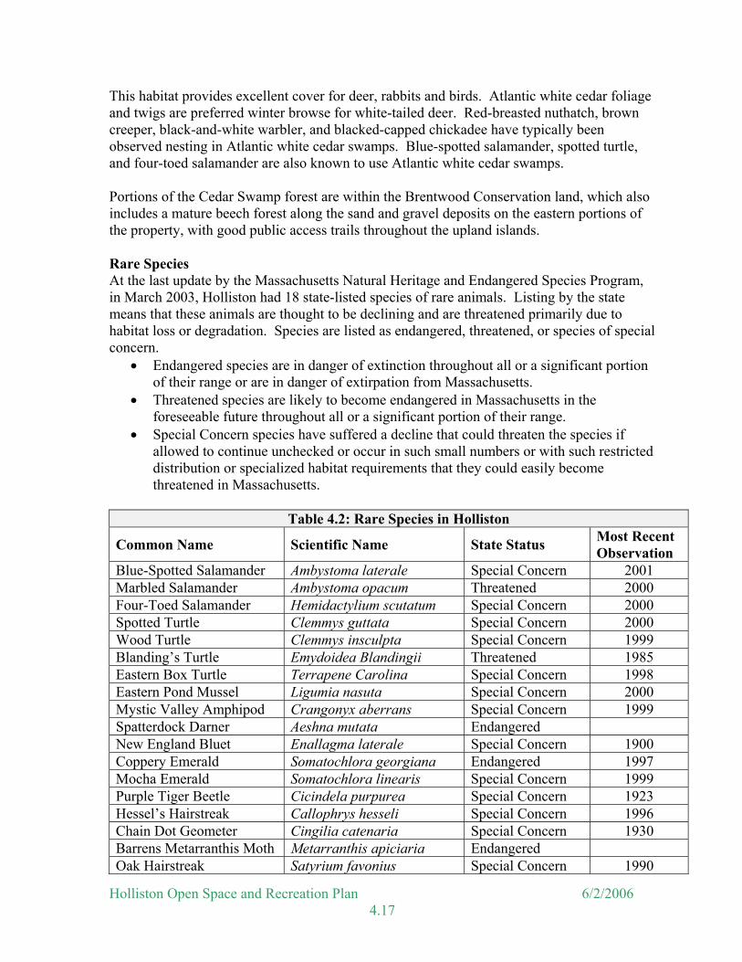
Table 4.2: Rare Species in Holliston
Common Name Scientific Name State Status Most Recent Observation
Blue-Spotted Salamander Ambystoma laterale Special Concern 2001 Marbled Salamander Ambystoma opacum Threatened 2000 Four-Toed Salamander Hemidactylium scutatum Special Concern 2000 Spotted Turtle Clemmys guttata Special Concern 2000 Wood Turtle Clemmys insculpta Special Concern 1999 Blanding’s Turtle Emydoidea Blandingii Threatened 1985 Eastern Box Turtle Terrapene Carolina Special Concern 1998 Eastern Pond Mussel Ligumia nasuta Special Concern 2000 Mystic Valley Amphipod Crangonyx aberrans Special Concern 1999 Spatterdock Darner Aeshna mutata Endangered New England Bluet Enallagma laterale Special Concern 1900 Coppery Emerald Somatochlora georgiana Endangered 1997 Mocha Emerald Somatochlora linearis Special Concern 1999 Purple Tiger Beetle Cicindela purpurea Special Concern 1923 Hessel’s Hairstreak Callophrys hesseli Special Concern 1996 Chain Dot Geometer Cingilia catenaria Special Concern 1930 Barrens Metarranthis Moth Metarranthis apiciaria Endangered Oak Hairstreak Satyrium favonius Special Concern 1990
Holliston Open Space and Recreation Plan 6/2/2006 4.17

There are several species of rare wetlands wildlife occurring in Holliston. The three species of Ambystoma or mole salamanders are usually found in deciduous or mixed forests of hardwood/hemlock where they spend the majority of their life underground. They depend on the occurrence of seasonal pools of standing water in the spring (A. laterale and A. maculatum) and in the fall (A. opacum) to breed and lay their eggs. These pools are often called spring pools or vernal pools. Since these important breeding sites are temporary, they are frequently filled by development activities. The identification and protection of the vernal pools in Holliston should be one of the resource protection priorities of the Conservation Commission. The four-toed salamander breeds in wetland swamps which are dominated by red maple and Atlantic white cedar, vernal pool habitats, and moist sphagnum moss and blueberry wetlands and are quite tolerant of acidic conditions. The adults are terrestrial and are generally found in forested areas near their breeding habitat. The spotted turtle is found in bogs, swamps, small ponds, and in other shallow, unpolluted bodies of water and frequents vernal pools. Blanding’s turtle is primarily aquatic, preferring densely vegetated shallow ponds, marshes, or small streams. It is most often observed on land during nesting activities, but has been known to feed and wander there as well. In Massachusetts, only seven nesting sites are known, containing an undetermined number of individuals. The wood turtle is found in or near slow moving streams with sandy bottoms and heavily vegetated banks. In the spring and summer they are often found meadows, roadsides, hayfields, and upland forests near the streams they use for breeding and winter hibernation. The Eastern Pond Mussel (previously only known historically in Town) has recently been observed in Holliston. It is a freshwater mussel that prefers silty sand and sandy/gravely substrates in slow moving to standing water. The species is only rarely found in streams with moderate current, but has been found to flourish below the falls of old, undisturbed impoundments. The Mystic Valley Amphipod is a freshwater crustacean that is found in lowland aquatic habitats and upland vernal pools in eastern Massachusetts. It is endemic to southeastern New England and its distribution in Massachusetts appears to be restricted to eastern parts of the state. It represents one of the very few species with distributions limited to New England. Vernal Pools Thirty-nine vernal pools have been certified in Holliston, including: seven in the northeastern area of the Cedar Swamp watershed; six in the Weston Pond watershed, six in the Miller Hill area; three near the southern portion of Chicken Brook; one near Factory Pond, two in the northeastern corner of Town, and three in the eastern edge of Town at Bullard Farm just east of Dirty Meadow Brook. An additional 120 areas have been identified as potential vernal pools. If any of these areas are confirmed as vernal pools the Natural Heritage and Endangered Species Program will certify them. Article XXX of the Town Bylaws protects areas subject to flooding or inundation (including verbal pools) and land within 100 feet of these areas. Certified Vernal Pools and potential vernal pools are shown on the map showing the BioMap Core Habitats (Figure 6).
Holliston Open Space and Recreation Plan 6/2/2006 4.18
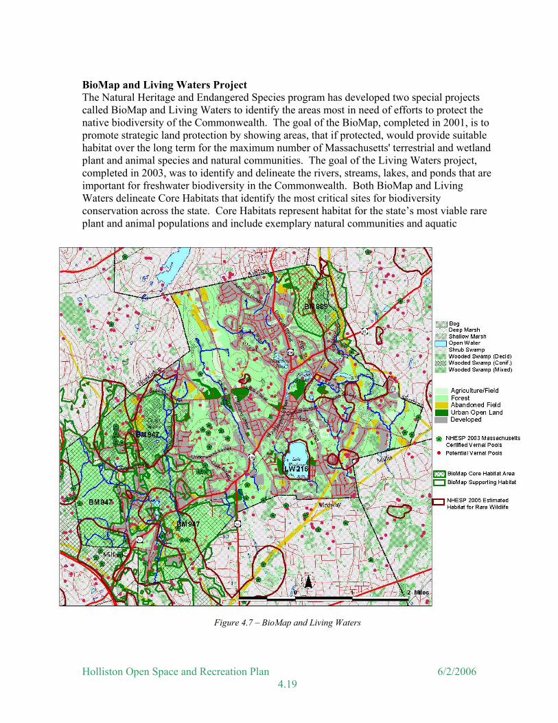
BioMap and Living Waters Project The Natural Heritage and Endangered Species program has developed two special projects called BioMap and Living Waters to identify the areas most in need of efforts to protect the native biodiversity of the Commonwealth. The goal of the BioMap, completed in 2001, is to promote strategic land protection by showing areas, that if protected, would provide suitable habitat over the long term for the maximum number of Massachusetts' terrestrial and wetland plant and animal species and natural communities. The goal of the Living Waters project, completed in 2003, was to identify and delineate the rivers, streams, lakes, and ponds that are important for freshwater biodiversity in the Commonwealth. Both BioMap and Living Waters delineate Core Habitats that identify the most critical sites for biodiversity conservation across the state. Core Habitats represent habitat for the state’s most viable rare plant and animal populations and include exemplary natural communities and aquatic
Figure 4.7 – BioMap and Living Waters
Holliston Open Space and Recreation Plan 6/2/2006 4.19

habitats. To further ensure the protection of Core Habitats and Massachusetts’ biodiversity in the long-term, the BioMap and Living Waters projects identify two additional areas that help support Core Habitats—Supporting Natural Landscapes, and Critical Supporting Watersheds. . Holliston has two BioMap Core Habitats area and one Living Waters Core Habitat. These areas are shown on the accompanying map and described below: Core Habitat BM947 This Core Habitat encompasses a broad area of diverse wetland, riparian, and upland habitats that support a variety of rare turtles, salamanders, butterflies, and dragonflies. The Core Habitat contains a large and good-quality Inland Atlantic White Cedar Swamp, which provides habitat for species such as Hessel’s Hairstreak butterfly. A portion of the area is protected as conservation land (Town Forest, Fairbanks Land, Rocky Woods, and Brentwood Conservation Area) and further protection from habitat fragmentation would help ensure the long-term viability of the rare species found here. Natural Communities of Core Habitat BM947
This Core Habitat contains a very large and high-quality example of the uncommon natural community, the Inland Atlantic White Cedar Swamp. Inland Atlantic White Cedar Swamps are forested wetlands dominated by Atlantic White Cedar, with Hemlock, Spruce, Red Maple, and Yellow Birch. As in all Atlantic White Cedar swamps, water-saturated peat overlies the mineral sediments.
Invertebrates In Holliston, the northern portion of this Core Habitat includes a variety of wetlands such as an Atlantic White Cedar swamp that is habitat for Hessel's Hairstreak butterfly, and a number of small forest streams that are habitat for both the Coppery Emerald dragonfly and the Mocha Emerald dragonfly. In Milford, the southwestern portion of this Core Habitat includes upland oak woods (the "Rocky Woods Range") that are habitat for the Oak Hairstreak butterfly. The power-line cut through the Rocky Woods Range provides open, sunny habitat with nectar sources for the adult butterflies.
Vertebrates This Core Habitat includes the Holliston Cedar Swamp and areas adjacent to Beaver Brook, as well as upper sections of Hopping Brook in Holliston and the Charles River in Milford. It contains seven Certified Vernal Pools and approximately 90 Potential Vernal Pools. Together these areas provide significant habitat for Spotted Turtles and Blue-spotted Salamanders. Habitat for Wood Turtles is also present along the upper reaches of the Charles River, its tributaries, and its associated wetlands.
Core Habitat BM889 This Core Habitat, between Jennings Road and the Dopping Brook Wetlands, includes rocky upland oak woods that are habitat for the rare Oak Hairstreak butterfly. Open and sunny areas around the perimeter of the woods, including human-influenced habitats such as gravel
Holliston Open Space and Recreation Plan 6/2/2006 4.20
pits and power-line cuts, provide sunny areas with nectar sources for the adult butterflies. The Oak Hairstreak butterfly has been known to occur in the vicinity of this Core Habitat for over 35 years. While the habitat is surrounded by development, it was relatively unfragmented until the hill to the west of the Dopping Brook wetlands was recently subdivided and several home sites were developed. The area is located less than 10 km from the population at the Rocky Woods Range in Milford, which probably allows for dispersal of individuals between these two locations. Outside of the Dopping Brook Wetlands, much of this Core Habitat was unprotected. Core Habitat LW216 Lake Winthrop supports four of the state's twelve freshwater mussel species, including the rare Eastern Pondmussel. The Lake Winthrop population of this rare species is particularly significant because young and old, as well as male and female mussels have been found here, which suggests that they are successfully reproducing. The lake has good water clarity, and some mussels can be readily seen in sections of the pond that have a sandy bottom and few aquatic plants. A population of a freshwater jellyfish thought to be Craspedacusta sowerbii was observed in Lake Winthrop in the summer of 2005. This jellyfish is not rare but its appearance is described as sporadic and unpredictable. The obvious adult form, or medusa, appears in some lakes in August and September one year but not in another.
Fisheries and Wildlife The Division of Fisheries and Wildlife manages land along Bogastow Brook, south of Route 16. This area is managed primarily for wildlife habitat, particularly waterfowl. Black duck and wood duck, both of which are experiencing reductions of their populations in New England, nest along Bogastow Brook. Artificial nesting boxes for breeding wood duck have been established, but are not regularly maintained. Other fisheries and wildlife resources in this area include trout, pheasants, songbirds, beavers and small mammals. According to the Division of Fisheries and Wildlife, there is semi-annual stocking of approximately 2,500 brown trout and brook trout measuring 9 to 12 inches into Bogastow Brook. This area is open to the public for fishing. The Holliston Conservation Commission and the Army Corps of Engineers presently maintain ownership of the Holliston Cedar Swamp. The Division of Fisheries and Wildlife manages the wildlife resources in this area, although there are presently no active wildlife management activities on this land. A series of upland islands run north to south through the center of the Cedar Swamp, and most of the significant cedar habitat occurs west of these islands. Bat boxes have been placed in the woods to encourage roosting by these insectivorous mammals. Some of the wildlife identified within the Town includes coyote, fisher, beaver, otter, opossum, fox, muskrat, bluebird, great blue heron, turtles, frogs, salamanders, snakes, bats,
Holliston Open Space and Recreation Plan 6/2/2006 4.21

Figure 4.8 – Wildlife Corridors
Source: MassGIS, Holliston Conservation Associates. deer, turkey, waterfowl, trout, pheasant, songbirds and small mammals. A bear was seen in Millis in June 2005. The same bear may also have been seen in Westwood and Norwood. While such sightings are unusual, it is only a matter of time before a bear is spotted in Holliston. The bear population in Massachusetts is increasing and now is estimated to be between 2,500 and 3,000. Most bear occur in the western part of the state but along with moose, they are increasing seen in Worcester County and the area to the east. Large areas of undeveloped land such as the Town Forest, Waseeka Reservation, Brentwood Conservation Area and Wenakeening Woods provide valuable wildlife habitat. Holliston also has a variety of significant wildlife corridors. Some of these corridors are located along wetlands and brook systems that traverse the Town, including Dopping Brook area, Chicken Brook area and the Cedar Swamp area. Transmission lines also provide opportunities for animals to move from one area to another and serve as wildlife corridors. Marc Connelly, a resident wildlife expert, has identified several wildlife corridors. These wildlife corridors, major open
Holliston Open Space and Recreation Plan 6/2/2006 4.22
spaces, transmission lines and wetland and brook systems are indicated on Figure 7. Many of these corridors also connect the town’s open spaces with open space in other towns. Hunting is not allowed in Holliston except with the consent of the Selectmen on public property or the consent of the owner on private property.
Summary
Vegetation and wildlife resources often go unappreciated until they are lost. Vegetation provides the visual backdrop and much of the character of the Town, while also providing wildlife habitat and scenic hiking and picnicking areas. Wildlife can provide recreational value to the area in terms of wildlife viewing and fishing. Bird watching and other wildlife observation are also valuable recreational and aesthetic opportunities. Exposure to and awareness of the natural environment can promote the awareness of the need for conservation for the youth of the Town.
Unique Features Visual and cultural values consist of an array of interrelated, intangible values that benefit the public, but are often very difficult to measure. These include aesthetic, recreational, educational and other heritage values. The term "heritage value" is used to define special uses or meanings that individuals have attached to a particular area because of personal or cultural interactions with that area. Marshes and other wetlands, for example, contribute directly to the scenic value of landscapes and add to landscape diversity. This value of aesthetics is achieved through direct recreational usage as well as from distance viewing. The recreational values vary greatly according to user and landform type. Recreational activities may range from bird watching and picnicking to walking, canoeing, hunting and fishing.
Jasper’s Rock
In 1660, Henry Adams of Medfield purchased part of the Lusher Grant in Holliston that included Mount Hollis and the meadowlands below it. He mowed the meadows and pastured his livestock, sending his sons Eleazur and Jasper to tend his flocks. Tradition tells us that a cabin was built on or near the hill and that from a large rock on the top of the hill Jasper sent smoke signals to his family in Medfield to assure them that he was still on duty. The rock from which the signal fires were sent was later used as a point in surveying the surrounding towns. Today Jasper's Rock is designated as a Historical Marker and can be reached from the upper part of Fairlane Way.
Holliston Open Space and Recreation Plan 6/2/2006 4.23
Many scenic areas may also serve as areas of scientific research and as outdoor educational exhibits to demonstrate the dynamics of ecological relationships or the natural or manmade history of a culture, landform, town or entire region. Holliston has several important natural and historical manmade features that contribute both visually to the Town and historically, including Lake Winthrop, Weston Pond, Mount Hollis, Jasper’s Rock (see above), the stone railroad bridge on Woodland Street, and the stone pile at the golf course. These unique features and scenic resources have been mapped on Figure 3.
Cultural and Historic Areas Well-preserved physical evidence of a community’s past helps to give each resident and the community a sense of its location in time and space. The present form of Holliston is derived from the numerous decisions made by those who lived here in the past - where to live, the type of structure to live in, how to support families. The evidence of each of these individual decisions is still present in many ways and can remain for our own pleasure and that of future generations, if steps are taken to preserve this heritage. In 1989, the Massachusetts Historical Commission designated the Thomas Hollis Historic District. This district includes Washington Street, from Highland Street to Winter Street. In 2002, they designated the East Holliston Historic District, also on Washington Street between Locust Street and Concord Street. This new district includes over 40 Washington Street homes most of which were built in the late 1700s and early 1800s. The Isaac Bullard House is listed on the Massachusetts State Register of Historic Places as a National Register individual property and also as part of the First Period Buildings of Eastern Massachusetts National Register Thematic Resource Area, which includes 113 properties from 46 towns. The Bullard Farm is also listed as a National Register property. Figure 3 also identifies the location of Holliston’s various historical homes and sites throughout the Town. The natural and cultural unique features of the Town contribute to the overall Town character and also create a sense of common history and community bond. Unique natural features are important to protect for their visual impact and their function as part of the natural environment. Cultural, historic and man-made features are also important scenic resources. Historic resources provide a connection to the past and a reminder of what the Town was like in the years past. Holliston strives to maintain its historic nature and promote new development in harmony with the existing environment.
Environmental Challenges There are several challenges, both in the community and in the region, which may affect the future of the town’s open space and recreation resources. These include hazardous waste sites, landfills, erosion, flooding, sedimentation, and effects of continued development, water pollution, and others.
Holliston Open Space and Recreation Plan 6/2/2006 4.24
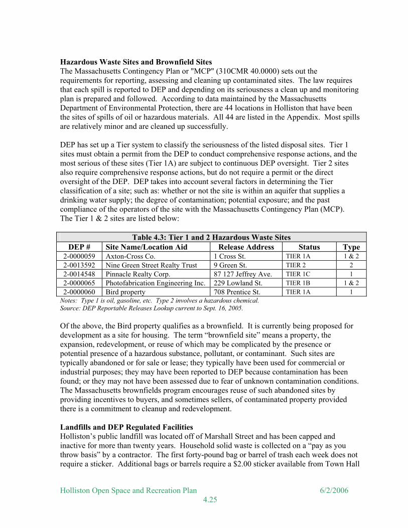
Hazardous Waste Sites and Brownfield Sites The Massachusetts Contingency Plan or "MCP" (310CMR 40.0000) sets out the requirements for reporting, assessing and cleaning up contaminated sites. The law requires that each spill is reported to DEP and depending on its seriousness a clean up and monitoring plan is prepared and followed. According to data maintained by the Massachusetts Department of Environmental Protection, there are 44 locations in Holliston that have been the sites of spills of oil or hazardous materials. All 44 are listed in the Appendix. Most spills are relatively minor and are cleaned up successfully. DEP has set up a Tier system to classify the seriousness of the listed disposal sites. Tier 1 sites must obtain a permit from the DEP to conduct comprehensive response actions, and the most serious of these sites (Tier 1A) are subject to continuous DEP oversight. Tier 2 sites also require comprehensive response actions, but do not require a permit or the direct oversight of the DEP. DEP takes into account several factors in determining the Tier classification of a site; such as: whether or not the site is within an aquifer that supplies a drinking water supply; the degree of contamination; potential exposure; and the past compliance of the operators of the site with the Massachusetts Contingency Plan (MCP). The Tier 1 & 2 sites are listed below:
Table 4.3: Tier 1 and 2 Hazardous Waste Sites DEP # Site Name/Location Aid Release Address Status Type
2-0000059 Axton-Cross Co. 1 Cross St. TIER 1A 1 & 2 2-0013592 Nine Green Street Realty Trust 9 Green St. TIER 2 2 2-0014548 Pinnacle Realty Corp. 87 127 Jeffrey Ave. TIER 1C 1 2-0000065 Photofabrication Engineering Inc. 229 Lowland St. TIER 1B 1 & 2 2-0000060 Bird property 708 Prentice St. TIER 1A 1
Notes: Type 1 is oil, gasoline, etc. Type 2 involves a hazardous chemical. Source: DEP Reportable Releases Lookup current to Sept. 16, 2005. Of the above, the Bird property qualifies as a brownfield. It is currently being proposed for development as a site for housing. The term “brownfield site” means a property, the expansion, redevelopment, or reuse of which may be complicated by the presence or potential presence of a hazardous substance, pollutant, or contaminant. Such sites are typically abandoned or for sale or lease; they typically have been used for commercial or industrial purposes; they may have been reported to DEP because contamination has been found; or they may not have been assessed due to fear of unknown contamination conditions. The Massachusetts brownfields program encourages reuse of such abandoned sites by providing incentives to buyers, and sometimes sellers, of contaminated property provided there is a commitment to cleanup and redevelopment. Landfills and DEP Regulated Facilities Holliston’s public landfill was located off of Marshall Street and has been capped and inactive for more than twenty years. Household solid waste is collected on a “pay as you throw basis” by a contractor. The first forty-pound bag or barrel of trash each week does not require a sticker. Additional bags or barrels require a $2.00 sticker available from Town Hall
Holliston Open Space and Recreation Plan 6/2/2006 4.25

and several local stores. The waste is eventually transported from Holliston and disposed of outside of the Town. Small recyclable materials are also picked curbside by a contractor. Portions of the former Marshall Street landfill are utilized for a Town composting area and recycling center. Un-bagged yard debris is accepted at the Marshall Street landfill for composting. The recycling center is utilized for larger recyclables that cannot be collected curbside. There is also an inactive landfill located on Union Street, which has been abandoned for decades. This landfill is capped, although not by today’s standards, and unlined. The landfill was used for household wastes and the waste was burned. Therefore, most of the waste at the landfill consists of ash. Several private companies in town have operations that are regulated by the DEP Bureau of Waste Prevention. Inclusion on this list does not indicate that a release of oil and/or hazardous materials has occurred, only that hazardous materials are generated on site or that the company has a treatment, storage and/or disposal facility. These could be considered “high risk” sites, particularly if they are located within an aquifer or Zone II. These sites are subject to inspection by DEP and the Board of Health to ensure compliance with waste prevention regulations.
Table 4.4: DEP Regulated Sites Facility ID Name Address Air HZW TURA
130389 Lista International 106 Lowland St. Y Y 130390 WF Wood Inc. 29 Everett Rd. Y 130387 Bardon Trimount 24 Lowland St. Y 137729 Axton Cross 1 Cross Street Y
Source: MassGIS current to March 2005 Notes: Air = Facilities with Air Operating Permits.
HZW = Hazardous Waste Recyclers TURA = Facilities permitted as large quantity toxics users and falling under the requirements of the Toxic Use Reduction Act
Underground Storage Tanks Underground storage tanks (UST) for oil or other chemicals are another potential source of groundwater contamination. The Underground Storage Tank regulations are designed to protect public safety from the hazards posed by the leakage of flammable and combustible liquids and to prevent environmental damage caused by leaking tanks. All regulated USTs must incorporate equipment to prevent and detect leaks, including cathodic protection, double walls and monitoring systems. Massachusetts’ regulations required that all existing tanks be upgraded to include leak detection and cathodic protection or be removed by December 22, 1998. Figure 8 shows the location of underground storage tanks, major hazardous waste spill sites, DEP regulated hazardous materials sites, and their relationship to the town’s aquifers.
Holliston Open Space and Recreation Plan 6/2/2006 4.26

Erosion Environmental quality at a particular location can be notably diminished through the loss of soil, or erosion. Erosion reduces the land’s capability to restore its vegetative cover. Steep slopes are particularly susceptible to erosion when plant cover is removed or when the surface is paved. Surface runoff is accelerated by erosion that may lead to increasing pollutants in surface waters. As the easily developable flat terrain in Holliston is being built out, development is encroaching into the steeper areas. The steeper areas are more likely to erode and cause sedimentation in downstream waters. The Conservation Commission under the Wetlands Protection Act require erosion and sedimentation barriers as part of Orders of Conditions issued for work within the Conservation Commission’s jurisdiction. These barriers are placed at the limit of work, between the disturbed area and wetland resource areas prior to construction. The Commission also requires that the disturbed soils be stabilized prior to the removal of the erosion control barriers.
Figure 4.9 – Hazardous Waste Sites
Holliston Open Space and Recreation Plan 6/2/2006 4.27
Chronic Flooding As previously mentioned, several flood prone areas have been identified by FEMA. These areas are generally associated with the many brooks that cross the Town. One area of chronic flooding was located on Washington Street (Route 16) near Cedar Swamp. Prior to the previous update, the Massachusetts Highway Department performed work in this area that has alleviated the flooding problem, but recent flooding has occurred. Flooding of streets may occur when culverts are temporarily blocked, however, no other chronic flooding problems have been identified in Town. Sedimentation Sedimentation occurs when solid material that is in suspension, is transported, or has been moved from its original location. Sedimentation can have various effects on water quality. High concentrations of suspended sediment in water bodies and waterways can alter the physical and chemical composition of the water. Sedimentation can increase turbidity, reduce light penetration, clog gills of fish and aquatic invertebrates, fill in the water body/way, and can carry toxic materials and trace metals. The primary source of sedimentation in Holliston is from construction activities. Sedimentation is generally controlled at construction sites by erosion and sedimentation control barriers required by the Conservation Commission. Additionally, the Conservation Commission also ensures that new construction near wetlands meet the nine standards required under the DEP Stormwater Management Policy that was issued in March 1997. The standards cover pre-construction and post-construction activities to improve the water quality of stormwater runoff from developed areas, provide recharge to groundwater, and otherwise protect resource areas that may be negatively affected by stormwater runoff. The nine standards are listed below.
STANDARD 1 No new stormwater conveyance (e.g. outfalls) may discharge untreated stormwater directly to or cause erosion in wetlands or waters of the Commonwealth. STANDARD 2 Stormwater management systems must be designed so that post-development peak discharge rates do not exceed pre-development peak discharge rates. STANDARD 3 Loss of annual recharge to groundwater should be minimized through the use of infiltration measures to the maximum extent practicable. The annual recharge from the post development site should approximate the annual recharge from the pre-development or existing conditions, based on soil types. STANDARD 4 For new development, stormwater management systems must be designed to remove 80% of the average annual load (post-development conditions) of Total Suspended Solids (TSS).
Holliston Open Space and Recreation Plan 6/2/2006 4.28
STANDARD 5 Stormwater discharges from areas with higher potential pollutant loads require the use of specific stormwater management Best Management Practices. The use of infiltration practices without pretreatment is prohibited. (See summary after Section 4.3.4 for a definition of BMPs.) STANDARD 6 Stormwater discharges to critical areas must utilize certain stormwater management BMPs approved for critical areas. Critical areas are Outstanding Resource Waters, shellfish beds, swimming beaches, coldwater fisheries and recharge areas for public water supplies. STANDARD 7 Redevelopment of previously developed sites must meet the Stormwater Management Standards to the maximum extent practicable. However, if it is not practicable to meet all the Standards, new (retrofitted or expanded) stormwater management systems must be designed to improve existing conditions.
STANDARD 8 Erosion and sediment controls must be implemented to prevent impacts during construction or land disturbance activities. STANDARD 9 All stormwater management systems must have an operation and maintenance plan to ensure that systems function as designed.
The Board of Health reviews stormwater management systems for all projects that are heard before the Planning Board. The Board of Health and Conservation Commission should work together to provide consistent stormwater management review of all projects, not just those located near wetlands. Development Impact The primary concerns for residents regarding development is both its effects on the quality of life in Holliston and its impacts on the environment. Residential housing development continues, and it can be expected that the population will continue to increase. Holliston has reworked the Zoning By-Law making the Town more attractive to businesses. Growth can strain existing drainage systems, increase road maintenance and repair costs and generally overburden the Town’s infrastructure. However, the greatest concern is that this development will continue to impinge on undeveloped land, or partially protected areas. The Open Space Committee in conjunction with the Conservation Commission has identified several properties and/or areas that are of interest for open space purposes (see Section 5). Maintaining the open space qualities of designated Chapter 61 agricultural lands is also important. Ground and Surface Water Pollution Groundwater pollution can generally be described in terms of point and non-point source pollution. Point source pollution can be traced to a particular storm drain or other identifiable source of pollution. Non-point source pollution cannot be traced back to a particular point source (such as a pipe) and is usually associated with surface runoff. Driveways and lawns, for example, serve to collect oil, fertilizers, and other harmful substances. Water that cannot be absorbed into these surfaces will continue flowing until a
Holliston Open Space and Recreation Plan 6/2/2006 4.29

new drainage path is found. Water bodies serve as the final destination for non-point pollution. Groundwater obtained from six wells in Town currently supply the water needs of 90-95% of the Town. There have been few problems with pollution in these wells. High iron content was noted in well No. 3 in the 1993 Update; however, iron alters the aesthetics (taste, color, appearance) of the water but is not considered hazardous for human consumption. Casella Waste Management Site In 1972 the town approved a permit for an operation at the eastern end of Washington Street to process and recycle solid waste. The permit limited the facility to 105 tons and 20 truck trips per day. The current operator, Casella Waste Management of Massachusetts, Inc., is processing up to 850 tons of municipal waste per day, with more than 300 truck trips through the center of town. The site is located on the Dopping Brook aquifer and less than ½ mile from the town’s #6 well. There were illegal sub-surface disposals of refuse and waste materials within one hundred feet of a wetland in 1975 that prompted the Conservation Commission to issue a Cease and Desist order. In 1989 and again in 1995 there was evidence of hazardous chemical spills associated with the operation and the Department of Environmental Protection issued cleanup orders. Continuing concerns about truck traffic and water contamination have prompted the formation of the Holliston-Sherborn Residents Group (www.hsrg.info). High levels of iron and manganese have been detected at well #6 and the Town Water Department is developing a treatment plant to address these chemicals.
Summary Environmental problems continue to be an issue in the protection of the natural resources of the Town. Past landfill activities and hazardous waste spills can have long lasting effects on the surrounding environment. DEP listed disposal sites are undergoing remediation activities to clean up the contamination. It is important to note that each household also contains quantities of hazardous materials in the form of oil, gasoline, paint and various cleaning products, to name a few. Residents of Holliston also need to be educated on which products are hazardous and what is the proper disposal of these products. Businesses, industries and residents need to control the use and disposal of hazardous materials to protect Holliston’s natural environment.
Perhaps the biggest environmental challenge to the open space and recreation resources of the town is associated with the impacts of future development. As noted in Section 3, many currently undeveloped or underdeveloped sites, including agricultural and forested areas, are unprotected and could be developed. One of the Town’s BioMap areas has already been reduced by recent home construction. The following sections will inventory lands of conservation and recreation interest and develop a vision and action plan to protect these resources.
Holliston Open Space and Recreation Plan 6/2/2006 4.30
![Highlands Environmental Resource Inventory for the [insert ...€¦ · Highlands Environmental Resource Inventory for the [insert municipal name]Tewksbury Township 5 Purpose and Scope](https://img.pdfslide.us/doc/110x75/5f6c77a5c7b0b02c0571057d/highlands-environmental-resource-inventory-for-the-insert-highlands-environmental.jpg)