Embed Size (px)
Citation preview
Geo-environmental data inventory of Katanga Province (Democratic Republic of Congo)
through a WebGIS platform.Vanbrabant Y., Burlet C.1, Dupin L., Goethals H. & Thys T.
Geological Survey of Belgium, Royal Belgian Institute for Natural Sciences,
Rue Jenner 13, BE-1000 Brussels, Belgium
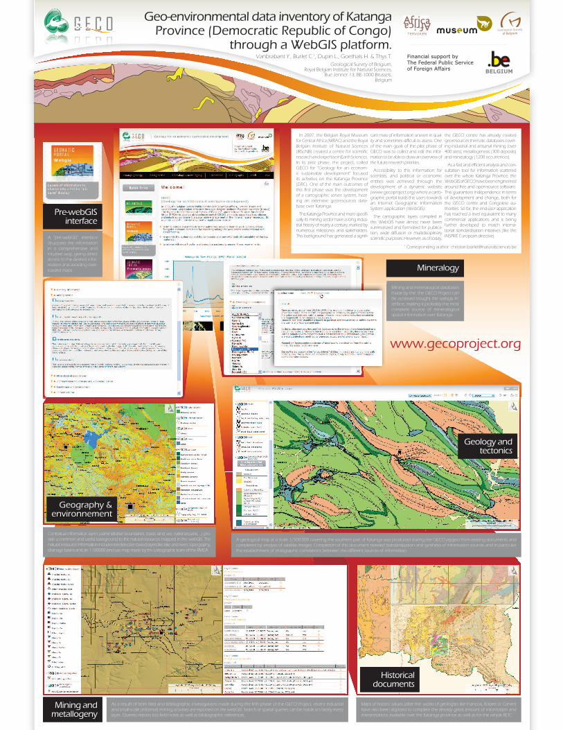
In 2007, the Belgian Royal Museum for Central Africa (MRAC) and the Royal Belgian Institute of Natural Sciences (IRScNB) created a centre for scientific research and expertise in Earth Sciences. In its pilot phase, the project, called GECO for “Geology for an econom-ic sustainable development” focused its activities on the Katanga Province (DRC). One of the main outcomes of this first phase was the development of a cartographic server system, host-ing an extensive georesources data-base over Katanga.
The Katanga Province and more specifi-cally its mining sector have a long indus-trial history of nearly a century, marked by numerous milestones and stakeholders. This background has generated a signifi-
cant mass of information uneven in qual-ity and sometimes difficult to assess. One of the main goals of the pilot phase of GECO was to collect and edit this infor-mation to be able to draw an overview of the future research priorities.
Accessibility to this information for scientists, and political or economic entities was achieved through the development of a dynamic website (www.gecoproject.org) where a carto-graphic portal leads the users towards an Internet Geographic Information System application (WebGIS).
The cartographic layers compiled in this WebGIS have almost never been summarized and formatted for publica-tion, wide diffusion or multidisciplinary scientific purposes. However, as of today,
the GECO centre has already created georesources thematic databases cover-ing industrial and artisanal mining (over 400 sites), metallogenesis (300 deposits) and mineralogy (1200 occurrences).
As a fast and efficient analysis and con-sultation tool for information scattered over the whole Katanga Province, the WebGIS of GECO have been engineered around free and open-source software. This guarantees independence in terms of development and change, both for the GECO centre and Congolese au-thorities. So far, the end-user application has reached a level equivalent to many commercial applications and is being further developed to match interna-tional standardisation initiatives (like the INSPIRE European directive).
Pre-webGIS interface
Mining and metallogeny
Mineralogy
A “pre-webGIS” interface structures the information in a comprehensive and intuitive way, giving direct access to the desired infor-mation and avoiding over-loaded maps.
As a resulft of both field and bibliographic investigations made during the firth phase of the GECO Project, recent industrial and small-scale (informal) mining activities are reported on the webGIS. Search or spatial queries can be made on nearly every layer. Queries reports lists field notes as well as bibliographic references.
Mining and mineralogical databases made by the the GECO Project can be accessed trought the webgis in-terface, making it probably the most complete source of mineralogical spatial information over Katanga.
Contextual information layers (administrative boundaries, roads, land use, national parks, ...) pro-vide a common and useful background to the natural resources mapped in the webGIS. The natural ressource information includes teledetection based layers like lake and rivers, topography, drainage basins and an 1:100000 land use map made by the cartographic team of the RMCA.
Maps of historic values (after the works of geologists like François, Robert or Cahen) have also been digitised to complete the already great amount of information and interpretations available over the Katanga province as well as for the whole RDC.
A geological map at a scale 1/500.000 covering the southern part of Katanga was produced during the GECO prjoject from existing documents and completed by analysis of satellite images. Completion of this document needed standardization and synthesis of information sources and in particular the establishment of stratigraphic correlations between the different sources of information.
1 Corresponding author: [email protected]
Geology and tectonics
Historical documents
Geography & environnement
www.gecoproject.org


![[NOV - DEC 2014] Exposing Ecuador- Katanga Johnson Newsletter](https://img.pdfslide.us/doc/110x75/55c781dfbb61eb29528b4825/nov-dec-2014-exposing-ecuador-katanga-johnson-newsletter.jpg)