Embed Size (px)
Citation preview

Prepared for Peet Limited September 2017
Section 38 Referral Supporting Documentation Lot 102 Farrall Road, Midvale Project No: EP16-009
Section 38 Referral Supporting Documentation Lot 102 Farrall Road, Midvale
Prepared for Peet Limited Doc No.: EP16-009(14)--038 CKK| Version: B
Project number: EP16-009|September 2017 Page i
Document Control
Doc name: Section 38 Referral Supporting Documentation Lot 102 Farrall Road, Midvale
Doc no.: EP16-009(14)--038 CKK
Version Date Author Reviewer
1 June 2017 Jessica Lisle JHL Chrystal King CKK
A September 2017 Chrystal King CKK Anna Welker ACW
Updated prior to submission to EPA.
B September 2017 Chrystal King CKK Anna Welker ACW
Updated to include EPBC Act referral timing.
© 2017 Emerge Associates All Rights Reserved. Copyright in the whole and every part of this document belongs to Emerge Associates and may not be used, sold, transferred, copied or reproduced in whole or in part in any manner or form or in or on any media to any person without the prior written consent of Emerge Associates.

Section 38 Referral Supporting Documentation Lot 102 Farrall Road, Midvale
Prepared for Peet Limited Doc No.: EP16-009(14)--038 CKK| Version: B
Project number: EP16-009|September 2017 Page ii
Table of Contents
1 Introduction ...........................................................................................................................................1
1.1 Purpose and scope ............................................................................................................................ 1 1.2 Proponent ......................................................................................................................................... 1 1.3 Environmental impact assessment process ...................................................................................... 2 1.4 Other approvals and regulation ........................................................................................................ 2
2 The Proposal ..........................................................................................................................................4
2.1 Background ....................................................................................................................................... 4 2.2 Justification of development ............................................................................................................ 4 2.3 Proposal description ......................................................................................................................... 5
3 Existing Environment .............................................................................................................................6
3.1 Soils ................................................................................................................................................... 6 3.2 Flora and Vegetation ......................................................................................................................... 6
3.2.1 Remnant FCT 20c vegetation ............................................................................................ 6 3.2.2 Threatened and priority flora ............................................................................................ 7 3.2.3 Disturbed areas with little or no native species present................................................... 7 3.2.4 Bush Forever ..................................................................................................................... 7
3.3 Terrestrial Fauna ............................................................................................................................... 8 3.4 Hydrology .......................................................................................................................................... 9
3.4.1 Groundwater ..................................................................................................................... 9 3.4.2 Surface Water ................................................................................................................... 9 3.4.3 Wetlands ........................................................................................................................... 9 3.4.4 Public Drinking Water Sources ........................................................................................ 10
3.5 Heritage .......................................................................................................................................... 10 3.5.1 Indigenous Heritage ........................................................................................................ 10 3.5.2 Non-Indigenous Heritage ................................................................................................ 10
4 Stakeholder engagement ..................................................................................................................... 11
4.1 Key stakeholders ............................................................................................................................. 11 4.2 Stakeholder consultation ................................................................................................................ 11
5 Potential Key Environmental Factors and Impact Assessment ............................................................. 12
5.1 Key environmental factor - Flora and Vegetation ........................................................................... 12 5.1.1 EPA objective ................................................................................................................... 12 5.1.2 Policy and guidance ......................................................................................................... 12 5.1.3 Receiving environment ................................................................................................... 12 5.1.4 Potential impacts ............................................................................................................ 13 5.1.5 Assessment of impacts .................................................................................................... 13 5.1.6 Mitigation ........................................................................................................................ 14 5.1.7 Predicted outcome .......................................................................................................... 16
6 Other environmental factors or matters .............................................................................................. 18
7 Matters of National Environmental Significance .................................................................................. 19
8 Holistic impact assessment .................................................................................................................. 20
9 References ........................................................................................................................................... 22
9.1 General references ......................................................................................................................... 22

Section 38 Referral Supporting Documentation Lot 102 Farrall Road, Midvale
Prepared for Peet Limited Doc No.: EP16-009(14)--038 CKK| Version: B
Project number: EP16-009|September 2017 Page iii
List of Tables
Table 1: Proponent details ...................................................................................................................................... 1 Table 2: Other approval and regulations ................................................................................................................. 3 Table 3 Aboriginal Heritage Sites within the site................................................................................................... 10 Table 4: Mitigation measures to minimise impacts to significant flora and vegetation ....................................... 16 Table 5: Assessment of other environmental factors. .......................................................................................... 18 Table 6: Significance test ....................................................................................................................................... 20
Figures
Figure 1: Site Locality Figure 2: Plant Communities Figure 3: Vegetation Condition Figure 4: Significant Environmental Values Figure 5: Management Areas and Zones
Appendices
Appendix A
Movida Local Structure Plan
Appendix B
Subdivision Plan
Appendix C
Technical Memorandum, Emerge Associates 2017
Appendix D
Rehabilitation and Vegetation Management Plan
Appendix E
Section 18 Consent
Appendix F
DBCA approval of RVMP
Section 38 Referral Supporting Documentation Lot 102 Farrall Road, Midvale
Prepared for Peet Limited Doc No.: EP16-009(14)--038 CKK| Version: B
Project number: EP16-009|September 2017 Page 1
1 Introduction
1.1 Purpose and scope
The purpose of this document is to support a Section 38 referral pursuant to the Environmental
Protection Act 1986 (EP Act), associated with an application for subdivision of Lot 102 Farrall Road,
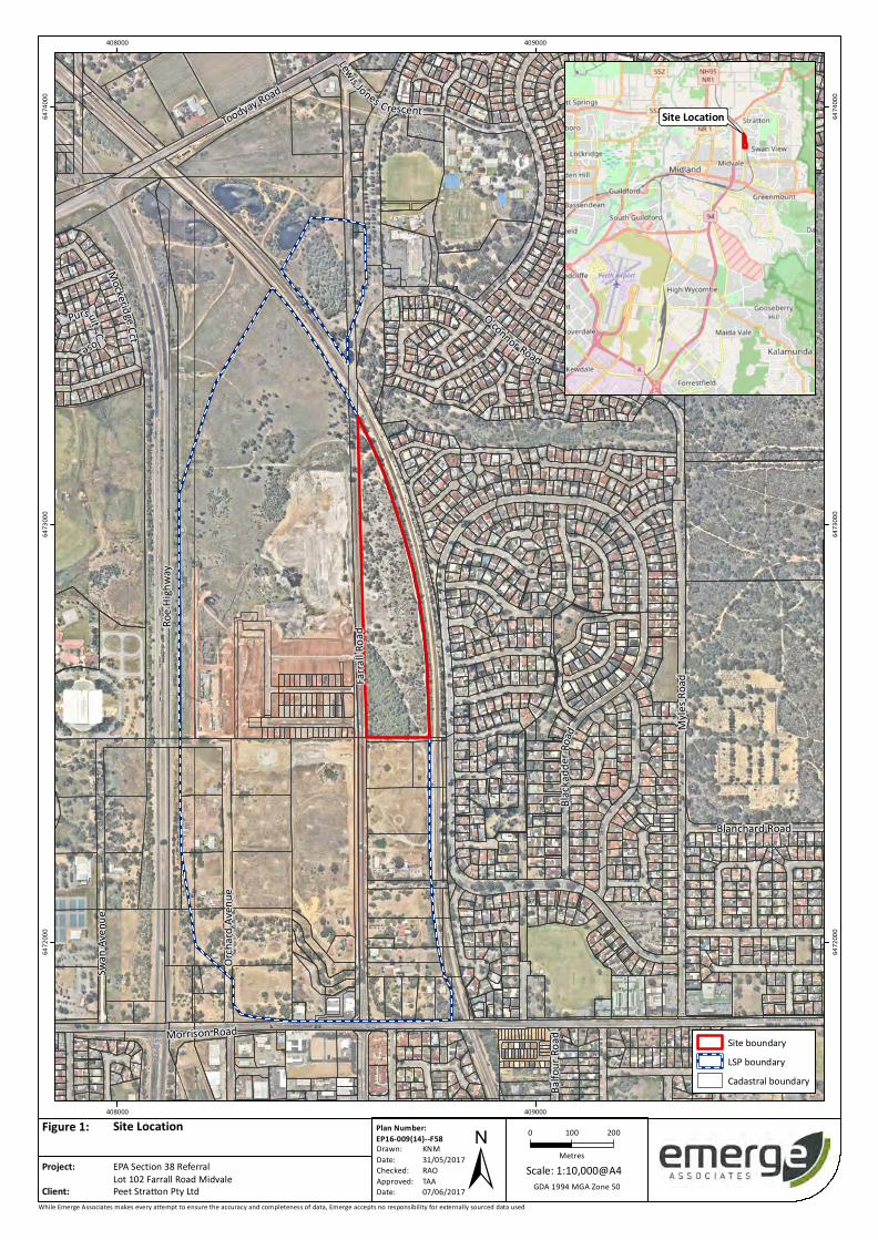
Midvale, Western Australia (herein referred to as ‘the site’ and shown Figure 1). Peet Stratton Pty
Ltd propose to develop the site for urban uses as part of the wider Movida residential development.
The Local Structure Plan (LSP) inclusive of the wider Estate and Lot 102 was approved by the Western
Australian Planning Commission (WAPC) on 15 September 2016. The LSP is provided as Appendix A.
The site was zoned ‘Urban’ under the Metropolitan Region Scheme (MRS) prior to 1996. At that
time, there were no provisions in the EP Act for the Environmental Protection Authority (EPA) to
review scheme amendments. This document has been prepared to provide succinct information for
the EPA in support of the subdivision application of the site. The proposed subdivision layout has
been provided in Appendix B.
1.2 Proponent
Table 1 provides the details of the proponent, Peet Stratton Pty Ltd.
Table 1: Proponent details
Proponent Details
Name Peet Stratton Pty Ltd
ACN/ABN 31 169 385 139 (ABN)
Postal Address PO Box 7224, Cloisters Square WA 6850
Proponent contact Paul Morgan Development Director, Operations Peet Limited [email protected]
Project Manager (Peet)
Julia Griffiths Development Manager Peet Limited 9420 1111 [email protected]
Consultant contact (Emerge Associates)
Chrystal King Suite 4, 26 Railway Road, Subiaco WA (08) 9380 4988 [email protected]
Section 38 Referral Supporting Documentation Lot 102 Farrall Road, Midvale
Prepared for Peet Limited Doc No.: EP16-009(14)--038 CKK| Version: B
Project number: EP16-009|September 2017 Page 2
1.3 Environmental impact assessment process
As part of the LSP approval process for the wider Movida residential development, a range of
environmental investigations were completed including specific fauna, flora and vegetation surveys.
The site-specific investigations for the site included:
• Geotechnical Investigation Report (MPA Williams & Associates 2005).
• Geotechnical Investigation (GHD 2008).
• Transport Assessment (Shawmac 2010).
• Road and Rail Acoustics Assessment (Herring Storer Acoustics 2010).
• Environmental Assessment Report (Coffey Environments 2010).
• Local Water Management Strategy (GHD 2010).
• Servicing Strategy Report (GHD 2010).
• Road and Rail Acoustic Assessment (Herring Storer Acoustics 2015).
• Geotechnical and Preliminary Acid Sulphate Soil Investigation (Douglas Partners 2014).
• Fire Management Plan (Natural Area Consulting Management Services 2015).
• Open Space Master Plan (Place Laboratory 2015).
• Local Water Management Strategy (Emerge Associates 2015d)
• Flora, Vegetation and Wetland Assessment (Emerge Associates 2015c).
• Fauna and Fauna Habitat Assessment (Greg Harewood 2014).
• Biophysical Assessment of Blackadder Creek and Woodbridge Creek (Emerge Associates 2015a).
The results of these surveys have been summarised in the Environmental Assessment and
Management Strategy (EAMS) (Emerge Associates 2015b) that was submitted as part of the LSP
documentation. During the LSP process consideration was given to the retention and management
of significant environmental features on the site.
Subsequent to the flora and vegetation investigations undertaken as part of the LSP process (Coffey
Environments 2010; Emerge Associates 2015c), a winter flora and vegetation assessment was
undertaken by Tauss & Associates (2016) and additional vegetation survey and mapping by Emerge
Associates (also in 2016). Whilst plant community and vegetation condition mapping is generally
consistent between these investigations, there are some minor differences.
For the purposes of this referral, a technical memorandum has been prepared to update the flora
and vegetation information from Emerge Associates (2015c) with information obtained by Emerge
Associates in February and June 2016 and by Tauss & Associates in June 2016. This technical
memorandum (Emerge Associates 2017b) has been provided in Appendix C.
1.4 Other approvals and regulation
Lot 102 is zoned ‘urban’ and ‘residential development’ under the MRS and the City of Swan Local
Planning Scheme (LPS) No. 17 respectively. The LSP for the wider Movida residential development
(inclusive of the site) was approved by the Western Australian Planning Commission (WAPC) on 15
September 2016 and is provided as Appendix A.
Section 38 Referral Supporting Documentation Lot 102 Farrall Road, Midvale
Prepared for Peet Limited Doc No.: EP16-009(14)--038 CKK| Version: B
Project number: EP16-009|September 2017 Page 3
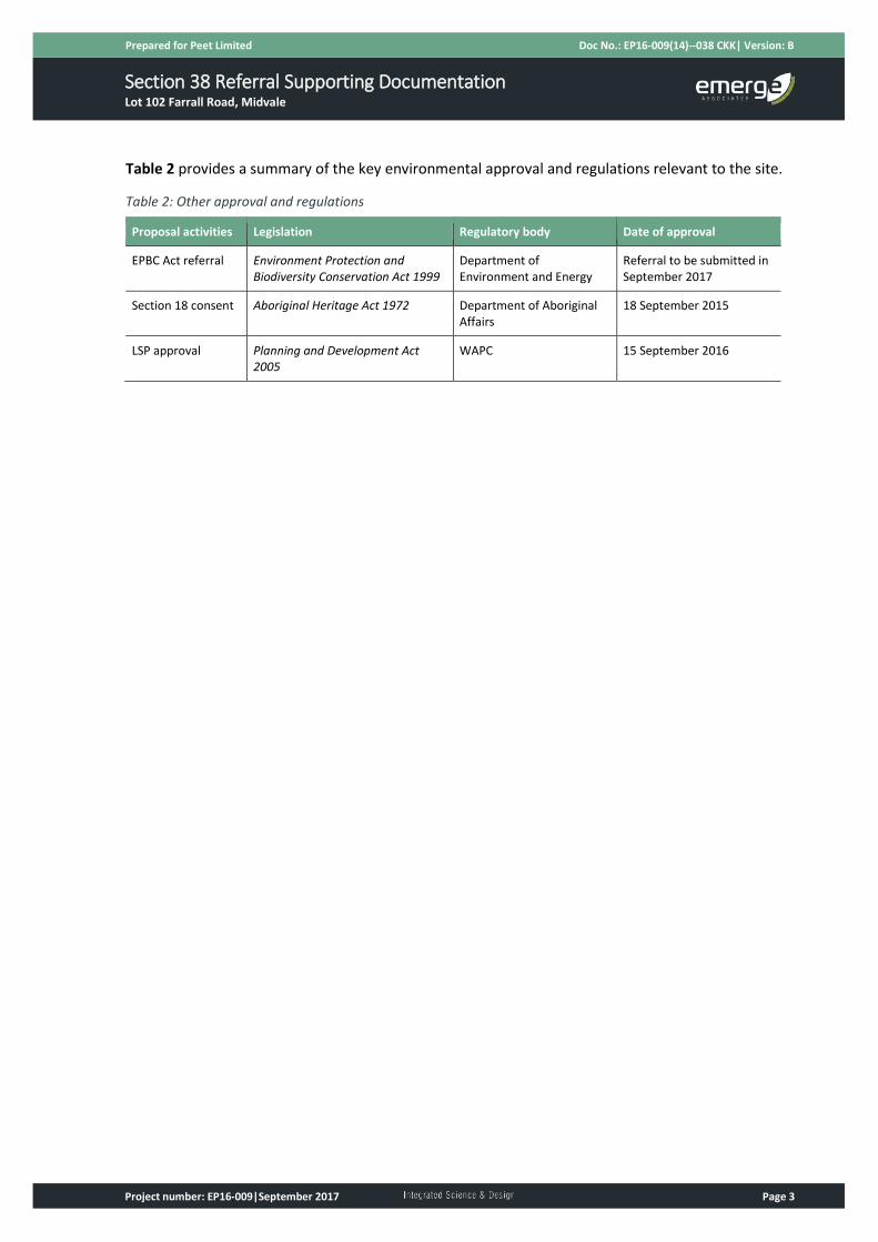
Table 2 provides a summary of the key environmental approval and regulations relevant to the site.
Table 2: Other approval and regulations
Proposal activities Legislation Regulatory body Date of approval
EPBC Act referral Environment Protection and Biodiversity Conservation Act 1999
Department of Environment and Energy
Referral to be submitted in September 2017
Section 18 consent Aboriginal Heritage Act 1972 Department of Aboriginal Affairs
18 September 2015
LSP approval Planning and Development Act 2005
WAPC 15 September 2016
Section 38 Referral Supporting Documentation Lot 102 Farrall Road, Midvale
Prepared for Peet Limited Doc No.: EP16-009(14)--038 CKK| Version: B
Project number: EP16-009|September 2017 Page 4
2 The Proposal
2.1 Background
Peet Stratton Pty Ltd proposes to develop the site for urban uses as part of the wider Movida
residential development (Figure 1).
The site was rezoned under the MRS from ‘Rural’ to ‘Urban’ prior to 1996, before the statutory
referral of scheme amendments to the EPA under Section 48 of the EP Act. As such, proposed
development within the site has not previously been assessed by the EPA.
As discussed in Section 1.3, a range of environmental investigations have been completed across the
wider Movida residential development which are summarised in Section 3.2. The significant
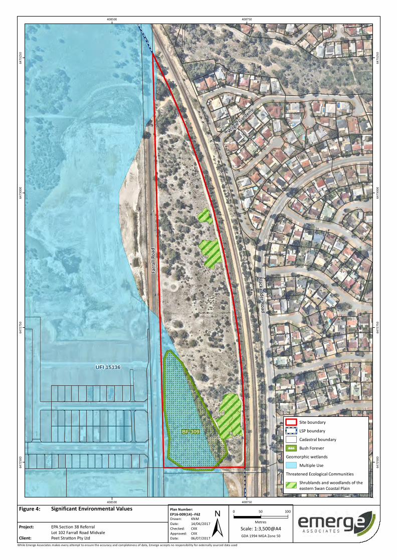
environmental values identified on the site include (see Figure 4):
• Bush Forever Site 309 (also referred to as the Farrall Road Bushland), and
• 0.5 ha the native vegetation ‘floristic community type’ (FCT) 20c ‘shrublands and woodlands of
eastern Swan Coastal Plain’1 in ‘good’ or ‘very good’ condition.
The FCT 20c vegetation in ‘good’ or ‘very good’ condition is considered representative of the Eastern
Shrublands and Woodlands Threatened Ecological Community (TEC). This TEC is listed as
‘endangered’ under the Environment Protection and Biodiversity Conservation Act 1999 (EPBC Act)
and ‘critically endangered’ by the WA Minister for the Environment. For the purposes of this referral
this vegetation is herein referred to as ‘FCT 20c TEC’. The FCT 20c TEC vegetation includes one large
patch (totalling approximately 0.3 ha) and two small, scattered patches (totalling approximately 0.2
ha) as described further in Section 3.2.
The LSP specifically responded to these significant values present within the site and proposes to
retain Bush Forever Site 309 and 0.3 ha of FCT 20c TEC within Public Open Space (POS) within Lot
102.
2.2 Justification of development
The Western Australian Department of Planning, Lands and Heritage (DoPLH) and WAPC are
responsible for urban, rural and regional land use planning and the coordination of urban
development within Western Australia. Statutory planning documents such as the MRS as well as
regional and strategic guidance documents, are prepared and updated to outline the location and
nature of necessary urban growth, commercial/activity centres, transport systems and infrastructure
throughout Western Australia. This planning framework considers environment, health, transport,
infrastructure, economy and community within an integrated and holistic framework. State
government agencies, local government and utilities use the MRS and the planning framework to
make decisions regarding infrastructure needs, commercial centres and community facilities within
specific areas.
1 This FCT is also referred to as ‘eastern shrublands and woodlands’ and ‘shrublands and woodlands of the eastern side of the Swan Coastal Plain’.
Section 38 Referral Supporting Documentation Lot 102 Farrall Road, Midvale
Prepared for Peet Limited Doc No.: EP16-009(14)--038 CKK| Version: B
Project number: EP16-009|September 2017 Page 5
In accordance with the above, the proposal is within an established broader land use planning
context, in which the Government of Western Australia has considered the extent of urban growth
required throughout Western Australia in order to accommodate the projected population growth.
The Midvale/Stratton area incorporating the site, was identified by the Government of Western
Australia for ‘Urban’ land use as part of the ‘north-east sub-region’ in Directions 2031 and beyond –
Metropolitan Planning Beyond the Horizon (WAPC 2010) as well as in the Draft North-East Sub-
regional Planning Framework (WAPC 2015), which once approved will ultimately become the sub-
regional structure plan for the area. The design of the LSP and the proposed subdivision
incorporating the site were informed and guided by these planning documents and strategies and
align with the permitted uses of the ‘Urban’ and ‘Residential Development’ zones under the MRS and
LPS No. 17 respectively.
2.3 Proposal description
The proposed subdivision will include the development of the site for residential development
(Appendix B) and will include the following future land uses:
• Residential land use
• Road reserves
• Public open space (POS)
• Bush Forever reserve and wetland buffer area
• Utilities/infrastructure
The subdivision of the site will result in the clearing of 2.68 ha remnant vegetation in ‘degraded’ or
‘good’ condition including approximately 0.2 ha of FCT 20c TEC. The residential development of the
site will also facilitate the retention, rehabilitation and management of the Bush Forever Site and 0.3
ha of adjacent FCT 20c TEC vegetation as discussed further in Section 0 and the Rehabilitation and
Vegetation Management Plan (RVMP) (Emerge Associates 2017a) (Appendix D).

Section 38 Referral Supporting Documentation Lot 102 Farrall Road, Midvale
Prepared for Peet Limited Doc No.: EP16-009(14)--038 CKK| Version: B
Project number: EP16-009|September 2017 Page 6
3 Existing Environment
The following section provides a summary of the existing environment of the site. This is provided in
more detail in the EAMS which was prepared by Emerge Associates (2015b) to support the LSP.
3.1 Soils
Environmental geology (surface soils) across the site has been mapped by the Geological Survey of
Western Australia (Gozzard 1986). The site comprises of pebbly silty sand overlying clay consistent
with the Guildford Formation and medium-grained yellow sands of the Yoganup Formation. The
underlay of clay soils is indicative of the Multiple Use wetlands present across a portion of the site.
The Geotechnical and Preliminary Acid Sulphate Soil Investigation (Douglas Partners 2014)
undertaken for the northern portion of the wider Movida site indicates that Acid Sulphate Soils are
unlikely to occur within the site to depths of two metres. This is generally consistent with the
published Department of Environment and Conservation mapping.
3.2 Flora and Vegetation
Detailed site-specific flora and vegetation investigations have been undertaken over the site by a
number of parties, including Coffey Environments (2010), Emerge Associates (2015c), Tauss &
Associates (2016) and additional vegetation survey and mapping by Emerge Associates (also in 2016).
While the information obtained through these investigations is generally consistent, the
understanding of plant community type and vegetation condition within the site has evolved over
time. In particular the presence of the FCT 20c TEC which was not confirmed until the surveys by
Tauss & Associates and Emerge Associates in February and June 2016.
For the purposes of this referral, a technical memorandum has been prepared to update the flora
and vegetation information from Emerge Associates (2015c) with information obtained by Emerge
Associates in February and June 2016 and by Tauss & Associates in June 2016. This has been
provided in Appendix C.
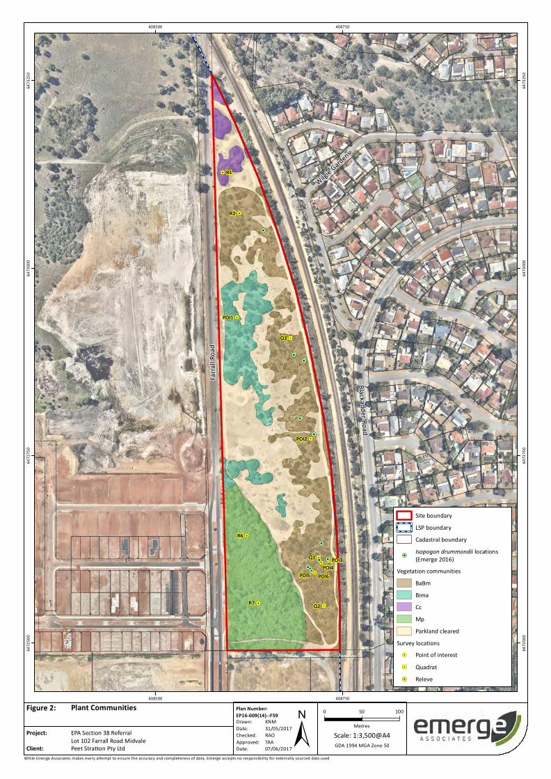
The plant communities and vegetation condition over the site has been provided in Figure 2 and
Figure 3 respectively.
3.2.1 Remnant FCT 20c vegetation
The vegetation determined to represent FCT 20c was mapped as a ‘sparse to open woodland of
Banksia attenuata, Banksia menziesii and Eucalyptus todtiana over open shrubland to shrubland of
Adenanthos cygnorum and Allocasuarina humilis over low sparse shrubland to shrubland of
Conostephium pendulum, Stirlingia latifolia and Hibbertia spp. over forb and sedgeland of Lyginia
spp., Dasypogon bromeliifolius, Conostylis aculeata, Podotheca gnaphalioides and forb/grassland of
pasture weeds’ (Emerge Associates 2015c). This is listed as community BaBm within Figure 2. This
community is known to occur 700 m east of the site within the Talbot Nature Reserve and represents
the Commonwealth and State listed TEC ‘shrublands and woodlands of the eastern Swan Coastal
Plain.’
Section 38 Referral Supporting Documentation Lot 102 Farrall Road, Midvale
Prepared for Peet Limited Doc No.: EP16-009(14)--038 CKK| Version: B
Project number: EP16-009|September 2017 Page 7
Floristic quadrats sampled by both (Tauss & Associates 2016) and Emerge (2016) were used to
determine the more intact parts of the vegetation community to represent FCT 20c. The vegetation
community associated with the remnant FCT 20c vegetation within the Lot 102 ranges from ‘very-
good’ to ‘completely degraded’ with the better condition vegetation located adjacent to the Bush
Forever site. The remaining areas of the FCT 20c vegetation to the south and north of the site are in
‘degraded’ and intermediate ‘good to degraded’ condition and include *Ehrharta calycina (perennial
veldt grass) at varying densities and cover (Figure 2).
Conservation advice was recently released by the Federal Government for the ‘shrublands and
woodlands of the eastern Swan Coastal Plain’ (DoEE 2017) noting that ‘because the ecological
community has a very restricted distribution and is listed as Critically Endangered in Western
Australia, no condition thresholds have been applied to the nationally-listed ecological community
and hence it is considered that all areas meeting the description of the ecological community are
critical to its survival’. Based on the extensive survey effort over the site which involved multiple site
visits by multiple parties, it is considered that the areas in ‘Degraded’ condition within the site do not
meet the description of the ecological community (with regards to the structural layers present and
the species composition) and are therefore not representative of the TEC. The extent of the TEC as
mapped in this referral was also agreed to by DPaW (now DBCA) Species and Communities Branch.
This is further summarised in the technical memorandum provided in Appendix C.
The site therefore contains a total of 0.5 ha of the FCT 20c TEC (shown in Figure 4), including:
• 0.3 ha located adjacent to the Bush Forever site in ‘very good’ (725 m2) and ‘good’ (2,225 m2)
condition which is proposed to be retained as part of this proposal.
• 0.2 ha located on the eastern boundary of the site in ‘good’ condition located in two patches of
500 m2 and 1,500 m2 which is proposed to be removed as part of this proposal.
3.2.2 Threatened and priority flora
A total of 14 individuals of one priority ‘3’ species, Isopogon drummondii, was recorded within the
eastern side of the site (Emerge Associates 2015c; Tauss & Associates 2016). The locations of these
individuals are shown on Figure 2. No other threatened or priority flora species are considered to
occur in the site.
3.2.3 Disturbed areas with little or no native species present
Parts of the site have been historically disturbed from past land uses and now contain areas of
vegetation in ‘completely degraded’ condition. Some of these areas include completely cleared
tracks which have been historically used for access across the site. Few native flora species remain in
these areas, although the native annual herb Podotheca gnaphalioides may be present. Perennial
veldt grass is dominant in most degraded and completely degraded locations.
3.2.4 Bush Forever
Bush Forever Site 309 (Farrall Road Bushland, Stratton) is located in the southern portion of Lot 102
(Figure 4). The attributes contributing to the regional significance of Bush Forever Site No. 309
include the representation of ecological communities and general criteria for the protection of

Section 38 Referral Supporting Documentation Lot 102 Farrall Road, Midvale
Prepared for Peet Limited Doc No.: EP16-009(14)--038 CKK| Version: B
Project number: EP16-009|September 2017 Page 8
wetland, streamline and estuarine fringing and coastal vegetation (Government of Western Australia
2000a).
Bush Forever Site 309 contains a seasonal wetland community that was mapped as ‘woodland to low
open forest of Melaleuca preissiana, with emergent Corymbia calophylla over sparse shrubland of
Astartea scoparia, Marianthus sp., Xanthorrhoea preissii and Acacia pulchella over sedgeland to
closed sedgeland of Dielsia stenostachya and Cyperaceae sp. and open forbland of Corynotheca
micrantha subsp. micrantha, Drosera spp. and Burchardia congesta (Emerge Associates 2015c). No
floristics quadrats were sampled within this vegetation, but based on its structure and composition it
is inferred to represent FCT 11 ‘Wet forests and woodlands’ (Gibson et al. 1994). FCT 11 is a relatively
well reserved wetland plant community across the Swan Coastal Plain (Gibson et al. 1994).
The remnant native vegetation in the Bush Forever site is mostly intact and was mapped as being in
‘excellent’ condition in accordance with the Keighery (1994) vegetation condition scale (Emerge
Associates 2015c). However, some degraded areas occur around the margins where understorey
layers are replaced by a closed grassland of *Ehrharta calycina (perennial; veldt grass), Ehrharta
longifolia (annual veldt grass), Eragrostis curvula (African love grass) with localised occurrence of the
bulb *Watsonia meriana var. bulbillifera (bugle lily).
Part of the site the Bush Forever Site 309 is mapped as a ‘multiple use’ wetland but due to the
generally excellent condition of vegetation present it is considered to be more representative of a
‘conservation category’ wetland (Emerge Associates 2015c).
3.3 Terrestrial Fauna
A level 1 fauna assessment undertaken for the majority of the site (Greg Harewood 2014) found that,
overall, fauna habitat values have been severely compromised by the total or partial clearing of
native vegetation. Most areas lack any natural attributes and are now only utilised by generally
common and widespread fauna species with non-specific requirements which allow them to persist
in highly disturbed habitats (Greg Harewood 2014). Various areas of remnant vegetation (particularly
within Bush Forever Site No. 309) provide the best value fauna habitat; however, these areas are
generally degraded and lack native groundcover/shrubs and microhabitats such as hollow logs (Greg
Harewood 2014).
Despite the area’s historical disturbance, the site contains some areas of suitable habitat for a range
of species including some species of conservation significance such as the:
• Baudin’s black cockatoo (Calyptorhynchus baudinii)
• Carnaby’s black cockatoo (Calyptorhynchus latirostris
• Forest red-tailed black cockatoo (Calyptorhynchus banksia naso)
• Peregrine falcon (Falco peregrinus)
• Southern brown bandicoot (Isoodon obesulus fusciventer) (Greg Harewood 2014).
Section 38 Referral Supporting Documentation Lot 102 Farrall Road, Midvale
Prepared for Peet Limited Doc No.: EP16-009(14)--038 CKK| Version: B
Project number: EP16-009|September 2017 Page 9
3.4 Hydrology
A summary of the hydrological processes on the site is provided below and further detail can be
found in the LWMS (Emerge Associates 2015d).
3.4.1 Groundwater
Information on groundwater from the Water Register (DoW 2014) indicates that groundwater
beneath the site is a multi-layered system comprised of the following:
• Perth – Superficial Swan unconfined aquifer (‘Shire of Swan South’ groundwater subarea)
• Perth – Leederville semi-confined aquifer (‘Perth south confined’ groundwater subarea)
• Perth – Yarragadee confined aquifer (‘Perth south confined’ groundwater subarea).
Groundwater data from the Perth Groundwater Atlas (DoW 2014) shows minimum groundwater
levels across the site are at approximately 11 m AHD with groundwater flowing in a westerly
direction. Historic groundwater monitoring undertaken by GHD in 2007 and 2008 (GHD 2010) for the
wider Movida residential development (LSP area) indicates that Maximum Groundwater Level (MGL)
ranges between 14 m AHD in the west of the site to 22 m AHD in the east.
3.4.2 Surface Water
A DoW mapped tributary drain to the Blackadder Creek begins within the Bush Forever site and runs
through the wider Movida development. This tributary is referred to as the ‘Blackadder tributary’.
A biophysical assessment was undertaken by Emerge Associates in order to understand the remnant
hydrological and ecological values associated with the mapped waterways and to determine the level
of consideration required (if any) within the LSP. Based on a detailed site-specific assessment of the
Blackadder tributary, it was determined that there are no ecological or hydrological values present at
the location of the mapped waterway (other than those associated with the wetland values of the
Bush Forever Site as discussed in Section 3.4 below), and no defined channel that would indicate a
seasonal flow through the site in this area. This assessment was approved by the (former)
Department of Water in January 2015.
3.4.3 Wetlands
Based on DPaW’s Geomorphic Wetland series mapping, a Multiple Use (MU) wetland (UFI 115136) is
located in the south-western corner of the site contained within Bush Forever site 309 (DPaW, 2013).
MU wetland areas are recognised as having few wetland attributes, but still provide some
hydrological functions. The management objective for these wetlands is to ‘use, develop and manage
in the context of water, town and environmental planning’ (WAPC 2005).
While this wetland while currently mapped as MU wetland, the vegetation within Bush Forever site
309 has been found to be representative of a Conservation Category (CC) wetland. CC wetlands
support a high level of environmental values, and are the highest priority wetlands. In accordance
with State Planning Policy 2.9 Water Resources, the management objective for CC wetlands is the
preservation, conservation and protection of wetlands environmental attributes functions and
values.

Section 38 Referral Supporting Documentation Lot 102 Farrall Road, Midvale
Prepared for Peet Limited Doc No.: EP16-009(14)--038 CKK| Version: B
Project number: EP16-009|September 2017 Page 10
3.4.4 Public Drinking Water Sources
The site is not located within any proclaimed or proposed Public Drinking Water Source Areas.
3.5 Heritage
3.5.1 Indigenous Heritage
Based on a review of the Department of Aboriginal Affairs (DAA) ‘Aboriginal Heritage Inquiry System’
online database, there are multiple registered Indigenous heritage sites within or immediately
adjacent to the site. These Aboriginal Heritage sites within the site are detailed in Table 3 below.
Table 3 Aboriginal Heritage Sites within the site
Site ID Site Name Site Type
DAA 3492 Green Bullfrog Dreaming Artefacts/Scatter, Mythological, Skeletal Material/Burial
DAA 3720 Blackadder and Woodbridge Creek Mythological
Both these sites cover a large area (beyond the proposal site) and these indigenous heritage sites
were investigated as part of the LSP process. Ethnographic consultation was completed in 2014 to
support a Section 18 application lodged in 2015. Section 18 consent for the proposed development
was received from the Department of Aboriginal Affairs on 18 September 2015. This Section 18
consent is attached as Appendix E.
3.5.2 Non-Indigenous Heritage
A desktop search of the Australian Heritage Database (Department of Environment 2013), the State
Heritage Office database (Heritage Council 2012) and the City of Swan’s local municipal heritage list
indicated there are no registered heritage sites within or in close proximity to the site. Middle Swan
Primary School, a listed local heritage site, is located approximately 400 m east of the site.
No further consideration was required for non-Indigenous heritage within the LSP.
Section 38 Referral Supporting Documentation Lot 102 Farrall Road, Midvale
Prepared for Peet Limited Doc No.: EP16-009(14)--038 CKK| Version: B
Project number: EP16-009|September 2017 Page 11
4 Stakeholder engagement
4.1 Key stakeholders
The following stakeholders have been identified as key stakeholders in regards to the proposal for
the site.
• Department of Parks and Wildlife (DPaW, now DBCA)
• Department of Planning (DoP, now DoPLH)
• Office of the Environmental Protection Authority (OEPA)
• City of Swan (CoS)
• Federal Department of Environment and Energy (DoEE).
4.2 Stakeholder consultation
Stakeholder consultation is undertaken through the LSP public advertising process. The advertising
process requires the landowner to respond to any concerns raised by government agencies or the
local community through public submissions.
Stakeholder consultation was also conducted during the preparation of the RVMP document
including an onsite meeting with DPaW (now DBCA), DoP and the OEPA at Lot 102 to discuss the
RVMP on the 22 November 2016. A separate meeting with held on the 16 February 2017 with the
City of Swan to discuss the RVMP and the LSP amendment. These meetings did not reveal any areas
of concern from stakeholders and all parties were generally supportive of the content and intent of
the RVMP. The RVMP for the site (Revision F, Appendix D) was approved by DBCA on the 16th August
2017 (Appendix F).
A pre-referral meeting was held with the OEPA on 6th of April 2017 at the OEPA offices. This was
attended by Teresa Byrant from the OEPA as well as representatives from Peet and Emerge
Associates. The purpose of the meeting was to discuss the Section 38 referral associated with this
proposal.
Consultation was undertaken via teleconference with assessment officers within the DoEE on the
16th August 2017 for this proposal. This was completed by Strategen Environmental Consultants who
are preparing the EPBC Act referral for this proposal. The EPBC Act referral is expected to be lodged
with the DoEE in September 2017.
Section 38 Referral Supporting Documentation Lot 102 Farrall Road, Midvale
Prepared for Peet Limited Doc No.: EP16-009(14)--038 CKK| Version: B
Project number: EP16-009|September 2017 Page 12
5 Potential Key Environmental Factors and Impact Assessment
Based on the analysis of the proposal and site investigations the proposal has the potential to impact
on one environmental factor: Flora and Vegetation. The potential impacts as well as mitigation and
management measures are described further in Section 5.1 below.
5.1 Key environmental factor - Flora and Vegetation
5.1.1 EPA objective
The EPA’s Environmental Factor Guidelines for Flora and Vegetation (EPA 2016) states that the broad
objective for flora and vegetation biodiversity conservation is: ‘To protect flora and vegetation so
that biological diversity and ecological integrity are maintained.’
5.1.2 Policy and guidance
The flora and vegetation investigations that have informed the planning of the site have been
conducted in accordance with the Technical Guidance - Flora and Vegetation Surveys for
Environmental Impact Assessment (Environmental Protection Authority (EPA) 2016) and the
Environmental Factor Guideline: Flora and Vegetation (EPA 2016).
5.1.3 Receiving environment
As stated in Section 3.2, the site contains the following vegetation (Figure 2):
• Woodland to low open forest of Melaleuca preissiana currently in ‘excellent’ Condition
associated with Bush Forever Site 309 (also referred to as the Farrall Road Bushland).
• Sparse open woodland of Banksia attenuata, Banksia menziesii and Eucalyptus todtiana mostly
in ‘degraded’ condition but with small areas identified as ‘good’ condition.
• Sparse native and planted exotic trees over closed forb/grassland of pasture weeds currently in
‘completely degraded’ condition.
Vegetation condition mapping in accordance with the Keighery (1994) vegetation condition scale is
shown over the site in Figure 3.
As shown in Figure 4,approximately 0.5ha of vegetation representative of the FCT 20c TEC is
contained within the site, including:
• 0.3 ha of vegetation located adjacent to the Bush Forever site in ‘very good’ (725 m2) and ‘good’
(2225 m2) condition
• 0.2 ha of vegetation located on the eastern boundary of the site in ‘good’ condition located in
two patches of 500 m2 and 1,500 m2.

Section 38 Referral Supporting Documentation Lot 102 Farrall Road, Midvale
Prepared for Peet Limited Doc No.: EP16-009(14)--038 CKK| Version: B
Project number: EP16-009|September 2017 Page 13
5.1.4 Potential impacts
The potential impacts to flora and vegetation as a result of the proposal include:
• Clearing of 2.68 ha native vegetation within the site in ‘degraded’ or ‘good’ condition
• Clearing of 0.2 ha of FCT 20c TEC vegetation on the eastern boundary of the site in ‘good’
condition located in two patches of 500 m2 and 1,500 m2
• Clearing of eight Priority 3 Isopogon drummondii individuals
5.1.5 Assessment of impacts
The subdivision has been designed in order to maximize the retention of native vegetation through
the position of Public Open Space. The Public Open Space will create a consolidated area of native
vegetation which incorporates FCT 20c TEC vegetation, Isopogon drummondii individuals, a wetland
and a Bush Forever site. This area of vegetation will be managed as a consolidated unit, providing
effective and efficient native vegetation management.
Significant survey work has been undertaken within the site to define the extent of the TEC, as well
as locate vegetated areas with the greatest value for retention. Based on this analysis,
approximately 2.68 ha of native vegetation, including 0.2 ha of the FCT 20c TEC vegetation and eight
Priority 3 Isopogon drummondii individuals is proposed to be cleared, and 2.3 ha of native
vegetation, including 0.3 ha of FCT 20c TEC vegetation and 6 Priority 3 Isopogon drummondii
individuals, is proposed to be retained.
The FCT 20c TEC vegetation that is proposed to be cleared includes two small parcels of FCT 20c TEC
vegetation which are isolated from other areas of intact vegetation (refer to Figure 4). The
vegetation immediately surrounding these patches is in ‘degraded’ or ‘completely degraded’
condition (refer to Figure 3). The retention of these two patches was determined to be
unsustainable due to:
• the small size of the community
• the surrounding heavily degraded vegetation
• isolation of the FCT 20c TEC vegetation from other non-degraded areas.
The patch of FCT 20c TEC that is proposed to be retained is considered more suitable for retention
given that it is:
• located adjacent to high quality vegetation within the Bush Forever reserve
• a larger patch of FCT 20c TEC vegetation and therefore less subject to edge effects (refer to
Figure 4)
• recorded as being in ‘good’ or ‘very good’ condition (refer to Figure 3).
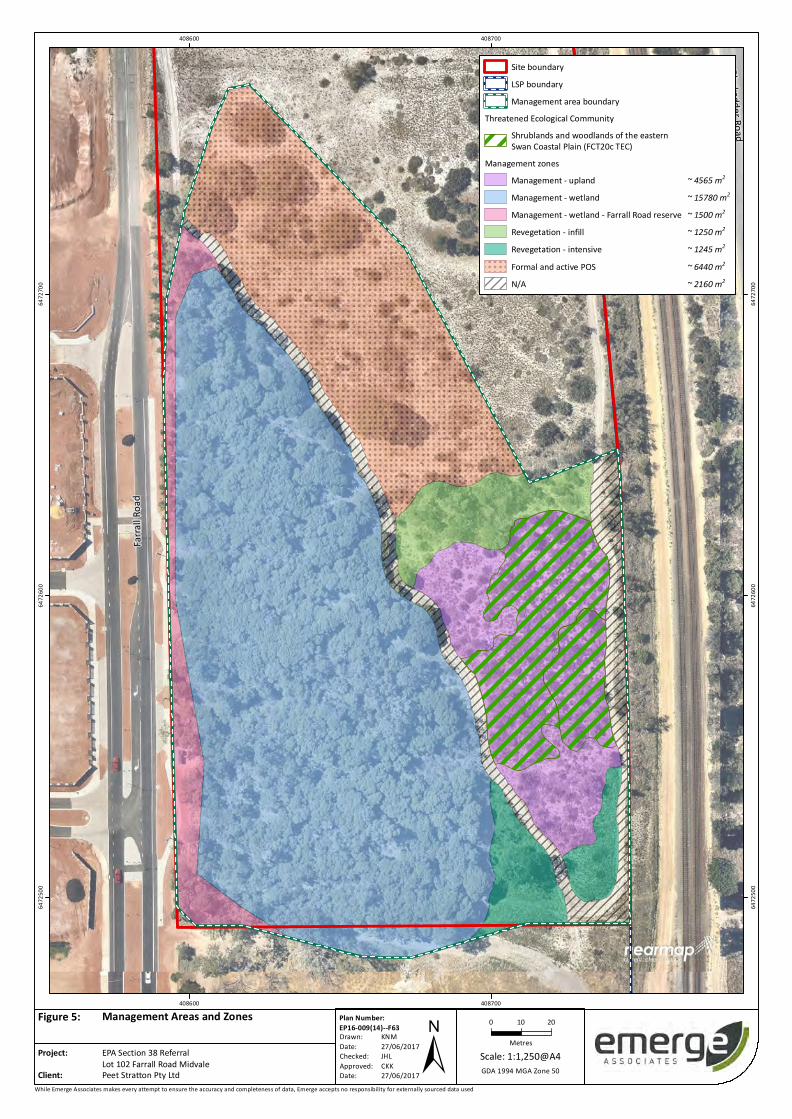
The proposal will also result in the rehabilitation and management of 0.4 ha of vegetation adjacent
to the FCT 20c TEC vegetation proposed to be retained (refer to Figure 5). The implementation of the
proposal will see these areas management by the proponent for three years, as well as transferred to
the Crown as part of subdivision and managed for conservation purposes within Public Open Space.
Section 38 Referral Supporting Documentation Lot 102 Farrall Road, Midvale
Prepared for Peet Limited Doc No.: EP16-009(14)--038 CKK| Version: B
Project number: EP16-009|September 2017 Page 14
5.1.6 Mitigation
The proposal has endeavored to mitigate the impact of the future urban development on the site
through retention of the most significant and intact vegetation on the site. Approximately 2.3 ha of
vegetation will be retained in future POS within the site. The vegetation proposed for retention and
conservation management includes:
• Approximately 1.6 ha of vegetation associated with the Bush Forever reserve and wetland.
• Approximately 0.3 ha of vegetation representative of the FCT 20c TEC. This vegetation has been
recorded as ‘good’ or ‘very good’ condition and its location adjacent to the Bush Forever reserve
suggests that it is a suitable area for retention.
• Approximately 0.4 ha of vegetation that is in ‘degraded’ to ‘completely degraded’ condition,
which is proposed to be rehabilitated.
An RVMP has been prepared as a condition of the LSP and will be implemented as a condition of
subdivision. The RVMP aims to manage and improve the condition of vegetation within the Public
Open Space area associated with Bush forever Site 309. This includes improving the condition of
degraded areas of FCT 20c vegetation to ‘very good’ condition, and to manage the condition of other
‘degraded’ and ‘completely degraded’ areas similar in composition to FCT 20c and FCT 11 wetland
vegetation to at least ‘good’ condition. Where vegetation is already in ‘very good’ or ‘excellent’
condition, rehabilitation may only require careful weed control.
In summary, the rehabilitation that is proposed within the RVMP (Appendix D) will result in:
• Management of 2,949 m2 of FCT 20c TEC vegetation and 1,616 m2 of the vegetation immediately
surrounding the FCT 20c TEC vegetation. It was determined that the best management
approach was to manage the FCT 20c TEC vegetation and the immediate surrounding vegetation
as one management cell (4,565 m2) to minimise disturbance. It is the intention that ‘degraded’
and ‘good’ portions of this vegetation are managed to achieve a vegetation condition rating of
‘very good’ or better.
• Infill revegetation of an area of approximately 1,250 m2 that is in ‘degraded’ condition with
species associated with the FCT 20c, using locally sourced genetic material where possible and
undertake management to achieve a vegetation condition rating of ‘good’ or better.
• Intensive revegetation of an area of approximately 1,245 m2 that is in ‘degraded’ condition with
species associated with the FCT 20c, using locally sourced genetic material where possible and
undertake management to achieve a vegetation condition rating of ‘good’ or better
• Management of 15,780 m2 FCT 11 vegetation within Bush Forever Site No. 309 to improve the
condition of ‘degraded’ portions to ‘good’ or better
Based on the above, the completion of the objectives outlined in the RVMP will result in the
restoration of approximately 0.4 ha of FCT 20c vegetation in addition to the retained 0.3 ha FCT 20c
TEC vegetation. A copy of the RVMP has been provided in Appendix D.
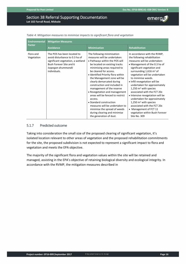
A summary of the above mitigation measures used to minimise the impact to significant flora and
vegetation is provided in

Section 38 Referral Supporting Documentation Lot 102 Farrall Road, Midvale
Prepared for Peet Limited Doc No.: EP16-009(14)--038 CKK| Version: B
Project number: EP16-009|September 2017 Page 15
Table 4.
Section 38 Referral Supporting Documentation Lot 102 Farrall Road, Midvale
Prepared for Peet Limited Doc No.: EP16-009(14)--038 CKK| Version: B
Project number: EP16-009|September 2017 Page 16
Table 4: Mitigation measures to minimise impacts to significant flora and vegetation
Environmental Factor
Mitigation Measures
Avoidance Minimisation Rehabilitation
Flora and Vegetation
The POS has been located to avoid disturbance to 0.3 ha of significant vegetation, a wetland Bush Forever Site and 6 Isopogon drummondii individuals.
The following minimisation measures will be undertaken: • Pathways within the POS will
be located on existing tracks minimising areas required to be cleared for access.
• Identified Priority flora within the Management zone will be clearly demarcated during construction and included in management of the reserve
• Revegetation and management areas will be fenced to restrict access.
• Standard construction measures will be undertaken to minimise the spread of weeds during clearing and minimise the generation of dust.
In accordance with the RVMP, the following rehabilitation measures will be undertaken: • Management of the 0.3 ha of
significant vegetation and surrounding 1,616 m2 of vegetation will be undertaken to minimise weeds.
• Infill revegetation will be undertaken for approximately 1,250 m2 with species associated with the FCT 20c
• Intensive revegetation will be undertaken for approximately 1,250 m2 with species associated with the FCT 20c
• Management of FCT 11 vegetation within Bush Forever Site No. 309
5.1.7 Predicted outcome
Taking into consideration the small size of the proposed clearing of significant vegetation, it’s
isolated location relevant to other areas of vegetation and the proposed rehabilitation commitments
for the site, the proposed subdivision is not expected to represent a significant impact to flora and
vegetation and meets the EPA objective.
The majority of the significant flora and vegetation values within the site will be retained and
managed, assisting in the EPA’s objective of retaining biological diversity and ecological integrity. In
accordance with the RVMP, the mitigation measures described in
Section 38 Referral Supporting Documentation Lot 102 Farrall Road, Midvale
Prepared for Peet Limited Doc No.: EP16-009(14)--038 CKK| Version: B
Project number: EP16-009|September 2017 Page 17
Table 4 will be undertaken to adequately offset the loss of the 0.2 ha of FCT 20c TEC vegetation,
specifically through the restoration of approximately 0.4 ha of FCT 20c vegetation in addition to the
retention of 0.3 ha FCT 20c TEC vegetation.
The RVMP will guide the rehabilitation and vegetation management of these areas and has been
prepared in accordance with the WA Environmental Offsets Policy and Guidelines (Government of
WA 2011, 2014) and with consideration of the Interim Recovery Plan for the FCT 20c community
from the Department of Environment and Conservation (DEC 2006). The implementation of the
RVMP will occur as a condition of subdivision. The proponent will implement, manage and monitor
the revegetation area for 3 years in accordance with the RVMP. Following the completion of the
monitoring and management by the proponent, the reserve will be transferred to the Crown and
managed for conservation purposes.
The RVMP for the site was also approved by the DBCA in August 2017 (Appendix F).
Section 38 Referral Supporting Documentation Lot 102 Farrall Road, Midvale
Prepared for Peet Limited Doc No.: EP16-009(14)--038 CKK| Version: B
Project number: EP16-009|September 2017 Page 18
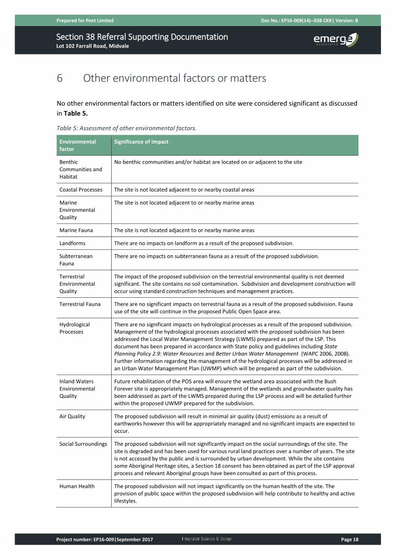
6 Other environmental factors or matters
No other environmental factors or matters identified on site were considered significant as discussed
in Table 5.
Table 5: Assessment of other environmental factors.
Environmental factor
Significance of impact
Benthic Communities and Habitat
No benthic communities and/or habitat are located on or adjacent to the site
Coastal Processes The site is not located adjacent to or nearby coastal areas
Marine Environmental Quality
The site is not located adjacent to or nearby marine areas
Marine Fauna The site is not located adjacent to or nearby marine areas
Landforms There are no impacts on landform as a result of the proposed subdivision.
Subterranean Fauna
There are no impacts on subterranean fauna as a result of the proposed subdivision.
Terrestrial Environmental Quality
The impact of the proposed subdivision on the terrestrial environmental quality is not deemed significant. The site contains no soil contamination. Subdivision and development construction will occur using standard construction techniques and management practices.
Terrestrial Fauna There are no significant impacts on terrestrial fauna as a result of the proposed subdivision. Fauna use of the site will continue in the proposed Public Open Space area.
Hydrological Processes
There are no significant impacts on hydrological processes as a result of the proposed subdivision. Management of the hydrological processes associated with the proposed subdivision has been addressed the Local Water Management Strategy (LWMS) prepared as part of the LSP. This document has been prepared in accordance with State policy and guidelines including State Planning Policy 2.9: Water Resources and Better Urban Water Management (WAPC 2006, 2008). Further information regarding the management of the hydrological processes will be addressed in an Urban Water Management Plan (UWMP) which will be prepared as part of the subdivision.
Inland Waters Environmental Quality
Future rehabilitation of the POS area will ensure the wetland area associated with the Bush Forever site is appropriately managed. Management of the wetlands and groundwater quality has been addressed as part of the LWMS prepared during the LSP process and will be detailed further within the proposed UWMP prepared for the subdivision.
Air Quality The proposed subdivision will result in minimal air quality (dust) emissions as a result of earthworks however this will be appropriately managed and no significant impacts are expected to occur.
Social Surroundings The proposed subdivision will not significantly impact on the social surroundings of the site. The site is degraded and has been used for various rural land practices over a number of years. The site is not accessed by the public and is surrounded by urban development. While the site contains some Aboriginal Heritage sites, a Section 18 consent has been obtained as part of the LSP approval process and relevant Aboriginal groups have been consulted as part of this process.
Human Health The proposed subdivision will not impact significantly on the human health of the site. The provision of public space within the proposed subdivision will help contribute to healthy and active lifestyles.
Section 38 Referral Supporting Documentation Lot 102 Farrall Road, Midvale
Prepared for Peet Limited Doc No.: EP16-009(14)--038 CKK| Version: B
Project number: EP16-009|September 2017 Page 19
7 Matters of National Environmental Significance
A number of potential Matters of National Environmental Significance (MNES) have the potential to
occur within the site, however only one MNES is considered to have the potential to be impacted by
the proposal which is Floristic Community Type 20c ‘shrublands and woodlands of the eastern Swan
Coastal Plain’.
Floristic Community Type 20c ‘shrublands and woodlands of the eastern Swan Coastal Plain’ is a TEC
that is listed as ‘endangered’ under the EPBC Act and ‘critically endangered’ by the WA Minister for
the Environment. As discussed, the subdivision will result in the clearing of approximately 0.2 ha of
significant vegetation representative of FCT 20c TEC vegetation, identified as being in ‘good’
condition. A RVMP has been prepared to offset the clearing of this vegetation and will result in the
retention of 0.3 ha of FCT 20c TEC vegetation within the site, and the revegetation and management
of approximately 0.4 ha that is in ‘degraded’ or ‘completely degraded’ condition with species
associated with the FCT 20c vegetation.
In accordance with the EPBC Act, the project will be referred to the Department of Environment and
Energy for consideration in September 2017.
Section 38 Referral Supporting Documentation Lot 102 Farrall Road, Midvale
Prepared for Peet Limited Doc No.: EP16-009(14)--038 CKK| Version: B
Project number: EP16-009|September 2017 Page 20
8 Holistic impact assessment
The EPA may have regard to various factors in reaching a decision as to whether a proposal is likely
to have a significant effect on the environment, whether it is likely to meet its objectives for
environmental factors and consequently, whether a referred Proposal should be assessed. Those
factors include:
• Values, sensitivity and quality of the environment which is likely to be impacted
• Extent (intensity, duration, magnitude and geographic footprint) of the likely impacts
• Consequence of the likely impacts (or change)
• Resilience of the environment to cope with the impacts or change
• Cumulative impact with other projects
• Connections and interactions between parts of the environment to inform a holistic view of
impacts to the whole environment
• Level of confidence in the prediction of impacts and the success of proposed mitigation
• Public interest about the likely effect of the proposal, if implemented, on the environment, and
public information that informs the EPA’s assessment.
A significance test has been conducted to determine whether the Proposal is likely to:
• have a significant effect on the environment
• meet its objectives for environmental factors
• require formal assessment.
The outcomes of the significant test are outlined in Table 6.
Table 6: Significance test
Criteria Assessment
Values, sensitivity and quality of the environment which is likely to be impacted
The site contains approximately 0.5 ha of FCT 20c ‘shrublands and woodlands of the eastern Swan Coastal Plain’ TEC vegetation. The vegetation is in three separate patches including a large patch of ‘good’ and ‘very good’ condition vegetation and two small patches of ‘good’ condition vegetation. The large patch is located adjacent to the proposed reserve associated with the Bush Forever site. The two small patches are located on the eastern boundary of the site, isolated from surrounding vegetation. The remainder of vegetation is ‘degraded’ or ‘completely degraded’ and contains no environmental significance.
Extent (intensity, duration, magnitude and geographic footprint) of the likely impacts
A maximum of 0.2 ha of significant vegetation will be cleared as a result of the proposal. This area contains two small patches (approximately 500 m2 and 1500 m2 in size) that are isolated from surrounding vegetation. The impacts associated with the Proposal are considered to be minimal. The overall effects of the Proposal are not expected to be significant at a local or regional level.
Consequence of the likely impacts (or change)
The proposed action will result in the removal of 0.2 ha of the FCT 20c TEC vegetation, retention of 0.3 ha of FCT 20c TEC vegetation and rehabilitation of 0.4 ha of FCT 20c vegetation. Rehabilitation will be undertaken by the proponent for 3 years. The retained and rehabilitated vegetation will be transferred to the Crown for conservation purposes.
Section 38 Referral Supporting Documentation Lot 102 Farrall Road, Midvale
Prepared for Peet Limited Doc No.: EP16-009(14)--038 CKK| Version: B
Project number: EP16-009|September 2017 Page 21
Criteria Assessment
Resilience of the environment to cope with the impacts or change
The proposed action will improve the resilience of the vegetation through appropriate rehabilitation, fencing and management of the retained FCT 20c vegetation. The FCT 20c TEC vegetation proposed to be removed is isolated from surrounding vegetation, and smaller in size, and therefore it would be reasonable to assume that this vegetation is likely to degrade over time without ongoing management.
Cumulative impact with other projects
Given the very small area of significant vegetation affected by the proposal, the overall cumulative impacts to key environmental factors are considered to be low. Rehabilitation of areas adjacent to the retained vegetation will be undertaken to overall increase the area of FCT 20c TEC vegetation within the site. The proposal will not affect other areas of vegetation outside of the site.
Connections and interactions between parts of the environment to inform a holistic view of impacts to the whole environment
Development of the site will aim to minimise environmental impacts through standard construction techniques used to mitigate dust and emissions. Water management will occur in accordance with the Better Urban Water Management Guidelines. The protection of wetland and retained FCT 20c TEC vegetation will occur through revegetation, rehabilitation and management by the proponent for a period of 3 years and subsequently will be transferred to the Crown for conservation purposes.
Level of confidence in the prediction of impacts and the success of proposed mitigation
The environmental impacts of this proposal will be addressed through the management measures identified in the RVMP that has been approved by DBCA providing a high level of confidence in the anticipated impacts of the proposal. The RVMP addresses a number of factors, including (but not limited to) rehabilitation and vegetation management relating to the FCT 20c vegetation. Rehabilitation and revegetation areas will be managed for 3 years by the proponent.
Public interest about the likely effect of the proposal, if implemented, on the environment, and public information that informs the EPA’s assessment.
Peet have undertaken extensive consultation during the LSP process with relevant government and community stakeholders. Peet will continue to consult with relevant stakeholders throughout the life of the development. The list of stakeholders will continue to be developed and revised as required.
The outcome of the significance test as outlined above suggests that the proposal is unlikely to be
significant, meets the EPA objectives and therefore is unlikely to warrant formal environmental
assessment.
Section 38 Referral Supporting Documentation Lot 102 Farrall Road, Midvale
Prepared for Peet Limited Doc No.: EP16-009(14)--038 CKK| Version: B
Project number: EP16-009|September 2017 Page 22
9 References
9.1 General references
Coffey Environments 2010, Environmental Report West Stratton Structure Plan, report prepared for
the Department of Housing.
Department of Environment and Conservation (DEC) 2006, Interim Recovery Plan 2006-2011 for the
shrublands and woodlands on the eastern side of the Swan Coastal Plain (community type 20c),
Department of Environment and Conservation, Perth.
Deparment of Environment and Energy (DoEE) 2017, Approved Conservation Advice for Shrublands
and Woodlands of the eastern Swan Coastal Plain, Canberra.
Emerge Associates 2015a, Biophysical Assessment of Blackadder Creek and Woodbridge Creek, report
prepared for Peet Stratton Pty Ltd, Subiaco.
Emerge Associates 2015b, Environmental Assessment and Management Strategy Midvale Local
Structure Plan report prepared for Peet Stratton Pty Ltd, Subiaco.
Emerge Associates 2015c, Flora, Vegetation and Wetland Assessment Various Allottments, Midvale
and Stratton, report prepared for Peet Stratton Pty Ltd, Subiaco.
Emerge Associates 2015d, Local Water Management Strategy Midvale Local Structure Plan, report
prepared on behalf of Peet Stratton Pty Ltd, Subiaco.
Emerge Associates 2017a, Rehabilitation and Vegetation Management Plan, report prepared for Peet
Stratton Pty Ltd, Subiaco.
Emerge Associates 2017b, Technical Memorandum: Lot 102 Farrall Road, Midvale, report prepared
for Peet Stratton Pty Ltd, Subiaco.
Environmental Protection Authority (EPA) 2016, Technical Guidance - Flora and Vegetation Surveys
for Environmental Impact Assessment Environmental Protection Authority, Perth.
Environmental Protection Authority (EPA) 2016, Environmental Factor Guideline: Flora and
Vegetation, Perth.
Gibson, N., Keighery, B., Keighery, G., Burbidge, A. and Lyons, M. 1994, A Floristic survey of the
southern Swan Coastal Plain, Department of Conservation and Land Management and the
Conservation Council of Western Australia, Perth.
Government of WA 2014, WA Environmental Offets Guidelines, Perth.
Keighery, B. 1994, Bushland Plant Survey: A guide to plant community survey for the community,
Wildflower Society of WA (Inc), Nedlands.
Tauss & Associates 2016, Winter Flora & Vegetation Survey: Lot 102 Farrell Rd Stratton, WA.

Section 38 Referral Supporting Documentation Lot 102 Farrall Road, Midvale
Prepared for Peet Limited Doc No.: EP16-009(14)--038 CKK| Version: B
Project number: EP16-009|September 2017 Page 23
Western Australian Planning Commission (WAPC) 2005, Guidelines for the Determination of Wetland
Buffer Requirements, Western Australian Planning Commission, Perth.
Western Australian Planning Commission (WAPC) 2006, State Planning Policy 2.9: Water Resources,
Gazetted in December 2006. Western Australian Planning Commission, Perth.
Western Australian Planning Commission (WAPC) 2008, Better Urban Water Management, Western
Australian Planning Commission, Perth.


Figure 1: Site Locality
Figure 2: Plant Communities
Figure 3: Vegetation Condition
Figure 4: Significant Environmental Values
Figure 5: Management Areas and Zones
Figures

rachel.omodei
Morrison Road
Orchar
d Aven
ue
Balfo
ur Ro
ad
Pursuit C lose
Blanchard Road
Swan
Avenu
e
Myles
Road
MockeridgeCct
Toodyay Road
O'connor Road
Lewis Jones C rescent
Farral
l Road
Roe H
ighwa
y
Blacka
dder
Road
408000
408000
409000
409000
6472
000
6472
000
6473
000
6473
000
6474
000
6474
000
While Emerge Associates makes every attempt to ensure the accuracy and completeness of data, Emerge accepts no responsibility for externally sourced data used
Site boundaryLSP boundaryCadastral boundary
Peet Stratton Pty LtdEPA Section 38 ReferralLot 102 Farrall Road Midvale
Site LocationFigure 1:
Project:Client:
Site Location
± GDA 1994 MGA Zone 50Scale: 1:10,000@A4
0 100 200
Metres
Plan Number:EP16-009(14)--F58Drawn:Date:Checked: Approved:Date:
KNM31/05/2017RAOTAA07/06/2017

rachel.omodei
"6
$1
$1
"6
!.!.
!. !."6
!.
!.
$1
$1
&(
&(&(&(&(
&(&(
&(
&(
&(
&(&(&(
&(
WilgieGardens
Blackadder Road
Farral
l Road
Q3
R7
R6
Q2
POI6POI5POI4
POI3Q1
POI2
POI1
R2
R1
408500
408500
408750
408750
6472
500
6472
500
6472
750
6472
750
6473
000
6473
000
6473
250
6473
250
While Emerge Associates makes every attempt to ensure the accuracy and completeness of data, Emerge accepts no responsibility for externally sourced data used
Site boundaryLSP boundaryCadastral boundary
&(Isopogon drummondii locations(Emerge 2016)
Vegetation communitiesBaBmBimaCcMpParkland cleared
Survey locations!. Point of interest"6 Quadrat$1 Releve
Peet Stratton Pty LtdEPA Section 38 ReferralLot 102 Farrall Road Midvale
Plant CommunitiesFigure 2:
Project:Client: ± GDA 1994 MGA Zone 50
Scale: 1:3,500@A4
0 50 100
Metres
Plan Number:EP16-009(14)--F59Drawn:Date:Checked: Approved:Date:
KNM31/05/2017RAOTAA07/06/2017


rachel.omodei
WilgieGardens
Blackadder Road
Farral
l Road
408500
408500
408750
408750
6472
500
6472
500
6472
750
6472
750
6473
000
6473
000
6473
250
6473
250
While Emerge Associates makes every attempt to ensure the accuracy and completeness of data, Emerge accepts no responsibility for externally sourced data used
Site boundaryLSP boundaryCadastral boundary
Vegetation conditionPristineExcellentVery goodGoodDegradedCompletely degraded
Peet Stratton Pty LtdEPA Section 38 ReferralLot 102 Farrall Road Midvale
Vegetation ConditionFigure 3:
Project:Client: ± GDA 1994 MGA Zone 50
Scale: 1:3,500@A4
0 50 100
Metres
Plan Number:EP16-009(14)--F60Drawn:Date:Checked: Approved:Date:
KNM31/05/2017RAOTAA07/06/2017

kyle.middleton
WilgieGardens
Blackadder Road
Farral
l Road
BF 309
UFI 15136
408500
408500
408750
408750
6472
500
6472
500
6472
750
6472
750
6473
000
6473
000
6473
250
6473
250
While Emerge Associates makes every attempt to ensure the accuracy and completeness of data, Emerge accepts no responsibility for externally sourced data used
Site boundaryLSP boundaryCadastral boundary
! ! ! ! ! ! !
! ! ! ! ! ! !
! ! ! ! ! ! !
! ! ! ! ! ! ! Bush ForeverGeomorphic wetlands
Multiple UseThreatened Ecological Communities
Shrublands and woodlands of theeastern Swan Coastal Plain
Peet Stratton Pty LtdEPA Section 38 ReferralLot 102 Farrall Road Midvale
Significant Environmental ValuesFigure 4:
Project:Client: ± GDA 1994 MGA Zone 50
Scale: 1:3,500@A4
0 50 100
Metres
Plan Number:EP16-009(14)--F62Drawn:Date:Checked: Approved:Date:
KNM14/06/2017CKKCKK06/07/2017

kyle.middletonBlackadder Road
Farral
l Road
408600
408600
408700
408700
6472
500
6472
500
6472
600
6472
600
6472
700
6472
700
While Emerge Associates makes every attempt to ensure the accuracy and completeness of data, Emerge accepts no responsibility for externally sourced data used
Site boundaryLSP boundaryManagement area boundary
Threatened Ecological CommunityShrublands and woodlands of the easternSwan Coastal Plain (FCT20c TEC)
Management zonesManagement - upland ~ 4565 m2
Management - wetland ~ 15780 m2
Management - wetland - Farrall Road reserve ~ 1500 m2
Revegetation - infill ~ 1250 m2
Revegetation - intensive ~ 1245 m2
! ! ! ! !
! ! ! ! !
! ! ! ! ! Formal and active POS ~ 6440 m2
N/A ~ 2160 m2
Peet Stratton Pty LtdEPA Section 38 ReferralLot 102 Farrall Road Midvale
Management Areas and ZonesFigure 5:
Project:Client: ± GDA 1994 MGA Zone 50
Scale: 1:1,250@A4
0 10 20
Metres
Plan Number:EP16-009(14)--F63Drawn:Date:Checked: Approved:Date:
KNM27/06/2017JHLCKK27/06/2017