Embed Size (px)
Citation preview

SECTION 2
Gippsland region
31

Snowysystem
Thomson,Macalister& Latrobe systems
2.1 Gippsland region overview ................................................................................................ 33
2.2 Latrobe system ................................................................................................................... 38
2.2.1 Latrobe River .......................................................................................................... 39
2.2.2 Lower Latrobe wetlands ........................................................................................ 45
2.3 Thomson system ................................................................................................................ 50
2.4 Macalister system .............................................................................................................. 57
2.5 Snowy system ..................................................................................................................... 64

33 Victorian Environmental Water Holder | Seasonal Watering Plan 2019–20
2.1 Gippsland region overviewThe systems in the Gippsland region that can receive water from the VEWH’s environmental entitlements are the Latrobe River and wetlands, and the Thomson and Macalister rivers. The Snowy River also receives water for the environment, but this is managed by the New South Wales Department of Planning, Industry and Environment.
Environmental values, recent conditions, environmental watering objectives and planned actions for each system in the Gippsland region are presented in the system sections that follow.
Traditional Owners in the Gippsland regionTraditional Owners and their Nations in the Gippsland region continue to have a deep connection to the region’s rivers, wetlands and floodplains.
The Registered Aboriginal Parties in this region are the Gunaikurnai Land and Waters Aboriginal Corporation (GLaWAC), Bunurong Land Council Aboriginal Corporation (BLCAC) and Wurundjeri Woi Wurrung Cultural Heritage Aboriginal Corporation. On 22 October 2010, the Federal Court recognised that the Gunaikurnai people hold native title over much of Gippsland. On the same day, Victoria entered into an agreement with the Gunaikurnai people under the Traditional Owner Settlement Act 2010. Under the agreement, the Gunaikurnai Traditional Owner Land Management Board was established, to jointly manage parks and reserves between Warragul and Orbost.
Through memorandums of understanding between West Gippsland CMA and GLaWAC, and West Gippsland CMA and BLCAC, they work together to ensure that Traditional Owners have the opportunity to be involved in every CMA project, from the inception stage. An example of this is the involvement of GLaWAC on the project advisory group for the Latrobe Environmental Water Requirements Investigation in 2018–19.
The New South Wales Department of Planning, Industry and Environment has historically worked with Aboriginal communities that have a strong connection to waterways in the Snowy Mountains. These include the Maneroo-Ngarigo, Bidwell Maap, Southern Monero (Monero-Ngarigo / Yuin / Bolga), Wongalu and Wiradjuri people.
In recognition of the cultural importance of water for Aboriginal people and their traditional ecological knowledge, waterway managers are working with Traditional Owners to involve them in management of environmental flows. In 2019–20, this will include continuing to develop an effective working relationship between the West Gippsland CMA Water Team and the newly formed GLaWAC Aboriginal Water Team. The teams share the CMA’s Traralgon office. This close proximity increases opportunities for the GLaWAC team to share traditional knowledge of local species and ecosystems with West Gippsland CMA staff. It also presents opportunities for West Gippsland CMA staff to help the GLaWAC Aboriginal Water Team increase their knowledge of and capacity for contemporary water management.
EngagementSeasonal watering proposals are informed by longer-term regional catchment strategies, regional waterway strategies, relevant technical studies (such as environmental flow studies and environmental water management plans), as well as by input from program partners and stakeholders. The strategies and technical reports collectively describe a range of cultural, economic, environmental, social, and Traditional Owner perspectives and longer-term integrated catchment and waterway management objectives that influence environmental watering actions and priorities. Program partners and other stakeholders help to identify environmental watering priorities and opportunities for the coming year.
The International Association for Public Participation’s Public Participation Spectrum (IAP2 Spectrum) has been used to categorise the levels of participation of stakeholders involved in the environmental watering planning process. Table 2.1.1 shows the IAP2 Spectrum categories and participation goals.
2.1 Gippsland region overview

34 Victorian Environmental Water Holder | Seasonal Watering Plan 2019–20
2.1 Gippsland region overview
Table 2.1.1 International Association for Public Participation’s Public Participation Spectrum categories and participation goals1
Engagement category Engagement goal
Inform Provide balanced and objective information to assist understanding, alternatives, opportunities and/or solutions
Consult Obtain feedback on analysis, alternatives and/or decisions
Involve Work directly throughout a process to ensure that concerns and aspirations are consistently understood and considered
Collaborate Partner in each aspect of the decision including the development of alternatives and the identification of the preferred solution
Empower Place final decision making in the hands of the stakeholder
1 The VEWH has the permission of the International Association for Public Participation to reproduce the IAP2 Spectrum.
Table 2.1.2 shows the partners, stakeholder organisations and individuals with which West Gippsland CMA engaged when preparing the Latrobe, Thomson and Macalister systems seasonal watering proposals. This includes engagement conducted as part of developing the seasonal watering proposals as well as engagement during the preparation of key foundational documents that directly informed the proposals.
The table also shows the level of engagement between West Gippsland CMA and stakeholders of the environmental watering program in the Gippsland region based on the CMA’s interpretation of the IAP2 Spectrum.
The level of engagement differs between organisations and between systems, due to the complexity of management arrangements and individual organisation’s responsibilities for each system. For example, Parks Victoria review and endorse all seasonal watering proposals that affect the public land they manage. However, their level of engagement can vary from system to system. In the Gippsland region, Parks Victoria is more involved in planning and management of water for the environment for the lower Latrobe wetlands than for the Latrobe River, because it is the land manager for Dowd Morass and Sale Common and it operates the regulators used to release water to these sites. Therefore, Parks Victoria collaborates with other program partners to implement the environmental watering program at the lower Latrobe wetlands. Parks Victoria is not involved in releases of environmental flows to the Latrobe River but it was consulted on environmental flows planning through membership on the project advisory group for the Latrobe Environmental Water Requirements Investigation in 2018–19.
As another example, in the Macalister system VRFish is represented on the Macalister Environmental Water Advisory Group and has a higher level of engagement (that is, it is directly involved in environmental watering decisions for the system) than other recreational users that are informed about proposed environmental flows in the system.

35 Victorian Environmental Water Holder | Seasonal Watering Plan 2019–20
2.1 Gippsland region overview
Table 2.1.2 Partners and stakeholders engaged by West Gippsland CMA in developing seasonal watering proposals for the Latrobe, Thomson and Macalister systems and other key foundation documents that have directly informed the proposals
Latrobe RiverLower Latrobe wetlands
Thomson system Macalister system
Community groups and environment groups
• Greening Australia
• Latrobe Valley Field Naturalists
• Native Fish Australia
• Greening Australia
• Latrobe Valley Field Naturalists
• Native Fish Australia
• Heyfield Wetlands Committee
• Environment Victoria
• Maffra and District Landcare Network
• Native Fish Australia• BirdLife Australia
• Landcare groups
• Waterwatch volunteers and co-ordinators
Government agencies
• Gippsland Water • Gippsland Water • Arthur Rylah Institute • Arthur Rylah Institute
• East Gippsland Catchment Management Authority
• Parks Victoria
• East Gippsland Catchment Management Authority
• Gippsland Water
Landholders/ farmers
• Individual landholders
• Individual landholders
• Individual landholders
• Macalister Irrigation District irrigators/diverters
Local businesses
• Port of Sale Heritage River Cruises
• Port of Sale Heritage River Cruises
Local government
• Baw Baw Shire Council
• Latrobe City Council
• Wellington Shire Council
• Baw Baw Shire Council
• Latrobe City Council
• Wellington Shire Council
• Baw Baw Shire Council
• Wellington Shire Council
• Wellington Shire Council
Program partners
• Southern Rural Water
• Victorian Environmental Water Holder
• Field and Game Australia
• Parks Victoria
• Victorian Environmental Water Holder
• Melbourne Water
• Southern Rural Water
• Victorian Environmental Water Holder
• Southern Rural Water
• Victorian Environmental Water Holder
• Department of Environment, Land, Water and Planning
• Department of Environment, Land, Water and Planning
Recreational users
• Field and Game Australia
• VRFish
• VRFish • Kayakers
• Canoe clubs
• VRFish
• Angling clubs
• Local birdwatchers
• Tourism information centres
• Regional tourism associations
• VRFish
• Local birdwatchers
• Kayakers and canoers
Traditional Owners
• Gunaikurnai Land and Waters Aboriginal Corporation
• Gunaikurnai Land and Waters Aboriginal Corporation
• Gunaikurnai Land and Waters Aboriginal Corporation
• Gunaikurnai Land and Waters Aboriginal Corporation
Key: Inform Consult Involve Collaborate Empower

36 Victorian Environmental Water Holder | Seasonal Watering Plan 2019–20
2.1 Gippsland region overview
__________
2 Rules in the Lower Latrobe Wetlands Environmental Entitlement 2011 only allow diversions to the wetlands when water levels in the Latrobe River are more than -0.7m AHD at the Swing Bridge Gauging Station, which may prevent timing of inflows to assist duck season.
In the Snowy system, the New South Wales Government is responsible for planning environmental flows in the Snowy River, in consultation with the Victorian Government. The Snowy Advisory Committee (SAC) was formed in 2018 and provides community and expert advice about the pattern of environmental flows to the Snowy River. The committee’s participants represent Aboriginal, local community and environmental interests, alongside New South Wales and Victorian government agencies. East Gippsland CMA is a member of the SAC, and the VEWH is an observer.
Community benefits from environmental wateringAs subsection 1.1.1 explains, by improving the health of rivers, wetlands and floodplains, environmental flows also provide benefits to communities. Healthy rivers and wetlands support vibrant and healthy communities.
Environmental outcomes provide direct flow-on cultural, economic, recreational, social, and Traditional Owner benefits for communities. In 2019–20, examples in the Gippsland region include:
• supporting populations of native fish that are valued by recreational fishers (for example, Australian bass in the Macalister and Thomson rivers and black bream and estuary perch in the Latrobe system)
• delivering water for the environment to the Heyfield wetlands in the Thomson system, which will complement community efforts to rehabilitate the wetland ecosystem and support educational programs at the site
• supporting waterbirds in the lower Latrobe wetlands, which are valued by bird watchers and duck hunters
• watering vegetation on the banks of the Latrobe, Thomson and Macalister rivers that prevents bank erosion and potential land loss for farmers
• increasing opportunities for canoeing and kayaking on the Snowy River.
Additional opportunities to enhance community benefits can also sometimes be provided by modifying environmental flows, provided environmental outcomes are not compromised. For example:
• environmental flows planned for the Thomson River in spring 2019 — that aim to cue juvenile Australian grayling to migrate into the river from the sea — and in autumn 2020 — that aim to trigger Australian grayling to move downstream for spawning — may be scheduled over a weekend within the appropriate ecological window to provide whitewater rafting opportunities for kayakers and canoeists, without affecting the flow objectives for fish
• West Gippsland CMA will consult with stakeholders about the timing of water deliveries to the lower Latrobe wetlands, to take account of duck-hunting seasons declared and regulated by the Victorian Game Management Authority.2
The ability of the VEWH and its partners to deliver these benefits will depend on the weather, climate considerations, the available water and the way the system is being operated to deliver water for other purposes.
Integrated catchment managementAltered water regimes are one of many threats to the health of Victoria’s waterways. To be effective, environmental flows need to be part of an integrated approach to catchment management. Many of the environmental objectives from water for the environment in the Gippsland region will not be fully met without simultaneously addressing issues such as barriers to fish movement, high nutrient loads, saltwater intrusion to the Latrobe wetlands, loss of stream bank vegetation and invasive species, to name just some issues.
Victorian and Australian government agencies, community groups and private landowners collectively implement a wide range of programs that aim to protect and improve the environmental condition and function of land, soils and waterways throughout Victoria’s catchments.
Examples of complementary programs that are likely to support environmental watering outcomes in the Gippsland region include:
• works by West Gippsland CMA to protect and enhance stream banks along priority reaches of rivers and their tributaries including fencing to exclude stock, revegetation of riverbanks, willow removal and erosion control
• West Gippsland CMA’s work with farmers along the Thomson and Macalister rivers on grazing and soil management, and on nutrient and water-use-efficiency projects that help improve water quality and river health
• construction of a fishway on the Thomson River by West Gippsland CMA to improve fish passage near the heritage-listed Horseshoe Bend Tunnel, completed in June 2019. The fishway will allow Australian grayling, which are specifically targeted with releases of water for the environment, and other migratory fish to access 85 km of high-quality river habitat in the upper reaches of the Thomson catchment
• a weed and willow control program by East Gippsland CMA in remote parts of the Snowy River catchment, which led to 200 km of the river now being willow-free: native vegetation is flourishing in areas where willows have been removed, and it provides a valuable source of food and habitat for animals.
For more information about integrated catchment management programs in the Gippsland region refer to the West Gippsland and East Gippsland regional catchment strategies and regional waterway strategies.

37 Victorian Environmental Water Holder | Seasonal Watering Plan 2019–20
2.1 Gippsland region overview
Seasonal outlook 2019–20Water for the environment for the Latrobe, Thomson and Macalister systems is held in Blue Rock Reservoir, Thomson Reservoir and Lake Glenmaggie respectively.
Environmental entitlements in these systems have unique characteristics that influence planning for environmental flows. The Thomson system receives a share of the daily inflows to the Thomson Reservoir and a secure annual allocation which is available on 1 July each year. In the Latrobe and Macalister systems, the availability of water for the environment depends on system inflows to Lake Glenmaggie and Blue Rock Reservoir. Winter and spring are the peak inflow periods for all systems, so annual allocations are usually well-known before the start of summer.
In dry years, waterway managers rely on carryover and early-season allocations to deliver the highest-priority environmental watering demands. In 2018–19, the Gippsland region experienced one of the driest and hottest periods on record. Environmental flows in 2018–19 were carefully managed to ensure a critical supply of water could be carried over for 2019–20.
The Gippsland system catchments will need significant rain in winter and spring 2019 to saturate the ground and generate substantial streamflow. Forecasts are for lower-than-average rainfall across the region in winter 2019, and waterway managers are therefore preparing to enact environmental watering plans for dry to drought scenarios in 2019–20.
The volume of water needed to meet environmental demands in the Latrobe, Thomson and Macalister systems in winter/spring 2019–20 is similar to the volume required to meet demands for summer/autumn. As supply is mostly determined by winter/spring inflows, waterway managers will be able to confidently plan the supply of watering demands for the whole year by mid to late spring 2019.
Drought conditions could significantly limit allocations of water for the environment during 2019–20. Most tier 1 environmental watering priorities for the Thomson and Macalister rivers in 2019–20 can be achieved with the volume of water that is likely to be available in those systems, but supply is not assured for several high-priority (that is, tier 1b) environmental watering actions in the Latrobe system. If conditions remain dry, water for the environment will need to be carefully managed throughout the year to ensure there is enough carryover to meet critical demands in 2020–21. Where critical demands cannot be met by existing allocations, the VEWH and its program partners may investigate alternative supply options (such as transfers or trades). The VEWH also works with storage managers to identify opportunities to adjust the pattern of consumptive water deliveries to support environmental watering outcomes while still meeting the needs of consumptive water users.
The New South Wales Department of Planning, Industry and Environment plans and manages environmental flows in the Snowy system in consultation with Victorian and Australian governments and relevant stakeholder groups. The water year for the Snowy system starts in May and finishes in April the following year, which differs from how water is managed in the other Gippsland systems. The total volume for release and daily release targets for the Snowy River from May 2019 to April 2020 are set in place, and daily releases will not vary unless flows increase the risk of flooding downstream or operational constraints prevent delivery.
Risk managementDuring the development of the seasonal watering proposals for the Latrobe, Thomson and Macalister systems, environmental watering program partners held a workshop to assess risks associated with potential environmental watering actions for 2019–20 and to identify appropriate mitigating strategies. Risks and mitigating actions are continually assessed by program partners throughout the year (see subsection 1.3.6).
In the Snowy system, when weather conditions increase the risk of flooding, the New South Wales Department of Planning, Industry and Environment works with the New South Wales State Emergency Service, the Bureau of Meteorology, East Gippsland CMA and the VEWH to inform the community about the management of planned releases. Releases may be cancelled or rescheduled to limit flood impacts on private land.

38 Victorian Environmental Water Holder | Seasonal Watering Plan 2019–20
2.2 Latrobe system
2.2 Latrobe system
Top: Latrobe River, by West Gippsland CMA Centre: Rakali, by North Central CMA Above: Growling grass frog, by East Gippsland CMA
Proportion of water entitlements in the Latrobe basin held by private users, water corporations or environmental water holders at 30 June 2018.
Waterway manager – West Gippsland Catchment Management Authority
Storage manager – Southern Rural Water
Environmental water holder – Victorian Environmental Water Holder
Latrobe
Private Environment Water authority
34%
8%
58%
Did you know ...?Carp are known as the ‘rabbits of the river’ due to their prolific breeding and the damage they do to native aquatic habitats. In 2018, Parks Victoria worked with local professional fishermen to catch and remove a whopping 25 tonnes of carp from the Sale Common! This helped increase the benefits from an environmental flow delivery which could be provided later, once the wetland was mostly carp-free.

39 Victorian Environmental Water Holder | Seasonal Watering Plan 2019–20
2.2 Latrobe system
The Latrobe system includes the Latrobe River and lower Latrobe wetlands: Sale Common, Dowd Morass and Heart Morass.
2.2.1 Latrobe River
System overview
The Latrobe River originates on the Baw Baw Plateau and passes through relatively flat to undulating plains cleared for agriculture, before flowing into Lake Wellington (the westernmost point of the Gippsland Lakes). Notable tributaries include the Tanjil River, Narracan Creek, Morwell River, Tyers River, Traralgon Creek and the Thomson River.
Water for the environment is supplied to the Latrobe River from Blue Rock Reservoir on the Tanjil River. Blue Rock Reservoir also supplies water for electricity generators in the Latrobe Valley and town water.
The Latrobe River from Rosedale to the Thomson River confluence (reach 5) is the priority reach for water for the environment because it contains endangered plant communities that have good potential for rehabilitation.
Environmental valuesThe upper Latrobe River flows through state forest and is relatively intact and ecologically healthy. It contains continuous stands of river red gums and intact riparian vegetation, and it supports native animals including barred galaxias, river blackfish, Gippsland spiny crayfish and nankeen night herons.
The Latrobe River is regulated downstream of Lake Narracan and is highly degraded due to historic river management practices. Most large woody habitat has been removed from the river and many sections have been artificially straightened. These practices have caused significant erosion and widened the channel, which has in turn reduced the quality and quantity of habitat for aquatic plants and animals.
Endangered and vulnerable vegetation are found in all but the most modified sections of the Latrobe River. The banks along the lower reaches support stands of swamp scrub, characterised by swamp paperbark and tea tree. Mature river red gums grow adjacent to the lower Latrobe wetlands and provide nesting habitat for sea eagles and other birds of prey that hunt in the wetlands. The Latrobe River supports several native estuarine and freshwater fish including black bream, Australian bass, Australian grayling and short- and long-finned eel.
The Latrobe River and its tributaries provide an essential source of freshwater to the Gippsland Lakes system, of which the lower Latrobe wetlands are an important component.
Environmental objectives in the Latrobe River
Maintain or increase native fish (migratory, resident and estuary) populations including eels
Increase frog populations and their range
Maintain refuge habitats
Maintain or increase in-stream geomorphic diversity
Maintain or increase the abundance and increase the range of existing platypus and rakali (water rat) populations
Maintain the abundance of freshwater turtle populations
Improve the condition and increase extent and diversity of submerged, emergent and riparian vegetation
Increase the abundance of all macro- and micro-invertebrates
Avoid adverse water-quality conditions (such as high salinity) in the lower Latrobe River and estuary

40 Victorian Environmental Water Holder | Seasonal Watering Plan 2019–20
2.2 Latrobe system
Figure 2.2.1 The Latrobe system
•Maffra
ThomsonReservoir
•
Avon
Perry
Barkly
Valencia
Freestone Creek
Toms
Rive
r
Creek
River
Creek
River
Macalister
River
Macalister
Thomson
Thomson
Aberfeldy
eig
gamn
elG
Black
all
Ben
Rainbow
Fiddlers Boggy
River
River
RiverCreek
Creek
Creek
Creek
River
Cree
k
Cruachan
Creek
••
•• •
•
•
•Neerim
Moe
Erica
Noojee
Rosedale
Sale
Warragul
Traralgon
Tyers
Morw
ell
Flyn
ns
Latrobe
Trar
algon
Shady
Moe
Middle
Tanjil
Eaglehawk Creek
Cree
k
Creek
Cree
k
Rive
r
River
River
River
Latrobe
River
River
Creek
River
Narrac
an
Loch
Waterhole
Latrobe
Creek
Creek
River
Lake Glenmaggie
Lake Wellington
GippslandLakes
Blue RockReservoir
LakeNarracan
1
2
3
46 7
Yallourn Weir
Morwell
Dowd Morass
Heart Morass
Sale Common
River
River
Latrobe
Thomson
MoondarraReservoir
•
Thomson Rainbow
River
Creek
•
•Rosedale
Sale
Traralgon
Flyn
ns
Trar
algon
Eaglehawk
Creek
Cree
k
Cree
k
Waterhole
Latrobe
Creek
Lake Wellington
Moondarra
Reservoir
4
11 Dowd Morass
Sale Common
Wetlands
8
Heart Morass
Jordan River
RiverThomson
Reach Upstream of Willow GroveReach Willow Grove to Lake NarracanReach Lake Narracan to Scarnes Bridge Reach Scarnes Bridge to Kilmany SouthReach Kilmany South to Thomson River confluenceReach Downstream of Thomson confluenceReach Lake WellingtonReach Tanjil River Water infrastructure Measurement point Town Indicates direction of flow
•
1
2
3
4
5
6
7
8
Grey river reaches have been included for context. The numbered reaches indicate where relevant environmental flow studies have been undertaken. Coloured reaches can receive environmental water.
5
Location within Victoria

41 Victorian Environmental Water Holder | Seasonal Watering Plan 2019–20
2.2 Latrobe system
Recent conditionsClimatic conditions in West Gippsland were warmer and drier than average during the 2018–19 water year. Sporadic heavy rainfall in late spring and early summer provided three freshes. An environmental flow was planned for the Latrobe River in November, to coincide with simultaneous environmental flows in the Thomson and Macalister systems. The coordinated releases aimed to deliver a large pulse through the system to support native fish migration and to water the lower Latrobe wetlands. While the environmental flows proceeded in the other systems, the water order was cancelled in the Latrobe system due to the sudden rainfall, meaning that the fresh was supplied mostly by natural flows from the upper Latrobe River and tributaries.
Summer and autumn rainfall was well below average. Low flows were provided in autumn, but a planned autumn fresh did not proceed due to minimal streamflows in the catchments. It was decided that conserving water for use in winter and spring 2019–20 would be more beneficial to the system.
Low flow recommendations were partially achieved from passing flows and unregulated flows during July to November 2018. Water for the environment was used to supply low flows in autumn for a short period, to allow in-stream bars to form and fish to move between habitats.
The environmental flow recommendations for the Latrobe River, Latrobe River estuary and lower Latrobe wetlands were updated in 2018–19. The updated recommendations take a more integrated approach to managing all the major waterways in the Latrobe system, and they have informed planning for 2019–20.
Scope of environmental wateringTable 2.2.1 describes the potential environmental watering actions that may be delivered in 2019–20, their functional watering objectives (that is, the intended physical or biological effect of the watering action) and the longer-term environmental objective they support. Each environmental objective relies on one or more potential environmental watering actions and their associated physical or biological functions.
Estuary flows and freshes described in Table 2.2.1 usually depend on contributions in the Thomson system. They aim to meet functional outcomes in the lower Latrobe River estuary as well as provide water to the lower Latrobe wetlands.
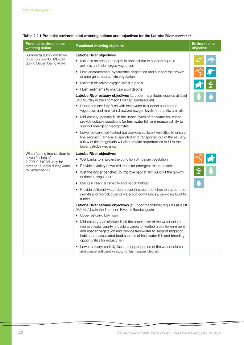
Table 2.2.1 Potential environmental watering actions and objectives for the Latrobe River
Potential environmental watering action
Functional watering objectiveEnvironmental objective
Summer/autumn freshes (four to six freshes of 920–1,300 ML/day for four to 15 days during December to May)1,2
Latrobe River objectives
• Wet benches to maintain habitat and support the growth of emergent macrophyte vegetation
• Support waterbug and zooplankton communities and maintain breeding substrate for blackfish
• Flush sediment (sands and silts) from pools and mix water in pools, helping to provide habitat for frogs and spawning conditions for Australian grayling and blackfish
• Provide longitudinal connectivity for platypus, rakali (water rats) and fish
Latrobe River estuary objectives (at upper magnitude; requires at least 930 ML/day in the Thomson River at Bundalaguah)
• Upper estuary: fully flush with freshwater to support submerged vegetation, provide suitable conditions including dissolved oxygen levels for aquatic animals, transport silt, wet benches and deliver freshwater to connected wetlands
• Mid-estuary: partially/fully flush the upper layer of the water column to improve water quality, support emergent macrophytes, provide freshwater habitat and associated food sources for freshwater fish and provide breeding opportunities for estuary fish
• Lower estuary (at higher magnitude): partially flush the upper layer of the water column; a flow of this magnitude will also provide opportunities to fill to the lower Latrobe wetlands
42 Victorian Environmental Water Holder | Seasonal Watering Plan 2019–20
2.2 Latrobe system
Potential environmental watering action
Functional watering objectiveEnvironmental objective
Summer/autumn low flows of up to 250–760 ML/day during December to May)1
Latrobe River objectives
• Maintain an adequate depth in pool habitat to support aquatic animals and submerged vegetation
• Limit encroachment by terrestrial vegetation and support the growth of emergent macrophyte vegetation
• Maintain dissolved oxygen levels in pools
• Flush sediments to maintain pool depths
Latrobe River estuary objectives (at upper magnitude; requires at least 340 ML/day in the Thomson River at Bundalaguah)
• Upper estuary: fully flush with freshwater to support submerged vegetation and maintain dissolved oxygen levels for aquatic animals
• Mid-estuary: partially flush the upper layers of the water column to provide suitable conditions for freshwater fish and reduce salinity to support emergent macrophytes
• Lower estuary: not flushed but provides sufficient velocities to ensure fine sediment remains suspended and transported out of the estuary; a flow of this magnitude will also provide opportunities to fill to the lower Latrobe wetlands
Winter/spring freshes (four to seven freshes of 2,200–2,710 ML/day for three to 20 days during June to November)1,2
Latrobe River objectives
• Wet banks to improve the condition of riparian vegetation
• Provide a variety of wetted areas for emergent macrophytes
• Wet the higher benches, to improve habitat and support the growth of riparian vegetation
• Maintain channel capacity and bench habitat
• Provide sufficient water depth over in-stream benches to support the growth and reproduction of waterbug communities, providing food for turtles
Latrobe River estuary objectives (at upper magnitude; requires at least 930 ML/day in the Thomson River at Bundalaguah)
• Upper estuary: fully flush
• Mid-estuary: partially/fully flush the upper layer of the water column to improve water quality, provide a variety of wetted areas for emergent and riparian vegetation and provide freshwater to support migration, habitat and associated food sources of freshwater fish and breeding opportunities for estuary fish
• Lower estuary: partially flush the upper portion of the water column and create sufficient velocity to flush suspended silt
Table 2.2.1 Potential environmental watering actions and objectives for the Latrobe River continued...
43 Victorian Environmental Water Holder | Seasonal Watering Plan 2019–20
2.2 Latrobe system
Table 2.2.1 Potential environmental watering actions and objectives for the Latrobe River continued...
Potential environmental watering action
Functional watering objectiveEnvironmental objective
Winter/spring low flows of 610–760 ML/day during June to November1
Latrobe River objectives
• Wet benches to maintain habitat and support the growth of emergent macrophyte vegetation
• Support waterbug and zooplankton communities and maintain breeding substrate for blackfish
• Flush sediment (sands and silts) from pools and mix the water column in pools, helping to provide habitat for frogs and spawning conditions for blackfish
• Longitudinal connectivity for platypus, rakali (water rats) and fish
Latrobe River estuary objectives (at upper magnitude; requires at least 490 ML/day in the Thomson River at Bundalaguah)
• Upper estuary: fully flush with freshwater to provide suitable conditions for waterbugs, to transport silt, to wet the benches and to deliver freshwater to connected wetlands
• Mid-estuary: fully flush the upper layer of the water column to improve water quality and provide freshwater for migration, habitat and associated food sources for freshwater fish and breeding opportunities for estuary fish
• Lower estuary: partially flush the upper layer of the water column; a flow of this magnitude will also provide opportunities to fill to the lower Latrobe wetlands
1 Lower magnitude supports flow objectives in the Latrobe River. Upper magnitude supports flow objectives in both the Latrobe River and estuary, however it is dependent on sufficient inflows from the Thomson River.
2 This fresh may involve inundating private land and will be subject to obtaining appropriate landholder agreements.
Scenario planningProtecting key ecological functions and high-priority refuges is the priority for environmental flows management in the Latrobe River. Flows are also aimed at preventing a catastrophic reduction in water quality, resulting in fish death events and algal blooms.
To achieve these goals, summer/autumn freshes and low flows in the river and into the Latrobe estuary (subject to water availability) are prioritised under all scenarios. These flows will support vegetation growth, provide connectivity for aquatic animal habitat, supply fresh water to improve water quality and provide water for the lower Latrobe wetlands. As there will be few natural freshes in the regulated parts of the system under drought and dry scenarios, using water for the environment is necessary to achieve these flows. Under all scenarios, only a subset of the required summer/autumn freshes and reduced durations of low flows will be possible with the available supply. Providing additional flows would help manage water quality, particularly salinity in the upper and mid-estuary, to maintain freshwater conditions for aquatic mammals, fish and vegetation.
In average and wet scenarios, winter/spring low flows and freshes are likely to be met naturally by spills from the Blue Rock Reservoir. If this occurs, water for the environment may not be used until summer/autumn.
Under the Blue Rock environmental entitlement, the VEWH accrues a share of inflows daily. It is important to consider rainfall, climate, river conditions and entitlement inflows between July and November when prioritising use of water for the environment. Environmental Water Holdings at the beginning of 2019–20 are likely to be lower than has been the case in previous years, due to ongoing dry conditions. Water Holdings are expected to increase with inflows under all climate scenarios, but under drought and dry scenarios the ability to deliver high-priority flows in full may be constrained by the water available and by competition for outlet capacity, with high demands from other users (particularly for low flows).
Table 2.2.2 outlines the potential environmental watering and expected water use under a range of planning scenarios.

44 Victorian Environmental Water Holder | Seasonal Watering Plan 2019–20
2.2 Latrobe system
Table 2.2.2 Potential environmental watering for the Latrobe River under a range of planning scenarios
Planning scenario Drought Dry Average Wet
Expected river conditions
• Small contributions from unregulated reaches and tributaries of the Latrobe River with little opportunity for freshes to occur naturally
• Consumptive demand from Blue Rock Reservoir will be very high and regular releases to the Tanjil River will contribute substantially to low flows
• There will be some unregulated flows that contribute to low flows and freshes
• Consumptive demand from Blue Rock Reservoir will be high and contribute to low flows
• Unregulated flows will provide low flows throughout the year, and multiple freshes (most likely in winter and spring)
• Some spills are likely and there will be releases for consumptive users which will partly contribute to low flows
• Unregulated flows provide strong low flows throughout the year
• Multiple spills from Blue Rock Reservoir will provide extended durations of freshes, high flows and overbank flows
• No significant releases from consumptive entitlements in Blue Rock Reservoir are likely
Expected availability of environmental water • Up to 12,000 ML • Up to 14,000 ML • Up to 19,000 ML • Up to 27,000 ML
Potential environmental watering – tier 1a (high priorities)
• Two summer/autumn freshes
• Summer/autumn low flows
• Two summer/autumn freshes
• Summer/autumn low flows1
• Three summer/autumn freshes
• Summer/autumn low flows1
• Five summer/autumn freshes
• Summer/autumn low flows1
Potential environmental watering – tier 1b (high priorities with shortfall)
• Two additional summer/autumn freshes
• Extended duration of summer/autumn baseflows where possible
• Four additional summer/autumn freshes
• Extended duration of summer/autumn baseflows where possible
• Three additional summer/autumn freshes
• Extended duration of summer/autumn baseflows where possible
• One additional summer/autumn fresh
• Extended duration of summer/autumn baseflows
Potential environmental watering – tier 2 (additional priorities)
• Three to five winter/spring estuary freshes
• Winter/spring low flows where possible
• Five to six winter/spring estuary freshes
• Winter/spring low flows where possible
• Six winter/spring estuary freshes
• Winter/spring low flows where possible
• Six winter/spring estuary freshes
• Winter/spring low flows2
Possible volume of water for the environment required to achieve objectives3
• 10,200 ML (tier 1a)
• 7,200 ML for freshes only (tier 1b)
• 5,300 ML per river fresh (tier 2)
• 13,800 ML (tier 1a)
• 14,400 ML for freshes only (tier 1b)
• 10,300 ML per river fresh (tier 2)
• 16,800 ML (tier 1a)
• 8,100 ML for freshes only (tier 1b)
• 15,000 ML per river fresh (tier 2)
• 24,700 ML (tier 1a)
• 3,200 ML for freshes only (tier 1b)
• 13,300 ML per river fresh (tier 2)
Priority carryover requirements N/A – there are no carryover provisions in the Blue Rock environmental entitlement.
1 Lower ranges of summer/autumn low flows are expected to be met by natural flows under dry to wet scenarios, and have not been accounted for in volume estimates.
2 Expected to be met by natural flows under a wet scenario and has not been accounted for in volume estimates.3 Water for the environment requirements for tier 2 actions are additional to tier 1 requirements. Some demands are expected to be met by natural flows. Water for the environment requirements for tier 2 actions are additional to tier 1
requirements. Volume demands from Latrobe storages decrease as inflows from the Thomson River increase.

45 Victorian Environmental Water Holder | Seasonal Watering Plan 2019–20
2.2 Latrobe system
2.2.2 Lower Latrobe wetlands
System overview
The lower Latrobe wetlands (Dowd Morass, Heart Morass and Sale Common) are an important component of the internationally recognised Gippsland Lakes Ramsar site and provide habitat for a variety of waterbirds of state, national and international conservation significance. The wetlands are located on the floodplain of the Latrobe River between its confluence with the Thomson River, and they form part of the Gippsland Lakes system.
River regulation and water extraction from the Latrobe, Thomson and Macalister rivers has reduced the frequency of small and medium-sized floods that naturally wet the lower Latrobe wetlands. Construction of levees and drains and filling of natural depressions have also altered water movement into and through the wetlands. The drainage and flooding regime in all three wetlands is now managed to some extent with regulators connected to the Latrobe River.
Environmental valuesSale Common is one of only two remaining freshwater wetlands in the Gippsland Lakes system, and it provides sheltered feeding, breeding and resting habitat for a large range of waterbirds.
Dowd Morass is a large, brackish wetland that regularly supports rookeries of colonial nesting waterbirds including Australian white ibis, straw-necked ibis, little black and little pied cormorants, royal spoonbills and great egrets.
Heart Morass is also a large brackish wetland, with open expanses providing shallow feeding habitat for waterbirds including black swans, Eurasian coots and a variety of ducks.
Together, the lower Latrobe wetlands function as a diverse and complementary ecological system. Colonial waterbirds breed among swamp paperbark trees at Dowd Morass in spring. Migratory shorebirds feed on the mudflats that are exposed as the wetlands draw down and dry over summer. Waterfowl and fish-eating birds use open-water habitat at the wetlands year-round. The wetlands also support threatened vegetation communities including swamp scrub, brackish herbland and aquatic herbland.
Environmental objectives in the lower Latrobe wetlands
Maintain the abundance of frog populations
Maintain the abundance of freshwater turtle populations
Maintain or restore a self-sustaining variety of submerged and emergent aquatic vegetation types
Maintain or restore the diversity, condition and/or extent of native riparian vegetation fringing wetlands
Discourage the introduction and spread, or reduce the extent and density, of undesirable/invasive plants (Sale Common)
Maintain or enhance waterbird breeding, recruitment, foraging and sheltering opportunities
Provide suitable physio-chemical conditions to support aquatic life
Recent conditionsClimatic conditions in West Gippsland were warmer and drier than average during the 2018–19 water year. Several storms in November 2018 had high rainfall, but none of these delivered significant inflows to the wetlands. Managed water delivery through regulators provided the only inflows to the wetlands in 2018–19.
The regulator to Dowd Morass was opened from August to October 2018, briefly in December 2018 and again in April 2019. The regulator was opened when the Latrobe River was high, to dilute saline water in Dowd Morass.
Heart Morass was partially filled between August and October 2018, and further top-ups were provided in December 2018 and March 2019 to manage acid sulphate soils. The managed inflows reduced salinity in the wetland and inundated the semi-aquatic grasses, which provided food for waterbirds.
Water was allowed to draw down naturally in Heart Morass and Dowd Morass from the middle of summer.
Sale Common received water for the environment throughout winter and spring and was one-third full in October 2018. Large stands of semi-aquatic wetland vegetation (such as knotweed and club-rush) dominated the wetland over summer. By autumn, the semi-aquatic vegetation began to dry out and was replaced by terrestrial grasses and sedges.

46 Victorian Environmental Water Holder | Seasonal Watering Plan 2019–20
2.2 Latrobe system
The environmental flow recommendations for the Latrobe River, Latrobe River estuary and lower Latrobe wetlands were reviewed and updated in early 2019. The updated recommendations take a more integrated approach to managing all the major waterways in the Latrobe system, and they have informed planning for 2019–20.
Scope of environmental wateringEnvironmental watering in the lower Latrobe wetlands aims to maintain and improve existing values and manage threats. Specific threats to the wetlands include saltwater intrusion and invasive plants and animals such as carp, giant rush and Brazilian milfoil.
Saltwater intrusion from the Gippsland Lakes is a constant threat to Dowd Morass and Heart Morass. Rising sea
levels due to climate change and reduced flows from the Latrobe River increase the threat, and studies indicate that intrusions may occur at any time. Vegetation in Heart Morass has been degraded by many years of intensive cattle grazing and saltwater inundation from Lake Wellington, but much of the wetland is now recovering with the aid of restoration programs including grazing exclusion, revegetation and weed control.
Table 2.2.3 describes the potential environmental watering actions in 2019–20, their functional watering objectives (that is, the intended physical or biological effect of the watering action) and the longer-term environmental objective they support. Each environmental objective relies on one or more potential environmental watering actions and their associated physical or biological functions.
Table 2.2.3 Potential environmental watering actions and objectives for the lower Latrobe wetlands
Potential environmental watering action
Functional watering objectiveEnvironmental objective
Sale Common
Partial fill (during July to December)
• Provide seasonal variation in water depth to support the growth and flowering of semi-aquatic plants
• Provide appropriate wetland fringing habitat
• Provide conditions that support waterbug communities and food resources for waterbirds
• Stimulate bird breeding by providing nesting habitat via wetting reed beds and deep water next to reedbeds
Fill (during August to November)
• Wet the outer boundaries of the wetland to support the growth and flowering of riparian and fringing wetland plants
• Provide connectivity between the river and wetlands
Fill (any time) • Prolong wetted habitat to discourage invasive plants, particularly the excessive spread of giant rush: this is most likely to occur in December and January, but it can happen any time
Partial or near-complete drawdown (during December to April)
• Oxygenate the soil for the germination and recruitment of aquatic vegetation
• Fluctuate water levels to provide conditions for the reproduction and expansion of swamp scrub and tall marsh
• Allow the die-off of aquatic vegetation and the breakdown of organic matter, to support nutrient recycling
• Discourage invasive aquatic plants
• Expose the mudflats and wetland fringe, to increase food sources and foraging opportunities for waterbirds

47 Victorian Environmental Water Holder | Seasonal Watering Plan 2019–20
2.2 Latrobe system
Potential environmental watering action
Functional watering objectiveEnvironmental objective
Fill or partial fill (any time)1 • Manage unexpected or out-of-season events, which may lead to catastrophic conditions. Such examples are to:
- Manage any sudden decline in dissolved oxygen- Provide habitat for waterbirds after breeding events
• Maintain ecosystem resilience
Dowd Morass
Fill or partial fill (any time) • Minimise the risk of salt water inundation
• Manage unexpected or out-of-season events which may lead to catastrophic conditions. Such examples are to:
- Respond to suddenly increasing salinity following intrusions/high water levels from Lake Wellington
- Manage any sudden decline in dissolved oxygen and pH- Provide habitat for waterbirds after breeding events
• Maintain ecosystem resilience
Partial fill (during March to December)
• Maintain or improve water quality by reducing salinity
• Provide seasonal variation in water depth, to support the growth and flowering of semi-aquatic plants
• Provide appropriate wetland fringing habitat and allow the growth and reproduction of waterbug communities
• Flood the banks and riparian zone, to create conditions to support bird-nesting
• Provide connectivity between the river and wetlands and between wetlands
• Provide conditions that support waterbug communities and food resources for waterbirds
• Stimulate bird breeding by providing nesting habitat via inundating reed beds and deep water next to reedbeds
Fill (during August to November)
• Wet vegetation that provides habitat for waterbirds (e.g. floodplain riparian woodland)
• Provide conditions that support waterbug communities and food resources for waterbirds
• Stimulate bird breeding by providing nesting habitat via inundating reed beds and deep water next to reedbeds
• Flood the banks and riparian zone to create conditions for waterbird nesting
• Provide connectivity between the river and wetlands and between wetlands
Table 2.2.3 Potential environmental watering actions and objectives for the lower Latrobe wetlands continued...

48 Victorian Environmental Water Holder | Seasonal Watering Plan 2019–20
2.2 Latrobe system
Table 2.2.3 Potential environmental watering actions and objectives for the lower Latrobe wetlands continued...
Potential environmental watering action
Functional watering objectiveEnvironmental objective
Partial or near-complete drawdown (during January to March)
• Oxygenate the soil for the germination and recruitment of aquatic vegetation
• Fluctuate water levels to provide conditions for the reproduction and expansion of swamp scrub and tall marsh
• Allow the die-off of aquatic vegetation and the breakdown of organic matter, to encourage nutrient recycling
• Expose the mudflats and wetland fringe to increase food sources and foraging opportunities for waterbirds
Heart Morass
Fill or partial fill (any time) • Keep soils wet to minimise the risk of acid sulfate soils
• Manage unexpected or out-of-season events, which may lead to catastrophic conditions. Such examples are to:
- Respond to decreasing pH from the rewetting of exposed acid sulfate soils (most likely during high-wind events)
- Respond to suddenly increasing salinity following intrusions/high water levels from Lake Wellington
- Provide habitat for waterbirds following bird-breeding events
• Maintain ecosystem resilience
Partial fill (during August to December)
• Provide seasonal variation in water depth to support the growth and flowering of semi-aquatic plants
• Provide appropriate wetland fringing habitat
• Provide conditions that support waterbug communities and food resources for waterbirds
• Stimulate bird breeding by providing nesting habitat via inundating reed beds and deep water next to reedbeds
Flushing flow (during June to November)
• Reduce salinity levels by exporting salts and sulfates from the wetland, helping to maintain vegetation diversity
• Disperse seeds and propagules
Drawdown (during December to February)
• Increase soil oxygenation for the germination and recruitment of aquatic vegetation
• Fluctuate water levels to provide conditions for the reproduction and expansion of swamp scrub and tall marsh
• Allow the die-off of aquatic vegetation and the breakdown of organic matter, encouraging nutrient recycling
• Expose the mudflats and wetland fringe, to increase food sources and foraging opportunities for waterbirds
1 Fill or partial fill (any time) will only occur if triggered by a sudden change in wetland conditions. The Lower Latrobe Wetlands Environmental Entitlement 2011 is a non-volumetric entitlement, and wetland watering is permitted any time when flows in the Latrobe River are greater than -0.7m AHD (as recorded at the Swing Bridge (Sale) Gauging Station).
49 Victorian Environmental Water Holder | Seasonal Watering Plan 2019–20
2.2 Latrobe system
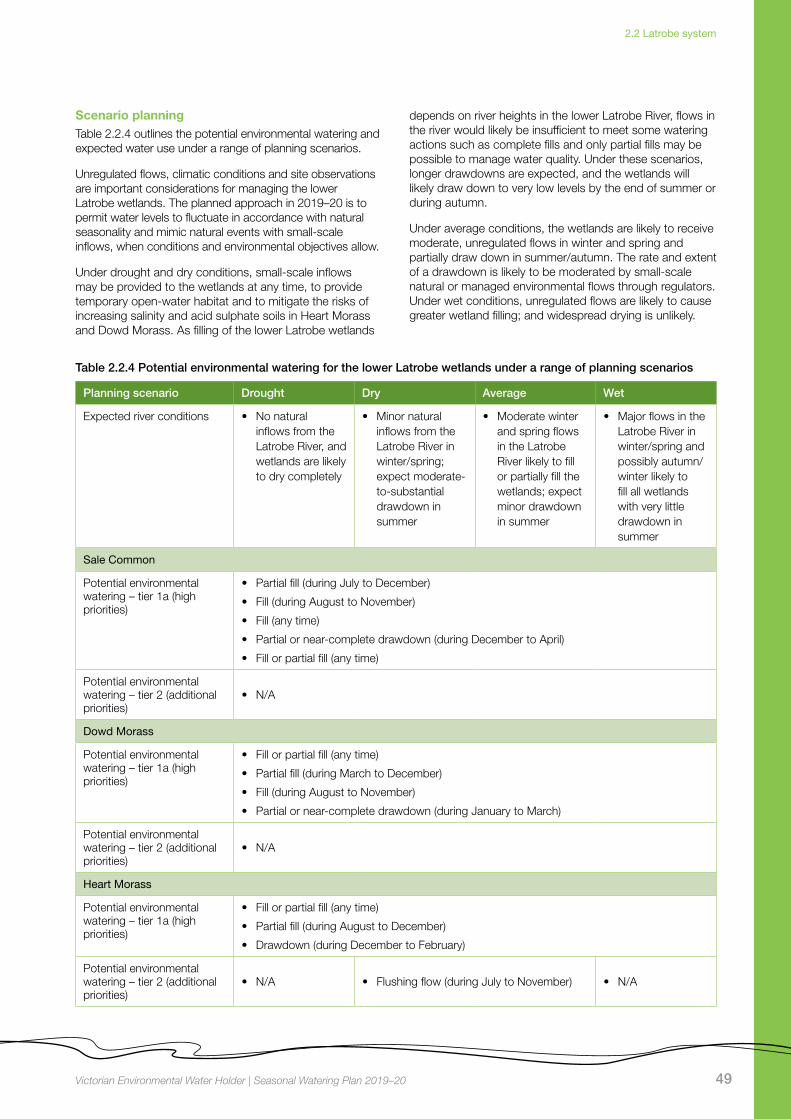
Scenario planningTable 2.2.4 outlines the potential environmental watering and expected water use under a range of planning scenarios.
Unregulated flows, climatic conditions and site observations are important considerations for managing the lower Latrobe wetlands. The planned approach in 2019–20 is to permit water levels to fluctuate in accordance with natural seasonality and mimic natural events with small-scale inflows, when conditions and environmental objectives allow.
Under drought and dry conditions, small-scale inflows may be provided to the wetlands at any time, to provide temporary open-water habitat and to mitigate the risks of increasing salinity and acid sulphate soils in Heart Morass and Dowd Morass. As filling of the lower Latrobe wetlands
depends on river heights in the lower Latrobe River, flows in the river would likely be insufficient to meet some watering actions such as complete fills and only partial fills may be possible to manage water quality. Under these scenarios, longer drawdowns are expected, and the wetlands will likely draw down to very low levels by the end of summer or during autumn.
Under average conditions, the wetlands are likely to receive moderate, unregulated flows in winter and spring and partially draw down in summer/autumn. The rate and extent of a drawdown is likely to be moderated by small-scale natural or managed environmental flows through regulators. Under wet conditions, unregulated flows are likely to cause greater wetland filling; and widespread drying is unlikely.
Table 2.2.4 Potential environmental watering for the lower Latrobe wetlands under a range of planning scenarios
Planning scenario Drought Dry Average Wet
Expected river conditions • No natural inflows from the Latrobe River, and wetlands are likely to dry completely
• Minor natural inflows from the Latrobe River in winter/spring; expect moderate-to-substantial drawdown in summer
• Moderate winter and spring flows in the Latrobe River likely to fill or partially fill the wetlands; expect minor drawdown in summer
• Major flows in the Latrobe River in winter/spring and possibly autumn/winter likely to fill all wetlands with very little drawdown in summer
Sale Common
Potential environmental watering – tier 1a (high priorities)
• Partial fill (during July to December)
• Fill (during August to November)
• Fill (any time)
• Partial or near-complete drawdown (during December to April)
• Fill or partial fill (any time)
Potential environmental watering – tier 2 (additional priorities)
• N/A
Dowd Morass
Potential environmental watering – tier 1a (high priorities)
• Fill or partial fill (any time)
• Partial fill (during March to December)
• Fill (during August to November)
• Partial or near-complete drawdown (during January to March)
Potential environmental watering – tier 2 (additional priorities)
• N/A
Heart Morass
Potential environmental watering – tier 1a (high priorities)
• Fill or partial fill (any time)
• Partial fill (during August to December)
• Drawdown (during December to February)
Potential environmental watering – tier 2 (additional priorities)
• N/A • Flushing flow (during July to November) • N/A

50 Victorian Environmental Water Holder | Seasonal Watering Plan 2019–20
2.3 Thomson system
2.3 Thomson system
Top: Thomson River, by West Gippsland CMA Centre: Stonefly, by Parks Victoria Above: Australian grayling being released, by David Dawson
Waterway manager – West Gippsland Catchment Management Authority
Storage managers – Melbourne Water (Thomson Reservoir), Southern Rural Water (Cowwarr Weir)
Environmental water holder – Victorian Environmental Water Holder
Did you know ...?The Thomson system is home to six species of
migratory fish that need to move between saltwater
and freshwater. Environmental flows throughout the
year help send the right signals to these fish to move
between the estuaries and the rivers and spawn.

51 Victorian Environmental Water Holder | Seasonal Watering Plan 2019–20
2.3 Thomson system
System overview
The Thomson River flows from the slopes of the Baw Baw Plateau to join the Latrobe River south of Sale. The major tributaries of the Thomson River are the Aberfeldy and Jordan rivers in the upper reaches and the Macalister River in the lowest reach. Most unregulated flows originate from the Aberfeldy River. Two major structures regulate flow on the Thomson River: Thomson Reservoir — the largest water supply storage for metropolitan Melbourne — and Cowwarr Weir — a regulating structure which supplies irrigation water to parts of the Macalister Irrigation District.
Thomson Reservoir harvests most of the flow from the Thomson River upper catchment and has a significant effect on flow in all downstream reaches. Unregulated flows from the Aberfeldy River, which meets the Thomson River downstream of Thomson Reservoir, are essential for providing natural freshes and high flows in the Thomson River.
Water for the environment is held in the Thomson Reservoir and released into the river as required. Reach 3 of the Thomson River (from the Aberfeldy River confluence to Cowwarr Weir) is the highest priority for environmental watering due to its heritage river status, high-value native riparian vegetation, high-quality in-stream habitat and low abundance of exotic fish species.
At Cowwarr Weir, the Thomson River splits into the old Thomson River course (reach 4a) and Rainbow Creek (reach 4b) (see Figure 2.3.1). Passing flows throughout the year are split two-thirds down reach 4a and one-third down 4b to avoid impacts to irrigators located on Rainbow Creek. Water for the environment is primarily delivered to the old Thomson River course (reach 4a) to support fish migration, because Cowwarr Weir impedes fish movement through Rainbow Creek.
Environmental valuesThe Thomson River supports six native species of migratory fish that need to move between the sea and freshwater environments to complete their life cycles. A focus for environmental flows management is the Australian grayling, which is listed as a threatened species in Victoria. Australian grayling spawn in response to autumn high flows, and the larvae and juveniles spend time at sea before returning to the freshwater sections of coastal rivers.
The composition and condition of riparian vegetation varies throughout the Thomson River catchment. The vegetation is intact and near-natural condition above Thomson Reservoir in the Baw Baw National Park. Riparian vegetation between Thomson Reservoir and Cowwarr Weir is mostly in good condition but is affected by exotic weeds including blackberry and gorse. Downstream of the Cowwarr Weir, the vegetation is degraded due to stock access and widespread weed invasion.
Environmental objectives in the Thomson system
Restore populations of native fish, specifically Australian grayling
Maintain/enhance the structure of native fish communities
Reduce competition from exotic fish
Maintain channel form diversity including pools, to provide a variety of habitats for aquatic animals
Maintain and restore the structural diversity and zonation of riparian vegetation
Increase the recruitment and growth of native riparian vegetation
Restore and maintain the natural invertebrate community
Heyfield wetlands objectives
Maintain the existing frog populations and provide suitable habitat
Maintain the existing vegetation, promote the growth and establishment of semi-aquatic species
Enhance the resilience of semi-aquatic and riparian woodland species
Provide freshwater refuge habitat for migratory and non-migratory wetland birds within the Gippsland Plains landscape
Continue to support observed terrestrial woodland and grassland birds by maintaining their riparian woodland habitat

52 Victorian Environmental Water Holder | Seasonal Watering Plan 2019–20
2.3 Thomson system
Figure 2.3.1 The Thomson system
•Maffra
Cowwarr Weir
•
Avon
Perry
Barkly
Valencia
Freestone Creek
Toms
Rive
r
Creek
River
Creek
River
etsil
aca
Mr
River
Macalister
Thomson
Aberfeldy
Jordan
eig
gamn
elG
Black
all
Ben
Rainbow
Fiddlers Boggy
River
revi
R
River
River
RiverCreek
Creek
Creek
Creek
River
Cree
k
Cruachan
Creek
••
•• •
•
•
•Neerim
Moe
Erica
Noojee
Rosedale
Sale
Warragul
Traralgon
Tyers
Morw
ell
Flyn
ns
Trar
algon
Shady
Moe
Middle
Tanjil
Eaglehawk Creek
Cree
k
Creek
Cree
k
Rive
r
River
River
River
Latrobe
Latrobe
RiverRiver
Creek
River
Narrac
an
Loch
Waterhole
Latrobe
Creek
Creek
River
LakeGlenmaggie
Lake Wellington
Blue RockReservoir
LakeNarracan
MoondarraReservoir
Morwell
Thomson
Thomson
ThomsonReservoir
•
2
3
4a
4b
5
6
2
4a
4b
5
6
Reach Thomson River: Thomson Dam to Aberfeldy RiverReach Thomson River: Aberfeldy River to Cowwarr WeirReach Old Thomson River: Cowwarr Weir to Rainbow CreekReach Rainbow Creek: Cowwarr Weir to Thomson RiverReach Thomson River: Rainbow Creek/Old Thomson confluence to Macalister RiverReach Thomson River: Macalister River to Latrobe River Water infrastructure Measurement point
TownWetland
Indicates direction of flow
3
Mount Whitelaw
Grey river reaches have been included for context. The numbered reaches indicate where relevant environmental flow studies have been undertaken. Coloured reaches can receive environmental water.
GippslandLakes
Location within Victoria
Heyfieldwetlands

53 Victorian Environmental Water Holder | Seasonal Watering Plan 2019–20
2.3 Thomson system
Recent conditionsIn recent years, water for the environment has primarily been used to deliver autumn and spring freshes to create spawning and recruitment opportunities for native fish including Australian grayling, Australian bass and tupong. Low flows have also been provided to enable fish to move between habitats along the river.
The Thomson system has experienced mostly dry conditions over the past two years. 2018–19 saw below-average rainfall through winter and spring and some of the highest ever recorded temperatures were observed in summer.
Passing flows in the Thomson River were modified during July 2018 to allow some water for the environment to be saved for use later in the year. The modification was agreed by the VEWH, West Gippsland CMA, Southern Rural Water and Melbourne Water, and it saved 1,270 ML of water for the environment. Those savings enabled a winter fresh to be delivered in early August 2018. This and a second partial fresh that was delivered late in August were timed to assist the migration and spawning of Australian bass.
In November 2018, a spring fresh was delivered to trigger the upstream movement of juvenile native fish from the sea and estuary. This fresh was timed to coincide with environmental and unregulated flows from the Macalister and Latrobe Rivers, to optimise outcomes in the lower Latrobe system.
In response to low rainfall throughout summer, consumptive water demands were high. Releases to meet these consumptive orders, combined with limited unregulated flows, met the targets for summer freshes from December 2018 to February 2019.
Construction works for the Thomson River fishway at Horseshoe Bend prevented the delivery of an autumn fresh in 2019. Autumn freshes are needed to trigger migration and spawning of native fish and are generally provided at least two out of every three years. Once completed, the fishway is expected to enhance the response to environmental flows, as it allows fish to move upstream of the Horseshoe Bend Tunnel (a known barrier to fish movement) to access about 85 km of high-quality habitat in the upper Thomson and Aberfeldy rivers.
A combination of water for the environment and consumptive water were used to maintain low flows in the Thomson River over autumn.
Scope of environmental wateringTable 2.3.1 describes the potential environmental watering actions that may be delivered in 2019–20, their functional watering objectives (that is, the intended physical or biological effect of the watering action) and the longer-term environmental objective they support. Each environmental objective relies on one or more potential environmental watering actions and their associated physical or biological functions.
Table 2.3.1 Potential environmental watering actions and objectives for the Thomson system
Potential environmental watering action
Functional watering objectiveEnvironmental objective
Thomson River
Autumn fresh (one to two freshes of 800 ML/day for four days each during April to May)
• Trigger the downstream migration (and spawning) of Australian grayling
• Carry plant seeds from the upper catchment for deposition downstream
• Deposit sediments on benches, to provide substrate for vegetation
• Wet the bank/bench to deliver dissolved and/or fine particulate organic matter
• Scour substrates to remove accumulated fine sediment
Autumn/winter low flows (up to 230 ML/day during April to June)1
• Increase the available habitat for waterbugs
• Wet large woody debris to provide food and shelter for waterbugs and fish
• Increase water depth to provide habitat for fish and provide opportunities for localised fish movement between habitats
Spring low flows (230 ML/day in November)
• Provide connectivity along the river to enable fish passage between habitats and supporting juvenile recruitment of native species
• Increase available habitat for waterbugs
• Wet large woody debris to provide food and shelter for waterbugs and fish

54 Victorian Environmental Water Holder | Seasonal Watering Plan 2019–20
2.3 Thomson system
Potential environmental watering action
Functional watering objectiveEnvironmental objective
Spring freshes (one to two freshes of 800 ML/day for four days each during October to November)
• Trigger upstream fish migration from marine/estuarine habitats, encouraging tupong spawning and the recruitment of juvenile native species including Australian grayling and Australian bass
• Improve and maintain riparian vegetation by inundating the benches and providing variable water levels for plant zonation
• Carry plant seeds from the upper catchment for deposition downstream
• Deposit dissolved and/or fine particulate sediments on the benches
• Scour substrates to remove accumulated fine sediment
Winter fresh (one to two freshes of 800 ML/day for four days each during June to August)
• Trigger native fish (such as tupong and Australian bass) to migrate towards estuary for spawning (Australian bass) or breeding (tupong)
• Carry plant seeds from the upper catchment for deposition downstream
• Deposit dissolved and/or fine particulate sediments on the benches, to help regenerate semi-aquatic vegetation communities
• Scour substrates to remove accumulated fine sediment
Summer freshes (up to seven freshes2 of 230 ML/day for four days each during December to April)
• Increase the water depth to provide habitat for native fish
• Wet aquatic and fringing vegetation to maintain its condition and support its growth
• Scour sediment to expose fresh habitat area
Heyfield wetlands
Fill (August) • Wet ponds to capacity, to stabilise the banks and support the spring growth of semi-aquatic vegetation
• Provide freshwater refuge habitat for waterbirds and frogs (such as growling grass frogs and golden bell frogs)
Partial fill (during October to November)
• Top up ponds to maintain the existing vegetation and enhance its recruitment by triggering seed dispersal
• Provide freshwater refuge habitat for waterbirds and frogs (such as growling grass frogs and golden bell frogs)
Partial drawdown (during December to February)
• Oxygenate surface soils, break down accumulated organic matter and cycle nutrients
• Enhance waterbird food availability by exposing the mudflats and provide access to burrowing invertebrates
1 Passing flows may be flexibly managed at rates less than 230 ML per day in July.2 Some summer freshes are likely to be met with consumptive water releases.
Table 2.3.1 Potential environmental watering actions and objectives for the Thomson system continued...
55 Victorian Environmental Water Holder | Seasonal Watering Plan 2019–20
2.3 Thomson system
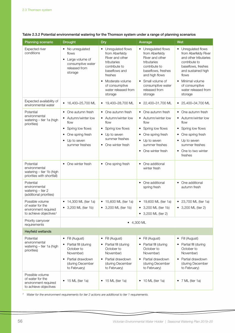
Scenario planningTable 2.3.2 outlines the potential environmental watering and expected water use under a range of planning scenarios.
The highest-priority watering actions in the Thomson River under all climate scenarios in 2019–20 will be low flows throughout autumn, winter and spring, and freshes in all seasons. The number or magnitude of these flow events will generally be smaller under drought and dry conditions, compared to average and wet conditions.
The recommended low flows for autumn, winter and spring are needed to maintain habitat for fish, waterbugs and aquatic and riparian vegetation, as well as to allow fish to move throughout the system.
Autumn freshes are needed in at least two out of three years, to cue Australian grayling to migrate downstream and spawn. No autumn freshes were delivered in the Thomson River in 2018–19 due to construction work on the Horseshoe Bend fishway, and therefore it is critical to deliver these flows in 2019–20. Summer freshes are needed to maintain habitat and food resources for waterbugs and fish and to maintain fringing riparian vegetation.
Winter freshes provide a cue for native fish including tupong and Australian bass to migrate downstream towards the estuary – where they breed or spawn, while spring freshes encourage juvenile migratory fish to move upstream from the sea or estuary. Spring and winter freshes require significant volumes of water, and it may be difficult to deliver both with the available supply under dry and drought conditions in 2019–20. Under a drought scenario, only a spring fresh is likely to be delivered with the available water. In a dry scenario, the winter fresh will be prioritised, as natural flows in spring are more likely to achieve a partial spring fresh. Fish surveys in 2017–18 indicated low numbers of Australian bass and tupong, and therefore if any additional water for the environment becomes available, it would likely be used to provide both winter and spring freshes in 2019–20 to help grow these populations in the Thomson system.
New flow recommendations for the Latrobe River estuary and lower Latrobe wetlands (see subsections 2.2.1 and 2.2.2) are highly dependent on flow contributions from the Thomson–Macalister system. Consequently, timing of the Thomson spring fresh will be influenced by conditions in these systems. Where possible, spring freshes in both the Thomson and Macalister systems will be timed to coincide with releases in the Latrobe system, to optimise outcomes in the Latrobe estuary and lower Latrobe wetlands.
Under all scenarios, 4,300 ML of water for the environment is expected to be carried over at the end of 2019–20 to meet critical minimum demands (winter, spring and autumn low flows and freshes) for environmental flows in 2020–21, under a drought scenario.
A trial watering is proposed at the Heyfield wetlands in 2019–20. The Heyfield wetlands consist of a cluster of several shallow pools and one deep freshwater pool located on a single 26 ha site adjacent to the township of Heyfield. The wetlands are isolated from Thomson River flows due to levees and changed flow regimes, and environmental watering intends to provide a more-natural filling regime to support existing the vegetation and to provide refuge habitat for waterbirds. A winter fill, then a partial fill in spring to top up the ponds before summer, followed by natural drying over the summer months, is proposed under all climatic scenarios.
56 Victorian Environmental Water Holder | Seasonal Watering Plan 2019–20
2.3 Thomson system
Table 2.3.2 Potential environmental watering for the Thomson system under a range of planning scenarios
Planning scenario Drought Dry Average Wet
Expected river conditions
• No unregulated flows
• Large volume of consumptive water released from storage
• Unregulated flows from Aberfeldy River and other tributaries contribute to baseflows and freshes
• Moderate volume of consumptive water released from storage
• Unregulated flows from Aberfeldy River and other tributaries contribute to baseflows, freshes and high flows
• Small volume of consumptive water released from storage
• Unregulated flows from Aberfeldy River and other tributaries contribute to baseflows, freshes and sustained high flows
• Minimal volume of consumptive water released from storage
Expected availability of environmental water • 16,400–25,700 ML • 19,400–28,700 ML • 22,400–31,700 ML • 25,400–34,700 ML
Potential environmental watering – tier 1a (high priorities)
• One autumn fresh
• Autumn/winter low flow
• Spring low flows
• One spring fresh
• Up to seven summer freshes
• One autumn fresh
• Autumn/winter low flow
• Spring low flows
• Up to seven summer freshes
• One winter fresh
• One autumn fresh
• Autumn/winter low flow
• Spring low flows
• One spring fresh
• Up to seven summer freshes
• One winter fresh
• One autumn fresh
• Autumn/winter low flow
• Spring low flows
• One spring fresh
• Up to seven summer freshes
• One to two winter freshes
Potential environmental watering – tier 1b (high priorities with shortfall)
• One winter fresh • One spring fresh • One additional winter fresh
Potential environmental watering – tier 2 (additional priorities)
• One additional spring fresh
• One additional autumn fresh
Possible volume of water for the environment required to achieve objectives1
• 14,300 ML (tier 1a)
• 3,200 ML (tier 1b)
• 15,600 ML (tier 1a)
• 3,200 ML (tier 1b)
• 19,600 ML (tier 1a)
• 3,200 ML (tier 1b)
• 3,200 ML (tier 2)
• 23,700 ML (tier 1a)
• 3,200 ML (tier 2)
Priority carryover requirements • 4,300 ML
Heyfield wetlands
Potential environmental watering – tier 1a (high priorities)
• Fill (August)
• Partial fill (during October to November)
• Partial drawdown (during December to February)
• Fill (August)
• Partial fill (during October to November)
• Partial drawdown (during December to February)
• Fill (August)
• Partial fill (during October to November)
• Partial drawdown (during December to February)
• Fill (August)
• Partial fill (during October to November)
• Partial drawdown (during December to February)
Possible volume of water for the environment required to achieve objectives
• 15 ML (tier 1a) • 15 ML (tier 1a) • 10 ML (tier 1a) • 7 ML (tier 1a)
1 Water for the environment requirements for tier 2 actions are additional to tier 1 requirements.

57 Victorian Environmental Water Holder | Seasonal Watering Plan 2019–20
2.4 Macalister system
2.4 Macalister system
Top: Upper Macalister River, by West Gippsland CMA Centre: Platypus, courtesy of Healesville Sanctuary Above: Long-necked turtle, by Hugh McGregor
Waterway manager – West Gippsland Catchment Management Authority
Storage manager – Southern Rural Water
Environmental water holder – Victorian Environmental Water Holder
Did you know ...?The Victorian Environmental Flows Monitoring and
Assessment Program (VEFMAP) is monitoring
vegetation in the lower Macalister River. Monitoring
results will help water managers and the community
understand how environmental flows in the Macalister
River have contributed to helping the recovery of
native vegetation along the river. Arthur Rylah Institute
scientists will be looking for diversity in species,
successful seed dispersal and germination of seeds.
58 Victorian Environmental Water Holder | Seasonal Watering Plan 2019–20
2.4 Macalister system
System overview
The Macalister River flows from Mt Howitt in the Alpine National Park and joins the Thomson River south of Maffra. The river winds its way in a south-easterly direction through mostly forested, confined valleys and narrow floodplains upstream of Lake Glenmaggie. The downstream reaches flow through wide alluvial floodplains that have been cleared for agriculture. The Wellington River and Glenmaggie Creek are the main tributaries of the Macalister River.
Lake Glenmaggie is the major water-harvesting storage regulating the Macalister River. Maffra Weir is a small diversion weir located further downstream in Maffra.
Before the construction of Lake Glenmaggie, the Macalister River would regularly receive high and medium flows in winter and spring. Although Lake Glenmaggie regularly spills, high flows are less frequent than natural because much of the water is captured by the storage. A notable impact of irrigation and water-harvesting is reversed seasonality of flows between Lake Glenmaggie and Maffra Weir. Summer flows through this reach are much higher than natural due to the delivery of irrigation water. Winter flows in this reach are lower than natural because a high proportion of the inflows are captured and there are no irrigation demands over winter. Downstream of Maffra Weir, most flows are diverted for irrigation in summer/autumn. The changed hydrology restricts fish migration, limits the growth and recruitment of in-stream and riparian plants and reduces the quality of in-stream habitat.
Water for the environment is stored in Lake Glenmaggie and released to the Macalister River. The river is divided into two reaches for the purposes of managing environmental flows: Lake Glenmaggie to Maffra Weir (reach 1) and Maffra Weir to the Thomson River (reach 2).
Maffra Weir is a major barrier to fish movement along the river, so environmental watering for migratory fish objectives mainly focus on reach 2. All other objectives apply to both reaches 1 and 2.
Environmental valuesThere are seven migratory native fish species that move between the Macalister River, the estuary and the sea to complete their life cycle. These species include the Australian grayling, short-finned eel, long-finned eel, tupong, Australian bass, short-headed lamprey and common galaxias. Yellow-eye mullet, which is an estuarine species, has been recorded in the river. Platypus and rakali (water rats) are widely distributed through the Macalister River and its tributaries.
The riparian vegetation corridor along the regulated reaches of the Macalister River is fragmented. Immediately downstream of Lake Glenmaggie, the vegetation is in good condition and includes remnant river red gums and good-quality stands of shrubs, particularly in areas where revegetation has occurred in combination with stock exclusion. Further downstream, the vegetation is degraded. In recent years, the cover of in-stream vegetation has declined, which may be due to a combination of increased water turbidity, erosion and a lack of an appropriate water regime to encourage plant growth. The cover of non-woody plants (such as reeds, sedges and rushes) along the fringes of the river is patchy.
Environmental objectives in the Macalister River
Increase the distribution, recruitment and abundance of all native fish, and increase opportunities for the spawning and recruitment of native migratory fish (such as the Australian grayling)
Improve and maintain the form of the riverbank and bed to provide physical habitat for aquatic ecology
Increase the abundance of platypus and rakali (water rats)
Improve native emergent (non-woody) and fringing (woody) vegetation in the riparian zone
Reinstate or instate submerged aquatic vegetation
Increase the abundance and number of functional groups of waterbugs

59 Victorian Environmental Water Holder | Seasonal Watering Plan 2019–20
2.4 Macalister system
Figure 2.4.1 The Macalister system
• Maffra
•
Avon
Perry
Barkly
Valencia
Freestone Creek
Toms
Rive
r
Creek
River
Creek
River
Macalister
River
Thomson
Thomson
Aberfeldy
eig
gamn
elG
Black
all
Ben
Rainbow
Fiddlers Boggy
River
River
RiverCreek
Creek
Creek
Creek
Cree
k
Cruachan
Creek
••
•• •
•
•
•Neerim
Moe
Erica
Noojee
Rosedale
Sale
Warragul
Traralgon
Tyers
Morw
ell
Flyn
ns
Trar
algon
Shady
Moe
Middle
Tanjil
Eaglehawk Creek
Cree
k
Creek
Cree
k
Rive
r
River
River
River
Latrobe
Latrobe
River
River
Creek
River
Narracan
Loch
Waterhole
Latrobe
Creek
Creek
River
Lake Glenmaggie
Lake Wellington
Blue RockReservoir
LakeNarracan
MoondarraReservoir
Morwell
Maffra Weir
Mount Howitt
ThomsonReservoir
GippslandLakes
Lake Wellington
1
2
Jordan River
RiverThomson
Reach Lake Glenmaggie to Maffra WeirReach Maffra Weir to Thomson River Water infrastructure Measurement point Town Indicates direction of flow
•
1
2
Grey river reaches have been included for context. The numbered reaches indicate where relevant environmental flow studies have been undertaken. Coloured reaches can receive environmental water.
Location within Victoria

60 Victorian Environmental Water Holder | Seasonal Watering Plan 2019–20
2.4 Macalister system
Recent conditionsClimatic conditions in the Macalister River catchment have been very dry over the last two years.
The 2017–18 year began with a dry winter/spring. Average rainfall in December 2017 and January 2018 caused Lake Glenmaggie to spill in December 2017, but the rest of summer/autumn 2018 were drier than average.
Dry conditions persisted into 2018–19, with below-average to well-below-average rainfall and above-average temperatures for most of the year. Lake Glenmaggie did not spill in 2018–19, which is rare for this system.
The reach between Lake Glenmaggie and Maffra Weir had consistent flow to meet operational demands throughout the irrigation season. Due to low inflows however, passing flows at Maffra Weir were reduced in March from 60 ML per day to 30 ML per day or less, in accordance with system rules.
Water for the environment was used to supplement low passing flows in reach 2 from late March to protect water quality, and it was also used to provide freshes at critical times and to supplement low flows when irrigation demand fell.
A winter fresh was delivered in August 2018 to trigger the migration and spawning of tupong and Australian bass. A spring fresh was delivered in early November 2018 to
encourage juvenile fish to migrate into the Macalister River from the sea, and to wet bankside vegetation and enable native seed dispersal.
An autumn fresh targeting fish migration was not delivered in April 2019. This fresh is usually timed to coincide with releases in the Thomson and Latrobe rivers to enhance migration cues. Construction of the Thomson River fishway at Horseshoe Bend meant an autumn fresh could not be delivered in the Thomson River. The lack of a complementary flow in the Thomson River reduced the value of the fresh in the Macalister River, and it was decided that the water should be held in storage to meet anticipated environmental demand in 2019–20. Foregoing the autumn fresh for one year is not expected to affect Australian grayling populations, but delivering the event in autumn 2020 will be a priority.
Scope of environmental wateringTable 2.4.1 describes the potential environmental watering actions that may be delivered in 2019–20, their functional watering objectives (that is, the intended physical or biological effect of the watering action) and the longer-term environmental objective they support. Each environmental objective relies on one or more potential environmental watering actions and their associated physical or biological functions.
Table 2.4.1 Potential environmental watering actions and objectives for the Macalister River
Potential environmental watering action
Functional watering objectiveEnvironmental objective
Macalister River reaches 1 and 2
Winter to summer low flow (up to 90 ML/day during June to December)
• Provide hydraulic habitat for fish by increasing the water depth in pools
• Provide fish passage for local movement through minimum depth over riffles
• Provide permanent wetted habitat for waterbugs through minimum water depth in pools
• Provide connectivity throughout the river for the local movement of platypus and rakali (water rats), as well as protection from predation, access to food sources; and to maintain refuge habitats
• Provide flows with low water velocity and appropriate depth to improve water clarity and enable establishment of in-stream vegetation
• Provide sustained wetting of low-level benches (increasing water depth) to limit terrestrial vegetation encroachment
Summer/autumn low flow (35–90 ML/day during January to May)
• Maintain the water depth in pools and hydraulic habitat for native fish
• Maintain permanent wetted habitat in pools and riffles for waterbugs
• Maintain shallow, slow-flowing habitat to enable the establishment of in-stream vegetation
• Maintain a minimum depth in pools to allow for turnover of water and to slow degradation of water quality to support aquatic life
• Expose and dry lower channel features for re-oxygenation

61 Victorian Environmental Water Holder | Seasonal Watering Plan 2019–20
2.4 Macalister system
Potential environmental watering action
Functional watering objectiveEnvironmental objective
Spring fresh (up to 1,500 ML/day for three days during September to October)1
• Cue the up-stream migration of adult fish (e.g. short-headed lamprey), and the recruitment of juveniles (e.g. Australian grayling, tupong, common galaxias, Australian bass, short and long-finned eels) from marine/estuarine environments
• Wet a greater area of the stream channel (increasing water depth) to limit terrestrial vegetation encroachment
• Wet mid and higher-level benches to water woody vegetation
• Flush pools to improve the water quality and increase wetted habitat for waterbugs
• Provide flows with sufficient shear stress to flush fine sediment from small gaps to improve geomorphic habitat
Macalister River reach 2
Autumn fresh (up to 350 ML/day for four to five days during April to May)
• Cue downstream migration for Australian grayling towards the estuary for spawning
Spring/summer fresh (700 ML/day for up to five days during September to December)
• Cue upstream migration of adult fish (e.g. short-headed lamprey), and recruitment of juveniles (e.g. Australian grayling, tupong, common galaxias, Australian bass, short and long-finned eels) from marine/estuarine environments
• Wet a greater area of the stream channel (increasing water depth) to limit terrestrial vegetation encroachment
• Wet low and mid-level benches to facilitate the dispersal of emergent and fringing vegetation throughout the reach
Summer/autumn fresh (one to three freshes of 140 ML/day for three days during December to May)
• Increase the depth to allow fish to move throughout the reach
• Flush pools to maintain water quality
• Flush substrates and improve the quality of existing waterbug habitat and food supply
• Wet low benches to facilitate the longitudinal dispersal of emergent vegetation
• Provide flows with sufficient shear stress to flush fine sediment from small gaps to improve geomorphic habitat
Winter fresh (one to two freshes of 700 ML/day for four to five days during June to August)
• Cue the downstream migration of tupong and Australian bass towards the estuary for spawning (Australian bass) and breeding (tupong)
1 This fresh will only be delivered following a spill in Lake Glenmaggie (if the magnitude is lower than minor flood level), to extend or slow the rate of ramp down. If a spill occurs, delivering this fresh will meet the functional flow objectives of the lower magnitude spring/summer fresh.
Table 2.4.1 Potential environmental watering actions and objectives for the Macalister River continued...

62 Victorian Environmental Water Holder | Seasonal Watering Plan 2019–20
2.4 Macalister system
Scenario planningTable 2.4.2 outlines the potential environmental watering and expected water use under a range of planning scenarios.
Providing year-round low flows and freshes in winter, spring and autumn are the highest priorities for 2019–20 under all climate scenarios, to provide connectivity through the river system so fish and other animals can move. Under drought and dry scenarios, water for the environment may be used to supplement reduced passing flows to maintain connectivity between habitats and water quality downstream of Maffra Weir.
Spring freshes are needed to trigger upstream migration of native migratory fish including tupong, lampreys and eels and to encourage juveniles to move into the Macalister River from the Latrobe River estuary. In most years, spring freshes are delivered by spills from Lake Glenmaggie, however Lake Glenmaggie did not spill in 2018–19 and early forecasts suggest Lake Glenmaggie may not spill again in spring 2019 and therefore a managed spring/summer fresh has been prioritised under all scenarios. In a drought scenario, a summer fresh may also be required to improve water quality and to prevent low levels of dissolved oxygen affecting aquatic life.
Autumn freshes are needed in the Macalister River to cue Australian grayling to breed. Australian grayling only live for up to three years, so autumn freshes are a priority in most years and under most climate scenarios, to ensure regular recruitment and the ongoing sustainability of the population. This watering action is a high priority in 2019–20 as the fresh was not delivered in 2018–19.
If additional water for the environment is available in average or wet conditions, winter freshes may be provided to trigger tupong and Australian bass to migrate downstream to the sea. A target carryover volume has been determined and is a high priority under all scenarios, to ensure there is sufficient water to deliver winter low flows in July 2019.

63 Victorian Environmental Water Holder | Seasonal Watering Plan 2019–20
2.4 Macalister system
Table 2.4.2 Potential environmental watering for the Macalister River under a range of planning scenarios
Planning scenario Drought Dry Average Wet
Expected river conditions
• No unregulated flows
• Passing flows at Maffra Weir reduced
• Possible spills from Lake Glenmaggie in spring, minor flood levels may occur
• Passing flows at Maffra Weir may be reduced
• Regular spills from Lake Glenmaggie in spring, minor to moderate flood levels may occur
• Large and frequent spills from Lake Glenmaggie, moderate to major flood levels may occur
Expected availability of environmental water • 12,500 ML • 15,800 ML • 17,800 ML • 22,300 ML
Potential environmental watering – tier 1a (high priorities)
• Winter to summer low flow (reach 1 and 2)
• Summer/autumn low flow
• One to three summer/autumn freshes (reach 2)
• One autumn fresh (reach 2)
• One winter fresh (reach 2)
• Winter to summer low flow (reach 1 and 2)
• Summer/autumn low flow
• One to three summer/autumn freshes (reach 2)
• One spring/summer fresh (reach 2) or spring fresh (reach 1 and 2) following spill
• One autumn fresh (reach 2)
• One winter fresh (reach 2)
• Winter to summer low flow (reach 1 and 2)
• One spring/summer fresh (reach 2) or spring fresh (reach 1 and 2) following spill
• One autumn fresh (reach 2)
• One winter fresh (reach 2)
• Winter to summer low flow (reach 1 and 2)
• One spring fresh (reach 1 and 2) following spill
• One autumn fresh (reach 2)
• Two winter freshes (reach 2)
Potential environmental watering – tier 1b (high priorities with shortfall)
• One spring/summer fresh (reach 2)
• Extend baseflow duration through winter and spring months if Lake Glenmaggie spills
• Extend baseflow duration through winter and spring months following Lake Glenmaggie spill
• Extend baseflow duration through winter and spring months following Lake Glenmaggie spill
Potential environmental watering – tier 2 (additional priorities)
• Extend baseflows through winter and spring months
• One additional winter fresh (reach 2)
• One additional winter fresh (reach 2)
• One additional spring/summer fresh (reach 2)
Possible volume of water for the environment required to achieve objectives1
• 10,400 ML (tier 1a)
• 3,500 ML (tier 1b)
• 1,100 ML (tier 2)
• 13,800 ML (tier 1a)
• 1,100 ML (tier 1b)
• 2,800 ML (tier 2)
• 16,600 ML (tier 1a)
• 1,100 ML (tier 1b)
• 2,800 ML (tier 2)
• 19,000 ML (tier 1a)
• 900 ML (tier 1b)
• 3,500 ML (tier 2)
Priority carryover requirements • 1,500–1,900 ML
1 Water for the environment requirements for tier 2 actions are additional to tier 1 requirements.

64 Victorian Environmental Water Holder | Seasonal Watering Plan 2019–20
2.5 Snowy system
2.5 Snowy system
Top: Snowy River, by East Gippsland CMA Centre: Eastern curlew, by East Gippsland CMA Above: Snowy River mouth, used by fish including flathead, mulloway and black bream, by Mark Toomey, VEWH
Waterway managers – East Gippsland Catchment Management Authority and New South Wales Department of Planning, Industry and Environment
Storage manager – Snowy Hydro Limited
Environmental water holders – Victorian Environmental Water Holder, New South Wales Department of Planning, Industry and Environment
Did you know ...?A new Snowy Advisory Committee was formed in
2018. The committee will guide decision-making
around environmental flows for the iconic Snowy
River. Membership includes local community
members, Aboriginal representation, environmental
experts and NSW Government and Victorian
Government delegates.

65 Victorian Environmental Water Holder | Seasonal Watering Plan 2019–20
2.5 Snowy system
System overview
The Snowy River originates on the slopes of Mount Kosciuszko. It drains the eastern slopes of the Snowy Mountains in New South Wales before flowing through the Snowy River National Park in Victoria and into Bass Strait.
There are four major dams and multiple diversion weirs in the upper Snowy River catchment that divert water to the Murrumbidgee and River Murray valleys. The hydrological effects of the Snowy Mountains Scheme are substantial, but they are partly alleviated by the contribution of flows from tributaries (such as the Delegate River in New South Wales and the Buchan and Brodribb rivers in Victoria).
Construction and operation of the Snowy Mountains Hydro-electric Scheme previously diverted 99 percent of the Snowy River’s mean annual natural flow at Jindabyne. The loss of flow changed the structure and function of the river, reduced the opening of the Snowy River entrance to Bass Strait and resulted in a decline in environmental values.
The Victorian, New South Wales and Commonwealth governments have recovered water to help restore damage done by decades of limited flow. Victorian water for the environment available for use in the Snowy system is held in the Murray, Goulburn and Loddon systems. This water is made available for environmental flows in the Snowy River via a substitution method, whereby Victorian water for the environment replaces water that was earmarked for transfer from the Snowy to Victoria to support irrigation demands.
Environmental valuesThe remaining environmental values in the upper reaches and tributaries of the Snowy River include freshwater fish (such as river blackfish and Australian grayling). The lower reaches support estuary perch and Australian bass that move between saltwater and freshwater systems. The estuary contains estuarine and saltwater species such as flathead, mulloway and black bream. The floodplain wetlands of the Snowy River near Marlo provide feeding and breeding areas for wetland and migratory birds.

66 Victorian Environmental Water Holder | Seasonal Watering Plan 2019–20
2.5 Snowy system
Figure 2.5.1 The Snowy system
Jindabyne
Orbost
MacLa
ughli
n
Delega
te
Mt Kosciuszko
LakeEucumbene
Thredbo RiverSnowy
Mowamba
River
Snowy
Brodribb
Snow
y
Buchan
EucumbeneRiver
Rive
r
River
Rive
rRiver
River
River
River
NEW SOUTH WALES/
VICTORIA BORDER
LakeJindabyne
Snowy Estuary
Reach Snowy River Town Indicates direction of flow
•
Grey river reaches have been included for context. The numbered reaches indicate where relevant environmental flow studies have been undertaken. Coloured reaches can receive environmental water.
Buchan
Location within Victoria

67 Victorian Environmental Water Holder | Seasonal Watering Plan 2019–20
2.5 Snowy system
Recent conditionsThe water year in the Snowy system runs from May to April. In 2018–19, about 137,087 ML3 of water for the environment was used to deliver five winter/spring high-flow events in the Snowy River. A major flushing flow was planned for October 2018, but prolonged, dry conditions and low inflows into Jindabyne Dam resulted in the flow rate being reduced, from 8,620 ML per day to 5,000 ML per day.
Scope of environmental wateringThe New South Wales Department of Planning, Industry and Environment plans environmental flow releases in the Snowy River, in consultation with the Victorian Government.
Environmental watering from May 2019 to April 2020 will aim to mimic the typical flow pattern of a mixed snowmelt/rainfall river system characteristic of the Snowy Mountains. The releases will aim to support ecological processes in the Snowy River below Jindabyne Dam and maintain a healthy river that is much smaller than the natural channel that existed before the river was regulated.
East Gippsland CMA has monitored the lower reaches and estuary over the past seven years. The results show that the managed environmental flows help improve physical and ecological processes, increase ecosystem productivity and improve aquatic habitat.
Five high-flow releases are scheduled between June and November 2019. A large, flushing flow is scheduled for late October 2019 and includes an eight-hour peak at a rate equivalent to 5,000 ML per day. Other peak flows will mimic winter rainfall events. These peak flows aim to improve the physical attributes of the river by scouring and depositing sediment and increasing available aquatic habitat. High flows will be sustained from July to December, to help mix water in the estuary to benefit plants and fish (such as Australian bass). Low flows will then be released until the end of the water year in April 2020.
The total volume planned for release in 2019–20 (including contributions from water savings in Victoria and New South Wales) is 118,671 ML.
__________
3 Preliminary figure of total releases in 2018–19. This volume may alter slightly due to accounting adjustments. Volume will be verified in Snowy Hydro Limited’s annual water operating plan.