Embed Size (px)
Citation preview

4/5/2017
1
Chapter 13
Section 13-1: Thunderstorms
Main Idea: The intensity and duration of thunderstorms depend on the local conditions that create them. Air-mass thunderstorm
Mountain thunderstorm
Sea-breeze thunderstorm
Frontal thunderstorm
Stepped leader
Return stroke
3 Things Needed for a
Thunderstorm
Abundant moisture in the lower
atmosphere.
A lift mechanism
Unstable atmosphere: the
atmosphere must be cooler with
altitude, so the air will continue to
rise
Air Stability – Cause?
Stability: The ability of air to resist
rising.

4/5/2017
2
Atmosphere Stability –
Day vs. Night
The speed or rate at which air rises
& cools determines its stability.
Speed of rising depends on the
temperature change from ground
to upper troposphere
Stable atmosphere = high
stability = little rising
Air at surface is similar in temp and
density as the air above, resulting
in little to no rising.
Clouds are thin stratus, or absent.
Untable atmosphere = instability
= Air rises quickly
Air temperature quickly decreases with altitude.
Air at the surface is warm with low density compared to the air above it.
The low density causes it to rapidly rise
Causes cumulonimbus clouds and intense precipitation.
Untable atmosphere = instability
= Air rises quickly

4/5/2017
3
Untable atmosphere Cont…
Instability can be increased with a
high amount of humidity in the air.
Results:
Lots of condensation at the LDL
(Lifted Condensation Level) will
release “latent heat”
Latent heat warms the atmosphere,
air continues to rise, cloud expands.
Untable atmosphere Cont…
Instability is also increased when warm
air is forced quickly up at a cold front.
Instability is increased during
orographic lifting.

4/5/2017
4
Classification of Thunderstorms
Thunderstorms are classified
by type of lift mechanism.
Air mass thunderstorms
Mountain
Sea breeze
Frontal thunderstorms
Air Mass Thunderstorms
Occurs in the middle of a single air mass due to convection in the middle.
Due to unequal surface heating within the air mass during the day.
Most common in late afternoon around 4pm.
Mountain Thunderstorms
Occur when an air mass rises
by orographic lifting, which
involves air moving up the side
of a mountain.
Sea-Breeze Thunderstorms
Caused by heating and temperature differences between land and water.
mT air is warm and humid – perfect for thunderstorm formation.
Do not produce severe storms.
Happen in late afternoon.

4/5/2017
5
Sea-Breeze Thunderstorms Frontal Thunderstorms
Produced mainly by cold fronts.
Steep front forces warm air up
quickly.
T-Storm develops at leading edge
(front edge)
Frontal Thunderstorms
Differences from air mass T-Storms
Last longer
Can occur day or night
More severe
Sometimes produced by warm fronts,
but not as often and not as severe.
Stages of Thunderstorm
Development
T-Storm Development:
3 stages classified by direction of
air movement (up and/or down)
4/5/2017
6
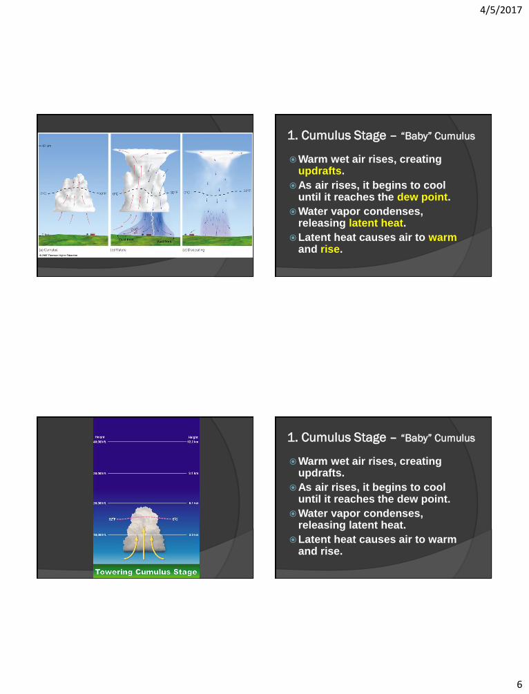
1. Cumulus Stage – “Baby” Cumulus
Warm wet air rises, creating updrafts.
As air rises, it begins to cool until it reaches the dew point.
Water vapor condenses, releasing latent heat.
Latent heat causes air to warm and rise.
1. Cumulus Stage – “Baby” Cumulus
Warm wet air rises, creating updrafts.
As air rises, it begins to cool until it reaches the dew point.
Water vapor condenses, releasing latent heat.
Latent heat causes air to warm and rise.
4/5/2017
7
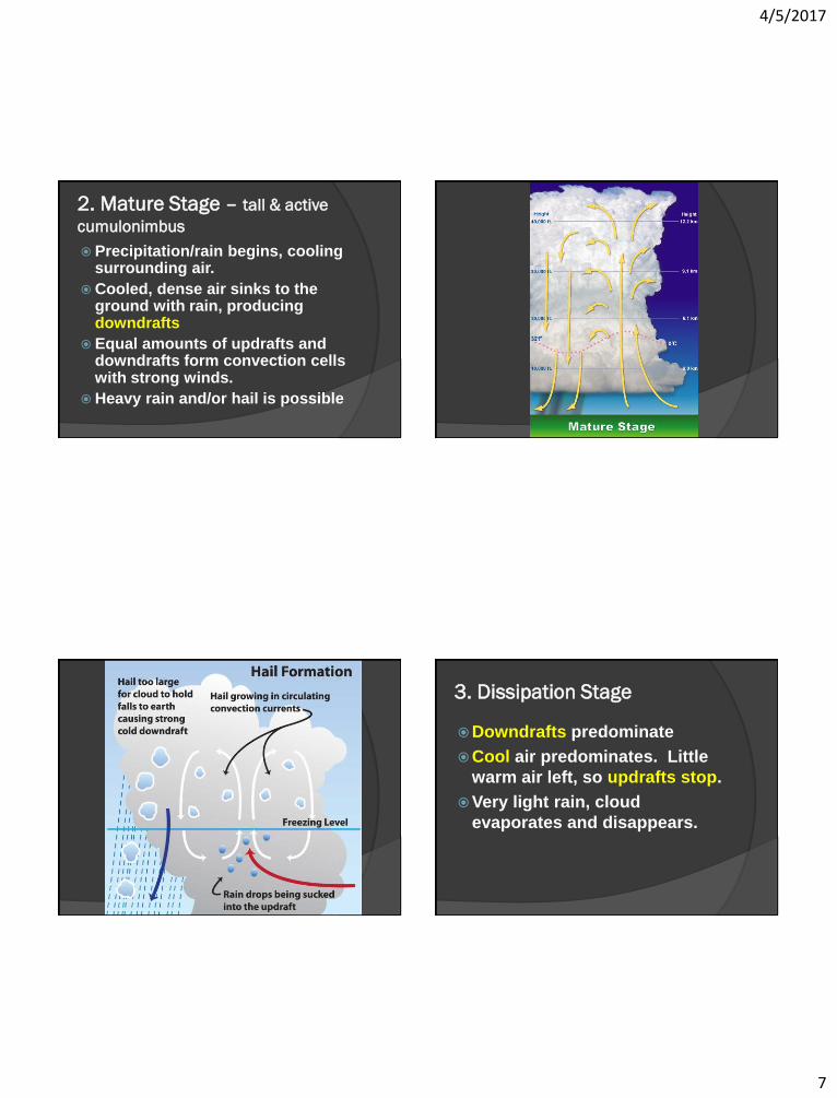
2. Mature Stage – tall & active
cumulonimbus
Precipitation/rain begins, cooling surrounding air.
Cooled, dense air sinks to the ground with rain, producing downdrafts
Equal amounts of updrafts and downdrafts form convection cells with strong winds.
Heavy rain and/or hail is possible
3. Dissipation Stage
Downdrafts predominate
Cool air predominates. Little
warm air left, so updrafts stop.
Very light rain, cloud
evaporates and disappears.

4/5/2017
8
3 Signs of Severe T-Storms
Strong winds of
50mph or more
Large hailstones
measuring 0.75” or more
Tornado present
Severe Thunderstorm Hazards
3 Hazards that accompany
severe T-storms responsible for
the most property damage and
deaths.
Lightning
Tornadoes
Flash Flooding

4/5/2017
9
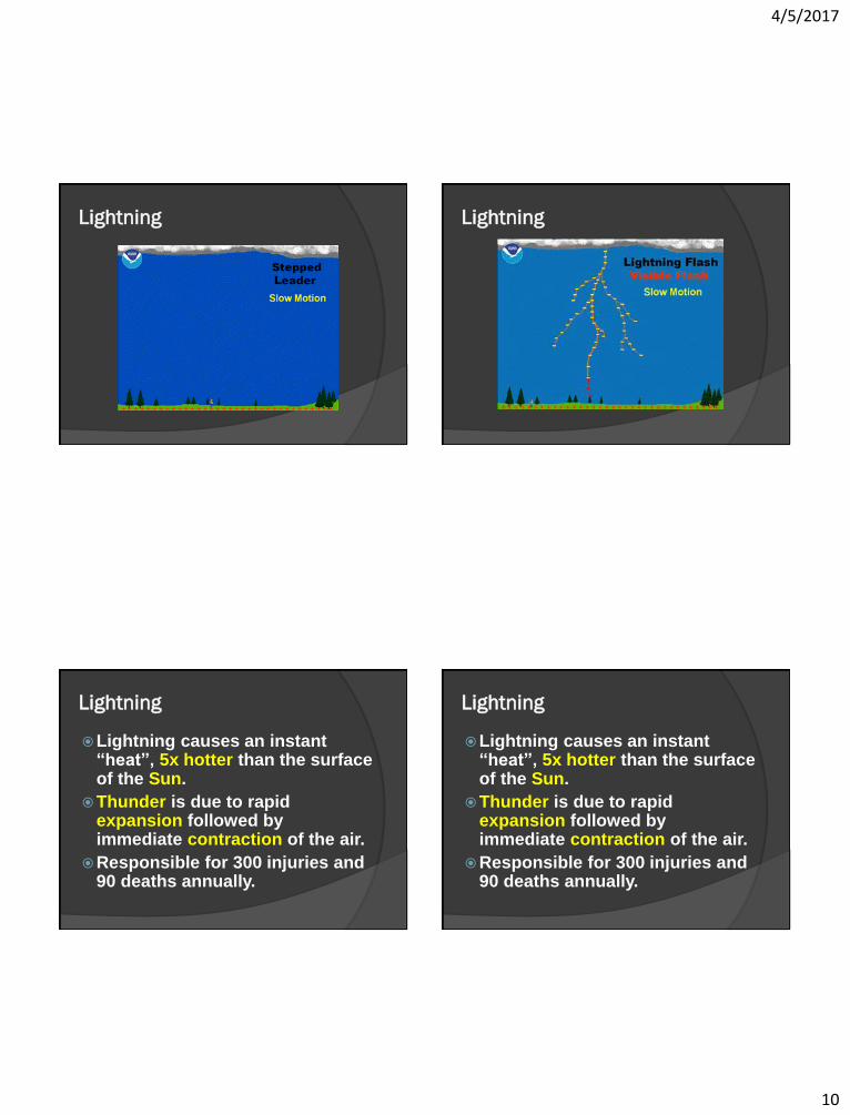
Lightning
Caused by electricity generated by the rapid rushes of air inside a cumulonimbus cloud.
Friction rubs/knocks electrons off.
Charges separate: - charge builds up on bottom, + charge on top of cloud.
- charge at bottom of cloud attracts and pulls positive charges on the ground to the tops of trees.
Lightning
Lightning
When charges build up, a giant
electrical spark/current jumps
from negative area to positive
area.
Lightning
A branched channel of partially charged air forms between the cloud and the ground, called a stepped leader.
When the stepped leader reaches the ground, it connects with the return stroke, a branch of positively charged particles.
4/5/2017
10
Lightning Lightning
Lightning
Lightning causes an instant “heat”, 5x hotter than the surface of the Sun.
Thunder is due to rapid expansion followed by immediate contraction of the air.
Responsible for 300 injuries and 90 deaths annually.
Lightning
Lightning causes an instant “heat”, 5x hotter than the surface of the Sun.
Thunder is due to rapid expansion followed by immediate contraction of the air.
Responsible for 300 injuries and 90 deaths annually.

4/5/2017
11
13-2: Supercells
Supercells are self-sustaining,
extremely powerful storms.
Characterized by:
Intense, rotating updrafts
Spawning long-lived tornadoes
240km/h winds
Less than 10% of thunderstorms in
the U.S. reach supercell proportions
13-2: Strong Winds
Violent downdrafts of 200km/h or greater concentrated in a local area are called downbursts.
Macrobursts: Can affect an area 5km wide, and lasts for up to 30 minutes
Microbursts: Can affect an area of 3km wide, and lasts fewer than 10 minutes.

4/5/2017
12
13-2: Strong Winds
Downbursts can be as
destructive or more
destructive than tornadoes.
Extremely difficult to
predict and detect.
13-2: Tornadoes
Violent, whirling column of air
in contact with the ground.
Prior to contact, called a
funnel cloud.
Formed when wind speed and
direction change suddenly.
13-2: Tornadoes
Begins with air moving
horizontally on the surface.
Storm updrafts flip the air
up.
Air begins to stretch out.
More stretching – faster air.

4/5/2017
13
13-2: Tornadoes
Begins with air moving
horizontally on the surface.
Storm updraft picks this air
up.
Air begins to stretch out.
More stretching – faster air.
13-2: Tornadoes (simplified)
Measuring/Classifying
Fujita tornado intensity scale
Based on estimated wind
speed and damage.
Determined AFTER the
tornado occurred – damage
must be assessed
Measuring/Classifying

4/5/2017
14
Measuring/Classifying
Enhanced Fujita Scale
Type of structure combined
with damage is evaluated,
because building more poorly
made will have more damage.
Locations Occur most often in spring in
the central U.S. where cold cP collide with mT (Large temp. differences)
As warm, moist mT air moves N from Feb to May, tornado occurrences also move N.
Usually occur in late afternoon.
13-3 Tropical Storms
Normally peaceful, tropical oceans are capable of producing one of Earth’s most violent weather system.
During summer and fall, the tropics experience conditions ideal for the formation of large, rotating, low-pressure tropical storms called tropical cyclones.

4/5/2017
15
Tropical Cyclones
Large, rotating, low-pressure storms.
Require warm ocean water.
Occur in late summer / early fall.
Called hurricanes in the U.S. and
Atlantic ocean.
Called typhoons in the Pacific ocean.
Latent Heat & Pressure
Counter-clockwise spin in the
Northern hemisphere.
Warm, moist air rises, condenses,
releasing latent heat, and continuing
to rise.
Continued rising increases energy and
spinning speed.
Overall Result
Low-pressure in the center of the
cyclone.
Spiraling surface wind speed
increases.
The lower the pressure, the stronger
the storm.

4/5/2017
16
Formation – 2 things needed
Abundant supply of warm water.
Disturbance causing lift.
Movement
Moves with wind currents.
(trade winds)
Lasts until no warm ocean water is
available to sustain it.
Energy no longer available when it
reaches:
Land (loses moisture)
Cold Water (loses warmth)

4/5/2017
17
Tropical Cyclone Stages
1. Tropical Disturbance
2. Tropical Depression
3. Tropical Storm
4. Hurricane
Tropical Disturbance
Starts as a weak low-pressure
system where air rises
because it is warm or because
it is lifted by the ITCZ
(Intertropical Convergence
Zone)
Tropical Disturbance Tropical Disturbance
May be a band of
thunderstorms in the tropics.

4/5/2017
18
Tropical Depressions and Storms
Tropical Depressions form
when spinning around the low
pressure center begins
Tropical Storms form when
cyclonic winds around the
center are 40mph or more.
Hurricanes
Hurricanes form when winds are >= 75mph (120kmph) and the eye is present.
The eye is calm and an area of extremely low pressure
The eyewall has the strongest/fastest winds.
Measuring Hurricanes
Saffir-Simpson hurricane
scale: Based on CURRENT
wind speed, pressure, and
storm surge damage potential
(NOT actual damage like the
Fujita Tornado Scale)
Saffir-Simpson hurricane scale
A hurricane can move up and
down through the different
levels throughout its life.
1-5 scale: lowest to highest
intensity

4/5/2017
19
Hurricane Destruction:
3 Main Hazards
1. Storm Surge
2. Wind Damage
3. Flash Flooding
Storm Surge
Huge wall of water that is
pushed over the land by the
hurricane winds.
Causes 90% of hurricane
deaths.
Storm Surge

4/5/2017
20
Storm Surge
Storm Surge
Wind Damage
75-150 mph winds
These change in intensity
depending on your location
and the path of the hurricane.
Most violent winds are in the
eye wall.
Wind Damage

4/5/2017
21
Flash Flooding
Caused by heavy rainfall in a
small duration of time.
Worse if combined with a
storm surge.
13-4: Recurrent Weather
Relatively mild weather can
become destructive if it
persists for long periods of
time.
Too much of any type of
weather can have serious
consequences.

4/5/2017
22
Droughts: Lack of Rainfall
Extended period with no rain,
or less than average rainfall.
Result of _______ pressure
system?
HIGH
Heat Waves:
Extended periods above
normal temperature.
With a HIGH-pressure system,
there are little to no clouds.
Air is rising or sinking?
Sun is intense since it does not
reflect off of cloud cover.
Heat Waves:
Usually accompany droughts.
Winds blowing out away from
center (H-Pressure) prevent
cool air masses from moving
in.
Health problems can occur
(heat stroke)
Heat Index
Compares combined heat and
humidity to the body’s ability
to sweat and cool off

4/5/2017
23
Cold Wave
Extended periods below
normal temperature.
Also due to high pressure, but
cP in origin.
Influenced by the jet stream.
Wind-Chill Factor
How cold the air feels based on
the estimated heat loss from
the skin due to cold
temperatures and WIND.