Embed Size (px)
Citation preview
SECTION .1000 - STORMWATER MANAGEMENT
15A NCAC 02H .1001 POST-CONSTRUCTION STORMWATER MANAGEMENT: PURPOSE AND SCOPE The purpose of this Section is to protect surface waters and aquatic resources from the adverse impacts of stormwater runoff from development activities.
(1) APPLICABILITY. This Section shall apply to development projects and major modifications of development projects for residential, commercial, industrial, or institutional use that are subject to one or more of the post-construction stormwater management programs listed in Item (2) of this Rule. This Section shall not apply to: (a) land management activities associated with agriculture or silviculture; (b) activities of the North Carolina Department of Transportation (NCDOT) that are regulated in
accordance with the provisions of NPDES Permit Number NCS000250; (c) linear transportation projects undertaken by an entity other than the NCDOT when:
(i) the project is constructed to NCDOT standards and is in accordance with the NCDOT Stormwater Best Management Practices Toolbox (Version 2, April 2014 Edition) which is herein incorporated by reference, including any subsequent amendments and editions, and may be accessed at no cost at https://connect.ncdot.gov/resources/hydro/HSPDocuments/2014_BMP_Toolbox.pdf;
(ii) upon completion, the project will be conveyed either to the NCDOT or another public entity and will be regulated in accordance with that entity's NPDES MS4 stormwater permit; and
(iii) the project is not part of a common plan of development; (d) development activities that have already received a State Stormwater Permit or Certification
where no modification or a minor modification is requested. These activities shall follow their existing permit conditions.
(e) airport facilities that are deemed permitted in accordance with G.S. 143-214.7(c4); and (f) "redevelopment" as the term is defined in G.S. 143-214.7(a1).
(2) STORMWATER PROGRAMS. The post-construction stormwater management programs consist of the following: (a) Coastal Counties – 15A NCAC 02H .1019; (b) Non-Coastal County High Quality Waters and Outstanding Resource Waters – 15A NCAC 02H
.1021; (c) NPDES MS4 Stormwater – 15A NCAC 02H .0126; 15A NCAC 02H .0150, .0151; 15A NCAC
02H .0153; 15A NCAC 02H .1017; (d) Urbanizing Areas – 15A NCAC 02H .1016; and (e) Universal Stormwater Management Program - 15A NCAC 02H .1020.
(3) PERMIT REQUIRED. A permit shall be required for development activities that are subject to any of the post-construction stormwater management programs listed in Item (2) of this Rule. The permit shall be issued by the implementing authority in accordance with this Section. If a project is subject to more than one post-construction stormwater management program, the requirements of both programs shall apply unless otherwise required or allowed by the applicable rule of this Section.
(4) DISPUTES REGARDING WATER QUALITY CLASSIFICATION. For stormwater programs that apply based on water quality classification, any disputes regarding water quality classification shall be determined by the N.C. Division of Water Resources pursuant to 15A NCAC 02B .0101 and in accordance with G.S. 143-214.1.
(5) PRIOR AUTHORIZATIONS. A development project shall not be required to comply with this Section or shall be allowed to follow an earlier version of the rules of this Section available for no cost on the Division's website at http://deq.nc.gov/about/divisions/energy-mineral-land-resources/energy-mineral-land- permits/stormwater-program if it is conducted pursuant to one of the following authorizations, provided that the authorization was obtained prior to the effective date of the applicable rule of this Section, and the authorization is valid, unexpired, unrevoked, and not otherwise terminated: (a) a building permit pursuant to G.S. 153A-357 or G.S. 160A-417; (b) a "site specific development plan" as defined by G.S. 153A-344.1(b)(5) and G.S. 160A-
385.1(b)(5); (c) a "phased development plan" as defined by G.S. 153A-344.1(b)(3) or G.S. 160A-385.1 that
shows: (i) for the initial or first phase of development, the type and intensity of uses for a specific
parcel or parcels, including the boundaries of the project and a subdivision plan that has been approved pursuant to G.S. 153A-330 through G.S. 153A-335 or G.S. 160A-371 through G.S. 160A-376; and
(ii) for any subsequent phase of development, sufficient detail that demonstrates to the permitting authority that implementation of the requirements of this Section to that phase of development would require a material change in that phase of development as contemplated in the phased development plan. Sufficient detail may include documentation of financial expenditures and contractual obligations, a copy of an approved site-specific development plan, and a narrative of how the new rules will require a material change to the subsequent phase or phases of development; or
(d) a vested right to the development pursuant to common law. (6) ANTI-DEGRADATION POLICY. Development projects that are subject to this Section shall comply with
the Antidegradation Policy set forth in 15A NCAC 02B .0201.
History Note: Authority G.S. 143-214.1; 143-214.7; 143-215.1; 143-215.3(a)(1); S.L. 2014-1; Eff. January 1, 1988; Amended Eff. September 1, 1995; Readopted Eff. January 1, 2017.
15A NCAC 02H .1002 DEFINITIONS The definition of any word or phrase in this Section shall be the same as given in Article 21, Chapter 143 of the General Statutes of North Carolina, as amended. Definitions set forth in 15A NCAC 02H .0150 and 40 CFR 122.2 and 122.26(b) (1 July 2015 Edition) are incorporated herein by reference, not including subsequent amendments and editions. These federal regulations may be accessed at no cost at http://www.gpo.gov/fdsys/. Other words and phrases used in this Section are defined as follows:
(1) "Adverse impact" means a detrimental effect upon water quality or best usages, including a violation of water quality standards, caused by or contributed to by a discharge or loading of a pollutant or pollutants.
(2) "Best usage" means those uses of waters specified for each classification as determined by the Commission in accordance with the provisions of G.S. 143-214.1 and as set forth in 15A NCAC 02B .0101, 15A NCAC 02B .0200, and 15A NCAC 02B .0300.
(3) "Built-upon area" or "BUA" has the same meaning as in G.S. 143-214.7. (4) "CAMA Major Development Permits" means those permits or revised permits required by the Coastal
Resources Commission as set forth in 15A NCAC 07J Sections .0100 and .0200. (5) "Certificate of Stormwater Compliance" means the approval for activities that meet the requirements for
coverage under a stormwater general permit for development activities that are regulated by this Section. (6) "Coastal Counties" means any of the following counties: Beaufort, Bertie, Brunswick, Camden, Carteret,
Chowan, Craven, Currituck, Dare, Gates, Hertford, Hyde, New Hanover, Onslow, Pamlico, Pasquotank, Pender, Perquimans, Tyrrell, and Washington.
(7) "Commission" means the North Carolina Environmental Management Commission. (8) "Common plan of development" means a site where multiple separate and distinct development activities
may be taking place at different times on different schedules but governed by a single development plan regardless of ownership of the parcels. Information that may be used to determine a "common plan of development" include plats, blueprints, marketing plans, contracts, building permits, public notices or hearings, zoning requests, and infrastructure development plans.
(9) "Curb Outlet System" means curb and gutter with breaks or other outlets used to convey stormwater runoff to vegetated conveyances or other vegetated areas.
(10) "Design volume" means the amount of stormwater runoff that an SCM or series of SCMs is designed to treat.
(11) "Development" has the same meaning as in G.S. 143-214.7. (12) "Director" means the Director of the Division of Energy, Mineral, and Land Resources. (13) “Dispersed flow" means uniform shallow flow that is conveyed to a vegetated filter strip as defined in Rule
.1059 of this Section, another vegetated area, or stormwater control measure. The purpose of "dispersed flow" is to remove pollutants through infiltration and settling, as well as to reduce erosion prior to stormwater reaching surface waters.
(14) "Division" means the Division of Energy, Mineral, and Land Resources. (15) "Drainage Area or Watershed" means the entire area contributing surface runoff to a single point. (16) "Erosion and Sedimentation Control Plan" means any plan, amended plan, or revision to an approved plan
submitted to the Division of Energy, Mineral, and Land Resources or a delegated authority in accordance with G.S. 113A-57.
(17) "Existing development" means those projects that are built or those projects that have established a vested right under North Carolina law as of the effective date of the state stormwater program or applicable local government ordinance to which the project is subject.
(18) "General Permit" means a permit issued under G.S. 143-215.1(b)(3) and G.S. 143-215.1(b)(4) authorizing

a category of similar activities or discharges. (19) "Geotextile fabric" means a permeable geosynthetic comprised solely of non-biodegradable textiles. (20) "Infiltration Systems" means stormwater control measures designed to allow runoff to move into the soil's
pore space. (21) "Intermittent stream" has the same meaning as in 15A NCAC 02B .0233. (22) "Local government" has the same meaning as in 15A NCAC 02B .0202. (23) "Major modification" means a change of a state stormwater permit that is not a "minor modification" as
that term is defined in this Rule. (24) "Minimum Design Criteria" or "MDC" means the requirements set forth in this Section for siting, site
preparation, design and construction, and post-construction monitoring and evaluation necessary for the Department to issue stormwater permits that comply with State water quality standards adopted pursuant to G.S. 143-214.1.
(25) "Minor modification" means a change of a state stormwater permit that does not increase the net built-upon area within the project or does not increase the overall size of the stormwater control measures that have been approved for the project.
(26) "Non-erosive velocity" means the flow rate of water, usually measured in feet per second, that does not exceed the maximum permissible velocity for the condition and type of soil and groundcover over which the water is flowing. Erosion occurs when the maximum permissible velocity is exceeded.
(27) "Notice of Intent" means a written notification to the Division that an activity or discharge is intended to be covered by a general permit in lieu of an application for an individual permit.
(28) "NPDES" means National Pollutant Discharge Elimination System. (29) "Off-site Stormwater Systems" means stormwater management systems that are located outside the
boundaries of the specific project in question, but designed to control stormwater drainage from that project and other potential development sites.
(30) "One-year, 24-hour storm" means the maximum amount of rainfall during a 24 consecutive hour period expected, on average, to occur once a year. One-year, 24-hour storm depths are estimated by the National Oceanic and Atmospheric Administration (NOAA) Precipitation Frequency Data Server (PFDS), which is herein incorporated by reference, including subsequent amendments and editions, and may be accessed at no cost at http://hdsc.nws.noaa.gov/hdsc/pfds/.
(31) "On-site Stormwater Systems" means the systems necessary to control stormwater within an individual development project and located within the project boundaries.
(32) "Peak attenuation volume" means stormwater runoff in excess of the design volume that is conveyed to an SCM where it is not treated in accordance with the applicable MDC, but is released by the SCM in a controlled manner to address potential downstream erosion and flooding impacts to meet federal, State, or local regulations beyond the requirements of this Section.
(33) "Perennial waterbody" has the same meaning as in 15A NCAC 02B .0233. (34) "Perennial stream" has the same meaning as in 15A NCAC 02B .0233. (35) "Permeable pavement" means paving material that absorbs water or allows water to infiltrate through the
paving material. "Permeable pavement" materials include porous concrete, permeable interlocking concrete pavers, concrete grid pavers, porous asphalt, and any other material with similar characteristics.
(36) "Person" has the same meaning as in G.S. 143-212(4). (37) "Primary SCM" means a wet pond, stormwater wetland, infiltration system, sand filter, bioretention cell,
permeable pavement, green roof, rainwater harvesting, or an approved new stormwater technology that is designed, constructed and maintained in accordance with the MDC.
(38) "Project" means the proposed development activity for which an applicant is seeking a stormwater permit from the state or other entity in accordance with this Section. "Project" shall exclude any land adjacent to the area disturbed by the project that has been counted as pervious by any other development regulated under a federal, State, or local stormwater regulation. Owners and developers of large developments consisting of many linked projects may consider developing a master plan that illustrates how each project fits into the design of the large development.
(39) "Public linear transportation project" means a project consisting of a road, bridge, sidewalk, greenway, or railway that is on a public thoroughfare plan or provides improved access for existing development and that is owned and maintained by a public entity.
(40) "Required storm depth" means the minimum amount of rainfall that shall be used to calculate the required treatment volume or to evaluate whether a project has achieved runoff volume match.
(41) "Redevelopment" has the same meaning as in G.S. 143-214.7. (42) "Residential development" has the same meaning as in 15A NCAC 02B .0202. (43) "Runoff treatment" means that the volume of stormwater runoff generated from all of the built-upon area of
a project at build-out during a storm of the required storm depth is treated in one or more primary SCMs or a combination of Primary and Secondary SCMs that provides equal or better treatment.
(44) "Runoff volume match" means that the annual runoff volume after development shall not be more than ten

percent higher than the annual runoff volume before development, except in areas subject to SA waters requirements per Rule .1019 of this Section where runoff volume match means that the annual runoff volume after development shall not be more than five percent higher than the annual runoff volume before development.
(45) "Seasonal High Water Table" or "SHWT" means the highest level of the saturated zone in the soil during a year with normal rainfall. SHWT may be determined in the field through identification of redoximorphic features in the soil profile, monitoring of the water table elevation, or modeling of predicted groundwater elevations.
(46) "Secondary SCM" means an SCM that does not achieve the annual reduction of Total Suspended Solids (TSS) of a "Primary SCM" but may be used in a treatment train with a primary SCM or other Secondary SCMs to provide pre-treatment, hydraulic benefits, or a portion of the required TSS removal.
(47) "Stormwater" has the same meaning as in G.S.143-213(16a). (48) "Stormwater Collection System" means any conduit, pipe, channel, curb, or gutter for the primary purpose
of transporting (not treating) runoff. A stormwater collection system does not include vegetated swales, swales stabilized with armoring, or alternative methods where natural topography or other physical constraints prevents the use of vegetated swales (subject to case-by-case review), curb outlet systems, or pipes used to carry drainage underneath built-upon surfaces that are associated with development controlled by the provisions of Rule .1003 in this Section.
(49) "Stormwater Control Measure" or "SCM," also known as "Best Management Practice" or "BMP," means a permanent structural device that is designed, constructed, and maintained to remove pollutants from stormwater runoff by promoting settling or filtration; or to mimic the natural hydrologic cycle by promoting infiltration, evapo-transpiration, post-filtration discharge, reuse of stormwater, or a combination thereof.
(50) "Ten-year storm intensity" means the maximum rate of rainfall of a duration equivalent to the time of concentration expected, on the average, once in 10 years. Ten-year storm intensities are estimated by the National Oceanic and Atmospheric Administration (NOAA) Precipitation Frequency Data Server (PFDS), which is herein incorporated by reference, including subsequent amendments and editions, and may be accessed at no cost at http://hdsc.nws.noaa.gov/hdsc/pfds/.
(51) "Vegetated setback" means an area of natural or established vegetation adjacent to surface waters, through which stormwater runoff flows in a diffuse manner to protect surface waters from degradation due to development activities.
(52) "Vegetated conveyance" means a permanent, designed waterway lined with vegetation that is used to convey stormwater runoff at a non-erosive velocity within or away from a developed area.
(53) "Water Dependent Structures" means a structure that requires access, proximity to, or siting within surface waters to fulfill its basic purpose, such as boat ramps, boat houses, docks, or bulkheads. Ancillary facilities such as restaurants, outlets for boat supplies, parking lots, and boat storage areas shall not be considered water dependent structures.
History Note: Authority G.S. 143-213; 143-214.1; 143-214.7; 143-215.3(a)(1);
Eff. January 1, 1988; Amended Eff. August 1, 2012 (see S.L. 2012-143, s.1. (f)); July 3, 2012; December 1, 1995; September 1, 1995; Temporary Amendment Eff. March 28, 2014; Amended Eff. January 1, 2015; Readopted Eff. January 1, 2017.
15A NCAC 02H .1003 REQUIREMENTS THAT APPLY TO ALL PROJECTS The following requirements shall apply to projects subject to any North Carolina stormwater program set forth in Rule .1001 of this Section.
(1) CALCULATION OF PROJECT DENSITY. The following requirements shall apply to the calculation of project density: (a) Project density shall be calculated as the total built-upon area divided by the total project area; (b) A project with existing development may use the calculation method in Sub-Item (1)(a) or shall
have the option of calculating project density as the difference of total built-upon area minus existing built-upon area divided by the difference of total project area minus existing built-upon area;
(c) Total project area shall exclude the following: (i) areas below the Normal High Water Line (NHWL); and (ii) areas defined as "coastal wetlands" pursuant to 15A NCAC 07H .0205, herein
incorporated by reference, including any subsequent amendments and editions, and may be accessed at no cost at http://reports.oah.state.nc.us/ncac.asp as measured landward
from the Normal High Water (NHW) line; and (d) On a case-by-case basis as determined by the Division during application review, projects may be
considered to have both high and low density areas based on one or more of the following criteria: (i) natural drainage area boundaries; (ii) variations in land use throughout the project; and (iii) construction phasing.
(2) DESIGN REQUIREMENTS FOR LOW DENSITY PROJECTS. Low density projects shall meet the following minimum design criteria: (a) DENSITY THRESHOLDS. Low density projects shall not exceed the low density development
thresholds set forth in the stormwater programs to which they are subject pursuant to Rules .1017, .1019, and .1021 of this Section. For projects subject to the requirements for Non-Coastal High Quality Waters and Outstanding Resource Waters, dwelling unit per acre may be used instead of density to establish low density status for single-family detached residential development as set forth in Rule .1021 in this Section;
(b) DISPERSED FLOW. Projects shall be designed to maximize dispersed flow through vegetated areas and minimize channelization of flow;
(c) VEGETATED CONVEYANCES. Stormwater that cannot be released as dispersed flow shall be transported by vegetated conveyances. A minimal amount of non-vegetated conveyances for erosion protection or piping for driveways or culverts under a road shall be allowed by the permitting authority when it cannot be avoided. Vegetated conveyances shall meet the following requirements: (i) Side slopes shall be no steeper than 3:1 (horizontal to vertical) unless it is demonstrated
to the permitting authority that the soils and vegetation will remain stable in perpetuity based on engineering calculations and on-site soil investigation; and
(ii) The conveyance shall be designed so that it does not erode during the peak flow from the 10-year storm as demonstrated by engineering calculations.
(d) CURB OUTLET SYSTEMS. Low density projects may use curb and gutter with outlets to convey stormwater to grassed swales or vegetated areas. Requirements for these curb outlet systems shall be as follows: (i) The curb outlets shall be designed such that the swale or vegetated area can carry the
peak flow from the 10-year storm at a non-erosive velocity; (ii) The longitudinal slope of the swale or vegetated area shall not exceed five percent,
except where not practical due to physical constraints. In these cases, devices to slow the rate of runoff and encourage infiltration to reduce pollutant delivery shall be provided;
(iii) The swale's cross-section shall be trapezoidal with a minimum bottom width of two feet; (iv) The side slopes of the swale or vegetated area shall be no steeper than 3:1 (horizontal to
vertical); (v) The minimum length of the swale or vegetated area shall be 100 feet; and (vi) Low density projects may use treatment swales designed pursuant to Rule .1061 of this
Section in lieu of the requirements specified in Sub-items (i) through (v) of this Item. (3) DESIGN REQUIREMENTS FOR HIGH DENSITY PROJECTS. High density projects are projects that
do not conform to Item (2) of this Rule. High density projects shall meet the following minimum design criteria: (a) TREATMENT REQUIREMENTS. SCMs shall be designed, constructed, and maintained so that
the project achieves either "runoff treatment" or "runoff volume match" as those terms are defined in Rule .1002 of this Section.
(b) OFF-SITE STORMWATER. Stormwater runoff from off-site areas and existing development shall not be required to be treated in the SCM. Runoff from off-site areas or existing development that is not bypassed shall be included in the sizing of on-site SCMs at its full built-out potential.
(c) OFF-SITE SCM. A project that controls runoff through an off-site SCM shall be allowed on a case-by-case basis as determined by the permitting authority if the off-site SCM meets the provisions of Rules .1050 through .1061 of this Section.
(d) EXPANSION OR REPLACEMENT OF EXISTING DEVELOPMENT. When new built-upon area is added to existing development or existing development is replaced with new built-upon area, only the area of net increase shall be subject to this Section.
(e) MDC FOR SCMS. SCMs shall meet the relevant MDC set forth in Rules .1050 through .1062 of this Section except in accordance with Item (6) of this Rule.

(4) VEGETATED SETBACKS. Vegetated setbacks shall be required adjacent to waters as specified in the stormwater rules to which the project is subject pursuant to this Section, in addition to the following requirements applicable to all vegetated setbacks: (a) The width of a vegetated setback shall be measured horizontally from the normal pool elevation
of impounded structures, from the top of bank of each side of streams or rivers, and from the mean high waterline of tidal waters, perpendicular to the shoreline;
(b) Vegetated setbacks may be cleared or graded, but shall be replanted and maintained in grass or other vegetation;
(c) Built-upon area that meets the requirements of G.S. 143-214.7(b2)(2) shall be allowed within the vegetated setback.
(d) Built-upon area that does not meet the requirements of G.S. 143-214.7(b2)(2) shall be allowed within a vegetated setback when it is not practical to locate the built-upon area elsewhere, the built-upon area within the vegetated setback is minimized, and channelizing runoff from the built- upon area is avoided. Built-upon area within the vegetated setback shall be limited to: (i) Publicly-funded linear projects such as roads, greenways, and sidewalks; (ii) Water Dependent Structures; and (iii) Minimal footprint uses such as poles, signs, utility appurtenances, and security lights.
(e) Stormwater that has not been treated in an SCM shall not be discharged through a vegetated setback; instead it shall be released at the edge of the vegetated setback and allowed to flow through the setback as dispersed flow.
(f) Artificial streambank and shoreline stabilization shall not be subject to the requirements of this Item.
(5) STORMWATER OUTLETS. Stormwater outlets shall be designed so that they do not cause erosion downslope of the discharge point during the peak flow from the 10-year storm event as shown by engineering calculations.
(6) VARIATIONS FROM THIS SECTION. The permitting authority shall have the option to approve projects that do not comply with all of the provisions of this Section on a case-by-case basis as follows: (a) If the variation pertains to an SCM design that does not meet all of the MDC, then the applicant
shall provide technical justification based on engineering calculations and the results of research studies showing that the proposed design provides equal or better stormwater control and equal or better protection of waters of the State than the requirements of this Section and that it shall function in perpetuity. The permitting authority shall have the option to require compliance with the MDC in the event that the alternative SCM design fails;
(b) If the variation pertains to other aspects of the project, then the applicant shall demonstrate that the project provides equal or better stormwater control and equal or better protection of waters of the State than the requirements of this Section; and
(c) Variations from this Section shall not be allowed if the project is being permitted under the fast- track process.
(7) DEED RESTRICTIONS AND PROTECTIVE COVENANTS. The permittee shall record deed restrictions and protective covenants prior to the issuance of a certificate of occupancy to ensure that projects will be maintained in perpetuity consistent with the plans and specifications approved by the permitting authority. For projects owned by public entities, the permittee shall have the option to incorporate specific restrictions and conditions into a facility management plan or another instrument in lieu of deed restrictions and protective covenants.
(8) COMPLIANCE WITH OTHER REGULATORY PROGRAMS. Project designs shall comply with all other applicable requirements pursuant to G.S. 143-214.1, G.S. 143-214.5, G.S. 143-214.7, and G.S. 143- 215.3(a)(1).
History Note: Authority G.S. 143-214.1; 143-214.7; 143-215.1(d); 143-215.3(a)(1); S.L. 2008-198;
Eff. January 1, 1988; Amended Eff. December 1, 1995; September 1, 1995; Readopted Eff. January 1, 2017.
15A NCAC 02H .1004 STATEWIDE STORMWATER GUIDELINES History Note: Authority G.S. 143-214.1; 143-214.7; 143-215.3(a)(1); 143-215.8A;
Eff. January 1, 1988; Repealed Eff. September 1, 1995.
15A NCAC 02H .1005 STORMWATER REQUIREMENTS: COASTAL COUNTIES 15A NCAC 02H .1006 STORMWATER REQUIREMENTS: HIGH QUALITY WATERS

15A NCAC 02H .1007 STORMWATER REQUIREMENTS: OUTSTANDING RESOURCE WATERS 15A NCAC 02H .1008 DESIGN OF STORMWATER MANAGEMENT MEASURES 15A NCAC 02H .1009 STAFF REVIEW AND PERMIT PREPARATION 15A NCAC 02H .1010 FINAL ACTION ON PERMIT APPLICATIONS TO THE DIVISION 15A NCAC 02H .1011 MODIFICATION AND REVOCATION OF PERMITS 15A NCAC 02H .1012 DELEGATION OF AUTHORITY 15A NCAC 02H .1013 GENERAL PERMITS
History Note: Authority G.S. 143-214.1; 143-214.7; 143-215.1; 143-215.3(a); 143-215.3(a)(1); S.L. 2011-220;
Eff. September 1, 1995; This Rule is superseded by S.L. 2008-211 Eff. October 1, 2008; Amended Eff. March 1, 2013; July 3, 2012; December 1, 1995; Repealed Eff. January 1, 2017.
15A NCAC 02H .1014 STORMWATER MANAGEMENT FOR URBANIZING AREAS 15A NCAC 02H .1015 URBANIZING AREA DEFINITIONS
History Note: Authority G.S. 143-214.1; 143-214.7; 143-215.1; 143-215.3(a)(1);
Eff. July 3, 2012; Repealed Eff. January 1, 2017.
15A NCAC 02H .1016 DEVELOPMENT IN URBANIZING AREAS: APPLICABILITY AND DELINEATION (a) Development in Unincorporated Areas of Counties.
(1) Development that cumulatively disturbs one acre or more of land, including development that disturbs less than one acre of land that is part of a larger common plan of development or sale, that is located in the unincorporated area of a county shall comply with the standards set forth in Rule.1017 of this Section beginning 1 July 2007 if the development is located in any of the following: (A) an area that is designated as an urbanized area under the most recent federal decennial census. (B) the unincorporated area of a county outside of a municipality designated as an urbanized area
under the most recent federal decennial census which is herein incorporated by reference, including subsequent amendments and editions, and may be accessed at no cost at: https://www.census.gov/programs-surveys/decennial-census/data.html that extends: (i) One mile beyond the corporate limits of a municipality with a population of less than
10,000 individuals; (ii) Two miles beyond the corporate limits of a municipality with a population of 10,000 or
more individuals but less than 25,000 individuals; or (iii) Three miles beyond the corporate limits of a municipality with a population of 25,000 or
more individuals. (C) an area delineated pursuant to Subparagraph (3) of this Paragraph. (D) a county that contains an area that is designated as an urbanized area under the most recent federal
decennial census in which the unduplicated sum of the following equal or exceed 75 percent of the total geographic area of the county: (i) the area that is designated as an urbanized area under the most recent federal decennial
census; (ii) the area described in Subparagraph (1)(B) of this Paragraph; (iii) the area delineated pursuant to Item (2) of this Paragraph; (iv) the jurisdiction of a regulated entity designated pursuant to Paragraph (a) of Rule
.0151(a) of this Subchapter; (v) the area that is regulated by a NPDES MS4permit for stormwater management required
pursuant to 15A NCAC 02H .0151(b); and (vi) areas in the county that are subject to any of the stormwater management programs
administered by the Division; or (E) A county that contains an area that is designated as an urbanized area under the 1990 or 2000
federal decennial census and that has an actual population growth rate that exceeded the State population growth rate for the period 1995 through 2004, unless that actual population growth rate occurred in an area within the county that consists of less than five percent of the total land area of the county.
(2) For purposes of this Paragraph, the stormwater programs administered by the Division shall be as follows: (A) Water Supply Watershed I (WS-I) – 15A NCAC 02B .0212; (B) Water Supply Watershed II (WS-II) – 15A NCAC 02B .0214;

(C) Water Supply Watershed III (WS-III) – 15A NCAC 02B .0215; (D) Water Supply Watershed IV (WS-IV) – 15A NCAC 02B .0216; (E) High Quality Waters (HQW) in Non-Coastal Counties – 15A NCAC 02H .1021; (F) Outstanding Resource Waters (ORW) in Non-Coastal Counties – 15A NCAC 02H .1021; (G) Coastal Counties – 15A NCAC 02H .1019; (H) Neuse River Basin Nutrient Sensitive Waters (NSW) Management Strategy – 15A NCAC 02B
.0235; (I) Tar-Pamlico River Basin Nutrient Sensitive (NSW) Management Strategy – 15A NCAC 02B
.0258; (J) Randleman Lake Water Supply Watershed Nutrient Management Strategy – 15A NCAC 02B
.0251; and (K) Other Environmental Management Commission Nutrient Sensitive Waters (NSW) Classifications
– 15A NCAC 02B .0223. (3) Delineation Process. The Commission shall delineate regulated coverage areas as follows:
(A) Schedule: The Commission shall implement the delineation process in accordance with the schedule for review and revision of basinwide water quality management plans as provided in G.S. 143-215.8B(c).
(B) Potential candidate coverage areas. A potential candidate coverage area shall be the unincorporated area of a county that is outside a municipality designated as a regulated entity pursuant to Rule .0151(a)(2) and (3) of this Subchapter that extends: (i) one mile beyond the corporate limits of a municipality with a population of less than
10,000 individuals; (ii) two miles beyond the corporate limits of a municipality with a population of 10,000 or
more individuals but less than 25,000 individuals; or (iii) three miles beyond the corporate limits of a municipality with a population of 25,000 or
more individuals. (C) Identification of candidate coverage areas. The Commission shall identify an area within a
potential candidate coverage area described in Part (3)(B) of this Subparagraph as a candidate coverage area if the discharge of stormwater within or from the unincorporated area has the potential to have an adverse impact on water quality.
(D) Notice and comment on candidacy. The Commission shall notify each public entity that is located in whole or in part in a candidate coverage area. After notification of each public entity, the Commission shall publish a map of the unincorporated areas within the river basin that have been identified as candidate coverage areas. The Commission shall accept public comment on the proposed delineation of a candidate coverage area for a period of not less than 30 days.
(E) Delineation of regulated coverage areas. After review of public comment, the Commission shall delineate regulated coverage areas. The Commission shall delineate a candidate coverage area as a regulated coverage area only if the Commission determines that the discharge of stormwater within or from the candidate coverage area either: (i) has an adverse impact on water quality; or (ii) results in a significant contribution of pollutants to sensitive receiving waters, taking into
account the effectiveness of other applicable water quality protection programs. To determine the effectiveness of other applicable water quality protection programs, the Commission shall consider the water quality of the receiving waters and whether the waters support the best usages.
(F) Notice of delineation. The Commission shall provide written notice to each public entity that is located in whole or in part in a candidate coverage area of its delineation determination. The notice shall state the basis for the determination.
(4) Except as provided in this Subparagraph and Rule .1018 of this Section, the Commission shall administer and enforce the standards for development in the regulated coverage areas. To the extent authorized by law, where the development is located in a municipal planning jurisdiction, the municipality shall administer and enforce the standards. A public entity may request that the Commission delegate administration and enforcement of the stormwater management program to the public entity as provided in Rule .1018 of this Section.
(b) Development in Incorporated Areas in Certain Counties. Development that cumulatively disturbs one acre or more of land, including development that disturbs less than one acre of land that is part of a larger common plan of development or sale, that is located in the incorporated areas of a county described in Parts (a)(1)(D) and (E) of this Rule that are not designated as an urbanized area under the most recent federal decennial census shall comply with the standards set forth in Rule. 1017 of this Section beginning 1 July 2007. The Commission shall administer and enforce the standards for development unless the public entity requests that the Commission delegate administration and enforcement of the stormwater
management program to the public entity as provided in Rule .1018 of this Section.
History Note: Authority G.S. 143-214.1; 143-214.7; 143-215.1; 143-215.3(a)(1); S.L. 2006-246; S.L. 2011-220; Eff. July 3, 2012; Amended Eff. July 1, 2013; Readopted Eff. January 1, 2017.
15A NCAC 02H .1017 NPDES MS4 AND URBANIZING AREAS: POST-CONSTRUCTION REQUIREMENTS The purpose of this Rule is to minimize the impact of stormwater runoff from new development on the water quality of surface waters and to protect their best usages.
(1) IMPLEMENTING AUTHORITY. The requirements of this Rule shall be implemented by permittees, delegated programs, and regulated entities in accordance with Rule .0151 of this Subchapter and Rule .1016 of this Section.
(2) APPLICABILITY. This Rule shall apply to all development subject to Rule .1016 of this Section or that disturbs one acre or more of land, including a development that disturbs less than one acre of land that is part of a larger common plan of development or sale, and is subject to a local NPDES post-construction stormwater program pursuant to Rule .0153 of this Subchapter. Where this Rule is administered by the Division, it shall not apply to projects that are subject to any of the following rules: (a) Water Supply Watershed I (WS-I) – 15A NCAC 02B .0212; (b) Water Supply Watershed II (WS-II) – 15A NCAC 02B .0214; (c) Water Supply Watershed III (WS-III) – 15A NCAC 02B .0215; (d) Water Supply Watershed IV (WS-IV) – 15A NCAC 02B .0216; (e) High Quality Waters (HQW) in Non-Coastal Counties – 15A NCAC 02H .1021; (f) Outstanding Resource Waters (ORW) in Non-Coastal Counties – 15A NCAC 02H .1021; (g) Neuse River Basin Nutrient Sensitive Waters (NSW) Management Strategy – 15A NCAC 02B
.0235; (h) Tar-Pamlico River Basin Nutrient Sensitive Waters (NSW) Management Strategy – 15A NCAC
02B .0258; (i) Randleman Lake Water Supply Watershed Nutrient Management Strategy – 15A NCAC 02B
.0251; (j) Jordan Water Supply Nutrient Strategy: Stormwater Management for New Development – 15A
NCAC 02B .0265; (k) Falls Reservoir Water Supply Nutrient Strategy: Stormwater Management for New Development
– 15A NCAC 02B .0277; (l) Coastal Counties: Stormwater Management Requirements – 15A NCAC 02H .1019; (m) Goose Creek Watershed: Stormwater Control Requirements – 15A NCAC 02B .0602; or (n) Universal Stormwater Management Program – 15A NCAC 02H .1020.
(3) GENERAL REQUIREMENTS FOR DEVELOPMENT. In addition to the requirements of this Rule, development shall comply with Rule .1003 of this Section.
(4) PROJECT DENSITY. A project shall be considered a low density project if it meets the low density criteria set forth in Rule .1003(2) of this Section and contains no more than 24 percent built-upon area or no more than two dwelling units per acre; otherwise, a project shall be considered high density. Low density projects shall comply with the requirements set forth in Rule .1003(2) of this Section. High density projects shall comply with the requirements set forth in Rule .1003(3) of this Section.
(5) REQUIRED STORM DEPTH. For high density projects designed to achieve runoff treatment, the required storm depth shall be one inch. Applicants shall have the option to design projects to achieve "runoff volume match" in lieu of "runoff treatment" as those terms are defined in Rule .1002 of this Section.
(6) OPERATION AND MAINTENANCE PLANS. Permittees and regulated entities shall implement and delegated programs shall require an operation and maintenance plan for SCMs in accordance with Rule .1050 of this Section. In addition, the operation and maintenance plan shall require the owner of each SCM to annually submit a maintenance inspection report on each SCM to the local program or regulated entity.
(7) FECAL COLIFORM REDUCTION. Regulated entities and delegated programs shall implement a fecal coliform reduction program that controls, to the maximum extent practicable, sources of fecal coliform. At a minimum, the program shall include a pet waste management component, which may be achieved by revising an existing litter ordinance, and an on-site domestic wastewater treatment system component to ensure proper operation and maintenance of such systems, which may be coordinated with local county health departments.
(8) DEED RESTRICTIONS AND PROTECTIVE COVENANTS. Restrictions and protective covenants shall be recorded by permittees or regulated entities on the property in the Office of the Register of Deeds in the
county where the property is located prior to the issuance of a certificate of occupancy and in accordance with Rule .1003(7) of this Section.
(9) PROJECTS IN AREAS DRAINING TO SENSITIVE RECEIVING WATERS. Additional requirements shall apply to projects located in areas draining to certain sensitive receiving waters as follows: (a) projects subject to the Class SA waters requirements of Rule .1019 of this Section shall meet
those requirements and shall use SCMs that result in the highest degree of fecal coliform die-off and control sources of fecal coliform to the maximum extent practicable;
(b) projects located in areas draining to Trout waters shall use SCMs that avoid a sustained increase in the receiving water temperature; and
(c) projects located in areas draining to Nutrient Sensitive Waters shall use SCMs that reduce nutrient loading, while still incorporating the stormwater controls required for the project's density level. Delegated programs and regulated entities may implement a nutrient application management program for inorganic fertilizer and organic nutrients to reduce nutrients entering waters of the State. In areas subject to a Nutrient Sensitive Water Stormwater Management Program, the provisions of that program fulfill the nutrient loading reduction requirement. Nutrient Sensitive Water Stormwater Management Program requirements are set forth in 15A NCAC 02B .0200.
(10) VEGETATED SETBACKS. Vegetated setbacks from perennial waterbodies, perennial streams, and intermittent streams shall be required in accordance with Rule .1003 of this Section and shall be at least 30 feet in width. Vegetated setbacks from such waters shall be required if the water is shown on either the most recent version of the soil survey map prepared by the Natural Resources Conservation Service of the United States Department of Agriculture which is herein incorporated by reference, including subsequent amendments and editions, and may be accessed at no cost at http://www.nrcs.usda.gov/wps/portal/nrcs/main/soils/survey/ or the most recent version of the 1:24,000 scale (7.5 minute) quadrangle topographic maps prepared by the United States Geologic Survey (USGS) which is herein incorporated by reference, including subsequent amendments and editions, and may be accessed at no cost at http://www.usgs.gov/pubprod/. Relief from this requirement may be allowed when surface waters are not present in accordance with 15A NCAC 02B .0233(3)(a). In addition, an exception to this requirement may be pursued in accordance with Item (12) of this Rule.
(11) EXCLUSIONS. Development shall not be subject to this Rule if it is conducted pursuant to one of the following authorizations, provided that the authorization was obtained prior to the effective date of the post-construction stormwater control requirements in the area in which the development is located, and the authorization is valid, unexpired, unrevoked, and not otherwise terminated: (a) a building permit pursuant to G.S. 153A-357 or G.S. 160A-417; (b) a "site specific development plan" as defined by G.S. 153A-344.1(b)(5) and G.S. 160A-
385.1(b)(5); (c) a "phased development plan" as defined by G.S. 153A-344.1 for a project located in the
unincorporated area of a county that is subject to this Rule, if the Commission is responsible for implementation of the requirements of this Rule, that shows: (i) for the initial or first phase of development, the type and intensity of use for a specific
parcel or parcels, including the boundaries of the project and a subdivision plan that has been approved pursuant to G.S. 153A-330 through G.S. 153A-335; and
(ii) for any subsequent phase of development, sufficient detail that demonstrates to the permitting authority that implementation of the requirements of this Rule to that phase of development would require a material change in that phase of development as contemplated in the phased development plan. Sufficient detail may include documentation of financial expenditures and contractual obligations, a copy of an approved site-specific development plan, and a narrative of how the new rules will require a material change to the subsequent phase or phases of development;
(d) a vested right to the development pursuant to G.S. 153A-344(b), G.S. 153A-344.1, G.S. 160A- 385(b), or G.S. 160A-385.1 issued by a local government that implements this Rule; or
(e) a vested right to the development pursuant to common law. (12) EXCEPTIONS. The Department or an appropriate local authority, pursuant to Article 18 of G.S. 153A or
Article 19 of G.S. 160A, may grant exceptions from the 30-foot landward location of built-upon area requirement of Item (10) of this Rule as well as the deed restrictions and protective covenants requirement of Item (8) of this Rule as follows: (a) An exception shall be granted if the application meets all of the following criteria:
(i) unnecessary hardships would result from strict application of the requirement, and these hardships result from conditions that are peculiar to the property, such as the location, size, or topography of the property, and not as a result from actions taken by the petitioner; and
(ii) the requested exception is consistent with the spirit, purpose, and intent of this Rule; will

protect water quality; will secure public safety and welfare; and will preserve substantial justice. Merely proving that the exception would permit a greater profit from the property shall not be considered adequate justification for an exception.
(b) Notwithstanding Sub-Item (a) of this Item, exceptions shall be granted in any of the following instances: (i) when there is a lack of practical alternatives for a road crossing, railroad crossing,
bridge, airport facility, or utility crossing as long as it is located, designed, constructed, and maintained to minimize disturbance; provide maximum nutrient removal; protect against erosion and sedimentation; have the least adverse effects on aquatic life and habitat; and protect water quality to the maximum extent practicable through the use of SCMs; or
(ii) when there is a lack of practical alternatives for a stormwater management facility; a stormwater management pond; or a utility, including water, sewer, or gas construction and maintenance corridor; as long as it is located 15 feet landward of all perennial waterbodies, perennial streams, and intermittent streams and as long as it is located, designed, constructed, and maintained to minimize disturbance, provide maximum nutrient removal, protect against erosion and sedimentation, have the least adverse effects on aquatic life and habitat, and protect water quality to the maximum extent practicable through the use of SCMs.
A lack of practical alternatives may be shown by demonstrating that, considering the potential for an alternative configuration, or a reduction in size or density of the proposed activity, the basic project purpose may not be practically accomplished in a manner that would avoid or result in less adverse impact to surface waters.
(c) Conditions and safeguards may be imposed upon any exception granted in accordance with G.S. 143-215.1(b).
(d) Delegated programs and regulated entities shall document the exception procedure and submit an annual report to the Department on all exception proceedings.
(e) Appeals of the Department's exception decisions shall be filed with the Office of Administrative Hearings, under G.S. 150B-23. Appeals of a local authority's exception decisions shall be made to the appropriate Board of Adjustment or other appropriate local governing body, pursuant to G.S. 160A-388 or G.S. 153A-345.1.
(13) In order to fulfill the post-construction minimum control measure program requirement, a permittee, delegated program, or regulated entity may use the Department's model ordinance, design its own post- construction practices based on the Department's guidance on scientific and engineering standards for SCMs, incorporate the post-construction model practices described in this Section, or develop its own comprehensive watershed plan that meets the post-construction stormwater management measure required by 40 CFR 122.34(b)(5) (1 July 2015 Edition), which is incorporated by reference, not including subsequent amendments and editions. A copy of the reference material may be accessed at no cost at http://www.gpo.gov/fdsys/.
(14) Nothing in this Rule shall alter the requirement that a discharge fully comply with all applicable State or federal water quality standards.
History Note: Authority G.S. 143-214.1; 143-214.7; 143-215.1; 143-215.3(a)(1); S.L. 2006-246; S.L. 2008-198;
Eff. July 3, 2012; Readopted Eff. January 1, 2017.
15A NCAC 02H .1018 URBANIZING AREAS: DELEGATION A public entity that does not administer the requirements of a NPDES MS4 permit for stormwater management throughout the entirety of its planning jurisdiction and whose planning jurisdiction includes a regulated coverage area pursuant to Rule .1016 of this Section may submit a stormwater management program for its regulated coverage area or a portion of its regulated coverage area to the Commission for approval pursuant to G.S. 143-214.7(c) and (d). One paper copy of the stormwater management program shall be submitted to the Division. The stormwater management program shall include an ordinance or regulation adopted by a public entity that meets or exceeds the minimum requirements of Rules .1003 and .1017 of this Section. Two or more public entities are authorized to establish a joint program and to enter into agreements that are necessary for the proper administration and enforcement of the program. The resolution, memorandum of agreement, or other document that establishes any joint program shall be duly recorded in the minutes of the governing body of each public entity participating in the program, and a certified copy of each resolution shall be filed with the Commission. The Commission shall review each proposed program submitted to it to determine whether the submission is complete. A complete submission shall contain the required ordinance or regulation; supporting documentation that demonstrates a public entity's stormwater management program meets the requirements of Rules .1003 and .1017 of this Section; and if applicable, certified resolutions with an effective date. Within 90 days after the receipt of a complete submission, the Commission shall notify the public
entity submitting the program that it has been approved, approved with modifications, or disapproved. The Commission shall approve a program only upon determining that its requirements meet or exceed those of Rules .1003 and .1017 of this Section. If the Commission determines that any public entity is failing to administer or enforce an approved stormwater management program, it shall notify the public entity in writing and shall specify the deficiencies of administration and enforcement. If the public entity has not taken corrective action within 30 days of receipt of notification from the Commission, the Commission shall assume administration and enforcement of the program until such time as the public entity indicates its willingness and ability to correct the deficiencies identified by the Commission and resume administration and enforcement of the program.
History Note: Authority G.S. 143-214.1; 143-214.7; 143-215.1; 143-215.3(a)(1); S.L. 2006-246; S.L. 2011-220;
Eff. January 1, 2017 (previously codified in 15A NCAC 02H .1016).
15A NCAC 02H .1019 COASTAL COUNTIES The purpose of this Rule is to protect surface waters in the 20 Coastal Counties from the impact of stormwater runoff from new development.
(1) Implementing Authority. This Rule shall be implemented by: (a) local governments and other entities within the 20 Coastal Counties that are required to implement
a Post-Construction program as a condition of their NPDES permits; (b) local governments and state agencies that are delegated to implement a stormwater program
pursuant to G.S. 143-214.7(c) and (d); and (c) the Division in all other areas where this Rule applies.
(2) APPLICABILITY OF THIS RULE. This Rule shall apply to the following types of developments within the Coastal Counties: (a) projects that require an Erosion and Sedimentation Control Plan pursuant to G.S. 113A-57; (b) projects that require a Coastal Area Management Act (CAMA) Major Development Permit
pursuant to G.S. 113A-118; and (c) projects that do not require either an Erosion and Sedimentation Control Plan or a CAMA Major
Development Permit, but meet one of the following criteria: (i) nonresidential projects that propose to cumulatively add 10,000 square feet or more of
built-upon area; or (ii) residential projects that are within ½ mile of and draining to SA waters, and propose to
cumulatively add more than 10,000 square feet of built-upon area, and result in a percentage built-upon area greater than 12 percent.
(3) EFFECTIVE DATES. The effective dates are as follows: (a) for prior Rule .1000 of this Section, January 1, 1988; (b) for prior Rule .1005 of this Section, September 1, 1995; (c) for S.L. 2006-264, August 16, 2006; and (d) for S.L. 2008-211, October 1, 2008. Prior versions of these rules are available for no cost on the Division's website at http://deq.nc.gov/about/divisions/energy-mineral-land-resources/energy-mineral-land-permits/stormwater- program.
(4) GENERAL REQUIREMENTS FOR ALL PROJECTS. In addition to the requirements of this Rule, development projects shall also comply with the requirements set forth in Rule .1003 of this Section.
(5) DETERMINATION OF WHICH COASTAL STORMWATER PROGRAM APPLIES. (a) SA WATER. SA Water requirements shall apply to projects located within one-half mile of and
draining to waters classified as SA-HQW or SA-ORW per 15A NCAC 02B .0301. (i) The SA boundary shall be measured from either the landward limit of the top of bank or
the normal high water level. In cases where a water is listed on the Schedule of Classifications, but the applicant provides documentation from the Division of Water Resources or the U.S. Army Corps of Engineers that the water is not present on the ground, the applicant shall not be subject to the SA requirements of this Rule.
(ii) An SCM with any portion of its drainage area located within the SA waters boundary shall be designed to meet SA water requirements.
(b) FRESHWATER ORW. Freshwater ORW requirements shall apply to projects that drain to waters classified as B-ORW and C-ORW per 15A NCAC 02B .0301.
(c) OTHER COASTAL COUNTY WATER. If a project does not meet the applicability requirements for Sub-Items (5)(a) or (b) of this Rule, then it shall be subject to the other Coastal County Water requirements set forth in Item (6) of this Rule.
(d) PROJECTS THAT ARE SUBJECT TO TWO OR MORE COASTAL STORMWATER PROGRAMS. Projects with portions that are located within two or more coastal stormwater program boundaries shall meet the applicable requirements of Item (6) inside each of the project's
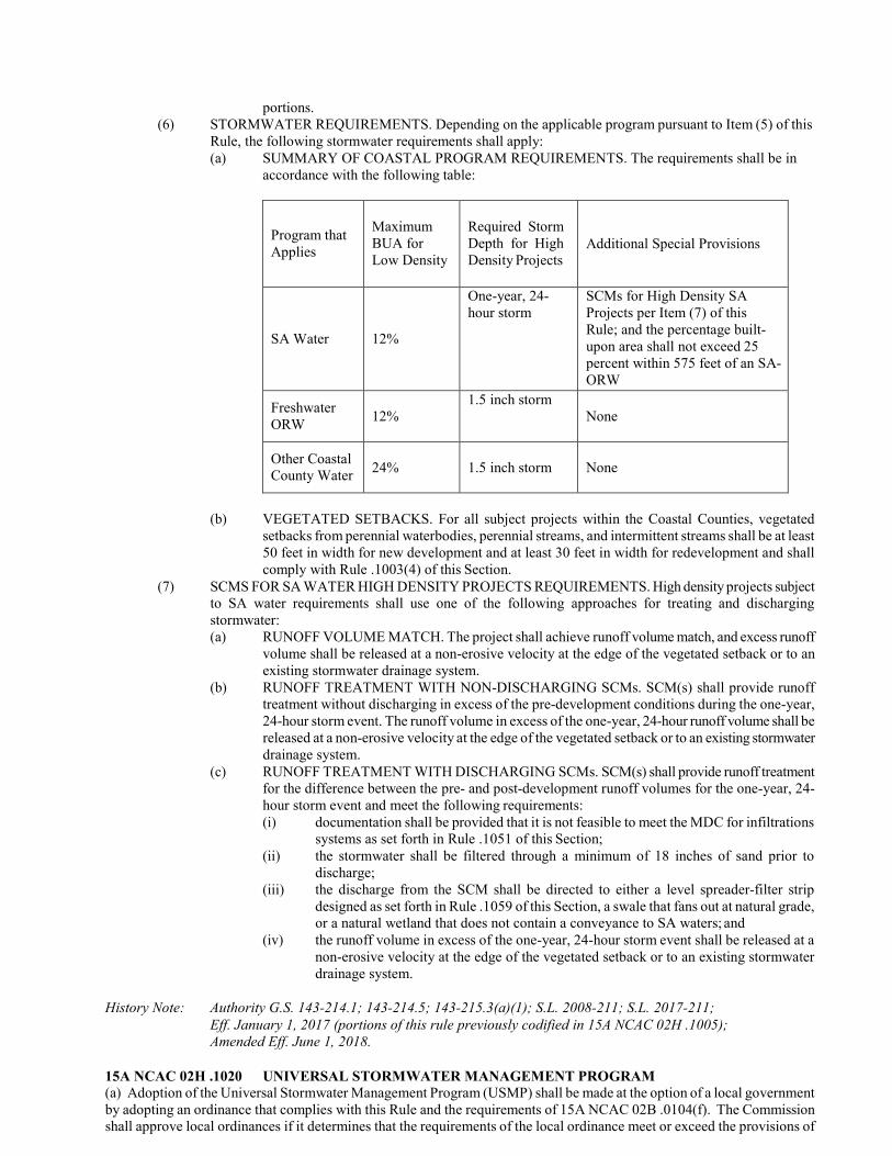
portions. (6) STORMWATER REQUIREMENTS. Depending on the applicable program pursuant to Item (5) of this
Rule, the following stormwater requirements shall apply: (a) SUMMARY OF COASTAL PROGRAM REQUIREMENTS. The requirements shall be in
accordance with the following table:
Program that Applies
Maximum BUA for Low Density
Required Storm Depth for High Density Projects
Additional Special Provisions
SA Water
12%
One-year, 24- hour storm
SCMs for High Density SA Projects per Item (7) of this Rule; and the percentage built- upon area shall not exceed 25 percent within 575 feet of an SA- ORW
Freshwater ORW
12%
1.5 inch storm None
Other Coastal County Water
24%
1.5 inch storm
None
(b) VEGETATED SETBACKS. For all subject projects within the Coastal Counties, vegetated setbacks from perennial waterbodies, perennial streams, and intermittent streams shall be at least 50 feet in width for new development and at least 30 feet in width for redevelopment and shall comply with Rule .1003(4) of this Section.
(7) SCMS FOR SA WATER HIGH DENSITY PROJECTS REQUIREMENTS. High density projects subject to SA water requirements shall use one of the following approaches for treating and discharging stormwater: (a) RUNOFF VOLUME MATCH. The project shall achieve runoff volume match, and excess runoff
volume shall be released at a non-erosive velocity at the edge of the vegetated setback or to an existing stormwater drainage system.
(b) RUNOFF TREATMENT WITH NON-DISCHARGING SCMs. SCM(s) shall provide runoff treatment without discharging in excess of the pre-development conditions during the one-year, 24-hour storm event. The runoff volume in excess of the one-year, 24-hour runoff volume shall be released at a non-erosive velocity at the edge of the vegetated setback or to an existing stormwater drainage system.
(c) RUNOFF TREATMENT WITH DISCHARGING SCMs. SCM(s) shall provide runoff treatment for the difference between the pre- and post-development runoff volumes for the one-year, 24- hour storm event and meet the following requirements: (i) documentation shall be provided that it is not feasible to meet the MDC for infiltrations
systems as set forth in Rule .1051 of this Section; (ii) the stormwater shall be filtered through a minimum of 18 inches of sand prior to
discharge; (iii) the discharge from the SCM shall be directed to either a level spreader-filter strip
designed as set forth in Rule .1059 of this Section, a swale that fans out at natural grade, or a natural wetland that does not contain a conveyance to SA waters; and
(iv) the runoff volume in excess of the one-year, 24-hour storm event shall be released at a non-erosive velocity at the edge of the vegetated setback or to an existing stormwater drainage system.
History Note: Authority G.S. 143-214.1; 143-214.5; 143-215.3(a)(1); S.L. 2008-211; S.L. 2017-211;
Eff. January 1, 2017 (portions of this rule previously codified in 15A NCAC 02H .1005); Amended Eff. June 1, 2018.
15A NCAC 02H .1020 UNIVERSAL STORMWATER MANAGEMENT PROGRAM (a) Adoption of the Universal Stormwater Management Program (USMP) shall be made at the option of a local government by adopting an ordinance that complies with this Rule and the requirements of 15A NCAC 02B .0104(f). The Commission shall approve local ordinances if it determines that the requirements of the local ordinance meet or exceed the provisions of
this Rule and the requirements of 15A NCAC 02B .0104(f). A model ordinance for the USMP shall be available at no cost on the Division's website at http://deq.nc.gov/about/divisions/energy-mineral-land-resources/energy-mineral-land- permits/stormwater-permits/usmp. Administration and implementation of the USMP shall be the responsibility of the adopting local government within its jurisdiction. Local governments located within one of the 20 Coastal Counties may elect to have the Division administer and implement the USMP, either in whole or in part, within their jurisdiction following their adoption of the program. The requirements of the USMP shall supersede and replace all other existing post-construction stormwater requirements within that jurisdiction, as specified in Paragraph (b) of this Rule. (b) With the exceptions noted in Paragraph (c) of this Rule, the requirements specified in this Rule shall replace the following post-construction stormwater control requirements:
(1) Water Supply (WS) Watershed II (WS II) (15A NCAC 02B .0214(3)(b)(i)); (2) WS Watershed II Critical Area (WS II CA) (15A NCAC 02B .0214(3)(b)(ii)); (3) WS Watershed III (WS III) (15A NCAC 02B .0215(3)(b)(i)); (4) WS Watershed III Critical Area (WS III CA) (15A NCAC 02B .0215(3)(b)(ii)); (5) WS Watershed IV (WS IV) (15A NCAC 02B .0216(3)(b)(i)); (6) WS Watershed IV Critical Area (WS IV CA) (15A NCAC 02B .0216(3)(b)(ii)); (7) High Quality Waters (HQW) for Freshwaters (15A NCAC 02H .1021); (8) Outstanding Resource Waters (ORW) for Freshwaters (15A NCAC 02H .1021); (9) Outstanding Resource Waters (ORW) for Saltwaters (15A NCAC 02H. 1019); (10) Shellfishing Waters (SA) (15A NCAC 02H .1019); (11) Post-Construction Stormwater Requirements of the NPDES MS4Program (15A NCAC 02H .1017); (12) Coastal Counties Stormwater Requirements in 15A NCAC 02H .1019; (13) Stormwater Management Plans for 401 Water Quality Certifications under 15A NCAC 02H .0500; (14) Catawba Buffer Rules (15A NCAC 02B .0243); and (15) Urban Stormwater Management Requirements of the Randleman Lake Water Supply Watershed Rules
(15A NCAC 02B .0251). (c) As mandated in 15A NCAC 02H .0506(b)(5) and (c)(5), the Director may review and require amendments to proposed stormwater control plans submitted under the provisions of the certification process pursuant to Section 401 of the Clean Water Act (33 U.S.C. 1341) in order to ensure that the proposed activity will not violate water quality standards. (d) Adoption of the USMP shall not affect the requirements specified in the following Rules:
(1) 15A NCAC 02B .0214(3)(b)(i)(I); (2) 15A NCAC 02B .0214(3)(b)(ii)(C) and (D); (3) 15A NCAC 02B .0215(3)(b)(i)(I); (4) 15A NCAC 02B .0215(3)(b)(ii)(C) and (D); and (5) 15A NCAC 02B .0216(3)(b)(ii)(C) and (D).
(e) The Catawba Buffer Rules shall be superseded in those areas where the buffers are contained within the jurisdiction of another stormwater program listed in Paragraph (b) of this Rule and the requirements of that program shall be replaced by the USMP. For the watershed that drains to Lake James, which is not contained within the jurisdiction of another stormwater program, the Catawba Buffer Rules shall be superseded if the USMP is implemented in the entire area within five miles of the normal pool elevation of Lake James. (f) The implementation of the USMP shall supersede the Urban Stormwater Requirements of the Randleman Lake Water Supply Watershed in 15A NCAC 02B .0251, but USMP implementation does not affect the Randleman Lake Water Supply Watershed: Protection and Maintenance of Existing Riparian Buffers requirements specified in 15A NCAC 02B .0250. (g) Coastal Counties Requirements. All development activities located in one of the 20 Coastal Counties that disturb 10,000 square feet or more of land, including projects that disturb less than 10,000 square feet of land that are part of a larger common plan of development or sale, shall control the runoff from the first one and one half inch of rainfall to the level specified in Paragraph (i) of this Rule. In addition, all impervious surfaces, except for roads, paths, and water dependent structures, shall be located at least 30 feet landward of all perennial waterbodies, perennial streams, and intermittent streams. In addition to the other requirements specified in this Paragraph, all development activities that are located within 575 feet of waters designated by the Commission as shellfishing waters shall be limited to a maximum impervious surface density of 36 percent. Redevelopment activities shall not be required to comply with the requirements of this Paragraph. (h) Non-Coastal Counties Requirements. All residential development activity that is located in one of the 80 Non-Coastal Counties that disturbs one acre or more of land, including residential development that disturbs less than one acre of land that is part of a larger common plan of development or sale, and all non-residential development activity that is located in one of the 80 Non-Coastal Counties that disturbs ½ acre or more of land, including non-residential development that disturbs less than ½ acre of land that is part of a larger common plan of development or sale, shall control the runoff from the first one inch of rainfall as specified in Paragraph (i) of this Rule. Except as allowed in this Paragraph, no new impervious or partially pervious surfaces, except for roads, paths, and water dependent structures, shall be allowed within the one percent Annual Chance Floodplain as delineated by the North Carolina Floodplain Mapping Program in the Division of Emergency Management which is herein incorporated by reference, including subsequent amendments and editions, and may be accessed at no cost at http://www.ncfloodmaps.com/. For perennial and intermittent streams that do not have a floodplain delineated by
the Floodplain Mapping Program, all development activities subject to this Rule shall be located at least 30 feet landward of all perennial waterbodies, perennial streams, and intermittent streams. In addition to the other requirements specified in this Paragraph, all development activities that are located within the area designated by the Commission as a Critical Area of a Water Supply Watershed as defined in 15A NCAC 02B .0202 shall be limited to a maximum impervious surface density of 36 percent. Redevelopment of residential structures within the one percent Annual Chance Floodplain shall be allowed. Redevelopment of non-residential structures within the one percent Annual Chance Floodplain shall be allowed provided that less than ½ acre is disturbed during the redevelopment activity. Redevelopment activities outside of the one percent Annual Chance Floodplain shall not be required to comply with the requirements of this Paragraph. (i) Structural stormwater controls required under Paragraphs (g) and (h) of this Rule shall meet the following criteria:
(1) achieve either runoff treatment or runoff volume match in accordance with Paragraphs (g) and (h) of this Rule; and (A) for SCMs designed to achieve runoff treatment, the required storm depth shall be one and one half
inch in the Coastal Counties and one inch in the Non-Coastal Counties. (B) applicants shall have the option to use SCMs designed to achieve "runoff volume match" in lieu
of "runoff treatment" in accordance with the definitions of those terms in Rule .1002 of this Section; and
(2) meet the requirements for all projects subject to stormwater rules as set forth in Rule .1003 of this Section. (j) For the purposes of this Rule, a surface water shall be deemed present if the feature is shown on either the most recent published version of the soil survey map prepared by the Natural Resources Conservation Service of the United States Department of Agriculture which is herein incorporated by reference, including subsequent amendments and editions, and may be accessed at no cost at http://www.nrcs.usda.gov/wps/portal/nrcs/main/soils/survey/ or the most recent version of the 1:24,000 scale (7.5 minute) quadrangle topographic maps prepared by the United States Geologic Survey (USGS) which is herein incorporated by reference, including subsequent amendments and editions, and may be accessed at no cost at http://www.usgs.gov/pubprod/. Relief from this requirement may be allowed when surface waters are not present in accordance with the provisions of 15A NCAC 02B .0233(3)(a). (k) Local governments that implement the USMP shall require applicants to record deed restrictions and protective covenants that ensure that the project will be maintained in perpetuity consistent with approved plans. (l) Local governments that implement the USMP shall require an operation and maintenance plan that ensures the operation of the structural stormwater control measures required by the USMP. The operation and maintenance plan shall require the owner of each structural control to submit a maintenance inspection report on each structural stormwater control measure annually to the local program. (m) In addition to the other measures required in this Rule, all development activities located in one of the 20 Coastal Counties that disturb 10,000 square feet or more of land within ½ mile and draining to SA waters shall:
(1) use stormwater control measures that result in fecal coliform die-off and that control to the maximum extent practicable sources of fecal coliform while complying with Paragraph (i) of this Rule; and
(2) prohibit new direct points of stormwater discharge to SA waters or expansion of existing stormwater conveyance systems that drain to SA waters. Any modification or redesign of a stormwater conveyance system within the contributing drainage basin shall not increase the net amount or rate of stormwater discharge through existing outfalls to SA waters. Diffuse flow of stormwater at a non-erosive velocity to a vegetated buffer or other natural area capable of providing effective infiltration of the runoff from the 1- year, 24-hour storm shall not be considered a direct point of stormwater discharge. Consideration shall be given to soil type, slope, vegetation, and existing hydrology when evaluating infiltration effectiveness.
(n) In addition to the other measures required in this Rule, development activities draining to trout (Tr) waters shall use stormwater control measures that do not cause an increase in the receiving water temperature while still incorporating the requirements specified in Paragraph (i) of this Rule. (o) The Division, upon determination that a local government is failing to implement or enforce the approved local stormwater program, shall notify the local government in writing of the local program's deficiencies. If the local government has not corrected the deficiencies within 90 days of receipt of written notification from the Division, then the Division shall take the following action:
(1) implement the requirements of 15A NCAC 02B .0243 and 15A NCAC 02H .1019, and .1021 in lieu of the local government's administration of the USMP in areas subject to those Rules; and
(2) enforce the requirements of 15A NCAC 02B .0214 through .0216, and .0251, and 15A NCAC 02H .0500 and .1017 in areas subject to those Rules.
(p) Development activities conducted within a jurisdiction where the USMP has been implemented may take credit for the nutrient reductions achieved by utilizing diffuse flow in the one percent Annual Chance Floodplain to comply with the nutrient

loading limits specified within NSW Rules where the one percent Annual Chance Floodplain exceeds the 50-foot Riparian Buffers. Development activities occurring where the USMP has been implemented but there is no delineated one percent Annual Chance Floodplain may take credit for the nutrient reductions achieved by utilizing diffuse flow into a vegetated filter strip that exceeds the 50-foot Riparian Buffer by at least 30 feet and has a slope of five degrees or less. (q) The following special provisions of the USMP apply only to federal facilities and Department of Defense (DoD) installations. Federal facilities and DoD installations may adopt the USMP within their boundaries by submitting a letter to the Chairman of the Commission that states that the facility in question has adopted controls that comply with the requirements of this Rule and with the requirements of 15A NCAC 02B .0104(f). In lieu of the protective covenants and deed restrictions required in Paragraph (k) of this Rule, federal facilities and DoD installations that choose to adopt the USMP within their boundaries shall incorporate specific restrictions and conditions into base master plans or other appropriate instruments to ensure that development activities regulated under this Rule will be maintained in a manner consistent with the approved plans. (r) Implementation of this USMP does not affect any other rule or requirement not specifically cited in this Rule.
History Note: Authority G.S. 143-214.1; 143-214.5;143-214.7; 143-215.1; 143-215.3(a); 143-
215.6A; 143- 215.6B; 143-215.6C; Eff. January 1, 2007; Readopted Eff. January 1, 2017.
15A NCAC 02H .1021 NON-COASTAL COUNTY HIGH QUALITY WATERS (HQW) AND OUTSTANDING RESOURCE WATERS (ORW) The purpose of this Rule is to minimize the impact of stormwater runoff from development on the water quality of surface waters and to protect their designated best usages in management zones of Non-Coastal County High Quality Waters (HQW) and Outstanding Resource Waters (ORW).
(1) IMPLEMENTING AUTHORITY. This rule shall be implemented by the Division. (2) APPLICABILITY. This Rule shall apply to development activities outside of Coastal Counties that
require an Erosion and Sedimentation Control Plan pursuant to G.S. 113A-57and are either: (a) within one mile of and draining to waters classified as HQW except that development
located in WS-I or WS-II watersheds as set forth in 15A NCAC 02B .0212 and .0214 are excluded from the requirements of this Rule; or
(b) draining to waters classified as ORW. (3) EFFECTIVE DATE. The effective date of prior Rules .1006 and .1007 of this Section is
September 1, 1995. (4) GENERAL REQUIREMENTS FOR NEW DEVELOPMENT. In addition to the requirements
of this Rule, projects shall also comply with the requirements set forth in Rule .1003 of this Section.
(5) PROJECT DENSITY. A project shall be considered a low density project if meets the low density criteria set forth in Item (2) of Rule .1003 of this Section and contains no more than 12 percent built-upon area or no more than one dwelling unit per acre; otherwise, a project shall be considered high density. Low density projects shall comply with the requirements set forth in Item (2) of Rule .1003 of this Section. High density projects shall comply with the requirements set forth in Item (3) of Rule .1003 of this Section.
(6) REQUIRED STORM DEPTH. For high density projects designed to achieve runoff treatment, the required storm depth shall be one inch. Applicants shall have the option to design projects to achieve "runoff volume match" in lieu of "runoff treatment" as those terms are defined in Rule .1002 of this Section.
(7) VEGETATED SETBACKS. Vegetated setbacks from perennial waterbodies, perennial streams, and intermittent streams shall be at least 30 feet in width for both low and high density developments and shall comply with Rule .1003(4) of this Section.
History Note: Authority G.S. 143-214.1; 143-214.7; 143-215.1; 143-215.3(a);
Eff. January 1, 2017 (portions of this Rule previously codified in 15A NCAC 02H .1006 and .1007).
15A NCAC 02H .1022 RESERVED FOR FUTURE CODIFICATION 15A NCAC 02H .1023 RESERVED FOR FUTURE CODIFICATION 15A NCAC 02H .1024 RESERVED FOR FUTURE CODIFICATION 15A NCAC 02H .1025 RESERVED FOR FUTURE CODIFICATION 15A NCAC 02H .1026 RESERVED FOR FUTURE CODIFICATION 15A NCAC 02H .1027 RESERVED FOR FUTURE CODIFICATION 15A NCAC 02H .1028 RESERVED FOR FUTURE CODIFICATION 15A NCAC 02H .1029 RESERVED FOR FUTURE CODIFICATION
15A NCAC 02H .1030 STORMWATER REQUIREMENTS: OIL AND GAS EXPLORATION AND PRODUCT (a) Regulated Development Activity. Persons engaged in oil and gas exploration, development, and production activities shall manage stormwater runoff in accordance with the provisions of this Rule.
(1) These persons shall submit a permit application to the Division of Energy, Mineral, and Land Resources (Division) in accordance with the requirements of this Section.
(2) These persons shall obtain a permit from the Division prior to any on-site activities other than land surveying, and surface soil testing of hydraulic conductivity and engineering properties.
(3) This Rule authorizes the Division to issue a stormwater-only permit. Any other discharge to surface waters is prohibited unless permitted in accordance with G.S. 143-215.1.
(4) The Division may issue stormwater permits as discrete, stand-alone stormwater permits or may incorporate stormwater permit conditions into an environmental protection permit encompassing multiple regulatory programs.
(b) Permit Application Requirements. (1) Notwithstanding the qualifying provisions of Rule .1003(b)(1), (2), and (3) of this Section, a
complete permit application and a permit are required for oil and gas exploration, development, and production activity, regardless of whether the activity also requires a CAMA major development permit or an Erosion and Sedimentation Control Plan. A permit application and permit are also required regardless of whether the development is located in the 20 coastal counties, drains to Outstanding Resource Waters (ORW), or drains to High Quality Waters (HQW).
(2) The Division shall treat each stormwater permit application for oil and gas exploration, development, and production activities as a High Density Project application as provided for in Rule .1003(d)(2) of this Section, and shall only grant permit coverage if the application itself and the proposed development meet the requirements of this Rule.
(3) The Director may solicit and receive comments from other regulatory agencies and the public when necessary to obtain additional information needed to complete the review of either the stormwater permit application or the stormwater conditions in an application for an environmental protection permit encompassing multiple regulatory programs. If comments are solicited, notice will be posted on the Division's website with 30 days provided for public comment to be submitted to the Director. The permit application will be included in the notice published on the Division's website.
(4) The permit application for oil and gas exploration, development, and production activities shall be submitted to the Division at the Raleigh Central Office located at 512 North Salisbury Street, Raleigh, North Carolina 27604.
(5) The stormwater permit application shall comply with the requirements in Rule .1003(g) of this Section. In addition, the application shall include the following information: (A) all North Carolina classifications and supplemental classifications (if any) assigned to
the receiving water; (B) the location of all stormwater discharge points, both by latitude and longitude
coordinates and by graphic representation; (C) the graphic representation of the location and delineation of wetlands and regulated
buffers on the site, adjacent to the site, or between the site and the receiving water; (D) a statement that there are no threatened or endangered species identified for the receiving
water or for downstream receiving waters. If threatened or endangered species are present the application shall identify the threatened and endangered species and their reported locations in the receiving water and downstream receiving waters. The application shall propose
specific measures for the protection of any threatened or endangered species present in the receiving water. The Division shall evaluate the proposed measures and may require additional or different measures in the final form of the stormwater management permit;
(E) a design narrative that explains the assumptions and calculations for the engineering design of the stormwater control systems proposed and that identifies how the design complies with each specific requirement of this Section; and
(F) a graphic representation of the final site grade and site conditions that will be implemented in support of a future request to rescind the stormwater permit, or comprehensive environmental permit, based on the final close out and the end of the permit holder's commercial interest in the site.
(6) As a part of the permit application, the applicant shall submit a Stormwater Management Plan that identifies the physical and procedural stormwater management measures proposed to minimize the discharge of pollutants through stormwater. The Stormwater Management Plan shall address all phases of site activity and operation. The Stormwater Management Plan shall include: (A) a description of site activities with the potential to affect the pollutant content of
stormwater runoff; (B) a description of the permittee's stormwater management strategy to control and
minimize stormwater exposure of significant materials; (C) a description of the permittee's spill prevention and response procedures; (D) a description of the permittee's preparations in anticipation of, and in response to,
rainfall events in excess of the design basis of the physical stormwater control and treatment measures employed;
(E) a description of good housekeeping measures and supporting facility inspections
including a schedule of inspections and maintenance on any structural control measures;
(F) a description of the permitee's training of site personnel in stormwater pollution prevention; and
(G) the identification of the specific person or position responsible for the overall coordination, development, implementation, and revision of the Stormwater Management Plan.
(c) Stormwater Management Requirements. (1) During initial site clearing, grading, excavation, and construction of earthen surface features,
including temporary erosion and sedimentation control measures and permanent stormwater control measures, the permittee shall manage (control, operate, maintain, store, handle, clean up, and dispose of) site conditions, materials, activities, and stormwater as follows: (A) Equipment, petroleum products, equipment wash waters, and associated spent fluids
shall be managed to prevent the potential or actual pollution of surface waters by direct discharge or via stormwater runoff.
(B) Herbicides, pesticides, fertilizers, and similar materials shall be managed to prevent introduction into stormwater runoff.
(C) Building material waste, land clearing and demolition debris, litter, and sanitary wastes shall be managed to prevent introduction into stormwater runoff. Dedicated management areas shall be established for these materials a minimum of 50 feet away from surface waters and discrete stormwater conveyances.
(D) Topsoil and excavated material stockpiles shall be located a minimum of 50 feet away from surface waters and stormwater conveyances and shall be managed to prevent runoff transport of the stockpiled materials to surface waters.
(E) Excess concrete, concrete wash water, and cement slurries shall be managed to prevent the potential or actual pollution of surface waters by direct discharge or via stormwater runoff.
(2) During initial site clearing, grading, excavation, and construction of earthen surface features, including temporary erosion and sedimentation control measures and permanent stormwater control measures, the permittee shall manage site conditions, materials, activities, and stormwater as follows:
(A) All perimeter dikes, perimeter swales, perimeter ditches, perimeter slopes, all slopes steeper than 3:1, and all slopes longer than 50 feet shall be provided with temporary or permanent ground cover stabilization within 7 calendar days from the last land disturbing activity.
(B) All other disturbed areas shall be provided temporary or permanent ground cover stabilization within 14 calendar days from the last land disturbing activity.
(C) Time extensions may be requested in writing by the permittee. These requests may be granted by the Division based on weather or site-specific conditions.
(D) Treatment measure requirements: (i) All sediment basins and traps with a contributing drainage area of one acre or
greater shall utilize outlet structures that withdraw water from the surface. (ii) Stormwater treated with polymers, flocculants, or other treatment chemicals
shall be routed through sediment traps, filters, or other settling devices to ensure removal prior to discharge to surface waters. Only chemicals that have been approved by the Division may be used. The approved chemicals list is available on the Division's website at http://portal.ncdenr.org/web/lr/construction-stormwater.
(3) For this Rule, 'spudding' the well means starting the oil or gas well drilling process by removing rock, dirt, and other sedimentary material with the drill bit. After initial site clearing, grading, excavation, and construction of earthen surface features, including temporary erosion and sedimentation control measures and permanent stormwater control measures, and at least 72 hours prior to spudding an oil or gas well, the permittee shall deliver to the Division written certification by the individual designing the stormwater control system in accordance with Rule .1008(j) of this Section. Regardless of whether a certificate of occupancy is provided or required by other authority, the permittee shall not proceed with spudding the well until the Division accepts the designer's written certification. Within 72 hours of receiving the designer's certificate the Division shall inspect the permitted stormwater control system. Subsequent to the inspection, the Division may withhold acceptance of the designer's certification upon concluding that the stormwater control system has not been installed in accordance with the stormwater permit and the approved stormwater permit application documents. If the Division fails to inspect the stormwater control system within 72 hours of receiving the designer's certification, the certification shall be deemed accepted by the Division and the permittee may proceed with spudding the well.
(4) After completion of the surface site preparation activity, and beginning with the surface activity in direct support of well drilling, the permittee shall manage site conditions, materials, activities, and stormwater as follows: (A) Stormwater control measures shall control and treat the runoff from the rainfall event
with a 24- hour precipitation total greater than or equal to 90 percent of all 24-hour rainfall event totals on an annual basis.
(B) Stormwater control measures shall discharge at a rate less than or equal to the peak pre- development discharge rate for the 1-year, 24-hour storm.
(C) Stormwater control measures shall be designed in accordance with the provisions of Rule .1008 of this Section.
(D) In addition to the measures identified in Rule .1008(a) of this Section, other measures shall be approved where individually, or in combination, the measures achieve 85% average annual removal of Total Suspended Solids, and upon the Division's review and conclusion of appropriate design and suitability for the anticipated site conditions.
(E) All stormwater control measures shall be equipped with underflow baffles or other effective means to prevent the discharge of hydrocarbons and floating pollutants.
(F) The requirements identified in Subparagraphs (1) and (2) of this Paragraph for initial site construction shall also apply to all subsequent phases of site operation.
(5) The Division shall establish record-keeping, self-inspection, and self-reporting permit requirements to insure effective site management attention, response actions, and control of the potential for polluted stormwater.
(6) Stormwater management requirements provided in this Paragraph pertain to the well pad area, all

adjacent developed areas, and access and haul roads in proximity to the well pad or directly associated with the operation of the permitted site.
(d) Coordination with other water quality regulations. (1) For oil and gas exploration, development, and production activities, compliance with this Rule
satisfies the requirements of Rule .1006 of this Section. However, pursuant to Rule .1006 of this Section, the Division may require more stringent measures for development activities draining to HQW waters.
(2) For oil and gas exploration, development, and production activities, compliance with this Rule satisfies the Freshwater ORW requirements of Rule .1007 of this Section. However, pursuant to Rule .1007 of this Section, the Division may require more stringent measures for development activities draining to ORW waters.
(3) This Rule is not intended to modify, repeal, or supersede any other rule, regulation, or other provision of law. The requirements of this Rule are in addition to the requirements of any other rule, regulation, or other provision of law. Where any requirement of this Rule imposes restrictions different from those imposed by any other rule, regulation, or other provision of law, whichever requirement is more restrictive or imposes higher protective standards for human or environmental health, safety, and welfare shall control. This includes Sections 15A NCAC 02B .0100, 15A NCAC 02B .0200, and 15A NCAC 02B .0300, whether administered by the State or by a local unit of government.
History Note: Authority G.S. 113-391(a3)(1); 143-214.1; 143-214.7; 143-215.1; 143-215.3(a); S.L. 2014-4 s. 2.(e);
Eff. March 17, 2015.
15A NCAC 02H .1040 PERMIT ADMINISTRATION This Rule applies to the permitting processes set forth in Rules .1041 through .1045 of this Section.
(1) SIGNATURES ON PERMIT APPLICATION FORMS. Application forms shall have an original signature by one of the following entities unless the application is accompanied by a letter of authorization signed by the appropriate authority as designated in Sub-Items (a) through (d) of this Item authorizing the signature of another entity: (a) in the case of a corporation, by a principal executive officer of the level of vice-
president or his authorized representative. In the case of a limited liability corporation (LLC), by a manager or company official as those terms are defined in G.S. 57D "North Carolina Limited Liability Company Act;"
(b) in the case of a partnership, by a general partner or a managing partner. In the case of a limited partnership, by a general partner;
(c) in the case of a proprietorship, by the proprietor(s); or (d) in the case of a municipal, state, or other public entity, by either a principal executive
officer, ranking official, or other duly authorized employee. (2) PERMIT PROCESSING TIMES. The Division shall process permit applications and additional
or amended information pursuant to G.S. 143-215.1. (3) DELEGATION. For permits issued by the Division, the Director shall be authorized to delegate to
Division staff any of the functions contained in these Rules, except the following: (a) denying a permit application; (b) revoking a permit if such revocation is not requested by the permittee; (c) modifying a permit not requested by the permittee; and (d) calling for a public notice or meeting.
(4) PERMIT ISSUANCE. The following shall apply to stormwater management permits issued by the Division: (a) stormwater management permits issued for low density projects shall not require permit
renewal; (b) stormwater management permits issued for projects that require the construction of
engineered stormwater control measures shall be issued for a period not to exceed 8 years; and
(c) stormwater management permits shall be issued to the property owner or to a lessee,
purchaser, or developer with the written permission of the property owner, and shall cover the entire project.
(5) PERMIT DENIAL. If the Director denies a permit, the letter of denial shall state the reason(s) for denial and the Director's estimate of the changes in the applicant's proposed activities or plans that would be required in order that the applicant may obtain a permit. Permit applications may be denied where the proposed project results in noncompliance with: (a) the purposes of G.S. 143, Article 21; (b) the purposes of G.S. 143-215.67(a); (c) rules governing coastal waste treatment or disposal, found in Section .0400 of this
Subchapter; (d) rules governing "subsurface disposal systems," found in 15A NCAC 18A .1900. Copies
of these Rules are available from the North Carolina Division of Public Health, 1632 Mail Service Center, Raleigh, North Carolina 27699-1632; or
(e) rules governing groundwater quality standards found in Subchapter 2L of this Chapter. (6) PERMIT REVOCATION OR MODIFICATION. Permits issued pursuant to these Rules are
subject to revocation, or modification by the Director upon 60 days' written notice by the Director in whole or in part for good cause including the following: (a) violation of any terms or conditions of the permit; (b) obtaining a permit by misrepresentation or failure to disclose all relevant facts; or (c) refusal of the permittee to allow authorized employees of the Department of
Environmental Quality, upon presentation of credentials: (i) to enter upon permittee's premises in which any records are required to be
kept under terms and conditions of the permit; (ii) to have access to any and all records required to be kept under terms and
conditions of the permit; (iii) to inspect any monitoring equipment or method required in the permit; or (iv) to sample any discharge of pollutants.
(7) DIRECTOR'S CERTIFICATION. With the exception of the fast track permitting as set forth in Rules .1043 and .1044 of this Section, projects that do not comply with the requirements of this Section may be approved on a case-by-case basis if the project is certified by the Director that water quality standards and best usages will not be threatened. Approval of alternative designs for SCMs that do not meet all the MDC shall be in accordance with Rule .1003(6) of this Section. Approval of new stormwater technologies shall be in accordance with Rule .1050(15) of this Section. The applicant shall provide information that demonstrates to the Director that: (a) there are practical difficulties or hardships due to the physical nature of the project
such as its size, shape, or topography that prevent strict compliance with this Section; and
(b) water quality standards and best usages will be protected, including development plans and specifications for SCMs that will be installed in lieu of the requirements of this Section or information that demonstrates that the project is located such that impacts to surface waters from pollutants present in stormwater from the site will be mitigated.
(8) PUBLIC NOTICE. The Director is authorized to call for a public notice or hearing to solicit and receive comments from other regulatory agencies and the public to obtain additional information needed to complete the review of either the stormwater permit application or the stormwater conditions. If comments are solicited, notice shall be posted on the Division's website and shall provide the public at least 30 days after publication to submit comments to the Director. The permit application shall be included in the notice published on the Division's website.
(9) CONTESTED CASE HEARING. An applicant whose application is denied or who is issued a permit subject to conditions that are not acceptable to the applicant may seek a contested case hearing pursuant to G.S. 150B-23.
(10) COMPLIANCE. Any individual or entity found to be in noncompliance with the provisions of a stormwater management permit or the requirements of this Section shall be subject to enforcement procedures as set forth in G.S. 143, Article 21.

History Note: Authority G.S. 143-214.1; 143-214.7; 143-215.1; 143-215.3(a); 143-215.3D; 143-215.6A; 143-
215.6B; 143-215.6C; Eff. January 1, 2017 (portions of this rule previously codified in 15A NCAC 02H .1003, .1010, .1011, and .1012).
15A NCAC 02H .1041 GENERAL PERMITS (a) In accordance with the provisions of G.S. 143-215.1(b)(3) and (4), general permits may be developed by the Division and issued by the Director for categories of activities covered in this Section. Each of the general permits shall be issued separately pursuant to G.S. 143-215.1, using all procedural requirements specified for State permits including application and public notice. (b) General permits may be written to regulate categories of activities that:
(1) involve the same or similar operations; (2) have similar characteristics; (3) require the same limitations or operating conditions; (4) require the same or similar monitoring; and (5) are controlled by a general permit as determined by the Director.
(c) General permit coverage shall be available to activities, such as the following: (1) construction of bulkheads and boat ramps; (2) installation of sewer lines with no proposed built-upon areas; (3) construction of an individual single family residence; and (4) other activities that, as determined by the Director, meet the criteria of Paragraph (b) of this Rule.
(d) General permits may be modified or revoked in accordance with the authority and requirements of Rule .1040 of this Section. (e) Procedural requirements for application and permit approval, unless designated as applicable to persons proposed to be covered under the general permits, apply only to the issuance of the general permits. (f) After issuance of the general permit by the Director, persons engaged in activities in the applicable categories may request coverage under the general permit, and if an activity falls within a category of activities governed by the general permit the Director or his designee shall grant coverage. All activities that receive a "Certificate of Coverage" for that category of activity shall be deemed governed by that general permit. (g) No provision in any general permit issued under this Rule shall be interpreted to allow the permittee to violate state water quality standards or other applicable environmental standards. (h) For a general permit to apply to an activity, a Notice of Intent to be covered by the general permit shall be submitted to the Division using forms provided by the Division on the Division's website at http://portal.ncdenr.org/web/lr/stormwater http://deq.nc.gov/about/divisions/energy-mineral-land-resources/energy-mineral-land-permits/stormwater-program . In addition to the application procedures set forth in Rules .1040 and .1042 of this Section, the Notice of Intent shall include the following:
(1) project name and physical location; (2) receiving stream name and classification; (3) total project area above mean high water; (4) total amount of proposed built-upon area; (5) description of best management practices employed at the project site; (6) two sets of site and grading plans; if applicable, plans shall show wetland delineation and the
"AEC" line as established by the North Carolina Coastal Resources Commission pursuant to Sections .0100 15A NCAC 07H .0100 - .0600; and
(7) location of the project indicated on a U.S. Geological Survey (USGS) map. If all requirements are met, coverage under the general permit may be granted. If all requirements are not met, or the Director determines the activity is not governed by the general permit, then the applicant shall be notified in writing and may apply for an individual permit pursuant to this Section. (i) General permits may be modified and reissued by the Division as necessary. Activities covered under general permits need not submit new Notices of Intent or renewal requests unless so directed by the Division. If the Division chooses not to renew a general permit, all facilities covered under that general permit shall be notified to submit applications for individual permits. (j) All previous state water quality permits issued to a facility that may be covered by a general permit, whether

for construction or operation, shall be revoked upon request of the permittee, termination of the individual permit, and issuance of the Certification of Coverage. (k) Any person engaged in the activities set forth in G.S. 143-215.1 and not permitted in accordance with this Section shall be in violation in G.S. 143-215.1. (l) Any person covered or considering coverage under a general permit may choose to pursue an individual permit for any activity covered by this Section. (m) The Director may require any person, otherwise eligible for coverage under a general permit, to apply for an individual permit by notifying that person that an individual permit application is required. Notification shall consist of a written description of the reason(s) for the decision, appropriate permit application forms and application instructions, a statement establishing the required date for submission of the application, and a statement informing the person that coverage by the general permit shall automatically terminate upon issuance of the individual permit. Reasons for requiring application for an individual permit include:
(1) the activity is a significant contributor of pollutants; (2) a change in the conditions at the permitted site, altering the constituents or characteristics of the
site such that the activity no longer qualifies for coverage under a general permit; (3) noncompliance with the general permit; (4) noncompliance with other provisions of G.S. 143-215.1; (5) a change has occurred in the availability of demonstrated technology or practices for the control
or abatement of pollutants applicable to the activity; or (6) a determination that the water of the stream receiving stormwater runoff from the site is not
meeting applicable water quality standards. (n) Any interested person may petition the Director to take an action under Paragraph (m) of this Rule to require an individual permit. A petition shall be submitted in writing by mail or email to the Director.
History Note: Authority G.S. 143-215.1; 143-215.3(a);143-215.3D;
Eff. January 1, 2017 (previously codified in 15A NCAC 02H .1013).
15A NCAC 02H .1042 STANDARD PERMITTING PROCESS This Rule contains the requirements for the application, review, issuance, and denial of state stormwater management permits under the standard permitting process.
(1) APPLICABILITY. This rule applies to: (a) any person seeking to permit a development activity subject to a stormwater program
implemented by the Division under the standard permitting process; and (b) any person proposing a major modification to an existing state stormwater permit
under the standard permitting process. (2) APPLICATION SUBMITTAL REQUIREMENTS. The applicant shall submit a nonrefundable
permit application fee in accordance with G.S. 143-215.3D and two signed hard copies and one electronic copy of each of the following: (a) a completed and signed Standard Process Application Form. This form may be
obtained on the Division's website athttp://portal.ncdenr.org/web/lr/stormwater http://deq.nc.gov/about/divisions/energy-mineral-land-resources/energy-mineral-land- permits/stormwater-program and shall include the following information: (i) current project name and previous project name, if applicable; (ii) information about the physical location of project; (iii) stormwater project number, if assigned; (iv) density of the entire project and each drainage area; (v) information about applicability of other State and federal environmental
permits to the project including CAMA Major Development Permits, NPDES, Erosion and Sedimentation Control Plans, and Section 401 of the Clean Water Act (33 U.S.C. 1341) permits;
(vi) description of SCMs that will be used on the project; (vi) information about vested rights, if applicable; (vii) applicant name, address, and contact information; and (ix) owner name, address, and contact information.
(b) when the applicant is a corporation or limited liability corporation (LLC): (i) documentation showing the corporation or LLC is an active corporation in good
standing with the NC Secretary of State; and (ii) documentation from the NC Secretary of State or other official documentation
showing the titles and positions held by the person who signed the application pursuant to Rule .1040(1) of this Section;
(c) when the applicant is not the property owner, a copy of a lease agreement, affidavit, or other document showing that the applicant has obtained legal rights to submit a stormwater permit application within the proposed project area;
(d) a U.S. Geological Survey (USGS) map identifying the project location and the GPS coordinates for the project. Areas within the project that are subject to SA Waters, Outstanding Resource Waters (ORW), or High Quality Waters (HQW) stormwater requirements set forth in Rules .1019 and .1021 of this Section shall be shown on the map;
(e) a location map with street names and SR numbers to the nearest intersection, with 1, 2, or 3 digit road numbers, legend, and north arrow. This map is not required to be to scale;
(f) signed, sealed, and dated calculations and documentation of project density and allocation of built-upon area for all lots at project completion;
(g) signed, sealed, and dated plans of the entire site that are a minimum of 22 inches by 34 inches in size and are at a legible scale. All plan packages shall include: (i) project name, designer, and dates; (ii) dimensioned project or project phase boundary with bearings and distances; (iii) the boundaries of all surface waters, wetlands, regulatory flood zones,
protected vegetated setbacks, and protected riparian buffers, or a note on the plans that none exist;
(iv) proposed contours and drainage patterns; (v) site layout showing all existing and proposed built-upon areas, except for
built-upon areas associated with single family residential lots and outparcels on commercial developments that are undetermined at the time of project submittal;
(vi) subdivision lot lines, maintenance access routes and easements, utility and drainage easements, public rights of way, and SCMs; and
(vii) the location of the stormwater collection system, including the locations of the inlets, outlets, pipes, and swales, as well as the inverts and diameters of pipes, excluding driveway culverts.
The Division shall accept conceptual stormwater plans in lieu of this Sub-Item when the applicant can demonstrate that the project complies with this Section, including that SCMs will be properly sized and sited. The detailed plans shall be provided to the Division for review before construction begins;
(h) signed, sealed, and dated plan details of each SCM in plan view at a scale of one inch equal to 30 feet or larger and a cross-section view. Other scales may be accepted if the scale is such that all details are legible on a copy. The plan details shall include: (i) dimensions, side slopes, and elevations with a benchmark for clean-out if
appropriate; (ii) all conveyance devices, including inlet device, bypass structure, pretreatment
area, flow distribution device, underdrains, outlet device, energy dissipater, and level spreader; and
(iii) specification sheets for materials used in the SCM, such as planting media, filter media, and aggregate;
(i) signed, sealed, and dated planting plans for each SCM that requires a planting plan per the Minimum Design Criteria. The planting plan shall include: (i) plant layout with species names and locations; (ii) total number and sizes of all plant species; and

(iii) for stormwater wetlands, a delineation of planting zones; (j) a signed and notarized operation and maintenance agreement; (k) for major modifications, a copy of the recorded deed restrictions and protective covenants
limiting the built-upon area so that it does not exceed the capacity of the SCM(s) or the BUA thresholds. For new projects, proposed deed restrictions and protective covenants. A signed agreement to provide final recorded articles shall be accepted when final documents are not available at the time of submittal; and
(l) for major modifications, a copy of the recorded drainage easements, when applicable. For new projects, proposed drainage easements shown on the plans, and a signed agreement to provide final recorded drainage easements if recorded documents are not available at the time of submittal; and
(m) wherever this Item requires sealed documents, a seal shall not be required if the person designing an SCM or components of an SCM is not required to be licensed as provided in Rule .1050 of this Section.
(3) DIVISION REVIEW OF APPLICATIONS. (a) The Division shall take one of the following actions:
(i) notify the applicant that additional information is necessary for the Division to determine whether the project complies with this Section. The Division shall provide a list of the additional information that is required. The applicant shall have 30 days from the date the letter was sent to submit the additional information to the Division;
(ii) return the application if the required information listed in Item (2) of this Rule is not provided or if information the Division has requested per Sub-Item (i) of this Sub-Item is not provided within 30 days. In this case, the application shall be deemed denied, and the applicant shall be required to resubmit a complete application with a new application fee;
(iii) issue a permit pursuant to Rule .1040 of this Section; or (iv) deny a permit pursuant to Rule .1040 of this Section.
(b) The Division shall require an applicant to submit plans, specifications, and other information it considers necessary to evaluate the application when the information provided is inadequate or incorrect. The applicant shall allow the Division safe access to the records, lands, and facilities of the applicant.
(c) If the Division fails to act within the required response times set forth in G.S. 143-215.1, then the application shall be considered approved unless: (i) the applicant agrees, in writing, to a longer period; (ii) a final decision is to be made pursuant to a public hearing; (iii) the applicant fails to furnish information necessary for the Division's decision
in accordance with Item (2) or Sub-item (3)(a) of this Rule; or (iv) the applicant refuses the staff access to its records or premises for the purpose
of gathering information necessary for the Division's decision. (4) FINAL SUBMITTAL REQUIREMENTS IF COMPLETED PROJECT COMPLIES WITH
PERMITTED PLANS. If the actual built-upon area is equal to or less than that shown on the permitted plans and the constructed SCM is in compliance with the approved plans, then within 45 days of completion of the project the applicant shall submit to the Division one hard copy and one electronic copy of the following: (a) a completed and signed Designer's Certification Form. This form may be obtained on
the Division’s website at http://deq.nc.gov/about/divisions/energy-mineral-land-resources/energy- mineral-land-permits/stormwater-program and shall include the following information: (i) designer name and licensure number; (ii) project name; (iii) project owner name; and (iv) information about deviations from approved plans and specifications;
(b) unless already provided with the permit application, a copy of the recorded deed
restrictions and protective covenants limiting the built-upon area so that it does not exceed the capacity of the SCM(s) or the built-upon area thresholds; and
(c) a copy of the recorded drainage easements, when applicable. (5) IF PROJECT DOES NOT COMPLY WITH PERMITTED PLANS. If the actual built-upon area
exceeds that shown on the permitted plans or if the constructed SCM is not in compliance with the approved plans, then within 30 days of completion of the project, the applicant shall submit an application for a modified stormwater permit in accordance with the requirements of this Rule. On a case-by-case basis, based on the project’s size and complexity, the Division may grant the applicant more time to submit the modification application.
History Note: Authority G.S. 143-214.7; 143-215.1; 143-215.3; 143-215.3(a); 143-215.3D;
Eff. January 1, 2017 (portions of this Rule previously codified in 15A NCAC 02H .1008, 1009, and .1010).
15A NCAC 02H .1043 FAST TRACK PERMITTING PROCESS: AUTHORIZATION TO CONSTRUCT The purpose of this Rule is to set forth the first of two phases of the Fast-Track Stormwater Permit application process: applying for and receiving an authorization to construct permit. There will be a completeness review during the first phase of this process; however, at project completion, the Division shall review the as-built submittal package to determine compliance with the Minimum Design Criteria (MDC).
(1) APPLICABILITY. The fast-track permitting process shall be an option for new projects and major modifications of existing projects provided that all of the MDC shall be met upon project completion. Projects that do not qualify for the fast-track permitting process include: (a) projects claiming an exemption from the MDC based on vested rights, a waiver, or
Director's certification pursuant to Rule .1040(7) of this Section; (b) modifications to existing projects where the proposed changes to the SCMs will not
result in compliance with MDC; and (c) projects that are not in compliance with a current stormwater permit.
(2) ELIGIBILITY FOR FAST-TRACK SUBMITTAL. Persons seeking authorization to construct under the fast-track permitting process shall submit an application bearing the signature and seal of a person licensed pursuant to either Chapter 89A or Chapter 89C of the NC General Statutes. The signature and seal of such persons on the fast-track application shall signify that they have the expertise, education, and experience required to design the SCMs proposed in the application in accordance with the MDC and that they are in compliance with the applicable standards of professional conduct.
(3) APPLICATION SUBMITTAL REQUIREMENTS. The applicant shall submit a permit application fee in accordance with G.S. 143-215.3D and two signed hard copies and one electronic copy of each of the following: (a) a completed and signed Fast-Track Process Application Form. This form may be
obtained on the Division's website at http://portal.ncdenr.org/web/lr/stormwater and shall include the following information: (i) current project name and previous project name, if applicable; (ii) information about the physical location of project; (iii) stormwater project number, if assigned; (iv) information about applicability of other State and federal environmental
permits to the project including CAMA Major Development Permits, NPDES, Erosion and Sedimentation Control Plans, and Section 401 of the Clean Water Act (33 U.S.C. 1341) permits;
(v) applicant name, address, and contact information; (vi) owner name, address, and contact information; and (vii) certification of financially responsible owner.
(b) when the applicant is a corporation or a limited liability corporation (LLC): (i) documentation showing the corporation or LLC is an active corporation in good
standing with the NC Secretary of State; and (ii) documentation from the NC Secretary of State or other official documentation
showing the titles and positions held by the persons signed the application pursuant to Rule .1040(1) of this Section;
(c) when the applicant is not the property owner, a copy of lease agreements, affidavits, or other documents showing that the applicant has obtained legal rights to submit a stormwater permit application within the proposed project area;
(d) a guaranty signed and notarized by the applicant and sealed by the licensed professional in accordance with Item (2) of this Rule attesting to the following: (i) the design has been completed in accordance with the MDC as set forth in
Rules .1050 through .1062 of this Section, as applicable. (ii) the completed design meets the MDC and that the percentage built-upon area
that is the basis for the design shall not be exceeded; and (iii) the applicant shall maintain a licensed professional of record for the duration
of the project who will prepare and certify the as-built package. If the applicant retains another licensed professional before the project is complete, then the applicant shall provide an updated guaranty with the current licensed professional's seal. A licensed professional shall inform the Division if he is no longer associated with this project;
(e) a U.S. Geological Survey (USGS) map identifying the project location and the GPS coordinates for the project. Areas within the project that are subject to SA Waters, Outstanding Resource Waters (ORW) or High Quality Waters (HQW) stormwater requirements set forth in Rules .1019 and .1021 of this Section shall be shown on the map;
(f) a site plan depicting the boundary of the project or project phase currently being permitted, including the locations of stormwater control measures, streams, wetlands, and buffers; and
(g) a construction sequence that discusses how any future development on the project may be phased.
(4) DIVISION REVIEW OF APPLICATIONS. The Division shall take one of the following actions within 30 days of the receipt of the application: (a) Notify the applicant that the project does not qualify for the fast track permitting process
pursuant to Item (1) of this Rule. The applicant shall then follow the standard permitting process in accordance with Rule .1042 of this Section;
(b) Notify the applicant that additional information is necessary for the Division to determine whether the project complies with this Section. The Division shall provide a list of the additional information required. The applicant shall have 30 days to submit the additional information to the Division;
(c) Return the application if the required information listed in Item (3) of this Rule is not provided or if information the Division has requested per Sub-item (4)(b) of this Rule is not provided within 30 days. In this case, the applicant shall be required to resubmit a complete application with a new application fee; or
(d) Issue an authorization to construct permit; or (e) Deny the application in accordance with Rule .1040 of this Section.
(5) EXPIRATION OF THE AUTHORIZATION TO CONSTRUCT PERMIT. The authorization to construct permit shall expire five years after the date of issuance.
History Note: Authority G.S. 143.214.7; 143-214.7B; 143-215.1; 143-215.3(a); S.L. 2013-82;
Eff. January 1, 2017.
15A NCAC 02H .1044 FAST TRACK PERMITTING PROCESS: FINAL PERMIT The purpose of this Rule is to set forth the Fast-Track Stormwater permitting process from the approval of the Authorization to Construct Permit to the approval of the Final Fast-Track Permit.
(1) CONSTRUCTION REQUIREMENTS. Technical design documents shall be available upon request by the Division.
(2) PROJECT COMPLETION. Approval of the as-built stormwater plans shall be required before the

Erosion and Sedimentation Control Plan for the project may be closed out. (3) AS-BUILT PACKAGE SUBMITTAL. The applicant shall submit a permit application fee in
accordance with G.S. 143-215.3D and an as-built package within 45 days of completion of the project. Signed and sealed documents shall be signed and sealed in accordance with Rule .1043(2) of this Section. The as-built package shall include the following: (a) an As-Built Certification Form signed and sealed by the licensed professional of record
and signed by the applicant. The As-Built Certification Form may be obtained on the Division's website at http://deq.nc.gov/about/divisions/energy-mineral-land-resources/energy-mineral-land- permits/stormwater-program and shall include the following information: (i) current project name and previous project name, if applicable; (ii) information about the physical location of project; (iii) stormwater project number, if assigned; (iv) density of the entire project and each drainage area; (v) information about applicability of other State and federal environmental
permits to the project including CAMA Major Development Permits, NPDES, Sedimentation and Erosion Control Plan, and Section 401 of the Clean Water Act (33 U.S.C. 1341) permits;
(vi) description of SCMs that were used on the project; (vii) applicant name, address, and contact information; and (viii) owner name, address, and contact information.
(b) signed, sealed, and dated as-built calculations for the SCMs and calculations of the project density;
(c) when an SCM that has an MDC requiring evaluation of the SHWT or the soil infiltration rate, the applicant shall include the signed, sealed, and dated soils report based on field evaluation indicating the depth of SHWT within the footprint of the SCM, and a map of the boring locations, and boring logs. When the MDC require determination of the infiltration rate, the report shall include the soil type, infiltration rate, and method for determining the infiltration rate. Soils reports shall be signed and sealed by a licensed professional;
(d) a location map with street names and SR numbers to the nearest intersection with 1, 2, or 3 digit road numbers, legend, and north arrow. This is not required to be to scale;
(e) signed, sealed, and dated plans of the entire site that are a minimum 22 by 34 inch in size and are at a legible scale. All plan packages shall include: (i) project name, designer, and dates; (ii) dimensioned project or project phase boundary with bearings and distances; (iii) the boundaries of all surface waters, wetlands, regulatory flood zones,
protected vegetated setbacks, and protected riparian buffers or a note on the plans that none exist; and
(iv) site layout showing all built-upon areas, maintenance access routes and easements, utility easements, drainage easements, public rights of way, stormwater collection systems, and SCMs at ultimate build-out. The information on stormwater collection systems shall include the locations of the inlets, outlets, pipes, and swales, as well as the inverts and diameters of pipes, excluding driveway culverts;
(f) signed, sealed, and dated as-built plan details of each SCM in both plan view at a scale of one inch equal to 30 feet or larger and cross-section. Other scales may be accepted if the scale is such that all details are legible on a copy. The as-built plan details shall include: (i) dimensions, side slopes, and elevations with a benchmark for clean-out if
appropriate; (ii) all conveyance devices, including inlet devices, bypass structures,
pretreatment areas, flow distribution devices, underdrain discharge points (if accessible), outlet devices, energy dissipater, and level spreader; and
(iii) specification sheets for materials used in the SCM, such as planting media, filter

media, and aggregate. (g) signed, sealed, and dated as-built planting plans for each stormwater wetland and
bioretention cell (or typical) at a scale of one inch equals 20 feet or larger. The planting plan shall include: (i) plant layout with species names and locations; (ii) total number and sizes of all plant species; and (iii) for stormwater wetlands, a delineation of planting zones;
(h) a copy of the signed, notarized, and recorded operation and maintenance agreement; (i) a copy of the recorded documents, deed restrictions, and protective covenants limiting
the built- upon area so that it does not exceed the capacity of the SCM(s) or the built-upon area thresholds;
(j) a copy of the recorded drainage easements; and (k) if there is an increase in built-upon area or a change in SCM design from the permitted
plans, then the applicant shall explain the increase or change. The permit applicant shall have the burden of providing sufficient evidence to ensure that the proposed system complies with all applicable water quality standards and requirements.
(4) SITE INSPECTION. The Division may perform a site inspection of the project to ensure that the as-built drawings are an accurate depiction of the stormwater management plan. The Division may inspect the site either: (a) before the final stormwater permit is issued by scheduling an inspection with the
applicant. If the applicant does not agree to the inspection date selected by the Division, then the Division shall work with the applicant to schedule another inspection date; however, in this case, the Division's deadline for action shall be modified pursuant to Item (5) of this Rule; or
(b) after issuance of the final stormwater permit as part of the sediment and erosion control plan close-out.
(5) DIVISION REVIEW OF THE AS-BUILT PACKAGE. Within 15 days after receipt of the as-built package or of additional or amended information, the Division shall notify the applicant if additional information is necessary to determine compliance with this Section. The applicant shall have 30 days from the date of such notice to submit the required information to the Division. If the as-built package is complete, then within 40 days after receipt of the as-built package or 30 days after completion of a site inspection that has been rescheduled at the request of the applicant, whichever date is later, the Division shall take any of the following actions: (a) issue the final permit pursuant to Rule .1040 of this Section; (b) draft a permit with special conditions in accordance with Item (6) of this Rule; (c) initiate compliance and enforcement action in accordance with G.S. 143, Article 21; or (d) deny the permit pursuant to Rule .1040 of this Section.
(6) PERMIT WITH SPECIAL CONDITIONS. If the Division determines that the stormwater plan has only minor deviations from the MDC, then it shall draft a permit with special conditions to bring the project into compliance with the MDC. The Division shall provide the applicant with a draft of the proposed permit and the applicant shall have 10 days to submit comments or concerns back to the Division. After the draft permit is reviewed by the applicant, the Division shall issue a final permit with special conditions that includes the following: (a) a list of corrections to be made to the stormwater plan to bring the project into
compliance with the MDC; and (b) a proposed schedule of compliance for meeting the MDC.
(7) COMPLIANCE. Applicants who fail to comply with the requirements of this Rule may be subject to enforcement action as set forth in G.S. 143-215.3.
(8) EXCEPTIONS TO ABOVE TIMEFRAMES. If the Division fails to act within the timelines specified in Item (5) of this Rule, the project shall be considered to be approved unless: (a) the applicant does not agree to the inspection date proposed by the Division pursuant to
Sub-item (4)(a) of this Rule. (b) the applicant agrees, in writing, to a longer period; (c) the final decision is to be made pursuant to a public notice or hearing;

(d) the applicant fails to furnish information necessary for the Division's as set forth in Items (3) and (5) of this Rule; or
(e) the applicant refuses the staff access to its records or premises for the purpose of gathering information necessary for the Division’s decision.
History Note: Authority 143.214.7; 143-214.7B; 143-215.1; 143-215.3; 143-215.3(a); 143-215.6A; 143-215.6B; 143-
215.6C; S.L. 2013-82; Eff. January 1, 2017.
15A NCAC 02H .1045 REQUIREMENTS FOR PERMIT TRANSFERS AND PERMIT RENEWALS This Rule contains the requirements for the transfer and renewal of State stormwater management permits that have been issued by the Division, including those issued under the standard and fast-track permitting processes.
(1) CONDITIONS UNDER WHICH A PERMIT SHALL BE TRANSFERRED. Permit transfer applications shall be accepted by the Division under the following scenarios: (a) upon the request of the current and proposed permittees; (b) upon the request of a permitted declarant of a condominium or planned community to
the unit owners association, owners association, or other management entity identified in the condominium or planned community’s declaration in accordance with G.S. 143-214.7(c2); or
(c) upon the request for a transfer without the consent of the permit holder to a successor-owner of the property on which the permitted activity is occurring or will occur as provided in G.S. 143- 214.7(c5).
(2) PERMIT TRANSFER APPLICATION SUBMITTAL REQUIREMENTS. The applicant shall submit a permit application fee in accordance with G.S. 143-215.3D and two signed hard copies and one electronic copy of each of the following: (a) a completed and signed Permit Transfer Application Form. This form may be obtained
on the Division's website at http://portal.ncdenr.org/web/lr/stormwater and shall include the following information: (i) current stormwater permit number; (ii) current project name; (iii) current permittee name and contact information; and (iv) proposed permittee name and contact information.
(b) when the applicant is a corporation or limited liability corporation (LLC): (i) Documentation showing the corporation or LLC for the proposed permittee is
an active corporation in good standing with the NC Secretary of State; and (ii) Documentation from the NC Secretary of State or other official documentation,
showing the titles and positions held by the person who signed the application pursuant to Rule .1040 of this Section;
(c) legal documentation of the property transfer to a new owner; (d) a copy of a signed and notarized operation and maintenance agreement from the
proposed permittee; (e) a copy of the recorded deed restrictions and protective covenants where required by the
permit. If the project has been built, documentation that the maximum allowed per lot built-upon area or the maximum allowed total built-upon area has not been exceeded. If the project has not been built, the new owner shall provide a signed agreement to submit final recorded deed restrictions and protective covenants; and
(f) if the project has been built, a signed, sealed, and dated letter from a licensed professional or other qualified person in accordance with Rule .1050 of this Section stating that the stormwater management system has been inspected and that it has been built and maintained in accordance with the approved plans.
(3) PERMIT RENEWAL APPLICATION SUBMITTAL REQUIREMENTS. Permittees shall submit

a permit renewal application to the Division a minimum of 180 days prior to the permit's expiration date. The applicant shall submit a permit application fee in accordance with G.S. 143-215.3D and two signed hard copies and one electronic copy of each of the following: (a) a completed and signed Permit Renewal Application Form. This form can be obtained
on the Division's website at http://portal.ncdenr.org/web/lr/stormwater and shall include the following information: (i) project name and stormwater permit number; (ii) permittee name and contact information; (iii) owner name, title, and contact information; (iv) information about the physical location of project; (v) description of SCMs used on the project; and (vi) if applicable, description of any changes made to the project as permitted.
(b) when the applicant is a corporation or limited liability corporation (LLC): (i) Documentation showing the corporation of LLC is an active corporation in
good standing with the NC Secretary of State; and (ii) Documentation from the NC Secretary of State or other official documentation,
showing the titles and positions held by the person who signed the application pursuant to Rule .1040 of this Section.
(c) documentation that the maximum allowed per lot built-upon area or the maximum allowed total built-upon area has not been exceeded;
(d) a signed, sealed, and dated letter from a licensed professional or other qualified person in accordance with Rule .1050 of this Section stating that the stormwater management system has been inspected and that it has been built and maintained in accordance with the approved plans;
(e) a copy of the current signed and notarized operation and maintenance agreement where required by the permit;
(f) a copy of the recorded deed restrictions and protective covenants, where required by permit; and
(g) if the project is out of compliance with permit conditions, a written schedule of actions to bring the project into compliance.
(4) DIVISION REVIEW OF APPLICATIONS. The Division shall follow these procedures in reviewing and approving applications for permit transfers and renewals. (a) The Division shall take one of the following actions upon receipt of the application:
(i) notify the applicant that the application is incomplete, and specify the additional information required as set forth in Items (2) or (3) of this Rule for the Division to determine whether the project complies with this Section. The Division shall provide a list of the additional information required. The applicant shall have 30 days from the date the letter was sent to submit the additional information to the Division;
(ii) return the application if the required information listed in Items (2) or (3) of this Rule is not provided or if information the Division has requested per Sub-item (4)(a)(i) is not provided. In this case, the application shall be deemed denied, and the applicant shall be required to resubmit a complete application with a new application fee; or
(iii) issue an updated permit in accordance with this Section if the application is complete and the project is in compliance with its permit conditions and approved plans.
(b) The applicant shall allow the Division safe access to the records, lands, and facilities of the applicant. The Division may conduct any inquiry or investigation it considers necessary before acting on an application and may require an applicant to submit plans, specifications, and other information the Division considers necessary to evaluate the application.
(c) If the Division fails to act within the response times set forth by G.S. 143-215.1, then the application shall be considered approved unless:
(i) the applicant agrees, in writing, to a longer period; (ii) the project being transferred or renewed is out of compliance with the
stormwater permit; (iii) a public notice or public hearing is required by the Director; (iv) the applicant fails to furnish information necessary for the Division's decision
in accordance with this Rule; or (v) the applicant refuses the staff access to its records or premises for the purpose
of gathering information necessary for the Division's decision.
History Note: Authority G.S. 143-214.1; 143-214.7; 143-215.1; 143-215.3(a); Eff. January 1, 2017 (portions of this Rule previously codified in 15A NCAC 02H .1003).
15A NCAC 02H .1050 MDC FOR ALL STORMWATER CONTROL MEASURES The purpose of this Rule is to set forth the design requirements for all Stormwater Control Measures (SCMs) that are constructed to meet the requirements of this Section. These Minimum Design Criteria (MDC) are required for every SCM. SCMs shall adhere to the MDC associated with the specific type of SCM being implemented.
(1) SIZING. The design volume of SCMs shall take into account the runoff at build out from all surfaces draining to the system. Drainage from off-site areas may be bypassed. The combined design volume of all SCMs on the project shall be sufficient to handle the required storm depth.
(2) CONTAMINATED SOILS. SCMs that allow stormwater to infiltrate shall not be located on or in areas with contaminated soils.
(3) SIDE SLOPES. Side slopes of SCMs stabilized with vegetated cover shall be no steeper than 3:1 (horizontal to vertical). Retaining walls, gabion walls, and other engineered surfaces may be steeper than 3:1. Steeper vegetated slopes may be accepted on a case-by-case basis if the applicant demonstrates that the soils and vegetation shall remain stable.
(4) EROSION PROTECTION. The inlets of SCMs shall be designed to protect the SCM from erosion resulting from stormwater discharges. The outlets of SCMs shall be designed so that they do not cause erosion downslope of the discharge point during the peak flow from the 10-year storm event as shown by engineering calculations.
(5) EXCESS FLOWS. SCMs shall include an overflow or bypass device for inflow volumes in excess of the treatment volume, or, if applicable, the peak attenuation volume.
(6) DEWATERING. SCMs shall have a method to draw down any standing water to facilitate maintenance and inspection.
(7) CLEAN OUT AFTER CONSTRUCTION. Every SCM impacted by sedimentation and erosion control during the construction phase shall be cleaned out and converted to its approved design state.
(8) MAINTENANCE ACCESS. Every SCM installed pursuant to this Section shall be made accessible for maintenance and repair. Maintenance accesses shall: (a) have a minimum width of ten feet; (b) not include lateral or incline slopes that exceed 3:1 (horizontal to vertical); and (c) extend to the nearest public right-of-way.
(9) EASEMENTS. All SCMs and associated maintenance accesses on privately owned land except for those located on single family residential lots shall be located in permanent recorded easements. The SCM shall be shown and labeled within the easement. These easements shall be granted in favor of the party responsible for enforcing the stormwater program under which the SCMs were approved.
(10) SINGLE FAMILY RESIDENTIAL LOTS. Plats for residential lots that contain an SCM shall include: (a) the specific location of the SCM on the lot; (b) a typical detail for SCM to be used; and (c) a note that the SCM on the property has been required to meet stormwater regulations and
that the property owner may be subject to enforcement procedures as set forth in G.S. 143, Article 21 if the SCM is removed, relocated, or altered without prior approval.
(11) OPERATION AND MAINTENANCE AGREEMENT. The owner of the SCMs shall enter into a Operation and Maintenance (O&M) Agreement with the party responsible for implementing the
stormwater program under which the SCMs were approved. The O&M Agreement shall require the owner to maintain, repair, or reconstruct the SCMs in accordance with the approved design plans and the O&M Plan. The O&M Agreement shall be referenced on the final plat and shall be recorded with the county Register of Deeds upon final plat approval. If no subdivision plat is recorded for the site, then the O&M Agreement shall be recorded with the county Register of Deeds so as to appear in the chain of title of all subsequent purchasers.
(12) OPERATION AND MAINTENANCE PLAN. There shall be an O&M Plan for every project subject to this Rule. The O&M Plan shall specify all operation and maintenance work necessary for the function of all SCM components, including the stormwater conveyance system, perimeter of the device, inlet(s), pretreatment measures, main treatment area, outlet, vegetation, and discharge point. The O&M plan shall specify methods to be used to maintain or restore the SCMs to design specifications in the event of failure. O&M plans shall be signed by the owner and notarized. The owner shall keep maintenance records and these shall be available upon request by the party responsible for enforcing the stormwater program under which the SCMs were approved.
(13) SCM SPECIFIC MINIMUM DESIGN CRITERIA (MDC). Every SCM shall follow the applicable device specific MDC pursuant to Rules .1051 through .1062 of this Section.
(14) SCM DESIGNER QUALIFICATIONS FOR THE FAST-TRACK PERMITTING PROCESS. For the fast-track permitting process as set forth in Rules .1043 and .1044 of this Section, SCMs and components of SCMs shall be designed by persons licensed under Chapters 89A, 89C, 89E, or 89F of the General Statutes.
(15) NEW STORMWATER TECHNOLOGIES. Applicants shall have the option to request Division approval of new stormwater technologies and associated MDC. The applicant shall submit to the Division the standards for siting, site preparation, design, construction, and maintenance of the stormwater technology as well as research studies demonstrating that the stormwater technology functions in perpetuity and is equally or more protective of water quality than the requirements of this Section. In accordance with G.S. 143-215.1 and 143-215.3, the Commission may delegate the review and approval of new stormwater technologies to Division staff and the Commission or its designee may request additional information deemed necessary to evaluate the stormwater technology. If the Commission or its designee deems that the applicant has demonstrated that the new stormwater technology shall be the same or more protective than the requirements of this Section, then the Division shall approve the use of the new stormwater technology to satisfy the requirements of this Section.
(16) NO EXCEPTIONS TO UNAUTHORIZED PROFESSIONAL PRACTICE. This Rule creates no exceptions to the unauthorized practice of the professions described in Chapters 89A, 89C, 89E, or 89F of the General Statutes, or the rules, standards, or codes of professional conduct promulgated by the applicable professional licensing boards.
History Note: Authority G.S. 143-214.7B; 143-215.1; 143-
215.3(a); Eff. January 1, 2017.
15A NCAC 02H .1051 MDC FOR INFILTRATION SYSTEMS The purpose of this Rule is to set forth the design requirements for infiltration systems that are constructed to meet the requirements of this Section.
(1) SOIL INVESTIGATION. A site-specific soil investigation shall be performed to establish the hydraulic properties and characteristics of the soil within the proposed footprint and at the proposed elevation of the infiltration system.
(2) SEPARATION FROM THE SHWT. The lowest point of the infiltration system shall be a minimum of two feet above the SHWT. However, the separation may be reduced to no less than one foot if the applicant provides a hydrogeologic evaluation that demonstrates that the water table will subside to its pre-storm elevation within five days or less.
(3) SOIL SUBGRADE SURFACE. The surface of the soil subgrade shall have a slope of less than or equal to two percent. Terraces and baffles may be installed to achieve a level subgrade.
(4) PRETREATMENT. Pretreatment devices shall be provided to prevent clogging. Pretreatment
devices may include measures such as sumps in catch basins, gravel verges, screens on roof and patio drains, filters, filter strips, grassed swales, and forebays. Rooftop runoff that is discharged to the surface of an infiltration system shall not require pretreatment.
(5) DRAW DOWN TIME. Infiltration systems shall be designed to dewater the design volume to the bottom of the infiltration device within 72 hours or less. In-situ soils may be removed and replaced with infiltration media or infiltration media may be placed on top of in-situ soils if the applicant provides a soils report that demonstrates that the modified soil profile allows for infiltration of the design volume within 72 hours or less.
(6) OBSERVATION PORT. For infiltration devices located under the ground surface, a minimum of one inspection port shall be provided.
History Note: Authority G.S. 143-214.7B; 143-215.1; 143-
215.3(a); Eff. January 1, 2017.
15A NCAC 02H .1052 MDC FOR BIORETENTION CELLS The purpose of this Rule is to set forth the design requirements for bioretention cells that are constructed to meet the requirements of this Section.
(1) SEPARATION FROM THE SHWT. The lowest point of the bioretention cell shall be a minimum of two feet above the SHWT. However, the separation may be reduced to no less than one foot if the applicant provides a hydrogeologic evaluation.
(2) MAXIMUM PONDING DEPTH FOR DESIGN VOLUME. The maximum ponding depth for the design volume shall be 12 inches above the planting surface.
(3) PEAK ATTENUATION VOLUME. Bioretention cells may store peak attenuation volume at a depth of up to 24 inches above the planting surface. The peak attenuation outlet shall be a maximum of 18 inches above the planting surface.
(4) UNDERDRAIN. An underdrain with internal water storage shall be installed unless a soils report is provided showing that the in-situ soil infiltration rate is two inches per hour or greater prior to the initial placement of the media. The top of the internal water storage zone shall be set at a minimum of 18 inches below the planting surface.
(5) MEDIA DEPTH. The minimum depth of the media depends on the design of the cell as follows: (a) all cells with trees and shrubs: 36 inches; (b) cells without trees and shrubs:
(i) with no internal water storage: 24 inches; or (iii) with internal water storage: 30 inches.
(6) MEDIA MIX. The media shall be a homogeneous engineered media blend with approximate volumes of: (a) 75 to 85 percent medium to coarse washed sand (ASTM C33, AASHTO M 6/M 80,
ASTM C330, AASHTO M195, or the equivalent); (b) 8 to 10 percent fines (silt and clay); and (c) 5 to 10 percent organic matter (such as pine bark fines).
(7) MEDIA P-INDEX. The phosphorus index (P-index) for the media shall not exceed 30 in Nutrient Sensitive Waters (NSW) as defined in 15A NCAC 02B .0202 and shall not exceed 50 elsewhere.
(8) NO MECHANICAL COMPACTION. The media shall not be mechanically compacted. It is recommended to either water it or walk on it as it is placed.
(9) MAINTENANCE OF MEDIA. The bioretention cell shall be maintained in a manner that results in a drawdown of at least one inch per hour at the planting surface.
(10) PLANTING PLAN. For bioretention cells with vegetation other than sod, the planting plan shall be designed to achieve a minimum of 75 percent plant coverage at five years after planting. The maximum coverage with tree or shrub canopy shall be 50 percent at five years after planting. If sod is used, then it shall be a non-clumping, deep-rooted species.
(11) MULCH. For bioretention cells with vegetation other than sod, triple shredded hardwood mulch shall be used for the portion of the cell that will be inundated. Mulch shall be uniformly placed two to four inches deep.
(12) CLEAN-OUT PIPES. A minimum of one clean-out pipe shall be provided on each underdrain
line. Clean out pipes shall be capped.
History Note: Authority G.S. 143-214.7B; 143-215.1; 143-215.3(a); Eff. January 1, 2017.
15A NCAC 02H .1053 MDC FOR WET PONDS The purpose of this Rule is to set forth the design requirements for wet ponds that are constructed to meet the requirements of this Section.
(1) MAIN POOL SURFACE AREA AND VOLUME. The main pool of the wet pond shall be sized using either: (a) the Hydraulic Retention Time (HRT) Method; or (b) the SA/DA and Average Depth Method.
(2) MAIN POOL DEPTH. The average depth of the main pool shall be three to eight feet below the permanent pool elevation. The applicant shall have the option of excluding the submerged portion of the vegetated shelf from the calculation of average depth.
(3) SEDIMENT STORAGE. The forebay and main pool shall have a minimum sediment storage depth of six inches.
(4) LOCATION OF INLET(S) AND OUTLET. The inlet(s) and outlet shall be located in a manner that avoids short circuiting.
(5) FOREBAY. A forebay that meets the following specifications shall be included; (a) Forebay volume shall be 15 to 20 percent of the volume in the main pool; (b) The forebay entrance shall be deeper than the forebay exit; (c) The water flowing over or through the structure that separates the forebay from the
main pool shall flow at a nonerosive velocity; and (d) If sediment accumulates in the forebay in a manner that reduces its depth to less than 75
percent of its design depth, then the forebay shall be cleaned out and returned to its design state.
(6) VEGETATED SHELF. The main pool shall be equipped with a vegetative shelf around its perimeter. The minimum width of the vegetated shelf shall be six feet and the slope shall be no steeper than 6:1 (horizontal to vertical).
(7) DRAWDOWN TIME. The design volume shall draw down to the permanent pool level between two and five days.
(8) PROTECTION OF THE RECEIVING STREAM. The wet pond shall discharge the runoff from the one- year, 24-hour storm in a manner that minimizes hydrologic impacts to the receiving channel.
(9) FOUNTAINS. If fountains are proposed, then documentation shall be provided that they will not cause a resuspension of sediment within the pond, or cause erosion on the side slopes of the pond.
(10) TRASH RACK. A trash rack or other device shall be provided to prevent large debris from entering the outlet system.
(11) VEGETATION. The following criteria apply to vegetation in and around the wet pond: (a) The dam structure, including front and back embankment slopes, of the pond shall be
vegetated with non-clumping turf grass; trees and woody shrubs shall not be allowed; and
(b) The vegetated shelf shall be planted with a minimum of three diverse species of herbaceous, native vegetation at a minimum density of 50 plants per 200 square feet of shelf area.
History Note: Authority G.S. 143-214.7B; 143-215.1; 143-
215.3(a); Eff. January 1, 2017.
15A NCAC 02H .1054 MDC FOR STORMWATER WETLANDS The purpose of this Rule is to set forth the design requirements for stormwater wetlands that are constructed to meet the requirements of this Section.
(1) TEMPORARY PONDING DEPTH. The ponding depth for the design volume shall be a maximum of 15 inches above the permanent pool.
(2) PEAK ATTENUATION DEPTH. The wetland may be designed to temporarily pond peak attenuation volume at a depth exceeding 15 inches.
(3) SURFACE AREA. The surface area shall be sufficient to limit the ponding depth to 15 inches or less. The surface area specifications in Items (6) through (9) of this Rule are based on the wetland at its temporary ponding depth.
(4) SOIL AMENDMENTS. The pH, compaction, and other attributes of the first 12-inch depth of the soil shall be adjusted if necessary to promote plant establishment and growth.
(5) LOCATION OF INLET(S) AND OUTLET. The inlet(s) and outlet shall be located in a manner that avoids short circuiting.
(6) FOREBAY. A forebay shall be provided at the inlet to the stormwater wetland. The forebay shall comprise 10 to 15 percent of the wetland surface area. The forebay depth shall be 24 to 40 inches below the permanent pool elevation. The forebay entrance shall be deeper than the forebay exit. If sediment accumulates in the forebay in a manner that reduces its depth to 15 inches, then the forebay shall be cleaned out and returned to its design state.
(7) NON-FOREBAY DEEP POOLS. Deep pools shall be provided throughout the wetland and adjacent to the outlet structure to prevent clogging. The non-forebay deep pools shall comprise 5 to 15 percent of the wetland surface area and shall be designed to retain water between storm events. The deep pools at their deepest points shall be at least 18 inches below the permanent pool elevation.
(8) SHALLOW WATER ZONE. The shallow water zone shall comprise 35 to 45 percent of the wetland surface area. The shallow water zone shall be zero to nine inches below the permanent pool elevation.
(9) TEMPORARY INUNDATION ZONE. The temporary inundation zone shall comprise 30 to 45 percent of the wetland surface area. The temporary inundation zone shall be between 0 and 15 inches above the permanent pool elevation.
(10) DRAWDOWN TIME. The design volume shall draw down to the permanent pool level between two and five days.
(11) PROTECTION OF THE RECEIVING STREAM. The wetland shall discharge the runoff from the one- year, 24-hour storm in a manner that minimizes hydrologic impacts to the receiving channel.
(12) LANDSCAPING PLAN. A landscape plan shall be provided and shall include the following: (a) delineation of planting zones; (b) plant layout with species names and locations; and (c) total number and sizes of all plant species.
(13) SHALLOW WATER PLANTINGS. The shallow water zone shall be planted with a minimum of three diverse species of herbaceous, native vegetation at a minimum density of 50 plants per 200 square feet (equivalent to 2 foot on center spacing).
(14) TEMPORARY INUNDATION ZONE PLANTINGS. The temporary inundation zone shall be planted according to one of the following options: (a) a minimum of three diverse species of herbaceous, native vegetation at a minimum
density of 50 plants per 200 square feet (equivalent to 2 foot on center spacing); (b) a minimum of eight shrubs per 200 square feet (equivalent to 5 foot on center spacing);
or (c) a minimum of one tree and a minimum of 40 grass-like herbaceous plants per 100 square
feet. (15) DAM STRUCTURE AND PERIMETER FILL SLOPES. On the dam structure and perimeter fill
slopes, non-clumping turf grass shall be provided; trees and woody shrubs shall not be allowed. (16) NO CATTAILS. Cattails shall not be planted in the wetland. (17) TRASH RACK. A trash rack or other device to trap debris shall be provided on piped outlet
structures.
History Note: Authority G.S. 143-214.7B; 143-215.1; 143-215.3(a); Eff. January 1, 2017.
15A NCAC 02H .1055 MDC FOR PERMEABLE PAVEMENT The purpose of this Rule is to set forth the design requirements for permeable pavement systems that are constructed to meet the requirements of this Section.
(1) SOIL INVESTIGATION. For infiltrating pavement systems, site-specific soil investigation shall be performed to establish the hydraulic properties and characteristics within the proposed footprint and at the proposed elevation of the permeable pavement system.
(2) SHWT REQUIREMENTS. The minimum separation between the lowest point of the subgrade surface and the SHWT shall be: (a) two feet for infiltrating pavement systems; however, the separation may be reduced to a
minimum of one foot if the applicant provides a soils report that demonstrates that the modified soil profile allows for infiltration of the design volume within 72 hours; and
(b) one foot for detention pavement systems. (3) SITING. Permeable pavement shall not be installed in areas where toxic pollutants are stored or
handled. (4) SOIL SUBGRADE SLOPE. The soil subgrade surface shall have a slope of less than or equal
to two percent. (5) STONE BASE. Washed aggregate base materials shall be used. (6) PAVEMENT SURFACE. The proposed pavement surface shall have a demonstrated infiltration
rate of at least 50 inches per hour using a head less than or equal to 4 inches. (7) RUNOFF FROM ADJACENT AREAS. Runoff to the permeable pavement from adjacent areas
shall meet these requirements: (a) The maximum ratio of additional built-upon area that may drain to permeable
pavement is 1:1. Screened rooftop runoff shall not be subject to the 1:1 loading limitation.
(b) Runoff from adjacent pervious areas shall be prevented from reaching the permeable pavement except for incidental, unavoidable runoff from stable vegetated areas.
(8) DRAW DOWN TIME. Infiltrating permeable pavement systems shall be designed to dewater the design volume to the bottom of the subgrade surface within 72 hours. In-situ soils may be removed and replaced with infiltration media or infiltration media may be placed on top of in-situ soils if the applicant provides a soils report that demonstrates that the modified soil profile allows for infiltration of the design volume within 72 hours.
(9) OBSERVATION WELL. Permeable pavement shall be equipped with a minimum of one observation well placed at the low point in the system. If the subgrade is terraced, then there shall be one observation well for each terrace. Observation wells shall be capped.
(10) DETENTION SYSTEMS. Pavement systems may be designed to detain stormwater in the aggregate for a period of two to five days.
(11) EDGE RESTRAINTS. Edge restraints shall be provided around the perimeter of permeable interlocking concrete pavers (PICP) and concrete grid pavers.
(12) GRADE WHEN DRY. The soil subgrade for infiltrating permeable pavement shall be graded when there is no precipitation.
(13) INSPECTIONS AND CERTIFICATION. After installation, permeable pavement shall be protected from sediment deposition until the site is completed and stabilized. An in-situ infiltration permeability test shall be conducted and certified on the pavement after site stabilization.
History Note: Authority G.S. 143-214.7B; 143-215.1; 143-
215.3(a); Eff. January 1, 2017.
15A NCAC 02H .1056 MDC FOR SAND FILTERS The purpose of this Rule is to set forth the design requirements sand filters that are constructed to meet the requirements of a State post-construction stormwater program.
(1) SHWT SEPARATION. The minimum separation between the lowest point of the sand filter system and the SHWT shall be: (a) two feet for open-bottom designs; and (b) one foot for closed bottom designs. Exceptions to the one foot SHWT separation may be
made if the applicant provides documentation that the design will neither float nor drain the water table.
(2) TWO CHAMBER SYSTEM. The sand filter shall include a sediment chamber and a sand chamber. Storage volume in each chamber shall be equivalent.
(3) SEDIMENT/SAND CHAMBER SIZING. The volume of water that can be stored in the sediment chamber and the sand chamber above the sand surface combined shall be 0.75 times the treatment volume. The elevation of bypass devices shall be set above the ponding depth associated with this volume. The bypass device may be designed to attenuate peak flows.
(4) MAXIMUM PONDING DEPTH. The maximum ponding depth from the top of the sand to the bypass device shall be six feet.
(5) FLOW DISTRIBUTION. Incoming stormwater shall be evenly distributed over the surface of the sand chamber.
(6) SAND MEDIA SPECIFICATION. Sand media shall meet ASTM C33 or the equivalent. (7) MEDIA DEPTH. The filter bed shall have a minimum depth of 18 inches. The minimum depth
of sand above the underdrain pipe shall be 12 inches. (8) MAINTENANCE OF MEDIA. The sand filter shall be maintained in a manner that results in a
drawdown of at least two inches per hour at the sand surface. (9) CLEAN-OUT PIPES. At least one clean-out pipe shall be provided at the low point of each
underdrain line. Clean out pipes shall be capped. History Note: Authority G.S. 143-214.7B; 143-215.1; 143-
215.3(a); Eff. January 1, 2017.
15A NCAC 02H .1057 MDC FOR RAINWATER HARVESTING The purpose of this Rule is to set forth the design requirements for rainwater harvesting systems that are constructed to meet the requirements of this Section.
(1) MAJOR COMPONENTS OF A RAINWATER HARVESTING SYSTEM. Rainwater harvesting systems shall include the following components: (a) a collection system; (b) a pre-treatment device to minimize gross and coarse solids collection in the tank; (c) a cistern or other storage device; (d) an overflow; and (e) a distribution system.
(2) FATE OF CAPTURED WATER. Captured stormwater shall be used or discharged as follows: (a) use to meet a water demand. The usage, type, volume, frequency, and seasonality of
water demand shall be established and justified; (b) discharge through a passive drawdown device to a vegetated infiltration area or another
SCM; or (c) a combination of use and passive discharge.
(3) SIZING. A rainwater harvesting system shall be considered as a primary SCM if the system is sized and water demand, passive discharge, or a combination of the two is provided for 85 percent of the total annual runoff volume as demonstrated through water balance calculations.
(4) WATER BALANCE CALCULATIONS. The water balance shall be calculated using the NCSU Rainwater Harvester model, which is herein incorporated by reference, including subsequent amendments and editions, and may be accessed at no cost at https://stormwater.bae.ncsu.edu/, or another continuous- simulation hydrologic model that calculates the water balance on a daily or more frequent time-step using a minimum of five representative years of actual rainfall records. The model shall account for withdrawals from the cistern for use, active or passive drawdown, and additions to the cistern by rainfall, runoff, and a make-up water source if applicable.
(5) DISTRIBUTION SYSTEM. The distribution system shall be tested for functionality prior to the completion of the rainwater harvesting system. The design shall include a protocol for testing the functionality of the distribution system upon completion of the initial system and upon additions to the existing system.
(6) SIGNAGE REQUIREMENTS. All harvested rainwater outlets such as spigots and hose bibs, and appurtenances shall be labeled as "Non-Potable Water" to warn the public and others that the
water is not intended for drinking. Passive drawdown devices, when employed, shall be marked with identifying signage or labels that are visible to owners and maintenance personnel.
History Note: Authority G.S. 143-214.7B; 143-215.1; 143-
215.3(a); Eff. January 1, 2017.
15A NCAC 02H .1058 MDC FOR GREEN ROOFS The purpose of this Rule is to set forth the design requirements for green roofs that are constructed to meet the requirements of this Section.
(1) MEDIA SPECIFICATION. The maximum organic fraction of the media shall be 10 percent by volume.
(2) DESIGN VOLUME. The design volume for a green roof shall equal the media depth times the plant available water (PAW). The maximum rainfall depth that may be treated by a green roof shall be 1.5 inches.
(3) MINIMUM MEDIA DEPTH. The minimum media depth shall be four inches if the roof will not be irrigated or three inches if the roof will be irrigated. For roofs with three-inch media depths, an irrigation plan shall be included in the Operation and Maintenance Plan.
(4) VEGETATION SPECIFICATION. The planting plan shall be designed to achieve a 75 percent vegetative cover within two years.
(5) SLOPE. The green roof shall have a slope (or pitch) of no greater than eight percent.
History Note: Authority G.S. 143-214.7B; 143-215.1; 143-215.3(a); Eff. January 1, 2017.
15A NCAC 2H .1059 MDC FOR LEVEL SPREADER-FILTER STRIPS The purpose of this Rule is to set forth the design requirements for level spreader-filter strips that are constructed to meet the requirements of this Section.
(1) LEVEL SPREADER LENGTH. The level spreader shall be a minimum of 10 feet in length per one cubic foot per second of stormwater flow that is directed to it.
(2) REQUIRED STORM INTENSITY AND BYPASS. The required storm intensity and bypass system shall be based on the source of the stormwater: (a) a level spreader that receives flow directly from the drainage area shall be sized based on
the flow rate during the 0.75 inch per hour storm, with a flow bypass system for larger storm events; or
(b) a level spreader that receives flow from an SCM shall be sized based on the draw down rate of the design volume, with a flow bypass for larger storm events.
(3) EXCEPTION FROM FLOW BYPASS REQUIREMENT. A flow bypass system shall not be needed if the level spreader is sized to handle the flow during 10-year storm event.
(4) BLIND SWALE. Upslope of the level spreader, there shall be a blind swale or other method of ponding water. The blind swale shall be designed to provide for uniform overtopping of the level spreader.
(5) LEVEL SPREADER SPECIFICATIONS. The lip of the level spreader shall be at a uniform elevation with a construction tolerance of plus or minus 0.25 inch at any point along its length. The level spreader shall be constructed of concrete or other stable material.
(6) LEVEL SPREADER SHAPE. The level spreader shall be straight or convex in plan view. (7) TRANSITION ZONE. Downslope of the level spreader, there shall be a one to three inch drop
followed by a transition zone that shall be protected from erosion by aggregate or high performance turf reinforcement matting. The transition zone shall be a minimum of 12 inches wide.
(8) MINIMUM WIDTH OF THE FILTER STRIP. The minimum width of the filter strip shall be 30 feet, measured perpendicular to the level spreader lip.
(9) NO DRAWS OR CHANNELS IN THE FILTER STRIP. The filter strip shall not contain draws or channels.
(10) FILTER STRIP SPECIFICATIONS. The following specifications shall apply to the filter strip: (a) filter strips shall be graded with a uniform transverse slope of eight percent or less;

(b) the pH, compaction, and other attributes of the first 12 inches of the soil shall be adjusted if necessary to promote plant establishment and growth;
(c) the filter strip and side slopes shall be planted with non-clumping, deep-rooted grass sod; and
(d) soils shall be stabilized with temporary means such as straw or matting until the permanent vegetative cover has taken root or the runoff shall be directed elsewhere until vegetation has established.
History Note: Authority G.S. 143-214.7B; 143-215.1; 143-
215.3(a); Eff. January 1, 2017.
15A NCAC 02H .1060 MDC FOR DISCONNECTED IMPERVIOUS SURFACES The purpose of this Rule is to set forth the design requirements for disconnected impervious surfaces that are constructed to meet the requirements of this Section.
(1) VEGETATED RECEIVING AREA FOR DISCONNECTED ROOFS. The following requirements shall apply to vegetated receiving areas for disconnected roofs: (a) a maximum of 500 square feet of roof shall drain to each disconnected downspout; (b) the receiving vegetated area shall be a rectangular shape. The length of the rectangle in
the direction of flow shall be a minimum of 0.04 times the area of the roof that drains to it. The width of the rectangle shall be one-half the length of the rectangle.
(c) the downspout shall discharge in the center of upslope end of the vegetated receiving area;
(d) the downspout shall be equipped with a splash pad; and (e) the vegetated receiving area shall not include any built-upon area.
(2) VEGETATED RECEVING AREA FOR DISCONNECTED PAVEMENT. The following requirements shall apply to the vegetated receiving area for disconnected pavement: (a) the pavement draining to the vegetated receiving area shall be a maximum of 100 feet in
length in the direction of flow; (b) the vegetated receiving area shall be a minimum of 10 feet in length in the direction of
flow; and (c) the vegetated receiving area shall not contain any built-upon area except for incidental
areas such as utility boxes, signs, and lamp posts. (3) VEGETATED RECEIVING AREA SPECIFICATIONS. The following specifications shall
apply to the vegetated receiving areas for both disconnected roofs and disconnected pavement: (a) vegetated receiving areas shall have a uniform transverse slope of 8 percent or less,
except in Hydrologic Soil Group A soils where slope shall be 15 percent or less; (b) The pH, compaction, and other attributes of the first eight inches of the soil shall be
adjusted if necessary to promote plant establishment and growth; (c) the vegetated receiving area shall be planted with a non-clumping, deep-rooted grass
species; and (d) soils shall be stabilized with temporary means such as straw or matting until the
permanent vegetative cover has taken root or the runoff shall be directed elsewhere until vegetation has established.
History Note: Authority G.S. 143-214.7B; 143-215.1; 143-
215.3(a); Eff. January 1, 2017.
15A NCAC 02H .1061 MDC FOR TREATMENT SWALES The purpose of this Rule is to set forth the design requirements for treatment swales that are constructed to meet the requirements of this Section. Vegetated conveyances that are designed to convey stormwater from a project but are not intended to remove pollutants shall not be subject to this Rule, but instead shall meet the requirements of Rule .1003(2)(c) of this Section.
(1) SHWT. Swales shall not be excavated below the SHWT. (2) SHAPE. Swales shall be trapezoidal in cross-section with a maximum bottom width of six feet.
Side slopes stabilized with vegetative cover shall be no steeper than 3:1 (horizontal to vertical).

Steeper vegetated slopes may be accepted on a case-by-case basis provided that the applicant demonstrates that the soils and vegetation will remain stable in perpetuity based on engineering calculations.
(3) SWALE SLOPE AND LENGTH. The longitudinal swale slope shall not exceed seven percent. The swale slope and length shall be designed to achieve a flow depth of six inches or less during the 0.75 inch per hour storm and a minimum hydraulic retention time of four minutes.
(4) GRASS SPECIFICATION. The grass species in the swale shall be: (a) non-clumping and deep-rooted; (b) able to withstand a velocity of four feet per second; (c) managed at an average of six inches; and (d) not be cut lower than four inches.
(5) CONVEYANCE OF LARGER STORMS. Swales shall be designed to non-erosively pass the ten-year storm.
History Note: Authority G.S. 143-214.7B; 143-215.1; 143-
215.3(a); Eff. January 1, 2017.
15A NCAC 02H .1062 MDC FOR DRY PONDS The purpose of this Rule is to set forth the design requirements for dry ponds that are constructed to meet the requirements of this Section.
(1) SEPARATION FROM THE SHWT. The lowest point of the dry pond shall be a minimum of six inches above the SHWT.
(2) TEMPORARY POOL DEPTH. The maximum depth of the temporary pool shall be 10 feet. (3) UNIFORM GRADING AND POSITIVE DRAINAGE. The bottom of the dry pond shall be
graded uniformly to flow toward the outlet structure without low or high spots other than an optional low flow channel.
(4) LOCATION OF INLET(S) AND OUTLET. The inlet(s) and outlet shall be located in a manner that avoids short circuiting.
(5) PRETREATMENT. Pretreatment devices shall be provided to settle sediment and prevent erosion. Pretreatment devices may include measures such as gravel verges, filter strips, grassed swales, and forebays.
(6) DRAWDOWN TIME. The design volume shall draw down between two and five days. (7) PROTECTION OF THE RECEIVING STREAM. The dry pond shall discharge the runoff from
the one- year, 24-hour storm in a manner that minimizes hydrologic impacts to the receiving channel.
(8) OUTLET. The dry pond shall include a small permanent pool near the outlet orifice to reduce clogging and keep floating debris away from the orifice. A screen or other device shall be provided to prevent large debris from entering the outlet system.
(9) VEGETATION. The dam structure, including the front and back embankment slopes, shall be planted with non-clumping turf grass, and trees and woody shrubs shall not be allowed.
History Note: Authority G.S. 143-214.7B; 143-215.1; 143-
215.3(a); Eff. January 1, 2017.