Embed Size (px)
Citation preview
Conservation International – Indonesia 1
Technical Report DEVELOPMENT OF COLLABORATIVE ORANGUTAN HABITAT PROTECTION IN BATANG TORU WATERSHED, NORTH SUMATRA
Conservation International – Indonesia Under: USAID Cooperative Agreement #497-A-00-05-00036-00
Erwin A Perbatakusuma, Asep Adikerana dan
Rondang Siregar
2007
Conservation International – Indonesia 2
CONTENTS
Page
I. PROJECT SUMMARY 1
II. BACKGROUND ANALYSIS 4
Target Species : Orangutan Status 4
Target Area : West Batang Toru 4
Target Orangutan Population : West Batang Toru 6
Conservation-based Economic Opportunities 7
CI’s Work To-Date in the Area 10
III. ACTIVITY DESCRIPTION AND IMPLEMENTATION PLAN 16
Overall Approach 16
1. Ensuring community-level successes 16
2. Building alliances to foster support and bring resources to
managing orangutan conservation efforts in West Batang Toru
16
3. Building local capacity to plan, implement, and manage
orangutan conservation efforts and their components
16
4. Improving the ability of relevant authorities and agencies to
establish and enforce policies needed to support orangutan
conservation
17
5. Integrating monitoring into planning 17
General approach to addressing gender issues 18
Adaptive Management 19
Project Components: Description 19
Component 1. Catalyze improved protection of orangutan habitat 19
OBJECTIVE 1.1. Work with partners to map orangutan
distribution and habitat and formulate a strategy to improve
protection
19
OBJECTIVE 1.2. Strategic interventions to support key
stakeholders for promoting the protection of orangutan
population developed and tested
21
Expected Results of Component 1 22
Component 2. Support communities and partners to develop
sustainable economic alternatives in Batang Toru
23
OBJECTIVE 2.1. Develop local support for conservation-based
income alternatives
25
Conservation International – Indonesia 3
OBJECTIVE 2. Catalyze local entrepreneurs to create alternatives
for sustainable economic activities
27
Expected Results of Component 2 28
IV. ACHIEVEMENT 30
Component 1. Catalyze improved protection of orangutan habitat 30
OBJECTIVE 1.1. Work with partners to map orangutan distribution
and habitat and formulate a strategy to improve protection
30
Activity 1.1.1. Information gathering on orangutan distribution
and identifying priority areas for targeted protection
31
Orangutan Population and Distribution 31
Biodiversity in Batang Toru Watershed 33
Biodiversity Database 35
Activity 1.1.2. Identify threats to orangutan habitat and create a
proactive intervention strategy
36
Activity 1.1.3. Identify habitat under deforestation threats
through forest cover change detection
39
Activity 1.1.4. Policy Analysis 39
Activity 1.1.5. Study on Economic Valuation of Batang Toru
Forest Block
41
Activity 1.1.6. Community Outreach 41
OBJECTIVE 1.2. Strategic interventions to support key stakeholders
for promoting the protection of orangutan population developed and
tested
44
Activity 1.2.1. Map enforcement agencies and the players in the
three regencies encompassing West Batang Toru
45
Activity 1.2.2. Collect quantitative and qualitative data
concerning conservation crimes related to orangutan and its
habitat
45
Activity 1.2.3. Co-develop strategic interventions to improve the
protection of orangutans
45
Activity 1.2.4. Test and modify interventions 46
Activity 1.2.5. Collaboratively develop law enforcement
monitoring activities
46
Component 2. Support communities and partners to develop
sustainable economic alternatives in Batang Toru
49
Preparatory Measures 49
Expected Results of Component 2 50
OBJECTIVE 2.1. Develop local support for conservation-based
income alternatives
50
Conservation International – Indonesia 4
Activity 2.1.1. Help community members to identify the Socio-
economic threats and opportunities of local livelihood systems,
macro-economic development, and markets
50
Activity 2.1.2. Mapping land use and land cover 56
Activity 2.1.3. Facilitation of village conservation agreement and
livelihood improvement supports
57
OBJECTIVE 2.2. Catalyze local entrepreneurs to create alternatives
for sustainable economic activities
58
Activity 2.2.1. Facilitate and support participatory process for
communities to design a strategy to develop sustainable
alternatives to destructive forest activities
58
Activity 2.2.2. Implement the strategy for promoting sustainable
economic activities
60
Activity 2.2.3. Development of monitoring and evaluating tools to
support sustainable economic activities
65
Conservation International – Indonesia 5
LIST OF TABLES
Page
Table 1. Orangutan density (individuals/km2) at four type of forest in
West Batang Toru forest
33
Table 2. List of globally animal species identified during RAP surveys
in West Batang Toru forest
35
Table 3. Threat in 10 survey/monitoring locations 38
Table 1. Trainings and expert consultations conducted 61
Table 2. Meetings/visits held with private sector entities 63
Table 3. Results of Self-Monitoring and Evaluation Tools 65
LIST OF FIGURES
Page
Figure 1. Mean population size of surviving West Batang Toru
orangutan populations with cessation of logging at 20,
15, 10 and 5 years and immediately (from Singleton et
al., 2004)
7
Figure 1. Three extensive surveys and transects location (source:
CI Indonesia unpub.technical report)
32
Figure 2. Male and female orangutan 32
Figure 3. Orangutan nest 32
Figure 4. Amorpophalus titanium 36
Figure 5. Tapirus indicus 36
Figure 6. Map of deforestation from 1990-2000 for around Batang
Toru area (subset from Sumatra deforestation map
1990-2000, WCS-CI-MoF, 2006)
37
Figure 7. Deforestation likelihood map 38
Figure 8. Illegal logging activities in Uluala 39
Figure 9. Sharing knowledge with Tiger and Rhino Patrol Officer
from Lampung
47
Figure 10. Community Participatory Monitoring- Orangutan
Protection Unit team
48
Conservation International – Indonesia 6
I. PROJECT SUMMARY
The conservation goal in West Batang Toru, Northern Sumatra is to conserve
the current orangutan population (estimated at ~400 individuals). It is a
realistic one, although neither it can be secured entirely nor sustainability be
guaranteed after the 2-year time frame of this project for a number of
reasons. First, conflict of interests with the economic development activities of
the Northern Sumatra region has certainly compromised any measure to
develop a regional consensus for protecting wildlife, including orangutan.
Second, the actual economic development at local levels has always been
slightly favorable for supporting the well-being of local livelihood, and this in
turn has compromised any effort to develop any commitment to conserve the
natural resources at local levels. Those are only a few that deserve significant
consideration. However, the project has been implemented with confident that
the project components and objectives, and the activities have produced clear
results marking significant progress toward the project goal.
The long term goals of the project are: (a) West Batang Toru Orangutan
population remains stable; and (b) The total area of Orangutan habitat under
improved natural resource management. While, two year interim results are
as follows.
(i) An orangutan conservation strategy for West Batang Toru is developed
that is supported by local stakeholders and based on state-of-the-art
population, distribution, and habitat data. The strategy will include plans
for sustainable economic activities to enhance alternative income
earning opportunities for local communities.
(ii) Alliances of local community, private, government, and NGOs to monitor
and enforce a protection system for orangutan in West Batang Toru.
(iii) A policy framework that supports a collaborative management of
existing West Batang Toru protection forests (‘hutan lindung’).
(iv) Increased capacity among local community members (including women
and other marginalized groups) to develop and implement sustainable
economic activities.
Conservation International – Indonesia 7
To address the identified threats and create the conditions required to
produce the results outlined above, the following components have been
designed:
1. Catalyzing improved protection of orangutan habitat.
2. Developing sustainable economic alternatives for local communities in
Batang Toru.
Together, these two components will reduce the current barriers to
conservation, i.e., the absence of a conservation plan, insufficient capacity
among local stakeholders to manage conservation efforts, lack of capacity and
incentives to pursue sustainable agroforestry or other economically viable
conservation-friendly businesses. Gathering accurate information on species
distribution and habitat requirements, and then sharing this knowledge with
stakeholders is essential for designing and applying appropriate conservation
interventions. This need will be met through Component 1.
Conservation is, of course, not only about meeting the needs of species of
concern. The economic needs and development aspirations of people also
must be successfully supported. Reducing pressure on forests means that
local communities must have opportunities to pursue sustainable economic
alternatives. These alternatives must provide a sufficient incentive to offset
benefits derived from poaching and illegal logging. If their immediate
economic and income needs can be met, then local communities are far more
likely to be receptive to conservation efforts. Component 2 focuses on this
problem. Activities in both components are designed to promote capacity
building of local partners by sharing data and engaging in participatory
process that allow for “learning by doing”.
The themes underpining our overall approach are:
1. Supporting community-level successes.
2. Building alliances to foster support and bring resources to managing
orangutan conservation efforts in West Batang Toru.
3. Building local capacity to plan, implement, and manage orangutan
conservation efforts and their components.
4. Improving the ability of relevant authorities and agencies to establish
and enforce policies needed to support orangutan conservation.
5. Integrating monitoring into planning.
Achieving results in the northern Sumatra is not easy. It requires a long-term
commitment to the area and credibility among communities, local NGOs,
regency and provincial governments, and the Ministry of Forestry. CI’s
Conservation International – Indonesia 8
experience in Northern Sumatra over the past 3 years has helped us build this
credibility – as a leader in conservation biology by spearheading the 2003
Conservation Assessment and Management Plan for Sumatran Threatened
Species (CBSG, 2003); as a convener in bringing together relevant
stakeholders to develop a corridor plan for Northern Sumatra, including a
collaboratively developed ‘vision’ map; as a capacity builder and financer of
civil society led conservation through the Critical Ecosystem Partnership Fund
(CEPF) and Verde Ventures Fund; and as a catalyst for on-the-ground
conservation results through our work with the Mandailing-Natal Regency and
the Ministry of Forestry in establishing the new Batang Gadis National Park.
Within Sumatra’s large, critically important biodiversity areas, CI, through the
CEPF, has established corridor and site level programs in Sumatra (Northern
Sumatra Corridor and Siberut; also Bukit Barisan Selatan with WCS as the
implementer and Tesso Nilo/Bukit Tigapuluh corridor with WWF implementer).
Success will require an understanding of and the ability to operate effectively
within the complex northern Sumatra milieu. Through CI’s past work in the
area, we have learned much about the complexity, challenges, and
opportunities faced in developing and implementing effective conservation
solutions. Our approach in this project will incorporate lessons learned not
only from northern Sumatra but also from our work in Java (Gunung Gede
National Park, Halimun and Salak National Park and surrounding area),
Sulawesi (the Togean Islands), and Papua (Mamberamo Corridor and Raja
Ampat Islands). Additionally, for orangutans, we use the experience gained
from working in Tanjung Puting National Park in Kalimantan and in
successfully building capacity in Orangutan Foundation International to assist
us in building capacity in other partners. We will engage local partners to
create the conditions needed for conservation to succeed and to effect the
systemic changes necessary to address the threats to biodiversity.
Our approach will emphasize fostering a process that creates local capacity
and ownership to replicate and scale up project successes.
Conservation International – Indonesia 9
II. BACKGROUND ANALYSIS
Target Species : Orangutan Status
As little as four decades ago, the island of Sumatra was almost completely
covered by tropical forests. Old growth forests in Indonesia, on which
orangutans depend, have declined by more than 80% in the last 25 years.
Deforestation has caused orangutan numbers to plummet in the region’s
exhaustively logged areas, as demonstrated by broad surveys throughout the
species’ entire range (Rijksen and Meijaard, 1999).
Sumatran and Bornean orangutans merit status as separate species. The
Sumatran orangutan, Pongo abelii, is listed as Critically Endangered and the
Bornean orangutan, Pongo pygmaeus, is Endangered on the IUCN Red List of
Threatened Species (IUCN, 2004). While the viability of both species is in
question, the Sumatran orangutan faces a more immediate risk of extinction.
Rijksen and Meijaard (1999) concluded that orangutans might still occur
farther south on Sumatra than previously assumed (Wilson and Wilson, 1973;
Rijksen, 1978). We now know that there is a southern population in West
Batang Toru, in the Sibolga – Tarutung – Padangsidempuan area of Northern
Sumatra, and it has been suggested that this population may be genetically
distinct from its northern relatives (Wich and Geurts, 2001).
Target Area : West Batang Toru
West Batang Toru (Block 20 – Appendix 1) comprises an area in North
Sumatra province south of Lake Toba. Roads separate West Batang from the
East Sarulla area, in which orangutans also are found. Batang Toru is a water
catchment area that encompasses three regencies: North Tapanuli, Central
Tapanuli, and South Tapanuli. Primary rain forest dominates the vegetation
cover, which grows on steep hillsides with more than a 60-degree slope.
Batang Toru holds at least six principal habitat types including moss forest
(above 620m), hillside moist forest (dominant between 200m–600m),
lowland, cliffs and talus slopes, secondary forest, and riparian forest. Total
extant habitat covers approximately 90,000 ha. Increasing pressures on
forest resources and habitats, including loss and degradation of habitat
through land clearing, threaten the remaining Batang Toru forest. In addition,
this area includes Batang Gadis, Batang Toru and Western Lake Toba, the
convergence point of southern and northern biogeographical assemblages,
Conservation International – Indonesia 10
i.e., where distributions of species such as orangutan, mitered leaf-monkeys
(Presbytis melalophos), Malayan tapir (Tapirus indicus), Sumatran serow
(Capricornis sumatraensis sumatraensis) and Raflessia gadutensis overlap. In
addition to the Sumatran orangutan, a second Critically Endangered species
occurs in this area, the Sumatran tiger (Panthera tigris sumatraensis).
Sumatran orangutans and tigers are the focus of intensive international
conservation efforts, with both species facing extinction within the next
decades if immediate conservation interventions are not successful.
A large forest block (81,000 ha) was set aside as a PT Teluk Nauli logging
concession, with 31,098 ha overlapping with the Batang Toru watershed area.
This concession officially ended in 2001 (Wich and Geurts, 2002), however,
the Ministry of Forestry still is considering a request for a permit extension (J.
Supriatna, pers. comm).
Newmont Mining Company (NMC) has initiated discussions with CI regarding
conservation concerns in West Batang Toru, where for the past 5 years, they
have explored for gold. The Government of Indonesia (GOI) granted NMC a
working contract for 256,300 ha in 1996. About 32,000 ha of the allocated
concession lies within the Batang Toru watershed and about 7,800 ha
overlaps with the protected forest there. However, although NMC was granted
a working contract, this does not necessarily translate into a right to exploit
the concession. NMC must follow the procedures/recommendations outlined in
the Environmental Impact Assessment regulations. Recognizing this, NMC
approached CI-Indonesia for advice and guidance to minimize the negative
impact and/or conserve the biodiversity-rich area inside its concession. NMC
already has conducted extensive biological surveys and is fully aware of the
biodiversity importance of the Batang Toru area. Through its Center for
Environmental Leadership in Business, CI has had preliminary, productive
discussions about the initiative with NMC, to which they have been very
receptive. These discussions are ongoing.
CI has conducted similar discussions with Unocal Geothermal. In February
1993, Unocal signed a contract with PERTAMINA to exploit geothermal
resources in a 980 km2 area around Sarulla and Sibualbuali in the Batang
Toru Forest Blocks. The GOI postponed the project in 1998, but PLN (the
state-owned electrical company) recently renewed discussions on Sarulla with
Unocal. The GOI intends to develop additional geothermal power plants
through 2010, including Sarulla Geothermal Power Plant with a total power of
330 MW, which would be the second largest geothermal plant in Indonesia
(Perbatakusuma, 2004).
Conservation International – Indonesia 11
Habitat loss also is occurring as a result of encroachment from villagers and
new immigrants living around the Batang Toru forest area. These two groups
have slowly converted the edges of the forest block and the area along the
first 16 km of the PT Teluk Nauli logging road into agricultural land. The other
major threat to orangutans is hunting, which appears to be a secondary
threat associated with illegal logging.
Target Orangutan Population : West Batang Toru
The current orangutan population in West Batang Toru is estimated at ~400
individuals and is believed to be at ecological carrying capacity with little
fragmentation. A very small portion of the orangutan population falls within
the Cagar Alam Dolok Sibual-buali Conservation Area. The estimated level of
logging in this area is relatively low – 2% per year – significantly less than in
other Sumatran orangutan areas where logging accounts for 10-15% of
annual forest loss. Modeling conducted during the 2004 Orangutan Population
and Habitat Viability Assessment (PHVA) workshop (Singleton et al., 2004) in
Jakarta suggested that potential conservation strategies to improve
population viability in West Batang Toru include preventing additional logging,
reducing or stopping existing logging, and reforesting logged areas to increase
habitat. Removing orangutans (e.g., poaching) in Sumatra is typically in
conjunction with logging; therefore, if the latter is addressed, the former
likely will be ameliorated as well.
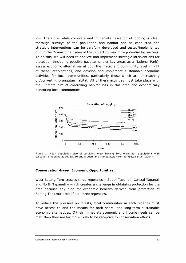
With current estimated rates of logging, habitat loss and the associated
removal of orangutans, model results from the PHVA indicated that only
populations of 250 or more orangutans show long-term viability, and that
high logging rates of 10-20% annually quickly drive populations to extinction.
Therefore, the relatively large population in West Batang Toru, with its
relatively low rate of habitat loss, may be able to persist longer than other
populations if data estimates are accurate and current conditions continue.
However, the challenge lies in correctly identifying and ameliorating – as soon
as possible – the existing and potential future conditions that will prevent the
long-term viability of this population. This includes not only logging but also
habitat encroachment and poaching.
Obviously, the sooner these factors are controlled, the larger the possibility to
stabilize orangutan population, and the greater its long-term viability.
However, if data estimates used at the PHVA are correct, models suggest that
an immediate halt to logging is not necessary to prevent extinction for this
population (Figure 1). This is largely because the West Batang Toru
population is large enough and the logging rate in the area now is relatively
Conservation International – Indonesia 12
low. Therefore, while complete and immediate cessation of logging is ideal,
thorough surveys of the population and habitat can be conducted and
strategic interventions can be carefully developed and tested/implemented
during the 2-year time frame of the project to maximize potential for success.
To do this, we will need to analyze and implement strategic interventions for
protection (including possible gazettement of key areas as a National Park),
assess economic alternatives at both the macro and community level in light
of these interventions, and develop and implement sustainable economic
activities for local communities, particularly those which are encroaching
on/converting orangutan habitat. All of these activities must take place with
the ultimate aim of controlling habitat loss in this area and economically
benefiting local communities.
Figure 1. Mean population size of surviving West Batang Toru orangutan populations with cessation of logging at 20, 15, 10 and 5 years and immediately (from Singleton et al., 2004).
Conservation-based Economic Opportunities
West Batang Toru crosses three regencies – South Tapanuli, Central Tapanuli
and North Tapanuli – which creates a challenge in obtaining protection for the
area because any plan for economic benefits derived from protection of
Batang Toru must benefit all three regencies.
To reduce the pressure on forests, local communities in each regency must
have access to and the means for both short- and long-term sustainable
economic alternatives. If their immediate economic and income needs can be
met, then they are far more likely to be receptive to conservation efforts.
Conservation International – Indonesia 13
The forest fauna of North Sumatra, including orangutans, is in particularly
high demand on the international wildlife market. The proximity to major
trading centers, such as Singapore, means that capturing and selling wildlife
to traders presents a lucrative opportunity to local Sumatran people who are
poor. Similarly, illegal logging operations often rely on local communities for
labor needed to extract timber from the forests. Because these communities
have limited choices and limited access to other economic opportunities, both
poaching and illegal logging provide attractive financial incentives. A key to
success will be identifying incentives that are more beneficial than poaching or
cutting trees to provide for local communities’ income needs.
Agriculture products important to biodiversity are a function of the size,
location, and composition of farms that grow them. Agriculture sectors have
contributed a significant portion of the Gross Domestic Products (GDP) in the
three West Batang Toru regencies. For example, in 1999, as much as 61.5%
of total GDP in North Tapanuli came from the agricultural sector; the same
year in Central Tapanuli, this sector contributed about 55.54% of total GDP
(Perbatakusuma, 2004). In many cases, farmers clear vegetation and use
chemicals and fertilizers in order to maximize yield. However, CI and its
partner, the World Agroforestry Center ICRAF, are experienced in working
with farmers whose farms are designed to buffer protected areas from
destructive economic activities (e.g., in Kerinci-Seblat National Park). Farmers
can improve the yield on a sustainable basis without loss of biodiversity or use
of chemicals by applying organic agriculture management techniques such as
shade management, terracing, composting and integrated pest management.
Our work with farmers in Gayo Regency (Aceh Province) with ForesTrade
includes strict guidelines for membership in the program, including bans on
hunting and clearing of new land, as well as restoration of owned degraded
land. Compliance is strictly monitored and people are eliminated from the
program if found in violation of any of the regulations. In return, access to a
better market is provided.
Baseline data for this activity used REPPPROT 1981, which includes soil types,
rain fall, climate, and land use. CI has conducted assessments of agroforestry
feasibility in several sites in North Sumatra using these data. In collaboration
with Starbuck’s Coffee Company, we have assessed the possibility of
sustainable shade-grown coffee farming in Dairi regency (north of Batang
Toru) and Mandailing-Natal Regency (south of Batang Toru).
The sustainability of a Hydroelectric Power Dam (55 MW) in Central Tapanuli
and the agricultural sector heavily depends on the existence of long-term
environmental services provided by the forest in the Batang Toru watershed.
Conservation International – Indonesia 14
Sustaining watershed functions, such as a dependable supply of clean water
and buffering river flow against peak rainfall, does not necessarily depend on
the persistence of natural forest. Modified forests and ‘agroforests’ (kebun
lindung) as they exist throughout Sumatra (and elsewhere in Indonesia) are
low-labor forms of growing tree crops (rubber, resins, fruits) for local or
international export markets (Joshi et al., 2003). These forests can maintain
the permanent soil cover, well-structured soil and sufficient deep root
anchoring of the soil on sloping land that is needed for watershed functions
(Ranieri et al., 2004; Van Noordwijk et al., 2004).
While watershed functions do not critically depend on natural forests
(although these do provide the benchmark in providing the service),
biodiversity conservation does – at least for biota with a very low tolerance to
human presence and modification of the forest environment. The relationship
between biodiversity conservation and forms of agroforestry still is heavily
debated in the context of the ‘intensification’ hypothesis: on one hand, high-
diversity extensive land use types with structural similarity to forest can
integrate production and conservation functions, on the other hand, more
intensive forms of (tree crop) production could free up more land for ‘set
asides’ of a full conservation status. The evidence for Sumatra is mixed
(Murdiyarso et al., 2002; Van Schaik and Van Noordwijk, 2002, Joshi et al.,
2003). The character of these agroforests, their current conservation value,
options for improvement and sustainability vary along with the dominant cash
crops that they contain and the management style (rotational ’plantations’ or
permanent agroforests with internal rejuvenation and enrichment planting
(Joshi et al., 2003).
For example, Toba benzoin (Styrax sumatrana) and Durame benzoin (Styrax
benzoin) have been cultivated by local farmers in the Batang Toru area for
almost 200 years, especially in the North Tapanuli Regency. This Regency is
the largest producer of the benzoin in Indonesia, with a total area of
plantations estimated to be 22,670 ha (in 2000), with a total production of
2,000 to 3,000 tons per year. The domestic price of benzoin varies between
Rp. 5,000 to Rp. 12,000 (US$0.55 to $1.31) per kg and the international
market price is about US$4 per kg. The benzoin from this area is marketed to
Java and exported to Europe, Singapore and Malaysia as an ingredient for
perfume, cigarettes, ritual ceremonies, and medicine (Fernandes, 2004a,
2004b).
The benzoin agroforests that has been used by local farmers for generations
is a system that claims and secures land ownership. The farmers also plant
coffee and durian in the benzoin plantation area. It has been estimated that
Conservation International – Indonesia 15
about 18,000 households (or more than 100,000 people) in ten villages in
North Sumatra are involved with and receive benefits from benzoin gardens.
Benzoin contributes about 30-45% of total annual household income – about
US$144 to US$216 (Fernandes, 2004a and 2004b).
Where agroforests are relevant for environmental services (such as
conservation of globally important species) that exceed the local value and
relevance, some form of ‘environmental service reward’ is needed (Tomich et
al., 2004). Ecotourism also may provide a way to link rewards and the
persistence of long-term environmental service. The potential of ecotourism in
this area needs to be fully explored, and where possible, used to work to the
advantage of local communities.
This project proposes an in-depth assessment of the livelihood strategies and
the opportunities to promote sustainable livelihood that can contribute to
forest protection to conserve Batang Toru’s orangutan population (under
Component 2).
CI’s Work To-Date in the Area
Achieving results in northern Sumatra is not easy. It requires a long-term
commitment to the area and credibility among communities, local NGOs,
regency and provincial governments, and with the Ministry of Forestry. CI’s
experience in Northern Sumatra over the past 3 years has helped us build this
credibility – as a leader in conservation biology by spearheading the 2003
Conservation Assessment and Management Plan for Sumatran Threatened
Species (CBSG, 2003); as a convener in bringing together relevant
stakeholders to develop a corridor plan for Northern Sumatra, including a
collaboratively developed ‘vision’ map; as a capacity builder and financer of
civil society led conservation through the Critical Ecosystem Partnership Fund
(CEPF) and Verde Ventures Fund; and as a catalyst for on-the-ground
conservation results through our work with the Mandailing-Natal Regency and
the Ministry of Forestry in establishing the new Batang Gadis National Park.
Within Sumatra’s large, critically important biodiversity areas, CI, through the
CEPF, has established corridor and site level programs in Sumatra (Northern
Sumatra Corridor and Siberut; also Bukit Barisan Selatan with WCS as the
implementer and Tesso Nilo/Bukit Tigapuluh corridor with WWF as the
implementer).
Success will require an understanding of and the ability to operate effectively
within the complex northern Sumatra milieu. Through CI’s past work in the
Conservation International – Indonesia 16
area, we have learned about the complexity, challenges, and opportunities
faced in developing and implementing effective conservation solutions. Our
approach in this project incorporated lessons learned, not only from northern
Sumatra but also from our work in Java (Gunung Gede National Park, Halimun
and Salak National Park and surrounding area), Sulawesi (the Togean
Islands), and Papua (Mamberamo Corridor and Raja Ampat Islands).
Additionally, for orangutans, we use the experience gained from working in
Tajung Putang National Park in Kalimantan and in successfully building
capacity within Orangutan Foundation International (OFI, see below) to assist
us in building capacity in other partners. We engaged local partners to create
the conditions needed for conservation to succeed and to effect the systemic
changes necessary to address the threats to biodiversity. Our approach
emphasized fostering a process that creates local capacity and ownership to
replicate and scale up project successes.
While Batang Toru is a new site for CI, we are firmly committed to working in
the area. Our activities to-date in North Sumatra provide a solid foundation
upon which the work proposed here will be based. Our North Sumatra
operation is based in Medan, and we are in the process of opening another
office in Panyabungan (Mandailing-Natal Regency), not far from Batang Toru.
We have an excellent working relationship with the Governor of North
Sumatra, who has written a letter of support for CI for this project.
CI already has made significant inroads toward building broad-based
understanding of the scale of forest loss in Sumatra, its implications for
people and for the orangutan. CI’s conservation vision in Northern Sumatra
includes: saving 4 million ha of forest land (including 90% of Sumatra’s
biodiversity representation), avoidance of species extinction, and creating/
establishing a corridor (connectivity). In order to achieve this vision, CI uses a
participatory approach by conducting series of dialogues, discussions, and
consultations with multiple layers of key stakeholders. These discussions
include identifying threats, opportunities, and common agendas, in the form
of establishing a conservation framework for Northern Sumatra Corridor
development. It is clear that no one organization can work alone to deal with
the complexities in conserving this critical area; success will be firmly
anchored in collaboration and partnership. In addition, no single intervention
will guarantee the survival of any species, including the orangutan. In the era
of decentralization in Indonesia, the conservation movement will be far more
effective if it is supported by local government, as well as other local
stakeholders. Conservation also must include multiple, interdisciplinary
approaches. CI’s successes to-date in Sumatra include the following:
Conservation International – Indonesia 17
Agroforestry.— CI has been working in agroforestry initiatives in Sumatra
(Aceh, west Sumatra, and Jambi) since the late 1990s. Our resource
economists and enterprise staff have worked with ForesTrade in developing
green products such as coffee, cinnamon, spices, and vanilla. We currently
have a project in Aceh with ForesTrade, funded by CI’s Verde Venture Fund.
Our projects aim to reduce the pressure to conservation areas by promoting
income generating livelihoods through environmentally-friendly agroforestry,
and also provide access to international markets.
CI also has been working on community-based agroforestry in Pak-Pak
Bharat, North Sumatra. This initiative, funded by a private sector Japanese
donor, DoCoMo, was linked with the effort to manage biologically important
protected areas adjacent to resettlement areas. With our partners, CCC
(Communication Conservation Center), the Pak-Pak Bharat Regency and local
NGOs, we have been implementing a participative conservation-economic
program to improve the long-term welfare of approximately 300 families and
the biodiversity resources under their stewardship. These family-owned
farmlands are situated adjacent to Samponan protected forests, Siranggas
Game Reserve, and Bukit Ardan protected forests; the latter sites are well-
known orangutan habitat. The project aimed at improving the ecosystem
carrying capacity by (a) creating migration corridors between fragmented
orangutan habitats, and (b) providing seasonal crops or even possible
economic alternatives for local communities.
Conservation Education.— CI believes that public awareness of the key
environmental services (e.g., watershed, erosion control) that forests provide
will be a key component in stopping or slowing illegal logging and, ultimately,
in conserving orangutans. It is clear that without efforts to reduce
fragmentation and link orangutan populations, continued habitat loss and
losses to poaching will soon drive this species close to extinction. To
counteract this threat, local communities must recognize the importance of
the species and the forests in which they live.
To reach the broadest audiences possible with the orangutan conservation
and ecosystem services message, CI has used a number of methods,
including a radio talk show series discussing orangutan conservation and
other related topics, and radio spots or Public Service Announcements on
orangutan conservation and related issues in Sumatra. Information also has
been disseminated in printed form, including fact sheets, posters, displays,
PowerPoint presentations, and several editions of Buletin Dakwah (sermon
sheets) to promote, from the perspectives of both Islam and Christianity, the
importance of protecting orangutan and nature. All of our awareness activities
Conservation International – Indonesia 18
were preceded by an awareness needs assessment for the general public
(including refugees) and key decision makers. CI’s awareness work to-date
has been funded by the World Bank-GEF, USAID, CEPF, USFWS and private
donors.
With funding from USFWS, CEPF and a private donor, and in partnership with
BKSDA, in the last 2 years CI operated the Sibolangit Interpretive Center. The
Center, about 1 hour’s drive from Medan, uses the Sumatran orangutan as a
‘flagship’ species to increase public awareness concerning natural resource
management and biodiversity conservation. Situated on the main road
between Medan and Lake Toba, and near Gunung Leuser National Park,
Sibolangit targets awareness and conservation education for the communities
surrounding the area. The Center staff are supported by volunteers from
surrounding communities, all of whom have undergone intensive training in
nature interpretation.
To reach audiences that otherwise might not otherwise have the opportunity
to learn about orangutan conservation, CI also operates a Orangutan Mobile
Education Unit that takes the conservation message beyond Sibolangit’s gates
to remote areas. This project began in 2001 with USAID funding, and
continued with funding from the CEPF. The Unit travels to remote villages and
camps out for 3-4 days, with regular return visits throughout the year. During
the visits, the CI team conducted informal learning sessions ranging from
school visits and puppet shows to interactive games and daytime forest walks.
Local communities warmly received the Mobile Unit and it has been very
effective in raising awareness among target audiences. To-date, the Mobile
Unit has reached villages and refugee camps in regencies in North Sumatra,
with hundreds of people attending each session, particularly a popular
evening ‘orangutan film series’. The Mobile Unit is an integral part of our
conservation education work in North Sumatra, and also has been an
important entry point to reach local decision makers.
Enforcement Training.— Almost every aspect of law enforcement, including
conservation and forestry laws, poses problems in Indonesia. In 2002, CI
conducted a stakeholder consultation that indicated that fragmented habitat,
deforestation, rampant illegal logging, illegal wildlife trade, and poor law
enforcement are the key issues (Supriatna et al., 2002). Under the
previously-funded USAID Sumatran orangutan grant, CI conducted a law
enforcement training needs assessment and developed training modules for
orangutan and habitat protection, as well as survey methodology for local law
enforcement personnel, including forestry rangers (Leuser National Park;
Conservation International – Indonesia 19
BKSDAs North Sumatra; and BKSDA NAD), police personnel, representative
from attorney offices, judges and members of NGOs.
Species Conservation Work.— CI continues to focus on the Sumatran
orangutan, and we expect work to begin with other species in Batang Gadis
National Park, Sumatra in FY08. In addition to CI’s USAID funded Sumatran
orangutan project, which ended in 2003, our most recent orangutan
conservation work includes leading the Sumatran orangutan working group at
the January PHVA workshop (Singleton et al., 2004). We secured funds from
the CEPF to reconvene the working group in October 2004, plus additional key
stakeholders (including government officials and local community members),
to build upon the work begun at the PHVA and to work toward developing a
Sumatran Orangutan Action Plan under the auspices of the IUCN/SSC Primate
Specialist Group.
We also have been active Sumatra-wide in species activities. In 2003 CI led a
Conservation Assessment and Management Plan for Sumatran Threatened
species (CBSG, 2003). The participatory approach used in this project
(utilizing the knowledge of more than 100 scientific experts, including Ministry
of Forestry staff), facilitated agreement on species priorities for nearly 300
species, based on local input and using rigorous criteria of the IUCN Red List
assessment process. Distribution maps for each species were developed and
provide a baseline for both establishing site priorities and for future
monitoring.
Institutional Capacity Building for Other International NGOs. From 2001-2003,
at USAID’s request, CI managed Orangutan Foundation International’s (OFI)
USAID-funded Bornean orangutan project in Tanjung Puting National Park. We
placed several key staff with OFI on the ground in Tanjung Puting and
successfully built their project management capacity, including financial
management and reporting – to the extent that OFI was able to win a USAID
orangutan RFA award on their own in 2003.
Facilitating the Establishment of Batang Gadis National Park. As part of its
effort to build, with partners, a corridor in Northern Sumatra, CI has
contributed substantively to the establishment of the 108,000-ha Batang
Gadis National Park, just south of Batang Toru. The Park’s establishment was
catalyzed by the November 2003 flooding at the Bukit Lawang resort, which
killed almost 150 people in the neighboring Langkat Regency – many blamed
the disaster on illegal logging in Gunung Leuser National Park. To avert a
similar disaster, the 30,000 people living in local communities along the banks
of the Batang Gadis River in the Mandailing-Natal Regency requested the
Conservation International – Indonesia 20
district government head (bupati) to designate 108,000 ha of forest near the
river as a National Park. CI worked with the provincial governor and bupati to
establish the Park under a new legal framework in Indonesia, which allows
local government officials to declare a National Park. (This is the first
Indonesian National Park declared in a “bottom-up” process initiated by the
local government.) This was a rapid process, with initial discussions among
the Mandailing-Natal bupati, the Governor of North Sumatra, and CI
beginning in December 2003. Funded by the CEPF, CI provided policy support
and advice to the Regency and the Governor to secure protection for the area.
These efforts culminated with a formal letter of approval by the Minister of
Forestry and Park inauguration by President Megawati Soekarnoputri in June
2004. This Park serves as a model for the development of other new National
Parks in Indonesia. The example provided by Batang Gadis already has
stimulated at least 20 new applications for National Parks from other local
governments (A. Susmianto, pers. comm).
CI’s partner, World Agroforestry Center ICRAF has extensive experience
throughout Indonesia and at various locations in Sumatra. ICRAF has worked
more than 10 years in Lampung on the Biological Management of Soil Fertility
project with university partners to develop farming systems that enhance
livelihoods of local communities. Additionally, ICRAF has seven years of
experience in the smallholder rubber agroforestry projects (in Jambi, West
Kalimantan, and West Sumatra) that in corporate the production of rice and
other food crops in rubber gardens. ICRAF also has experience with intensive
tree farming and horticulutural systems that integrate the production of food
crops for both market-sale and home consumption in Sumberjaya and North
Lampung (both sites in Lampung).
Conservation International – Indonesia 21
III. ACTIVITY DESCRIPTION AND IMPLEMENTATION PLAN
Overall Approach
The themes that underpin overall approach are described as follows.
1. Ensuring community-level successes
Ultimately, efforts to conserve biodiversity must succeed at the community
level and will be the true measure of effectiveness. Therefore, close
collaboration with stakeholders is extremely vital in building the community-
level components of the project, including fostering efforts to establish new
conservation areas, if feasible, including building the capacity to manage them
effectively, and facilitating stakeholder efforts to establish participatory
planning processes, etc.
2. Building alliances to foster support and bring resources to
managing orangutan conservation efforts in West Batang Toru
Conservation efforts will be successful only if people support them, now and
well into the future. This support must be public and broad-based to
withstand the inevitable periodic efforts by parts of society to divert resources
or support for natural resource management efforts to other priorities.
Alliances of civil society, communities, the private sector, and government are
a powerful tool to create this support. Creating alliances will require building
awareness and creating incentives for people to support conservation efforts,
like anti-poaching patrols or co-management of protected forests. These
alliances will be most effective if members actively participate in developing
and implementing such conservation efforts. Fostering this participation
requires helping the relevant decision-making and resource management
agencies develop mechanisms to seek public input and active support.
3. Building local capacity to plan, implement, and manage
orangutan conservation efforts and their components
Alliance members will need technical and organizational skills to use
biophysical and economic data to design and manage conservation efforts.
CI’s approach ensures that the members of the alliances possess and utilize
these skills and information to sustain and build on the conservation
successes of this program. Threats-based analysis is a key tool in this process
Conservation International – Indonesia 22
to help communities identify the primary constraints to conserving
orangutans. The particular capacity needs to be built will depend on the local
circumstances and the needs and interests of the alliance members. For
example, for local governments it could involve building local capacity to use
GIS data and land-use planning methods. With community members, it could
involve building women’s capacity to articulate and present their needs in a
planning meeting. With the private sector, it could involve building capacity to
provide business-development services in ecotourism, or to adopt ecologically
sound business practices in agricultural activities.
4. Improving the ability of relevant authorities and agencies to
establish and enforce policies needed to support orangutan
conservation
Considering the existing patterns of natural resource management and law
enforcement, it has been proved the importance of identifying and analyzing
the disincentive value for illegal activities, and determining the weakest links
of enforcement chain, as it was revealed with the CI’s USAID-funded
economic enforcement project in Papua. It is only with this kind of analysis
and thorough understanding of the entire chain of enforcement that make it
possible for designing and implementing wise investment that will
substantively improve law enforcement for conservation.
Orangutan conservation efforts depend on the ability and willingness of the
responsible authorities to enforce regulations, zoning, and conservation plans.
Thus a key component of CI’s strategy is to build the capacity of alliance
members at the local, regional, and national levels and in communities to
create and enforce the necessary policies. Effective enforcement requires
appropriate policies, effective site-level actions, and success along each step
in the enforcement chain, from detection, to case-building and prosecution
and conviction.
5. Integrating monitoring into planning
Creating a successful conservation project is an exceedingly complex process.
The only way to know if the project gains success in the midst of this
complexity is to monitor the biophysical, economic, and social conditions that
the project attempts to influence. Monitoring data could disclose the project
impacts and document its progress, which is vitally important to keeping
alliance members committed and to maintaining the credibility of the
initiative. Thus, building the capacity to do participatory monitoring and to
Conservation International – Indonesia 23
integrate those data into planning (an essential step in monitoring) is one of
the key components of the project’s strategy.
General approach to addressing gender issues
The social roles of men and women will affect ability to achieve results. With
this in mind, the effects of gender roles will be identified to ensure that the
gender issues do not constrain the project to succeed. The most likely gender
issues that would be faced are:
* Ensuring men and women have equitable roles in deciding how to plan
and manage biodiversity conservation. Women are often excluded from
deciding how to manage natural resources. Working with local partners
will ensure that management plans and planning processes reflect the
needs of groups that are typically marginalized in communities,
including women, the poor, and indigenous groups. Women in the local
communities will also be ensured to have the same access as men to
information about how to participate in government decision-making.
* Ensuring women have equitable access to the benefits of the project.
Often women are excluded from new opportunities created by
development programs. Women and other marginalized groups will be
ensured to have the same opportunities to gain from the project as
others in society, such as access to training, new positions of authority
in planning and management roles, technical and management capacity
building, etc.
* Ensuring equal access to information. Men and women tend to obtain
information and news from different sources. They also tend to respond
to different messages in awareness campaigns. The awareness
campaigns will be designed as such that are capable of reaching men
and women.
* Ensuring equal access to training. Women often are excluded from
training programs. A common assumption is that the men who are
trained will share their new skills with women, which rarely happens. As
a result, women continue to be left out of new opportunities and
programs do not reflect their interests. Women and other marginalized
groups will have equal opportunities to be involved in the training
supported by the project, including training in planning, management,
enterprise development, land use and agricultural practices, etc.
Conservation International – Indonesia 24
* Ensuring equitable access to business support, women will have the
same access as the men, such as business development services and
improved access to credit.
Because of space limitations, these examples represent only some of the ways
in which gender issues can be addressed accordingly.
Adaptive Management
The dynamic socio-economic and political condition in North Sumatra will to
some extent demand the project adjustment in order for the project to be
effective. Adaptation to changing local conditions might not be inevitable, and
such will always be consulted with the USAID. To ensure the focus of long-
term goals of the project, a Performance Measurement Plan with indicators to
help track progress and identify has been developed. Collaboration with
ICRAF, local NGOs and business enterprise to monitor these indicators and to
adjust actions as necessary to maintain progress. This process will also be
utilized for supporting the improvement of local partners’ capacity, and
therefore helping them build both sustainable and adaptive approaches to
fostering conservation.
Project Components: Description
Component 1. Catalyze improved protection of orangutan habitat.
OBJECTIVE 1.1. Work with partners to map orangutan distribution
and habitat and formulate a strategy to improve protection.
Two key elements in managing wildlife populations are: (1) having accurate
information on species distribution and habitat requirements and (2) having
support for and capacity within local stakeholders to use this information to
formulate and apply appropriate conservation interventions. This objective is
designed to create these conditions. All of the activities are designed to
promote capacity building of local partners by sharing data and engaging in
participatory process that allow for ‘learning by doing’.
The following are the activities planned to achieve Objective 1.
Conservation International – Indonesia 25
Activity 1.1.1. Information gathering on orangutan distribution and
identifying priority areas for targeted protection.
Several representative sample sites would be chosen for thorough transect
surveys in West Batang Toru. Regular and repeated censuses would be
conducted in order to obtain an accurate estimate of orangutan density.
Orangutan habitat, especially that occurring near villages (or other human
activities) would be prioritized. Primary data would be combined with other
secondary data (vital statistics of the development, including land use plans,
of neighboring villages), analyzed, and mapped. Auto-triggered camera ‘traps’
along similar census routes would be used to compliment data gathered on
orangutan distribution. The applicability of using field surveys and ground-
truthing techniques, coupled with survey data from camera traps, would be
assessed for orangutan distribution mapping in the Batang Toru forest. Aided
by aerial photos and interviews with local people, these techniques would be
invaluable in determining basic population distribution information as well as
priority areas for targeted protection.
Activity 1.1.2. Identify threats to orangutan habitat and create a proactive
intervention strategy.
Loss of natural habitat and poaching are the most significant factors
contributing to the reduction of orangutan populations in the West Batang
Toru area. Root causes of key threats must be fully analyzed to prepare a
threat abatement plan. With local and provincial government, CI would
conduct a thorough threats analysis for the Batang Toru area, and would
engage decision makers in the three Regency governments that comprise the
West Batang Toru area, local NGOS, and affected communities in a
participatory process to develop a plan to manage threats. This would include
developing indicators of success, identifying responsible parties to carry out
threat abatement actions, with accurate estimates of the costs and a
timetable for executing the plan. This activity would also build the capacity of
local government to carry out these kinds of analytic and planning activities.
Activity 1.1.3. Identify habitat under deforestation threats through forest
cover change detection.
A change detection analysis of Batang Toru region will be performed using
LANDSAT TM images gathered from different years to identify areas with the
greatest deforestation rate. Methodologies and analytical techniques include
acquiring the images, permissions obtained for overflights, collection of aerial
survey data, processing of images to create a mosaic of change map,
Conservation International – Indonesia 26
finalization and validation of the map using aerial surveys and available
supplementary ground data. These data are shared with Regency government
officials and communities close to areas of high deforestation as part of a
long-term effort to build their capacity to use this information as they adapt
and refine their conservation activities.
OBJECTIVE 1.2. Strategic interventions to support key stakeholders
for promoting the protection of orangutan population developed and
tested.
To sustain a viable number of individual orangutans for population survival,
improved protection is essential. However, first, there will be an assessment
and a development of the most strategic interventions or cost-effective
investment or mechanisms to address the problems as identified under
Objective 1. With extensive local law enforcement input, there will be an
analysis on the weaknesses in the enforcement system, and development of a
least-cost investment strategy to address them. The enforcement escalation
efforts would be focused solely on assisting in protecting and maintaining
orangutan habitats and supporting anti-poaching measures.
The following are the activities planned to achieve Objective 1.
Activity 1.2.1. Map enforcement agencies and the players in the three
regencies encompassing West Batang Toru.
Accurate information concerning the ‘players’ who influence the existing
habitat and orangutan population, including persons acting ‘behind the
scenes’ is a key entry point in resolving enforcement problems. Potential
constraints/misperceptions among stakeholders, especially enforcement
agencies, can be avoided from the beginning by socializing efforts and
obtaining political and technical support. Possible local/traditional enforcement
systems would also be assessed to use traditional knowledge to protect the
orangutan and its habitat. Under this activity there will be a series of
consultative meetings with enforcement agencies and stakeholders aiming at
collecting information regarding capacity, resources, infrastructure, skills, and
knowledge of each institution, and strengths and weaknesses of enforcement
agencies.
Activity 1.2.2. Collect quantitative and qualitative data concerning
conservation crimes related to orangutan and its habitat.
Conservation International – Indonesia 27
According to the Indonesian Criminal Justice System, the enforcement chain
for conservation and forestry crimes is the responsibility of forest rangers,
Forest Civil Investigators, the police, Attorneys, and the Court. Poor
performance by any one of these parties will reduce the effectiveness or
performance of law enforcement. Under this activity, there will be an
assessment on the enforcement performance using quantitative and
qualitative data for existing crimes. This data will be used to calculate the
probabilities of each step in the enforcement chain and the overall value of
the enforcement disincentive presented by the government enforcement
system. This work will build upon CI’s USAID-funded economic enforcement
project in Papua.
Activity 1.2.3. Co-develop strategic interventions to improve the protection
of orangutans.
Under this activity, the project would: (a) Disseminate the results of analyses
in Activities 1 and 2 to key stakeholders and build consensus on which link(s)
are critical for improvement and which interventions are optimal for securing
results; (b) Develop a strategy with stakeholders. This would include
identifying key interventions and partners with whom these interventions can
be examined; and (c) Provide in-house training for law enforcement personnel
and NGOs involved in enforcement work.
Activity 1.2.4. Test and modify interventions.
Under this activity, there will be tasks to validate or adapt the interventions
developed under Activity 1.2.3.
Activity 1.2.5. Collaboratively develop law enforcement monitoring activities.
Under this activity the project would be geared to: (a) use time-series
analysis of LANDSAT images to detect habitat change; (b) resurvey densities
of targeted populations of the Sumatra orangutan; and (c) work with regency
governments and the Ministry of Forestry to monitor the number of incidences
of orangutan smuggling, poaching and trading.
Expected Results of Component 1
An orangutan conservation strategy for West Batang Toru, supported by
local stakeholders that is based on state-of-the-art population,
distribution, and habitat data. The strategy will include plans for
Conservation International – Indonesia 28
sustainable economic activities to enhance alternative income earning
opportunities for local communities.
Alliances of local community, private, government, and NGOs to monitor
and enforce a protection system for orangutan in West Batang Toru.
A policy framework that supports a collaborative management of
existing West Batang Toru protection forests (‘hutan lindung’).
Component 2. Support communities and partners to develop
sustainable economic alternatives in Batang Toru.
There are many economic incentives for community members in Batang Toru
to cut down the forest and hunt orangutans. The preservation of orangutan
and its habitat in Batang Toru, positive incentives will need to be developed in
order to counter the negative incentives that emerge during the project
implementation. It is therefore crucial to collaborate with community
members and other local partners to develop new ways of generating income
without destroying the forest or the orangutans. In order to do this, a number
of tasks will need to be accomplished, namely: (1) gain in-depth knowledge of
the livelihood systems and to identify potential incentives to motivate the
local people towards conservation-oriented activities, including macro-
economic drivers; (2) understand which high-quality habitats are critically
threatened and create sustainable land use matrices to connect the core
habitats across the landscape; (3) develop diverse sustainable livelihood
opportunities rooted in local knowledge and resources; (4) assist
communities, local government and park managers to develop spatial
planning strategies that best meet all parties’ objectives.
Agroforests in Indonesia traditionally have provided extensive but
‘domesticated’ modes of production of the most valuable elements of the local
forest (e.g., damar – Shorea robusta, and durian – Durio zibethinus). The
transition from collecting ‘forest products’ to growing them in agroforests
requires modifying tenurial institutions. Along with tenurial modification,
support for support for locally available sustainable economic opportunities
must be engendered to ameliorate rapid forest depletion from agricultural and
illegal logging activities. Through a multistakeholder ‘negotiation support’
approach, barriers to and bottlenecks for more sustainable land use can be
identified and addressed.
Two alternative income activities with significant potential in the priority area
are mixed agroforestry systems and ecotourism. The main form of
agroforestry in the area is based on benzoin harvested from Styrax spp. This
Conservation International – Indonesia 29
is an extensive form of agroforestry in which the structure and environmental
functions of natural forests is functionally replicated through using other,
sometimes domesticated, forest tree species (e.g., Shorea spp.). Benzoin
agroforestry systems provide habitat for wildlife and plant biodiversity and
perform soil and water conservation services, while also serving both market
and household needs.
CI work with ICRAF to use lessons learned from the rubber agroforests in
Sumatra and Kalimantan, in particular, that a wide range of management
intensity may provide similar ‘returns for labor’, although yields-per-ha differ.
The ecological value depends on the mode of rejuvenation, with the ‘sisipan’
method of interplanting being much more supportive of high tree (and
associated) diversity than a ‘plantation’ approach. It is expected that the
agroforests of Batang Toru and surrounding area can provide a sustainable
livelihood option with opportunities to increase farmer income without
negative environmental impact.
Our approach is one of sustainable agriculture that will include trees at both
the farm and landscape scales. It is acknowledged that there is the need for
quick, productive elements in the land use and farm systems to meet
immediate food security needs. Based on initial results, there will be tasks to
identify a number of innovations to enhance food crop production – likely to
include soil fertility management, the use of improved varieties/germplasm,
small livestock and deliberate management. While focusing on the immediate
need for basic food crops, there will also an attempt to link farmers with new
knowledge about soil, crop and tree management to develop long-term
sustainable agriculture and agroforestry systems.
The approach to developing such economic opportunities would be carried out
in two phases. Based on CI’s experience and that of partner, namely ICRAF,
this is achievable within the 2-year timeframe of the project. Objective 2.1 is
primarily focused on investigating economically-feasible and socially-
acceptable strategies for the Batang Toru region. Objective 2.2 is to catalyze,
guide, and provide technical support to an extensive network of local
stakeholders to design and implement such strategies.
ICRAF would be involved in the socio economic and land use assessment of
livelihood systems in Batang Toru and, with CI and local stakeholders,
formulating and implementing a strategy to promote sustainable agroforestry
activities. ICRAF would station two full-time technical staff on site who work
with CI, local farmer groups, community institutions and NGOs to implement
the project. Various Bogor-based experts will provide technical backstopping.
Conservation International – Indonesia 30
In the 2-year time frame of this project, fostering a shift toward conservation-
based alternative income sources is a two-step process: (1) building local
support for this shift; (2) developing specific plans to begin making this shift.
OBJECTIVE 2.1. Develop local support for conservation-based income
alternatives.
The first phase of this component is to build local awareness of the
opportunities of preserving the forest resources and the costs of destroying
them. This begins with conducting a series of participatory rapid assessments
to gain in-depth knowledge of the livelihood systems and to identify potential
incentives to motivate the local people towards conservation-oriented
activities. This include the mapping of tree-based land use system
(agroforests) that can combine the sustainable economic activities and
orangutan habitat protection.
In addition, there would also an assessment of the macro-economic drivers to
derive regional or regency-level incentives towards the removal of “perverse”
policies for deforestation (e.g., when regional government issues permits for
log utilization (Ijin Pemanfaatan Kayu) in order to increase regional revenue
(Pendapatan Asli Daerah) from oil-palm business and plantations and promote
the road development through protected area) and toward the development
of feasible alternative income activities at the local community level.
The land use and land cover mapping assessment (described in Component 1)
will provide information on the distribution of viable orangutan habitats in the
priority area, and, when overlaid with the location of deforestation and other
destructive activities, help understand where the most critically threatened
habitats are located. Conservation efforts then can be focused on protecting
remaining high-quality habitats and creating sustainable land use matrices to
connect the core habitats across the landscape. The mapping assessment also
would contribute to the understanding on current land uses to design
sustainable alternatives appropriate to the region.
The following are the activities planned to achieve Objective 2.
Activity 2.1.1. Help community members to identify the Socio-economic
threats and opportunities of local livelihood systems, macro-economic
development, and markets.
Conservation International – Indonesia 31
Under this activity there will be tasks to:
(a) Assess, with farmers, women and other marginalized groups, their
livelihood options within the priority area and potential incentives for
stakeholders’ involvement in habitat protection. The major component of
the livelihood assessment is food security and all facets of food security
will be examined. The livelihood assessment will include the
identification of opportunities to improve agricultural production and to
improve post-harvest handling and marketing of agricultural products,
and other opportunities for increasing income and improving access to
markets.
(b) Identify the potential market constraints and opportunities for the
development of ecologically-appropriate options. Potential options that
might be suitable would include complex agroforestry systems,
ecotourism and development of non-timber forest product systems.
(c) Conduct a macro-economic and policy assessment of existing and
potential economic activities (e.g., agriculture, mining, logging,
industrial and infrastructure development) and regency land use plans
for North, South and Central Tapanuli Regencies. This also include an
analysis of local government revenue needs to identify potential macro-
economic threats to orangutan habitats.
Activity 2.1.2. Mapping land use and land cover.
This activity will complement the GIS activities described in Component 1,
focusing on agricultural land uses, village compounds, agroforests, and forest
fallows.
Develop spatial data (GIS and Remote Sensing) layers to answer
conservation research and landscape management questions.
Map and assess the distribution of remaining orangutan habitats in the
priority area using the latest satellite imagery available. Results of
habitat classification will be reviewed with local remote sensing experts
and ground-truthed by field staff familiar with vegetation distribution at
Batang Toru.
Appraise current land cover and land use in a GIS, with a legend that
reflects the conservation value (different forest types) as well as human
livelihood options (including ‘agroforests’ and forest fallows).
Analyze deforestation and fragmentation threats from the satellite
images.
Conservation International – Indonesia 32
OBJECTIVE 2. Catalyze local entrepreneurs to create alternatives for
sustainable economic activities.
The second part of Component 2 is to develop and implement the alternative
income activities identified as feasible and prioritized as having highest
potential for success under Objective 1 of this component. Further analyses
will focus on generating critical understanding of threats, opportunities,
barriers and barrier removal strategies. To be robust for the long-term, these
sustainable livelihood opportunities must have roots in local knowledge and
resources, and must be diverse enough to allow for fluctuating economic
cycles, including downturns.
Introducing market-economics in this region has created commercial
opportunities for benzoin and other tree and annual crop products. However,
most farmers are not able to take advantage of these market opportunities –
because they do not proactively manage their plantations, the type and
quality of their products do not match market demand. Assisting farmers to
focus on four points can help them turn traditional tree garden systems into
market-oriented systems: (1) identify priority species and their products that
have a high market demand; (2) use high quality seed or seedlings to
establish these species; (3) develop deliberate management methods that to
produce products that meet market specifications; and (4) develop and
enhance commercial linkages between farmers and the market. This
assistance is best implemented through a farmer group extension approach
that helps farmers identify their priorities and build their leadership and
technical capacity. GIS and remote sensing tools conducted under Objective 1
will be integrated into this effort to help communities, local government and
park mangers to develop spatial planning strategies that best meet all
partners’ objectives.
The activities would be carried out with multiple stakeholder groups (including
women and other marginalized groups) and local partners, with significant
effort placed on building local capacity for interaction with the private sector,
as well as obtaining buy-in from the private sector for alternative economic
activities.
Activity 2.2.1. Facilitate and support participatory process for communities
to design a strategy to develop sustainable alternatives to destructive forest
activities.
Under this activity, there will be tasks to:
Conservation International – Indonesia 33
(a) Analyze the constraints and barriers for implementing the selected
potential economic alternatives, including the institutional, market,
policy, technology and social barriers, based on results from
assessments carried out in Component 2, Objective 1, Activities 1 and
2;
(b) Develop strategic interventions to remove barriers for implementing the
selected sustainable economic activities; and
(c) Hold consultations with local stakeholders, including women and other
marginalized groups, to socialize, prioritize and discuss the strategic
interventions.
Activity 2.2.2. Implement the strategy for promoting sustainable economic
activities.
Under this activity, there would be tasks to: (a) Mobilize multiple
stakeholders, including women and other marginalized groups, to implement
the strategy for promoting most feasible sustainable economic activities; (b)
Establish an extensive network of local communities, local NGOs, regency and
provincial governments and local universities for implementing the sustainable
economic activities; (c) Build capacity and provide technical assistance to
local stakeholders (local community, including women and other marginalized
groups, local NGOs, local government and universities) to enable successful
implementation of the sustainable economic alternatives; and (d) Introduce
business development professionals in Indonesia to this area.
Activity 2.2.3. Development of monitoring and evaluating tools to support
sustainable economic activities.
Under this activity, there would be tasks to: (a) Develop participatory
mechanism to conduct the monitoring and evaluation of the project; (b) Set
appropriate targets and indicators for monitoring and evaluation through
participatory approach; and (c) Gain the consensus and build capacity to local
stakeholders (local communities, including women and other marginalized
groups, local NGOs, local government and universities) to enable conducting
monitoring and evaluation activities.
Expected Results of Component 2
An orangutan conservation strategy for West Batang Toru is developed
that is supported by local stakeholders and based on state-of-the-art
Conservation International – Indonesia 34
population, distribution, and habitat data. The strategy will include plans
for sustainable economic activities to enhance alternative.
Increased capacity among local community members (including women
and other marginalized groups) to develop and implement sustainable
economic activities.
Conservation International – Indonesia 35
IV. ACHIEVEMENT
Component 1. Catalyze improved protection of orangutan habitat.
Achievement of Component 1
The state-of-the-art population, distribution, and habitat data of orangutan in
West Batang Toru forest blocks have been developed during the project
implementation. Participatory rural appraisals undertaken in a number of pilot
villages have essentially provided the foundation for further supporting both
the sustainable development at village level and the conservation of
orangutan and its habitat. The project has successfully facilitated a few of the
village needs in the forms of farmer trainings in producing plant growth bio-
stimulant, bio-pesticides and compost as bio-fertilizer, assisting the villages in
rehabilitating their irrigation systems, and providing village library. In these
pilot villages, the local communities have developed their respective village
conservation agreement governing the use and management of village natural
resources. In addition, an economic valuation of natural resources in West
Batang Toru was also undertaken, which recommended a number of actions
need to be taken into account by the local governments. Public outreach in
attempts to augment the local people awareness on the conservation of
orangutan and its habitat has also done in a number of ways targetting at
both local and national public.
Policy analysis undertaken by the project discovered a discrepancy between
the need for orangutan conservation and that for economic development. The
project suggested that there was the requirement to replenish the
government’s policies on the management of natural forests in Batang Toru,
and that the necessity to develop priority strategies for the protection of
natural forests in the Batang Toru watershed area that function as the life
supporting system as well as orangutan habitat. The status of national park
for West Batang Toru area might be very ideal as a strategic intervention, but
there need a very strategic approach to make it happen. Most of the local
people in Batang Toru, for example, did not at all understand the function of a
national park, instead they expressed their anxiety on whether a national park
would just limit their access to their own natural resources. Moreover, there
seemed to be a number of conflicting interests in West Batang Toru in terms
of natural resource utilization that need to be considered.
Conservation International – Indonesia 36
The project has developed another intervention at a local level, namely the
establishment of Community Participatory Monitoring-Orangutan Protection
Unit (CPM-OPU). It is a voluntary alliance of local communities, private
sectors, government agencies, and NGOs to monitor and enforce a protection
system for orangutan in West Batang Toru. Such an alliance has also formed
a West Batang Toru Forum, of which its function in augmenting all
stakeholders’ commitment to develop a management plan for conserving
orangutan and its habitat needs to be further facilitated in the future.
OBJECTIVE 1.1. Work with partners to map orangutan distribution
and habitat and formulate a strategy to improve protection.
CI Indonesia and its partners have built up the foundation for preventing the
habitat loss and helping conserve the orangutan. This was achieved though
the following activities:
Consultation with key government partners (Local government in North
Tapanuli, Central Tapanuli and South Tapanuli, Forestry and Nature
Conservation Unit, NGOs) and local people in areas that orangutan
occurred in surrounding forest;
Obtained the accurate information on orangutan population and
distribution, also its habitat requirements;
Having support for and capacity within local stakeholders to use this
information to formulate and apply appropriate conservation
interventions;
Formulated the strategic intervention to improve protection through
collaboration with stakeholders.
The following are details of achievement of Objective 1 in accordance with its
activities.
Activity 1.1.1. Information gathering on orangutan distribution and
identifying priority areas for targeted protection
Orangutan Population and Distribution
Identifying species population and distribution is a very useful way to
establish the priority on conservation management unit, especially for the
species under the critically endangered criteria such as Sumatran orangutan.
Critically Endangered criteria refer to a 50% probability of extinction in five
years. Deforestation rate and high population decline are believed as major
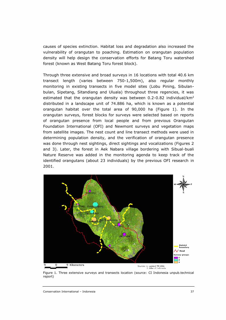
Conservation International – Indonesia 37
causes of species extinction. Habitat loss and degradation also increased the
vulnerability of orangutan to poaching. Estimation on orangutan population
density will help design the conservation efforts for Batang Toru watershed
forest (known as West Batang Toru forest block).
Through three extensive and broad surveys in 16 locations with total 40.6 km
transect length (varies between 750-1,500m), also regular monthly
monitoring in existing transects in five model sites (Lobu Pining, Sibulan-
bulan, Sipetang, Sitandiang and Uluala) throughout three regencies, it was
estimated that the orangutan density was between 0.2-0.82 individual/km2
distributed in a landscape unit of 74.886 ha, which is known as a potential
orangutan habitat over the total area of 90,000 ha (Figure 1). In the
orangutan surveys, forest blocks for surveys were selected based on reports
of orangutan presence from local people and from previous Orangutan
Foundation International (OFI) and Newmont surveys and vegetation maps
from satellite images. The nest count and line transect methods were used in
determining population density, and the verification of orangutan presence
was done through nest sightings, direct sightings and vocalizations (Figures 2
and 3). Later, the forest in Aek Nabara village bordering with Sibual-buali
Nature Reserve was added in the monitoring agenda to keep track of the
identified orangutans (about 23 individuals) by the previous OFI research in
2001.
Figure 1. Three extensive surveys and transects location (source: CI Indonesia unpub.technical report)
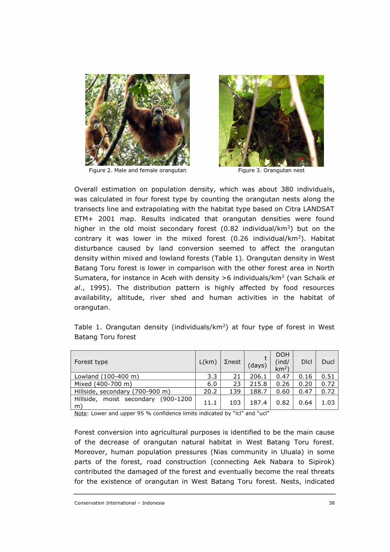
Conservation International – Indonesia 38
Figure 2. Male and female orangutan Figure 3. Orangutan nest
Overall estimation on population density, which was about 380 individuals,
was calculated in four forest type by counting the orangutan nests along the
transects line and extrapolating with the habitat type based on Citra LANDSAT
ETM+ 2001 map. Results indicated that orangutan densities were found
higher in the old moist secondary forest (0.82 individual/km2) but on the
contrary it was lower in the mixed forest (0.26 individual/km2). Habitat
disturbance caused by land conversion seemed to affect the orangutan
density within mixed and lowland forests (Table 1). Orangutan density in West
Batang Toru forest is lower in comparison with the other forest area in North
Sumatera, for instance in Aceh with density >6 individuals/km2 (van Schaik et
al., 1995). The distribution pattern is highly affected by food resources
availability, altitude, river shed and human activities in the habitat of
orangutan.
Table 1. Orangutan density (individuals/km2) at four type of forest in West
Batang Toru forest
Forest type L(km) Σnest t
(days)
DOH (ind/ km2)
Dlcl Ducl
Lowland (100-400 m) 3.3 21 206.1 0.47 0.16 0.51
Mixed (400-700 m) 6.0 23 215.8 0.26 0.20 0.72
Hillside, secondary (700-900 m) 20.2 139 188.7 0.60 0.47 0.72
Hillside, moist secondary (900-1200 m)
11.1 103 187.4 0.82 0.64 1.03
Note: Lower and upper 95 % confidence limits indicated by “lcl” and “ucl”
Forest conversion into agricultural purposes is identified to be the main cause
of the decrease of orangutan natural habitat in West Batang Toru forest.
Moreover, human population pressures (Nias community in Uluala) in some
parts of the forest, road construction (connecting Aek Nabara to Sipirok)
contributed the damaged of the forest and eventually become the real threats
for the existence of orangutan in West Batang Toru forest. Nests, indicated
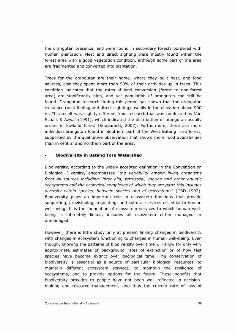
Conservation International – Indonesia 39
the orangutan presence, and were found in secondary forests bordered with
human plantation. Nest and direct sighting were mostly found within the
forest area with a good vegetation condition, although some part of the area
are fragmented and converted into plantation.
Trees for the orangutan are their home, where they built nest, and food
sources, also they spent more than 50% of their activities up in trees. This
condition indicates that the rates of land conversion (forest to non-forest
area) are significantly high, and yet population of orangutan can still be
found. Orangutan research during this period has shown that the orangutan
existence (nest finding and direct sighting) usually in the elevation above 900
m. This result was slightly different from research that was conducted by Van
Schaik & Azwar (1991), which indicated the distribution of orangutan usually
occurs in lowland forest (Sitaparasti, 2007). Furthermore, there are more
individual orangutan found in Southern part of the West Batang Toru forest,
supported by the qualitative observation that shown more food availabilities
than in central and northern part of the area.
Biodiversity in Batang Toru Watershed
Biodiversity, according to the widely accepted definition in the Convention on
Biological Diversity, encompasses “the variability among living organisms
from all sources including, inter alia, terrestrial, marine and other aquatic
ecosystems and the ecological complexes of which they are part; this includes
diversity within species, between species and of ecosystems” (CBD 1992).
Biodiversity plays an important role in ecosystem functions that provide
supporting, provisioning, regulating, and cultural services essential to human
well-being. It is the foundation of ecosystem services to which human well-
being is intimately linked, includes all ecosystem either managed or
unmanaged.
However, there is little study only at present linking changes in biodiversity
with changes in ecosystem functioning to changes in human well-being. Even
though, knowing the patterns of biodiversity over time will allow for only very
approximate estimates of background rates of extinction or of how fast
species have become extinct over geological time. The conservation of
biodiversity is essential as a source of particular biological resources, to
maintain different ecosystem services, to maintain the resilience of
ecosystems, and to provide options for the future. These benefits that
biodiversity provides to people have not been well reflected in decision-
making and resource management, and thus the current rate of loss of
Conservation International – Indonesia 40
biodiversity is higher than it would be had these benefits been taken into
account (Millennium Ecosystem Assessment, 2005).
Concurrently with the orangutan surveys, the biodiversity survey using the
Rapid Assessment Program (RAP) was also conducted to fill the knowledge
gap and contribute additional data and information for Batang Toru watershed
conservation planning. This RAP method, developed by Conservation
International and have been widely used, is to quickly assess the biological
diversity of an area. RAP results are made available immediately to local
decision makers and international forum to help support conservation action
and biodiversity protection in the area.
The Batang Toru RAP team consisted several independent surveys experts
(orangutan/mammals, birds, herpetofauna and vegetation, GIS specialist),
one student from postgraduate program in University of Indonesia and local
people both as porters and part of the surveys group. Training in scientific
methods on surveys was given to the local people participated at survey as a
part of capacity building.
Surveys were conducted in 22 November–22 December 2005 (considered as
wet season), 17 February–14 March 2006 (considered as wet season), 28
August–16 September 2006 (considered as dry season), designed to provide
biodiversity baseline data and information, also to determine the orangutan
population and distribution. Surveys included collection of biological and
ecological data through an intensive inventory of plants and reptiles and
amphibians. Specific threatened species that known to be present in the area
including Sumatran Tiger (Panthera tigris sumatraensis), Malayan tapir
(Tapirus indicus), Sumatran serow (Capricornis sumatraensis), are also
targeted. Multiple methodologies were utilized in undertaking biodiversity
surveys, including line transects for mammals/primates, point counts along
transects for birds, and visual encounter surveys for reptiles and amphibians.
Vegetation samples were collected using the Quadrant Method with plots on
each transects. Unidentified flora found in the plots/transects were taken to
the Herbarium Bogoriensis for further identification.
Biodiversity results are presented in Table 2, including the IUCN and CITES
criterion. Although it is not directly related to orangutan protection, these
findings are extremely important since it demonstrates that the areas of West
Batang Toru is rich in biodiversity, including multiple restricted range and/or
threatened species (Figures 4 and 5).
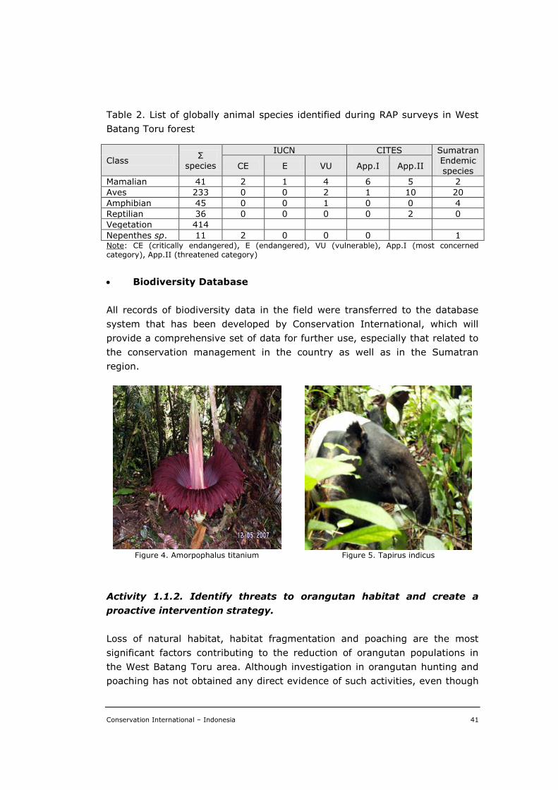
Conservation International – Indonesia 41
Table 2. List of globally animal species identified during RAP surveys in West
Batang Toru forest
Class Σ
species
IUCN CITES Sumatran Endemic
species CE E VU App.I App.II
Mamalian 41 2 1 4 6 5 2
Aves 233 0 0 2 1 10 20
Amphibian 45 0 0 1 0 0 4
Reptilian 36 0 0 0 0 2 0
Vegetation 414
Nepenthes sp. 11 2 0 0 0 1 Note: CE (critically endangered), E (endangered), VU (vulnerable), App.I (most concerned category), App.II (threatened category)
Biodiversity Database
All records of biodiversity data in the field were transferred to the database
system that has been developed by Conservation International, which will
provide a comprehensive set of data for further use, especially that related to
the conservation management in the country as well as in the Sumatran
region.
Figure 4. Amorpophalus titanium Figure 5. Tapirus indicus
Activity 1.1.2. Identify threats to orangutan habitat and create a
proactive intervention strategy.
Loss of natural habitat, habitat fragmentation and poaching are the most
significant factors contributing to the reduction of orangutan populations in
the West Batang Toru area. Although investigation in orangutan hunting and
poaching has not obtained any direct evidence of such activities, even though
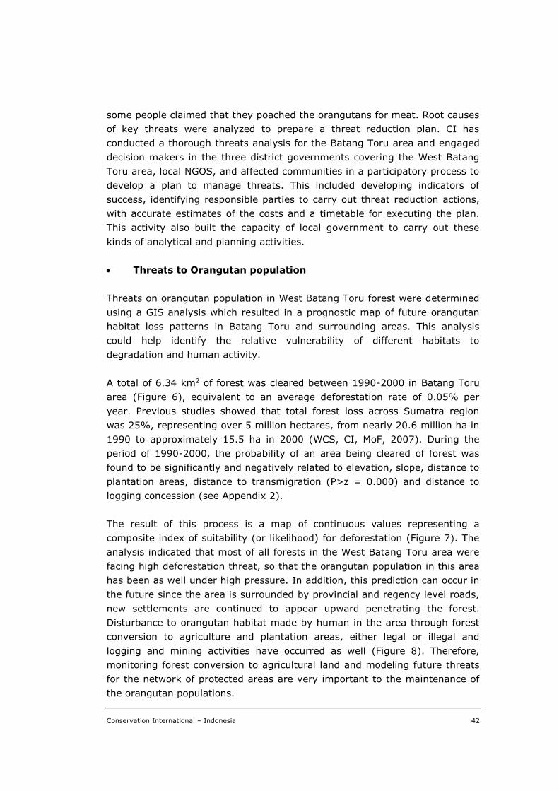
Conservation International – Indonesia 42
some people claimed that they poached the orangutans for meat. Root causes
of key threats were analyzed to prepare a threat reduction plan. CI has
conducted a thorough threats analysis for the Batang Toru area and engaged
decision makers in the three district governments covering the West Batang
Toru area, local NGOS, and affected communities in a participatory process to
develop a plan to manage threats. This included developing indicators of
success, identifying responsible parties to carry out threat reduction actions,
with accurate estimates of the costs and a timetable for executing the plan.
This activity also built the capacity of local government to carry out these
kinds of analytical and planning activities.
Threats to Orangutan population
Threats on orangutan population in West Batang Toru forest were determined
using a GIS analysis which resulted in a prognostic map of future orangutan
habitat loss patterns in Batang Toru and surrounding areas. This analysis
could help identify the relative vulnerability of different habitats to
degradation and human activity.
A total of 6.34 km2 of forest was cleared between 1990-2000 in Batang Toru
area (Figure 6), equivalent to an average deforestation rate of 0.05% per
year. Previous studies showed that total forest loss across Sumatra region
was 25%, representing over 5 million hectares, from nearly 20.6 million ha in
1990 to approximately 15.5 ha in 2000 (WCS, CI, MoF, 2007). During the
period of 1990-2000, the probability of an area being cleared of forest was
found to be significantly and negatively related to elevation, slope, distance to
plantation areas, distance to transmigration (P>z = 0.000) and distance to
logging concession (see Appendix 2).
The result of this process is a map of continuous values representing a
composite index of suitability (or likelihood) for deforestation (Figure 7). The
analysis indicated that most of all forests in the West Batang Toru area were
facing high deforestation threat, so that the orangutan population in this area
has been as well under high pressure. In addition, this prediction can occur in
the future since the area is surrounded by provincial and regency level roads,
new settlements are continued to appear upward penetrating the forest.
Disturbance to orangutan habitat made by human in the area through forest
conversion to agriculture and plantation areas, either legal or illegal and
logging and mining activities have occurred as well (Figure 8). Therefore,
monitoring forest conversion to agricultural land and modeling future threats
for the network of protected areas are very important to the maintenance of
the orangutan populations.
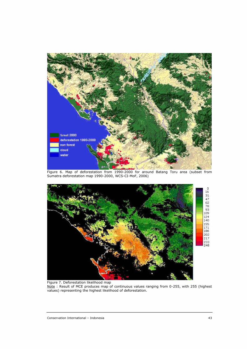
Conservation International – Indonesia 43
Figure 6. Map of deforestation from 1990-2000 for around Batang Toru area (subset from Sumatra deforestation map 1990-2000, WCS-CI-MoF, 2006)
Figure 7. Deforestation likelihood map Note : Result of MCE produces map of continuous values ranging from 0-255, with 255 (highest values) representing the highest likelihood of deforestation.
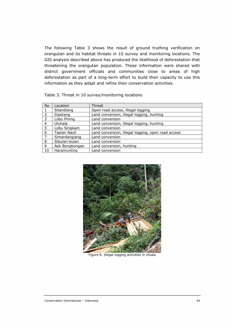
Conservation International – Indonesia 44
The following Table 3 shows the result of ground truthing verification on
orangutan and its habitat threats in 10 survey and monitoring locations. The
GIS analysis described above has produced the likelihood of deforestation that
threatening the orangutan population. These information were shared with
district government officials and communities close to areas of high
deforestation as part of a long-term effort to build their capacity to use this
information as they adapt and refine their conservation activities.
Table 3. Threat in 10 survey/monitoring locations
No Location Threat
1 Sitandiang Open road access, illegal logging
2 Sipetang Land conversion, illegal logging, hunting
3 Lobu Pining Land conversion
4 Uluhala Land conversion, illegal logging, hunting
5 Lobu Singkam Land conversion
6 Tapian Nauli Land conversion, illegal logging, open road access
7 Simardangiang Land conversion
8 Sibulan-bulan Land conversion
9 Aek Bongbongan Land conversion, hunting
10 Haramunting Land conversion
Figure 8. Illegal logging activities in Uluala
Conservation International – Indonesia 45
Activity 1.1.3. Identify habitat under deforestation threats through
forest cover change detection.
The GIS analysis described above has produced the likelihood of deforestation
that threatening the orangutan population. These information were shared
with district government officials and communities close to areas of high
deforestation as part of a long-term effort to build their capacity to use this
information as they adapt and refine their conservation activities.
There have been a number of activities implemented in addition to those
activities in this Objective 1.1 that significantly supported the project
achievement. Each activity and its achievement are described as follows.
Activity 1.1.4. Policy Analysis
Within the last 25 years the sumatran orangutan population has drastically
reduced. The remaining orangutan population is estimated to be around 7,500
individuals that are dispersed in 21 population pockets in Aceh and North
Sumatra. In 2002, two of these population groups were identified in the
forested areas of West Batang Toru and East Sarulla of North Sumatra, which
number about 5-10% of the total estimated population on the island. A
number of factors have atributed to such a drastic reduction in orangutan
population. Forest conversion has been the main inducing factor of various
exploitative activities such as timber logging, gold mining, infrastructure
development, agriculture expansion, as well as illegal logging. This has caused
both habitat loss and habitat fragmentation which threathened the survival of
orangutan.
Protecting the remaining orangutan population has been the top priority at
the global and national levels, and it should also the priority for both the
provincial and district levels as well as business actors in the region. The
responsibility of local governments has been explicitly addressed in the Act No
33/2004 stating that the local government has an obligation to conserve the
natural resources, including the biodiversity and its ecosystem. While the
obligation of business actors should have incorporated in the good corporate
governance scheme that demands the business sectors to be involved in
conserving nature through their corporate social responsibility mechanism.
Reviews on the government’s policies, a series of workshops, and regular
consultation with both the local governments and business sectors have
identified a discrepancy between the need for orangutan conservation and
Conservation International – Indonesia 46
that for economic development. One important proposition was the
requirement to replenish the government’s policies on the management of
natural forests in Batang Toru. Another proposition was the necessity to
develop priority strategies for the protection of natural forests in the Batang
Toru watershed area that function as the life supporting system as well as
orangutan habitat.
Policy replenishment should prioritize the needs to review land management
in the forested areas of West Batang Toru, where a number of aspects should
be taken into account. One important aspect has been the status and function
of forested areas. Ideally, there should be a cohesive commitment to
transform the existing forest functions into ‘protected areas’ where logging
concession areas, limited production forest areas, and nature reserves in the
areas are combined into a ‘national park’ for the fact that those areas are
orangutan’s habitat. However, a status of national park might not the only
choice, other options need indeed to be explored. Once all stakeholders in the
areas could agree on the need to manage forests sustainably, which reserves
the importance of wildlife conservation (e.g. orangutan and tiger), a feasible
option would be to develop a management body that accomodates the needs
of all districts’ objectives in achieving the regional sustainable development.
An integrated management body that considers the needs to deal with forest
functions as the source of energy (via water supply for both hydro-electricity
and geothermal powers), the main source of water supply for daily local
livelihood (via sustainable agriculture development), the agents for soil
fertility maintenance and climatic equilibrium.
Activity 1.1.5. Study on Economic Valuation of Batang Toru Forest
Block
In general, the study revealed that the total economic value of natural
resources in Batang Toru area was estimated to be IDR 3,6 billion (appr.
equal to USD 400 million at IDR 9,000 per USD 1) per annum. Assuming that
the interest rate is 10%, the Net Present Value is about USD 4,066,666,667.
This figure was resulted from both the inseparable use and non-use values. It
also found that the local economic development tended to focus merely on
economic growth regardless the needs for integrating economic development
into both social and ecological development, about which such an integration
has been globally promoted throught the sustainable development principles.
Based upon this study, a number of recommendation were proposed for
consideration at the local levels.
Conservation International – Indonesia 47
Natural resource accounting.— This activity seems to be urgent for local levels
since this will reveal the balance of natural resources available in the region,
which could later be utilized as the main basis for determining appropriate
indicators of economic development. In turn, this would help formulize the
appropriate strategy of economic development. The result of such an
accounting will provide baseline for re-calculating the potency of district
income.
Promotion of community-based economic activities.— It was found that this
time the local people have limited access to and option of economic
opportunities, and this has left the local communities with extractive options.
At the same time there are a number of options to be explored and promoted
by the local authority.
Development of a participatory sustainable development strategy.— It is
timely for every authority in this country to develop a strategy for
implementing sustainable development. Not only will this provide the local
communities with more plausible economic options, but also build the
foundation for a better political promotion at the global level.
Activity 1.1.6. Community Outreach
A number of tasks that have been succesfully accomplished were: (a)
assessment of the local people perception on the forest resources and
orangutan conservation; (b) media coverage on the issues of orangutan
conservation; and (c) development and dissemination of communication tools
necessary for augmenting the needs for orangutan conservation and better
management of forested areas in West Batang Toru.
Task 1. Assessment of the Local Perception on Orangutan Conservation
Surveys were conducted in three villages, namely Sibulan-bulan, Sitandiang
and Aek Nabara, with a total respondents of 98 peoples. In general, it was
found that the local people perceived the natural forests as the main life
supporting system for their own livelihood where they are obliged to maintain
the natural forest ecosystem. This is the most crucial finding that deserves
more consideration in any attempt to develop any sustainable management of
the natural forests in the area. A fraction of local people regarded that the
forests have been either the sources for timber or non-timber. Such a divided
opinion might have stemmed from the facts that the forests have always been
exploited for both timber and non-timber products, although rattan collection
has been long abandoned by the local people for it has been rarely found in
Conservation International – Indonesia 48
the forests. However, there were a small fraction of local people regarded the
forests as the only available land for their agricultural expansion. This might
need a thorough consideration for this could become an alarming threat in the
future when agriculture is developed as such that ignores the need for
sustainable agriculture. At the same time, another small fraction of local
people considered the forests as the ‘protector’ for natural disaster. This is
also another good point to account since it can be utilized as the entry point
for community outreach activities in the future.
The assessment also showed that the local people comprehended the fact that
orangutan has been protected by National Laws, and therefore any attempt to
poach and hunt orangutan has been legally forbidden. At the same time, the
local people showed minimal understanding about the importance of a
national park as the area for both developing community livelihood and
conserving biodiversity. The local people expressed their anxiety on the issue
of national park establishment in Batang Toru. This is a common sense when
they do not have appropriate understanding on the national park issue.
Task 2. Media coverage concerning orangutan conservation issues.
Press Conference
A press conference was undertaken during the 2nd Workshop on
Orangutan Conservation done in Medan on March 30, 2007. The General
Secretary of the Ministry of Forestry (i.e. Mr. Arman Malolongan) lead
the press conference that was attended by representatives of Analisa (a
local media, North Sumatra coverage), Medan Bisnis (North Sumatra
newspaper), the detik.com (online national media), Kompas (national
media), and Sinar Harapan (national coverage media). The materials in
this press conference have been the subjects of community outreach in
the respective media.
Media Visit
National Geographic Indonesia (NGI) made a visit to Sitandiang and
Uluala villages. The results of this journalism excursion were presented
in a Special Issue of NGI published in June 2007, of which 40,000 copies
were nationally distributed. This special issue consisted of three
sections. First section covered the background of the project and the
progress of project implementation in the field. Second section
presented photo essay depicting the habitat loss and local community
activities surrounding the areas. While the last section was devoted to
describing participatory monitoring on orangutan presence and its
habitat condition undertaken by the local villagers.
Conservation International – Indonesia 49
RCTI (Rajawali Citra Televisi Indonesia) – national television
broadcasting company – visited Sitandiang village to cover OPU activity,
of which the visit results were presented on air nationally in August
2007. Another visit was also done by Kompas – a major national
newspaper. The visit resulted in two articles published in the newspaper,
namely: “DAS Batang Toru Dikaji“ (Batang Toru Water-catchment on
Discussion), and “Maradingin dan Mawas pun Perlu Hidup
Berdampingan” (Maradingin and Orangutan Need to Live in Harmony)
(Note: Maradingin is the head of Sibulan-bulan village).
Ci-Indonesia itself has published a special edition of TROPIKA – a
popular magazine on nature conservation publicized by CI-Indonesia
concerning the conservation of orangutan in Sumatra.
All these efforts have been successful in that the media coverage on
orangutan conservation in Batang Toru has reached a total of
147,767,500 national audiences suing both electronic and printing
media.
Dissemination through Website
All those publications have been places in the website of Ci-Indonesia,
namely www.conservation.or.id that can be aesily and freely accessed
by public at large.
Task 3. Develop and disseminate communication tools
Comic poster
This comic poster – with a total of 5,000 copies – tells a story about the
needs to conserve the forests for they could help sustain the local
livelihood through supplying water for agriculture and villagers’ daily
need, and preventing natural disaster that might happen in the village.
It also tells the need for village consultation prior to making decision on
village development involving foreign investors.
T Shirt and Rolling Banners
A total of 500 T-shirt were produced and disseminated amongst CII’s
parterns in the local communities. The T-shirts depicts the role of
orangutan in sustaining the local agricultural products such as rubber,
coffee, and durian. A number of rolling banners depicting the need to
curb wildlife trade and hunting, especially orangutan and tiger, have
Conservation International – Indonesia 50
also been produced and disseminated to relevant partners, who could
help promote stopping wildlife trade in the Norther Sumatra region.
OBJECTIVE 1.2. Strategic interventions to support key stakeholders
for promoting the protection of orangutan population developed and
tested.
Improving the species protection is essential to sustain a viable number of
individual orangutans for population survival. An assessment was undertaken
prior to developing the strategic interventions or cost-effective investment or
mechanisms to address the problems as identified under Objective 1. Such an
assessment could determine the weakness of law enforcement system with
extensive local law enforcement input in order to develop a least-cost
investment strategy to address them. Moreover, a training in assessment and
design the enforcement-training module for PPNS (States’ Civil Investigators
at Forestry Offices) and other local enforcement officials was also conducted,
with the expectation that this training will lead to a reduction in the number of
poaching and wildlife trading incidences. This focused on assisting in the
protection and maintenance of orangutan habitats and supporting anti-
poaching measures.
The following are details of achievement of Objective 2 in accordance with its
activities.
Activity 1.2.1. Map enforcement agencies and the players in the three
regencies encompassing West Batang Toru
Accurate information concerning the ‘players’ who influence the existing
habitat and orangutan population, including persons acting ‘behind the
scenes’ is a key entry point in resolving enforcement problems. Potential
constraints/misperceptions among stakeholders, especially enforcement
agencies, can be avoided from the beginning by socializing efforts and
obtaining political and technical support. All possible local or traditional
enforcement systems to use traditional knowledge to protect the orangutan
and its habitat were assessed. Further, a series of consultative meetings were
undertaken with enforcement agencies and stakeholders in each district,
aiming at collecting information regarding capacity, resources, infrastructure,
skills, and knowledge of each institution, and strengths also weaknesses of
enforcement agencies.
Conservation International – Indonesia 51
Activity 1.2.2. Collect quantitative and qualitative data concerning
conservation crimes related to orangutan and its habitat.
In accordance to the Indonesian Criminal Justice System, the enforcement
chain for conservation and forestry crimes is the responsibility of forest
rangers, Forest Civil Investigators (=PPNS), the police, attorneys, and the
court. Poor performance by any one of these parties will reduce the
effectiveness or performance of law enforcement. Under this activity, the
enforcement performance was assessed using quantitative and qualitative
data for existing crimes. Data are used in calculating the probabilities of each
step in the enforcement chain and the overall value of the enforcement
disincentive presented by the government enforcement system. This work is
built upon CI’s USAID-funded economic enforcement project in Papua.
Activity 1.2.3. Co-develop strategic interventions to improve the
protection of orangutans.
A number of tasks were accomplished, namely: (a) Dissemination of the
analysis results in Activities 1 and 2 to key stakeholders; (b) Building up
consensus critical for improvement and securing results; (c) Development of a
strategy with stakeholders, including identifying key interventions and
partners; and (d) An in-house training for law enforcement personnel and
NGOs involved in enforcement work.
A series of consultative meetings were regularly undertaken, when CI
proposed recommendation on law enforcement relevant to orangutan
protection in the three districts and at the province level. The consultations
successfully gained support from these agencies for law enforcement
activities. With these stakeholders, CI drafted the intervention strategy to
protect orangutans and their habitats in Batang Toru through increased and
improved law enforcement. All the enforcement agencies that participated in
the consultations expressed respective official commitment to support CI’s
efforts on protection of the orangutan and its habitat. For the first time ever,
these agencies also endorsed specific action plans to combat threats against
orangutans. Finally, with CI’s facilitation, the enforcement agencies endorsed
the concept and organization structure of Community Participatory Monitoring
Unit (CPM) or to be specific sometimes it called as Orangutan Protection Unit
(OPU) in selected villages.
Conservation International – Indonesia 52
Activity 1.2.4. Test and modify interventions.
The intervention developed under Activity 1.2.3 was validated under a close
collaboration with the Office of the Species Protection and Nature
Conservation Unit (BKSDA Sumut II) responsible for patrolling all protected
forests in DAS Batang Toru. The establishment of Community Participatory
Monitoring Unit (CPM) or Orangutan Protection Unit (OPU) – both combined
into CPM-OPU has been the main intervention supported by the BKSDA Sumut
II. A decree on the CPM-OPU establishment, outlining the roles and
responsibilities of the officers/members within the contexts of local, provincial
and national laws, has also been issued (SK No. 3875/IV-K3/KKH/2006
tentang Pembentukan, Penetapan Wilayah Kerja dan Personil Orangutan
Protection Unit Balai KSDA Sumatera Utara II). Members of the CPM-OPU are
individuals selected from local communities and forest rangers (see Appendix
3). Supports were gained from from the police and military staff in special
cases during the operation. Regular consultation was done with other NGOs,
such as the Wildlife Conservation Society, to obtain advice and
recommendation based on their experience with similar activities in other
national parks.
Activity 1.2.5. Collaboratively develop law enforcement monitoring
activities.
A number of tasks were accomplished, namely: (a) Detection of habitat
change overtime and determine the deforestation rates as main threat for the
orangutan population using time-series analysis of LANDSAT images (2001
and 2005); (b) Regularly updated baseline data on targeted populations of
the Sumatra orangutan in West Batang Toru; (c) Collaboration with the
district governments and the Ministry of Forestry to monitor the number of
incidences of orangutan smuggling, poaching and trading; (d) Development of
the law enforcement monitoring activities through the implementation of CPM-
OPU that consisted of local people, forest rangers, and accompanied by the
local policemen or military officers.
Two extensive training for CPM-OPU members were held in North and South
Tapanuli with a focus on biodiversity, population monitoring, and use of GIS
(Figures 9 and 10). The unit is responsible for conducting regular patrols in
target areas and undercover works in targeted villages, markets, ports, and
bus stations. Furthermore, one site in South Tapanuli, namely Aek Nabara,
was chosen for further research and regular patrolling area for CPM-OPU as
the forest in that site is connected with the Sibual-buali Nature Reserve. This
is served as a pilot site to test the monitoring implementation, because it has
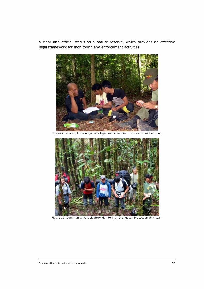
Conservation International – Indonesia 53
a clear and official status as a nature reserve, which provides an effective
legal framework for monitoring and enforcement activities.
Figure 9. Sharing knowledge with Tiger and Rhino Patrol Officer from Lampung
Figure 10. Community Participatory Monitoring- Orangutan Protection Unit team
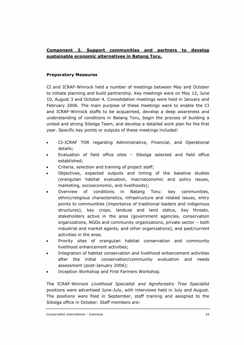
Conservation International – Indonesia 54
Component 2. Support communities and partners to develop
sustainable economic alternatives in Batang Toru.
Preparatory Measures
CI and ICRAF-Winrock held a number of meetings between May and October
to initiate planning and build partnership. Key meetings were on May 12, June
10, August 3 and October 4. Consolidation meetings were held in January and
February 2006. The main purpose of these meetings were to enable the CI
and ICRAF-Winrock staffs to be acquainted, develop a deep awareness and
understanding of conditions in Batang Toru, begin the process of building a
united and strong Sibolga Team, and develop a detailed work plan for the first
year. Specific key points or outputs of these meetings included:
CI-ICRAF TOR regarding Administrative, Financial, and Operational
details;
Evaluation of field office sites – Sibolga selected and field office
established;
Criteria, selection and training of project staff;
Objectives, expected outputs and timing of the baseline studies
(orangutan habitat evaluation, macroeconomic and policy issues,
marketing, socioeconomic, and livelihoods);
Overview of conditions in Batang Toru: key communities,
ethnic/religious characteristics, infrastructure and related issues, entry
points to communities (importance of traditional leaders and indigenous
structures), key crops, landuse and land status, key threats,
stakeholders active in the area (government agencies, conservation
organizations, NGOs and community organizations, private sector – both
industrial and market agents, and other organizations), and past/current
activities in the area;
Priority sites of orangutan habitat conservation and community
livelihood enhancement activities;
Integration of habitat conservation and livelihood enhancement activities
after the initial conservation/community evaluation and needs
assessment (post-January 2006);
Inception Workshop and First Farmers Workshop.
The ICRAF-Winrock Livelihood Specialist and Agroforestry Tree Specialist
positions were advertised June-July, with interviews held in July and August.
The positions were filed in September, staff training and assigned to the
Sibolga office in October. Staff members are:
Conservation International – Indonesia 55
Livelihood Specialist – Jusupta Tarigan, formerly employed with CIFOR
Livelihood Enhancement Program.
Agroforestry Tree Specialist – Endri Martini, formerly assigned to
ICRAF’s Jambi field office.
Achievement of Component 2
Initial consultative meetings were held with approximately 500 local
stakeholders representing 50 villages aimed at evaluating and selecting
priority villages where the project pilot would be implemented. Five villages
were selected for that purpose, namely: Sibulan-bulan (of North Tapanuli
District), Hutagurgur (of Central Tapanuli District), Sitandiang, WEK I and Aek
Nabara (of South Tapanuli District). The project’s livelihood-conservation
strategies and model sites were implemented in those five focal villages.
Supporting the improvement of local agroforestry system was undertaken in
those villages, where cacao and rubber have been the main plantations that
provide income to the local communities. A series of trainings in sustainable
farming practices and nursery development were provided to the local
communities, under a close collaboration with CI-Indonesia and its local NGO
partners. Altogether, there were over 1,300 farmers involved in 13 sessions of
trainings and supervision held in those focal villages. This expectedly made
600 hectares of farmer agroforestry systems under improved management,
where 120 farmers (22.5% women) were actively involved in all project
activities. In addition, there were five nurseries established, where 25,000
rubber seedlings were produced, although the seedlings were not all utilized
by the farmers as yet. In turn, this would expectedly make 10,000 ha of
natural forests benefiting from improved natural resource management.
A number of technical reports were produced during the project
implementation that covered such topics as market study report and
presentation, modeling simulation of durian-rubber agroforestry systems,
Rapid Land Tenure Assessment (RATA), and non-timber forest products as a
source of livelihood diversification. In addition, 34 maps or imagery were
compiled from existing data/information sources, from which three new maps
were developed and presented to the local stakeholders.
Conservation International – Indonesia 56
OBJECTIVE 2.1. Develop local support for conservation-based income
alternatives.
The following are details of achievement of Objective 2.1. in accordance with
its activities.
Activity 2.1.1. Help community members to identify the Socio-
economic threats and opportunities of local livelihood systems,
macro-economic development, and markets.
Site Evaluation and Selection.— The ICRAF Bogor based Team conducted
three site evaluation trips between October 2005 and January 2006. The
purpose of the trips were: (i) characterization and identification of
socioeconomic, farming system and marketing systems of the greater Batang
Toru watershed; (ii) identification of threats, opportunity, land-use system,
priority species, socioeconomics, land-tenure status, extension-marketing
issue, and (iii) identify priority actions. Additionally the ICRAF Sibolga staff
conducted a minimum of twelve follow-up visits with partners and candidate
communities during the same period.
The primary purpose of these visits was: (i) socialization of the project; (ii)
introduction of staff and ICRAF; (iii) deeper exploration of the existing
agroforestry systems and potential sustainable economic alternatives; and
(iv) collecting and cross-checking baseline data. Through this evaluation
process approximately 50 villages were visited by the ICRAF teams. By
combining the results of the socioeconomic studies and those of the
environmental evaluation process ICRAF and CI selected the focal villages for
Component 2 activities. Selected villages were:
Sibulan-bulan, North Tapanuli
Sitandiang, South Tapanuli
WEK I, South Tapanuli
Hutagurgur, Central Tapanuli
Aek Nabara, South Tapanuli
Demographics, Landuse, and Livelihoods.— The Batang Toru watershed
includes part of three different districts - North Tapanuli, Central Tapanuli,
and South Tapanuli. The three districts have similar history, demographic,
livelihood and economic characteristics. All three have large rural-based
populations with population densities varying from 126/km2 in Central
Tapanuli, to 69/km2 in North Tapanuli, to 54/km2 in South Tapanuli. The
population is dominated by the indigenous Batak Toba, Batak Pesisir, Batak
Conservation International – Indonesia 57
Angkola-Mandailang ethnic groups with some communities of Javanese or
Nias. The watershed covers approximately 100,000 ha, includes 251 villages
with a human population of 133,971 in 27,906 households.
Natural forest and agroforests are the primary land cover. Elevations range
from 200 m to 1500 m, with slopes of 30° to 60°. The local communities have
a long history of sustainable forest resource management through a gradient
of landuse intensities ranging from mixed tree gardens where species
composition is largely controlled by farmers and management is intermediate,
to natural forests where impact from human intervention is light with small
quantities of products harvested. In between are various types to agroforests
(forest farming systems) where human management favors plant species that
provide useful/valuable products but management remains extension rather
than intensive. Mixed tree garden and agroforest systems are collectively
referred to as upland agroforestry systems.
Land ownership various from 1 to 2 hectares/family. Agriculture is dominated
by irrigated rice production and upland agroforestry systems, which include:
(1) rubber agroforestry (jungle rubber) systems; (2) durian agroforestry
systems; (3) rubber monoculture systems; (4) homegarden systems; (5)
fruit-cacao systems; (6) pinang-cacao agroforestry systems; (7) cinnamon
monoculture systems; (8) upland rice-banana-cassava-cacao systems, and
(9) coffee monoculture systems. Key products of these systems include rice
(Oryza sativa), rubber (Hevea brasiliensis), cacao (Theobroma cacao), coffee
(Coffee arbica and C. robusta), kemenyan (Styrax benzoin), aren (Arenga
pinnata), durian (Durio zibethinus), petai (Parkia speciosa), candlenut
(Aleurites moluccana), salak (Salacca zalacca), and banana (Musa sp). Other
fruits, medicinal crops and timber are also produced in these systems. Rice,
medicinal crops and timbers are primarily produced for home use. Rubber,
cacao and kemenyan are exclusively market crops. Other crops are both
consumed in the home and marketed. None of the agroforestry systems are
intensely because farmers lack access to high quality germplasm, technical
support, infrastructure, and market information.
Average annual farm-based income per household in the project area is
approximately US$650, with total annual income about US$1000/household.
Common off-farm income sources include operating small shops, government
service, trade of agricultural crops, and remittance. Livestock production and
non-timber forest products (NTFPs), which maybe be collected from natural
forests or cultivated in tree gardens or agroforests, provide secondary but
important sources of income – particularly during holidays and to fill seasonal
income needs or other cash flow gaps.
Conservation International – Indonesia 58
Market Analysis.— The ICRAF-Winrock team conducted market surveys and
related activities to identify:
1. Agroforestry products (including specification, quantity, quality,
seasonality, etc) that hold potential for smallholder farmers;
2. Market channels used by or that hold potential for smallholder farmers;
3. Marketing problems commonly experienced by farmer and market
agents;
4. Opportunities to enhance farmer’s knowledge regarding markets and/or
marketing; and
5. Opportunities to expand farmer’s market role.
Initial surveys identified rubber, durian, cacao, sugar palm, and kemenyan as
important sources of income in the five focal villages. At the Batang Toru level
these five crop contribute greater to household farm incomes: rubber 40%;
durian 18%, cacao 9%, and sugar palm 5%. In Aek Nabara and Sitandiang
sugar palm is the main agricultural crop. (Across Batang Toru coffee,
bettlenut (pinang), coconut, kemenyan and cinnamon are also economically
importance to smallholder crops, but are only minor crops in the five focal
villages. Oil palm is also an important agricultural crop in the area but not for
smallholder farmers.) Subsequent activities and surveys also identified the
following smallholder products as currently or potentially important: gaharu
(Aquillaria sp), petai (Parkia speciosa), nilam (Pogostemon cablin), flowers
(Nepenthes spp, Amorphophallus spp, and orchids), high-quality rubber
seedlings, medicinal plants, mushrooms, vegetables, and goats.
However incomes from these crops are limited by a number of technical and
marketing issues. Farmers practice traditional non-intensive management,
lack access to technical assistance, and are not familiar with grafting
techniques. Farmers lack market information and have limited market options
because of poor infrastructure and their remote location. Farmers also require
advance payment, which reduces their income. Agents complain that
smallholder products are of uncertain quality, quantity, and reliability (yields
fluctuate), that the location is remote and there is no farmer’s association to
facilitate transactions. Existing smallholder market linkages and an
‘illustrative’ smallholder market link for the future are shown below:
Rubber
Farmer Local collector District broker Factory
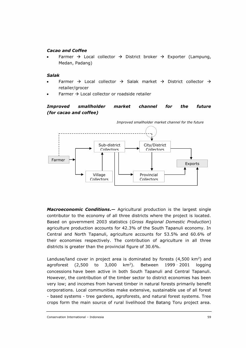
Conservation International – Indonesia 59
Cacao and Coffee
Farmer Local collector District broker Exporter (Lampung,
Medan, Padang)
Salak
Farmer Local collector Salak market District collector
retailer/grocer
Farmer Local collector or roadside retailer
Improved smallholder market channel for the future
(for cacao and coffee)
Macroeconomic Conditions.— Agricultural production is the largest single
contributor to the economy of all three districts where the project is located.
Based on government 2003 statistics (Gross Regional Domestic Production)
agriculture production accounts for 42.3% of the South Tapanuli economy. In
Central and North Tapanuli, agriculture accounts for 53.5% and 60.6% of
their economies respectively. The contribution of agriculture in all three
districts is greater than the provincial figure of 30.6%.
Landuse/land cover in project area is dominated by forests (4,500 km2) and
agroforest (2,500 to 3,000 km2). Between 1999‐2001 logging
concessions have been active in both South Tapanuli and Central Tapanuli.
However, the contribution of the timber sector to district economies has been
very low; and incomes from harvest timber in natural forests primarily benefit
corporations. Local communities make extensive, sustainable use of all forest
- based systems - tree gardens, agroforests, and natural forest systems. Tree
crops form the main source of rural livelihood the Batang Toru project area.
Farmers
Sub-district Collectors
City/District Collectors
Village Collectors
Provincial Collectors
Exports
Improved smallholder market channel for the future
Conservation International – Indonesia 60
The most important household crops are: rubber, durian, coffee, cacao,
beetle-nut (pinang), and sugar palm. Oil palm is an important tree crops at
the provincial level, but contribute very little to smallholder economies and
causes significant loss of forest cover. By contrast, smallholder management
of tree gardens, agroforests, and natural forests are sustainable. Spatial
analysis and land tenure studies both indicate that tree-based landuse
systems under smallholder are not being converted to other landuse systems
and maintaining environmental services. Supporting smallholder farmers to
improve their tree based landuse systems will benefit both for regional
economy as well as the environment.
Land Tenure Assessment.— A Rapid Land Tenure Assessment (RATA) was
conducted to explore conflicting claims among the stakeholders, linked to
property rights and legal terms. The study also focused on historical land
tenure, landuse and land access and recognized community’s traditional role
in natural resource conservation. It also intended to provide policy options to
avoid/resolve landuse conflict. The biggest potential for landuse conflict is the
proposal to develop a national park in Batang Toru based on the forest
gazettement. Some of the Batang Toru Area was gazetted as state forest land
in the 1920s, however no further gazettement has been conducted, despite
government claim that most of the Batang Toru Area is state forest land.
Legally, the unfinished gazettement process leaves the land open to claims by
local communities. Furthermore, the designation of the state forest zone in
North Sumatra, based on Ministry Decree No. 44/2006 and 201/2006, has not
been accepted locally because some of the area was already allocated to local
governments for development or infrastructure. Local government resistance
has been recorded in North Tapanuli and Central Tapanuli.
In contrary to the government claim, communities have legal claim to the
forest in Batang Toru have been legalized recognized by the National Land
Agency. Approximately, 17,391 ha of land in the proposed national park is
registered as customary land. However, spatial analysis indicates that about
32,573 ha are actually under traditional landuse (classified as agroforests).
These overlapping land claims strongly indicate that conflict may result if the
national park is established with transparency and opportunity for
communities to voice their claims. The study concludes that the Batang Toru
Area should be fully gazetted so that the area is clear of overlapping landuse
claims. All stakeholders’ views and interests should be considered during the
gazettement and national park development processes – particularly those of
the local communities. The RATA results were shared with stakeholders at a
regional meeting in Medan, a meeting in Bogor and a international forum of
conservationists in Hanoi.
Conservation International – Indonesia 61
Consultations with stakeholders.— The project was socialized and sites
evaluated by visited 50 villages and meeting with a minimum of 500 farmers
and other stakeholders. To develop local support and opportunities for
conservation-based economic alternatives the following stakeholder
consultations were held:
NGO Stakeholder Meeting in Medan December 2005. Attended by 15
NGO staff.
Regional Meeting in Medan, January 2006. Attended by 80 stakeholders
- national and local government officials, NGOs and farmers.
Farmers Workshop in Sibulan-bulan, March 2006. Attended by 30
farmers, 5 Subdistrict Chiefs, 15 other local government officials, 5
extension agents.
Regional Meeting in Medan March 2007. Attended by 150 stakeholders
representing NGOs, conservation organizations, farming communities,
universities, national and local governments (provincial, district,
subdistrict, and village), technical agencies, the private sector, and
donors.
Farmers Workshops in focal villages, May 2007. Attended by 70
stakeholders.
Activity 2.1.2. Mapping land use and land cover
Landuse and land cover mapping and analysis.— ICRAF’s Spatial Analysis
Unit supported the project by compiling, collecting and analyzing secondary
and primary spatial data. Secondary data was compiled by means of
reviewing in-house data, downloading available data from the internet,
exchanging data with colleagues from other institutions, digitizing hardcopies
of maps, mapping points and tracks visited in the field, and purchasing.
Thirty-four maps compiled and produced from secondary data covering
terrain, topography, forests, land tenure, satellite imagery, and GPS data. A
list of those maps and relevant details are found in Appendix 4. Two field trips
were conducted to collect data, access the accuracy of land cover maps, and
consult with stakeholders.
Spatial analysis of the data compiled and collected resulted in three key
outputs: (i) land cover mapping; (ii) land cover change analysis; and (iii)
conservation and livelihood index mapping. Details regarding these outputs
are found in Appendix 5. Sixteen land cover classes were identified, ranged
from natural forest and complex agroforestry systems to various agricultural
Conservation International – Indonesia 62
systems. In general, the time series map showed that despite the common
perception that forest cover is declining in the watershed, the agroforestry
systems managed by farmer remain primarily unchanged. Those agroforestry
systems provide livelihood support for the community and at the same time
provide environmental services and act as a buffer to the natural forest area.
The analysis concludes that efforts to reduce threats to natural habitat by
developing protected areas (national park, protected forests, nature reserves,
etc.) must consider existing local livelihood activities and potential
opportunities/threats from the surrounding areas. The ICRAF team developed
the Conservation and Livelihood Index (C & L Index) as a base map tool for
landuse based negotiations between stakeholders. The results from C & L
Index analysis were shared with stakeholders in Medan and an international
forum of conservationists in Hanoi. Details regarding the components of the
index are found in Appendix 6.
There have been another activity implemented by CI-Indonesia itself under a
collaboration with two local NGOs, namely Yayasan PEKAT and Yayasan
Ekowisata Sumatra, in addition to those activities in Objective 2.1
implemented by ICRAF, which significantly supported the project
achievement. Each activity and its achievement are described as follows.
Activity 2.1.3. Facilitation of village conservation agreement and
livelihood improvement supports
Prior to implementing activities at village levels aimed at achieving common
consensus to the conservation of natural forest and its biodiversity, strategic
issue and objectives were initially assessed using a participatory appraisal
methodology. The local strategic issue was identified as the preservation of
water source due to the fact that the local people significantly rely on water
supply for their own agriculture, mainly paddy fields. And to maintain such an
important water supply, the forests surrounding the village need to be
conserved. The strategic objectives were therefore: (a) to foster the need for
village agreement on the conservation of forest resources; and (b) to support
the development or improvement of village livelihood through appropriate
facilitation.
The activities were undertaken in four villages, namely Sibulan-bulan and
Sitandiang villages from North Tapanuli District, and the villages of Aek
Nabara and Uluala from the South Tapanuli District. Main activities
undertaken to achieve those objectives in each village were: (a) encouraging
Conservation International – Indonesia 63
the villagers’ awareness on the importance of water sources through
presentation of film on natural resources and environment; (b) developing
village mapping and appraisal using PRA methodology aimed at prioritizing
livelihood aspects to be addressed; (c) provision of trainings in producing
growth stimulant for crops, bio-pesticide and compost; (d) rehabilitation of
water irrigation; (e) generating village conservation agreement based on
activity b above; (f) provision of village library as a media for education
improvement.
For the local people, film presentation has always been the most effective way
to convey messages on nature conservation, with which the people could
learn the importance of water sources for their own livelihood. However, most
appropriate films could only be available in foreign language, namely English,
which is surely difficult to comprehend without subtitles. The most effective
film – as suggested by the local people themselves – would be an animated or
cartoon film about wildlife conservation, about which has always been
neglected by national film industry.
Village appraisal and mapping resulted in a number of livelihood priorities
specific to respective villages that were recommended to be addressed. It was
only the provision of trainings in producing growth stimulant for crops, bio-
pesticide and compost, and the rehabilitation of water irrigation that could be
provided for those villages during the project implementation. In addition, as
one of priorities being acquired by Aek Nabara village, a village library was
developed as the main media for people education in the village. Another
important conclusion was to generate village conservation agreement, with
which the local people in respective villages would consent to the committed
arrangement for conserving the village natural resources.
OBJECTIVE 2.2. Catalyze local entrepreneurs to create alternatives for
sustainable economic activities.
The following are details of achievement of Objective 2.2. in accordance with
its activities.
Activity 2.2.1. Facilitate and support participatory process for communities
to design a strategy to develop sustainable alternatives to destructive forest
activities.
Community conservation-livelihood strategies.— To facilitate and
support the community-based participatory design of strategies to develop
Conservation International – Indonesia 64
sustainable economic alternatives bi-weekly meetings were held with farmer
groups in the five focal villages commencing in April 2006. One-hundred
twenty farmers were active members of the five focal farmer groups and
regularly participated in bi-weekly meetings; 22.5% of the members were
women. The gradient of landuse systems practiced by Batang Toru
communities vary from annual cropping systems, to mixed tree gardens,
agroforests, and forests; they are compatible with conservation of the area’s
unique and globally important biodiversity. There exists concerning that
population and economic pressure could result in adoption of destructive
landuse systems, if suitable livelihoods option are not identified and
developed.
The approach adopted by ICRAF and partners was to worked with
communities and local government agencies to develop community
conservation-livelihood strategies that provide frameworks for: (i) recognizing
communities traditional role in conserving natural resources; (ii) recognizing
which local agricultural/forest livelihood systems are compatible with
environmental conservation; and (iii) strengthening communities/other
stakeholders understanding/commitment to conservation as an approach to
protect the environmental services (biodiversity, watersheds and carbon
stocks). Strategies also identified/facilitated technical and marketing
services/improvements to enable communities to enhance the
productivity/profitability of their agroforestry livelihood systems. All five focal
villages developed conservation-livelihood strategies that included recognition
of priority crops, a prioritization of technical training and relevant follow-up
activities, and commitment to conservation. Three of the communities
Sibulanbulan, Aek Nabara and Sitandiang. Have developed strategy working
documents called livelihood-conservation strategy agreements. Agreements
consist of introduction, background, goal, objectives, plans to achieve
objectives, roles and responsibilities of the stakeholders, terms of the
agreement, activities, and monitoring plan. Additional clauses can be included
as necessary. Agreements are intend to be transparent, equitable, realistic
and flexible.
As a result of developing livelihood-conservation strategies traditional
sustainable natural resource management practices have been strengthened
or maintained; and appreciation of the value of the natural forest renewed.
Through the implementation of the strategies (see Activity 2.2.2) more
intensive, yet sustainable, management is practiced on roughly 600 hectares
of smallholder tree garden; and 10,000 hectares of natural forests
surrounding focal communities benefit directly from improved natural
resource manage. Potentially, all 100,000 hectares of the Batang Toru
Conservation International – Indonesia 65
watershed could benefit from the improved natural resource management
initiated.
Priority crop.— Based on existing farm resources, farmers experience,
project expertise, market study results, and accessible extension support the
following priority crops were identified by the focal communities as rubber,
cacao, durian and sugar palm. Crops of secondary importance included
gaharu (Aquillaria sp), petai (Parkia speciosa), nilam (Pogostemon cablin),
flowers (Nepenthes spp, Amorphophallus spp, and orchids), high-quality
rubber seedlings, medicinal plants, mushrooms, vegetables, and goats.
Model Simulation of Durian-Rubber Agroforestry System.— The ICAF
Team conducted simulation study the SeXI-FS (Spatially Explicit Individual-
based Forest Simulator) model to predict the dynamic growth and yield of
durian-rubber agroforestry systems in the Batang Toru area. Rubber was
selected because it is the main smallholder crop in Batang Toru. Durian was
selected because it is favored by farmers, has a high and lucrative market
demand, and also can sustain orangutan populations by providing both food
and habitat. The data used in the model was based on biophysical and farmer
surveys that determined the relationship between durian fruit production and
tree structure. Four durian-rubber compositions were compared, durian as
7%, 17%, 33% and 50% of a 1 ha agroforestry system. Other parameters
were: durian production starts at 15 years and fruits are harvested every 2
years; rubber production starts after its diameter is 15 cm; the price for
durian is Rp 3000/fruit and for dry rubber latex price Rp 6000/kg.
Model results show that increases in the durian component increased overall
income of the system, although not at a statistically significant level. Changes
in the species composition have little impact on the overall income from
rubber-durian agroforest, when prices of both commodities are constant.
However, the prices of both durian and rubber commonly fluctuate. Farmers
constantly alter their management practices, and even the components of
their agroforestry systems, based their expectation of future prices. Mixed
agroforestry systems provide farmers greater flexibility to respond to dynamic
market forces and price fluctuations. The model results support the
development of multiple species agroforestry systems.
Activity 2.2.2. Implement the strategy for promoting sustainable economic
activities.
Trainings and expert consultations.— To assist focal villages
implement/achieve their livelihood-conservation strategies, the ICRAF team
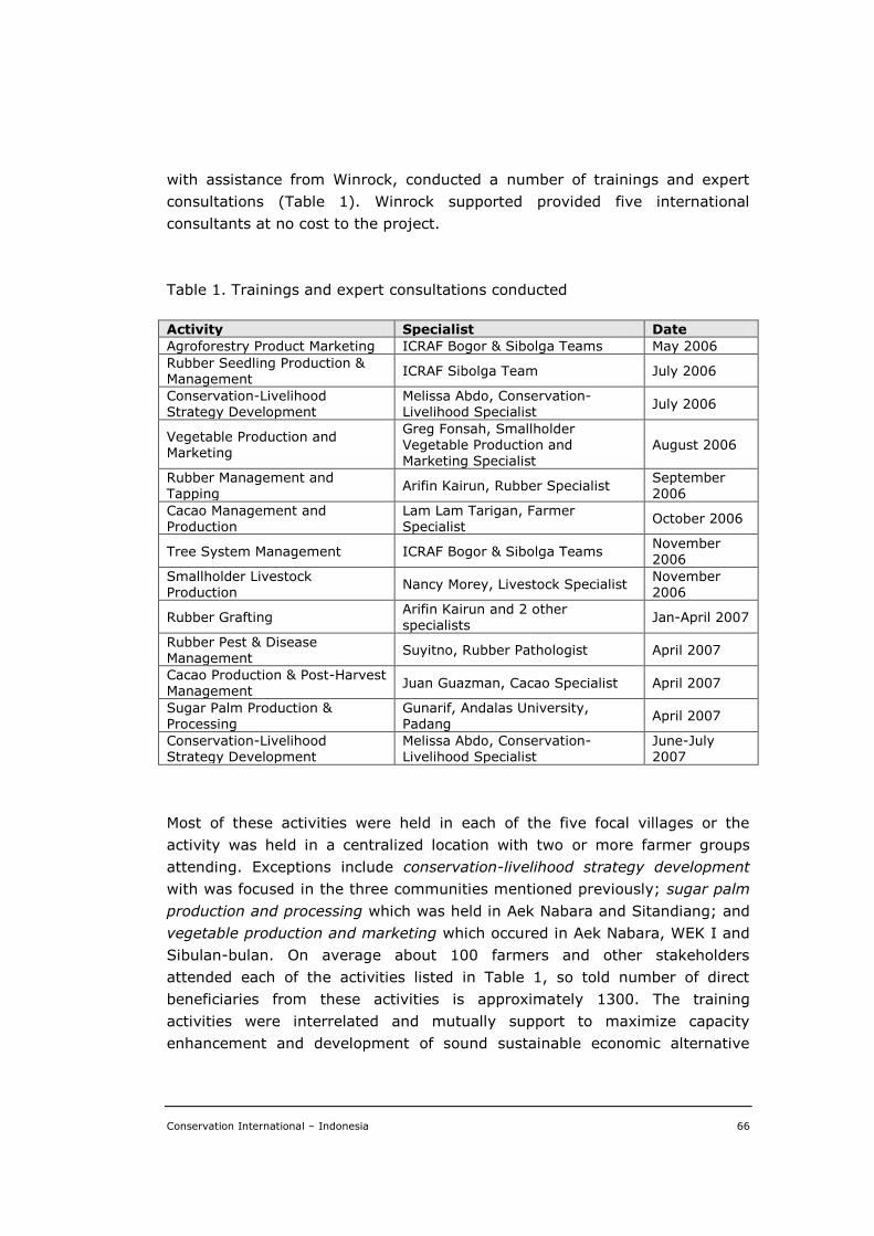
Conservation International – Indonesia 66
with assistance from Winrock, conducted a number of trainings and expert
consultations (Table 1). Winrock supported provided five international
consultants at no cost to the project.
Table 1. Trainings and expert consultations conducted
Activity Specialist Date
Agroforestry Product Marketing ICRAF Bogor & Sibolga Teams May 2006
Rubber Seedling Production & Management
ICRAF Sibolga Team July 2006
Conservation-Livelihood Strategy Development
Melissa Abdo, Conservation-Livelihood Specialist
July 2006
Vegetable Production and Marketing
Greg Fonsah, Smallholder Vegetable Production and Marketing Specialist
August 2006
Rubber Management and Tapping
Arifin Kairun, Rubber Specialist September 2006
Cacao Management and Production
Lam Lam Tarigan, Farmer Specialist
October 2006
Tree System Management ICRAF Bogor & Sibolga Teams November 2006
Smallholder Livestock Production
Nancy Morey, Livestock Specialist November 2006
Rubber Grafting Arifin Kairun and 2 other specialists
Jan-April 2007
Rubber Pest & Disease
Management Suyitno, Rubber Pathologist April 2007
Cacao Production & Post-Harvest Management
Juan Guazman, Cacao Specialist April 2007
Sugar Palm Production & Processing
Gunarif, Andalas University, Padang
April 2007
Conservation-Livelihood Strategy Development
Melissa Abdo, Conservation-Livelihood Specialist
June-July 2007
Most of these activities were held in each of the five focal villages or the
activity was held in a centralized location with two or more farmer groups
attending. Exceptions include conservation-livelihood strategy development
with was focused in the three communities mentioned previously; sugar palm
production and processing which was held in Aek Nabara and Sitandiang; and
vegetable production and marketing which occured in Aek Nabara, WEK I and
Sibulan-bulan. On average about 100 farmers and other stakeholders
attended each of the activities listed in Table 1, so told number of direct
beneficiaries from these activities is approximately 1300. The training
activities were interrelated and mutually support to maximize capacity
enhancement and development of sound sustainable economic alternative
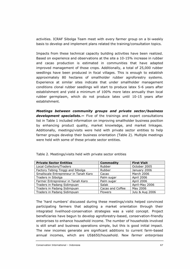
Conservation International – Indonesia 67
activities. ICRAF Sibolga Team meet with every farmer group on a bi-weekly
basis to develop and implement plans related the training/consultation topics.
Impacts from these technical capacity building activities have been realized.
Based on experience and observations at the site a 10-15% increase in rubber
and cacao production is estimated in communities that have adapted
improved management of those crops. Additionally, a total of 25,000 rubber
seedlings have been produced in focal villages. This is enough to establish
approximately 80 hectares of smallholder rubber agroforestry systems.
Experience at similar sites indicate that under smallholder management
conditions clonal rubber seedlings will start to produce latex 5-6 years after
establishment and yield a minimum of 100% more latex annually than local
rubber germplasm, which do not produce latex until 10-15 years after
establishment.
Meetings between community groups and private sector/business
development specialists.— Five of the trainings and expert consultations
list in Table 1 included information on improving smallholder business position
by enhancing product quality, market knowledge, and market linkages.
Additionally, meetings/visits were held with private sector entities to help
farmer groups develop their business orientation (Table 2). Multiple meetings
were held with some of these private sector entities.
Table 2. Meetings/visits held with private sector entities
Private Sector Entities Commodity First Visit
Local Collectors/Traders Rubber October 2005
Factory Tebing Tinggi and Sibolga Rubber January 2006
Smallscale Entrepreneur in Tanah Karo Cacao March 2006
Traders in Sibolga Palm sugar April 2006
Farmer Entrepreneur in Tanah Karo Palm sugar April 2006
Traders in Padang Sidimpuan Salak April-May 2006
Traders in Padang Sidimpuan Cacao and Coffee May 2006
Traders in Padang Sidimpuan Flowers July & Aug 2006
The ‘hard numbers’ discussed during these meetings/visits helped convinced
participating farmers that adopting a market orientation through their
integrated livelihood-conservation strategies was a valid concept. Project
beneficiaries have begun to develop agroforestry-based, conservation-friendly
enterprises to enhance household income. The number of households involved
is still small and business operations simple, but this is good initial impact.
The new incomes generate are significant additions to current farm-based
annual incomes, which are US$650/household. New farmer enterprises
Conservation International – Indonesia 68
(defined as any new farm-based venture, endeavor, or activity that enhances
household livelihoods or incomes) resulting from project activities include:
Rubber seedling. Farmers sold approximately 2,000 high-quality clonal
rubber seedlings to local farmers, government agencies and other
customers. Nursery materials were supplied through the project. Total
income is approximately Rp 4,000,000 or US$444 (2,000 seedlings x
Rp. 2,000).
Flower. Five families in Sibulan-bulan have been collecting or
propagating indigenous flowers (Nepenthes spp, Amorphophallus spp,
and orchids) since October 2006. Sale price is Rp 50,000, but can be as
high as Rp 100,000. To date, approximately 50 flowers have been sold
to urban based market agents or customers. There are no monetary
operational costs, as all material inputs are locally available. Total
income during the last year is estimated to be a minimum of Rp
2,500,000 or US$278 (Rp 50,000 x 50); averaging US$56/family.
Mushroom. Five other families in Sibulan-bulan have collected,
processed and marketed forest mushrooms (Danburabi) since May
2007. Based on experience to date, it is estimated that each family can
collect a minimum of 5 kg (dry weight) of mushroom annually. Sale
price is Rp 80,000/kg (dry weight). There are no monetary operational
costs. Annual income is estimated to be Rp 2,00,000 or US$222 (5 gs x
5 families x Rp80,000); averaging US$44/family.
Livestock. Approximately 35 households have adopted
recommendations regarding minimum level of goat management, which
are yielding one additional buck annually. Income projections indicate
additional income of US$85/household/year.
Jamu. A women’s group (20 members) in Sibulan-bulan developed a
jamu (medical tonic made of herbs) enterprise in April 2007. The group
sells about 50 packets of jamu/event at Rp10,000/packet. There are
approximately 4 events per year. Operational costs (herbs, other
ingredients, & packaging) account for approximately 35% of sales price.
Annual income for the group is Rp 2,00,000 (US$222) with a profit Rp
1,200,000 (US$144).
Traditional medicines. Some families in the three villages have
switched to using traditional medicines. It is estimate that 30-40% of
households income (approximately Rp500,000/month) is used for
Conservation International – Indonesia 69
medical expenses and that the use of traditional medicines would save
20% of medical expenses. The use of traditional medicines represents
an annual cash savings of Rp420,000/family or US$47/family.
Farmers have not been able to adapt all recommendations provided through
the project. For example while interested in market-oriented vegetable
production, farmers face barriers related to limited land availability, labor
shortages, lack of technical inputs, limited access to quality germplasm, poor
infrastructure, and weak market positions. Farmers are not willing to forsake
their traditional sustainable multi-species perennial farming systems for
annual crop oriented systems that are financially and environmentally riskier.
Local food and livelihood security are better served by diverse, mutli-product
agroforestry systems. Similarly, improved rubber market channels have been
identified but socioeconomic and transparency barriers remain. Additional
work is required before the new market channel identified above under Market
Analysis can be actualized.
Model sites.— Livelihood and food security activities implemented at the at
the five focal communities include: (i) farmer group organizing and
strengthening; (ii) livelihood-conservation strategy development; (iii)
biweekly meeting to continue to develop and implement strategies; (iv)
rubber nursery establishment, training and management; (v) additional
technical trainings and expert consultations; (vi) meetings with private sector
entities; and (vii) development of new farmer enterprises. Additionally, ICRAF
and CI established a community information centre to build awareness
regarding the importance of integrating conservation with livelihood activities.
The centre provides: (i) information on production and marketing of priority
agricultural and commodity crops (rubber, cacao, coffee, durian) – including
pest and disease management; (ii) information regarding the domestication of
non-timber forest products; (iii) general information on the importance of
maintaining diverse agroecosystems (tree gardens, agroforests, and natural
forests); and (iv) open spaces for announcements and information sharing.
The centre is located in Sibulanbulan, but available to serve the needs of all
focal villages and other interested communities.
Activity 2.2.3. Development of monitoring and evaluating tools to support
sustainable economic activities.
Monitoring and Evaluation.— A participatory monitoring and evaluation
(M&E) tool was developed with the focal farmer groups. To instill local
responsibility and control the tool was designed to be self-monitoring and
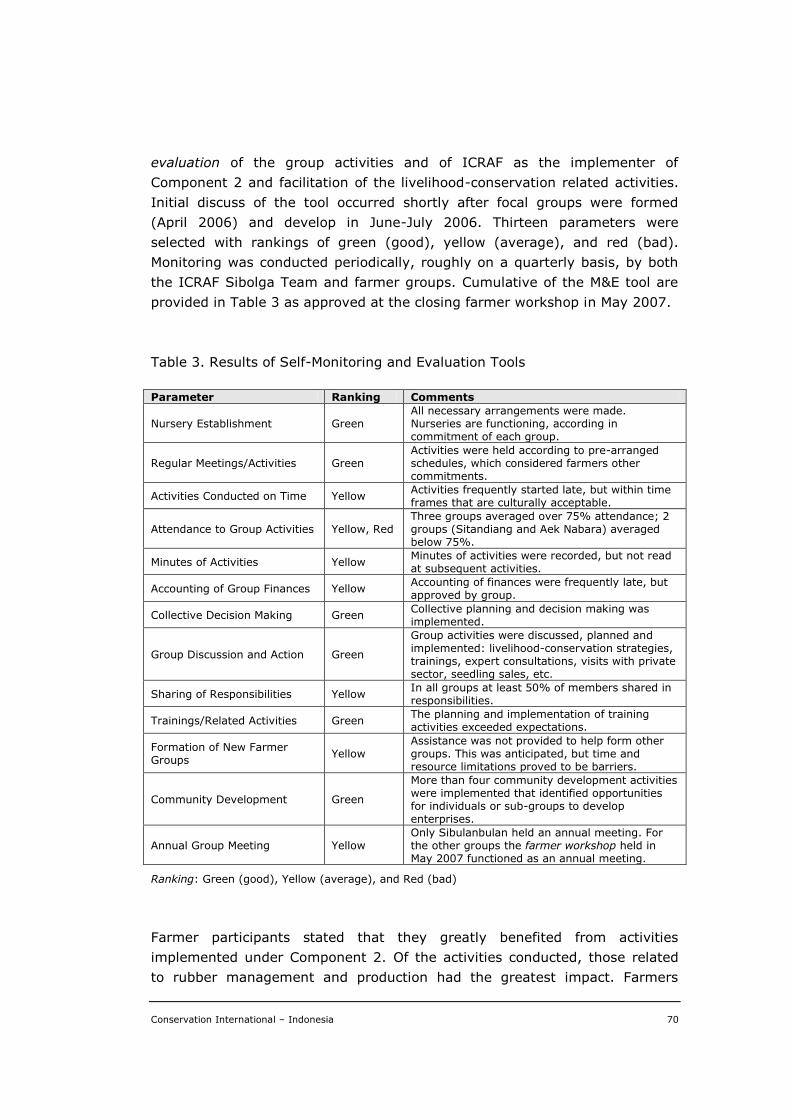
Conservation International – Indonesia 70
evaluation of the group activities and of ICRAF as the implementer of
Component 2 and facilitation of the livelihood-conservation related activities.
Initial discuss of the tool occurred shortly after focal groups were formed
(April 2006) and develop in June-July 2006. Thirteen parameters were
selected with rankings of green (good), yellow (average), and red (bad).
Monitoring was conducted periodically, roughly on a quarterly basis, by both
the ICRAF Sibolga Team and farmer groups. Cumulative of the M&E tool are
provided in Table 3 as approved at the closing farmer workshop in May 2007.
Table 3. Results of Self-Monitoring and Evaluation Tools
Parameter Ranking Comments
Nursery Establishment Green All necessary arrangements were made. Nurseries are functioning, according in commitment of each group.
Regular Meetings/Activities Green Activities were held according to pre-arranged schedules, which considered farmers other commitments.
Activities Conducted on Time Yellow Activities frequently started late, but within time frames that are culturally acceptable.
Attendance to Group Activities Yellow, Red Three groups averaged over 75% attendance; 2 groups (Sitandiang and Aek Nabara) averaged below 75%.
Minutes of Activities Yellow Minutes of activities were recorded, but not read at subsequent activities.
Accounting of Group Finances Yellow Accounting of finances were frequently late, but approved by group.
Collective Decision Making Green Collective planning and decision making was implemented.
Group Discussion and Action Green
Group activities were discussed, planned and implemented: livelihood-conservation strategies, trainings, expert consultations, visits with private sector, seedling sales, etc.
Sharing of Responsibilities Yellow In all groups at least 50% of members shared in responsibilities.
Trainings/Related Activities Green The planning and implementation of training activities exceeded expectations.
Formation of New Farmer Groups
Yellow Assistance was not provided to help form other groups. This was anticipated, but time and resource limitations proved to be barriers.
Community Development Green
More than four community development activities were implemented that identified opportunities for individuals or sub-groups to develop enterprises.
Annual Group Meeting Yellow Only Sibulanbulan held an annual meeting. For the other groups the farmer workshop held in May 2007 functioned as an annual meeting.
Ranking: Green (good), Yellow (average), and Red (bad)
Farmer participants stated that they greatly benefited from activities
implemented under Component 2. Of the activities conducted, those related
to rubber management and production had the greatest impact. Farmers

Conservation International – Indonesia 71
agree they need additional technical and marketing assistance to maintain the
current momentum in improving their agroforestry systems and strengthening
community-based conservation. Three of the farmer groups have official
registered as community organizations with district forest offices and
anticipate, expect, technical support from those agencies. Farmer groups in all
five communities agree to continue their agroforestry and conservation
activities, and volunteer to transfer their knowledge to other interested
individuals and communities. They hope to expand their information network
with other farmers, NGOs, government agencies and the private sector to
enhance their agroforestry and forest management capacity. Farmer groups
request the ICRAF, CI and USAID continue their support of Batang Toru
communities.
Conservation International – Indonesia 72
V. CONCLUSION AND RECOMMENDATION
Highlights of success for the two project components are summarized below:
1. Law enforcement institutions, including the police and army regional
offices, regional courts and attorneys, have officially committed to
supporting the orangutan protection in West Batang Toru, and
developed detailed action plans for law enforcement activities.
2. The Community Participatory Monitoring Unit for Orangutan Protection
consisting of the local people and forest rangers has been established to
continue patrolling the forest and existing orangutan transects.
3. All key stakeholders (i.e., communities, all district governments,
national government, private sectors) concurred to establish a
communication network (in a form of FORUM) that would promote the
sustainability of existing natural resources of West Batang Toru for the
benefits of both the local people and wildlife in the areas.
4. A series of consultative meetings, there has been a notion from the
three districts (North Tapanuli, Central Tapanuli and South Tapanuli)
about the needs for incorporating nature (e.g., orangutan) conservation
into their respective spatial planning. The government of South Tapanuli
District has allocate the district annual budget (i.e., APBD) for initiating
such a process for the fiscal year 2008.
5. The government of South Tapanuli District has also submitted an inquiry
to the Ministry of Forestry about the possibility of establishing a locally-
designed and managed protected area under a collaboration with CI-
Indonesia. The respond is yet to be awaited.
6. The project has facilitated the local communities in fulfilling a number of
needs at village levels. Rehabilitation of irrigation system has been done
in two villages, rubber nurseries have been developed in five villages,
trainings in sustainable agriculture practices were provided to the
farmers in two villages, a village library functioning as a village
information center was established in one village, and a curriculum
model incorporating the orangutan conservation was participatorily
developed with a local school in one village.
Conservation International – Indonesia 73
The project implementation has indeed achieved its objectives that could
provide an important foundation for attaining its long term goals. However,
further endeavors seem inevitable when biodiversity conservation is to
succeed in the future. Promoting a regional spatial planning based on
sustainable development principles would be one of crucial tasks in the future,
where economic development could go hand in hand with nature conservation
and social development. Sustainable livelihood development (i.e. diversifying
economic options to the local people) also seems crucial to be addressed if
nature conservation to succeed at community levels.
Diversifying local economic options could be designed as such that lessens the
local people dependecy on forest resources, and more favourable if it could
provide the local people with conservation incentives in many ways. There has
been a notion on developing ecotourism in the area as to expound such
incentives, but developing ecotourism industry needs a comprehensive and
integrated plan involving a variety of parties from both the local governments
and private sectors as well as the readiness of local people themselves. By the
very end of project implementation period, there has been a contact with a
local company based in Jakarta/Bandung that facilitate the local people with
technical trainings and market for less-known weedy plants such as Pueraria
lobata, P.thunbergiana, and P.montana, and Miscantus sp. Consulative
meetings have been undertaken that concluded in CI needed to develop a
collaborative work with this company in the near future, when another source
of funding is available to CI.
Not only is West Batang Toru a home for orangutan but it is also foraging area
for other threatened wildlife species such as Sumatran tiger, Malayan tapir
and Malayan bear. Therefore, West Batang Toru deserves an appropriate
management, which can be incorporated into the regional spatial plan.
However, at a landscape or rather ecosystem scale, this area is connected to
the area of Aek Sarulla at the western side, including the two nature reserves
(Dolok Sibual-buali and Dolok Sipirok) at the southern side. This would
demand thorough consideration in incorporating these areas into such a
management. In turn, this will require an ecosystem approach as the basis for
further developing nature and biodiversity conservation based upon
sustainable development principles.
Last but not least, it is also vital to explore the linkages between cultural
practices, livelihood options, ecosystem and biodiversity. Since Batang Toru
area encompasses three districts land-marked with dramatic contrasts in
terrain, histories, cultures and religious beliefs, an incredible diversity in
Conservation International – Indonesia 74
ecological landscape will help human communities evolve an equally diverse
mosaic of traditions and cultural practices, rooted in the knowledge of
biodiversity wealth. Therefore, each eco-region will have its particular set of
livelihood practices.
Conservation International – Indonesia 75
VI. CONSTRAINTS, LESSON LEARNT AND PROSPECTS
Overall, the project has been successfully implemented, of which the results
could become the valuable foundation for further developing any kind of
management plan for the forested areas in West Batang Toru. However,
reservation should be made and considered in order for any nature
conservation programme to succeed in the area. Here are constraints and
lessons learnt from the project implementation, and the prospects for
successful conservation of biodiversity in the areas in the future, described
according to the themes as follows.
Community-level successes
It is indeed true that efforts to conserve biodiversity must succeed at the
community level and will be the genuine measure of effectiveness. During the
project implementation, however, a number of constraints were found in
developing a common commitment to conserve biodiversity (e.g., orangutan)
and the forests as the habitat for many biodiversity species. Conflict of
interests within the policy makers in the region of Northern Sumatra on forest
utilization seemed to be the main obstacle for further developing nature
conservation measures. Batang Toru Forest Block is not an uninhabited and
undeveloped watershed area. It comprises legally designated areas with
various functions and uses such as settlements, agricultural lands, mining
concessions, logging concessions, hydrological electricity power plant, town
expansions, and reserved for other land conversion purposes. These are the
sources of such conflicting interests that emerge both at the governmental
level and the community level.
Within the local communities, especially new immigrants from Nias,
agricultural expansion seemed to be the only way of improving their
livelihood. Meanwhile, the need for livelihood improvement seems to be the
main constraint across the communities in the areas of West Batang Toru. In
any consultative meeting with the village communities, it has always been the
main inquiry for developing sustainable economic development at village level
that is capable of incorporating orangutan conservation. Lack of economic
options seemed urgent to deal with prior to endorsing any system of nature
conservation management. And yet, there are potentials to diversify economic
generating activities at the local levels.
Along the course of project implementation, it proved that a micro-spatial
planning (i.e., spatial planning at village level developed using a participatory
Conservation International – Indonesia 76
approach) has been a better way to augment the local people perception and
willingness to promote sustainable development principles. In this way, the
local people would have been able to express their needs and to find better
ways to fill their own needs, provided that the local government would
supervise and facilitate their articulation. In this way, the integration of nature
conservation into economic development can be engaged in achieving the
sustainable development from village to district levels.
It would then be favourable to all parties when the village development could
be based upon participatory micro-spatial planning, which is later
accommodated by the local government as the basis for developing a district
spatial planning. Only then, the success of nature conservation at community
levels can be achieved.
Building alliances to foster support for orangutan conservation
Alliances of civil society, communities, the private sector, and government are
indeed a powerful tool to create this support. However, it proved difficult to
build any alliance when the stakeholders did not have the same perception on
orangutan conservation. Awareness building in fact was not as easy as it was
expected in the communities with a variety of interests and livelihood
problems. Creating incentives for people to support conservation efforts is just
as problematical as the others when there was limited option for leveraging
sustainable funding. Diversifying livelihood income at the local level is surely
the superlative option to provide incentives to the people, but this will require
a comprehensive approach involving all levels of stakeholders, i.e. the
availability of private sectors supporting market for new income generating
initiative, the willingness of local governments to facilitate any new initiative
in alternative activities at the community level, and the readiness of local
community themselves in developing new income generating alternatives.
Along the course of project implementation, there has been little support to
develop such alternatives, except at the very end of project period there was
found a possibility to collaborate with a private company, with which such a
feasibility is going to be explored (by the mid of December 2007).
Co-management of protected forests will need a gazetted area to be managed
and yet the creation on a national park for Batang Toru forest block is so
problematical that impossible to deal with during the period of project
implementation. As an alternative the project has proposed a creation of a
Batng Toru Forum where all relevant stakeholders could be allianced and
could actively participate in developing and implementing conservation plans
for the area. Such a forum is also expected to help the relevant decision-
Conservation International – Indonesia 77
making and resource management agencies develop mechanisms to seek
public input and active support.
Integrating conservation (and monitoring) into planning
The most siginificant constraint for developing any measure of biodiversity
conservation (not only orangutan, but also other wildlife species) in the
Tapanuli region has been the lack of integration of biodiversity conservation
into the regional spatial planning. Apart from providing the relevant
government agencies at both provincial and district levels with updated data
from the fields, the project could only recommend to incorporate the need for
biodiversity conservation in their respective spatial planning. At the same
time, indeed the spatial planning at both provincial and district levels has
been in processes of revision, where the provided data could be utilized,
although their use is much more questionable since the process of spatial
planning development involves a consultant company with less participatory
mechanism for the local people.
In order to show the importance of participatory process in developing a
spatial planning, the project has started developing a model of village spatial
planning that incoporate the needs for local livelihhod development and
biodiversity conservation. This would provide the local governments with the
more appropriate model of spatial planning development while promoting
good-governance processes. This village model will be completed by the end
of December 2007. And it is expected that the local governments would adopt
the processes accordingly in the future.


![[INDONESIAN INVESTIGATION] - drh-norway.weebly.comdrh-norway.weebly.com/uploads/1/8/7/2/18723022/how_about_indonesia.pdf · Halimun Salak preserves the most complete rainforest ecosystem](https://img.pdfslide.us/doc/110x75/5d4ecb7c88c99350518b6d58/indonesian-investigation-drh-halimun-salak-preserves-the-most-complete.jpg)