Embed Size (px)
Citation preview
t is sometimes difficult to remember that Fort Grange and Beverwijck were two different establishments under the Dutch West India Company. Fort Grange was the trading center built by the Company in 1624, and Bever- wijck was the town laid out by the Company in 1652 some distance to the north but within a cannon shot of Fort Grange. As establishments of the West India Company primarily intended to facilitate and control trade, Fort Orange and Beverwijck were separate from the Colonie of Rensselaerswijck which entirely surrounded them.
Fort Orange in 1624 and Bevcrwijclc in 1652 belong within two distinct phases of colonial settlement and urban development that occurred before 1664. Predated by the settlements of Jamestown in 1607 and by Plymouth in 1620 and located far inland on a tidal river, Fort Grange was a third isolated outpost of European civilization in what later became the thirteen original colonies. The construction by the Dutch of Fort Amster- dam on Manhattan in 1626 included the laying out of streets nearby which became New Amsterdam. In New England, other modem cities also survive today from their beginnings as small compact, nucleated settlements established and laid out in a remarkable per&l between 1630 and 1639. These include Cambridge, Boston, Hartford, Providence, New Haven, and Newport, for example. On Chesapeake Bay, however, compact settle- ments such as Jamestown and St. Mary’s City (1634) survive today only as archeological sites. Fort Orange was abandoned in 1676 and also did not survive as an integral part of a modem city. While technically not a compact, nucleated settlement of the same type as the other examples, Fort Orange was directly across the river from a village of Rensselaerswijck tradesmen and mechanics at Greenbush which Van Rensselaer ordered to be established in 1639 and which began in the early 1630s as a farm, mill, and guard house in need of protec- tion from the f0rt.l
Following this initial period of settlement planning and establishment before 1640, New Netherland under the directorship of Petrus Stuyvesant experienced a
second phase of planned town development during the 1650s and 1660s. Qneof theearliest developments in this period was the construction of Fort Casimir and the town of New Amstel on the Delaware beginning in 1651 and 1652. At Fort Grange, meanwhile, an illegal cluster of houses had grown up on the noreh side of the fort that, by 1652, was said to number about 100 structures. Unlike these illegal houses of Rensselaerswijck immediately outside the fort, other houses had been built beginning in 1647 inside Fort Grange by private traders with the permission of the Company and of Stuyvesant himself. Fort Grange became a crowded, enclosed, small community. Stuyvesant was determined to eradicate the illegal houses built close to the fort outside, and in 1648 his soldiers began to tear some of them down. Finally, in 1652, Stuyvesant laid out the town of Beverwijck, consisting of lots along two main streets which are today Broadway and State Street in Albany, located at what he considered a safe distance north of Fort Orange.”
Other planned towns in New Netherland soon followed Beverwijck. Nieuw Utrecht was laid out in 1657, and Nieuw Haerlem and Wiltwijck (Kingston) followed in 1658. Still later, in 1662, Schenectady and Nieuw Dot-p (Hurley) were established. If and when archeological remains of some of these communities are excavated and then carefully studied and if comparisons with the evidence from Fort Orange and Beverwijck can be made, it may yet be possible to identify cultural behavior patterns which are distinctly urban in character and to test the hypothetical classification of 17th century communities. The basic challenge for archaeologists as well as historians in studying urban sites is to consider the problem of defining the terms “urban” and “city,” or “town.” As early as 1961 Eric Lampard called attention to the problem of inadequate definitions of “urban” and “rural” as terms used by historians who had not carefully considered the question. All too often non-urban communities had been lumped together arbitrarily as “rural,” while distinctly “urban” traits had been very loosely defined. Lampard observed that
Scholars have been preoccupied with biographies of particular communities, with case studies in urban rivalry, or the general
327

328 SELECTED RENSSELAERSWIJCK SEMINAR PAPERS
impact of the city on society, rather than the study of urbanization as a societal process. We know little beyond a bare statistical outline of the secular phenomenon of population concentration, the multiplication of points of concentration, or of relations among concentrations of different size and density in various parts of the country at different times in our history.
Perhaps the archeological analysis and comparison of fauna1 remains as dietary evidence, of ceramic types as evidence of status and wealth or of acceptance of change, of structural remains as evidence of construction permanence, or of other forms of cultural behavior from various “urban” and“rural” sites will help in determining (according to Lampard)
. . . what is generically ‘urban’ or otherwise in the experience of particular communities . . . Phenomena that are found in cities are not necessarily ‘urban’ per se, and yet this is precisely what many scholars have implied.
It is, of course, necessary to continue the careful study of land records and other documents to develop a better knowledge of early urban development. The Dutch settlements on Long Island such as Midwout, Amersfoort, and Breuckelyn, for example, should be carefully considered in terms of their origins and early growth as “village” communities. Many early towns, particularly in New England, began not as compact, concentrated village settlements but as groups of enclosed lands and relatively isolated farmsteads.
Early Archeological Evidence of 17th- Century Fort Orange and Beverwijck
The walled town of Beverwijck, which became Albany in 1664, continued to be enclosed by a wall for another century. The city experienced one major expan- sion in the 175Os, when the stockade wall was movedand enlarged (Figure #56). Fort Orange remained outside the town, to the south and close to the river bank, until it was replaced in 1676 by a new fort at a different location, which was on the hill at the head of State Street in Albany. Unfortunately, the above-ground structures from the 17th century have entirely disappeared from the modern city, but the 17th-century street plan has survived as a tangible, visible reminder of Albany’s long history. This historic street plan has remained relatively iiilaltered until only recently.
Some of the most important archeological deposits in Albany still exist under these streets, despite the numerous utility lines that have been installed under them. Elsewhere, 19th and 2Otb century buildings have obliterated most remains from the’colonial period, except
where deep filling occurred or where the later buildings have shallow cellars. But in a city, as the process of demolition and new construction steadily continues and as the old utilities are replaced by new ones’, little by little the earliest archeological traces disappear until they, too, are gone entirely.
Most of the archeological information about Fort Orange and Beverwijck that survived was lost in the 19th and early 20th centuries in the absence of archeologists with modem methods of data retrieval. The still visible remains of Fort Orange, however, came to be appreciated as an historic site after the Revolutionary War, and historical observances were held there.4 But soon Albany began to expand its boundaries southward., and in 1790 Simeon Dewitt, as surveyor of the new blocks of city land, laid out Broadway to extend directly across the east part of the visible Fort Orange site. Dewitt then purchased two lots of land in 1793 and 1794 on the west side of Broadway. With Dewitt’s apparent sense of history,it was no coincidence that these two lots included much of the remainder of the Fort Orange site west of the street. Dewitt immediately commenced construction of a large new house on the two lots, thereby destroying much of the site.5 In 1848, this house wa,s burned in a great fire which devastated this part of Albany, but the area was soon rebuilt. One wonders, of course, what artifacts were recovered by Dewitt, or by the builders after 1848. It is quite possible that many Dutch yellow clinker bricks appeared at the site, for which it may have become known. A writer in Buffalo, New York, about 1847 reported that the modem yellow bridks then made in Wisconsin were harder and better than any others he had ever seen, “unless it be those little yellow bricks which are imported from Holland, by the Dutch of Fort Orange to build their houses with.“6
Many other discoveries, meanwhile, evidently occurred in Albany in the area that had been Beverwijck, but only a few records of these have survived. In September 1866, Patrick McCarty, a builder, presented to the Albany Common Council some relics that he had found with remains of the stockade wall which he uncovered in a lot on Hudson Avenue belonging to Hose Company No. 7. Early in the 1870s,another stockade line was uncovered during excavation of the basement for a building at the southwest comer of North Pearl Street and Sheridan Avenue. Joel Munsell recorded that “the workmen uncovered a row of stumps of a stockade, which ran comerwise across the lot, and a crowd of persons unacquainted with these ancient defenses was
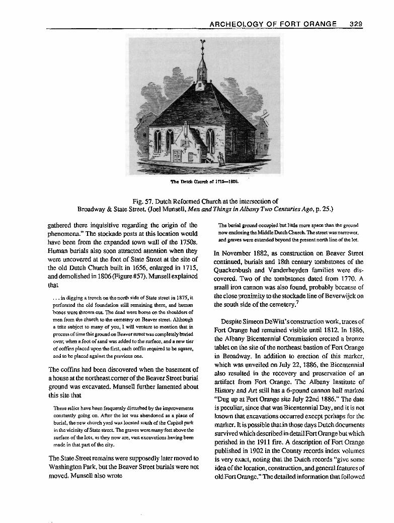
ARCHEOLOGY OF FORT ORANGE 329
Fig. 57. Dutch Reformed Church at the intersection of Broadway & State Street. (Joel IvIunsell, Mep1 anQ Things in Alb~~ay Two Centuries Ago, p. 25.)
gathered there inquisitive regarding the origin of the phenomena.” The stockade posts at this location would have been from the expanded town wall of the 1750s. Human burials also soon attracted attention when they were uncovered at the foot of State Street at the site of the old Dutch Church built in 1656, enlarged in 1715, and demolished in 1806 (Figure#57). lvlunsell explain& that
. . . in digging a trench on the north side of State street in 1875, it perforated the old foundation still remaining there, and human bones were thrown out. The dead were borne on the shoulders of men from the church to the cemetery on Beaver street. Although a trite subject to many of you, I will venture to mention that in process of time this ground on Beaver street was completely buried over; when a foot of sand was added to the surface, and a new tier of coffins placed upon the first, each coffin required to be square, and to be placed against the previous one.
The coffins had been discovered when the basement of a house at the northeast comer of the Beaver Street burial ground was excavated. Munsell further lamented about this site that
These relics have been frequently disturbed by the improvements constantly going on. After the lot was abandoned as a place of burial, the new church yard was located south of the Capitol park in the vicinity of State street. The graves weremany feet above the surface of the lots, as they now are, vast excavations having been made in that pan of the city.
The State Street remains were supposedly later moved to Washington Park, but the Beaver Street burials were not moved. Munsell also wrote
The burial ground occupied but little mom space than the ground now enclosing the Middle Dutch Church. The street was narrower, and graves were extended beyond the present north line of the lot.
In November 1882, as construction on Beaver Street continued, burials and 18th century tombstones of the Quackenbush and Vanderheyden families were dis- covered. Two of the tombstones dated from 1770. A small iron cannon was also found, probably because of the close proximity to the stockade line of Beverwijck on the south side of the cemetery.7
Despite Simeon Dewitt’s construction work, traces of Fort Qrange had remained visible until 1812. In 1886, the Albany Bicentennial Commission erected a bronze tablet on the site of the northeast bastion of Fort Orange in Broadway. In addition to erection of this marker, which was unveiled on July 22, 1886, the Bicentennial also resulted in the recovery and preservation of an artifact from Fort Qrange. The Albany Institute of History and Art still has a g-pound cannon ball marked “Dug up at Fort Orange site July 22nd 1886.” The date is peculiar, since that was Bicentennial Day, and it is not known that excavations occurred exeept perhaps for the marker. It is possible thatin those days Dutch documents survived which describedin detail Fort Qrangebut which perished in the 1911 fire. A description of Fort Orange published in 1902 in the County records index volumes is very exact, noting that the Dutch records “give some idea of the location, construction, and general features of old Fort Orange.” The detailed information that followed

330 SELECTED RENSSELAERSWIJCK SEMINAR PAPERS
is not found in any translated Dutch documents currently available.8
Unfortunately, Broadway was altered early in the 1930s with construction of the Dunn Memorial Bridge. The bronze tablet was moved from its 1886 location and was placed in a pedestrian underpass below the D&H Railroad tracks. In 1971, after archeological excavations had revealed part of Fort Orange during the arterial highway construction, this tablet was once again moved. It was mounted on a new concrete wall on the site of Fort Orange, but far from the northeast bastion. In light of present knowledge it would perhaps be appropriate to mount a second tablet there to explain and record the discrepancy, as well as its present location in relation to the actual site of Fort Orange.
Excavations at the Site of Fort Orange
Until the first test hole at the site of Fort Orange was excavated on October 20,1970, diagnostic 17th century Dutch artifacts had not been discovered and identified from sites in the Albany area despite the many published translations of Dutch records and the extensive research of historians on the Dutch period. While previous excavations in other sites in or near Albany had produced numerous 18th century or later materials, it had become clear that an improved understanding of cultural behavior and material from the 18th century British colonial period and the process of Anglo-Dutch acculturation would depend heavily on archeological evidence from the 17th century Dutch and early English periods. That initial test hole was dug in what had been the cellar of Simeon Dewitt’s house of 1794 and the street immediately in front. It was found that the 1794 cellar had obliterated all traces of 17th century occupa- tion, but under what had been the surface of Broadway in front of Dewitt’s house there were abundant 17th century artifacts. These included brass Jew’s harps, marked tobacco pipe fragments, glass trade beads, a piece of Rhenish stoneware with the date 1632, and pieces of Dutch majolica and delft?
The excavations, conducted by the New York State Historic Trust in cooperation with the Department of Transportation, continued steadily until March 1971. A large triangular area was carefully exposed between the 1930s concrete crash wall for the D&H tracks on the east, the facade line of the late 18th century houses along Broadway on the west, and the location of a 1960s gas station to the south. The entire area had been under ‘Broadway from the 1790s until the 1930s. The excava-
tions revealed what is believed to have been a section of the cobblestone-faced south moat and stone counterscarp or ravelin wall and, inside the fort, a part of the Hendrick Andriessen van Doesburgh house, parts of the founda- tion of a brewery built by Jean Labatie in 1647, a pebbled pathway leading from the east entrance of the fort, and small sections of cellars of the houses of Abraham Staats and Hans Vos. The Van Doesburgh house evidently collapsed about 1664 or 1665, and the Staats house burned in 1668. A scattering of wood chips near the south wall toward the southeast bastion area may date from repairs attempted early in the 167Os, while soil strata in the south moat evidently continued to build up from repeated floods before and after the fort was abandoned in 1676. The concrete crash wall of the 1930s had unfor- tunately destroyed the entire east curtain wall and bas- tions, but despite the effects of damage and destruction from this and other development, the excavations produced a vast number of artifacts of interest. The initial analysis of this material is now only partially completed but is continuing; conclusions are necessarily still preliminary.
Although a complete fauna1 analysis of the garbage bone remains has not been conducted, it appears that the number of deer that were consumed for food at Fort Orange greatly outnumbered other sources of meat. Pigs were evidently the second most commonly slaughtered, after deer. Fish, of course, were also commonly consumed. In deposits dating probably before 1648, the greatest number of fish bones and scales were found buried in a pit about twenty feet south of the entrance path. A few pieces of sturgeon plate also appeared, but sturgeon remains were infrequently found in the later 17th century deposits in Fort Orange. The number of deer is not surprising, however. In terms of survival, the trade with the Indians for venison and other food was as vital as the fur trade. On the Rensselaerswijck map of about 1630 it is noted that
From the Maquaas (especially in the winter) plenty of venison can bc obtained that is fat and fine; about 3.4, or 5 hands of seawan for a deer. They would be glad to exchange a deer for milk or butter. The meat is fit for smoking orpickling. . . In the fou& kill are pike and all sorts of fish. The sturgeon there is smaller than at the Manhattans. One can be bought from the savages for a knife.”
Eating and drinking utensils included lead-glazed red- bodied and white/buff-bodied earthenwares, tin-glazed earthenwares, Rhenish stonewares, Chinese porcelain, glass roemers, spechter glasses, and facoln de Venise glassware. The lead-glazed earthenwares, mostly clear glazed but sometimes green glazed on the: white/buff-

ARCHEOLOGY OF FORT ORANGE 331
Fig. 58. Selected Dutch majolica sherds excavated at Fort Orange. Similar examples from the 17th century, decorated with this central star pattern in blue, have been excavated in the Netherlands at Haarlem, Leiden, Harlingen, and elsewhere.
bodied specimens, were generally utility wares. The majority of the decorated tin-glazed earthenwares, at least in the deposits dating before 1650, were glazed white and decorated on front, while the reverse or back side was glazed with a semi-clear lead glaze. These charactcrfstics identify these tin-glazed wares as Dutch majolica, as distinct from Dutch delft (faience). Dutch delft was a type of ware glazed white on front and back and which was developed during the 17th century, gradually replacing Dutch majolica. A study of the decorated Dutch majolica at Fort Orange reveals remark- able similarities with the patterns on the various ex- amples of 17th century Dutch majolica excavated in the Netherlands, and in many instances the patterns and workmanship are identical (Figure #58).”
Rhenish stonewares were generally less common than the tin-glazed earthenwares or the lead-glazed utility earthenwares. These salt-glazed stonewares included large “Belhumine” jugs decorated with bearded faces and oval medallions molded on the body. A second type of Rhenish stoneware was from the Westerwald and consisted of vessels decorated in cobalt blue on a gray or buff body. It was often ornamented with elaborate molded decoration, including medallions. Westerwald
stoneware fragments with parts of medallions identical to those excavated at Fort Orange have come from numerous Indian sites; examples have been found in western New York at Seneca sites such as Power House (ca. 1635-1655). Dann (165%1675), and Gannagaro (1670-1687).1”
Porcelain was uncommon at Fort Orange, and only a few sherds were recovered from 17th century contexts. Some porcelain rim sherds, however, have a blue pattern and are identical in form and pattern to an existing Chinese porcelain mustard pot with 17th century Dutch silver mountings.13
Glasswares included many broken roemer fragments. These drinking glasses consisted of a conical base formed by coiling a string of molten glass, with a cylindrical hollow stem above decorated with raspberry- shaped, plain, or pointed buttons called prunts, and fin- ally with a thin, plain globular glass bowl above the stem. Roemer glasses frequently appear in the still life paint- ings of Dutch artists such as Peter Claesz, although the glasses at Port Orange were typicaRy of smaller size than those commonly shown in 17th century still life paint- ings. The roemers at Fort Orange were also extra-
332 SELECTED RENSSELAERSWIJCK SEMINAR PAPERS
ordinarily thin and delicate; the glass of the bowl portion was frequently no thicker than that of a modem light bulb.
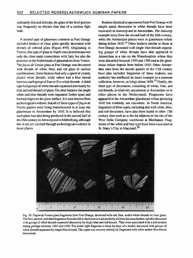
A second type of glassware common at Fort Orange included beakers of clear glass spirally decorated with threads of colored glass (Figure #59). Originating in Venice, this type of glass in Dutch sites demonstrates not only the close trade connections with Italy but also the presence in theNetherlands of glassmakers from Venice. The faGon de Venise glass at Fort Orange was decorated with threads of white, blue, and red glass in various combinations. Some beakers had only a spiral of closely placed white threads, while others had a blue thread between each group of four or five white threads. A third type had groups of white threads separatedalternately by blue and red threads of glass. On other beakers the single white and blue threads were separated farther apart and formed ridges on the glass surface. It is now known from archeological evidence that all of these types offaEon de Venise glasses were being manufactured in at least one glasshouse in Amsterdam by 1610. It is believed that such glass was also being produced in the second half of the 16th century in Antwerp and in Middelburg, although this is not yet verified through archeological evidence in those places.
Beakers identical to specimens from Fort Orange with simple spiral decoration in white threads have been excavated in Antwerp and in Amsterdam. The Antwerp example dates from the second half of the 16th century, while the Amsterdam pieces were in glasshouse refuse dating before 1610.t4 Other beakers similar to those at Fort Orange decorated with single blue threads separat- ing groups of white threads have also appeared in Amsterdam at a site on the Waterloop18ein where they were discarded between 1593 and 1596 alnd at the glass- house refuse deposit from before 1610. Other Amster- dam sites from the second quarter of the 17th century have also included fragments of these beakers; one authority has attributed an intact example in a museum collection, however, to Liege about 1650.15 Finally, the third type of decoration, consisting of white, blue, and red threads, is relatively uncommon in Amsterdam or in other places in the Netherlands. Fragments have appeared in the Amsterdam glasshouse refuse predating 1610 but evidently not elsewhere. In North America, fragments of these types, including that with white, blue, and red decoration, have also been found in other 17th century sites such as in the lot adjacent to the site of the West India Company warehouse at Manhattan. Frag- ments of the white and blue type have been excavated at St. Mary’s City in Maryland.16
Fig. 59. Fqon-de Venise glass fragments from Fort Orange, decorated with red, blue, and/or white threads on clear glass. The first, second, and~thirdfragments from the left in the lower row are probably all from the same,beaker, spirally decorated with groups of whitethreads separatedalternately by single blue and red threads. They were associated with a soil stratum dating perhaps between 1624 and 1640. The lower right fragment is from the base of a beaker decorated with groups of white threads separated by single blue threads. The upper row consists entirely of fragments with white and/or ‘blue thread decoration.

ARCHEOLOGY OF FORT ORANGE 333
More than 300 glass beads were excavated at Fort Orange, representing many of the varieties and types used in trade with the Indians. Small round beads of clear glass with a white middle layer were most common, while blue tubular beads were second most common. Many other beads were decorated with or made of combinations of blue, red, green, yellow, white, and other colors of glass. Such beads could have been imported by the Dutch from Venice, but the glasshouse refuse deposit in Amsterdam shows that many such beads could have been made there even before 1610.17
The large number of glass beads uncovered at the site of Fort Orange and the even much larger numbers of these beads at Iroquois sites of this period extending westward seem indicative of the intensity of trade activity at this site and of the far-reaching influence of the Dutch. In contrast, for example, it has been noted that by comparison English colonial sites in New England and elsewhere in this period often produce relatively few glass beads.‘* It appears that the presence of glass beads may be equally sparse at 17th century Dutch sites in Rensselaerswijck, outside Fort Orange and Beverwijck. What seems typical of many 17th century Dutch sites, however, is the large number of clay tobacco pipe frag- ments. At Fort Orange, the pipes were also used as trade items, and the dual function of pipes for personal use and for trade apparently resulted in consumption of a variety of pipes imported from an immense number of different pipe makers in the Netherlands. The makers often marked their pipes with stamped initials or some other mark on the heel or base of the pipe bowls; at Fort Orange 73 different makers’ marks have been found occurring on a total of 245 marked bowls. Many other 17th century pipe bowls have no makers’ marks at all.
Also frequent at Fort Orange and at other 17th century Dutch sites were small clay or stone marbles. They are not usually found, however, at 17th century English sites in America or in England, at least before 1650, after which a few examples are reported. The marbles are nearly perfect spheres. One example dating probably before 1648 has a diameter that varies only from .562 to .574 inch, while another example from a deposit dating about 1648 to 1657 has a diameter of .561 to .574 inch. A third marble from a deposit dating about 1657 to 1664 varies in diameter from .507 to .5 15 inch. The remarkable spherical precision and similarity in size of such marbles suggests they were more than children’s toys. Indeed, many Dutch paintings and drawings show children playing games of marbles, from as early as Brueghel’s
Children’s Games of 1560. There is less documentary evidence of the use of marbles for adult gambling, but in 1617 G.A. Bredero in his play De Spaaplschepl Brabander in Amsterdam criticized those who threw away money “playing among themselves at cards and skittles, lobbing marbles, flipping coins, guessing heads or tails.” Gambling in New Netherland had become such a problem by 1656, for example, that passengers who sailed for New Amstel were strictly warned not to “bring or make on board any dice, cards, or any other imple- ments of gaming.“lg
Excava&ions in Bwerwijck
a. Broadway, State Street, South Pearl Street Extensive excavations for trenches to install power
line conduits occurred in Albany under Broadway, State Street, and South Pearl Street in 1972 and 1973, and archeologists with the Historic Trust (subsequently the State Board for I-Iistoric Preservation) carefully observed this work in an effort to record historical information and artifacts. Two of the streets, State Street and Broadway north of State Stteet, were original streets of 17th century Beverwijck with the names Jonker Straat and Handelaer Swat, respectively. South Pearl Street, however, was not opened to its full width as a street until 1798, requir- ing demolition of a house which Philip Pietersen Schuyler had purchased and remodeled in 1667. The house adjoining next to the east had been purchased by Schuyler before 1659 and remained standing on the corner of South Pearl and State Streets until it was demolished in 1887. It was the birthplace in 1733 of General Philip I. Schuyler.20
The conduit trench followed a route that had remained largely undisturbed by other parallel utility lines that were under the streets. South of State Street. the trench under South Pearl Street revealed the original north slope of the Wutten Kill ravine, located behind the Schuyler houses. The profile cross section of the soil layers exposed by this north-south trench revealed not only the sloping ground surface but also remains of wood-lined privies and stratified layers of earth fill which had been dumped into the ravine during the colonial period. Of particular interest in this area were numerous small scraps of thin bark that apparently had been cut and stitched by Indians to make small baskets or other utensils. Similar pieces of worked birch bark have been excavated from 17th and 18th century Indian sites on the upper Great Eakes.21
334 SELECTED RENSSELAERSWIJCK SEMINAR PAPERS
The excavations under State Street and Broadway revealed additional information about the urban environ- ment of colonial Albany and Beverwijck. Under Broad- way in front of Union Station, for example, an early corduroy street surface was discovered, consisting of logs of small diameter laid side-by-side. Lying close to the river in the lowest part of town, Broadway was evidently subject to frequent flooding and serious mud problems, in addition to the nuisance of deep deposits of garbage, manure, and trash that accumulated in the streets. Study of the conduit trench excavations under Broadway and State Street revealed the presence of extensive deposits of trash, particularly on the slope of State Street from South Pearl Street down the hill to Broadway. Wood shavings, fragments of wooden casks, leather cuttings, and trimmings of window glass indicated some of the various trades practiced by residents of the town. Remains of wooden water pipes, consisting of slender logs cut flat on one side and grooved to form a channel which was covered with a plank nailed down, probably represent the water system which was installed in Albany in 1678.22
The trench also uncovered evidence of structures that once stood in State Street and Broadway. At the foot of the State Street hill was found a wall of the Dutch Reformed Church which stood at the center of the junc- tion of State Street and Broadway until 1806. At the junction of State Street andNorth and South Pearl Streets was evidence of the colonial British blockhouse which had stood in the center of the street, and debris from the
making of wampum from clam shells at this site suggests one way in which the idle soldiers there profitably passed their time. Traces of wood-lined cellars ‘were found not only under Broadway north of State Street but also under State Street above North and South Pearl Streets. The wood-lined feature under Broadway may have been part of the British stables and magazine of 1756 or 1757, but identity of two wooden cellars found in upper State Street above North and South Pearl Streets remains uncertain.
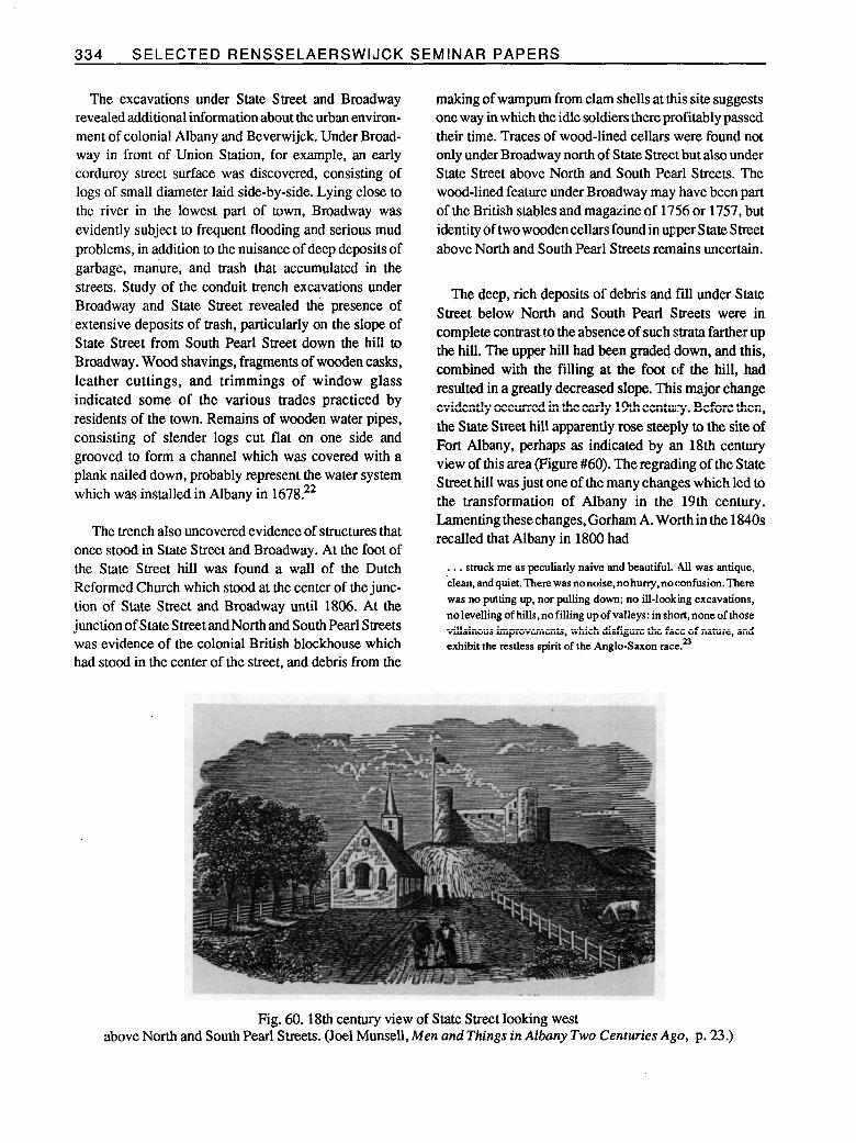
The deep, rich deposits of debris and fill under State Street below North and South Pearl Streets were in complete contrast to the absence of such strata farther up the hill. The upper hill had been graded down, and this, combined with the filling at the foot of the hill, had resulted in a greatly decreased slope. This major change evidently occurred in the early 19th century. Before then, the State Street hill apparently rose steeply to the site of Fort Albany, perhaps as indicated by an 18th century view of this area (Figure #60). The regrading of the State Street hill was just one of the many changes which led to the transformation of Albany in the 19th century. Lamenting these changes, Gorham A. Worth in the 1840s recalled that Albany in 1800 had
. . . struck me as peculiarly naive and beautiful. .All was antique, clean,andquiet.There wasnonoise,nohuny,noconfusion.There was no putting up, nor pulling down; no ill-looking excavations, nolevelling of hills, no filling up of valleys: in short, none of those villainous improvements, which disfigure the face of nature, and exhibit the restless spirit of the Anglo-Saxon race. 23
Fig. 60. 18th century view of State Street looking west above North and South Pearl Streets. (Joel Munsell, Men and Things in Albany Two Centuries Ago, p. 23.)

ARCHEOLOGY OF FORT ORANGE 335
b. Key Carp (Almshouse) Site The Rutten Kill ran down to the river in a ravine which
cut through Beverwijck south of and roughly parallel to State Street; it disappeared during the 19th century as it was channeled underground through a culvert, and new land was created on fill above it, Large lots were laid out along the south side of the Rutten Kill as part of the town of Beverwijck in 1652, and two of these lots (granted to Anthony de Hooges and Volkert Hansen Douw) represent the land that is today bounded on the east by Green Street, on the south by Beaver Street, and on the north by Norton street.
During its development of this block with new build- ings, Key Bank’s developer contracted with Hartgen Archeological Associates to conduct archeological test- ing in a portion of the block selected as the future site of its new corporate headquarters building. The testing was conducted in November 1985, revealing mixed deposits that included artifacts mostly from the 18th and 19th
centuries. At least one 17th century artifact was recovered, however: a tobacco pipe bowl marked EB. It was in a mixed deposit, in association with 18th, 19th, and 23th century materials?” Further excavations were not conducted until early in March 1986, when amateur archeologists discovered that remains of a wooden plank floor in association with additional pipe fragments and other diagnostic 17th century artifacts had been partially uncovered during the construction work. Construction work was halted, and the developer provided time for archeological rescue excavation of the feature. The work was done by a Hartgen Archeological Associates crew assisted by archeologists from the Division for Historic Preservation of the New York State Office of l%rks, Recreation and Historic Preservation.
The excavations continued throughout March and into early April, and wooden floors at two levels were revealed, together with fragmentary evidence of stone cellar walls. These remains had been preserved under a 19th century building at 18 Norton Street which
Fig. 61. Floor beams uncovered in March 1986 in the north part of the Key Carp site, probably from the almshouse of ca. 1685-1686.
336 SELECTED RENSSELAERSWIJCK SEMINAR PAPERS
fortunately had been constructed without excavation of a new cellar underneath. The lot was part of the land south of the Rutten Kill originally granted to Volkert Jansen Douw in 1652. An immigrant who arrived in 1642, Douw was charged an annual ground rent as early as 1647, and he may have occupied the property at that time. His house is referred to in 1655 in a deed from Anthony de Hooges, and it is possible that the area of floor that was at the lower level and in the south portion of the site was part of Douw’s house of ca. 1650. The orientation of structural elements indicates the gables were probably at the east and west ends, meaning the house faced either east or west.25
Volkert Jansen Douw was active in the Indian trade and in the early administration of the town of Bever- wijck. Together with his business parmer, Jan Thomas- sen Witbeck, he also acquiredextensive, very fertile farm land on islands extending southward along the east side of the Hudson River in the 1650s and 1660s. In 1662 he and Witbeck were among the petitioners for estab- lishment of Nieuw Dorp (Hurley) near Kingston. In 1680 Douw sold the west part of his property in Albany along the Rutten Kill to Gerrit Bancker, and in 1681 he sold the east part of his Rutten Kill property to Harmen Rutgers. Douw died in 1683, and in 1685 his widow and son sold the remainder of the lot “with the old house” to the deacons of the Reformed Church.26
The Church evidently rebuilt this “old house” in 1685, and the building became the new Reformed Church almshouse. Little is presently known about the history of the structure, however. It required extensive repairs in 1715, anda century later, in 1815, theReformedChurch divided and sold the almshouse property to individual owners.27 The archeological excavations revealed floor beams (Figure #61) in the north part of the site that had supported a cellar floor at a higher level than in the south area and were probably from the almshouse construction in 1685. The structure would have stood in the northwest comer of the almshouse lot of 1685. The’orientation of these beams indicates the gables were at the north and south ends of the structure and that the building probably faced northward, on Norton Street. The stone side walls of the cellar had been heavily disturbed by later construc- tion, and a north-south central partition wall probably of stone had been entirely salvaged and removed. Soil and artifacts deposited between the floor beams seem to represent evidence of occupation at thealmshouse begin- ning soon after 1685. The floor boards that had rested on these beams were missing, but above that level sub-
sequent layers of soil separated by thin layers of rotted wood boards represented later periods of occupation and a series of wood floors extending in time through the first half of the 18th century.
The original, previous Beverwijck almshouse had stood evidently just one block to the east, on land granted to the Deacons of Beverwijck in April 1652 at the same time the other town lots were granted. to various individuals. The reasons for establishing a new almshouse farther to the west in 1685 are not clear, but by 1697 the number of poor had decreased so that the salary of Doctor Jacob Staats, physician to the poor since 1690, was reduced. In 1698 the almshouse was rented to Robert Barrett, a soldier serving for pay in Colonel Richard Ingoldesby’s Company. Barrett’s four children had been baptized in the Reformed Church between 1689 and 1696, and a fifth was baptized in January 1699. The widow of Gerrit Swart, “the last of the church poor,” died in February 1700, but it is not clear whether :she occupied the almshouse. On May 1, 1700, Robert 13arrett again rented from the Reformed Church for one year “the western part of the almshouse with half the farm occupied by it.” In 1707, Jacob Staats was paid rent by the church for the half of his small house occupied by the widow of Patrick McGregory. McGregory, like Robert Barrett, had been a soldier and had married a Dutch wife, but in 1704 he and his family were suffering in poverty. It is not known why the church chose to pay rent for McGregory’s widow rather than to lodge her in the almshouse, since it seems unlikely the almshouse was filled to capacity. Even later in the 18th century, apparently so few were the needs of the poor that in fact the Reformed Church borrowed from the church poor fund in 1760 the money to pay the expenses of bringing over Reverend Eliardus Westerlo.2g
With the apparently decreasing number of poor and the relatively few destitute individuals such as widow McGregory, there may have been little actual need for the almshouse. Indeed, in the 165Os, orphan children and young adults were sent from the almshouse in Amster- dam to New Netherland to increase the population of the colony. While orphans from London, for example, were also sent to New England to serve as apprentices and then become self-sufficient, in New England, South Carolina, and Pennsylvania, unlike New Netherland and New York, care of the poor and the need for almshouses became a serious and demanding problem in the late 17th century. Outside the province of New York, only Newport in Rhode Island had relatively few paupers,
ARCHEOLOGY OF FORT ORANGE 337
Fig. 62. The Horwood Almshouse in Church Lane, Barnstaple, Devon, England. founded and endowed by Thomas Horwood, merchant snd twice mayor, and finished in 1658. Each of the individual apartmentsopensintoasmallcommoncourtyardintherear withasinglepumpforwater.
Fig. 63. Almshouse and central courtyard in Haarlem built in 1608 by Lieven de Key, now the Frans Hals Museum. It was the Old Men’s Home and is one of at least 25 old almshouses around the Church of St. Bavo in Haarlem. (Echte foto).
338 SELECTEDRENSSELAERSWIJCKSEMINAH PAPERS
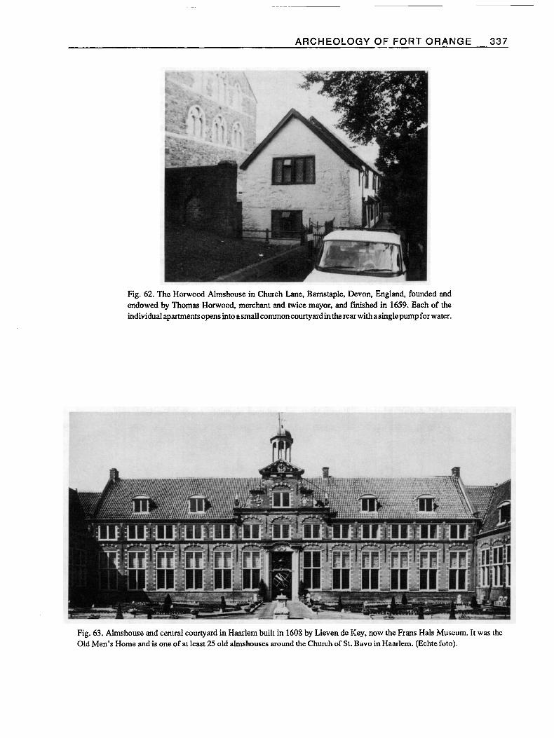
once the Indian War of the 1670s was ended. A significant factor in creating the problems of pauperism in the 17th and 18th centuries in other cities was undoub- tedly the existence of populated settlements on an exposed and vulnerable frontier. In 1696 Reverend John Miller reported that the burdens of the French war in New York “have made 2 or 300 families forsake it, and remove to Pensilvania and Maryland cheifly and some to New England.“29 Albany as well as New York City and Philadelphia were perhaps unique before the 1680s in relying upon the church as the source of charity, but after 1685, New York City and Philadelphia were forced to rely in part also on government funding for poor relief. In England, the 16th century dissolution of monasteries and the enactment of poor laws made the parish as a unit of local government responsible for care of the poor, many generous individuals, however, bequeathed huge sums for charity or built almshouses, particularly in the 17th century (Figure #62). It was the Netherlands which became a source of surprise and admiration to English and other foreign visitors who observed the advanced and elaborate system of care for the poor in cities such as Amsterdam and Haarlem (Figures #63 & 64). The various churches organized charitable institutions, while additional institutions were supervised by individuals appointed by the governing burgomasters of the city.3o
Almshouses of the 17th century in both England and the Netherlands varied in style from plain to very fancy. They consistently included a number of small apartments
or house units facing an enclosed central courtyard and a pump or spring for a common source of ‘water. In the Netherlands, charitable institutions grew steadily in number and in specialization, with separate estab- lishmeats for children, elderly men, elderly women, the sick, and other persons in need of assistance or care.31 Workhouses in England accommodated increasing num- bers of the poor in addition to “idle and disorderly persons.” In the 18th century the town poor of Barnstaple, Devon, were set to work in a workhouse established in 1615 at “spinning, carding and weaving [wool] into proper cloth for cloathing the poor.” Archeological excavation of the building :site revealed rough, depressed areas in the floor, a row of holes for wooden posts, possibly for a large loom, and a sump and drain which was probably for washing fleeces. The local poor taken into the workhouse established in Padstow, Cornwall, about 1768 were employed in knotting rope yarn, picking rope to produce oakum for caulking ships, carding wool, knitting stockings, spinnmg yarn, and making linen clothing for other poor persons. Their lives were strictly regulated. In the Netherlands, the estab- lishment of work-houses for the poor became widespread after 1790 in cities such as Haarlem, where, in 1806, a large almshouse was turned into a workhouse for the poor as an experiment.32
When the Board of Trade in the 1690s began to suggest the construction of workhouses in Maryland, the colonial assembly rejected the idea, explaining “the
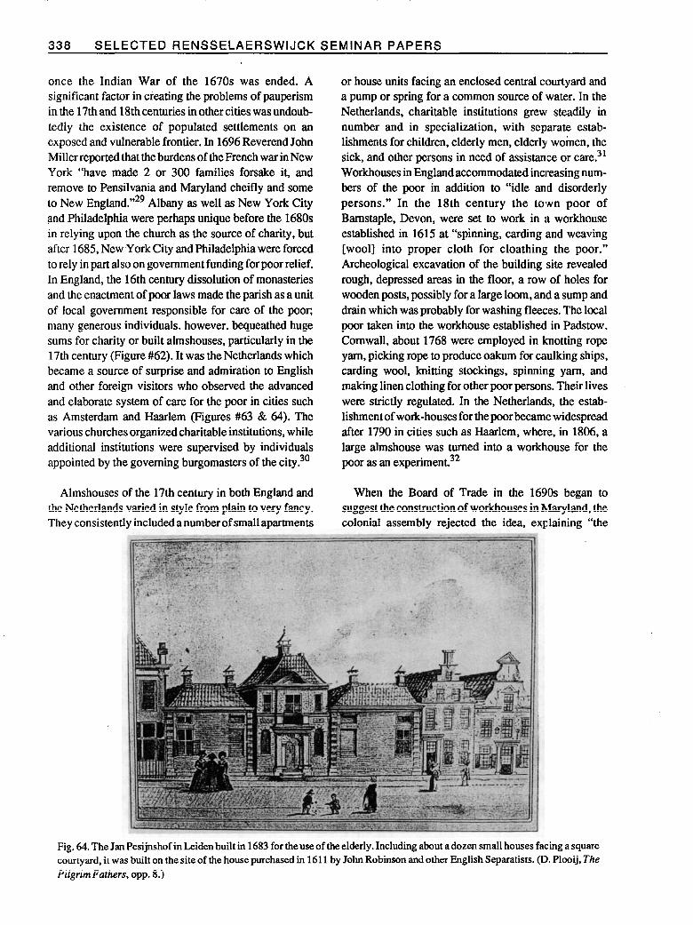
Fig. 64. The Jan Pesijnshof in Leiden built in 1683 for the use of the elderly. Including about a dozen small houses facing a square courtyard, it was built on the site of the house purchased in 1611 by John Robinson and other English Separatists. (D. Plooij, The PilgrimFathers, opp. 8.)

ARCHEOLOGY OF FORT ORANGE 339
Province.wants workman, . . .workeman want not work.” Only a very few places in the American colonies erected workhouses, and those did not establish strict disci- plinary or punitive routines. The Boston workhouse became little more than an adjunct to the town almshouse. Colonial almshouses, it is believed, general- ly resembled family households in structure and routine. David Rothman has found, moreover, that they “lacked both a distinctive architecture and special administrative procedures.” The 18th century ahnshouses of New York and Baltimore on the outside resembled ordinary residences or other neighborhood buildings, and the resi- dents lived as they would in a family.33
A careful study of the artifacts excavated in 1986 from the stratified sequence of soils that accumulated in the Albany almshouse cellar may reveal more definite infor- mation about whether the structure was used for its intended purpose. One of the most outstanding charac- teristics of these deposits was perhaps the immense amount of shell debris from the making of wampum. Bach stage of the manufacture of the small wampum beads was represented in the archeological evidence: there were steel drills and abrading stones, unfinished beads broken during manufacture, and thousands of purple or white clam shell fragments and pieces of conch or whelk shells.
Because of its great value to the Indians, wampum had become essential for trade and served as a basic medium of exchange in the 17th century. It is possible the almshouse in Albany also functioned as a workhouse and wampum factory beginning late in the 17th century, representing a significant shift in the source and value of wampum. Very little, if any, distinct evidence of wampum making, for example, appeared in the 17th century soil layers at Fort Orange dating before 1676. The Dutch Reformed Church hired a person for sixteen days to string wampum in 1669, while careful inven- tories of the sacks of wampum and specie in the church treasury were recorded until 1696, when the treasury was depleted from the expenses of improvements to real estate and new construction?4
The use of conch or whelk shells to make wampum, in addition to the more commonly used hard shell clams of Long Island, is reported as early as 1653 by Van der Donck, who observed that wampum was made only near the seashores and that conch shells were washed ashore twice a year. By 1659 barrels of conch shells were being shipped to New Amsterdam from Curacao. Albany had
become known as a place of wampum manufacture as early as 1690, when in January of that year at Onondaga, representatives from Albany met with Ottawa Indians who expressed a desire “to learn understanding from them & the Christians. . . [and] go quite to Albany to see . . . where the Wampum pipes [beads] are made.” A Scottish visitor to Albany in 1744 noticed the “manufac- torys for wampum” in the city, where the beads were made from clam shells as well as from conch shells from the West Indies. The scale of this manufacture is indi- cated by the order of Cornelius Cuyler, an Albany trader, in 1753 for 40,000 clam shells and 500 conch shells to be sent from New York. Many people in Albany made wampum to supply the trade, according to Kalm, and William Smith in 1757 observed “There are always several poor families at Albany, who support themselves by coining this cash for the traders.“35
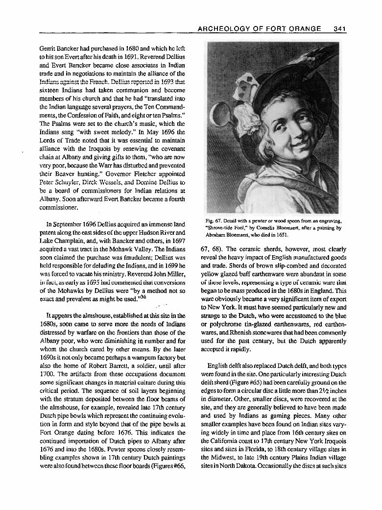
Careful study of the archeological evidence may reveal to what extent, if any, the almshouse began to be used as a wampum factory during the 169Os, particularly after depletion of the church’s wampum stock by 1696. Romer’s detailed map of Albany in 1698 shows a build- ing in the north part of the almshouse property identified as “The Indian Praying House.” It was probably a part of the almshouse or adjoined it to the east. With the begin- ning of war with France in 1689, conversion of the Indians had become vitally important to the church in Albany and its membership. Thus, not only was there evidence of the making of wampum in the almshouse site, but numerous items typical of the Indian trade were also found: an iron trade axe, Jew’s harps, scissors, glass beads, iron knives, and “gaming pieces*’ made from sherds of tin-glared earthenware (Figure #65). In 1689, the Reformed Church collected 252 guilders from various donors “for gunpowder at the almshouse;” one can easily imagine that Indians coming to Albany and staying at the almshouse or the “Praying House” were eager to be given gunpowder, whether as charity or in exchange for furs.
Reverend Godfrey Dellius was Reformed Church minister from I683 to 1699, and hebecame very influen- tial with the Indians. Not only did he teach them Chris- tianity but he also endeavored to maintain their alliance with the British after 1689 during the difficult and dangerous time of war which followed. French attacks left many Mohawk Indians homeless early in the 169Os, and it is easy to understand how the almshouse may have become a temporary refuge for homeless Indians. Immediately west of the almshouse was the land which
340 SELECTED RENSSELAERSWIJCK SEMINAR PAPERS -
Fig. 65. Dutch delft sherd excavated at the Key Corp site, from a lobed dish, reworked to form a circular disc pendant or gaming piece.
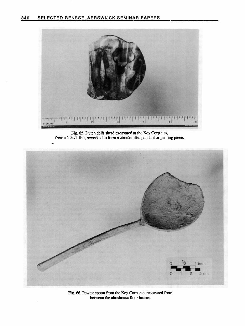
Fig. 66. Pewter spoon from the Key Corp site, recovered from between the almshouse floor beams.
ARCHEOLOGY OF FORT ORANGE 34-l
Gerrit Bancker had purchased in 1680 and which he left to his son Evert after his death in 169 1. Reverend Dell&s and Ever-t Bancker became close associates in Indian trade and in negotiations to maintain the alliance of the Indians against the French. Dellius reported in 1693 that sixteen Indians had taken communion and become members of his church and that he had “translated into the Indian language several prayers, the Ten Command- ments, the Confession of Faith, and eight or ten Psalms.” The Psalms were set to the church’s music, which the Indians sang “with sweet melody.” In May 1696 the Lords of Trade noted that it was essential to maintain alliance with the Iroquois by renewing the covenant chain at Albany and giving gifts to them, “who are now very poor, because the Warr has disturbed and prevented their Beaver hunting.” Governor Fletcher appointed Peter Schuyler, Dirck Wessels, and Domine Dellius to be a board of commissioners for Indian relations at Albany. Soon afterward Evert Bancker became a fourth commissioner.
In September 1696 Dellius acquired an immense land patent along the east sides of the upper Hudson River and Lake Champlain, and, with Bancker and others, in 1697 acquired a vast tract in the Mohawk Valley. The Indians soon claimed the purchase was fraudulent; Dellius was held responsible for deluding the Indians, and in 1699 he was forced to vacate his ministry. Reverend John Miller, in fact, as early as 1695 had commented that conversions of the Mohawks by Dellius were “by a method not so exact and prevalent as might be ~sed.“‘~~
c --
It appears the almshouse, established at this site in the 168Os, soon came to serve more the needs of Indians distressed by warfare on the frontiers than those of the Albany poor, who were diminishing in number and for whom the church cared by other means. By the later 1690s it not only became perhaps a wampum factory but also the home of Robert Barrett, a soldier, until after 1700. The artifacts from these occupations document some significant changes in material culture during this critical period. The sequence of soil layers beginning with the stratum deposited between the floor beams of the almshouse, for example, revealed late 17th century Dutch pipe bowls which represent the continuing evolu- tion in form and style beyond that of the pipe bowls at Fort Orange dating before 1676. This indicates the continued importation of Dutch pipes to Albany after 1676 and into the 1680s. Pewter spoons closely resem- bling examples shown in 17th century Dutch paintings were also found between these floor boards (Figures #(is,
Fig. 67. Detail with a pewter or wood spoon from an engraving, “Shrove-tide Fool.” by Comelis Bloemaert, after a painting by Abraham Bloemaext, who died in 1651.
67, 68). The ceramic sherds, however, most clearly reveal the heavy impact of English manufactured goods and trade. Sherds of brown slip-combed and decorated yellow glazed buff earthenware were abundant in some of these levels, representing a type of ceramic ware that began to be mass produced in the 1680s in England. This ware obviously became a very significant item of export to New York. It must have seemed particularly new and strange to the Dutch, who were accustomed to the blue or polycbrome tin-glazed earthenwares, red earthen- wares, and Rhenish stonewares that had been commonly used for the past century, but the Dutch apparently accepted it rapidly.
English delft also replaced Dutch delft, and both types were found in the site. One particularly interesting Dutch delft sherd (Figure #65) had been carefully ground on the edges to form a circular disc a little more than 2% inches in diameter. Other, smaller discs, were recovered at the site, and they are generally believed to have been made and used by Indians as gaming pieces. Many other smaller examples have been found on Indian sites vary- ing widely in time and place from 16th century sites on the California coast to 17th century New York Iroquois sites and sites in Florida, to 18th century village sites in the Midwest, to late 19th century Plains Indian village sites in North Dakota. Occasionally the discs at such sites
342 SELECTED RENSSELAERSWIJCK SEMINAR PAPERS
Fig. 68. Detail with a pewter spoon from The Dancing Couple by Jan Steen, 1663. A leather shoe similar to the one shown was also excavated from the Key Corp site, in the south portion that probably predates 1685. (Widener Collection, National Gallery of Art, Washington, D.C.)
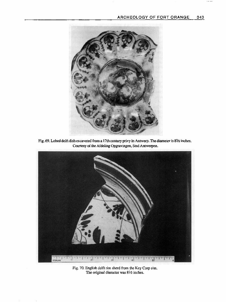
were bored through to make pendants. In England, similar discs fashioned from delft sherds and dating from the late 17th or early 18th centuries have been excavated from a cellar on the south side of Aldgate in London.37 This specimen from the almshouse site is from a 17th century lobed dish, made probably in Delftbetween 1640 and 1660. It is simply decorated with figurative flowers in blue and dark purple. The repetitive pattern around the rim and the lobed shape match a complete example excavated in Delft. Another complete, closely similar example is in the collection of Museum Het Princessehof at Leeuwarden. A third example of a lobed dish, ex- cavated from a 17th century privy in Antwerp, also bears a repetitive flower pattern on the rim from which the pattern on the almshouse sherd was clearly derived (Fig- ure #69). A fourth example was excavated in Virginia at a plantation site occupied from about 1670 to 1730. As many thousands of these dishes were produced and decorated by hand, elements of such patterns naturally evolved or were reduced to simplified but still recog- nizable forms. The technology of making tin-glazed majolica and delft spread directly from the Netherlands to London and Norwich, and since the workmen and even the raw materials were often of Dutch origin, the
early English products are similar and probably indistin- guishable from much that was made in the Low Countries. A dated lobed dish made probably at Brislington, near Bristol, in 1683 is also decorated in blue and purple and has a rim pattern that is clearly derived from that of the almshouse specimen and the other Dutch examples3’
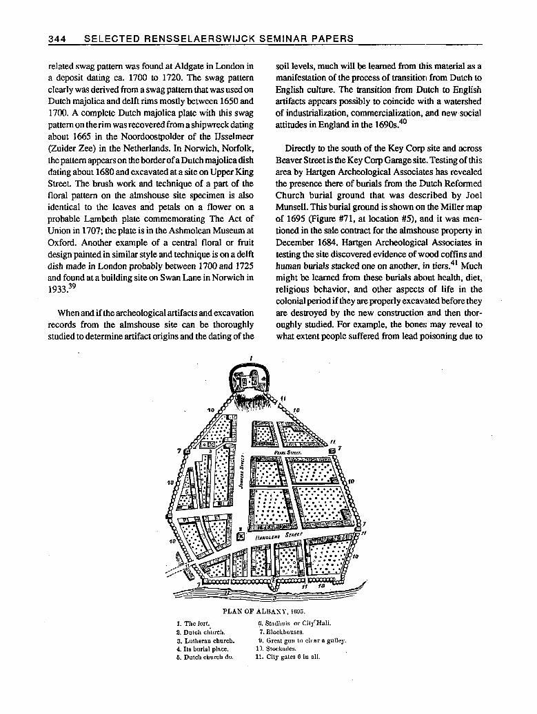
Another blue-decorated delft sherd :is from a plate originally about 8th inches in diameter. It was found in the soil between the almshouse floor beams and is clearly English in origin (Figure #70). Its shape and its distinc- tive concentric pattern of blue rings and a band around the rim indicate that it is a product of the: delft pottery at Lambetb, in London, probably from as early as ca. 1710. Dated examples of this rim pattern are from 1712 and 1719. Many existing examples commlemorate Queen Anne or King George I. The shape of the plate is typical of Lambeth from as early as 1690. ‘This plate was decorated in the center with swags surrounding a floral pattern, and part of this swag decoration closely resembles that on the rim of a Lambeth delft plate excavated in St. Olave’s Parish in Soutlhwark, London. Another London delft dish with a similar or closely
ARCHEOLOGY OF FORT ORANGE 343
Fig. 69. Lobed delft dish excavated from a 17th century privy in Antwerp. The diameter is 8% inches. Courtesy of the Afdeling @gravingen, SFad Antweqen.
Fig. 70. English delft rim sherd from the Key Corp site. The original diameter was 8U inches.
344 SELECTED RENSSELAERSWIJCK SEMINAR PAPERS
related swag pattern was found at Aldgate in London in a deposit dating ca. 1700 to 1720. The swag pattern clearly was derived from a swag pattern that was used on Dutch majolica and delft rims mostly between 1650 and 1700. A complete Dutch majolica plate with this swag pattern on the rim was recovered from a shipwreck dating about 1665 in the Noordoostpolder of the IJsselmeer (Zuider Zee) in the Netherlands. In Norwich, Norfolk, the pattern appears on the border of a Dutch majolica dish dating about 1680 and excavated at a site on Upper King Street. The brush work and technique of a part of the floral pattern on the almshouse site specimen is also identical to the leaves and petals on a flower on a probable Lambeth plate commemorating The Act of Union in 1707; the plate is in the Ashmolean Museum at Oxford. Another example of a central floral or fruit design painted in similar style and technique is on a delft dish made in London probably between 1700 and 1725 and found at a building site on Swan Lane in Norwich in 1933.39
When and if the archeological artifacts and excavation records from the almshouse site can be thoroughly studied to determine artifact origins and the dating of the
soil levels, much will be learned from this material as a manifestation of the process of transition from Dutch to English culture. The transition from Dutch to English artifacts appears possibly to coincide with a watershed of industrialization, commercialization, and new social attitudes in England in the 1690s:’
Directly to the south of the Key Carp site and across Beaver Street is the Key Corp Garage site,. Testing of this area by Hartgen Archeological Associates has revealed the presence there of burials from the Dutch Reformed Church burial ground that was described by Joel Munsell. This burial ground is shown on the Miller map of 1695 (Figure #71, at location #5), alnd it was men- tioned in the sale contract for the almshouse property in December 1684. Hartgen Archeological Associates in testing the site discovered evidence of wood coffins and human burials stacked one on another, in tiers.41 Much might be learned from these burials about health, diet, religious behavior, and other aspects of life in the colonial period if they are properly excavated before they are destroyed by the new construction and then thor- oughly studied. For example, the bones may reveal to what extent people suffered from lead poisoning due to
PLA’PI OF ALBAST, 1635.
1. The fort. 2. Dulch &WC!,. 3. Lntherau church. 4. Its burisl place. 6. Dutch church do.
(l. S1:dhuis 01’ Cify’Hali. 7. Blockhouses. 9. Great guo to cknr * gulley.
11. Stockndes. 11. City gates 0 io 011.
ARCHEOLOGYOFFORTORANGE 345 -
the frequent use of pewter utensils and of lead glazed ceramics. Historic burials such as these should at least be treated with respect rather than be bulldozed. In his address to the Albany Institute on April 18, 1876, Joel Munsell said of this site
The ancient denizens of the city still repose there in three layers, and I wish every one of their descendants could be thoroughly imbued with a filial sentiment of the impropriety, to say the least, of ever parting wirh that ground; but that the church edifice now standing upon it might be preserved as a monument to the venerated dead beneath. The bones of Anneke Janse being sup- posed to rest there, and so great a multitude claiming descent from her, what adverse influence might arise from a mercenary aliena- tion of those bones, should give us pause1
The church that stood there was the Middle Butch Reformed Church, a beautiful structure built in 1806 by Philip Hooker and vacated in 188 1 .42
Preservation Priorirties and Planning
The archeological remains from the colonial period that have survived in Albany are a priceless resource that must be carefully managed. The location and extent of archcologically significant deposits must first be identified, and decisions should be made during the process of planning for new development whether a specific site can be preserved or, if not, whether it should be excavated for its research value. Except for limited sampling to answer specific research questions, it is often best to leave non-threatened sites as resources for the future, when there will be not only greatly improved techniques of excavation and analysis but also more refined research questions.
Archeologists have hardly scratched the surface in terms of making a significant contribution of data toward the study of 17th century urbanization or of urban and rural cultural patterns. Enough carefully documented urban sites have not yet been excavated by archeologists to produce contmlled samples of artifacts with which to make meaningful comparisons between sites. Too many sites are instead being lost, while time and funding for excavation projects are usually not available or sufficient to enable completion of analysis of the artifacts and other data at a meaningful historical and anthropological level.
Smaller cities are sometimes reluctant to require developers to pay for the archeology that is necessary as a consequence of their new construction, even when irreplaceable information on a city’s earliest history will be lost forever. In European cities such as London and Amsterdam, extensive urban archeology is successfully conducted at no charge to developers by the full-time archeology department of a city historical museum. The excavations are planned in advance of construction, and developers usually grant permission. The developers, however, pay the costs indirectly through higher tax rates that would be unacceptable to many large American businesses.43 Thus, it becomes a social responsibility for the American private sector to mitigate any harmful effects of new development which may be initiated. Whether private support for mitigation of the adverse effects of new development on cultural resources will be sufficient to sustain archeological work. of quality without the need for government regulation in the public interest remains to be seen.
346 SELECTED RENSSELAERSWIJCK SEMINAR PAPERS
Notes
‘A.J.F. van Laer, trans. and ed., Van Rensselaer Bowier Manuscripts (Albany: University of the State of New York, 1908), 298,454-55; A.J.F. van Laer, trans. and ed., Minutes of the Court of Rensselaerswyck: 1648- 1652 (Albany: University of the State of New York, 1922), 21-22; David Grayson Allen, “‘Vacuum Domicilium’: The Social and Cultural Landscape of Seventeenth-Century New England,” New England Begins: The Seventeenth Century (Boston: Museum of Fine Arts, 1982), I: 4-6, 28-29; Henry M. Miller, A Searchfor the “Citty of Saint Maries” (St. Mary’s City: St. Mary’s City Commission, 1983), 1; Garry Wheeler Stone, “Manorial Maryland,” Maryland Historical Magazine, 82/l (Spring 1987): 3, 11-12. 2Charles N; Glaab and A. Theodore Brown, A History of Urban America (New York, London: Macmillan Com- pany, 1968), 7; Charles T. Gehring, trans. and ed., New York Historical Manuscripts: Dutch. Volumes GG, HH, &
II: Land Papers (Baltimore: Genealogical Publishing Co., 1980), 93; Van Laer, Minutes of the Court of Rensselaerswyck, 18,151;A.J.F.va.nLaer,trans.anded., Minutes of the Court of Fort Orange and Beverwyck: 16.52-16.56 (Albany: University of the State of New York, 1920), 8; Paul R. Huey, “Archaeological Excava- tions in the Site of Fort Grange, a Dutch West India Company Trading Fort Built in 1624,” New Netherland Studies: Bulletin KNOB, 84/2-3 (Juni 1985): 73. 3Edmund B. O’Callaghan, Calenaiar ofDutch Historical Manuscripts, (Ridgewood: Gregg Press, 1968), 134, 180, 191; Eric E. Lampard, “American Historians and the Study of Urbanization,” The American Historical Review, r~v11/1 (October 1961): 50, 54, 56; Allen, “‘Vacuum Domicilium’,” 29. 4Joel Munsell, The Annals of Albany, I (Albany: Joel Munsell, 1869), 235; Joel Munsell, The Annals of Albany, II (Albany: J. Munsell, 1850). 195. ‘Munsell, The Annals of Albany, I: 257; Albany County Deeds, Book 61: 249,263; George Dexter, ed., Journal of a Tour from Boston to Oneida, June, I796 by Jeremy Belknap (Cambridge: John Wilson and Son, 1882), 11. 6H. Russell Zimmermarm, “Milwaukee: Cream City Brick,” Historic Preservation, 22/3 (July-Sept. 1970): 5. 7Joel Munsell, Collections on the History of Albany, III (Albany: J. Munsell, 1870), 928; Joel Munsell, Men and Things in Albany Two Centuries Ago (Albany: Joel Munsell’s Sons, n.d.), 6,35; Joel Munsell, The Annals of Albany, I: 130-3 1; S.V. Talcott, Genealogical Notes of New York and New England Families (Baltimore: Genealogical Publishing Co., 1973), 269-70,443-44. *Joel Munsell, The Annals of Albany, v (Albany: J.
Munsell, 1854), 258; Albany Institute of History and Art, catalog number X1940.775.3; Index to the Public Records of the County of Albany, I (Albany: The Argus Company, Printers, 1902): x-xi. The 190:2 reference was noted by John R. Wolcott. ‘“Find Artifacts at Fort Grange,” De Halve Maen, XLV/~
(January 1971): 15. The date on the Rhenish stoneware sherd was indistinct and at first was thought to be 1612 rather than 1632. “Further Finds at Fort Orange,” De Halve Maen, XLVI/~ (April 1971): 2. loVan Laer, Van Rensselaer Bowier Manuscripts, 35- 36,212. “Charlotte Wilcoxen, “Dutch Majolica of the Seven- teenth Century,” American Ceramic Circle Bulletin, 3 (1982): 17-26; Dingeman Korf, Nederlandse majolica (I-h&em: De Haan, 1981). 172-73 andpassim.
12Charles F. Wray, “The Volume of Dutch Trade Goods Received by the Seneca Iroquois, 1600-1687 A.D.,” New
Netherland Studies: Bulletin KNOB, 8412-3 (Juni 1985): 111. 13T. Volker, Porcelain and the Dutch East India Com- pany (L&den: E.J. Brill, 1971), 240, pl. XI (18). 14J. M. Baart, W. Krook, and A.C. Lagaweij, “Herstel- lung und Gebrauch von Trinkglas in Amsterdam (1580- I&IO),” Spechtergliiser: Austellung im Glasmuseum Wertheim, I986 (Wertheim: Glasmuseum Wertheim, 1986), 55-56, 59-60; Tony Oost, Van nederzetting tot metropol (Antwerp: Oudheidkundige :Musea, 1982), 118. “Baart, Krook, and Lagerweij, 56-58.64.69; E. Bar- rington Haynes, Glass Through the Ages (Baltimore: Penguin Books, 1966), pl. 25(b). ‘hart, Krook, and Lag erweij, 55-56, 85; Joel W. Grossman, ed., “The Excavation of Augustine Heermans’ Warehouse and Associated 17th Century Dutch West India Company Deposits” (unpublished draft) New York: Greenhouse Consultants Incorporated, 1985, m-3 1; Henry M. Miller, A Searchfor the “Citty of Saint Maries”, 101-2. 17Paul R. Huey, “Glass Beads from Fort Orange (1624- 1676), Albany, New York,” Proceedings of the 1982 Glass Trade Bead ConjIerence (Rochester: Rochester Museum & Science Center, 1983), 87-90; Baart, Krook, and Lagerweij, 62,66,74-75,77-78. “Henry M. Miller, Dennis J. Pogue, and Michael A. Smolek, “Beads from the Seventeenth Century Chesapeake,” Proceedings of the 1982 Gl~ass Trade Bead Corgference, 131; James W. Bradley, “Bhue Crystals and Other Trinkets: Glass Beads from 16th and Early 17th

ARCHEOLOGY OF FORT ORANGE 347
Century New England,” ibid., 29. “GA. Bredero, The Spanish Brabanter translated by H. David Brumble III (Binghamton: Center for Medieval h Early Renaissance Studies, 1982), 86; Charles T. Gehring, trans. and ed., New York Historical Manuscripts: Dutch. Volumes XVIII-XIX, Delaware Papers (Baltimore: Genealogical Publishing Co., 1981), 92. “Kristin L. Gibbons and Peter H. Stott, Schuyler Mansion: A Historic Structure Report (Albany: New York State Parks and Recreation, 1979), 4. “‘George Irving Quimby, Indian Culture and European Trade Goods (Madison: The University of Wisconsin Press, 1966), 156-57; W.A. Kenyon, The Grimsby Site: A Historic Neutral Cemetery (Toronto: Royal Ontario Museum, 1982), 62,71. “2Paul R. Huey, “Dutch Sites of the 17th Century in Rensselaerswyck,” The Scope of Historical Archaeology edited by David S. Orr and Daniel G. Crozier (Phila- delphia: Laboratory of Anthropology, Temple Univer- sity, 1984), 67,74-75, 23Gorham a. Worth, Random Recollections of Albany, from 1800 to 1808 (Albany: J. Munsell, 1866), 23. 24Hartgen Archeological Associates, Inc., Archeological Investigations at Key Corp Plaza (Troy: Hartgen Archeological Associates, Inc., 1985), 12, Appendix I (517-100). “Van Laer, Van Rensselaer Bowier Manuscripts, 814, 826; Van Laer, Minutes of the Court of Rensselaerswt$k: 1648-1652,136; A.J.F. van Laer, ed., Early Records of the City and County of Albany and Colony ofRensselaerswyck, II (Albany: The University of the State of New York, 1916), 91-92n; Joel Munsell, Collections on the History of Albany, IV (Albany: 3. Munsell, 1871), 231. 26Van Laer, Van Rensselaer Bowier Manuscripts, 826; Berthold Femow, trans. and ed., Documents Relating to the History and Settlements of the Towns Along the Hudson and Mohawk Rivers (Albany: Weed, Parsons and Company, 1881), 219-21; Van Laer, EarlyRecords of the City and County of Albany and Colony of Rensselaerswyck, II: 91, 126-27, 331-32; A.J.F. van Laer, trans. and ed., Correspondence of Maria van Rensselaer: 1669-1689 (Albany: University of the State of New York, 1935), 125. 27Joel Munsell, Collections on the History of Albany, I
(Albany: J. Munsell, 1865), 4547,57; Albany County Deeds, Book 38: 51. The latter reference was provided by John R. Wolcott. *sJoel Munsell, The Annals of Albany, VII (Albany: J. Munsell, 1856), 232-34, 239; Munsell, Collections on the History of Albany, I: 48,51-53, 55; Records of the Reformed Dutch Church of Albany, New York: 1683-
1809 (Baltimore: Genealogical Publishing Co., Inc., 1978), pt. I, 29,49,56,65,73,75,80,83; Third Annual Report of the State Historian of the State of New York, 1897 (New York and Albany: Wynkoop Hallenbeck Crawford Co., State Printers, 1898), 467; Joel Munsell, The Annals of Albany, IV (Albany: Joel Munsell, 1871), 176-77. 2gKenneth Scott, “Orphan Children Sent to New Nether- land,” De Halve Maen, XLIX/~ (October 1974): 5-6, Constance Ross Ulrich, “Mathys Coenradtsen Hough- taling of Coxsackie, New York, and His Descendants,” The New York Genealogical and Biographical Record, 101/4 (October 1970): 193-94; William J. Hoffman, “Random Notes Concerning Settlers of Dutch Descent,” New World Immigrants edited by Michael Tepper, I (Baltimore: Genealogical Publishing Co., Inc., 1980), 129; Carl Bridenbaugh, Cities in the Wilderness (Oxford: OxfordUniversity Press, 1971), 7885,232-38,391-98; W.K. Jordan, The Charities of London: 1480-1660 (Hamden, Ct.: Archon Books, 1974), 170; John Miller, “A Description of the Province and City of New York,” Historic Chronicles of New Amsterdam, Colonial New York and Early Long Island edited by Cornell Joray (Port Washington, N.Y.: Ira J. Friedman, Inc., 1968), 91. A New England writer as early as 1622 suggested that in contrast to the need for almshouses in England, in America, with its spacious land, there would be oppor- tunity for all. Yet, with its almshouse lot of 1652, Bever- wijck may have been the first town to establish an almshouse in North America. The deacons of New Amsterdam built an almshouse in 1653, and Boston built its almshouse in 1662. See Edward Arber, The Story of the Pilgrim Fathers (London: Ward and Downey Limited; Boston and New York: Kraus Reprint Co., 1969), 503, See also Bridenbaugh, 81,84, and David J. Rothman, The Discovery of the Asylum (Boston and Toronto: Little, Brown and Company, 1971), 39. [Ed. note: Jansje Venema, research assistant with the New Netherland Project, completed in 1990 a transcription of the Deacon’s Account Books pertaining to the almshouse and used this new information for a SUNY/Albany master’s thesis on poor care in Bever- wijck.] 3%idenba ugh, 84-85; Jordan, 24,159; G.M. Trevelyan, History of England, II (Garden City: Doubleday & Company, Inc., 1952), 32-33, 124; George B. Adams and Robert L. Schuyler, Constitutional History of England (New York: Henry Holt and Company, 1956), 262; Marjorie and C.H.B. Quennell, A History of Everyday Things in England, II (London: B.T. Batsford, Ltd., 1950), 110-l 1; Renee Kistemaker and Roelof van Gelder, Amsterdam: The Golden Age, 1275-l 795 (PJew York: Abbeville Press, Publishers, 1983), 108, 171; Bredero, 133; Ronald W. Herlan, “Relief of the Poor in Bristol from Late Elizabethan Times until the Restora-
348 SELECTED RENSSELAERSWIJCK SEMINAR PAPERS
tion Era,” Proceedings of the American Philosophical Society, XXVI/ 3 (June 8, 1982): 227-28. 31D. Plooij, The Pilgrim Fathers from a Dutch Point of View (New York: New York University Press, 1932), 8; F.W.J. Koom, DC. van der Maaml, et al., “750 jaar Haarlem, de Haarlemmers en hun armenzorg,“Ach Lieve Tijd (Zwolle: Uitgeverij Waanders b.v., 1984), see text for illustrations on 200-3,208-9,211-12; R. J. Spruit, “Zeven eeuwen Hoom, zijn bewoners en hun zieken en armen,” Ach Lieve Tijd (Zwolle: Uitgeverij Waanders b.v., 1986), text for illustrations on 23-25; Barry Cun- liffe, The City of Bath (New Haven and London: Yale University Press, 1987), 101. 32An Excavation at North Devon Area Library Site, Barnstaple: Summary Report Number 1 (Barnstaple: North Devon District Council, 1985). 1, 7; Donald R. Rawe and Jack Ingrey, Padstow and District (Padstow, Cornwall: Lodenek Press, 1984), 59-61; Koom, Van der Maarel, et al., 205-06. 33Lois Green Carr andRussellR. Menard,“Immigration and Opportunity: The Freedman in Early Colonial Maryland,” The Chesapeake in the Seventeenth Century edited by Thad W. Tate and David L. Ammerman (New York and London: W.W. Norton & Company, 1979), 216; Rothman, 37,41,42,55. 34Munsell, Collections on the History of Albany, I: 31, 44,51. 35Adriaen van der Donck, A Description of the New Netherlands (Syracuse: Syracuse University Press, 1968), 93; Charles T. Gehring and J.A. Schiltkamp, trans. and ed., New NetherlandDocuments, VO~U~~XVII, Curacao Papers: 1640-1665 (Interlaken: Heart of Lakes Publishing, 1987), 138-39, 169, 213, 218; Daniel K. Richter, “Rediscovered Links in the Covenant Chain,” Proceedings of the American Antiquarian Society, 9211 (April 1982): 71-72; Carl Bridenbaugh, ed., Gentleman’s Progress: The Itinerarium of Dr. Alexander Hamilton, 1744 (Chapel Hill: University of North Carolina Press, 1948), 73; Thomas Elliot Norton, The Fur Trade in Colonial New York, 1686-1776 (Madison: The University of Wisconsin Press, 1974), 90; Munsell, The Annals of Albany, I: 57; William Smith, Jr., The History of the Province of New-York edited by Michael Kammen, I (Cambridge: Belknap Press of Harvard University Press, 1972), 51n. The Smith refer- ence was provided by Joseph S. Sopko. 3%Iap of A ba y y 1 n b Wolfgang Romer, 1698, CO7OO/New York 3, Public Record Office, London; Lois M. Feister, “Indian-Dutch Relations in the Upper Hudson Valley,” Man in the Northeast 24 (Fall 1982): 93; Munsell, Collections on the History of Albany, I: 51; E.T: Corwin, ed., Ecclesiastical Records: State of New York (Albany: James B. Lyon, State Printer, and The University of the State of New York, 1901-1916), 799,
1087, 11166, 1169, 1181; Munsell, Annals of Albany, I:
95; John Miller, “A Description of the Province and City of New York,” 52-53. 37Edward P. von der Porten, “Drake andi Cermeno in California: Sixteenth Century Chinese Ceramics,” Historical Archaeology, VI (1972): 15; Kathleen A. Deagan, “Fig Springs: The Mid-Seventeenth Century in North-Central Florida,” ibid., 38.; Mary Elizabeth Good, Guebert Site: an 18th Century, Histor.ic Kaskaskia Indian Village (Wood River, Illinois: The Central States Archaeological Societies, Inc., 1972). 179; G. Hubert Smith, Like-a-Fishhook Village and Fort Berthold, Garrison Reservoir, North Dakota (‘Washington: National Park Service, U.S. Department of the Interior, 1972), 77-78, 173-74; James W. Elradley, The Onondaga Iroquois: 1500-16.55 (Ann Arbor: University Microfilms International, 1979). 221; Alan Thompson, Francis Grew, and John Schofield, “Excavations at Aldgate, 1974,” Post-MedievalArchaeology, 18 (1984): 118-19. Most of the above references were collected by Joseph E. McEvoy. 38J. D. van Dam, Geleyersgoet en Hollants Porceleyn, Mededelingenblad Nederlandse Vereniging van Vrien- den van de Ceramiek, 108 (1982/4): 52,75,92; Michael Archer, “Delftware from Brislington,” The Connoisseur, 171/689 (July 1969): 152,157,158; Frazier D. Neiman, The “Manner House” Before Strarford (D,iscovering the Clifts Plantation) (Stratford, Va.: Stratfor~d Hall, 1980). 44. The delft dish from Antwerp is in the Oudheidkun- dige Musea of Anhverp. 39F.H. Garner and Michael Archer, English Delftware (London: Faber and Faber, 1972). 80, pls. 66A, 66C; Michael Archer and Brian Morgan, F,air as China Dishes: English DeFtware (Washington: International Exhibitions Foundation, 1977), 78.81.126-27; Michael Archer, English DelftwarelEngels Deljts Aardewerk (Amsterdam: Rijksmuseum, n.d.), 35, fig..80; Ivor Noi? Hume, Early English Delftware from London and Virginia (Williamsburg: The Colonial Williamsburg Foundation, 1977), 99, 100; Anthony Ray, English D&ware Pottery in the Robert Hall Warren Collection, Ashmoleon Museum, O#ord (Boston: Boston Book & Art Shop, 1968), ~1.7; Thompson, Grew, and Schofield, 35.56, 57 (no. 118); Korf, 56 (fig. 107, type 127), 240 (fig. 710); Sarah Jennings, Eighteen Centuries of Pottery from Norwich (Norwich: University of East Anglia, 1981), 192,194 (fig. 1381), 209,210 (fig. 1490). 4oNeil McKendrick, John Brewer, and J.H. Plumb, The Birth of a Consumer Society: The Commercialization of Eighteenth-Century England (Bloomington: Indiana University Press, 1985), 13-15,265,268,271,287. 4*Hartgen Archeological Associates, Inc., Dutch Reformed Church Burial Ground, c. 1656-1882 (Troy: Hartgen Archeological Associates, Inc., 1986). 5.

ARCHEOLOGY OF FORT ORANGE 349 -
42Munsell, Men and Things in Albany Two Centuries Maen, XLVIII/~ (April 1973): 1 l-12. Ago, 35-36; see also George 0. Zabriskie, “The Found- 43Martin Biddle and Daphne M. Hudson, The Future of ing Fathers of New Netherland, Nos. 5 and 6: The London’s Past (Worcester: Rescue, a trust for British Roelofs and Bogardus Families, Part III,” De Halve Archaeology, l973), 8,28,47-49.
![Scotland’s Geospatial Renaissance Periodinspire.ec.europa.eu/events/conferences/inspire... · Pont’s Map of Renaissance Period [1650s] The twin summits of Ben Vorlich ( Bin Vouirlyg)](https://img.pdfslide.us/doc/110x75/602b1add1bb8ae550968294d/scotlandas-geospatial-renaissance-pontas-map-of-renaissance-period-1650s-the.jpg)