Embed Size (px)
Citation preview
The University of MaineDigitalCommons@UMaine
Miscellaneous Reports Maine Agricultural and Forest Experiment Station
12-2015
MR447: Seasonal Water Table and TemperatureRelationships in Calcareous Till and Residual Soilsof Central MaineDavid E. [email protected]
Christopher C. Dorion
Nicholas R. Butler
Ivan J. [email protected]
Follow this and additional works at: http://digitalcommons.library.umaine.edu/aes_miscreports
Part of the Soil Science Commons
This Report is brought to you for free and open access by DigitalCommons@UMaine. It has been accepted for inclusion in Miscellaneous Reports byan authorized administrator of DigitalCommons@UMaine.
Recommended CitationTurcotte, David E., Christopher C. Dorion, Nicholas R. Butler, and Ivan J. Fernandez. 2015. Seasonal water table and temperaturerelationships in calcareous till and residual soils of central Maine. Maine Agricultural and Forest Experiment Station MiscellaneousReport 447.

College of Natural Sciences, Forestry, and Agriculture
Maine Agricultural and Forest Experiment StationMiscellaneous Report 447 • December 2015
ISSN: 1070-1516
Seasonal Water Table and Temperature Relationships in Calcareous Till and Residual Soils of Central MaineDavid E. Turcotte, Christopher C. Dorion, Nicholas R. Butler, and Ivan J. Fernandez


Seasonal Water Table and Temperature Relationships in Calcareous Till and Residual Soils of Central Maine
David E. Turcotte USDA-Natural Resources Conservation Service, Dover-Foxcroft, Maine (retired)
Christopher C. Dorion C.C. Dorion Geological Services, LLC, Portland, Maine
Nicholas R. Butler USDA-Natural Resources Conservation Service, Dover-Foxcroft, Maine
Ivan J. Fernandez School of Forest Resources, University of Maine, Orono, Maine
Email: [email protected]
Maine Agricultural and Forest Experiment Station Miscellaneous Report 447 • December 2015
College of Natural Sciences, Forestry, and Agriculture 5782 Winslow Hall University of Maine Orono, ME 04469-5782

ii
The University of Maine does not discriminate on the grounds of race, color, religion, sex, sexual orientation, including transgender status and gender expression, national origin, citizenship status, age, disability, genetic information, or veteran status in employment, education, and all other programs and activities. The following person has been designated to handle inquiries regarding nondiscrimination policies: Director, Office of Equal Opportunity, 101 North Stevens Hall, 581.1226, [email protected].
ABSTRACTWater table depths and soil temperatures were monitored for four growing seasons in six calcareous till pedons
developed on gently rolling to level till plains in Corinth and Exeter, Maine. These soils are part of a new catena that supports potato production in southeastern Penobscot County. Three of these coarse-loamy to fine-loamy pedons are moderately well drained (MWD) Oxyaquic Eutrudepts taxadjuncts in potato fields, and three are somewhat poorly drained (SPD) Aquic Dystric Eutrudepts (or taxadjuncts thereof) in predominantly deciduous forest. Soil morphology, hydrologic data, and a,a dipyridyl applications support the described subgroup classification of each pedon, along with the udic moisture regime. Despite a smooth, glaciated landscape that would suggest the presence of extensive lodgment till, five observation sites lacked a densic contact and one contained residuum (saprolite) in the substratum. Apparent water tables in the SPD very deep soils, as well as oxyaquic hydrology in the deep soils on 0 to 3 percent slopes, suggest the more permeable subglacial melt-out till predominating, rather than lodgment till in all of these pedons. It is likely that densic materials were present following deglaciation and that the processes of soil flocculation and acid solution weathering of rock fragments throughout the Holocene has alleviated the original compaction. Similar bedrock and soil parent material have been found in the potato lands of northeastern Aroostook County, Maine. Growing season concepts were compared based on frost-free season at 0 and -2.2° C thresholds, soil temperatures in the plow layer, soil temperature at 50 cms and well-water temperature. The commencement of the growing season in the spring did not differ much across all five concepts. However, in the fall there was a 4- to 8-week lag between the air or shallower soil-temperature growing-season concepts and the deeper soil or well-water-temperature growing-season concepts. During this lag period, most terrestrial plants are dormant while soil microbial activity is presumably still active. Daytime air temperature during the first 2 years of monitoring differed significantly between spring and fall seasons, but not between field and forest sites within each season.
ACKNOWLEDGMENTSThe authors express gratitude to Warren C. Lynn, deceased soil scientist from the National Soil Survey Center
in Lincoln, Nebraska, who provided key guidance for the study’s experimental design. They also are thankful for the contributions of Lindsay Hodgman from the Natural Resource Conservation Service in Bangor, Maine, who helped developed several of the figures.

iii
Contents
CALCAREOUS TILL SOILS OF MAINE 1
Comparisons with Existing Soil Series 1
A New Catena Is Established 3
Comparison of NRCS and MAPSS Drainage Classifications 4
Bedrock Geology 4
Study Objectives 5
DESCRIPTIONS AND DATA TO SUPPORT A NEW CATENA 6
Location and Duration of Study 6
Description of Study Sites 6
Instrumentation and Measurements 6
Analyses of Data 9
PRESENTATION OF RESULTS 9
Precipitation and Soil Moisture Regime 9
The “Invisible” Seasonal High Water Table 10
Moisture Regime Subclasses and Drainage Class for the Wassookeag Soil Series 10
Moisture Regime Subclasses and Drainage Class for the Kenduskeag Soil Series 12
Perched vs Apparent Water Tables 12
Growing Season Comparisons 12
Effect of High Water Tables on Soil Temperatures 15
Effect of Canopy Cover 15
DISCUSSION OF RESULTS 15
Soil Hydrology, Morphology and Tilth on Calcareous Till Plains 15
Comparison of Frost-free vs Edaphic-based Growing Seasons 17
CONCLUSIONS 18
LITERATURE CITED 18
APPENDIX 21

iv
Tables
1. Five new and two preexisting soil series, their drainage classes, and depth to bedrock. 3
2. Site/soil characteristics of the southern Penobscot County water table study. 7
3. Horizon properties of soils of southern Penobscot County water table study. 8
4. Corinna daily NOAA Climatic Station. 10
5. Water tables in monitoring wells during normal precipitation seasons at Wassookeag sites. 11
6. Water tables in monitoring wells at the Kenduskeag sites. 14
Figures
1. Regional location of study sites in southern Penobscot County. 2
2. Comparison of the MAPSS drainage class system and the NRCS Soil Survey Staff aquic vs oxyaquic subgroup classification system for loamy soils in this study. 4
3. Limestone members of the Waterville and Sangerville bedrock formations in central and southern Maine. 5
4. Substratum H2O table levels at lower Kenduskeag site in Corinth. 12
5. Substratum H2O Table Levels at Upper Kenduskeag Site in Corinth. 13
6. Growing seasons based on mean air, 10-cm soil depth, 50-cm soil depth, and well-water temperatures. 13
7. Mean afternoon air temperatures in spring and fall 2002 and 2003. 14
8. Subglacial melt-out till over saprolite at Exeter Wassookeag site. 16
9. 10YR 4/1 decayed fragment in Bw-horizon of Kenduskeag pedon at lower Beans Mill site. 17

Maine Agricultural & Forest Experiment Station Miscellaneous Report 447 1
CALCAREOUS TILL SOILS OF MAINE
Base saturation is a soil property that reflects the relative availability of essential cationic nutrients and the balance between acids and bases in soils. For this rea-son, base saturation is an important index of productiv-ity for crop production in humid regions. Macronutrient cations (calcium, magnesium, and potassium) compete with hydrogen and aluminum for exchange sites, and if the balance between these cations favors the latter two, then a nutrient deficiency can occur because of absolute limits on nutrient availability, or competition with aluminum for uptake by roots. Hence, it is not a coincidence that prime farmland tends to occur on soils with high base saturation in humid regions.
Where till plain and ground moraine landforms (USDA, NRCS 2015) in humid regions occur over cal-careous bedrock, deeper soils with higher base satura-tion typically have deeper sola and/or more friable substrata. In Maine, this has been demonstrated and documented in potato-growing regions of Aroostook County, (Arno 1964a, 1964b; Rourke and Bangs 1975), neighboring New Brunswick (Arno et al. 1964), and central Maine (Goodman 1963; Arno 1972; Rourke and Bangs 1975). In these areas, crop production is also enhanced by better drainage due to deeper sola and/or higher saturated hydraulic conductivity in the substrata, as well as higher water-holding capacity in the sola and substrata. The primary reason for this is the way calcium and magnesium carbonates enhance soil flocculation (Brady and Weil 2002). As divalent cations, calcium and magnesium encourage individual colloidal particles to come together as small aggregates called floccules, thereby resulting in higher soil macro-porosity. Another contributing reason for higher macro-porosity is that, in humid regions, calcareous rocks dissolve in place after being leached of free carbonates, leaving insoluble, soft residue.
Additional morphological indicators of high base saturation, glacial till soils in Maine include decayed fragments, or limestone ghosts (Goodman 1963; Arno 1964a, 1964b; Arno et al. 1964; Bates and Jackson 1984); parafragments (Schoeneberger et al. 2012); subangular blocky structure in the substrata; paralithic materials (Schoeneberger et al. 2012; Soil Survey Staff 2014a); and/or saprolite (USDA, NRCS 2015). Decayed rock fragments, paralithic materials, and saprolite are
a result of acid solution weathering (Birkeland 1984; Brady and Weil 2002) on calcareous rocks or bedrock: CaCO3 + CO2 + H2O >>> Ca++ + 2HCO3
–. Parachanners are both a function of acid solution weathering and the mechanical breakdown of thinly bedded phyllite and shale that split into thin flakes.
Podzolization is a form of pedogenesis where sandy to loamy, relatively acid soils in humid regions have a significant eluviated horizon, typically below a layer of hemic–sapric organic material in a forested setting (Birkeland 1984; Buol et al. 1997). The albic horizon loses iron, aluminum, and organic matter, which move downward, precipitating in a lower illuvial spodic ho-rizon (Soil Survey Staff 2014a). In forested areas with no evidence of prior agronomic land use, somewhat poorly drained (SPD) and better drained soils derived from calcareous till exhibit minimal podzolization. This is predominantly a function of higher pHs and base saturation that facilitate mixing by micro- and macrofauna (commonly earthworms) and leave iron and aluminum as less soluble.
Reich et al. (2005) observed the highest levels of calcium in deciduous (vs coniferous) litter in replicated, long-term monoculture plot experiments on 14 tree species in Poland. Not coincidentally, higher earthworm concentrations and associated cycling and movement of carbon correlated significantly with higher levels of calcium in the litter. In Maine, the maple (Acer saccharum)–ash (Fraxinus americana)–basswood (Tilia americana) forest cover type (Maine Natural Areas Program 2015) is often indicative of these enriched soils, along with the presence of northern white cedar (Thuja occidentalis) (Eyre 1980). Alternatively, very acidic litter from coniferous Picea spp., Tsuga spp., Abies spp., Pinus spp., and Larix spp. inhibits decomposition of organic carbon, resulting in thicker O horizons and more pronounced podzolization (Nauman et al. 2015).
Comparisons with Existing Soil SeriesSoil series1 of the Caribou and Bangor catenas in
Maine2 represent the higher base saturation soils of the published soil surveys of Aroostook, Penobscot and Somerset counties, respectively (Rourke and Hardesty 1966; Hutchinson 1968; Rourke and Bangs 1975; Hughes, personal communication). The Caribou
1 https://soilseries.sc.egov.usda.gov/osdname.asp
2 http://efotg.sc.egov.usda.gov/references/public/ME/ME_Catena_Key_2015.pdf

Maine Agricultural & Forest Experiment Station Miscellaneous Report 4472
catena is prevalent in Major Land Resource Area (MLRA) 146 (Figure 1), while the Bangor catena occupies por-tions of MLRA 144b (Figure 1) in central Maine and MLRA 143 in northern New Hampshire. These MLRAs are within the northeastern forage and forest region (USDA, NRCS 2006). Not coincidentally, these were the prevalent soils that were delineated in each of these county’s potato-growing regions. Slightly acidic soils, balmy summer nights, and cool fall nights make these regions in Maine ideal for growing potatoes.
Caribou catena soils are fine-loamy, while Bangor catena soils are coarse-loamy. The finer textures of the Caribou catena are likely due to the softer, more eas-ily weathered nature of the sedimentary bedrock that
the till is weathered from, compared to the metamor-phic bedrock of the Bangor catena. Except for these textural differences and the bedrock they are associated with, and perhaps the nature of their rock fragments, the chemical and other physical properties of the glacial till sola and substrata of these two catenas are similar. The Caribou catena is in a colder and drier climate than the Bangor catena (McMahon 1990; Briggs and Lemin 1992) though both have frigid temperature regimes and udic or aquic moisture regimes. Also, unlike the Bangor catena, the Caribou catena contains multiple tills from two different ice sheet advances: one ca. 40,000 years BP and one ca. 25,000 years BP (Dorion 1997).
Except for the moderate-ly deep Mapleton series (see footnote 1) in the Caribou catena, which is a Eutrudept, the better drained (non-hydric) soils of both the Caribou and Bangor catenas are classified as Haplorthods
at the great group level (Soil Survey Staff 2014a). Since Caribou catena soils are mapped (Arno 1964a, 1964b) in areas that are almost always over, or in relatively close proximity to, gray-blue limestone or calcareous siltstone (Pavlides 1968), it is quite probable that these soil series (Caribou and Conant) should be reclassified as Eutrudepts, since one of the requirements of podzol-ization is relatively acid conditions. When these soils were originally classified (Soil Survey Staff 1975) the criteria for keying out Spodosols was not as strict as in subsequent revisions to the Keys to Soil Taxonomy. On a regional basis, as mapped, Caribou soils probably fit their geomorphic setting on and around potato
Major Land Resource Areas of Maine
Northeastern Mountains—143New England & E. New York Upland Northern Part—144BAroostook Area—146Study Sites
Figure 1. Regional location of study sites in southern Penobscot County.
N
S
EW

Maine Agricultural & Forest Experiment Station Miscellaneous Report 447 3
fields (often rotated with broccoli, oats, canola, and/or barley) of eastern Aroostook County (USDA, NRCS 2006). In addition, areas portrayed with Silurian un-named limestone bedrock in southeastern Aroostook County, eastern Penobscot County, central Somerset County, and central Piscataquis County (Osberg et al. 1985) likely should have at least been partially mapped with Caribou catena soils.
Within Maine, soils of the Bangor catena were often mapped (in parts of Penobscot and Somerset Counties and adjacent Waldo County) far removed from calcareous bedrock/till. The same can be said in New Hampshire, where the catena is defined as being derived primarily from mica schist and phyllite, as noted in the Keys to the Soils of New Hampshire.3 As such, it is not uncommon to find the very deep Bangor and Dixmont series mapped without calcareous characteristics in Maine and New Hampshire. In addition, though these soil series were historically described with chemical and physical properties exemplifying a calcareous influence, their present classification as Spodosols do not reflect those properties.
The loamy-skeletal, shallow Thorndike series (see footnote 2)—a Haplorthod (Soil Survey Staff 2014a)—has been mapped in soil survey areas of northern to central Maine and in proximity to Caribou and Bangor catena soils. Thorndike soils have also been mapped in New Hampshire. This soil series is described as overly-ing highly fractured slate, phyllite or shale. As with the Bangor catena soils, the Thorndike series eventually drifted from its original concept. Updated mapping of Thorndike soils in areas of calcareous till has revealed an absence of a skeletal particle size class and spodic horizons. Relative to hard fragments and bedrock, para fragments and paralithic materials ultimately
3 http://www.nrcs.usda.gov/wps/portal/nrcs/main/nh/soils/
contribute some measure of water-holding capacity and fertility, but are less useful for engineering appli-cations such as gravel aggregate for road construction, concrete or asphalt.
A New Catena Is EstablishedAs more intensive mapping and deeper soil pit
excavations began in Penobscot County in 1999, NRCS soil mappers were increasingly able to separate out soils developed over, or in close proximity to, highly weathered, calcareous bedrock. The characteristics of friable or slightly firm till (sometimes overlying residuum), decayed rock fragments, higher pH/base saturation, and negligible podzolization led soil survey staff in Maine and the Northeast to set up a new cat-ena of soils that truly represented soils derived from calcareous till and/or residuum in central Maine. The new Sebasticook catena will replace the Bangor catena in areas with calcareous till and/or residuum. This new catena was introduced in the southern Penobscot County soil survey update for coarse-loamy Eutrudepts and Dystrudepts without free carbonates and typically without (or in some cases with relatively deep) densic materials (Table 1).
It was decided to map the very deep Monarda and Burnham series as the poorly drained (PD) and very poorly drained (VPD) members of this catena, even though both soils are defined as having densic materi-als and the Monarda series as having an acid family reaction class (see footnote 1). These Endoaquepts and Humaquepts (Soil Survey Staff 2014a), respectively, are similar to other members of this catena in terms of their particle size and surficial geomorphic settings. Since they are hydric soils, densic materials were considered insignificant for most land use and management appli-cations when the catena was introduced. In actuality, the nonacid Easton series (see footnote 1), which is the
Table 1. Five new and two preexisting soil series, their drainage classes, and depth to bedrock. The great group of each series is italicized. The poorly drained Monarda and very poorly drained Burnham soils were the preexisting series.
Somewhat Excessively Drained(SED)
Well Drained(WD)
Well Drained(WD)
Moderately Well Drained(MWD)
Somewhat Poorly Drained(SPD)
Poorly Drained(PD)
Very Poorly Drained(VPD)
Corinna Dystrudept
Sebasticook Eutrudept
Penobscot Dystrudept
Wassookeag Eutrudept
Kenduskeag Eutrudept
Monarda Endoaquept
Burnham Humaquept
Shallow (25–49 cm)
Deep (100–149 cm)
Mod. Deep (50–99 cm)
Deep (100–149 cm)
Very Deep (150+ cm)
Very Deep (150+ cm)
Very Deep (150+ cm)

Maine Agricultural & Forest Experiment Station Miscellaneous Report 4474
PD member of the Caribou catena, is a better fit with the Sebasticook catena as far as higher base saturation, higher pH, and deeper sola or more friable substratum. The Easton series, howev-er, is fine-loamy. Future investigations by National Cooperative Soil Survey (NCSS) staff will determine whether to use the Easton series as the nonacid PD member of the Sebasticook catena, or if a new series is warranted to fill this niche.
As a very deep Typic Dystrudept, the Lombard series (see footnote 1) from New Hampshire and Vermont matches well with this catena, par-ticularly in terms of the nature of its associated bedrock, subglacial melt-out till sola, and classification as an Inceptisol. However, the residuum is typically much thicker than what is encountered in the Sebasticook catena. The moderately deep Penquis series (see footnote 1), used in the adjacent southern Piscataquis County soil sur-vey, has similar attributes and bedrock geology as the Penobscot series, but is classified as a Haplorthod, makes no mention of paralithic materials, and has lower ranges of percentage clay in its particle-size control section.
Comparison of NRCS and MAPSS Drainage Classifications
Both of these drainage classification systems are widely used throughout Maine by soil scientists (Figure 2). To key out the drainage class of a soil, one begins with the VPD and PD criteria and continues toward better drained (and hence deeper seasonal high water table) until the key is satisfied by a particular drainage class. Likewise, in the 12th edition of the Keys to Soil Taxonomy (Soil Survey Staff 2014a), the Aquic subgroup keys out before Oxyaquic for Inceptisols with a udic moisture regime. For loamy soils in Maine, the upper height of the seasonal high water table (SHWT) for the Aquic subgroup is set at 18 cm in Figure 2 to coincide with SPD vs PD soils, since PD loamy soils in Maine are
classified as Aquepts (Soil Survey Staff 2014a) with an aquic moisture regime.
Bedrock GeologySebasticook catena soils are derived from subglacial
melt-out till and/or residuum derived from limestone members of both the Waterville Formation and the Sangerville Formation (Pankiwskyj et al. 1976; Osberg et al. 1985). These similar metamorphic bedrock formations of southern and central Maine (Figure 3) have subtle differences in lithology, stratigraphy, and associated minor rock types. In this regard, the Sangerville Formation was once considered to be the northwest facies of the Waterville Formation (Osberg 1968). The limestone members of these formations are composed of limestone-interbedded phyllite, calcareous
Figure 2. Comparison of the Maine Association of Professional Soil Scientists (MAPSS) drainage class system and the NRCS Soil Survey Staff Aquic vs Oxyaquic subgroup classification system for loamy soils in this study.
Source: http://mapss.org/catena&drain.htm and Soil Survey Staff (2014a).

Maine Agricultural & Forest Experiment Station Miscellaneous Report 447 5
metasiltstone, and pelitic limestone (Osberg 1988). Each formation dips steeply, is thinly bedded, and strikes northeast/southwest. Future NCSS updates in southern and central Maine are expected to incorporate this new catena of soils over and/or to the southeast of these calcareous bedrock formation members and to investigate the need to introduce a PD series (or to use and possibly refine the existing Easton series) in those areas.
In southwestern Maine, another limestone unit occurs within the Anassagunticook Member of the Sangerville Formation (Pankiwskyj et al. 1976; Osberg et al. 1985). Relative to the other limestone member
of the Sangerville Formation and the limestone member of the Waterville Formation farther northeast, this limestone member has undergone a higher grade of metamorphism and differs structurally (dips shallower), though it is also thinly bedded (Creasy 1979; Hussey 1983). Consequently, rocks derived from this bedrock are more highly lithified, less fractured, and coarser-grained. For these reasons, it would be too speculative at this time to associate Sebasticook catena soils with this limestone unit.
Study Objectives In this paper, we focus on the
Wassookeag and Kenduskeag soil series NRCS Aquic and Oxyaquic sub-group classifications (Soil Survey Staff 2014a) and the Maine Association of Professional Soil Scientists (MAPSS) SPD, moderately well drained (MWD), and well drained (WD) drainage class-es.4 The initial justification for this study was to monitor the hydrology of Wassookeag soils on 0%–3% slopes in potato fields (rotated with corn and barley or winter rye), compar-ing redoximorphic features (RMFs) as indicators of seasonal saturation and aquic conditions in comparison to measured water tables. This is im-portant because saprolite—or neutral to slightly alkaline pHs in subglacial
melt-out till—may inhibit the expression of RMFs in these soils (Ponnamperuma 1972; Gotoh and Patrick 1974; Vepraskas 1992). Hydrologic data would also help answer whether they were Aquic Dystric or Oxyaquic at the subgroup level. In addition, the study aimed to determine whether Kenduskeag soils on 0%–8% slopes had apparent or perched water tables, since there was debate as to whether wetter, deeper, and sometimes fine-loamy soils of this new catena contained densic materials (lodgment till).
4 http://efotg.sc.egov.usda.gov/references/public/ME/ME_Catena_Key_2015.pdf
Figure 3. Limestone members of the Waterville and Sangerville bedrock formations in central and southern Maine (Osberg et al. 1985).
Sangerville Bedrock Formation—Limestone MemberWaterville Bedrock Formation—Limestone Member
N
S
W E

Maine Agricultural & Forest Experiment Station Miscellaneous Report 4476
Thus, the objectives of this study were multiple and highly interrelated:
1. Test to determine soil moisture regime, pe-don classification, and apparent vs perched hydrology
2. Define each soil’s drainage class using estab-lished standards
3. Evaluate soil temperature early and late in the growing season in the Ap horizons of Wassookeag soils
4. Determine the length of the growing season and compare to that defined in regulatory and agronomic statutes
5. Compare daytime air temperatures in the spring and fall time periods and between field and forest settings
6. Evaluate soil temperatures during the spring–summer and fall periods at 50-cm depth and compare them to shallow ground-water in the pedons
DESCRIPTIONS AND DATA TO SUPPORT A NEW CATENALocation and Duration of Study
Water table depth, soil temperature at 10 and 50 cm, well-water temperature, air temperature, and precipitation were monitored near six described and sampled pedons in the towns of Corinth and Exeter, Penobscot County, Maine (Figure 1). Four of the sites, in Corinth, were monitored for four growing seasons (2002–2005). One of the other sites, in Exeter, was only monitored for two and a half to three growing seasons (2002–2004) due to accidental damage by farm machinery during the third summer. Monitoring of the other site in Exeter was discontinued after the third growing season because of its distance from the sites in Corinth. Water table depths were measured using both monitoring wells and piezometers.
Description of Study SitesThree pedons at the monitoring locations classify as
taxadjuncts of the Wassookeag series, a coarse-loamy, mixed, active, frigid, Oxyaquic Eutrudept (see footnote 1), and three as the Kenduskeag series, a coarse-loamy, mixed, semiactive, frigid, Aquic Dystric Eutrudept (see footnote 1) or taxadjuncts thereof. Two of the sites for each soil type were in the town of Corinth, and one was
in the town of Exeter. All of the pedons were located on a till plain within the confines or in close proxim-ity to the southwest of the Limestone member of the Waterville Formation (Griffin 1971).
The Wassookeag pedons were located in potato fields (rotated with corn and barley or winter rye) in a Wassookeag-Penobscot Complex, while the Kenduskeag pedons were located in forested settings in a very stony Wassookeag-Kenduskeag Complex. Each forested set-ting was in a very or extremely stony map unit phase (Schoeneberger et al. 2012) with ample microrelief from tree throw, suggesting that they have always been forested rather than cleared at one time for agronomic or horticultural uses. At the lower-elevation site in Corinth, the predominant tree species composition was sugar maple (Acer saccharum), yellow birch (Betula alleghaniensis), and white ash (Fraxinus americana), while at the upper-elevation site the tree stratum con-tained American beech (Fagus grandifolia), big-tooth aspen (Populus grandidentata), and balsam fir (Abies balsamea). For the Exeter site the dominant trees were eastern hemlock (Tsuga canadensis), gray birch (Betula populifolia), and quaking aspen (Populus tremuloides).
Each pedon was fully described and sampled for Kellogg Soil Survey Laboratory analyses (Soil Survey Staff 2014b). Laboratory analyses and calculated pa-rameters included pH in H2O, base saturation, particle-size, 15 bar water, pH in NaF, and cation exchange capacity (CEC). Base saturation and CEC used to classify the pedons are based on NH4OAc at pH 7 extractions. Summaries of each pedon’s description (including texture, percentage clay, and pH from laboratory data), classification (based on the description and pertinent laboratory data), and site characteristics are presented in Tables 2 and 3. Though it did not appear to be on a fluvial landform, one of the Kenduskeag pedons was uncharacteristically acidic, with a gravelly light sandy loam substratum from 58 to 165 cm, so its hydrologic comparisons are omitted from the results and discus-sion that pertained to apparent vs perched water tables. One of the Wassookeag pedons had saprolite below 61 cm of subglacial melt-out till. The remaining four Wassookeag and Kenduskeag pedons consisted of deep or very deep subglacial melt-out till.
Instrumentation and MeasurementsAir temperature, soil temperatures at two depths,
well-water temperature, depth to water table, and
Maine Agricultural & Forest Experiment Station Miscellaneous Report 447 7
precipitation were monitored on a weekly basis at the six sites throughout the growing season, when water tables (at some of the sites) were within 100 cm of the surface. For the Kenduskeag sites, we used the “grow-ing season” concept of water temperature in monitor-ing wells as being above 5o C , or biological zero (Soil Survey Staff 1975; Smith 1986). Generally speaking, using a threshold of 5o C for biological zero in soil works well for the growth and development of plants and organisms, save for those in very cold regions. At the Wassookeag sites, with their deeper water tables, we used soil temperature at 50 cm when above biological zero (5o C). Monitoring occurred between April and June and between September and November or December.
PVC monitoring wells with perforations from 15 to 100 cm below the soil surface and PVC piezometers with perforations from 85 to 100 cm below the soil surface were installed to monitor water tables and test
for perching. The inner length and diameter of the pipes were 132 and 3.5 cm, respectively, and the perforations were 0.025 cm wide. The pipes were installed after a 112-cm-deep hole was opened by a 9.5-cm-diameter bucket auger. Sand was poured and gently tamped in the annular space around the perforated portion of the vertical pipes. Bentonite pellets were poured and wet-ted above the sand in the annular space and mounded and wetted around the pipes above the soil surface to an elevation of 15 cm. The pipes’ caps were vented by drilling small holes through them. These wells and pi-ezometers were installed according to U.S. Army Corps of Engineers guidelines (Sprecher 2000). The mounded bentonite was replenished and rewetted in September of the second monitoring year.
Using a Barnant Type K thermocouple thermometer, soil temperature was measured at 50-cm depth (using a buried sensor with a wire leading to the surface) and
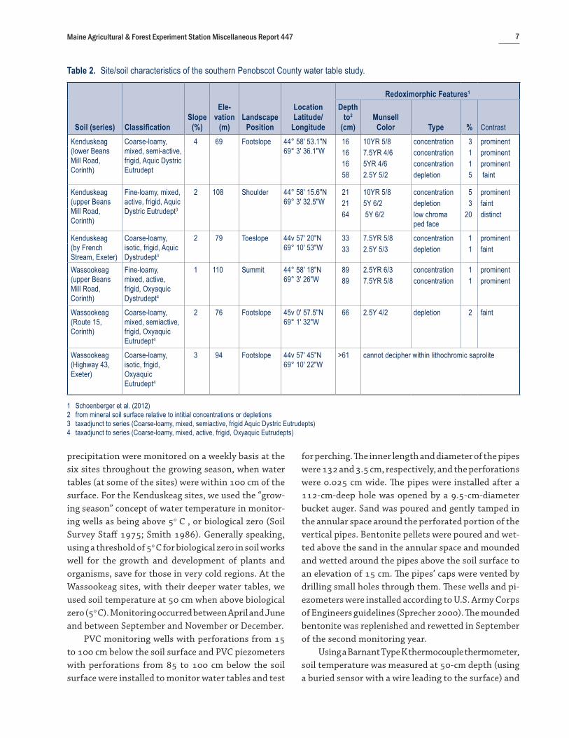
Table 2. Site/soil characteristics of the southern Penobscot County water table study.
Redoximorphic Features1
Soil (series) ClassificationSlope
(%)
Ele-vation
(m)Landscape
Position
Location Latitude/
Longitude
Depth to2
(cm)Munsell
Color Type % Contrast
Kenduskeag (lower Beans Mill Road, Corinth)
Coarse-loamy, mixed, semi-active, frigid, Aquic Dystric Eutrudept
4 69 Footslope 44° 58' 53.1"N69° 3' 36.1"W
16 10YR 5/8 concentration 3 prominent16 7.5YR 4/6 concentration 1 prominent16 5YR 4/6 concentration 1 prominent58 2.5Y 5/2 depletion 5 faint
Kenduskeag (upper Beans Mill Road, Corinth)
Fine-loamy, mixed, active, frigid, Aquic Dystric Eutrudept3
2 108 Shoulder 44° 58' 15.6"N69° 3' 32.5"W
21 10YR 5/8 concentration 5 prominent21 5Y 6/2 depletion 3 faint64 5Y 6/2 low chroma
ped face20 distinct
Kenduskeag (by French Stream, Exeter)
Coarse-loamy, isotic, frigid, Aquic Dystrudept3
2 79 Toeslope 44v 57' 20"N69° 10' 53"W
33 7.5YR 5/8 concentration 1 prominent33 2.5Y 5/3 depletion 1 faint
Wassookeag (upper Beans Mill Road, Corinth)
Fine-loamy, mixed, active, frigid, Oxyaquic Dystrudept4
1 110 Summit 44° 58' 18"N69° 3' 26"W
89 2.5YR 6/3 concentration 1 prominent89 7.5YR 5/8 concentration 1 prominent
Wassookeag (Route 15, Corinth)
Coarse-loamy, mixed, semiactive, frigid, Oxyaquic Eutrudept4
2 76 Footslope 45v 0' 57.5"N69° 1' 32"W
66 2.5Y 4/2 depletion 2 faint
Wassookeag (Highway 43, Exeter)
Coarse-loamy, isotic, frigid, Oxyaquic Eutrudept4
3 94 Footslope 44v 57' 45"N69° 10' 22"W
>61 cannot decipher within lithochromic saprolite
1 Schoenberger et al. (2012) 2 from mineral soil surface relative to intitial concentrations or depletions 3 taxadjunct to series (Coarse-loamy, mixed, semiactive, frigid Aquic Dystric Eutrudepts)4 taxadjunct to series (Coarse-loamy, mixed, active, frigid, Oxyaquic Eutrudepts)

Maine Agricultural & Forest Experiment Station Miscellaneous Report 4478
Table 3. Horizon properties of soils of southern Penobscot County water table study.
Horizon
Thickness or Depth Range
(cm)Moist Munsell Matrix
Color
Texture Class1/Percentage
Clay
Percentage Para1
Channers
Percentage Friable
Fragments pH (1:1 H20)
Kenduskeag (lower Beans Mill Road, Corinth)Bw2 18–40 2.5Y 5/4 G-L/12 0 1 6.3C1 40–60 2.5Y 5/3 and 2.5Y 4/4 G-L 15 0 2 6.4C2 60–103 2.5Y 5/3 SIL/16 2 5 6.8C3 103–160+ 10YR 4/4 G-SIL 2 4
Kenduskeag (upper Beans Mill Road, Corinth)Bw2 23–40 2.5Y 5/3 SIL/15 0 0 5.3C1 40–66 2.5Y 4/3 and 5Y 5/3 G-SIL/19.5 0 1 5.2C2 66–99 2.5Y 4/4 G-SIL/21 5 8 5.5C3 99–157 2.5Y 4/4 SIL/20 10 16 6.9
Kenduskeag (by French Stream, Exeter)Bw3 20–38 2.5Y 4/4 G-SIL/13 0 0 4.8BC 38–46 2.5Y 5/4 SIL/17 5 0 5.2C 46–58 2.5Y5/4 SIL/13 5 0 5.12C1 58–81 2.5Y 4/4 SL/3 0 3 5.32C2 81–117 2.5Y 4/3 G-SL/6 5 0 5.92C3 117–165 2.5Y 4/3 G-SL 5 3
Wassookeag (upper Beans Mill Road, Corinth)Bw14 25–39 2.5Y 5/6 SIL/17.5 1 2 5.5Bw2 39–89 2.5Y 4/4 SIL/19 5 11 5.5C 89–120 2.5Y 4/4 and 2.5Y 5/3 SIL/17 5 8 5.7
Wassookeag (Route 15, Corinth)Bw14 26–43 2.5Y 4/4 L/8 10 6 7.2Bw2 43v66 2.5Y 4/3 PCN-SIL/8 15 9 8C 66–119 2.5Y 4/3 FL-FSL/6 15 5 7.5
Wassookeag (Route 43, Exeter)Bw4 44–61 7.5YR 4/4 & 7.5YR 4/6 SIL / 12 5 20 6.72C1 (saprolite)
61–73 7.5YR 2.5/2 (35%) 7.5-10YR 4/6 (30%)
2.5Y 4/2 (25%) 10YR 3/4 (10%)
SIL / 8.7 5 > 50 (consolidated)
6.0
2C2 (saprolite)
73–119 2.5Y 4/2 (50%) 10YR 4/6 (20%) 7.5YR 3/2 (15%) 10YR 3/4 (15%)
SIL / 11.3 10 > 50 (consolidated)
6.7
1 Schoenberger et al. (2012)2 below 2 cm of Oi horizon and A horizon 3 below 5 cm of Oi-Oehorizon and A horizon4 below Ap horizon

Maine Agricultural & Forest Experiment Station Miscellaneous Report 447 9
at 10 cm depth (by opening a small hole each time). Data were consistently collected in the afternoon (be-tween noon and 6:00 p.m.) for reproducibility because temporal variability is high with soil temperature at such a shallow depth, particularly without canopy cover in the better drained potato fields. In this way, these summarized temperature readings were likely to be closer to the diurnal high. The air temperature and the temperature of the water (when present) in its upper part in the well were also measured with the same instrument. The thermocouple was placed in an ice bath at the end of the first monitoring year and measured 0.0o C.
For the Wassookeag sites, the buried temperature sensor was in a grassy area adjacent to the potato field, while the shallower soil temperature measurement was taken in the potato field. It was not practical to place wells, piezometers, and buried temperature sensors in the potato fields since they would have been destroyed by machinery. Herbaceous vegetation at the Exeter site was regularly trimmed to limit the density of aboveg-round biomass, and loppers were used at the Route 15 Corinth site to keep that area from reverting to woodland. The Beans Mill Corinth site did not require vegetative maintenance, as the pipes and sensor were on a noncultivated division used by farm machinery.
Rain gauges were placed at each site, and cumula-tive precipitation was recorded weekly to the nearest millimeter (mm). Supporting climatic data from a daily National Oceanic and Atmospheric Administration (NOAA) climatic station with long-term records in the neighboring town of Corinna were used to determine if precipitation for a given year (based on December–November timeframes) was construed to be “normal” (NOAA 2001). A normal year of precipitation is within one standard deviation of the mean from the most recent 30-year record (Soil Survey Staff 2014a), in this case 1971–2000. These precipitation and temperature data were also broken down to compare precipitation amounts between spring and fall seasons and to make comparisons of different growing season start and end dates.
Since soil morphology at the SPD Kenduskeag sites did not key out as having an aquic moisture regime, during the second monitoring year freshly excavated wet soil within 50 cm of the mineral soil surface was tested at each site for the presence of ferrous iron, using alpha, alpha-dipyridyl (Childs 1981). Care was taken
to avoid having the solution touch the tiling spade, as that would yield a false positive reaction. A preponder-ance of consecutive weekly positive reactions at a given site would have supported an aquic moisture regime classification for that pedon (Soil Survey Staff 2014a).
Analyses of DataWater table depths and soil (50-cm depth) or water
temperatures were plotted by season on graph paper for each sampling site and year. Soil temperature, water temperature (when applicable), and water table depths from the monitoring wells were then linearly extrapolated between calendar dates to determine the days when hydrology (with soil or water temperatures above 5o C) corresponded with an Aquic or Oxyaquic subgroup, or an SPD or MWD drainage class.
In interpreting the data for the 10-cm depth soil temperature, readings for each calendar date were averaged to achieve agronomic significance across the sites (in some cases in the fall across two years when calendar dates coincided) and restricted to the middle of the plow layer (Ap horizon) at the Wassookeag sites. These averaged temperatures were plotted vs calendar dates for the four spring and fall monitoring seasons. Temperatures that were taken before noon or after 6:00 p.m. were omitted from the analysis. Air temperature analysis was also restricted to afternoon readings, and the t-test (Huntsberger and Billingsley 1981) was used to see if average air temperature at the Wassookeag field and Kenduskeag forest sites differed significantly within spring and fall seasons, or between the two seasons for each type of site cover.
PRESENTATION OF RESULTSPrecipitation and Soil Moisture Regime
Climatological data from Corinna indicates total precipitation for 2002, 2003, and 2004 to be normal, while 2005 was abnormally wet (Table 4). Annual precipitation was based on records from December 1 to November 30 because soil and/or well-water temperature measurements in a given calendar year ended between early November and early December, depending on the site and year. September and October of 2003 were abnormally wet months, which suggest water tables would be higher than normal that fall. Also, the early part of 2004 was abnormally dry overall, sug-gesting that the water table that spring was lower than

Maine Agricultural & Forest Experiment Station Miscellaneous Report 44710
normal. Taking this all into consideration, the spring and fall of 2002, spring of 2003, and fall of 2004 were considered to have normal precipitation.
The reader is referred to the 12th edition of the Keys to Soil Taxonomy (Soil Survey Staff 2014a) for the complete discussion of normal years, as well as detailed descriptions of soil moisture regimes that place the central Maine soils into either aquic or udic moisture regimes. As Inceptisols here the moisture regimes are denoted as Aquepts or Udepts at the suborder level. It is important to note that the term aquic is also used at the subgroup level of soil taxonomy as a subclass of the udic moisture regime, as is the case here for the Kenduskeag series.
The “Invisible” Seasonal High Water TableDetermining the height of the SHWT in pedon
descriptions is based primarily on clearly visible soil RMFs. The majority of pedon descriptions in central and northern Maine occur during the spring–sum-mer–fall season, when thawed ground allows reason-able excavation of soil. It has been observed over many years of statewide soil mapping that water tables in frigid temperature and udic moisture regimes (such as in central Maine) are higher during the nongrowing season (when evapotranspiration rates are diminished
or nonexistent). Typically the SHWT is highest at snowmelt in early spring and then again in late fall prior to freeze-up. Thus, soil scientists rely on the highest observable level of RMFs as a proxy for the SHWT in a soil pit.
The crux of the challenge is the condi-tion whereby a soil is saturated outside of the growing season, so that RMFs do not form because soil temperature is < 5o
C. This condition has broad implications for use and management of these types of soils. For example, more intensive land development activities, such as road construction, buildings, recreational uses, agricultural, and infrastructure projects can unknowingly excavate below the SHWT when soil morphologic indi-cators of saturation are absent, thereby inadvertently dewatering large areas. This can affect adjacent protected natural resources such as wetlands, streams, and
sensitive vegetative communities. In addition, storm-water engineering that was designed for only control of surface water will be improperly sized. Thus, it is oftentimes crucial to determine the invisible SHWT in soils by using piezometers and shallow wells throughout an entire calendar year. This study provides this crucial data for the two soil series Wassookeag and Kenduskeag.
Moisture Regime Subclasses and Drainage Class for the Wassookeag Soil Series
To key out Inceptisols as Aquic or Aquic Dystric at the subgroup level, redox depletions with a chroma of 2 or less and aquic conditions for some time in nor-mal years need to occur within 60 cm of the mineral soil surface (Soil Survey Staff 2014a). None of the Wassookeag pedons had RMF-depletions described within 60 cm. The only noteworthy duration when a water table was recorded within 60 cm in Wassookeag wells was during October and November of 2003. Fall 2003 was exceedingly wet, however (Table 4), and between October 13 and 30 of that year, 223 mm of precipitation fell in Corinna.
Soils that are classified as Oxyaquic at the subgroup level within Inceptisols require saturation in one or more layers within 100 cm of the mineral soil surface for 20 or more consecutive days or 30 or more cumulative
Table 4. Corinna daily NOAA Climatic Station (NOAA 2001).
Year
Annual Precipitation1
(mm)Normal Year?2
Abnormally Wet or Dry Months3
(Dec.–July)
Abnormally Wet or Dry Months3
(Aug.– Nov.)2002 1,112 Yes + none dry August
wet November2003 1,240 Yes + dry January
wet February dry July
wet September wet October
2004 951 Yes - wet December dry January dry March dry June
wet August dry October
2002–2004 mean 1,1012005 1,574 No + wet April
wet Mayvery wet October
(362 ml)2002–2005 mean 1,219 1971–2000 mean, standard deviation
1,088±159 (929 to 1,247)
1 based on sum of December–November monthly totals2 Soil Survey Staff 20143 Outside of the standard deviation of the 30 year mean for that month.

Maine Agricultural & Forest Experiment Station Miscellaneous Report 447 11
days in normal years (Soil Survey Staff 2014a). Oxyaquic Eutrudepts or Dystrudepts do not require RMFs within 100 cm because saturation may occur when saturated soil temperatures are below 5o C. On the other hand, if RMFs do occur within 100 cm, but no shallower than 60 cm, then the soil immediately keys to the Oxyaquic great group, since RMFs, a proxy for the SHWT in a soil, generally require at least two continuous weeks of saturation during the growing season (Veneman et al. 1976; Vepraskas 1992; Committees on Characterization of Wetlands 1995; U.S. Army Corps of Engineers 2012). This two-week threshold should be reasonable for both the Wassookeag sites and the Kenduskeag sites, since they are on relatively flat slopes with loamy soil tex-tures. Hence, based on hydrologic and accompanying soil morphologic data, the Exeter Wassookeag site is MWD and Oxyaquic. RMFs between 100 and 40 cm below the mineral soil surface key out as MWD in Maine (see footnore 4) and in accordance with historical NRCS guidelines (Soil Survey Staff 1951).
Based on their morphology, both Wassookeag pe-dons in Corinth key out as Oxyaquic (NRCS classifica-tion) and as MWD (MAPSS classification), since RMFs were described above 100 cm (Table 2), but not above 60 cm (NRCS) or 40 cm (MAPSS). The RMFs described in these pedons were few and faint, however.
The Exeter Wassookeag pedon had saprolite with lithochromic colors from the bottom of the pedon up to 61 cm (Table 3), so at the beginning of the study it could not be established as to whether the soil was Oxyaquic/MWD based on presence of RMFs. Described
colors in the platy saprolite included contrasting high and low chroma Munsell colors; as described, the percentage of low chroma (chroma ≤ 2 and value ≥ 4) colors increased from 25% to 50% at 73 cm (Table 3). For the five monitoring seasons at this site, there were 0, 0, 8, 9, and 29 consecutive days, respectively, when the water table in the well rose as high as 73 cm below the mineral soil surface. The season with 29 consecu-tive days was the abnormally wet fall of 2003 (Table 4).
Table 5 presents durations of saturation in the up-per 100 cm at each Wassookeag site during the growing season. The growing season was based on soil tempera-ture at 50 cm being above 5o C because temperature data from the well water was not continuous enough to plot out and extrapolate on a weekly basis. From 45 comparisons, the Pearson Correlation Coefficient (R2)
between water temperatures in the monitoring wells and the soil temperature at 50 cm equaled 0.65.
Based on the summarized hydrologic data in Table 5, the site that was most conclusively MWD and Oxyaquic was the Exeter Route 43 site, where there was water in the monitoring well for two weeks or longer within 100 cm in two of the three monitoring seasons, with evidence of saturation outside of the growing season in all three monitoring seasons.
For the Corinth Beans Mill site, the two-week threshold for saturation was met during the growing season in only one of the four normal seasons. For the Corinth Route 15 site, none of the four seasons met the requirement (Table 5). Therefore, according to these results, these sites do not appear to be MWD.
Table 5. Water tables in monitoring wells during normal precipitation seasons at Wassookeag sites during the growing season based on soil temperatures above 5° C at 50 cm.
Spring 2002 Fall 2002 Spring 2003 Fall 2004
Route 15, Corinth 7–13 days1
May 1 to 7–13(to 89 cm)
none(to 100 cm)
7–9 days2
May 3 to 9–11(to 94 cm)
none (to 96 cm)3
Beans Mill Road, Corinth 7–13 days1
May 1 to 7–13(to 99 cm)
none (to 98 cm)
none2
(to 100 cm)17–19 days3
Sept. 19 to Oct. 5–7(to 89 cm)
Route 43, Exeter 29–35 days1
Apr. 24 to May 22–28(to 91 cm)
none (to 100 cm)3 16 days1
May 4 to May 19(to 91 cm)
1 water table was present within 100 cm when growing season commenced2 water table was present within 100 cm before growing season commenced3 water table was present within 100 cm at least 13 to 15 days after growing season concluded

Maine Agricultural & Forest Experiment Station Miscellaneous Report 44712
Both Corinth Wassookeag sites appear to be Oxyaquic though, as water tables within 100 cm were evident outside of the growing season in six of the eight normal precipitation cases (Table 5), and in all cases during the abnormally wet seasons.
Moisture Regime Subclasses and Drainage Class for the Kenduskeag Soil Series
Soils in this region key out as SPD when RMFs occur within less than 40 cm of the mineral soil surface (see footnote 4). Based on their morphology, each of the Kenduskeag pedons keyed out as SPD and classified as Aquic Dystric or Aquic at the subgroup level (Table 2). For three of the four normal precipitation seasons, the hydrology at each of the sites also supported the SPD class as well as an Aquic Dystric or Aquic subgroup by having 14 days or more of continuous saturation (Table 5).
To test for the presence of ferrous iron (Fe++) produced by soil microbial reducing con-ditions, alpha, alpha-dipyridyl was applied to freshly excavated wet soil above 50-cm depth on 48 occasions in 2003, when the water table was within 50 cm of the surface and water temperature in the monitoring well was above biological zero. RMFs and continuous saturation during the growing season within 50 cm would indicate that the Kenduskeag pedons had an aquic moisture regime, together with a preponderance of positive reactions to alpha, alpha-dipyridyl (Soil Survey Staff 2014a). On only one out of 48 occasions was there a positive reaction to alpha, alpha-dipyridyl. Based on these results, the three Kenduskeag sites have an udic moisture regime (with an Udept suborder), vs an aquic moisture regime (with an Aquept suborder).
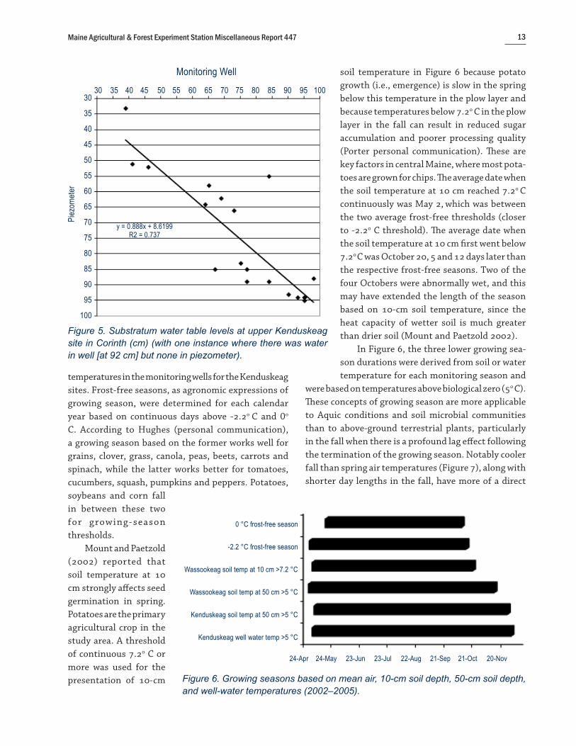
Perched vs Apparent Water Tables Figures 4 and 5 reveal the relationship between
water levels in the monitoring well and piezometer at the two Kenduskeag sites in Corinth when water tables in the well were below the top of the substratum (C hori-zon) and within 100 cm of the mineral soil surface. The soil morphologies of the pedons at these sites (Tables 2 and 3) are representative of the Kenduskeag soil series. Both substratums were described as beginning at 38 cm from the top of the mineral soil surface (Table 3).
For the lower Kenduskeag site, there was only one instance when water was in the well (below the top of the substratum) but not in the piezometer. In the remaining 10 instances, there was water in the piezometer when there was water in the well (Figure 4). Similarly, there was only one instance at the upper site when water was in the well but not in the piezometer. The remaining 20 instances are plotted in Figure 5. Water-table levels in both the piezometers and wells fluctuated in unison during the year, as evidenced by the trend lines in each figure being close to a 1:1 relationship. These results indicate that water tables for the soils at these two sites are apparent, rather than perched. Nearly equal hori-zontal and vertical hydraulic heads in the groundwater produced comparable water levels in the monitoring wells and piezometers in these unconfined aquifers.
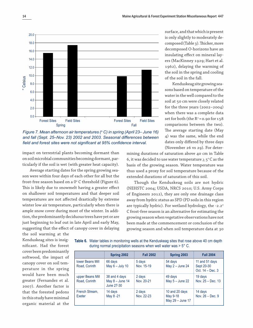
Growing Season ComparisonsFigure 6 presents a summary of growing season
comparisons from daily Corinna air temperature lows (NOAA 2001), soil temperature at 10 cm for the Wassookeag sites, soil temperatures at 50 cm for the Kenduskeag and the Wassookeag sites, and the water
30 35 40 45 50 55 60 65 70 75 80 85 90 95 10030
35
40
45
50
55
60
65
70
75
80
85
90
95
100
Piez
omet
er
y = 0.9908x + 0.54 R² = 0.9255
Figure 4. Substratum water table levels at lower Kenduskeag site in Corinth (cm) (with one instance where there was water in well [at 83 cm], but none in piezometer).
Monitoring Well
Maine Agricultural & Forest Experiment Station Miscellaneous Report 447 13
temperatures in the monitoring wells for the Kenduskeag sites. Frost-free seasons, as agronomic expressions of growing season, were determined for each calendar year based on continuous days above -2.2o C and 0o C. According to Hughes (personal communication), a growing season based on the former works well for grains, clover, grass, canola, peas, beets, carrots and spinach, while the latter works better for tomatoes, cucumbers, squash, pumpkins and peppers. Potatoes, soybeans and corn fall in between these two for growing- season thresholds.
Mount and Paetzold (2002) reported that soil temperature at 10 cm strongly affects seed germination in spring. Potatoes are the primary agricultural crop in the study area. A threshold of continuous 7.2o C or more was used for the presentation of 10-cm
soil temperature in Figure 6 because potato growth (i.e., emergence) is slow in the spring below this temperature in the plow layer and because temperatures below 7.2o C in the plow layer in the fall can result in reduced sugar accumulation and poorer processing quality (Porter personal communication). These are key factors in central Maine, where most pota-toes are grown for chips. The average date when the soil temperature at 10 cm reached 7.2o C continuously was May 2, which was between the two average frost-free thresholds (closer to -2.2o C threshold). The average date when the soil temperature at 10 cm first went below 7.2o C was October 20, 5 and 12 days later than the respective frost-free seasons. Two of the four Octobers were abnormally wet, and this may have extended the length of the season based on 10-cm soil temperature, since the heat capacity of wetter soil is much greater than drier soil (Mount and Paetzold 2002).
In Figure 6, the three lower growing sea-son durations were derived from soil or water temperature for each monitoring season and
were based on temperatures above biological zero (5o C). These concepts of growing season are more applicable to Aquic conditions and soil microbial communities than to above-ground terrestrial plants, particularly in the fall when there is a profound lag effect following the termination of the growing season. Notably cooler fall than spring air temperatures (Figure 7), along with shorter day lengths in the fall, have more of a direct
0 °C frost-free season
-2.2 °C frost-free season
Wassookeag soil temp at 10 cm >7.2 °C
Wassookeag soil temp at 50 cm >5 °C
Kenduskeag soil temp at 50 cm >5 °C
Kenduskeag well water temp >5 °C
24-Apr 24-May 23-Jun 23-Jul 22-Aug 21-Sep 21-Oct 20-Nov
Figure 6. Growing seasons based on mean air, 10-cm soil depth, 50-cm soil depth, and well-water temperatures (2002–2005).
30 35 40 45 50 55 60 65 70 75 80 85 90 95 10030
35
40
45
50
55
60
65
70
75
80
85
90
95
100
Piez
omet
er
y = 0.888x + 8.6199R2 = 0.737
Figure 5. Substratum water table levels at upper Kenduskeag site in Corinth (cm) (with one instance where there was water in well [at 92 cm] but none in piezometer).
Monitoring Well
Maine Agricultural & Forest Experiment Station Miscellaneous Report 44714
impact on terrestrial plants becoming dormant than on soil microbial communities becoming dormant, par-ticularly if the soil is wet (with greater heat capacity).
Average starting dates for the spring growing sea-son were within four days of each other for all but the frost-free season based on a 0o C threshold (Figure 6). This is likely due to snowmelt having a greater effect on shallower soil temperatures and that deeper soil temperatures are not affected drastically by extreme winter low air temperature, particularly when there is ample snow cover during most of the winter. In addi-tion, the predominantly deciduous trees have yet or are just beginning to leaf out in late April and early May, suggesting that the effect of canopy cover in delaying the soil warming at the Kenduskeag sites is insig-nificant. Had the forest cover been predominantly softwood, the impact of canopy cover on soil tem-perature in the spring would have been much greater (Fernandez et al. 2007). Another factor is that the forested pedons in this study have minimal organic material at the
surface, and that which is present is only slightly to moderately de-composed (Table 3). Thicker, more decomposed O-horizons have an insulating effect on mineral lay-ers (MacKinney 1929; Hart et al. 1962), delaying the warming of the soil in the spring and cooling of the soil in the fall.
Kenduskeag site growing sea-sons based on temperature of the water in the well compared to the soil at 50 cm were closely related for the three years (2002–2004) when there was a complete data set for both (the R2 = 0.90 for 158 comparisons between the two). The average starting date (May 4) was the same, while the end dates only differed by three days (November 26 vs 29). For deter-
mining durations of saturation above 40 cm in Table 6, it was decided to use water temperature > 5o C as the basis of the growing season. Water temperature was thus used a proxy for soil temperature because of the extended durations of saturation of this soil.
Though the Kenduskeag soils are not hydric (NEHSTC 2004; USDA, NRCS 2010; U.S. Army Corps of Engineers 2012), they are only one drainage class away from hydric status as SPD (PD soils in this region are typically hydric). For wetland hydrology, the -2.2o C frost-free season is an alternative for estimating the growing season when vegetative observations have not been made at the commencement or conclusion of the growing season and when soil temperature data at 30
Table 6. Water tables in monitoring wells at the Kenduskeag sites that rose above 40 cm depth during normal precipitation seasons when well water was > 5° C.
Spring 2002 Fall 2002 Spring 2003 Fall 2004
lower Beans MillRoad, Corinth
66 daysMay 6 – July 10
5 daysNov. 15-19
54 daysMay 2 – June 24
11 and 51 daysSept 20-30Oct. 14 – Dec. 3
upper Beans Mill Road, Corinth
38 and 4 daysMay 8 – June 14June 27-30
2 daysNov. 20-21
49 daysMay 5 – June 22
19 daysNov. 25 – Dec. 13
French Stream, Exeter
14 daysMay 8 -21
2 daysNov. 22-23
10 and 20 daysMay 9-18May 29 – June 17
14 daysNov. 26 – Dec. 9
Forest Sites Field Sites Forest Sites Field Sites Spring Fall
20.0
18.0
16.0
14.0
12.0
10.0
8.0
6.0
4.0
2.0
0.0
° Cels
ius
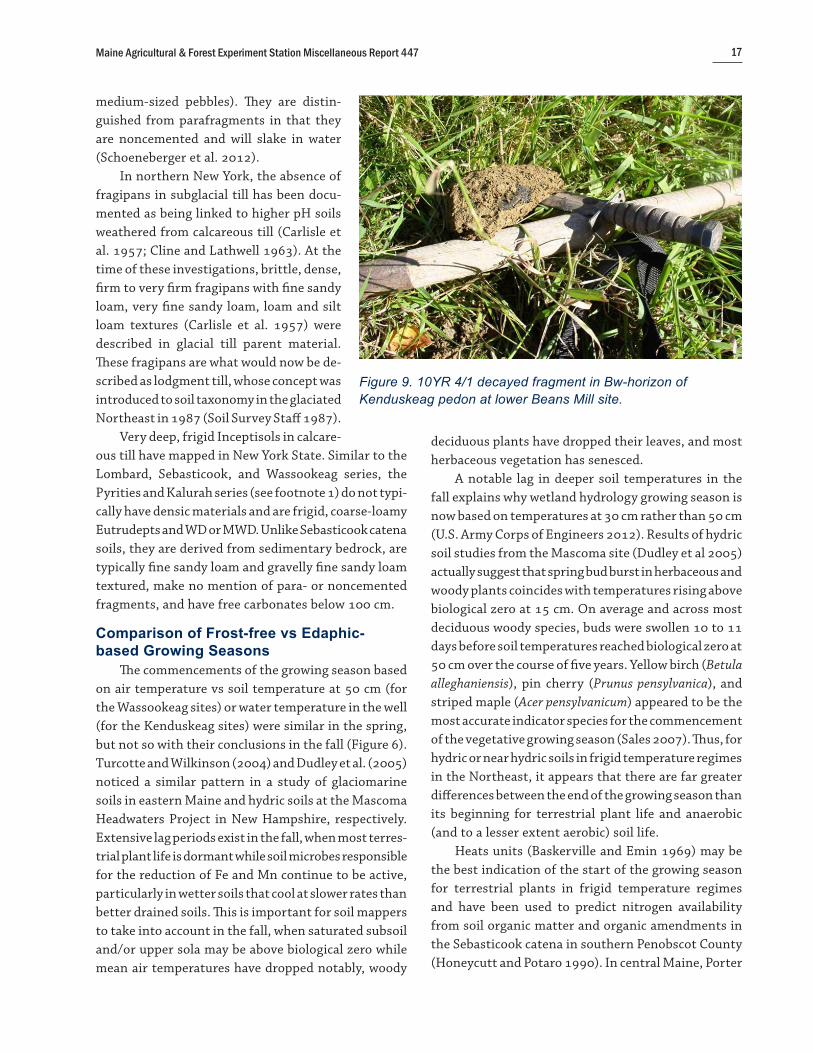
Figure 7. Mean afternoon air temperatures (o C) in spring (April 23– June 16) and fall (Sept. 25–Nov. 23) 2002 and 2003. Seasonal differences between field and forest sites were not significant at 95% confidence interval.

Maine Agricultural & Forest Experiment Station Miscellaneous Report 447 15
cm is not available (U.S. Army Corps of Engineers 2012). On average, differences between the Kenduskeag sites’ growing season based on well-water temperature vs the -2.2o C frost-free season (Figure 6) were minor in the spring (three days). In sharp contrast, on average well-water temperature remained above 5o C for 48 days beyond the end of the -2.2o C frost-free season in the fall (through the end of November).
Effect of High Water Tables on Soil Temperatures
When comparing soil temperatures at 50-cm depth in the fall, the lag between growing season termination dates based on air temperature vs soil temperature was more pronounced at the Kenduskeag sites. As soil temperatures decreased in the fall, on average the Kenduskeag sites with higher water tables/wetter soil remained above 5o C for 18 days longer than the Wassookeag sites (Figure 6). Once again, this is likely due to the heat capacity of water being far greater than the heat capacity of any other component in the soil. Thus the wetter the soil, the greater the buffer against change in soil temperature, particularly in the fall as soil temperatures decline. Differences between growing season onset in the spring were much less, presumably because of the influence of snow cover and snowmelt in buffering the soil against colder air temperatures at all sites (Mount and Paetzold 2002).
Effect of Canopy CoverDuring each pedon soil description at the forested
Kenduskeag sites, canopy cover was noted to range from ~65% to ~80%. Figure 7 provides comparisons between afternoon air temperatures during spring and fall for the field (Wassookeag) and forest (Kenduskeag) sites during the first two monitoring years (when all six sites were monitored). In the spring, the data show that afternoon air temperature was ~2o C cooler in the forested sites. In the fall, afternoon air temperatures were ~1.5o C cooler in the forested sites. The average air temperature in the fall season was significantly lower (at 95% confidence interval) than the spring season at field and forest sites due to the lower solar radiation in the fall. Within the spring seasons and the fall seasons, however, there was no significant difference at 95% con-fidence interval between the Kenduskeag forested sites and the Wassookeag field sites. Differences between field
and forest would have been expected to be significant had the forest cover been primarily coniferous.
DISCUSSION OF RESULTS
Soil Hydrology, Morphology and Tilth on Calcareous Till Plains
Soil morphology (Table 2) and hydrologic data (Table 5) at the Wassookeag sites support the Oxyaquic subgroup and to a lesser extent the MWD drainage class. On relatively level (0%–3% gradient) till plains, lodgment till soils such as those of the Chesuncook catena (see footnote 2) with comparable textures would be expected to have a SPD or wetter drainage class and have an Aquic subgroup, if not an aquic moisture regime. The pedon descriptions from the six sites in this study support the presence of subglacial melt-out till (USDA, NRCS 2015) rather than densic materials (as lodgment till). It is likely that densic materials were present following deglaciation, and that the processes of soil flocculation and acid solution weathering of rock fragments have eliminated these less permeable, denser materials over the last ~12,000 years.
A noticeable increase with depth in the percent-age of low chroma color in the saprolite was initially interpreted as perhaps being indicative of aquic condi-tions during normal years (Table 3 and Figure 8). Only three of the five seasons that the site was monitored had normal precipitation, and durations of saturation within the saprolite during those three seasons were less than 14 consecutive days. Thus, the low chroma colors appear to be geogenic (i.e., inherited from the calcareous interbedded phyllite). In fresh outcrop, this phyllite is greenish to gray, producing lower chromas and mid to higher values of color.
It was somewhat surprising just how freely drained the two Wassookeag soils and sites were in Corinth, where the drainage class in both cases approaches WD. With respect to the Route 15 site, moderately to slightly alkaline pHs in the lower solum and substratum (Table 3) lower the capability for iron to be reduced in the soil (Ponnamperuma 1972; Gotoh and Patrick 1974; Vepraskas 1992), which likely explains why there is diminished occurrence and expression of RMFs there. Iron is less soluble in the neutral to alkaline range than at a lower soil pH, meaning that it is less apt to be reduced all other factors being equal. With respect to

Maine Agricultural & Forest Experiment Station Miscellaneous Report 44716
the Beans Mill Wassookeag site, the deeper and scant expression of RMFs there (Table 2)—as well as the hydrology that was nearly WD (Table 5)—was likely a function of the high landscape position. That site was located on a broad summit (Table 2) with negligible watershed area above.
Another possible reason for both Corinth and Wassookeag pedons being borderline WD in terms of their soil morphology is low levels of organic carbon in the substratum. Organic carbon serves as a food and energy source for microbial communities that drive redox potential (Vepraskas and Wilding 1983; Dobos et al. 1990). In addition, soil temperatures that drive the reduction of iron and manganese in saturated soils (Dobos et al. 1990; Vepraskas 1992; Committee on Characterization of Wetlands 1995) do not rise as much as they do closer to the soil surface during the growing season.
Based on the soil morphology at Kenduskeag sites in Corinth (Tables 2 and 3), the very infrequent reactions to alpha, alpha-dipyridyl, and the hydrologic data (Table 6), it can be concluded with a high level of confidence that these two replicate sites were SPD with an udic moisture regime. The coarse-loamy to light end of fine-loamy particle-size families of these soils may best account for the propensity of negative reactions to alpha, alpha-dipyridyl that results in a udic, rather than an aquic moisture regime. Turcotte and Wilkinson
(2004) concluded that SPD glaciomarine Lamoine pedons in Maine were Aquepts (with an aquic moisture regime) because low saturated conductivity in finer textured soils is well-documented and finer/deeper soils are more readily reduced under aquic conditions.
When comparing the two most repre-sentative Kenduskeag sites in Corinth, the lower site consistently had longer durations of saturation closer to the surface during the growing season (Table 6). This was some-what surprising since the upper site was flatter (Table 2) and only 63 m from a PD to VPD Monarda-Burnham complex, and had finer textures (Table 3). Both pedons had 38 cm of mineral solum. Apparently in this case, the lower landscape position (39 m lower in elevation) had a greater effect than the flatter terrain and finer textures of the site
above. It has been noted by many soil mappers that long watersheds with significant up-gradient catchments can produce higher wetness indices (Moore 1993). It also explains how better drained Wassookeag-Penobscot complexes in potato fields are often above adjacent, sometimes steeper-sloped very stony Wassookeag-Kenduskeag complexes that are forested.
From a soil hydrology perspective, MWD to WD deep soils on relatively level (0% to 3% gradient) areas and the absence of perched water tables on very deep, SPD soils areas support the absence of described densic materials in the pedons by these sites. This is consistent with how soils of the Caribou and Bangor catenas have historically been described with deeper sola or the absence of densic materials, and/or soft or decayed fragments.
One must take care when describing decayed fragments (formerly known as ghosts) to distinguish them from redoximorphic features (Figure 9). In this respect, these decayed fragments could be mistaken for RMFs such as iron depletions, iron masses, or iron-manganese masses. Common colors for decayed fragments in Sebasticook catena soils are 2.5Y 6/6, 10YR 4/1, 7.5YR 4/4 and 5YR 2.5/2. They can be distinguished from RMFs in that their texture feels uniform (as silt, very fine sand or fine sand) and they are notably three-dimensional (as very friable, fine to
Figure 8. Subglacial melt-out till over saprolite at Exeter Wassookeag site (pedon described on May 21, 2002). The saprolite is observed to begin at 61 cm depth.
Maine Agricultural & Forest Experiment Station Miscellaneous Report 447 17
medium-sized pebbles). They are distin-guished from parafragments in that they are noncemented and will slake in water (Schoeneberger et al. 2012).
In northern New York, the absence of fragipans in subglacial till has been docu-mented as being linked to higher pH soils weathered from calcareous till (Carlisle et al. 1957; Cline and Lathwell 1963). At the time of these investigations, brittle, dense, firm to very firm fragipans with fine sandy loam, very fine sandy loam, loam and silt loam textures (Carlisle et al. 1957) were described in glacial till parent material. These fragipans are what would now be de-scribed as lodgment till, whose concept was introduced to soil taxonomy in the glaciated Northeast in 1987 (Soil Survey Staff 1987).
Very deep, frigid Inceptisols in calcare-ous till have mapped in New York State. Similar to the Lombard, Sebasticook, and Wassookeag series, the Pyrities and Kalurah series (see footnote 1) do not typi-cally have densic materials and are frigid, coarse-loamy Eutrudepts and WD or MWD. Unlike Sebasticook catena soils, they are derived from sedimentary bedrock, are typically fine sandy loam and gravelly fine sandy loam textured, make no mention of para- or noncemented fragments, and have free carbonates below 100 cm.
Comparison of Frost-free vs Edaphic-based Growing Seasons
The commencements of the growing season based on air temperature vs soil temperature at 50 cm (for the Wassookeag sites) or water temperature in the well (for the Kenduskeag sites) were similar in the spring, but not so with their conclusions in the fall (Figure 6). Turcotte and Wilkinson (2004) and Dudley et al. (2005) noticed a similar pattern in a study of glaciomarine soils in eastern Maine and hydric soils at the Mascoma Headwaters Project in New Hampshire, respectively. Extensive lag periods exist in the fall, when most terres-trial plant life is dormant while soil microbes responsible for the reduction of Fe and Mn continue to be active, particularly in wetter soils that cool at slower rates than better drained soils. This is important for soil mappers to take into account in the fall, when saturated subsoil and/or upper sola may be above biological zero while mean air temperatures have dropped notably, woody
deciduous plants have dropped their leaves, and most herbaceous vegetation has senesced.
A notable lag in deeper soil temperatures in the fall explains why wetland hydrology growing season is now based on temperatures at 30 cm rather than 50 cm (U.S. Army Corps of Engineers 2012). Results of hydric soil studies from the Mascoma site (Dudley et al 2005) actually suggest that spring bud burst in herbaceous and woody plants coincides with temperatures rising above biological zero at 15 cm. On average and across most deciduous woody species, buds were swollen 10 to 11 days before soil temperatures reached biological zero at 50 cm over the course of five years. Yellow birch (Betula alleghaniensis), pin cherry (Prunus pensylvanica), and striped maple (Acer pensylvanicum) appeared to be the most accurate indicator species for the commencement of the vegetative growing season (Sales 2007). Thus, for hydric or near hydric soils in frigid temperature regimes in the Northeast, it appears that there are far greater differences between the end of the growing season than its beginning for terrestrial plant life and anaerobic (and to a lesser extent aerobic) soil life.
Heats units (Baskerville and Emin 1969) may be the best indication of the start of the growing season for terrestrial plants in frigid temperature regimes and have been used to predict nitrogen availability from soil organic matter and organic amendments in the Sebasticook catena in southern Penobscot County (Honeycutt and Potaro 1990). In central Maine, Porter
Figure 9. 10YR 4/1 decayed fragment in Bw-horizon of Kenduskeag pedon at lower Beans Mill site.

Maine Agricultural & Forest Experiment Station Miscellaneous Report 44718
(personal communication) suggests baseline (average air daily) temperatures of about 10o C for corn, 7.2o C for potatoes, and 4.4o C for cool season forages to indicate the start of the growing season for these crops.
Average afternoon soil temperatures in the plow layer of Wassookeag soils in potato fields (based on 7.2o C thresholds) started three days after and ended seven days later than the frost-free season based on -2.2o C (Figure 6). The fall dates may have been closer had there not been a wet September, wet October, and very wet October out of the four falls monitored, since wetter soil has greater heat capacity that buffers more against changes in soil temperature.
CONCLUSIONSSoil morphology and water table results support an
Oxyaquic subgroup for the three Wassookeag series pe-dons with udic moisture regimes, and to a lesser extent, an MWD drainage class. RMFs at the sites without sap-rolite may have been suppressed by neutral to slightly alkaline pHs, low organic carbon concentrations, and temperatures that do not rise as much as they do closer to the surface during the growing season. For the site with saprolite, there was an increase with depth of a low chroma component, but that increase is likely a function of the geogenic color of the underlying phyl-lite, rather than aquic conditions during normal years.
Soil morphology in, water table results from, and applications of alpha, alpha-dipyridyl to the three Kenduskeag pedons strongly support an udic moisture regime, an Aquic Dystric subgroup, SPD drainage class, and apparent water tables. SPD soils are sometimes defined as having aquic moisture regimes, but in this case, the pedons likely had a udic moisture regime because of their loamy (vs fine-silty or fine) nature. When comparing the two sites on the same landform, there was greater saturation closer to the surface at the lower site even though the upper site was finer textured, had less relief, and was relatively close to a hydric soil map unit. This exemplifies the importance of landscape position on soil hydrology in steeper, larger watersheds.
Oxyaquic subgroups and the absence of densic materials on the low-relief till plains of the study area can be accounted for by the calcareous nature of the sub-glacial melt-out till, resulting in higher macro-porosity due to better soil structure and acid solution weathering of rock fragments. This has been documented in the
Caribou and Bangor catenas of published soil surveys in Aroostook, Penobscot, and Somerset counties, Maine. It has also been documented in frigid, glacial till soil series in New York State. Relative to the Chesuncook catena with comparable particle-size and landscape settings, better drainage in the Sebasticook catena is complimented by higher base saturation and water-holding capacity that makes these better drained soils prime farmland, particularly for potatoes.
When comparing growing season duration based on air temperature or shallow soil temperatures to those based on deeper soil or well-water temperature, there was general agreement as to when the growing season began in the spring, but not so at its termination in the fall. On average, the gap between the end of the growing season based on frost-free season at 0o or -2.2o C and temperature at 50 cm or well-water temperature ranged from 30 to 54 days. Thus, for these soils and sites, there can be four to eight weeks of time in the fall when vascular plants have become dormant, yet soil microbial communities remain active. The gap was wider at the Kenduskeag sites because the heat capacity of wetter soil is greater.
Diurnal high temperatures of 7.2o C or more in the Ap horizons of Wassookeag soils in potato fields most closely approximated the onset and close of the frost-free season based on a -2.2o C threshold, rather than a 0o C threshold. Daytime air temperatures during the first two monitoring years were significantly higher in the spring than in the fall. Daytime air temperatures between the field and forest sites for each season were not significantly different. This was likely due to the mostly deciduous cover at the forest sites.
LITERATURE CITEDArno, J.R. 1964a. Soil survey of Aroostook County, Maine,
northeastern part. Series 1958, #27. USDA, Soil Conservation Service and Maine Agricultural Experiment Station. USGPO, Washington, DC.
———. 1964b. Soil survey of Aroostook County, Maine, southern part. Series 1961, No. 6. USDA. Soil Conservation Service and Maine Agricultural Experiment Station. USGPO, Washington, DC.
———. 1972. Soil survey of Somerset County, Maine: southern part. USDA. Soil Conservation Service and Maine Agricultural Experiment Station. USGPO, Washington, DC.
Arno, J.R., R.A. Struchtemeyer, K.K. Langmaid, and J.F.G. Milette. 1964. A look at the Caribou Soils. USDA Soil

Maine Agricultural & Forest Experiment Station Miscellaneous Report 447 19
Conservation Service, Maine Agricultural Experiment Station, and Canada Department of Agriculture.
Baskerville, G.L., and P. Emin. 1969. Rapid estimation of heat accumulation from maximum and minimum temperatures. Ecology 50:514–517.
Bates, R.L., and J.A. Jackson (eds). 1984. Dictionary of Geological Terms. Anchor Press, New York.
Birkeland, P.W. 1984. Soils and Geomorphology. Oxford University Press, New York.
Brady, N.C., and R.R. Weil. 2002. Elements of the Nature and Properties of Soil. Pearson/Prentice Hall, Upper Saddle River, NJ.
Briggs, R.D., and R.C. Lemin Jr. 1992. Delineation of climatic regions in Maine. Canadian Journal of Forest Research 22:801–811
Buol, S.W., F.D. Hole, R.J. McCracken and R.J. Southard. 1997. Soil Genesis and Classification, 4th ed. Iowa State University Press, Ames.
Carlisle, F.J., E.G. Knox and R.B. Grossman. 1957. Fragipan horizons in New York soils: I. General characteristics and distribution. Soil Science Society of America Journal 21:320–330.
Childs, C.W. 1981. Field test for ferrous iron and ferric-organic complexes (on exchange sites or in water-soluble forms) in soils. Australian Journal of Soil Research 19:175–180.
Cline, M.G., and D.J. Lathwell. 1963. Physical and chemical properties of soils of northern New York. Cornell Agricultural Experiment Station Bulletin 981.
Committee on Characterization of Wetlands, National Research Council. 1995. Wetlands: Characteristics and Boundaries. National Academies Press, Washington, DC.
Creasy, J.W. 1979. Geologic report to accompany the preliminary geologic map and structure sections of the Poland 15' quadrangle, Maine. Open-File Report 79-15. Maine Geological Survey, Augusta.
Dobos, R.R., E.J. Ciolkosz, and W.J. Waltman. 1990. The effect of organic carbon, temperature, time, and redox conditions on soil color. Soil Science 150(2): 506–512.
Dorion, C.C. 1997. An updated high resolution chronology of deglaciation and accompanying marine transgression in Maine. M.S. thesis, University of Maine. Orono.
Dudley, K., W.C. Lynn, P.J. Schoeneberger, D. Harms, J. Homer, and S. Hundley, eds. 2005. The Mascoma Headwaters project: A study of soil morphology and temperature in New Hampshire for documenting hydric soil indicators and wetland boundary criteria. USDA, Natural Resources Conservation Service, National Soil Survey Center, Soil Survey Investigations Report 50.
Fernandez, I. J., J.E. Karem, S.A. Norton, and L.E. Rustad. 2007. Temperature, soil moisture and streamflow at the Bear Brook watershed in Maine. Maine Agricultural and Forest Experiment Station Technical Bulletin 196.
Goodman, K.V. 1963. Soil survey of Penobscot County, Maine. Series 1959, #28. USDA Soil Conservation Service and Maine Agricultural Experiment Station.
Gotoh, S., and W.H. Patrick Jr. 1974. Transformation of iron in waterlogged soil as influenced by redox potential and pH. Soil Science Society of America Journal 38:66–70.
Griffin, J.R. 1971. Reconnaisance bedrock geology of the Stetson quadrangle, Maine. Open File Map No. 71-1. Maine Geological Survey, Augusta.
Hart, G., R.E. Leonard, and R.S. Pierce. 1962. Leaf fall, humus depth, and soil frost in a northern hardwood forest. USDA, Forest Service, Forest Research Note 131.
Honeycutt, C.W., and L.J. Potaro. 1990. Field evaluation of heat units for predicting crop residue carbon and nitrogen mineralization. Plant and Soil 125:213–220.
Huntsberger, D.V., and P. Billingsley. 1981. Elements of Statistical Inference. Allyn and Bacon, Inc., Boston.
Hussey II, Arthur M. 1983. Bedrock geology of the Lewiston 15' quadrangle, Maine. Open-File Report 83-4. Maine Geological Survey, Augusta.
Hutchinson, F.E. 1968. The chemical properties of seven agricultural soil series and their relationship to soil fertility. Maine Agricultural Experiment Station Technical Bulletin 31.
MacKinney, A.L. 1929. Effects of forest litter on soil temperature and soil freezing in autumn and winter. Ecology 10:312–321.
Maine Natural Areas Program. 2015. Enriched northern hardwood forest: maple – basswood – ash. Maine Department of Agriculture, Conservation and Forestry, Augusta. http://www.maine.gov/dacf/mnap/features/communities/maplebassashforest.htm [Accessed September 22, 2015]
McMahon, J.S. 1990. The biophysical regions of Maine: Patterns in the landscape and vegetation. M.S. thesis, University of Maine, Orono.
Moore. I.D., P.E. Gessler, G.A. Nielsen and G.A. Peterson. 1993. Soil attribute prediction using terrain analysis. Soil Science Society of America Journal 57:443–452.
Mount, H.R., and R.F Paetzold. 2002. The temperature regime for selected soils in the United States. Soil Survey Investigations Report 48. USDA, Natural Resources Conservation Service, National Soil Survey Center, Lincoln, NE.
National Oceanic and Atmostpheric Administration (NOAA). 2001. Monthly station normals of temperature, precipitation, and heating and cooling degree days 1971–2000: 17 Maine. Climatography of the United States No. 81. NOAA, National Climatic Data Center, Asheville, NC. http://www.ncdc.noaa.gov/climatenormals/clim81/MEnorm.pdf
Nauman, T.W., J.A. Thompson, S.J. Teets, T.A. Dillipane, J.W. Bell, S.J. Connolly, H.J. Liebermann, and K.M. Yoast. 2015. Ghosts of the forest: Mapping pedomemory to guide forest restoration. Geoderma 247–248:51–64.

Maine Agricultural & Forest Experiment Station Miscellaneous Report 44720
New England Hydric Soils Technical Committee (NEHSTC). 2004. Field Indicators for Identifying Hydric Soils in New England, 3d edition. New England Interstate Water Pollution Control Commission, Lowell, MA.
Osberg, P.H. 1968. Stratigraphy, structural geology, and metamorphism of the Waterville-Vassalboro area, Maine. Maine Geological Survey Bulletin 20.
———. 1988. Geologic relations within the shale-wacke sequence in south-central Maine. Studies in Maine Geology, ed. R.G. Marvinney and R.D. Tucker. Maine Geological Survey, Augusta. pp 51–73.
Osberg, P.H., A.M. Hussey II, and G.M. Boone (eds). 1985. Bedrock geologic map of Maine: Maine Geological Survey, scale 1:500,000. Maine Geological Survey, Augusta.
Pankiwskyj, K.A., A. Ludman, J.R. Griffin, and W.B.N. Berry. 1976. Stratigraphic relationships on the southeast limb of the Merrimack Synclinorium in central and west-central Maine. Geological Society of America Memoirs 146:263–280.
Pavlides, Louis. 1968. Stratigraphic and facies relationships of the Carys Mills Formation of Ordovician and Silurian age, northeast Maine. Geological Survey Bulletin 1264, US GPO, Washington, DC.
Ponnamperuma, F.N. 1972. The chemistry of submerged soils. Advances in Agronomy 24:29–96.
Reich, P.B., J. Oleksyn, J. Modrzynski, P. Mrozinski, S.E. Hobbie, D.M. Eissenstat, J. Chorover, O.A. Chadwick, C.M. Hale, and M.G. Tjoelker. 2005. Linking litter calcium, earthworms and soil properties: a common garden test with 14 tree species. Ecology Letters 8:811–818
Rourke, R.V., and R. Bangs. 1975. Chemical and physical properties of the Bangor, Dixmont, Caribou, Conant, Perham and Daigle soil mapping units. Life Sciences and Agriculture Experiment Station Technical Bulletin 75.
Rourke, R.V., and J.S. Hardesty. 1966. The soils of Maine. Maine Agricultural Experimen Station Miscellaneous Publication 676.
Sales, Tracie. 2007. Relationship between soil temperature and the onset of vegetative growth in northern New Hampshire. M.S. thesis, Antioch University–New England, Keene, NH.
Schoeneberger, P.J., D.A. Wysocki, E.C. Benham, and Soil Survey Staff. 2012. Field book for describing and sampling soils, Version 3.0. Natural Resources Conservation Service, National Soil Survey Center, Lincoln, NE.
Smith, G. 1986. Chapter 3.3.2.1: Selection of critical temperatures. The Guy Smith Interviews: Rationale for Concepts in Soil Taxonomy. SMSS Technical Monograph 11. USDA, Soil Conservation Service, Washington, DC.
Soil Survey Staff. 1951. Soil survey manual. USDA Agricultural Handbook 18. U.S. GPO, Washington, DC.
———. 1975. Soil Taxonomy: A Basic System of Soil Classification for Making and Interpreting Soil Surveys. USDA Handbook 436. Washington, DC: US GPO.
———. 1987. Keys to Soil Taxonomy. SMSS Technical Monograph 6. Cornell University, Ithaca, NY.
———. 2014a. Keys to Soil Taxonomy, 12th ed. USDA, Natural Resources Conservation Service, Washington, DC.
———. 2014b. Soil survey field and laboratory methods manual. Soil Survey Investigations Report No. 51, Version 2.0, ed. R. Burt and Soil Survey Staff. USDA, Natural Resources Conservation Service.
Sprecher, S.W. 2000. Installing monitoring wells/piezometers in wetlands. WRAP Technical Notes Collection (ERDC TN-WRAP-00-02). U.S. Army Engineer Research and Development Center, Vicksburg, MS.
Turcotte, D.E., and D.E. Wilkinson. 2004. Seasonal water table and temperature relationships in glaciomarine soils of eastern Maine. Soil Survey Horizons 45:14–33.
U.S. Army Corps of Engineers. 2012. Regional supplement to the Corps of Engineers wetlands delineation manual: Northcentral and northeast region. ERDC/EL TR-12-1. U.S. Army Engineer Research and Development Center, Vicksburg, MS. http://www.usace.army.mil/Portals/2/docs/civilworks/regulatory/reg_supp/NCNE_suppv2.pdf
USDA, Natural Resources Conservation Service (USDA, NRCS). 2006. Land resource regions and major land resource areas of the United States, the Caribbean, and the Pacific Basin. USDA Handbook 296. USDA, NRCS, Washington, DC. http://www.nrcs.usda.gov/wps/portal/nrcs /detail/soils/ref/?cid=nrcs142p2_054230#00
———. 2010. Field Indicators of Hydric Soils in the United States: A Guide for Identifying and Delineating Hydric Soils, Version 7.0, ed. L.M. Vasilas, G.W. Hurt, and C.V. Noble. USDA, NRCS, in cooperation with the National Technical Committeee for Hydric Soils.
———. 2015. National soil survey handbook title 430-VI, Part 629: Glossary of landform and geologic terms.
Veneman, P.L.M., M.J. Vepraskas, and J. Bouma. 1976. The physical significance of soil mottling in a Wisconsin toposequence. Geoderma 15:103–118.
Vepraskas, M.J. 1992. Redoximorphic features for identifying aquic conditions. North Carolina Agricultural Research Service Technical Bulletin 301.
Vepraskas, M.J., and L.P. Wilding. 1983. Aquic moisture regimes in soils with and without low chroma colors. Soil Science Society of America Journal 47:280–285.
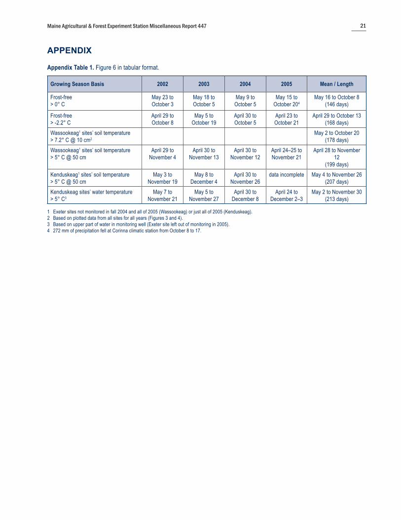
Maine Agricultural & Forest Experiment Station Miscellaneous Report 447 21
Appendix Table 1. Figure 6 in tabular format.
Growing Season Basis 2002 2003 2004 2005 Mean / Length
Frost-free > 0° C
May 23 to October 3
May 18 to October 5
May 9 to October 5
May 15 to October 204
May 16 to October 8(146 days)
Frost-free > -2.2° C
April 29 to October 8
May 5 to October 19
April 30 to October 5
April 23 to October 21
April 29 to October 13 (168 days)
Wassookeag1 sites’ soil temperature > 7.2° C @ 10 cm2
May 2 to October 20(178 days)
Wassookeag1 sites’ soil temperature > 5° C @ 50 cm
April 29 to November 4
April 30 to November 13
April 30 to November 12
April 24–25 to November 21
April 28 to November 12
(199 days)Kenduskeag1 sites’ soil temperature > 5° C @ 50 cm
May 3 to November 19
May 8 to December 4
April 30 to November 26
data incomplete May 4 to November 26(207 days)
Kenduskeag sites’ water temperature > 5° C3
May 7 to November 21
May 5 to November 27
April 30 to December 8
April 24 to December 2–3
May 2 to November 30(213 days)
1 Exeter sites not monitored in fall 2004 and all of 2005 (Wassookeag) or just all of 2005 (Kenduskeag).2 Based on plotted data from all sites for all years (Figures 3 and 4).3 Based on upper part of water in monitoring well (Exeter site left out of monitoring in 2005).4 272 mm of precipitation fell at Corinna climatic station from October 8 to 17.
APPENDIX

Maine Agricultural & Forest Experiment Station Miscellaneous Report 44722
CORINTH LOWER FORESTED: 2003by Kenduskeag Pedon
End of Growing Season (H20 >5° C): Nov. 14 (with Nov. 24–Dec. 4 respite [11 days])
Water Table <40 cm within Growing Season:Oct. 10–Nov. 14 (35 days)
BLUE = Centimeters to water in wellRED = Temperature (°C) of H2O in monitoring wellPURPLE = Temperature (°C) of soil at 50 cm
0
10
20
30
40
50
60
70
80
90
100
15
13
11
9
7
5
3
1
15 30 15 31 15 30 15
SEPT. OCT. NOV. DEC.
cm fr
om so
il sur
face
°Celsius
CORINTH LOWER FORESTED: 2002by Kenduskeag Pedon
Start of Growing Season (H20 temp >5° C): May 6
Water Table <40 cm within Growing Season: May 6–July 10 (extrapolated)(65 days)
Soil Temp. (@50 cm) readings not taken the first 3 weeks of monitoring here.
BLUE = Centimeters to water in wellRED = Temperature (°C) of H2O in monitoring wellPURPLE = Temperature (°C) of soil at 50 cm
0
10
20
30
40
50
60
70
80
90
100
15
13
11
9
7
5
3
1
15 30 15 31 15 30 15
APRIL MAY JUNE JULY
°Celsius
cm fr
om so
il sur
face
The following graphs are examples of how the hydrologic data was plotted and interpreted throughout the extent of the water table study for a given site and season:

Maine Agricultural & Forest Experiment Station Miscellaneous Report 447 23
0
10
20
30
40
50
60
70
80
90
100
15
13
11
9
7
5
3
1
CORINTH BEANS MILL: 2003Near Wassookeag Pedon
Growing Season Starts (>5° C): April 30
*Water Table ≤60 cm: 0 days
*Water Table ≤100 cm: 0 days No water table to 100 cm from April 17 to June 16, and on July 16*during growing season
15 30 15 31 15 30 15
APRIL MAY JUNE JULY
CORINTH RT. 15: 2002Near Wassookeag Pedon
End of Growing Season: Nov. 3 (13–18 day respite)
No water table observed on August 16 and between Sept. 19 and Nov. 22
0
10
20
30
40
50
60
70
80
90
100
15
13
11
9
7
5
3
1
15 30 15 31 15 30 15
SEPT. OCT. NOV. DEC.
cm fr
om so
il sur
face
cm fr
om so
il sur
face
°Celsius°Celsius

![Temperature-pressure phase relationships in niobium … · Temperature-Pressure Phase Relationships in Niobium ... references at the end of ... with a dc Carey·Foster Bridge [4]](https://img.pdfslide.us/doc/110x75/5ac7226a7f8b9af91c8ea63b/temperature-pressure-phase-relationships-in-niobium-phase-relationships-in-niobium.jpg)