Embed Size (px)
Citation preview

SEA EXPERIENCE AND TOOLS AVAILABLE UNDER CEP
17 December 2013
GREATER MEKONG SUBREGION
CORE ENVIRONMENT PROGRAM

The Core Environment Program (CEP)
CEP Phase II (2012–2016) aims to mainstream improved environmental management across all sectors of the GMS development program via 4 components: 1. Environmental Monitoring, Planning & Safeguards
2. Biodiversity Landscapes & Livelihoods
3. Climate Change
4. Institutions & Financing

Environmental Monitoring, Planning & Safeguards
Upgrading sustainable development planning capacities and creating enabling policies for their use in the GMS economic corridors and the biodiversity conservation corridors.
(i) Building subregional and national SEA capacities
(i) Capacity development for environmental and social safeguards
(i) Strengthening environmental and social monitoring processes and methods.

ENVIRONMENTAL PLANNING SUPPORT TOOLS
1. Forecasting and previewing strategic planning tools.
2. Tools for assessing investment suitability and
location.
3. Baseline assessment, monitoring and information management tools.
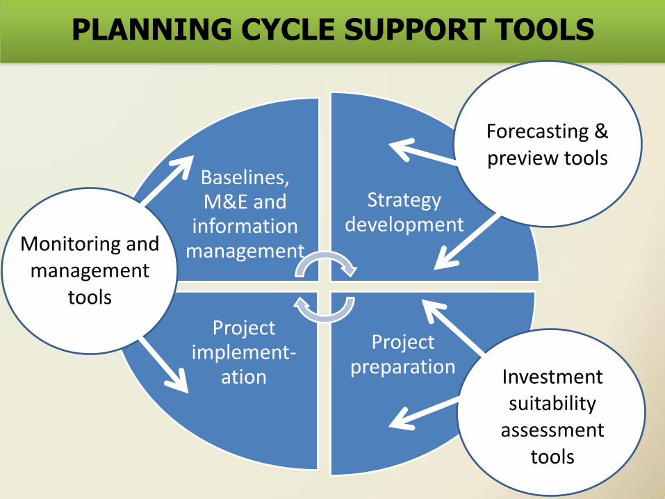
PLANNING CYCLE SUPPORT TOOLS
Baselines, M&E and
information management
Strategy development
Project preparation
Project implement-
ation
Monitoring and management
tools
Investment suitability
assessment tools
Forecasting & preview tools

FORECASTING AND PREVIEWING TOOLS
1. Scenario-driven land demand allocation (CLUE)
2. Water Evaluation And Planning (WEAP)
3. Long range Energy Alternatives Planning (LEAP)

Scenario-driven land demand allocation
(CLUE)
• Purpose: Identify demand scenarios that adversely affect energy investments
• Approach: Land demand allocation modelling • Time: ?? weeks • Area: Provincial to national level ?? • Skills: Advanced vector and raster GIS skills • Staff: 1-2 part time staff

Integrated energy and water planning
WEAP LEAP
Climate change is a key driver of water systems Current focus on water sufficiency and climate change adaptation LEAP provides insights into climate mitigation potential in the water sector
Energy systems drive climate change Current focus on energy sufficiency and climate change mitigation WEAP provides insights into how climate adaptation will effect energy systems

Water Evaluation And Planning (WEAP)
• Facilitates engagement of diverse stakeholders through an open and transparent process.
• Uses water demand and supply information to drive a simulation model.
• Calculates water demand, supply, runoff, infiltration, etc. under varying hydrologic and policy scenarios.
• Evaluates a full range of water management options, taking account of multiple and competing uses of water.

Long range Energy Alternatives Planning
(LEAP)
• An integrated modelling tool used to track energy consumption, production and resource extraction.
• Accounts for both energy sector and non-energy sector GHG emission sources and sinks.
• Designed around long-range scenario analysis of how an energy system might evolve over time.
• Promotes inter-agency cooperation by presenting complex energy analysis concepts in a transparent and intuitive way.

ASSESSING INVESTMENT SUITABILITY
1. Hydropower sustainability assessment (RSAT)
2. Spatial Multi-Criteria Assessment (SMCA)

Rapid hydropower sustainability assessment
(RSAT)
• A rapid, simple, participatory assessment tool. • Provides a framework for analysing basin-wide
hydropower suitability. • Looks beyond individual schemes to consider
multiple projects at different stages. • Promotes a common understanding of key issues
among diverse stakeholders. • Complements more data-intensive tools such as
SEA, CIA, EIA, etc.

Spatial Multi-criteria Assessment (SMCA)
• A decision-support tool that generates suitability/ vulnerability maps to compare alternatives.
• Highlights environmental, climatic & social impacts posed by development projects.
• Identifies appropriate mitigation measures. • Provides guidelines for locating proposed
development projects. • Produces recommendations for environmental
interventions to enhance long term performance of development investments

BASELINE ASSESSMENT AND MONITORING
1. Forest Cover Mapping
2. Pollution Intensities Estimation
3. Natural Capital Valuation

Forest Cover Mapping (FCM)
• Adequate forest cover map essential for SEA/EIA • Forest cover assessment expensive and timely • Provincial FCM in Quang Nam:
Purpose: Basis for PES fund allocation to communes Time: 4-8 weeks Area: Provincial to national level Quality: Superior to existing data Skills: Basic to medium raster GIS skills Staff: 2-3 part time staff including field verification

Pollution Intensities Estimation (IPPS)
• Purpose: To identify polluting sectors and their geographic distribution
• Approach: Sector pollution coefficients applied to labour data
• Time: 4-8 weeks • Area: Provincial to national level • Skills: Excel and basic GIS skills • Staff: 1 part time staff

Natural Capital Valuation
Sumit or Michael to provide a summary