Embed Size (px)
Citation preview

Boreal shorebird monitoring assessment December 2004
Boreal Shorebirds An Assessment of Conservation Status and Potential for Population Monitoring Program for Regional and International Shorebird Monitoring (PRISM) Boreal Committee Pam Sinclair1
Yves Aubry1 Jon Bart2 Vicky Johnston1 Rick Lanctot3
Brian McCaffrey3
Ken Ross1 Pam Sinclair1 Paul Smith1 Lee Tibbitts2 1. Canadian Wildlife Service 2. U.S. Geological Survey 3. U.S. Fish and Wildlife Service
1

Boreal shorebird monitoring assessment December 2004
Table of Contents 1.0 Background............................................................................................................. 3
1.1 The Boreal Region .............................................................................................. 4 1.2 Boreal Shorebird Species.................................................................................... 5
2.0 Conservation Priorities............................................................................................ 6 2.1 Prioritization Protocol......................................................................................... 6 2.2 Species Prioritization Scores............................................................................... 8
3.0 Potential Methods for Monitoring Boreal Shorebirds .......................................... 10 3.1 The North American Breeding Bird Survey ..................................................... 10
3.1.1 Methodological Considerations ................................................................ 10 3.1.2 Regional Considerations ........................................................................... 14 3.1.3 Recommendations..................................................................................... 17
3.2 Off-road Point Counts....................................................................................... 17 3.2.1 Methodological Considerations ................................................................ 17 3.2.2 Regional Considerations ........................................................................... 18 3.2.3 Recommendations..................................................................................... 19
3.3 Ground-based Wetland Surveys during the Breeding Season .......................... 19 3.3.1 General Considerations............................................................................. 19 3.3.2 Recommendations..................................................................................... 20
3.4 Aerial Surveys on the Breeding Grounds ......................................................... 20 3.4.1 Methodological Considerations ................................................................ 20 3.4.2 Regional Considerations ........................................................................... 21 1.1.1 3.4.2.5 Recommendations......................................................................... 24
3.5 Stopover Site Monitoring.................................................................................. 24 3.5.1 Aerial Surveys........................................................................................... 24 3.5.2 Ground Surveys ........................................................................................ 26 3.5.3 Boreal Stopover Sites................................................................................ 27 3.5.4 Recommendations..................................................................................... 28
4. Potential for Monitoring each Species...................................................................... 28 4.1 High-Priority Boreal Species ............................................................................ 28 4.2 Lower-Priority Boreal Species.......................................................................... 30
5. Summary and Conclusions ....................................................................................... 33 6. Recommendations..................................................................................................... 34 7. Literature Cited ......................................................................................................... 36
2

Boreal shorebird monitoring assessment December 2004
Boreal Shorebirds An Assessment of Conservation Status and Potential for Population Monitoring PRISM Boreal Committee
1.0 Background Most North American shorebird species show evidence of recent population declines, and some have suffered drastic declines in the past. Data from a variety of surveys across the continent indicate that of 31 Canadian nesting shorebird species with trend data available, 25 show negative population trends overall, while only 6 show positive trends overall (Donaldson et al. 2000). Seventeen of those 31 species nest in the boreal; of these, 10 show statistically significant downward trends, and another four show non-significant downward trends. Population monitoring is needed in order to document the severity, and geographic extent, of population declines, so that priorities can be set for conservation, in order to reverse these alarming trends. A number of major efforts are underway to improve and coordinate bird monitoring throughout North America, through regional, national, and continental bird monitoring plans (e.g. Downes et al. 2000, NABCI-U.S. Monitoring Working Group 2003). Coverage is relatively good for some groups of birds in large areas of the continent – for example, waterfowl, landbirds, and migrant shorebirds which concentrate in certain staging or wintering areas - through well established monitoring programs (the North American Breeding Bird Survey, U.S. Fish and Wildlife Service waterfowl surveys, etc.). However, other groups of birds have not been well monitored, mostly due to inaccessibility of their habitats, broad dispersion of birds, or difficulties with detection. Shorebirds which breed in the boreal forest are not being adequately monitored. Their forest wetland habitats are remote and therefore difficult and expensive to access; these habitats are generally difficult to walk through, and difficult to see across (compared to tundra, prairie, and coastal habitats used by other groups of shorebirds). Further, few boreal nesting shorebirds concentrate during migration or on wintering grounds, making population monitoring problematic during the non-breeding season as well. Recent efforts to evaluate, coordinate, and improve monitoring of shorebird populations in North America (e.g. Howe et al. 2000, Bart et al. 2002) have identified boreal nesting shorebirds as a poorly-covered group in need of further planning before a monitoring program can be implemented. This report is a first step in addressing that need. The purpose of this discussion paper is to assess the status of shorebirds which breed in the boreal region of North America, and to explore potential methods for monitoring their populations, particularly on the breeding grounds. Boreal
3

Boreal shorebird monitoring assessment December 2004
shorebirds do not comprise a particularly large group of species; nor are there large amounts of funding targeted to this group. Broad-scale monitoring of their populations will therefore likely involve coordination with monitoring programs that are primarily designed for other species groups, such as waterfowl or landbirds. In this discussion paper we consider existing bird survey techniques and programs, and assess the extent to which they can be used, combined, and/or modified to monitor populations of boreal shorebirds.
1.1 The Boreal Region We define the boreal region (Figure 1) as the portion of North America which lies within NABCI Bird Conservation Regions (BCRs) 4,6,7, and 8. These are: BCR 4 – Northwestern Interior Forest BCR 6 – Boreal Taiga Plains BCR 7 – Taiga Shield and Hudson Plains BCR 8 - Boreal Softwood Shield These BCRs comprise a huge expanse stretching from interior Alaska to Newfoundland. This region is largely forested, but also includes extensive subalpine and alpine areas in the west, as well as numerous small and large bodies of water.
Figure 1. The boreal region, consisting of NABCI Bird Conservation Regions 4, 6, 7, and 8.
4

Boreal shorebird monitoring assessment December 2004
1.2 Boreal Shorebird Species Nineteen shorebird species regularly breed in the boreal region: American Golden-Plover Pluvialis dominica Semipalmated Plover Charadrius semipalmatusKilldeer Charadrius vociferus Greater Yellowlegs Tringa melanoleuca Lesser Yellowlegs Tringa flavipes Solitary Sandpiper Tringa solitaria Wandering Tattler Heteroscelus incanus Spotted Sandpiper Actitis macularia Upland Sandpiper Bartramia longicauda Whimbrel Numenius phaeopus Hudsonian Godwit Limosa haemastica Marbled Godwit Limosa fedoa Surfbird Aphriza virgata Least Sandpiper Calidris minutilla Baird's Sandpiper Calidris bairdii Short-billed Dowitcher Limnodromus griseus Wilson's Snipe Gallinago gallinago Wilson's Phalarope Phalaropus tricolor Red-necked Phalarope Phalaropus lobatus
For four species, the boreal region encompasses almost their entire breeding range. These include Greater Yellowlegs, Lesser Yellowlegs, Solitary Sandpiper, and Short-billed Dowitcher. Six other species are widespread breeders in the boreal region, but also have large populations elsewhere. These include Semipalmated Plover, Least Sandpiper, and Red-necked Phalarope which also nest in the Arctic; and Killdeer, Spotted Sandpiper and Wilson’s Snipe, which also have large populations further south. Three species have unusual breeding ranges which include parts of the boreal region: Hudsonian Godwit nests only in scattered locations in the Arctic and boreal regions; Marbled Godwit nests primarily in the Prairies but has disjunct populations in western Alaska and James Bay; and Upland Sandpiper breeds primarily in grasslands south of the boreal but also has significant populations in subalpine, grassland, and tundra habitats in the northwestern part of the boreal region. Four species nest in the boreal region rather peripherally. Three are primarily Arctic breeders which also nest on alpine tundra areas in the western boreal region (American Golden-Plover, Whimbrel, Baird’s Sandpiper); and one
5
Boreal shorebird monitoring assessment December 2004
primarily Prairie species nests within the southern edge of the boreal (Wilson’s Phalarope). Finally, two species breed extensively within the boreal region but not in forested habitats; they are restricted to high elevation areas far above treeline (Wandering Tattler and Surfbird). Several boreal shorebirds have distinct breeding populations or subspecies. These include (subspecies/populations which breed predominantly within the boreal region are in bold) Solitary Sandpiper Tringa solitaria T. s. solitaria (Labrador to southern prairie provinces to eastern B.C.) T. s. cinnamomea (northern prairie provinces to Alaska) Whimbrel Numenius phaeopus
N. p. hudsonicus (Hudson Bay lowlands; Arctic and boreal) N. p. rufiventris (Alaska to Mackenzie; Arctic, Western Alaskan, and
boreal) Hudsonian Godwit Limosa haemastica L. haemastica (Alaska, Mackenzie; Arctic, Western Alaskan, and boreal)
L. haemastica (Hudson Bay) Marbled Godwit Limosa fedoa L. f. fedoa (Great Plains, extending into boreal) L. f. fedoa (James Bay)
(L. f. beringiae (western Alaska, not within boreal region)) Short-billed Dowitcher Limnodromus griseus L. g. griseus (James Bay to Labrador)
L. g. hendersoni (Alberta to western James Bay) L. g. caurinus (Alaska, British Columbia, Yukon; coastal and boreal)
2.0 Conservation Priorities
2.1 Prioritization Protocol In order to establish priorities for conservation of boreal shorebirds, we use the following protocol, which combines a continental conservation status score with an estimate of the importance of the boreal region to each species. First, Continental (Canada/U.S.) Conservation Categories were taken from the Canadian Shorebird Conservation Plan (Donaldson et al. 2000). These scores, presented in Appendix 1, indicate the continental conservation status of each shorebird species, based on population trend, abundance and distribution, and threats (for codes and definitions see Appendix 2). Species are scored on a scale of 1 (not at risk) to 5 (highly imperiled). We have modified the continental scores for two species (Lesser Yellowlegs and Upland Sandpiper), to conform with changes which appeared in the second edition of the U.S. Shorebird
6

Boreal shorebird monitoring assessment December 2004
Conservation Plan (Brown et al. 2001), based on new information on population trends. Next, the importance of the boreal region to each species was scored using a “Boreal Importance Code”. The Boreal Importance Code is a Regional Importance Code (Brown et al. 2001; and see below) for the boreal region. It is an indication of the importance, to each species, of the boreal region relative to other regions of North America. Finally, we assigned a Boreal Conservation Category to each species, by using its Boreal Importance Code to modify its Continental Conservation Category. For example, a species ranked as Continental Conservation Category 3 (moderate concern), for which the boreal region is extremely important (Boreal Importance Code B), was upgraded to 4 (high priority) for its Boreal Conservation Category. Conversely, a species ranked as Continental Conservation Category 4 (high concern), for which the boreal region is relatively unimportant in terms of numbers present (Boreal Importance Code b), was downgraded to 3 (moderate priority) for its Boreal Conservation Category. Continental Conservation Categories The Canadian Shorebird Conservation Plan (Donaldson et al. 2000) uses the following ranking scheme to score the conservation status of each shorebird species for North America (United States and Canada; for further details see Appendix 2): 5 = Highly Imperiled: All species listed as threatened or endangered nationally, plus all species with significant population declines and either low populations or some other high risk factor. 4 = Species of High Concern: Populations of these species are known or thought to be declining, and have some other known or potential threat as well. 3 = Species of Moderate Concern: Populations of these species are either a) declining with moderate threats or distributions; b) stable with known or potential threats and moderate to restricted distributions; c) and d) relatively small and restricted; or e) declining but with no other known threats. 2 = Species of Low Concern: Populations of these species are either a) stable with moderate threats and distributions; b) increasing but with known or potential threats and moderate to restricted distributions; or c) of moderate size. 1 = Species Not at Risk: All other species Regional Importance Codes (or Boreal Importance Codes) The U.S. Shorebird Conservation Plan (Brown et al. 2001) uses the following codes to score the relative importance of a region (B=breeding, M=migration, W=wintering): B,M,W=high concentrations, region extremely important to the species relative to the majority of other regions. B,M,W=common or locally abundant, region important to the species
7

Boreal shorebird monitoring assessment December 2004
b,m,w=uncommon to fairly common, region within species range but occurs in low relative abundance relative to other regions.
2.2 Species Prioritization Scores Boreal Conservation Categories are presented in Table 1. Nine species fall into Boreal Conservation Category 4 or 5 (high priority). These include Greater and Lesser Yellowlegs, Solitary Sandpiper, Hudsonian Godwit, Marbled Godwit, Short-billed Dowitcher, and Wilson’s Snipe; and also the alpine nesting species, Surfbird and Wandering Tattler. These nine are species of moderate or high concern continentally, for which the boreal region is important or extremely important relative to other regions of the continent. Each of the four boreal BCRs is “important” for four to seven high-priority boreal shorebirds: BCR 4 – Lesser Yellowlegs, Solitary Sandpiper, Hudsonian Godwit (Alaska population), and Wilson’s Snipe, as well as the alpine nesting species, Surfbird and Wandering Tattler BCR 6 - Greater and Lesser Yellowlegs, Solitary Sandpiper, Hudsonian Godwit (“Alaska” population), Marbled Godwit, Short-billed Dowitcher, and Wilson’s Snipe BCR 7 – Greater and Lesser Yellowlegs, Hudsonian and Marbled godwits, Short-billed Dowitcher, and Wilson’s Snipe BCR 8 – Greater Yellowlegs, Solitary Sandpiper, Short-billed Dowitcher, and Wilson’s Snipe
8

Boreal shorebird monitoring assessment December 2004
9
Table 1. Conservation Priorities for Boreal Shorebirds. Species Boreal Continental
Conservation Category1
Conservation Category2
Boreal Importance Code3
Boreal Importance Code
BCR 4 BCR 6 BCR 7 BCR 8
(breeding) (migration) American Golden-Plover 2 4 b m b b b Semipalmated Plover 2 2 B m B B B b Killdeer 2 3 b m b B b B Greater Yellowlegs 4 3 B m b B B B Lesser Yellowlegs 4 3 B m B B B b Solitary Sandpiper 5 4 B m B B b B T. s. solitaria 5 4 B m B B T. s. cinnamomea 5 4 B m B B Wandering Tattler 4 3 B m B Spotted Sandpiper 2 2 B m B B B B Upland Sandpiper 3 4 b m B b Whimbrel 3 4 b m b b B N. p. hudsonicus 5 4 B B N. p. rufiventris 4 4 B B b Hudsonian Godwit 4 4 B M b b B,M L. haemastica (Alaska) 4 4 B B B L. haemastica (Hudson Bay) 5 4 B B Marbled Godwit 4 4 B m B B L. f. fedoa (Great Plains) 3 4 b B L. f. fedoa (James Bay) 5 4 B B Surfbird 5 4 B m B Least Sandpiper 3 3 B m B B B b Baird's Sandpiper 2 2 b m b Short-billed Dowitcher 5 4 B m b B B B L. g. griseus 5 4 B B b L. g. hendersoni 5 4 B B B L. g. caurinus 3 4 b b Wilson's Snipe 4 3 B m B B B B Wilson's Phalarope 3 4 b m b B b Red-necked Phalarope 3 3 B m B B B b 1. Boreal Conservation Categories are 1,2=low priority, 3=moderate priority, 4,5=high priority. 2. Continental Conservation Categories are 1=not at risk, 2=low concern, 3=moderate concern, 4=high concern, 5=highly imperiled. 3. Regional Importance Codes are B=extremely important, B=important, b=less important (relative to other regions of North America); these are presented for Bird Conservation Regions 4, 6, 7 and 8, as well as for the entire boreal region (“Boreal Importance Code”). See Appendix 2 for definitions of codes.

Boreal shorebird monitoring assessment December 2004
Two of the high-priority species nest in the boreal region, but not in the boreal forest. These are the high alpine breeders, Surfbird and Wandering Tattler. Logistical and methodological issues will differ for these two species, compared to the majority of boreal shorebirds which nest in forest or taiga habitats. Although it is acknowledged here that these are priority species for conservation in the boreal region, a full assessment of the potential for monitoring their populations is beyond the scope of this report. Six species are of moderate priority, and four are low-priority species for the boreal region. Boreal monitoring schemes should include these species where possible, but should be designed primarily to monitor the priority species. Bart et al. (2004) suggest that surveys should be designed for species that have at least a third of their population in the focal area (in this case the boreal).
3.0 Potential Methods for Monitoring Boreal Shorebirds In this section we discuss the potential of using various existing survey methods for monitoring boreal shorebirds. “Monitoring” refers to tracking long-term population trends and/or changes in distribution, and may also involve determining population size, or relative abundance across regions and/or habitats.
3.1 The North American Breeding Bird Survey
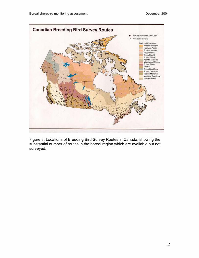
3.1.1 Methodological Considerations The North American Breeding Bird Survey, initiated in 1966, is a volunteer-based, continent-wide program which uses roadside point counts to survey breeding birds (for methodology see e.g. Bystrak 1981). It is an attractive monitoring tool because it is a well-established protocol which has already been used to monitor population trends in a large number of species (mostly landbirds; see e.g. Dunn et al. 2000). However, the BBS is a roadside survey which samples mostly upland habitats, and as such it has some limitations for shorebirds. Coverage in the boreal region has been low, due to the scarcity of qualified volunteer observers, and the low densities of roads (see Figure 2). With increased coverage the BBS may be an effective monitoring tool for some boreal shorebirds. For boreal shorebirds the BBS would likely be used to monitor a population index (i.e., calling birds along roads) and we would need to determine whether this index is sufficiently representative of the populations as a whole to warrant tracking. In the boreal region, a total of 417 BBS routes have been established since the survey began in 1966. Of the 417 routes established, 374 are currently “active” (i.e. have not been discontinued). Of the 374 “active” boreal routes, only a small proportion are run in a given year (see Figure 3). For example in 2002, 137 routes were run (37% of active routes). The proportion of active routes which are
10

Boreal shorebird monitoring assessment December 2004
run varies among BCRs – for example in 2002, 56% of active routes in BCR 4 were run while only 13% of active routes in BCR 8 were run. BBS coverage in the boreal would be almost tripled if all active routes were run (see Table 2).
Figure 2. Locations of North American Breeding Bird Survey routes, showing poor coverage in the boreal region.
11
Boreal shorebird monitoring assessment December 2004
Figure 3. Locations of Breeding Bird Survey Routes in Canada, showing the substantial number of routes in the boreal region which are available but not surveyed.
12

Boreal shorebird monitoring assessment December 2004
Table 2. Current BBS coverage in the boreal: number of routes run in 2002, with total number of “active” (i.e. available) routes in parentheses, by Bird Conservation Region and province/territory/state.
BCR 4 BCR 6 BCR 7 BCR 8 total routes run in 2002
total active routes
routes run/ routes active
Alaska 41(53) 41 53 0.77Alberta 31(84) 31 84 0.37B.C. 1(8) 3(5) 4 13 0.31N.W.T. 5(9) 1(1) 6 10 0.60Manitoba 15(19) 1(1) 4(13) 20 33 0.61Newfoundland 0(3) 8(26) 8 29 0.28Ontario 2(47) 2 47 0.04Quebec 0(3) 2(40) 2 43 0.05Saskatchewan 12(28) 12 28 0.43Yukon 11(34) 11 34 0.32total 53(95) 66(145) 2(8) 16(126) 137 374 0.37 In many areas of the boreal, the availability of qualified observers appears to be more immediately limiting than availability of suitable roads. Not only are many routes established but not run; in addition, areas remain which have suitable roads but no BBS routes. For example in the Yukon, establishing routes in the 11 “degree blocks” with suitable roads which do not yet have BBS routes would increase the number of “active” boreal BBS routes there from 34 to 45. Even if coverage were increased, there are a number of concerns and questions regarding the ability of the BBS to monitor shorebirds. For example, as a roadside survey, the BBS may not sample enough shorebird habitat to “capture” enough shorebirds to monitor them effectively. The rights-of-way cleared along many roads is very wide, so that much of the “count circle” is regularly disturbed, and does not represent potential breeding habitat for most shorebird species. Modifications of the BBS could be tested, such as a “near-road” survey which follows a section of road but which places the actual point locations perhaps 150 m from the road. Fewer points would be surveyed per route (perhaps 10 instead of 50). Since two people are usually required on remote routes for safety reasons, conventional roadside and “near road” surveys could be conducted simultaneously. This technique could be valuable for monitoring landbirds as well as shorebirds. As a survey that does not specifically target wetlands, the BBS may not sample shorebird habitats adequately. In some areas, roads are placed to avoid wetlands, while in mountainous areas, roads tend to be placed in lowlands and valleys, which often to feature a disproportionate amount of riparian habitat. A roadside survey which targeted wetlands (adjacent to and/or near to roads) might be more efficient than the BBS. Such surveys exist for waterfowl, and for secretive marsh birds (Conway 2004). High-priority boreal shorebirds that may
13

Boreal shorebird monitoring assessment December 2004
be more efficiently monitored using a roadside wetlands survey include Greater and Lesser yellowlegs, Solitary Sandpiper, and Wilson’s Snipe. Other questions regarding the effectiveness of the BBS for monitoring shorebirds include whether the seasonal timing of the BBS is appropriate for shorebirds; whether the 400 m radius point count is appropriate for shorebirds; how detectability varies over the season; etc.
3.1.2 Regional Considerations
3.1.2.1 BCR 4 Within Canada, BCR 4 encompasses all 34 active Yukon BBS routes, and 8 active routes in British Columbia. In Alaska, there are 53 active routes within BCR 4. In addition, there are some river routes in Alaska that are analyzed as part of the BBS data set. Coverage is good in Alaska, where about 80% of active routes are currently run, and poor in the Canadian portion of the BCR, where under 30% of active routes are currently run.
In the Canadian portion of BCR 4, 8 species have been reported on BBS routes. Lesser Yellowlegs, Spotted Sandpiper, and Wilson’s Snipe occur on most routes, in moderate to fairly high numbers (maximum per route 54, 11, and 18 respectively). Solitary Sandpiper occurs in low numbers on about half of Yukon BBS routes (maximum of 6 recorded on a route). Semipalmated Plover and Upland Sandpiper have been recorded on about 20% of the routes, in low numbers. Red-necked Phalarope has been recorded on 3 routes, in low numbers. In the Canadian portion of the BCR, volunteers who run BBS routes have received minimal training, and have not been tested for bird identification skills. Most BBS participants are proficient at identifying landbirds by call, but may not be sufficiently skilled at identifying shorebirds by call. If the BBS were to be used to monitor boreal shorebirds, training and “quality control” would be required. Certain species, such as Solitary Sandpiper, may occur more frequently on BBS routes than is indicated by the data, as it is likely some observers are missing them. If the BBS were to be used for monitoring boreal shorebirds, efforts should be made to increase coverage, and the consistency of coverage, across the Yukon and in northern BC. This would likely require hiring skilled observers to run BBS routes in remote areas. In addition, the efficacy of options such as assigning two routes to each volunteer, to be run in alternate years, would be investigated, as would the appropriate seasonal timing of BBS surveys for these shorebirds.
14

Boreal shorebird monitoring assessment December 2004
In summary, the BBS could be an effective monitoring tool for Lesser Yellowlegs, Wilson’s Snipe, Spotted Sandpiper, and Solitary Sandpiper in BCR 4.. Increased coverage, better consistency of coverage, some training of observers, and recruitment of observers would be required, and could be accomplished at reasonable cost. Volunteer participation would likely have to be supplemented with paid observers for more remote routes.
3.1.2.2 BCR 6 There are many active BBS routes in the southern reaches of BCR 6. Coverage in the boreal regions is better in Alberta than in Saskatchewan. Alberta’s routes (not restricted to BCR 6) capture many Killdeer, Spotted Sandpiper, Marbled Godwit, Wilson’s Snipe and Wilson’s Phalarope. They capture some Lesser Yellowlegs, Solitary Sandpiper and Upland Sandpiper. They capture few individuals of the other boreal species. In Saskatchewan (BCRs 6,7,8,11), BBS routes count many Killdeer, Marbled Godwit and Wilson’s Snipe and some Upland Sandpiper and Wilson’s Phalaropes. In the NWT, road access is poor, and there are only 10 active BBS routes across the territory. Nine are in BCR 6. From 2000-2002, these captured many Lesser Yellowlegs and Wilson’s Snipe, and fewer Solitary Sandpiper. The Mackenzie Valley has only a single BBS route (Normal Wells). Increased coverage along Highway 1 could be useful. In summary, the BBS could be effective at monitoring Killdeer, Marbled Godwit, Wilson’s Snipe, Wilson’s Phalarope and Spotted Sandpiper in BCR 6. With increased coverage, BBS routes could be an effective tool for Lesser Yellowlegs, Solitary Sandpiper and Upland Sandpiper.
3.1.2.3 BCRs 7 and 8 BBS routes are run in BCR 8 where the road system extends. They have potential to provide adequate data for Wilson’s Snipe and Spotted Sandpiper. Solitary Sandpipers could also be detected but density is likely not sufficient for population monitoring. In Quebec, there is also potential for monitoring some sections of BCR 7 where there is limited road access associated with hydro developments and also around Schefferville in the east. Additional species that could be monitored there are Greater and Lesser yellowlegs, Semipalmated Plover and Least Sandpiper. Red-necked Phalarope and Short-billed Dowitcher might possibly be monitored in the Schefferville area but densities are likely too low for an effective sample.
15

Boreal shorebird monitoring assessment December 2004
3.1.2.4 Boreal-wide Summary Overall, the BBS has some potential for monitoring Greater and Lesser yellowlegs, Solitary Sandpiper, Marbled Godwit, and Wilson’s Snipe. Lower-priority species which have potential for monitoring in the boreal using the BBS include Spotted Sandpiper, Killdeer, and Upland Sandpiper. High-priority species which have very little potential to be monitored using the BBS, due to restricted ranges and/or ranges and habitats which do not overlap much with roads, include Hudsonian Godwit and Short-billed Dowitcher, as well as Surfbird and Wandering Tattler. As a roadside survey, the BBS may not “capture” enough shorebirds to monitor their populations effectively. Modifications of the protocol, for example moving survey points 150 m off the road and surveying fewer points, could be tested in order to determine whether they would sample shorebird habitats more effectively. Strategies for increased coverage could be investigated, for example assigning pairs of routes to observers, with each route to be surveyed in alternate years).
16

Boreal shorebird monitoring assessment December 2004
3.1.3 Recommendations
Delineate the portion of each species’ (and breeding populations’) range that contains roads suitable for the BBS, in order to determine the current and potential BBS coverage for each species. This would be a mapping exercise in which active BBS routes, and suitable roads, are overlaid with species ranges. Trails accessible by ATV, for example along powerlines, should also be indicated.
Increase coverage, or simulate increased coverage, of the BBS in the boreal, and investigate the power of the BBS to detect changes in population size for each species. Determine for which species population monitoring may be achieved with the BBS; for which species distribution monitoring may be achieved; and for which species the BBS has minimal utility.
Test a “near road” protocol in which BBS routes are used, but the actual survey points are located off-road, and fewer points are surveyed per route.
Investigate less frequent coverage of a greater number of routes as a strategy to increase coverage – e.g. assign a pair of routes to each observer, each route to be surveyed in alternate years.
Investigate seasonal changes in detectability, to determine the optimal seasonal “window(s)” for the BBS for shorebirds.
3.2 Off-road Point Counts
3.2.1 Methodological Considerations Researchers have developed point count survey programs for landbirds off of the road system (off-road point counts) that address the unmeasured sampling biases inherent in the BBS (principally, limited geographic scope of road systems and non-random sampling of habitats). These problems are most pronounced in Alaska and northern and western Canada where whole bioregions are essentially missed by the BBS due to the absence of roads. In Alaska some have tried to address this problem by using rivers to run BBS routes. This has potential for sampling higher densities and more species of shorebirds, but has the same inherent biases in sampling frame as the roadside routes. Furthermore both BBS (road and river) and off-road point count programs are conducted too late in the season to capture the peak period of detectability for most shorebird species.
17

Boreal shorebird monitoring assessment December 2004
Based on the data collected in Alaska over the past 10 years, off-road point counts, even when placed in shorebird habitats, still have very low detection rates for shorebirds. This appears to be related to the low breeding densities of most shorebirds, the placement of sample locations (primarily uplands) and the timing of sampling (after the peak breeding display period).
3.2.2 Regional Considerations
3.2.2.1 BCR 4 Currently there are two programs in Alaska that use off-road point counts to monitor landbirds at scales larger than the disturbed habitat corridor along the road system: the Off-Road Point Count program (ORPC) and the Alaska Landbird Monitoring System (ALMS). Routes in the ORPC were non-randomly selected but instead located opportunistically to measure interannual variation in numbers. This information was then used to craft the design of the more statistically rigorous state-wide program, the ALMS. The ALMS program is based on a random block design and will be used to monitor long-term trends in breeding populations of landbirds (and some shorebirds) within all ecoregions of Alaska. There is some bias associated with accessibility of sites in the ALMS but the program attempts to measure this bias by stratifying sampling by accessibility. Importantly, data from the ALMS will be analyzed jointly with data from BBS to increase power to detect long-term declines.
3.2.2.2 BCR 6 Point counts were conducted in the Taiga Shield by V. Johnston in 2000. She suggests that they may adequately monitor Lesser Yellowlegs and Wilson’s Snipe. Both species were most detectable in late May (25th) and late June (25th). In Alberta and Saskatchewan, the extensive road network makes this method less attractive. In the NWT, it would be expensive and logistically challenging. Until all roads are covered by BBS routes, we see no pressing need to develop this program in the NWT.
3.2.2.3 BCRs 7 and 8 Such an approach would give similar results to the BBS in BCR 8 and thus would not be a step forward. In Ontario, it could be used along the shore in BCR 7 to monitor Semipalmated Plover and possibly on the beach ridges for Red-necked Phalaropes around Cape Henrietta Maria. This would probably require helicopter support and would be hard to justify the cost unless it was integrated with other surveys. Such surveys in the Hudson Bay Lowlands proper would be very hard to undertake even using a helicopter as landing is difficult and most of the land is inundated. These surveys in BCR 7 in Quebec would be similarly prohibitive in cost.
18

Boreal shorebird monitoring assessment December 2004
3.2.2.4 Boreal-wide Summary Off-road Point Counts may be useful in areas where there are no roads, such as BCR 7 and northern parts of BCR 6. However, we recommend that the full potential of the BBS should be explored first. In Alaska, where the BBS is being used at close to its full potential, off-road point counts are being developed and used in order to expand coverage to areas without roads. Once better BBS coverage is achieved in boreal Canada, a need for off-road point counts may develop. Off-road point counts are also being developed in Alberta and Ontario. As data from these programs are collected and analyzed, the costs and benefits of using off-road sites can be examined. All of these off-road point count programs are being developed primarily for landbirds, and do not address the question of whether a monitoring program focused on wetland habitats would be more efficient for boreal shorebirds.
3.2.3 Recommendations
Design any new off-road programs to complement the BBS rather than be completely independent data sets. Assess whether off-road programs are logistically and economically feasible in the relevant provinces and Alaska.
Measure biases to assure that trends are not confounded by detectability, accessibility, changes in habitats through time, etc.
Determine if an earlier sampling window (e.g. early to mid-May) may increase both power to detect trends and number of species covered.
3.3 Ground-based Wetland Surveys during the Breeding Season
3.3.1 General Considerations The two ground-based breeding season surveys which have been considered (the BBS, and Off-road Point Counts) are both primarily aimed at surveying landbirds. For shorebirds, a survey which targets wetland habitats may be more efficient for monitoring populations of most species.
19

Boreal shorebird monitoring assessment December 2004
Existing ground-based breeding season wetland bird surveys include Spring Roadside Pair (waterfowl) Surveys in Yukon, British Columbia, and near Yellowknife, Northwest Territories; and Marsh Bird Monitoring surveys. Protocols have recently been developed for monitoring secretive marsh birds (Conway 2004). There may be opportunities to use these protocols in the boreal, and survey shorebirds along with marsh birds.
3.3.2 Recommendations
Identify ground surveys of waterfowl being conducted in the boreal from mid-May through June, and determine which shorebird species could potentially be recorded along with waterfowl during these surveys. Explore the feasibility of adding one or more easily-identified shorebirds species to the waterfowl recorded on these surveys.
Track implementation of Marsh Bird Monitoring protocols, and explore feasibility of monitoring shorebird species using these surveys.
3.4 Aerial Surveys on the Breeding Grounds
3.4.1 Methodological Considerations Much of our knowledge of shorebird population sizes and trends comes from aerial surveys of staging sites, where large concentrations of birds can be counted. Although counting the birds is relatively straightforward, unbiased estimates or indices of population can be difficult to obtain because of counting bias and uncertainty in length of stay. Further, focusing survey efforts only on staging sites leads to a poor understanding of distribution and abundance on the breeding grounds (Robinson and Warnock 1997). Surveys on the breeding grounds avoid the problems with determining length of stay, and give us valuable information on distribution and habitat associations during this important phase of shorebird life-cycles. Since the late 1990’s, breeding pairs and broods of waterfowl in the western boreal forest have been monitored using aerial helicopter transect and wetland basin surveys. Breeding pair surveys might be suitable for estimating populations of at least some shorebird species. Detection rates have been developed for some of the survey areas, and they are considerably higher than rates derived for the standard waterfowl fixed wing aerial surveys in the same habitat. For example, the estimate for detection of Blue-winged Teal on the conventional fixed-wing aerial surveys is approximately 10%. In their Fort Nelson study area, Ducks Unlimited estimated that generic teal detection rates during helicopter surveys were nearly 90% (Glen Mack, pers. comm.).
20
Boreal shorebird monitoring assessment December 2004
The same study claims a double observer-based detection rate of greater than 99% for shorebirds as a group (i.e. the observer is detecting >99% of all shorebirds that flush or are otherwise detectable by the observer). These results are encouraging, though the shorebird detection rate needs to be replicated in various areas, habitat types, and survey types (e.g. transects versus wetland basin surveys). As part of their Western Boreal Forest Initiative, Ducks Unlimited Canada (DUC) is flying extensive helicopter surveys of boreal regions. Their waterfowl breeding pair surveys occur at approximately the right time and places (focus on wetlands of >1ha in size) to double as shorebird surveys. These surveys may not meet our needs in the long term because DUC does not plan to repeat these surveys. However, their current surveys would serve well to test and refine an aerial survey methodology for shorebirds. Collaboration with DUC could also be useful for identifying areas of high shorebird abundance in the boreal region, and for delineating species ranges.
3.4.2 Regional Considerations
3.4.2.1 BCR 4 At least six species in BCR 4 have some potential for monitoring by aerial (helicopter) surveys during the breeding season: Greater and Lesser yellowlegs, Spotted Sandpiper, Solitary Sandpiper, Hudsonian Godwit, and Short-billed Dowitcher. However, Lesser Yellowlegs may be the only species which is both easy enough to recognize from the air and common enough to be detected in sufficient numbers during surveys. In contrast, species that have small populations and restricted, reasonably well-defined ranges (e.g. Hudsonian Godwit in Alaska) may be effectively monitored with targeted aerial surveys within appropriate breeding habitats in their range. Lesser Yellowlegs is widespread and relatively common, is distinguishable from other species from the air, and flushes when a helicopter flies over. Lesser Yellowlegs is not readily distinguishable from Greater Yellowlegs, but most of its range in BCR 4 does not overlap with that of Greater Yellowlegs. In areas of overlap, such as southeast Yukon and parts of southcentral Alaska, species ratios could be determined using ground surveys. Greater Yellowlegs is also easily identified during fixed-wing surveys of shorelines adjacent to their breeding areas in Alaska. Spotted Sandpiper is widespread and fairly common, and is distinguishable from other species from the air, although not as readily as the larger Lesser Yellowlegs. Solitary Sandpiper is widespread, and may be distinguishable from other species from the air, but is sparsely distributed.
21

Boreal shorebird monitoring assessment December 2004
Hudsonian Godwit in BCR 4 has a relatively restricted range in southcentral and western Alaska. Its large size and distinctive plumage make it very recognizable from the air. This species would not normally be encountered on general survey flights; however, intensive aerial surveys of known breeding areas, using a species-specific protocol, could be used for monitoring. Short-billed Dowitcher is readily distinguishable from all other species except Long-billed Dowitcher, and the latter is absent from BCR 4 during June and the first week of July. Its very limited distribution would likely require targeted surveys to monitor population trends. Wilson’s Snipe may be distinguishable from other species, and is common and widespread, but may sit tight and not react to the helicopter. Least Sandpiper is not readily distinguishable from migrant peeps. Red-necked Phalarope is too small to be detected from fast moving aircraft but may be distinguishable from slow-moving or hovering helicopters. Semipalmated Plover and Upland Sandpiper use upland habitats not usually surveyed by helicopter. Helicopter surveys dedicated to boreal shorebirds would likely be prohibitively costly. However, DUC is carrying out helicopter surveys of waterfowl in BCR 4, and possibilities are being investigated for coordinating with DUC in order to survey shorebirds in addition to waterfowl during their survey flights. Over the next few years, DUC will be conducting surveys in the Peel Plateau in northeastern Yukon. Issues to consider include the adequacy of geographic coverage, the seasonal timing of surveys, etc. (surveys could be timed to avoid counting migrants, i.e. early June to the first days of July; and/or to coincide with the peak of breeding displays in mid- to late May, or the peak of parental distraction behaviour in late June) If boreal shorebird surveys were to “piggyback” on DUC waterfowl surveys, we would need to ensure that waterfowl observers could consistently detect and record shorebirds, in addition to recording waterfowl. If detecting and recording shorebirds is neglected in rich wetlands where the observers’ full attention is directed to recording waterfowl, then this would bias the shorebird results, and the sampling design would need to address this. Alternatively, there may be room for an additional “shorebird observer” in the helicopter. Usually, on DUC waterfowl surveys, there is an observer in the front left and an observer in the rear right, in order to cover both sides of the aircraft. Both observers could detect and record shorebirds, or a protocol could be developed in which a third person surveyed only shorebirds from the rear left. In summary, helicopter surveys have potential as a monitoring tool for Lesser Yellowlegs, Solitary Sandpiper and Spotted Sandpiper in BCR 4. These species are relatively common and widespread, are distinguishable from the air, and use habitats likely to be targeted by aerial surveys. They could potentially be added
22

Boreal shorebird monitoring assessment December 2004
to the waterfowl already recorded during DUC survey flights, in particular the Lesser Yellowlegs which is easiest to recognize from the air, and could be recorded by waterfowl surveyors, rather than requiring a shorebird specialist. Helicopter surveys could also be used to monitor Short-billed Dowitcher and Hudsonian Godwit within their limited breeding ranges, with species-specific protocols.
3.4.2.2 BCR 6 In June 2002, boreal shorebirds were recorded on helicopter surveys in the Sahtu region of NWT (V. Johnston). Lesser Yellowlegs were easily identified from the air (there were no Greater Yellowlegs in the area flown). In addition, Wilson’s Snipe, Solitary Sandpiper, American Golden-Plover and Red-necked Phalarope could be consistently identified “with practice”. Ducks Unlimited Canada continues to work in BCR 6 as part of their Western Boreal Forest Initiative/Lower Mackenzie River Watershed project. Helicopter and ground surveys are planned for the Peel Plateau (BCR 4 / BCR 6) in 2004. In addition, DUC will be LandSat mapping 3.2 million ha of BCR 6. DUC is a willing collaborator, and this is a good opportunity to properly evaluate the utility of aerial surveys for boreal shorebirds on the breeding grounds.
3.4.2.3 BCRs 7 and 8 There is potential to monitor Spotted Sandpipers and Solitary Sandpipers from a helicopter and, in fact, this is presently being done in BCR 8 as part of the annual Black Duck Survey undertaken each spring. Yellowlegs are quite visible from the helicopter but in Ontario, both species are present in roughly similar abundance and distinguishing between them is not reliable. If yellowlegs were to be surveyed where their ranges overlap, species ratios could potentially be established using ground surveys. None of the other species are sufficiently visible (Semipalmated Plover, Least Sandpiper, Wilson’s Snipe, Red-necked Phalarope) or densely distributed (Hudsonian Godwit, Marbled Godwit, Short-billed Dowitcher) to be effectively surveyed using such an expensive approach. In BCR 7, fuel availability is very restricted making extensive surveys with such short range aircraft as helicopters prohibitive in cost as fuel would have to be cached at over $1000/drum. In Quebec, such surveys also could not be carried out near native communities during the traditional goose hunting periods.
3.4.2.4 Regional Summary Lesser Yellowlegs could potentially be monitored using helicopter surveys, where its range does not overlap with that of Greater Yellowlegs. Both species could be monitored where they overlap, if species ratios could be established. Solitary Sandpipers are being monitored using helicopter surveys in BCR 8, but more skill is required to detect these than yellowlegs. There is also potential for Spotted
23

Boreal shorebird monitoring assessment December 2004
Sandpipers, a moderate-priority species. There are restrictions due to cost, and restrictions on timing of helicopter flights in some areas. Species-specific aerial surveys could be used to monitor populations within the very limited breeding distributions of Hudsonian Godwit and Short-billed Dowitcher.
3.4.2.5 Recommendations
Encourage a partnership with DU and DUC to identify opportunities for collaboration.
Calculate estimates of detectability of shorebird species by conducting an analysis of data from simultaneous ground and aerial surveys.
Conduct a pilot study of the feasibility of having waterfowl surveyors also record yellowlegs.
3.5 Stopover Site Monitoring
3.5.1 Aerial Surveys Aerial surveys are used throughout North America to monitor a variety of game birds, and considerable effort has been devoted to refining the methods. For waterfowl, species specific measures of detectability have been determined, and their sensitivity to observer and year effects have been investigated (Smith 1995). Aerial surveys for shorebirds are not uncommon, but the methods are less refined. They primarily target concentrations of birds at stop-over sites or wintering areas (e.g. Morrison et al. 1998, Bishop et al. 2000), and questions of detectability have not been addressed. To be a useful tool for monitoring boreal shorebirds, aerial surveys must enhance our ability to meet our monitoring goals. Specifically, they should help us achieve unbiased estimation of population size or an unbiased index of population size for estimation of trends. Current aerial shorebird surveys do not account for sources of potential bias and, without refinement, cannot achieve these goals. It is clear that aerial survey counts will be increasingly inaccurate as bird density increases, but this counting error should cancel out over a large number of counts. What is more problematic is counting bias: the increased tendency to undercount when densities are higher (e.g. Caughley 1974, Krebs 1999). This bias stems both from an inability to detect the animals (availability bias) and an inability to count fast enough (perception bias) (Marsh and Sinclair 1989). Where perception bias is the primary concern, aerial observers’ counts can be corrected through comparison with photographs (Krebs 1999). Where photographs do not provide accurate counts, a variety of ground surveys, mark-recapture and telemetric techniques have been used to generate correction factors for detectability (e.g. Grier 1982, Caughley and Grice 1982, Packard et al. 1985,
24

Boreal shorebird monitoring assessment December 2004
Pollock and Kendall 1987). The effect of these forms of bias on aerial shorebird counts, or the best means of deriving a correction factor, are currently unknown. As few studies of aerial shorebird surveys have been conducted, we have insufficient data to fully assess their utility. Aerial surveys of staging or wintering shorebirds are not uncommon, and have proven to be an effective monitoring tool at several locations (e.g. Warnock et al. 1998, Bishop et al. 2000). Considerable effort has been expended on developing techniques to estimate both population size and trends in abundance, but at present surveys do not adequately address issues of bias. Aerial surveys are flown from a fixed-winged aircraft or helicopter, typically at a height of 25-60 m and a groundspeed of 60-100 knots (Beyersbergen pers. comm., Andres and Brown 1998, Warnock et al. 1998, Bishop et al. 2000). Usually, shorebirds flush in response to the approach of an aircraft and are counted on the wing, but in some situations, shorebirds do not flush and can be photographed and/or counted as they remain on the ground (Gill and Tibbitts 1999). Photographs can then be used to verify or correct counts. Generally, surveys of the entire staging site are flown repeatedly throughout the migration period. To generate an estimate of the total number of birds passing through the site, numbers of birds present on each day of the migration period are interpolated from counts for survey days and summed. To correct for repeat counts of individuals using the site for >1 day, this sum is divided by the mean length of stay. Many shorebirds cannot be reliably distinguished from the air, particularly the smaller species, and they are often recorded in groups of similar species. Ground surveys are used to determine the proportion of each species that comprise the groups on each survey day, and these proportions are used to determine the composition of mixed flocks. In order to use aerial surveys to monitor boreal staging sites, we would first need to identify the staging sites themselves. This could be achieved in the western boreal forest through collaboration with DUC, which is currently undertaking extensive habitat mapping and aerial surveys in north-western Canada, and has expressed interest in contributing to shorebird monitoring. DUC plans to expand its Western Boreal program into a National Boreal Forest Initiative (McDonald pers. comm.). By working with DUC, we could further our understanding of distribution, relative abundance and habitat relationships of boreal shorebirds in a cost effective way. Collaboration with DUC would allow us to identify important boreal staging areas. However, developing survey methods for these sites would require a great deal of effort. Whether we are interested in estimating population size, or relying on an index of population for trend analysis, counts from aerial surveys would need to be corrected for counting bias.
25

Boreal shorebird monitoring assessment December 2004
Current aerial survey methods for estimating the total number of birds passing through a staging site rely on the assumption that all birds present are counted on each survey. This is unlikely, and with no correction for the proportion of birds detected, this method could yield biased estimates or indices of population size. In PRISM ground surveys of Arctic regions, detectability has been shown to vary with factors such as observer experience, weather, phenology and survey method (Bart et al. in prep.). It is likely that these and other factors would influence detectability on aerial surveys for shorebirds (e.g. Caughley et al. 1976). If we can assume that ground surveys capture all birds present, species specific estimates of detectability could be determined through ground surveys within the aerial survey area. Ideally these detectability estimates should be site and year specific, and are applied to aerial counts to estimate the true number of birds present. Estimates of total numbers using a staging site are highly dependent on the length of stay. Even at major coastal stop-over sites, this can be a difficult parameter to measure. Two techniques are commonly used to determine the length of stay: colour marking/resighting schemes and radio telemetry. While colour marking is much cheaper, in can be ineffective if resighting probability is low (Senner et al. 1991). Radio marking holds the most promise (e.g. Iverson et al. 1996), but may be prohibitively expensive if a large number of stop-over sites are to be monitored. While issues of bias and inaccuracy could be resolved by refining the methods, a potentially insurmountable problem is the expense of aerial surveys. Even without correcting for detectability, the survey effort required to detect a population decline with aerial surveys can be quite large (e.g. Bishop et al. 2000). When the expense of ground work is considered, the cost may be prohibitive. At present, there are no data available to determine the level of effort that would be required to monitor shorebirds in the boreal forest
3.5.2 Ground Surveys Surveys on the ground at staging sites could allow us to better enumerate groups of species which are indistinguishable from the air. In the boreal regions, many species are difficult to distinguish, including Lesser and Greater Yellowlegs, Least and Baird’s Sandpipers, and Short and Long-billed Dowitchers. Depending on the timing and location of the surveys, boreal residents could also be confused with a number of arctic migrants. Ground counts are needed to divide counts for species groups into counts for individual species. The ground survey data collected to determine detectability could also be used for this correction. At more accessible sites, such as some of the Prairie potholes, ground surveys are currently used to monitor numbers of migrant shorebirds. Further investigation is required in order to evaluate the current and potential role of ground counts at stopover sites in monitoring populations of boreal shorebirds.
26

Boreal shorebird monitoring assessment December 2004
3.5.3 Boreal Stopover Sites The boreal region has relatively few known significant concentration sites for migrating shorebirds. However, there are a few very significant sites; and there are a few boreal shorebird species for which counts at stopover sites may provide the best opportunity for population monitoring. A full inventory of boreal stopover sites is beyond the scope of this report, but a few are listed below.
3.5.3.1 Boreal Sites supporting Boreal Shorebirds BCR 6: Prairie Potholes There are a few “Prairie” pothole lakes that fall within the boreal region, in BCR 6. In Saskatchewan, Quill Lakes supports significant numbers of Hudsonian Godwit (mixed flocks of Alaskan and Mackenzie Delta breeders), Least Sandpiper, Red-necked Phalarope, Yellowlegs, and Marbled Godwit. Burke/Porter/Buffer lakes, Blaine Lakes, and Lac Lenore/Basin Lake also support large numbers of staging shorebirds, including Hudsonian Godwit. BCR 7: James Bay/Hudson Bay Large numbers of Hudsonian Godwits (over 10,000) stage on the west coast of James Bay in fall. Several sites along the Hudson Bay coast from Churchill east (e.g. Churchill, Nelson River/Hayes River, Pen Islands) also support significant numbers of shorebirds in fall, including Hudsonian Godwit.
3.5.3.2 Boreal Sites supporting Non-boreal Shorebirds Stopover sites within the boreal region that are important for non-boreal shorebirds include the Mingan Islands and Banc du Portneuf on the north shore of the St. Lawrence, in BCR 8 (Red Knots and White-rumped Sandpipers). Sites in BCR 6 include Kimiwan Lake, Alberta (Long-billed Dowitchers and Pectoral Sandpipers); and Last Mountain Lake, Saskatchewan (Ruddy Turnstone, Red Knot). In BCR 7, several of the sites in Hudson and James Bay which support Hudsonian Godwit also support significant numbers of Red Knot and Ruddy Turnstone.
3.5.3.3 Non-boreal sites supporting Boreal Shorebirds Some boreal shorebirds which are difficult to monitor on the breeding grounds may be better monitored at stopover sites south of the boreal. Full consideration of this issue is beyond the scope of this report, but a few examples of important sites are included here. Baird’s Sandpipers congregate in spring at Chaplin Lakes (16 733 birds in 1999) and Metiskow Lake (10 000 birds in 1999), both in Saskatchewan south of the boreal. Tens of thousands of Red-necked Phalaropes migrate through Saskatchewan in spring and fall, including sites south of the boreal, and are easily counted at stopover sites; fall migrants are western Arctic
27

Boreal shorebird monitoring assessment December 2004
breeders, but the breeding grounds of the spring migrants is unknown. Most of the world’s Wilson’s Phalaropes appear to stage at Mono Lake, California.
3.5.4 Recommendations
Calculate estimates of detectability of shorebird species by conducting an analysis of data from simultaneous ground and aerial surveys at stopover sites.
Inventory and evaluate current stopover site monitoring for coverage of boreal shorebirds, both within and outside of the boreal region.
Determine which species could be monitored at boreal stop-over sites, using existing Canadian Wildlife Service data (held by G. Beyersbergen and others)
4. Potential for Monitoring each Species The potential for monitoring each species is summarized in Table 3, and some further details of monitoring opportunities and challenges are presented below. Full assessment of how effectively each species is, or could be, monitored by each method requires further investigation. North American population (from Donaldson et al. 2000) is in parentheses after species name.
4.1 High-Priority Boreal Species Surfbird (North American Population Size: 70,000) – High alpine breeding species in BCR 4, sparsely and patchily distributed. Some coverage on breeding grounds through new PRISM alpine surveys in Alaska; also monitored during migration and wintering when it concentrates along the Pacific coast. Greater Yellowlegs (100,000) – Widespread boreal forest species common in BCRs 6,7,8. Range overlaps with roads in Newfoundland, and southern portions of BCR 6, as well as sparsely elsewhere; therefore some possibility of coverage with BBS. Helicopter surveys can’t reliably distinguish from Lesser Yellowlegs; but could establish species ratios from the ground; also potential where only Greater Yellowlegs breeds, i.e. Newfoundland, Labrador, and Quebec east of James Bay area. Potential for point counts, and ground-based wetland surveys. Small concentrations during migration. Lesser Yellowlegs (500,000) – Widespread boreal forest species common in BCRs 4,6,7. Range overlaps with roads in Alaska, Yukon, and BCR 6, therefore potential for coverage with BBS. Helicopter surveys can’t reliably distinguish from Greater Yellowlegs, but potential where only Lesser Yellowlegs breeds, i.e. BCR
28

Boreal shorebird monitoring assessment December 2004
4 and NWT/Nunavut. Potential for point counts, and ground-based wetland surveys. Small concentrations during migration. Solitary Sandpiper (25,000) – Widespread boreal forest species fairly common but relatively sparsely distributed in BCRs 4,6,8. Range overlaps with roads in Alaska, Yukon, BCR 6, and Ontario, therefore potential for coverage with BBS. Can be distinguished on helicopter surveys by skilled individuals, and is currently being monitored during Black Duck surveys in northern Ontario. Potential for point counts, and ground-based wetland surveys. Does not concentrate during migration. Wandering Tattler (10,000) – Sparsely distributed alpine breeding species in BCR 4. Some coverage on breeding grounds through new PRISM alpine surveys in Alaska. Migrates and winters along Pacific coast, but does not concentrate, so poorly covered by existing surveys. Hudsonian Godwit (50,000) – Taiga nesting species with remote, highly dispersed breeding sites. Alaskan and Hudson Bay populations may be genetically distinct. Not covered by BBS. Breeding season surveys would have to focus on specific breeding sites. During migration, concentrates at staging sites including western James Bay, and a few sites in southern Saskatchewan. During winter concentrates at a few sites in Argentina and Chile. Marbled Godwit (171,500) – Predominately a Great Plains species, but breeding range extends into southern parts of BCR 6, and also has a small population at James Bay (BCR 7) and a distinct subspecies (Limosa fedoa beringiae) in western Alaska (not within the boreal region). The Great Plains range, where it extends into BCR 6, overlaps with roads, and could be covered by BBS. Some concentrations during migration. Short-billed Dowitcher (320,000) – An uncommon to fairly common boreal forest and taiga nesting species with three subspecies. Range does not overlap significantly with roads, therefore not covered by BBS. Identifiable from the air by helicopter, but limited breeding range not covered by existing helicopter surveys; however, intensive species-specific aerial surveys could be used within known breeding areas. Concentrates during migration, although difficult to distinguish from Long-billed Dowitcher. Wilson’s Snipe (2,000,000) – Common, widespread boreal breeding species which also nests extensively south of the boreal region. Good potential for monitoring in the boreal region using the BBS (already recorded on numerous boreal BBS routes). Flushed birds identifiable from helicopter, but may seldom flush in response to helicopter (detection rates would have to be determined). For point counts, this species is highly detectable by sound, but questions regarding its far-ranging flight displays would have to be addressed. Cryptic during migration.
29

Boreal shorebird monitoring assessment December 2004
4.2 Lower-Priority Boreal Species Spotted Sandpiper (150,000) – A common, widespread species which breeds throughout the boreal region and also well to the south. Does not concentrate during migration or winter. Fairly well suited for coverage by the BBS, and especially riverside BBS in Alaska. Could be detected during helicopter surveys by skilled observers. Does not concentrate in migration. Upland Sandpiper (350,000) – Predominately a grassland species which also nests in alpine/taiga areas in BCRs 4 and 6; southern breeding range extends north into southern margin of BCR 6 as well. Encountered on very few boreal BBS routes, but is fairly well covered by the BBS south of the boreal. Upland habitats not well suited for helicopter surveys. Few concentrations during migration. Potential to monitor on upland wintering grounds in South America? Whimbrel (57,000) – A tundra and taiga nesting species which extends somewhat marginally into the boreal region. Not covered by the BBS; little potential for helicopter surveys. Monitoring at coastal migration and wintering sites likely yields better information; also some coverage through Arctic and alpine PRISM surveys. Least Sandpiper (600,000) – A tundra and taiga nesting species which extends southward into the northern boreal forest. Not covered by the BBS; not readily identified on helicopter surveys. Does not concentrate much during migration, usually in mixed flocks with similar-looking, more abundant species. Some coverage through Arctic and alpine PRISM surveys Wilson’s Phalarope (1,500,000) – Breeds at shallow wetlands in interior western North America, extending northward into southern parts of BCR 6 and (marginally) into BCRs 4 and 7. Occurs on a few boreal BBS routes, but more commonly on BBS routes south of the boreal. Very large concentrations at staging areas in the U.S. during fall migration, with good potential for monitoring. Red-necked Phalarope (2,500,000) – Breeds in Arctic tundra regions, extending into the northern boreal forest. Not covered by the BBS. Large coastal concentrations. Huge staging flocks on the east coast have disappeared in recent years, and their fate is unknown. Monitored on the breeding grounds through Arctic PRISM surveys. American Golden-Plover (150,000) – An Arctic tundra nesting species which extends southward into the boreal region in alpine areas of BCR 4, as well as along the Hudson Bay coast. Monitored on breeding grounds through Arctic PRISM surveys. Some concentration during migration. Potential for monitoring on wintering grounds?
30

Boreal shorebird monitoring assessment December 2004
Semipalmated Plover (150,000) – Predominately Arctic tundra nesting species which also nests throughout most of BCR 4, and in northern parts of BCRs 6 and 7. Not covered by BBS, except potentially in BCR 4? Migrates and winters along both coasts, but does not form large concentrations. Some coverage through Arctic PRISM surveys. Killdeer (1,000,000) – Widespread breeder from boreal forest south throughout much of North America. Good BBS coverage, mostly south of the boreal but also fairly good within southern boreal. Breeding habitats not suitable for helicopter surveys. Seldom concentrates in migration. Baird’s Sandpiper (300,000) – Arctic tundra nester which extends southward into alpine tundra areas of BCR 4. Marginal in boreal region; better monitored on Arctic breeding grounds or staging/wintering areas.
31

Boreal shorebird monitoring assessment December 2004
Table 3. Potential methods for monitoring boreal shorebirds. “++” indicates the species may be well-suited for monitoring by a given method; “+” indicates some potential suitability.
Species BBS Off-road point counts
Ground-based wetland surveys
Aerial breeding ground surveys, extensive
Aerial breeding ground surveys, targeted
Stop-over site surveys
Winter ArcticPRISM
Alpine PRISM
High-priority Boreal Species Surfbird ++ ++ +Greater Yellowlegs + + + + +Lesser Yellowlegs ++ ++ ++ ++ +Solitary Sandpiper + + + +Wandering Tattler +Hudsonian Godwit + ++ +Marbled Godwit + + + +Short-billed Dowitcher + +Wilson’s Snipe ++ ++ ++Moderate-priority Boreal Species Spotted Sandpiper + + +Upland Sandpiper + + + +Whimbrel + + + +Least Sandpiper + + + +Wilson’s Phalarope + + +Red-necked Phalarope + +Low-priority Boreal Species American Golden-Plover
+ + + +
Semipalmated Plover + + + + +Killdeer + + +Baird’s Sandpiper + + +
32

Boreal shorebird monitoring assessment December 2004
5. Summary and Conclusions Many shorebird species which nest in the boreal region of North America are showing population declines, as are shorebirds in general. Of the nineteen shorebird species which nest at least partly in the boreal region, nine have been categorized in this discussion paper as “high” priorities for conservation in the boreal. This prioritization is based on North American conservation categories established in the Canadian and U.S. Shorebird Conservation Plans (Donaldson et al. 2000, Brown et al. 2001), as well as the importance to each species of the boreal region, relative to other regions of North America. Species assigned high conservation priority in the boreal region are Surfbird, Greater Yellowlegs, Lesser Yellowlegs, Solitary Sandpiper, Wandering Tattler, Hudsonian Godwit, Marbled Godwit, Short-billed Dowitcher, and Wilson’s Snipe. Boreal shorebird populations have not been well monitored, due to the remote nature of their breeding grounds as well as the fact that many are highly dispersed, even during migration and wintering. We recommend that rather than devising a new survey technique specifically for boreal nesting shorebirds, immediate efforts should be directed at exploring and evaluating the use and/or modification of existing surveys for monitoring boreal shorebirds. Surveys discussed include those aimed primarily at landbirds (North American Breeding Bird Survey, Off-road Point Counts), waterfowl (aerial surveys of wetlands, roadside waterfowl surveys), marsh birds (Marsh Bird Monitoring), and migrant shorebirds (aerial and ground-based stopover site surveys). Because of differences among boreal species in geographic distribution and habitat use, no one survey type can be used to monitor all boreal shorebirds. For some species, such as the high alpine breeders Surfbird and Wandering Tattler, adequate population monitoring on the breeding grounds may not be feasible in the near future, and surveys during migration and wintering should be further investigated. For species with very limited breeding ranges, such as Hudsonian Godwit and Short-billed Dowitcher, species-specific surveys may be required within small geographic areas. For some species, expanding coverage of the BBS, which is well established and relatively inexpensive to conduct, to encompass the many roads within the boreal region that are not currently surveyed, may prove adequate for population monitoring. Roadside surveys which target wetlands, such as roadside waterfowl surveys and marsh bird surveys, may also be valuable, cost-effective tools for monitoring some boreal shorebirds. We have made recommendations for further investigations into the feasibility of using each survey method to monitor boreal shorebirds. Potential for monitoring is also summarized for each species.
33

Boreal shorebird monitoring assessment December 2004
This report is a first attempt to outline the issues, challenges, and opportunities surrounding the monitoring of boreal shorebirds. Further work will be required in order to coordinate with efforts to improve monitoring of other boreal birds such as landbirds and marsh birds. Any new surveys, or modification of existing surveys, should be developed in a coordinated fashion so as to accommodate as many species as possible from all “bird groups”, including landbirds, shorebirds, waterfowl, marsh birds, etc.
6. Recommendations Specific recommendations made in the body of this report are repeated here. North American Breeding Bird Survey 1. Delineate the portion of each species’ (and breeding populations’) range that
contains roads suitable for the BBS, in order to determine the potential for BBS coverage for each species. This would be a mapping exercise in which suitable roads are overlaid with species ranges. Trails accessible by ATV, for example along powerlines, should also be indicated.
2. Increase coverage, or simulate increased coverage, of the BBS in the boreal,
and investigate the power of the BBS to detect changes in population size for each species. Determine for which species population monitoring may be achieved with the BBS; for which species distribution monitoring may be achieved; and for which species the BBS has minimal utility.
3. Test a “near road” protocol in which BBS routes are used, but the actual
survey points are located off-road, and fewer points are surveyed per route.
4. Investigate less frequent coverage of a greater number of routes as a strategy
to increase coverage – e.g. assign a pair of routes to each observer, each route to be surveyed in alternate years.
5. Investigate seasonal changes in detectability, to determine the optimal
seasonal “window(s)” for the BBS for shorebirds. 6.2 Off-road Point Counts 1. Design any new off-road programs to complement the BBS rather than be
completely independent data sets. 2. Assess whether off-road programs are logistically and fiscally feasible in the
relevant provinces and Alaska.
34

Boreal shorebird monitoring assessment December 2004
3. Measure biases to assure that trends are not confounded by detectability,
accessibility, changes in habitats through time, etc. 4. Determine if an earlier sampling window (e.g. early to mid-May) may increase
both power to detect trends and number of species covered. 6.3 Ground-based Wetland Surveys during the Breeding Season 1. Identify ground surveys of waterfowl being conducted in the boreal from mid-
May through June, and determine which shorebird species could potentially be recorded along with waterfowl during these surveys. Explore the feasibility of adding one or more easily-identified shorebirds species to the waterfowl recorded on these surveys.
2. Track development of Marsh Bird Monitoring protocols, and explore feasibility
of monitoring shorebird species using these surveys. 6.4 Aerial Surveys on the Breeding Grounds 1. Encourage partnerships with DU and DUC to identify opportunities for
collaboration 2. Calculate estimates of detectability of shorebird species by conducting an
analysis of data from simultaneous ground and aerial surveys 3. Conduct a pilot study of the feasibility of having waterfowl surveyors also
record yellowlegs. 6.5 Stopover Site Monitoring 1. Calculate estimates of detectability of shorebird species by conducting an
analysis of data from simultaneous ground and aerial surveys at stopover sites.
2. Inventory and evaluate current stopover site monitoring for coverage of boreal
shorebirds, both within and outside of the boreal region. 3. Determine which species could be monitored at boreal stop-over sites, using
existing Canadian Wildlife Service data (held by G. Beyersbergen and others)
35
Boreal shorebird monitoring assessment December 2004
7. Literature Cited Andres, B., and B.T. Browne. 1998. Spring migration of shorebirds on the Yakutat Forelands, Alaska. Wilson Bulletin, 110: 326-331. Bart, J., B. Andres, S. Brown, G. Donaldson, B. Harrington, H. Johnson, V. Johnston, S. Jones, R.I.G. Morrison, M. Sallaberry, S. Skagen, and N. Warnock. 2002. Program for Regional and International Shorebird Monitoring (PRISM). http://wss.wr.usgs.gov/data/PRISMOverview_01.doc Bart, J., K.P. Burnham, E.A. Dunn, C.M. Frances and C.J. Ralph. 2004. Goals and strategies for estimating trends in landbird abundance. Journal of Wildlife Management 68:611-626. Bart. J., V. Johnston, P.A. Smith, B. Andres, S. Brown, G. Donaldson, S. Earnst, B. McCaffery, R.I.G. Morrison, and C. Wightman. In prep. Design of a long-term survey for shorebirds in the arctic. Bishop, M.A., P.M. Meyers, and P.F. McNeely. 2000. A method to estimate migrant shorebird numbers on the Copper River Delta, Alaska. Journal of Field Ornithology, 71: 627-637. Brown, S., C. Hickey, B. Harrington, and R. Gill, eds. 2001. United States Shorebird Conservation Plan, second edition. Manomet Center for Conservation Sciences, Manomet, Massachusetts. Bystrak, D. 1981. The North American Breeding Bird Survey. Pages 34-41 in C.J. Ralph and J.M. Scott, eds. Estimating numbers of terrestrial birds. Studies in Avian Biology No. 6. Caughley, G. 1974. Bias in aerial survey. Journal of Wildlife Management, 38: 921-933. Caughley, G., and D. Grice. 1982. A correction factor for counting emus from the air, and its application to counts in Western Australia. Australian Wildlife Research 9: 253-259. Caughley, G., R. Sinclair, and D. Scott-Kemis. 1976. Experiments in aerial survey. Journal of Wildlife Management, 40: 290-300. Conway, C. 2004. Standardized North American marsh bird monitoring protocols. University of Arizona, Tuscon. Donaldson, G.M., C. Hyslop, R.I.G. Morrison, H.L. Dickson, and I. Davidson. 2000. Canadian Shorebird Conservation Plan. Canadian Wildlife Service, Ottawa.
36

Boreal shorebird monitoring assessment December 2004
Downes, C.M., E.H. Dunn, and C.M. Francis. 2000. Canadian Landbird Monitoring Strategy: monitoring needs and priorities into the new millennium. Partners in Flight-Canada, Ottawa. Dunn, E.H., C.M. Downes, and B.T. Collins. 2000. The Canadian Breeding Bird Survey, 1967-1998. Canadian Wildlife Service Progress Notes No. 216: 1-40. Gill, R. E., Jr., and T. L. Tibbitts. 1999. Seasonal shorebird use of intertidal habitats in Cook Inlet, Alaska. Final Report. U. S. Department of the Interior; U. S. Geological Survey, Biological Resources Division; OCS Study, MMS 99-0012. 55 pp Grier, J.W. 1982. Ban of DDT and subsequent recovery of reproduction in bald eagles. Science, 218: 1232-1234. Howe, M., J. Bart, S. Brown, C. Elphick, R. Gill, B. Harrington, C. Hickey, R.I.G. Morrison, S. Skagen, and N. Warnock, eds. 2000. A comprehensive monitoring program for North American shorebirds. Manomet Center for Conservation Sciences. http://www.Manomet.org/USSCP/files.htm Iverson, G.C., S.E. Warnock, R.W. Butler, M.A. Bishop, and N. Warnock. 1996. Spring migration of Western Sandpipers (Calidris mauri) along the Pacific coast of North America: a telemetry study. Condor, 98: 10-21. Krebs, C.J. 1999. Ecological methodology, 2nd ed. Addison-Wesley Educational Publishers, Inc. Don Mills, Ontario. Marsh, H., and D.F. Sinclair. 1989. Correcting for visibility bias in strip transect aerial surveys of aquatic fauna. Journal of Wildlife Managemen, 53: 1017-1024. Morrison, R.I.G., R.W. Butler, G.W. Beyersbergen, H.L. Dickson, A. Bourget, P.W. Hicklin, J.P. Goossen, R.K. Ross, and C.L. Trevor-Gratto. 1995. Potential western hemisphere shorebird reserve network sites for shorebirds in Canada: second edition 1995. Tech. Rep. Series No. 227, Canadian Wildlife Service, Ottawa. Morrison, R.I.G., R.W. Butler, F.S. Delago, and R.K. Ross. 1998. Atlas of Nearctic shorebirds and other waterbirds on the coast of Panama. Canadian Wildlife Service Special Publication, Environment Canada, Ottawa, Ontario. Morrison, R.I.G., R.E. Gill, B.A. Harrington, S. Skagen, G.W. Page, C.L. Gratto-Trevor, and S.M. Haig. 2001. Estimates of shorebird populations in North America. Canadian Wildlife Service Occasional Paper No. 104. Environment Canada, Ottawa, Canada.
37

Boreal shorebird monitoring assessment December 2004
NABCI-U.S. Monitoring Working Group. 2003. The North American Coordinated Bird Monitoring Plan (Draft). North American Bird Conservation Initiative. Packard, J.M., R.C. Summers, and L.B. Barnes. 1985. Variation of visibility bias during aerial surveys of manatees. Journal of Wildlife Management, 49: 347-351. Pollock, K.H., and W.L. Kendall. 1987. Visibility in aerial surveys: A review of estimation procedures. Journal of Wildlife Management 51:502-510. Robinson, J.A., and S.E. Warnock. 1997. The staging paradigm and wetland conservation in arid environments: shorebirds and wetlands of the North American Great Basin. International Wader Studies, 9: 37-44. Senner, S.E., G.C. West, and D.W. Norton. 1981. The spring migration of Western Sandpipers and Dunlins in southcentral Alaska: numbers, timing and sex ratios. Journal of Field Ornithology, 52: 271-284. Smith, G.W. 1995. A critical review of the aerial and ground surveys of breeding waterfowl in North America. Biological Science Report 5, U.S. Department of the Interior, Washington, D.C. U.S. Shorebird Conservation Plan. 2004. High priority shorebirds – 2004. Unpublished report, U.S. Fish and Wildlife Service, 4401N. Fairfax Dr., MBSP 4107, Arlington, VA, 22203 U.S.A. 5 pp. Warnock, N., S. Haig, and L.W. Oring. 1998. Monitoring species richness and abundance of shorebirds in the western great basin. Condor, 100: 589-600.
38

Boreal shorebird monitoring assessment December 2004
Appendix 1. Continental prioritization scores and conservation categories for boreal shorebirds. See Appendix 2 for definitions of codes. Scores are taken from Donaldson et al. 2000, with updates from Brown et al. 2001 and U.S. Shorebird Conservation Plan 2004. Species PT RA TB TN BD ND Category American Golden-Plover 5 3 2 4 2 3 4Semipalmated Plover 3 3 2 2 1 1 2Killdeer 4 1 3 3 1 2 3Greater Yellowlegs 3 4 2 2 2 1 3Lesser Yellowlegs 5 2 2 3 2 1 3Solitary Sandpiper 4 5 4 2 3 2 4Wandering Tattler 3 5 2 2 3 2 3Spotted Sandpiper 3 3 2 2 1 1 2Upland Sandpiper 5 2 2 4 2 3 4Whimbrel 4 5 2 3 4 3 4Hudsonian Godwit 3 5 3 4 4 4 4Marbled Godwit 4 5 4 4 3 3 4Surfbird 4 4 2 4 4 3 4Least Sandpiper 5 2 2 2 2 2 3Baird's Sandpiper 3 2 2 2 3 3 2Short-billed Dowitcher 5 4 2 4 3 2 4Wilson's Snipe 5 1 3 2 1 2 3Wilson's Phalarope 5 1 3 4 2 5 4Red-necked Phalarope 5 1 2 3 2 1 3
39

Boreal shorebird monitoring assessment December 2004
Appendix 2. Continental Conservation Categories and Scores (from Donaldson et al. 2000) Continental Conservation Categories 5 = Highly Imperiled: All species listed as threatened or endangered nationally, plus all species with significant population declines and either low populations or some other high risk factor. a. PT = 5 and RA, BD, TB, or TN = 5 4 = Species of High Concern: Populations of these species are known or thought to be declining, and have some other known or potential threat as well: a. PT = 4 or 5 and either RA, BD, TB, or TN = 4 or 5; b. RA = 4 or 5 and either TB or TN = 4 or 5 3 = Species of Moderate Concern: Populations of these species are either a) declining with moderate threats or distributions; b) stable with known or potential threats and moderate to restricted distributions; c) and d) relatively small and restricted; or e) declining but with no other known threats: a. PT = 4 or 5 and RA, BD, ND, TN, or TB = 3; b. PT = 3 and RA, BD, ND, TN, or TB = 4 or 5; c. RA = 3 and BD or ND = 4 or 5; d. RA = 4 and BD and ND < 4; e. PT = 5 and RA, BD, ND, TN, or TB > 1 2 = Species of Low Concern: Populations of these species are either a) stable with moderate threats and distributions; b) increasing but with known or potential threats and moderate to restricted distributions; or c) of moderate size: a. PT = 3 and RA, BD, ND, TN, or TB = 3; b. PT = 2 and RA, BD, ND, TN, or TB = 4 or 5; c. RA = 3 1 = Species Not at Risk: All other species Codes and Scores PT = Population Trend Estimate 5 = significant population decline (p < 0.10) 4 = apparent population decline 3 = apparently stable population or status unknown (if the population trend cannot be classified at all due to the lack of appropriate data, the PT score is represented as "U" for Unknown) 2 = apparent population increase 1 = significant population increase RA = Relative Abundance Estimate 5 = <25 000 4 = 25 000 – 150 000 3 = 150 000 – 300 000 2 = 300 000 – 1 000 000 1 = >1 000 000 TB = Threats during Breeding Season 5 = known threats are actually occurring (i.e., significant loss of critical habitat) and can be documented 4 = significant potential threats exist (i.e., oil spills) but have not actually occurred
40

Boreal shorebird monitoring assessment December 2004
3 = no known threats, or information not available 2 = threats assumed to be low 1 = demonstrably secure TN = Threats during Non-breeding Season 5 = known threats are actually occurring (i.e., significant loss of critical habitat) and can be documented. Concentration of birds in an area results in actual risk. 4 = significant potential threats exist (i.e., oil spills) but have not actually occurred. Concentration of birds in an area results in high potential risk. 3 = no known threats, or concentration not a risk, or information not available 2 = threats assumed to be low from all factors including concentration 1 = demonstrably secure BD = Breeding Distribution 5 = <2.5% of North America (551 493 km2) 4 = 2.5 – 4.9% of North America 3 = 5 – 9.9% of North America 2 = 10 – 20% of North America 1 = >20% of North America (4 411 940 km2) ND = Non-breeding Distribution 5 = highly restricted (<130 000 km2, or very restricted coastal areas, or interior uplands 4 = local (130 000 – 500 000 km2 or <1600 km of coastline) 3 = intermediate (500 000 – 5 000 000 km2, or along 1600 – 5000 km of coast) 2 = widespread (5 000 000 – 10 000 000 km2, or along 5000 – 8000 km of coast) 1 = very widespread (10 000 000 – 18 000 000 km2, or along 8000 – 14 500 km of coast)
41