Embed Size (px)
Citation preview
Draft Scop ing Report for GreenTech in Zone 2 o f the At lant i s Spec ia l Economic Zone, At lant i s Industr ia l , Western Cape
Scoping and Environmental Impact Assessment (EIA) for GreenTech in Zone 2 of the Atlantis Special Economic Zone,
Atlantis Industrial, Western Cape
DRAFT SCOPING REPORT
October 2018 Prepared for: City of Cape Town Metropolitan Municipality and GreenCape Sector Development Agency Prepared by: CSIR P O Box 320 Stellenbosch 7599 Tel: 021 888 2432 Fax: 021 888 2473 Lead Authors: Kelly Stroebel, Rirhandzu Marivate and Paul Lochner
© CSIR 2018. This report/document is copyright protected under the Berne Convention. In terms of the Copyright Act, Act No. 98 of 1978, no part of this book/document may be reproduced or transmitted in any form or by any means, electronic or mechanical, including photocopying, recording or by any information storage and retrieval system, without permission in writing from the CSIR.
Draft Scop ing Report for GreenTech in Zone 2 o f the At lant i s Spec ia l Economic Zone, At lant i s Industr ia l , Western Cape
Copyright 2018 © CSIR
pg 1
Title: Scoping and Environmental Impact Assessment (EIA) for GreenTech in Zone 2 of the
Atlantis Special Economic Zone, Atlantis Industrial, Western Cape
Purpose of this report:
This Draft Scoping Report forms part of a series of reports and information sources that are being provided during the Environmental Impact Assessment (EIA) process for the proposed GreenTech in the Atlantis SEZ, Western Cape. In accordance with the EIA Regulations, the purpose of the Scoping Report is to:
Provide a description of the proposed project, including a sufficient level of detail to enable stakeholders to raise issues and concerns;
Describe the local planning context and environment within which the project is proposed, to assist further in identifying issues and concerns;
Provide an overview of the process being followed in the Scoping Phase, in particular the public participation process, as well as present the Plan of Study for EIA that would be followed in the subsequent EIA phase; and
Present the issues and concerns identified to date from the stakeholder engagement process, together with an explanation of how these issues will be addressed through the EIA process.
Prepared for: City of Cape Town Metropolitan Municipality and GreenCape Sector Development Agency
Prepared by: CSIR
P O Box 320
Stellenbosch
7599
Tel: 021 888 2432
Fax: 021 888 2473
Authors: Kelly Stroebel, Rirhandzu Marivate and Paul Lochner
Date: October 2018
To be cited as: Greentech Project in the Atlantis SEZ
Draft Scop ing Report for GreenTech in Zone 2 o f the At lant i s Spec ia l Economic Zone, At lant i s Industr ia l , Western Cape
Copyright 2018 © CSIR
pg 2
EXECUTIVE SUMMARY
Chapter 1 Introduction
Chapter 2 Project Description
Chapter 3 Description of the Affected Environment
Chapter 4 Approach to EIA Process and Public Participation
Chapter 5 Project Alternatives
Chapter 6 Potential Environmental Impacts
Chapter 7 Plan of Study for EIA
Chapter 8 References
APPENDICES
Appendix A Curriculum Vitae of the Environmental Assessment Practitioner(s) and Declaration
Appendix B Database of Interested and Affected Parties
Appendix C Biodiversity offset Information: Integrated Reserve Management Plan
Appendix D Other:
1. Excerpt from the DEA Screening tool report (sesnitivities)
2. Confirmation from DEA&DP that no Noise Impact Assessment is required
Draft Scop ing Report for GreenTech in Zone 2 o f the At lant i s Spec ia l Economic Zone, At lant i s Industr ia l , Western Cape
Copyright 2018 © CSIR
pg 3
PROJECT OVERVIEW
The City of Cape Town (CoCT): Property Management Department in collaboration with GreenCape is proposing to develop a Green Technology Manufacturing facility (hereafter referred to as “GreenTech”) and associated infrastructure in the Atlantis Special Economic Zone (SEZ) on the land designated as Zone 2. Zone 2 is made up of several land portions that will comprise the “site”, namely ERF Portion Remainder of ERF 277, ERF 246, ERF 254 and ERF Portion Remainder of 171 (these are the new ERF numbers, previously known as portions of Cape Farm 1183), Atlantis Industrial, approximately 40 km north of Cape Town. The portions that comprise the site (i.e. Zone 2) make up a total of 32.6 ha which will be used for the proposed development. The site is zoned “General Industrial” and is located in the Atlantis Industrial Area. The site is therefore within the Urban Edge of Atlantis and is in line with the principles of the Cape Town Spatial Development Framework. The proposal is therefore to utilise the proposed portions of land located in the Atlantis Industrial Area for its intended purposes - Industrial development. Furthermore, the CoCT intend to lease the land to company’s within the renewable energy sector and therefore the proposal is for the construction of manufacturing facilities to support the renewable energy industry and the broader “Green Economy”.
Need for the Project
A Special Economic Zone (SEZ) is an economic development tool to promote national economic growth and export by using targeted support measures to attract foreign and domestic investments and technology. Traditionally SEZs geographically delineated and fenced- in areas that allowed for the duty- and tax-free import of raw and intermediate materials for processing and re-export. Modern forms of SEZs are not exclusively export focused and can encompass larger areas and support a wider range of economic activities or have a specific technology or sector focus. The typical SEZ policy package includes, “import and export duty exemptions, streamlined customs and administrative controls and procedures, liberal foreign exchange policies and income tax incentives.” SEZ’s in South Africa, such as the Atlantis Industrial area, have the ability to accelerate the rate of industrial development and agglomeration and are a platform for guiding the deployment of other tools such as incentives, skills development and infrastructure development.
Draft Scop ing Report for GreenTech in Zone 2 o f the At lant i s Spec ia l Economic Zone, At lant i s Industr ia l , Western Cape
Copyright 2018 © CSIR
pg 4
Project Description
It is important to point out at the outset that the exact specifications of the proposed project components will be determined during the detailed engineering phase. The CoCT has made available this portion of vacant, City owned industrial land for these purposes, namely the manufacturing and supply of utility-scale renewable energy to the national grid and associated ‘green’ technology industries e.g. producing turbine blades, turbine towers, turbine assemblers, PV panel assembly plants and inverter manufacturers etc. The buildings (coverage, height etc.) to be located on site will be in accordance with the existing zoning of the site and the location in which the site is situated i.e. ‘General Residential’ and the Atlantis Industrial Area. The CoCT’s building regulations and planning policies will be adhered to. A combination of Technological Alternatives will form part of the ‘green’ manufacturing hub in Atlantis. Typically, a GreenTech manufacturing facility would consist of the following:
A typical “warehouse” structure. These structures will house offices and facilities for personnel and will not decrease aesthetic value in the surrounding area;
Office and control room (often combined with ablution, crib and recreational facilities); Storage facilities (combined with the workshop and provides accommodation for the
maintenance personnel, plant equipment and spare parts); Existing access roads; Existing municipal service connections:
o Potable Water: The site can be serviced from a 150 mm diameter pressurised pipe-line municipal pipeline provides for both domestic and fire-fighting requirements. Pressure within the pipeline is maintained between 7 to 9 bars, should water be required at higher pressure then booster pumps will have to be installed by the developer.
o Foul Sewer: In the Atlantis district there are two parallel municipal gravity pipeline in the adjacent road network. Generally effluent is divided into two categories namely: (1) Domestic effluent generated from toilets, showers, hand basins and kitchen sinks, and (2). Industrial effluent which could include noxious effluents (bye produfrom manufacturing process).
o Electrical: The City of Cape Town is the supplier of electricity to the Atlantis Industrial area. Currently the power supply network capacity in the area is limited. The municipality indicates they could provide up to 2MVA to the site. Anything larger than 2 MVA can be accommodated, but with significant implications to their network. It is proposed that alternative renewable energy sources will be considered, i.e. photovoltaic (PV) panels, to provide electricity directly into the building (depending on energy requirements).
o Solid Waste: The removal of refuse (solid waste) is managed by the municipality, alternatively this service can be provided by private contractors, depending on developer’s needs.
Draft Scop ing Report for GreenTech in Zone 2 o f the At lant i s Spec ia l Economic Zone, At lant i s Industr ia l , Western Cape
Copyright 2018 © CSIR
pg 5
Need for an Environmental Impact
Assessment
As noted above, in terms of the EIA Regulations promulgated under Chapter 5 of the NEMA published in GN R327, R326, R325 and R324 in Government Gazette 40772, dated 7 April 2017, a full Scoping and EIA Process is required for the proposed project. The need for the full Scoping and EIA is triggered by, amongst others, the inclusion of Activity 15 listed in GN R325 (Listing Notice 2): “15. The clearance of an area of 20 hectares or more of indigenous vegetation, excluding where such clearance of indigenous vegetation is required for- (i) the undertaking of a linear activity; (ii) maintenance purposes undertaken in accordance with a maintenance management plan.”
The purpose of the EIA is to identify, assess and report on any potential impacts the proposed project, if implemented, may have on the receiving environment. The Environmental Assessment therefore needs to show the Competent Authority, the DEA&DP (Western Cape); and the project proponent, City of Cape Town, what the consequences of their choices will be in terms of impacts on the biophysical and socio-economic environment and how such impacts can be, as far as possible, enhanced or mitigated and managed as the case may be.
Purpose of the Scoping Report
The Scoping Phase of the EIA refers to the process of determining the spatial and temporal boundaries for the EIA. In broad terms, the objectives of the Scoping Process in terms of the 2014 NEMA EIA Regulations (as amended on 7 April 2018 (GN R326) are to:
Confirm the process to be followed and opportunities for stakeholder engagement; Clarify the project scope to be covered; Identify and confirm the preferred activity and technology alternative; Identify and confirm the preferred site for the preferred activity; Identify the key issues to be addressed in the impact assessment phase and the approach to be
followed in addressing these issues; and Confirm the level of assessment to be undertaken during the impact assessment
This is achieved through parallel initiatives of consulting with:
The lead authorities involved in the decision-making for this EIA application; The public to ensure that local issues are well understood; and The EIA specialist team to ensure that technical issues are identified.
The Scoping Process is supported by a review of relevant background literature on the local area. Through this comprehensive process, the environmental assessment can identify and focus on key issues requiring assessment. The primary objective of the Scoping Report is to present key stakeholders (including affected organs of state) with an overview of the project and key issues that require assessment in the EIA Phase and allow the opportunity for the identification of additional issues that may require assessment. Issues raised in response to this Draft Scoping Report (currently being released for a 30-day comment period) will be captured in an Comments and Responses Trail as an appendix to the Final Scoping Report, which will be submitted to the DEA&DP for decision-making (i.e. approval or
Draft Scop ing Report for GreenTech in Zone 2 o f the At lant i s Spec ia l Economic Zone, At lant i s Industr ia l , Western Cape
Copyright 2018 © CSIR
pg 6
rejection) in line with Regulation 21 (1) of GN R326. This approval is planned to mark the end of the Scoping Phase after which the EIA Process moves into the impact assessment and reporting phase.
Identification of Issues
The results of this high-level preliminary impact assessment will be verified by relevant specialists during the EIA Phase. Table 7.4 in Chapter 7 highlights the summary of issues and impacts to be addressed in the EIA phase, as well as the extensive list of existing information for the Atlantis SEZ that has and will be used (to avoid study duplication). Potential impacts associated with the Atlantis GreenTech project are anticipated to mainly be of very low to moderate negative significance after mitigation, whilst some high positive socio-economic impacts may be expected. The Plan of Study for EIA (Chapter 8) presents the approach to the forthcoming EIA Phase. This includes the Terms of Reference for the various specialist studies that are proposed to address the issues raised, where necessary.
Draft Scop ing Report for GreenTech in Zone 2 o f the At lant i s Spec ia l Economic Zone, At lant i s Industr ia l , Western Cape
Copyright 2018 © CSIR
pg 7
AEL Air Emissions License
ADT Average Daily Traffic
AGIS Agricultural Geo-Referenced Information System
BGIS Biodiversity Geographic Information System
BID Background Information Document
CA Competent Authority
CBA Critical Biodiversity Area
CCGT Closed Combined Gas Turbine
CoCT City of Cape Town
CSIR Council for Scientific and Industrial Research
DAFF National Department of Agriculture, Forestry and Fisheries
DEA National Department of Environmental Affairs
DEA&DP Western Cape Department of Environmental Affairs and Development Planning
DMR National Department of Minerals Resources
DOE Department Of Energy
DOT National Department of Transport
DSR Draft Scoping Report
DWA National Department of Water Affairs
EA Environmental Authorization
EAP Environmental Assessment Practitioner
EIA Environmental Impact Assessment
EMPr Environmental Management Programme
ESA Ecological Support Area
FEPA Freshwater Ecosystem Protection Areas
FSR Final Scoping Report
GA General Authorization
GG Government Gazette
GIS Geographical Information Systems
GN R Government Notice Regulation
HWC Heritage Western Cape
I&AP Interested and Affected Party
IEM Integrated Environmental Management
IDP Integrated Development Plan
IPP Independent Power Producer
IRP Integrated Resource Plan
kWh Kilowatt Hours
MW Megawatts
NBA South African National Parks
NEMA National Environmental Management Act (Act 107 of 1998)
NEMBA National Environmental Management: Biodiversity Act
NERSA National Energy Regulator of South Africa
NFEPA National Freshwater Ecosystems Protected Areas
NHRA National Heritage Resources Act (Act 25 of 1999)
NPAES National Protected Expansion Strategy
NWA National Water Act (Act No. 36 of 1998)
PES Present Ecological State
PPA Power Purchasing Agreement
S&EIR Scoping and Environmental Impact Reporting
SABAP2 South African Bird Atlas Project
SAHRA South African Heritage Resources Agency
SANRAL South African National Roads Agency Limited
SANS South African National Standards
SANBI South African National Biodiversity Institute
SDF Spatial Development Framework
SEZ Special Economic Zone
TDS Total Dissolved Solids
ToR Terms of Reference
WASA Wind Atlas of South Africa
WMA Water Management Area
WULA Water Use License Application

Draft Scop ing Report for GreenTech in Zone 2 o f the At lant i s Spec ia l Economic Zone, At lant i s Industr ia l , Western Cape
CHAPTER 1 - I NTRODU CTIO N
pg 1-1
1. INTRODUCTION 1-5
1.1. PROJECT APPLICANT AND PROJECT OVERVIEW 1-5
1.2. PROJECT MOTIVATION (INCLUDING NEED AND DESIRABILITY) 1-7 1.2.1. Need and Desirability 1-7
1.3. REQUIREMENTS FOR AN ENVIRONMENTAL IMPACT ASSESSMENT 1-12
1.4. EIA TEAM 1-12
1.5. DETAILS AND EXPERTISE OF THE EAP 1-13
1.6. OBJECTIVES OF THE SCOPING REPORT 1-14
Table 1.1: DEADP list of 14 questions to determine the “Need and Desirability” of the proposed project
(2010 guidleines) 1-8
Table 1.2: The EIA Management Team and Specialist Team 1-13
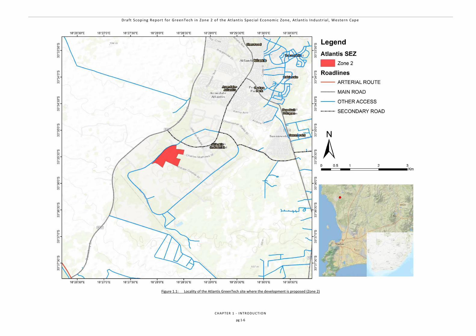
Figure 1.1: Locality of the Atlantis GreenTech site where the development is proposed (Zone 2) 1-6
Draft Scop ing Report for GreenTech in Zone 2 o f the At lant i s Spec ia l Economic Zone, At lant i s Industr ia l , Western Cape
CHAPTER 1 - I NTRODU CTIO N
pg 1-2
NEMA REQUIREMENTS WITH REFERENCE TO RELEVANT
SECTIONS OF THIS REPORT
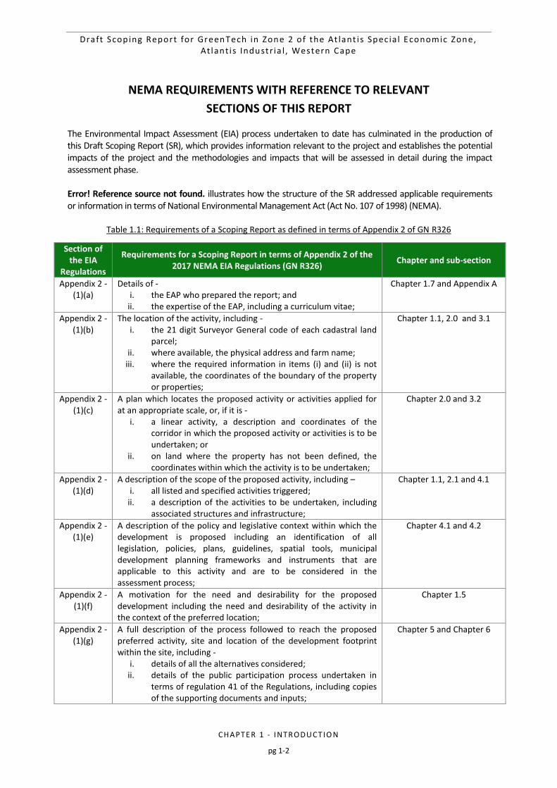
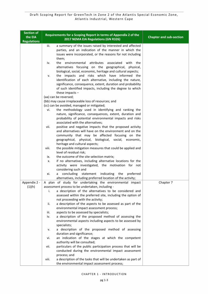
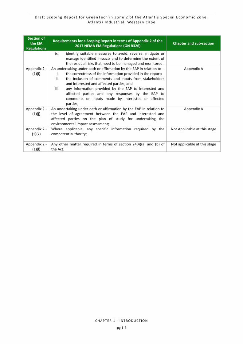
The Environmental Impact Assessment (EIA) process undertaken to date has culminated in the production of this Draft Scoping Report (SR), which provides information relevant to the project and establishes the potential impacts of the project and the methodologies and impacts that will be assessed in detail during the impact assessment phase. Error! Reference source not found. illustrates how the structure of the SR addressed applicable requirements or information in terms of National Environmental Management Act (Act No. 107 of 1998) (NEMA).
Table 1.1: Requirements of a Scoping Report as defined in terms of Appendix 2 of GN R326
Section of the EIA
Regulations
Requirements for a Scoping Report in terms of Appendix 2 of the 2017 NEMA EIA Regulations (GN R326)
Chapter and sub-section
Appendix 2 - (1)(a)
Details of - i. the EAP who prepared the report; and
ii. the expertise of the EAP, including a curriculum vitae;
Chapter 1.7 and Appendix A
Appendix 2 - (1)(b)
The location of the activity, including - i. the 21 digit Surveyor General code of each cadastral land
parcel; ii. where available, the physical address and farm name;
iii. where the required information in items (i) and (ii) is not available, the coordinates of the boundary of the property or properties;
Chapter 1.1, 2.0 and 3.1
Appendix 2 - (1)(c)
A plan which locates the proposed activity or activities applied for at an appropriate scale, or, if it is -
i. a linear activity, a description and coordinates of the corridor in which the proposed activity or activities is to be undertaken; or
ii. on land where the property has not been defined, the coordinates within which the activity is to be undertaken;
Chapter 2.0 and 3.2
Appendix 2 - (1)(d)
A description of the scope of the proposed activity, including – i. all listed and specified activities triggered;
ii. a description of the activities to be undertaken, including associated structures and infrastructure;
Chapter 1.1, 2.1 and 4.1
Appendix 2 - (1)(e)
A description of the policy and legislative context within which the development is proposed including an identification of all legislation, policies, plans, guidelines, spatial tools, municipal development planning frameworks and instruments that are applicable to this activity and are to be considered in the assessment process;
Chapter 4.1 and 4.2
Appendix 2 - (1)(f)
A motivation for the need and desirability for the proposed development including the need and desirability of the activity in the context of the preferred location;
Chapter 1.5
Appendix 2 - (1)(g)
A full description of the process followed to reach the proposed preferred activity, site and location of the development footprint within the site, including -
i. details of all the alternatives considered; ii. details of the public participation process undertaken in
terms of regulation 41 of the Regulations, including copies of the supporting documents and inputs;
Chapter 5 and Chapter 6
Draft Scop ing Report for GreenTech in Zone 2 o f the At lant i s Spec ia l Economic Zone, At lant i s Industr ia l , Western Cape
CHAPTER 1 - I NTRODU CTIO N
pg 1-3
Section of the EIA
Regulations
Requirements for a Scoping Report in terms of Appendix 2 of the 2017 NEMA EIA Regulations (GN R326)
Chapter and sub-section
iii. a summary of the issues raised by interested and affected parties, and an indication of the manner in which the issues were incorporated, or the reasons for not including them;
iv. the environmental attributes associated with the alternatives focusing on the geographical, physical, biological, social, economic, heritage and cultural aspects;
v. the impacts and risks which have informed the identification of each alternative, including the nature, significance, consequence, extent, duration and probability of such identified impacts, including the degree to which these impacts –
(aa) can be reversed; (bb) may cause irreplaceable loss of resources; and (cc) can be avoided, managed or mitigated;
vi. the methodology used in identifying and ranking the nature, significance, consequences, extent, duration and probability of potential environmental impacts and risks associated with the alternatives;
vii. positive and negative impacts that the proposed activity and alternatives will have on the environment and on the community that may be affected focusing on the geographical, physical, biological, social, economic, heritage and cultural aspects;
viii. the possible mitigation measures that could be applied and level of residual risk;
ix. the outcome of the site selection matrix; x. if no alternatives, including alternative locations for the
activity were investigated, the motivation for not considering such and
xi. a concluding statement indicating the preferred alternatives, including preferred location of the activity;
Appendix 2 - (1)(h)
A plan of study for undertaking the environmental impact assessment process to be undertaken, including -
i. a description of the alternatives to be considered and assessed within the preferred site, including the option of not proceeding with the activity;
ii. a description of the aspects to be assessed as part of the environmental impact assessment process;
iii. aspects to be assessed by specialists; iv. a description of the proposed method of assessing the
environmental aspects including aspects to be assessed by specialists;
v. a description of the proposed method of assessing duration and significance;
vi. an indication of the stages at which the competent authority will be consulted;
vii. particulars of the public participation process that will be conducted during the environmental impact assessment process; and
viii. a description of the tasks that will be undertaken as part of the environmental impact assessment process;
Chapter 7
Draft Scop ing Report for GreenTech in Zone 2 o f the At lant i s Spec ia l Economic Zone, At lant i s Industr ia l , Western Cape
CHAPTER 1 - I NTRODU CTIO N
pg 1-4
Section of the EIA
Regulations
Requirements for a Scoping Report in terms of Appendix 2 of the 2017 NEMA EIA Regulations (GN R326)
Chapter and sub-section
ix. identify suitable measures to avoid, reverse, mitigate or manage identified impacts and to determine the extent of the residual risks that need to be managed and monitored.
Appendix 2 - (1)(i)
An undertaking under oath or affirmation by the EAP in relation to - i. the correctness of the information provided in the report;
ii. the inclusion of comments and inputs from stakeholders and interested and affected parties; and
iii. any information provided by the EAP to interested and affected parties and any responses by the EAP to comments or inputs made by interested or affected parties;
Appendix A
Appendix 2 - (1)(j)
An undertaking under oath or affirmation by the EAP in relation to the level of agreement between the EAP and interested and affected parties on the plan of study for undertaking the environmental impact assessment;
Appendix A
Appendix 2 - (1)(k)
Where applicable, any specific information required by the competent authority;
Not Applicable at this stage
Appendix 2 - (1)(l)
Any other matter required in terms of section 24(4)(a) and (b) of the Act.
Not applicable at this stage
Draft Scop ing Report for GreenTech in Zone 2 o f the At lant i s Spec ia l Economic Zone, At lant i s Industr ia l , Western Cape
CHAPTER 1 - I NTRODU CTIO N
pg 1-5
1. INTRODUCTION
The City of Cape Town (CoCT): Property Management Department in collaboration with GreenCape is proposing to develop a Green Technology Manufacturing facility (hereafter referred to as “GreenTech”) and associated infrastructure in the Atlantis Special Economic Zone (SEZ) on the land designated as Zone 2. Zone 2 is made up of several land portions that will comprise the “site”, namely ERF Portion Remainder of ERF 277, ERF 246, ERF 254 and ERF Portion Remainder of 171 (these are the new ERF numbers, previously known as portions of Cape Farm 1183), Atlantis Industrial, approximately 40 km north of Cape Town. The portions that comprise the site (i.e. Zone 2) make up a total of 32.6 ha which will be used for the proposed development. Figure 1.1 below shows the overall locality of the proposed GreenTech site considered in the Scoping Phase. In terms of the National Environmental Management Act (Act 107 of 1998, as amended) (NEMA) and the 2014 NEMA Environmental Impact Assessment (EIA) Regulations (as amended on 7 April 2017) promulgated in Government Gazette 40772 and Government Notice (GN) R327, R326, R325 and R324, a full Scoping and Environmental Impact Assessment (EIA) Process is required for the construction of the proposed Atlantis GreenTech facility. The Applicant has appointed the Council for Scientific and Industrial Research (CSIR) to undertake the EIA Processes in order to determine the biophysical, social and economic impacts associated with undertaking the proposed activity.
1.1. PROJECT APPLICANT AND PROJECT OVERVIEW
South Africa is an energy intensive country, largely as a result of our historic economic focus on energy intensive industries such as mining and primary metal processing. With current energy and electricity demands projected to continue increasing, new investments in electricity generation capacity are required. In terms of the New Generation Regulations, the Integrated Resource Plan (IRP), developed in March 2011, by the Department of Energy set out the new generation capacity requirement per technology, taking energy efficiency and the demand-side management projects into account. The introduction of private sector generation, as proposed in the Electricity Regulation Act (Act no. 4 of 2006), has multiple benefits and will contribute greatly to the diversification of both the supply and nature of energy production and enable the benchmarking of performance and pricing. The planned roll-out of renewable energy in South Africa will result in investments of R10-20 billon every year for the next 20 years. The manufacturing industry to support this renewable energy roll-out will be significant. It is estimated that about 2200 blue collar jobs will be created in this new industry. The Provincial strategic vision and intent is that the Western Cape has a secure supply of quality, reliable, clean, safe energy, which delivers social, economic and environmental benefits to the Province’s citizens, while also addressing the climate change challenges facing the region and eradicating energy poverty. The Western Cape Provincial Government and the City of Cape Town (CoCT) have joined together in support of the renewable energy industry. The CoCT has simplified the process for those in the renewable energy industry wishing to find sites suitable for manufacturing activities. Atlantis has been identified as a development priority by National, Provincial and Regional government and will largely benefit from the creation of an established “Green Technology Manufacturing Cluster”. In addition, the CoCT will, for the majority, be leasing the land to company’s within the renewable energy sector and therefore the proposal is for the construction of manufacturing facilities to support the renewable energy industry and the broader “Green Economy”. The CoCT has made available Zone 2 for these purposes namely, the manufacturing and supply of utility-scale renewable energy to the national grid and associated ‘green’ technology industries e.g. producing turbine blades, turbine towers, turbine assemblers, PV panel assembly plants and inverter manufacturers etc. The proposal will therefore entail the utilisation of the entire site for industrial development. GreenCape is a sector development agency established by the CoCT and Western Cape Provincial Government with the task of unlocking and unblocking opportunities in the Green Economy, and are facilitating the development of GreenTech in the Atlantis SEZ.
Draft Scop ing Report for GreenTech in Zone 2 o f the At lant i s Spec ia l Economic Zone, At lant i s Industr ia l , Western Cape
CHAPTER 1 - I NTRODU CTIO N
pg 1-6
Figure 1.1: Locality of the Atlantis GreenTech site where the development is proposed (Zone 2)
Draft Scop ing Report for GreenTech in Zone 2 o f the At lant i s Spec ia l Economic Zone, At lant i s Industr ia l , Western Cape
CHAPTER 1 - I NTRODU CTIO N
pg 1-7
1.2. PROJECT MOTIVATION (INCLUDING NEED AND DESIRABILITY)
GreenCape has been appointed as the project management office for the proposed special economic zone (SEZ) in Atlantis with the land owner and applicant for the proposed project being the City of Cape Town Metropolitan Municipality: Property Management Department (hereafter referred to as City of Cape Town). Special Economic Zones are geographically designated area of a country set aside for targeted industrial or economic activities which are supported through special arrangements and measures that often are not available to the rest of the country. It is expected that following the Department of Energy’s request for information (RFI) from potential developers for proposals for GreenTech projects, it will play a significant role in South Africa’s power generation mix. Special Economic Zones in South Africa, such as the Atlantis area, have the ability to accelerate the rate of industrial development and agglomeration and are a platform for guiding the deployment of other tools such as incentives, skills development and infrastructure development. The benefit of the proposed facility and its location and contribution to the greater Atlantis SEZ will furthermore allow for the increased focus on the development of desired industrial capabilities, “host regions” for development, and comprehensive planning and design to accommodate the diverse regional development needs and contexts. The need for renewable energy (and associated technologies) is becoming increasingly apparent, in both local and international context, with South Africa becoming an integral part of the global transition towards renewable sources of electricity generation. The urgency behind this evolution can be appreciated considering that South Africa is the largest emitter of greenhouse gases in Africa, accounting for as much as 42% of the continent’s total emissions, and is also estimated to rank amongst the top 20 largest emitters of greenhouse gases in the world. These emissions are largely a result of an energy-intensive economy and high dependence on coal-based electricity generation. The South African government is therefore committed to supplementing the existing generation capacity of thermal and nuclear power plants with renewable energy power generation, thus creating the framework that will lead to an increase in the supply of clean energy for the nation. The proposed project would also have international significance as it contributes to South Africa being able to meet some of its international obligations by aligning domestic policy with internationally agreed strategies and standards as set by the United Nations Framework Convention on Climate Change (UNFCCC), Kyoto Protocol, and United Nations Convention on Biological Diversity (UNCBD) all of which South Africa is a signatory to. Renewable energy is critical to South Africa as this source of energy is recognised as a major contribution to climate protection, has a much lower environmental impact, as well as advancing economic and social development. The preferred site (i.e. Zone 2) for the proposed Atlantis GreenTech project includes approximately 32.6 ha of land. It may be possible that the final layout does not require the utilisation of the entire 32.6 ha, however, a potentially larger than required surface area has been proposed during this phase of the project to ensure that should development constraints be present, the footprint can be reduced without the project being compromised. A project description (based on the conceptual design) is provided in Chapter 2 of this Draft Scoping Report. Additional information regarding the project contextualisation is provided in Chapters 2 and 5 of this Scoping Report.
1.2.1. Need and Desirability
It is an important requirement in the EIA Process to review the need and desirability of the proposed project. The Western Cape Department of Environmental Affairs and Development Planning (DEA&DP) published a Guideline on Need and Desirability in 2010. The DEADP Guideline (2010) states that the essential aim of investigating the need and desirability of a proposed project revolves around determining suitability (i.e. is the activity proposed in the right location for the suggested land-use/activity) and timing (i.e. is it the right time to develop a given activity?). DEA&DP describes need and desirability as components of the “wise use of land”, where need refers to time, and desirability to place. In other words, need and desirability answer the question of whether the activity is being proposed at the right time and in the right place. Table 1.1 includes a list of questions based on the DEA&DP 2010 Guideline to determine the need and desirability of the proposed project.
Draft Scop ing Report for GreenTech in Zone 2 o f the At lant i s Spec ia l Economic Zone, At lant i s Industr ia l , Western Cape
CHAPTER 1 - I NTRODU CTIO N
pg 1-8
Table 1.1: DEADP list of 14 questions to determine the “Need and Desirability” of the proposed project
(2010 guidleines)
NEED
1. Is the land use (associated with the activity being applied for) considered within the timeframe intended by the existing approved Spatial Development Framework (SDF) agreed to by the relevant environmental authority? (i.e. is the proposed development in line with the projects and programmes identified as priorities within the credible IDP).
Answer: Yes Justification: The purpose of the Western Cape’s Provincial Spatial Development Framework (PSDF) is to:
Be the spatial expression of the Provincial Growth and Development Strategy (PGDS).
Guide (metropolitan, district and local) municipal integrated development plans (IDPs) and
spatial development frameworks (SDFs) and provincial and municipal framework plans (ie. sub-
SDF spatial plans).
Help prioritise and align investment and infrastructure plans of other provincial departments, as well as national departments' and parastatals' plans and programmes in the Province.
Provide clear signals to the private sector about desired development directions.
Increase predictability in the development environment, for example by establishing no-go, conditional and "go" areas for development and redress the spatial legacy of apartheid.
The establishment of a GreenTech facility and SEZ in Atlantis will promote the area for further investment, stimulate and contribute towards the economy as well as created a number of much needed blue-collar jobs within the area. These goals/ outcomes that will result from the proposed development are in line with the 5 year plan for the municipality. In addition the proposed facility is in line with Spatial Development Objective (1) of the Blaauwberg District Plan (2012) which relates to the promotion of infill industrial development.
2. Should development, or if applicable, expansion of the town/area concerned in terms of this land use (associated with the activity being applied for) occur here at this point in time?
Answer: Yes Justification: Developments such as the Atlantis GreenTech facility have been stipulated in the CoCT’s IDP 5 year plan. In addition, the biodiversity offset put in place by the CoCT for the Atlantis SEZ to compensate for the loss of biodiversity and to promote industrial development in that area allows for immediate development to happen in this area with a significantly reduced ecosystem cost. There are also a number of positive socio-economic benefits will result as a direct and indirect effect of this activity. The most notable being:
Job Creation.
Growth of the local, regional and provincial economies.
Diversity in the manufacturing industry through the investment in the energy sector.
3. Does the community/area need the activity and the associated land use concerned (is it a societal priority)? This refers to the strategic as well as local level (e.g. development is a national priority, but within a specific local context it could be inappropriate).
Answer: Yes Justification: Atlantis has been identified as a development priority by National, Provincial and Regional government. Historically, Atlantis was a decentralised zone for manufacturing. The proposed activity within the Atlantis Industrial Area will therefore benefit from the SEZ. The proposed site in Atlantis will be a priority area through which the path will be laid for future investments. The socio-economic benefits associated with the proposed development will have significant positive long-term benefits for Atlantis and the Western Cape.
Draft Scop ing Report for GreenTech in Zone 2 o f the At lant i s Spec ia l Economic Zone, At lant i s Industr ia l , Western Cape
CHAPTER 1 - I NTRODU CTIO N
pg 1-9
4. Are the necessary services with adequate capacity currently available (at the time of application), or must additional capacity be created to cater for the development?
Answer: Partially Justification: There are strict guidelines set out by the Atlantis Water Resource Management Scheme concerning the disposal of stormwater and effluent from sites within the Atlantis Industrial Zone. The purpose of these guideline is to ensure quality of potential waste water (stormwater and effluent), which is used to artificially recharge the Atlantis Aquifer, is of a quality which minimise contamination of ground water resource used as potable watersupply for the Atlantis district, alternatively to dispose of unsuitable effluent to prevent contamination of the ground water. Potable Water: The site is serviced from a 150 mm diameter pressurised pipe-line located along the western boundary of the site. The municipal pipeline provides for both domestic and fire-fighting requirements. Pressure within the pipeline is maintained between 7 to 9 bars, should water be required at higher pressure then booster pumps will have to be installed by the developer. Stormwater: The pipe network in the adjacent municipal roads is designed to take the predevelopment 1:2 year recurrence interval storm run-off for low traffic volumes areas to 1:10 year recurrence interval storm run-off for prime commercial developments. The balance of the run-off is conveyed within defined overland flow routes utilising streets to discharge into green belts comprising parks and playing fields where flood peak attenuation techniques are applied in accordance with the CoCT’s Management of Urban Storm Water Impacts Policy” document. Electrical: The City of Cape Town is the supplier of electricity to the Atlantis Industrial area. Currently the power supply network capacity in the area is limited. The municipality indicates they could provide up to 2MVA to the site. Anything larger than 2 MVA can be accommodated, but with significant implications to their network.
5. Is this development provided for in the infrastructure planning of the municipality, and if not what will the implication be on the infrastructure planning of the municipality (priority and placement of services and opportunity costs)?
Answer: No Justification: There is no anticipated negative impact on municipal infrastructure planning (no clash of priority, and/or placement) as additional infrastructure required to maintain the proposed facility would be provided and maintained by the Applicant. The activity is furthermore proposed on industrial land with little existing and planned infrastructure.
6. Is this project part of a national programme to address an issue of national concern or importance? Answer: Yes Justification: South Africa is an energy intensive country, largely as a result of our historic economic focus on energy intensive industries such as mining and primary metal processing. With current energy and electricity demands projected to continue increasing, new investments in electricity generation capacity are required, resulting in the need for technological manufacturing. Future increases in electricity demand are particularly expected for the regions around the Western Cape. In terms of the New Generation Regulations, the Integrated Resource Plan (IRP) that has been developed in 2011 by the Department of Energy and sets out the new generation capacity requirement per technology, taking energy efficiency and the demand-side management projects into account. The introduction of private sector generation has multiple benefits and will contribute greatly to the diversification of both the supply and nature of energy production and enable the benchmarking of performance and pricing. It is a political and economic imperative that the Western Cape attracts a portion of the investment in Renewable Energy Industry. The proposed site in Atlantis will be one such priority area through which the path will be laid for
Draft Scop ing Report for GreenTech in Zone 2 o f the At lant i s Spec ia l Economic Zone, At lant i s Industr ia l , Western Cape
CHAPTER 1 - I NTRODU CTIO N
pg 1-10
future investments. The vast socio-economic benefits associated with the proposed development will have significant positive long-term benefits for Atlantis and the Western Cape.
DESIRABILITY
7. Is the development the best practicable environmental option for this land/site? Answer: Yes (based on previous EA’s conducted for neighbouring and nearby sites) Justification: It would be premature to decide on the environmental practicability of the proposed development prior to the completion of the impact assessment phase of this EIA Process, however, based on current information and specialist studies that have already been conducted on nearby sites, the location factors favour this land use for a number of reasons e.g.:
The site is already zoned ‘General Industrial’ and is located inside the Atlantis Industrial Area (within the Urban Edge).
Atlantis is considered a national, provincial and regional priority area for readdressing the eras of apartheid through encouraging investment in the area and, as a result, creating jobs and contributing towards the local economy.
The size of the land is appropriate in that they are large enough for the types of industries proposed.
The road network in the area is also much more appropriate for transporting abnormal loads rather than navigating city traffic and passes.
Easy, quick access onto the N7 allowing easier access to port facilities along the West Coast.
The proposed development is in line with all the planning policies for the CoCT and the greater WC province.
8. Would the approval of this application compromise the integrity of the existing approved and credible municipal IDP and SDF as agreed to by the relevant authorities?
Answer: No Justification: The proposed activity does not compromise any of the objectives set within the Municipality IDP. The proposed project will also be supportive of the IDP’s objective of creating more job opportunities. The proposed facility will assist in local job creation during the construction and operation phases of the project (if an EA is granted by the DEA&DP). However, as noted above, employment opportunities will be temporary during the construction phase and long-term during the operational phase as the plant is expected to be operational for 20 years. Objective 1.1 of the IDP is to “create an enabling environment to attract investment that generates economic growth and job opportunities. There is considerable space for investment and growth, now and into the future in the Atlantis SEZ. The City plays a pivotal role in creating demand for these services through its programmes, projects and procurement systems, as well as through the use of energy in its own operations. The City aims to promote small-scale embedded power generation in Cape Town as well as to ensure that it benefits from regional and national-scale projects where suitable. The City faces skills development challenges, and requires significant investment, land release and buy-in from various stakeholders. There are opportunities for sustainable industries (such as solar water heater, photovoltaic and wind turbine manufacturers), who’s services and products will be required for many years. This can result in job creation and skills development from new businesses.”
9. Would the approval of this application compromise the integrity of the existing environmental management priorities for the area (e.g. as defined in EMFs), and if so, can it be justified in terms of sustainability considerations?
Answer: No (but to be confirmed during the EIA Phase) Justification: It is not expected that the approval of the proposed project would compromise the integrity of the existing environmental management priorities for the area and the The City of Cape Town's EMF (Blaauwberg District Plan as adopted on 26 August 2013, PN. 297/2013, 13 September 2013). However, this will be determined during the EIA Phase of the proposed project. Furthermore, the proposed project will require mitigation of potential
Draft Scop ing Report for GreenTech in Zone 2 o f the At lant i s Spec ia l Economic Zone, At lant i s Industr ia l , Western Cape
CHAPTER 1 - I NTRODU CTIO N
pg 1-11
negative environmental impacts during the construction, operational and potential decommissioning phases. To this end, an Environmental Management Programme (EMPr) will be compiled for the proposed project to ensure that all potential negative impacts identified are suitably managed and mitigated, and potential positive impacts are enhanced.
10. Do location factors favour this land use (associated with the activity applied for) at this place? (this relates to the contextualisation of the proposed land use on this site within its broader context)
Answer: Yes Justification: The site is zoned ‘General Industrial’ and is located in the Atlantis Industrial Area. An industrial development will therefore be in line with the existing land use rights of the property. As a result of the dire socio-economic needs of the Atlantis community the establishment of jobs and the contribution towards the growth of the economy would be highly desirable.
11. How will the activity or the land use associated with the activity applied for, impact on sensitive natural and cultural areas (built and rural/natural environment)?
Answer: To be confirmed during the EIA Phase, however, based on previous specialist studies done on neighbouring sites, it is likely that there will be no significant impact. Justification: The proposed activity will have an impact on the endangered and critically endangered vegetation found on site, which will be removed completely. However, the CoCT has confirmed land elsewhere to offset the Atlantis Industrial Area – so that it may be developed in future. An appropriate biodiversity offset has been agreed upon to balance the loss of the sensitive vegetation on this site which is located in the Atlantis Industrial Area. Please see Appendix C for the report on the Klein Dassenberg Nature Reserve (biodiversity offset).
12. How will the development impact on people’s health and wellbeing (e.g. in terms of noise, odours, visual character and sense of place, etc.)?
Answer: To be confirmed during the EIA Phase. Justification:
Noise: There may be noise associated with this development during its operation and the impacts, however, this will be in line with the zoning regulations of the site.
Odours: These will be minimal during the construction phase and relatively minimal during the operational phase.
Visual Character and Sense of Place: The proposed activity involves the construction of an industrial development within the Atlantis Industrial Area. The context within which the site is located is already characterised by industrial buildings and therefore will not have a significant impact on the visual character or sense of place of the area.
13. Will the proposed activity or the land use associated with the activity applied for, result in unacceptable opportunity costs?
Answer: No Justification: The proposed activity involves the construction of an industrial development within the Atlantis Industrial Area. The most significant impacts could be the loss of a portion of Cape Flats Dune Strandveld (endangered) and Atlantis Sand Fynbos (critically endangered). However, an appropriate offset has been put in place to mitigate this impact.
14. Will the proposed land use result in unacceptable cumulative impacts? Answer: To be confirmed during the EIA Phase. Justification: The significant cumulative impacts associated with this development include the following: Cumulative loss of vegetation within the Atlantis Industrial Area has led to extensive loss of two vegetation types, namely Atlantis Sand Fynbos (CRITICALLY ENDANGERED) and Cape Flats Dune Strandveld (ENDANGERED). Note –
Draft Scop ing Report for GreenTech in Zone 2 o f the At lant i s Spec ia l Economic Zone, At lant i s Industr ia l , Western Cape
CHAPTER 1 - I NTRODU CTIO N
pg 1-12
see above on Biodiversity Offset to compensate for this cumulative impact;
Job Creation;
Noise and visual;
Economic growth and diversity;
Investment in the Energy Sector. It must be noted that the potential cumulative impacts resulting from the proposed project can only be objectively determined at the end of the EIA Process. These will be assessed as part of the EIA for this project.
1.3. REQUIREMENTS FOR AN ENVIRONMENTAL IMPACT ASSESSMENT
In terms of the National Environmental Management Act (Act 107 of 1998, as amended) (NEMA) and the 2014 NEMA Environmental Impact Assessment (EIA) Regulations (as amended on 7 April 2017) promulgated in Government Gazette 40772 and Government Notice (GN) R327, R326, R325 and R324, a full Scoping and Environmental Impact Assessment (EIA) Process is required for the construction of the proposed Atlantis GreenTech facility. The need for the full Scoping and EIA is triggered by, amongst others, the inclusion of Activity 15 listed in GN R325 (Listing Notice 2): “15. The clearance of an area of 20 hectares or more of indigenous vegetation, excluding where such clearance of indigenous vegetation is required for— (i) the undertaking of a linear activity; or (ii) maintenance purposes undertaken in accordance with a maintenance management plan.” Chapter 4 of this Scoping Report contains the detailed list of activities contained in R327, R325 and R324 which may be triggered by the various project components and thus form part of this Scoping and EIA Process. The purpose of the EIA is to identify, assess and report on any potential impacts the proposed project, if implemented, may have on the receiving environment. The environmental assessment therefore needs to show the Competent Authority (i.e. the DEA&DP), and the project proponent, CoCT, what the consequences of their choices will be in terms of impacts on the biophysical and socio-economic environment and how such impacts can be, as far as possible, enhanced or mitigated and managed as the case may be.
1.4. EIA TEAM
As previously noted, the CSIR has been appointed by CoCT and GreenCape to undertake the EIA required for the proposed project. A public participation process (PPP) forms an integral part of the Environmental Assessment Process and assists in identifying issues and possible alternatives to be considered during the EIA Process. The CSIR is undertaking the PPP for this EIA. Details on the PPP are included in Chapter 4 of this Scoping Report. The EIA team which is involved in this Scoping and EIA Process is listed in Table 1.2 below. This team includes a number of specialists which have either been involved to date, or are planned to provide inputs during the EIA Process.
Draft Scop ing Report for GreenTech in Zone 2 o f the At lant i s Spec ia l Economic Zone, At lant i s Industr ia l , Western Cape
CHAPTER 1 - I NTRODU CTIO N
pg 1-13
Table 1.2: The EIA Management Team and Specialist Team
NAME ORGANISATION ROLE/STUDY TO BE UNDERTAKEN
Environmental Management Services (CSIR)
Paul Lochner CSIR Technical Advisor and Quality Assurance (EAPSA) Certified
Kelly Stroebel CSIR Project Manager (Appointed EAP)
Rirhandzu Marivate CSIR Project Officer and GIS specialist
Specialists
Paul Emms Bergwind Botanical Surveys and Tours
Ecological Impact Assessment (including Terrestrial Ecology)
Christo Bredenhann WSP Traffic Impact Statement
Jonathan Kaplan Agency for Cultural Resource Management (ACRM)
Heritage Impact Assessment
John Pether N/A Desktop Palaeontological Impact Assessment
Note: ToR’s for Specialist Studies as well as a description of the use of extensive existing information in the area is described further in Chapter 7 of this Draft Scoping Report.
1.5. DETAILS AND EXPERTISE OF THE EAP
Over the past 30 years the CSIR has been involved in a multitude of projects across Africa and South Africa, with experience in 32 sub-Saharan African and Indian Ocean Island countries. The Environmental Management Services (EMS) group within the CSIR has been involved in the management and execution of numerous environmental assessment and management studies in more than 15 countries in Africa, as well as the Middle East, South America and Russia. These studies have included both public and private sector clients. Consequently, the CSIR EMS team offers a wealth of experience and appreciation of the environmental and social priorities and national policies and regulations in South Africa. The EMS team at CSIR has also been involved in environmental assessments in the Atlantis SEZ (including an EIA on the neighbouring site and EA amendments in the SEZ). The EIA Project Team is being led by the Project Manager, Kelly Stroebel. Paul Lochner will act as A Technical Advisor for the proposed project. Rirhandzu Marivate will be providing support on the project as a project officer/assistant and GIS expertise. Refer to Appendix A of this Scoping Report for the Curriculum Vitae of the EAPs. Appendix A of this Scoping Report also includes a declaration of and affirmation by the EAP as required by the 2014 EIA Regulations (as amended). The following roles and responsibilities are assigned in terms of this Scoping and EIA Process: Designated Environmental Assessment Practitioner (EAP):
Kelly Stroebel - Kelly is an EAP in the EMS group of the CSIR and she has an Honours degree in Environmental Science and is a Registered Candidate Natural Scientist (Registration Number: 100151/14) with the SACNASP. She has 5 years of experience in the Environmental Management field, and has been involved in various Basic Assessments, EIA’s and SEA’s in the infrastructure, agriculture and renewable energy fields. She has also worked on environmental assessments in the Atlantis SEZ.
Technical Advisor:
Paul Lochner - Paul has 22 years of experience in environmental assessment and management studies, primarily in the leadership and integration functions. This has included SEAs, EIAs and Environmental Management Plans.

Draft Scop ing Report for GreenTech in Zone 2 o f the At lant i s Spec ia l Economic Zone, At lant i s Industr ia l , Western Cape
CHAPTER 1 - I NTRODU CTIO N
pg 1-14
In July 2003, he obtained certification as a registered EAP with the Interim Certification Board for EAPs of South Africa (EAPSA). Project Officer:
Rirhandzu Marivate – Rirhandzu is an EAP in the EMS group of the CSIR holds a Bachelor degree in Zoology & Geology, Honours in Ecology, Environment and Conservation from the University of the Witwatersrand; and has environmental research experience with the University of Cape Town. She has 5 years’ experience in various forms of environmental assessments (BAs, EIAs, SEAs); consultation with stakeholders and public meetings; Project administration and GIS for EIA’s.
1.6. OBJECTIVES OF THE SCOPING REPORT
The Scoping Phase of the EIA refers to the process of determining the spatial and temporal boundaries for the EIA. In broad terms, the objectives of the Scoping Process in terms of the 2014 NEMA EIA Regulations (as amended) (GN R326) are to:
Confirm the process to be followed and opportunities for stakeholder engagement;
Clarify the project scope to be covered;
Identify and confirm the preferred activity and technology alternative;
Identify and confirm the preferred site for the preferred activity;
Identify the key issues to be addressed in the impact assessment phase and the approach to be followed in addressing these issues; and
Confirm the level of assessment to be undertaken during the impact assessment This is achieved through parallel initiatives of consulting with:
The lead authorities involved in the decision-making for this EIA application;
The public to ensure that local issues are well understood; and
The EIA specialist team to ensure that technical issues are identified. The Scoping Process is supported by a review of relevant background literature on the local area. Through this comprehensive process, the environmental assessment can identify and focus on key issues requiring assessment. The primary objective of the Draft Scoping Report is to present key stakeholders (including affected organs of state) with an overview of the project and key issues that require assessment in the EIA Phase and allow the opportunity for the identification of additional issues that may require assessment. Issues raised in response to this Scoping Report (currently being released for a 30-day comment period) will be captured in the Comments and Responses Trail and will be included in the finalised Scoping Report and Plan of Study for EIA, which will be submitted to DEAD&DP for decision-making (i.e. approval or rejection) in line with Regulation 21 (1) of GN R326. This approval is planned to mark the end of the Scoping Phase after which the EIA Process moves into the impact assessment and reporting phase. In terms of legal requirements, a crucial objective of the Scoping Report is to satisfy the requirements of Appendix 2 of the 2014 NEMA EIA Regulations (as amended on 7 April 2017) (as noted in Regulation 21 (3) of the GN R326). This section regulates and prescribes the content of the Scoping Report and specifies the type of supporting information that must accompany the submission of the Scoping Report to the authorities. An overview of where the requirements of Appendix 2 of the 2014 NEMA EIA Regulations (as amended) are addressed in this Draft Scoping Report is presented in Table 1.3. Furthermore, this process is designed to satisfy the requirements of Regulations 41, 42, 43 and 44 of the 2014 NEMA EIA Regulations as amended) relating to the PPP and, specifically, the registration of and submissions from I&APs.

Draft Scop ing Report for GreenTech in Zone 2 o f the At lant i s Spec ia l Economic Zone, At lant i s Industr ia l , Western Cape
CHAPTER 2 – PROJE CT DE SCRIPT IO N
pg 2-1
2. PROJECT DESCRIPTION 2-3
2.1. ATLANTIS SEPCIAL ECONOMIC ZONE (SEZ) AND “GREENTECH” 2-3
2.2. SITE SELECTION 2-4
2.3. COMPONENTS OF A GREENTECH FACILITY 2-6
2.4. EIA AND THE ENVELOPE APPROACH 2-8
2.5. TYPICAL COMPOENETS OF A GREENTECH FACILITY 2-8
2.6. SUSTAINABLE DESIGN PRINCIPLES 2-9 2.6.1. Building Design 2-9
2.6.2. Water Conservation 2-10
2.6.3. Energy Efficiency 2-10
2.6.4. Waste and Recycling 2-10
2.6.5. Stormwater Management 2-10
2.7. PROJECT DEVELOPMENT CYCLE 2-12 2.7.1. Construction 2-12
2.7.2. Operation and Maintenance 2-12
2.7.3. Decommissioning 2-12
Table 2.1: Land Portions and sizes that comprise the site (i.e. Zone 2 of the Atlantis SEZ) 2-4
Table 2.2: SG codes for the land portions that comprise the site (i.e. Zone 2 of the Atlantis SEZ) 2-4
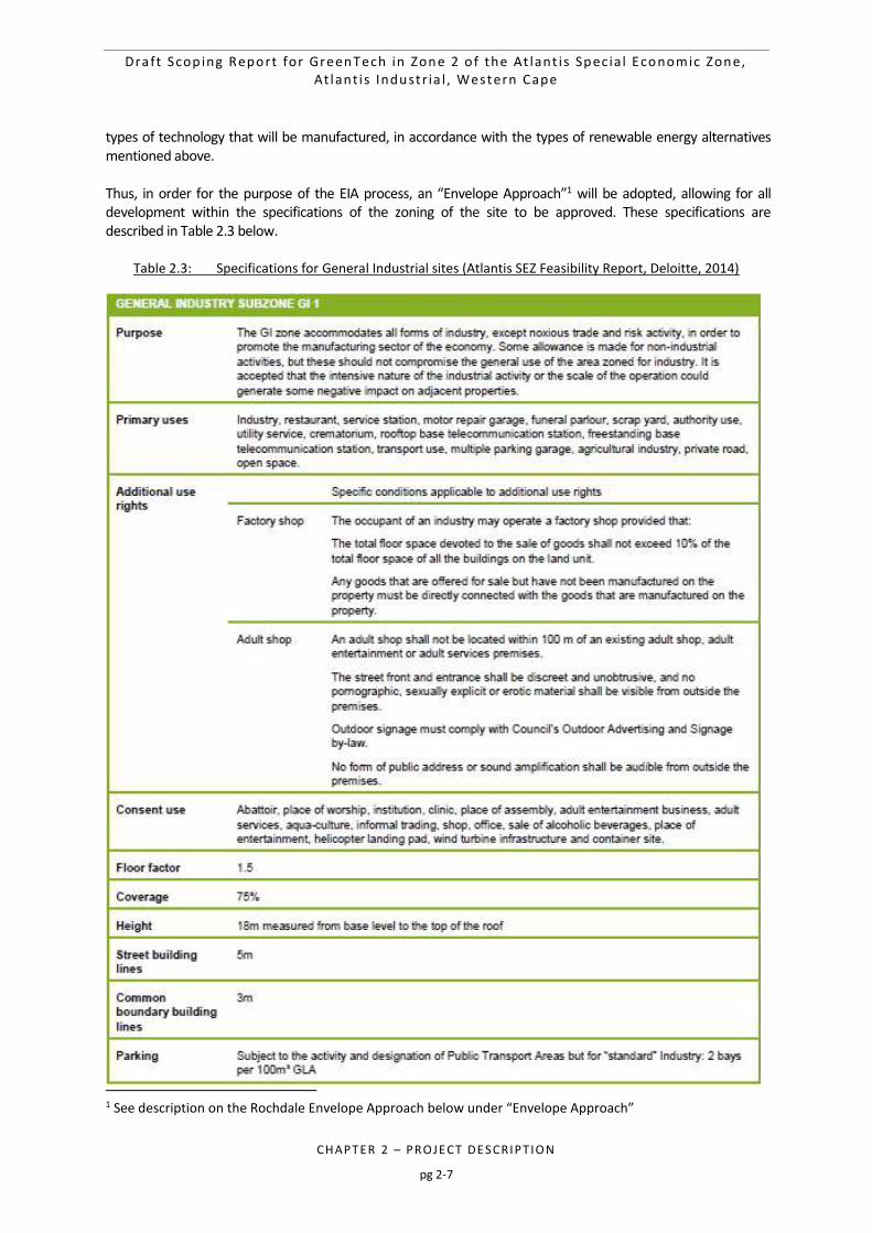
Table 2.3: Specifications for General Industrial sites (Atlantis SEZ Feasibility Report, Deloitte, 2014) 2-7
Draft Scop ing Report for GreenTech in Zone 2 o f the At lant i s Spec ia l Economic Zone, At lant i s Industr ia l , Western Cape
CHAPTER 2 – PROJE CT DE SCRIPT IO N
pg 2-2
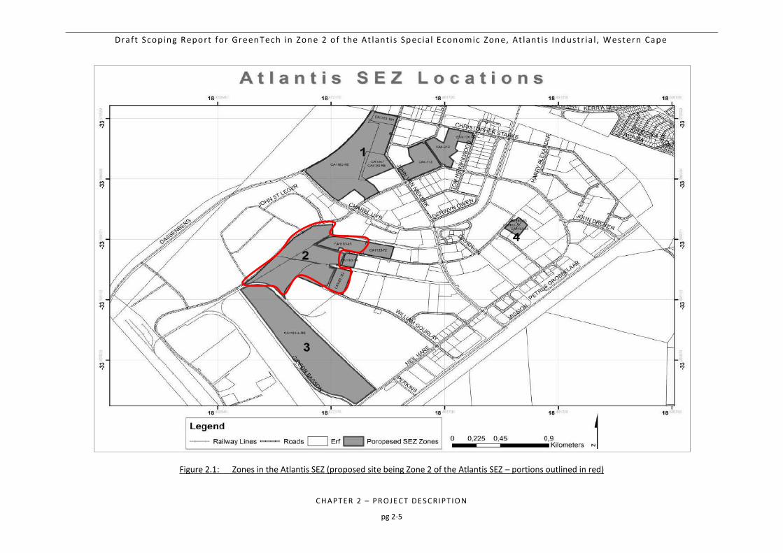
Figure 2.1: Zones in the Atlantis SEZ (proposed site being Zone 2 of the Atlantis SEZ – portions outlined in
red) 2-5
Figure 2.2: Example of a typical layout structure of a GreenTech manufacturing facility (Atlantis SEZ
Feasibility Report, Deloitte, 2014) 2-11
Draft Scop ing Report for GreenTech in Zone 2 o f the At lant i s Spec ia l Economic Zone, At lant i s Industr ia l , Western Cape
CHAPTER 2 – PROJE CT DE SCRIPT IO N
pg 2-3
2. PROJECT DESCRIPTION
This chapter provides an overview of the conceptual project design and an overview of the site and technology selection process for the proposed Atlantis GreenTech facility. The purpose of this chapter is to present sufficient project information to inform the EIA Process in terms of design parameters applicable to the project. It is important to note that the project description details are preliminary at this stage and it is likely that some of the details presented herein may change during the detailed design phase and upon further investigations (including the findings and input of the specialist studies conducted during the EIA Phase of the proposed project). However, the project description (and design) used in this EIA Process assumes a worst-case scenario, where the maximum development footprint and requisite infrastructure is considered. Consequently, should any changes in project design be affected; such changes will only serves to reduce the overall infrastructure requirement and/or development footprint.
2.1. ATLANTIS SEPCIAL ECONOMIC ZONE (SEZ) AND “GREENTECH”
A Special Economic Zone (SEZ) is an economic development tool to promote national economic growth and export by using targeted support measures to attract foreign and domestic investments and technology. Traditionally SEZs geographically delineated and fenced- in areas that allowed for the duty- and tax-free import of raw and intermediate materials for processing and re-export. Modern forms of SEZs are not exclusively export focused and can encompass larger areas and support a wider range of economic activities or have a specific technology or sector focus. The typical SEZ policy package includes, “import and export duty exemptions, streamlined customs and administrative controls and procedures, liberal foreign exchange policies and income tax incentives.” SEZ’s in South Africa, such as the Atlantis Industrial area, have the ability to accelerate the rate of industrial development and agglomeration and are a platform for guiding the deployment of other tools such as incentives, skills development and infrastructure development. In the Government Gazette of 20 March 2015, the Minister of Trade and Industry (Dr Rob Davies) issued the Special Economic Zones Regulations for public comment. Within these SEZs, support measures and funding are to be provided to businesses. The GreenTech industry cannot be defined in terms of the conventional standard industry classification (SIC) system and there is also no unique or universally accepted definition of the term. The UN however recommends the following broad definition of GreenTech used originally to describe environmentally sound technologies in Agenda 21, their 1992 plan to achieve sustainable development14: “Greentech includes technologies that “protect the environment, are less polluting, use all resources in a more sustainable manner, recycle more of their wastes and products, and handle residual wastes in a more acceptable manner than the technologies for which they are substitutes. Furthermore, GreenTech refers not just to the ‘individual technologies’, but total systems which include know-how, procedures, goods and services, equipment as well as organizational and managerial procedures.” In summary, GreenTech refers to technologies that limit or prevent harm to the natural environment relative to conventional alternatives because they:
are less polluting and\or
use all natural resources in a more sustainable manner and\or
recycle more of their wastes and products and\or
handle residual wastes in a more acceptable manner.
Draft Scop ing Report for GreenTech in Zone 2 o f the At lant i s Spec ia l Economic Zone, At lant i s Industr ia l , Western Cape
CHAPTER 2 – PROJE CT DE SCRIPT IO N
pg 2-4
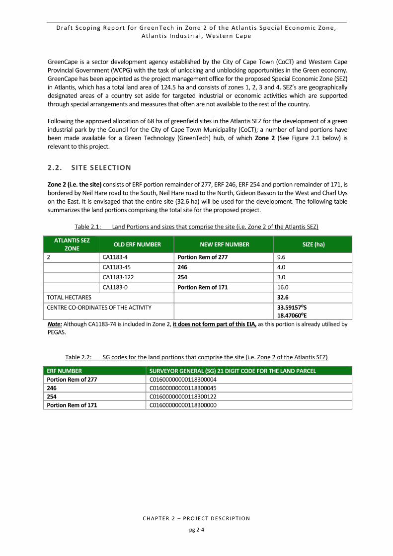
GreenCape is a sector development agency established by the City of Cape Town (CoCT) and Western Cape Provincial Government (WCPG) with the task of unlocking and unblocking opportunities in the Green economy. GreenCape has been appointed as the project management office for the proposed Special Economic Zone (SEZ) in Atlantis, which has a total land area of 124.5 ha and consists of zones 1, 2, 3 and 4. SEZ’s are geographically designated areas of a country set aside for targeted industrial or economic activities which are supported through special arrangements and measures that often are not available to the rest of the country. Following the approved allocation of 68 ha of greenfield sites in the Atlantis SEZ for the development of a green industrial park by the Council for the City of Cape Town Municipality (CoCT); a number of land portions have been made available for a Green Technology (GreenTech) hub, of which Zone 2 (See Figure 2.1 below) is relevant to this project.
2.2. SITE SELECTION
Zone 2 (i.e. the site) consists of ERF portion remainder of 277, ERF 246, ERF 254 and portion remainder of 171, is bordered by Neil Hare road to the South, Neil Hare road to the North, Gideon Basson to the West and Charl Uys on the East. It is envisaged that the entire site (32.6 ha) will be used for the development. The following table summarizes the land portions comprising the total site for the proposed project.
Table 2.1: Land Portions and sizes that comprise the site (i.e. Zone 2 of the Atlantis SEZ)
ATLANTIS SEZ ZONE
OLD ERF NUMBER NEW ERF NUMBER SIZE (ha)
2 CA1183-4 Portion Rem of 277 9.6
CA1183-45 246 4.0
CA1183-122 254 3.0
CA1183-0 Portion Rem of 171 16.0
TOTAL HECTARES 32.6
CENTRE CO-ORDINATES OF THE ACTIVITY 33.59157⁰S 18.47060⁰E
Note: Although CA1183-74 is included in Zone 2, it does not form part of this EIA, as this portion is already utilised by PEGAS.
Table 2.2: SG codes for the land portions that comprise the site (i.e. Zone 2 of the Atlantis SEZ)
ERF NUMBER SURVEYOR GENERAL (SG) 21 DIGIT CODE FOR THE LAND PARCEL
Portion Rem of 277 C01600000000118300004
246 C01600000000118300045
254 C01600000000118300122
Portion Rem of 171 C01600000000118300000
Draft Scop ing Report for GreenTech in Zone 2 o f the At lant i s Spec ia l Economic Zone, At lant i s Industr ia l , Western Cape
CHAPTER 2 – PROJE CT DE SCRIPT IO N
pg 2-5
Figure 2.1: Zones in the Atlantis SEZ (proposed site being Zone 2 of the Atlantis SEZ – portions outlined in red)
Draft Scop ing Report for GreenTech in Zone 2 o f the At lant i s Spec ia l Economic Zone, At lant i s Industr ia l , Western Cape
CHAPTER 2 – PROJE CT DE SCRIPT IO N
pg 2-6
2.3. COMPONENTS OF A GREENTECH FACILITY
The site is zoned “General Industrial” and is located in the Atlantis Industrial Area. The proposal is for the use of the site for industrial purposes. The site is therefore within the Urban Edge of Atlantis and is in line with the principles of the Cape Town Spatial Development Framework. The proposal is therefore to utilise the proposed portions of land located in the Atlantis Industrial Area for its intended purposes - Industrial development. Furthermore, the CoCT intend to lease the land to company’s within the renewable energy sector and therefore the proposal is for the construction of manufacturing facilities to support the renewable energy industry and the broader “Green Economy”. The CoCT has made available this portion of vacant, City owned industrial land for these purposes, namely the manufacturing and supply of utility-scale renewable energy to the national grid and associated ‘green’ technology industries e.g. producing turbine blades, turbine towers, turbine assemblers, PV panel assembly plants and inverter manufacturers etc. The proposal will therefore entail the utilisation of the entire site for industrial development, as it is zoned. The buildings (coverage, height etc.) to be located on site will be in accordance with the existing zoning of the site and the location in which the site is situated i.e. ‘General Residential’ and the Atlantis Industrial Area. The CoCT’s building regulations and planning policies will be adhered to. A combination of Technological Alternatives will form part of the ‘green’ manufacturing hub in Atlantis. All three are considered viable alternatives and will form part of the proposed activity description. The three main technology alternatives to be manufactured are as follows:
Wind There will be enough demand in the IRP2010 to justify 1 utility scale blade manufacturer. Currently there are no companies in South Africa that manufacture utility scale wind turbine blades. There is scope for 1 or 2 manufacturers of wind turbine towers.
Solar Photo Voltaic (PV) There is enough demand in the IRP2010 to justify 1 or 2 photo voltaic (PV) manufacturing facilities. Currently in South Africa there are 3 PV manufacturers (Tenesol, Solairedirect and Setsolar). These are all located in Cape Town and currently employ 250 people. There is an opportunity for these companies (or a new player) to set up a factory to supply the new demand.
Inverters It is anticipated that there will be 1 inverter manufacturer established. There is one current inverter manufacturer (MLT-Drives), they employ around 35 people and would need to scale up tenfold to meet this demand. A concept site lay-out and design has been prepared in the ASEZ feasibility report (2014) for an industrial facility accommodating the anticipated 10-year demand for smaller Atlantis SEZ users. The lay-out is described as follows:
- A grid-like movement structure enabling easy movement from and to the surrounding route network as well as between and through buildings.
- Building orientation to maximise natural light.
- Appropriate yard/service space to individual units.
- Modular buildings (based on a grid design which could be easily converted/ adapted to accommodate larger or smaller units depending on the specific needs of users, and phasing of the development based on demand), repeated in rows.
As mentioned, the buildings (coverage, height etc.) will be in accordance with the existing zoning of the site (GI1) and the location of the site. It is not considered feasible to design the layout of the facility at this stage as it would depend on the investors who are successful in terms of the bidding process to lease the land and the
Draft Scop ing Report for GreenTech in Zone 2 o f the At lant i s Spec ia l Economic Zone, At lant i s Industr ia l , Western Cape
CHAPTER 2 – PROJE CT DE SCRIPT IO N
pg 2-7
types of technology that will be manufactured, in accordance with the types of renewable energy alternatives mentioned above. Thus, in order for the purpose of the EIA process, an “Envelope Approach”1 will be adopted, allowing for all development within the specifications of the zoning of the site to be approved. These specifications are described in Table 2.3 below.
Table 2.3: Specifications for General Industrial sites (Atlantis SEZ Feasibility Report, Deloitte, 2014)
1 See description on the Rochdale Envelope Approach below under “Envelope Approach”
Draft Scop ing Report for GreenTech in Zone 2 o f the At lant i s Spec ia l Economic Zone, At lant i s Industr ia l , Western Cape
CHAPTER 2 – PROJE CT DE SCRIPT IO N
pg 2-8
2.4. EIA AND THE ENVELOPE APPROACH
In terms of Environmental Authorisation and the identification of listed activities in the EIA regulations, the project description will follow the envelope approach as mentioned above. The Rochdale Envelope Approach2 will be applied to determine the preferred Development Envelope for the proposed facility. The Rochdale Envelope approach is named after two legal cases relating to a proposed business park in Rochdale in the United Kingdom. These cases considered applications for outline planning consent in the context of preparing an EIA. The goal of the Rochdale Envelope approach is to allow for an EIA to be undertaken, based on the ‘worst case scenario’, whereby the Competent Authority granting the EA will then decide whether, based on this ‘worst case scenario’, the environmental impacts are acceptable. This approach is very useful since normally an EIA is undertaken prior to the technical assessment of the site which would consider the exact placement of, for example, the buildings and associated infrastructure. The main principle behind this approach is that, should the development fall within the parameters set within this “envelope”, as determined by the EIA Process, the placement of the different components could be determined at a later stage provided that the components fall within the parameters of the envelope. This approach therefore allows for flexibility to the developer during the detailed design phase in terms of engineering, design and construction parameters. The development envelope parameters in which this project will fall will be determined by the zoning of the site within the SEZ. The General Industry Subzone (GI1) zoning of the site permits to GreenTech industries identified through market segmentation and sizing. In making the land available specifically for the SEZ, the City has further limited use rights on the land in that only applicants who comply in terms of one or more of the following categories will qualify for evaluation, i.e., companies that:
Have been awarded power purchase agreements. Are Supplying components to utility scale renewable energy installations. Manufacture/ supply energy efficient equipment. Manufacture/ supply green technology. Specialise in the construction and/ or management and/ or maintenance of renewable energy
installations. Manufacture and/ or repair components for primarily green manufacturing industries. Are involved in research and experiments in respect of renewable energy.
It is acknowledged that a specific green technology activity may require further deviation from the applicable zoning regulations, for example in relation to building height, setbacks, floor area, or coverage. In these cases, departures from the provisions of the zoning scheme could be applied for. However, for the purpose of EA, it is understood that if the facility falls within the parameters of the development envelope, as mentioned above, the exact building placement and layout can be determined at a later stage in the design phase. Thus, the environmental impact assessment will take into considerations the parameters of a “worst-case scenario” as per the GI1 zoning by-laws above.
2.5. TYPICAL COMPOENETS OF A GREENTECH FACILITY
As mentioned above, the Envelope Approach is being proposed for this Environmental Impact Assessment process, as specific layouts and descriptions depend on the investment opportunities in the Atlantis SEZ. However, some key infrastructure and components of a typical GreenTech facility are described in this sub-section. Typically, a GreenTech manufacturing facility would consist of the following:
2 Infrastructure Planning Commission (IPC), Using the ‘Rochdale Envelope’. February 2011

Draft Scop ing Report for GreenTech in Zone 2 o f the At lant i s Spec ia l Economic Zone, At lant i s Industr ia l , Western Cape
CHAPTER 2 – PROJE CT DE SCRIPT IO N
pg 2-9
A typical “warehouse” structure. These structures will house offices and facilities for personnel and will not decrease aesthetic value in the surrounding area;
Office and control room (often combined with ablution, crib and recreational facilities);
Storage facilities (combined with the workshop and provides accommodation for the maintenance personnel, plant equipment and spare parts);
Existing access roads;
Existing municipal service connections: o Potable Water: The site can be serviced from a 150 mm diameter pressurised pipe-line
municipal pipeline provides for both domestic and fire-fighting requirements. Pressure within the pipeline is maintained between 7 to 9 bars, should water be required at higher pressure then booster pumps will have to be installed by the developer.
o Foul Sewer: In the Atlantis district there are two parallel municipal gravity pipeline in the adjacent road network. Generally effluent is divided into two categories namely: (1) Domestic effluent generated from toilets, showers, hand basins and kitchen sinks, and (2). Industrial effluent which could include noxious effluents (bye produfrom manufacturing process).
o Electrical: The City of Cape Town is the supplier of electricity to the Atlantis Industrial area. Currently the power supply network capacity in the area is limited. The municipality indicates they could provide up to 2MVA to the site. Anything larger than 2 MVA can be accommodated, but with significant implications to their network. It is proposed that alternative renewable energy sources will be considered, i.e. photovoltaic (PV) panels, to provide electricity directly into the building (depending on energy requirements).
o Solid Waste: The removal of refuse (solid waste) is managed by the municipality, alternatively this service can be provided by private contractors, depending on developer’s needs.
Generally service connections (potable water and foul sewer) to the site are installed by the developer (i.e. the City of Cape Town), however they might not be in the position dedicated by the preferred placement of the building footprint. In this instance an application to the Municipality for new service connections would be necessary. Section 2.6 below describes the sustainable design principles that will be applies for the proposed development, which should reduce the reliance on municipal services.
2.6. SUSTAINABLE DESIGN PRINCIPLES
The proposed project will strive to not only supply GreenTech components to support the green economy but should itself be developed in a “green” and sustainable way. To achieve such an outcome, Sustainable Design Principles will be developed for the site. The following provides key areas identified where sustainable practices and principles will be targeted (Note: mitigation measures associated with the sub-sections below will also form part of the EMPr in the EIA Phase):
2.6.1. Building Design
Industrial buildings to target objectives in terms of the Green Building Council of South Africa’s Green Star Custom Industrial Tool.
Office buildings to target objectives in terms of the Green Building Council of South Africa’s Green Star Office Tool.
Orient building to allow natural lighting to reduce the need for internal lighting.
Consider linkages with adjacent buildings in terms of resource sharing.
Incorporate shading to keep building cool and to reduce glare.
Include designated area for waste/materials management.
Design in a modular fashion to enable easy extensions with limited wasted resources during the construction phase (buildings to be flexible).
Draft Scop ing Report for GreenTech in Zone 2 o f the At lant i s Spec ia l Economic Zone, At lant i s Industr ia l , Western Cape
CHAPTER 2 – PROJE CT DE SCRIPT IO N
pg 2-10
Design to minimise the need for maintenance.
2.6.2. Water Conservation
Capture rainwater for re-use in the building.
Include dual reticulation plumbing to enable non-potable water to be used for toilet flushing, machine washing, irrigation, use in on-site processes, etc.
Treat grey water for re-use (either irrigation or recirculate back into the building).
Specify low flow aerators for taps (e.g. 1.3 litre/min).
Urinals to be waterless.
Consider on-site sewage treatment and re-use of treated wastewater.
Consider using treated effluent for fire water from the Atlantis WWTW.
Diversify water use to reduce reliance on Municipal potable supply.
2.6.3. Energy Efficiency
Include insulation to reduce heating and cooling requirements.
Encourage use of natural ventilation and natural lighting to reduce energy consumption for building temperature control.
Use building materials / finishes that reflect heat in summer.
Specify Energy Star equipment and appliances.
Provide sub-meters to enable energy consumption to be monitored.
2.6.4. Waste and Recycling
The EMP which will form part of the Environmental Impact Assessment (EIA) Report will address waste management practices to be implemented.
During the design phase of the project, targets will be set for the re-use of construction waste materials thereby limiting waste sent to landfill (i.e. goal would be zero waste to landfill during construction and operational phases)
2.6.5. Stormwater Management
Create a more natural system where stormwater and rainwater are captured onsite and used for activities to minimise the reliance on municipal supply.
Incorporate the use of bioretention areas, etc. to allow excess stormwater / rainwater from roads, sidewalks and parking areas, to infiltrate whilst treating the water to improve water quality.
No hardened channels for stormwater management.
Enhance stormwater systems so that they become an amenity and promote biodiversity and open space for people to enjoy.
Ensure stormwater systems tie into the existing Atlantis Aquifer Recharge Scheme to promote aquifer recharge.
As per a previously conducted feasibility study done for the SEZ, and example of a solar photovoltaic manufacturing facility can be seen in Figure 2.2 below.
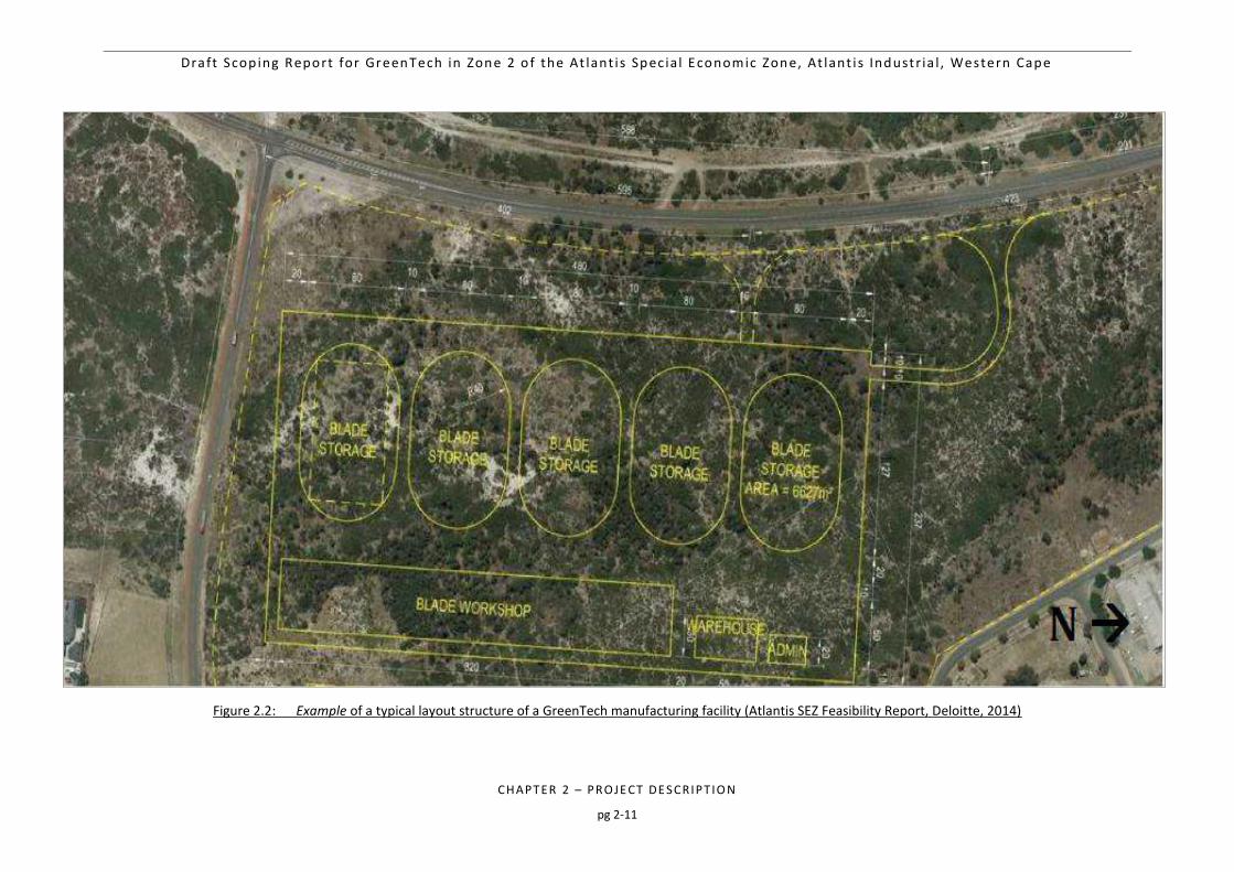
Draft Scop ing Report for GreenTech in Zone 2 o f the At lant i s Spec ia l Economic Zone, At lant i s Industr ia l , Western Cape
CHAPTER 2 – PROJE CT DE SCRIPT IO N
pg 2-11
Figure 2.2: Example of a typical layout structure of a GreenTech manufacturing facility (Atlantis SEZ Feasibility Report, Deloitte, 2014)
Draft Scop ing Report for GreenTech in Zone 2 o f the At lant i s Spec ia l Economic Zone, At lant i s Industr ia l , Western Cape
CHAPTER 2 – PROJE CT DE SCRIPT IO N
pg 2-12
2.7. PROJECT DEVELOPMENT CYCLE
2.7.1. Construction
The construction phase will take place subsequent to the issuing of an Environmental Authorisation (EA). The construction phase for the proposed Atlantis GreenTech project is expected to extend over a period of between 15 and 38 months, assuming normal daylight working hours are in place (however the construction period is subject to the final requirements of Eskom). The construction phase will involve the transportation of personnel, construction material and equipment to the site, and personnel away from the site. In terms of site establishment, laydown areas will be required at the outset of the construction phase, as well as dedicated access routes from the laydown areas to the working areas. Haul roads for construction traffic (for the delivery of concrete, road materials and other construction materials) will be required. The laydown area will either be located adjacent to or at the project site. It is expected that the laydown area will be temporary in nature (for the duration of the construction phase) and will include the establishment of the construction site camp (including site offices and other temporary facilities for the appointed Contractors). The laydown area is expected to cover a maximum area of 1 ha (depending on the contracting strategy at the time). If the laydown area is located outside of the footprint of the GreenTech facility itself, the area will thereafter be rehabilitated (i.e. returned to its pre-construction condition) at the end of the construction phase. All efforts will be made to ensure that all construction work will be undertaken in compliance with local, provincial and national legislation, local and international best practice, as well as the Environmental Management Programme (EMPr), which will be compiled during the EIA Phase and included in the EIA Report. During the construction phase, both skilled and unskilled temporary employment opportunities will be created. It is difficult to specify the actual number of employment opportunities that will be created at this stage; however approximately 200 personnel in project support industries will be utilized during the construction phase.
2.7.2. Operation and Maintenance
The anticipated date of the start of operations of the proposed Atlantis GreenTech project is dependent on several external factors (i.e. investors). The following activities will occur during the operational phase:
Manufacturing of renewable energy technologies (i.e. wind/solar/invertors);
Maintenance of the GreenTech facility (routine, scheduled and unscheduled). The projected operations are expected to provide several services and added economic spin offs (as highlighted in Chapter 1 of this Scoping Report). The operational phase of the project is expected to create skilled employment opportunities. However, other opportunities may arise for unskilled labour to be integrated to the ancillary activities. Approximately 280 temporary and 180 permanent employment opportunities will be created over the lifespan of the proposed facility.
2.7.3. Decommissioning
The main aim of decommissioning is to return the land to its original, pre-construction condition. Should the unlikely need for decommissioning arise (i.e. if the facility becomes outdated or the land needs to be used for other purposes), the decommissioning procedures will be undertaken in line with the EMPr and the site will be rehabilitated and returned to its pre-construction state.
Draft Scop ing Report for GreenTech in Zone 2 o f the At lant i s Spec ia l Economic Zone, At lant i s Industr ia l , Western Cape
CHAPTER 3 – AFFE CTED E NVIRONME NT
pg 3-1
3 DESCRIPTION OF THE AFFECTED ENVIRONMENT 3-3
3.1 BACKGROUND 3-3
3.2 PRELIMINARY SENSITIVITY SCREENING 3-3
3.3 BIOPHYSICAL ENVIRONMENT 3-6 3.3.1 Climatic Conditions 3-6
3.3.2 Geology 3-7
3.3.3 Topography 3-7
3.3.4 Agricultural Capability and Sensitivity 3-8
3.3.5 Soil Types and Soil Potential 3-9
3.3.6 Existing Groundwater Data 3-9
3.3.7 Terrestrial Environment 3-10
3.3.8 Threatened ecosystems (remaining extent) 3-10
3.3.8.1 Conservation planning and aquatic systems 3-12
3.3.9 Heritage Profile 3-13
3.3.9.1 Historical Background 3-13
3.3.9.2 Archaeology 3-13
3.3.9.3 Palaeontology 3-13
3.3.10 Socio-Economic Environment 3-14
3.3.11 Proximity to the Koeberg Nuclear Power Station's Urgent Protection Zone (UPZ) 3-17
Table 3.1: Estimated Volumes of Groundwater stored in the Atlantis Primary Aquifer System
(Bredenkamp and Vandoolaeghe, 1982) 3-9
Table 3.2: Description, significance and permissible actions for the Critical Biodiversity Areas as
defined by the CoCT BioNet (adapted from Holmes et al, 2012). 3-13
Table 3.3: Demographic Profile of the Atlantis Area (City of Cape Town Suburbs Census, 2011) 3-14
Table 3.4: Education Profile of the Atlantis Area (City of Cape Town Suburbs Census, 2011) 3-15
Table 3.5: Employment Profile of the Atlantis Area (City of Cape Town Suburbs Census, 2011) 3-16
Table 3.6: Household Income Profile of the Atlantis Area (City of Cape Town Suburbs Census, 2011) 3-16
Table 3.7: Anticipated population increase affecting the Koeberg Nuclear Power Station’s TEM 3-17
Draft Scop ing Report for GreenTech in Zone 2 o f the At lant i s Spec ia l Economic Zone, At lant i s Industr ia l , Western Cape
CHAPTER 3 – AFFE CTED E NVIRONME NT
pg 3-2
Figure 3.1: Regional Context of the Atlantis GreenTech site (i.e. Zone 2 of the Atlantis SEZ) 3-4
Figure 3.2: Composite map of potential sensitive ecological features in the area proposed for
GreenTech Project (i.e. Zone 2 of the Atlantis SEZ) 3-5
Figure 3.3: Mean Annual Rainfall Levels of South Africa (Source: Northern Cape PSDF, 2012) 3-6
Figure 3.4: Long-term mean a) temperatures (°C); and b) mean precipitation (mm) for Atlantis,
Western Cape (Worldweatheronline.com, 2015). 3-7
Figure 3.5: Geological features of the Atlantis Area 3-8
Figure 3.6: National Protected Areas within 15 km of the proposed Atlantis SEZ (Note: Klein
Dassenberg is the protected area designated as a biodiversity offset for the Atlantis SEZ –
refer to Appendix C of this report). 3-10
Figure 3.7: Threatened ecosystems in the area proposed for the GreenTech facility 3-12
Figure 3.8: Age profile of the Atlantis Area (City of Cape Town Suburbs Census, 2011) 3-15
Figure 3.9: Location of preferred site (highlighted in red) in relation to the Koeberg UPZ 3-18
Draft Scop ing Report for GreenTech in Zone 2 o f the At lant i s Spec ia l Economic Zone, At lant i s Industr ia l , Western Cape
CHAPTER 3 – AFFE CTED E NVIRONME NT
pg 3-3
3 DESCRIPTION OF THE AFFECTED ENVIRONMENT
This chapter of the Scoping Report provides an overview of the affected environment for the proposed Atlantis GreenTech project and the surrounding region. The receiving environment is understood to include biophysical, socio-economic and heritage aspects which could be affected by the proposed development or which in turn might impact on the proposed development. This information is provided to identify the potential issues and impacts of the proposed project on the environment. The information presented here has been sourced from:
Scoping input from the specialists that form part of the project team;
Review of information available on the South African National Biodiversity Institute (SANBI) Biodiversity Geographical Information System (BGIS) and Agricultural Geo-Referenced Information System (AGIS); and
City of Cape Town Metropolitan Municipality IDPs and the Cape Town PSDF.
Basic Assessment & correlating specialist studies, as well as the full Scoping & EIA conducted (by CSIR) for nearby sites in Atlantis (Portion 1 and Portion 4 of Cape Farm 1183) in 2012 and 2015/16 respectively.
It is important to note that this chapter intends to provide an overview and does not represent a detailed environmental study. Detailed studies focused on significant environmental aspects of this project will be provided during the EIA Phase1.
3.1 BACKGROUND
The proposed project is situated on erf portion remainder of 277, 246, 254 and portion remainder of 171, is bordered by Neil Hare road to the South, Neil Hare road to the North, Gideon Basson to the West and Charel Uys on the East. The total portion property covers approximately 32.6 ha in area. As previously noted, the site is located approximately 43 km north of Cape Town, in the Koeberg and Blaauwberg Sub-Councils of the Cape Town Metropolitan Municipality. The co-ordinates of the corner points of the preferred project area are provided in Chapter 2 of this Scoping Report. Figure 3.1 provides a locality map of the proposed project area within a regional setting. The proposed GreenTech facility is far removed from major centers, roads and tourist attractions. It is located near the R307 which functions as a primary access route to Atlantis from Cape Town. The closest major road is the R27 which functions as a connector between Saldanha and Cape Town.
3.2 PRELIMINARY SENSITIVITY SCREENING
Figure 3.1 represents the regional setting of the proposed Atlantis GreenTech project in terms of the surrounding sensitive ecosystem features and sensitive geographical areas (as indicated in Listing Notice 2 and 3 of the 2014 EIA Regulations, as amended in 2017) in proximity to the site. Based on the preliminary sensitivity screening undertaken for the site (as well as existing information for the area), the proposed Atlantis GreenTech facility is situated within the Cape West Coast Biosphere reserve and approximately 8 km west of Camphill Private Nature Reserve. In terms of the City of Cape Town (CoCT) urban conservation areas, the proposed site is approximately 10.5 km north-west of Philadelphia. The proposed development of the Atlantis GreenTech facility may have a visual impact on surrounding protected areas. However, the landscape has already been altered by industrial infrastructure (e.g. Ankerlig power station), and therefore the proposed development is anticipated to have limited visual impacts on sensitive visual receptors. Cape Flats Dune Strandveld is listed as being Endangered, whilst the Atlantis Sand Fynbos is listed as being Critically Endangered (Fynbos Forum, 2016). The proposed facility is situated in the Cape Fltats Dune Strandveld and immediately outside of the Atlantis Sand Fynbos vegetation type (east). The proposed facility is located in an area identified by the Biodiversity Network (BioNet) as Other natural vegetation, which means that activities in the area are negotiable, but low impact activities are preferable as the vegetation is still in a good condition and should be sustainably managed.
1 Environmental Impact Assessment within the South African context exists of 2 distinct phases; namely, the
Scoping Phase (of which this report is part), and the Environmental Impact Assessment Phase.
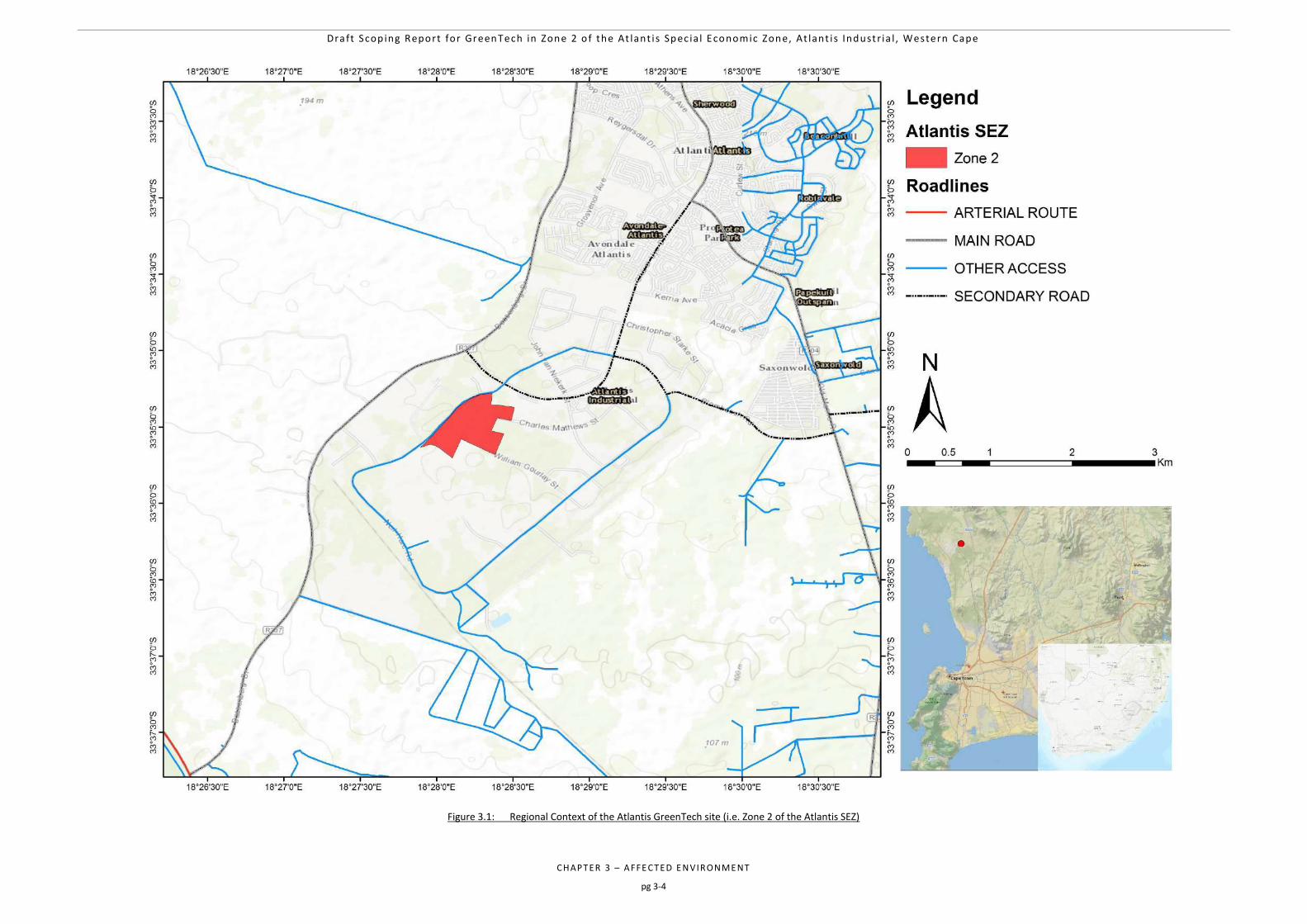
Draft Scop ing Report for GreenTech in Zone 2 o f the At lant i s Spec ia l Economic Zone, At lant i s Industr ia l , Western Cape
CHAPTER 3 – AFFE CTED E NVIRONME NT
pg 3-4
Figure 3.1: Regional Context of the Atlantis GreenTech site (i.e. Zone 2 of the Atlantis SEZ)
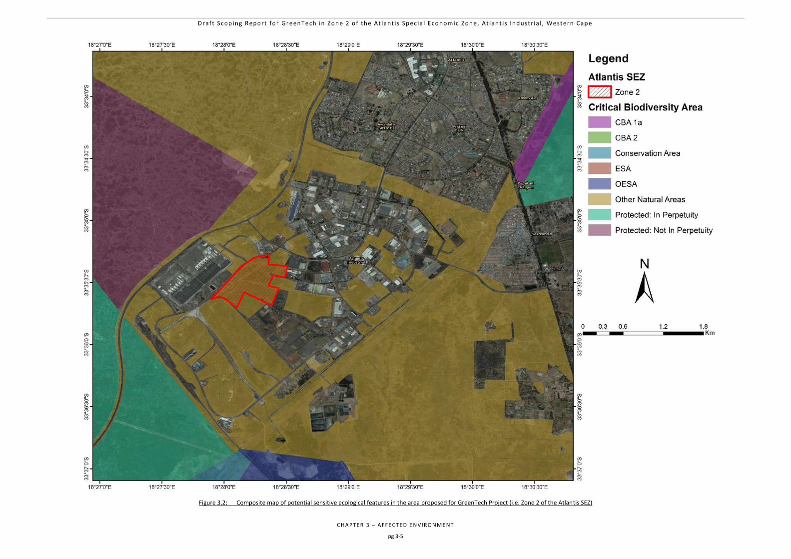
Draft Scop ing Report for GreenTech in Zone 2 o f the At lant i s Spec ia l Economic Zone, At lant i s Industr ia l , Western Cape
CHAPTER 3 – AFFE CTED E NVIRONME NT
pg 3-5
Figure 3.2: Composite map of potential sensitive ecological features in the area proposed for GreenTech Project (i.e. Zone 2 of the Atlantis SEZ)
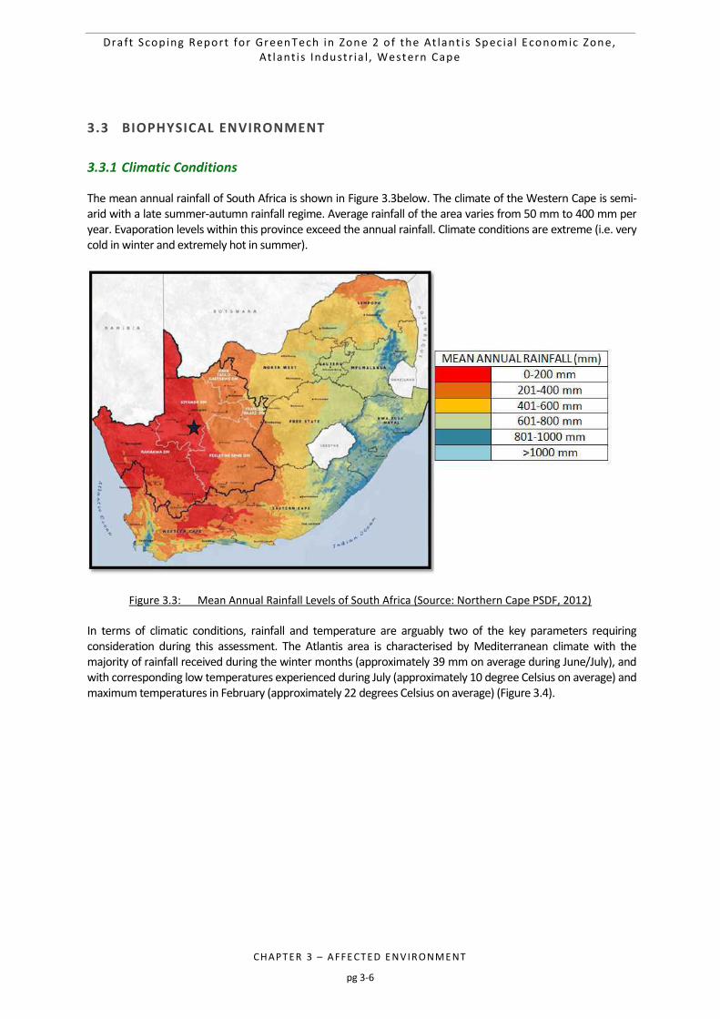
Draft Scop ing Report for GreenTech in Zone 2 o f the At lant i s Spec ia l Economic Zone, At lant i s Industr ia l , Western Cape
CHAPTER 3 – AFFE CTED E NVIRONME NT
pg 3-6
3.3 BIOPHYSICAL ENVIRONMENT
3.3.1 Climatic Conditions
The mean annual rainfall of South Africa is shown in Figure 3.3below. The climate of the Western Cape is semi-arid with a late summer-autumn rainfall regime. Average rainfall of the area varies from 50 mm to 400 mm per year. Evaporation levels within this province exceed the annual rainfall. Climate conditions are extreme (i.e. very cold in winter and extremely hot in summer).
Figure 3.3: Mean Annual Rainfall Levels of South Africa (Source: Northern Cape PSDF, 2012)
In terms of climatic conditions, rainfall and temperature are arguably two of the key parameters requiring consideration during this assessment. The Atlantis area is characterised by Mediterranean climate with the majority of rainfall received during the winter months (approximately 39 mm on average during June/July), and with corresponding low temperatures experienced during July (approximately 10 degree Celsius on average) and maximum temperatures in February (approximately 22 degrees Celsius on average) (Figure 3.4).
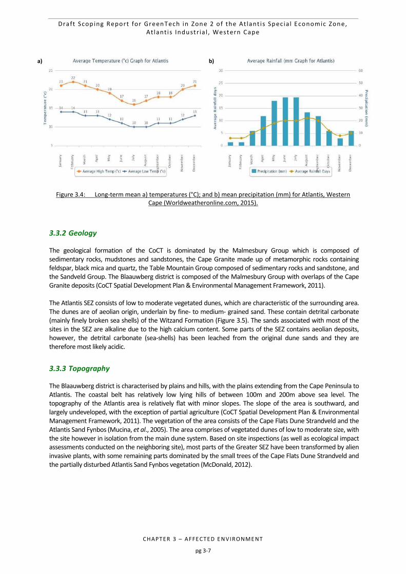
Draft Scop ing Report for GreenTech in Zone 2 o f the At lant i s Spec ia l Economic Zone, At lant i s Industr ia l , Western Cape
CHAPTER 3 – AFFE CTED E NVIRONME NT
pg 3-7
Figure 3.4: Long-term mean a) temperatures (°C); and b) mean precipitation (mm) for Atlantis, Western
Cape (Worldweatheronline.com, 2015).
3.3.2 Geology
The geological formation of the CoCT is dominated by the Malmesbury Group which is composed of sedimentary rocks, mudstones and sandstones, the Cape Granite made up of metamorphic rocks containing feldspar, black mica and quartz, the Table Mountain Group composed of sedimentary rocks and sandstone, and the Sandveld Group. The Blaauwberg district is composed of the Malmesbury Group with overlaps of the Cape Granite deposits (CoCT Spatial Development Plan & Environmental Management Framework, 2011). The Atlantis SEZ consists of low to moderate vegetated dunes, which are characteristic of the surrounding area. The dunes are of aeolian origin, underlain by fine- to medium- grained sand. These contain detrital carbonate (mainly finely broken sea shells) of the Witzand Formation (Figure 3.5). The sands associated with most of the sites in the SEZ are alkaline due to the high calcium content. Some parts of the SEZ contains aeolian deposits, however, the detrital carbonate (sea-shells) has been leached from the original dune sands and they are therefore most likely acidic.
3.3.3 Topography
The Blaauwberg district is characterised by plains and hills, with the plains extending from the Cape Peninsula to Atlantis. The coastal belt has relatively low lying hills of between 100m and 200m above sea level. The topography of the Atlantis area is relatively flat with minor slopes. The slope of the area is southward, and largely undeveloped, with the exception of partial agriculture (CoCT Spatial Development Plan & Environmental Management Framework, 2011). The vegetation of the area consists of the Cape Flats Dune Strandveld and the Atlantis Sand Fynbos (Mucina, et al., 2005). The area comprises of vegetated dunes of low to moderate size, with the site however in isolation from the main dune system. Based on site inspections (as well as ecological impact assessments conducted on the neighboring site), most parts of the Greater SEZ have been transformed by alien invasive plants, with some remaining parts dominated by the small trees of the Cape Flats Dune Strandveld and the partially disturbed Atlantis Sand Fynbos vegetation (McDonald, 2012).
a) b)
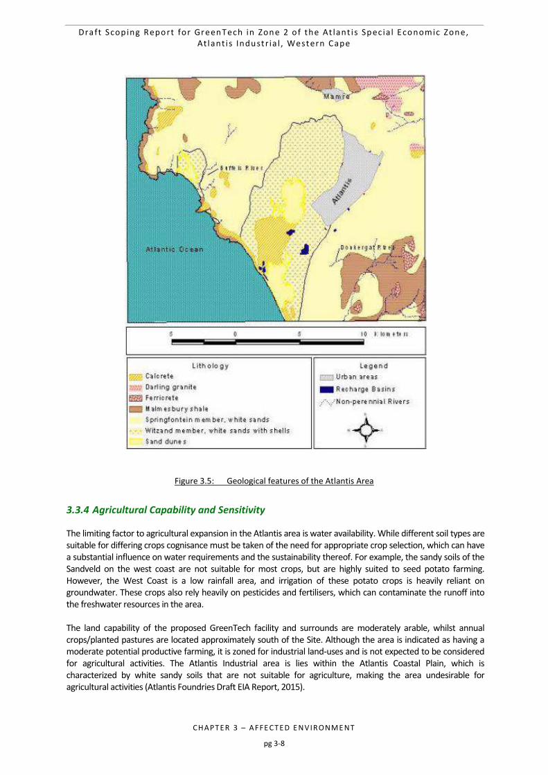
Draft Scop ing Report for GreenTech in Zone 2 o f the At lant i s Spec ia l Economic Zone, At lant i s Industr ia l , Western Cape
CHAPTER 3 – AFFE CTED E NVIRONME NT
pg 3-8
Figure 3.5: Geological features of the Atlantis Area
3.3.4 Agricultural Capability and Sensitivity
The limiting factor to agricultural expansion in the Atlantis area is water availability. While different soil types are suitable for differing crops cognisance must be taken of the need for appropriate crop selection, which can have a substantial influence on water requirements and the sustainability thereof. For example, the sandy soils of the Sandveld on the west coast are not suitable for most crops, but are highly suited to seed potato farming. However, the West Coast is a low rainfall area, and irrigation of these potato crops is heavily reliant on groundwater. These crops also rely heavily on pesticides and fertilisers, which can contaminate the runoff into the freshwater resources in the area. The land capability of the proposed GreenTech facility and surrounds are moderately arable, whilst annual crops/planted pastures are located approximately south of the Site. Although the area is indicated as having a moderate potential productive farming, it is zoned for industrial land-uses and is not expected to be considered for agricultural activities. The Atlantis Industrial area is lies within the Atlantis Coastal Plain, which is characterized by white sandy soils that are not suitable for agriculture, making the area undesirable for agricultural activities (Atlantis Foundries Draft EIA Report, 2015).
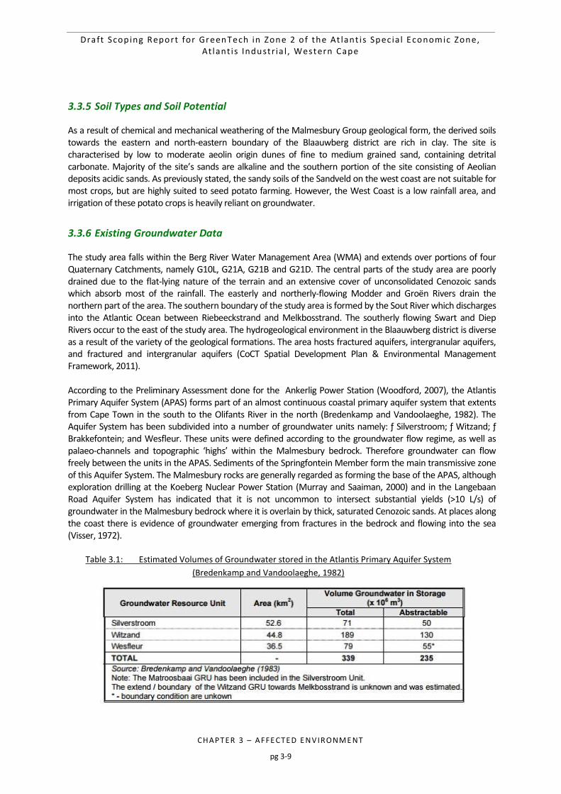
Draft Scop ing Report for GreenTech in Zone 2 o f the At lant i s Spec ia l Economic Zone, At lant i s Industr ia l , Western Cape
CHAPTER 3 – AFFE CTED E NVIRONME NT
pg 3-9
3.3.5 Soil Types and Soil Potential
As a result of chemical and mechanical weathering of the Malmesbury Group geological form, the derived soils towards the eastern and north-eastern boundary of the Blaauwberg district are rich in clay. The site is characterised by low to moderate aeolin origin dunes of fine to medium grained sand, containing detrital carbonate. Majority of the site’s sands are alkaline and the southern portion of the site consisting of Aeolian deposits acidic sands. As previously stated, the sandy soils of the Sandveld on the west coast are not suitable for most crops, but are highly suited to seed potato farming. However, the West Coast is a low rainfall area, and irrigation of these potato crops is heavily reliant on groundwater.
3.3.6 Existing Groundwater Data
The study area falls within the Berg River Water Management Area (WMA) and extends over portions of four Quaternary Catchments, namely G10L, G21A, G21B and G21D. The central parts of the study area are poorly drained due to the flat-lying nature of the terrain and an extensive cover of unconsolidated Cenozoic sands which absorb most of the rainfall. The easterly and northerly-flowing Modder and Groën Rivers drain the northern part of the area. The southern boundary of the study area is formed by the Sout River which discharges into the Atlantic Ocean between Riebeeckstrand and Melkbosstrand. The southerly flowing Swart and Diep Rivers occur to the east of the study area. The hydrogeological environment in the Blaauwberg district is diverse as a result of the variety of the geological formations. The area hosts fractured aquifers, intergranular aquifers, and fractured and intergranular aquifers (CoCT Spatial Development Plan & Environmental Management Framework, 2011). According to the Preliminary Assessment done for the Ankerlig Power Station (Woodford, 2007), the Atlantis Primary Aquifer System (APAS) forms part of an almost continuous coastal primary aquifer system that extents from Cape Town in the south to the Olifants River in the north (Bredenkamp and Vandoolaeghe, 1982). The Aquifer System has been subdivided into a number of groundwater units namely: ƒ Silverstroom; ƒ Witzand; ƒ Brakkefontein; and Wesfleur. These units were defined according to the groundwater flow regime, as well as palaeo-channels and topographic ‘highs’ within the Malmesbury bedrock. Therefore groundwater can flow freely between the units in the APAS. Sediments of the Springfontein Member form the main transmissive zone of this Aquifer System. The Malmesbury rocks are generally regarded as forming the base of the APAS, although exploration drilling at the Koeberg Nuclear Power Station (Murray and Saaiman, 2000) and in the Langebaan Road Aquifer System has indicated that it is not uncommon to intersect substantial yields (>10 L/s) of groundwater in the Malmesbury bedrock where it is overlain by thick, saturated Cenozoic sands. At places along the coast there is evidence of groundwater emerging from fractures in the bedrock and flowing into the sea (Visser, 1972).
Table 3.1: Estimated Volumes of Groundwater stored in the Atlantis Primary Aquifer System
(Bredenkamp and Vandoolaeghe, 1982)
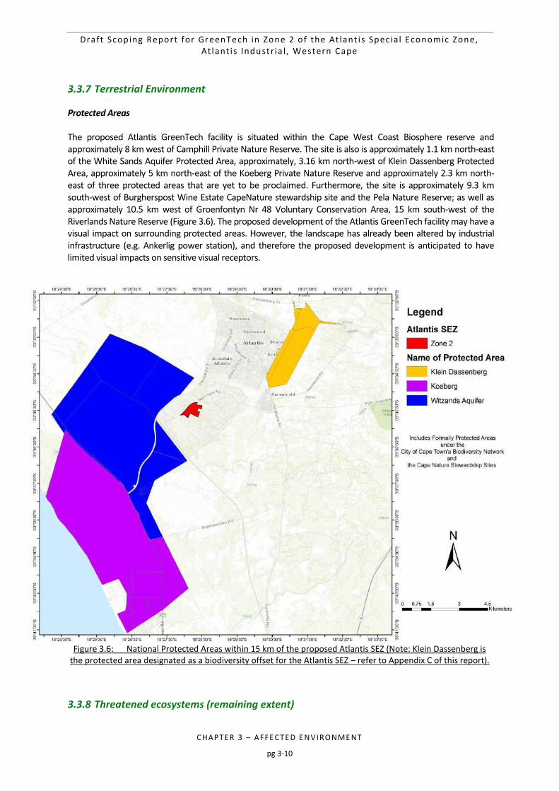
Draft Scop ing Report for GreenTech in Zone 2 o f the At lant i s Spec ia l Economic Zone, At lant i s Industr ia l , Western Cape
CHAPTER 3 – AFFE CTED E NVIRONME NT
pg 3-10
3.3.7 Terrestrial Environment
Protected Areas The proposed Atlantis GreenTech facility is situated within the Cape West Coast Biosphere reserve and approximately 8 km west of Camphill Private Nature Reserve. The site is also is approximately 1.1 km north-east of the White Sands Aquifer Protected Area, approximately, 3.16 km north-west of Klein Dassenberg Protected Area, approximately 5 km north-east of the Koeberg Private Nature Reserve and approximately 2.3 km north-east of three protected areas that are yet to be proclaimed. Furthermore, the site is approximately 9.3 km south-west of Burgherspost Wine Estate CapeNature stewardship site and the Pela Nature Reserve; as well as approximately 10.5 km west of Groenfontyn Nr 48 Voluntary Conservation Area, 15 km south-west of the Riverlands Nature Reserve (Figure 3.6). The proposed development of the Atlantis GreenTech facility may have a visual impact on surrounding protected areas. However, the landscape has already been altered by industrial infrastructure (e.g. Ankerlig power station), and therefore the proposed development is anticipated to have limited visual impacts on sensitive visual receptors.
Figure 3.6: National Protected Areas within 15 km of the proposed Atlantis SEZ (Note: Klein Dassenberg is the protected area designated as a biodiversity offset for the Atlantis SEZ – refer to Appendix C of this report).
3.3.8 Threatened ecosystems (remaining extent)
Draft Scop ing Report for GreenTech in Zone 2 o f the At lant i s Spec ia l Economic Zone, At lant i s Industr ia l , Western Cape
CHAPTER 3 – AFFE CTED E NVIRONME NT
pg 3-11
A national list of threatened ecosystems is provided for in The National Environmental Management: Biodiversity Act (NEMBA) (No. 10 of 2004) (South Africa, 2004). There are three classes of threatened ecosystems namely: i) Critically endangered (CR) vegetation types which have less than 25 % of its original cover remaining, have undergone severe degradation of ecological structure, function or composition due to human activities, and are subject to an extremely high risk of irreversible transformation; ii) Endangered (EN) vegetation types have lost more than 60% of its original extent and have undergone degradation of ecological structure, function, or composition due to human activities, although they are not critically endangered ecosystems; and iii) Vulnerable (VU) vegetation types that have lost approximately 50 % of its original extent and are at a high risk of undergoing significant degradation of ecological structure, function or composition due to human activities, although they are not critically endangered ecosystems or endangered ecosystems. Cape Flats Dune Strandveld is listed as being Endangered, whilst the Atlantis Sand Fynbos is listed as being Critically Endangered (South Africa, 2004). The proposed Atlantis GreenTech facility is partly situated in the Cape Flats Dune Strandveld vegetation types (Figure 3.7). In response to high demand and need for development within the Atlantis urban edge, the City of Cape Town adopted a pro-active stance towards the conservation of the highly threatened biodiversity within the Atlantis district. The vegetation types in this area are Endangered or Critically Endangered and there are remnants of these vegetation types occurring within the urban edge. The City of Cape Town consequently embarked on the Atlantis Industrial Incentives Scheme, which has also been termed a Land Banking Mechanism. The project entails the pro-active purchase or obtaining of land for formal conservation, which then forms part of the land bank against which development of natural areas within the Atlantis urban edge can be used as a debit against the proactively secured land and therefore act as an incentive for industrial development within the Atlantis urban edge. The biodiversity offset property consists of Critically Endangered Atlantis Sand Fynbos in very good condition with a low level of alien invasive species infestation (very rare within an urban context) and contains several Red Listed threatened species. The subject property is therefore suitable for offsetting the fragments of natural vegetation within the urban edge, which are more fragmented and heavily infested with alien invasive species, however still of conservation importance due to the threatened status and possibility of threatened species present, but unlikely to be viable in the long term. Refer to Appendix C of this Draft Scoping Report for the Biodiversity Offset Report, which covers for the loss of vegetation that will be incurred for this proposed development.
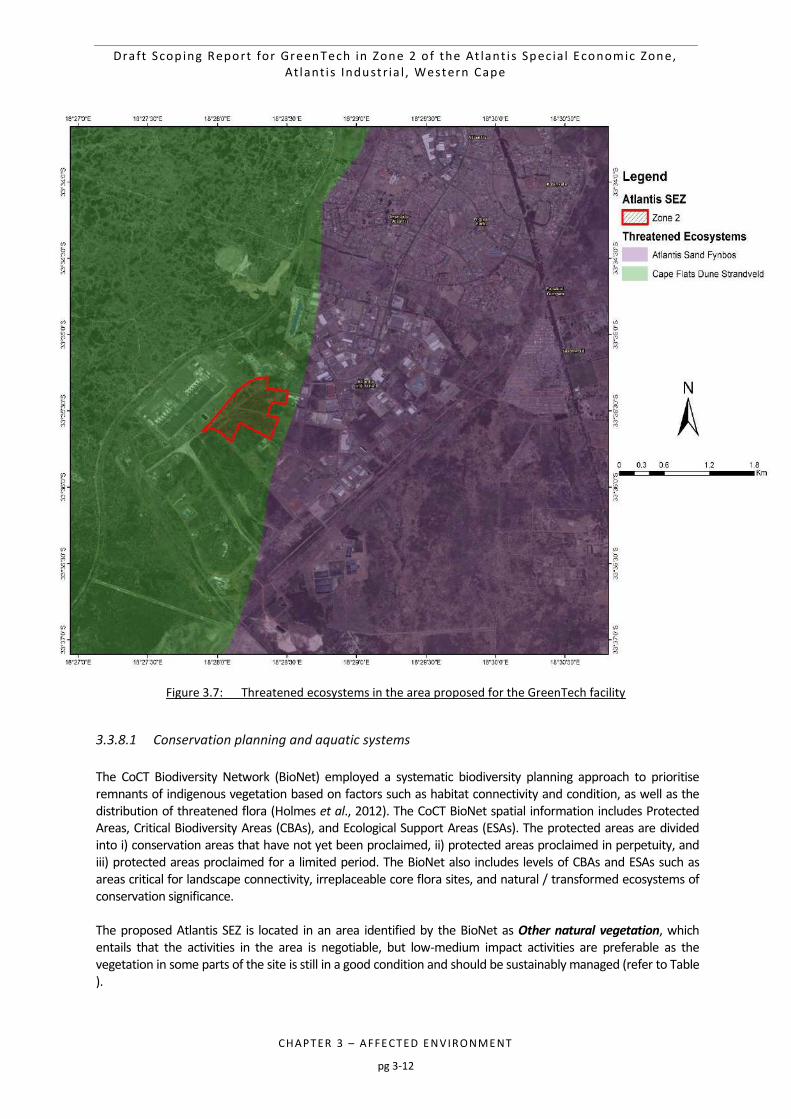
Draft Scop ing Report for GreenTech in Zone 2 o f the At lant i s Spec ia l Economic Zone, At lant i s Industr ia l , Western Cape
CHAPTER 3 – AFFE CTED E NVIRONME NT
pg 3-12
Figure 3.7: Threatened ecosystems in the area proposed for the GreenTech facility
3.3.8.1 Conservation planning and aquatic systems
The CoCT Biodiversity Network (BioNet) employed a systematic biodiversity planning approach to prioritise remnants of indigenous vegetation based on factors such as habitat connectivity and condition, as well as the distribution of threatened flora (Holmes et al., 2012). The CoCT BioNet spatial information includes Protected Areas, Critical Biodiversity Areas (CBAs), and Ecological Support Areas (ESAs). The protected areas are divided into i) conservation areas that have not yet been proclaimed, ii) protected areas proclaimed in perpetuity, and iii) protected areas proclaimed for a limited period. The BioNet also includes levels of CBAs and ESAs such as areas critical for landscape connectivity, irreplaceable core flora sites, and natural / transformed ecosystems of conservation significance. The proposed Atlantis SEZ is located in an area identified by the BioNet as Other natural vegetation, which entails that the activities in the area is negotiable, but low-medium impact activities are preferable as the vegetation in some parts of the site is still in a good condition and should be sustainably managed (refer to Table ).
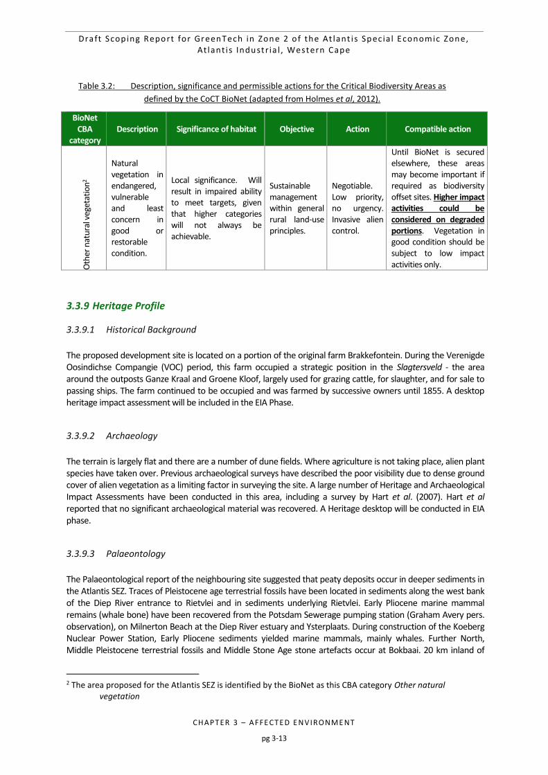
Draft Scop ing Report for GreenTech in Zone 2 o f the At lant i s Spec ia l Economic Zone, At lant i s Industr ia l , Western Cape
CHAPTER 3 – AFFE CTED E NVIRONME NT
pg 3-13
Table 3.2: Description, significance and permissible actions for the Critical Biodiversity Areas as
defined by the CoCT BioNet (adapted from Holmes et al, 2012).
BioNet CBA
category Description Significance of habitat Objective Action Compatible action
Oth
er n
atu
ral v
eget
atio
n2
Natural vegetation in endangered, vulnerable and least concern in good or restorable condition.
Local significance. Will result in impaired ability to meet targets, given that higher categories will not always be achievable.
Sustainable management within general rural land-use principles.
Negotiable. Low priority, no urgency. Invasive alien control.
Until BioNet is secured elsewhere, these areas may become important if required as biodiversity offset sites. Higher impact activities could be considered on degraded portions. Vegetation in good condition should be subject to low impact activities only.
3.3.9 Heritage Profile
3.3.9.1 Historical Background
The proposed development site is located on a portion of the original farm Brakkefontein. During the Verenigde Oosindichse Compangie (VOC) period, this farm occupied a strategic position in the Slagtersveld - the area around the outposts Ganze Kraal and Groene Kloof, largely used for grazing cattle, for slaughter, and for sale to passing ships. The farm continued to be occupied and was farmed by successive owners until 1855. A desktop heritage impact assessment will be included in the EIA Phase.
3.3.9.2 Archaeology
The terrain is largely flat and there are a number of dune fields. Where agriculture is not taking place, alien plant species have taken over. Previous archaeological surveys have described the poor visibility due to dense ground cover of alien vegetation as a limiting factor in surveying the site. A large number of Heritage and Archaeological Impact Assessments have been conducted in this area, including a survey by Hart et al. (2007). Hart et al reported that no significant archaeological material was recovered. A Heritage desktop will be conducted in EIA phase.
3.3.9.3 Palaeontology
The Palaeontological report of the neighbouring site suggested that peaty deposits occur in deeper sediments in the Atlantis SEZ. Traces of Pleistocene age terrestrial fossils have been located in sediments along the west bank of the Diep River entrance to Rietvlei and in sediments underlying Rietvlei. Early Pliocene marine mammal remains (whale bone) have been recovered from the Potsdam Sewerage pumping station (Graham Avery pers. observation), on Milnerton Beach at the Diep River estuary and Ysterplaats. During construction of the Koeberg Nuclear Power Station, Early Pliocene sediments yielded marine mammals, mainly whales. Further North, Middle Pleistocene terrestrial fossils and Middle Stone Age stone artefacts occur at Bokbaai. 20 km inland of
2 The area proposed for the Atlantis SEZ is identified by the BioNet as this CBA category Other natural
vegetation
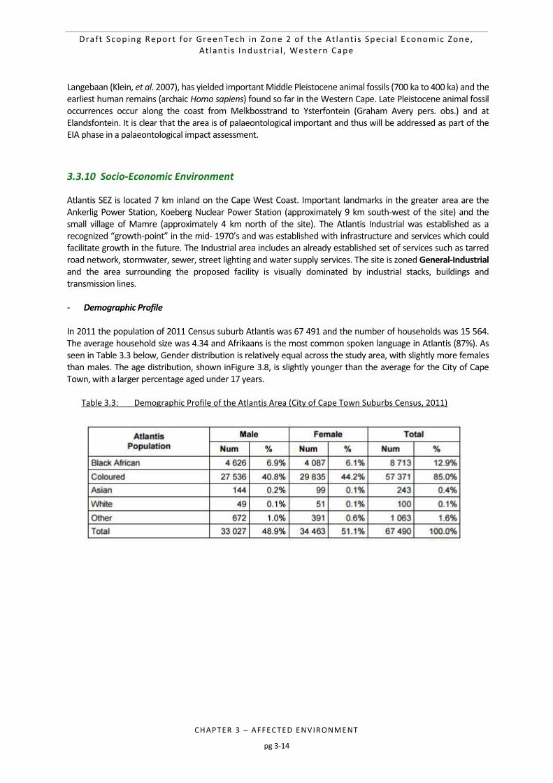
Draft Scop ing Report for GreenTech in Zone 2 o f the At lant i s Spec ia l Economic Zone, At lant i s Industr ia l , Western Cape
CHAPTER 3 – AFFE CTED E NVIRONME NT
pg 3-14
Langebaan (Klein, et al. 2007), has yielded important Middle Pleistocene animal fossils (700 ka to 400 ka) and the earliest human remains (archaic Homo sapiens) found so far in the Western Cape. Late Pleistocene animal fossil occurrences occur along the coast from Melkbosstrand to Ysterfontein (Graham Avery pers. obs.) and at Elandsfontein. It is clear that the area is of palaeontological important and thus will be addressed as part of the EIA phase in a palaeontological impact assessment.
3.3.10 Socio-Economic Environment
Atlantis SEZ is located 7 km inland on the Cape West Coast. Important landmarks in the greater area are the Ankerlig Power Station, Koeberg Nuclear Power Station (approximately 9 km south-west of the site) and the small village of Mamre (approximately 4 km north of the site). The Atlantis Industrial was established as a recognized “growth-point” in the mid- 1970’s and was established with infrastructure and services which could facilitate growth in the future. The Industrial area includes an already established set of services such as tarred road network, stormwater, sewer, street lighting and water supply services. The site is zoned General-Industrial and the area surrounding the proposed facility is visually dominated by industrial stacks, buildings and transmission lines. - Demographic Profile In 2011 the population of 2011 Census suburb Atlantis was 67 491 and the number of households was 15 564. The average household size was 4.34 and Afrikaans is the most common spoken language in Atlantis (87%). As seen in Table 3.3 below, Gender distribution is relatively equal across the study area, with slightly more females than males. The age distribution, shown inFigure 3.8, is slightly younger than the average for the City of Cape Town, with a larger percentage aged under 17 years.
Table 3.3: Demographic Profile of the Atlantis Area (City of Cape Town Suburbs Census, 2011)
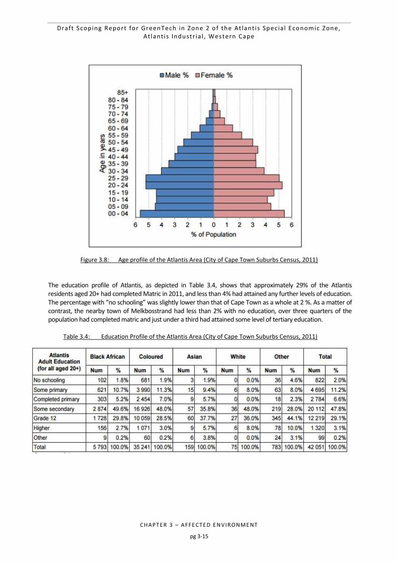
Draft Scop ing Report for GreenTech in Zone 2 o f the At lant i s Spec ia l Economic Zone, At lant i s Industr ia l , Western Cape
CHAPTER 3 – AFFE CTED E NVIRONME NT
pg 3-15
Figure 3.8: Age profile of the Atlantis Area (City of Cape Town Suburbs Census, 2011)
The education profile of Atlantis, as depicted in Table 3.4, shows that approximately 29% of the Atlantis residents aged 20+ had completed Matric in 2011, and less than 4% had attained any further levels of education. The percentage with “no schooling” was slightly lower than that of Cape Town as a whole at 2 %. As a matter of contrast, the nearby town of Melkbosstrand had less than 2% with no education, over three quarters of the population had completed matric and just under a third had attained some level of tertiary education.
Table 3.4: Education Profile of the Atlantis Area (City of Cape Town Suburbs Census, 2011)
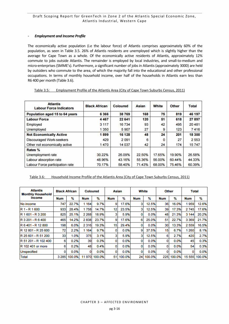
Draft Scop ing Report for GreenTech in Zone 2 o f the At lant i s Spec ia l Economic Zone, At lant i s Industr ia l , Western Cape
CHAPTER 3 – AFFE CTED E NVIRONME NT
pg 3-16
- Employment and Income Profile The economically active population (i.e the labour force) of Atlantis comprises approximately 60% of the population, as seen in Table 3.5. 26% of Atlantis residents are unemployed which is slightly higher than the average for Cape Town as a whole. Of the economically active residents of Atlantis, approximately 12% commute to jobs outside Atlantis. The remainder is employed by local industries, and small-to-medium and micro-enterprises (SMME’s). Furthermore, a significant number of jobs in Atlantis (approximately 3000) are held by outsiders who commute to the area, of which the majority fall into the educational and other professional occupations. In terms of monthly household income, over half of the households in Atlantis earn less than R6 400 per month (Table 3.6).
Table 3.5: Employment Profile of the Atlantis Area (City of Cape Town Suburbs Census, 2011)
Table 3.6: Household Income Profile of the Atlantis Area (City of Cape Town Suburbs Census, 2011)
Draft Scop ing Report for GreenTech in Zone 2 o f the At lant i s Spec ia l Economic Zone, At lant i s Industr ia l , Western Cape
CHAPTER 3 – AFFE CTED E NVIRONME NT
pg 3-17
The economy of the Atlantis Area is dominated by industry and agriculture and contributes greatly to the economy of the Western Cape. Atlantis offers significant potential for economic development, and the City of Cape Town Metropolitan Municipality IDP (2004) identified Atlantis as one of the focal areas for residential upgrading. The Atlantis Industrial area is ideal and unique in its suitability and potential to contribute to industrial and economic development, specifically in terms of South Africa’s power mix. It has been noted that there are no major tourist destinations in close proximity to the site (Figure 3.9 below), which adds to the suitability of this site for the proposed GreenTech facility. Due to the zoning of this area as a Special Economic Zone, earmarked for industrial development, the CoCT IDP indicates that industrial development is one of the most important economic sectors in the Western Cape, specifically in Atlantis, due to its locality and existing infrastructure.
3.3.11 Proximity to the Koeberg Nuclear Power Station's Urgent Protection Zone (UPZ)
The site is situated between the 5- 16 km Urgent Protective Action Planning Zone (UPZ) boundary of the Koeberg Nuclear Power Station (KNPS). Figure 3.9 indicates the location of the site in relation to the Koeberg UPZ. It is difficult to estimate the exact number of people to be employed on a temporary and permanent basis as well as the amount sourced locally or non-locally, as this may only be finalized in the development phase (and may fluctuate). 3 However, it is important to provide a high-level assessment and anticipation of the population increase to the UPZ under the circumstance of a nuclear emergency. Thus, this increase needs to be tested against the KNPS Traffic Evacuation Model (TEM), as seen in Table 3.7 below.
Table 3.7: Anticipated population increase affecting the Koeberg Nuclear Power Station’s TEM
Proposed Atlantis GreenTech facility’s population increase for the Koeberg TEM
PLEASE SPECIFY THE TYPE OF LAND USE:
SG CODE OR X,Y - COORDINATES
(GLA m²) / Nr OF DWELLING UNITS / HOUSEHOLDS
INCOME GROUP (LOW/MIDDLE/HIGH FOR TYPE OF LAND USE)
POP INCREASE FROM INSIDE UPZ (RESIDENTS, WORKERS, OTHER OCCUPENTS)
POP INCREASE FROM OUTSIDE UPZ (RESIDENTS, WORKERS, OTHER OCCUPENTS)
General Industrial (GI)
SG Code: C01600000000118300004 C01600000001183000000 C01600000000118300008 C01600000001183000074
GreenTech facility i.e. warehouse-type structure (also consisting of an office for personnel)
Skilled personnel working on site will be predominaely from a high income group, where as the unskilled personnel from low- middle income groups.
~200 (Staff, skilled and support labour, construction and/or operation)
~20 (Specialist shutdown and outage personnel to be mobilised into the area for short periods)
3 This table will be updated in the development phase when the size of the project as well as the number of personnel needed is finalized by the Applicant.
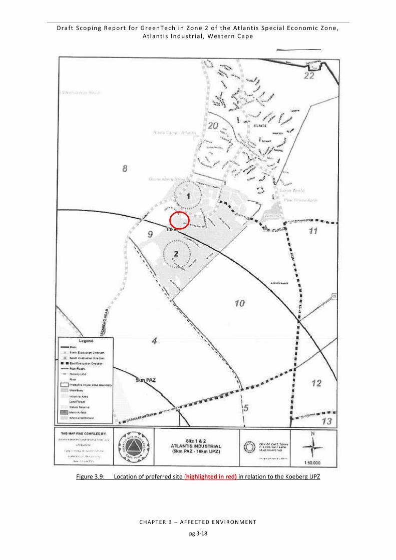
Draft Scop ing Report for GreenTech in Zone 2 o f the At lant i s Spec ia l Economic Zone, At lant i s Industr ia l , Western Cape
CHAPTER 3 – AFFE CTED E NVIRONME NT
pg 3-18
Figure 3.9: Location of preferred site (highlighted in red) in relation to the Koeberg UPZ
Draft Scop ing Report for GreenTech in Zone 2 o f the At lant i s Spec ia l Economic Zone, At lant i s Industr ia l , Western Cape
CHAPTER 4 – APPRO ACH
pg 4-1
4 APPROACH 4-2
4.1 LEGAL CONTEXT FOR THIS EIA 4-2
4.2 LEGISLATION AND GUIDELINES PERTINENT TO THIS EIA 4-5 4.2.1 National Legislation 4-5
4.2.3 International Finance Corporation Performance Standards 4-10
4.3 PRINCIPLES FOR SCOPING AND PUBLIC PARTICIPATION 4-11
4.4 OBJECTIVES OF THE SCOPING PROCESS 4-12
4.5 TASKS IN THE SCOPING PHASE 4-12
4.6 SCHEDULE FOR THE EIA 4-15
Table 4.1: Listed Activities in GN R327, R325 and R324 that potentially form part of the proposed
Atlantis GreenTech EIA 4-2
Table 4.2: Project schedule for the Atlantis GreenTech Project 4-16
Figure 4.1: Threatened ecosystems in the area proposed for the Atlantis GreenTech site. 4-4
Draft Scop ing Report for GreenTech in Zone 2 o f the At lant i s Spec ia l Economic Zone, At lant i s Industr ia l , Western Cape
CHAPTER 4 – APPRO ACH
pg 4-2
4 APPROACH
This chapter presents the EIA Process to be conducted for the proposed development and gives particular attention to the legal context and guidelines that apply to this EIA, the steps in the Scoping and Public Participation component of the EIA (in accordance with Regulations 41, 42, 43 and 44 of GN R326), and the schedule for the EIA Process.
4.1 LEGAL CONTEXT FOR THIS EIA
Section 24(1) of the NEMA states: "In order to give effect to the general objectives of integrated environmental management laid down in this
Chapter, the potential impact on the environment of listed activities must be considered, investigated, assessed and reported to the competent authority charged by this Act with granting the relevant environmental authorization."
The reference to "listed activities" in Section 24 of the NEMA relates to the regulations promulgated in GN R327, R326, R325 and R324 in Government Gazette 40772, dated 7 April 2017. The relevant Government Notices published in terms of the NEMA collectively comprise the NEMA EIA Regulations listed activities that require either a Basic Assessment, or Scoping and EIA (that is a “full EIA”) be conducted. As noted in Chapter 1 of this Scoping Report, the proposed project requires a full EIA, as it particularly includes, inter alia, the inclusion of , the inclusion of Activity 2 listed in GN R325 (Listing Notice 2): “15. The clearance of an area of 20 hectares or more of indigenous vegetation, excluding where such clearance of indigenous vegetation is required for- (i) the undertaking of a linear activity; (ii) maintenance purposes undertaken in accordance with a maintenance management plan.” All the listed activities potentially forming part of this proposed development and therefore requiring Environmental Authorisation (EA) were included in the Notice of Intent to Develop (NID) and will form part of the Application Form for EA that will be prepared and submitted to the DEA&DP. At the time of release of this Draft Scoping Report to Interested and Affected Parties (I&APs) for review, the letter of acknowledgement from the DEA&DP stipulating the EIA Reference Number for the proposed project was pending. The listed activities potentially triggered by the proposed project are indicated in Table 4.1.
Table 4.1: Listed Activities in GN R327, R325 and R324 that potentially form part of the proposed
Atlantis GreenTech EIA
Activity No. Description as per the Regulations Description as per the project specifics
GNR 327
47
The expansion of facilities or infrastructure for the transmission and distribution of electricity where the expanded capacity will exceed 275 kilovolts and the development footprint will increase.
This project will entail the upgrading of the electrical infrastructure to service the facility.
GNR 325
Draft Scop ing Report for GreenTech in Zone 2 o f the At lant i s Spec ia l Economic Zone, At lant i s Industr ia l , Western Cape
CHAPTER 4 – APPRO ACH
pg 4-3
Activity No. Description as per the Regulations Description as per the project specifics
15
The clearance of an area of 20 hectares or more of indigenous vegetation, excluding where such clearance of indigenous vegetation is required for— (i) the undertaking of a linear activity; or (ii) Maintenance purposes undertaken in accordance with a maintenance management plan.
This project entails the clearance of approximately 33 ha of indigenous vegetation for the development of a GreenTech manufacturing facility.
GNR 324
12
The clearance of an area of 300 square metres or more of indigenous vegetation except where such clearance of indigenous vegetation is required for maintenance purposes undertaken in accordance with a maintenance management plan. i. Western Cape i. Within any critically endangered or endangered ecosystem listed in terms of section 52 of the NEMBA or prior to the publication of such a list, within an area that has been identified as critically endangered in the National Spatial Biodiversity Assessment 2004; ii. Within critical biodiversity areas identified in bioregional plans.
This project entails the clearance of approximately 33 ha of indigenous vegetation for the development of a GreenTech manufacturing facility. A preliminary screening of the vegetation types for Zone 2 in the Atlantis SEZ indicated that the land parcels comprising this Zone consist of the Endangered Cape Flats Dune Strandveld.
Notes regarding the identification of potential listed activities: It should be noted that a precautionary approach was followed when identifying listed activities (for
inclusion in the NID and Application for EA and to be assessed as part of the Scoping and EIA Process), i.e. if the activity potentially forms part of the project, it is listed. However, the final project description will be shaped by the findings of the EIA Process and certain activities may be added or removed from the project proposal. The DEA&DP and I&APs will be informed in writing of such amendments accordingly.
Although internal roads are being constructed, Activity 24 (ii) in GNR 327 relating to the construction of roads is not being applied for as the property falls within the urban edge.
Based on the preliminary sensitivity screening undertaken for the site, the proposed project area does fall within a threatened ecosystem. A national list of threatened ecosystems is provided for in The National Environmental Management: Biodiversity Act (NEMBA) (No. 10 of 2004) (South Africa, 2004). There are three classes of threatened ecosystems namely: i) Critically endangered (CR) vegetation types which have less than 25 % of its original cover remaining, have undergone severe degradation of ecological structure, function or composition due to human activities, and are subject to an extremely high risk of irreversible transformation; ii) Endangered (EN) vegetation types have lost more than 60% of its original extent and have undergone degradation of ecological structure, function, or composition due to human activities, although they are not critically endangered ecosystems; and iii) Vulnerable (VU) vegetation types that have lost approximately 50 % of its original extent and are at a high risk of undergoing significant degradation of
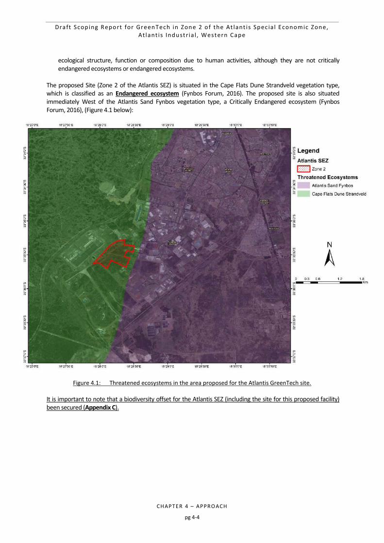
Draft Scop ing Report for GreenTech in Zone 2 o f the At lant i s Spec ia l Economic Zone, At lant i s Industr ia l , Western Cape
CHAPTER 4 – APPRO ACH
pg 4-4
ecological structure, function or composition due to human activities, although they are not critically endangered ecosystems or endangered ecosystems.
The proposed Site (Zone 2 of the Atlantis SEZ) is situated in the Cape Flats Dune Strandveld vegetation type, which is classified as an Endangered ecosystem (Fynbos Forum, 2016). The proposed site is also situated immediately West of the Atlantis Sand Fynbos vegetation type, a Critically Endangered ecosystem (Fynbos Forum, 2016), (Figure 4.1 below):
Figure 4.1: Threatened ecosystems in the area proposed for the Atlantis GreenTech site.
It is important to note that a biodiversity offset for the Atlantis SEZ (including the site for this proposed facility) been secured (Appendix C).
Draft Scop ing Report for GreenTech in Zone 2 o f the At lant i s Spec ia l Economic Zone, At lant i s Industr ia l , Western Cape
CHAPTER 4 – APPRO ACH
pg 4-5
4.2 LEGISLATION AND GUIDELINES PERTINENT TO THIS EIA
The scope and content of this Scoping Report has been informed by the following legislation, guidelines and information series documents:
4.2.1 National Legislation
The Constitution of the Republic of South Africa (Act 108 of 1996) The Constitution, which is the supreme law of the Republic of South Africa, provides the legal framework for legislation regulating environmental management in general, against the backdrop of the fundamental human rights. Section 24 of the Constitution states that: “Everyone has the right:
o to an environment that is not harmful to their health or well-being; and o to have the environment protected, for the benefit of present and future generations through
reasonable legislative and other measures that – prevent pollution and ecological degradation; promote conservation; and secure ecologically sustainable development and use of natural resources while
promoting justifiable economic and social development.” Section 24 of the Bill of Rights therefore guarantees the people of South Africa the right to an environment that is not detrimental to human health or well-being, and specifically imposes a duty on the State to promulgate legislation and take other steps that ensure that the right is upheld and that, among other things, ecological degradation and pollution are prevented. In support of the above rights, the environmental management objectives of proposed project is to protect ecologically sensitive areas and support sustainable development and the use of natural resources, whilst promoting justifiable socio-economic development in the towns nearest to the project site. NEMA and EIA Regulations published under Chapter 5 of the NEMA on 8 December 2014, as amended on 7 April 2017 (GN R327, GN R326, GN R325 and GN R324) The NEMA sets out a number of principles (Chapter 1, Section 2) to give guidance to developers, private land owners, members of public and authorities. The proclamation of the NEMA gives expression to an overarching environmental law. Various mechanisms, such as cooperative environmental governance, compliance and non-compliance, enforcement, and regulating government and business impacts on the environment, underpin NEMA. NEMA, as the primary environmental legislation, is complemented by a number of sectoral laws governing marine living resources, mining, forestry, biodiversity, protected areas, pollution, air quality, waste and integrated coastal management. Principle number 3 determines that a development must be socially, environmentally and economically sustainable. Principle Number 4(a) states that all relevant factors must be considered, inter alia i) that the disturbance of ecosystems and loss of biological diversity are avoided, or, where they cannot be altogether avoided, are minimised and remedied; ii) that pollution and degradation of the environment are avoided, or, where they cannot be altogether avoided, are minimised and remedied; vi) that the development, use and exploitation of renewable resources and the ecosystems of which they are part do not exceed the level beyond which their integrity is jeopardised; and viii) that negative impacts on the environment and on peoples’ environmental rights be anticipated and prevented, and where they cannot be altogether prevented, are minimised and remedied. National Environmental Management: Biodiversity Act (Act 10 of 2004) The National Environmental Management: Biodiversity Act (Act 10 of 2004) (NEMBA) provides for “the management and conservation of South Africa’s biodiversity within the framework of the NEMA, the protection of species and ecosystems that warrant national protection, and the use of indigenous biological resources in a
Draft Scop ing Report for GreenTech in Zone 2 o f the At lant i s Spec ia l Economic Zone, At lant i s Industr ia l , Western Cape
CHAPTER 4 – APPRO ACH
pg 4-6
sustainable manner, amongst other provisions”. The Act states that the state is the custodian of South Africa’s biological diversity and is committed to respect, protect, promote and fulfil the constitutional rights of its citizens. Furthermore, NEMBA states that the loss of biodiversity through habitat loss, degradation or fragmentation must be avoided, minimised or remedied. The loss of biodiversity includes inter alia the loss of threatened or protected species. Biodiversity offsets are a means of compensating for the loss of biodiversity after all measures to avoid, reduce or remedy biodiversity loss have been taken, but residual impacts still remain and these are predicted to be medium to high. Chapter 5 of NEMBA (Sections 73 to 75) regulates activities involving invasive species, and lists duty of care as follows: the land owner/land user must take steps to control and eradicate the invasive species and prevent their
spread, which includes targeting offspring, propagating material and regrowth, in order to prevent the production of offspring, formation of seed, regeneration or re-establishment;
take all required steps to prevent or minimise harm to biodiversity; and ensure that actions taken to control/eradicate invasive species must be executed with caution and in a
manner that may cause the least possible harm to biodiversity and damage to the environment. An amendment to the NEMBA has been promulgated, which lists 225 threatened ecosystems based on vegetation types present within these ecosystems. Should a project fall within a vegetation type or ecosystem that is listed, actions in terms of NEMBA are triggered. Based on the preliminary sensitivity screening undertaken for the proposed site, none of the threatened ecosystems occur within the study area. This will be confirmed as part of the Ecological Impact Assessment study undertaken during the EIA Phase. The National Heritage Resources Act (Act 25 of 1999) The National Heritage Resources Act (Act 25 of 1999) (NHRA) introduces an integrated and interactive system for the managements of national heritage resources (which include landscapes and natural features of cultural significance). Parts of sections 35(4), 36(3) (a) and 38(1) (8) of the NHRA apply to the proposed project: Archaeology, palaeontology and meteorites: Section 35 (4) No person may, without a permit issued by the responsible heritage resources authority: a) destroy, damage, excavate, alter, deface or otherwise disturb any archaeological or palaeontological site or
any meteorite; b) destroy, damage, excavate, remove from its original position, collect or own any archaeological or
palaeontological material or object or any meteorite; c) bring onto or use at an archaeological or palaeontological site any excavation equipment or any equipment
which assist in the detection or recovery of metals or archaeological and palaeontological material or objects, or use such equipment for the recovery of meteorites.
Burial grounds and graves: Section 36 (3) (a) No person may, without a permit issued by South African Heritage Resources Agency (SAHRA) or a provincial heritage resources authority: a) destroy, damage, alter, exhume or remove from its original position or otherwise disturb the grave of a
victim of conflict, or any burial ground or part thereof which contains such graves; b) destroy, damage, alter, exhume, remove from its original position or otherwise disturb any grave or burial
ground older than 60 years which is situated outside a formal cemetery administered by a local authority; or c) bring onto or use at a burial ground or grave referred to in paragraph (a) or (b) any excavation equipment,
or any equipment which assists in the detection or recovery of metals.
Draft Scop ing Report for GreenTech in Zone 2 o f the At lant i s Spec ia l Economic Zone, At lant i s Industr ia l , Western Cape
CHAPTER 4 – APPRO ACH
pg 4-7
Heritage resources management: 38. (1) Subject to the provisions of subsections (7), (8) and (9), any person who intends to undertake a development categorized as: a) the construction of a road, wall, power line, pipeline, canal or other similar form of linear development or
barrier exceeding 300 m in length; b) the construction of a bridge or similar structure exceeding 50 m in length; c) any development or other activity which will change the character of the site –
(i) exceeding 5000 m2 in extent, or (ii) involving three or more erven or subdivisions thereof; or (iii) involving three or more erven or divisions thereof which have been consolidated within the past
five years; or (iv) the costs of which will exceed a sum set in terms of regulations by SAHRA, or a provincial resources
authority; d) the re-zoning of a site exceeding 10 000 m2 in extent; or e) any other category of development provided for in regulations by SAHRA or a provincial heritage resources
authority, must at the very earliest stages of initiating such a development, notify the responsible heritage resources authority and furnish it with details regarding the location, nature and extent of the proposed development.
While landscapes with cultural significance do not have a dedicated Section in the NHRA, they are protected under the definition of the National Estate (Section 3). Section 3(2)(c) and (d) list “historical settlements and townscapes” and “landscapes and natural features of cultural significance” as part of the National Estate. Furthermore, Section 3(3) describes the reasons a place or object may have cultural heritage value. Section 38 (2a) of the NHRA states that if there is reason to believe that heritage resources will be affected then an impact assessment report must be submitted. NOTE: A Desktop Heritage Assessment will be undertaken as part of the EIA Phase. Based on existing heritage information for the area and confirmation from Heritage Western Cape that there are no significant heritage resources present on neighbouring sites, it is unlikely that any significant heritage concerns will be raised. Conservation of Agricultural Resources Act (Act 43 of 1983) The objectives of the Conservation of Agricultural Resources Act (Act 43 of 1983) (CARA) are to provide for the conservation of the natural agricultural resources of South Africa by the: maintenance of the production potential of land; combating and prevention of erosion and weakening or destruction of the water sources; and protection of the vegetation and the combating of weeds and invader plants. The CARA states that no land user shall utilise the vegetation of wetlands (a watercourse or pans) in a manner that will cause its deterioration or damage. This includes cultivation, overgrazing, diverting water run-off and other developments that damage the water resource. The CARA includes regulations on alien invasive plants. According to the amended regulations (GN R280 of March 2001), declared weeds and invader plants are divided into three categories: Category 1 may not be grown and must be eradicated and controlled, Category 2 may only be grown in an area demarcated for commercial cultivation purposes and for which a
permit has been issued, and must be controlled, and Category 3 plants may no longer be planted and existing plants may remain as long as their spread is
prevented, except within the flood line of watercourses and wetlands. It is the legal duty of the land user or land owner to control invasive alien plants occurring on the land under their control.

Draft Scop ing Report for GreenTech in Zone 2 o f the At lant i s Spec ia l Economic Zone, At lant i s Industr ia l , Western Cape
CHAPTER 4 – APPRO ACH
pg 4-8
Should alien plant species occur within the study area; this will be managed in line with the EMPr. Rehabilitation after disturbance to agricultural land is also managed by CARA. The DAFF reviews and approves applications in terms of these Acts according to their Guidelines for the evaluation and review of applications pertaining to renewable energy on agricultural land, dated September 2011. National Water Act (Act 36 of 1998) One of the important objectives of the National Water Act (Act 36 of 1998) (NWA) is to ensure the protection of the aquatic ecosystems of South Africa’s water resources. Section 21 of this Act identifies certain land uses, infrastructural developments, water supply/demand and waste disposal as ‘water uses’ that require authorisation (licensing) by the Department of Water and Sanitation (DWS). Chapter 4 (Part 1) of the NWA sets out general principles for the regulation of water use. Water use is defined broadly in the NWA, and includes taking and storing water, activities which reduce stream flow, waste discharges and disposals, controlled activities (activities which impact detrimentally on a water resource), altering the bed, banks, course or characteristics of a watercourse, removing water found underground for certain purposes, and recreation. In general a water use must be licensed unless it is listed in Schedule I, is an existing lawful use, is permissible under a general authorisation, or if a responsible authority waives the need for a licence. The Minister may limit the amount of water which a responsible authority may allocate. In making regulations the Minister may differentiate between different water resources, classes of water resources and geographical areas. All water users who are using water for agriculture: aquaculture, agriculture: irrigation, agriculture: watering livestock, industrial, mining, power generation, recreation, urban and water supply service must register their water use. This covers the use of surface and ground water. Section 21 of the Act lists the following water uses that need to be licensed: a) taking water from a water resource; b) storing water; c) impeding or diverting the flow of water in a watercourse; d) engaging in a stream flow reduction activity contemplated in section 36; e) engaging in a controlled activity identified as such in section 37(1) or declared under section 38(1); f) discharging waste or water containing waste into a water resource through a pipe, canal, sewer, sea outfall
or other conduit; g) disposing of waste in a manner which may detrimentally impact on a water resource; h) disposing in any manner of water which contains waste from, or which has been heated in, any industrial or
power generation process; i) altering the bed, banks, course or characteristics of a watercourse; j) removing, discharging or disposing of water found underground if it is necessary for the efficient
continuation of an activity or for the safety of people; and k) using water for recreational purposes. Any activities that take place within a water course or within 500 m of a wetland boundary require a Water Use Licence (WUL) under the Section 21 (c) and Section 21 (i) of the NWA. The need for a Water Use Licence will be determined in the EIA Phase. National Environmental Management: Air Quality Act (Act 39 of 2004) The aim of this act is to reform the law regulating air quality in order to protect the environment by providing reasonable measures for the prevention of pollution and ecological degradation and for securing ecologically sustainable development while promoting justifiable economic and social development; to provide for national norms and standards regulating air quality monitoring, management and control by all spheres of government; for specific air quality measures.
Draft Scop ing Report for GreenTech in Zone 2 o f the At lant i s Spec ia l Economic Zone, At lant i s Industr ia l , Western Cape
CHAPTER 4 – APPRO ACH
pg 4-9
Development Facilitation Act (Act 67 of 1995) The Development Facilitation Act (Act 67 of 1995) (DFA) sets out a number of key planning principles which have a bearing on assessing proposed developments in light of the national planning requirements. The planning principles most applicable to the study area include: Promoting the integration of the social, economic, institutional and physical aspects of land development; Promoting integrated land development in rural and urban areas in support of each other; Promoting the availability of residential and employment opportunities in close proximity to or integrated
with each other; Optimising the use of existing resources including such resources relating to agriculture, land, minerals, bulk
infrastructure, roads, transportation and social facilities; Contributing to the correction of the historically distorted spatial patterns of settlement in the Republic and
to the optimum use of existing infrastructure in excess of current needs; Promoting the establishment of viable communities; and Promoting sustained protection of the environment. Hazardous Substances Act (Act 15 of 1973) This Act provides for the control of substances which may cause injury or ill health to, or death, of human beings by reason of their toxic, corrosive, irritant, strongly sensitising or flammable nature. To provide for the prohibition and control of the importation, manufacture, sale, use, operation, application, modification, disposal or dumping of such substances and products. Other Applicable Legislation Other applicable national legislation that may apply to the proposed project include: Integrated Resource Plan for Electricity (IRP) (GN R400, 6 May 2011) Electricity Act (Act 41 of 1987); Electricity Regulations Amendments (August 2009); Energy Efficiency Strategy of the Republic of South Africa (Department of Minerals and Energy (DME) now
operating as Department of Mineral Resources (DMR), March, 2005); Promotion of Administrative Justice Act (Act 2 of 2000); Integrated Resource Plan for South Africa (2010); Occupational Health and Safety Act (Act 85 of 1993), as amended by Occupational Health and Safety
Amendment (Act 181 of 1993); Fencing Act (Act 31 of 1963); National Environmental Management: Protected Areas Act (NEM:PA) (Act 31 of 2004); National Environmental Management: Waste Management Act (Act 59 of 2008); and National Road Traffic Act (Act 93 of 1996).
4.2.2 Regional Planning Legislation
Blaauwberg District Spatial Development Plan and Environmental Management Framework (2011) Due to the relatively large amounts of undeveloped land within the urban edge of the Blaauwberg district, combined with the fact that land outside the urban edge in the district is of lower agricultural quality than in other areas of the City, the district is viewed as a major growth axis of the City. However, the undeveloped land parcels within the Blaauwberg district contain some of the last remaining tracts of two of South Africa’s rarest vegetation types, namely Sand Plain Fynbos and West Coast Renosterveld. From a biodiversity perspective, it is imperative that high conservation worthy remnants is protected and that ecological corridors are provided to allow for the movement of fauna and flora.
Draft Scop ing Report for GreenTech in Zone 2 o f the At lant i s Spec ia l Economic Zone, At lant i s Industr ia l , Western Cape
CHAPTER 4 – APPRO ACH
pg 4-10
This situation often leads to conflict between environmental and developmental objectives within the district. The challenge is therefore to create a balance between these competing needs to ensure the sustainability of the district, the environment and communities. The form and location of development therefore needs to happen in a way that allows for the provision and accommodation of the development needs of a growing City, but still ensures the sustainable conservation of valuable natural assets. The direction, form and phasing of growth within the district needs to be managed and directed to ensure resource protection and linked infrastructure provision. The district SDP needs to begin to provide guidance in this regard, particularly in relation to the phasing of development in the short and medium term as a guide to infrastructure provision. The phasing of development in the district should take guidance from the City SDF in terms of overall City growth. The removal of tax relief incentives for industrial development in Atlantis and the poor historic settlement patterns resulting in isolated nodes with very limited access to employment opportunities (Atlantis and Mamre) have been identified as pressures and constraints for this district that need to be addressed. Also to be addressed are high levels of unemployment, and the associated socio-economic pressures, particularly in Doornbach, Du Noon, Saxonworld, Witsand, Tafelozono and the outlying settlements of Atlantis and Mamre. Guidelines, Frameworks and Protocols Public Participation Guideline, October 2012 (Government Gazette 35769); DEADP and DEA Guidelines published in terms of the NEMA EIA Regulations, in particular:
o Guideline on Transitional Arrangements (DEADP, March 2013); o Guideline on Alternatives (DEADP, March 2013); o Guideline on Public Participation (DEADP, March 2013); and o Guideline on Need and Desirability (DEADP, March 2013);
Information Document on Generic Terms of Reference for EAPs and Project Schedules (March 2013); Integrated Environmental Management Information Series (Booklets 0 to 23) (Department of
Environmental Affairs and Tourism (DEAT), 2002 – 2005); Guidelines for Involving Specialists in the EIA Processes Series (DEADP; CSIR and Tony Barbour, 2005 –
2007); United Nations Framework Convention on Climate Change (1997); and Kyoto Protocol (which South Africa acceded to in 2002).
4.2.3 International Finance Corporation Performance Standards
In order to promote responsible environmental stewardship and socially responsible development, the proposed Atlantis GreenTech project will, as far as practicable, incorporate the environmental and social policies of the International Finance Corporation (IFC). These policies provide a frame of reference for lending institutions to review of environmental and social risks of projects, particularly those undertaken in developing countries. Through the Equator Principles, the IFC’s standards are now recognised as international best practice in project finance. The IFC screening process categorises projects into A, B or C in order to indicate relative degrees of environmental and social risk. The categories are: Category A - Projects expected to have significant adverse social and/or environmental impacts that are
diverse, irreversible, or unprecedented. Category B - Projects expected to have limited adverse social and/or environmental impacts that can be
readily addressed through mitigation measures. Category C - Projects expected to have minimal or no adverse impacts, including certain financial
intermediary projects. Accordingly, projects such as the proposed Atlantis GreenTech project are categorised as Category B projects. The EA Process for Category B projects examines the project’s potential negative and positive environmental
Draft Scop ing Report for GreenTech in Zone 2 o f the At lant i s Spec ia l Economic Zone, At lant i s Industr ia l , Western Cape
CHAPTER 4 – APPRO ACH
pg 4-11
impacts and compares them with those of feasible alternatives (including the ‘without project’ scenario). As required for Category B projects a Scoping and EIA Process is being undertaken. Other Acts, standards and/or guidelines which may also be applicable will be reviewed in more detail as part of the specialist studies to be conducted for the EIA.
4.3 PRINCIPLES FOR SCOPING AND PUBLIC PARTICIPATION
The public participation process (PPP) for this Scoping and EIA Process is being driven by a stakeholder engagement process that will include inputs from authorities, I&APs, technical specialists and the project proponent. Guideline 4 on “Public Participation in support of the EIA Regulations” published by DEAT in May 2006, states that public participation is one of the most important aspects of the EA Process. This stems from the requirement that people have a right to be informed about potential decisions that may affect them and that they must be afforded an opportunity to influence those decisions. Effective public participation also improves the ability of the Competent Authority (CA) to make informed decisions and results in improved decision-making as the view of all parties are considered. An effective PPP could therefore result in stakeholders working together to produce better decisions than if they had worked independently. It provides an opportunity for I&APs, EAPs and the CA to obtain clear, accurate and understandable
information about the environmental impacts of the proposed activity or implications of a decision; o Provides I&APs with an opportunity to voice their support, concern and question regarding the
project, application or decision; o Enables an applicant to incorporate the needs, preferences and values of affected parties into its
application; o Provides opportunities for clearing up misunderstanding about technical issues, resolving disputes
and reconciling conflicting interests; o Is an important aspect of securing transparency and accountability in decision-making; and o Contributes toward maintaining a health, vibrant democracy.
To the above, one can add the following universally recognised principles for public participation: Inclusive consultation that enables all sectors of society to participate in the consultation and assessment
processes; Provision of accurate and easily accessible information in a language that is clear and sufficiently non-
technical for I&APs to understand, and that is sufficient to enable meaningful participation; Active empowerment of grassroots people to understand concepts and information with a view to active
and meaningful participation; Use of a variety of methods for information dissemination in order to improve accessibility, for example, by
way of discussion documents, meetings, workshops, focus group discussions, and the printed and broadcast media;
Affording I&APs sufficient time to study material, to exchange information, and to make contributions at various stages during the assessment process;
Provision of opportunities for I&APs to provide their inputs via a range of methods, for example, via briefing sessions, public meetings, written submissions or direct contact with members of the EIA team.
Public participation is a process and vehicle to provide sufficient and accessible information to I&APs in an objective manner to assist I&APs to identify issues of concern, to identify alternatives, to suggest opportunities to reduce potentially negative or enhance potentially positive impacts, and to verify that issues and/or inputs have been captured and addressed during the assessment process.
At the outset it is important to highlight two key aspects of public participation:
Draft Scop ing Report for GreenTech in Zone 2 o f the At lant i s Spec ia l Economic Zone, At lant i s Industr ia l , Western Cape
CHAPTER 4 – APPRO ACH
pg 4-12
There are practical and financial limitations to the involvement of all individuals within a PPP. Hence, public
participation aims to generate issues that are representative of societal sectors, not each individual. Hence, the PPP will be designed to be inclusive of a broad range of sectors relevant to the proposed project.
The PPP will aim to raise a diversity of perspectives and will not be designed to force consensus amongst I&APs. Indeed, diversity of opinion rather than consensus building is likely to enrich ultimate decision-making. Therefore, where possible, the PPP will aim to obtain an indication of trade-offs that all stakeholders (i.e. I&APs, technical specialists, the authorities and the development proponent) are willing to accept with regard to the ecological sustainability, social equity and economic growth associated with the project.
4.4 OBJECTIVES OF THE SCOPING PROCESS
This Scoping Process is being planned and conducted in a manner that is intended to identify and provide sufficient information to enable the authorities to reach a decision regarding the scope of issues to be addressed in this EIA Process, and in particular to convey the range of specialist studies that will be included as part of the Environmental Impact Reporting Phase of the EIA, as well as the approach to these specialist studies. As highlighted in Chapter 1 of this Scoping Report, within this context, the objectives of this Scoping Process (as per the 2014 EIA Regulations, as amended) are to: Identify and inform a broad range of stakeholders about the proposed development; Confirm the process to be followed and opportunities for stakeholder engagement; Clarify the project scope to be covered; Identify and confirm the preferred activity and technology alternative; Identify and confirm the preferred site for the preferred activity; Clarify the alternatives being considered and ensure due consideration of alternative options regarding the
proposed development, including the “No-go” option; Conduct an open, participatory and transparent approach and facilitate the inclusion of stakeholder issues
in the decision-making process; Identify and document the key issues to be addressed in the impact assessment phase (through a process of
broad-based consultation with stakeholders) and the approach to be followed in addressing these issues; and
Confirm the level of assessment to be undertaken during the impact assessment
4.5 TASKS IN THE SCOPING PHASE
This section provides an overview of the tasks being undertaken in the Scoping Phase, with a particular emphasis on providing a clear record of the PPP followed. As discussed in Chapter 1 of this Scoping Report, a GreenTech project is being proposed by the Applicant which requires a Scoping and EIA Process.
TASK 1: I&AP IDENTIFICATION, REGISTRATION AND THE CREATION OF AN ELECTRONIC DATABASE
Prior to advertising the EA Process in the local print media an initial database of I&APs (including key stakeholders and organs of state) was developed for the Scoping Process. This was supplemented with input from the EIA Project Managers, CSIR, and the Project Applicant, CoCT. A total of 95 I&APs were included on the project database in this manner. Appendix B of this Scoping Report contains the current I&AP database, which has been updated to include requests to register interest in the project, and comments received. At the time of compiling this Scoping Report, the database stands at 95 I&APs, who will be informed about the availability of the Draft Scoping Report for comment.

Draft Scop ing Report for GreenTech in Zone 2 o f the At lant i s Spec ia l Economic Zone, At lant i s Industr ia l , Western Cape
CHAPTER 4 – APPRO ACH
pg 4-13
While I&APs have been encouraged to register their interest in the project from the start of the process, following the public announcements (refer to Task 2), the identification and registration of I&APs will be ongoing for the duration of the study. Stakeholders from a variety of sectors, geographical locations and/or interest groups can be expected to show an interest in the proposed project, for example: Provincial and Local Government Departments; Local interest groups, for example, Councillors and Rate Payers associations; Surrounding landowners; Farmer Organisations; Environmental Groups and NGOs; and Grassroots communities and structures. In terms of the electronic database, I&AP details are being captured and automatically updated as and when information is distributed to or received from I&APs. This ongoing record of communication is an important component of the PPP. It must be noted that while not required by the regulations, those I&APs proactively identified at the outset of the Scoping Process will remain on the project database throughout the EIA Process and will be kept informed of all opportunities to comment and will only be removed from the database by request.
TASK 2: ANNOUNCEMENT OF THE SCOPING PROCESS
In order to notify and inform the public of the proposed project and invite I&APs to register on the project database, the project and EIA Process will be advertised in the Cape Times (English) and Die Burger (Afrikaans) concurrently with the release of this Draft Scoping Report. Copies of the advertisements placed will be contained within the Final Scoping Report. Regulation 41 (2) (a) of the 2014 EIA Regulations require that a notice board providing information on the project and EIA Process is fixed at a place that is conspicuous to and accessible by the public at the boundary, on the fence or along the corridor of the site where the application will be undertaken or any alternative site. A copy of the notice boards and proof of placement thereof will be included in the Final Scoping Report.
TASK 3: ONGOING COMMUNICATION AND CAPACITY BUILDING
The process for this Scoping and EIA aims to ensure that people are involved from the outset, that we proactively solicit the involvement of stakeholders representing all three dimensions of sustainability (i.e. biophysical, social and economic dimensions), and that we provide them with sufficient and accessible information to contribute meaningfully to the process. In this manner, the PPP aims to build the capacity of stakeholders to participate. Within the context of the EIA Process, capacity building is not viewed as a “once off” event, but rather a series of events and/or information sharing which provides information on a continuous basis thereby building the capacity and knowledge of I&APs to effectively participate in the EIA Process and raise issues of concern. One of the challenges facing the PPP is the diversity of South African society. Public participation by its very nature is a dynamic process with various sectors of society having varying needs, values and interests. The core question for public participation is “How can I, the interested and affected party, meaningfully participate in the process?” This varies according to the needs of I&APs. The PPP should be inclusive of all I&APs, and afford them the opportunity to raise their issues and concerns in a manner that suits them. Coupled with this South African society is characterized by varying socio-economic, literacy and language levels all of which need to be considered in the participation process. For example, certain I&APs may want to receive documentation only and not attend meetings, some I&APs may want to only attend meetings, other I&APs may not want to attend meetings and send their comments in writing, and some I&APs may want to be actively involved throughout the process.
Draft Scop ing Report for GreenTech in Zone 2 o f the At lant i s Spec ia l Economic Zone, At lant i s Industr ia l , Western Cape
CHAPTER 4 – APPRO ACH
pg 4-14
In order to accommodate the varying needs of I&APs and develop their capacity to participate in the process, information sharing forms an integral and ongoing component of the EIA Process to ensure effective public participation. The following provides an overview of how information sharing is being effected throughout the EIA Process in order to develop the capacity of I&APs to effectively engage in the PPP: Website – placing EIA related project information on the project website
https://www.csir.co.za/environmental-impact-assessment Language – encouraging I&APs to use the language of their choice at meetings or during telephonic
discussions and providing translations at meetings in Afrikaans, when required; Newspaper Advertisements (to be placed at the same time as the release of this DSR) - requesting I&APs to
register their interest in the project, raise issues of concern or notifying I&APs of potential public meetings (if required to be held);
Report Distribution – providing hard copies of the Scoping and EIA Reports at local library (Avondale Public Library) for I&APs to access for viewing. Electronic copies of the reports will also be loaded onto the project website for access. Key organs of state will be provided with hard copies and/or electronic copies of the reports;
Public Meeting – a public meeting could possibly be held during the review of the EIA Report if warranted and if there is substantial public interest during the EIA Phase. Furthermore, telephonic consultations with key I&APs will take place, upon request; and
Focus Group Meetings – may be undertaken (depending on the interest in the projects) with key I&AP groups (Councillors, ratepayers association, surrounding landowners, affected organs of state, environmental organisations).
Documents will continuously being posted onto the project website (https://www.csir.co.za/environmental-impact-assessment) as and when they become available and I&APs will be notified accordingly.
TASK 4: CONSULTATION WITH AUTHORITIES
All public participation documentation will reach the DEA&DP, as well as other relevant authorities and organs of state included on the I&AP database. Comments received on the NID and the Scoping Process from the authorities will be included in the Comments and Response Trail as an appendix to the Final Scoping Report (which will be submitted to the DEA&DP for decision-making in line with Regulation 22 of the 2014 EIA Regulations, as amended).
TASK 5: TECHNICAL SCOPING WITH PROJECT PROPONENT AND EIA TEAM
The Scoping Process has been designed to incorporate two complementary components: a stakeholder engagement process that includes the relevant authorities and wider I&APs; and a technical process involving the EIA team and the project proponent. The purpose of the technical Scoping Process is to draw on the past experience of the EIA team and the project proponent to identify environmental issues and concerns related to the proposed project, and confirm that the necessary specialist studies have been identified. The specialist team has worked with the CSIR on several other projects in the Western Cape, as well as projects specifically in the Atlantis SEZ. The specialists were therefore able to identify issues (as shown in Chapter 6 of this Scoping Report) to be addressed in the EIA based on their experience and knowledge of the area and type of activity. Their inputs have informed the scope and Terms of Reference for the specialist studies (as included in Chapter 7 of this Scoping Report). The findings of the Scoping Process with the public and the authorities will inform the specialist studies, which will only be completed after the public Scoping Process has been finalised.
Draft Scop ing Report for GreenTech in Zone 2 o f the At lant i s Spec ia l Economic Zone, At lant i s Industr ia l , Western Cape
CHAPTER 4 – APPRO ACH
pg 4-15
TASK 6: REVIEW OF THE DRAFT SCOPING REPORT (CURRENT STAGE)
The process is currently at this stage, when I&APs are invited to review the Draft Scoping Report and register as an I&AP. This stage and the forthcoming steps in the Scoping Process are presented below. This stage in the process entails the release of the Draft Scoping Report for a 30-day period for public review (in line with Regulation 3 (8) and Regulation 21 (1) of the 2014 EIA Regulations, as amended). All I&APs on the project database will be notified in writing of the release of the Draft Scoping Report for review. Please note that the Competent Authority (DEA&DP) is included in this review process, as comments from the Competent Authority on the Draft Scoping Report are required by Regulation 21 (1) of the 2014 EIA Regulations. The following mechanisms and opportunities will be utilised to notify I&APs of the release of the Draft Scoping Report for comment: Correspondence to I&APs - Letter to notify I&APs of the the project and the opportunity to comment on
the Draft Scoping Report. The comment period will be sent via registered mail and email (where postal, physical and email addresses are available for I&APs and organs of state on the project database).
Availability of Information - the Draft Scoping Report will be made available for review by I&APs and key authorities through the following means:
o The Draft Scoping Report will be placed on the project website (https://www.csir.co.za/environmental-impact-assessment)
o The Draft Scoping Report will be placed at the Avondale Public Library o Key authorities will be provided with either a hard copy and/or CD of the Draft Scoping Report. o Telephonic consultations will be held with key I&AP and organs of state groups, as necessary.
Following the 30 day review of the Draft Scoping Report, all issues will be captured in an comments and responses trail which will be included in the Final Scoping Report to be submitted to the Competent Authority (DEA&DP).
TASK 7: SUBMISSION OF SCOPING REPORTS TO THE DEA FOR DECISION-MAKING
An updated Scoping Report, reflecting the comments received during the above mentioned commenting period, will be submitted to the DEA for decision-making in line with Regulation 22 of the 2014 EIA Regulations. In line with best practice, I&APs on the project database will be notified of the submission of the Scoping Reports to the DEA for decision-making. The Final Scoping Report that is submitted for decision-making will also include proof of the PPP that was undertaken to inform organs of state and I&APs of the availability of the Draft Scoping Report for the 30 day review (during Task 7, as explained above). It will also include proof of the newspaper advertisements placed. Site notices places and all other communications with I&APs. The DEA&DP will have 43 days (from receipt of the Final Scoping Report) to either accept the Scoping Reports with or without conditions, or refuse EA. This step marks the end of the PPP for the Scoping Phase. The PPP for the subsequent EIA Phase is presented in the Plan of Study for EIA (Chapter 7).
4.6 SCHEDULE FOR THE EIA
The proposed schedule for the EIA, based on the legislated EIA Process, is presented in Table 4.2. The table highlights actions going forward for the proposed project. It should be noted that this schedule could be revised during the EIA Process, depending on factors such as the time required for decisions from authorities.
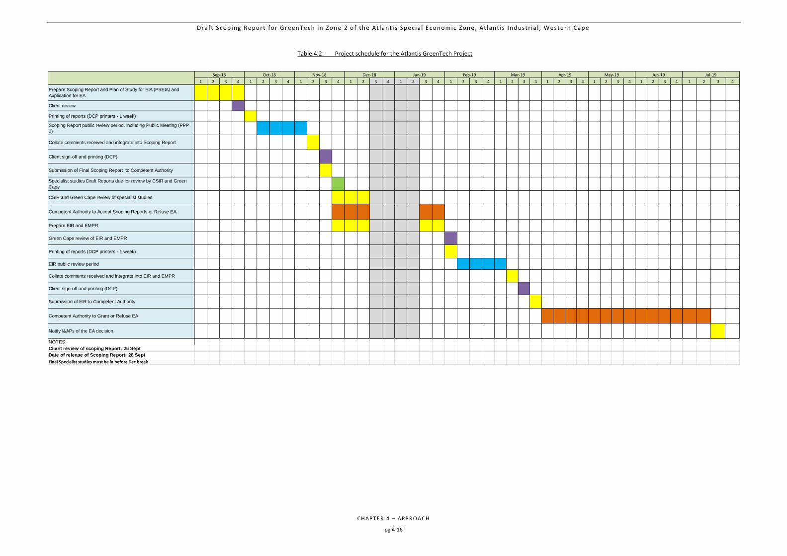
Draft Scop ing Report for GreenTech in Zone 2 o f the At lant i s Spec ia l Economic Zone, At lant i s Industr ia l , Western Cape
CHAPTER 4 – APPRO ACH
pg 4-16
Table 4.2: Project schedule for the Atlantis GreenTech Project
1 2 3 4 1 2 3 4 1 2 3 4 1 2 3 4 1 2 3 4 1 2 3 4 1 2 3 4 1 2 3 4 1 2 3 4 1 2 3 4 1 2 3 4
Prepare Scoping Report and Plan of Study for EIA (PSEIA) and
Application for EA
Client review
Printing of reports (DCP printers - 1 week)
Scoping Report public review period. Including Public Meeting (PPP
2)
Collate comments received and integrate into Scoping Report
Client sign-off and printing (DCP)
Submission of Final Scoping Report to Competent Authority
Specialist studies Draft Reports due for review by CSIR and Green
Cape
CSIR and Green Cape review of specialist studies
Competent Authority to Accept Scoping Reports or Refuse EA.
Prepare EIR and EMPR
Green Cape review of EIR and EMPR
Printing of reports (DCP printers - 1 week)
EIR public review period
Collate comments received and integrate into EIR and EMPR
Client sign-off and printing (DCP)
Submission of EIR to Competent Authority
Competent Authority to Grant or Refuse EA
Notify I&APs of the EA decision.
NOTES:
Client review of scoping Report: 26 Sept
Date of release of Scoping Report: 28 Sept
Final Specialist studies must be in before Dec break
Nov-18Oct-18Sep-18 Jun-19 Jul-19Dec-18 Jan-19 Feb-19 Mar-19 Apr-19 May-19

Draft Scop ing Report for GreenTech in Zone 2 o f the At lant i s Spec ia l Economic Zone, At lant i s Industr ia l , Western Cape
CHAPTER 5 – PROJE CT ALTERNATIVES
pg 5-1
5 PROJECT ALTERNATIVES 5-2
5.1 NO-GO ALTERNATIVE 5-2
5.2 LAND-USE ALTERNATIVE 5-4
5.3 TECHNOLOGY ALTERNATIVES 5-5 5.3.1 Technological Alternative 1: Wind 5-5
5.3.2 Technological Alternative 2: Photo Voltaic (PV) 5-5
5.3.3 Technological Alternative 3: Inverters 5-5
5.4 LAYOUT ALTERNATIVES 5-6
5.5 LOCATION/SITE ALTERNATIVES 5-6 5.5.1 Key environmental attributes 5-7
5.5.2 Spatial character 5-7
5.5.3 Proximity to sensitive human structures 5-7
5.5.4 Preferred site alternative and site selection matrix 5-10
5.6 CONCLUDING STATEMENT ON PREFERRED ALTERNATIVES 5-11
Table 5.1: Costs and benefits of implementing the ‘no-go’ alternative (i.e. no GreenTech facility
development). 5-3
Table 5.2: Potentially sensitive features considered for the preferred location of the Atlantis
GreenTech site. 5-9
Table 5.3: Site selection matrix for determining the preferred location of the Atlantis GreenTech site. 5-10
Figure 5.1: Locality of the proposed Atlantis GreenTech site (Zone 2 - highlighted in blue) 5-8
Draft Scop ing Report for GreenTech in Zone 2 o f the At lant i s Spec ia l Economic Zone, At lant i s Industr ia l , Western Cape
CHAPTER 5 – PROJE CT ALTERNATIVES
pg 5-2
5 PROJECT ALTERNATIVES
The 2014 NEMA EIA Regulations (GN R326), as amended on 7 April 2017, define “alternatives”, in relation to a proposed activity, as “different means of meeting the general purpose and requirements of the activity, which may include alternatives to the:
property on which or location where the activity is proposed to be undertaken;
type of activity to be undertaken;
design or layout of the activity;
technology to be used in the activity; or
operational aspects of the activity; and
includes the option of not implementing the activity”. Additionally, Appendix 2 of the 2014 NEMA EIA Regulations (as amended) provides the objectives of the Scoping Process in relation to alternatives as identification and confirmation of the:
preferred activity and technology alternative through an impact and risk assessment and ranking process; and
preferred site, through a detailed site selection process, which includes an impact and risk assessment process inclusive of cumulative impacts and a ranking process of all the identified alternatives focusing on the geographical, physical, biological, social, economic, and cultural aspects of the environment.
The Scoping Report is therefore required to provide a full description of the process followed to reach the proposed preferred activity, technology, site and location within the site, including details of all the alternatives considered and the outcome of the site selection matrix. The need to include investigation and assessment of impacts associated with alternatives to the proposed project within an EIA are also highlighted within Sections 24(4) (b) (i) and 24(4A) of the NEMA. In addition, Section 24O (1)(b)(iv) also requires that the Competent Authority, when considering an application for EA, takes into account “where appropriate, any feasible and reasonable alternatives to the activity which is the subject of the application and any feasible and reasonable modifications or changes to the activity that may minimise harm to the environment”. As such, the assessment of alternatives should, as a minimum, include the following:
The consideration of the no-go alternative as a baseline scenario;
A comparison of the reasonable and feasible alternatives; and
Providing a methodology for the elimination of an alternative. This chapter discusses the selection of the preferred alternatives that will be assessed as part of the EIA Phase.
5.1 NO-GO ALTERNATIVE
The no-go alternative assumes that the proposed project will not go ahead i.e. the proposed Atlantis GreenTech project is not constructed and developed into an operational energy facility. This alternative entails that the development of the proposed GreenTech facility would not drive any environmental change and result in no environmental impacts on the site or surrounding local area. It provides the status quo or baseline against which other alternatives are compared and will be considered throughout the report. At present the proposed site is zoned for “General Industrial” use, and is not being utilized (natural vegetation). Preliminary investigations indicate that area is classified as non-arable and low potential grazing land – hence, utilising the area for continued agricultural land-use is not a preferred or sustainable alternative.
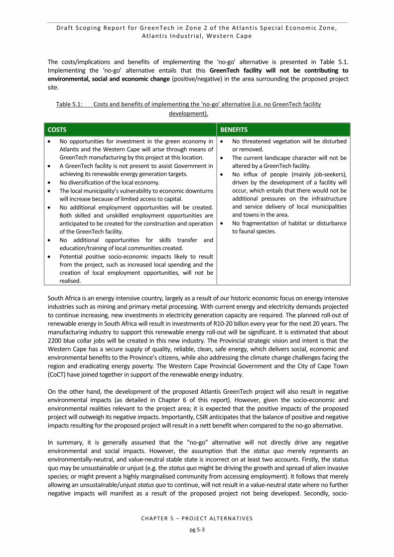
Draft Scop ing Report for GreenTech in Zone 2 o f the At lant i s Spec ia l Economic Zone, At lant i s Industr ia l , Western Cape
CHAPTER 5 – PROJE CT ALTERNATIVES
pg 5-3
The costs/implications and benefits of implementing the ‘no-go’ alternative is presented in Table 5.1. Implementing the ‘no-go’ alternative entails that this GreenTech facility will not be contributing to environmental, social and economic change (positive/negative) in the area surrounding the proposed project site.
Table 5.1: Costs and benefits of implementing the ‘no-go’ alternative (i.e. no GreenTech facility
development).
COSTS BENEFITS
No opportunities for investment in the green economy in Atlantis and the Western Cape will arise through means of GreenTech manufacturing by this project at this location.
A GreenTech facility is not present to assist Government in achieving its renewable energy generation targets.
No diversification of the local economy.
The local municipality’s vulnerability to economic downturns will increase because of limited access to capital.
No additional employment opportunities will be created. Both skilled and unskilled employment opportunities are anticipated to be created for the construction and operation of the GreenTech facility.
No additional opportunities for skills transfer and education/training of local communities created.
Potential positive socio-economic impacts likely to result from the project, such as increased local spending and the creation of local employment opportunities, will not be realised.
No threatened vegetation will be disturbed or removed.
The current landscape character will not be altered by a GreenTech facility.
No influx of people (mainly job-seekers), driven by the development of a facility will occur, which entails that there would not be additional pressures on the infrastructure and service delivery of local municipalities and towns in the area.
No fragmentation of habitat or disturbance to faunal species.
South Africa is an energy intensive country, largely as a result of our historic economic focus on energy intensive industries such as mining and primary metal processing. With current energy and electricity demands projected to continue increasing, new investments in electricity generation capacity are required. The planned roll-out of renewable energy in South Africa will result in investments of R10-20 billon every year for the next 20 years. The manufacturing industry to support this renewable energy roll-out will be significant. It is estimated that about 2200 blue collar jobs will be created in this new industry. The Provincial strategic vision and intent is that the Western Cape has a secure supply of quality, reliable, clean, safe energy, which delivers social, economic and environmental benefits to the Province’s citizens, while also addressing the climate change challenges facing the region and eradicating energy poverty. The Western Cape Provincial Government and the City of Cape Town (CoCT) have joined together in support of the renewable energy industry. On the other hand, the development of the proposed Atlantis GreenTech project will also result in negative environmental impacts (as detailed in Chapter 6 of this report). However, given the socio-economic and environmental realities relevant to the project area; it is expected that the positive impacts of the proposed project will outweigh its negative impacts. Importantly, CSIR anticipates that the balance of positive and negative impacts resulting for the proposed project will result in a nett benefit when compared to the no-go alternative. In summary, it is generally assumed that the “no-go” alternative will not directly drive any negative environmental and social impacts. However, the assumption that the status quo merely represents an environmentally-neutral, and value-neutral stable state is incorrect on at least two accounts. Firstly, the status quo may be unsustainable or unjust (e.g. the status quo might be driving the growth and spread of alien invasive species; or might prevent a highly marginalised community from accessing employment). It follows that merely allowing an unsustainable/unjust status quo to continue, will not result in a value-neutral state where no further negative impacts will manifest as a result of the proposed project not being developed. Secondly, socio-
Draft Scop ing Report for GreenTech in Zone 2 o f the At lant i s Spec ia l Economic Zone, At lant i s Industr ia l , Western Cape
CHAPTER 5 – PROJE CT ALTERNATIVES
pg 5-4
economic and environmental processes do not cease to function in a status quo environment. Accordingly, the vagaries of changing environmental and macro/micro economic conditions will continue to result in both positive and negative impacts to the local environment; regardless of whether the proposed project is developed or not. It is therefore important not to reflectively ascribe neutral values to the no-go option. Similarly, developers often depreciate the status quo as not being able to provide positive benefits to the local community in the absence of a proposed project. Clearly, such an approach also offends against the principle that the status quo is not a neutral condition. However, given the socio-economic and environmental realities of the receiving environment (Table 5.1); the costs of the no-go alternative appear to outweigh its potential benefits. Based on the above, the “no-go” alternative is not deemed to be the preferred alternative but will be taken forward and indirectly considered within the EIA Phase as this alternative will serve as the baseline against which the potential impacts associated with the project are assessed.
5.2 LAND-USE ALTERNATIVE
When determining the appropriate land-use activity for the Atlantis GreenTech project site, there are several aspects that are essential in order to justify the rationale for this activity. The Integrated Resource Plan for South Africa for the period 2010 to 2030 (referred to as “IRP2010”) and the IRP Updated Report (2013) proposes to secure 17 800 MW of renewable energy capacity by 2030. The DOE subsequently has entered into a bidding process for the procurement of 3725 MW of renewable energy from IPPs by 2016 and beyond to enable the Department to meet this target. On 18 August 2015, an additional procurement target of 6300 MW to be generated from renewable energy sources was added to the REIPPPP for the years 2021 - 2025, as published in Government Gazette 39111. The additional target allocated for wind energy, solar PV energy, and solar CSP energy is 3040 MW, 2200 MW, and 600 MW respectively. These are substantial amounts, translating to approximately 200 wind turbines annually and about 3 000 000 square meters of PV. Broadly, the cost to install wind or PV is R15-30mil per MW, in other words, the investment on these installations will be in the order of R10 – 20 billion per year, every year for the next 20 years. The Department of Energy, aided by the National Treasury will issue a request for proposals (RFP). The conditions of this RFP will be based on BEE, local content, project readiness and price. The local content requirement will lead to the manufacture of components in South Africa. This anticipated local content will result in an investment of R1bn in manufacturing facilities. The combined turnover of these factories will be in the order of R 6 – 7 billion and employ approximately 6000 blue collar workers. The Provincial strategic vision and intent is that the Western Cape has a secure supply of quality, reliable, clean, safe energy, which delivers social, economic and environmental benefits to the Province’s citizens, while also addressing the climate change challenges facing the region and eradicating energy poverty. It is a political and economic imperative that the Western Cape attracts a portion of the investment in Renewable Energy. Support for the economic activity behind renewable energy led to a research paper ‘GreenTech’ and the Provincial government to establish the GreenCape initiative – this initiative has the task of creating and supporting the manufacturing industry that will supply components for the roll-out of renewable energy in the Western Cape and South Africa. There has been further tacit support from the PGWC in investigations around defining the ‘Green Economy’ and reviewing the legislative framework looking to identify possible levers for development of this industry. Atlantis has been identified as a development priority by National, Provincial and Regional government. Historically, Atlantis was a decentralisation zone for manufacturing. But, since the lifting of sanctions the manufacturing industry in Atlantis has struggled. The extension of the Bus Rapid Transit (BRT) system to Atlantis has created a public transport link between the City and Atlantis. This has increased labour mobility and supports industrial development. There is serviced, industrially zoned, vacant, City land in Atlantis. Atlantis is
Draft Scop ing Report for GreenTech in Zone 2 o f the At lant i s Spec ia l Economic Zone, At lant i s Industr ia l , Western Cape
CHAPTER 5 – PROJE CT ALTERNATIVES
pg 5-5
strategically located to supply large components to the wind developments along the West Coast. The transport of these larger components is a costly and logistically challenging operation. Atlantis’s proximity to the N7 and R27 allow a significant transportation advantages to all of the West coast developments. It is for the above reasons that, not only is GreenTech the preferred land-use alternative for this site, but the manufacturing of renewable energy products through the establishment of a GreenTech manufacturing facility in Atlantis is considered the preferred activity alternative above all others.
5.3 TECHNOLOGY ALTERNATIVES
Based on the quantity of renewable energy in the IRP2010, it is anticipated that there will be enough demand to justify the following investments in manufacturing of the original equipment used in renewable energy power plants. In addition, the REIPPP specifically included local content as a prerequisite due to the lack of local manufacturing of renewable components. A combination of the manufacturing of the technological alternatives below will form part of the GreenTech project in the Atlantis SEZ and therefore all three are considered viable alternatives and will form part of the proposed activity description:
5.3.1 Technological Alternative 1: Wind
The global wind turbine industry is among the fastest growing industries globally, with an average annual growth rate of nearly 30% between 2000 and 2010 (Grant Thornton, 2012). This growth has been driven mainly by significant cost reductions and efficiency improvements in the core components, supportive policies and the rising costs of alternative sources of energy, such as oil and diesel. The creation of a domestic manufacturing base for wind-turbine components has been a strategic priority for the government of South Africa in driving industrialisation and economic development. The domestic wind-turbine industry has therefore been supported by various promotional policies, such as local content requirements (LCRs) and economic incentives provided by the government. There is enough demand in the IRP2010 to justify 1 or more utility scale blade manufacturer. Currently there are few companies in South Africa that manufacture utility scale wind turbine blades. There is scope for 1 or 2 manufacturers of wind turbine towers.
5.3.2 Technological Alternative 2: Photo Voltaic (PV)
It has been noted that key impediments of the localisation of solar PV is the lack of key local resources such as silicon, glass and skilled personnel, as well as the lack of sufficient demand to entice manufacturing facilities. It is estimated that a minimum annual demand of 600 MW is required in order for PV module manufacturers to be enticed to set up full PV module manufacturing facilities (Solar PV Baseline Report, SAPVIA, 2013). There is enough demand in the IRP2010 to justify 1 or 2 photo voltaic (PV) manufacturing facilities. Currently in South Africa there are 3 PV manufacturers (Tenesol, Solairedirect and Setsolar). These are all located in Cape Town and currently employ 250 people. There in an opportunity for these companies (or a new player) to set up a factory to supply the new demand. While developers have been able to meet local content requirements without sourcing modules from South Africa, additional solar manufacturers will increase the domestic supply of modules ahead of the upcoming bidding rounds.
5.3.3 Technological Alternative 3: Inverters
With the Government’s policy commitment on localisation, it is imperative that the private sector responds to their renewable energy policy imperatives. The REIPPP specifically included local content as a prerequisite due to the lack of local manufacturing of renewable components, such as inverters. As mentioned above, a lack of local
Draft Scop ing Report for GreenTech in Zone 2 o f the At lant i s Spec ia l Economic Zone, At lant i s Industr ia l , Western Cape
CHAPTER 5 – PROJE CT ALTERNATIVES
pg 5-6
manufacturers is a major barrier to many bidders. There are several benefits to locating an inverter manufacturer within the Western Cape’s green cluster, close to the supply chain. It is anticipated that there will be 1 inverter manufacturer established. There are currently two inverter manufacturers (MLT-Drives), however, they would need to scale up tenfold to meet this demand.
5.4 LAYOUT ALTERNATIVES
It is to be assumed that the entire site (32.6 ha) (in accordance with local planning policies) will be utilised for the activity. The buildings (coverage, height etc.) to be located on site will be in accordance with the existing zoning of the site and the location in which the site is situated i.e. ‘General Residential’ and the Atlantis Industrial Area. The CoCT’s building regulations and planning policies will be adhered to. Layout alternatives are therefore not possible to design at this stage as it would depend on the investors who are successful in terms of the bidding process to lease the land and in terms of what types of technology are being manufactured in accordance with the types of renewable energy alternatives e.g. wind, photo voltaic and/ or inverters. Refer to Chapter 2, Section 2.4 which describes the “Envelope Approach” to be applied in this EIA. In addition, a “typical” layout is provided in Chapter 2 (Figure 2.2) for reference.
5.5 LOCATION/SITE ALTERNATIVES
CoCT has made several land portions in Zone 2 of the Atlantis SEZ available for a green technology (Greentech) hub in Atlantis, Western Cape, for the purpose of developing a GreenTech facility (Figure 5.1, Note: although CA1183-72 are included in Zone 2 in this map, it does not form part of this EIA, as this portion is already utilised):
Portion Rem of 277
246
254
Portion Rem of 171 A site selection overview was undertaken to determine which sites within the SEZ (owned by the CoCT) were suitable for the proposed activity. The main determinant for Zone 2 as the preferred Alternative, is the size of the ERF’s (combined) which allow for the suitability of such activities. In addition, Zone 2 is further away from sensitive receptors that some of the other zones in the SEZ. Some of the biggest contributing factors in selecting the Atlantis Industrial Area as the only viable site (in comparison to other industrial areas e.g. Montagu Gardens, Epping etc.) were as follows:
Large portions of land were required in excess of 10-20 ha in order to accommodate the large factories/ lay-down areas required to manufacture the abnormal structures found within the Renewable Energy sector e.g. wind turbine blades. Land of this size, owned by the CoCT, is not available within the industrial areas of the City and therefore areas such as Montague Gardens, Epping, etc. are not feasible alternatives.
In addition to the above, the transport network found within the City is not appropriate for transporting abnormal loads associated with the Renewable Energy sector. Cape Town Port facilities are also not appropriate for gaining access for the purposes of shipping and therefore finding land north of the City’s central hub would be far more desirable.
Furthermore, Atlantis is a distressed area in severe socio-economic crisis being a spatially and economically isolated area with little economic activity. Established in the apartheid era, Atlantis has a population of approximately 70 000 of which 98% belong to the group previously classified as coloured. With the removal of regional industrial incentives offered during the apartheid area, the attraction of Atlantis as a business location declined, contributing to the area’s long-term economic decline and existence as a dormitory urban area that is in many senses disarticulated from the urban core of Cape Town. Despite notable industrial potential, Atlantis has limited commercial (mainly manufacturing) and service economic activity that has experienced severe curtailment given impacts of the recent economic crisis. Furthermore, Atlantis has been hard hit by the global and domestic economic crisis,
Draft Scop ing Report for GreenTech in Zone 2 o f the At lant i s Spec ia l Economic Zone, At lant i s Industr ia l , Western Cape
CHAPTER 5 – PROJE CT ALTERNATIVES
pg 5-7
with a loss of business and jobs. Rising unemployment is further compounded by high food price inflation, the hikes in electricity pricing and the current fuel price shock has had severe social implications in an already distressed area. Poverty and economic exclusion are rife. Out-dated 2001 Census estimates suggested that even then over half of Atlantis’ population (51%) earned between R1 600 and R6 400 a month, while just over a third of the population (34%) earned below R1 600 a month. Over ten years on, economic hardship has exacerbated further given the impact of the recent global and economic recession, and social ills that are driven by crime, gangs, drugs and domestic violence, dominate daily reality in the area. The draft Atlantis Revitalization Framework is one of many policies that have been established with the aim to “articulate a constructive and meaningful working relationship where responsibilities between the key stakeholders – government, business, and civil society are agreed and shared, so as to enable successful implementation of the strategies and actions for the revitalisation and thereafter growth and development of Atlantis”. The proposed activity will assist with the aforementioned goals.
It is for the above reasons Zone 2 in the Atlantis SEZ is considered the only viable site alternative within the CoCT and is therefore the preferred site alternative above all others.
5.5.1 Key environmental attributes
As is evident from the positive Environmental Authorisations obtained for the same type of activities on one neighbouring and another nearby site in the Atlantis SEZ in 2012 (Proposed ‘green technology manufacturing cluster’ industrial development and associated infrastructure on portion 0 of farm CA1183 and portion 93 of farm ca4, Atlantis; Proposed ‘green technology manufacturing cluster’ industrial development and associated infrastructure on farm CA118 portion 4 and portion 1, Atlantis – Doug Jeffrey Environmental Consultants, 2012), the proposed site recommended for the proposed Atlantis GreenTech facility poses limited risk to biophysical, agricultural and human infrastructure. The site contains remnants of endangered Cape Flats Dune Strandveld (Chapter 3) and a biodiversity offset has been secured for the site (Appendix C) in order to compensation for any potential loss of endangered vegetation resulting from subsequent development. The site does not fall within a CBA.
5.5.2 Spatial character
The site falls within an area earmarked by CoCT for the development of future green technology hub. Furthermore, the site is located in an area zoned for industrial development and is in close proximity to the existing Ankerlig CCGT and its supporting infrastructure. As a result, development of the proposed GreenTech facility on the site will be in keeping with the existing development character and zoning of the area.
5.5.3 Proximity to sensitive human structures
It is apparent that development on the site will have limited impact on potential sensitive human features present in the area, such as local community structures, purely as a result of it being located a good distance away from these structures (Table 5.2). This is a noteworthy consideration both in terms of potential noise emission, but also in terms of the inherent human health risk associated with manufacturing. The proposed development of the project may have a visual impact on sensitive visual receptors (e.g. members of the public and visitors to protected areas). However, the landscape has already been altered by industrial infrastructure (e.g. Ankerlig power station), and therefore limited visual impacts are anticipated from the proposed Atlantis SEZ development.
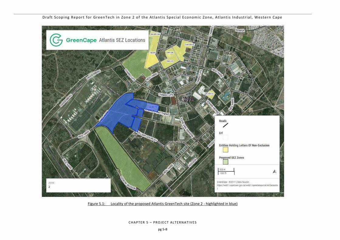
Draft Scop ing Report for GreenTech in Zone 2 o f the At lant i s Spec ia l Economic Zone, At lant i s Industr ia l , Western Cape
CHAPTER 5 – PROJE CT ALTERNATIVES
pg 5-8
Figure 5.1: Locality of the proposed Atlantis GreenTech site (Zone 2 - highlighted in blue)
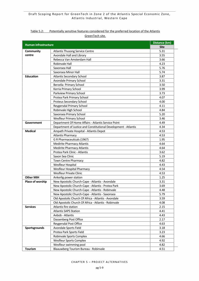
Draft Scop ing Report for GreenTech in Zone 2 o f the At lant i s Spec ia l Economic Zone, At lant i s Industr ia l , Western Cape
CHAPTER 5 – PROJE CT ALTERNATIVES
pg 5-9
Table 5.2: Potentially sensitive features considered for the preferred location of the Atlantis
GreenTech site.
Human infrastructure Distance (km)
Site
Community centre
Atlantis Thusong Service Centre 5.31
Avondale Hall and Library 3.55
Rebecca Van Amsterdam Hall 3.66
Robinvale Hall 4.23
Saxonsea Hall 5.76
Saxonsea Minor Hall 5.74
Education Atlantis Secondary School 3.87
Avondale Primary School 3.31
Berzelia Primary School 3.50
Kerria Primary School 3.99
Parkview Primary School 3.73
Protea Park Primary School 4.07
Proteus Secondary School 4.00
Reygersdal Primary School 4.11
Robinvale High School 4.84
Saxonsea Primary School 5.20
Wesfleur Primary School 3.46
Government Department Of Home Affairs - Atlantis Service Point 4.49
Department of Justice and Constitutional Development - Atlantis 4.34
Medical Ampath Private Hospital - Atlantis Depot 4.53
Atlantis Pharmacy 4.53
G R Pharmaceuticals (1967) 1.95
Medirite Pharmacy Atlantis 4.64
Medirite Pharmacy Atlantis 4.64
Protea Park Clinic - Atlantis 3.62
Saxon Sea Clinic 5.19
Town Centre Pharmacy 4.82
Wesfleur Hospital 4.43
Wesfleur Hospital Pharmacy 4.54
Wesfleur Private Clinic 4.53
Other MIH Ankerlig power station 1.25
Place of worship New Apostolic Church-Cape - Atlantis - Avondale 3.31
New Apostolic Church-Cape - Atlantis - Protea Park 3.69
New Apostolic Church-Cape - Atlantis - Robinvale 4.48
New Apostolic Church-Cape - Atlantis - Saxonsea 5.79
Old Apostolic Church Of Africa - Atlantis - Avondale 3.59
Old Apostolic Church Of Africa - Atlantis - Robinvale 4.08
Services Atlantis fire station 2.15
Atlantis SAPS Station 4.41
Avbob - Atlantis 4.43
Dassenberg Post Office 2.17
Reygersdal Post Office 4.63
Sportsgrounds Avondale Sports Field 3.18
Protea Park Sports Field 3.23
Robinvale Sports Complex 4.66
Wesfleur Sports Complex 4.92
Wesfleur swimming pool 4.82
Tourism Blaauwberg Tourism Bureau - Robinvale 4.51
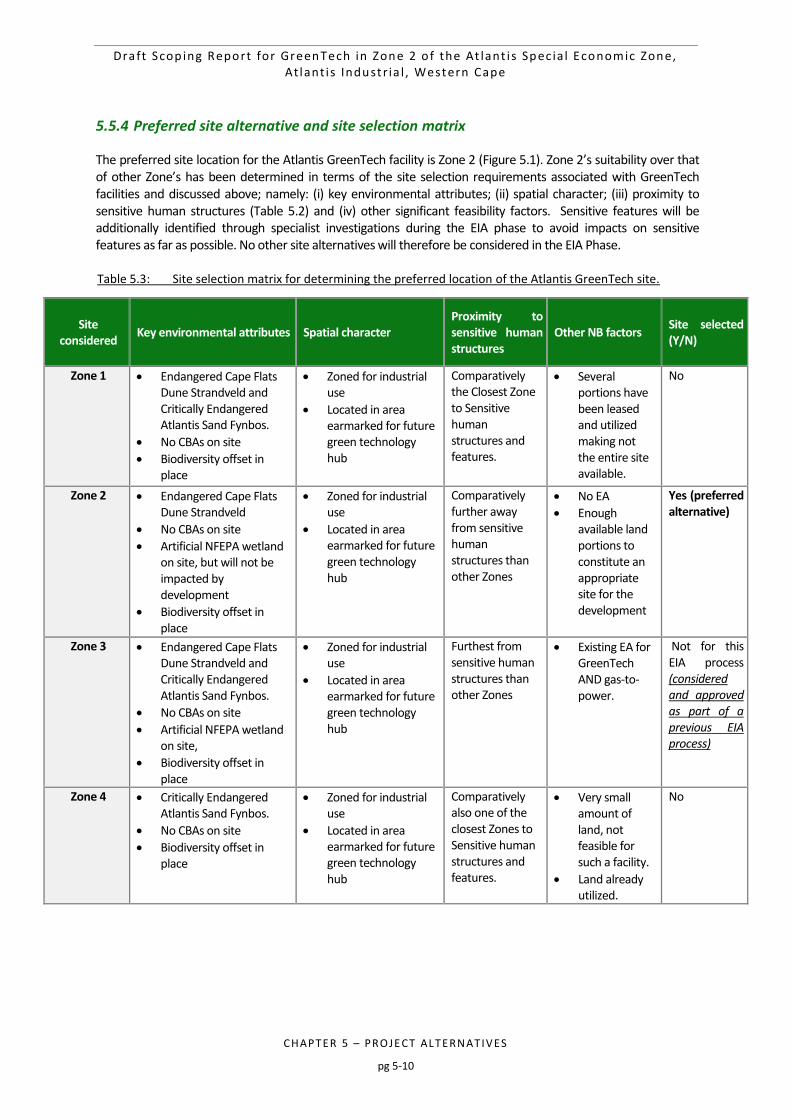
Draft Scop ing Report for GreenTech in Zone 2 o f the At lant i s Spec ia l Economic Zone, At lant i s Industr ia l , Western Cape
CHAPTER 5 – PROJE CT ALTERNATIVES
pg 5-10
5.5.4 Preferred site alternative and site selection matrix
The preferred site location for the Atlantis GreenTech facility is Zone 2 (Figure 5.1). Zone 2’s suitability over that of other Zone’s has been determined in terms of the site selection requirements associated with GreenTech facilities and discussed above; namely: (i) key environmental attributes; (ii) spatial character; (iii) proximity to sensitive human structures (Table 5.2) and (iv) other significant feasibility factors. Sensitive features will be additionally identified through specialist investigations during the EIA phase to avoid impacts on sensitive features as far as possible. No other site alternatives will therefore be considered in the EIA Phase. Table 5.3: Site selection matrix for determining the preferred location of the Atlantis GreenTech site.
Site considered
Key environmental attributes Spatial character Proximity to sensitive human structures
Other NB factors Site selected (Y/N)
Zone 1 Endangered Cape Flats Dune Strandveld and Critically Endangered Atlantis Sand Fynbos.
No CBAs on site
Biodiversity offset in place
Zoned for industrial use
Located in area earmarked for future green technology hub
Comparatively the Closest Zone to Sensitive human structures and features.
Several portions have been leased and utilized making not the entire site available.
No
Zone 2 Endangered Cape Flats Dune Strandveld
No CBAs on site
Artificial NFEPA wetland on site, but will not be impacted by development
Biodiversity offset in place
Zoned for industrial use
Located in area earmarked for future green technology hub
Comparatively further away from sensitive human structures than other Zones
No EA
Enough available land portions to constitute an appropriate site for the development
Yes (preferred alternative)
Zone 3 Endangered Cape Flats Dune Strandveld and Critically Endangered Atlantis Sand Fynbos.
No CBAs on site
Artificial NFEPA wetland on site,
Biodiversity offset in place
Zoned for industrial use
Located in area earmarked for future green technology hub
Furthest from sensitive human structures than other Zones
Existing EA for GreenTech AND gas-to-power.
Not for this EIA process (considered and approved as part of a previous EIA process)
Zone 4 Critically Endangered Atlantis Sand Fynbos.
No CBAs on site
Biodiversity offset in place
Zoned for industrial use
Located in area earmarked for future green technology hub
Comparatively also one of the closest Zones to Sensitive human structures and features.
Very small amount of land, not feasible for such a facility.
Land already utilized.
No
Draft Scop ing Report for GreenTech in Zone 2 o f the At lant i s Spec ia l Economic Zone, At lant i s Industr ia l , Western Cape
CHAPTER 5 – PROJE CT ALTERNATIVES
pg 5-11
5.6 CONCLUDING STATEMENT ON PREFERRED ALTERNATIVES
As per Appendix 2, Section 2 (xi) of the 2014 EIA Regulations (as amended on 7 April 2017), details on the preferred alternative that will be taken forward into the EIA Phase are presented inTable 5.3. Based on the aspects considered in this Chapter, the concluding statement of the preferred alternatives that will be considered in the EIA Phase is: This EIA will assess the development of the proposed Atlantis GreenTech facility, manufacturing renewable energy components (i.e. solar, wind or invertors – all feasible), in the preferred location, the Atlantis SEZ, on the preferred site, namely Zone 2 (Portion remainder of 277, 246, 254 and Portion remainder of 171).
Draft Scop ing Report for GreenTech in Zone 2 o f the At lant i s Spec ia l Economic Zone, At lant i s Industr ia l , Western Cape
CHAPTER 6 – POTE NTI AL E NVIRO NME NTAL R I SK S AND IM PACTS
pg 6-1
6 POTENTIAL ENVIRONMENTAL RISKS AND IMPACTS 6-2
6.1 ASSESSMENT OF POTENTIAL IMPACTS (SCOPING LEVEL) 6-2 6.1.1 Method 6-2
6.1.2 Scoping-level impact assessment 6-4
6.2 IMPACTS TO BE ASSESSED IN THE EIA PHASE 6-7 6.2.1 Terrestrial Ecology 6-7
6.2.1.1 Key Issues 6-7
6.2.1.2 Biodiversity Offset 6-8
6.2.1.3 Assessment to be undertaken during the EIA Phase 6-8
6.2.2 Paleontology 6-9
6.2.2.1 Key Issues 6-9
6.2.2.2 Assessment to be undertaken during the EIA Phase 6-9
6.2.3 Heritage 6-9
6.2.3.1 Key Issues 6-9
6.2.3.2 Assessment to be undertaken during the EIA Phase 6-10
6.2.4 Traffic 6-10
6.2.4.1 Key Issues 6-10
6.2.4.2 Assessment to be undertaken during the EIA Phase 6-11
6.2.5 Cumulative Impacts 6-11
Table 6.1: Scoping level assessment of potential and residual risks/impacts, with high-level mitigation
measures. 6-5
Figure 6.1: Guide to assessing risk/impact significance as a result of consequence and probability. 6-2
Figure 6.2: Schematic Diagram for the assessment of Cumulative Impacts 6-12
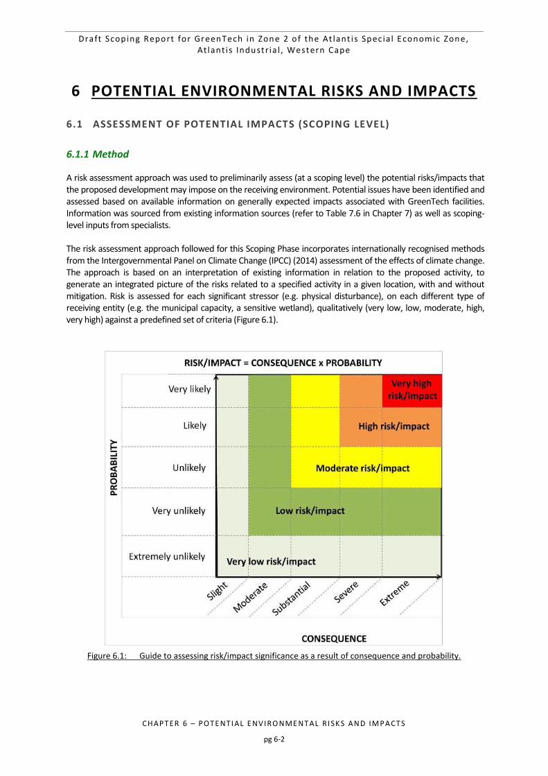
Draft Scop ing Report for GreenTech in Zone 2 o f the At lant i s Spec ia l Economic Zone, At lant i s Industr ia l , Western Cape
CHAPTER 6 – POTE NTI AL E NVIRO NME NTAL R I SK S AND IM PACTS
pg 6-2
6 POTENTIAL ENVIRONMENTAL RISKS AND IMPACTS
6.1 ASSESSMENT OF POTENTIAL IMPACTS (SCOPING LEVEL)
6.1.1 Method
A risk assessment approach was used to preliminarily assess (at a scoping level) the potential risks/impacts that the proposed development may impose on the receiving environment. Potential issues have been identified and assessed based on available information on generally expected impacts associated with GreenTech facilities. Information was sourced from existing information sources (refer to Table 7.6 in Chapter 7) as well as scoping-level inputs from specialists. The risk assessment approach followed for this Scoping Phase incorporates internationally recognised methods from the Intergovernmental Panel on Climate Change (IPCC) (2014) assessment of the effects of climate change. The approach is based on an interpretation of existing information in relation to the proposed activity, to generate an integrated picture of the risks related to a specified activity in a given location, with and without mitigation. Risk is assessed for each significant stressor (e.g. physical disturbance), on each different type of receiving entity (e.g. the municipal capacity, a sensitive wetland), qualitatively (very low, low, moderate, high, very high) against a predefined set of criteria (Figure 6.1).
Figure 6.1: Guide to assessing risk/impact significance as a result of consequence and probability.
Draft Scop ing Report for GreenTech in Zone 2 o f the At lant i s Spec ia l Economic Zone, At lant i s Industr ia l , Western Cape
CHAPTER 6 – POTE NTI AL E NVIRO NME NTAL R I SK S AND IM PACTS
pg 6-3
The following criteria have been considered in the assessment of risk/impacts of the location alternatives:
Status - Whether the risk/impact on the overall environment will be: o Positive - environment overall will benefit from the impact; or o Negative - environment overall will be adversely affected by the impact.
Spatial extent – The size of the area that will be affected by the risk/impact: o Site; o Local (<10 km from site); o Regional (<100 km of site); o National; or o International (e.g. Greenhouse Gas emissions or migrant birds).
Duration – The timeframe during which the risk/impact will be experienced: o Very short term (instantaneous); o Short term (less than 1 year); o Medium term (1 to 10 years); o Long term (the impact will occur for the project duration); or o Permanent (mitigation will not occur in such a way or in such a time span that the impact can be
considered transient (i.e. the impact will occur beyond the project decommissioning)).
Consequence – The anticipated consequence of the risk/impact: o Slight; o Moderate; o Substantial; o Severe; and o Extreme.
Probability – The probability of the impact occurring: o Very likely; o Likely; o Unlikely; o Very unlikely; and o Extremely unlikely.
Reversibility of the Impacts - the extent to which the risks/impacts are reversible assuming that the project has reached the end of its life cycle (decommissioning phase):
o Yes: High reversibility of impacts (impact is highly reversible at end of project life); o Partially: Moderate reversibility of impacts; or o No: Impacts are non-reversible (impact is permanent).
Irreplaceability of Receiving Environment/Resource Loss caused by risk/impacts – the degree to which the impact causes irreplaceable loss of resources assuming that the project has reached the end of its life cycle (decommissioning phase):
o High irreplaceability of resources (project will destroy unique resources that cannot be replaced); o Moderate irreplaceability of resources; or o Low irreplaceability of resources.
The significance of the risk/impact is then determined through a combination of the consequence and probability and is rated qualitatively as follows:
Draft Scop ing Report for GreenTech in Zone 2 o f the At lant i s Spec ia l Economic Zone, At lant i s Industr ia l , Western Cape
CHAPTER 6 – POTE NTI AL E NVIRO NME NTAL R I SK S AND IM PACTS
pg 6-4
Very low (the risk/impact may result in very minor alterations of the environment and can be easily avoided by implementing appropriate mitigation measures, and will not have an influence on decision-making);
Low (the risk/impact may result in minor alterations of the environment and can be easily avoided by implementing appropriate mitigation measures, and will not have an influence on decision-making);
Moderate (the risk/impact will result in moderate alteration of the environment and can be reduced or avoided by implementing the appropriate mitigation measures, and will only have an influence on the decision-making if not mitigated);
High (the risk/impact will result in major alteration to the environment even with the implementation on the appropriate mitigation measures and will have an influence on decision-making); and
Very high (the impact will result in very major alteration to the environment even with the implementation on the appropriate mitigation measures and will have an influence on decision-making (i.e. the project cannot be authorised unless major changes to the engineering design are carried out to reduce the significance rating)).
Please note that impacts with a positive status (e.g. employment opportunities and diversified economy) may also be indicated as having high or very high. In these cases high and very high ratings are desirable and indicate benefits to the particular receiving environment. With the implementation of mitigation measures, the residual impacts/risks are ranked as follows in terms of significance:
Very low = 5;
Low = 4;
Moderate = 3;
High = 2; and
Very high = 1.
6.1.2 Scoping-level impact assessment
Please note that this Scoping Phase impact assessment was conducted by the CSIR project team based on existing information (i.e. Table 7.6 in Chapter 7). The results of this high-level preliminary impact assessment will be verified by relevant specialists during the EIA Phase. Please see Chapter 7 for the EIA Plan of study (PoS) and Terms of Reference for a list of proposed specialist studies. Potential impacts associated with the Atlantis GreenTech project are anticipated to mainly be of very low to moderate negative significance after mitigation, whilst some high positive socio-economic impacts may be expected (Table 6.1).
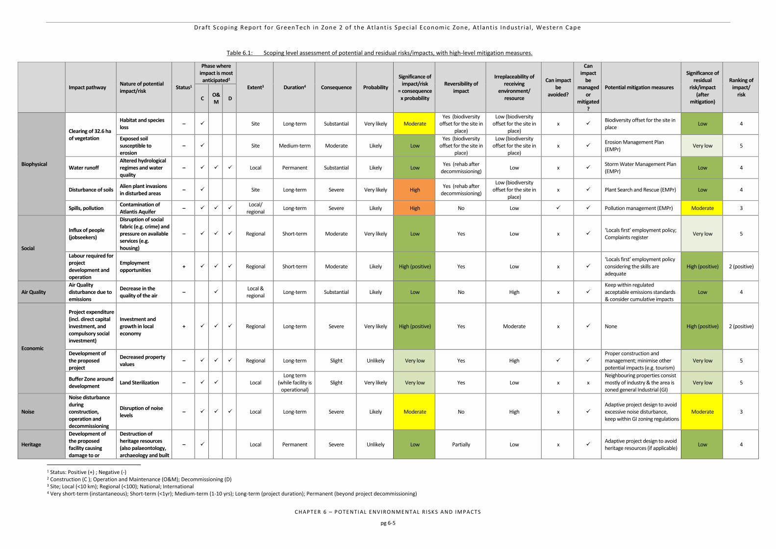
Draft Scop ing Report for GreenTech in Zone 2 o f the At lant i s Spec ia l Economic Zone, At lant i s Industr ia l , Western Cape
CHAPTER 6 – POTE NTI AL E NVIRO NME NTAL R I SK S AND IM PACTS
pg 6-5
Table 6.1: Scoping level assessment of potential and residual risks/impacts, with high-level mitigation measures.
Impact pathway
Nature of potential impact/risk
Status1
Phase where impact is most
anticipated2 Extent3 Duration4 Consequence Probability
Significance of impact/risk
= consequence x probability
Reversibility of impact
Irreplaceability of receiving
environment/ resource
Can impact be
avoided?
Can impact
be managed
or mitigated
?
Potential mitigation measures
Significance of residual
risk/impact (after
mitigation)
Ranking of impact/
risk C
O&M
D
Biophysical
Clearing of 32.6 ha of vegetation
Habitat and species loss
–
Site Long-term Substantial Very likely Moderate Yes (biodiversity
offset for the site in place)
Low (biodiversity offset for the site in
place) x
Biodiversity offset for the site in place
Low 4
Exposed soil susceptible to erosion
–
Site Medium-term Moderate Likely Low Yes (biodiversity
offset for the site in place)
Low (biodiversity offset for the site in
place) x
Erosion Management Plan (EMPr)
Very low 5
Water runoff Altered hydrological regimes and water quality
– Local Permanent Substantial Likely Low Yes (rehab after
decommissioning) Low x
Storm Water Management Plan (EMPr)
Low 4
Disturbance of soils Alien plant invasions in disturbed areas
–
Site Long-term Severe Very likely High Yes (rehab after
decommissioning)
Low (biodiversity offset for the site in
place) x Plant Search and Rescue (EMPr) Low 4
Spills, pollution Contamination of Atlantis Aquifer
– Local/
regional Long-term Severe Likely High No Low Pollution management (EMPr) Moderate 3
Social
Influx of people (jobseekers)
Disruption of social fabric (e.g. crime) and pressure on available services (e.g. housing)
– Regional Short-term Moderate Very likely Low Yes Low x ‘Locals first’ employment policy; Complaints register
Very low 5
Labour required for project development and operation
Employment opportunities
+ Regional Short-term Moderate Likely High (positive) Yes Low x ‘Locals first’ employment policy considering the skills are adequate
High (positive) 2 (positive)
Air Quality Air Quality disturbance due to emissions
Decrease in the quality of the air
–
Local & regional
Long-term Substantial Likely Low No High x Keep within regulated acceptable emissions standards & consider cumulative impacts
Low 4
Economic
Project expenditure (incl. direct capital investment, and compulsory social investment)
Investment and growth in local economy
+ Regional Long-term Severe Very likely High (positive) Yes Moderate x None High (positive) 2 (positive)
Development of the proposed project
Decreased property values
– Regional Long-term Slight Unlikely Very low Yes High Proper construction and management; minimise other potential impacts (e.g. tourism)
Very low 5
Buffer Zone around development
Land Sterilization – Local Long term
(while facility is operational)
Slight Very likely Very low Yes Low x x Neighbouring properties consist mostly of industry & the area is zoned general Industrial (GI)
Very low 5
Noise
Noise disturbance during construction, operation and decommissioning
Disruption of noise levels
– Local Long-term Severe Likely Moderate No High x Adaptive project design to avoid excessive noise disturbance, keep within GI zoning regulations
Moderate 3
Heritage
Development of the proposed facility causing damage to or
Destruction of heritage resources (also palaeontology, archaeology and built
– Local Permanent Severe Unlikely Low Partially Low x Adaptive project design to avoid heritage resources (if applicable)
Low 4
1 Status: Positive (+) ; Negative (-) 2 Construction (C ); Operation and Maintenance (O&M); Decommissioning (D) 3 Site; Local (<10 km); Regional (<100); National; International 4 Very short-term (instantaneous); Short-term (<1yr); Medium-term (1-10 yrs); Long-term (project duration); Permanent (beyond project decommissioning)
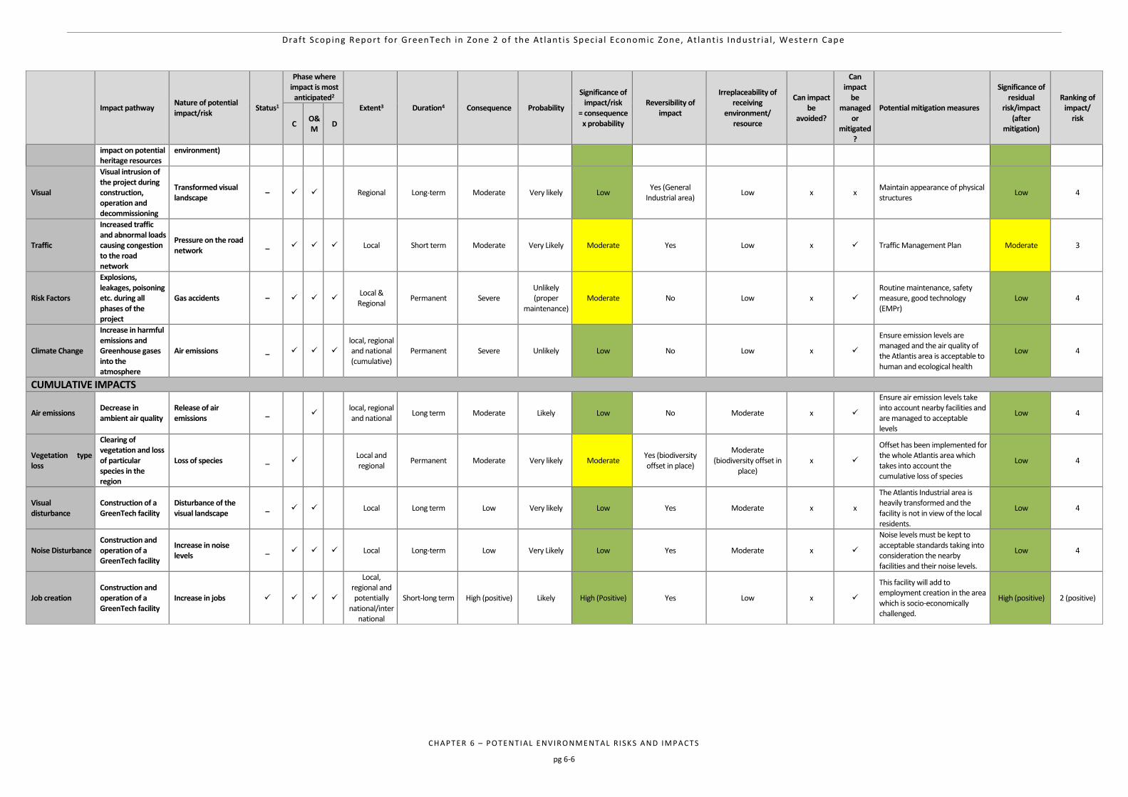
Draft Scop ing Report for GreenTech in Zone 2 o f the At lant i s Spec ia l Economic Zone, At lant i s Industr ia l , Western Cape
CHAPTER 6 – POTE NTI AL E NVIRO NME NTAL R I SK S AND IM PACTS
pg 6-6
Impact pathway
Nature of potential impact/risk
Status1
Phase where impact is most
anticipated2 Extent3 Duration4 Consequence Probability
Significance of impact/risk
= consequence x probability
Reversibility of impact
Irreplaceability of receiving
environment/ resource
Can impact be
avoided?
Can impact
be managed
or mitigated
?
Potential mitigation measures
Significance of residual
risk/impact (after
mitigation)
Ranking of impact/
risk C
O&M
D
impact on potential heritage resources
environment)
Visual
Visual intrusion of the project during construction, operation and decommissioning
Transformed visual landscape
–
Regional Long-term Moderate Very likely Low Yes (General
Industrial area) Low x x
Maintain appearance of physical structures
Low 4
Traffic
Increased traffic and abnormal loads causing congestion to the road network
Pressure on the road network
_ Local Short term Moderate Very Likely Moderate Yes Low x Traffic Management Plan Moderate 3
Risk Factors
Explosions, leakages, poisoning etc. during all phases of the project
Gas accidents – Local &
Regional Permanent Severe
Unlikely (proper
maintenance) Moderate No Low x
Routine maintenance, safety measure, good technology (EMPr)
Low 4
Climate Change
Increase in harmful emissions and Greenhouse gases into the atmosphere
Air emissions _ local, regional and national (cumulative)
Permanent Severe Unlikely Low No Low x
Ensure emission levels are managed and the air quality of the Atlantis area is acceptable to human and ecological health
Low 4
CUMULATIVE IMPACTS
Air emissions Decrease in ambient air quality
Release of air emissions
_ local, regional and national
Long term Moderate Likely Low No Moderate x
Ensure air emission levels take into account nearby facilities and are managed to acceptable levels
Low 4
Vegetation type loss
Clearing of vegetation and loss of particular species in the region
Loss of species _ Local and regional
Permanent Moderate Very likely Moderate Yes (biodiversity offset in place)
Moderate (biodiversity offset in
place) x
Offset has been implemented for the whole Atlantis area which takes into account the cumulative loss of species
Low 4
Visual disturbance
Construction of a GreenTech facility
Disturbance of the visual landscape
_ Local Long term Low Very likely Low Yes Moderate x x
The Atlantis Industrial area is heavily transformed and the facility is not in view of the local residents.
Low 4
Noise Disturbance Construction and operation of a GreenTech facility
Increase in noise levels
_ Local Long-term Low Very Likely Low Yes Moderate x
Noise levels must be kept to acceptable standards taking into consideration the nearby facilities and their noise levels.
Low 4
Job creation Construction and operation of a GreenTech facility
Increase in jobs
Local, regional and potentially
national/international
Short-long term High (positive) Likely High (Positive) Yes Low x
This facility will add to employment creation in the area which is socio-economically challenged.
High (positive) 2 (positive)
Draft Scop ing Report for GreenTech in Zone 2 o f the At lant i s Spec ia l Economic Zone, At lant i s Industr ia l , Western Cape
CHAPTER 6 – POTE NTI AL E NVIRO NME NTAL R I SK S AND IM PACTS
pg 6-7
6.2 IMPACTS TO BE ASSESSED IN THE EIA PHASE
The issues and impacts presented in this chapter have been identified via the environmental status quo of the receiving environment (environmental, social and heritage features present on site), an assessment of the extensive existing information sources for the Atlantis SEZ, a review of environmental impacts from other similar GreenTech projects, and input from specialists that form part of the project team. Potential environmental risks/impacts will be confirmed during the EIA phase. The main potential risks/impacts that the proposed GreenTech development may pose to the receiving environmental and socio-economic environment are discussed below5. Impacts and issues to be addressed in the specialist studies are described below. This is based on a reasonable amount of information available (due to Atlantis being an industrial and heavily transformed area) to specialists prior to their specialist studies. These issues will be expanded upon and studied in greater detail in the EIA phase.
6.2.1 Terrestrial Ecology
6.2.1.1 Key Issues
The proposed development will result in a number of actions that will arise in both the construction and operation phases of the project and include inter alia:
Possible levelling of topographic features;
Clearance of approximately 32.6 ha of vegetation;
Establishment of warehouse-like structures;
Fencing of the site;
Other supportive infrastructure. The construction phase is a relatively short term undertaking, although “intensive” in terms of the rapid physical changes that arise on site. Given this, it is expected that the following impacts of an ecological nature may arise during the construction and operational phases. Construction Phase The proposed GreenTech development would impact on one vegetation types, which includes a large portion of ENDANGERED, good quality Cape Flats Dune Strandveld. The transitional area - where the soil interface gives rise to a changeover and interchange of species between the vegetation types is of high conservation importance since such ecotones usually drive speciation and are important in terms of ecological processes. The large portion of Cape Flats Dune Strandveld (population of Leucospermum parile found on the neighboring site) is of high conservation importance. However, these occur within an area overtaken by alien vegetation and with limited connectivity to the Atlantis dune area. Restoration, although possible, is unlikely to occur in the near future, which means that the land will undergo further degradation through alien invasion. In order for the land
5 The list of assessments described in this section pertains to the specialist studies that will be conducted as per Chapter 8 of this report. Other impacts relating to the project (i.e. noise, visual, social etc.) will be assessed using the extensive amount of information available for the Atlantis SEZ. This will be expanded upon and assessed in the EIA phase
Draft Scop ing Report for GreenTech in Zone 2 o f the At lant i s Spec ia l Economic Zone, At lant i s Industr ia l , Western Cape
CHAPTER 6 – POTE NTI AL E NVIRO NME NTAL R I SK S AND IM PACTS
pg 6-8
to hold any conservation value in the future, the alien vegetation would have to be eradicated and biodiversity corridors created to link with the Atlantis dune area. The offset (Appendix C) is supported by the specialist since this would ensure the conservation of an unfragmented area greater than the existing site that will be lost and it would become a well-managed conservation area. Thus although the impacts would be HIGH NEGATIVE these would more than adequately compensate in the offset scenario which could be a gain for biodiversity conservation. Operational Phase
Alteration of ecological processes on account of the exclusion of certain species inherent to the functional state of land within the facility generally leading to possible variations in populations of other species that remain within the site, with concomitant ecological change;
The fencing of the site, possibly with electric fencing, is likely to impact upon faunal behaviour, leading to the exclusion of certain species and possible mortalities.
6.2.1.2 Biodiversity Offset
There has been a biodiversity offset secured and implemented (with regular audits by CapeNature) for the entire Atlantis SEZ, including the site for this proposed GreenTech facility. This was deemed necessary as the area has been ear-marked for development, which meant measures needed to be taken to ensure that species of special concern were not lost. The full report on the details of the Biodiversity Offset (known as the Klein Dassenberg Nature Reserve) can be found as Appendix C. The Klein Dassenberg Nature Reserve is situated about 45 km from Cape Town’s Central Business District (CBD), immediately east of Atlantis and directly adjacent to Pella on the northern boundary, Western Cape, South Africa (Map 1 – Appendix C). The approximate coordinates are (Google Earth, 2013):
18°30’29.888”E
33°32’26.044”S The Reserve is currently 371.97 ha in extent consisting of the farm Klein Dassenberg No 20/9 and farms No 7, 8, 10 and an unregistered portion of 1502 Cape road and Cape Farm No 17/1. Portion 3 of the farm Papekuil Outspan No 6 is currently unregistered state land and is being managed as part of the current reserve network. This portion is 183.5218ha in extent. The Botanical specialist assessment will take this information into account in the impact assessment, noting that the proposed offset is a gain for biodiversity conservation since this would ensure the conservation of an unfragmented area greater than the existing site that will be lost and it would become a well-managed conservation area. Thus although the impacts would be high, these would more than adequately compensate in the offset scenario.
6.2.1.3 Assessment to be undertaken during the EIA Phase
An Ecological Impact Assessment will be undertaken during the EIA Phase, which will include a site investigation. The findings of the assessment will be utilised to identify the most appropriate location of the project within the development footprint, and any significant or fatal flaws that may arise within the particular development footprint.
Draft Scop ing Report for GreenTech in Zone 2 o f the At lant i s Spec ia l Economic Zone, At lant i s Industr ia l , Western Cape
CHAPTER 6 – POTE NTI AL E NVIRO NME NTAL R I SK S AND IM PACTS
pg 6-9
6.2.2 Paleontology
6.2.2.1 Key Issues
A review of published sources and personal observations indicates that the proposed development falls on land under which deposits of potential palaeontological significance may exist. The area is within the Duinefontyn Dune Plume where wind erosion has in other parts exposed deeper sediments that underlie the Holocene (<10 000 year old (10 ka) Witzand Formation. Vegetation comprises a mix of indigenous Strandveld and alien Acacia species. Absolute dates place some fossil material at 330 ka, but there are even older known marine fossiliferous deposits dating back to at least 5 Ma (Million years ago) at the coast. Sparse scatters of stone artefacts of probable Early Stone Age occur with some of the fossils; Middle and Later Stone Age artefacts also occur, the latter on or within the Witzand Formation and most likely the result of activities of Khoekhoe herders, who arrived in the Western Cape some 2000 years ago. Similar occurrences may have been located during the archaeological survey of the proposed area. Collaboration between the contractor and a suitably-qualified palaeontologist (or archaeologist with appropriate experience) will be required during excavations for foundations and infrastructure so that information and/or material can be recorded appropriately. Prior access to geotechnical information and accurate foundation depths would help to determine the likelihood of this and the best strategy. Provided that the recommendations of this assessment are complied with, there is no palaeontological reason why the erection of the proposed development should not proceed. The recommendations from the specialist are as follows:
Excavations for foundations/infrastructure should be monitored by an appropriate palaeontologist. The frequency of this to be worked out a priori with the contractor to minimize time spent on site.
If possible, geotechnical information, together with the proposed depths of excavations for foundations and/or infrastructure, should be provided prior to the commencement of construction. This may enable a better estimation of the time(s) when monitoring will take place and even the extent of recovery work.
Protocols for dealing with palaeontological monitoring/mitigation must be included in the Environmental Management Plan (EMP). Any such material is likely to be fragile and due care must be exercised.
Any material recovered will be lodged in the collections of Iziko South African Museum.
6.2.2.2 Assessment to be undertaken during the EIA Phase
From the above, it is clear that the proposed development is in an area under which potentially important palaeontological remains may occur. Such palaeontological remains are likely to be rare and sparsely distributed but, if encountered, must be carefully exposed and recorded by an appropriately qualified person. Due to the paleontological sensitivity of the area, a desktop Paleontological Heritage Assessment will be undertaken during the EIA Phase and it will include recommendations for inclusion in the EMPr.
6.2.3 Heritage
6.2.3.1 Key Issues
Significant impacts to heritage resources are likely to be limited to archaeological resources and may be easily avoided by the final layout. Surface archaeological sites in Bushmanland tend to be very easy to record and sample and, as such, mitigation could be very easily effected should this be required. The terrain is largely flat and there are a number of dune fields. Where agriculture is not taking place, alien plant species have taken over. Previous archaeological surveys have described the poor visibility due to dense ground cover of alien vegetation. A large number of Heritage and Archaeological Impact Assessments have been conducted in this area, including
Draft Scop ing Report for GreenTech in Zone 2 o f the At lant i s Spec ia l Economic Zone, At lant i s Industr ia l , Western Cape
CHAPTER 6 – POTE NTI AL E NVIRO NME NTAL R I SK S AND IM PACTS
pg 6-10
a survey by Hart et al. (2007) which also covered the two sites identified for the current development. He reported that no significant archaeological material was recovered. A literature survey of the Atlantis area strongly suggests that the likelihood of uncovering any significant archaeological remains on the site which is proposed for the GreenTech development are minimal. Prior surveys have been conducted on the neighboring properties which has been identified for the current proposed GreenTech development. No significant archaeological remains were reported. However, human remains can occur anywhere on the landscape. In the event that human remains are uncovered, certain protocols must be observed. The area around the burial should be cordoned off and both Heritage Western Cape and the police must be notified. No further construction should take place until the authorities have investigated the remains and made their recommendations. Key issues during the construction and operational phases are:
Direct disturbance and/or destruction of archaeological material;
Direct impacts to the landscape through introduction of industrial type facilities; and
Direct disturbance and/or destruction of possible heritage features or graves.
6.2.3.2 Assessment to be undertaken during the EIA Phase
A Heritage Impact Assessment will be during the EIA Phase, which will include an assessment of the potential impacts associated with the proposed development on the heritage features present on site and the mitigation measures to be implemented to adequately protect these heritage features.
6.2.4 Traffic
6.2.4.1 Key Issues
The purpose of the Traffic Impact Study is to investigate the traffic impact of the proposed development on the surrounding road network and to propose mitigating measures if required. At the time of this draft Report there are no known planned changes to the existing road infrastructure in the study area that will have an effect on the future development. There are also no planned road links in the study area that will have an impact on trip distribution or traffic volumes in the study area. No known latent rights exist within the immediate study area that will have an impact on the local intersection performance, which indicates a low cumulative impact. The trip generation for a large industrial site of ±33ha to which a typical trip rate per 100 square metre Gross Leasable Area (GLA) is calculated indicates there will be traffic impacts associated with this proposed development. Impacts expected to arise in the phases of the project as described below: Construction and Decommissioning Phase
Increase in vehicles coming to site (increase in traffic) to transport various components of the development to site including an increase in noise, dust and exhaust emissions.
Increase in vehicles coming to site to transport workers and contractors to site including an increase in noise, dust and exhaust emissions.
Increase in vehicles coming to site (increase in traffic) from during the construction phase to transport various components of the development to site including an increase in noise, dust and exhaust emissions.
Operational Phase
Increase in vehicles coming to site to transport permanent employees to site including an increase in noise, dust and exhaust emissions.
Draft Scop ing Report for GreenTech in Zone 2 o f the At lant i s Spec ia l Economic Zone, At lant i s Industr ia l , Western Cape
CHAPTER 6 – POTE NTI AL E NVIRO NME NTAL R I SK S AND IM PACTS
pg 6-11
Increase in trucks carrying abnormal heavy loads from site causing increased congestion, traffic, noise dust and exhaust emissions and pressure on the road network.
6.2.4.2 Assessment to be undertaken during the EIA Phase
Due to the industrial nature of the site and the surrounding area, the traffic volumes contributed by the construction and operation phases of the facility on the existing traffic volumes and road network are considered acceptable, with mitigation. A Traffic Impact Statement will be undertaken during the EIA Phase and it will include road maintenance measures and other traffic management measures within the EMPr.
6.2.5 Cumulative Impacts
The cumulative impacts will be assessed by identifying other applicable projects, such as manufacturing facilities and other industrial developments in the local Atlantis SEZ area. In terms of cumulative impacts, the fact that the Atlantis SEZ is heavily transformed and demarcated for future industrial development has resulted in the City of Cape Town Municipality, DEA&DP and other organs of state such as CapeNature, finding ways in which these impacts can be managed and/or offset. The proximity of the proposed Atlantis GreenTech facility to Ankerlig and future potential gas import infrastructure means that the impacts can be concentrated to the Atlantis Industrial area. This is why the biodiversity offset has been secured for the entire Atlantis SEZ (Appendix C). However it is still important to promote sustainable and environmentally responsible development, which is why cumulative impacts for this development will be more thoroughly assessed in the EIA phase. At a scoping phase level, cumulative effects associated with these similar types of projects include inter alia:
Traffic generation;
Habitat destruction and fragmentation;
Removal of vegetation;
Increase in air emissions and decrease in overall regional air quality;
Increased contribution to climate change;
Increase in noise disturbance;
Increase in visual disturbance to sensitive receptors
Increase in stormwater run-off and erosion;
Job creation;
Social upliftment; and
Contribution of resources to the local renewable energy sector.
Draft Scop ing Report for GreenTech in Zone 2 o f the At lant i s Spec ia l Economic Zone, At lant i s Industr ia l , Western Cape
CHAPTER 6 – POTE NTI AL E NVIRO NME NTAL R I SK S AND IM PACTS
pg 6-12
Figure 6.2: Schematic Diagram for the assessment of Cumulative Impacts
Draft Scop ing Report for GreenTech in Zone 2 o f the At lant i s Spec ia l Economic Zone, At lant i s Industr ia l , Western Cape
CHAPTER 7 – PL AN O F STU DY FO R E I A
pg 7-1
7 PLAN OF STUDY FOR EIA 7-1
7.1 PURPOSE OF EIA AND REQUIREMENTS OF THE 2014 EIA REGULATIONS 7-1
7.2 OVERVIEW OF APPROACH TO PREPARING THE EIA REPORT AND EMPR 7-2
7.3 PUBLIC PARTICIPATION PROCESS 7-2
7.4 APPROACH TO IMPACT ASSESSMENT AND SPECIALIST STUDIES 7-5 7.4.1 Generic TOR for the Assessment of Potential Impacts 7-5
7.5 ISSUES TO BE ADDRESSED IN THE SPECIALIST STUDIES 7-9
7.6 ALTERNATIVES TO BE ASSESSED IN THE EIA PHASE 7-10
7.7 TOR FOR THE SPECIALIST STUDIES 7-10
7.8 MILESTONES IN THE EIA PROCESS 7-12
Table 7.1: Requirements for Plan of Study for EIA in accordance with the 2014 EIA Regulations (as
amedned on 7 Aoril 2017) 7-1
Table 7.2: Authority Communication Schedule 7-5
Table 7.3: Example of Table for Assessment of Impacts 7-8
Table 7.4: Brief summary of Issues to be addressed during the EIA Phase as part of the specialist
studies 7-9
Table 7.5: Specialist Studies and Associates Specialists 7-11
Table 7.6: Lisrt of exisiting information and studies that will inform this EIA process 7-11
Draft Scop ing Report for GreenTech in Zone 2 o f the At lant i s Spec ia l Economic Zone, At lant i s Industr ia l , Western Cape
CHAPTER 7 – PL AN O F STU DY FO R E I A
pg 7-1
7 PLAN OF STUDY FOR EIA
This chapter presents the Plan of Study for the EIA (PSEIA), which sets out the process to be followed in the EIA Phase (as required by the 2014 EIA Regulations, as amended). The PSEIA is based on the outcomes of the Scoping Phase (to date) and provides the Terms of Reference (TOR) for the specialist studies that have been identified, the alternatives that will be considered and assessed, as well as the PPP that will be undertaken during the EIA Phase.
7.1 PURPOSE OF EIA AND REQUIREMENTS OF THE 2014 EIA REGULATIONS
The purpose of the EIA Phase is to:
Address issues that have been identified through the Scoping Process;
Assess alternatives to the proposed activity in a comparative manner;
Assess all identified impacts and determine the significance of each impact; and
Recommend actions to avoid/mitigate negative impacts and enhance benefits. The EIA Phase consists of three parallel and overlapping processes:
Central assessment process through which inputs are integrated and presented in an EIA Report that is submitted for approval to the DEA and other commenting authorities
Undertaking of a PPP whereby findings of the EIA Phase are communicated and discussed with I&APs and responses are documented
Undertaking of specialist studies that provide additional information/assessments required to address the issues raised in the Scoping Phase
Table 7.1 below shows the requirements for the PSEIA in accordance with Appendix 2 (2) (i) of the 2014 EIA Regulations (as amended on 7 April 2017.
Table 7.1: Requirements for Plan of Study for EIA in accordance with the 2014 EIA Regulations (as
amedned on 7 Aoril 2017)
Section of the EIA Regulations:
Appendix 2 (2) (i)
Requirements for a Scoping Report in terms of Appendix 2 of the 2014 NEMA EIA Regulations (GN R982)
Location in this Chapter
i. A plan of study for undertaking the EIA process to be undertaken, including - a description of the alternatives to be considered and
assessed within the preferred site, including the option of not proceeding with the activity;
Section 7.7
ii. a description of the aspects to be assessed as part of the environmental impact assessment process;
Section 7.8
iii. aspects to be assessed by specialists; Section 7.8
iv. a description of the proposed method of assessing the environmental aspects, including a description of the proposed method of assessing the environmental aspects including aspects to be assessed by specialists;
Section 7.5
v. a description of the proposed method of assessing duration and significance;
Section 7.5
vi. an indication of the stages at which the competent authority will be consulted;
Section 7.3 and Section 7.4
vii. particulars of the public participation process that will be Section 7.3 and Section 7.4
Draft Scop ing Report for GreenTech in Zone 2 o f the At lant i s Spec ia l Economic Zone, At lant i s Industr ia l , Western Cape
CHAPTER 7 – PL AN O F STU DY FO R E I A
pg 7-2
Section of the EIA Regulations:
Appendix 2 (2) (i)
Requirements for a Scoping Report in terms of Appendix 2 of the 2014 NEMA EIA Regulations (GN R982)
Location in this Chapter
conducted during the environmental impact assessment process;
viii. a description of the tasks that will be undertaken as part of the environmental impact assessment process; and
Section 7.2, Section 7.3 and Section 7.4
ix. identify suitable measures to avoid, reverse, mitigate or manage identified impacts and to determine the extent of the residual risks that need to be managed and monitored.
Section 7.8
7.2 OVERVIEW OF APPROACH TO PREPARING THE EIA REPORT AND EMPR
The results of the specialist studies and other relevant project information for the Atlantis GreenTech project will be summarised and integrated into the EIA Report. The Draft EIA Report will be released for a 30-day I&AP and authority review period, as outlined in Sections 7.3 and 7.4 of this chapter. All registered I&APs on the project database will be notified in writing of the release of the Draft EIA Report for review. Should it be deemed necessary (based on feedback on the Scoping Process), one public meeting can be arranged during this review period, or following requests from stakeholders, several focus group meetings with key I&APs and stakeholders can instead be arranged. The purpose of these meetings (if deemed necessary) will be to provide an overview of the outcome and recommendations from the specialist studies, as well as provide opportunity for comment. Comments raised, through written correspondence (emails, comments, forms) and at meetings (public meeting and/or focus group meetings) will be captured in a Comments and Responses Trail for inclusion in the EIA Reports that will be submitted to the DEA&DP for decision-making in terms of Regulation 23 (1) (a) of the 2014 EIA Regulations (as amended). Comments raised will be responded to by the EIA team and/or the applicant. These responses will indicate how the issue has been dealt with in the EIA Process. Should the comment received fall beyond the scope of this EIA, clear reasoning will be provided. All comments received (and the associated responses from the EIA team) will be attached as an appendix to the EIA Report for submission to the DEA&DP. The EIA Report will include an EMPr, which will be prepared in compliance with the relevant regulations (i.e. Appendix 4 of the 2014 EIA Regulations, as amended). This EMPr will be based broadly on the environmental management philosophy presented in the ISO 14001 standard, which embodies an approach of continual improvement. Actions in the EMP will be drawn primarily from the management actions in the specialist studies for the construction and operational phases of the project. If the project components are decommissioned or re-developed, this will need to be done in accordance with the relevant environmental standards and clean-up/remediation requirements applicable at the time.
7.3 PUBLIC PARTICIPATION PROCESS
The key steps in the PPP for the EIA Phase are described below. This approach will be confirmed with the provincial and national environmental authorities through their review of the PSEIA.
TASK 1: I&AP REVIEW OF THE DRAFT EIA REPORT AND EMPR
The first stage in the process will entail the release of the Draft EIA Report for a 30-day I&AP and stakeholder review period. Relevant organs of state and I&APs will be informed of the review process in the following manner:
Placement of one English advertisement in The Cape Times newspaper and one Afrikaans advertisement in Die Burger to notify potential I&APs of the availability of the EIA Reports;
A letter will be sent via registered mail and email to all registered I&APs and organs of state (where postal, physical and email addresses are available) on the database. The letter will include notification
Draft Scop ing Report for GreenTech in Zone 2 o f the At lant i s Spec ia l Economic Zone, At lant i s Industr ia l , Western Cape
CHAPTER 7 – PL AN O F STU DY FO R E I A
pg 7-3
of the 30-day comment period for the Draft EIA Report, as well as an invitation to attend the public meeting and/or focus group meetings, if required.
A public meeting could possibly be held during the review of the Draft EIA Report, if warranted, and if there is substantial public interest during the EIA Phase. Furthermore, telephonic consultations with key I&APs will take place, upon request; and
Meeting(s) with key authorities involved in decision-making for this EIA (if required and requested). The Draft EIA Report will be made available and distributed through the following mechanisms to ensure access to information on the project and to communicate the outcome of specialist studies:
Copies of the report will be placed at the local library (i.e. Avondale Public Library) for I&APs to access for viewing;
Key authorities will be provided with either a hard copy and/or CD of the Draft EIA Report;
The Draft EIA Report will be uploaded to the project website (https://www.csir.co.za/environmental-impact-assessment) and
Telephonic consultations will be held with key I&AP and organs of state groups, as necessary.
TASK 2: COMMENTS AND RESPONSES TRAIL
A key component of the EIA Process is documenting and responding to the comments received from I&APs and the authorities. The following comments on the Draft EIA Report will be documented:
Written and emailed comments (e.g. letters and completed comment and registration forms);
Comments made at public meetings and/or focus group meetings (if required);
Telephonic communication with CSIR project team; and
One-on-one meetings with key authorities and/or I&APs (if required). The comments received during the 30-day review of the Draft EIA Report will be compiled into a Comments and Responses Trail for inclusion in an appendix to the Final EIA Report that will be submitted to the DEA&DP in terms of Regulation 23 (1) (a) for decision-making. The Comments and Responses Trail will indicate the nature of the comment, as well as when and who raised the comment. The comments received will be considered by the EIA team and appropriate responses provided by the relevant member of the team and/or specialist. The response provided will indicate how the comment received has been considered in the EIA Reports for submission to the DEA&DP and in the project design or EMPRs.
TASK 3: COMPILATION OF FINAL EIA REPORT FOR SUBMISSION TO THE DEA
Following the 30-day commenting period of the Draft EIA Report and incorporation of the comments received into the reports, the Final EIA Report (i.e. hard copies and electronic copies) will be submitted to the DEA&DP for decision-making in line with Regulation 23 (1) of the 2014 EIA Regulations, as amended. In line with best practice, I&APs on the project database will be notified via email (where email addresses are available) of the submission of the Final EIA Report to the DEA&DP for decision-making. The Final EIA Report that is submitted for decision-making will also include proof of the PPP that was undertaken to inform organs of state and I&APs of the availability of the Draft EIA Report for the 30 day review (during Task 1, as explained above). The DEA&DP will have 107 days (from receipt of the Final EIA Report) to either grant or refuse EA (in line with Regulation 24 (1) of the 2014 EIA Regulations, as amended).
TASK 4: EA AND APPEAL PERIOD
Subsequent to the decision-making phase, if an EA is granted by the DEA&DP for the proposed project, all registered I&APs and stakeholders on the project database will receive notification of the issuing of the EA and the appeal period. The 2014 EIA Regulations (as amended on 7 April 2017) (i.e. Regulation 4 (1)) states that after the Competent Authority has a reached a decision, it must inform the Applicant of the decision, in writing, within
Draft Scop ing Report for GreenTech in Zone 2 o f the At lant i s Spec ia l Economic Zone, At lant i s Industr ia l , Western Cape
CHAPTER 7 – PL AN O F STU DY FO R E I A
pg 7-4
5 days of such decision. Regulation 4 (2) of the EIA Regulations stipulates that I&APs need to be informed of the EA and associated appeal period within 14 days of the date of the decision. All registered I&APs will be informed of the outcome of the EA and the appeal procedure and its respective timelines. The following process will be followed for the distribution of the EA (should such authorisation be granted by the DEA&DP) and notification of the appeal period:
Placement of one English advertisement and one Afrikaans advertisement in local Newspapers to notify I&APs of the EA and associated appeal process;
A letter will be sent via registered mail and email to all registered I&APs and organs of state (where postal, physical and email addresses are available) on the database. The letter will include information on the appeal period, as well as details regarding where to obtain a copy of the EA;
A copy of the EA will be uploaded to the project website(https://www.csir.co.za/environmental-impact-assessment) and
All I&APs on the project database will be notified of the outcome of the appeal period in writing. Authority Consultation during the EIA Phase Authority consultation is integrated into the PPP, with additional one-on-one meetings held with the lead authorities, where necessary. It is proposed that the Competent Authority (DEA&DP) as well as other lead authorities will be consulted at various stages during the EIA Process. At this stage, the following authorities have been identified for the purpose of this EIA Process (additional authorities might be added to this list as the EIA Process proceeds):
National DEA;
Department of Environmental Affairs and Development Planning Western Cape Province;
DWS of the Western Cape Province;
Department of Energy of the Western Cape Province;
Eskom Holdings SOC Ltd;
Transnet SOC Ltd;
South African National Parks;
National Energy Regulator of South Africa;
National DAFF;
DAFF of the Western Cape Province;
Department of Agriculture, Land Reform & Rural Development of the Western Cape Province;
Department of Public Works, Roads and Transport of the Western Cape Province;
Department of Labour;
SAHRA;
South African National Road Agency Limited;
City of Cape Town Metropolitan Municipality The authority consultation process for the EIA Phase is outlined in Table 7.2 below.
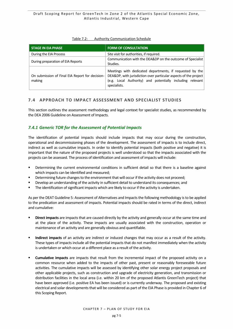
Draft Scop ing Report for GreenTech in Zone 2 o f the At lant i s Spec ia l Economic Zone, At lant i s Industr ia l , Western Cape
CHAPTER 7 – PL AN O F STU DY FO R E I A
pg 7-5
Table 7.2: Authority Communication Schedule
7.4 APPROACH TO IMPACT ASSESSMENT AND SPECIALIST STUDIES
This section outlines the assessment methodology and legal context for specialist studies, as recommended by the DEA 2006 Guideline on Assessment of Impacts.
7.4.1 Generic TOR for the Assessment of Potential Impacts
The identification of potential impacts should include impacts that may occur during the construction, operational and decommissioning phases of the development. The assessment of impacts is to include direct, indirect as well as cumulative impacts. In order to identify potential impacts (both positive and negative) it is important that the nature of the proposed projects is well understood so that the impacts associated with the projects can be assessed. The process of identification and assessment of impacts will include: Determining the current environmental conditions in sufficient detail so that there is a baseline against
which impacts can be identified and measured; Determining future changes to the environment that will occur if the activity does not proceed; Develop an understanding of the activity in sufficient detail to understand its consequences; and The identification of significant impacts which are likely to occur if the activity is undertaken. As per the DEAT Guideline 5: Assessment of Alternatives and Impacts the following methodology is to be applied to the predication and assessment of impacts. Potential impacts should be rated in terms of the direct, indirect and cumulative: Direct impacts are impacts that are caused directly by the activity and generally occur at the same time and
at the place of the activity. These impacts are usually associated with the construction, operation or maintenance of an activity and are generally obvious and quantifiable.
Indirect impacts of an activity are indirect or induced changes that may occur as a result of the activity.
These types of impacts include all the potential impacts that do not manifest immediately when the activity is undertaken or which occur at a different place as a result of the activity.
Cumulative impacts are impacts that result from the incremental impact of the proposed activity on a
common resource when added to the impacts of other past, present or reasonably foreseeable future activities. The cumulative impacts will be assessed by identifying other solar energy project proposals and other applicable projects, such as construction and upgrade of electricity generation, and transmission or distribution facilities in the local area (i.e. within 20 km of the proposed Atlantis GreenTech project) that have been approved (i.e. positive EA has been issued) or is currently underway. The proposed and existing electrical and solar developments that will be considered as part of the EIA Phase is provided in Chapter 6 of this Scoping Report.
STAGE IN EIA PHASE FORM OF CONSULTATION
During the EIA Process Site visit for authorities, if required.
During preparation of EIA Reports Communication with the DEA&DP on the outcome of Specialist Studies.
On submission of Final EIA Report for decision-making
Meetings with dedicated departments, if requested by the DEA&DP, with jurisdiction over particular aspects of the project (e.g. Local Authority) and potentially including relevant specialists.
Draft Scop ing Report for GreenTech in Zone 2 o f the At lant i s Spec ia l Economic Zone, At lant i s Industr ia l , Western Cape
CHAPTER 7 – PL AN O F STU DY FO R E I A
pg 7-6
Spatial extent – The size of the area that will be affected by the impact:
Site specific;
Local (<2 km from site);
Regional (within 30 km of site);
National; or
International (e.g. Greenhouse Gas emissions or migrant birds). Intensity – The anticipated severity of the impact:
High (severe alteration of natural systems, patterns or processes);
Medium (notable alteration of natural systems, patterns or processes); or
Low (negligible alteration of natural systems, patterns or processes). Duration – The timeframe during which the impact will be experienced:
Temporary (less than 1 year);
Short term (1 to 6 years);
Medium term (6 to 15 years);
Long term (the impact will cease after the operational life of the activity); or
Permanent (mitigation will not occur in such a way or in such a time span that the impact can be considered transient).
Reversibility of the Impacts - the extent to which the impacts are reversible assuming that the project has
reached the end of its life cycle (decommissioning phase) will be
High reversibility of impacts (impact is highly reversible at end of project life);
Moderate reversibility of impacts;
Low reversibility of impacts; or
Impacts are non-reversible (impact is permanent). Irreplaceability of Resource Loss caused by impacts – the degree to which the impact causes irreplaceable
loss of resources assuming that the project has reached the end of its life cycle (decommissioning phase) will be:
High irreplaceability of resources (project will destroy unique resources that cannot be replaced);
Moderate irreplaceability of resources;
Low irreplaceability of resources; or
Resources are replaceable (the affected resource is easy to replace/rehabilitate). Using the criteria above, the impacts will further be assessed in terms of the following: Probability –The probability of the impact occurring:
Improbable (little or no chance of occurring);
Probable (<50% chance of occurring);
Highly probable (50 – 90% chance of occurring); or
Definite (>90% chance of occurring). Significance – Will the impact cause a notable alteration of the environment?
Low to very low (the impact may result in minor alterations of the environment and can be easily avoided by implementing appropriate mitigation measures, and will not have an influence on decision-making);
Medium (the impact will result in moderate alteration of the environment and can be reduced or avoided by implementing the appropriate mitigation measures, and will only have an influence on the decision-making if not mitigated); or
Draft Scop ing Report for GreenTech in Zone 2 o f the At lant i s Spec ia l Economic Zone, At lant i s Industr ia l , Western Cape
CHAPTER 7 – PL AN O F STU DY FO R E I A
pg 7-7
High (the impacts will result in major alteration to the environment even with the implementation on the appropriate mitigation measures and will have an influence on decision-making).
Status - Whether the impact on the overall environment will be:
Positive - environment overall will benefit from the impact;
Negative - environment overall will be adversely affected by the impact; or
Neutral - environment overall not be affected. Confidence – The degree of confidence in predictions based on available information and specialist
knowledge:
Low;
Medium; or
High. Impacts will then be collated into the EMPr and these will include the following:
Quantifiable standards for measuring and monitoring mitigatory measures and enhancements will be set. This will include a programme for monitoring and reviewing the recommendations to ensure their ongoing effectiveness.
Identifying negative impacts and prescribing mitigation measures to avoid or reduce negative impacts. Where no mitigatory measures are possible this will be stated.
Positive impacts will be identified and augmentation measures will be identified to potentially enhance positive impacts where possible.
Other aspects to be taken into consideration in the assessment of impact significance are:
Impacts will be evaluated for the construction and operation phases of the development. The assessment of impacts for the decommissioning phase will be brief, as there is limited understanding at this stage of what this might entail. The relevant rehabilitation guidelines and legal requirements applicable at the time will need to be applied;
Impacts will be evaluated with and without mitigation in order to determine the effectiveness of mitigation measures on reducing the significance of a particular impact;
The impact evaluation will, where possible, take into consideration the cumulative effects associated with this and other facilities/projects which are either developed or in the process of being developed in the local area; and
The impact assessment will attempt to quantify the magnitude of potential impacts (direct and cumulative effects) and outline the rationale used. Where appropriate, national standards are to be used as a measure of the level of impact.
Table 7.3 is to be used by specialists for the rating of impacts.
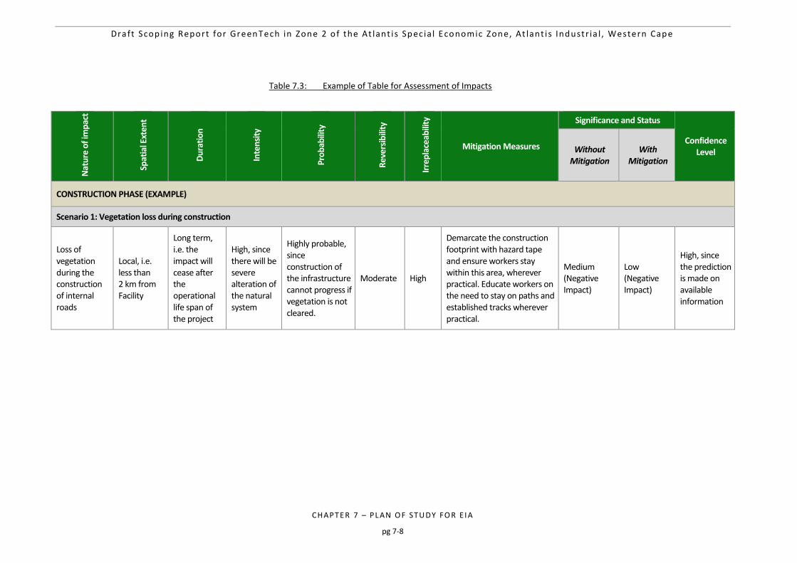
Draft Scop ing Report for GreenTech in Zone 2 o f the At lant i s Spec ia l Economic Zone, At lant i s Industr ia l , Western Cape
CHAPTER 7 – PL AN O F STU DY FO R E I A
pg 7-8
Table 7.3: Example of Table for Assessment of Impacts
Nat
ure
of i
mp
act
Spat
ial E
xten
t
Du
rati
on
Inte
nsi
ty
Pro
bab
ility
Rev
ersi
bili
ty
Irre
pla
ceab
ility
Mitigation Measures
Significance and Status
Confidence Level Without
Mitigation With
Mitigation
CONSTRUCTION PHASE (EXAMPLE)
Scenario 1: Vegetation loss during construction
Loss of vegetation during the construction of internal roads
Local, i.e. less than 2 km from Facility
Long term, i.e. the impact will cease after the operational life span of the project
High, since there will be severe alteration of the natural system
Highly probable, since construction of the infrastructure cannot progress if vegetation is not cleared.
Moderate High
Demarcate the construction footprint with hazard tape and ensure workers stay within this area, wherever practical. Educate workers on the need to stay on paths and established tracks wherever practical.
Medium (Negative Impact)
Low (Negative Impact)
High, since the prediction is made on available information
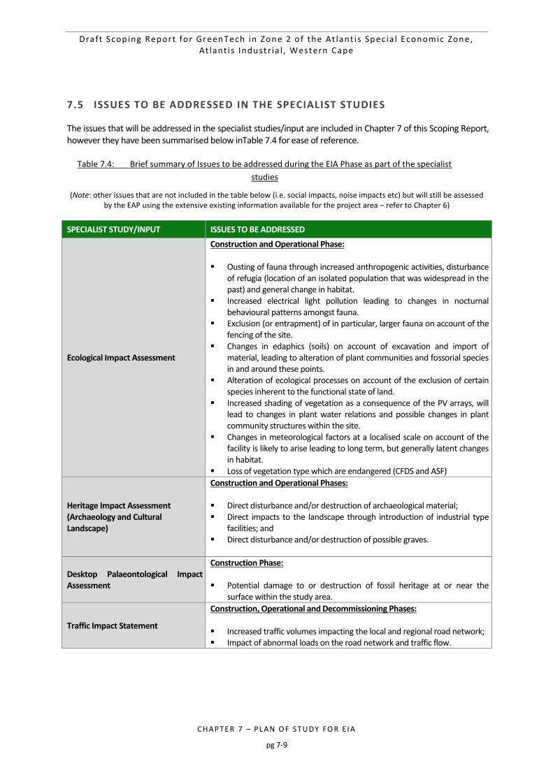
Draft Scop ing Report for GreenTech in Zone 2 o f the At lant i s Spec ia l Economic Zone, At lant i s Industr ia l , Western Cape
CHAPTER 7 – PL AN O F STU DY FO R E I A
pg 7-9
7.5 ISSUES TO BE ADDRESSED IN THE SPECIALIST STUDIES
The issues that will be addressed in the specialist studies/input are included in Chapter 7 of this Scoping Report, however they have been summarised below inTable 7.4 for ease of reference.
Table 7.4: Brief summary of Issues to be addressed during the EIA Phase as part of the specialist
studies
(Note: other issues that are not included in the table below (i.e. social impacts, noise impacts etc) but will still be assessed by the EAP using the extensive existing information available for the project area – refer to Chapter 6)
SPECIALIST STUDY/INPUT ISSUES TO BE ADDRESSED
Ecological Impact Assessment
Construction and Operational Phase: Ousting of fauna through increased anthropogenic activities, disturbance
of refugia (location of an isolated population that was widespread in the past) and general change in habitat.
Increased electrical light pollution leading to changes in nocturnal behavioural patterns amongst fauna.
Exclusion (or entrapment) of in particular, larger fauna on account of the fencing of the site.
Changes in edaphics (soils) on account of excavation and import of material, leading to alteration of plant communities and fossorial species in and around these points.
Alteration of ecological processes on account of the exclusion of certain species inherent to the functional state of land.
Increased shading of vegetation as a consequence of the PV arrays, will lead to changes in plant water relations and possible changes in plant community structures within the site.
Changes in meteorological factors at a localised scale on account of the facility is likely to arise leading to long term, but generally latent changes in habitat.
Loss of vegetation type which are endangered (CFDS and ASF)
Heritage Impact Assessment (Archaeology and Cultural Landscape)
Construction and Operational Phases: Direct disturbance and/or destruction of archaeological material; Direct impacts to the landscape through introduction of industrial type
facilities; and Direct disturbance and/or destruction of possible graves.
Desktop Palaeontological Impact Assessment
Construction Phase: Potential damage to or destruction of fossil heritage at or near the
surface within the study area.
Traffic Impact Statement
Construction, Operational and Decommissioning Phases: Increased traffic volumes impacting the local and regional road network; Impact of abnormal loads on the road network and traffic flow.
Draft Scop ing Report for GreenTech in Zone 2 o f the At lant i s Spec ia l Economic Zone, At lant i s Industr ia l , Western Cape
CHAPTER 7 – PL AN O F STU DY FO R E I A
pg 7-10
7.6 ALTERNATIVES TO BE ASSESSED IN THE EIA PHASE
A description of the alternatives that will be assessed or considered during the EIA Phase is provided in Chapter 6 of this Scoping Report. However, they have been summarised below for ease of reference: No-go Alternative:
o The no-go alternative assumes that the proposed project will not go ahead i.e. it is the option of not constructing the proposed GreenTech facility. This alternative would result in no environmental impacts on the site or surrounding local area, as a result of the facility. It will provide a baseline against which other alternatives will be compared and considered during the EIA Phase.
Land Use Alternative:
o No other manufacturing types were deemed to be appropriate for the site and therefore these technologies will not be further assessed during the EIA Phase. The implementation of a GreenTech facility at the proposed project site is more favourable than other alternative energy facilities and other industrial land uses due to the following:
The support of the green economy in South Africa (and specifically the Western Cape) through the provision of locally manufactured renewable energy technologies.
The proposed GreenTech facility currently falls within the Atlantis SEZ which has been identified by the City of Cape Town as being of strategic importance for industrial and economic development (as discussed in Chapter 1 and Chapter 2 of this Scoping Report);
The zoning of the site as General Industrial allowing for its suitability and reduced sensitivity to sensitive receptors.
Location Alternatives within the Selected Site:
o The selection of the site (i.e. Zone 2 of the Atlantis SEZ) is described in Chapter 6 of this Scoping Report. During the EIA Phase, possible layout plans within the preferred Atlantis GreenTech project site will be discussed.
Technology Alternatives:
o Applicable and relevant technology options will be described during the EIA Phase, such as those relating to different renewable energy technology manufacturing.
Layout Alternatives:
o Layout alternatives for the project will be discussed following the input from the various specialists. The studies will aim to identify various environmental sensitivities present on the preferred site that should be avoided, which will be taken into account during the determination of the proposed layout of the GreenTech facility.
o The use of the existing service roads will also be discussed during the EIA Phase. It is important to note that where alternatives are not feasible or will not be assessed, a motivation has been provided in Chapter 6 of this Scoping Report. The preferred alternatives will be assessed during the EIA Phase.
7.7 TOR FOR THE SPECIALIST STUDIES
The TOR for the specialist studies will essentially consist of the generic assessment requirements and the specific issues identified for each discipline. The TOR will be updated to include relevant comments received from I&APs and authorities during the 30-day review of the Draft Scoping Report. The following additional specialist studies have been identified based on the issues identified to date, as well as potential impacts associated with the project. The TOR for each specialist study is discussed in detail below. The
Draft Scop ing Report for GreenTech in Zone 2 o f the At lant i s Spec ia l Economic Zone, At lant i s Industr ia l , Western Cape
CHAPTER 7 – PL AN O F STU DY FO R E I A
pg 7-11
specialist studies and associated specialists are shown in Table 7.5 below. Additional specialist studies could possibly be commissioned as a result of issues raised during the Scoping Process.
Table 7.5: Specialist Studies and Associates Specialists
NAME ORGANISATION ROLE/STUDY TO BE UNDERTAKEN
Environmental Management Services (CSIR)
Paul Lochner CSIR Technical Advisor and Quality Assurance (EAPSA) Certified
Kelly Stroebel CSIR Project Manager (Appointed EAP)
Rirhandzu Marivate CSIR Project Officer and GIS specialist
Specialists
Paul Emms Bergwind Botanical Surveys and Tours Ecological Impact Assessment (including Terrestrial Ecology)
Christo Bredenhann WSP Traffic Impact Statement
Jonathan Kaplan Agency for Cultural Resource Management (ACRM)
Heritage Impact Assessment
John Pether N/A Desktop Palaeontological Impact Assessment
As explained in Chapter 7 of this Scoping Report, it is important to note at the outset that cumulative impacts will be assessed in the specialist studies (as applicable) by identifying other applicable projects, such as manufacturing facilities in the local area (i.e. within 20 km of the proposed Atlantis GreenTech projects) that have been approved (i.e. positive EA has been issued) or for which an EIA process is currently underway. This Scoping and EIA process will make use of the extensive existing information and studies for the Atlantis area, as previously mentioned in this report. The reason for this is to preserve resources and to avoid the duplication of efforts for studies that have already been conducted. The Atlantis SEZ included a range of pre-feasibility studies which included information on the social, economic and biophysical environment. The Table below indicates the range of existing information and studies that will be used to inform his Scoping and EIA process (Note: this list is not exhaustive and this table will be updated should additional information be used):
Table 7.6: Lisrt of exisiting information and studies that will inform this EIA process
INFORMATION SOURCE AUTHOR/DATE
Basic Assessment (and all associated specialist studies) conducted for proposed ‘green technology manufacturing cluster’ industrial development and associated infrastructure on Portion 0 of Farm CA1183 and Portion 93 of farm CA4, Atlantis
Doug Jeffrey Environmental Consultants (Pty) Ltd - 2012
Basic Assessment (and all associated specialist studies) conducted for proposed ‘green technology manufacturing cluster’ industrial development and associated infrastructure on Farm CA1183, Portion 4 and Portion 1 , Atlantis
Doug Jeffrey Environmental Consultants (Pty) Ltd - 2012
EIA for the proposed Atlantis Gas-to-Power facility on Portion 1 and Portion 4 of Cape Farm 1183, Western Cape
CSIR – 2017
Feasibility Report: Atlantis SEZ Deloitte (commissioned by the Department of Trade and Industry) - 2014
Atlantis Special Economic Zone: Technical Investor Brochure
GreenCape
Economic Analysis of the Proposed Green-tech Special Stratecon - 2015
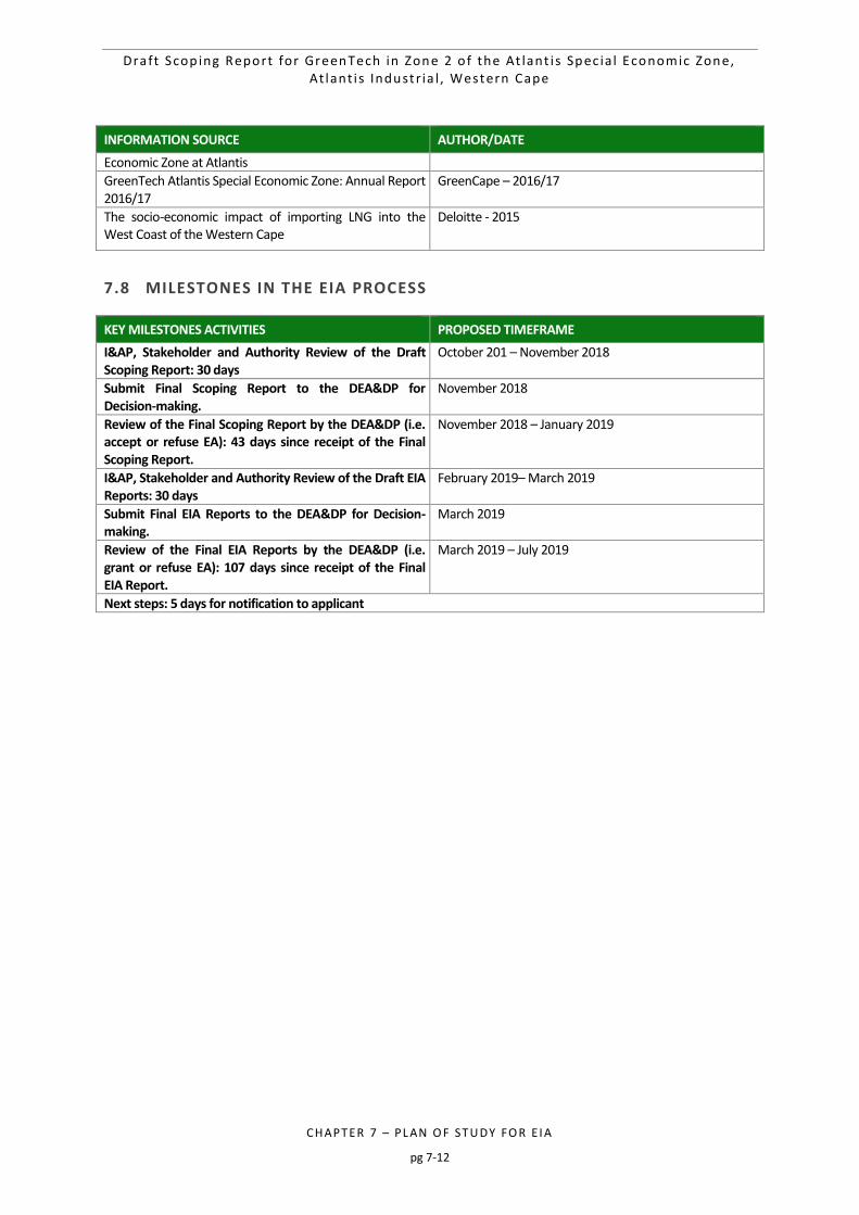
Draft Scop ing Report for GreenTech in Zone 2 o f the At lant i s Spec ia l Economic Zone, At lant i s Industr ia l , Western Cape
CHAPTER 7 – PL AN O F STU DY FO R E I A
pg 7-12
INFORMATION SOURCE AUTHOR/DATE
Economic Zone at Atlantis
GreenTech Atlantis Special Economic Zone: Annual Report 2016/17
GreenCape – 2016/17
The socio-economic impact of importing LNG into the West Coast of the Western Cape
Deloitte - 2015
7.8 MILESTONES IN THE EIA PROCESS
KEY MILESTONES ACTIVITIES PROPOSED TIMEFRAME
I&AP, Stakeholder and Authority Review of the Draft Scoping Report: 30 days
October 201 – November 2018
Submit Final Scoping Report to the DEA&DP for Decision-making.
November 2018
Review of the Final Scoping Report by the DEA&DP (i.e. accept or refuse EA): 43 days since receipt of the Final Scoping Report.
November 2018 – January 2019
I&AP, Stakeholder and Authority Review of the Draft EIA Reports: 30 days
February 2019– March 2019
Submit Final EIA Reports to the DEA&DP for Decision-making.
March 2019
Review of the Final EIA Reports by the DEA&DP (i.e. grant or refuse EA): 107 days since receipt of the Final EIA Report.
March 2019 – July 2019
Next steps: 5 days for notification to applicant


Draft Scop ing Report for GreenTech in Zone 2 o f the At lant i s Spec ia l Economic Zone, At lant i s Industr ia l , Western Cape
CHAPTER 8 – RE FERE NCE S
pg 8-1
8 REFERENCES 8-2
Draft Scop ing Report for GreenTech in Zone 2 o f the At lant i s Spec ia l Economic Zone, At lant i s Industr ia l , Western Cape
CHAPTER 8 – RE FERE NCE S
pg 8-2
8 REFERENCES
Bredenkamp, D.B. & Vandoolaeghe, M.A.C., (1982). Die Ontginbare Grondwater Potensiaal van die Atlantisgebied,
Technical Report GH 3227, Directorate Geohydrology, Department of Water Affairs and Forestry, Pretoria.
City of Cape Town Metropolitan Municipality (CoCT). (2004). Infrastructure Development Plan.
City of Cape Town Metropolitan Municipality (CoCT). (2011). Spatial Development Plan and Environmental Management Framework.
Department of Co-operative Governance, Human Settlements and Traditional Affairs. (2012). Western Cape Provincial Spatial Development Framework. Department of Co-operative Governance, Human Settlements and Traditional Affairs.
Department of Energy (DOE). (2011). TENDER NO: DOE/001/2011/2012, PART C: EVALUATION CRITERIA, Section 1.4.
Department of Environmental Affairs and Development Planning (DEADP). (2010). Guideline on Need and Desirability, EIA Guideline and Information Document Series. Western Cape Department of Environmental Affairs and Development Planning.
Department of Water Affairs and Forestry (DWAF). (2002). 1:500 000 Hydrogeological map series of the Republic of South Africa. Cape Town, 3318.
GLVIA. 2002. Guidelines for Landscape and Visual Impact Assessment. 2nd ed. United Kingdom: Spon Press.
Holmes, P., Stipinovich, A. & Purves, A. 2012. City of Cape Town Biodiversity Network: Methods and results technical report. City of Cape Town Municipality, Economic, Environmental and Spatial Planning Directorate, Environmental Resource Management Department. January 2012.
IUCN Red List of Threatened Species. 2013. www.iucnredlist.org
Johnson, M. R., Anhaeusser, C.R. and Thomas, R.J. eds. 2006. The Geology of South Africa. Geological Society of South Africa, Johannesburg/Council of Geoscience, Pretoria.
Mucina, L. and Rutherford, M. (2006). “The Vegetation of South Africa, Swaziland and Lesotho”. Strelitzia.
Murray, E.C. and Saayman, I. (2000): Geohydrological Investigation for Pebble Bed Modular Reactor Project, Koeberg Nuclear Power Station, Report submitted to Jones and Wagener for Eskom, CSIR Report ENV/S-C 2000-084, July 2000, CSIR, Western Cape.
National Water Act. (1998). The National Water Act, No 36.Department of Water Affair and Forestry. Pretoria.
Oberholzer, B. (2005). Guideline for Involving Visual & Aesthetic Specialists in EIA Processes. Guidelines ENV-S-C 2005 053 F. Cape Town: CSIR, Provincial Government of the Western Cape, Department of Environmental Affairs & Development. http://www.capegateway.gov.za/Text/2005/10/5_deadp_visual_guideline_june05.pdf.
SANBI (2014) Species Status Database. Retrieved Available online at: http://www.speciesstatus.sanbi.org/reports/Conservation.aspx?SPID=195 (Accessed 4 February 2015)
SANBI (2015) BGIS Database. Available online at: http://bgis.sanbi.org/nfepa/NFEPAmap.asp (Accessed on 3 March 2015)
Draft Scop ing Report for GreenTech in Zone 2 o f the At lant i s Spec ia l Economic Zone, At lant i s Industr ia l , Western Cape
CHAPTER 8 – RE FERE NCE S
pg 8-3
Schultze, R.E. (1997). South African Atlas of Agrohydrology and –Climatology, Water Research Commission, Report TT82/96, Pretoria.
Schulze R.E., Maharaj M., Warburton, M.L., Gers, C.J., Horan, M.J.C., Kunz, R.P., and Clark, D.J. (2008). South African Atlas of climatology and agrohydrology. Water Research Commission 1489/1/08.
South Africa. 1993. Occupational Health and Safety Act No. 85 of 1993.
South Africa. 1998. National Environmental Management Act No. 107 of 1998.
South Africa. 2004. National Environmental Management: Biodiversity Act No.10 of 2004.
South Africa. 2014a. Special Economic Zones Act No. 16 of 2014.
South Africa. 2014b. Environmental Impact Assessment Regulations, 2014. (Notice 982). Government Gazette, 38282, 4 Dec.
Visser, H.N., (1992). Geological Report on the Koeberg Nuclear Power Station Site at Duynefontein 34, Specialist Geological Report No. NSIP-K8G-003000P1-15, Geological Survey, Cape Town
Water Research Commission. Undated. South African Rain Atlas available at http://134.76.173.220/rainfall/index.html.
Worldweatheronline.com. 2015. Atlantis Monthly Climate Average, South Africa. [Url] http://www.worldweatheronline.com/Atlantis-weather-averages/Western-Cape/ZA.aspx. [Date accessed: 13 July, 2015.]
APPE NDI X A – E AP CV s a n d EAP d ec l ara t io n
pg 0
APPE NDI X A – E AP CV s a n d EAP d ec l ara t io n
pg 1
Draft Scop ing Report for GreenTech in Zone 2 o f the At lant i s Spec ia l Economic Zone, At lant i s Industr ia l , Western Cape
APPE NDI X A – E AP CV s a n d EAP d ec l ara t io n
pg 1
1 CURRICULUM VITAE OF PAUL LOCHNER – PROJECT LEADER 2
2 CURRICULUM VITAE OF KELLY STROEBEL – PROJECT MANAGER 10
3 CURRICULUM VITAE OF RIRHANDZU MARIVATE – PROJECT MEMBER 13
4 EAP DECLARATION 17
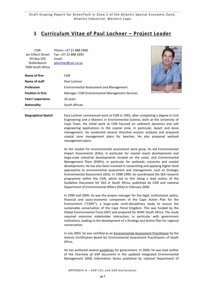
Draft Scop ing Report for GreenTech in Zone 2 o f the At lant i s Spec ia l Economic Zone, At lant i s Industr ia l , Western Cape
APPE NDI X A – E AP CV s a n d EAP d ec l ara t io n
pg 2
1 Curriculum Vitae of Paul Lochner – Project Leader
CSIR Jan Cilliers Street
PO Box 320 Stellenbosch
7600 South Africa
Phone: +27 21 888 2400 Fax: +27 21 888 2693 Email: [email protected]
Name of firm CSIR
Name of staff Paul Lochner
Profession Environmental Assessment and Management
Position in firm Manager: CSIR Environmental Management Services
Years’ experience 24 years
Nationality South African
Biographical Sketch
Paul Lochner commenced work at CSIR in 1992, after completing a degree in Civil Engineering and a Masters in Environmental Science, both at the University of Cape Town. His initial work at CSIR focused on sediment dynamics and soft engineering applications in the coastal zone, in particular, beach and dune management. He conducted several shoreline erosion analyses and prepared coastal zone management plans for beaches. He also prepared wetland management plans. As the market for environmental assessment work grew, he led Environmental Impact Assessments (EIAs), in particular for coastal resort developments and large-scale industrial developments located on the coast; and Environmental Management Plans (EMPs), in particular for wetlands, estuaries and coastal developments. He has also been involved in researching and applying higher-level approaches to environmental assessment and management, such as Strategic Environmental Assessment (SEA). In 1998-1999, he coordinated the SEA research programme within the CSIR, which led to him being a lead author of the Guideline Document for SEA in South Africa, published by CSIR and national Department of Environmental Affairs (DEA) in February 2000. In 1999 and 2000, he was the project manager for the legal, institutional, policy, financial and socio-economic component of the Cape Action Plan for the Environment (“CAPE”), a large-scale multi-disciplinary study to ensure the sustainable conservation of the Cape Floral Kingdom. This was funded by the Global Environmental Fund (GEF) and prepared for WWF-South Africa. The study required extensive stakeholder interaction, in particular with government institutions, leading to the development of a Strategy and Action Plan for regional conservation. In July 2003, he was certified as an Environmental Assessment Practitioner by the Interim Certification Board for Environmental Assessment Practitioners of South Africa. He has authored several guidelines for government. In 2004, he was lead author of the Overview of IEM document in the updated Integrated Environmental Management (IEM) Information Series published by national Department of
Draft Scop ing Report for GreenTech in Zone 2 o f the At lant i s Spec ia l Economic Zone, At lant i s Industr ia l , Western Cape
APPE NDI X A – E AP CV s a n d EAP d ec l ara t io n
pg 3
Environmental Affairs and Tourism (DEAT). In 2005, he was part of the CSIR team that prepared the series entitled Guidelines for involving specialists in EIA processes for the Western Cape Department of Environmental Affairs and Development Planning (DEADP); and he authored the Guideline for Environmental Management Plans published by Western Cape government in 2005. In 2006-2007, he worked closely with the (then) Dept of Minerals and Energy (DME) of South Africa to prepare a Guideline for Scoping, Environmental Impact Assessment and Environmental Management Plans for mining in South Africa. Over the past 20 years has been closely involved with several environmental studies for industrial and port-related projects in Coega Industrial Development Zone (IDZ), near Port Elizabeth. This included the SEA for the establishment of the Coega IDZ in 1996/7, an EIA and EMP for a proposed aluminium smelter in 2002/3, and assistance with environmental permit applications for air, water and waste. At the Coega IDZ and port, he has also conducted environmental assessments for port development, LNG storage and a combined cycle gas turbine power plant, manganese export, rail development, marine pipelines, and wind energy projects. Since 2009, he has undertaken numerous EIAs for the renewable energy sector, in particular for wind and solar photovoltaic energy projects. In these EIAs, he has been project leader and integrated the specialist findings from a range of specialist disciplines. He is currently project leader on two Strategic Environmental Assessments (SEAs) that are being undertaken for national DEA. These SEAs are to support the implementation of the Strategic Integrated Projects (SIPs) that are being promoted by the Presidential Infrastructure Coordinating Committee (PICC). The SEA for Wind and Solar Photovoltaic Energy for South Africa is being conducted over 2013-2014, and the SEA for electricity grid infrastructure commenced January 2014. Since 2009, Paul has been the manager of the Environmental Management Services (EMS) group within CSIR. This group currently consists of approximately 20 environmental assessment practitioners and a group assistant, with offices in Stellenbosch and Durban. EMS focuses on conducting complex environmental studies in challenging environments, such as remote and data poor regions in Africa (e.g. Cameroon, Gabon, Angola, Namibia and Ethiopia). We also specialise in environmental studies for emerging and innovative technologies, drawing on research and applied scientific expertise within CSIR. Our role is to assist in ensuring the sustainability of projects in terms of environmental and social criteria, by providing a range of environmental services that extend across the project lifecycle, from the pre-feasibility stage through to feasibility, commissioning, operations and closure. We provide this service to government, international agencies, private sector and non-government organisations.
EMPLOYMENT TRACK RECORD
The following table presents a sample of the projects that Paul Lochner has been involved in to this date:
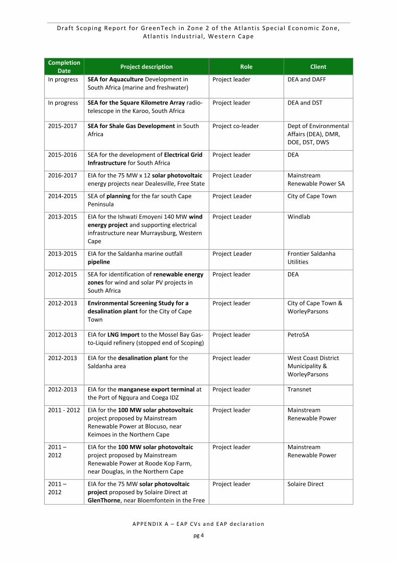
Draft Scop ing Report for GreenTech in Zone 2 o f the At lant i s Spec ia l Economic Zone, At lant i s Industr ia l , Western Cape
APPE NDI X A – E AP CV s a n d EAP d ec l ara t io n
pg 4
Completion Date
Project description Role Client
In progress SEA for Aquaculture Development in South Africa (marine and freshwater)
Project leader DEA and DAFF
In progress SEA for the Square Kilometre Array radio-telescope in the Karoo, South Africa
Project leader DEA and DST
2015-2017 SEA for Shale Gas Development in South Africa
Project co-leader Dept of Environmental Affairs (DEA), DMR, DOE, DST, DWS
2015-2016 SEA for the development of Electrical Grid Infrastructure for South Africa
Project leader DEA
2016-2017 EIA for the 75 MW x 12 solar photovoltaic energy projects near Dealesville, Free State
Project Leader Mainstream Renewable Power SA
2014-2015 SEA of planning for the far south Cape Peninsula
Project Leader City of Cape Town
2013-2015 EIA for the Ishwati Emoyeni 140 MW wind energy project and supporting electrical infrastructure near Murraysburg, Western Cape
Project Leader Windlab
2013-2015 EIA for the Saldanha marine outfall pipeline
Project Leader Frontier Saldanha Utilities
2012-2015 SEA for identification of renewable energy zones for wind and solar PV projects in South Africa
Project leader DEA
2012-2013 Environmental Screening Study for a desalination plant for the City of Cape Town
Project leader City of Cape Town & WorleyParsons
2012-2013 EIA for LNG Import to the Mossel Bay Gas-to-Liquid refinery (stopped end of Scoping)
Project leader PetroSA
2012-2013 EIA for the desalination plant for the Saldanha area
Project leader West Coast District Municipality & WorleyParsons
2012-2013 EIA for the manganese export terminal at the Port of Ngqura and Coega IDZ
Project leader Transnet
2011 - 2012 EIA for the 100 MW solar photovoltaic project proposed by Mainstream Renewable Power at Blocuso, near Keimoes in the Northern Cape
Project leader Mainstream Renewable Power
2011 – 2012
EIA for the 100 MW solar photovoltaic project proposed by Mainstream Renewable Power at Roode Kop Farm, near Douglas, in the Northern Cape
Project leader Mainstream Renewable Power
2011 – 2012
EIA for the 75 MW solar photovoltaic project proposed by Solaire Direct at GlenThorne, near Bloemfontein in the Free
Project leader Solaire Direct
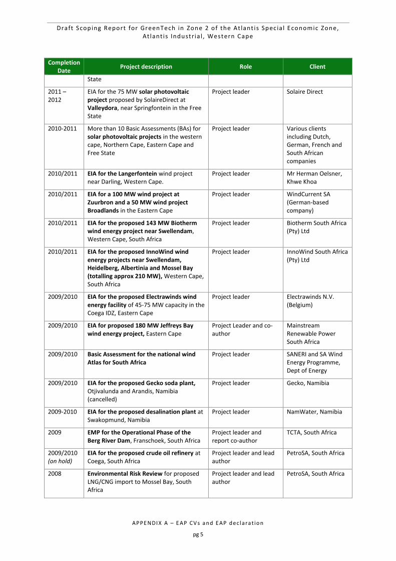
Draft Scop ing Report for GreenTech in Zone 2 o f the At lant i s Spec ia l Economic Zone, At lant i s Industr ia l , Western Cape
APPE NDI X A – E AP CV s a n d EAP d ec l ara t io n
pg 5
Completion Date
Project description Role Client
State
2011 – 2012
EIA for the 75 MW solar photovoltaic project proposed by SolaireDirect at Valleydora, near Springfontein in the Free State
Project leader Solaire Direct
2010-2011 More than 10 Basic Assessments (BAs) for solar photovoltaic projects in the western cape, Northern Cape, Eastern Cape and Free State
Project leader Various clients including Dutch, German, French and South African companies
2010/2011 EIA for the Langerfontein wind project near Darling, Western Cape.
Project leader Mr Herman Oelsner, Khwe Khoa
2010/2011
EIA for a 100 MW wind project at Zuurbron and a 50 MW wind project Broadlands in the Eastern Cape
Project leader WindCurrent SA (German-based company)
2010/2011
EIA for the proposed 143 MW Biotherm wind energy project near Swellendam, Western Cape, South Africa
Project leader Biotherm South Africa (Pty) Ltd
2010/2011
EIA for the proposed InnoWind wind energy projects near Swellendam, Heidelberg, Albertinia and Mossel Bay (totalling approx 210 MW), Western Cape, South Africa
Project leader InnoWind South Africa (Pty) Ltd
2009/2010
EIA for the proposed Electrawinds wind energy facility of 45-75 MW capacity in the Coega IDZ, Eastern Cape
Project leader Electrawinds N.V. (Belgium)
2009/2010
EIA for proposed 180 MW Jeffreys Bay wind energy project, Eastern Cape
Project Leader and co-author
Mainstream Renewable Power South Africa
2009/2010 Basic Assessment for the national wind Atlas for South Africa
Project leader SANERI and SA Wind Energy Programme, Dept of Energy
2009/2010 EIA for the proposed Gecko soda plant, Otjivalunda and Arandis, Namibia (cancelled)
Project leader Gecko, Namibia
2009-2010
EIA for the proposed desalination plant at Swakopmund, Namibia
Project leader NamWater, Namibia
2009 EMP for the Operational Phase of the Berg River Dam, Franschoek, South Africa
Project leader and report co-author
TCTA, South Africa
2009/2010 (on hold)
EIA for the proposed crude oil refinery at Coega, South Africa
Project leader and lead author
PetroSA, South Africa
2008 Environmental Risk Review for proposed LNG/CNG import to Mossel Bay, South Africa
Project leader and lead author
PetroSA, South Africa
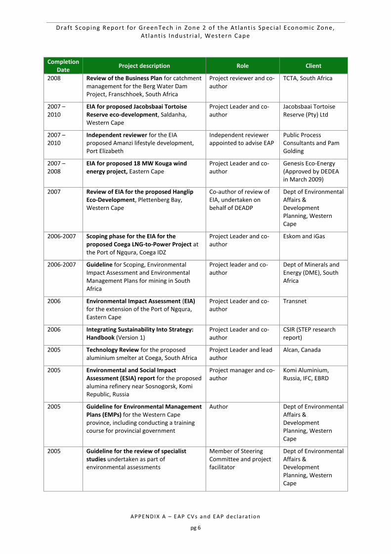
Draft Scop ing Report for GreenTech in Zone 2 o f the At lant i s Spec ia l Economic Zone, At lant i s Industr ia l , Western Cape
APPE NDI X A – E AP CV s a n d EAP d ec l ara t io n
pg 6
Completion Date
Project description Role Client
2008 Review of the Business Plan for catchment management for the Berg Water Dam Project, Franschhoek, South Africa
Project reviewer and co-author
TCTA, South Africa
2007 – 2010
EIA for proposed Jacobsbaai Tortoise Reserve eco-development, Saldanha, Western Cape
Project Leader and co-author
Jacobsbaai Tortoise Reserve (Pty) Ltd
2007 – 2010
Independent reviewer for the EIA proposed Amanzi lifestyle development, Port Elizabeth
Independent reviewer appointed to advise EAP
Public Process Consultants and Pam Golding
2007 – 2008
EIA for proposed 18 MW Kouga wind energy project, Eastern Cape
Project Leader and co-author
Genesis Eco-Energy (Approved by DEDEA in March 2009)
2007 Review of EIA for the proposed Hanglip Eco-Development, Plettenberg Bay, Western Cape
Co-author of review of EIA, undertaken on behalf of DEADP
Dept of Environmental Affairs & Development Planning, Western Cape
2006-2007
Scoping phase for the EIA for the proposed Coega LNG-to-Power Project at the Port of Ngqura, Coega IDZ
Project Leader and co-author
Eskom and iGas
2006-2007
Guideline for Scoping, Environmental Impact Assessment and Environmental Management Plans for mining in South Africa
Project leader and co-author
Dept of Minerals and Energy (DME), South Africa
2006 Environmental Impact Assessment (EIA) for the extension of the Port of Ngqura, Eastern Cape
Project Leader and co-author
Transnet
2006 Integrating Sustainability Into Strategy: Handbook (Version 1)
Project Leader and co-author
CSIR (STEP research report)
2005 Technology Review for the proposed aluminium smelter at Coega, South Africa
Project Leader and lead author
Alcan, Canada
2005 Environmental and Social Impact Assessment (ESIA) report for the proposed alumina refinery near Sosnogorsk, Komi Republic, Russia
Project manager and co-author
Komi Aluminium, Russia, IFC, EBRD
2005 Guideline for Environmental Management Plans (EMPs) for the Western Cape province, including conducting a training course for provincial government
Author Dept of Environmental Affairs & Development Planning, Western Cape
2005 Guideline for the review of specialist studies undertaken as part of environmental assessments
Member of Steering Committee and project facilitator
Dept of Environmental Affairs & Development Planning, Western Cape
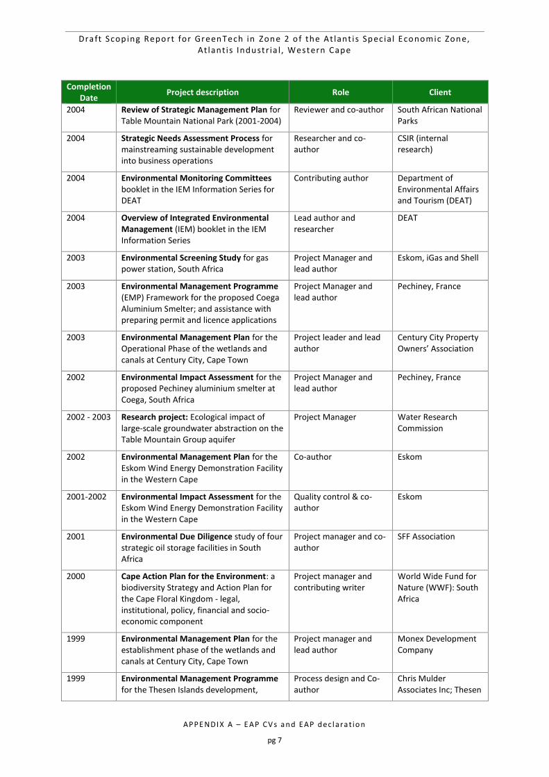
Draft Scop ing Report for GreenTech in Zone 2 o f the At lant i s Spec ia l Economic Zone, At lant i s Industr ia l , Western Cape
APPE NDI X A – E AP CV s a n d EAP d ec l ara t io n
pg 7
Completion Date
Project description Role Client
2004 Review of Strategic Management Plan for Table Mountain National Park (2001-2004)
Reviewer and co-author South African National Parks
2004 Strategic Needs Assessment Process for mainstreaming sustainable development into business operations
Researcher and co-author
CSIR (internal research)
2004 Environmental Monitoring Committees booklet in the IEM Information Series for DEAT
Contributing author Department of Environmental Affairs and Tourism (DEAT)
2004 Overview of Integrated Environmental Management (IEM) booklet in the IEM Information Series
Lead author and researcher
DEAT
2003 Environmental Screening Study for gas power station, South Africa
Project Manager and lead author
Eskom, iGas and Shell
2003 Environmental Management Programme (EMP) Framework for the proposed Coega Aluminium Smelter; and assistance with preparing permit and licence applications
Project Manager and lead author
Pechiney, France
2003 Environmental Management Plan for the Operational Phase of the wetlands and canals at Century City, Cape Town
Project leader and lead author
Century City Property Owners’ Association
2002 Environmental Impact Assessment for the proposed Pechiney aluminium smelter at Coega, South Africa
Project Manager and lead author
Pechiney, France
2002 - 2003 Research project: Ecological impact of large-scale groundwater abstraction on the Table Mountain Group aquifer
Project Manager Water Research Commission
2002 Environmental Management Plan for the Eskom Wind Energy Demonstration Facility in the Western Cape
Co-author Eskom
2001-2002 Environmental Impact Assessment for the Eskom Wind Energy Demonstration Facility in the Western Cape
Quality control & co-author
Eskom
2001 Environmental Due Diligence study of four strategic oil storage facilities in South Africa
Project manager and co-author
SFF Association
2000 Cape Action Plan for the Environment: a biodiversity Strategy and Action Plan for the Cape Floral Kingdom - legal, institutional, policy, financial and socio-economic component
Project manager and contributing writer
World Wide Fund for Nature (WWF): South Africa
1999 Environmental Management Plan for the establishment phase of the wetlands and canals at Century City, Cape Town
Project manager and lead author
Monex Development Company
1999 Environmental Management Programme for the Thesen Islands development,
Process design and Co-author
Chris Mulder Associates Inc; Thesen
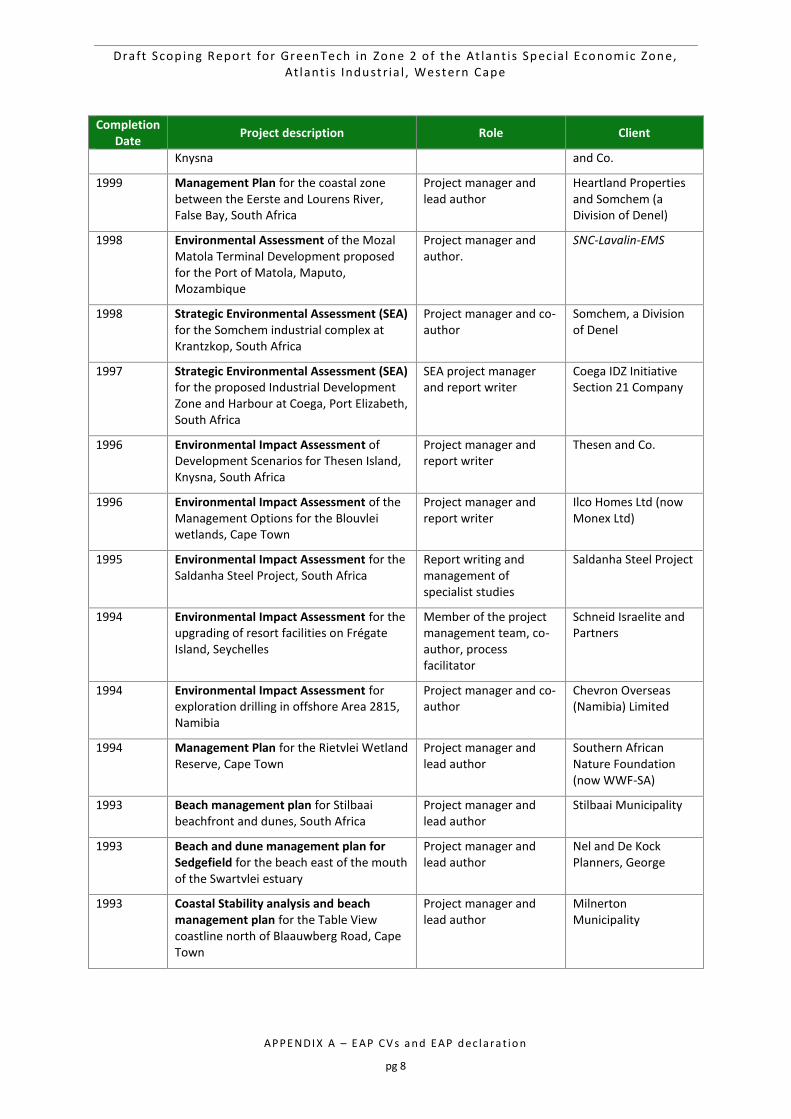
Draft Scop ing Report for GreenTech in Zone 2 o f the At lant i s Spec ia l Economic Zone, At lant i s Industr ia l , Western Cape
APPE NDI X A – E AP CV s a n d EAP d ec l ara t io n
pg 8
Completion Date
Project description Role Client
Knysna and Co.
1999 Management Plan for the coastal zone between the Eerste and Lourens River, False Bay, South Africa
Project manager and lead author
Heartland Properties and Somchem (a Division of Denel)
1998 Environmental Assessment of the Mozal Matola Terminal Development proposed for the Port of Matola, Maputo, Mozambique
Project manager and author.
SNC-Lavalin-EMS
1998 Strategic Environmental Assessment (SEA) for the Somchem industrial complex at Krantzkop, South Africa
Project manager and co-author
Somchem, a Division of Denel
1997 Strategic Environmental Assessment (SEA) for the proposed Industrial Development Zone and Harbour at Coega, Port Elizabeth, South Africa
SEA project manager and report writer
Coega IDZ Initiative Section 21 Company
1996 Environmental Impact Assessment of Development Scenarios for Thesen Island, Knysna, South Africa
Project manager and report writer
Thesen and Co.
1996 Environmental Impact Assessment of the Management Options for the Blouvlei wetlands, Cape Town
Project manager and report writer
Ilco Homes Ltd (now Monex Ltd)
1995 Environmental Impact Assessment for the Saldanha Steel Project, South Africa
Report writing and management of specialist studies
Saldanha Steel Project
1994 Environmental Impact Assessment for the upgrading of resort facilities on Frégate Island, Seychelles
Member of the project management team, co-author, process facilitator
Schneid Israelite and Partners
1994 Environmental Impact Assessment for exploration drilling in offshore Area 2815, Namibia
Project manager and co-author
Chevron Overseas (Namibia) Limited
1994 Management Plan for the Rietvlei Wetland Reserve, Cape Town
Project manager and lead author
Southern African Nature Foundation (now WWF-SA)
1993 Beach management plan for Stilbaai beachfront and dunes, South Africa
Project manager and lead author
Stilbaai Municipality
1993 Beach and dune management plan for Sedgefield for the beach east of the mouth of the Swartvlei estuary
Project manager and lead author
Nel and De Kock Planners, George
1993 Coastal Stability analysis and beach management plan for the Table View coastline north of Blaauwberg Road, Cape Town
Project manager and lead author
Milnerton Municipality
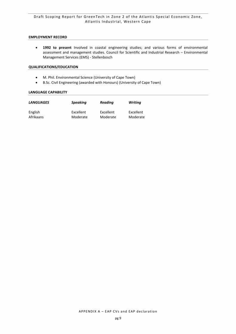
Draft Scop ing Report for GreenTech in Zone 2 o f the At lant i s Spec ia l Economic Zone, At lant i s Industr ia l , Western Cape
APPE NDI X A – E AP CV s a n d EAP d ec l ara t io n
pg 9
EMPLOYMENT RECORD
1992 to present Involved in coastal engineering studies; and various forms of environmental assessment and management studies. Council for Scientific and Industrial Research – Environmental Management Services (EMS) - Stellenbosch
QUALIFICATIONS/EDUCATION
M. Phil. Environmental Science (University of Cape Town)
B.Sc. Civil Engineering (awarded with Honours) (University of Cape Town) LANGUAGE CAPABILITY
LANGUAGES Speaking Reading Writing English Excellent Excellent Excellent Afrikaans Moderate Moderate Moderate
Draft Scop ing Report for GreenTech in Zone 2 o f the At lant i s Spec ia l Economic Zone, At lant i s Industr ia l , Western Cape
APPE NDI X A – E AP CV s a n d EAP d ec l ara t io n
pg 10
2 Curriculum Vitae of Kelly Stroebel – Project Manager
CSIR
Jan Cilliers Street PO Box 320
Stellenbosch 7600 South Africa
Phone: +27 21 888 2400 Fax: +27 21 888 2693 Email: [email protected]
Name of firm CSIR
Name of staff Kelly Stroebel
Profession Environmental Assessment Practitioner
Position in firm Environmental Assessment Practitioner
Years’ experience 4 years
Nationality South African
Biographical Sketch
Kelly holds a Bachelor of Science with Honours in Environmental Science from Rhodes University in Grahamstown and is currently pursuing a Masters at the University of Stellenbosch. Her undergraduate degree was a Bachelor of Science with majors in Environmental Science and Zoology. She is currently working as an environmental assessment practitioner at the Council for Scientific and Industrial Research (CSIR). Kelly has been the Project Manager of several EIA’s in South Africa and several Basic Assessments for the Special Needs and Skills Development Programme. She has assisted in the SIP projects including the National Wind & Solar Strategic Environmental Assessment (SEA) and Electricity Grid Infrastructure SEA as SEA which were commissioned by the national Department of Environmental Affairs. On a personal level, Kelly enjoys the outdoors, traveling and SCUBA diving and is passionate about the field of environmental science and management.
EMPLOYMENT TRACK RECORD
The following table presents a sample of the projects that Kelly Stroebel has been involved in to this date:
Completion Date
Project description Role Client
2017 EIA for gas-to-power in the Atlantis SEZ
Project Manager/EAP CoCT/GreenCape
In progress EIA’s in the South African energy sector
Project Manager/EAP Private energy companies and organs of state
In progress Special Needs and Skills Development Programme (DEA-CSIR)
Project Manager conducting Environmental services such as basic Assessments and Environmental Screening Studies.
Various SMME’s and Community Trusts
2015 Strategic Environmental Assessment (SEA) for Electricity Grid Infrastructure
Project member-stakeholder engagement and project support.
National Department of Environmental Affairs
2015 EIA for two proposed Project member- Public Umgeni Water
Draft Scop ing Report for GreenTech in Zone 2 o f the At lant i s Spec ia l Economic Zone, At lant i s Industr ia l , Western Cape
APPE NDI X A – E AP CV s a n d EAP d ec l ara t io n
pg 11
Completion Date
Project description Role Client
Desalination plants on the KZN coast.
Participation Process, stakeholder engagement and project support.
August 2014
National Strategy for Sustainable Development Review (NSSD1)
Project member- research and report development.
National Department of Environmental Affairs
2013-2014 Strategic Environmental Assessment (SEA) for roll out of photovoltaic solar and wind energy in South Africa.
Project member- Stakeholder engagement and project support
National Department of Environmental Affairs
EMPLOYMENT RECORD
2015 to present Environmental Scientist and Assessment Practitioner. Council for Scientific and Industrial Research – Consulting and Analytical Services (CAS) - Stellenbosch
2014 Environmental Scientist and Assessment Practitioner (Intern). Council for Scientific and Industrial Research – Consulting and Analytical Services (CAS) - Stellenbosch
2013 Environmental Education Counselor - Fernwood Cove Summer Camp, USA.
2012 Graduate Assistant: Rhodes University Department of Environmental Science.
2011 Vacation Internship: Environmental Management Department of Mittal Steel, Newcastle.
2011 Vacation Internship: Northern Kwa-Zulu Natal branch of WWF. QUALIFICATIONS/EDUCATION
BSc Hons. Environmental Science (Rhodes University, Grahamstown, South Africa) o Honours modules including Environmental Impact Assessment, Statistics, Climate Change
Adaptation, Urban Ecology and Environmental Water Quality. o Honours thesis: “Water use and conservation by households of different economic status in
King Willliam’s Town”
Bachelor of Science with Distinction (Rhodes University, Grahamstown, South Africa) o Undergraduate courses including Environmental Science, Zoology, Ichthyology, Chemistry,
Earth Science, Botany and Computer Science.
IEB Matric Certificate, 5 Distinctions (St Dominic’s Academy, Newcastle) TRAINING, CONFERENCES AND PROFFESIONAL REGISTRATIONS
Member of the Conference Organizing Committee (COC) for the IAIAsa Annual Conference 2017
Project Management Practices and Principles with MS projects with the University of Pretoria: Distinction obtained (2016)
Introduction to Earth Observation using ENVI with the University of Stellenbosch (2016)
Public Participation Course with IAP2 (2016)
Conflict Management Accredited through Conflict Dynamics (2015)
Media and Science Training Accreditation through Jive Media Africa (2015)
IAIA WC Workshop for Integrating Climate Change into EIA practice (2015)
Presented on the DEA-CSIR “Special Needs and Skills Development Programme” at the 2014 & 2015 Annual IAIA (International Association for Impact Assessment) South Africa Conference.
Environmental Impact Assessment Training Course accreditation through Coastal and Environmental Services, Grahamstown (2012)
Draft Scop ing Report for GreenTech in Zone 2 o f the At lant i s Spec ia l Economic Zone, At lant i s Industr ia l , Western Cape
APPE NDI X A – E AP CV s a n d EAP d ec l ara t io n
pg 12
DEA&DP Training on the EIA Regulations (2014)
Registered as a Candidate Natural Scientist with the South African Council for Natural Scientific Professions (SACNASP) (Reg #: 100151/14)
Member of the South African Affiliate of the International Association for Impact Assessment (Membership no: 3588 )
LANGUAGE CAPABILITY
LANGUAGES Speaking Reading Writing English Excellent Excellent Excellent Afrikaans Moderate Moderate Moderate
Draft Scop ing Report for GreenTech in Zone 2 o f the At lant i s Spec ia l Economic Zone, At lant i s Industr ia l , Western Cape
APPE NDI X A – E AP CV s a n d EAP d ec l ara t io n
pg 13
3 Curriculum Vitae of Rirhandzu Marivate – Project Member
PO Box 320 Stellenbosch 7599 South Africa
Office : +27 21 888 2432 Cell : +27 76 183 0642 Fax : +27 21 888 2473 Email : [email protected]
Position in Firm: Junior Environmental Assessment Practitioner (305759) Full Name: Marivate, Rirhandzu Anna Specialisation: Environmental & Ecological Science Professional Registration: Cand. Sci. Nat. Environmental Sciences – Reg Number: 100147/14 Date of Birth: 23 February 1989 Nationality: South African BIOSKETCH
Rirhandzu holds a Bachelor degree in Zoology & Geology, Honours in Ecology, Environment and Conservation from the University of the Witwatersrand; and has environmental research experience with the Climate Systems Analysis Group at the University of Cape Town. The research focus has been within the domain of socioecology, looking at investigating local ecological knowledge of stakeholders on the provisioning of freshwater resources and its impacts on the management for of the Berg river in the Western Cape, South Africa. The research looked at how perception on resource utilisation affects management priorities, and creating a matrix of perceptions would be used a tool for better decision making within the Berg River Catchment Management Areas. Rirhandzu is currently studying towards her Master in Philosophy in Sustainable Development at the University of Stellenbosch. Here current research interest is looking at environmental planning and management within municipalities and how to optimise green spaces by including ecosystem goods and services to build resilience within those municipalities. Since 2014, Rirhandzu has worked at the Council for Scientific and Industrial Research (CSIR) as an Environmental Assessment Practitioner (EAP) Intern within the Environmental Management Services (EMS) group, and from 2015 as a Junior Environmental Practitioner for the same group. Her duties include Assistance to other EAPs within EMS in their projects; Research in environmental assessment topics (e.g. indications, best practice, legislation); Report writing and project management; Participating in various forms of environmental assessments (BAs, EIAs, SEAs); consultation with stakeholders and public meetings; and Project administration (e.g. contracting and invoicing). She is particularly involved with the Special Needs and Skills Development (SNSD) Programme, which looks at assisting Community Trusts, Small, Micro to Medium Enterprises, with environmental services. She has also been involved with the Monitoring and Evaluation of the National Strategy for Sustainable Development by the Department of Environmental Affairs (DEA). Rirhandzu has established good client relationships and partnerships with the Land Bank, Department of Agriculture, Forestry and Fisheries (DAFF), and Department of Mineral Resources (DMR) through the SNSD Programme. She is involved as a stakeholder in the continuous consultations for the Development of Environmental Indices in response to the National Development Plan (NDP), led by the DEA.
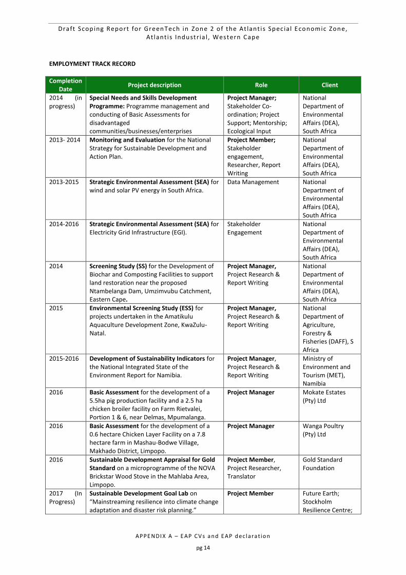
Draft Scop ing Report for GreenTech in Zone 2 o f the At lant i s Spec ia l Economic Zone, At lant i s Industr ia l , Western Cape
APPE NDI X A – E AP CV s a n d EAP d ec l ara t io n
pg 14
EMPLOYMENT TRACK RECORD
Completion Date
Project description Role Client
2014 (in progress)
Special Needs and Skills Development Programme: Programme management and conducting of Basic Assessments for disadvantaged communities/businesses/enterprises
Project Manager; Stakeholder Co-ordination; Project Support; Mentorship; Ecological Input
National Department of Environmental Affairs (DEA), South Africa
2013- 2014 Monitoring and Evaluation for the National Strategy for Sustainable Development and Action Plan.
Project Member; Stakeholder engagement, Researcher, Report Writing
National Department of Environmental Affairs (DEA), South Africa
2013-2015 Strategic Environmental Assessment (SEA) for wind and solar PV energy in South Africa.
Data Management National Department of Environmental Affairs (DEA), South Africa
2014-2016 Strategic Environmental Assessment (SEA) for Electricity Grid Infrastructure (EGI).
Stakeholder Engagement
National Department of Environmental Affairs (DEA), South Africa
2014 Screening Study (SS) for the Development of Biochar and Composting Facilities to support land restoration near the proposed Ntambelanga Dam, Umzimvubu Catchment, Eastern Cape.
Project Manager, Project Research & Report Writing
National Department of Environmental Affairs (DEA), South Africa
2015 Environmental Screening Study (ESS) for projects undertaken in the Amatikulu Aquaculture Development Zone, KwaZulu-Natal.
Project Manager, Project Research & Report Writing
National Department of Agriculture, Forestry & Fisheries (DAFF), S Africa
2015-2016 Development of Sustainability Indicators for the National Integrated State of the Environment Report for Namibia.
Project Manager, Project Research & Report Writing
Ministry of Environment and Tourism (MET), Namibia
2016 Basic Assessment for the development of a 5.5ha pig production facility and a 2.5 ha chicken broiler facility on Farm Rietvalei, Portion 1 & 6, near Delmas, Mpumalanga.
Project Manager Mokate Estates (Pty) Ltd
2016 Basic Assessment for the development of a 0.6 hectare Chicken Layer Facility on a 7.8 hectare farm in Mashau-Bodwe Village, Makhado District, Limpopo.
Project Manager Wanga Poultry (Pty) Ltd
2016 Sustainable Development Appraisal for Gold Standard on a microprogramme of the NOVA Brickstar Wood Stove in the Mahlaba Area, Limpopo.
Project Member, Project Researcher, Translator
Gold Standard Foundation
2017 (In Progress)
Sustainable Development Goal Lab on “Mainstreaming resilience into climate change adaptation and disaster risk planning.”
Project Member Future Earth; Stockholm Resilience Centre;
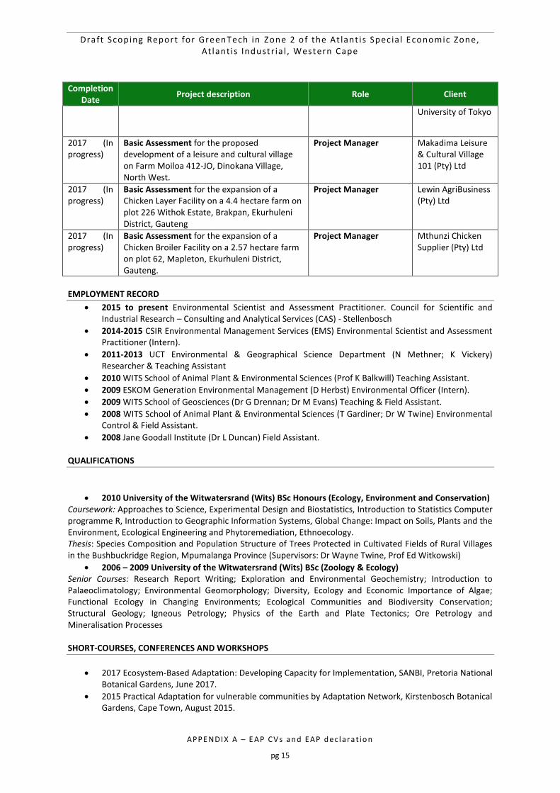
Draft Scop ing Report for GreenTech in Zone 2 o f the At lant i s Spec ia l Economic Zone, At lant i s Industr ia l , Western Cape
APPE NDI X A – E AP CV s a n d EAP d ec l ara t io n
pg 15
Completion Date
Project description Role Client
University of Tokyo
2017 (In progress)
Basic Assessment for the proposed development of a leisure and cultural village on Farm Moiloa 412-JO, Dinokana Village, North West.
Project Manager Makadima Leisure & Cultural Village 101 (Pty) Ltd
2017 (In progress)
Basic Assessment for the expansion of a Chicken Layer Facility on a 4.4 hectare farm on plot 226 Withok Estate, Brakpan, Ekurhuleni District, Gauteng
Project Manager Lewin AgriBusiness (Pty) Ltd
2017 (In progress)
Basic Assessment for the expansion of a Chicken Broiler Facility on a 2.57 hectare farm on plot 62, Mapleton, Ekurhuleni District, Gauteng.
Project Manager Mthunzi Chicken Supplier (Pty) Ltd
EMPLOYMENT RECORD
2015 to present Environmental Scientist and Assessment Practitioner. Council for Scientific and Industrial Research – Consulting and Analytical Services (CAS) - Stellenbosch
2014-2015 CSIR Environmental Management Services (EMS) Environmental Scientist and Assessment Practitioner (Intern).
2011-2013 UCT Environmental & Geographical Science Department (N Methner; K Vickery) Researcher & Teaching Assistant
2010 WITS School of Animal Plant & Environmental Sciences (Prof K Balkwill) Teaching Assistant.
2009 ESKOM Generation Environmental Management (D Herbst) Environmental Officer (Intern).
2009 WITS School of Geosciences (Dr G Drennan; Dr M Evans) Teaching & Field Assistant.
2008 WITS School of Animal Plant & Environmental Sciences (T Gardiner; Dr W Twine) Environmental Control & Field Assistant.
2008 Jane Goodall Institute (Dr L Duncan) Field Assistant. QUALIFICATIONS
2010 University of the Witwatersrand (Wits) BSc Honours (Ecology, Environment and Conservation) Coursework: Approaches to Science, Experimental Design and Biostatistics, Introduction to Statistics Computer programme R, Introduction to Geographic Information Systems, Global Change: Impact on Soils, Plants and the Environment, Ecological Engineering and Phytoremediation, Ethnoecology. Thesis: Species Composition and Population Structure of Trees Protected in Cultivated Fields of Rural Villages in the Bushbuckridge Region, Mpumalanga Province (Supervisors: Dr Wayne Twine, Prof Ed Witkowski)
2006 – 2009 University of the Witwatersrand (Wits) BSc (Zoology & Ecology) Senior Courses: Research Report Writing; Exploration and Environmental Geochemistry; Introduction to Palaeoclimatology; Environmental Geomorphology; Diversity, Ecology and Economic Importance of Algae; Functional Ecology in Changing Environments; Ecological Communities and Biodiversity Conservation; Structural Geology; Igneous Petrology; Physics of the Earth and Plate Tectonics; Ore Petrology and Mineralisation Processes SHORT-COURSES, CONFERENCES AND WORKSHOPS
2017 Ecosystem-Based Adaptation: Developing Capacity for Implementation, SANBI, Pretoria National Botanical Gardens, June 2017.
2015 Practical Adaptation for vulnerable communities by Adaptation Network, Kirstenbosch Botanical Gardens, Cape Town, August 2015.
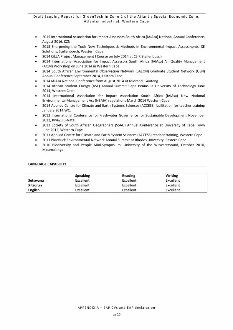
Draft Scop ing Report for GreenTech in Zone 2 o f the At lant i s Spec ia l Economic Zone, At lant i s Industr ia l , Western Cape
APPE NDI X A – E AP CV s a n d EAP d ec l ara t io n
pg 16
2015 International Association for Impact Assessors South Africa (IAIAsa) National Annual Conference, August 2016, KZN.
2015 Sharpening the Tool: New Techniques & Methods in Environmental Impact Assessments, SE Solutions, Stellenbosch, Western Cape
2014 CiLLA Project Management I Course on July 2014 at CSIR Stellenbosch
2014 International Association for Impact Assessors South Africa (IAIAsa) Air Quality Management (AQM) Workshop on June 2014 in Western Cape
2014 South African Environmental Observation Network (SAEON) Graduate Student Network (GSN) Annual Conference September 2014, Eastern Cape.
2014 IAIAsa National Conference from August 2014 at Midrand, Gauteng
2014 African Student Energy (ASE) Annual Summit Cape Peninsula University of Technology June 2014, Western Cape
2014 International Association for Impact Association South Africa (IAIAsa) New National Environmental Management Act (NEMA) regulations March 2014 Western Cape
2014 Applied Centre for Climate and Earth Systems Sciences (ACCESS) facilitation for teacher training January 2014,WC.
2012 International Conference for Freshwater Governance for Sustainable Development November 2012, KwaZulu-Natal
2012 Society of South African Geographers (SSAG) Annual Conference at University of Cape Town June 2012, Western Cape
2011 Applied Centre for Climate and Earth System Sciences (ACCESS) teacher training, Western Cape
2011 BlueBuck Environmental Network Annual Summit at Rhodes University, Eastern Cape
2010 Biodiversity and People Mini-Symposium, University of the Witwatersrand, October 2010, Mpumalanga
LANGUAGE CAPABILITY
Speaking Reading Writing Setswana Excellent Excellent Excellent Xitsonga Excellent Excellent Excellent English Excellent Excellent Excellent
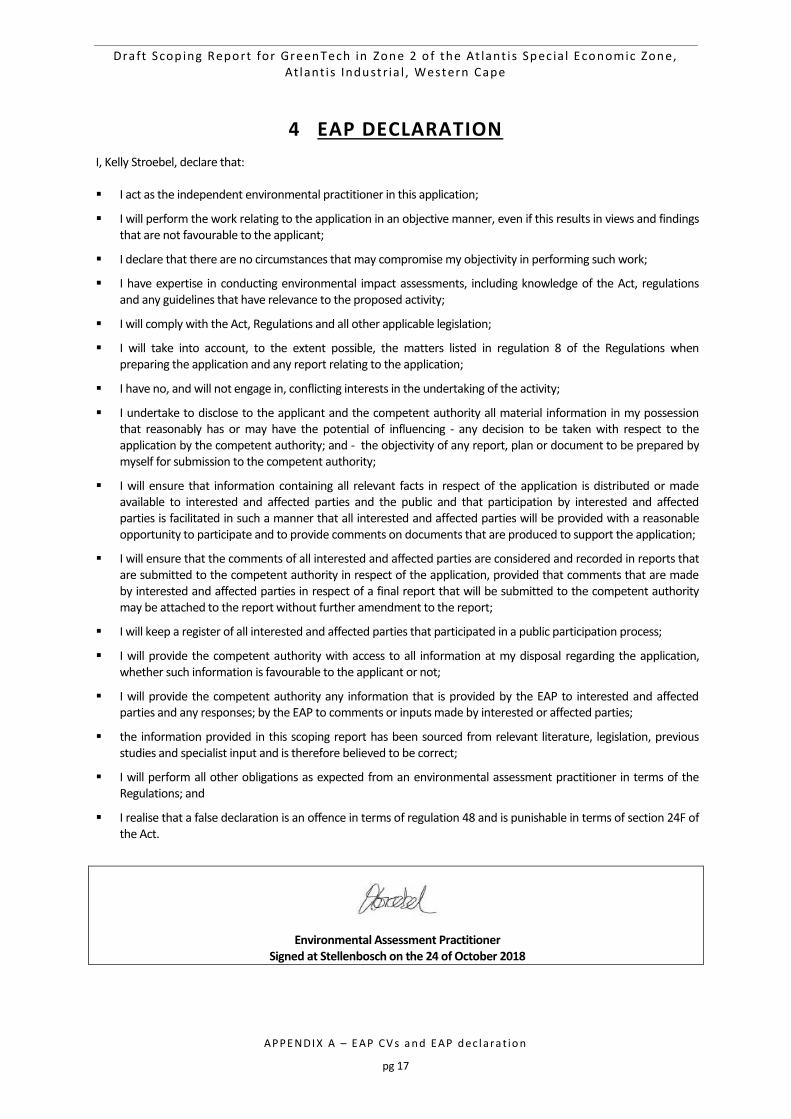
Draft Scop ing Report for GreenTech in Zone 2 o f the At lant i s Spec ia l Economic Zone, At lant i s Industr ia l , Western Cape
APPE NDI X A – E AP CV s a n d EAP d ec l ara t io n
pg 17
4 EAP DECLARATION
I, Kelly Stroebel, declare that: I act as the independent environmental practitioner in this application;
I will perform the work relating to the application in an objective manner, even if this results in views and findings that are not favourable to the applicant;
I declare that there are no circumstances that may compromise my objectivity in performing such work;
I have expertise in conducting environmental impact assessments, including knowledge of the Act, regulations and any guidelines that have relevance to the proposed activity;
I will comply with the Act, Regulations and all other applicable legislation;
I will take into account, to the extent possible, the matters listed in regulation 8 of the Regulations when preparing the application and any report relating to the application;
I have no, and will not engage in, conflicting interests in the undertaking of the activity;
I undertake to disclose to the applicant and the competent authority all material information in my possession that reasonably has or may have the potential of influencing - any decision to be taken with respect to the application by the competent authority; and - the objectivity of any report, plan or document to be prepared by myself for submission to the competent authority;
I will ensure that information containing all relevant facts in respect of the application is distributed or made available to interested and affected parties and the public and that participation by interested and affected parties is facilitated in such a manner that all interested and affected parties will be provided with a reasonable opportunity to participate and to provide comments on documents that are produced to support the application;
I will ensure that the comments of all interested and affected parties are considered and recorded in reports that are submitted to the competent authority in respect of the application, provided that comments that are made by interested and affected parties in respect of a final report that will be submitted to the competent authority may be attached to the report without further amendment to the report;
I will keep a register of all interested and affected parties that participated in a public participation process;
I will provide the competent authority with access to all information at my disposal regarding the application, whether such information is favourable to the applicant or not;
I will provide the competent authority any information that is provided by the EAP to interested and affected parties and any responses; by the EAP to comments or inputs made by interested or affected parties;
the information provided in this scoping report has been sourced from relevant literature, legislation, previous studies and specialist input and is therefore believed to be correct;
I will perform all other obligations as expected from an environmental assessment practitioner in terms of the Regulations; and
I realise that a false declaration is an offence in terms of regulation 48 and is punishable in terms of section 24F of the Act.
Environmental Assessment Practitioner Signed at Stellenbosch on the 24 of October 2018

APPE NDI X B – Dat ab as e o f In te r es te d an d Af fec te d p art ie s
pg 0
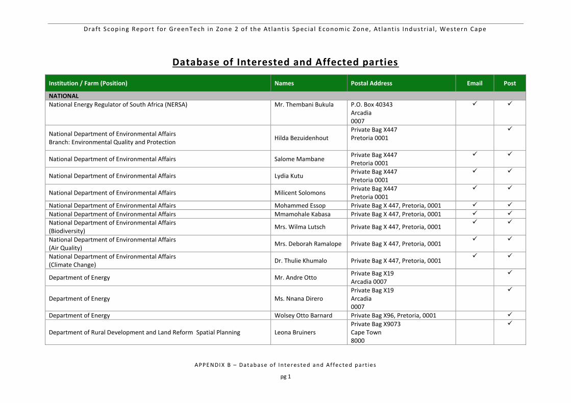
Draft Scop ing Report for GreenTech in Zone 2 o f the At lant i s Spec ia l Economic Zone, At lant i s Industr ia l , Western Cape
APPE NDI X B – Dat ab as e o f In te r es te d an d Af fec te d p art ie s
pg 1
Database of Interested and Affected parties
Institution / Farm (Position) Names Postal Address Email Post
NATIONAL
National Energy Regulator of South Africa (NERSA) Mr. Thembani Bukula P.O. Box 40343 Arcadia 0007
National Department of Environmental Affairs Branch: Environmental Quality and Protection
Hilda Bezuidenhout Private Bag X447 Pretoria 0001
National Department of Environmental Affairs Salome Mambane Private Bag X447 Pretoria 0001
National Department of Environmental Affairs Lydia Kutu Private Bag X447 Pretoria 0001
National Department of Environmental Affairs Milicent Solomons Private Bag X447 Pretoria 0001
National Department of Environmental Affairs Mohammed Essop Private Bag X 447, Pretoria, 0001
National Department of Environmental Affairs Mmamohale Kabasa Private Bag X 447, Pretoria, 0001
National Department of Environmental Affairs (Biodiversity)
Mrs. Wilma Lutsch Private Bag X 447, Pretoria, 0001
National Department of Environmental Affairs (Air Quality)
Mrs. Deborah Ramalope Private Bag X 447, Pretoria, 0001
National Department of Environmental Affairs (Climate Change)
Dr. Thulie Khumalo Private Bag X 447, Pretoria, 0001
Department of Energy Mr. Andre Otto Private Bag X19 Arcadia 0007
Department of Energy Ms. Nnana Direro Private Bag X19 Arcadia 0007
Department of Energy Wolsey Otto Barnard Private Bag X96, Pretoria, 0001
Department of Rural Development and Land Reform Spatial Planning Leona Bruiners Private Bag X9073 Cape Town 8000
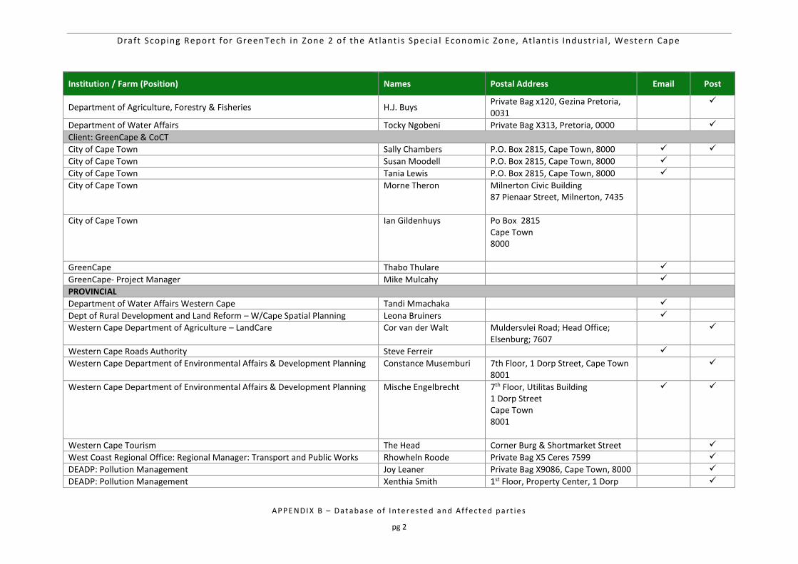
Draft Scop ing Report for GreenTech in Zone 2 o f the At lant i s Spec ia l Economic Zone, At lant i s Industr ia l , Western Cape
APPE NDI X B – Dat ab as e o f In te r es te d an d Af fec te d p art ie s
pg 2
Institution / Farm (Position) Names Postal Address Email Post
Department of Agriculture, Forestry & Fisheries H.J. Buys Private Bag x120, Gezina Pretoria, 0031
Department of Water Affairs Tocky Ngobeni Private Bag X313, Pretoria, 0000
Client: GreenCape & CoCT
City of Cape Town Sally Chambers P.O. Box 2815, Cape Town, 8000
City of Cape Town Susan Moodell P.O. Box 2815, Cape Town, 8000
City of Cape Town Tania Lewis P.O. Box 2815, Cape Town, 8000
City of Cape Town Morne Theron Milnerton Civic Building 87 Pienaar Street, Milnerton, 7435
City of Cape Town Ian Gildenhuys Po Box 2815 Cape Town 8000
GreenCape Thabo Thulare
GreenCape- Project Manager Mike Mulcahy
PROVINCIAL
Department of Water Affairs Western Cape Tandi Mmachaka
Dept of Rural Development and Land Reform – W/Cape Spatial Planning Leona Bruiners
Western Cape Department of Agriculture – LandCare Cor van der Walt Muldersvlei Road; Head Office; Elsenburg; 7607
Western Cape Roads Authority Steve Ferreir
Western Cape Department of Environmental Affairs & Development Planning Constance Musemburi 7th Floor, 1 Dorp Street, Cape Town 8001
Western Cape Department of Environmental Affairs & Development Planning Mische Engelbrecht 7th Floor, Utilitas Building 1 Dorp Street Cape Town 8001
Western Cape Tourism The Head Corner Burg & Shortmarket Street
West Coast Regional Office: Regional Manager: Transport and Public Works Rhowheln Roode Private Bag X5 Ceres 7599
DEADP: Pollution Management Joy Leaner Private Bag X9086, Cape Town, 8000
DEADP: Pollution Management Xenthia Smith 1st Floor, Property Center, 1 Dorp
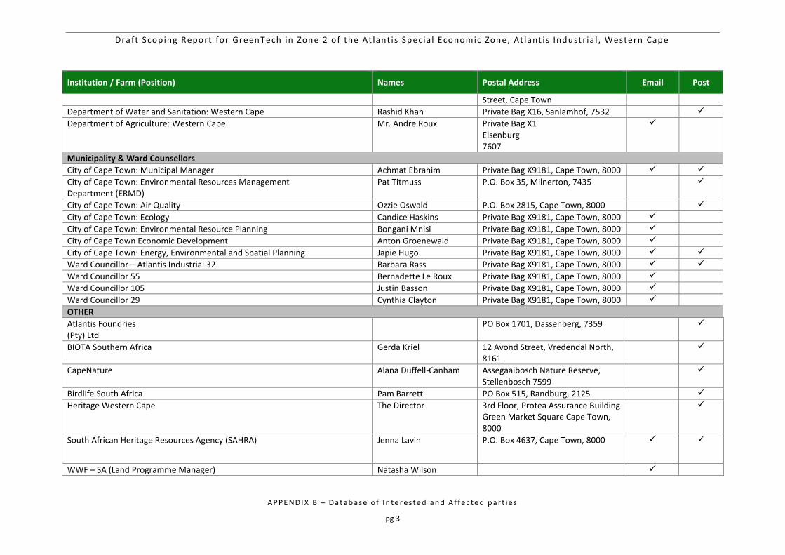
Draft Scop ing Report for GreenTech in Zone 2 o f the At lant i s Spec ia l Economic Zone, At lant i s Industr ia l , Western Cape
APPE NDI X B – Dat ab as e o f In te r es te d an d Af fec te d p art ie s
pg 3
Institution / Farm (Position) Names Postal Address Email Post
Street, Cape Town
Department of Water and Sanitation: Western Cape Rashid Khan Private Bag X16, Sanlamhof, 7532
Department of Agriculture: Western Cape Mr. Andre Roux Private Bag X1 Elsenburg 7607
Municipality & Ward Counsellors
City of Cape Town: Municipal Manager Achmat Ebrahim Private Bag X9181, Cape Town, 8000
City of Cape Town: Environmental Resources Management Department (ERMD)
Pat Titmuss P.O. Box 35, Milnerton, 7435
City of Cape Town: Air Quality Ozzie Oswald P.O. Box 2815, Cape Town, 8000
City of Cape Town: Ecology Candice Haskins Private Bag X9181, Cape Town, 8000
City of Cape Town: Environmental Resource Planning Bongani Mnisi Private Bag X9181, Cape Town, 8000
City of Cape Town Economic Development Anton Groenewald Private Bag X9181, Cape Town, 8000
City of Cape Town: Energy, Environmental and Spatial Planning Japie Hugo Private Bag X9181, Cape Town, 8000
Ward Councillor – Atlantis Industrial 32 Barbara Rass Private Bag X9181, Cape Town, 8000
Ward Councillor 55 Bernadette Le Roux Private Bag X9181, Cape Town, 8000
Ward Councillor 105 Justin Basson Private Bag X9181, Cape Town, 8000
Ward Councillor 29 Cynthia Clayton Private Bag X9181, Cape Town, 8000
OTHER
Atlantis Foundries (Pty) Ltd
PO Box 1701, Dassenberg, 7359
BIOTA Southern Africa Gerda Kriel 12 Avond Street, Vredendal North, 8161
CapeNature Alana Duffell-Canham Assegaaibosch Nature Reserve, Stellenbosch 7599
Birdlife South Africa Pam Barrett PO Box 515, Randburg, 2125
Heritage Western Cape The Director 3rd Floor, Protea Assurance Building Green Market Square Cape Town, 8000
South African Heritage Resources Agency (SAHRA) Jenna Lavin P.O. Box 4637, Cape Town, 8000
WWF – SA (Land Programme Manager) Natasha Wilson
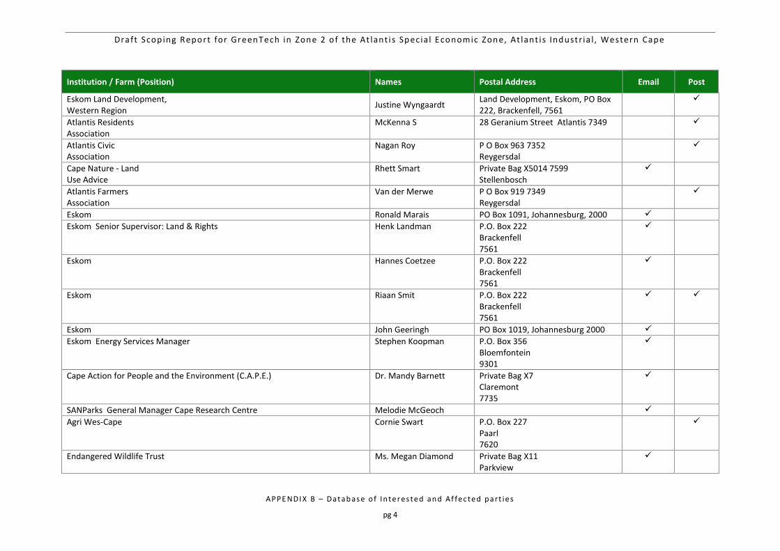
Draft Scop ing Report for GreenTech in Zone 2 o f the At lant i s Spec ia l Economic Zone, At lant i s Industr ia l , Western Cape
APPE NDI X B – Dat ab as e o f In te r es te d an d Af fec te d p art ie s
pg 4
Institution / Farm (Position) Names Postal Address Email Post
Eskom Land Development, Western Region
Justine Wyngaardt Land Development, Eskom, PO Box 222, Brackenfell, 7561
Atlantis Residents Association
McKenna S 28 Geranium Street Atlantis 7349
Atlantis Civic Association
Nagan Roy P O Box 963 7352 Reygersdal
Cape Nature - Land Use Advice
Rhett Smart Private Bag X5014 7599 Stellenbosch
Atlantis Farmers Association
Van der Merwe P O Box 919 7349 Reygersdal
Eskom Ronald Marais PO Box 1091, Johannesburg, 2000
Eskom Senior Supervisor: Land & Rights Henk Landman P.O. Box 222 Brackenfell 7561
Eskom Hannes Coetzee P.O. Box 222 Brackenfell 7561
Eskom Riaan Smit P.O. Box 222 Brackenfell 7561
Eskom John Geeringh PO Box 1019, Johannesburg 2000
Eskom Energy Services Manager Stephen Koopman P.O. Box 356 Bloemfontein 9301
Cape Action for People and the Environment (C.A.P.E.) Dr. Mandy Barnett Private Bag X7 Claremont 7735
SANParks General Manager Cape Research Centre Melodie McGeoch
Agri Wes-Cape Cornie Swart P.O. Box 227 Paarl 7620
Endangered Wildlife Trust Ms. Megan Diamond Private Bag X11 Parkview
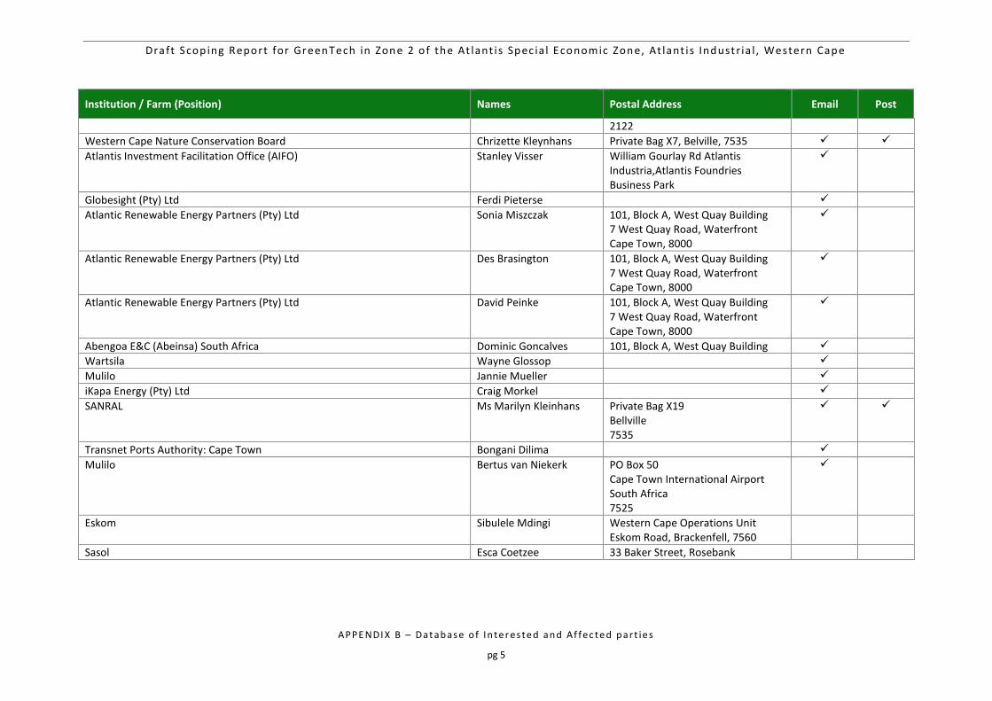
Draft Scop ing Report for GreenTech in Zone 2 o f the At lant i s Spec ia l Economic Zone, At lant i s Industr ia l , Western Cape
APPE NDI X B – Dat ab as e o f In te r es te d an d Af fec te d p art ie s
pg 5
Institution / Farm (Position) Names Postal Address Email Post
2122
Western Cape Nature Conservation Board Chrizette Kleynhans Private Bag X7, Belville, 7535
Atlantis Investment Facilitation Office (AIFO) Stanley Visser William Gourlay Rd Atlantis Industria,Atlantis Foundries Business Park
Globesight (Pty) Ltd Ferdi Pieterse
Atlantic Renewable Energy Partners (Pty) Ltd Sonia Miszczak 101, Block A, West Quay Building 7 West Quay Road, Waterfront Cape Town, 8000
Atlantic Renewable Energy Partners (Pty) Ltd Des Brasington 101, Block A, West Quay Building 7 West Quay Road, Waterfront Cape Town, 8000
Atlantic Renewable Energy Partners (Pty) Ltd David Peinke 101, Block A, West Quay Building 7 West Quay Road, Waterfront Cape Town, 8000
Abengoa E&C (Abeinsa) South Africa Dominic Goncalves 101, Block A, West Quay Building
Wartsila Wayne Glossop
Mulilo Jannie Mueller
iKapa Energy (Pty) Ltd Craig Morkel
SANRAL Ms Marilyn Kleinhans Private Bag X19 Bellville 7535
Transnet Ports Authority: Cape Town Bongani Dilima
Mulilo Bertus van Niekerk PO Box 50 Cape Town International Airport South Africa 7525
Eskom Sibulele Mdingi Western Cape Operations Unit Eskom Road, Brackenfell, 7560
Sasol Esca Coetzee 33 Baker Street, Rosebank
Klein Dassenberg Nature Reserve] October 15, 2014
ii
INTEGRATED
RESERVE MANAGEMENT PLAN
KLEIN DASSENBERG
NATURE RESERVE
City of Cape Town
October 2014
Klein Dassenberg Nature Reserve] October 15, 2014
iii
CONTENTS List of Maps v
List of Figures v
List of Tables vi
List of Appendices vi
List of Abbreviations used vi
PART A 1
PART 1 - DESCRIPTION _____________________________ 1
1 INTRODUCTION 1
1.1 Aim of the Integrated Reserve Management Plan 1
1.2 Location and Extent 4
2 DESCRIPTION OF LANDHOLDINGS AND OWNERSHIP 6
2.1 Property Details and Title Deed Information 6
2.2 Landscape Perspective 8
2.3 Physical Environment 12
2.3.1 Climate 12
2.3.2 Geology, geomorphology, soils and land types 12
2.4 Biological Environment 12
2.4.1 Vegetation 13
2.4.2 Mammals 15
2.4.3 Birds 15
2.4.4 Reptiles 16
2.4.5 Amphibians 17
2.4.6 Invertebrates 17
2.5 Socio-Political Context 18
2.5.1 History 18
2.5.2 Socio-economic Context 18
2.6 Protected Area Expansion 19
3 PURPOSE, VISION / MISSION, SIGNIFICANCE / VALUE 19
3.1 Purpose of the Protected Area 19
3.2 Vision and Mission 20
3.2.1 Vision 20
3.2.2 Mission 20
Klein Dassenberg Nature Reserve] October 15, 2014
iv
3.3 Significance of Property (Biodiversity, Heritage and Social) 20
PART 2 - MANAGEMENT POLICY FRAMEWORK _______ 22
4 ADMINISTRATIVE AND LEGAL FRAMEWORK FOR THE MANAGEMENT
AUTHORITY 22
4.1 Legal Framework 22
4.2 Administrative Framework 33
5 PROTECTED AREA POLICY FRAMEWORK & GUIDING MANAGEMENT
PRINCIPLES 35
5.1 Management Objectives 35
5.1.1 Biodiversity and Heritage Objectives 35
5.1.2 Socio-economic objectives: 39
5.2 SWOT analysis 42
5.3 Protected Area Management Policy Framework and Guiding Principles 44
5.3.1 Community Participation 44
5.3.2 Security and safety 45
5.3.3 Tourism development and management 45
5.3.4 Infrastructure management 45
5.3.5 Biodiversity Conservation Management 46
5.4 Sensitivity Analysis of the Klein Dassenberg Nature Reserve 51
5.5 Zonation Plan of the Klein Dassenberg Nature Reserve 52
5.5.1 Zoning Informants 52
5.5.2 Zoning Definitions and Descriptions 53
6 DEVELOPMENT PLAN 53
7 COSTING PLAN 55
PART 3 – MONITORING AND AUDITING _______________ 56
8 MONITORING & AUDITING 56
8.1 ANNUAL AUDIT PROCEDURE [Set format taken from previous CCT Management Plan] 56
8.1.1 Management Effectiveness Tracking Tool –METT 56
8.1.2 Protected Area Review 57
8.2 Management Plan review 57
8.3 Biodiversity Monitoring 58
PART 4 - REFERENCES ____________________________ 60
9 REFERENCES 60
Klein Dassenberg Nature Reserve] October 15, 2014
v
PART 5 - APPENDICES _____________________________ 63
10 APPENDICES 63
PART B 81
PART 6 - MANAGEMENT SCHEDULE _________________ 81
10.1 PROGRAMME OF IMPLEMENTATION 81
10.2 Management Programmes: Details of Annual Plan of Operations (APOs) 81
10.3 Annual Plan of Operation 91
List of Maps
Map 1: Reserve Location in the City of Cape Town 5
Map 2: Subsections of Klein Dassenberg Nature Reserve 6
Map 3: Klein Dassenberg Nature Reserve Boundary 6
Map 4: Klein Dassenberg Nature Reserve Erven Map 8
Map 5: Klein Dassenberg Nature Reserve and Biodiversity Network 10
Map 6: Klein Dassenberg Nature Reserve in relation to surrounding Reserves 11
Map 7: Vegetation Types within and around Klein Dassenberg Nature Reserve 14
Map 8: Zonation Map of Klein Dassenberg Nature Reserve 31
Map 9: Nature Reserve Firebreaks and Footpaths 47
Map 10 Veld Age Map of Klein Dassenberg Nature Reserve 58
Map 11: Alien Clearing Blocks of Klein Dassenberg Nature Reserve 60
Map 12: Footpaths in Klein Dassenberg Nature Reserve 60
List of Figures
Figure 1: The elements of the Integrated Reserve Management Plan 2
Figure 2: Legal and planning framework for the Integrated Management Plan 3
Figure 3: Klein Dassenberg Nature Reserve Staff Organogram 33
Figure 4: North Region Organogram 34
Figure 5: The greater Dassenberg Coastal Catchment Partnership 64
Klein Dassenberg Nature Reserve] October 15, 2014
vi
List of Tables
Table 1: Erf numbers of Papekuil Nature Reserve 7
Table 2: Potential threatened species of birds which could occur within the immediate area. 16
Table 3: Legal Framework 22
Table 4: Biodiversity and Heritage Objectives for Klein Dassenberg Nature Reserve 35
Table 5: Socio-economic objectives for Klein Dassenberg Nature Reserve 39
Table 6: Broad costing management breakdown for Klein Dassenberg Nature Reserve: 55
Table 7: The Reserve’s monitoring requirements: 58
Table 8: Invasive Species, Densities and Age (to be updated annually, or as information changes) 88
List of Appendices
Appendix 1: The S.G. Diagrams 63
Appendix 2: The Dassenberg Coastal Catchment Partnership (DCCP) 63
Appendix 3: The most recent plant species list for Klein Dassenberg Nature Reserve (updated 25/09/2014) 66
Appendix 4: Existing Firebreaks on Papekuil Nature Reserve 72
Appendix 5: Annual Review Procedure (Example of an audit proforma) 73
Appendix 6: Fixed Point Photography Data Sheet 80
List of Abbreviations used
APO Annual Plan of Operations
BIONET Biodiversity Network
CAPEX Capital Budget
CARA Conservation of Agricultural Resources Act, 1983
CBD Central Business District
CBNRM Community Based Natural Resource Management
CCT City of Cape Town
CDF Conservation Development Framework
CFR Cape Floral Region
CR Critically Endangered
CSIR Council for Scientific and Industrial Research
EIA Environmental Impact Assessment
EMS Environmental Management System
EN Endangered
ESKOM Electricity Supply Commission (of South Africa)
Klein Dassenberg Nature Reserve] October 15, 2014
vii
ERMD Environmental Resource Management Department
GN Government Notice
GIS Geographic Information System
IUCN International Union for Conservation of Nature and Natural Resources
IDP Integrated Development Plan
IMEP Integrated Metropolitan Environmental Policy
IRMP Integrated Reserve Management Plan
LBSAP Local Biodiversity Strategic Action Plan
MEC Member of Executive Council
METT-SA Management Effectiveness Tracking Tool
MOU Memorandum of Understanding
MPA Marine Protected Area
NEMA National Environmental Management Act, 107 of 1998
NEM:BA National Environmental Management: Biodiversity Act, 10 of 2004
NGOs Non-Governmental Organisations
SAAQIS South African Air Quality Information System
SANBI South African National Biodiversity Institute
SDF Spatial Development Framework
SLA Service Level Agreement
ToR Terms of Reference
WfW Working for Water
WfWet Working for Wetlands
WWF World Wildlife Fund for Nature
Klein Dassenberg Nature Reserve] October 15, 2014
1
PART A
PART 1 - DESCRIPTION
1 INTRODUCTION
The Klein Dassenberg Nature Reserve will be proclaimed a nature reserve in terms of
Protected Areas Act No. 57 of 2003 section 23(1).
The strategic management planning process (which results in the development of an
Integrated Reserve Management Plan), for the Klein Dassenberg Nature Reserve begins
with the definition of the Vision which is followed by the Purpose for the reserve. This
Purpose is then supported by Desired States for the Reserve. The Reserve objectives
contribute to realising the Purpose and Desired States. For each Desired State a number of
Management objectives are identified. These Management objectives are then made
operational through the identification of outputs. Objectives for each Desired State are
prioritised for the five-year time horizon of the plan. Time frames, deliverables, performance
indicators and targets are then allocated for each objective, or a group of linked outputs
contributing to the Desired State.
In context, this management plan is a dynamic document that should be updated every five
years or as soon as new information comes to light that may better inform decisions on
responsible land management.
1.1 Aim of the Integrated Reserve Management Plan
The aim of the Integrated Reserve Management Plan (IRMP) is to ensure that the Klein
Dassenberg Nature Reserve has clearly defined objectives and activities to direct the
protection and sustainable use of its natural, scenic and heritage resources over a five year
time period. The IRMP thus provides the medium-term operational framework for the
prioritised allocation of resources and capacity in the management, use and development of
the reserve. The IRMP intends to add value and continuity by clearly stating management
objectives, scheduling action and providing guidelines on the management approach.
The context of the Reserve planning process for the Klein Dassenberg Nature Reserve are:
(i) City’s Integrated Development Plan (IDP) (Anon 2010); (ii) City’s Integrated Metropolitan
Environmental Policy (IMEP) (Anon 20031); (iii) Biodiversity Strategy (Anon 20032) and Local
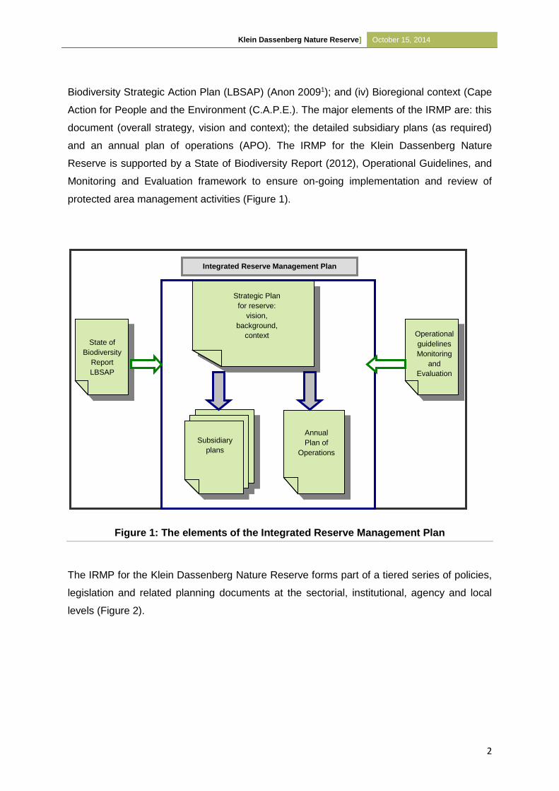
Klein Dassenberg Nature Reserve] October 15, 2014
2
Biodiversity Strategic Action Plan (LBSAP) (Anon 20091); and (iv) Bioregional context (Cape
Action for People and the Environment (C.A.P.E.). The major elements of the IRMP are: this
document (overall strategy, vision and context); the detailed subsidiary plans (as required)
and an annual plan of operations (APO). The IRMP for the Klein Dassenberg Nature
Reserve is supported by a State of Biodiversity Report (2012), Operational Guidelines, and
Monitoring and Evaluation framework to ensure on-going implementation and review of
protected area management activities (Figure 1).
Figure 1: The elements of the Integrated Reserve Management Plan
The IRMP for the Klein Dassenberg Nature Reserve forms part of a tiered series of policies,
legislation and related planning documents at the sectorial, institutional, agency and local
levels (Figure 2).
Integrated Reserve Management Plan
Subsidiary
plans
Annual
Plan of
Operations
Strategic Plan
for reserve:
vision,
background,
context State of
Biodiversity
Report
LBSAP
Operational
guidelines
Monitoring
and
Evaluation
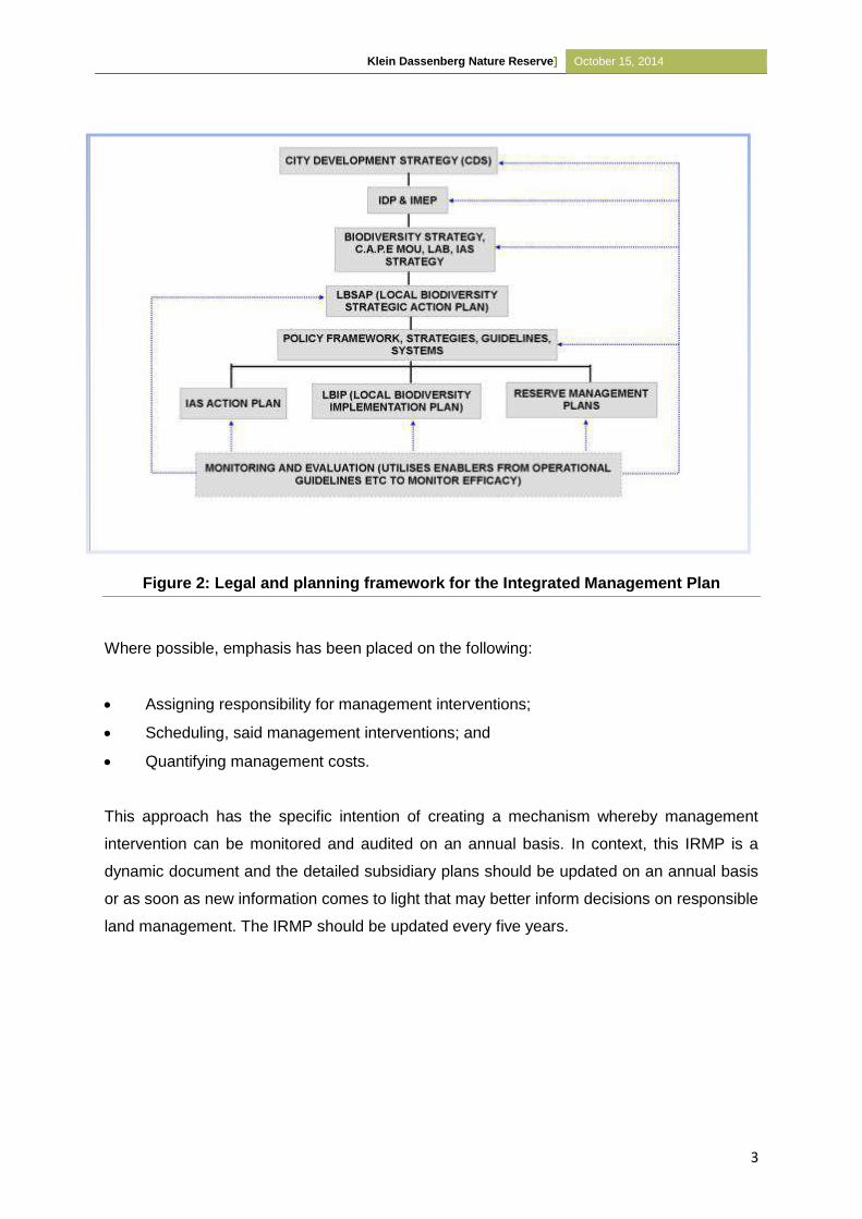
Klein Dassenberg Nature Reserve] October 15, 2014
3
Figure 2: Legal and planning framework for the Integrated Management Plan
Where possible, emphasis has been placed on the following:
Assigning responsibility for management interventions;
Scheduling, said management interventions; and
Quantifying management costs.
This approach has the specific intention of creating a mechanism whereby management
intervention can be monitored and audited on an annual basis. In context, this IRMP is a
dynamic document and the detailed subsidiary plans should be updated on an annual basis
or as soon as new information comes to light that may better inform decisions on responsible
land management. The IRMP should be updated every five years.
Klein Dassenberg Nature Reserve] October 15, 2014
4
1.2 Location and Extent
The Klein Dassenberg Nature Reserve is situated about 45 km from Cape Town’s Central
Business District (CBD), immediately east of Atlantis and directly adjacent to Pella on the
northern boundary, Western Cape, South Africa (Map 1). The approximate coordinates are
(Google Earth, 2013):
18°30’29.888”E
33°32’26.044”S
The Reserve is currently 371.9699ha in extent (see Map 2) consisting of the farm Klein
Dassenberg No 20/9 and farms No 7, 8, 10 and an unregistered portion of 1502 Cape road
and Cape Farm No 17/1. Portion 3 of the farm Papekuil Outspan No 6 is currently
unregistered state land and is being managed as part of the current reserve network. This
portion is 183.5218ha in extent.
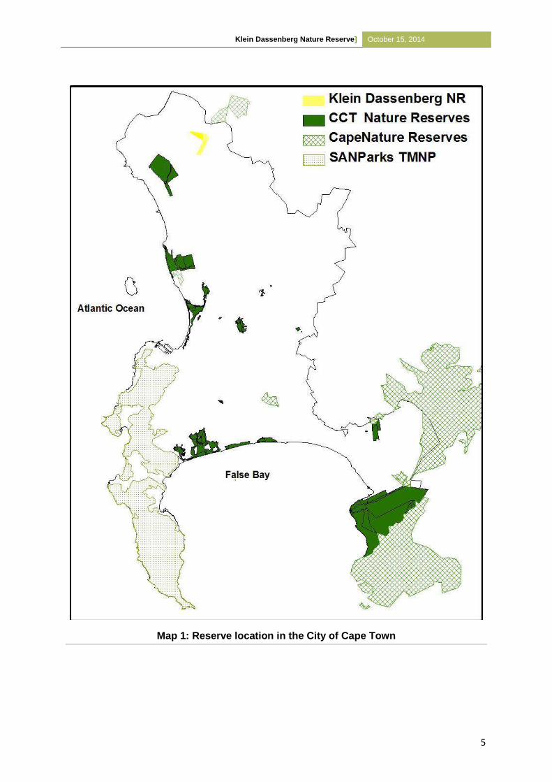
Klein Dassenberg Nature Reserve] October 15, 2014
5
Map 1: Reserve location in the City of Cape Town
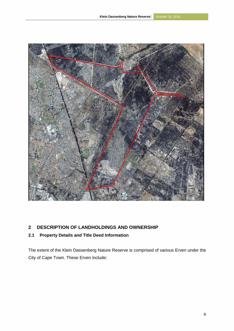
Klein Dassenberg Nature Reserve] October 15, 2014
6
2 DESCRIPTION OF LANDHOLDINGS AND OWNERSHIP
2.1 Property Details and Title Deed Information
The extent of the Klein Dassenberg Nature Reserve is comprised of various Erven under the
City of Cape Town. These Erven include:
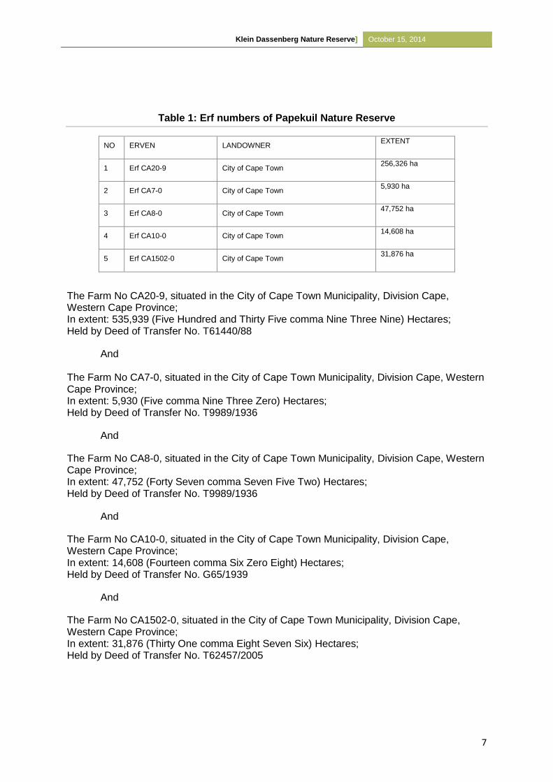
Klein Dassenberg Nature Reserve] October 15, 2014
7
Table 1: Erf numbers of Papekuil Nature Reserve
NO ERVEN LANDOWNER EXTENT
1 Erf CA20-9 City of Cape Town 256,326 ha
2 Erf CA7-0 City of Cape Town 5,930 ha
3 Erf CA8-0 City of Cape Town 47,752 ha
4 Erf CA10-0 City of Cape Town 14,608 ha
5 Erf CA1502-0 City of Cape Town 31,876 ha
The Farm No CA20-9, situated in the City of Cape Town Municipality, Division Cape, Western Cape Province; In extent: 535,939 (Five Hundred and Thirty Five comma Nine Three Nine) Hectares; Held by Deed of Transfer No. T61440/88
And The Farm No CA7-0, situated in the City of Cape Town Municipality, Division Cape, Western Cape Province; In extent: 5,930 (Five comma Nine Three Zero) Hectares; Held by Deed of Transfer No. T9989/1936
And
The Farm No CA8-0, situated in the City of Cape Town Municipality, Division Cape, Western Cape Province; In extent: 47,752 (Forty Seven comma Seven Five Two) Hectares; Held by Deed of Transfer No. T9989/1936
And
The Farm No CA10-0, situated in the City of Cape Town Municipality, Division Cape, Western Cape Province; In extent: 14,608 (Fourteen comma Six Zero Eight) Hectares; Held by Deed of Transfer No. G65/1939
And
The Farm No CA1502-0, situated in the City of Cape Town Municipality, Division Cape, Western Cape Province; In extent: 31,876 (Thirty One comma Eight Seven Six) Hectares; Held by Deed of Transfer No. T62457/2005
Klein Dassenberg Nature Reserve] October 15, 2014
8
2.2 Landscape Perspective
South Africa is globally known as a biodiversity-rich country, owing to the three hotspots that
occur in the country. The Cape Floristic Region (CFR), one of the three hotspots, which is
concentrated within the Western Cape is famous for its high species diversity and
endemism, such that it is recognised as an entirely separate Floral Kingdom, one of only six
globally (Cowling et al., 2003; van Wilgen, 2009; Parnell et al., 2010). Within the Western
Cape, the Cape Town Metropole is not only recognised as a centre of plant endemism but
also contains more than 120 threatened plant species (Rouget et al. 2003).
To date more than 30% of the CFR has been lost. The extensive loss of biodiversity is as a
result of the large-scale transformations that have taken place in the lowlands (Cape Flats)
for urban development, commercial agriculture, extensive alien species invasion, changes in
fire regimes and unsustainable natural resource use (Hall, 1987; Rebelo and Siegfried,
1990; Rouget et al., 2003). In addition to anthropogenic disturbances, climate change and
global warming has been predicted to further threaten the natural ecosystems of the
Western Cape, especially in terms of rainfall and temperature.
The Klein Dassenberg Nature Reserve contains high quality Critically Endangered Atlantis
Sand Fynbos which supports numerous threatened fauna and flora. It has been identified
since the 1980’s as a key conservation priority and a Core Botanical site critical for
conservation if a representative of the Cape Flat’s natural heritage is to be conserved
(Jarman, 1986; Kilian, 1995). Klein Dassenberg was specifically identified in 1999 to be an
important fynbos corridor between the fynbos habitats in the Dassenberg/Pella region with
the remnants to the south of Atlantis (Jeffery, 1999).
The Klein Dassenberg Nature Reserve forms part of the City’s Biodiversity Network (BioNet),
a systematic, fine-scale conservation plan that is used to identify important areas for
protected area expansion. This initiative highlighted Klein Dassenberg as an “Irreplaceable
Core Flora Site” (CCT, 2012) (Refer to Map 5). Additionally, the greater Atlantis and
Dassenberg area, was highlighted as a Critical Biodiversity Area by Cape Nature’s 2010
Protected Area Expansion Strategy (Purnell et al., 2010) as well as by the 2010 WWF-Table
Mountain Fund Climate Change Corridor (Huyser and Pence, 2010). Following these
reports, the landscape initiative known as the Dassenberg Coastal Catchment Partnership
(DCCP) was initiated. This initiative aims to protect and link important Fynbos remnants
while maximising associated social and economic opportunities. Therefore, without Klein
Dassenberg Nature Reserve, the DCCP would not exist. The stakeholders involved in this
Klein Dassenberg Nature Reserve] October 15, 2014
9
initiative include the Environmental Resource Management Department of the City of Cape
Town, CapeNature, WWF, Table Mountain Fund, Wilderness Foundation, Cape West Coast
Biosphere, SANParks and SANBI.
In conjunction with the DCCP, Klein Dassenberg Nature Reserve falls within the buffer of the
southern core of the greater Cape West Coast Biosphere Reserve (CWCBR).
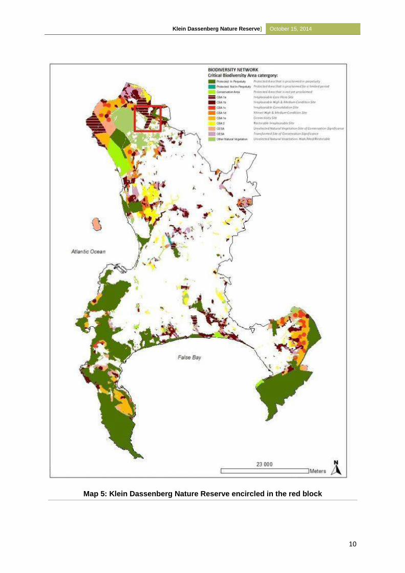
Klein Dassenberg Nature Reserve] October 15, 2014
10
Map 5: Klein Dassenberg Nature Reserve encircled in the red block
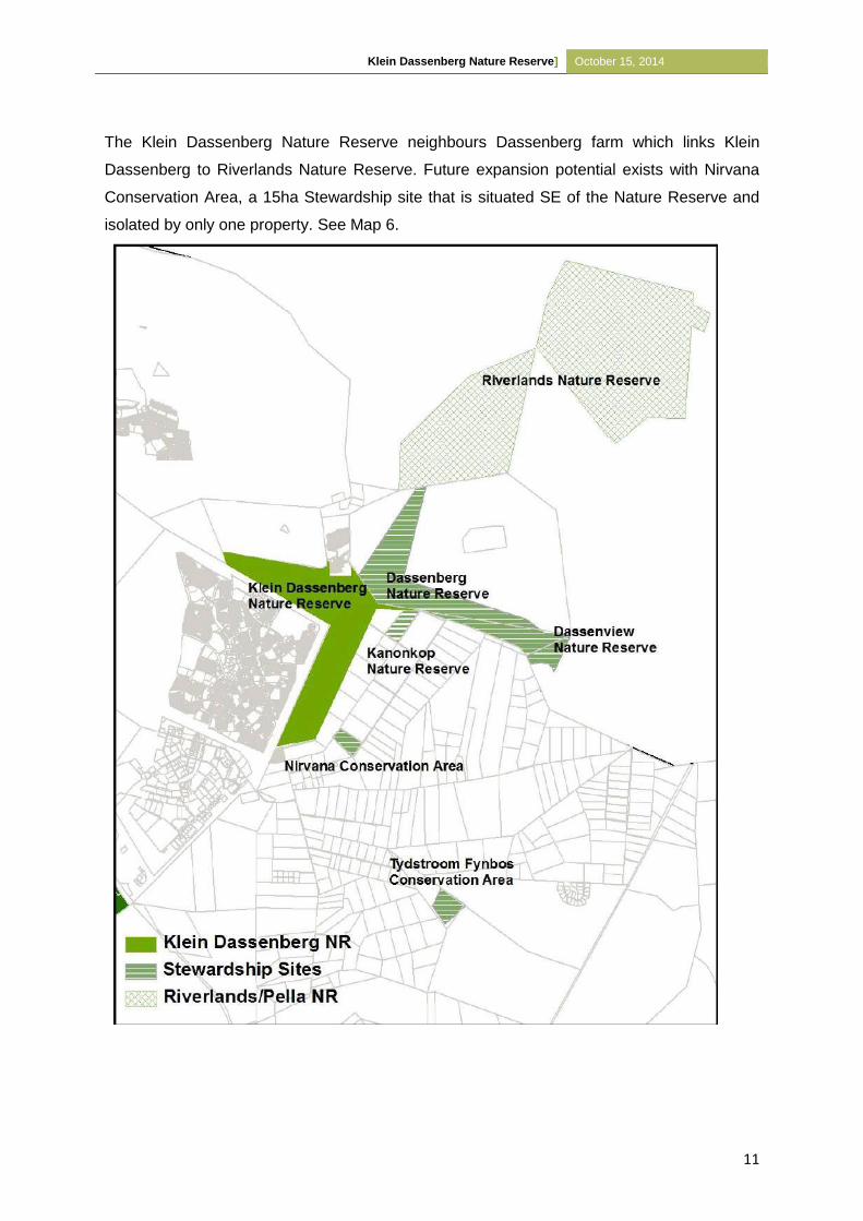
Klein Dassenberg Nature Reserve] October 15, 2014
11
The Klein Dassenberg Nature Reserve neighbours Dassenberg farm which links Klein
Dassenberg to Riverlands Nature Reserve. Future expansion potential exists with Nirvana
Conservation Area, a 15ha Stewardship site that is situated SE of the Nature Reserve and
isolated by only one property. See Map 6.
Klein Dassenberg Nature Reserve] October 15, 2014
12
2.3 Physical Environment
2.3.1 Climate
The area is associated with a Mediterranean climate with winter rainfall, hot dry summers
and cold, wet winters. Rainfall is mainly produced by the passage of westerly wave cold
frontal systems. Summers are relatively dry due to the effects of the South Atlantic
Anticyclone system (Mugabe, 2008). The mean maximum temperature in summer
(November, December, January) is 260 C. The mean minimum temperature in winter (June,
July, August) is 7 0 C. The warmest month on average is February and the coldest month on
average is July. Mist occurs frequently in winter, supplying additional precipitation. The
Winter-rainfall regime includes precipitation peaking from May to August. The Mean Annual
Rainfall is 290–660 mm (mean: 440 mm) (Mucina and Rutherford, 2006). The mean annual
evaporation rate is 1445 mm (Mabihi, 2009).
Management needs to look into obtaining reliable rainfall stats for the area by means of
setting up a rain gauge in the Nature Reserve which must be systematically monitored and
recorded after each rainfall to obtain updated reliable local rainfall data.
2.3.2 Geology, geomorphology, soils and land types
The soil type of Atlantis Sand Fynbos is acidic tertiary grey regic sand originally derived from
Cambrian Cape Granite with an Aeolian origin (Stabbert et al., 2010). Granite intrusions of
the Cape Granite Suite are to be found in the Mamre area. Shale outcrops occur along the
coast and inland to the north and south of Atlantis. The Centre for Scientific and Industrial
Research (CSIR, 2002) report further states that the granite outcrops of Dassenberg,
Kanonkop and Mamre-Darling near Mamre, constitutes the highest points in the area at
heights of 210 and 410m above sea level.
2.4 Biological Environment
The most recent botanical species lists for the Nature Reserve forms part of the appendices
(Appendix 3) and was drawn up by volunteers of the Custodians of Rare and Endangered
Wildflowers (CREW). The species list will be updated on a regular basis, as new information
becomes available. The species list can also be accessed through the South African
Biodiversity Database (www.biodiversity.co.za), which contains all listed species and
statistics for all City managed conservation areas as well as other areas as part of the
BIoNet (see Map 5 above).
Klein Dassenberg Nature Reserve] October 15, 2014
13
2.4.1 Vegetation
The natural vegetation in the Klein Dassenberg Nature Reserve consists of Atlantis Sand
Fynbos with a very small portion of Swartland Granite Renosterveld on the slopes of
Kanonkop. See Map 7.
To date a total of 152 plant species, of which two are classified/listed as Near Threatened
(NT), 12 Vulnerable (V), 10 Endangered (E), two Critically Endangered (CR) and one
Declining have been recorded at the Klein Dassenberg Nature Reserve (Appendix 3).
According to the latest national ecosystem conservation status (2011), Atlantis Sand Fynbos
is Critically Endangered (CR). The reason for this status is largely due to transformation, by
urban and agricultural development and the intense invasive of alien vegetation (Mucina and
Rutherford, 2006). To date 45% has already been transformed with only 15% of Atlantis
Sand Fynbos remaining within the City, of which 6% is currently conserved in Riverlands,
Paardenberg and at the Pella Research Site. The National conservation target for Atlantis
Sand Fynbos is 30%. With the proclamation of Klein Dassenberg Nature Reserve, a further
1.26% will be conserved, increasing the total protected area to 7.26%.
2.4.1.1 Atlantis Sand Fynbos
Sand Fynbos occurs on deep sands of marine or aeolian origin (Jacobs and Jangle, 2008).
Structural dominance is dependent on the depth of the water table. When the water table is
deep and moisture is only derived from precipitation, restioid fynbos will be dominant. Where
the water table is shallow and non-fluctuating, proteoid fynbos dominates. Asteraceous
fynbos dominates where it is deeper but still accessible and ericaceous fynbos dominates
where the surface is seasonally moist. Sand Fynbos is characterised by the presence of the
Erica mammosa (Ninepin Heath), Phylica cephalantha (Starface), Trichocephalus stipularis
(Baboon Face), and the restioids including Thamnochortus obtusus and T. punctatus
(Sandveld Thatching Reed) (Rebelo et al., 2011).
According to Mucina and Rutherford (2006), Atlantis Sand Fynbos, which is found at
altitudes of 40-250m, is distributed in the Western Cape from Rondeberg to Blouberg on the
West Coast coastal flats; along the Groen River on the eastern side of the Dassenberg-
Darling Hills through Riverlands and between Atlantis and Kalbaskraal. It is also found
between Klipheuwel and the Paardeberg with outliers west of the Berg River east and north
of Riebeek-Kasteel between Hermon and Heuningberg.
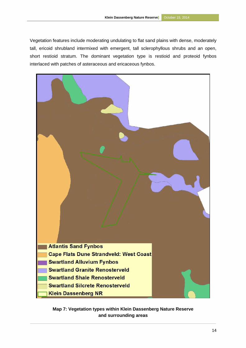
Klein Dassenberg Nature Reserve] October 15, 2014
14
Vegetation features include moderating undulating to flat sand plains with dense, moderately
tall, ericoid shrubland intermixed with emergent, tall sclerophyllous shrubs and an open,
short restioid stratum. The dominant vegetation type is restioid and proteoid fynbos
interlaced with patches of asteraceous and ericaceous fynbos.
Map 7: Vegetation types within Klein Dassenberg Nature Reserve
and surrounding areas
Klein Dassenberg Nature Reserve] October 15, 2014
15
2.4.2 Mammals
To date, no dedicated baseline fauna collection has been conducted for the greater
Dassenberg Area. Historically, numerous large mammal species would have occurred within
the area. This assemblage of large fauna would have included Eland (Taurotragus oryx),
Red Hartebeest (Alcelaphus buselaphus) and Brown Hyena (Hyaena brunnea). These
species were quickly eradicated once formal agricultural practices became established in the
Cape.
However, the majority of smaller and medium sized mammal species still occur within the
area. These include three small antelope, namely Steenbok (Raphicerus campestris), Cape
Grysbok (Raphicerus melanotis) and Common Duiker (Sylvicaptra grimmia). Other animals
confirmed to occur in the area are Small Spotted Genet (Genetta genetta), Caracal (Felis
caracal), Porcupine (Hystrix africaeaustrali) and Small Grey Mongoose (Galerella
pulverulenta).
Numerous rodent and shrew species can be expected to occur but only Forest Shrew
(Myosorex varius), Grey Climbing Mouse (Dendromus melanotis), Striped Field Mice
(Rhabdomys pumilio) and Cape Gerbil (Tatera afra) have been confirmed to date. Rock
Hyrax (Procavia capensis) is also present near the summit of Kanonkop. Recent records of
species with extremely large home ranges such as Honey Badger (Mellivorus capensis) and
Aardvark (Orycteropus afer) in the general vicinity can be seen as a positive sign. Their
continued occurrence is evidence that the area of natural veld is relatively extensive and that
there is at least some ecological connectivity to the north and west.
Many of the indigenous mammal species are inconspicuous, secretive and nocturnal. As
such, they are not easily observed. Their presence is often most easily noted by observing
signs of their presence, namely are middens, scat and spoor.
2.4.3 Birds
A collated bird list has not been compiled for the conservation area as yet. However, the
common bush bird’s characteristic of Fynbos and Renosterveld vegetation have been
confirmed from the site. These include: Grey-backed Cisticola (Cisticola subruficapillus),
Karoo Prinia (Prinia maculosa), Southern Double-collared Sunbird (Cinnyris chalybea),
Long-billed Crombec (Sylvietta rufescens), Malachite Sunbird (Nectarinia famosa), Cape
Klein Dassenberg Nature Reserve] October 15, 2014
16
Francolin (Pternistis capensis), Stone Chat (Saxicola torquata) and Cape Robin-Chat
(Cossypha caffra).
In the dense thicket and areas dominated by invasive alien Acacias, Cape Batis (Batis
capensis), Bar-throated Apalis (Apalis thoracica), Cape White-eye (Zosterops pallidus),
Fiscal Flycatcher (Sigelus silens), and Acacia Pied Barbet (Tricholaema leucomelas) have
all been recorded.
Additional common birds include Cape Sparrow (Passer melanurus), Common Fiscal
(Lanius collaris), Cape Bulbul (Pycnonotus capensis), Cape Wagtail (Motacilla capensis),
White-throated Canary (Serinus albogularis) and Bokmakierie (Telophorus zeylonus).
Annually, the bird diversity is augmented with the arrival of the summer migrants. These
include Eurasian Bee-eater (Merops apiaster), Pearl-breasted Swallow (Hirundo dimidiata),
Yellow-billed Kite (Milvus parasitus), Barn Swallow (Hirundo rustica), and White-rumped
Swift (Apus caffer).
No species of conservation concern have been identified on the reserve to date but it is
expected that a few red listed species may occur in the vicinity. These are listed in Table 1.
Table 2: Potential threatened species of birds which could occur within the immediate
area.
# Common Name Scientific Name IUCN Status
1 Black Harrier Circus maurus Near-threatened
2 White Pelican Pelecanus onocrotalus Near-threatened
3 Secretarybird Sagittarius serpentarius Near-threatened
4 Martial Eagle Polemaetus bellicosus Near-threatened
5 Blue Crane Anthropoides paradiseus Vulnerable
2.4.4 Reptiles
As the nature reserve falls within a large, relatively intact, landscape the reptile diversity can
be assumed to be high. It is also unlikely that any species have become locally extinct on the
site due to anthropogenic influences. Baseline data collection recorded on neighbouring
Papekuil included the following reptile species: Delalandes Beaked Blind Snake
(Rhinotyphlops lalandei), Mole Snake (Pseudaspis cana), Cape Skink (Trachylepis
Klein Dassenberg Nature Reserve] October 15, 2014
17
capensis), Silvery Dwarf Burrowing Skink (Scelotes bipes) and Red Sided Skink (Trachylepis
homalocephala). Other reptile sightings in the surrounding areas but not on Klein
Dassenberg include Cape Girdled Lizard (Cordylus cordylus) in the exposed granite areas
and both Angulate (Chersina angulata) and Parrot-beaked Tortoise (Homopus aeriolatus).
Snake species that have been confirmed as occurring are Cape Cobra (Naja nivea),
Boomslang (Dispholidus typus), Rhombic Skaapsteker (Psammophylax rhombeatus),
Spotted Harlequin Snake (Homoroselaps lacteus) and Mole Snake (Pseudaspis cana).
The discovery of a dead Southern Adder (Bitis armarta) on Papekuil was of immense
conservation significance. It has long been assumed that this endangered reptile was extinct
within the City boundaries. There is a strong probability that there are more dwarf adders
within the area. The confirmation of the species status in the area is a priority and any
possible records must be reported to the Conservation Authorities. It is also probable that
the near-threatened Cape Sand Snake (Psammophis leightonii) occurs in the area.
Numerous additional reptiles are expected to occur on the site and dedicated baseline data
collection needs to be conducted for the area.
2.4.5 Amphibians
Minimal baseline data conducted within the Reserve recorded the common and widespread
Clicking Stream Frog (Strongylopus grayii. It can be expected that there will be limited
amphibian diversity on the Nature Reserve area. It is highly likely that the specialist rain
frogs, Sand Rain Frog (Breviceps rosei) and Namaqua Rain Frog (B. namaquensis) do occur
on site.
It is unlikely that any threatened amphibian species occur in the Reserve.
2.4.6 Invertebrates
To date, only arachnids were collected during invertebrate surveys on Papekuil,
neighbouring the reserve. These include Funnel-web spider (Benoitia ocellata), Termite
feeders ( Ammoxenus kalaharicus ), Orange Lung-less Spider (Caponia capensis ), Ground
Velvet Spider (Dresserus collinus ), Flat-bellied Ground Spider (Asemesthes montanus and
Camillina biplagia), Wolf Spider (Lycosoid spp.), Tube-trapdoor (Pionotheie spp.), Palp-
footed Spider (Diaphorocellus spp.), Hackled-meshweb Weavers (Vidole capensis),
Huntsman Spider (Parapalstes spp.), Baboon Spider (Harpactira atra and Harpactirella
helenae), Crab Spider (Xysticus subjugalis ), Burrowing Spider (Psammoduon arenicola,
Klein Dassenberg Nature Reserve] October 15, 2014
18
Psammoduon canosum, Psammorygma spp., Cydrela spp., Chariobas cylindraceus and
Australutica spp.).
The immense importance of the Dassenberg area for threatened and localised invertebrates
was highlighted by lepidopterist, Jonathan Ball. Although, the last known sighting of the
Critically Endangered Dickson’s Copper (Chrysoritis dicksoni) in the area was in 1994, it is
likely that the species still occurs in high quality Atlantis Sand Fynbos remnants.
Also of significance was the discovery of the paddle winged lacewing (Halterina pulchellum),
in the Nature Reserve in 2011 by Andrew Morton. The species was only known from the
type specimen described in 1910 and was presumed extinct.
2.5 Socio-Political Context
2.5.1 History
Papekuil, also known as Papekuil/ Papenkuil Outspan, which was owned by the then Cape
Metropolitan Council (which was formally known as the Western Cape Regional Services
Council), was historically used as grazing land and the occasional flower picking (Kilian,
1995). The area originated when it was proclaimed part of the Mamre Rural Coloured Area
in 1970. Mamre, which is situated North West of the Nature Reserve originated in 1791 as a
military post (CapeBiosphere, 2012).
Klein Dassenberg was owned by Klein Dassenberg Trust who purchased the property in
1988. In 1996, ownership of the land was changed with the intent to subdivide and develop
the area. These developments were prevented due to botanical assessment and the City of
Cape Town offered to purchase the land in writing. However, this transaction only occurred
recently (See Appendix 1).
The Blaauwberg Municipality, along with all of the other municipalities in the Cape Town
area, were grouped together to form the City of Cape Town in 2000. The reserve is now
managed by the City of Cape Town, specifically the Biodiversity Management Branch under
the Environmental Resource Management Department.
2.5.2 Socio-economic Context
Currently, a site coordinator, a field ranger and an intern are employed to manage the Klein
Dassenberg Nature Reserve. The goal is to eventually appoint another field ranger/ general
worker and a community conservation officer.
Klein Dassenberg Nature Reserve] October 15, 2014
19
The Atlantis, Mamre and Pella communities are the closest residential communities to the
site, with Pella and Atlantis bordering the Reserve.
Atlantis was established as an industrial growth point in the mid-1970s with the aim of
decreasing concentrated housing and development away from the Cape Metropolitan Area
(CMA). However, with removal of several large employing industries, the scheme was
unsuccessful, resulting in very high levels of unemployment in the area (CapeBiosphere,
2012).
2.6 Protected Area Expansion
Future expansion of the Reserve exists with Nirvana, a 15ha Stewardship Site found to the
South East of the Reserve (See Map 6). Furthermore negotiations into signing privately
owned land situated in Mamre into Stewardship Agreements are currently underway, as well
as approaching viable farms east of Klein Dassenberg for future Stewardship Agreements.
Expansion of the Reserve is important in terms of reaching the National Conservation
Targets of conserving 30% of Atlantis Sand Fynbos as well as reaching the DCCP’s goal.
3 PURPOSE, VISION / MISSION, SIGNIFICANCE / VALUE
3.1 Purpose of the Protected Area
The Klein Dassenberg Nature Reserve is located in the Cape Floristic Region, an area of
global biodiversity significance. The Nature Reserve conserves a unique combination of
habitats, ecosystems and species, many of which are either rare or endemic to the area.
With 80% of the CFR falling within the Western Cape, the primary purpose of the Nature
Reserve is the conservation of this unique biodiversity and associated ecosystem features
and functions.
The natural systems of the CFR and Western Cape are under serious threat from a range of
factors such as unsustainable natural resource use, extensive alien species invasion and
recent rapid infrastructural development. Many areas, particularly the lowlands, have been
reduced to a fraction of their original range of which little is protected. With 21 Critically
Endangered (CR), 13 Endangered (EN) and 22 Vulnerable (VU) ecosystems listed from the
Western Cape alone, this Nature Reserve is of immense importance. In addition to
anthropogenic disturbances, climate change and global warming has been predicted to
further threaten the natural ecosystems of the Western Cape, especially in terms of rainfall
and temperature. Not only do these ecosystems support exceptionally threatened
Klein Dassenberg Nature Reserve] October 15, 2014
20
biodiversity, they also provide an irreplaceable source of environmental goods and services
for the people and economy of South Africa. A fine scale conservation plan, namely the City
of Cape Town’s Biodiversity Network, was used to identify the areas where the protection of
important remnant vegetation was needed.
As per Chapter 3, section 17 of the National Environmental Management: Protected
Areas Act (NEM:PAA) the purpose of declaring Klein Dassenberg Nature Reserve are:
(a) that Critically Endangered Atlantis Sand Fynbos is found on the property;
(b) good representation of endemic, rare and threatened species;
(c) that the property supports high biodiversity;
(d) the presence of an edaphic interface and altitudinal gradient;
(e) that the property contributes to the Dassenberg Coastal Catchment Partnership
(DCCP);
(f) that the property was identified as a Critical Biodiversity Area on the BIONET;
(g) that the property is in need of long-term protection for the maintenance of its
biodiversity and for the provision of environmental goods and services.
3.2 Vision and Mission
3.2.1 Vision
To conserve and protect the critically endangered biodiversity that occurs in the Klein
Dassenberg Nature Reserve as to contribute to the DCCP.
3.2.2 Mission
To manage and restore the natural environment and its associated ecological processes and
services through the implementation of the management objectives of Klein Dassenberg
Nature Reserve.
3.3 Significance of Property (Biodiversity, Heritage and Social)
The Klein Dassenberg Nature Reserve contains one National vegetation type, Atlantis Sand
Fynbos, which is classified as Critically Endangered. The site was identified by The City of
Cape Town’s Biodiversity Network as an “Irreplaceable Core Flora Site”. Additionally the
greater Atlantis and Dassenberg region was highlighted as a priority in CapeNature’s
Provincial Protected Area Expansion Strategy as well as one of two most important Climate
Change adaption corridors in the Western Cape by the TMP-WWF study. The area has been
identified since the 1980s as an important conservation area (Jarman, 1986).
Klein Dassenberg Nature Reserve] October 15, 2014
21
Therefore this area forms an integral part of the Biodiversity Network, as well as an essential
part of the DCCP (See section 2.2 above). The Nature Reserve has a confirmed plant
species list of 152 of which 28 are threatened.
Summary of qualifying site assessment criteria:
Core botanical site
Critically Endangered Atlantis Sand Fynbos
Klein Dassenberg is a critical component of the Dassenberg Coastal Catchment
Partnership (DCCP) a priority landscape conservation initiative.
The area has the potential to incorporate some of the high quality state land in the
vicinity into the Nature Reserve through stewardship or other opportunities
Identified as important site for conservation in 1986 by Jarman
Preliminary assessment has revealed at least 24 threatened plant species on site
Amphithalea ericifolia ssp erecta (CR)
Macrostylis villosa (EN)
Ruschia tecta (EN)
Lampranthus explanatus (EN)
Leucospermum parile (EN)
•The Nature Reserve is well connected through natural open space to extensive
natural areas to the north, west and east and there is also potential to incorporate
some of the high quality private and state land in the vicinity into the Nature Reserve
through stewardship or various other opportunities in order to further maximise
conservation for the broader Cape Metropolitan Area and further opportunities for
integrating viable linkages (corridors) between the Nature Reserve and neighbouring
areas; and
Extension potential exists with Nirvana, a Private Conservation Area of 15 ha
situated to the North West of the Nature Reserve.
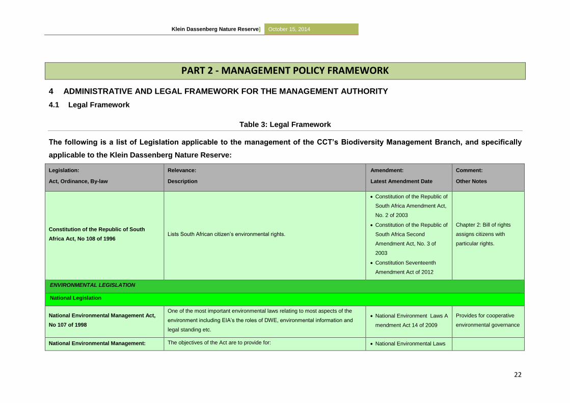
Klein Dassenberg Nature Reserve] October 15, 2014
22
PART 2 - MANAGEMENT POLICY FRAMEWORK
4 ADMINISTRATIVE AND LEGAL FRAMEWORK FOR THE MANAGEMENT AUTHORITY
4.1 Legal Framework
Table 3: Legal Framework
The following is a list of Legislation applicable to the management of the CCT’s Biodiversity Management Branch, and specifically
applicable to the Klein Dassenberg Nature Reserve:
Legislation:
Act, Ordinance, By-law
Relevance:
Description
Amendment:
Latest Amendment Date
Comment:
Other Notes
Constitution of the Republic of South
Africa Act, No 108 of 1996 Lists South African citizen’s environmental rights.
Constitution of the Republic of
South Africa Amendment Act,
No. 2 of 2003
Constitution of the Republic of
South Africa Second
Amendment Act, No. 3 of
2003
Constitution Seventeenth
Amendment Act of 2012
Chapter 2: Bill of rights
assigns citizens with
particular rights.
ENVIRONMENTAL LEGISLATION
National Legislation
National Environmental Management Act,
No 107 of 1998
One of the most important environmental laws relating to most aspects of the
environment including EIA’s the roles of DWE, environmental information and
legal standing etc.
National Environment Laws A
mendment Act 14 of 2009
Provides for cooperative
environmental governance
National Environmental Management: The objectives of the Act are to provide for: National Environmental Laws
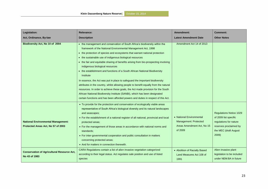
Klein Dassenberg Nature Reserve] October 15, 2014
23
Legislation:
Act, Ordinance, By-law
Relevance:
Description
Amendment:
Latest Amendment Date
Comment:
Other Notes
Biodiversity Act, No 10 of 2004 the management and conservation of South Africa’s biodiversity within the
framework of the National Environmental Management Act, 1998
the protection of species and ecosystems that warrant national protection
the sustainable use of indigenous biological resources
the fair and equitable sharing of benefits arising from bio-prospecting involving
indigenous biological resources
the establishment and functions of a South African National Biodiversity
Institute
In essence, the Act was put in place to safeguard the important biodiversity
attributes in the country, whilst allowing people to benefit equally from the natural
resources. In order to achieve these goals, the Act made provision for the South
African National Biodiversity Institute (SANBI), which has been designated
certain functions and has been afforded powers and duties in respect of this Act.
Amendment Act 14 of 2013
National Environmental Management:
Protected Areas Act, No 57 of 2003
To provide for the protection and conservation of ecologically viable areas
representative of South Africa’s biological diversity and its natural landscapes
and seascapes;
For the establishment of a national register of all national, provincial and local
protected areas;
For the management of those areas in accordance with national norms and
standards;
For inter-governmental cooperation and public consultation in matters
concerning protected areas;
And for matters in connection therewith.
National Environmental
Management: Protected
Areas Amendment Act, No 15
of 2009
Regulations Notice 1029
of 2009 list specific
regulations for nature
reserves proclaimed by
the MEC (draft August
2009)
Conservation of Agricultural Resource Act,
No 43 of 1983
CARA Regulations contain a list of alien invasive vegetation categorized
according to their legal status. Act regulates sale position and use of listed
species
Abolition of Racially Based
Land Measures Act 108 of
1991
Alien invasive plant
legislation to be included
under NEM:BA in future
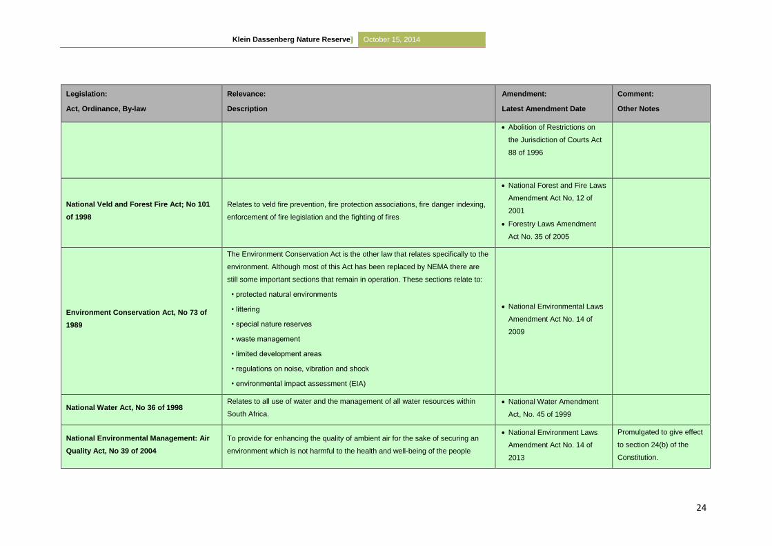
Klein Dassenberg Nature Reserve] October 15, 2014
24
Legislation:
Act, Ordinance, By-law
Relevance:
Description
Amendment:
Latest Amendment Date
Comment:
Other Notes
Abolition of Restrictions on
the Jurisdiction of Courts Act
88 of 1996
National Veld and Forest Fire Act; No 101
of 1998
Relates to veld fire prevention, fire protection associations, fire danger indexing,
enforcement of fire legislation and the fighting of fires
National Forest and Fire Laws
Amendment Act No, 12 of
2001
Forestry Laws Amendment
Act No. 35 of 2005
Environment Conservation Act, No 73 of
1989
The Environment Conservation Act is the other law that relates specifically to the
environment. Although most of this Act has been replaced by NEMA there are
still some important sections that remain in operation. These sections relate to:
• protected natural environments
• littering
• special nature reserves
• waste management
• limited development areas
• regulations on noise, vibration and shock
• environmental impact assessment (EIA)
National Environmental Laws
Amendment Act No. 14 of
2009
National Water Act, No 36 of 1998 Relates to all use of water and the management of all water resources within
South Africa.
National Water Amendment
Act, No. 45 of 1999
National Environmental Management: Air
Quality Act, No 39 of 2004
To provide for enhancing the quality of ambient air for the sake of securing an
environment which is not harmful to the health and well-being of the people
National Environment Laws
Amendment Act No. 14 of
2013
Promulgated to give effect
to section 24(b) of the
Constitution.
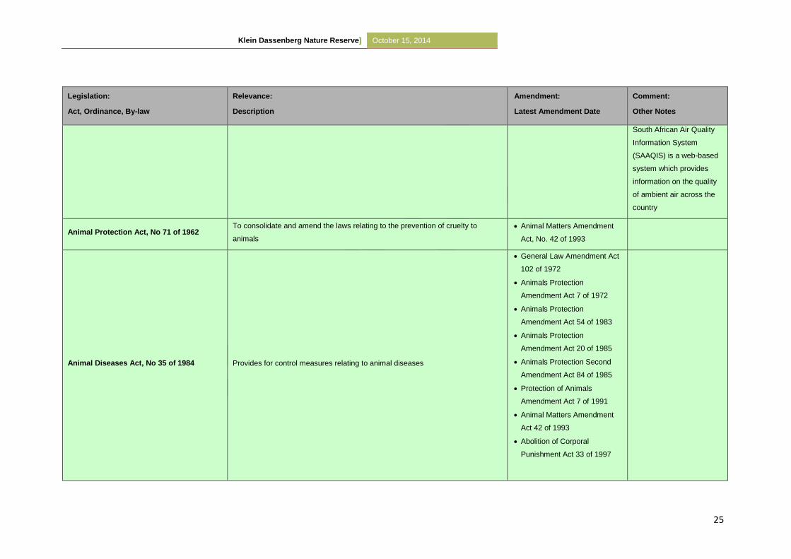
Klein Dassenberg Nature Reserve] October 15, 2014
25
Legislation:
Act, Ordinance, By-law
Relevance:
Description
Amendment:
Latest Amendment Date
Comment:
Other Notes
South African Air Quality
Information System
(SAAQIS) is a web-based
system which provides
information on the quality
of ambient air across the
country
Animal Protection Act, No 71 of 1962 To consolidate and amend the laws relating to the prevention of cruelty to
animals
Animal Matters Amendment
Act, No. 42 of 1993
Animal Diseases Act, No 35 of 1984 Provides for control measures relating to animal diseases
General Law Amendment Act
102 of 1972
Animals Protection
Amendment Act 7 of 1972
Animals Protection
Amendment Act 54 of 1983
Animals Protection
Amendment Act 20 of 1985
Animals Protection Second
Amendment Act 84 of 1985
Protection of Animals
Amendment Act 7 of 1991
Animal Matters Amendment
Act 42 of 1993
Abolition of Corporal
Punishment Act 33 of 1997
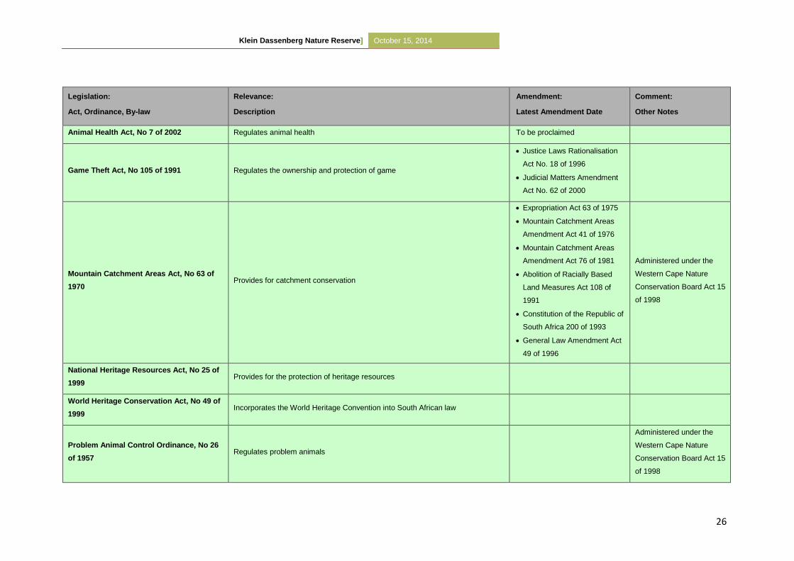
Klein Dassenberg Nature Reserve] October 15, 2014
26
Legislation:
Act, Ordinance, By-law
Relevance:
Description
Amendment:
Latest Amendment Date
Comment:
Other Notes
Animal Health Act, No 7 of 2002 Regulates animal health To be proclaimed
Game Theft Act, No 105 of 1991 Regulates the ownership and protection of game
Justice Laws Rationalisation
Act No. 18 of 1996
Judicial Matters Amendment
Act No. 62 of 2000
Mountain Catchment Areas Act, No 63 of
1970 Provides for catchment conservation
Expropriation Act 63 of 1975
Mountain Catchment Areas
Amendment Act 41 of 1976
Mountain Catchment Areas
Amendment Act 76 of 1981
Abolition of Racially Based
Land Measures Act 108 of
1991
Constitution of the Republic of
South Africa 200 of 1993
General Law Amendment Act
49 of 1996
Administered under the
Western Cape Nature
Conservation Board Act 15
of 1998
National Heritage Resources Act, No 25 of
1999 Provides for the protection of heritage resources
World Heritage Conservation Act, No 49 of
1999 Incorporates the World Heritage Convention into South African law
Problem Animal Control Ordinance, No 26
of 1957 Regulates problem animals
Administered under the
Western Cape Nature
Conservation Board Act 15
of 1998
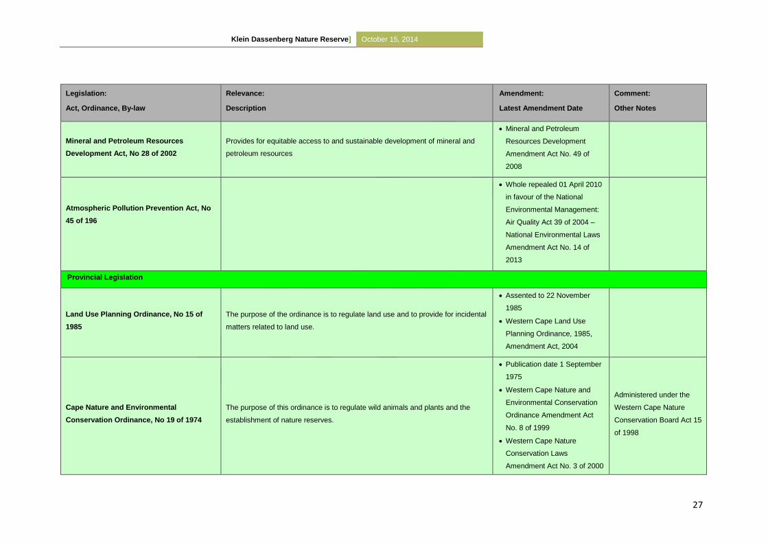
Klein Dassenberg Nature Reserve] October 15, 2014
27
Legislation:
Act, Ordinance, By-law
Relevance:
Description
Amendment:
Latest Amendment Date
Comment:
Other Notes
Mineral and Petroleum Resources
Development Act, No 28 of 2002
Provides for equitable access to and sustainable development of mineral and
petroleum resources
Mineral and Petroleum
Resources Development
Amendment Act No. 49 of
2008
Atmospheric Pollution Prevention Act, No
45 of 196
Whole repealed 01 April 2010
in favour of the National
Environmental Management:
Air Quality Act 39 of 2004 –
National Environmental Laws
Amendment Act No. 14 of
2013
Provincial Legislation
Land Use Planning Ordinance, No 15 of
1985
The purpose of the ordinance is to regulate land use and to provide for incidental
matters related to land use.
Assented to 22 November
1985
Western Cape Land Use
Planning Ordinance, 1985,
Amendment Act, 2004
Cape Nature and Environmental
Conservation Ordinance, No 19 of 1974
The purpose of this ordinance is to regulate wild animals and plants and the
establishment of nature reserves.
Publication date 1 September
1975
Western Cape Nature and
Environmental Conservation
Ordinance Amendment Act
No. 8 of 1999
Western Cape Nature
Conservation Laws
Amendment Act No. 3 of 2000
Administered under the
Western Cape Nature
Conservation Board Act 15
of 1998
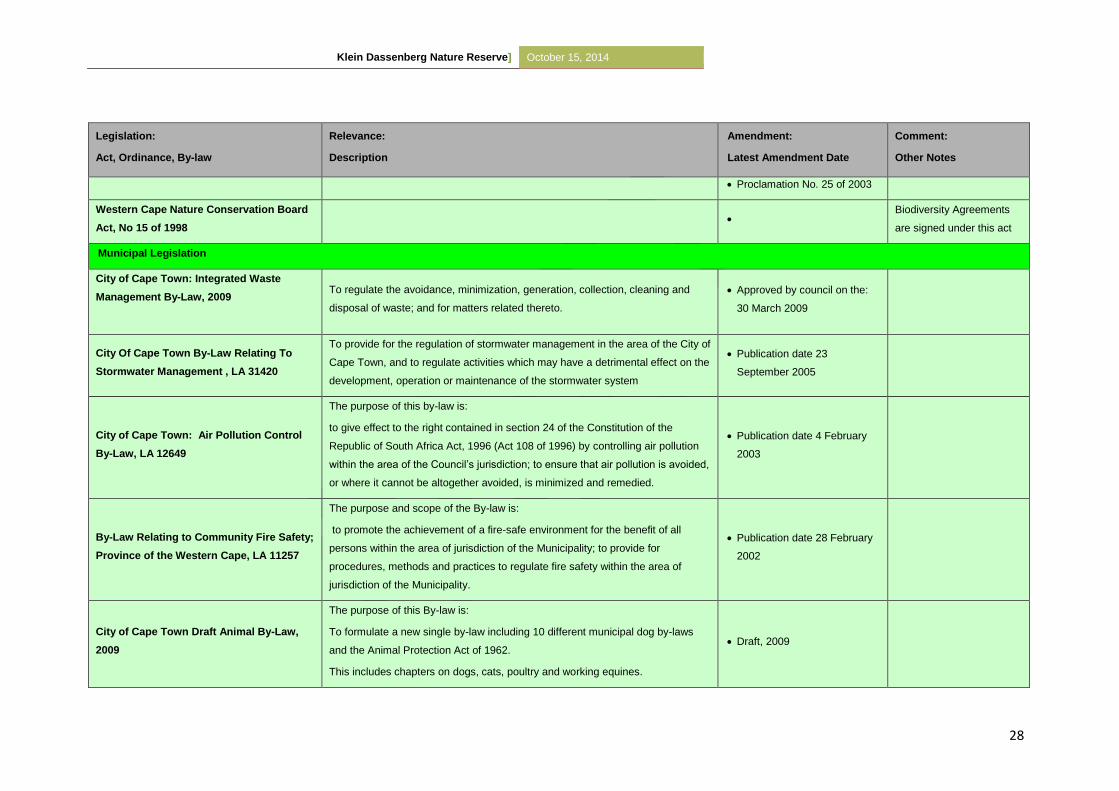
Klein Dassenberg Nature Reserve] October 15, 2014
28
Legislation:
Act, Ordinance, By-law
Relevance:
Description
Amendment:
Latest Amendment Date
Comment:
Other Notes
Proclamation No. 25 of 2003
Western Cape Nature Conservation Board
Act, No 15 of 1998
Biodiversity Agreements
are signed under this act
Municipal Legislation
City of Cape Town: Integrated Waste
Management By-Law, 2009
To regulate the avoidance, minimization, generation, collection, cleaning and
disposal of waste; and for matters related thereto.
Approved by council on the:
30 March 2009
City Of Cape Town By-Law Relating To
Stormwater Management , LA 31420
To provide for the regulation of stormwater management in the area of the City of
Cape Town, and to regulate activities which may have a detrimental effect on the
development, operation or maintenance of the stormwater system
Publication date 23
September 2005
City of Cape Town: Air Pollution Control
By-Law, LA 12649
The purpose of this by-law is:
to give effect to the right contained in section 24 of the Constitution of the
Republic of South Africa Act, 1996 (Act 108 of 1996) by controlling air pollution
within the area of the Council’s jurisdiction; to ensure that air pollution is avoided,
or where it cannot be altogether avoided, is minimized and remedied.
Publication date 4 February
2003
By-Law Relating to Community Fire Safety;
Province of the Western Cape, LA 11257
The purpose and scope of the By-law is:
to promote the achievement of a fire-safe environment for the benefit of all
persons within the area of jurisdiction of the Municipality; to provide for
procedures, methods and practices to regulate fire safety within the area of
jurisdiction of the Municipality.
Publication date 28 February
2002
City of Cape Town Draft Animal By-Law,
2009
The purpose of this By-law is:
To formulate a new single by-law including 10 different municipal dog by-laws
and the Animal Protection Act of 1962.
This includes chapters on dogs, cats, poultry and working equines.
Draft, 2009
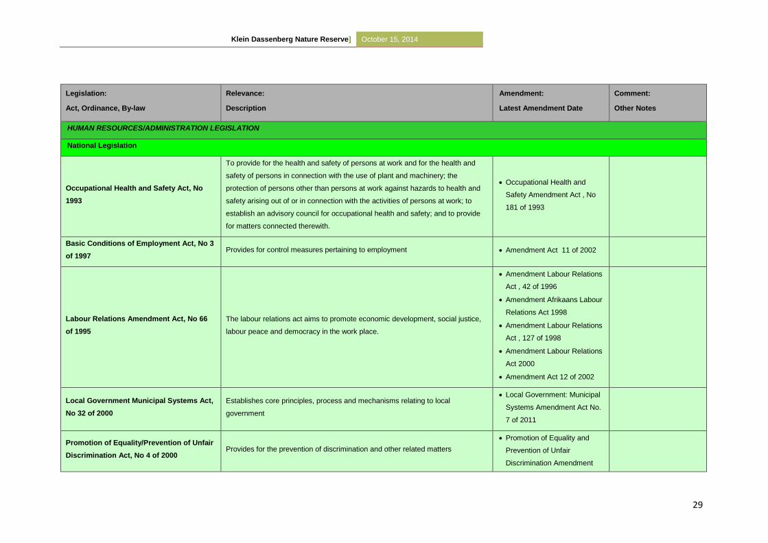
Klein Dassenberg Nature Reserve] October 15, 2014
29
Legislation:
Act, Ordinance, By-law
Relevance:
Description
Amendment:
Latest Amendment Date
Comment:
Other Notes
HUMAN RESOURCES/ADMINISTRATION LEGISLATION
National Legislation
Occupational Health and Safety Act, No
1993
To provide for the health and safety of persons at work and for the health and
safety of persons in connection with the use of plant and machinery; the
protection of persons other than persons at work against hazards to health and
safety arising out of or in connection with the activities of persons at work; to
establish an advisory council for occupational health and safety; and to provide
for matters connected therewith.
Occupational Health and
Safety Amendment Act , No
181 of 1993
Basic Conditions of Employment Act, No 3
of 1997 Provides for control measures pertaining to employment Amendment Act 11 of 2002
Labour Relations Amendment Act, No 66
of 1995
The labour relations act aims to promote economic development, social justice,
labour peace and democracy in the work place.
Amendment Labour Relations
Act , 42 of 1996
Amendment Afrikaans Labour
Relations Act 1998
Amendment Labour Relations
Act , 127 of 1998
Amendment Labour Relations
Act 2000
Amendment Act 12 of 2002
Local Government Municipal Systems Act,
No 32 of 2000
Establishes core principles, process and mechanisms relating to local
government
Local Government: Municipal
Systems Amendment Act No.
7 of 2011
Promotion of Equality/Prevention of Unfair
Discrimination Act, No 4 of 2000 Provides for the prevention of discrimination and other related matters
Promotion of Equality and
Prevention of Unfair
Discrimination Amendment
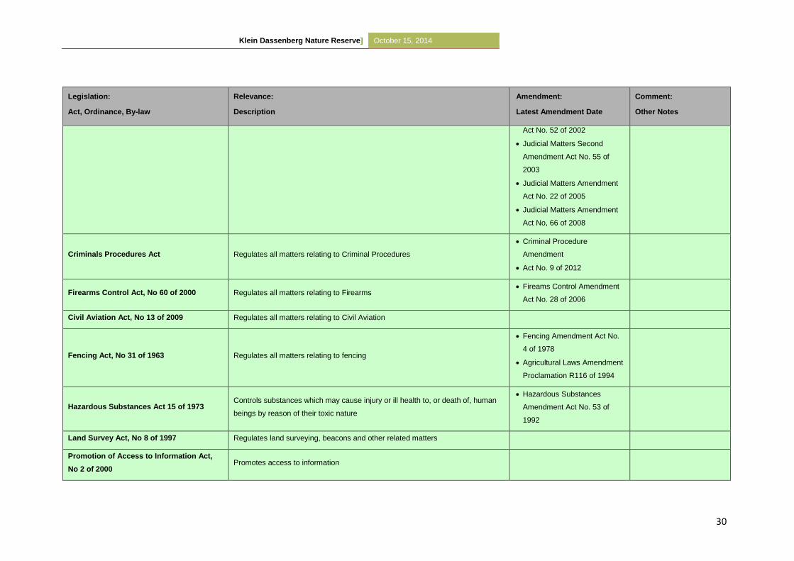
Klein Dassenberg Nature Reserve] October 15, 2014
30
Legislation:
Act, Ordinance, By-law
Relevance:
Description
Amendment:
Latest Amendment Date
Comment:
Other Notes
Act No. 52 of 2002
Judicial Matters Second
Amendment Act No. 55 of
2003
Judicial Matters Amendment
Act No. 22 of 2005
Judicial Matters Amendment
Act No, 66 of 2008
Criminals Procedures Act Regulates all matters relating to Criminal Procedures
Criminal Procedure
Amendment
Act No. 9 of 2012
Firearms Control Act, No 60 of 2000 Regulates all matters relating to Firearms Fireams Control Amendment
Act No. 28 of 2006
Civil Aviation Act, No 13 of 2009 Regulates all matters relating to Civil Aviation
Fencing Act, No 31 of 1963 Regulates all matters relating to fencing
Fencing Amendment Act No.
4 of 1978
Agricultural Laws Amendment
Proclamation R116 of 1994
Hazardous Substances Act 15 of 1973 Controls substances which may cause injury or ill health to, or death of, human
beings by reason of their toxic nature
Hazardous Substances
Amendment Act No. 53 of
1992
Land Survey Act, No 8 of 1997 Regulates land surveying, beacons and other related matters
Promotion of Access to Information Act,
No 2 of 2000 Promotes access to information
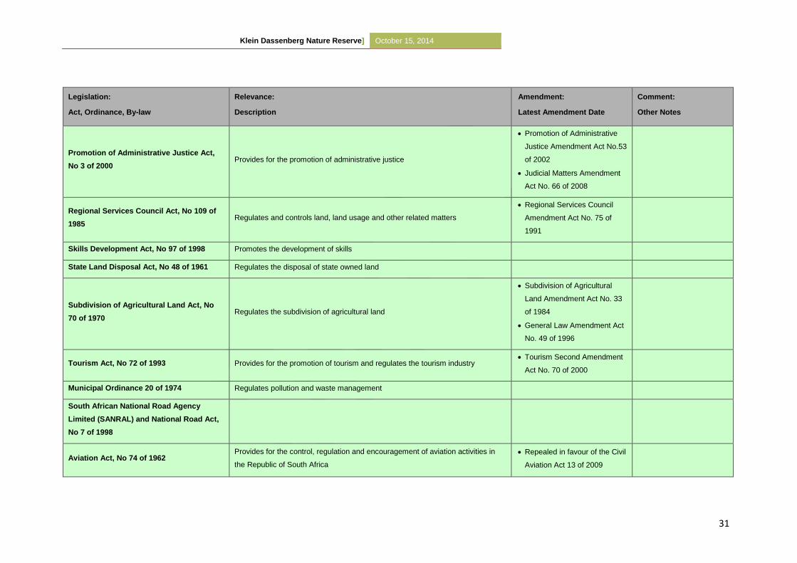
Klein Dassenberg Nature Reserve] October 15, 2014
31
Legislation:
Act, Ordinance, By-law
Relevance:
Description
Amendment:
Latest Amendment Date
Comment:
Other Notes
Promotion of Administrative Justice Act,
No 3 of 2000 Provides for the promotion of administrative justice
Promotion of Administrative
Justice Amendment Act No.53
of 2002
Judicial Matters Amendment
Act No. 66 of 2008
Regional Services Council Act, No 109 of
1985 Regulates and controls land, land usage and other related matters
Regional Services Council
Amendment Act No. 75 of
1991
Skills Development Act, No 97 of 1998 Promotes the development of skills
State Land Disposal Act, No 48 of 1961 Regulates the disposal of state owned land
Subdivision of Agricultural Land Act, No
70 of 1970 Regulates the subdivision of agricultural land
Subdivision of Agricultural
Land Amendment Act No. 33
of 1984
General Law Amendment Act
No. 49 of 1996
Tourism Act, No 72 of 1993 Provides for the promotion of tourism and regulates the tourism industry Tourism Second Amendment
Act No. 70 of 2000
Municipal Ordinance 20 of 1974 Regulates pollution and waste management
South African National Road Agency
Limited (SANRAL) and National Road Act,
No 7 of 1998
Aviation Act, No 74 of 1962 Provides for the control, regulation and encouragement of aviation activities in
the Republic of South Africa
Repealed in favour of the Civil
Aviation Act 13 of 2009
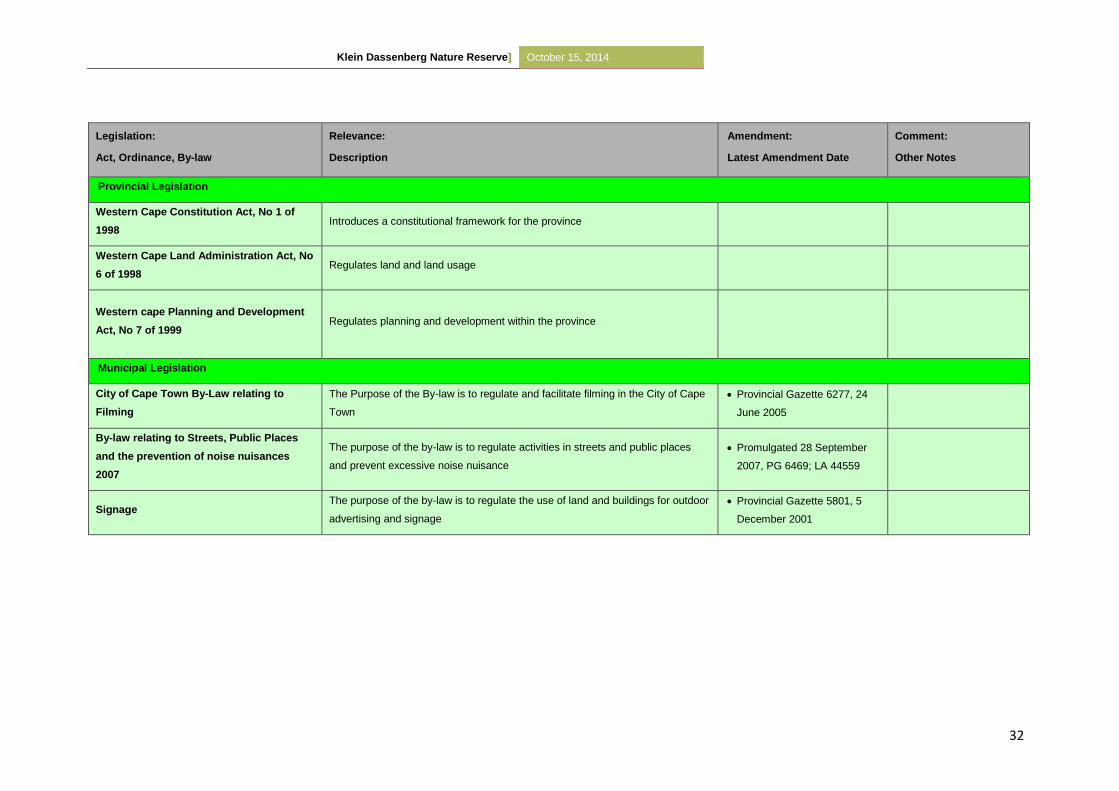
Klein Dassenberg Nature Reserve] October 15, 2014
32
Legislation:
Act, Ordinance, By-law
Relevance:
Description
Amendment:
Latest Amendment Date
Comment:
Other Notes
Provincial Legislation
Western Cape Constitution Act, No 1 of
1998 Introduces a constitutional framework for the province
Western Cape Land Administration Act, No
6 of 1998 Regulates land and land usage
Western cape Planning and Development
Act, No 7 of 1999 Regulates planning and development within the province
Municipal Legislation
City of Cape Town By-Law relating to
Filming
The Purpose of the By-law is to regulate and facilitate filming in the City of Cape
Town
Provincial Gazette 6277, 24
June 2005
By-law relating to Streets, Public Places
and the prevention of noise nuisances
2007
The purpose of the by-law is to regulate activities in streets and public places
and prevent excessive noise nuisance
Promulgated 28 September
2007, PG 6469; LA 44559
Signage The purpose of the by-law is to regulate the use of land and buildings for outdoor
advertising and signage
Provincial Gazette 5801, 5
December 2001
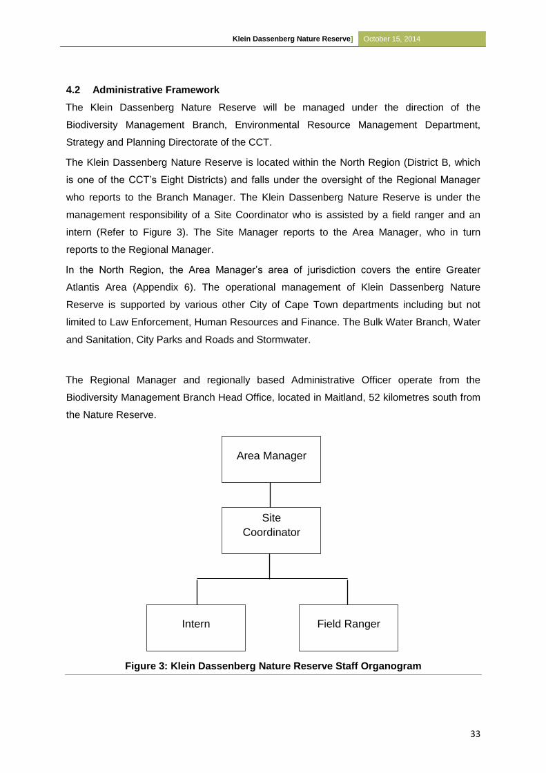
Klein Dassenberg Nature Reserve] October 15, 2014
33
4.2 Administrative Framework
The Klein Dassenberg Nature Reserve will be managed under the direction of the
Biodiversity Management Branch, Environmental Resource Management Department,
Strategy and Planning Directorate of the CCT.
The Klein Dassenberg Nature Reserve is located within the North Region (District B, which
is one of the CCT’s Eight Districts) and falls under the oversight of the Regional Manager
who reports to the Branch Manager. The Klein Dassenberg Nature Reserve is under the
management responsibility of a Site Coordinator who is assisted by a field ranger and an
intern (Refer to Figure 3). The Site Manager reports to the Area Manager, who in turn
reports to the Regional Manager.
In the North Region, the Area Manager’s area of jurisdiction covers the entire Greater
Atlantis Area (Appendix 6). The operational management of Klein Dassenberg Nature
Reserve is supported by various other City of Cape Town departments including but not
limited to Law Enforcement, Human Resources and Finance. The Bulk Water Branch, Water
and Sanitation, City Parks and Roads and Stormwater.
The Regional Manager and regionally based Administrative Officer operate from the
Biodiversity Management Branch Head Office, located in Maitland, 52 kilometres south from
the Nature Reserve.
Figure 3: Klein Dassenberg Nature Reserve Staff Organogram
Area Manager
Site
Coordinator
Intern Field Ranger
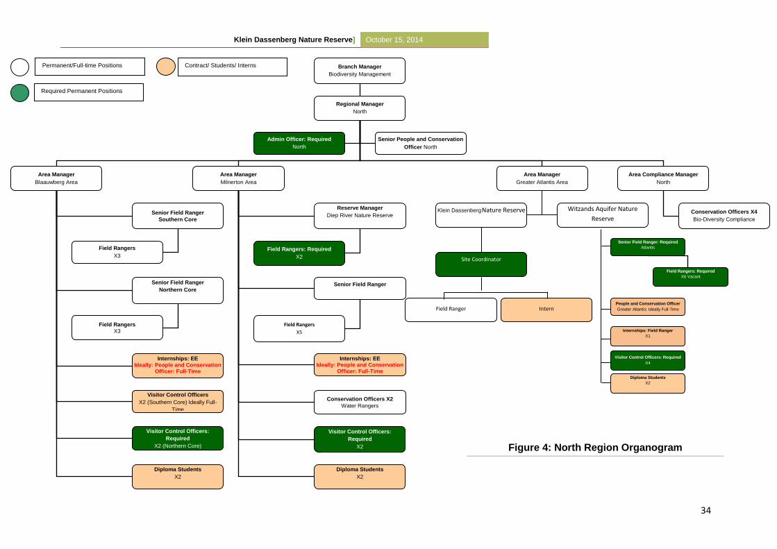
Klein Dassenberg Nature Reserve] October 15, 2014
34
Branch Manager
Biodiversity Management
Regional Manager
North
Area Manager
Blaauwberg Area
Area Manager
Milnerton Area
Area Manager
Greater Atlantis Area
Reserve Manager
Diep River Nature Reserve
Area Compliance Manager
North
Conservation Officers X4
Bio-Diversity Compliance
Senior Field Ranger
Field Rangers
X5
Internships: EE Ideally: People and Conservation
Officer: Full-Time
Senior Field Ranger
Southern Core
Field Rangers
X3
Senior Field Ranger
Northern Core
Internships: EE Ideally: People and Conservation
Officer: Full-Time
Admin Officer: Required
North
Conservation Officers X2
Water Rangers
Visitor Control Officers
X2 (Southern Core) Ideally Full-
Time
Senior People and Conservation
Officer North
Visitor Control Officers:
Required
X2
Visitor Control Officers:
Required
X2 (Northern Core)
Field Rangers
X3
Diploma Students
X2
Diploma Students
X2
Field Rangers: Required
X2
Contract/ Students/ Interns
Required Permanent Positions
Permanent/Full-time Positions
Klein Dassenberg Nature Reserve Witzands Aquifer Nature
Reserve
Senior Field Ranger: Required
Atlantis
Internships: Field Ranger
X1
Visitor Control Officers: Required
X4
Diploma Students
X2
Field Rangers: Required
X6 Vacant
People and Conservation Officer
Greater Atlantis: Ideally Full-Time
Site Coordinator
Field Ranger Intern
Figure 4: North Region Organogram
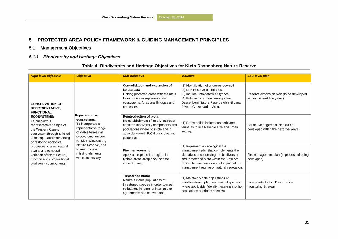
Klein Dassenberg Nature Reserve] October 15, 2014
35
5 PROTECTED AREA POLICY FRAMEWORK & GUIDING MANAGEMENT PRINCIPLES
5.1 Management Objectives
5.1.1 Biodiversity and Heritage Objectives
Table 4: Biodiversity and Heritage Objectives for Klein Dassenberg Nature Reserve
High level objective Objective Sub-objective Initiative Low level plan
CONSERVATION OF
REPRESENTATIVE,
FUNCTIONAL
ECOSYSTEMS:
To conserve a
representative sample of
the Western Cape’s
ecosystem through a linked
landscape, and maintaining
or restoring ecological
processes to allow natural
spatial and temporal
variation of the structural,
function and compositional
biodiversity components.
Representative
ecosystems:
To incorporate a
representative range
of viable terrestrial
ecosystems, unique
to Klein Dassenberg
Nature Reserve, and
to re-introduce
missing elements
where necessary.
Consolidation and expansion of
land areas:
Linking protected areas with the main
focus on under representative
ecosystems, functional linkages and
processes.
(1) Identification of underrepresented
(2) Link Reserve boundaries.
(3) Include untransformed fynbos.
(4) Establish corridors linking Klein
Dassenberg Nature Reserve with Nirvana
Private Conservation Area.
Reserve expansion plan (to be developed
within the next five years)
Reintroduction of biota:
Re-establishment of locally extinct or
depleted biodiversity components and
populations where possible and in
accordance with IUCN principles and
guidelines.
(1) Re-establish indigenous herbivore
fauna as to suit Reserve size and urban
setting.
Faunal Management Plan (to be
developed within the next five years)
Fire management:
Apply appropriate fire regime in
fynbos areas (frequency, season,
intensity, size).
(1) Implement an ecological fire
management plan that complements the
objectives of conserving the biodiversity
and threatened biota within the Reserve.
(2) Continuous monitoring of impact of fire
management regime on natural vegetation.
Fire management plan (in process of being
developed)
Threatened biota:
Maintain viable populations of
threatened species in order to meet
obligations in terms of international
agreements and conventions.
(1) Maintain viable populations of
rare/threatened plant and animal species
where applicable (identify, locate & monitor
populations of priority species)
Incorporated into a Branch wide
monitoring Strategy
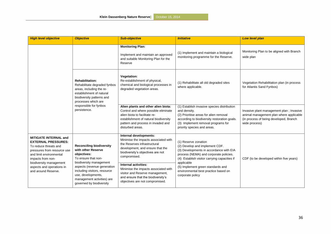
Klein Dassenberg Nature Reserve] October 15, 2014
36
High level objective Objective Sub-objective Initiative Low level plan
Monitoring Plan:
Implement and maintain an approved
and suitable Monitoring Plan for the
Reserve
(1) Implement and maintain a biological
monitoring programme for the Reserve.
Monitoring Plan to be aligned with Branch
wide plan
Rehabilitation:
Rehabilitate degraded fynbos
areas, including the re-
establishment of natural
biodiversity patterns and
processes which are
responsible for fynbos
persistence.
Vegetation:
Re-establishment of physical,
chemical and biological processes in
degraded vegetation areas.
(1) Rehabilitate all old degraded sites
where applicable.
Vegetation Rehabilitation plan (in process
for Atlantis Sand Fynbos)
Alien plants and other alien biota:
Control and where possible eliminate
alien biota to facilitate re-
establishment of natural biodiversity
pattern and process in invaded and
disturbed areas.
(1) Establish invasive species distribution
and density.
(2) Prioritise areas for alien removal
according to biodiversity restoration goals.
(3) Implement removal programs for
priority species and areas.
Invasive plant management plan ; Invasive
animal management plan where applicable
(in process of being developed, Branch
wide process)
MITIGATE INTERNAL and
EXTERNAL PRESSURES:
To reduce threats and
pressures from resource use
and limit environmental
impacts from non-
biodiversity management
aspects and operations in
and around Reserve.
Reconciling biodiversity
with other Reserve
objectives:
To ensure that non-
biodiversity management
aspects (revenue generation
including visitors, resource
use, developments,
management activities) are
governed by biodiversity
Internal developments:
Minimise the impacts associated with
the Reserves infrastructural
development, and ensure that the
biodiversity’s objectives are not
compromised.
(1) Reserve zonation
(2) Develop and implement CDF.
(3) Developments in accordance with EIA
process (NEMA) and corporate policies.
(4) Establish visitor carrying capacities if
applicable
(5) Implement green standards and
environmental best practice based on
corporate policy
CDF (to be developed within five years)
Internal activities:
Minimise the impacts associated with
visitor and Reserve management,
and ensure that the biodiversity’s
objectives are not compromised.
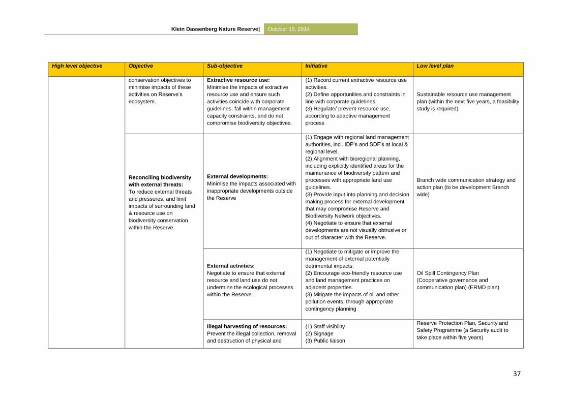
Klein Dassenberg Nature Reserve] October 15, 2014
37
High level objective Objective Sub-objective Initiative Low level plan
conservation objectives to
minimise impacts of these
activities on Reserve’s
ecosystem.
Extractive resource use:
Minimise the impacts of extractive
resource use and ensure such
activities coincide with corporate
guidelines; fall within management
capacity constraints, and do not
compromise biodiversity objectives.
(1) Record current extractive resource use
activities.
(2) Define opportunities and constraints in
line with corporate guidelines.
(3) Regulate/ prevent resource use,
according to adaptive management
process
Sustainable resource use management
plan (within the next five years, a feasibility
study is required)
Reconciling biodiversity
with external threats:
To reduce external threats
and pressures, and limit
impacts of surrounding land
& resource use on
biodiversity conservation
within the Reserve.
External developments:
Minimise the impacts associated with
inappropriate developments outside
the Reserve
(1) Engage with regional land management
authorities, incl. IDP’s and SDF’s at local &
regional level.
(2) Alignment with bioregional planning,
including explicitly identified areas for the
maintenance of biodiversity pattern and
processes with appropriate land use
guidelines.
(3) Provide input into planning and decision
making process for external development
that may compromise Reserve and
Biodiversity Network objectives.
(4) Negotiate to ensure that external
developments are not visually obtrusive or
out of character with the Reserve.
Branch wide communication strategy and
action plan (to be development Branch
wide)
External activities:
Negotiate to ensure that external
resource and land use do not
undermine the ecological processes
within the Reserve.
(1) Negotiate to mitigate or improve the
management of external potentially
detrimental impacts.
(2) Encourage eco-friendly resource use
and land management practices on
adjacent properties.
(3) Mitigate the impacts of oil and other
pollution events, through appropriate
contingency planning
Oil Spill Contingency Plan
(Cooperative governance and
communication plan) (ERMD plan)
Illegal harvesting of resources:
Prevent the illegal collection, removal
and destruction of physical and
(1) Staff visibility
(2) Signage
(3) Public liaison
Reserve Protection Plan, Security and
Safety Programme (a Security audit to
take place within five years)
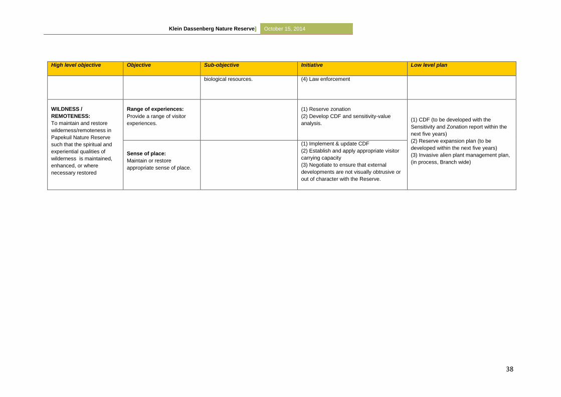
Klein Dassenberg Nature Reserve] October 15, 2014
38
High level objective Objective Sub-objective Initiative Low level plan
biological resources. (4) Law enforcement
WILDNESS /
REMOTENESS:
To maintain and restore
wilderness/remoteness in
Papekuil Nature Reserve
such that the spiritual and
experiential qualities of
wilderness is maintained,
enhanced, or where
necessary restored
Range of experiences:
Provide a range of visitor
experiences.
(1) Reserve zonation
(2) Develop CDF and sensitivity-value
analysis. (1) CDF (to be developed with the
Sensitivity and Zonation report within the
next five years)
(2) Reserve expansion plan (to be
developed within the next five years)
(3) Invasive alien plant management plan,
(in process, Branch wide)
Sense of place:
Maintain or restore
appropriate sense of place.
(1) Implement & update CDF
(2) Establish and apply appropriate visitor
carrying capacity
(3) Negotiate to ensure that external
developments are not visually obtrusive or
out of character with the Reserve.
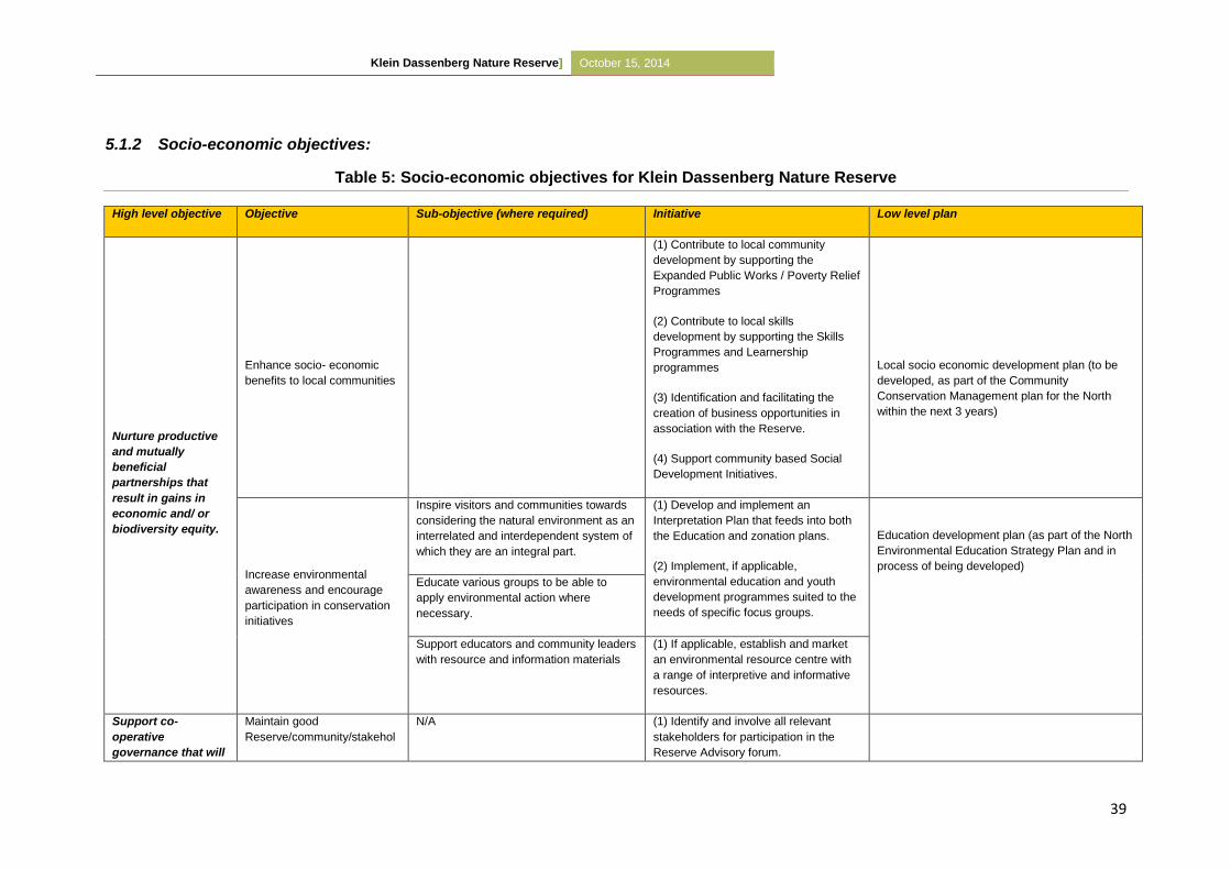
Klein Dassenberg Nature Reserve] October 15, 2014
39
5.1.2 Socio-economic objectives:
Table 5: Socio-economic objectives for Klein Dassenberg Nature Reserve
High level objective Objective Sub-objective (where required) Initiative Low level plan
Nurture productive
and mutually
beneficial
partnerships that
result in gains in
economic and/ or
biodiversity equity.
Enhance socio- economic
benefits to local communities
(1) Contribute to local community
development by supporting the
Expanded Public Works / Poverty Relief
Programmes
(2) Contribute to local skills
development by supporting the Skills
Programmes and Learnership
programmes
(3) Identification and facilitating the
creation of business opportunities in
association with the Reserve.
(4) Support community based Social
Development Initiatives.
Local socio economic development plan (to be
developed, as part of the Community
Conservation Management plan for the North
within the next 3 years)
Increase environmental
awareness and encourage
participation in conservation
initiatives
Inspire visitors and communities towards
considering the natural environment as an
interrelated and interdependent system of
which they are an integral part.
(1) Develop and implement an
Interpretation Plan that feeds into both
the Education and zonation plans.
(2) Implement, if applicable,
environmental education and youth
development programmes suited to the
needs of specific focus groups.
Education development plan (as part of the North
Environmental Education Strategy Plan and in
process of being developed)
Educate various groups to be able to
apply environmental action where
necessary.
Support educators and community leaders
with resource and information materials
(1) If applicable, establish and market
an environmental resource centre with
a range of interpretive and informative
resources.
Support co-
operative
governance that will
Maintain good
Reserve/community/stakehol
N/A (1) Identify and involve all relevant
stakeholders for participation in the
Reserve Advisory forum.
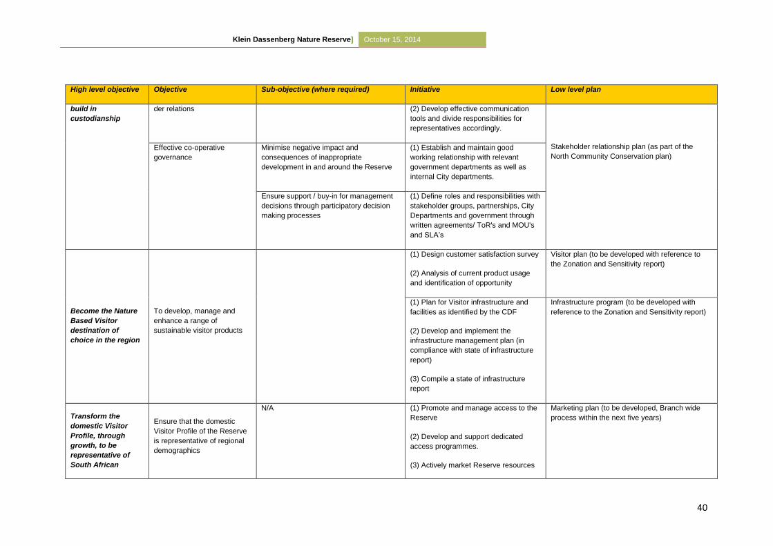
Klein Dassenberg Nature Reserve] October 15, 2014
40
High level objective Objective Sub-objective (where required) Initiative Low level plan
build in
custodianship
der relations (2) Develop effective communication
tools and divide responsibilities for
representatives accordingly.
Stakeholder relationship plan (as part of the
North Community Conservation plan)
Effective co-operative
governance
Minimise negative impact and
consequences of inappropriate
development in and around the Reserve
(1) Establish and maintain good
working relationship with relevant
government departments as well as
internal City departments.
Ensure support / buy-in for management
decisions through participatory decision
making processes
(1) Define roles and responsibilities with
stakeholder groups, partnerships, City
Departments and government through
written agreements/ ToR's and MOU's
and SLA’s
Become the Nature
Based Visitor
destination of
choice in the region
To develop, manage and
enhance a range of
sustainable visitor products
(1) Design customer satisfaction survey
(2) Analysis of current product usage
and identification of opportunity
Visitor plan (to be developed with reference to
the Zonation and Sensitivity report)
(1) Plan for Visitor infrastructure and
facilities as identified by the CDF
(2) Develop and implement the
infrastructure management plan (in
compliance with state of infrastructure
report)
(3) Compile a state of infrastructure
report
Infrastructure program (to be developed with
reference to the Zonation and Sensitivity report)
Transform the
domestic Visitor
Profile, through
growth, to be
representative of
South African
Ensure that the domestic
Visitor Profile of the Reserve
is representative of regional
demographics
N/A (1) Promote and manage access to the
Reserve
(2) Develop and support dedicated
access programmes.
(3) Actively market Reserve resources
Marketing plan (to be developed, Branch wide
process within the next five years)
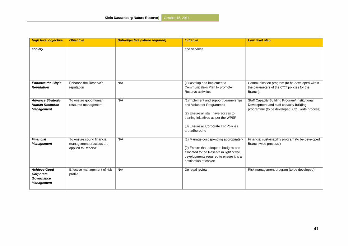
Klein Dassenberg Nature Reserve] October 15, 2014
41
High level objective Objective Sub-objective (where required) Initiative Low level plan
society and services
Enhance the City’s
Reputation
Enhance the Reserve’s
reputation
N/A (1)Develop and implement a
Communication Plan to promote
Reserve activities
Communication program (to be developed within
the parameters of the CCT policies for the
Branch)
Advance Strategic
Human Resource
Management
To ensure good human
resource management
N/A (1)Implement and support Learnerships
and Volunteer Programmes
(2) Ensure all staff have access to
training initiatives as per the WPSP
(3) Ensure all Corporate HR Policies
are adhered to
Staff Capacity Building Program/ Institutional
Development and staff capacity building
programme (to be developed, CCT wide process)
Financial
Management
To ensure sound financial
management practices are
applied to Reserve
N/A (1) Manage cost spending appropriately
(2) Ensure that adequate budgets are
allocated to the Reserve in light of the
developments required to ensure it is a
destination of choice
Financial sustainability program (to be developed
Branch wide process.)
Achieve Good
Corporate
Governance
Management
Effective management of risk
profile
N/A Do legal review Risk management program (to be developed)
Klein Dassenberg Nature Reserve] October 15, 2014
42
5.2 SWOT analysis
The following identifies the Strengths, Weaknesses, Opportunities and Threats for the Klein
Dassenberg Nature Reserve.
Strengths:
The Nature Reserve forms part of the DCCP and was identified as a key area for
protected area expansion by Cape Nature’s 2010 Protected Area Expansion Strategy
as well as the 2010 WWF-Table Mountain Fund Climate Change Corridor
Local knowledge and expertise of areas under jurisdiction
Community involvement and participation
Management commitment to compiling and implementing management plans and
Biodiversity Action plans
Legislative support- Municipal By-laws, Nature Conservation Ordinance, NEMA and
various other relevant or related legislations.
Constitutional support
Management has experience and knowledge in managing Protected areas
Corporate Support Services exist
Staff determination and will to succeed
Fully functional ecosystems exist
Access to Specialist services and databases
Borders Dassenberg Nature Reserve, expanding the DCCP initiative
Potential expansion with Nirvana
Protects Critically Endangered Atlantis Sand Fynbos vegetation
Klein Dassenberg Nature Reserve] October 15, 2014
43
Weaknesses:
The Nature Reserve is not enclosed so management of illegal activities will be difficult
Managements lack of knowledge of area and history
Limited knowledge of security threats within the Nature Reserve
Operational Budget needs review
Law enforcement tends to be reactive instead of proactive
Lack of operationally mandated staff to adequately utilise environmental legislation
Ignorance by public of applicable environmental legislation
Lack of adequate operational and administrative office space and equipment
Geographically far from City Administrative hubs
Lack of co-ordination and co-operation between Nature Reserve and
National/Provincial government departments
Invasive alien plants (invasion of/by alien invasive plant species)
Community liaison
Opportunities:
Aesthetic beauty of the Nature Reserve which could potentially attract tourists
Potential expansion which would form part of the DCCP
Community development
The implementation of biological monitoring systems
Increased environmental awareness/ education opportunities
Increased community ownership
Creation of job opportunities and career succession and planning
To proactively engage communities closest to the Nature Reserve and recognising
their needs.
Continuous liaison with Community Based Organisations (CBOs) and other Non-
Governmental Organisations (NGOs)
To link up with surrounding land owners, share knowledge, resources in order to
effectively manage the Biodiversity Network
Promote the Nature Reserve as a destination of choice for outdoor environmentally
sound activities
To build and establish a viable volunteer group to actively participate in Nature
Reserve management activities
To entrench and maintain strong political support from local Ward Councillors
Klein Dassenberg Nature Reserve] October 15, 2014
44
Threats:
Conflict between surrounding communities
Conflict between CCT and surrounding communities on land ownership
Illegal activities (illegal harvesting of fauna and flora, illegal sand mining, illegal
dumping, off–road vehicles, inappropriate fir regimes).
Poor reserve management (plus lack of staff)
Lack of funding for necessary infrastructure to increase tourist attraction
Unemployment leads to rising crime levels
Threats and intimidation towards conservation staff when applying legislation
Lack of commitment from stakeholders
Lack of appropriate training
Personal safety of staff
Growing external communities with increasing needs
Lack of sustainable funding for students and Interns
Lack of adequate funding to hire appropriate numbers of full-time staff
Lack of adequate operational funding
Loss of biodiversity due to inappropriate fires, invasive species, illegal activities and
inappropriate land-use practices
Change in local government political structures
Illegal entry points not controlled i.e. off-road vehicles and the network of footpaths and
tracks
Inappropriate development – edge effect impacts could reduce the viability of the
Nature Reserve through fragmentation of the habitat
Climate change
5.3 Protected Area Management Policy Framework and Guiding Principles
5.3.1 Community Participation
The Klein Dassenberg Nature Reserve is to become the future focus of community- and
tourist-centred programmes directed at the sustainable long-term conservation and use of its
ecological and historical landscape.
For the Reserve to succeed in the absence of substantial public funding, mutually beneficial
partnerships which will result in economic and/or biodiversity equity will be pursued.
In the development of a Regional Community Conservation Management Plan, the
objectives should closely coincide with the DCCP’s.
Klein Dassenberg Nature Reserve] October 15, 2014
45
A contribution towards the development of local skills can be achieved through the
participation in Skills Development and Learnership Programmes in working partnerships
with CBOs and NGOs. Through the support of community based Social Development
initiatives the Nature Reserve can also enhance socio-economic benefits to local
communities.
5.3.2 Security and safety
The aim of a safety and security audit is to investigate the current security situation, security
services, infrastructure, staffing and social context of Klein Dassenberg Nature Reserve.
This audit is a priority for the Nature Reserve as known security problems currently occurring
is partly due to inadequate fencing and dense Acacia stands. The current illegal activities
include illegal access and trespassing; illegal harvesting; illegal dumping and livestock
grazing.
5.3.3 Tourism development and management
Tourism potential for the Nature Reserve as part of the Greater Atlantis/Mamre tourism route
concept exists. Currently, no tourism development is considered as the priority of the Nature
Reserve is to allow the vegetation to recover after too frequent fires and the extensive alien
infestation and consequent clearing. Any future tourism ventures should be assessed when
this management plan is reviewed in five years. The Nature Reserve has been zoned so
that tourism development can only occur on the most degraded area of the Reserve which is
situated next to the R304 on the Klein Dassenberg Section.
5.3.4 Infrastructure management
Minimum infrastructure exists within the Klein Dassenberg Nature Reserve, with only a few
dilapidated houses on the outskirts of Klein Dassenberg, next to R304. Currently these
houses are occupied, but negotiations with the residents are in process to find alternative
housing. Since these buildings conditions prevent cost-effective restoration, it is
recommended to knock them down once planning has been put in place for tourism
development. It is essential that any future infrastructure be managed in such a way that
there are no negative impacts on the already Critically Endangered vegetation. The
infrastructure should also add to visitors overall experience.
The road network infrastructure as well as footpaths also needs to be accessed and
prioritised in order to avoid continuous damage to the already sensitive vegetation types in
Klein Dassenberg Nature Reserve] October 15, 2014
46
the Nature Reserve. Illegal entrance will never fully be stopped therefore this situation
should be monitored and managed in terms of preventing damage to natural vegetation and
illegal activities.
5.3.5 Biodiversity Conservation Management
5.3.5.1 Community-based natural resource management (CBNRM)
The illegal harvesting that is occurring in the Nature Reserve should be stopped or at least
limited until a harvesting feasibility study is done. Little is known about the long-term effects
of harvesting on the viability of wild flower populations (Lamont et al., 2001). However it is
known non-sprouting species are more vulnerable to loss of flowers, fruits or seeds and that
the removal of flowering stems or fruits directly affects seed availability for future generations
and reduces the vigour of the plant. Nevertheless, more seeds are usually produced than
what is required for self-replacement which leads to strong intraspecific competition and
seedling mortality. Therefore in theory it should be possible to remove the “excess” without
threatening population viability. A study done by Lamont et al. (2001), picking should be
banned for the first 10 years post-fire, with picking commencing at 20% in year 11. However
these results are site specific therefore a harvesting feasibility plan is imperative for Papekuil
Nature Reserve. The feasibility plan should be produced in conjunction with veld age and fire
management.
A species harvesting plan where necessary should be developed in order to ensure the
sustainability of the relevant species and community livelihoods.
5.3.5.2 Fire Management
Fire plays a fundamental ecological role in the life-cycle of fynbos as it is both fire-prone and
fire-dependent. Fire is crucial to the long term conservation of the vegetation within the
Papekuil Nature Reserve as it shapes the structure and composition of fynbos, it is therefore
considered an important factor of nature reserve management (Rutherford et al., 2011). Fire
management involves controlling the season, frequency, size and intensity of fires to meet
all ecological requirements of the vegetation.
Invasive alien flora has been found to increase fuel load by 50-100%. Thus, it is essential
that any fire management plan should be carefully integrated with a plan to control invasive
alien plants. Currently, the fire management for Papekuil Nature Reserve is to strongly
prevent any fires from occurring, especially in the young veld and areas containing invasive
alien flora. This plan must be assessed during the revision of the management plan.
Klein Dassenberg Nature Reserve] October 15, 2014
47
Too frequent fires, or fires which don’t occur during the natural burning regime, could force
slower-growing species into extinction. It also results in veld degradation, allowing alien
species, especially grasses to invade. Grasses maintain a shorter fire cycle and permanently
change the vegetation structure and biodiversity value. On the other hand, if fire is excluded,
encroachment by other indigenous species can occur which would result in decreased
species richness and species coexistence.
Atlantis Sand Fynbos
Historically, unnatural fires have occurred too frequently in the Nature Reserve, resulting in a
mosaic of veld ages. Records of these fires as well as post fire monitoring records have
been used to determine veld ages which will influence fire management (Refer to Figure 11).
As depicted, fire exclusion in the young veld is a major priority as most of the Reserve is
younger than 10 years. The natural fire season is between November-April with a peak
between November and February (Brown et al., 1991). However, natural fires are limited in
spread within the constraints of ecological, project and public safety requirements.
Firebreaks and other fire control measures required by law will be implemented where
necessary and feasible.
The Reserve’s terrain and property boundaries increase the chances of fire spreading both
into- and out of the Reserve. Therefore pre-fire protection measures and a plan of action are
necessary in the event of a fire. The interaction by various CCT departments, independent
stakeholders and continuous public and private landowner involvement is essential.
Prescribed burning is used as a management tool when fynbos becomes senescent which
poses a risk of species loss. It is suggested that controlled burning be done at intervals
which would allow at least 50% of individuals in a population of the slowest-growing, obligate
reseeding plant species that have flowered and set seed for at least three consecutive
seasons (van Wilgen et al., 2010). This practice will assist in maintaining a vegetation
mosaic which would promote plant and animal diversity.
The Regional Conservation Policy statements of regular burning (12-20 years) in late
summer/autumn is largely based on the response of serotinous and other Proteaceae to fire.
There is no optimum regime for conserving diversity as a fixed regime will favour certain
species while others are suppressed, therefore a variation in the fire regime is important for
ensuring species coexistence (van Wilgen et al., 1994).
Klein Dassenberg Nature Reserve] October 15, 2014
48
Veld age maps should be used to determine prescribed burning patches (See Map 11). The
decision to administer prescribed burns is considered on an annual basis, and if required
planned and implemented accordingly. Fire may be used to keep fuel loads low so as to
reduce the risk of uncontrolled fires, particularly on the urban edge and in areas which
become a potential risk to infrastructure and public safety.
Implementation with regards to fire management in the Nature Reserve involves:
Application of guidelines on season, burning intervals and species requirements
acquired from relevant documentation and Biophysical Specialists;
Accurate record keeping of all fires, including details and maps;
Use of fire data and GIS for recording and mapping;
Application of post-fire monitoring programmes;
Application of fire data to determine prescribed burning needs; and
Development and Implementation of a Fire Protection and Reaction plan which
includes affected stakeholders, City of Cape Town department and private
landowners neighbouring the Nature Reserve.
5.3.5.3 Soil erosion and control
Within the Klein Dassenberg Nature Reserve, natural erosion processes are allowed to
operate without any interference, except where needed. In the case of human-induced
aggravated erosion, appropriate management action should take place. The source of
problem erosion sites and the management thereof will also be considered.
Currently there is no serious erosion occurring in the Nature Reserve, but frequent
monitoring is suggested especially during veld recovery after invasive alien removal.
Implementation with regards to soil management in the Nature Reserve includes:
Identification and recording of erosion sites, including restoration plans when
required
The use of GIS for recoding and mapping of erosion sites
Application of fixed-point monitoring programmes at identified sites; and
Accurate documentation of applied management actions to restoration sites including
subsequent results
Klein Dassenberg Nature Reserve] October 15, 2014
49
5.3.5.4 Invasive species management
Invasive alien organisms are a major global environmental problem and considered the
second most significant threat to biodiversity following direct habitat destruction (Holmes et
al., 2000). Not only do invasive alien trees and shrubs post a threat to fynbos vegetation, but
it also reduces our already scare water resources. Once alien trees have established, they
outcompete indigenous species, forming close stands which reduce light penetration and
alter nutrient recycling patterns, litter fall and fuel properties.
It is for this reason that alien clearing and follow-up is a priority within the Reserve. This is
done in order to facilitate the re-establishment of the Critically Endangered Atlantis Sand
Fynbos. The most dense invasive alien trees in the Nature Reserve is Port Jackson-Willow
(Acacia saligna), followed by Eucalyptus (Eucalyptus sp.) and Pine (Pinus sp.). Herbaceous
weeds should also be monitored in order to prevent invasive establishment.
Invasive species management within the Nature Reserve is applied in accordance with the
CCT Invasive Alien Species Strategy and in co-ordination with various government funded
initiatives, including Working for Water (WfW) and Working for Wetlands (WfWet).
Management should aim to implement a carefully planned and co-ordinated programme in
order to prevent reestablishment or spread of invasive alien fauna.
The cleared vegetation should be stacked into small brush piles and burnt during the cool
winter months. It is recommended to burn the piles during winter to reduce the adverse
ecological effects on the soil and allow greater indigenous seed recruitment. Although this
techniques requires a more intensive follow-up control of Acacia species, it is less
destructive to indigenous seed banks and results in higher recruitment than stand burns
(Jasson, 2005).
After the removal of invasive alien plant species, the gerbil (Tetra afra) and Cape dune mole-
rat (Bathyergus suillus)) populations need to be monitored in case management strategies
need to be implemented to control their activities which prevent veld recovery through added
disturbances. This could be achieved by putting up owl boxes in the Reserve and through
the recovery of native snake species.
There is currently no alien faunal species within the Nature Reserve. However, this should
be monitored and formal plans outlining the removal and management of an alien faunal
species is required.
In order to achieve these objectives the following is required:
Klein Dassenberg Nature Reserve] October 15, 2014
50
Mapping the extent of invasion in terms of density and species;
Determining the costs of removal and a plan of operations listing Initial control, Follow-up
control and Maintenance;
Prioritisation of lightly infested areas for alien removal in accordance with the
management blocks focussing on biodiversity restoration(Refer to Map 12/ Table 8);
The implementation of removal programmes for priority species and areas;
Keeping a detailed record of clearing operations
5.3.5.5 Species introductions
The potential to reintroduce faunal species which historically occurred in the Nature Reserve
and for which suitable habitats and eco-niches occur, does exist. However, it is not
recommended until the vegetation has fully recovered from alien clearing and anthropogenic
disturbances.
The potential for game reintroduction should be considered in five years time during the
revision of the management plan.
A full proposal prior to the re-introduction of any species must be submitted to the Fauna and
Flora Management Committee for consideration and endorsement. This ensures a full
investigation into the availability of suitable habitat for the species, the historical occurrence
and status of the species and the effect of re-introduction on the area. Public participation
would be required if the species is potentially dangerous or has the potential to become
problematic.
Only once the proposal is approved by the committee and Provincial authorities may
implementation take place. The implementation programme must also be specified in the
plan of action and documented accurately.
5.3.5.6 Water management
Water management within the Nature Reserve must comply with the National Water Act No.
36 of 1998, this includes the use of boreholes.
5.3.5.7 Strategic research
The collection of baseline data is essential for determining the presence of species and to
illustrate any changes in some features of the ecosystem. This data can also be used to
predict future vegetation patterns. It is also essential in determining whether management
practices are successful and where improvements are needed.
Klein Dassenberg Nature Reserve] October 15, 2014
51
Fixed point photography is a very useful tool for monitoring and documenting change. It is
definitely essential in adapting the management plan in terms of burning regimes and
rehabilitation.
5.4 Sensitivity Analysis of the Klein Dassenberg Nature Reserve
The Nature Reserve is important as it forms part of the DCCP and makes a significant
contribution to the national vegetation targets of threatened vegetation types as listed in the
National Spatial Biodiversity Assessment (Driver et al. 2005)
The development of a Sensitivity and Zonation plan is one of the steps required in compiling
a Conservation Development Framework (CDF) for the Nature Reserve. A CDF is a tool to
reconcile the various land-use needs and to demarcate visitor user zones and the
positioning and nature of new infrastructure; access points, roads and facilities. Currently,
there is no Sensitivity and Zonation report for the Nature Reserve but it is a priority that
should take place during the revision of this management plan in five years time. It is
recommended that infrastructural development occur only in Block 1 (See Map 8) of Klein
Dassenberg and none in Papekuil.
The CDF process has grown in response to the requirements of the National Environmental
Management: Biodiversity Act, Act 10 of 2004, hereby referred to as the NEM:BA (2004) and
is a strategy to comply with the spatial planning requirements of these Acts. The CDF will
ensure that best practice and sustainable development principles are integrated into spatial
planning within protected areas.
The Sensitivity-Value analysis is the landscape analysis portion of the broader Conservation
Development Framework. It is a multi-criteria decision-support tool for spatial planning that is
designed to integrate the best available information into a format that allows for defensible
and transparent decisions to be made. The Sensitivity-Value process is based on the
principle that the acceptability of a development (or placement of a structure) at a site is
based on the site’s value (either from biodiversity, heritage, aesthetic or a combination of
values) and its sensitivity or vulnerability to a variety of types of disturbance (Holness et al.
2005).
Klein Dassenberg Nature Reserve] October 15, 2014
52
The Sensitivity-Value analysis, the CDF and the associated zonation plan should form
part of an adaptive management system. They will grow and change over time as the
understanding of the landscapes and ecosystems improve; and
It does not replace the need for detailed site and zone planning and Environmental
Impact Assessment (EIA) compliance at site level.
5.5 Zonation Plan of the Klein Dassenberg Nature Reserve
5.5.1 Zoning Informants
This section briefly outlines the values underlying the identification of broad tourism use
zones. It is important to remember that the landscape/biodiversity analysis is just one of the
informants in the zonation process. Although the biodiversity analysis of the zoning process
is relatively objective, there are other informants that are not.
Although every attempt is made to place high sensitivity-value sites into more protected
zones where possible, the zoning process is in its essence a compromise between
environment and development. In particular, often the identified high value sites are the key
biodiversity assets that need to be made available in an appropriate manner to the
ecotourism market. Direct links between the biodiversity layers and the spatial management
of the Nature Reserve are made during the identification of special management areas
(where applicable). Even within high tourist use zones, there are likely to be areas subject to
very tight conservation controls (potentially including complete exclusion of human impacts
from an area).
Underlying decision making rules used in the zonation process:
The zonation process is aimed a striking a balance between environmental protection
and the development required to meet the broader economic and social objectives of
the Nature Reserve;
The zoning process takes into account existing development footprints and tourism
access routes;
This is based on the underlying principle that all else being equal, an existing
transformed site is preferable to a greenfields site from a biodiversity perspective;
Infrastructure costs are dramatically increased when developments take place away
from existing infrastructure;
Klein Dassenberg Nature Reserve] October 15, 2014
53
Existing tourism nodes and access routes are a reality of the economic landscape, and
it is would not be possible to shut down existing tourism sites compromising the
development objectives of the Nature Reserve;
Where existing development nodes, tourist sites and access routes occur in areas with
high sensitivity-value, then the broad use zoning aims to keep the development
footprint as small as is realistically possible, preferably within the existing transformed
site;
Where possible, sites with high biodiversity sensitivity-value are put into stronger
protection zones;
Peripheral development is favoured and where possible should be located outside of
the conservation area;
Two key points need to be emphasized:
The designation of a broad use zone does not imply that all sites within that zone
would be suitable for all the development types anticipated within that use zone.
Detailed site level planning is still required, and many sites may prove to be unsuitable
at a site/precinct/EIA level of planning; and
Special Management Areas/Overlays need to be formalised and the links made to the
management plans. (Adapted from Holness 2008)
5.5.2 Zoning Definitions and Descriptions
The zonation definitions and descriptions were work shopped with Regional and Area
managers. Four categories were decided on, namely; Primary Conservation zone,
Conservation zone, Low Intensity leisure zone and High Intensity leisure zone.
6 DEVELOPMENT PLAN
No development will occur within the Nature Reserve until the IRMP is reviewed in five years
time. The Reserve has however been zoned so that development of conservation related
infrastructure can only occur on the most degraded sites of the Reserve which is situated
next to the R304 of the Klein Dassenberg Section (Map 8). This zone has been allocated
according to veld degradation and tourism potential.
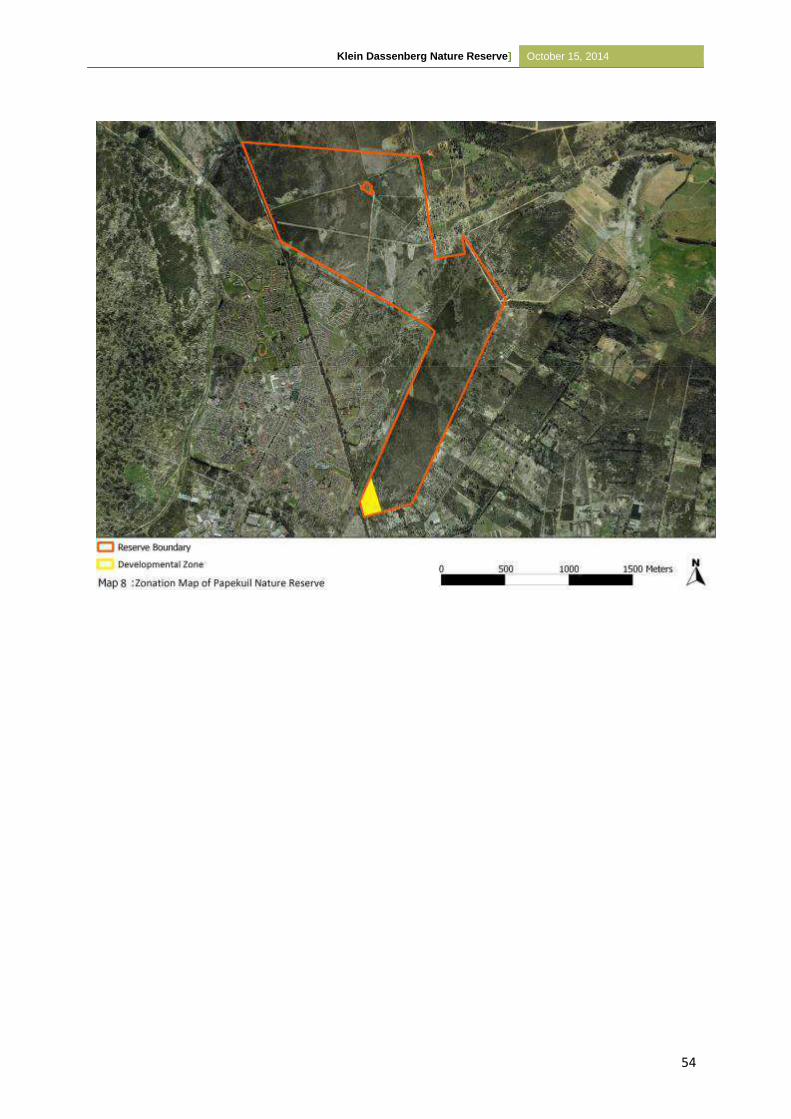
Klein Dassenberg Nature Reserve] October 15, 2014
54
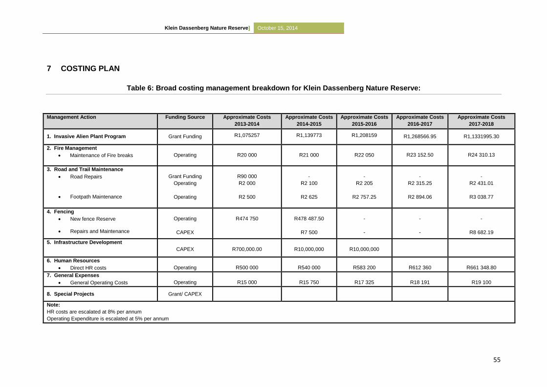
Klein Dassenberg Nature Reserve] October 15, 2014
55
7 COSTING PLAN
Table 6: Broad costing management breakdown for Klein Dassenberg Nature Reserve:
Management Action Funding Source Approximate Costs
2013-2014
Approximate Costs
2014-2015
Approximate Costs
2015-2016
Approximate Costs
2016-2017
Approximate Costs
2017-2018
1. Invasive Alien Plant Program Grant Funding R1,075257 R1,139773 R1,208159 R1,268566.95 R1,1331995.30
2. Fire Management
Maintenance of Fire breaks
Operating
R20 000
R21 000
R22 050 R23 152.50 R24 310.13
3. Road and Trail Maintenance
Road Repairs
Footpath Maintenance
Grant Funding
Operating
Operating
R90 000
R2 000
R2 500
-
R2 100
R2 625
-
R2 205
R2 757.25
-
R2 315.25
R2 894.06
-
R2 431.01
R3 038.77
4. Fencing
New fence Reserve
Repairs and Maintenance
Operating
CAPEX
R474 750
R478 487.50
R7 500
-
-
-
-
-
R8 682.19
5. Infrastructure Development
CAPEX
R700,000.00
R10,000,000
R10,000,000
6. Human Resources
Direct HR costs
Operating
R500 000
R540 000
R583 200
R612 360
R661 348.80
7. General Expenses
General Operating Costs
Operating
R15 000
R15 750
R17 325
R18 191
R19 100
8. Special Projects Grant/ CAPEX
Note:
HR costs are escalated at 8% per annum
Operating Expenditure is escalated at 5% per annum
Klein Dassenberg Nature Reserve] October 15, 2014
56
PART 3 – MONITORING AND AUDITING
8 MONITORING & AUDITING
8.1 ANNUAL AUDIT PROCEDURE [Set format taken from previous CCT Management
Plan]
8.1.1 Management Effectiveness Tracking Tool –METT
The METT-SA is a rapid, site-level assessment tool adapted from the World Bank & WWF’s
system (2007). The system is based on the concept that appropriate protected area
management encompasses six distinct stages:
1. Understanding the context (where are we now?) of existing values and threats,
2. Progress through planning (where do we want to be?)
3. Allocation of resources (inputs) (what do we need?)
4. Implementing management actions (processes) (how do we go about it?)
5. Producing products and services from the management actions (outputs) (what were
the results?),
6. The management outcomes (what did we achieve?).
This version has been compiled so that it can be applied to the full range of protected areas
managed by all C.A.P.E. Partners. It is also applicable to protected areas in other regions and
with minor adaptations could be applied outside of South Africa. It may also be applied to
MPA’s and islands, but in the long run it may be necessary to amend the system to be more
specific to these areas. It may be necessary to develop a system for “off reserve” conservation
areas such as conservancies or stewardships.
When applying METT-SA it is important that the following be kept in mind:
The METT-SA is intended to report on progress of the reserve. Thus the score is the
baseline against which future assessments are made to see if there has been an
improvement;
It is site specific and must thus not be used to compare scores between different
protected areas;
It is a useful tool to give indications of trends in management. In this version the six
groups of elements of the management process as defined in the original version are
Klein Dassenberg Nature Reserve] October 15, 2014
57
scored as subsets of the total. This gives an indication of where improvement in
management needs to focus;
It is not intended to replace more detailed assessments as part of adaptive management
systems;
The METT has limitations in the quantitative measurement of Outcomes and these should
be measured by more objective and quantitative systems;
This version adjusts the total score where questions are not relevant; and
Often low scores in some questions can be a reflection on the organization and are out of
the control of the protected area manager. Thus under no circumstances should the
performance of managers be measured against the results of the METT-SA.
Frequency of application: Tracking the trends of management effectiveness is a long term
process and instant improvements are unlikely to be obtained. Generally the METT is applied at
three year intervals, but an annual application is acceptable if it is understood that changes may
only be slight.
8.1.2 Protected Area Review
The PA Review is an internal review conducted annually to assist managers in reviewing their
sites and to allow for adaptive management actions to take place where required (and within the
managers control).
8.2 Management Plan review
On a five-yearly basis, this Management Plan should be reviewed and adjusted accordingly. To
achieve this, the following questions (and others as needed) should be addressed:
Did this Integrated Reserve Management Plan make a significant contribution to
management of the Papekuil Nature Reserve?
Were individual management “prescriptions” realistic and achievable? Were they written
unambiguously which led to misunderstanding?
Were allocated budgets for each management activity realistic? If not, were they too
much or too little?
Were sufficiently qualified staff members allocated to each management activity?
There will be some overlap between the review and the audit and they should therefore be
done on the same day, by the same team.
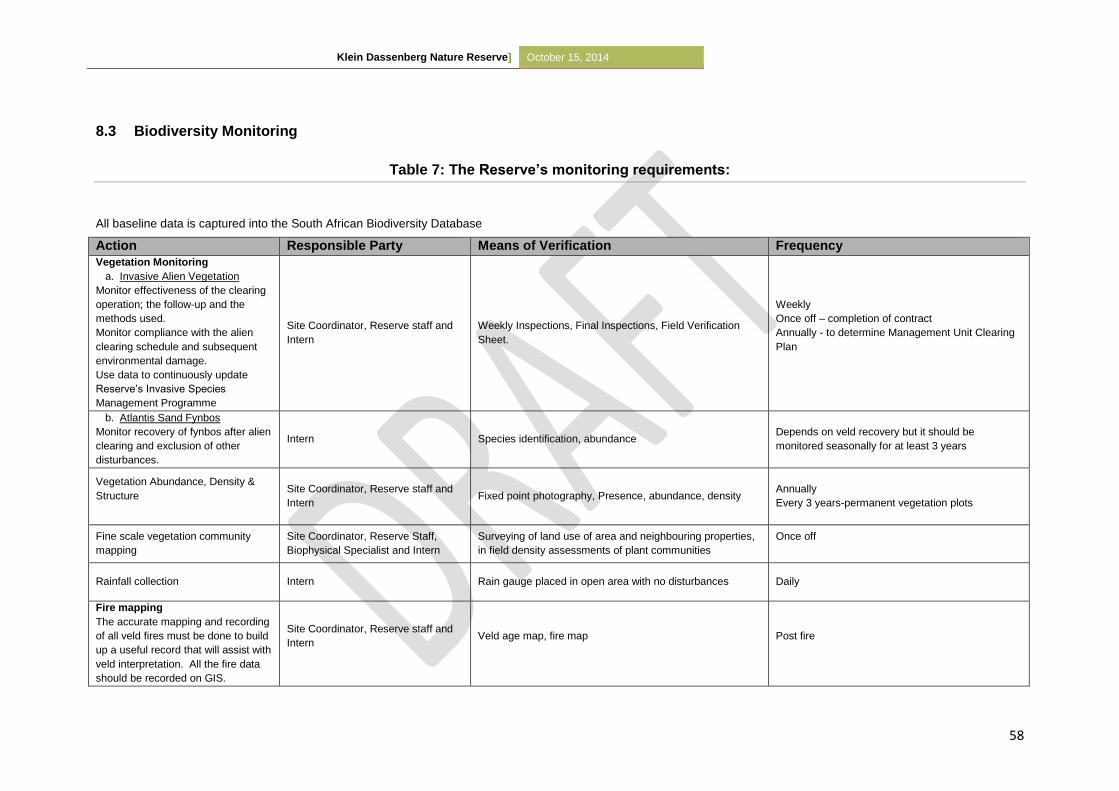
Klein Dassenberg Nature Reserve] October 15, 2014
58
8.3 Biodiversity Monitoring
Table 7: The Reserve’s monitoring requirements:
All baseline data is captured into the South African Biodiversity Database
Action Responsible Party Means of Verification Frequency
Vegetation Monitoring
a. Invasive Alien Vegetation
Monitor effectiveness of the clearing
operation; the follow-up and the
methods used.
Monitor compliance with the alien
clearing schedule and subsequent
environmental damage.
Use data to continuously update
Reserve’s Invasive Species
Management Programme
Site Coordinator, Reserve staff and
Intern
Weekly Inspections, Final Inspections, Field Verification
Sheet.
Weekly
Once off – completion of contract
Annually - to determine Management Unit Clearing
Plan
b. Atlantis Sand Fynbos
Monitor recovery of fynbos after alien
clearing and exclusion of other
disturbances.
Intern Species identification, abundance Depends on veld recovery but it should be
monitored seasonally for at least 3 years
Vegetation Abundance, Density &
Structure
Site Coordinator, Reserve staff and
Intern
Fixed point photography, Presence, abundance, density Annually
Every 3 years-permanent vegetation plots
Fine scale vegetation community
mapping
Site Coordinator, Reserve Staff,
Biophysical Specialist and Intern
Surveying of land use of area and neighbouring properties,
in field density assessments of plant communities
Once off
Rainfall collection Intern Rain gauge placed in open area with no disturbances Daily
Fire mapping
The accurate mapping and recording
of all veld fires must be done to build
up a useful record that will assist with
veld interpretation. All the fire data
should be recorded on GIS.
Site Coordinator, Reserve staff and
Intern
Veld age map, fire map
Post fire
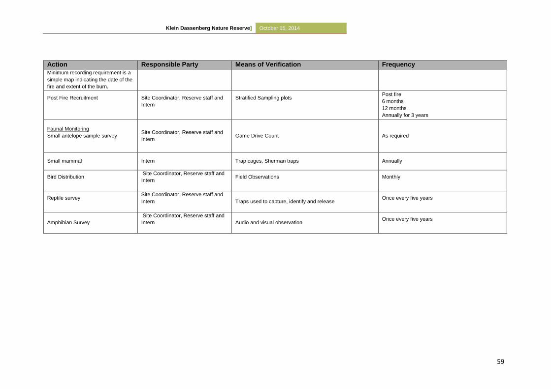
Klein Dassenberg Nature Reserve] October 15, 2014
59
Action Responsible Party Means of Verification Frequency
Minimum recording requirement is a
simple map indicating the date of the
fire and extent of the burn.
Post Fire Recruitment
Site Coordinator, Reserve staff and
Intern
Stratified Sampling plots
Post fire
6 months
12 months
Annually for 3 years
Faunal Monitoring
Small antelope sample survey
Site Coordinator, Reserve staff and
Intern
Game Drive Count
As required
Small mammal Intern Trap cages, Sherman traps Annually
Bird Distribution
Site Coordinator, Reserve staff and
Intern
Field Observations
Monthly
Reptile survey
Site Coordinator, Reserve staff and
Intern
Traps used to capture, identify and release Once every five years
Amphibian Survey
Site Coordinator, Reserve staff and
Intern
Audio and visual observation Once every five years

Klein Dassenberg Nature Reserve] October 15, 2014
60
PART 4 - REFERENCES
9 REFERENCES
Anon. 20031. The Integrated Metropolitan Environmental Policy. Unpublished report, City of
Cape Town.
Anon. 20032. The Biodiversity Strategy. Unpublished report, City of Cape Town.
Anon. 20091. Local Biodiversity Strategy and Action Plan 2009 – 2019. Unpublished report, City
of Cape Town.
Anon. 2010. City of Cape Town, Five-year Plan for Cape Town, Integrated Development Plan
(IDP) 2007 – 2012, 2010 – 2011 Review. Unpublished report, City of Cape Town.
Brown, P.J., Manders, P.T. and Bands, D.P. 1991. Prescribed Burning as a Conservation
Management Practice: A Case History from the Cederberg Mountains, Cape Province, South
Africa. Biological Conservation 56:133-150.
Cape West Coast Biosphere. 2012. Paleontological, Historical and Cultural History. [Online]
Available at: http://www.capebiosphere.co.za/index.php/nature/bio-
diversity/paleontological-historical-and-cultural-history [Accessed 2 September 2013]
City of Cape Town, 2012. City of Cape Town Biodiversity Network: Methods and Results
Technical report. Cape Town: City of Cape Town.
CSIR, 2002. Atlantis Aquifer: A status report on 20 years of groundwater management at
Atlantis. Stellenbosch: CSIR.
Cowling, R.M., Pressey, R.L., Rouget, M.R. and Lombard, A.T. (2003). A conservation plan for
a global biodiversity hotspot – the Cape Floristic Region, South Africa. Biological
Conservation, 112:191-216.
Driver, A., Maze, K., Rouget, M., Lombard, A.T., Nel, J., Turpie, J. K., Cowling, R.M., Desmet,
P., Goodman, P., Harris, J., Jonas, Z., Reyers, B., Sink, K. and Strauss, T. 2005. National
Spatial Biodiversity Assessment 2004: Priorities for biodiversity conservation in South Africa.
Strelitzia 17, SANBI, Pretoria.
Google Earth, 2013. Papkuil Nautre Reserve Global Positioning Co-ordinates [Online] Available
at: http://www.Google\Google Earth\client\googleearth.exe [Accessed 11 October 2013].
Hall, A.V. (1987). Threatened Plants in the Fynbos and Karoo Biomes, South Africa. Biological
Conservation, 40:29-52.
Holmes, P.M., Richardson, D.M., van Wilgen, B.W. and Gelderblom, C. 2000. Recovery of
South African fynbos vegetation following alien woody plant clearing and fire: implications for
restoration. Australian Ecology 25:631-639.
Klein Dassenberg Nature Reserve] October 15, 2014
61
Holness, 2005. Sensitivity Value Analyses Manual. A decision support tool, operating on the
principles of systemic conservation planning, for intergrating best available biodiversity
knowledge into spatial planning within national parks. SANParks Internal report.
Holness, S. and Skowno, A. 2008. Report on Sensitivity-Value Analyses and Zonation Process
for the Boland Mountain Complex. CapeNature Conservation Internal report.
Huyser, O. and Pence, G. 2010. Towards Protecting Key Climate-Adaptation Corridors in the
Western Cape [Powerpoint Presentation]. Cap EbA Workshop, CBC.
Jacobs, K. and Jangle, R. 2008. Fynbos Ecosystem Management Plan: Western Cape.
Unpublished, The Nature Conservation Cooperation, Cape Town.
Jarman, 1986. Conservation priorities in lowland regions of the fynbos biome. South African
National Scientific Programmes Report No. 87. CSIR.
Jasson, René. 2005. Management of Acacia species seed banks in the Table Mountain
National Park, Cape Peninsula, South Africa. Masters Dissertation, University of
Stellenbosch.
Jeffery, D. 1999. A Botanical Assessment of Saxonwold, Atlantis. Environmental Consultants
(Pty) Ltd. Ref 1999/47.
Kilian, D. 1995. Dreams for the Dassenberg. FCC Report 95/2. Flora Conservation Committee ,
Botanical Society of South Africa.
Lamont, B.B., Marsula., R., Enright, N.J. and Witkowski, E.T.F. 2001. Conservation
requirements of an exploited wildflower: modelling the effects of plant age, growing
conditions and harvesting intensity. Biological Conservation 99:157-168.
Mabihi, K. 2009. Student Experiential Training Report, Witzands Aquifer Conservation Area.
Mucina, L and Rutherford, M.C. 2006. The vegetation of South Africa, Lesotho and Swaziland.
South African National Biodiversity Institute.
Mugabe, J.C. 2008. Small Mammal Communities in the Transformed Landscapes of the
Western Cape Lowlands and Their Role in Alien Invasion into Fynbos Remnants. Masters
Dissertation, University of Stellenbosch.
Purnell, K., Kirkwood, D. and Maree, K. 2010. CapeNature Protected Area Expansion Strategy
and Implementation Plan 2010-2015. CapeNature.
Rebelo, A. G. and Siegfried, W.R. 1990. Protection of Fynbos Vegetation: Ideal and Real-World
Options. Biological Conservation 54:15-31.
Rebelo, A. G., Holmes, P. M., Dorse, C., and Wood, J. 2011. Impacts of urbanization in a
biodiversity hotspot: conservation challenges in Metropolitan Cape Town. South African
Journal of Botany 77(1):20-35.
Rouget, M., Richardson, D.M., Cowling, R.M., Lloyd, J.W. and Lombard, A.T. (2003). Current
patterns of habitat transformation and future threats to biodiversity in terrestrial
Klein Dassenberg Nature Reserve] October 15, 2014
62
ecosystems of the Cape Floristic Region, South Africa. Biological Conservation, 112:63-
85.
Rutherford, M.C., Powrie, L.W., Husted, L.B. and Turner, R.C. 2011. Early post-fire plant
succession in Peninsula Sandstone Fynbos: The first three years after disturbance. South
African Journal of Botany 77:665-674.
Stabbert, E., Kongor, R.Y, Esler, K.J. and Jacobs, K. 2010. Microbial diversity and community
structure in Fynbos soil. Molecular Ecology 19:1031-1041.
Turner, A. (ed.) 2012. Western Cape Province State of Biodiversity 2012. CapeNature Scientific
Services, Stellenbosch. ISBN: 978-0-621-41407-3
van Wilgen, B.W. (2009). The evolution of fire and invasive alien plant management practices in
fynbos. South African Journal of Science, 105:335-342.
Van Wilgen, B.W., Forsyth, G.G., de Klerk, H., Das, S., Khuluse, S. and Schmitz, P. 2010. Fire
management in Mediterranean-climate shrublands: a case study from the Cape fynbos,
South Africa. Journal of Applied Ecology 47:631-638.
Van Wilgen, B.W., Richardson, D.M. and Seydack, A.H.W. 1994. Managing fynbos for
biodiversity: constraints and options in a fire-prone environment. South African Journal of
Science. 90:322-329.
WWF International and The World Bank. 2007. Management Effectiveness Tracking Tool
(METT): Reporting Progress at Protected Area Sites 2nd Edition.
Klein Dassenberg Nature Reserve] October 15, 2014
63
PART 5 - APPENDICES
10 APPENDICES
Appendix 1: The S.G. Diagrams
Appendix 2: The Dassenberg Coastal Catchment Partnership (DCCP)
The Dassenberg Coastal Catchment Partnership (DCCP) is a landscape initiative between the
Environmental Resource Management Department of the City of Cape Town, CapeNature,
WWF, Table Mountain Fund, Wilderness Foundation, Cape West Coast Biosphere, SANParks
and SANBI. This region is highlighted as a priority in CapeNature’s Provincial Protected Area
Expansion Strategy. The area has also been identified as one of the two most important Climate
Change adaptation corridors in the Western Cape by the TMF-WWF study and is arguably one
of the highest priority conservation areas in the country.
This conservation initiative aims to look at the protection and consolidation of the incredible
natural heritage in the region while maximising associated social and economic opportunities.
The concept strives for a balanced approach as the success of the initiative is dependent on
unlocking social and economic opportunities while focussing on a more inclusive, people and
community orientated approach. The envisaged area boarders on the communities of Atlantis,
Mamre, Pella, Riverlands and Chatsworth and will focus on the high quality natural remnants
that are outside of the urban edge. In addition, the area contains immense cultural and historical
significance and there are numerous tourism opportunities contained within the area.
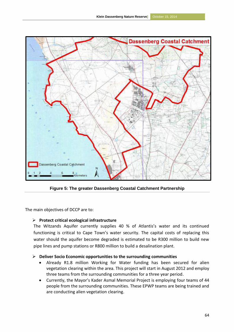
Klein Dassenberg Nature Reserve] October 15, 2014
64
Figure 5: The greater Dassenberg Coastal Catchment Partnership
The main objectives of DCCP are to:
Protect critical ecological infrastructure The Witzands Aquifer currently supplies 40 % of Atlantis’s water and its continued
functioning is critical to Cape Town’s water security. The capital costs of replacing this
water should the aquifer become degraded is estimated to be R300 million to build new
pipe lines and pump stations or R800 million to build a desalination plant.
Deliver Socio Economic opportunities to the surrounding communities
Already R1.8 million Working for Water funding has been secured for alien vegetation clearing within the area. This project will start in August 2012 and employ three teams from the surrounding communities for a three year period.
Currently, the Mayor’s Kader Asmal Memorial Project is employing four teams of 44 people from the surrounding communities. These EPWP teams are being trained and are conducting alien vegetation clearing.
Klein Dassenberg Nature Reserve] October 15, 2014
65
The area is an excellent locality for skills development projects and economic opportunities
For alien clearing alone, at least 450 000 person days are required for the initial three years
Several current recreation and tourism activities occur; the focus should be to build on these existing initiatives. (e.g. Mamre Heritage and Wild Flower show)
The area contains numerous potential recreation and tourism activities – the areas close proximity to Cape Town is highly advantageous.
The sound management of fire and alien vegetation in the area will reduce cover for illegal activities and reduce fire risk. There is potential to create a 22 strong Working on Fire Team to be based in the region.
Ensure the protection of the identified critical climate change adaptation and mitigation corridor The area has been identified as one of the two priority climate change adaptation and
mitigation corridors in the Western Cape. This is due to the large areas of natural
vegetation which still occurs in the area, the coastal to inland link and the incredibly
high levels of biodiversity and endemism.
Protect and promote the incredible natural and cultural heritage of the area
There are many highly significant cultural heritage features in the area.
The potential is to create a large and ecologically viable area.
There is good potential to reintroduce game such as Eland and Red Hartebeest.
The area contains extensive high quality remnants of three Critically Endangered and one Endangered Vegetation types.
It is estimated that more than 200 threatened plant species occur in the Dassenberg Coastal Catchment corridor (30% endemic to the corridor & 60% endemic within 50km of the corridor).
Klein Dassenberg Nature Reserve] October 15, 2014
66
Appendix 3: The most recent plant species list for Klein Dassenberg
Nature Reserve (updated 25/09/2014)
# FAMILY TAXA Status
1 AIZOACEAE Aizoon sarmentosum LC
2 AIZOACEAE Carpobrotus edulis LC
3 AIZOACEAE Conicosia pugioniformis LC
4 AIZOACEAE Lampranthus cf aurantium LC
5 AIZOACEAE
Mesembryanthemum canaliculatum (=Phyllobolus)
LC
6 AIZOACEAE Ruschia sp - pink flowers LC
7 AIZOACEAE Tetragonia nigrescens LC
8 AIZOACEAE Lampranthus explanatus EN
9 AIZOACEAE Ruschia indecora EN
10 AIZOACEAE Ruschia tecta EN
11 AIZOACEAE Lampranthus aurantiacus LC
12 AMARYLLIDACEAE Haemanthus pubescens LC
13 ANACARDIACEAE Searsia laevigata laevigata LC
14 ANACARDIACEAE Searsia rosmarinifolia LC
15 ANARCARDIACEAE Rhus rosmarinifolia LC
16 APOCYNACEAE Asclepias crispa LC
17 APOCYNACEAE Cynanchum africanum LC
18 ASPHODELACEAE Trachyandra hirsutiflora LC
19 ASPARAGACEAE Asparagus lignosus LC
20 ASPARAGACEAE Asparagus capensis LC
21 ASPARAGACEAE Asparagus rubicundus LC
22 ASTERACEAE Arctotheca calendula LC
23 ASTERACEAE Arctotis acaulis LC
24 ASTERACEAE Arctotis hirsuta LC
25 ASTERACEAE Cotula duckittiae VU
26 ASTERACEAE Cotula turbinata LC
27 ASTERACEAE Dimorphotheca nudicaulis LC
28 ASTERACEAE Dimorphotheca pluvialis LC
29 ASTERACEAE Eriocephalus racemosus LC
30 ASTERACEAE Elytropappus glandulosus LC
31 ASTERACEAE Felicia cf tenella LC
32 ASTERACEAE Gazania sp LC
33 ASTERACEAE Gymnodiscus capillaris LC
34 ASTERACEAE Helichrysum cochleariforme NT
35 ASTERACEAE Helichrysum cf moeserianum LC
36 ASTERACEAE Metalasia adunca NT
37 ASTERACEAE Metalasia brevifolia LC
38 ASTERACEAE Metalasia capitata VU
39 ASTERACEAE Metalasia muricata LC
40 ASTERACEAE Oedera imbricata LC
41 ASTERACEAE Osteospermum clandestinum LC
Klein Dassenberg Nature Reserve] October 15, 2014
67
# FAMILY TAXA Status
42 ASTERACEAE Othonna filicaulis LC
43 ASTERACEAE Othonna gymnodiscus LC
44 ASTERACEAE Othonna linearifolia EN
45 ASTERACEAE Pteronia camphorata LC
46 ASTERACEAE Petalacte coronata LC
47 ASTERACEAE Senecio foeniculoides CR
48 ASTERACEAE Senecio pubigerus LC
49 ASTERACEAE Stoebe plumosa LC
50 ASTERACEAE Trichogyne ambigua LC
51 ASTERACEAE Ursinia chrysanthemoides LC
52 BORAGINACEAE Lobostemon glaucophyllus LC
53 BORAGINACEAE Lobostemon fruticosus LC
54 BRUNIACEAE Berzelia abrotanoides LC
55 BRUNIACEAE Staavia radiata LC
56 CAMPANULACEAE Prismatocarpus sp LC
57 CAMPANULACEAE Roella cf arenaria VU
58 CAMPANULACEAE Wahlenbergia androsacea LC
59 CAMPANULACEAE Wahlenbergia capensis LC
60 CRASSULACEAE Crassula dichotoma LC
61 CRASSULACEAE Crassula cf multiflora LC
62 CYPERACEAE Ficinia deusta LC
63 CYPERACEAE Ficinia cf secunda LC
64 CYPERACEAE Ficinia cf paradoxa LC
65 CYPERACEAE Ficinia sp compact head LC
66 CYPERACEAE Ficinia sp single spikelet cf F. indica LC
67 DROSERACEAE Drosera trinervia LC
68 EBENACEAE Diospyros glabra LC
69 FAMILY TAXA Status
70 ERICACEAE Erica axillaris LC
71 ERICACEAE Erica corrifolia LC
72 ERICACEAE Erica ferrea EN
73 ERICACEAE Erica lasciva LC
74 ERICACEAE Erica mammosa LC
75 ERICACEAE Erica plukenetii LC
76 ERICACEAE Erica plumosa LC
77 ERIOSPERMACEAE Eriospermum capensis LC
78 ERIOSPERMACEAE Eriospermum nanum LC
79 EUPHORBIACEAE Euphorbia tuberosa LC
80 FABACEAE Acacia saligna LC
81 FABACEAE Argyrolobium cf velutinum EN
82 FABACEAE Aspalathus albens VU
83 FABACEAE Aspalathus retroflexa cf bicolor CR
84 FABACEAE Amphithalea ericifolia ssp erecta CR
85 FABACEAE Rafnia angulata angulata LC
86 FABACEAE Cyclopia genistoides LC
87 GERANIACEAE Pelargonium capitatum LC
88 GERANIACEAE Pelargonium oenothera LC
Klein Dassenberg Nature Reserve] October 15, 2014
68
# FAMILY TAXA Status
89 GERANIACEAE Pelargonium sp LC
90 GERANIACEAE Pelargonium myrrhifolium fruticosum
91 GERANIACEAE Pelargonium psammophilum (m.s.Marais)
92 GERANIACEAE Pelargonium triste LC
93 HAEMODORACEAE Wachendorfia sp LC
94 HEMEROCALLIDACEAE Caesia sabulosa VU
95 HYACINTHACEAE Albuca cooperi LC
96 HYACINTHACEAE Lachenalia sp LC
97 HYACINTHACEAE Lachenalia rubida LC
98 IRIDACEAE Aristea sp cf A.africana LC
99 IRIDACEAE Babiana ambigua LC
100 IRIDACEAE Babiana ringens LC
101 IRIDACEAE Bobartia cf indica LC
102 IRIDACEAE Gladiolus brevifolius LC
103 IRIDACEAE Gladiolus carinatus LC
104 IRIDACEAE Moraea flaccida LC
105 IRIDACEAE Moraea galaxia LC
106 IRIDACEAE Moraea neglecta LC
107 IRIDACEAE Moraea tripelata LC
108 IRIDACEAE Romulea cf flava - white form LC
109 IRIDACEAE Romulea flava - yellow form LC
110 IRIDACEAE Romulea rosea LC
111 IRIDACEAE Romulea schlechteri LC
112 IRIDACEAE Watsonia marginata LC
113 LAMIACEAE Salvia lanceolata LC
114 LAURACEAE Cassytha ciliolata LC
115 LOBELIACEAE Lobelia coronopifolia LC
116 MOLLUGINACEAE Pharnaceum cf lanatum LC
117 ORCHIDACEAE Disa bifida (= Schizodium) LC
118 ORCHIDACEAE Pterygodium sp LC
119 ORCHIDACEAE Satyrium sp LC
120 OROBANCHACEAE Orobanche sanguinea LC
121 OXALIDACEAE Oxalis luteola LC
122 OXALIDACEAE Oxalis obtusa LC
123 OXALIDACEAE Oxalis pes-caprae LC
124 PENAEACEAE Stylapterus fruticulosus EN
125 POACEAE Avena sativa LC
126 POACEAE Briza maxima LC
127 POACEAE Ehrhatha villosa LC
128 FAMILY TAXA Status
129 POACEAE Tribolium uniolae LC
130 POLYGALACEAE Muraltia cf ericoides LC
131 POLYGALACEAE Polygala garcinii
132 POLYGALACEAE Polygala recognita LC
133 POLYGONACEAE Rumex sp LC
134 PROTEACEA Leucadendron salignum LC
135 PROTEACEAE Leucodendron lanigerum VU
Klein Dassenberg Nature Reserve] October 15, 2014
69
# FAMILY TAXA Status
136 PROTEACEAE Leucospermum hypophyllocarpodendron hybrid X L. parile VU
137 PROTEACEAE
Leucospermum hypophyllocarpodendron subsp canaliculata
VU
138 PROTEACEAE Leucospermum parile EN
139 PROTEACEAE Protea scolymocephala VU
140 PROTEACEAE Serruria decipiens VU
141 PROTEACEAE Protea repens LC
142 PROTEACEAE Serruria fasciflora VU
143 RESTIONACEAE Calopsis impolita VU
144 RESTIONACEAE Cannomois cf arenicola LC
145 RESTIONACEAE Chondropetalum nudum LC
146 RESTIONACEAE Staberoha cernua LC
147 RESTIONACEAE Staberoha distachyos LC
148 RESTIONACEAE Thamnochortus punctatus Declining
149 RESTIONACEAE Thamnochortus sp LC
150 RESTIONACEAE Willdenowia arescens LC
151 RHAMNACEAE Phylica cephalantha LC
152 RHAMNACEAE Phylica imberbis LC
153 RHAMNACEAE Trichocephalus stipularis LC
154 ROSACEAE Cliffortia falcata LC
155 ROSACEAE Cliffortia polygonifolia LC
156 RUBIACEAE Anthospermum spathulatum LC
157 RUBIACEAE Carpacoce vaginellata LC
158 RUTACEAE Adenandra cf villosa LC
159 RUTACEAE Agathosma imbricata LC
160 RUTACEAE Diosma oppositifolia LC
161 RUTACEAE Macrostylis villosa EN
162 RUTACEAE Macrostylis villosa villosa EN
163 SANTALACEAE Thesium aggregatum LC
164 SANTALACEAE Thesium cf pubescens LC
165 SANTALACEAE Thesium capitatum LC
166 SANTALACEAE Thesium cf diversifolium LC
167 SANTALACEAE Thesium sp, gracile LC
168 SCROPHULARIACEAE Diascia capensis LC
169 SCROPHULARIACEAE Hebenstretia repens LC
170 SCROPHULARIACEAE Lyperia tristis LC
171 SCROPHULARIACEAE Microdon capitatus LC
172 SCROPHULARIACEAE Microdon dubius LC
173 SCROPHULARIACEAE Manulea rubra LC
174 SCROPHULARIACEAE Nemesia strumosa NT
175 SCROPHULARIACEAE Nemesia versicolor LC
176 TECOPHILAEACEAE Cyanella hyacinthoides LC
177 THYMELAEACEAE Gnidia pinifolia LC
178 THYMELAEACEAE Lachnaea capitata VU
179 THYMELAEACEAE Lachnaea grandiflora VU
180 THYMELAEACEAE Passerina corymbosa LC
181 THYMELAEACEAE Struthiola ciliata LC
Klein Dassenberg Nature Reserve] October 15, 2014
70
# FAMILY TAXA Status
182 THYMELAEACEAE Struthiola striata LC
183 THYMELAEACEAE Struthiola dodecandra LC
184 TRICHOCEPHALUS Trichocephalus stipularis LC
185 URTICACEAE Urtica cf urens LC
186 ZYGOPHYLLACEAE Zygophyllum flexuosum LC
187 ZYGOPHYLLACEAE Zygophyllum sessilifolium LC
188 ZYGOPHYLLACEAE Zygophyllum spinosum LC
Klein Dassenberg Nature Reserve] October 15, 2014
71
Status Definition of Status Amount
Critically Endangered
(CR)
Taxa which is facing an extremely high risk of extinction in the wild
in the immediate future 3
Endangered
(EN)
Taxa which is not CR but is facing a very high risk of extinction in
the wild in near future 10
Vulnerable
(VU)
Taxa which is not CR or EN but is facing high risk of extinction in
the wild in medium-term future 14
Near Threatened
(NT)
Taxa which do not qualify for Conservation dependent, but which
are close to qualifying for VU 3
Declining Taxa which do not qualify for Conservation dependent, but which
are close to qualifying for NT 1
Least Concern
(LC) Taxa which do not qualify for Conservation dependent or NT 147
Data Deficient
(DD)
When there is inadequate information to make a direct or indirect
assessment of its risk of extinction based on its distribution and / or
population status
Exotic Taxa which did not originally occur in the area but has been
introduced
TOTAL 178
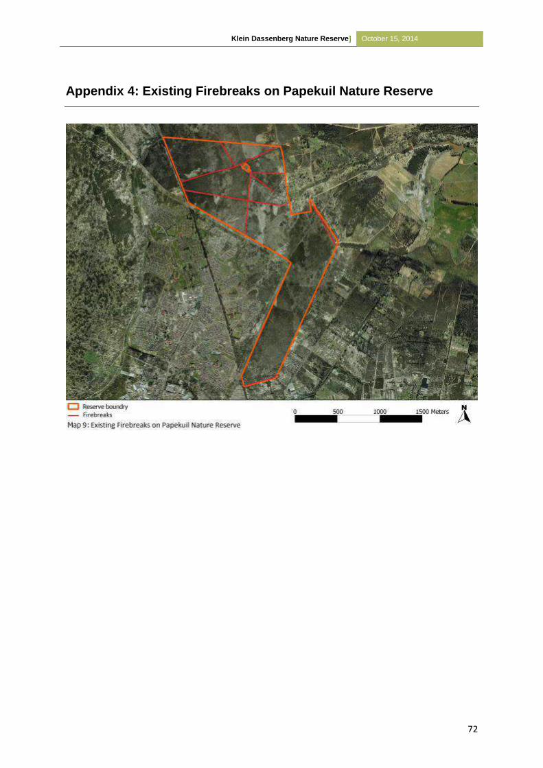
Klein Dassenberg Nature Reserve] October 15, 2014
72
Appendix 4: Existing Firebreaks on Papekuil Nature Reserve
Klein Dassenberg Nature Reserve] October 15, 2014
73
Appendix 5: Annual Review Procedure (Example of an audit proforma)
Ecological Auditing for Contractual Reserves & Biodiversity Agreements.
The ecological auditing pro-forma is a guideline document, developed primarily to capture biodiversity management performance for a given vegetation type.
It should be adapted to the specific circumstances stipulated in the management plan for the Management Agreement & Contractual Reserve in question.
Name of Property
Name of Owners Name of Auditors
Tel Tel
Fax Fax
Cell Cell
E-mail E-mail
Date of Audit:
Date of next Audit:
Alien Vegetation: Is there an alien vegetation management plan? YES/NO Note:
Management Objective Are objectives for the 12 month management period clearly stated?
Measurable Have objectives for the 12 month management period been met?
Responsible Party
Yes/No
Quality H/M/L
If NOT UNDERTAKEN / UNSUCCESFUL please state reasons and attach as Appendix 1: Alien Vegetation
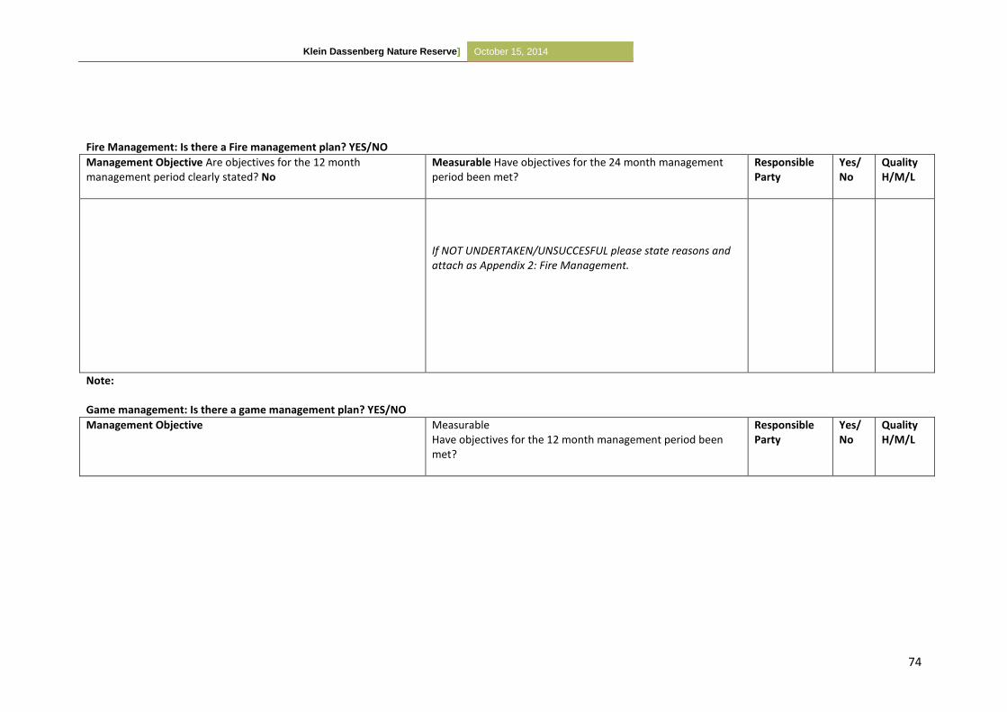
Klein Dassenberg Nature Reserve] October 15, 2014
74
Fire Management: Is there a Fire management plan? YES/NO
Management Objective Are objectives for the 12 month management period clearly stated? No
Measurable Have objectives for the 24 month management period been met?
Responsible Party
Yes/No
Quality H/M/L
If NOT UNDERTAKEN/UNSUCCESFUL please state reasons and attach as Appendix 2: Fire Management.
Note: Game management: Is there a game management plan? YES/NO
Management Objective Measurable Have objectives for the 12 month management period been met?
Responsible Party
Yes/No
Quality H/M/L
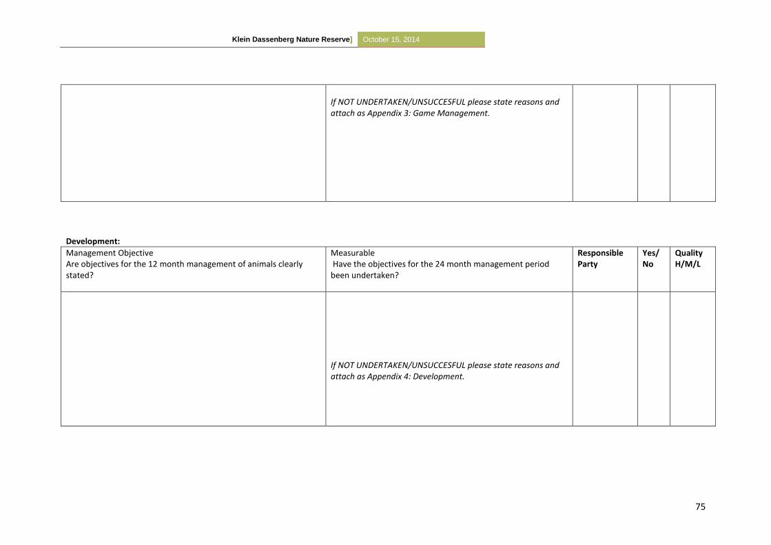
Klein Dassenberg Nature Reserve] October 15, 2014
75
If NOT UNDERTAKEN/UNSUCCESFUL please state reasons and attach as Appendix 3: Game Management.
Development:
Management Objective Are objectives for the 12 month management of animals clearly stated?
Measurable Have the objectives for the 24 month management period been undertaken?
Responsible Party
Yes/No
Quality H/M/L
If NOT UNDERTAKEN/UNSUCCESFUL please state reasons and attach as Appendix 4: Development.
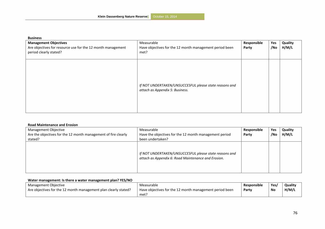
Klein Dassenberg Nature Reserve] October 15, 2014
76
Business
Management Objectives Are objectives for resource use for the 12 month management period clearly stated?
Measurable Have objectives for the 12 month management period been met?
Responsible Party
Yes/No
Quality H/M/L
If NOT UNDERTAKEN/UNSUCCESFUL please state reasons and attach as Appendix 5: Business.
Road Maintenance and Erosion
Management Objective Are the objectives for the 12 month management of fire clearly stated?
Measurable Have the objectives for the 12 month management period been undertaken?
Responsible Party
Yes/No
Quality H/M/L
If NOT UNDERTAKEN/UNSUCCESFUL please state reasons and attach as Appendix 6: Road Maintenance and Erosion.
Water management: Is there a water management plan? YES/NO
Management Objective Are objectives for the 12 month management plan clearly stated?
Measurable Have objectives for the 12 month management period been met?
Responsible Party
Yes/No
Quality H/M/L
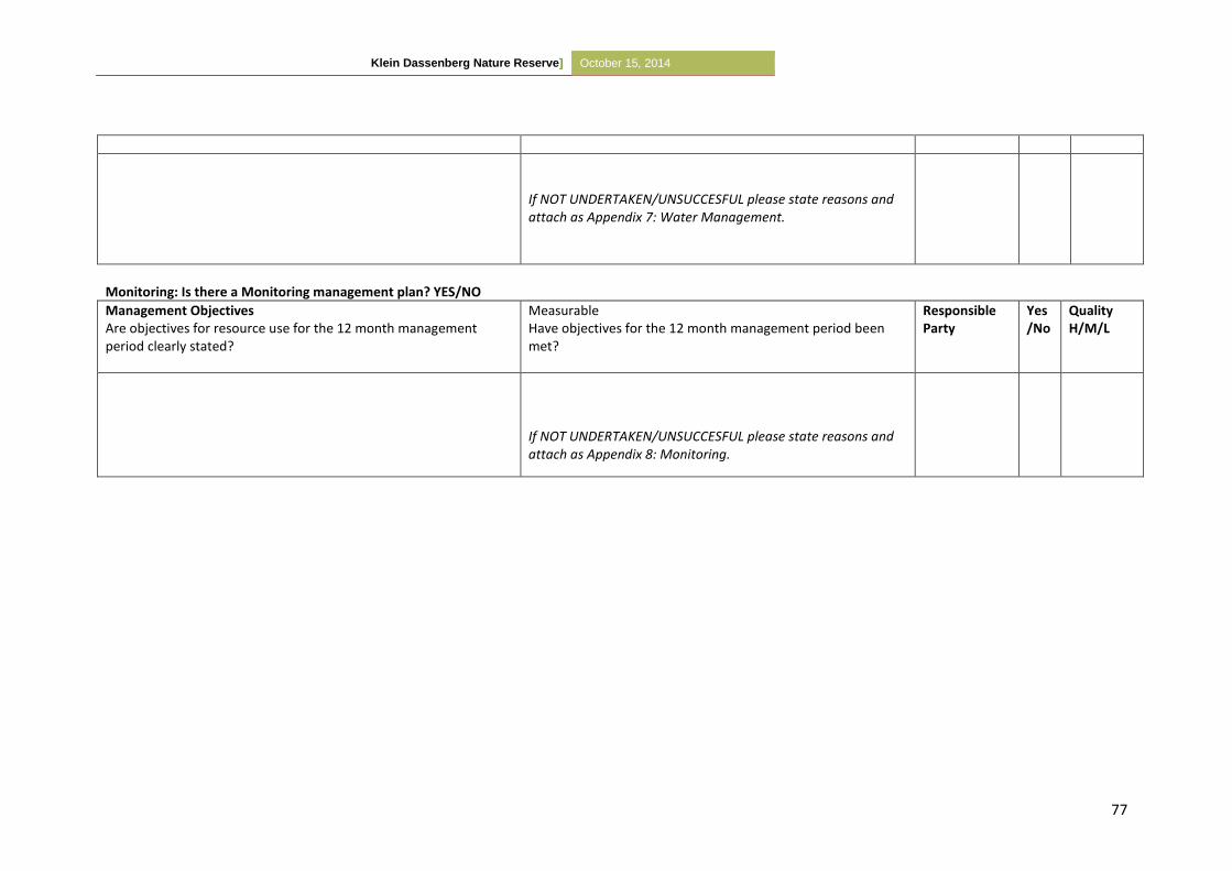
Klein Dassenberg Nature Reserve] October 15, 2014
77
If NOT UNDERTAKEN/UNSUCCESFUL please state reasons and attach as Appendix 7: Water Management.
Monitoring: Is there a Monitoring management plan? YES/NO
Management Objectives Are objectives for resource use for the 12 month management period clearly stated?
Measurable Have objectives for the 12 month management period been met?
Responsible Party
Yes/No
Quality H/M/L
If NOT UNDERTAKEN/UNSUCCESFUL please state reasons and attach as Appendix 8: Monitoring.
Klein Dassenberg Nature Reserve] October 15, 2014
78
Addendum 1 – Alien Vegetation
List Reason Actions
Interventions not undertaken
Interventions unsuccessful
New interventions
Addendum 2 – Fire Management
List Reason Actions
Interventions not undertaken
Interventions unsuccessful
New interventions
Addendum 3 – Game Management
List Reason Actions
Interventions not undertaken
Interventions unsuccessful
New interventions
Addendum 4 – Development
List Reason Actions
Interventions not undertaken
Interventions unsuccessful
New interventions
Addendum 5– Business
List Reason Actions
Interventions not undertaken
Interventions unsuccessful
New interventions
Klein Dassenberg Nature Reserve] October 15, 2014
79
Addendum 6 – Road maintenance & Erosion
List Reason Actions
Interventions not undertaken
Interventions unsuccessful
New Interventions
Addendum 7 – Water Management
List Reason Actions
Interventions not undertaken
Interventions unsuccessful
New Interventions
Addendum 8 – Monitoring
List Reason Actions
Interventions not undertaken
Interventions unsuccessful
New interventions
Klein Dassenberg Nature Reserve] October 15, 2014
80
Appendix 6: Fixed Point Photography Data Sheet
FIXED POINT PHOTOGRAPHY DATA SHEET
PLOT NO: DATE: SURVEYOR:
GPS CO-ORDINATE:
GRID REF NO:
POINT DESCRIPTION: (How to find the points)
HABITAT DESCRIPTION: (use back of form, if necessary)
VEGETATION TYPE:
TREE & SHRUB SPECIES:
DWARF SCRUB SPECIES:
HERBACEOUS PLANT SPECIES:
COVER DESCRIPTION:
COVER TYPE HEIGHT % OF PLOT DOMINANT SPECIES
CANOPY COVER
GROUND COVER
UTILIZATION:
BROWSING DENSITY: PLANTS BROWSED BROWSING HERBIVORES
HEAVY
MODERATE
LIGHT
GRAZING INTENSITY:
PLANTS GRAZED
GRAZING HERBIVORES
HEAVY
MODERATE
LIGHT
OTHER NOTES:
Klein Dassenberg Nature Reserve] October 15, 2014
81
PART B
PART 6 - MANAGEMENT SCHEDULE
10.1 PROGRAMME OF IMPLEMENTATION
This section focuses on specific programmes that were identified in Section A, paragraph 5.3
Protected Area Management Policy Framework and Guiding Principles, describing the day-to-
day management activities and assigning responsibility for the implementation thereof.
10.2 Management Programmes: Details of Annual Plan of Operations (APOs)
Management Programme 1: Community Participation (see section 5.3.1. above)
Management Action 1 – Community Participation
Objective To develop a constructive, mutually beneficial relationship between the Reserve, communities close to or adjacent to the Reserve and the surrounding landowners to establish the long term success of Papekuil Nature Reserve.
Responsible Party The City of Cape Town
Time Frame Continuous
Means Establish community based initiatives and partnerships to promote and support economic and employment opportunities.
Provide related alien clearing training and awareness initiatives.
Management Programme 2: Security and Safety (see section 5.3.2 above)
Management Action 2 – Safety and Security
Objective To provide a safe environment for staff members and potential tourists.
Responsible Party The City of Cape Town
Time Frame Continuous
Means Implement a Safety and Security Audit to highlight problem areas.
Firebreaks should ensure safety of neighbouring communities from fire risks.
Management Programme 3: Tourism Development and Management (see section 5.3.3
above)
Management Action 3 - Tourism
Objective Legal Tourism Ventures that adhere to the zoning rights of the property and which do not impede on any National Environmental Management Act (NEMA) principles are supported. Establish tourism ventures within Nature Reserve which would provide visitors with meaningful experience while preventing damage to the critically endangered vegetation.
Klein Dassenberg Nature Reserve] October 15, 2014
82
Responsible Party The City of Cape Town
Time Frame To be reviewed in five years time
Means Review the Development Plan to determine the extent of tourism adventure development necessary.
Monitor tourism related impacts on vegetation and implement corrective management where necessary (See Management Programme 11 - Strategic Research).
Determine feasibility of tourism activities.
All infrastructure need to be maintained.
Management Programme 4: Infrastructure Management (see section 5.3.4 above)
Management Action 4 - Development
Objective With exception of the demarcated development zone (33°34’25.02”S, 18°31’11.63”E, See Map 8), the marked footpaths/ firebreaks and fencing, no further development is to occur within the Nature Reserve. Any proposed development needs to be done in accordance with NEMA principles and follow all stakeholders’ applicable legislation and procedures.
Additionally, infrastructure should also align to the Zonation Plan of the Nature Reserve.
Roads and footpaths within the Reserve should be maintained.
All the tracks and firebreaks that are not needed within the Reserve should be closed off and rehabilitated.
Responsible Party The City of Cape Town
Time Frame Continuous
Means To be developed with reference to the Zonation and Sensitivity report.
Management Programme 4: Biodiversity Conservation Management (see section 5.3.5
above)
Management Action 6 – Community-Based Natural Resource Management (CBNRM)
Objective Determine impact of flower harvesting on vegetation survival and recruitment.
Responsible Party The City of Cape Town
Time Frame Continuously
Means Implement a Harvesting Feasibility Study within the next five years.
See Management Action 11 - Monitoring
Management Action 7 – Fire Management
Objective Prevent too frequent fires, create and maintain firebreaks, carry out management/ ecological burns, allow appropriate natural fires, and conform to Fire Reaction Plan.
Fire Management should be carried out in accordance with the National Veld and Forest Act No. 101 of 1998.
Klein Dassenberg Nature Reserve] October 15, 2014
83
Fire Breaks
Firebreaks need strategic placement to provide optimal protection to the natural veld, surrounding communities and private areas. Existing roads and firebreaks need to be mapped (See Appendix 4).
Once the Reserve is fenced and operational, these networks need to be assessed as to determine whether they are sufficient or whether realignment is required. Any excess firebreaks/ tracks should be closed off and rehabilitated.
New firebreaks/ tracks, if applicable, should be carefully planned to prevent excessive damage to the veld.
Firebreaks should not be burnt or ploughed, instead it should be mowed annually, during October, before the start of fire season. They should not be wider than 3m.
Veld Age
The veld age varies between 8 months and older than 10 years. While a basic veld age map is available, all efforts should be made to determine the veld age of areas not covered by the map in (Map 10) to ensure proper fire management planning.
Prescribed Burns
Fire should be used as a management tool on Papekuil Nature Reserve by simulating natural the natural burning regime to prevent vegetation from becoming senescent. These burns need to be thoroughly planned and complement the alien clearing operation (See Map 10/ Table 8).
Currently, no prescribed burns are needed in the Nature Reserve as the veld is too young.
Responsible Party Fire Breaks
The City of Cape Town
Veld Age
The use of prescribed burns should be assessed in combination with the veld age map (Map 10).
Prescribed Burns
The City of Cape Town
Time Frame Firebreaks should be maintained at least once a year prior to the fire season (October).
A self-audit should be carried out prior to the start of the fire season (October).
Each block should be evaluated to establish its readiness to be burnt with the aid of the veld age map (See Map 10). It has been recommended to burn Atlantis Sand Fynbos every 8-15 years.
Means Firebreaks should be prepared according to National Veld and Forest Act, No. 101 of 1998, however it is recommended that firebreaks be mowed annually in October, prior to the start of the fire season. Firebreaks should not be wider than 3m, as this is sufficient to allow vehicle access when required.
Prescribed burns should be based on sound ecological principles.
Alien clearing and fire management should be integrated as to control some invasive alien species. Conversely, following a wildfire, the alien clearing plan should be reviewed to prioritize the recently burnt area for alien clearing.
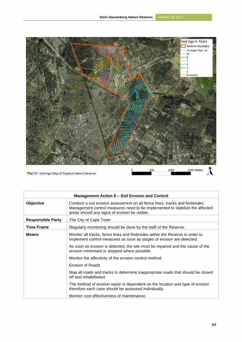
Klein Dassenberg Nature Reserve] October 15, 2014
84
Management Action 8 – Soil Erosion and Control
Objective Conduct a soil erosion assessment on all fence lines, tracks and firebreaks. Management control measures need to be implemented to stabilize the affected areas should any signs of erosion be visible.
Responsible Party The City of Cape Town
Time Frame Regularly monitoring should be done by the staff of the Reserve.
Means Monitor all tracks, fence lines and firebreaks within the Reserve in order to implement control measures as soon as stages of erosion are detected.
As soon as erosion is detected, the site must be repaired and the cause of the erosion minimised or stopped where possible.
Monitor the affectivity of the erosion control method.
Erosion of Roads
Map all roads and tracks to determine inappropriate roads that should be closed off and rehabilitated.
The method of erosion repair is dependent on the location and type of erosion therefore each case should be assessed individually.
Monitor cost effectiveness of maintenance.
Klein Dassenberg Nature Reserve] October 15, 2014
85
Management Action 9 – Invasive Species Management
Objective Alien vegetation clearing should be carried out in accordance with the Conservation of Agricultural Resources Act No.43 of 1983.
Manage invasive species in accordance with the Alien Clearing Schedule (See Table 8).
Current Status The invasive alien trees were not managed before the site became a Nature Reserve thus there are areas of high infestation. Invasive species management was implemented in 2012 and continues.
Responsible Party The City of Cape Town
Time Frame Implement according to Alien Clearing Schedule (See Table 8)
Means Invasive species schedule should include:
A map (Map 11) outlining the perimeter and Management Blocks.
Identify and map all alien and invasive flora and determine densities and age in the various management blocks.
The clearing schedule and method should follow the best practice as defined by the City of Cape Town’s Invasive Unit.
Keep record of clearing operations, especially the cost of each cleared block as to determine cost effectiveness of clearing. Actual costs should also be compared with planned costs for a given area/ year to assist in future budgeting.
Only trained personnel should be used for alien clearing.
Prevent the introduction of invasive alien species by ensuring surrounding landowners are aware of relevant legislation.
Brush Piles
Brush piles are only to be burnt in the cool winter months to prevent soil damage.
Brush piles should be stacked at least 5m wide, 5m high and at least 5m apart.
Each stack should be ignited one at a time using drip torches with a diesel/petrol mix.
Light branches should be stacked separately from heavy timber as to prevent intensely hot fires and consequent soil damage.
Stockpiles should not be stacked under trees, power and telephone lines or within 30 metres of a fire belt.
Footpaths
After alien clearing has occurred in the various management blocks, unnecessary footpaths should be rehabilitated. This can be achieved by placing branches over the degraded area to prevent further damage (See Map 12).
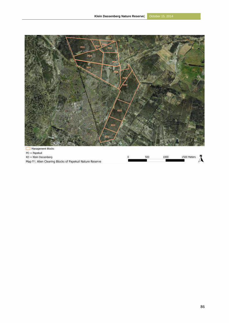
Klein Dassenberg Nature Reserve] October 15, 2014
86
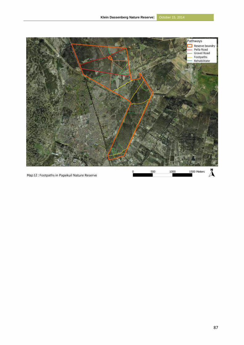
Klein Dassenberg Nature Reserve] October 15, 2014
87
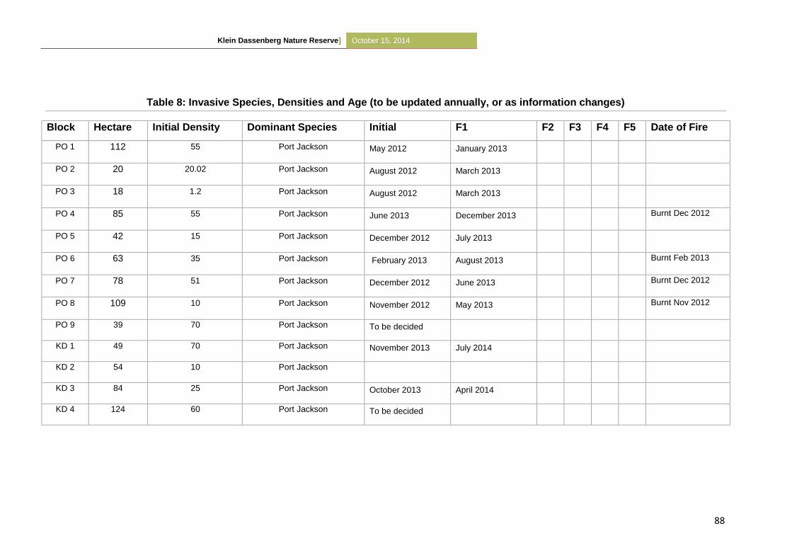
Klein Dassenberg Nature Reserve] October 15, 2014
88
Table 8: Invasive Species, Densities and Age (to be updated annually, or as information changes)
Block Hectare Initial Density Dominant Species Initial F1 F2 F3 F4 F5 Date of Fire
PO 1 112 55 Port Jackson May 2012 January 2013
PO 2 20 20.02 Port Jackson August 2012 March 2013
PO 3 18 1.2 Port Jackson August 2012 March 2013
PO 4 85 55 Port Jackson June 2013 December 2013 Burnt Dec 2012
PO 5 42 15 Port Jackson December 2012 July 2013
PO 6 63 35 Port Jackson February 2013 August 2013 Burnt Feb 2013
PO 7 78 51 Port Jackson December 2012 June 2013 Burnt Dec 2012
PO 8 109 10 Port Jackson November 2012 May 2013 Burnt Nov 2012
PO 9 39 70 Port Jackson To be decided
KD 1 49 70 Port Jackson November 2013 July 2014
KD 2 54 10 Port Jackson
KD 3 84 25 Port Jackson October 2013 April 2014
KD 4 124 60 Port Jackson To be decided
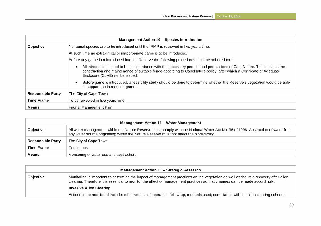
Klein Dassenberg Nature Reserve] October 15, 2014
89
Management Action 10 – Species Introduction
Objective No faunal species are to be introduced until the IRMP is reviewed in five years time.
At such time no extra-limital or inappropriate game is to be introduced.
Before any game in reintroduced into the Reserve the following procedures must be adhered too:
All introductions need to be in accordance with the necessary permits and permissions of CapeNature. This includes the construction and maintenance of suitable fence according to CapeNature policy, after which a Certificate of Adequate Enclosure (CoAE) will be issued.
Before game is introduced, a feasibility study should be done to determine whether the Reserve’s vegetation would be able to support the introduced game.
Responsible Party The City of Cape Town
Time Frame To be reviewed in five years time
Means Faunal Management Plan
Management Action 11 – Water Management
Objective All water management within the Nature Reserve must comply with the National Water Act No. 36 of 1998. Abstraction of water from any water source originating within the Nature Reserve must not affect the biodiversity.
Responsible Party The City of Cape Town
Time Frame Continuous
Means Monitoring of water use and abstraction.
Management Action 11 – Strategic Research
Objective Monitoring is important to determine the impact of management practices on the vegetation as well as the veld recovery after alien clearing. Therefore it is essential to monitor the effect of management practices so that changes can be made accordingly.
Invasive Alien Clearing
Actions to be monitored include: effectiveness of operation, follow-up, methods used; compliance with the alien clearing schedule
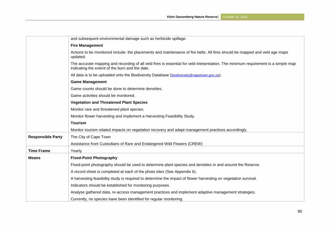
Klein Dassenberg Nature Reserve] October 15, 2014
90
and subsequent environmental damage such as herbicide spillage.
Fire Management
Actions to be monitored include: the placements and maintenance of fire belts. All fires should be mapped and veld age maps updated.
The accurate mapping and recording of all veld fires is essential for veld interpretation. The minimum requirement is a simple map indicating the extent of the burn and the date.
All data is to be uploaded onto the Biodiversity Database ([email protected]).
Game Management
Game counts should be done to determine densities.
Game activities should be monitored.
Vegetation and Threatened Plant Species
Monitor rare and threatened plant species.
Monitor flower harvesting and implement a Harvesting Feasibility Study.
Tourism
Monitor tourism related impacts on vegetation recovery and adapt management practices accordingly.
Responsible Party The City of Cape Town
Assistance from Custodians of Rare and Endangered Wild Flowers (CREW)
Time Frame Yearly
Means Fixed-Point Photography
Fixed-point photography should be used to determine plant species and densities in and around the Reserve.
A record sheet is completed at each of the photo sites (See Appendix 6).
A harvesting feasibility study is required to determine the impact of flower harvesting on vegetation survival.
Indicators should be established for monitoring purposes.
Analyse gathered data, re-access management practices and implement adaptive management strategies.
Currently, no species have been identified for regular monitoring.
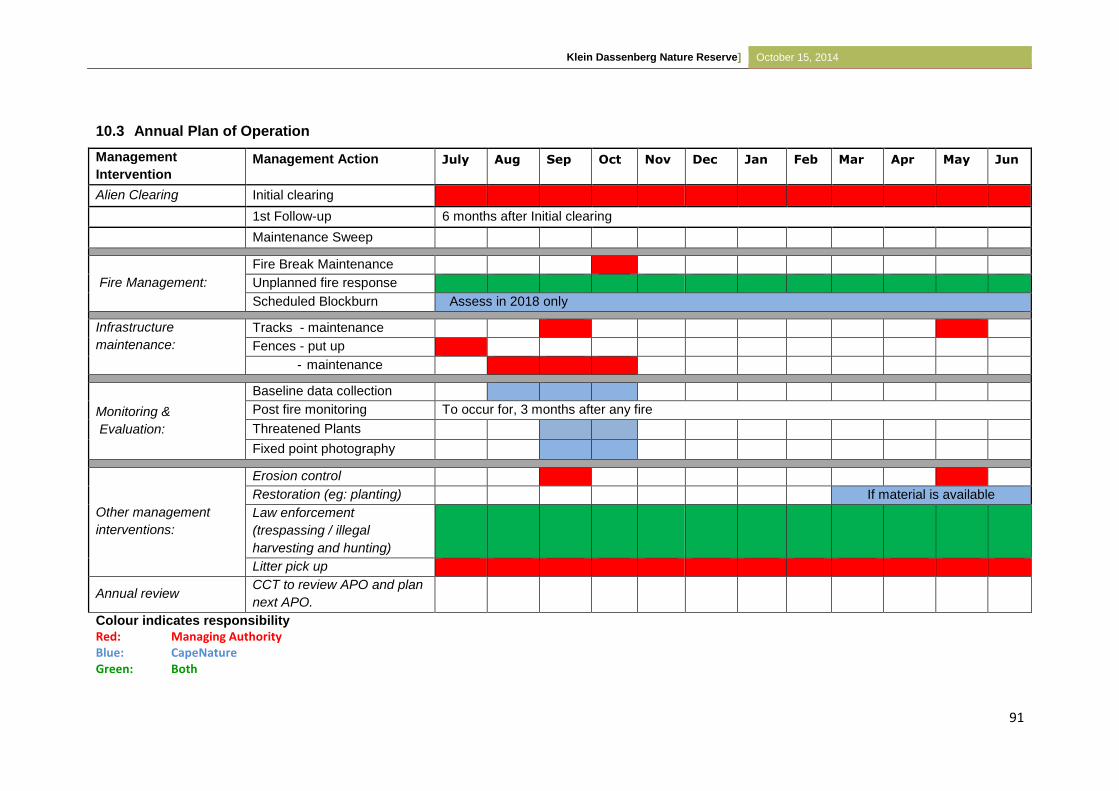
Klein Dassenberg Nature Reserve] October 15, 2014
91
10.3 Annual Plan of Operation
Management
Intervention Management Action July Aug Sep Oct Nov Dec Jan Feb Mar Apr May Jun
Alien Clearing Initial clearing
1st Follow-up 6 months after Initial clearing
Maintenance Sweep
Fire Management:
Fire Break Maintenance
Unplanned fire response
Scheduled Blockburn Assess in 2018 only
Infrastructure
maintenance:
Tracks - maintenance
Fences - put up
- maintenance
Baseline data collection
Monitoring &
Evaluation:
Post fire monitoring To occur for, 3 months after any fire
Threatened Plants
Fixed point photography
Other management
interventions:
Erosion control
Restoration (eg: planting) If material is available
Law enforcement
(trespassing / illegal
harvesting and hunting)
Litter pick up
Annual review CCT to review APO and plan
next APO.
Colour indicates responsibility
Red: Managing Authority Blue: CapeNature Green: Both
APPE NDI X D – Ot he r i nfor mat ion
pg 0
Draft Scop ing Report for GreenTech in Zone 2 o f the At lant i s Spec ia l Economic Zone, At lant i s Industr ia l , Western Cape
APPE NDI X D – Ot he r i nfor mat ion
pg 1
1. EXCERPT FROM THE DEA SCREENING TOOL REPORT (SENSITIVITIES IDENTIFIED BY THE
TOOL) 2
2. CONFIRMATION FROM THE DEA&DP (DATED 11 OCTOBER 2017) THAT A NOISE
IMPACT ASSESSMENT IS NOT NECESSARY FOR THIS PROPOSED DEVELOPMENT 3
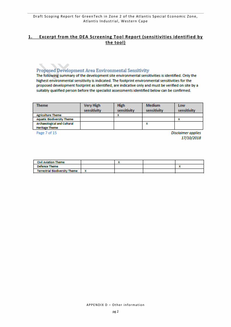
Draft Scop ing Report for GreenTech in Zone 2 o f the At lant i s Spec ia l Economic Zone, At lant i s Industr ia l , Western Cape
APPE NDI X D – Ot he r i nfor mat ion
pg 2
1. Excerpt from the DEA Screening Too l Report (sensitivities identified by the tool)
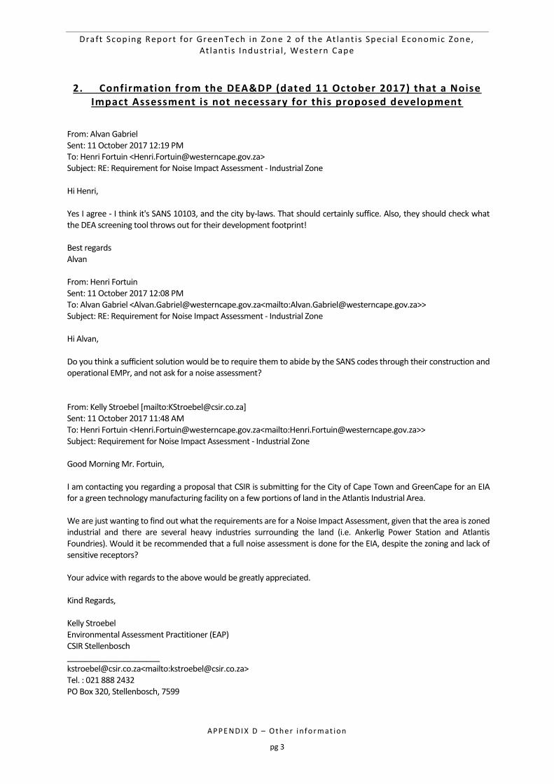
Draft Scop ing Report for GreenTech in Zone 2 o f the At lant i s Spec ia l Economic Zone, At lant i s Industr ia l , Western Cape
APPE NDI X D – Ot he r i nfor mat ion
pg 3
2. Confirmation from the DEA&DP (dated 11 October 2017) that a Noise Impact Assessment is not necessary for this proposed development
From: Alvan Gabriel Sent: 11 October 2017 12:19 PM To: Henri Fortuin <[email protected]> Subject: RE: Requirement for Noise Impact Assessment - Industrial Zone Hi Henri, Yes I agree - I think it's SANS 10103, and the city by-laws. That should certainly suffice. Also, they should check what the DEA screening tool throws out for their development footprint! Best regards Alvan From: Henri Fortuin Sent: 11 October 2017 12:08 PM To: Alvan Gabriel <[email protected]<mailto:[email protected]>> Subject: RE: Requirement for Noise Impact Assessment - Industrial Zone Hi Alvan, Do you think a sufficient solution would be to require them to abide by the SANS codes through their construction and operational EMPr, and not ask for a noise assessment? From: Kelly Stroebel [mailto:[email protected]] Sent: 11 October 2017 11:48 AM To: Henri Fortuin <[email protected]<mailto:[email protected]>> Subject: Requirement for Noise Impact Assessment - Industrial Zone Good Morning Mr. Fortuin, I am contacting you regarding a proposal that CSIR is submitting for the City of Cape Town and GreenCape for an EIA for a green technology manufacturing facility on a few portions of land in the Atlantis Industrial Area. We are just wanting to find out what the requirements are for a Noise Impact Assessment, given that the area is zoned industrial and there are several heavy industries surrounding the land (i.e. Ankerlig Power Station and Atlantis Foundries). Would it be recommended that a full noise assessment is done for the EIA, despite the zoning and lack of sensitive receptors? Your advice with regards to the above would be greatly appreciated. Kind Regards, Kelly Stroebel Environmental Assessment Practitioner (EAP) CSIR Stellenbosch _____________________ [email protected]<mailto:[email protected]> Tel. : 021 888 2432 PO Box 320, Stellenbosch, 7599


![MeyGen EIA Scoping Document [DRAFT] - Marine Scotlandmarine.gov.scot/datafiles/lot/Meygen/MeyGen_Offshore_Tidal_Array_SoS_Scoping_Opinion...MeyGen Phase 1 EIA Scoping Document MEYGEN-ER-002-EIA](https://img.pdfslide.us/doc/110x75/5e7ebfe8a85be0141b417522/meygen-eia-scoping-document-draft-marine-meygen-phase-1-eia-scoping-document.jpg)