Embed Size (px)
Citation preview
Bilder über Kopf- und Fußzei
1
Scientific Acivities 2013 – 2018
2
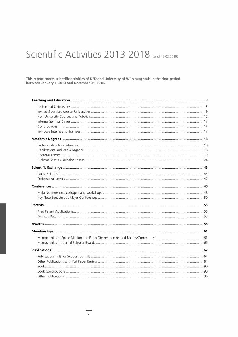
This report covers scientific activities of DFD and University of Würzburg staff in the time period between January 1, 2013 and December 31, 2018.
Teaching and Education ............................................................................................................................................. 3
Lectures at Universities ............................................................................................................................................ 3 Invited Guest Lectures at Universities ....................................................................................................................... 9 Non-University Courses and Tutorials ..................................................................................................................... 12 Internal Seminar Series .......................................................................................................................................... 17 Contributions ........................................................................................................................................................ 17 In-House Interns and Trainees ................................................................................................................................ 17
Academic Degrees .................................................................................................................................................... 18
Professorship Appointments .................................................................................................................................. 18 Habilitations and Venia Legendi ............................................................................................................................. 18 Doctoral Theses ..................................................................................................................................................... 19 Diploma/Master/Bachelor Theses ............................................................................................................................ 24
Scientific Exchange ................................................................................................................................................... 43
Guest Scientists ..................................................................................................................................................... 43 Professional Leaves ................................................................................................................................................ 47
Conferences .............................................................................................................................................................. 48
Major conferences, colloquia and workshops ......................................................................................................... 48 Key Note Speeches at Major Conferences .............................................................................................................. 50
Patents ...................................................................................................................................................................... 55
Filed Patent Applications ........................................................................................................................................ 55 Granted Patents .................................................................................................................................................... 55
Awards ...................................................................................................................................................................... 56
Memberships ............................................................................................................................................................ 61
Memberships in Space Mission and Earth Observation related Boards/Committees .................................................. 61 Memberships in Journal Editorial Boards ................................................................................................................ 65
Publications .............................................................................................................................................................. 67
Publications in ISI or Scopus Journals ...................................................................................................................... 67 Other Publications with Full Paper Review .............................................................................................................. 84 Books.................................................................................................................................................................... 90 Book Contributions ............................................................................................................................................... 90 Other Publications ................................................................................................................................................. 96
Scientific Activities 2013-2018 (as of 19.03.2019)
3
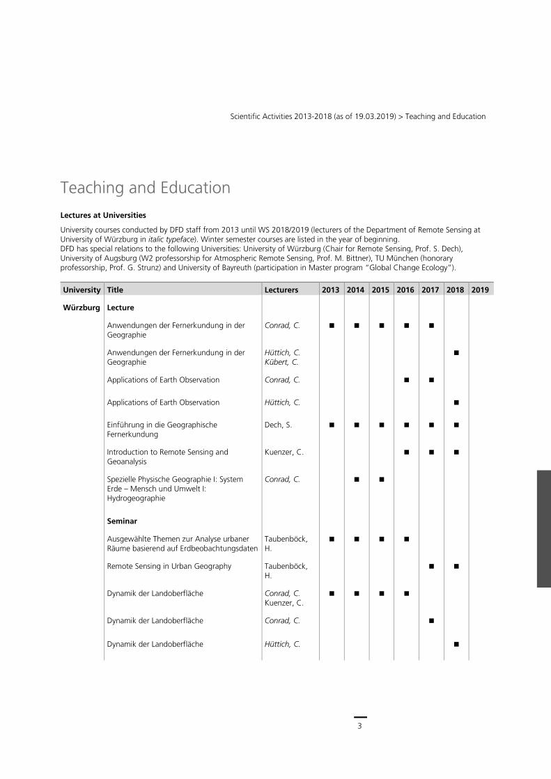
Scientific Activities 2013-2018 (as of 19.03.2019) > Teaching and Education
Teaching and Education
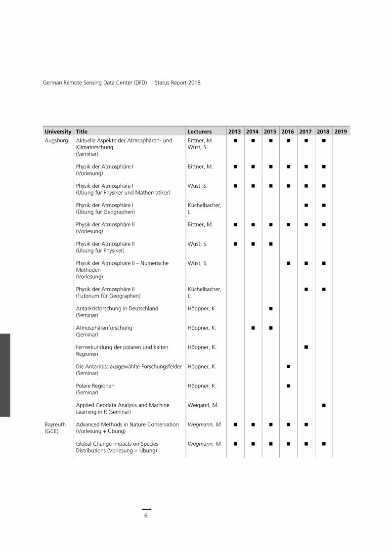
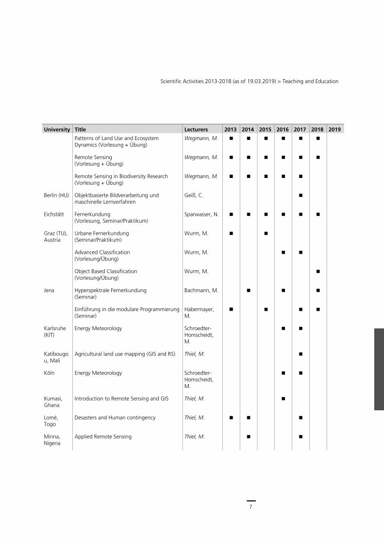
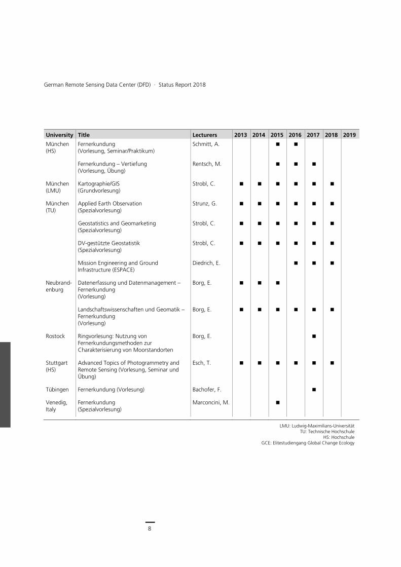
Lectures at Universities
University courses conducted by DFD staff from 2013 until WS 2018/2019 (lecturers of the Department of Remote Sensing at University of Würzburg in italic typeface). Winter semester courses are listed in the year of beginning. DFD has special relations to the following Universities: University of Würzburg (Chair for Remote Sensing, Prof. S. Dech), University of Augsburg (W2 professorship for Atmospheric Remote Sensing, Prof. M. Bittner), TU München (honorary professorship, Prof. G. Strunz) and University of Bayreuth (participation in Master program “Global Change Ecology”).
University Title Lecturers 2013 2014 2015 2016 2017 2018 2019
Würzburg Lecture
Anwendungen der Fernerkundung in der Geographie
Conrad, C.
Anwendungen der Fernerkundung in der Geographie
Hüttich, C. Kübert, C.
Applications of Earth Observation Conrad, C.
Applications of Earth Observation Hüttich, C.
Einführung in die Geographische Fernerkundung
Dech, S.
Introduction to Remote Sensing and Geoanalysis
Kuenzer, C.
Spezielle Physische Geographie I: System Erde – Mensch und Umwelt I: Hydrogeographie
Conrad, C.
Seminar
Ausgewählte Themen zur Analyse urbaner Räume basierend auf Erdbeobachtungsdaten
Taubenböck, H.
Remote Sensing in Urban Geography Taubenböck, H.
Dynamik der Landoberfläche Conrad, C. Kuenzer, C.
Dynamik der Landoberfläche Conrad, C.
Dynamik der Landoberfläche Hüttich, C.
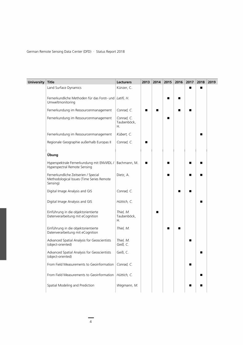
4
German Remote Sensing Data Center (DFD) ∙ Status Report 2018
University Title Lecturers 2013 2014 2015 2016 2017 2018 2019
Land Surface Dynamics Künzer, C.
Fernerkundliche Methoden für das Forst- und Umweltmonitoring
Latifi, H.
Fernerkundung im Ressourcenmanagement Conrad, C.
Fernerkundung im Ressourcenmanagement Conrad, C. Taubenböck, H.
Fernerkundung im Ressourcenmanagement Kübert, C.
Regionale Geographie außerhalb Europas II Conrad, C.
Übung
Hyperspektrale Fernerkundung mit ENVI/IDL / Hyperspectral Remote Sensing
Bachmann, M.
Fernerkundliche Zeitserien / Special Methodological Issues (Time Series Remote Sensing)
Dietz, A.
Digital Image Analysis and GIS Conrad, C.
Digital Image Analysis and GIS Hüttich, C.
Einführung in die objektorientierte Datenverarbeitung mit eCognition
Thiel, M. Taubenböck, H.
Einführung in die objektorientierte Datenverarbeitung mit eCognition
Thiel, M.
Advanced Spatial Analysis for Geoscientists (object-oriented)
Thiel, M. Geiß, C.
Advanced Spatial Analysis for Geoscientists (object-oriented)
Geiß, C.
From Field Measurements to Geoinformation Conrad, C.
From Field Measurements to Geoinformation Hüttich, C.
Spatial Modeling and Prediction Wegmann, M.
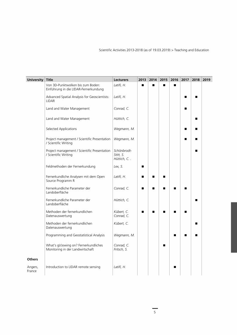
5
Scientific Activities 2013-2018 (as of 19.03.2019) > Teaching and Education
University Title Lecturers 2013 2014 2015 2016 2017 2018 2019
Von 3D-Punktwolken bis zum Boden: Einführung in die LIDAR-Fernerkundung
Latifi, H.
Advanced Spatial Analysis for Geoscientists: LiDAR
Latifi, H.
Land and Water Management Conrad, C.
Land and Water Management Hüttich, C.
Selected Applications Wegmann, M.
Project management / Scientific Presentation / Scientific Writing
Wegmann, M.
Project management / Scientific Presentation / Scientific Writing
Schönbrodt-Stitt, S. Hüttich, C. .
Feldmethoden der Fernerkundung Lex, S.
Fernerkundliche Analysen mit dem Open Source Programm R
Latifi, H.
Fernerkundliche Parameter der Landoberfläche
Conrad, C.
Fernerkundliche Parameter der Landoberfläche
Hüttich, C.
Methoden der fernerkundlichen Datenauswertung
Kübert, C. Conrad, C.
Methoden der fernerkundlichen Datenauswertung
Kübert, C.
Programming and Geostatistical Analysis Wegmann, M.
What's g(r)owing on? Fernerkundliches Monitoring in der Landwirtschaft
Conrad, C. Fritsch, S.
Others
Angers, France
Introduction to LIDAR remote sensing Latifi, H.
6
German Remote Sensing Data Center (DFD) ∙ Status Report 2018
University Title Lecturers 2013 2014 2015 2016 2017 2018 2019
Augsburg Aktuelle Aspekte der Atmosphären- und Klimaforschung (Seminar)
Bittner, M. Wüst, S.
Physik der Atmosphäre I (Vorlesung)
Bittner, M.
Physik der Atmosphäre I (Übung für Physiker und Mathematiker)
Wüst, S.
Physik der Atmosphäre I (Übung für Geographen)
Küchelbacher, L.
Physik der Atmosphäre II (Vorlesung)
Bittner, M.
Physik der Atmosphäre II (Übung für Physiker)
Wüst, S.
Physik der Atmosphäre II – Numerische Methoden (Vorlesung)
Wüst, S.
Physik der Atmosphäre II (Tutorium für Geographen)
Küchelbacher, L.
Antarktisforschung in Deutschland (Seminar)
Höppner, K
Atmosphärenforschung (Seminar)
Höppner, K.
Fernerkundung der polaren und kalten Regionen
Höppner, K.
Die Antarktis: ausgewählte Forschungsfelder (Seminar)
Höppner, K.
Polare Regionen (Seminar)
Höppner, K.
Applied Geodata Analysis and Machine Learning in R (Seminar)
Weigand, M.
Bayreuth (GCE)
Advanced Methods in Nature Conservation (Vorlesung + Übung)
Wegmann, M.
Global Change Impacts on Species Distributions (Vorlesung + Übung)
Wegmann, M.
7
Scientific Activities 2013-2018 (as of 19.03.2019) > Teaching and Education
University Title Lecturers 2013 2014 2015 2016 2017 2018 2019
Patterns of Land Use and Ecosystem Dynamics (Vorlesung + Übung)
Wegmann, M.
Remote Sensing (Vorlesung + Übung)
Wegmann, M.
Remote Sensing in Biodiversity Research (Vorlesung + Übung)
Wegmann, M.
Berlin (HU) Objektbasierte Bildverarbeitung und maschinelle Lernverfahren
Geiß, C.
Eichstätt Fernerkundung (Vorlesung, Seminar/Praktikum)
Sparwasser, N.
Graz (TU), Austria
Urbane Fernerkundung (Seminar/Praktikum)
Wurm, M.
Advanced Classification (Vorlesung/Übung)
Wurm, M.
Object Based Classification (Vorlesung/Übung)
Wurm, M.
Jena Hyperspektrale Fernerkundung (Seminar)
Bachmann, M.
Einführung in die modulare Programmierung (Seminar)
Habermayer, M.
Karlsruhe (KIT)
Energy Meteorology Schroedter-Homscheidt, M.
Katibougou, Mali
Agricultural land use mapping (GIS and RS) Thiel, M.
Köln Energy Meteorology Schroedter-Homscheidt, M.
Kumasi, Ghana
Introduction to Remote Sensing and GIS Thiel, M.
Lomé, Togo
Desasters and Human contingency Thiel, M.
Minna, Nigeria
Applied Remote Sensing Thiel, M.
8
German Remote Sensing Data Center (DFD) ∙ Status Report 2018
University Title Lecturers 2013 2014 2015 2016 2017 2018 2019
München (HS)
Fernerkundung (Vorlesung, Seminar/Praktikum)
Schmitt, A.
Fernerkundung – Vertiefung (Vorlesung, Übung)
Rentsch, M.
München (LMU)
Kartographie/GIS (Grundvorlesung)
Strobl, C.
München (TU)
Applied Earth Observation (Spezialvorlesung)
Strunz, G.
Geostatistics and Geomarketing (Spezialvorlesung)
Strobl, C.
DV-gestützte Geostatistik (Spezialvorlesung)
Strobl, C.
Mission Engineering and Ground Infrastructure (ESPACE)
Diedrich, E.
Neubrand-enburg
Datenerfassung und Datenmanagement – Fernerkundung (Vorlesung)
Borg, E.
Landschaftswissenschaften und Geomatik – Fernerkundung (Vorlesung)
Borg, E.
Rostock Ringvorlesung: Nutzung von Fernerkundungsmethoden zur Charakterisierung von Moorstandorten
Borg, E.
Stuttgart (HS)
Advanced Topics of Photogrammetry and Remote Sensing (Vorlesung, Seminar und Übung)
Esch, T.
Tübingen Fernerkundung (Vorlesung) Bachofer, F.
Venedig, Italy
Fernerkundung (Spezialvorlesung)
Marconcini, M.
LMU: Ludwig-Maximilians-Universität
TU: Technische Hochschule HS: Hochschule
GCE: Elitestudiengang Global Change Ecology
9
Scientific Activities 2013-2018 (as of 19.03.2019) > Teaching and Education
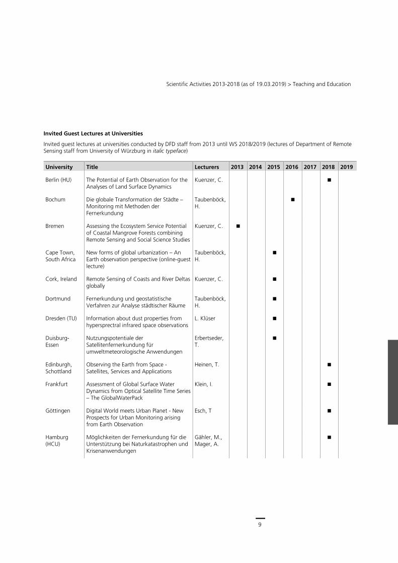
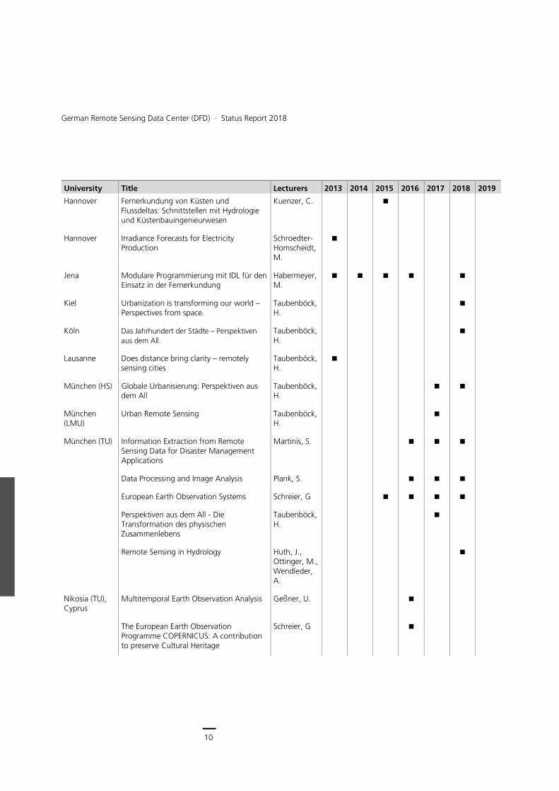
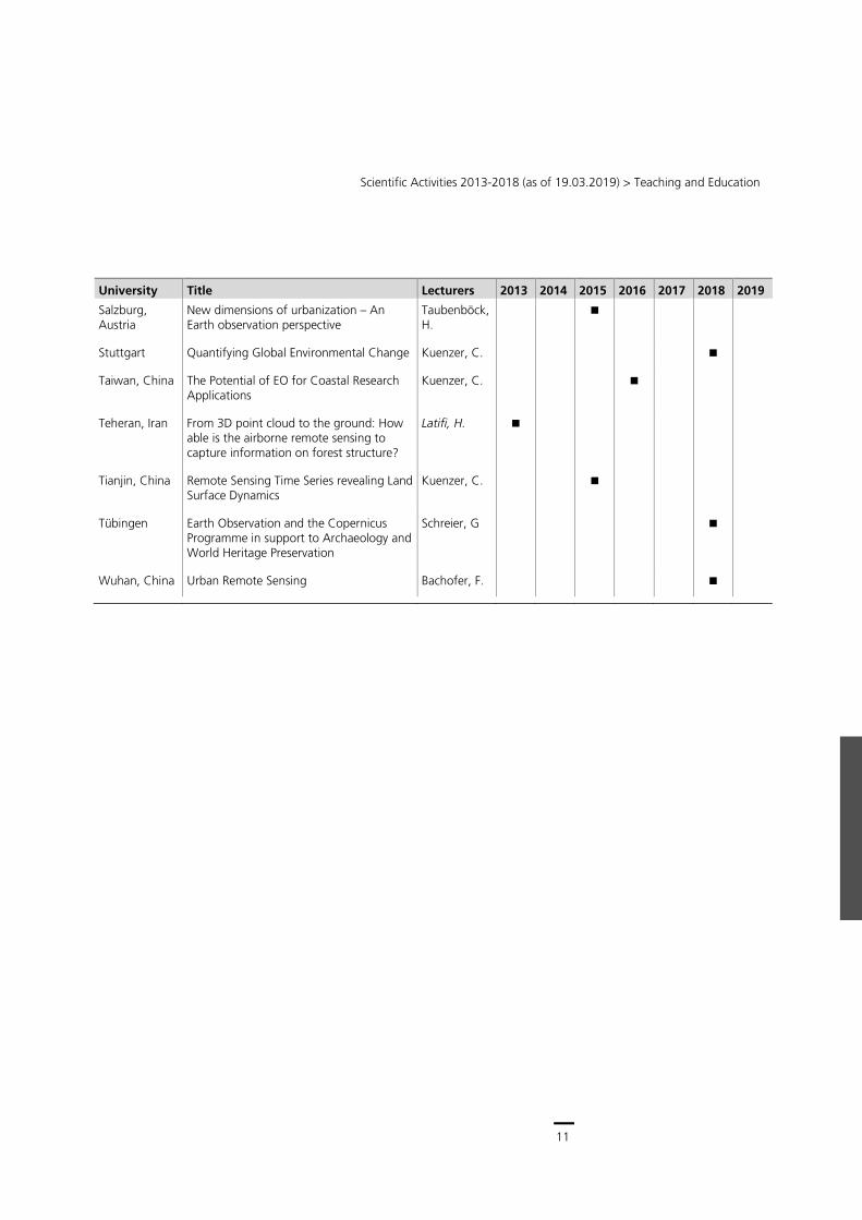
Invited Guest Lectures at Universities
Invited guest lectures at universities conducted by DFD staff from 2013 until WS 2018/2019 (lectures of Department of Remote Sensing staff from University of Würzburg in italic typeface)
University Title Lecturers 2013 2014 2015 2016 2017 2018 2019
Berlin (HU) The Potential of Earth Observation for the Analyses of Land Surface Dynamics
Kuenzer, C.
Bochum Die globale Transformation der Städte – Monitoring mit Methoden der Fernerkundung
Taubenböck, H.
Bremen Assessing the Ecosystem Service Potential of Coastal Mangrove Forests combining Remote Sensing and Social Science Studies
Kuenzer, C.
Cape Town, South Africa
New forms of global urbanization – An Earth observation perspective (online-guest lecture)
Taubenböck, H.
Cork, Ireland Remote Sensing of Coasts and River Deltas globally
Kuenzer, C.
Dortmund Fernerkundung und geostatistische Verfahren zur Analyse städtischer Räume
Taubenböck, H.
Dresden (TU) Information about dust properties from hypersprectral infrared space observations
L. Klüser
Duisburg-Essen
Nutzungspotentiale der Satellitenfernerkundung für umweltmeteorologische Anwendungen
Erbertseder, T.
Edinburgh, Schottland
Observing the Earth from Space - Satellites, Services and Applications
Heinen, T.
Frankfurt Assessment of Global Surface Water Dynamics from Optical Satellite Time Series – The GlobalWaterPack
Klein, I.
Göttingen Digital World meets Urban Planet - New Prospects for Urban Monitoring arising from Earth Observation
Esch, T
Hamburg (HCU)
Möglichkeiten der Fernerkundung für die Unterstützung bei Naturkatastrophen und Krisenanwendungen
Gähler, M., Mager, A.
10
German Remote Sensing Data Center (DFD) ∙ Status Report 2018
University Title Lecturers 2013 2014 2015 2016 2017 2018 2019
Hannover Fernerkundung von Küsten und Flussdeltas: Schnittstellen mit Hydrologie und Küstenbauingenieurwesen
Kuenzer, C.
Hannover Irradiance Forecasts for Electricity Production
Schroedter-Homscheidt, M.
Jena Modulare Programmierung mit IDL für den Einsatz in der Fernerkundung
Habermeyer, M.
Kiel Urbanization is transforming our world – Perspectives from space.
Taubenböck, H.
Köln Das Jahrhundert der Städte – Perspektiven
aus dem All. Taubenböck, H.
Lausanne Does distance bring clarity – remotely sensing cities
Taubenböck, H.
München (HS) Globale Urbanisierung: Perspektiven aus dem All
Taubenböck, H.
München (LMU)
Urban Remote Sensing Taubenböck, H.
München (TU) Information Extraction from Remote Sensing Data for Disaster Management Applications
Martinis, S.
Data Processing and Image Analysis Plank, S.
European Earth Observation Systems Schreier, G
Perspektiven aus dem All - Die Transformation des physischen Zusammenlebens
Taubenböck, H.
Remote Sensing in Hydrology Huth, J., Ottinger, M., Wendleder, A.
Nikosia (TU), Cyprus
Multitemporal Earth Observation Analysis Geßner, U.
The European Earth Observation Programme COPERNICUS: A contribution to preserve Cultural Heritage
Schreier, G
11
Scientific Activities 2013-2018 (as of 19.03.2019) > Teaching and Education
University Title Lecturers 2013 2014 2015 2016 2017 2018 2019
Salzburg, Austria
New dimensions of urbanization – An Earth observation perspective
Taubenböck, H.
Stuttgart Quantifying Global Environmental Change Kuenzer, C.
Taiwan, China The Potential of EO for Coastal Research Applications
Kuenzer, C.
Teheran, Iran From 3D point cloud to the ground: How able is the airborne remote sensing to capture information on forest structure?
Latifi, H.
Tianjin, China Remote Sensing Time Series revealing Land Surface Dynamics
Kuenzer, C.
Tübingen Earth Observation and the Copernicus Programme in support to Archaeology and World Heritage Preservation
Schreier, G
Wuhan, China Urban Remote Sensing Bachofer, F.
12
German Remote Sensing Data Center (DFD) ∙ Status Report 2018
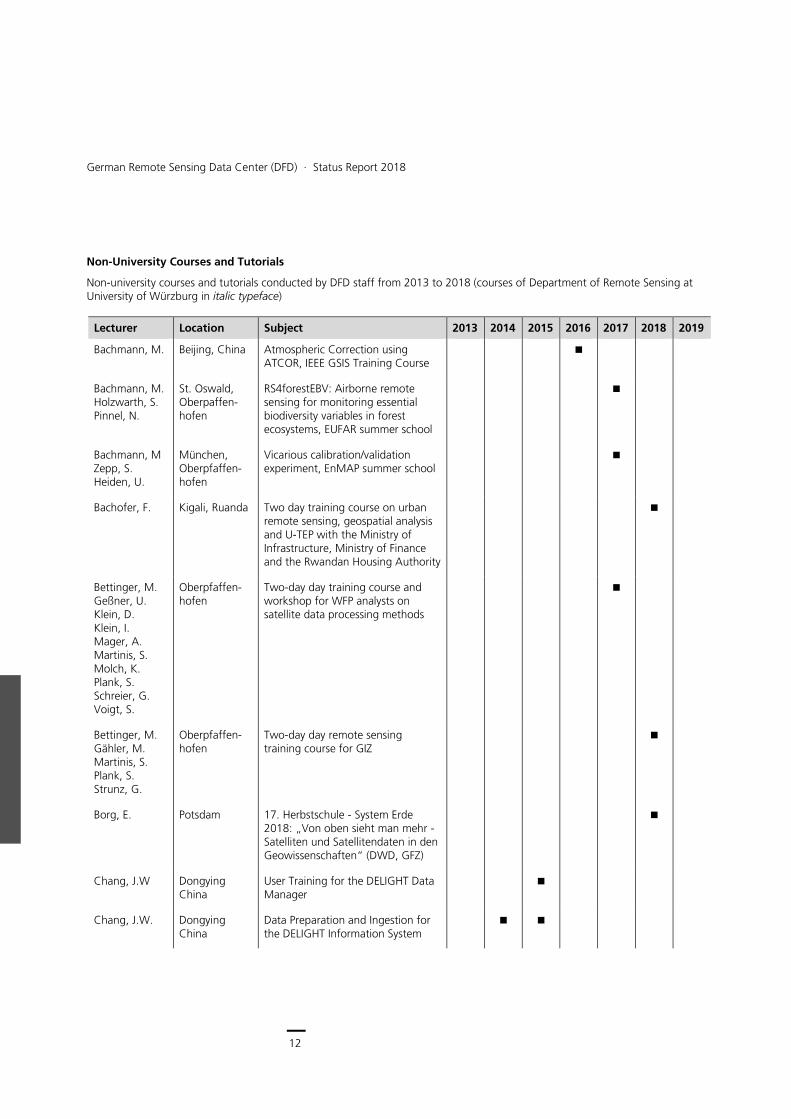
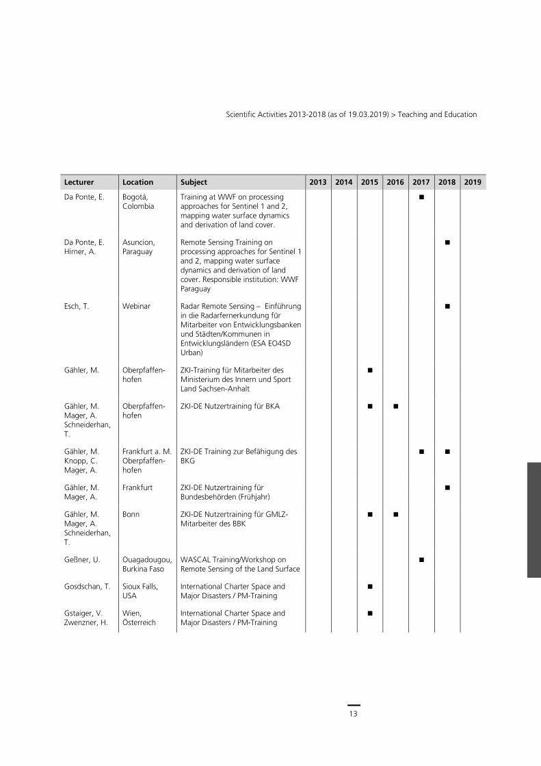
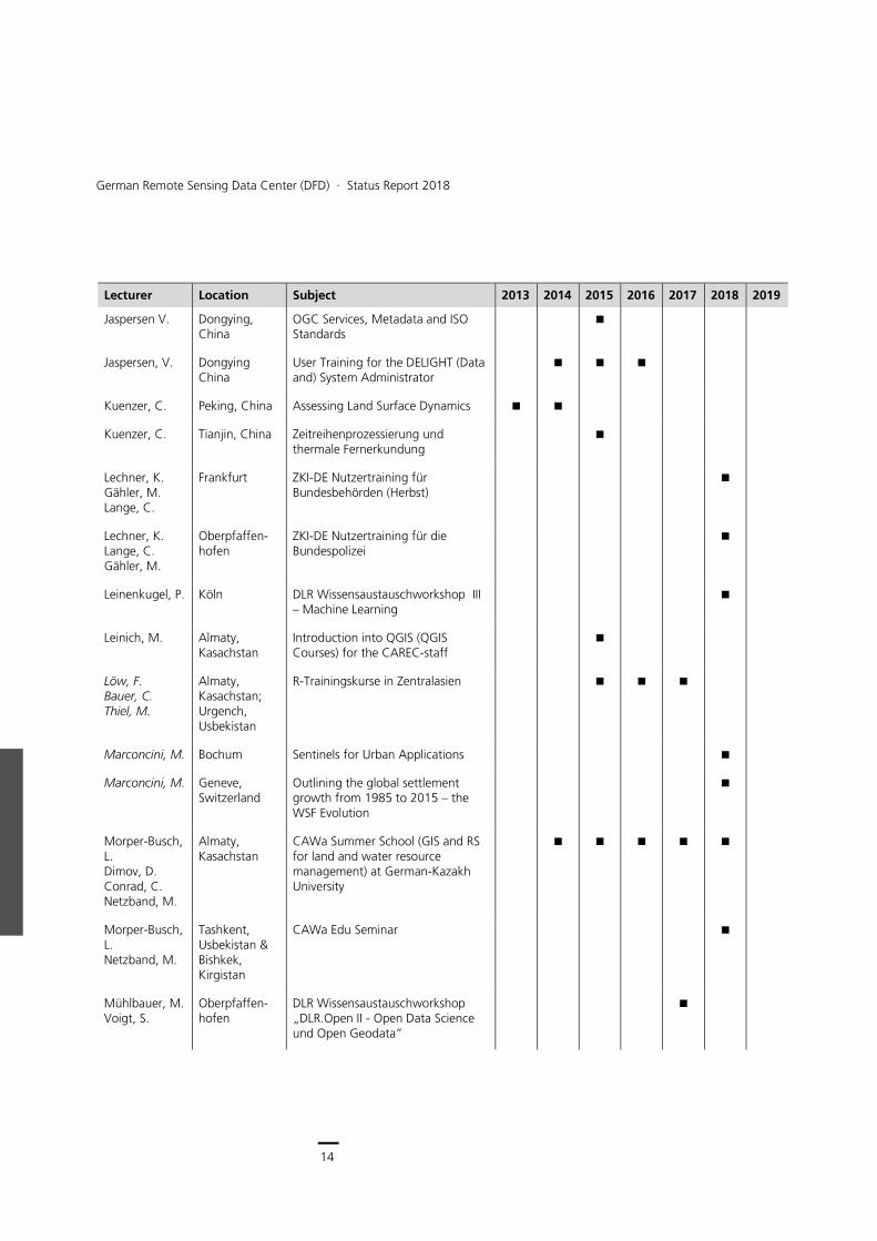
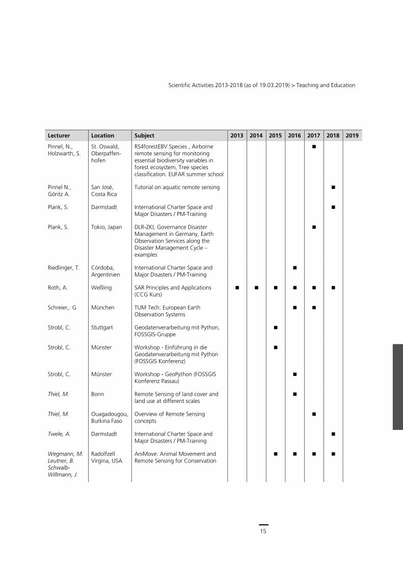
Non-University Courses and Tutorials
Non-university courses and tutorials conducted by DFD staff from 2013 to 2018 (courses of Department of Remote Sensing at University of Würzburg in italic typeface)
Lecturer Location Subject 2013 2014 2015 2016 2017 2018 2019
Bachmann, M. Beijing, China Atmospheric Correction using ATCOR, IEEE GSIS Training Course
Bachmann, M. Holzwarth, S. Pinnel, N.
St. Oswald, Oberpaffen-hofen
RS4forestEBV: Airborne remote sensing for monitoring essential biodiversity variables in forest ecosystems, EUFAR summer school
Bachmann, M Zepp, S. Heiden, U.
München, Oberpfaffen-hofen
Vicarious calibration/validation experiment, EnMAP summer school
Bachofer, F. Kigali, Ruanda Two day training course on urban remote sensing, geospatial analysis and U-TEP with the Ministry of Infrastructure, Ministry of Finance and the Rwandan Housing Authority
Bettinger, M. Geßner, U. Klein, D. Klein, I. Mager, A. Martinis, S. Molch, K. Plank, S. Schreier, G. Voigt, S.
Oberpfaffen-hofen
Two-day day training course and workshop for WFP analysts on satellite data processing methods
Bettinger, M. Gähler, M. Martinis, S. Plank, S. Strunz, G.
Oberpfaffen-hofen
Two-day day remote sensing training course for GIZ
Borg, E. Potsdam 17. Herbstschule - System Erde 2018: „Von oben sieht man mehr - Satelliten und Satellitendaten in den Geowissenschaften“ (DWD, GFZ)
Chang, J.W Dongying China
User Training for the DELIGHT Data Manager
Chang, J.W. Dongying China
Data Preparation and Ingestion for the DELIGHT Information System
13
Scientific Activities 2013-2018 (as of 19.03.2019) > Teaching and Education
Lecturer Location Subject 2013 2014 2015 2016 2017 2018 2019
Da Ponte, E. Bogotá, Colombia
Training at WWF on processing approaches for Sentinel 1 and 2, mapping water surface dynamics and derivation of land cover.
Da Ponte, E. Hirner, A.
Asuncion, Paraguay
Remote Sensing Training on processing approaches for Sentinel 1 and 2, mapping water surface dynamics and derivation of land cover. Responsible institution: WWF Paraguay
Esch, T. Webinar Radar Remote Sensing – Einführung in die Radarfernerkundung für Mitarbeiter von Entwicklungsbanken und Städten/Kommunen in Entwicklungsländern (ESA EO4SD Urban)
Gähler, M. Oberpfaffen-hofen
ZKI-Training für Mitarbeiter des Ministerium des Innern und Sport Land Sachsen-Anhalt
Gähler, M. Mager, A. Schneiderhan, T.
Oberpfaffen-hofen
ZKI-DE Nutzertraining für BKA
Gähler, M. Knopp, C. Mager, A.
Frankfurt a. M. Oberpfaffen-hofen
ZKI-DE Training zur Befähigung des BKG
Gähler, M. Mager, A.
Frankfurt ZKI-DE Nutzertraining für Bundesbehörden (Frühjahr)
Gähler, M. Mager, A. Schneiderhan, T.
Bonn ZKI-DE Nutzertraining für GMLZ-Mitarbeiter des BBK
Geßner, U. Ouagadougou, Burkina Faso
WASCAL Training/Workshop on Remote Sensing of the Land Surface
Gosdschan, T. Sioux Falls, USA
International Charter Space and Major Disasters / PM-Training
Gstaiger, V. Zwenzner, H.
Wien, Österreich
International Charter Space and Major Disasters / PM-Training
14
German Remote Sensing Data Center (DFD) ∙ Status Report 2018
Lecturer Location Subject 2013 2014 2015 2016 2017 2018 2019
Jaspersen V. Dongying, China
OGC Services, Metadata and ISO Standards
Jaspersen, V. Dongying China
User Training for the DELIGHT (Data and) System Administrator
Kuenzer, C. Peking, China Assessing Land Surface Dynamics
Kuenzer, C. Tianjin, China Zeitreihenprozessierung und thermale Fernerkundung
Lechner, K. Gähler, M. Lange, C.
Frankfurt ZKI-DE Nutzertraining für Bundesbehörden (Herbst)
Lechner, K. Lange, C. Gähler, M.
Oberpfaffen-hofen
ZKI-DE Nutzertraining für die Bundespolizei
Leinenkugel, P. Köln DLR Wissensaustauschworkshop III – Machine Learning
Leinich, M. Almaty, Kasachstan
Introduction into QGIS (QGIS Courses) for the CAREC-staff
Löw, F. Bauer, C. Thiel, M.
Almaty, Kasachstan; Urgench, Usbekistan
R-Trainingskurse in Zentralasien
Marconcini, M. Bochum Sentinels for Urban Applications
Marconcini, M. Geneve, Switzerland
Outlining the global settlement growth from 1985 to 2015 – the WSF Evolution
Morper-Busch, L. Dimov, D. Conrad, C. Netzband, M.
Almaty, Kasachstan
CAWa Summer School (GIS and RS for land and water resource management) at German-Kazakh University
Morper-Busch, L. Netzband, M.
Tashkent, Usbekistan & Bishkek, Kirgistan
CAWa Edu Seminar
Mühlbauer, M. Voigt, S.
Oberpfaffen-hofen
DLR Wissensaustauschworkshop „DLR.Open II - Open Data Science und Open Geodata”
15
Scientific Activities 2013-2018 (as of 19.03.2019) > Teaching and Education
Lecturer Location Subject 2013 2014 2015 2016 2017 2018 2019
Pinnel, N., Holzwarth, S.
St. Oswald, Oberpaffen-hofen
RS4forestEBV:Species , Airborne remote sensing for monitoring essential biodiversity variables in forest ecosystem, Tree species classification. EUFAR summer school
Pinnel N., Göritz A.
San José, Costa Rica
Tutorial on aquatic remote sensing
Plank, S. Darmstadt International Charter Space and Major Disasters / PM-Training
Plank, S. Tokio, Japan DLR-ZKI, Governance Disaster Management in Germany, Earth Observation Services along the Disaster Management Cycle – examples
Riedlinger, T. Córdoba, Argentinien
International Charter Space and Major Disasters / PM-Training
Roth, A. Weßling SAR Principles and Applications (CCG Kurs)
Schreier,. G München TUM Tech: European Earth Observation Systems
Strobl, C. Stuttgart Geodatenverarbeitung mit Python, FOSSGIS-Gruppe
Strobl, C. Münster Workshop - Einführung in die Geodatenverarbeitung mit Python (FOSSGIS Konferenz)
Strobl, C. Münster Workshop - GeoPython (FOSSGIS Konferenz Passau)
Thiel, M. Bonn Remote Sensing of land cover and land use at different scales
Thiel, M. Ouagadougou, Burkina Faso
Overview of Remote Sensing concepts
Twele, A. Darmstadt International Charter Space and Major Disasters / PM-Training
Wegmann, M. Leutner, B. Schwalb-Willmann, J.
Radolfzell Virgina, USA
AniMove: Animal Movement and Remote Sensing for Conservation
16
German Remote Sensing Data Center (DFD) ∙ Status Report 2018
Lecturer Location Subject 2013 2014 2015 2016 2017 2018 2019
Zeidler, J. Cape Town, South Africa
Geospatial Demography: Combining Satellite, Survey, Census and Cellphone Data to Provide Small-area Estimates. Mapping Settlements and Exploring data, tools, training
CCG: Carl-Cranz-Gesellschaft
17
Scientific Activities 2013-2018 (as of 19.03.2019) > Teaching and Education
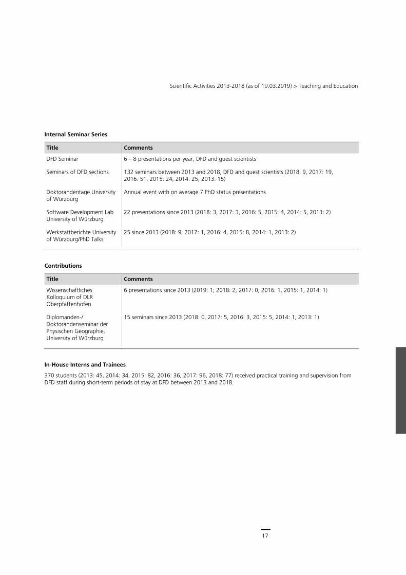
Internal Seminar Series
Title Comments
DFD Seminar 6 – 8 presentations per year, DFD and guest scientists
Seminars of DFD sections 132 seminars between 2013 and 2018, DFD and guest scientists (2018: 9, 2017: 19, 2016: 51, 2015: 24, 2014: 25, 2013: 15)
Doktorandentage University of Würzburg
Annual event with on average 7 PhD status presentations
Software Development Lab University of Würzburg
22 presentations since 2013 (2018: 3, 2017: 3, 2016: 5, 2015: 4, 2014: 5, 2013: 2)
Werkstattberichte University of Würzburg/PhD Talks
25 since 2013 (2018: 9, 2017: 1, 2016: 4, 2015: 8, 2014: 1, 2013: 2)
Contributions
Title Comments
Wissenschaftliches Kolloquium of DLR Oberpfaffenhofen
6 presentations since 2013 (2019: 1; 2018: 2, 2017: 0, 2016: 1, 2015: 1, 2014: 1)
Diplomanden-/ Doktorandenseminar der Physischen Geographie, University of Würzburg
15 seminars since 2013 (2018: 0, 2017: 5, 2016: 3, 2015: 5, 2014: 1, 2013: 1)
In-House Interns and Trainees
370 students (2013: 45, 2014: 34, 2015: 82, 2016: 36, 2017: 96, 2018: 77) received practical training and supervision from DFD staff during short-term periods of stay at DFD between 2013 and 2018.
18
German Remote Sensing Data Center (DFD) ∙ Status Report 2018
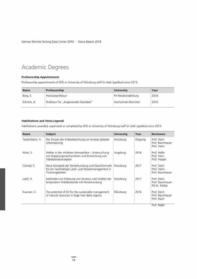
Academic Degrees
Professorship Appointments
Professorship appointments of DFD or University of Würzburg staff (in italic typeface) since 2013.
Name Professorship University Year
Borg, E. Honorarprofessur FH Neubrandenburg 2018
Schmitt, A. Professur für „Angewandte Geodäsie“ Hochschule München 2016
Habilitations and Venia Legendi
Habilitations awarded, supervised or completed by DFD or University of Würzburg staff (in italic typeface) since 2013
Name Subject University Year Reviewers
Taubenböck, H. Der Einsatz der Erdbeobachtung zur Analyse globaler Urbanisierung
Würzburg Ongoing Prof. Dech Prof. Baumhauer Prof. Hahn
Wüst, S. Wellen in der mittleren Atmosphäre – Untersuchung von Kopplungsmechanismen und Entwicklung von Validationskonzepten
Augsburg 2018 Prof. Reller Prof. Horn Prof. Hoppe
Conrad, C. Neue Konzepte der Fernerkundung und Geoinformatik für ein nachhaltiges Land- und Wassermanagement in Trockengebieten
Würzburg 2017 Prof. Dech Prof. Hahn Prof. Baumhauer
Latifi, H. Methoden zur Erfassung von Struktur und Vitalität der temporären Waldbestände mit Fernerkundung
Würzburg 2017 Prof. Dech Prof. Baumhauer PD Dr. Müller
Kuenzer, C. The potential of EO for the sustainable management of natural resources in large river delta regions
Würzburg 2016 Prof. Dech Prof. Baumhauer Prof. Rauh
Prof. Reller
19
Scientific Activities 2013-2018 (as of 19.03.2019) > Academic Degrees
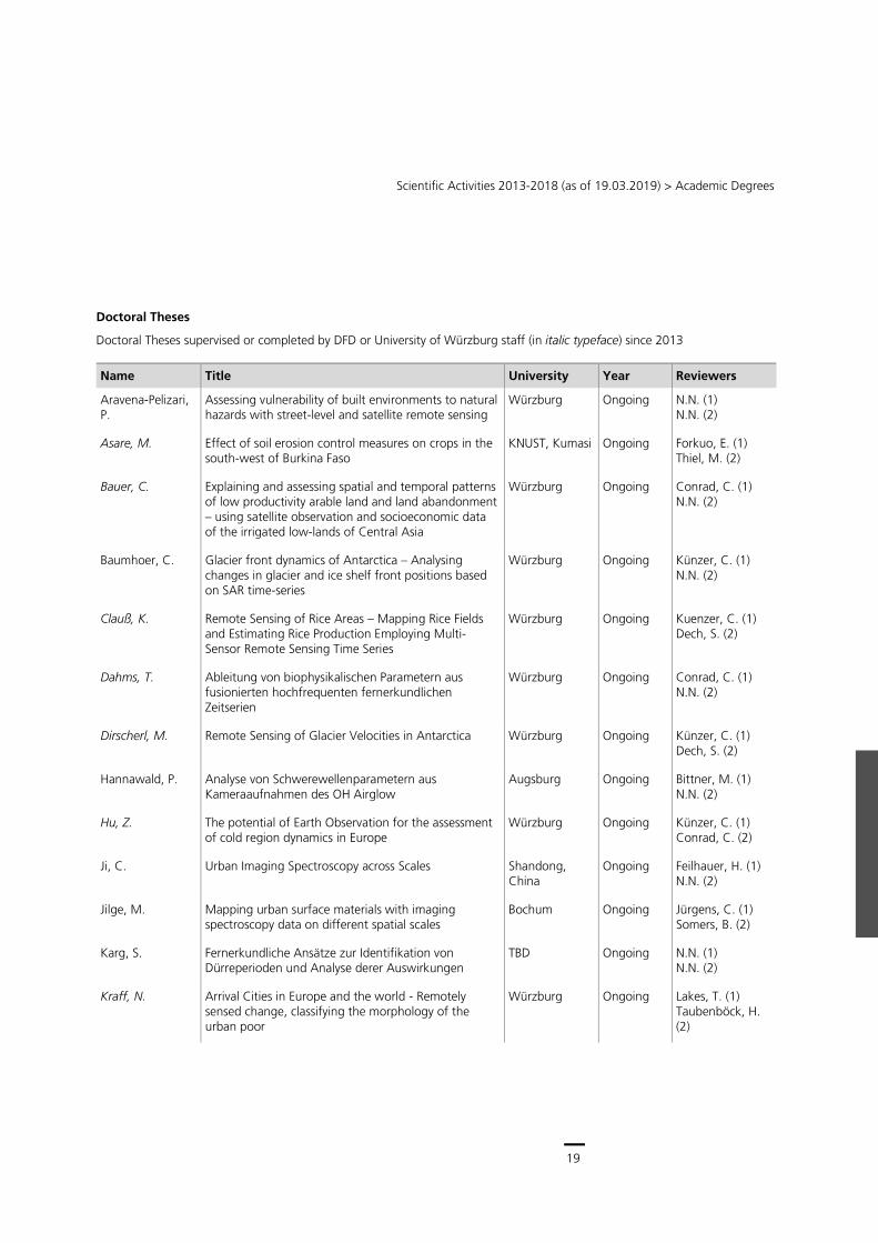
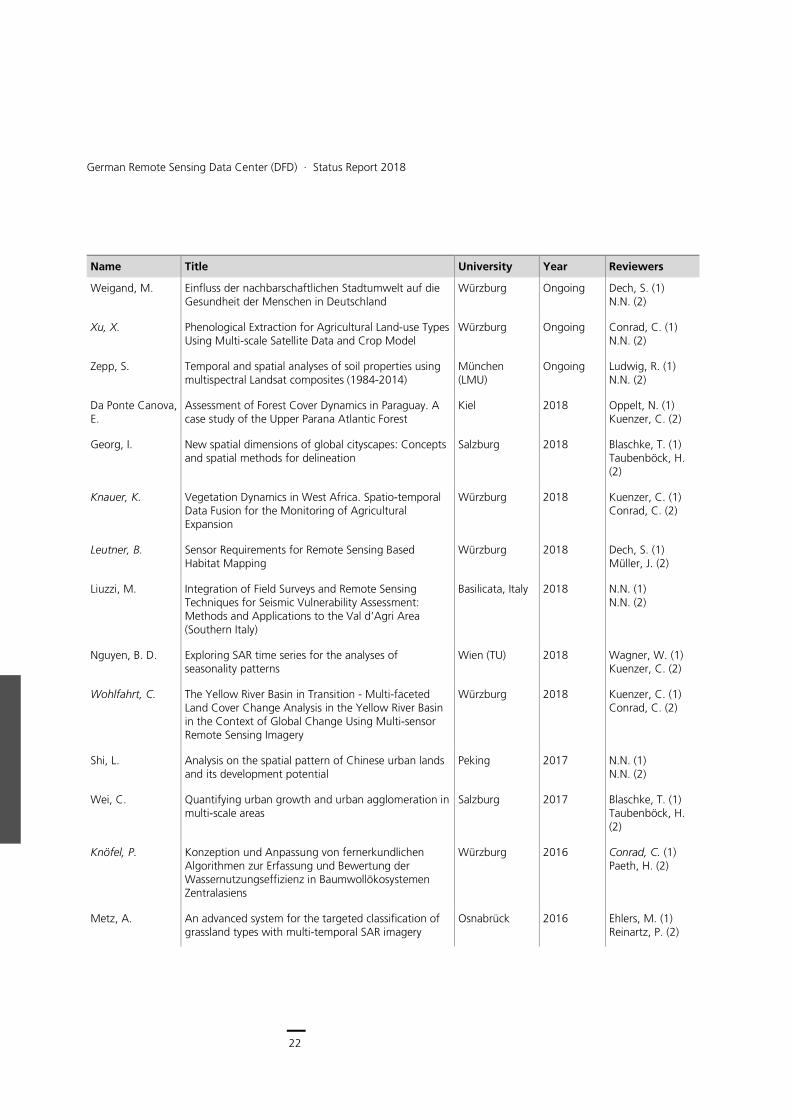
Doctoral Theses
Doctoral Theses supervised or completed by DFD or University of Würzburg staff (in italic typeface) since 2013
Name Title University Year Reviewers
Aravena-Pelizari, P.
Assessing vulnerability of built environments to natural hazards with street-level and satellite remote sensing
Würzburg Ongoing N.N. (1) N.N. (2)
Asare, M. Effect of soil erosion control measures on crops in the south-west of Burkina Faso
KNUST, Kumasi Ongoing Forkuo, E. (1) Thiel, M. (2)
Bauer, C. Explaining and assessing spatial and temporal patterns of low productivity arable land and land abandonment – using satellite observation and socioeconomic data of the irrigated low-lands of Central Asia
Würzburg Ongoing Conrad, C. (1) N.N. (2)
Baumhoer, C. Glacier front dynamics of Antarctica – Analysing changes in glacier and ice shelf front positions based on SAR time-series
Würzburg Ongoing Künzer, C. (1) N.N. (2)
Clauß, K. Remote Sensing of Rice Areas – Mapping Rice Fields and Estimating Rice Production Employing Multi-Sensor Remote Sensing Time Series
Würzburg Ongoing Kuenzer, C. (1) Dech, S. (2)
Dahms, T. Ableitung von biophysikalischen Parametern aus fusionierten hochfrequenten fernerkundlichen Zeitserien
Würzburg Ongoing Conrad, C. (1) N.N. (2)
Dirscherl, M. Remote Sensing of Glacier Velocities in Antarctica Würzburg Ongoing Künzer, C. (1) Dech, S. (2)
Hannawald, P. Analyse von Schwerewellenparametern aus Kameraaufnahmen des OH Airglow
Augsburg Ongoing Bittner, M. (1) N.N. (2)
Hu, Z. The potential of Earth Observation for the assessment of cold region dynamics in Europe
Würzburg Ongoing Künzer, C. (1) Conrad, C. (2)
Ji, C. Urban Imaging Spectroscopy across Scales Shandong, China
Ongoing Feilhauer, H. (1) N.N. (2)
Jilge, M. Mapping urban surface materials with imaging spectroscopy data on different spatial scales
Bochum Ongoing Jürgens, C. (1) Somers, B. (2)
Karg, S. Fernerkundliche Ansätze zur Identifikation von Dürreperioden und Analyse derer Auswirkungen
TBD Ongoing N.N. (1) N.N. (2)
Kraff, N. Arrival Cities in Europe and the world - Remotely sensed change, classifying the morphology of the urban poor
Würzburg Ongoing Lakes, T. (1) Taubenböck, H. (2)
20
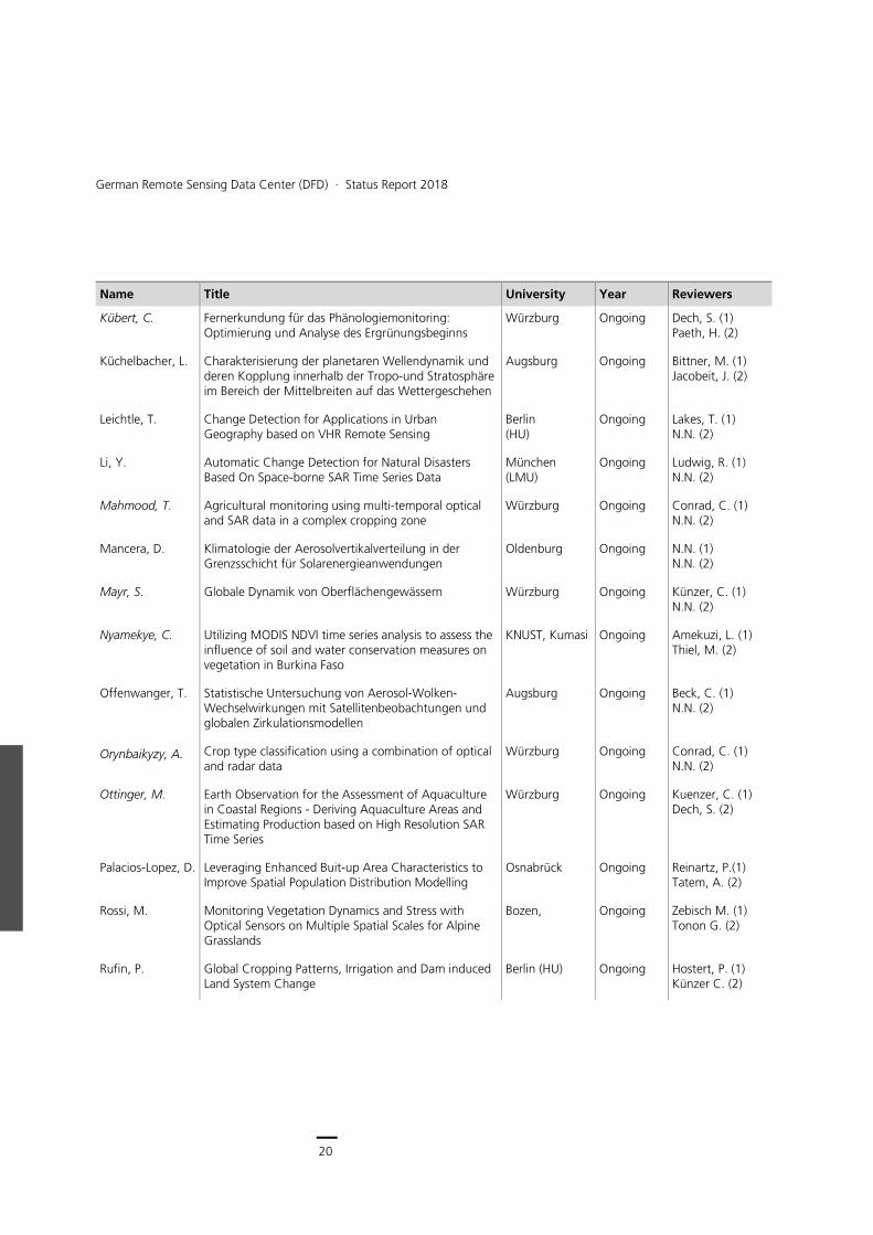
German Remote Sensing Data Center (DFD) ∙ Status Report 2018
Name Title University Year Reviewers
Kübert, C. Fernerkundung für das Phänologiemonitoring: Optimierung und Analyse des Ergrünungsbeginns
Würzburg Ongoing Dech, S. (1) Paeth, H. (2)
Küchelbacher, L. Charakterisierung der planetaren Wellendynamik und deren Kopplung innerhalb der Tropo-und Stratosphäre im Bereich der Mittelbreiten auf das Wettergeschehen
Augsburg Ongoing Bittner, M. (1) Jacobeit, J. (2)
Leichtle, T. Change Detection for Applications in Urban Geography based on VHR Remote Sensing
Berlin (HU)
Ongoing Lakes, T. (1) N.N. (2)
Li, Y. Automatic Change Detection for Natural Disasters Based On Space-borne SAR Time Series Data
München (LMU)
Ongoing Ludwig, R. (1) N.N. (2)
Mahmood, T. Agricultural monitoring using multi-temporal optical and SAR data in a complex cropping zone
Würzburg Ongoing Conrad, C. (1) N.N. (2)
Mancera, D. Klimatologie der Aerosolvertikalverteilung in der Grenzsschicht für Solarenergieanwendungen
Oldenburg Ongoing N.N. (1) N.N. (2)
Mayr, S. Globale Dynamik von Oberflächengewässern Würzburg Ongoing Künzer, C. (1) N.N. (2)
Nyamekye, C. Utilizing MODIS NDVI time series analysis to assess the influence of soil and water conservation measures on vegetation in Burkina Faso
KNUST, Kumasi Ongoing Amekuzi, L. (1) Thiel, M. (2)
Offenwanger, T. Statistische Untersuchung von Aerosol-Wolken-Wechselwirkungen mit Satellitenbeobachtungen und globalen Zirkulationsmodellen
Augsburg Ongoing Beck, C. (1) N.N. (2)
Orynbaikyzy, A. Crop type classification using a combination of optical and radar data
Würzburg Ongoing Conrad, C. (1) N.N. (2)
Ottinger, M. Earth Observation for the Assessment of Aquaculture in Coastal Regions - Deriving Aquaculture Areas and Estimating Production based on High Resolution SAR Time Series
Würzburg Ongoing Kuenzer, C. (1) Dech, S. (2)
Palacios-Lopez, D. Leveraging Enhanced Buit-up Area Characteristics to Improve Spatial Population Distribution Modelling
Osnabrück Ongoing Reinartz, P.(1) Tatem, A. (2)
Rossi, M. Monitoring Vegetation Dynamics and Stress with Optical Sensors on Multiple Spatial Scales for Alpine Grasslands
Bozen, Ongoing Zebisch M. (1) Tonon G. (2)
Rufin, P. Global Cropping Patterns, Irrigation and Dam induced Land System Change
Berlin (HU) Ongoing Hostert, P. (1) Künzer C. (2)
21
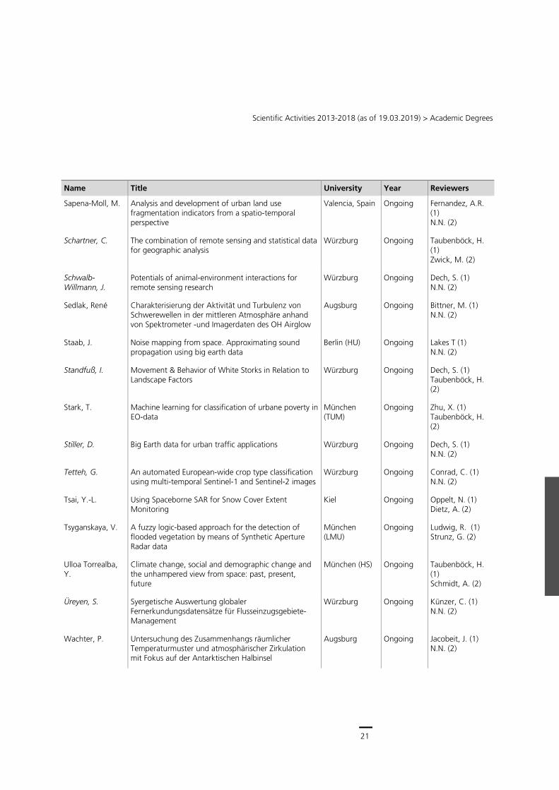
Scientific Activities 2013-2018 (as of 19.03.2019) > Academic Degrees
Name Title University Year Reviewers
Sapena-Moll, M. Analysis and development of urban land use fragmentation indicators from a spatio-temporal perspective
Valencia, Spain Ongoing Fernandez, A.R. (1) N.N. (2)
Schartner, C. The combination of remote sensing and statistical data for geographic analysis
Würzburg Ongoing Taubenböck, H. (1) Zwick, M. (2)
Schwalb-Willmann, J.
Potentials of animal-environment interactions for remote sensing research
Würzburg Ongoing Dech, S. (1) N.N. (2)
Sedlak, René Charakterisierung der Aktivität und Turbulenz von Schwerewellen in der mittleren Atmosphäre anhand von Spektrometer -und Imagerdaten des OH Airglow
Augsburg Ongoing Bittner, M. (1) N.N. (2)
Staab, J. Noise mapping from space. Approximating sound propagation using big earth data
Berlin (HU) Ongoing Lakes T (1) N.N. (2)
Standfuß, I. Movement & Behavior of White Storks in Relation to Landscape Factors
Würzburg Ongoing Dech, S. (1) Taubenböck, H. (2)
Stark, T. Machine learning for classification of urbane poverty in EO-data
München (TUM)
Ongoing Zhu, X. (1) Taubenböck, H. (2)
Stiller, D. Big Earth data for urban traffic applications Würzburg Ongoing Dech, S. (1) N.N. (2)
Tetteh, G. An automated European-wide crop type classification using multi-temporal Sentinel-1 and Sentinel-2 images
Würzburg Ongoing Conrad, C. (1) N.N. (2)
Tsai, Y.-L. Using Spaceborne SAR for Snow Cover Extent Monitoring
Kiel Ongoing Oppelt, N. (1) Dietz, A. (2)
Tsyganskaya, V. A fuzzy logic-based approach for the detection of flooded vegetation by means of Synthetic Aperture Radar data
München (LMU)
Ongoing Ludwig, R. (1) Strunz, G. (2)
Ulloa Torrealba, Y.
Climate change, social and demographic change and the unhampered view from space: past, present, future
München (HS) Ongoing Taubenböck, H. (1) Schmidt, A. (2)
Üreyen, S. Syergetische Auswertung globaler Fernerkundungsdatensätze für Flusseinzugsgebiete-Management
Würzburg Ongoing Künzer, C. (1) N.N. (2)
Wachter, P. Untersuchung des Zusammenhangs räumlicher Temperaturmuster und atmosphärischer Zirkulation mit Fokus auf der Antarktischen Halbinsel
Augsburg Ongoing Jacobeit, J. (1) N.N. (2)
22
German Remote Sensing Data Center (DFD) ∙ Status Report 2018
Name Title University Year Reviewers
Weigand, M. Einfluss der nachbarschaftlichen Stadtumwelt auf die Gesundheit der Menschen in Deutschland
Würzburg Ongoing Dech, S. (1) N.N. (2)
Xu, X. Phenological Extraction for Agricultural Land-use Types Using Multi-scale Satellite Data and Crop Model
Würzburg Ongoing Conrad, C. (1) N.N. (2)
Zepp, S. Temporal and spatial analyses of soil properties using multispectral Landsat composites (1984-2014)
München (LMU)
Ongoing Ludwig, R. (1) N.N. (2)
Da Ponte Canova, E.
Assessment of Forest Cover Dynamics in Paraguay. A case study of the Upper Parana Atlantic Forest
Kiel 2018 Oppelt, N. (1) Kuenzer, C. (2)
Georg, I. New spatial dimensions of global cityscapes: Concepts and spatial methods for delineation
Salzburg 2018 Blaschke, T. (1) Taubenböck, H. (2)
Knauer, K. Vegetation Dynamics in West Africa. Spatio-temporal Data Fusion for the Monitoring of Agricultural Expansion
Würzburg 2018 Kuenzer, C. (1) Conrad, C. (2)
Leutner, B. Sensor Requirements for Remote Sensing Based Habitat Mapping
Würzburg 2018 Dech, S. (1) Müller, J. (2)
Liuzzi, M. Integration of Field Surveys and Remote Sensing Techniques for Seismic Vulnerability Assessment: Methods and Applications to the Val d’Agri Area (Southern Italy)
Basilicata, Italy 2018 N.N. (1) N.N. (2)
Nguyen, B. D. Exploring SAR time series for the analyses of seasonality patterns
Wien (TU) 2018 Wagner, W. (1) Kuenzer, C. (2)
Wohlfahrt, C. The Yellow River Basin in Transition - Multi-faceted Land Cover Change Analysis in the Yellow River Basin in the Context of Global Change Using Multi-sensor Remote Sensing Imagery
Würzburg 2018 Kuenzer, C. (1) Conrad, C. (2)
Shi, L. Analysis on the spatial pattern of Chinese urban lands and its development potential
Peking 2017 N.N. (1) N.N. (2)
Wei, C. Quantifying urban growth and urban agglomeration in multi-scale areas
Salzburg 2017 Blaschke, T. (1) Taubenböck, H. (2)
Knöfel, P. Konzeption und Anpassung von fernerkundlichen Algorithmen zur Erfassung und Bewertung der Wassernutzungseffizienz in Baumwollökosystemen Zentralasiens
Würzburg 2016 Conrad, C. (1) Paeth, H. (2)
Metz, A. An advanced system for the targeted classification of grassland types with multi-temporal SAR imagery
Osnabrück 2016 Ehlers, M. (1) Reinartz, P. (2)
23
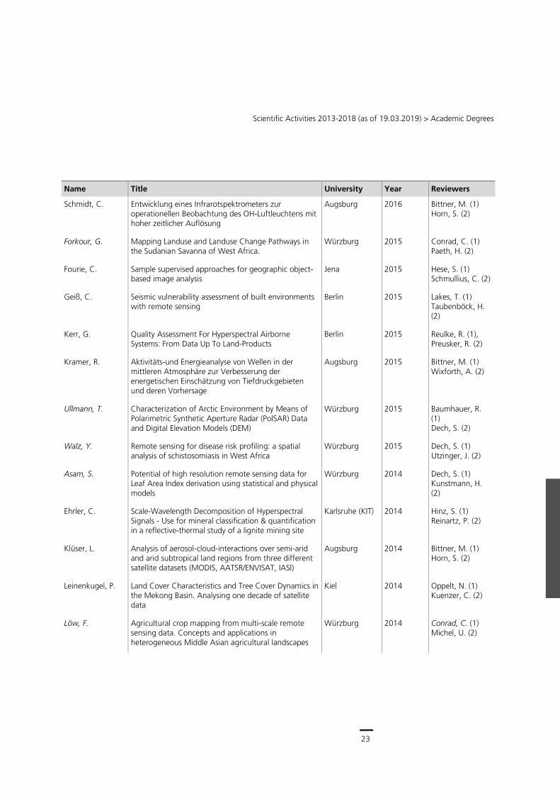
Scientific Activities 2013-2018 (as of 19.03.2019) > Academic Degrees
Name Title University Year Reviewers
Schmidt, C. Entwicklung eines Infrarotspektrometers zur operationellen Beobachtung des OH-Luftleuchtens mit hoher zeitlicher Auflösung
Augsburg 2016 Bittner, M. (1) Horn, S. (2)
Forkour, G. Mapping Landuse and Landuse Change Pathways in the Sudanian Savanna of West Africa.
Würzburg 2015 Conrad, C. (1) Paeth, H. (2)
Fourie, C. Sample supervised approaches for geographic object-based image analysis
Jena 2015 Hese, S. (1) Schmullius, C. (2)
Geiß, C. Seismic vulnerability assessment of built environments with remote sensing
Berlin 2015 Lakes, T. (1) Taubenböck, H. (2)
Kerr, G. Quality Assessment For Hyperspectral Airborne Systems: From Data Up To Land-Products
Berlin 2015 Reulke, R. (1), Preusker, R. (2)
Kramer, R. Aktivitäts-und Energieanalyse von Wellen in der mittleren Atmosphäre zur Verbesserung der energetischen Einschätzung von Tiefdruckgebieten und deren Vorhersage
Augsburg 2015 Bittner, M. (1) Wixforth, A. (2)
Ullmann, T. Characterization of Arctic Environment by Means of Polarimetric Synthetic Aperture Radar (PolSAR) Data and Digital Elevation Models (DEM)
Würzburg 2015 Baumhauer, R. (1) Dech, S. (2)
Walz, Y. Remote sensing for disease risk profiling: a spatial analysis of schistosomiasis in West Africa
Würzburg 2015 Dech, S. (1) Utzinger, J. (2)
Asam, S. Potential of high resolution remote sensing data for Leaf Area Index derivation using statistical and physical models
Würzburg 2014 Dech, S. (1) Kunstmann, H. (2)
Ehrler, C. Scale-Wavelength Decomposition of Hyperspectral Signals - Use for mineral classification & quantification in a reflective-thermal study of a lignite mining site
Karlsruhe (KIT) 2014 Hinz, S. (1) Reinartz, P. (2)
Klüser, L. Analysis of aerosol-cloud-interactions over semi-arid and arid subtropical land regions from three different satellite datasets (MODIS, AATSR/ENVISAT, IASI)
Augsburg 2014 Bittner, M. (1) Horn, S. (2)
Leinenkugel, P. Land Cover Characteristics and Tree Cover Dynamics in the Mekong Basin. Analysing one decade of satellite data
Kiel 2014 Oppelt, N. (1) Kuenzer, C. (2)
Löw, F. Agricultural crop mapping from multi-scale remote sensing data. Concepts and applications in heterogeneous Middle Asian agricultural landscapes
Würzburg 2014 Conrad, C. (1) Michel, U. (2)
24
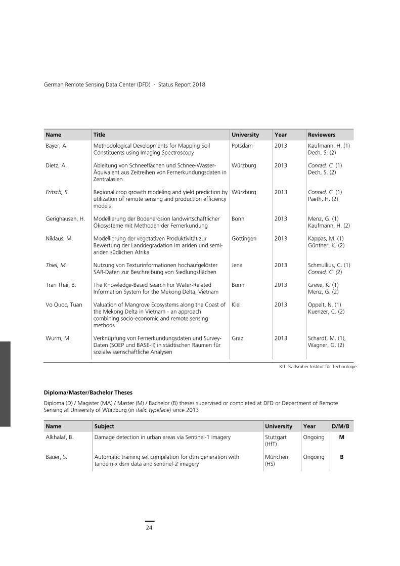
German Remote Sensing Data Center (DFD) ∙ Status Report 2018
Name Title University Year Reviewers
Bayer, A. Methodological Developments for Mapping Soil Constituents using Imaging Spectroscopy
Potsdam 2013 Kaufmann, H. (1) Dech, S. (2)
Dietz, A. Ableitung von Schneeflächen und Schnee-Wasser-Äquivalent aus Zeitreihen von Fernerkundungsdaten in Zentralasien
Würzburg 2013 Conrad, C. (1) Dech, S. (2)
Fritsch, S. Regional crop growth modeling and yield prediction by utilization of remote sensing and production efficiency models
Würzburg 2013 Conrad, C. (1) Paeth, H. (2)
Gerighausen, H. Modellierung der Bodenerosion landwirtschaftlicher Ökosysteme mit Methoden der Fernerkundung
Bonn 2013 Menz, G. (1) Kaufmann, H. (2)
Niklaus, M. Modellierung der vegetativen Produktivität zur Bewertung der Landdegradation im ariden und semi-ariden südlichen Afrika
Göttingen 2013 Kappas, M. (1) Günther, K. (2)
Thiel, M. Nutzung von Texturinformationen hochaufgelöster SAR-Daten zur Beschreibung von Siedlungsflächen
Jena 2013 Schmullius, C. (1) Conrad, C. (2)
Tran Thai, B. The Knowledge-Based Search For Water-Related Information System for the Mekong Delta, Vietnam
Bonn 2013 Greve, K. (1) Menz, G. (2)
Vo Quoc, Tuan Valuation of Mangrove Ecosystems along the Coast of the Mekong Delta in Vietnam - an approach combining socio-economic and remote sensing methods
Kiel 2013 Oppelt, N. (1) Kuenzer, C. (2)
Wurm, M. Verknüpfung von Fernerkundungsdaten und Survey-Daten (SOEP und BASE-II) in städtischen Räumen für sozialwissenschaftliche Analysen
Graz 2013 Schardt, M. (1), Wagner, G. (2)
KIT: Karlsruher Institut für Technologie
Diploma/Master/Bachelor Theses
Diploma (D) / Magister (MA) / Master (M) / Bachelor (B) theses supervised or completed at DFD or Department of Remote Sensing at University of Würzburg (in italic typeface) since 2013
Name Subject University Year D/M/B
Alkhalaf, B. Damage detection in urban areas via Sentinel-1 imagery Stuttgart (HfT)
Ongoing M
Bauer, S. Automatic training set compilation for dtm generation with tandem-x dsm data and sentinel-2 imagery
München (HS)
Ongoing B
25
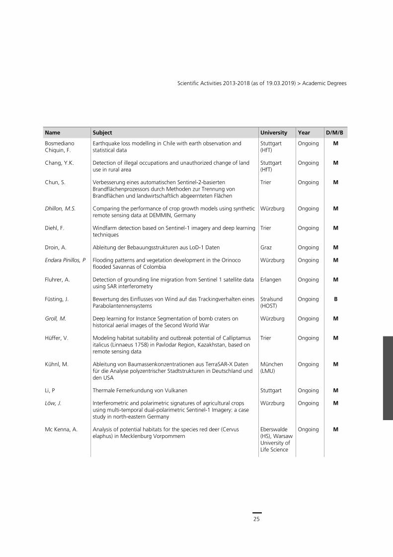
Scientific Activities 2013-2018 (as of 19.03.2019) > Academic Degrees
Name Subject University Year D/M/B
Bosmediano Chiquin, F.
Earthquake loss modelling in Chile with earth observation and statistical data
Stuttgart (HfT)
Ongoing M
Chang, Y.K. Detection of illegal occupations and unauthorized change of land use in rural area
Stuttgart (HfT)
Ongoing M
Chun, S. Verbesserung eines automatischen Sentinel-2-basierten Brandflächenprozessors durch Methoden zur Trennung von Brandflächen und landwirtschaftlich abgeernteten Flächen
Trier Ongoing M
Dhillon, M.S. Comparing the performance of crop growth models using synthetic remote sensing data at DEMMIN, Germany
Würzburg Ongoing M
Diehl, F. Windfarm detection based on Sentinel-1 imagery and deep learning techniques
Trier Ongoing M
Droin, A. Ableitung der Bebauungsstrukturen aus LoD-1 Daten Graz Ongoing M
Endara Pinillos, P Flooding patterns and vegetation development in the Orinoco flooded Savannas of Colombia
Würzburg Ongoing M
Fluhrer, A. Detection of grounding line migration from Sentinel 1 satellite data using SAR interferometry
Erlangen Ongoing M
Füsting, J. Bewertung des Einflusses von Wind auf das Trackingverhalten eines Parabolantennensystems
Stralsund (HOST)
Ongoing B
Groll, M. Deep learning for Instance Segmentation of bomb craters on historical aerial images of the Second World War
Würzburg Ongoing M
Hüffer, V. Modeling habitat suitability and outbreak potential of Calliptamus italicus (Linnaeus 1758) in Pavlodar Region, Kazakhstan, based on remote sensing data
Trier Ongoing M
Kühnl, M. Ableitung von Baumassenkonzentrationen aus TerraSAR-X Daten für die Analyse polyzentrischer Stadtstrukturen in Deutschland und den USA
München (LMU)
Ongoing M
Li, P Thermale Fernerkundung von Vulkanen Stuttgart Ongoing M
Löw, J. Interferometric and polarimetric signatures of agricultural crops using multi-temporal dual-polarimetric Sentinel-1 Imagery: a case study in north-eastern Germany
Würzburg Ongoing M
Mc Kenna, A. Analysis of potential habitats for the species red deer (Cervus elaphus) in Mecklenburg Vorpommern
Eberswalde (HS), Warsaw University of Life Science
Ongoing M
26
German Remote Sensing Data Center (DFD) ∙ Status Report 2018
Name Subject University Year D/M/B
Mönks, M. House facade segmentation of CityGML data with Deep Learning Approaches
Greifswald Ongoing M
Nolting, S. Auswertung von Fernerkundungsdaten für Hochwasser-Risikoanalysen in Nordrhein-Westfalen
Würzburg Ongoing M
Osterkamp, N. Erfassung und Analyse von Grünflächen auf Basis optischer Satellitenbilddaten für ausgewählte Städte in Deutschland
Bochum Ongoing M
Ramirez-Mejia, A. Investigating aerosol densities and pollution over built-up areas using Sentinel 2 data
Stuttgart (HfT)
Ongoing M
Reiners, P. Multi-annual assessment of a new consistent AVHRR Land Surface Temperature product using MODIS LST and in situ measurements
Marburg Ongoing M
Reiter, M. Shares of green spaces in German cities Würzburg Ongoing M
Rörsch, S. Development of a semi-automated method to measure solar potential
Würzburg Ongoing M
Rosenberg, S. Intra-class spectral variability of tree species induced by topography and environmental parameters
Erlangen Ongoing M
Roth, F. Weiterentwicklung eines automatischen Brandflächen-Prozessors auf der Basis von Sentinel-2 Daten
Wien Ongoing M
Saadallah, A. The potential of Earth Observation for monitoring agricultural lands in Egypt Nile Delta Region (1984-2017)
Würzburg Ongoing M
Schiller, C. Analyse und Anwendung von terrestrischen und satellitengestützten Umweltdaten in der Landwirtschaft
Potsdam Ongoing M
Selvaraj, B. Assessing the development of circle irrigation in South Africa since 2000
Würzburg Ongoing M
Soto Calderón, A. Earthquake loss modelling in Chile with earth observation and statistical data
München (TUM)
Ongoing M
Thiele, A. Analyse, Verschneidung und Produktgenerierung von 3D Daten anhand eines ausgewählten Anwendungsbeispiels im ZKI
Göttingen Ongoing M
Weusthoff, M. Großwohnsiedlung Scharnhorst-Ost: Blick von unten und Blick von oben.
Dortmund Ongoing B
Wiertz, K. Development of a semi-automatic remote sensing approach for change-detection of forest structures in Bialowieza Forest
Würzburg Ongoing M
Atieku-Dzandu, B. Understanding the Impact of Urbanization of Land-use using TimeScan and Global Urban Footprint Dataset - A Case Study for the Greater Accra Region, Ghana
Stuttgart (HFT)
2018 M
27
Scientific Activities 2013-2018 (as of 19.03.2019) > Academic Degrees
Name Subject University Year D/M/B
Basdas, K. Globaler Vergleich von Versiegelungsgraden urbaner Agglomerationen
München (HS)
2018 B
Bauer, A. Klassifizierung der Seen auf dem Baltoro-Gletscher mithilfe von Sentinel-2 und Landsat-8 Daten im Zeitraum 2016 bis 2018
München (HS)
2018 B
Bauer, A. Soil Repository – Determination of Thresholds for the Detection of Active Soils from Landsat Time Series
Ebertswalde (HS)
2018 M
Baumgartner, F. Objektorientierte Erstellung eines digitalen Friedhofsplans mittels hochaufgelöster Drohnen-Luftbilder: Eine Fallstudie für die Gemeinde Kürnach
Würzburg 2018 B
Bhagwat, T. Bird´s Eye View: Using bird migration patterns for land-cover classifications
Bayreuth 2018 M
Borngräber, S. Eignung von Fernerkundungsdaten zur Ableitung des flächendeckenden Wärmebedarfs von Wohngebäuden in Baden – Württemberg
Tübingen 2018 M
Cerri, M. Multivariable flood damage modelling for residential buildings using open data with random forests
München (TUM)
2018 M
Dahle, F. Räumliche Analyse von Siedlungsstrukturen und sozio-ökonomische Parameter für Europa
Würzburg 2018 B
Dinh Dieu, A. Spatio-temporal analysis of flood patterns in the Mekong Delta based on satellite data time series”
Faro, Portugal 2018 M
Gstaiger, V. 3D-Informationen aus Fernerkundungsdaten für den Bevölkerungsschutz - Nutzungsmöglichkeiten am Beispiel zweier Großveranstaltungen
Bonn 2018 M
Gutwinski, M. Entwicklung und Analyse eines Informationssystems urbaner hyperspektraler Bildspektren
Bochum 2018 M
Huang, R. Geo-Information extraction from Tweets Tübingen 2018 M
Kupfer, N. A novel land use and land cover product for the Mekong Delta based on high spatial resolution, satellite data time series
Heidelberg 2018 M
Lange, A. Erfassung und Analyse von Grünflächen auf Basis optischer Satellitenbilddaten für ausgewählte Städte in Deutschland
Wien 2018 B
Liu, C. Assessment of Chinese Typhoon Disaster Situation Based on VGI München (TUM)
2018 M
Martini, M. Automated three detection: applications for object-based image analysis in arid systems
Bayreuth 2018 M
28
German Remote Sensing Data Center (DFD) ∙ Status Report 2018
Name Subject University Year D/M/B
Mast, J. Analyse und Vergleich der Oberflächenstruktur von Gemeinden in Nordrhein-Westfalen anhand des Local-Climate Zone Konteptes
Hannover 2018 B
Miesgang, C. Evaluierung, Kalibrierung und Validierung eines Algorithmus zur Detektion von Brandflächen mit Sentinel-3 OLCI Daten auf Basis der Active Level Set Methode
München (LMU)
2018 M
Paulik, F. Supervised Machine Learning for Spectral Classification using Hyperspectral Images of Semi-Arid Regions
München (LMU)
2018 M
Reinermann, S. Extreme Events in Europe between 2000 and 2017: Analysis of Vegetation Dynamics based on Earth Observation Time Series
Bayreuth 2018 M
Schork, K. Ableitung der Schneeflächen aus einer Kombination von Sentinel-1 und Sentinel-2 in drei Untersuchungsgebieten
Augsburg 2018 M
Schrade, H. Machine Learning-based Regression for Characterization of Urban Environments with Sentinel-2
Augsburg 2018 M
Schwalb-Willmann, J.
A deep learning movement prediction framework for identifying anomalies in animal-environment interactions
Würzburg 2018 M
Shakya, H. Computing flood frequency and Duration from Earth Observation data
München (TUM)
2018 M
Sill, S. GIS-gestützte Analyse von Klimatopen in der Stadt Tübingen - Auf Basis der Oberflächentemperaturen aus ASTER-Thermalkarten
Tübingen 2018 B
Sokolovska, A. Optimization of Payload Data Downlink Strategy for EO Missions Using Ka-band Downlink Technology
München (TUM)
2018 M
Stark, T. Using Deep Convolutional Neural Networks for the Identification of Informal Settlements to Improve a Sustainable Development in Urban Environments
München (TUM)
2018 M
Steffen, J. Analyse der Lage der Wellenfronten eines tsunamiinduzierten Infraschallereignisses vor der Küste Chiles in der Mesopausenregion
Augsburg 2018 B
Stiller, D. Analysing Spatio-temporal Patterns of Coastal Aquaculture Based on Three Decades of Satellite Data
Bayreuth 2018 M
Talapatra, M. Modelling Population Distribution using Global Urban Footprint (GUF) and VHR SAR Imagery for Java, Indonesia
Stuttgart (HS) 2018 M
Wagner, L. Feasibility study of a dashboard for extended monitoring of system components in the German satellite data archive
Fulda (HS) 2018 B
Weber, M. Räumliche Vorhersage verschiedener Vogelarten mit Hilfe der Fernerkundung
Würzburg 2018 B
29
Scientific Activities 2013-2018 (as of 19.03.2019) > Academic Degrees
Name Subject University Year D/M/B
Yavsan. Z. Spektral aufgelöste Analyse der Aktivität von atmosphärischen Schwerewellen in der Mesopause an verschiedenen geographischen Breiten
Augsburg 2018 B
Zehner, M. Detection of impervious soil area in multispectral remote sensing - a comparison
Würzburg 2018 B
Baumhoer, C. An automated approach to estimate large-scale flood volumes based on SAR satellite imagery and different DEMs - a risk management support
Bonn 2017 M
Biber, M. Can animal movement and remote sensing data help to improve conservation efforts? A case stuy on plains and Grevy´s zebtras
Bayreuth 2017 M
Binning, J. Entwicklung eines räumlich-dynamischen Ansatzes zur fernerkundungsbasierten Modellierung der tatsächlichen Evatranspiration von Bewässerungsregionen im Aralseebecken
Würzburg 2017 M
Blickensdörfer, L. Improving Classification of Very-High-Resolution Satellite Imagery – Combining Invariant Support Vector Machines and Object-Based Image Analysis to Tackle Limited Information Input.
Heidelberg 2017 B
Borngräber, S. Erdbeobachtungspotential im Kontext von kommunalen Wärmeplänen
Tübingen 2017 M
Brandl, V. Evaluierung von Sentinel-3-Daten für die Zwecke der Landbedeckungsklassifikation
Würzburg 2017 B
Cwik, K. Flood mapping with the Sentinel-1 time-series data in arid areas München (TU)
2017 M
Deck, R. The Potential of Open Geodata and Multi-Temporal Landsat Data for Automated Large-Scale Land Use and Land Cover Classification
Augsburg 2017 M
Devi Eswaramoorthy, V.
Increasing the Statistical Significance for MODIS Active Fire Hotspots in Portugal Using One-Class Support Vector Machines
München (TU)
2017 M
Färber, V. Analysing drought severity in Ethiopia using high resolution optical satellite data
Innsbruck 2017 M
Fetik, Y. Supervised machine learning of fullcube hyperspectral data Salzburg 2017 M
Glaser, P. Random-Forest-Klassifikation agrarischer Landnutzungsflächen mithilfe von Sentinel-1-Daten am Beispiel östliches Harvorland
Würzburg 2017 B
Hammer, L. Erklärung räumlichen Verhaltens von Störchen mittels Fernerkundung
Würzburg 2017 B
30
German Remote Sensing Data Center (DFD) ∙ Status Report 2018
Name Subject University Year D/M/B
Hintermaier, S. Rekonstruktion von Bodenradar-Daten des Vernagtferners aus multifrequenten SAR-Aufnahmen
München (HS)
2017 B
Kalusche, E. Ableitung zeitlich und räumlich variabler Emissionsfaktoren für den Raum München und Augsburg aus realistischen Verkehrsdichten
Augsburg 2017 M
Karg, S. Burn scar detection using polarimetric ALOS-2 time-series data Bayreuth 2017 M
Kühnlenz, S. Beitrag zur Ermittlung des Bodensignals zur verbesserten Ableitung des Vegetationssignals aus Fernerkundungsdaten
Neubranden-burg
2017 M
Macheleidt, L. Census versus morphological slums derived from EO data - A spatial comparison of locations and structures for two megacities in Brazil
Kiel 2017 B
Maier, P. Modellierung von Erntemengen für Hopfensorten in der Hallertau mittels Deep Learning Algorithmen auf Basis von Klima- und Satellitendaten
Würzburg 2017 M
Mittelstädt, L. Untersuchung des Halbjahresgangs der Temperatur und Zusammenhang mit der Albedo
Augsburg 2017 M
Müller, I. Exposition und Lage von Slums in Megastädten - eine Analyse mit Hilfe von Fernerkundung
Kiel 2017 M
Murawski, M. Morphologie von Großwohnsiedlungen – Eine Strukturanalyse städtebaulicher Großwohnsiedlungen basierend auf räumlichen Daten
Kiel 2017 M
Palacios Lopez, D. Multi-temporal Analysis of Sentinel-1 SAR Satellite Data for Post-Seismic Building Damage Assessment of the Mw.6.0 Earthquake in Italy
Stuttgart (HS)
2017 M
Phillip, M. Spectral and spatial resolution of remote sensing data and ist impact on classification processes. A case study of the Bavarian Steigerwald
Würzburg 2017 M
Reck, R. Tree Species Classification in the Bavarian Forest National Park using Hyperspectral Remote Sensing and Site Specific Information
Augsburg 2017 M
Reuß; F. Detection of favelas in Brazil using texture parameters and machine learning
Graz 2017 M
Rohde, A. Satellitengestützte Analyse der Feinstaubkonzentration über Deutschland
Augsburg 2017 M
Roth, G. Umsetzung eines MODIS-basierten Prozessors zur Detektion von Flutflächen in Python
München (LMU)
2017 B
Schrade, H. Large-Area Morphologic Characterization of Urban Environments with Machine Learning Regression Algorithms Using Data of the TanDEM-X Mission and Sentinel-2
Augsburg 2017 M
31
Scientific Activities 2013-2018 (as of 19.03.2019) > Academic Degrees
Name Subject University Year D/M/B
Schulte, H. Quantifying landcover change using remote sensing data in a transboundary protected area
Bayreuth 2017 M
Staab, J. Applying Computer Vision of Monitoring Visitor Numbers Würzburg 2017 M
Steiner, S. Sentinel-2 based Land Cover Inventory in Punjab, Pakistan Würzburg 2017
Thoma, M. Cost-Sensitive Active Learning mit Fernerkundungsdaten zur Abschätzung der Gebäudevulnerabilität bei Hochwasser und Erdbeben
Hagen 2017 M
Von Uslar, J. Der Einfluss stratifizierter Sampling Methoden auf multi-temporale, objektbasierte Random-Forest Klassifikation
Würzburg 2017 M
Weigand, M. SAR Image Feature Analysis for Slum Detection in Megacities Augsburg 2017 M
Winkler, K. Assessment of agricultural drought over Africa and its relation to El Niño-Southern Oscillation using remote sensing-based time series
Tübingen 2017 M
Wittmann, C. Aufbau eines Infrarotspektrometers zur Beobachtung verschiedener OH-Rotations-Vibrationsbanden in atmosphärischen Nachtleuchten
Augsburg 2017 M
Baumann, M. Entwicklung der landwirtschaftlichen Nitratbelastung des bayerischen Mains vor dem Hintergrund der Europäischen Wasserrahmenrichtlinie
Würzburg 2016 B
Becker, C. Global flood detection using Sentinel-2A-MSI by combining histogram-based and regional methods compared with an automated RandomForest approach
München (HS)
2016 M
Berndt, F. Satellite-based shelter detection in the context of large scale events and refugee camps: Development and transferability of an object-based classification approach
Salzburg 2016 M
Bettinger, M. Entwicklung einer Prozesskette zur automatischen Detektion von Brandflächen auf der Basis von Sentinel-2 Daten
München (TU)
2016 M
Bolkart, M. Mapping and Monitoring Locust Habitats in the Aral Sea Region based on Satellite Earth Observation Data
Würzburg 2016 M
Dada, E. Monitoring and Evaluating Temporal Changes of Cocoa Plantation in Ondo State, Nigeria with Remote Sensing Techniques
Stuttgart (HS)
2016 M
Deb, P. Settlement Pattern Analysis of Germany based on Global Human Settlement Raster Data Sets
Stuttgart (HS)
2016 M
Eger, D. Ernteabtragungsabschätzung von Winterweizen mittels hochauflösender spektraler Daten
Würzburg 2016 B
32
German Remote Sensing Data Center (DFD) ∙ Status Report 2018
Name Subject University Year D/M/B
Ferstl, J. Klassifizierung und Kategorisierung von Regionen in Europa - Eine Analyse von Siedlungsmustern abgeleitet aus Erdbeobachtungsdaten des Global Urban Footprint
München (HS)
2016 B
Fix, M. Signaturen von Infraschall im atmosphärischen Luftleuchten Augsburg 2016 M
Fürmann, M. Evaluation of High Temperature Event Detection Algorithms with the space-borne TET-1 Infrared Sensor
Stockholm 2016 M
Griep, T. Charakterisierung von Einschlägen blindgegangener Fliegerbomben aus dem Zweiten Weltkrieg auf Grundlage historischer Luftbilder und verifizierter Bombenfunde des Bay. Innenministeriums zur Anwendung in der Kampfmittelvorerkundung
Würzburg 2016 B
Groll, M. Verwendung eines PROSPECT Inversionsmodels zur Ableitung von Trockenmasse und Chlorophyllgehalt durch Spektrometermessungen auf Weizenfeldern
Würzburg 2016 B
Heckel, K. Analysis of a long-term Time Series of 1 km NDVI Data derived from AVHRR over Europe and North Africa - Impact of Sensor Correction
Jena 2016 M
Heisig, J. A multitemporal land cover classification of Bavaria from Landsat 8 satellite data
München (LMU)
2016 B
Katz, E. Untersuchung der Volumenschwankungen des Sarykamyschsee mit Hilfe fernerkundlicher Methoden
Würzburg 2016 B
Kovatsch, M. Earth Observation Based Monitoring of the Refugee Camp Yida in South Sudan and Its Impact on the Environment
München (TU)
2016 M
Küchelbacher, L. Variabilität und Trends planetarer Wellen der mittleren Atmosphäre der Nordhalbkugel
Augsburg 2016 M
Kuhn, J. Using very high resolution remote sensing imagery to assess crop diversity in the Fergana Valley, Uzbekistan
Würzburg 2016 M
Kühnl, M. Räumliche Strukturen informeller Besiedlung in Europa Augsburg 2016 B
Lambrecht, L. Untersuchung und Besprechung der fernerkundlich erfassten Veränderung der Landnutzung in Nord-Ghana unter Berücksichtigung des Niederschlags
Würzburg 2016 B
Löw, J. Analyse der Bodenfeuchteentwicklung in zentralasiatischen Bewässerungssystemen anhand von CCI Soil Moisture- Zeitserien
Würzburg 2016 B
Majhen, P. Objektbasierte Klassifikation und physiognomischer Strukturvergleich der informellen Siedlungstypen in der Metropolregion Greater Cairo
Graz (TU)
2016 M
33
Scientific Activities 2013-2018 (as of 19.03.2019) > Academic Degrees
Name Subject University Year D/M/B
Müller, T. Analysis of the spectral calibration of NOAA-AVHRR sensors and correcting its effects using hyperspectral data
Salzburg 2016 M
Offenwanger, T. Räumliche Charakteristik atmosphärischer Wellen in OH*-Airglowdaten: Anwendung eines neuen Messverfahrens basierend auf IR-Spektrometern
Augsburg 2016 M
Pitz, N. Quantitative Analyse der informellen Siedlungsstrukturen in Caracas, Venezuela
Gießen 2016 B
Premier, J. B. The Lynx Effect: Behaviour of Roe Deer in the Presence of Lynx in a European Forest Ecosystem
Würzburg 2016 M
Roersch, S. Urbane Entwicklung und Struktur im ländlichen Raum Usbekistans am Beispiel des Ferganatals
Würzburg 2016 B
Sauerbrey, J. A. Volumenschwankungen von Stauwasserseen im Gebiet Khorezm, Usbekistan
Würzburg 2016 B
Schlegel, I. Potentiale von Erdbeobachtungsdaten für die Ableitung von Vulnerabilitätsindikatoren im Delta des Gelben Flusses, China
Hamburg 2016 M
Schmöckel, J. Analyse von Schwerewellen und ihren nicht-linearen resonanten Wechselwirkungen über den Alpen basierend auf TIMED-SABER Temperaturprofilen
Augsburg 2016 M
Schneider, T. Earth observation (EO)-based identification of land use/ land cover changes related to large-scale land investments using the example of Lichinga, Niassa
Erlangen 2016 M
Schöler, C. Moderne Webtechnologien und –standards als Basis für die Entwicklung eines Webportals für das Projekt IMPC
Neubranden-burg (HS)
2016 B
Schröter, E. Innovative Visualisierungen von Kriseninformation auf Basis von Fernerkundungsdaten: UAS-gestützte Lagebilderfassung für zivile Sicherheitsanwendungen
Hamburg 2016 M
Schröther, T. Untersuchung des Einflusses von Polarisationseffekten bei der Beobachtung des Hydroxyl(OH*)-Leuchtens mit dem IR-Spektrometer GRIPS
Augsburg 2016 B
Schubert, H. Vorhersagegüte räumlicher Texturmerkmale in der hochaufgelösten Landbedeckungsklassifikation mit Hilfe von maschinellen Lernverfahren
Jena 2016 B
Schumann, B. Ermittlung der Baumkronendichte des Ober- und Unterstandes in heterogenen Wäldern mit Hilfe von multitemporalen LiDAR-Daten
Würzburg 2016 M
Schwalb-Willmann, J.
Comparison of different algorithms for calculating broadband albedo from AVHRR data
München (LMU)
2016 B
34
German Remote Sensing Data Center (DFD) ∙ Status Report 2018
Name Subject University Year D/M/B
Schwarz, M. Auswertung satellitenbasierter Langzeitreihen zur Stickstoffdioxidbelastung globaler Megacities
München (LMU)
2016 B
Sedlak, R. Aufbau eines neuen Airglow Imagers zur Messung kleinskaliger dynamischer Strukturen in der mittleren Atmosphäre
Augsburg 2016 M
Sostmann, H. Vergleich unterschiedlicher statistischer Verfahren zur Ableitung biophysikalischer Parameter aus RapidEye Daten
Würzburg 2016 B
Stelzner, T. Einfluss der Wasserverfügbarkeit auf Dynamik der Nutzungsintensität landwirtschaftlicher Flächen in zentralasiatischen Bewässerungsgebieten
Würzburg 2016 B
Stephani, A. Impact of remote sensing characteristics for biodiversity monitoring - A case study of Southern Myanmar mangroves
Bayreuth 2016 M
Tavri, A. Flood monitoring based on multi-temporal Sentinel-1 data - a synergistic approach of amplitude data with interferometric coherence
München (TU)
2016 M
Ulloa Torrealba, Y.Z.
Land change in the Main catchment with an Object Based approach using eCognition
Bayreuth 2016 M
Üreyen, S. Monitoring urban growth by means of multi-temporal time-series of optical Landsat data
Jena 2016 M
Asja, B. Mind the Gap: A Global Analysis of Grassland Fragmentation using MODIS Land Cover Data
Bayreuth 2015 M
Baron von Freytag-Loringhoven, L.
Untersuchung der Abhängigkeit der Vegetationsvitalität von der Topographie auf landwirtschaftlich genutzten Flächen in Nordwest Benin unter Erstellung einer semiautomatisierten Prozesskette
Würzburg 2015 B
Bauer, P. Räumliche Analyse der Megaregionen Chinas auf Basis von Daten des Global Urban Footprint
München (LMU)
2015 B
Bernd, A. Global Grassland intactness analysis (working title) Bayreuth 2015 M
Beroya-Eitner, M. Flood Vulnerability Index for Delta Socio-Economical Systems: Application to the Mekong River Delta, Vietnam
Bayreuth 2015 M
Birkholz, R. Multitemporale Analyse von Landbedeckungs-/ Landnutzungsänderungen entlang des Ili-Flusslaufs und deren Auswirkungen auf das Ökosystem des Flussdeltas
Jena 2015 M
Broszeit, A. Assessing long-term inland water quality using satellite imagery: A feasibility and validation study of different lake types
Würzburg 2015 M
Bürgmann, T. Investigating the Separability of Slums in Mumbai based on RADARSAT Images using Object-based Image Analysis Methods
Karlsruhe (HS)
2015 B
35
Scientific Activities 2013-2018 (as of 19.03.2019) > Academic Degrees
Name Subject University Year D/M/B
Fissmer, B. Multitemporal analysis and statistical evaluation of Radar backscatter and bi-static coherence of flood affected areas
Bochum 2015 M
Fricke, J. Slums in Rio de Janeiro. Spatial and temporal analyses of slums derived from remote sensing data based on visual image interpretation
Augsburg 2015 B
Friedl, P. Ableitung glaziologischer Parameter aus ERS-SAR-Daten auf der Antarktischen Halbinsel
Erlangen 2015 M
Gebhardt, V. Untersuchung eines möglichen Einflusses der Albedo auf die Mesopausenregion
München (LMU)
2015 B
Gnoyke, P. Large Land Acquisitions in East Africa. An examination of spatial dynamics through remote sensing
Bayreuth 2015 M
Graf, W. Suitability of LiDAR and texture measures of aerial distribution of Glaucidium passerinum (pygmy owl) in Vercors, French Alps
Bayreuth 2015 M
Henkel, F. Automatische Erstellung von GDI-DE konformen Produktmetadaten im Kontext der Krisenkartierung
Salzburg 2015 M
Hess, A. Deforestation in Myanmar-what can we say about causes? Würzburg 2015 M
Hill, S. Predicting the Forest Development after Natural Disturbance in the Bavarian Forest National Park using Airborne LiDAR
Würzburg 2015 M
Holzapfel, J. Statistische Ableitung der Chlorophyllkonzentration auf Weizenfeldern des Kalibrations- und Validationstestfeldes DEMMIN mittels Fernerkundungsdaten und Feldmessungen
Würzburg 2015 B
Homolka, A. Entwicklung einer standardisierten Schnittstelle zur funktionalen Erweiterung von WPS-Diensten (am Beispiel des GZS MODIS Feuerservices)
Jena 2015 M
Jung, S. Variabilität der solaren Einstrahlung in 1-Minuten aufgelösten Strahlungszeitserien
Augsburg 2015 M
Kasten, A. Entwicklung eines Verfahrens zur automatisierten Küstenlinienerkennung aus monospektralen Fernerkundungsbildern
Neubranden-burg (HS)
2015 M
Kazlova, A. Adaptation of an algorithm based on the two dimensional Fast-Fourier-Transform (FFT) for the analysis of OH-airglow intensity measurements
München (LMU)
2015 M
Klink, A. Kleinmaßstäbige Erfassung von Baumarten mittels multisensoraler Fernerkundungsdaten
Würzburg 2015 B
Loewert, C. Analyse der Siedlungsentwicklung in der Stadt Dano in Südwest Burkina Faso in den Jahren 2009-2014
Würzburg 2015 B
36
German Remote Sensing Data Center (DFD) ∙ Status Report 2018
Name Subject University Year D/M/B
Malec, S. Assessment of Soil erosion parameters in Costa Rica using reflectance hyperspectral and simulated EnMAP imagery
Bayreuth 2015 M
März, F. Untersuchung verschiedener Eisklassifizierungsverfahren mit TerraSAR-X am Beispiel vom Algonquin Nationalpark in Ontario, Kanada
München (LMU)
2015 B
Neiß, M. Entwicklung eines Verfahrens zur Detektion von Flachdächern am Beispiel der Landeshauptstadt München Development of a detection process for platform roofs on the example of Munich
Augsburg 2015 M
Pausch, M. Konzeption, Design und prototypische Entwicklung eines kartographischen, multimedialen Kriseninformationssystems
München (HS)
2015 M
Pletziger, F. Workflow zur Visualisierung von OpenStreetMap-Daten im Kontext Kriseninformationen
Bochum 2015 B
Rossi, M. Statistische Analyse von Standortfaktoren zur Erklärung phänologischer Zeitpunkte am Beispiel von Grünlandflächen im Alpenvorland
Würzburg 2015 M
Schauß, A. Joint Use of Remote Sensing and Volunteered Geographic Information for Exposure Estimation
Heidelberg 2015 M
Schlegel, I. Potentiale von Erdbeobachtungsdaten für die Ableitung von Vulnerabilitätsindikatoren im Delta des Gelben Flusses, China
Hamburg 2015 M
Schneider, N. Klassifikation von informellen Siedlungen am Beispiel Kapstadt - Eine Analyse auf der Grundlage von hochauflösenden Radar- und Zensusdaten
München (LMU)
2015 M
Sieg, T. The potential of interferometric and polarimetric SAR data to characterize urban areas at the example of Mumbai and Manila
Bayreuth 2015 M
Singhammer, M. Veränderungsanalyse der Siedlungsstruktur in der Nildeltaregion auf Grundlage von multitemporalen Satellitenbilddaten
München (HS)
2015 B
Sirueri, F. Comparing spatial patterns of informal settlements between Nairobi and Dar es Salaam
Twente (NL) 2015 M
Sommer, C. Feature based tree sepcies classification using airborne hyperspectral and LiDAR data for the Bavarian Forerst National Park
München (LMU)
2015 M
Staab, J. Remote Sensing based evaluation of settlement development of Abuja City
Würzburg 2015 B
Standfuß, I. Validation of the European Urban Atlas & Automatic Classification of Urban Structures utilizing Cartosat-1 nDSM Data
Bochum 2015 M
Utz, S. Zeitliche Entwicklung von Siedlungsstrukturen in Nord- und Südkorea
München (HS)
2015 B
37
Scientific Activities 2013-2018 (as of 19.03.2019) > Academic Degrees
Name Subject University Year D/M/B
Vollmuth, M. Zusammenhänge der Schneedynamik und des Abflussverhaltens im
Einzugsgebiet des Naryn - Statistische Betrachtungen und
physiogeographische Erklärungen
Würzburg 2015 M
Wisböck, S. Explaining variation of home range size of red deer (Cervus elaphus) in the Bavarian Forest National Park using Lidar derived metrics on forest structure and fractional cover
Würzburg 2015 B
Zellner, P. Towards quantifying stress factors in wheat and maize monitoring - a comparison of LAI derived using a mechanistic plant growth model and satellite measurements
Würzburg 2015 M
Zepp, S. Entwicklung eines multi-skaligen Ansatzes zur Erfassung und Auswertung bergbaubedingter Veränderungen der Landoberfläche am Beispiel eines Altbaugebietes in Südafrika
München (LMU)
2015 M
Baron, D. Analysis of MODIS time series data for characterization of hydrometeorological factors in relation to landslide activity in Southern Kyrgyzstan
Würzburg 2014 M
Böck, M. Konzeption und Umsetzung von Webmapping-Applikationen zur Visualisierung krisenrelevanter Informationen
München (HS)
2014 B
Chow, C. Evaluation of the applicability of a probabilistic terrain descriptor to improve the thematic accuracy of DLR’s TerraSAR-X based Flood Service (TFS)
Dresden 2014 M
Dahms, T. Phänologische Analysen basierend auf fusionierten Zeitserien aus RapidEye und Landsat Daten
Würzburg 2014 M
El Fouly, M. Entwicklung einer Web Mapping Anwendung für einen fernerkundungsgestützten Feuer- und Wasserservice
München (TUM)
2014 M
Fabritius, H. Optimierung eines auf Satellitendaten beruhenden Pflanzenwachstumsmodell am Beispiel von Winterweizen in Deutschland
Würzburg 2014 M
Färber, V. Stadtstruktureller Vergleich von Slums in türkischen Großstädten unter Verwendung von Satellitendaten
Würzburg 2014 B
Flock, H. „Lokale Energiewende“ - Fernerkundliche Veränderungsanalyse der agrarischen Landschaftsstruktur durch den Bau von Biogasanlagen in Süddeutschland
Würzburg 2014 D
Fürmann, M. Evaluation von Methoden zur Erkennung von aktiven Feuern mit AVHRR
München (LMU)
2014 B
Gaub, V. Untersuchung der Lebensräume in 3D: Wie ändert sich das Mikroklima unter verschiedenen Einzelbaumbedingungen im Nationalpark Bayrischer Wald
Würzburg 2014 D
38
German Remote Sensing Data Center (DFD) ∙ Status Report 2018
Name Subject University Year D/M/B
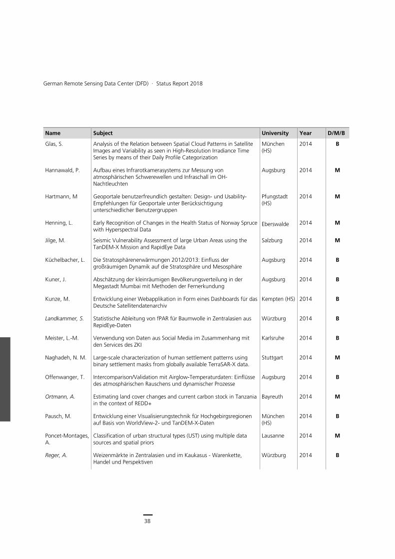
Glas, S. Analysis of the Relation between Spatial Cloud Patterns in Satellite Images and Variability as seen in High-Resolution Irradiance Time Series by means of their Daily Profile Categorization
München (HS)
2014 B
Hannawald, P. Aufbau eines Infrarotkamerasystems zur Messung von atmosphärischen Schwerewellen und Infraschall im OH-Nachtleuchten
Augsburg 2014 M
Hartmann, M Geoportale benutzerfreundlich gestalten: Design- und Usability- Empfehlungen für Geoportale unter Berücksichtigung unterschiedlicher Benutzergruppen
Pfungstadt (HS)
2014 M
Henning, L. Early Recognition of Changes in the Health Status of Norway Spruce with Hyperspectral Data
Eberswalde 2014 M
Jilge, M. Seismic Vulnerability Assessment of large Urban Areas using the TanDEM-X Mission and RapidEye Data
Salzburg 2014 M
Küchelbacher, L. Die Stratosphärenerwärmungen 2012/2013: Einfluss der großräumigen Dynamik auf die Stratosphäre und Mesosphäre
Augsburg 2014 B
Kuner, J. Abschätzung der kleinräumigen Bevölkerungsverteilung in der Megastadt Mumbai mit Methoden der Fernerkundung
Augsburg 2014 B
Kunze, M. Entwicklung einer Webapplikation in Form eines Dashboards für das Deutsche Satellitendatenarchiv
Kempten (HS) 2014 B
Landkammer, S. Statistische Ableitung von fPAR für Baumwolle in Zentralasien aus RepidEye-Daten
Würzburg 2014 B
Meister, L.-M. Verwendung von Daten aus Social Media im Zusammenhang mit den Services des ZKI
Karlsruhe 2014 B
Naghadeh, N. M. Large-scale characterization of human settlement patterns using binary settlement masks from globally available TerraSAR-X data.
Stuttgart 2014 M
Offenwanger, T. Intercomparison/Validation mit Airglow-Temperaturdaten: Einflüsse des atmosphärischen Rauschens und dynamischer Prozesse
Augsburg 2014 B
Ortmann, A. Estimating land cover changes and current carbon stock in Tanzania in the context of REDD+
Bayreuth 2014 M
Pausch, M. Entwicklung einer Visualisierungstechnik für Hochgebirgsregionen auf Basis von WorldView-2- und TanDEM-X-Daten
München (HS)
2014 B
Poncet-Montages, A.
Classification of urban structural types (UST) using multiple data sources and spatial priors
Lausanne 2014 M
Reger, A. Weizenmärkte in Zentralasien und im Kaukasus - Warenkette, Handel und Perspektiven
Würzburg 2014 B

39
Scientific Activities 2013-2018 (as of 19.03.2019) > Academic Degrees
Name Subject University Year D/M/B
Richter, D Raumzeitliche Erfassung des Siedlungswachstums mittels Auswertung von Zeitserien multispektraler Erdbeobachtungsdaten
München (HS)
2014 D
Rieke, Ch. Analyse und statistische Auswertung von multitemporalen Radardaten für die verbesserte Hochwasserdetektion
Jena 2014 B
Roch, M. Revealing forest cover loss in Paraguay´s Atlantic Forest region - A remote sensing and GIS based forest monitoring
Salzburg 2014 M
Rudloff, M. Siedlungsflächenentwicklung im ländlichen Raum Usbekistans am Beispiel Khorezm
Würzburg 2014 M
Rudolph, A. Modeling species distribution in Kenya influenced by environmental parameters using Random Forest algorithm
Würzburg 2014 B
Sander, D. Aufbau eines automatischen Messsystems zur Erfassung und Auswertung des Wolkenbedeckungsgrades in der Antarktis
München (TUM)
2014 B
Schleicher, R. Konzeption und Umsetzung einer Webmapping-Applikation zur Visulalisierung raum-zeitlicher Veränderungen ausgewählter Ballungsräume
München (HS)
2014 M
Serfas, K. Räumlicher Zusammenhang zwischen Schistosomiasisprävalenz und möglichen Krankheitsübertragungsstätten am Beispiel der Elfenbeinküste
Würzburg 2014 B
Sokol, V. Interaction between white stork migration patterns and urban environment in Germany
Bayreuth 2014 M
Starmanns, S. Spatial disaggregation of population data onto Urban Footprint data Innsbruck 2014 M
Stolle, A. Quantitativer Vergleich von Bildsegmentierungsverfahren als Grundlage für die semiautomatische Extrahierung von kleinräumigen Objekten im Kontext von Großveranstaltungen
Potsdam 2014 M
Tsyganskaya V Ableitung und Analyse von großflächigen Informationen zur urbanen Struktur mit Methoden der Fernerkundung
München (LMU)
2014 M
Voinov, S. Modeling population distribution based on EO-derived data on the built environment
Stuttgart (HfT)
2014 M
Weigand, M. Discrimination of formal and informal settlements based on multipolarized TSX imagery in the Megacity Mumbai, India
Würzburg 2014 B
Wildegger, M. Multi-Project Management in Research and Development of International Corporations
München (FOM)
2014 B
Ziewers, K. Declining migratory avian species in the UK: a consequence of habitat quality alteration in western Africa? A case study using remote sensing data
Bayreuth 2014 M
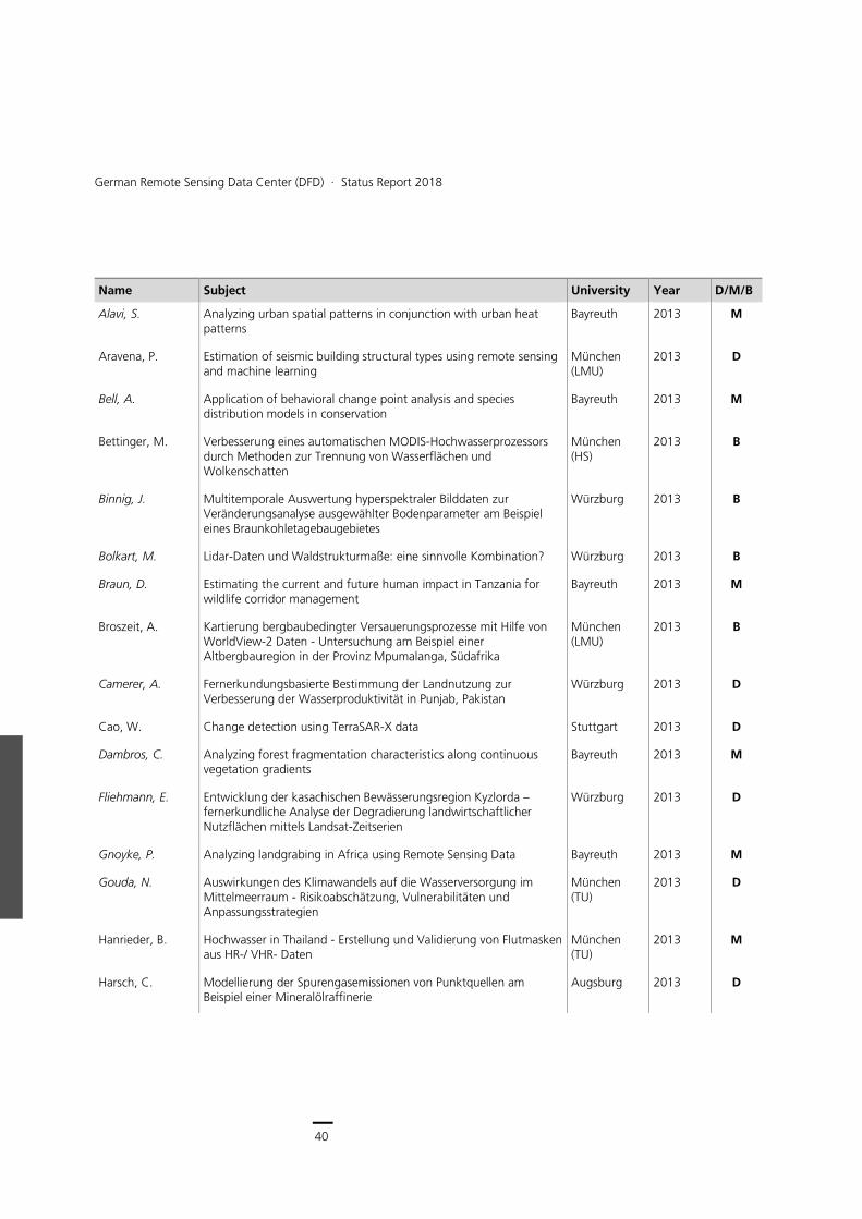
40
German Remote Sensing Data Center (DFD) ∙ Status Report 2018
Name Subject University Year D/M/B
Alavi, S. Analyzing urban spatial patterns in conjunction with urban heat patterns
Bayreuth 2013 M
Aravena, P. Estimation of seismic building structural types using remote sensing and machine learning
München (LMU)
2013 D
Bell, A. Application of behavioral change point analysis and species distribution models in conservation
Bayreuth 2013 M
Bettinger, M. Verbesserung eines automatischen MODIS-Hochwasserprozessors durch Methoden zur Trennung von Wasserflächen und Wolkenschatten
München (HS)
2013 B
Binnig, J. Multitemporale Auswertung hyperspektraler Bilddaten zur Veränderungsanalyse ausgewählter Bodenparameter am Beispiel eines Braunkohletagebaugebietes
Würzburg 2013 B
Bolkart, M. Lidar-Daten und Waldstrukturmaße: eine sinnvolle Kombination? Würzburg 2013 B
Braun, D. Estimating the current and future human impact in Tanzania for wildlife corridor management
Bayreuth 2013 M
Broszeit, A. Kartierung bergbaubedingter Versauerungsprozesse mit Hilfe von WorldView-2 Daten - Untersuchung am Beispiel einer Altbergbauregion in der Provinz Mpumalanga, Südafrika
München (LMU)
2013 B
Camerer, A. Fernerkundungsbasierte Bestimmung der Landnutzung zur Verbesserung der Wasserproduktivität in Punjab, Pakistan
Würzburg 2013 D
Cao, W. Change detection using TerraSAR-X data Stuttgart 2013 D
Dambros, C. Analyzing forest fragmentation characteristics along continuous vegetation gradients
Bayreuth 2013 M
Fliehmann, E. Entwicklung der kasachischen Bewässerungsregion Kyzlorda – fernerkundliche Analyse der Degradierung landwirtschaftlicher Nutzflächen mittels Landsat-Zeitserien
Würzburg 2013 D
Gnoyke, P. Analyzing landgrabing in Africa using Remote Sensing Data Bayreuth 2013 M
Gouda, N. Auswirkungen des Klimawandels auf die Wasserversorgung im Mittelmeerraum - Risikoabschätzung, Vulnerabilitäten und Anpassungsstrategien
München (TU)
2013 D
Hanrieder, B. Hochwasser in Thailand - Erstellung und Validierung von Flutmasken aus HR-/ VHR- Daten
München (TU)
2013 M
Harsch, C. Modellierung der Spurengasemissionen von Punktquellen am Beispiel einer Mineralölraffinerie
Augsburg 2013 D
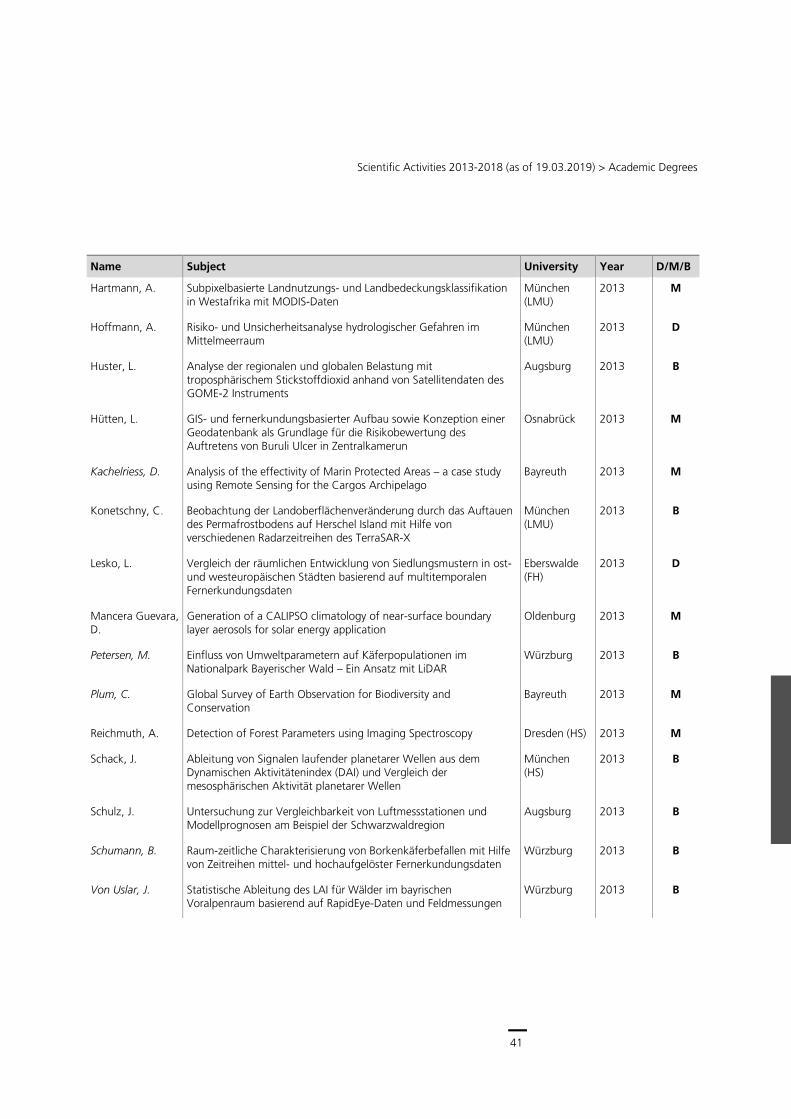
41
Scientific Activities 2013-2018 (as of 19.03.2019) > Academic Degrees
Name Subject University Year D/M/B
Hartmann, A. Subpixelbasierte Landnutzungs- und Landbedeckungsklassifikation in Westafrika mit MODIS-Daten
München (LMU)
2013 M
Hoffmann, A. Risiko- und Unsicherheitsanalyse hydrologischer Gefahren im Mittelmeerraum
München (LMU)
2013 D
Huster, L. Analyse der regionalen und globalen Belastung mit troposphärischem Stickstoffdioxid anhand von Satellitendaten des GOME-2 Instruments
Augsburg 2013 B
Hütten, L. GIS- und fernerkundungsbasierter Aufbau sowie Konzeption einer Geodatenbank als Grundlage für die Risikobewertung des Auftretens von Buruli Ulcer in Zentralkamerun
Osnabrück 2013 M
Kachelriess, D. Analysis of the effectivity of Marin Protected Areas – a case study using Remote Sensing for the Cargos Archipelago
Bayreuth 2013 M
Konetschny, C. Beobachtung der Landoberflächenveränderung durch das Auftauen des Permafrostbodens auf Herschel Island mit Hilfe von verschiedenen Radarzeitreihen des TerraSAR-X
München (LMU)
2013 B
Lesko, L. Vergleich der räumlichen Entwicklung von Siedlungsmustern in ost- und westeuropäischen Städten basierend auf multitemporalen Fernerkundungsdaten
Eberswalde (FH)
2013 D
Mancera Guevara, D.
Generation of a CALIPSO climatology of near-surface boundary layer aerosols for solar energy application
Oldenburg 2013 M
Petersen, M. Einfluss von Umweltparametern auf Käferpopulationen im Nationalpark Bayerischer Wald – Ein Ansatz mit LiDAR
Würzburg 2013 B
Plum, C. Global Survey of Earth Observation for Biodiversity and Conservation
Bayreuth 2013 M
Reichmuth, A. Detection of Forest Parameters using Imaging Spectroscopy Dresden (HS) 2013 M
Schack, J. Ableitung von Signalen laufender planetarer Wellen aus dem Dynamischen Aktivitätenindex (DAI) und Vergleich der mesosphärischen Aktivität planetarer Wellen
München (HS)
2013 B
Schulz, J. Untersuchung zur Vergleichbarkeit von Luftmessstationen und Modellprognosen am Beispiel der Schwarzwaldregion
Augsburg 2013 B
Schumann, B. Raum-zeitliche Charakterisierung von Borkenkäferbefallen mit Hilfe von Zeitreihen mittel- und hochaufgelöster Fernerkundungsdaten
Würzburg 2013 B
Von Uslar, J. Statistische Ableitung des LAI für Wälder im bayrischen Voralpenraum basierend auf RapidEye-Daten und Feldmessungen
Würzburg 2013 B
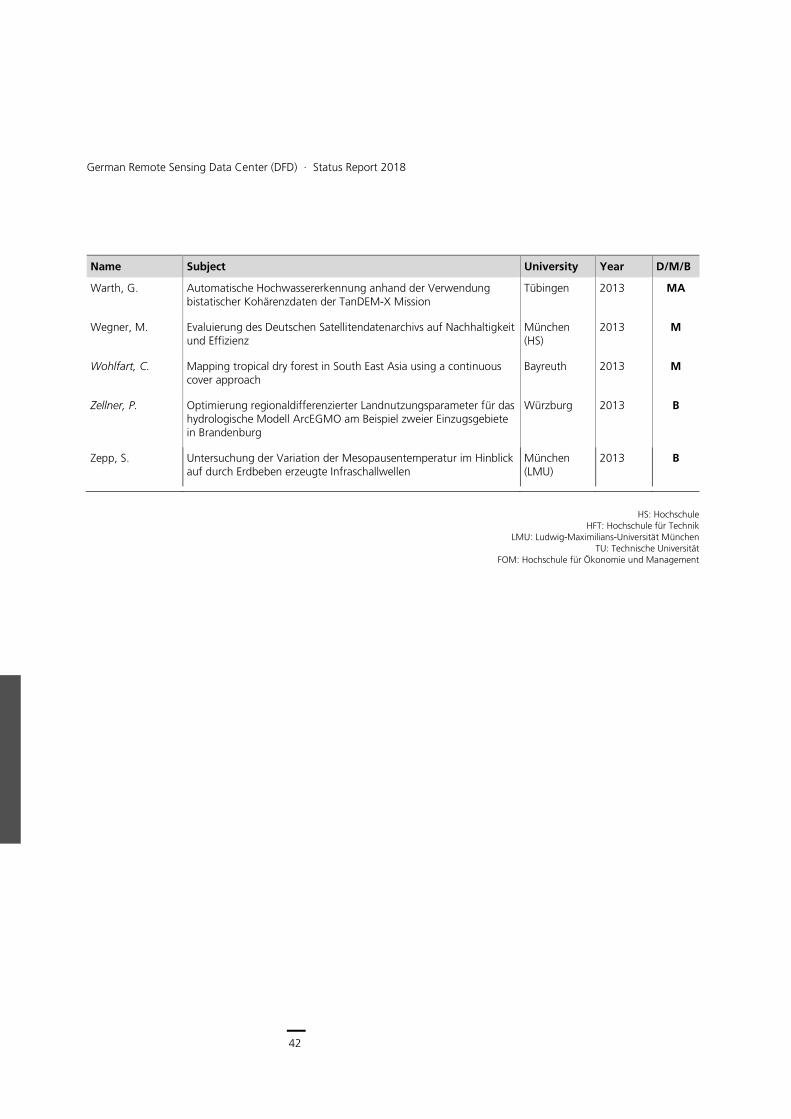
42
German Remote Sensing Data Center (DFD) ∙ Status Report 2018
Name Subject University Year D/M/B
Warth, G. Automatische Hochwassererkennung anhand der Verwendung bistatischer Kohärenzdaten der TanDEM-X Mission
Tübingen 2013 MA
Wegner, M. Evaluierung des Deutschen Satellitendatenarchivs auf Nachhaltigkeit und Effizienz
München (HS)
2013 M
Wohlfart, C. Mapping tropical dry forest in South East Asia using a continuous cover approach
Bayreuth 2013 M
Zellner, P. Optimierung regionaldifferenzierter Landnutzungsparameter für das hydrologische Modell ArcEGMO am Beispiel zweier Einzugsgebiete in Brandenburg
Würzburg 2013 B
Zepp, S. Untersuchung der Variation der Mesopausentemperatur im Hinblick auf durch Erdbeben erzeugte Infraschallwellen
München (LMU)
2013 B
HS: Hochschule
HFT: Hochschule für Technik LMU: Ludwig-Maximilians-Universität München
TU: Technische Universität FOM: Hochschule für Ökonomie und Management
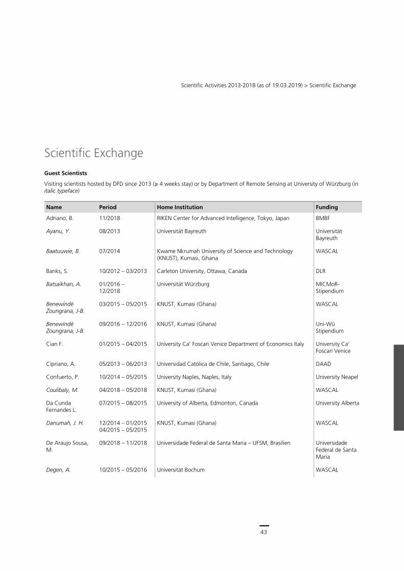
43
Scientific Activities 2013-2018 (as of 19.03.2019) > Scientific Exchange
Scientific Exchange
Guest Scientists
Visiting scientists hosted by DFD since 2013 (≥ 4 weeks stay) or by Department of Remote Sensing at University of Würzburg (in italic typeface)
Name Period Home Institution Funding
Adriano, B. 11/2018 RIKEN Center for Advanced Intelligence, Tokyo, Japan BMBF
Ayanu, Y. 08/2013 Universität Bayreuth Universität Bayreuth
Baatuuwie, B. 07/2014 Kwame Nkrumah University of Science and Technology (KNUST), Kumasi, Ghana
WASCAL
Banks, S. 10/2012 – 03/2013 Carleton University, Ottawa, Canada DLR
Batsaikhan, A. 01/2016 – 12/2018
Universität Würzburg MICMoR-Stipendium
Benewindé Zoungrana, J-B.
03/2015 – 05/2015 KNUST, Kumasi (Ghana) WASCAL
Benewindé Zoungrana, J-B.
09/2016 – 12/2016 KNUST, Kumasi (Ghana) Uni-Wü Stipendium
Cian F. 01/2015 – 04/2015 University Ca’ Foscari Venice Department of Economics Italy University Ca’ Foscari Venice
Cipriano, A. 05/2013 – 06/2013 Universidad Católica de Chile, Santiago, Chile DAAD
Confuerto, P. 10/2014 – 05/2015 University Naples, Naples, Italy University Neapel
Coulibaly, M. 04/2018 – 05/2018 KNUST, Kumasi (Ghana) WASCAL
Da Cunda Fernandes L.
07/2015 – 08/2015 University of Alberta, Edmonton, Canada University Alberta
Danumah, J. H. 12/2014 – 01/2015 04/2015 – 05/2015
KNUST, Kumasi (Ghana) WASCAL
De Araujo Sousa, M.
09/2018 – 11/2018 Universidade Federal de Santa Maria – UFSM, Brasilien Universidade Federal de Santa Maria
Degen, A. 10/2015 – 05/2016 Universität Bochum WASCAL
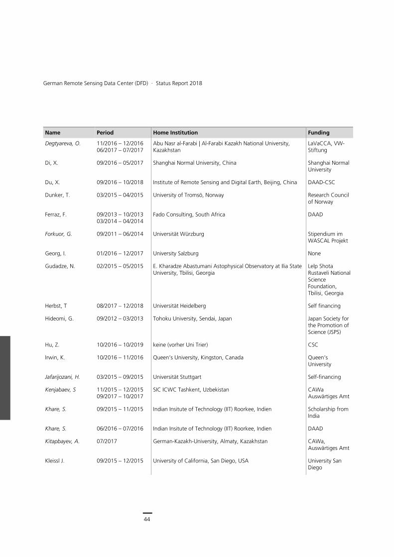
44
German Remote Sensing Data Center (DFD) ∙ Status Report 2018
Name Period Home Institution Funding
Degtyareva, O. 11/2016 – 12/2016 06/2017 – 07/2017
Abu Nasr al-Farabi | Al-Farabi Kazakh National University, Kazakhstan
LaVaCCA, VW-Stiftung
Di, X. 09/2016 – 05/2017 Shanghai Normal University, China Shanghai Normal University
Du, X. 09/2016 – 10/2018 Institute of Remote Sensing and Digital Earth, Beijing, China DAAD-CSC
Dunker, T. 03/2015 – 04/2015 University of Tromsö, Norway Research Council of Norway
Ferraz, F. 09/2013 – 10/2013 03/2014 – 04/2014
Fado Consulting, South Africa DAAD
Forkuor, G. 09/2011 – 06/2014 Universität Würzburg Stipendium im WASCAL Projekt
Georg, I. 01/2016 – 12/2017 University Salzburg None
Gudadze, N. 02/2015 – 05/2015 E. Kharadze Abastumani Astophysical Observatory at Ilia State University, Tbilisi, Georgia
Lelp Shota Rustaveli National Science Foundation, Tbilisi, Georgia
Herbst, T 08/2017 – 12/2018 Universität Heidelberg Self financing
Hideomi, G. 09/2012 – 03/2013 Tohoku University, Sendai, Japan Japan Society for the Promotion of Science (JSPS)
Hu, Z. 10/2016 – 10/2019 keine (vorher Uni Trier) CSC
Irwin, K. 10/2016 – 11/2016 Queen’s University, Kingston, Canada Queen’s University
Jafarijozani, H. 03/2015 – 09/2015 Universität Stuttgart Self-financing
Kenjabaev, S 11/2015 – 12/2015 09/2017 – 10/2017
SIC ICWC Tashkent, Uzbekistan CAWa Auswärtiges Amt
Khare, S. 09/2015 – 11/2015 Indian Insitute of Technology (IIT) Roorkee, Indien Scholarship from India
Khare, S. 06/2016 – 07/2016 Indian Insitute of Technology (IIT) Roorkee, Indien DAAD
Kitapbayev, A. 07/2017 German-Kazakh-University, Almaty, Kazakhstan CAWa, Auswärtiges Amt
Kleissl J. 09/2015 – 12/2015 University of California, San Diego, USA University San Diego
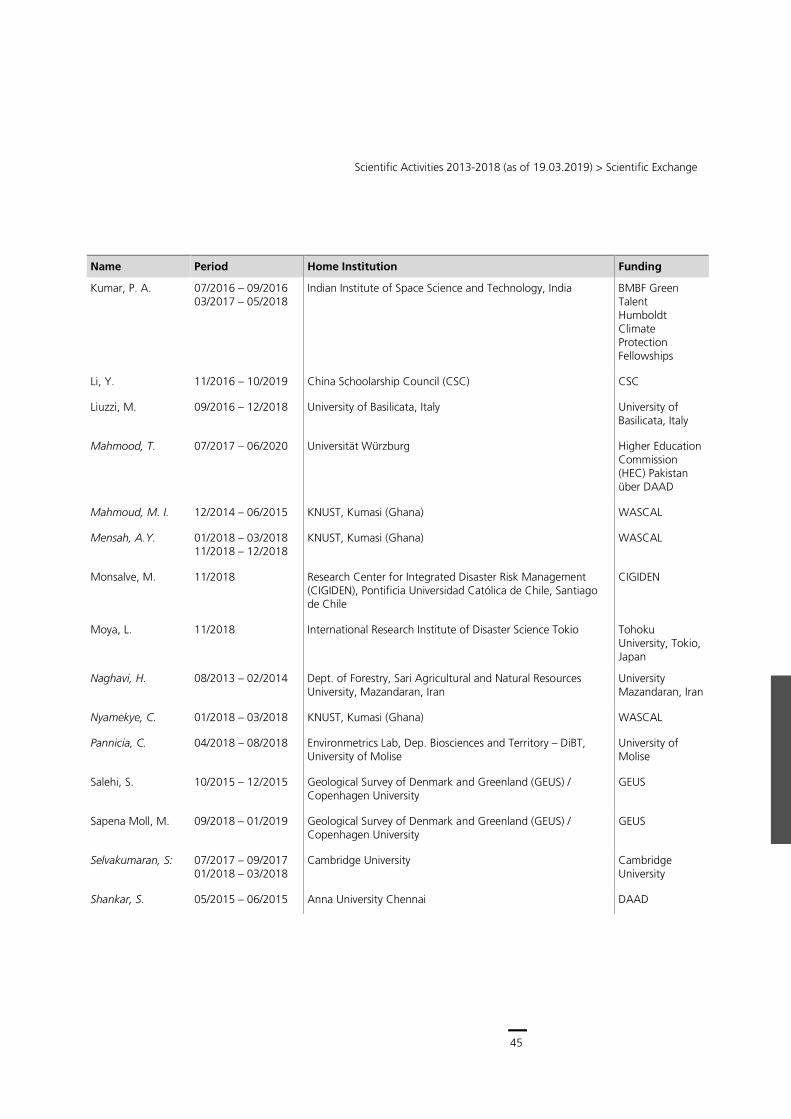
45
Scientific Activities 2013-2018 (as of 19.03.2019) > Scientific Exchange
Name Period Home Institution Funding
Kumar, P. A. 07/2016 – 09/2016 03/2017 – 05/2018
Indian Institute of Space Science and Technology, India BMBF Green Talent Humboldt Climate Protection Fellowships
Li, Y. 11/2016 – 10/2019 China Schoolarship Council (CSC) CSC
Liuzzi, M. 09/2016 – 12/2018 University of Basilicata, Italy University of Basilicata, Italy
Mahmood, T. 07/2017 – 06/2020 Universität Würzburg Higher Education Commission (HEC) Pakistan über DAAD
Mahmoud, M. I. 12/2014 – 06/2015 KNUST, Kumasi (Ghana) WASCAL
Mensah, A.Y. 01/2018 – 03/2018 11/2018 – 12/2018
KNUST, Kumasi (Ghana) WASCAL
Monsalve, M. 11/2018 Research Center for Integrated Disaster Risk Management (CIGIDEN), Pontificia Universidad Católica de Chile, Santiago de Chile
CIGIDEN
Moya, L. 11/2018 International Research Institute of Disaster Science Tokio Tohoku University, Tokio, Japan
Naghavi, H. 08/2013 – 02/2014 Dept. of Forestry, Sari Agricultural and Natural Resources University, Mazandaran, Iran
University Mazandaran, Iran
Nyamekye, C. 01/2018 – 03/2018 KNUST, Kumasi (Ghana) WASCAL
Pannicia, C. 04/2018 – 08/2018 Environmetrics Lab, Dep. Biosciences and Territory – DiBT, University of Molise
University of Molise
Salehi, S. 10/2015 – 12/2015 Geological Survey of Denmark and Greenland (GEUS) / Copenhagen University
GEUS
Sapena Moll, M. 09/2018 – 01/2019 Geological Survey of Denmark and Greenland (GEUS) / Copenhagen University
GEUS
Selvakumaran, S: 07/2017 – 09/2017 01/2018 – 03/2018
Cambridge University Cambridge University
Shankar, S. 05/2015 – 06/2015 Anna University Chennai DAAD
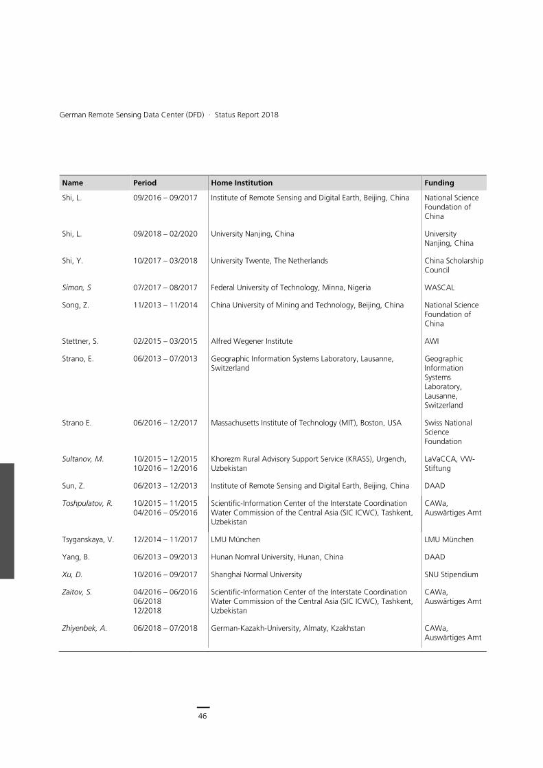
46
German Remote Sensing Data Center (DFD) ∙ Status Report 2018
Name Period Home Institution Funding
Shi, L. 09/2016 – 09/2017 Institute of Remote Sensing and Digital Earth, Beijing, China National Science Foundation of China
Shi, L. 09/2018 – 02/2020 University Nanjing, China University Nanjing, China
Shi, Y. 10/2017 – 03/2018 University Twente, The Netherlands China Scholarship Council
Simon, S 07/2017 – 08/2017 Federal University of Technology, Minna, Nigeria WASCAL
Song, Z. 11/2013 – 11/2014 China University of Mining and Technology, Beijing, China National Science Foundation of China
Stettner, S. 02/2015 – 03/2015 Alfred Wegener Institute AWI
Strano, E. 06/2013 – 07/2013 Geographic Information Systems Laboratory, Lausanne, Switzerland
Geographic Information Systems Laboratory, Lausanne, Switzerland
Strano E. 06/2016 – 12/2017 Massachusetts Institute of Technology (MIT), Boston, USA Swiss National Science Foundation
Sultanov, M. 10/2015 – 12/2015 10/2016 – 12/2016
Khorezm Rural Advisory Support Service (KRASS), Urgench, Uzbekistan
LaVaCCA, VW-Stiftung
Sun, Z. 06/2013 – 12/2013 Institute of Remote Sensing and Digital Earth, Beijing, China DAAD
Toshpulatov, R. 10/2015 – 11/2015 04/2016 – 05/2016
Scientific-Information Center of the Interstate Coordination Water Commission of the Central Asia (SIC ICWC), Tashkent, Uzbekistan
CAWa, Auswärtiges Amt
Tsyganskaya, V. 12/2014 – 11/2017 LMU München LMU München
Yang, B. 06/2013 – 09/2013 Hunan Nomral University, Hunan, China DAAD
Xu, D. 10/2016 – 09/2017 Shanghai Normal University SNU Stipendium
Zaitov, S. 04/2016 – 06/2016 06/2018 12/2018
Scientific-Information Center of the Interstate Coordination Water Commission of the Central Asia (SIC ICWC), Tashkent, Uzbekistan
CAWa, Auswärtiges Amt
Zhiyenbek, A. 06/2018 – 07/2018 German-Kazakh-University, Almaty, Kzakhstan CAWa, Auswärtiges Amt
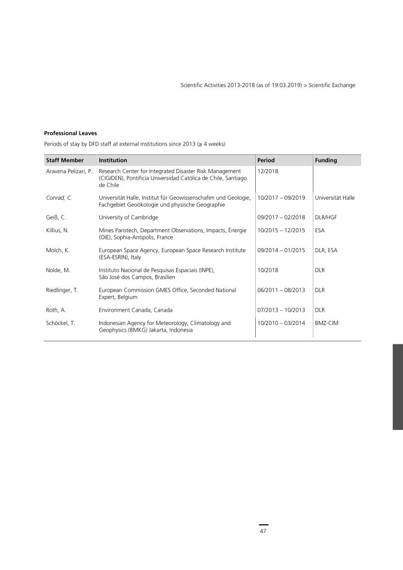
47
Scientific Activities 2013-2018 (as of 19.03.2019) > Scientific Exchange
Professional Leaves
Periods of stay by DFD staff at external institutions since 2013 (≥ 4 weeks)
Staff Member Institution Period Funding
Aravena Pelizari, P. Research Center for Integrated Disaster Risk Management (CIGIDEN), Pontificia Universidad Católica de Chile, Santiago de Chile
12/2018
Conrad, C. Universität Halle, Institut für Geowissenschafen und Geologie, Fachgebiet Geoökologie und physische Geographie
10/2017 – 09/2019 Universität Halle
Geiß, C. University of Cambridge 09/2017 – 02/2018 DLR/HGF
Killius, N. Mines Paristech, Department Observations, Impacts, Énergie (OIE), Sophia-Antipolis, France
10/2015 – 12/2015 ESA
Molch, K. European Space Agency, European Space Research Institute (ESA-ESRIN), Italy
09/2014 – 01/2015 DLR, ESA
Nolde, M. Instituto Nacional de Pesquisas Espaciais (INPE), São José dos Campos, Brasilien
10/2018 DLR
Riedlinger, T. European Commission GMES Office, Seconded National Expert, Belgium
06/2011 – 08/2013 DLR
Roth, A. Environment Canada, Canada 07/2013 – 10/2013 DLR
Schöckel, T. Indonesian Agency for Meteorology, Climatology and Geophysics (BMKG) Jakarta, Indonesia
10/2010 – 03/2014 BMZ-CIM
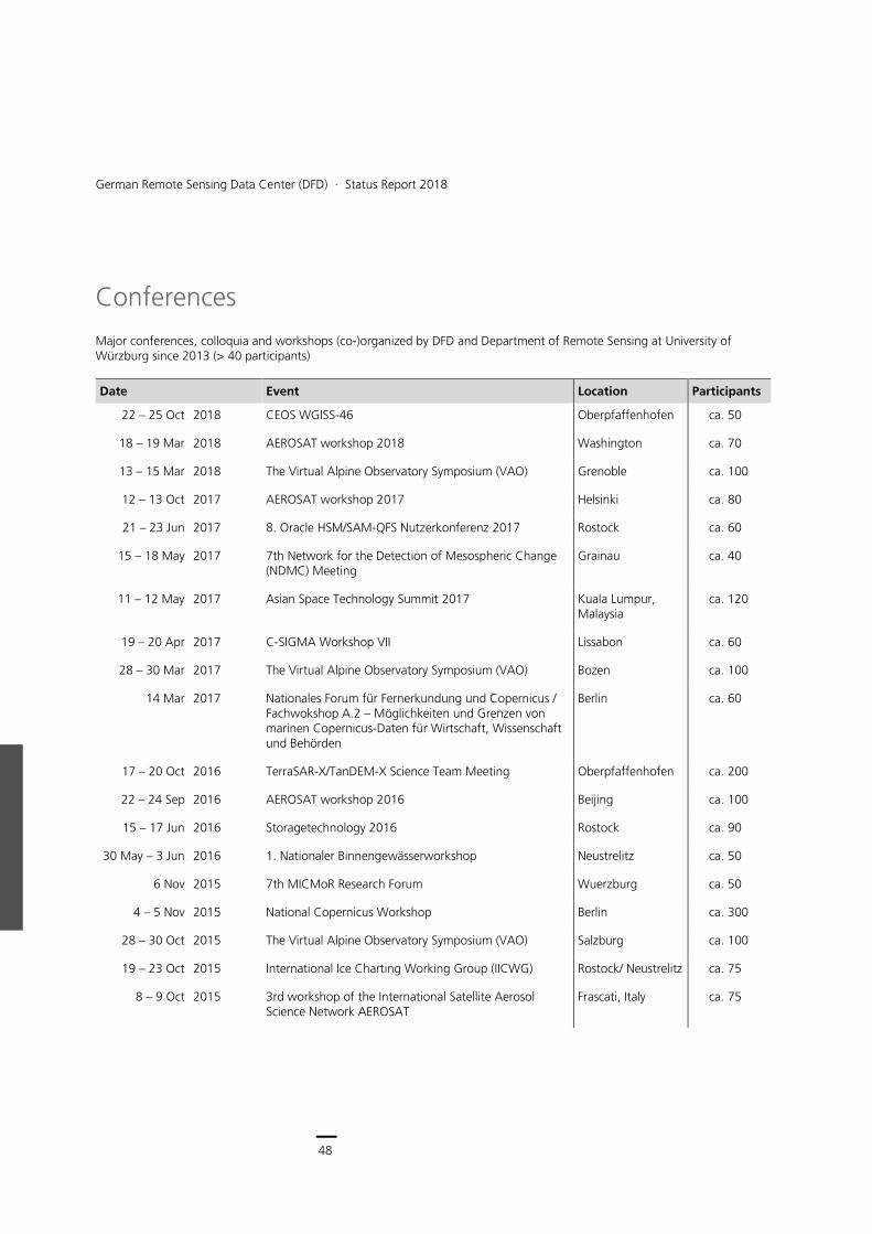
48
German Remote Sensing Data Center (DFD) ∙ Status Report 2018
Conferences
Major conferences, colloquia and workshops (co-)organized by DFD and Department of Remote Sensing at University of Würzburg since 2013 (> 40 participants)
Date Event Location Participants
22 – 25 Oct 2018 CEOS WGISS-46 Oberpfaffenhofen ca. 50
18 – 19 Mar 2018 AEROSAT workshop 2018 Washington ca. 70
13 – 15 Mar 2018 The Virtual Alpine Observatory Symposium (VAO) Grenoble ca. 100
12 – 13 Oct 2017 AEROSAT workshop 2017 Helsinki ca. 80
21 – 23 Jun 2017 8. Oracle HSM/SAM-QFS Nutzerkonferenz 2017 Rostock ca. 60
15 – 18 May 2017 7th Network for the Detection of Mesospheric Change (NDMC) Meeting
Grainau ca. 40
11 – 12 May 2017 Asian Space Technology Summit 2017 Kuala Lumpur, Malaysia
ca. 120
19 – 20 Apr 2017 C-SIGMA Workshop VII Lissabon ca. 60
28 – 30 Mar 2017 The Virtual Alpine Observatory Symposium (VAO) Bozen ca. 100
14 Mar 2017 Nationales Forum für Fernerkundung und Copernicus / Fachwokshop A.2 – Möglichkeiten und Grenzen von marinen Copernicus-Daten für Wirtschaft, Wissenschaft und Behörden
Berlin ca. 60
17 – 20 Oct 2016 TerraSAR-X/TanDEM-X Science Team Meeting Oberpfaffenhofen ca. 200
22 – 24 Sep 2016 AEROSAT workshop 2016 Beijing ca. 100
15 – 17 Jun 2016 Storagetechnology 2016 Rostock ca. 90
30 May – 3 Jun 2016 1. Nationaler Binnengewässerworkshop Neustrelitz ca. 50
6 Nov 2015 7th MICMoR Research Forum Wuerzburg ca. 50
4 – 5 Nov 2015 National Copernicus Workshop Berlin ca. 300
28 – 30 Oct 2015 The Virtual Alpine Observatory Symposium (VAO) Salzburg ca. 100
19 – 23 Oct 2015 International Ice Charting Working Group (IICWG) Rostock/ Neustrelitz ca. 75
8 – 9 Oct 2015 3rd workshop of the International Satellite Aerosol Science Network AEROSAT
Frascati, Italy ca. 75
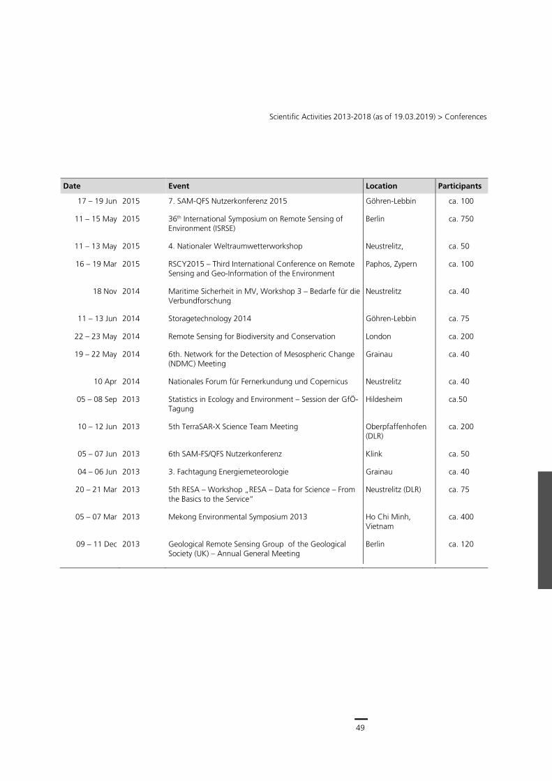
49
Scientific Activities 2013-2018 (as of 19.03.2019) > Conferences
Date Event Location Participants
17 – 19 Jun 2015 7. SAM-QFS Nutzerkonferenz 2015 Göhren-Lebbin ca. 100
11 – 15 May 2015 36th International Symposium on Remote Sensing of Environment (ISRSE)
Berlin ca. 750
11 – 13 May 2015 4. Nationaler Weltraumwetterworkshop Neustrelitz, ca. 50
16 – 19 Mar 2015 RSCY2015 – Third International Conference on Remote Sensing and Geo-Information of the Environment
Paphos, Zypern ca. 100
18 Nov 2014 Maritime Sicherheit in MV, Workshop 3 – Bedarfe für die Verbundforschung
Neustrelitz ca. 40
11 – 13 Jun 2014 Storagetechnology 2014 Göhren-Lebbin ca. 75
22 – 23 May 2014 Remote Sensing for Biodiversity and Conservation London ca. 200
19 – 22 May 2014 6th. Network for the Detection of Mesospheric Change (NDMC) Meeting
Grainau ca. 40
10 Apr 2014 Nationales Forum für Fernerkundung und Copernicus Neustrelitz ca. 40
05 – 08 Sep 2013 Statistics in Ecology and Environment – Session der GfÖ-Tagung
Hildesheim ca.50
10 – 12 Jun 2013 5th TerraSAR-X Science Team Meeting Oberpfaffenhofen (DLR)
ca. 200
05 – 07 Jun 2013 6th SAM-FS/QFS Nutzerkonferenz Klink ca. 50
04 – 06 Jun 2013 3. Fachtagung Energiemeteorologie Grainau ca. 40
20 – 21 Mar 2013 5th RESA – Workshop „RESA – Data for Science – From the Basics to the Service“
Neustrelitz (DLR) ca. 75
05 – 07 Mar 2013 Mekong Environmental Symposium 2013 Ho Chi Minh, Vietnam
ca. 400
09 – 11 Dec 2013 Geological Remote Sensing Group of the Geological Society (UK) – Annual General Meeting
Berlin ca. 120
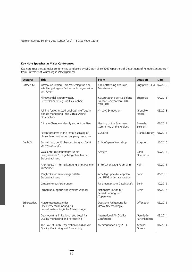
50
German Remote Sensing Data Center (DFD) ∙ Status Report 2018
Key Note Speeches at Major Conferences
Key note speeches at major conferences conducted by DFD staff since 2013 (speeches of Department of Remote Sensing staff from University of Würzburg in italic typeface)
Lecturer Title Event Location Date
Bittner, M. Infrasound Explorer: ein Vorschlag für eine satellitengetragene Erdbeobachtungsmission aus Bayern
Kabinettsitzung des Bayr. Ministerrats
Zugspitze (UFS) 07/2018
Klimawandel: Extremwetter, Luftverschmutzung und Gesundheit
Klausurtagung der Koalitions-Fraktionsspitzen von CDU, CSU, SPD
Zugspitze 04/2018
Joining forces instead duplicating efforts in climate monitoring - the Virtual Alpine Observatory
4th VAO Symposium Grenoble, France
03/2018
Climate Change – Identify and Act on Risks Hearing of the European Committee of the Regions
Brussels, Belgium
06/2017
Recent progress in the remote sensing of atmospheric waves and coupling processes
COSPAR Istanbul,Turkey 08/2016
Dech, S. Entwicklung der Erdbeobachtung aus Sicht der Wissenschaft
5. INNOspace Workshop Augsburg 10/2016
Was leistet die Raumfahrt für die Energiewende? Einige Möglichkeiten der Erdbeobachtung
Acatech Bonn-Oberkassel
02/2015
Anthropozän – Fernerkundung eines Planeten im Wandel
8. Forschungstag Raumfahrt Köln 03/2015
Möglichkeiten satellitengestützter Erdbeobachtung
Arbeitsgruppe Außenpolitik der SPD-Bundestagsfraktion
Berlin 05/2015
Globale Herausforderungen Parlamentarische Gesellschaft Berlin 12/2015
Fernerkundung für eine Welt im Wandel Nationales Forum für Fernerkundung und Copernicus
Berlin 04/2014
Erbertseder, T.
Nutzungspotentiale der Satellitenfernerkundung für umweltmeteorologische Anwendungen
Deutsche Fachtagung für Umweltmeteorologie
Offenbach 03/2015
Developments in Regional and Local Air Quality Monitoring and Forecasting
International Air Quality Conference
Garmisch-Partenkirchen
03/2014
The Role of Earth Observation in Urban Air Quality Monitoring and Forecasting
Mediterranean City 2014 Athens, Greece
06/2014
51
Scientific Activities 2013-2018 (as of 19.03.2019) > Conferences
Lecturer Title Event Location Date
Esch, T. A New Platform for Global Urban Monitoring and Analysis - The Urban TEP
ESA EO Open Science Conference
Frascati, Italy 09/2017
Observing the Built Environment from Space - Global Monitoring of Human Settlement Patterns and Characteristics
The Mediterranean City Conference
Athens, Greece
06/2014
Geiß, C. Naturgefahrenrisiko im Zeitalter globaler Urbanisierung
Symposium „Trends und Herausforderungen satellitengestützter Erdbeobachtung für Wirtschaft und Gesellschaft
Graz, Austria 05/2017
Gessner, U. Fernerkundung für Landwirtschaft und Ernährungssicherheit
AK Fernerkundung, AK Auswertung von Fernerkundungsdaten, Methoden und Anwendungen der Fernerkundung als Beiträge zur nachhaltigen Entwicklung
Heidelberg 10/2018
Potential and Challenges of Earth Observation Time Series for the Analysis of Global Change
38th Annual EARSeL Symposium
Chania, Griechenland
07/2018
Heiden, U. Using spectral libraries for imaging spectroscopy analyses – the urban example
ISSI WORKSHOP Bern, Switzerland
11/2016
Klein, D. Challenges of Earth Observation for Global Change Monitoring
EARSEL Symposium Bonn 06/2016
Klein, I. The Potential of Earth Observation for the Analysis of River Deltas and the Coastal Zone
ASLO 2018 - Water connects Victoria, Canada
06/2018
Kuenzer, C. The Potential of Time Series Based Earth Observation for the Monitoring of Large River Deltas
American Geophysical Union, AGU Fall Meeting
San Francisco, USA
12/2015
Latifi, H. Remote sensing - assisted mapping of bark beetle-induced tree mortality
ForBioSens 2016 Bialowieza, Poland
11/2016
Popp, T. ESA’s Aerosol_cci project AEROCOM annual assembly Frascati, Italy 10/2015
Rogge, D. From proximal to satellite geological spectral sensing, a perspective for resource exploration
ISSI WORKSHOP Bern, Switzerland
11/2016
Schreier, G. International Cooperation in Earth Observation
ISPRS TC V Mid Term Symposium
Dehradun, India
11/2018
52
German Remote Sensing Data Center (DFD) ∙ Status Report 2018
Lecturer Title Event Location Date
Programme und Daten in der Erdbeobachtung - Möglichkeiten für die Archäologie und den Schutz des Weltkulturerbes
Fernerkundungsdaten und ihre Auswertungsmöglichkeiten in der Landschaftsarchäologie
Berlin 11/2018
Earth Observation and the Copernicus Programme in support to Archaeology and World Heritage Preservation
International Symposium on the use of Space Technologies for Natural and Cultural sites
Campeche, Mexico
09/2018
50 years of Earth observation – What’s next?; ISPRS 2018 Wien 06/2018
Chancen und Herausforderungen für die Erdbeobachtung durch die neue Informations-Technologien
TAMA eCognition Anwenderkonferenz
München 06/2018
The Preservation of Natural Resources through Space
GLAC2018 Montevideo, Uruguay
05/2018
Earth Observation and the Copernicus Programme in support to Archaeology and World Heritage Preservation
CAA Tübingen 03/2018
Global Trends changing Earth Observation World View Global Alliance User Conference
München 10/2017
Copernicus – The European Earth Observation System
3rd International Conference on Remote Sensing and Geoinformation of Environment (RSCy2015)
Paphos, Cyprus
03/2015
Europäisches Umweltbeobachtungsprogramm "Copernicus"
15 Raumfahrttage der Deutschen Raumfahrtausstellung
Morgenröthe Rautenkranz
06/2015
Das Copernicus-Programm, politische Hintergründe, vorgesehene Dienste
Jahrestagung der Deutschen Geodätischen Kommission (DGK)
München 11/2015
Schwarz, E. Near Real Time Applications for Maritime Situational Awareness
Workshop on Solutions for Maritime Situational Awareness
Helsinki, Finland
02/2016
Spengler, D. Durable Environmental Multidisciplinary Monitoring Information Network DEMMIN - Agricultural Research at the TERENO German Northeastern Lowlands Observatory.
BELAIR Workshop 2016 Bruges, Belgium
11/2016
Strunz, G. The Sendai Framework for Disaster Risk Reduction – Opportunities for Earth Observation
United Nations / Germany International Conference on Earth Observation
Bonn 05/2015
53
Scientific Activities 2013-2018 (as of 19.03.2019) > Conferences
Lecturer Title Event Location Date
Fernerkundung für das Krisenmanagement und die zivile Sicherheit – Aktuelle Forschungs- und Entwicklungsarbeiten
Nationales Forum für Fernerkundung und Copernicus 2015
Berlin 11/ 2015
Beiträge der Erdbeobachtung zum internationalen Katastrophenmanagement
Deutsche Gesellschaft für Auswärtige Politik
Berlin 01/2014
Taubenböck, H.
The future will be urban – A responsibility for urban remote sensing
EARSeL Urban Remote Sensing Special Interest Group
Bochum 09/2018
Approaching poverty from outer space. Capabilities, ideas and challenges
Workshop “Examing Dynamics of Deprived Settlements in Different Geographic Contexts, Standards and Transferability
Amsterdam, The Netherlands
07/2018
Fernerkundliche Nachweise der globalen Urbanisierung
IÖR Jahrestagung Dresden 06/2018
Expanding cities – diminishing space – A perspective from outer space
Real CORP Vienna, Austria 04/2018
Die globale Transformation der Städte – Was erwartet uns?
Verband Beratender Ingenieure, VBI Landesverband Saarland. Vortrag und Podiumsdiskussion mit Umweltminister und Leiter der Obersten Landesbaubehörde
11/2017
Urbanization – A global change issue Kick-off So2Sat project Oberpfaffenhofen
09/2017
Die globale Transformation der Städte – Was erwartet uns?
Arbeitstagung der Prüfingenieure
Baden-Baden 06/2017
Big Data – Key for future Geoinformation services
2nd GeoInformation Symposium
Berlin 06/2017
Urbane Armut – Globale Wissenslücken durch Big Earth Data schließen
DLR Forschungstag Köln 04/2017
Die globale Transformation der Städte – Monitoring mit Methoden der Fernerkundung
Bundeskongress des Verbands beratender Ingenieure
Leipzig 11/2016
Cities from Space: Monitoring the Global Proces of Urbanization
SPADE conference Berlin 04/2016
‘Quo Vadis’ urban remote sensing? Joint Urban Remote Sensing Conference
Sao Paulo, Brazil
04/2013
54
German Remote Sensing Data Center (DFD) ∙ Status Report 2018
Lecturer Title Event Location Date
Wurm, M. New possibilities of sensed data in urban areas ITC Twente Enschede, The Netherlands
06/2018
Cities from Space – Analysis and monitoring of physical urbanization processes
Symposium on Peaceful Use of Space Technologies
Muskat, Oman 10/2016
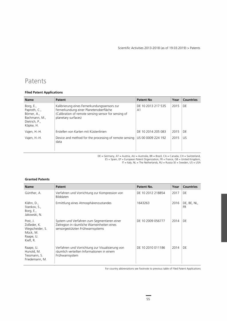
55
Scientific Activities 2013-2018 (as of 19.03.2019) > Patents
Patents
Filed Patent Applications
Name Patent Patent No Year Countries
Borg, E., Paproth, C., Börner, A., Bachmann, M., Dietrich, P., Köpke, H.
Kalibrierung eines Fernerkundungssensors zur Fernerkundung einer Planetenoberfläche (Calibration of remote sensing sensor for sensing of planetary surfaces)
DE 10 2013 217 535 A1
2015 DE
Vajen, H.-H. Erstellen von Karten mit Küstenlinien DE 10 2014 205 083 2015 DE
Vajen, H.-H. Device and method for the processing of remote sensing data
US 00 0009 224 192 2015 US
DE = Germany, AT = Austria, AU = Australia, BR = Brazil, CA = Canada, CH = Switzerland,
ES = Spain, EP = European Patent Organization, FR = France, GB = United Kingdom, IT = Italy, NL = The Netherlands, RU = Russia SE = Sweden, US = USA
Granted Patents
Name Patent Patent No. Year Countries
Günther, A. Verfahren und Vorrichtung zur Kompression von Bilddaten
DE 10 2012 218854 2017 DE
Klähn, D., Stankov, S., Borg, E., Jakowski, N.
Ermittlung eines Atmosphärenzustandes 1643263 2016 DE, BE, NL, FR
Post, J. Zoßeder, K. Wegscheider, S. Mück, M. Raape, U. Kiefl, R.
System und Verfahren zum Segmentieren einer Zielregion in räumliche Warneinheiten eines sensorgestützten Frühwarnsystems
DE 10 2009 056777 2014 DE
Raape, U. Hunold, M. Tessmann, S. Friedemann, M.
Verfahren und Vorrichtung zur Visualisierung von räumlich verteilten Informationen in einem Frühwarnsystem
DE 10 2010 011186 2014 DE
For country abbreviations see footnote to previous table of Filed Patent Applications
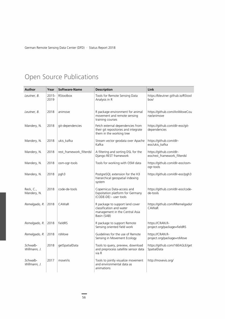
56
German Remote Sensing Data Center (DFD) ∙ Status Report 2018
Open Source Publications
Author Year Software-Name Description Link
Leutner, B. 2015- 2019
RStoolbox Tools for Remote Sensing Data Analysis in R
https://bleutner.github.io/RStoolbox/
Leutner, B. 2018 animove R package environment for animal movement and remote sensing training courses
https://github.com/AniMoveCourse/animove
Mandery, N. 2018 git-dependencies Fetch external dependencies from their git repositories and integrate them in the working tree
https://github.com/dlr-eoc/git-dependencies
Mandery, N. 2018 ukis_kafka Stream vector geodata over Apache Kafka
https://github.com/dlr-eoc/ukis_kafka
Mandery, N. 2018 rest_framework_filterdsl A filtering and sorting DSL for the Django REST framework
https://github.com/dlr-eoc/rest_framework_filterdsl
Mandery, N. 2018 osm-ogr-tools Tools for working with OSM data https://github.com/dlr-eoc/osm-ogr-tools
Mandery, N. 2018 pgh3 PostgreSQL extension for the H3 hierarchical geospatial indexing system
https://github.com/dlr-eoc/pgh3
Reck, C., Mandery, N.
2018 code-de-tools Copernicus Data-access and Expoitation platform for Germany (CODE-DE) - user tools
https://github.com/dlr-eoc/code-de-tools
Remelgado, R. 2018 CAWaR R package to support land cover classification and water management in the Central Asia Basin (SAB)
https://github.com/RRemelgado/CAWaR
Remelgado, R. 2018 fieldRS R package to support Remote Sensing oriented field work
https://CRAN.R-project.org/package=fieldRS
Remelgado, R. 2018 rsMove Guidelines for the use of Remote Sensing in Movement Ecology
https://CRAN.R-project.org/package=rsMove
Schwalb-Willmann, J.
2018 getSpatialData Tools to query, preview, download and preprocess satellite sensor data via R
https://github.com/16EAGLE/getSpatialData
Schwalb-Willmann, J.
2017 moveVis Tools to jointly visualize movement and environmental data as animations
http://movevis.org/

57
Scientific Activities 2013-2018 (as of 19.03.2019) > Open Source Publications
Mandery, N. 2016 git-changelog Generate changelogs from git tags https://github.com/dlr-eoc/git-changelog
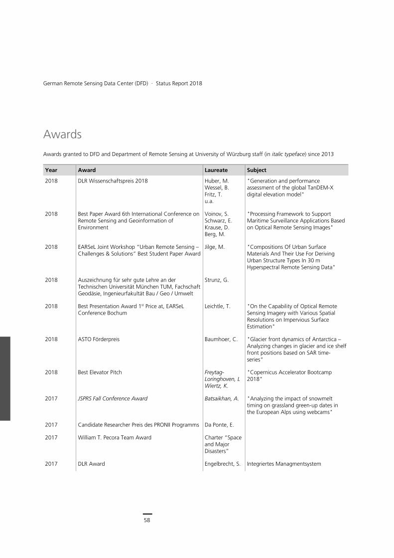
58
German Remote Sensing Data Center (DFD) ∙ Status Report 2018
Awards
Awards granted to DFD and Department of Remote Sensing at University of Würzburg staff (in italic typeface) since 2013
Year Award Laureate Subject
2018 DLR Wissenschaftspreis 2018 Huber, M. Wessel, B. Fritz, T. u.a.
"Generation and performance assessment of the global TanDEM-X digital elevation model"
2018 Best Paper Award 6th International Conference on Remote Sensing and Geoinformation of Environment
Voinov, S. Schwarz, E. Krause, D. Berg, M.
"Processing Framework to Support Maritime Surveillance Applications Based on Optical Remote Sensing Images"
2018 EARSeL Joint Workshop “Urban Remote Sensing – Challenges & Solutions” Best Student Paper Award
Jilge, M.
"Compositions Of Urban Surface Materials And Their Use For Deriving Urban Structure Types In 30 m Hyperspectral Remote Sensing Data"
2018 Auszeichnung für sehr gute Lehre an der Technischen Universität München TUM, Fachschaft Geodäsie, Ingenieurfakultät Bau / Geo / Umwelt
Strunz, G.
2018 Best Presentation Award 1st Price at, EARSeL Conference Bochum
Leichtle, T. "On the Capability of Optical Remote Sensing Imagery with Various Spatial Resolutions on Impervious Surface Estimation"
2018 ASTO Förderpreis Baumhoer, C. "Glacier front dynamics of Antarctica – Analyzing changes in glacier and ice shelf front positions based on SAR time-series"
2018 Best Elevator Pitch Freytag-Loringhoven, L Wiertz, K.
"Copernicus Accelerator Bootcamp 2018"
2017 JSPRS Fall Conference Award Batsaikhan, A. "Analyzing the impact of snowmelt timing on grassland green-up dates in the European Alps using webcams"
2017 Candidate Researcher Preis des PRONII Programms Da Ponte, E.
2017 William T. Pecora Team Award Charter “Space and Major Disasters”
2017 DLR Award Engelbrecht, S. Integriertes Managmentsystem
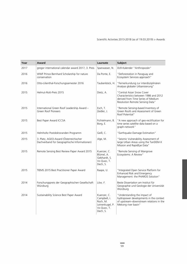
59
Scientific Activities 2013-2018 (as of 19.03.2019) > Awards
Year Award Laureate Subject
2017 gregor international calendar award 2017, 3. Preis Sparwasser, N. DLR-Kalender "Anthropozän"
2016 WWF Prince Bernhard Scholarship for nature conservation
Da Ponte, E. "Deforestation in Paraguay and Ecosystem Services approach"
2016 Otto-Lilienthal-Forschungssemester 2016 Taubenböck, H. "Fernerkundung zur interdisziplinären Analyse globaler Urbanisierung"
2015 Helmut-Rott-Preis 2015 Dietz, A. "Central Asian Snow Cover Characteristics between 1986 and 2012 derived from Time Series of Medium Resolution Remote Sensing Data"
2015 International Green Roof Leadership Award – Green Roof Pioneers
Esch, T. Zeidler, J.
"Remote Sensing-based Inventory of Green Roofs and Assessment of Green Roof Potential"
2015 Best Paper Award ICCSA Fichtelmann, B. Borg, E.
"A new approach of geo-rectification for time series satellite data based on a graph-network"
2015 Helmholtz Postdoktoranden Programm Geiß, C. "Earthquake Damage Estimation"
2015 3. Platz, AGEO-Award (Österreichischer Dachverband für Geographische Informationen)
Jilge, M. "Seismic Vulnerability Assessment of large Urban Areas using the TanDEM-X Mission and RapidEye Data"
2015 Remote Sensing Best Review Paper Award 2015 Kuenzer, C. Blümel, A. Gebhardt, S. Vo Quoc, T. Dech, S.
"Remote Sensing of Mangrove Ecosystems: A Review"
2015 TIEMS 2015 Best Practitioner Paper Award Raape, U. "Integrated Open Service Platform for Enhanced Risk and Emergency Management: the PHAROS Solution"
2014 Forschungspreis der Geographischen Gesellschaft Würzburg
Löw, F. Beste Dissertation am Institut für Geographie und Geologie der Universität Würzburg
2014 Sustainability Science Best Paper Award Kuenzer, C. Campbell, I. Roch, M. Leinenkugel, P. Vo Quoc, T. Dech, S.
"Understanding the impact of hydropower developments in the context of upstream–downstream relations in the Mekong river basin"
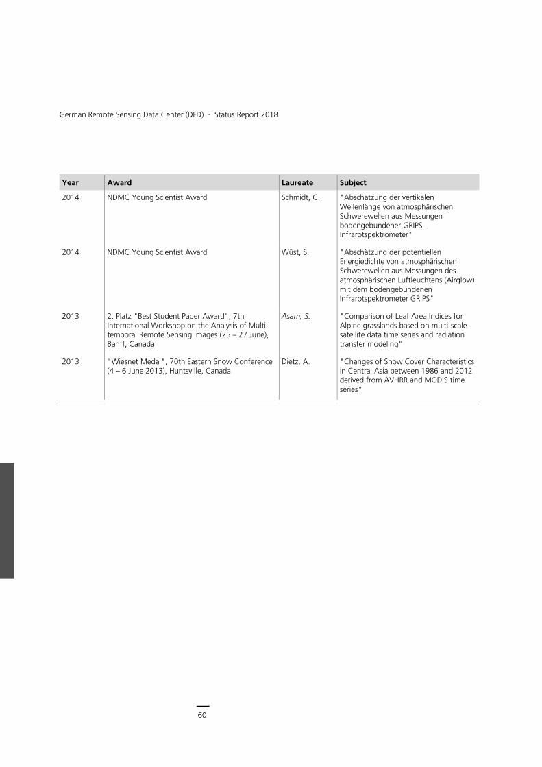
60
German Remote Sensing Data Center (DFD) ∙ Status Report 2018
Year Award Laureate Subject
2014 NDMC Young Scientist Award Schmidt, C. "Abschätzung der vertikalen Wellenlänge von atmosphärischen Schwerewellen aus Messungen bodengebundener GRIPS-Infrarotspektrometer"
2014 NDMC Young Scientist Award Wüst, S. "Abschätzung der potentiellen Energiedichte von atmosphärischen Schwerewellen aus Messungen des atmosphärischen Luftleuchtens (Airglow) mit dem bodengebundenen Infrarotspektrometer GRIPS"
2013 2. Platz "Best Student Paper Award", 7th International Workshop on the Analysis of Multi-temporal Remote Sensing Images (25 – 27 June), Banff, Canada
Asam, S. "Comparison of Leaf Area Indices for Alpine grasslands based on multi-scale satellite data time series and radiation transfer modeling"
2013 "Wiesnet Medal", 70th Eastern Snow Conference (4 – 6 June 2013), Huntsville, Canada
Dietz, A. "Changes of Snow Cover Characteristics in Central Asia between 1986 and 2012 derived from AVHRR and MODIS time series"
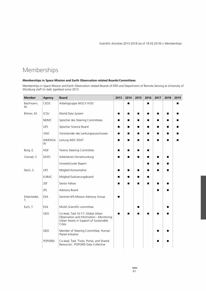
61
Scientific Activities 2013-2018 (as of 19.03.2019) > Memberships
Memberships
Memberships in Space Mission and Earth Observation related Boards/Committees
Memberships in Space Mission and Earth Observation related Boards of DFD and Department of Remote Sensing at University of Würzburg staff (in italic typeface) since 2013
Member Agency Board 2013 2014 2015 2016 2017 2018 2019
Bachmann, M.
CEOS Arbeitsgruppe WGCV IVOS
Bittner, M. ICSU World Data System
NDMC Sprecher des Steering Committees
UFS Sprecher Science Board
VAO Vorsitzender des Lenkungsausschusses
WMO/GAW
Leitung WDC-RSAT
Borg, E. HGF Tereno Steering Committee
Conrad, C. DGfG Arbeitskreis Fernerkundung
Umweltcluster Bayern
Dech, S. UFS Mitglied Konsortialrat
EURAC Mitglied Evaluierungsboard
ZEF Senior Fellow
ZFL Advisory Board
Erbertseder, T.
ESA Sentinel-4/5-Mission Advisory Group
Esch, T. ESA MUAS Scientific committee
GEO Co-lead, Task GI-17: Global Urban Observation and Information - Monitoring Urban Assets in Support of Sustainable Cities
GEO Member of Steering Committee, Human Planet Initiative
POPGRID Co-lead, Task ‘Tools, Portal, and Shared Resources’, POPGRID Data Collective
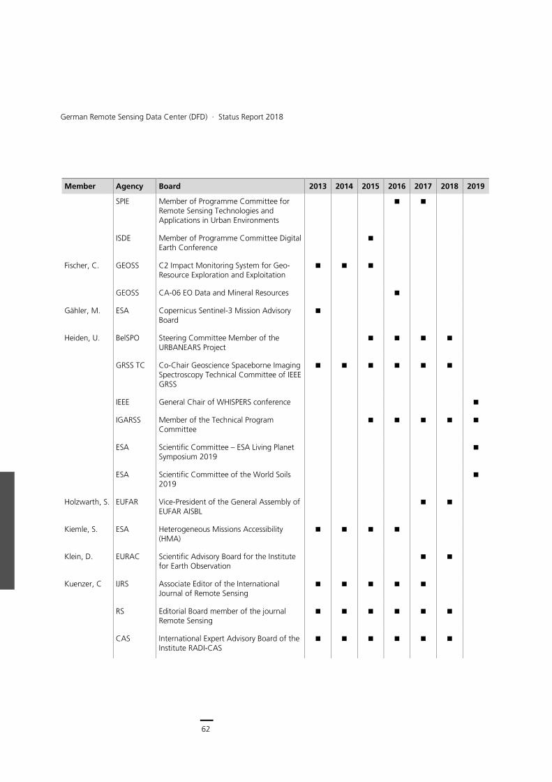
62
German Remote Sensing Data Center (DFD) ∙ Status Report 2018
Member Agency Board 2013 2014 2015 2016 2017 2018 2019
SPIE Member of Programme Committee for Remote Sensing Technologies and Applications in Urban Environments
ISDE Member of Programme Committee Digital Earth Conference
Fischer, C. GEOSS C2 Impact Monitoring System for Geo-Resource Exploration and Exploitation
GEOSS CA-06 EO Data and Mineral Resources
Gähler, M. ESA Copernicus Sentinel-3 Mission Advisory Board
Heiden, U. BelSPO Steering Committee Member of the URBANEARS Project
GRSS TC Co-Chair Geoscience Spaceborne Imaging Spectroscopy Technical Committee of IEEE GRSS
IEEE General Chair of WHISPERS conference
IGARSS Member of the Technical Program Committee
ESA Scientific Committee – ESA Living Planet Symposium 2019
ESA Scientific Committee of the World Soils 2019
Holzwarth, S. EUFAR Vice-President of the General Assembly of EUFAR AISBL
Kiemle, S. ESA Heterogeneous Missions Accessibility (HMA)
Klein, D. EURAC Scientific Advisory Board for the Institute for Earth Observation
Kuenzer, C IJRS Associate Editor of the International Journal of Remote Sensing
RS Editorial Board member of the journal Remote Sensing
CAS International Expert Advisory Board of the Institute RADI-CAS
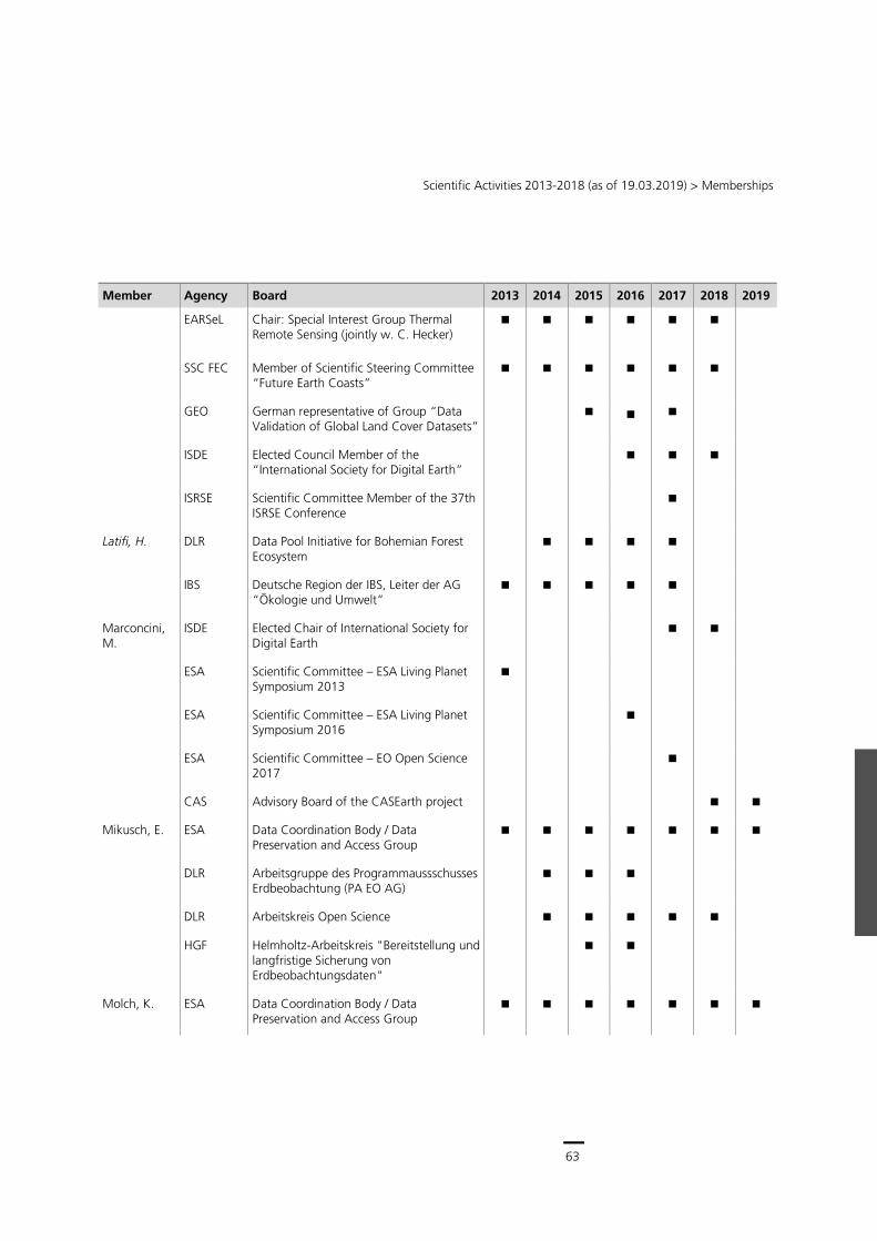
63
Scientific Activities 2013-2018 (as of 19.03.2019) > Memberships
Member Agency Board 2013 2014 2015 2016 2017 2018 2019
EARSeL Chair: Special Interest Group Thermal Remote Sensing (jointly w. C. Hecker)
SSC FEC Member of Scientific Steering Committee “Future Earth Coasts”
GEO German representative of Group “Data Validation of Global Land Cover Datasets”
ISDE Elected Council Member of the “International Society for Digital Earth”
ISRSE Scientific Committee Member of the 37th ISRSE Conference
Latifi, H. DLR Data Pool Initiative for Bohemian Forest Ecosystem
IBS Deutsche Region der IBS, Leiter der AG “Ökologie und Umwelt”
Marconcini, M.
ISDE Elected Chair of International Society for Digital Earth
ESA Scientific Committee – ESA Living Planet Symposium 2013
ESA Scientific Committee – ESA Living Planet Symposium 2016
ESA Scientific Committee – EO Open Science 2017
CAS Advisory Board of the CASEarth project
Mikusch, E. ESA Data Coordination Body / Data Preservation and Access Group
DLR Arbeitsgruppe des Programmaussschusses Erdbeobachtung (PA EO AG)
DLR Arbeitskreis Open Science
HGF Helmholtz-Arbeitskreis "Bereitstellung und langfristige Sicherung von Erdbeobachtungsdaten"
Molch, K. ESA Data Coordination Body / Data Preservation and Access Group
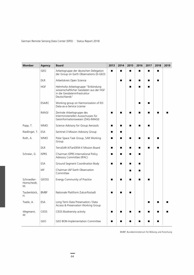
64
German Remote Sensing Data Center (DFD) ∙ Status Report 2018
Member Agency Board 2013 2014 2015 2016 2017 2018 2019
GEO Arbeitsgruppe der deutschen Delegation der Group on Earth Observations (D-GEO)
DLR Arbeitskreis Open Science
HGF Helmholtz-Arbeitsgruppe "Einbindung wissenschaftlicher Geodaten aus der HGF in die Geodateninfrastruktur Deutschlands"
ESA/EC Working group on Harmonization of EO Data-as-a-Service License
IMAGI Zentrale Arbeitsgruppe des Interministeriellen Aussschusses für Geoinformationswesen (ZAG-IMAGI)
Popp, T. WMO Science Advisory for Group Aerosols
Riedlinger, T. ESA Sentinel-3 Mission Advisory Group
Roth, A. WMO Polar Space Task Group, SAR Working Group
DLR TerraSAR-X/TanDEM-X Mission Board
Schreier, G ISPRS Chairman ISPRS International Policy Advisory Committee (IPAC)
ESA Ground Segment Coordination Body
IAF Chairman IAF Earth Observation Committee
Schroedter-Homscheidt, M.
GEOSS Energy Community of Practice
Taubenböck, H.
BMBF Nationale Plattform Zukunftsstadt
Twele, A. ESA Long Term Data Preservation / Data Access & Preservation Working Group
Wegmann, M.
CEOS CEOS Biodiversity activity
GEO GEO BON Implementation Committee
BMBF: Bundesministerium für Bildung und Forschung
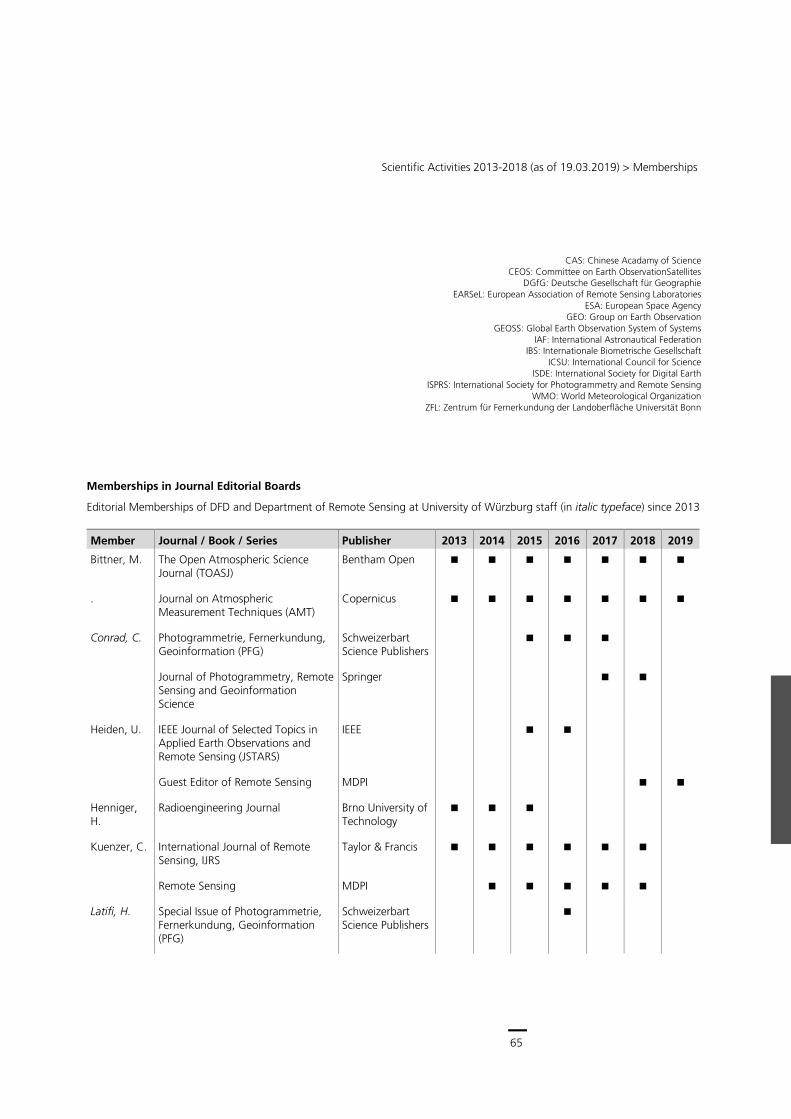
65
Scientific Activities 2013-2018 (as of 19.03.2019) > Memberships
CAS: Chinese Acadamy of Science CEOS: Committee on Earth ObservationSatellites
DGfG: Deutsche Gesellschaft für Geographie EARSeL: European Association of Remote Sensing Laboratories
ESA: European Space Agency GEO: Group on Earth Observation
GEOSS: Global Earth Observation System of Systems IAF: International Astronautical Federation
IBS: Internationale Biometrische Gesellschaft ICSU: International Council for Science
ISDE: International Society for Digital Earth ISPRS: International Society for Photogrammetry and Remote Sensing
WMO: World Meteorological Organization ZFL: Zentrum für Fernerkundung der Landoberfläche Universität Bonn
Memberships in Journal Editorial Boards
Editorial Memberships of DFD and Department of Remote Sensing at University of Würzburg staff (in italic typeface) since 2013
Member Journal / Book / Series Publisher 2013 2014 2015 2016 2017 2018 2019
Bittner, M. The Open Atmospheric Science Journal (TOASJ)
Bentham Open
. Journal on Atmospheric Measurement Techniques (AMT)
Copernicus
Conrad, C. Photogrammetrie, Fernerkundung, Geoinformation (PFG)
Schweizerbart Science Publishers
Journal of Photogrammetry, Remote Sensing and Geoinformation Science
Springer
Heiden, U. IEEE Journal of Selected Topics in Applied Earth Observations and Remote Sensing (JSTARS)
IEEE
Guest Editor of Remote Sensing MDPI
Henniger, H.
Radioengineering Journal Brno University of Technology
Kuenzer, C. International Journal of Remote Sensing, IJRS
Taylor & Francis
Remote Sensing MDPI
Latifi, H. Special Issue of Photogrammetrie, Fernerkundung, Geoinformation (PFG)
Schweizerbart Science Publishers
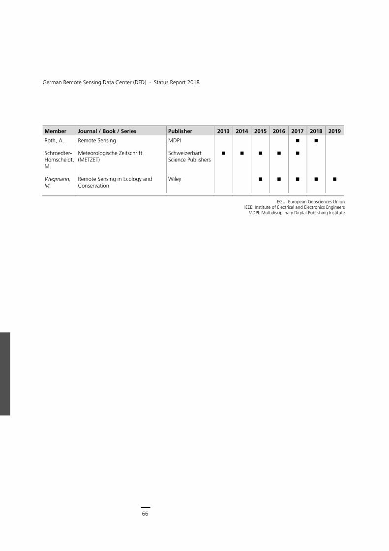
66
German Remote Sensing Data Center (DFD) ∙ Status Report 2018
Member Journal / Book / Series Publisher 2013 2014 2015 2016 2017 2018 2019
Roth, A. Remote Sensing MDPI
Schroedter-Homscheidt, M.
Meteorologische Zeitschrift (METZET)
Schweizerbart Science Publishers
Wegmann, M.
Remote Sensing in Ecology and Conservation
Wiley
EGU: European Geosciences Union
IEEE: Institute of Electrical and Electronics Engineers MDPI: Multidisciplinary Digital Publishing Institute
Scientific Activities 2013-2018 (as of 19.03.2019) > Publications in ISI or Scopus Journals
67
Publications
This chapter lists in reverse chronological order for the time period between January 1, 2013 and December 31, 2018.
publications in ISI and SCOPUS journals,
other publications with full paper review,
books and book contributions,
other publications (> 1 page).
Internal reports as well as doctoral, diploma, Master and Bachelor theses are not listed.
DFD authors appear in bold typeface, employees of the LS_FE are in bold and italic typeface.
For identification purposes citations include the ELIB reference number (“€….€”,”€LMF€”).
Publications in ISI or Scopus Journals
2018
[1] Aravena Pelizari, P., Spröhnle, K., Geiß, C., Schoepfer, E., Plank, S., Taubenböck, H.: Multi-sensor feature fusion for very high spatial resolution built-up area extraction in temporary settlements, Remote Sensing of Environment, 209, pp. 793-807, 2018.€115611€
[2] Arndt, J., Lartner, R., Friedl, P., Gohl, C., Höppner, K.: Bathymetric controls on calving processes at Pine Island Glacier, The Cryosphere, 12, pp. 2039-2050, 2018.€120589€
[3] Asam, S., Callegari, M., Matiu, M., Fiore, G., De Gregorio, L., Jacob, A.,
Menzel, A., Zebisch, M., Notarnicola, C.: Relationship between Spatiotemporal Variations of Climate, Snow Cover and Plant Phenology over the Alps - An Earth Observation-Based Analysis, Remote Sensing, 10 (11), pp. 1-26, 2018.€123049€
[4] Baumhoer, C., Dietz, A., Dech, S., Künzer, C.: Remote Sensing of Antarctic Glacier and Ice-Shelf Front Dynamics - A Review, Remote Sensing, 10 (9), pp. 1-28, 2018.€121634€
[5] Benedetti, A., Reid,, J. S., Knippertz, P., Marsham, J., Di Giuseppe, F., Remy, S., Basart, S., Boucher, O., Menut, L., Mona, L., Laj, P., Pappalardo, G., Wiedensohler, A., Baklanov, A., Brooks, M., Colarco, P., Cuevas, E., Da Silva, A., Escribano, J., Flemming, J., Huneeus, N., Jorba, O., Kazadzis, S., Kinne, S., Popp, T., Quinn, P. K., Sekiyama, T., Tanaka, T., Terradellas, E.: Status and future of numerical atmospheric aerosol prediction with a focus on data requirements, Atmospheric Chemistry and Physics (ACP), 18, pp. 10615-10643, 2018.€122826€
[6] Bliefernicht, J., Berger, S., Salack, S., Guug, S., Hingerl, L., Heinzeller, D., Mauder, M., Steinbrecher, R., Steup, G., Bossa, A. Y., Waongo, M., Quansah, E., Balogun, A. A., Yira, Y., Arnault, J., Wagner, S., Klein, C., Gessner, U., Knauer, K., Straub, A., Schönrock, R., Kunkel, R., Okogbue, E. C., Rogmann, A., Neidl, F., Jahn, C., Diekkrüger, B., Aduna, A., Barry, B., Kunstmann, H.: The WASCAL Hydrometeorological Observatory in the Sudan Savanna of Burkina Faso and Ghana, Vadose Zone Journal, 17, pp. 1-20, 2018.€125348€
[7] Blocksdorf, A., Schmitt, A., Wendleder, A.: Der Forggensee im Jahreswandel – auf dem Weg zur täglichen Wasserstandsmeldung aus dem Weltall, Photogrammetrie Fernerkundung Geoinformation, 86 (1), pp. 29-33, 2018.€120355€
[8] Buchanan, G. M., Beresford, A. E., Hebblewhite, M., Escobedo, F. J., de Klerk, H., Donald, P. F., Escribano, P., Koh, L. P., Martinez-Lopez, J., Pettorelli, N., Skidmore, A., Szantoi, Z., Tabor, K., Wegmann, M., Wich, S.: Free satellite data key to conservation, Science, 361 (6398), pp. 139-140, 2018.€124494€
[9] Buckreuss, S., Schättler, B., Fritz, T., Mittermayer, J., Kahle, R., Maurer, E., Böer, J., Bachmann, M., Mrowka, F., Schwarz, E., Breit, H., Steinbrecher, U.: Ten Years of TerraSAR-X Operations, Remote Sensing, 10 (6), pp. 1-28, 2018.€119875€
[10] Bulgin, C. E., Merchant, C., Ghent, D., Klüser, L., Popp, T., Poulson, C., Sogacheva, L.: Quantifying Uncertainty in Satellite-Retrieved Land Surface Temperature from Cloud Detection Errors, Remote Sensing, 10 (4), pp. 1-20, 2018.€122825€
[11] Caseiro, A., Rücker, G., Tiemann, J., Leimbach, D., Lorenz, E., Frauenberger, O., Kaiser, W. J.: A methodology for gas flaring detection and characterisation using SLSTR, Remote Sensing, 10 (1118), pp. 1-28, 2018.€123933€
[12] Chrysoulakis, N., Grimmond, S., Feigenwinter, C., Lindberg, F., Gastellu-Etchegorry, J.-P., Marconcini, M., Mitraka, Z., Stagakis, S.: Urban energy exchanges monitoring from space, Scientific Reports, 8 (1), pp. 1-8, 2018.€121556€
[13] Cian, F., Marconcini, M., Ceccato, P., Giupponi, C.: Flood depth estimation by means of high-resolution SAR images and lidar data, Natural Hazards and Earth System Sciences, 18 (11), pp. 3063-3084, 2018.€124358€
[14] Clauss, K., Ottinger, M., Leinenkugel, P., Künzer, C.: Estimating rice production in the Mekong Delta, Vietnam, utilizing time series of Sentinel-1 SAR data, International Journal of Applied
German Remote Sensing Data Center (DFD) Status Report 2013 – 2018
68
Earth Observation and Geoinformation, 2018 (73), pp. 574-585, 2018.€121618€
[15] Crawford, B., Grimmond, S., Gabey, A., Marconcini, M., Ward, H. C., Kent, C. W.: Variability of urban surface temperatures and implications for aerodynamic energy exchange in unstable conditions, Quarterly Journal of the Royal Meteorological Society, 144 (715), pp. 1719-1741, 2018.€121553€
[16] Dhillon, M. S., Kaur, S., Sood, A.,Aggarwal, R.: Estimation of carbon emissions from groundwater pumping in central Punjab, Carbon Management, 9, pp. 425-435, 2018. €124502€
[17] Esch, T., Asamer, H., Bachofer, F., Balhar, J., Boettcher, M., Boissier, E., d'Angelo, P., Gevaert, C. M., Hirner, A., Jupova, K., Kurz, F., Kwarteng, A. Y., Mathot, E., Marconcini, M., Marin, A., Metz-Marconcini, A., Pacini, F., Paganini, M., Permana, H., Soukup, T., Üreyen, S., Small, C., Svaton, V., Zeidler, J.: Digital world meets urban planet - new prospects for evidence-based urban studies arising from joint exploitation of big earth data, information technology and shared knowledge, International Journal of Digital Earth, pp. 1-22, 2018.€124946€
[18] Esch, T., Bachofer, F., Heldens, W., Hirner, A., Marconcini, M., Palacios-Lopez, D., Roth, A., Üreyen, S., Zeidler, J., Dech, S., Gorelick, N.: Where we live – A summary of the achievements and planned evolution of the Global Urban Footprint, Remote Sensing, 10 (6), pp. 1-18, 2018.€120292€
[19] Faye, B., Webber, H., Naab, J. B., MacCarthy, D. S., Adam, M., Ewert, F., Lamers, J., Schleussner, C.-F., Ruane, A., Gessner, U., Hoogenboom, G., Boote, K., Shelia, V., Saeed, F., Wisser, D., Hadir, S., Laux, P., Gaiser, T.: Impacts of 1.5 versus 2.0°C on cereal yields in the West African Sudan Savanna, Environmental Research Letters, 13, pp. 1-14, 2018.€119146€
[20] Feigenwinter, C., Vogt, R., Parlow, E., Lindberg, F., Marconcini, M., Del Frate, F., Chrysoulakis, N.: Spatial Distribution of Sensible and Latent Heat Flux in the city of Basel (Switzerland), IEEE Journal of Selected Topics in Applied Earth Observations and Remote Sensing, 11 (8), pp. 2717-2723, 2018.€114985€
[21] Friesen, J., Taubenböck, H., Wurm, M., Pelz, P.: The similar size of slums, Habitat International, 73, pp. 79-88, 2018.€119073€
[22] Geiß, C., Thoma, M., Taubenböck, H.: Cost-Sensitive Multitask Active Learning for Characterization of Urban Environments With Remote Sensing, IEEE Geoscience and Remote Sensing Letters, 15 (6), pp. 922-926, 2018.€120168€
[23] Georg, I., Blaschke, T., Taubenböck, H.: Are We in Boswash Yet? A Multi-Source Geodata Approach to Spatially Delimit Urban Corridors, ISPRS International Journal of Geo-Information, 7 (15), pp. 1-19, 2018.€121218€
[24] Giardino, C., Brando, V., Gege, P., Pinnel, N., Hochberg, E., Knaeps, E., Reusen, I., Doerffer, R., Bresciani, M., Braga, F., Foerster, S., Champollion, N., Dekker, A.: Imaging Spectrometry of Inland and Coastal Waters: State of the Art, Achievements and Perspectives, Surveys in Geophysics, pp. 1-29, 2018.€120319€
[25] Gstaiger, V., Tian, J., Kiefl, R., Kurz, F.: 2D vs. 3D Change Detection Using Aerial Imagery to Support Crisis Management of Large-Scale Events, Remote Sensing, 10 (12), pp. 1-19, 2018.€125007€
[26] Heinrich, I., Balanzategui, D., Bens, O., Blasch, G., Blume, T., Böttcher, F., Borg, E., Brademan, B., Brauer, A., Conrad, C., Dietze, E., Dräger, N., Fiener, P., Güntner, A., Heine, I., Helle, G., Herbrich, M., Harfenmeister, K., Heussner, K.-U., Hohmann, C., Itzerott, S., Kaiser, K., Kappler, C., Koebsch, F.,
Liebner, S., Lischeid, G., Merz, B., Missling, K.-D., Morgner, M., Pinkerneil, S., Plessen, B., Raab, T., Ruhtz, T., Sachs, T., Sommer, M., Spengler, D., Stender, V., Stüve, P., Wilken, F.: Integrating time scales: Interdisciplinary geo-ecological research in the Northeast German Lowland Observatory (TERENO-NE)., Vadose Zone Journal, pp. 1-25, 2018.€123106€
[27] Immitzer, M., Böck, S., Einzmann, K., Vuolo, F., Pinnel, N., Wallner, A., Atzberger, C.: Fractional cover mapping of spruce and pine at 1 ha resolution combining very high and medium spatial resolution satellite imagery, Remote Sensing of Environment, 204, pp. 690-703, 2018.€114500€
[28] Irwin, K., Braun, A., Fotopoulos, G., Roth, A., Wessel, B.: Assessing Single-Polarization and Dual-Polarization TerraSAR-X Data for Surface Water Monitoring, Remote Sensing, 10 (6), pp. 1-17, 2018.€121141€
[29] Kang, J., Körner, M., Wang, Y., Taubenböck, H., Zhu, X. X.: Building instance classification using street view images, ISPRS Journal of Photogrammetry and Remote Sensing, 145 (A), pp. 44-59, 2018.€124194€
[30] Kranz, O., Schoepfer, E., Tegtmeyer, R., Lang, S.: Earth observation based multi-scale assessment of logging activities in the Democratic Republic of the Congo, ISPRS Journal of Photogrammetry and Remote Sensing, 144, pp. 254-267, 2018.€123320€
[31] Krause, D., Schwarz, E., Voinov, S., Damerow, H., Tomecki, D.: Sentinel-1 near real-time application for maritime situational awareness, CEAS Space Journal, pp. 1-9, 2018.€123786€
[32] Kuffer, M., Pfeffer, K., Sliuzas, R., Taubenböck, H., Baud, I., Maarseveen, M. v.: Capturing the Urban Divide in Nighttime Light Images From the International Space Station, IEEE Journal of Selected Topics in Applied Earth
Scientific Activities 2013-2018 (as of 19.03.2019) > Publications in ISI or Scopus Journals
69
Observations and Remote Sensing, 11 (8), pp. 2578-2586, 2018.€122908€
[33] Kylling, A., Vandenbussche, S., Capelle, V., Cuesta, J., Klüser, L., Lelli, L., Popp, T., Stebel, K., Veefkind, P.: Comparison of dust layer heights from active and passive satellite sensors, Atmospheric Measurement Techniques (AMT), 11, pp. 2911-2936, 2018.€122823€
[34] Latifi, H., Dahms, T., Beudert, B., Heurich, M., Kübert, C., Dech, S.: Synthetic RapidEye data used for the detection of area-based spruce tree mortality induced by bark beetles, Giscience & Remote Sensing, 55 (6), pp. 839-859, 2018.€122829€
[35] Lausch, A., Borg, E., Bumberger, J., Dietrich, P., Heurich, M., Huth, A., Jung, A., Klenke, R., Knapp, S., Mollenhauer, H., Paasche, H., Paulheim, H., Pause, M., Schweitzer, C., Schmullius, C., Settele, J., Skidmore, A., Wegmann, M., Zacharias, S., Kirsten, T., Schaepman, M. E.: Understanding Forest Health with Remote Sensing, Part III: Requirements for a Scalable Multi-Source Forest Health Monitoring Network Based on Data Science Approaches, Remote Sensing, 10 (1120), pp. 1-52, 2018.€124497€
[36] Lausch, A., Borg, E., Bumberger, J., Dietrich, P., Heurich, M., Huth, A., Jung, A., Klenke, R., Knapp, S., Mollenhauer, H., Paaschen, H., Paulheim, H., Pause, M., Schweizer, C., Schmullius, C., Settele, J., Skidmore, A., Wegmann, M., Zacharias, S., Kirsten, T., Schaepman, M. E.: Understanding forest health with remote sensing -Part III - Requirements for a global multi-source forest health monitoring network, Remote Sensing, 10 (1120), pp. 1-52, 2018.€121736€
[37] Li, Y., Martinis, S., Plank, S. M., Ludwig, R.: An automatic change detection approach for rapid flood mapping in Sentinel-1 data, International Journal of Applied Earth Observation and
Geoinformation, 73, pp. 123-135, 2018.€121380€
[38] Luque, S., Pettorelli, N., Vihervaara, P., Wegmann, M.: Improving biodiversity monitoring using satellite remote sensing to provide solutions towards the 2020 conservation targets, Methods in Ecology and Evolution, 9 (8), pp. 1784-1786, 2018.€124482€
[39] Martinis, S., Plank, S. M., Cwik, K.: The use of Sentinel-1 time-Series data to improve flood Monitoring in arid areas, Remote Sensing, 10 (582), pp. 1-13, 2018.€119660€
[40] Mills, S. L., Bragina, E. V., Kumar, A. V., Zimova, M., Lafferty, D. J., Feltner, J., Davis, B. M., Hackländer, K., Alves, P. C., Good, J. M., Melo-Ferreira, J., Dietz, A., Abramov, A. V., Lopatina, N., Fay, K.: Winter color polymorphisms identify global hot spots for evolutionary rescue from climate change, Science, 359, pp. 1033-1036, 2018.€119239€
[41] Misra, G., Buras, A., Heurich, M., Asam, S., Menzel, A.: LiDAR derived topography and forest stand characteristics largely explain the spatial variability observed in MODIS land surface phenology, Remote Sensing of Environment, 218, pp. 231-244, 2018.€123051€
[42] Nyamekye, C., Thiel, M., Schönbrodt-Stitt, S., Zoungrana, B. J., Amekudzi, L.: Soil and Water Conservation in Burkina Faso, West Africa, Sustainability, 10 (9), pp. 1-24, 2018.€125024€
[43] Okujeni, A., Canters, F., Cooper, S. D., Degerickx, J., Heiden, U., Hostert, P., Priem, F., Roberts, D., Somers, B., van der Linden, S.: Generalizing machine learning regression models using multi-site spectral libraries for mapping vegetation-impervious-soil fractions across multiple cities, Remote Sensing of Environment, 216, pp. 482-496, 2018.€124347€
[44] Ottinger, M., Clauss, K., Künzer, C.: Opportunities and Challenges for the Estimation of Aquaculture Production Based on Earth Observation Data, Remote Sensing, 10 (7), pp. 1-24, 2018.€120848€
[45] Plank, S., Karg, S., Martinis, S.: Full-polarimetric burn scar mapping - the differences of active fire and post-fire situations, International Journal of Remote Sensing, 40 (1), pp. 253-268, 2018.€121477€
[46] Plank, S., Martinis, S.: A Fully Automatic Burnt Area Mapping Processor Based on AVHRR Imagery - A TIMELINE Thematic Processor, Remote Sensing, 10 (341), pp. 1-15, 2018.€119102€
[47] Plank, S., Nolde, M., Richter, R., Fischer, C., Martinis, S., Riedlinger, T., Schoepfer, E., Klein, D.: Monitoring of the 2015 Villarrica Volcano Eruption by Means of DLR's Experimental TET-1 Satellite, Remote Sensing, 10 (1379), pp. 1-17, 2018.€122294€
[48] Reichmuth, A., Henning, L., Pinnel, N., Bachmann, M., Rogge, D.: Early Detection of Vitality Changes of Multi-Temporal Norway Spruce Laboratory Needle Measurements - The Ring-Barking Experiment, Remote Sensing, 10 (1), pp. 1-19, 2018.€117994€
[49] Rocchini, D., Bacaro, G., Chirici, G., Da Re, D., Feilhauer, H., Foody, G. M., Galluzzi, M., Garzon-Lopez, C. X., Gillespie, T. W., He, K. S., Lenoir, J., Marcantonio, M., Nagendra, H., Ricotta, C., Rommel, E., Schmidtlein, S., Skidmore, A., Van de Kerchove, R., Wegmann, M., Rugani, B.: Remotely sensed spatial heterogeneity as an exploratory tool for taxonomic and functional diversity study, Ecological Indicators, 85, pp. 983-990, 2018.€116988€
[50] Rogge, D., Bauer, A., Zeidler, J., Müller, A., Esch, T., Heiden, U.: Building an exposed soil composite
German Remote Sensing Data Center (DFD) Status Report 2013 – 2018
70
processor (SCMaP) for mapping spatial and temporal characteristics of soils with Landsat imagery (1984-2014), Remote Sensing of Environment, 205, pp. 1-17, 2018.€116026€
[51] Roman, M. O., Wang, Z., Sun, Q., Kalb, V., Miller, S. D., Molthan, A. L., Schultz, L. A., Bell, J. R., Stokes, E., Pandey, B., Seto, K., Hall, D. K., Oda, T., Wolfe, R. E., Lin, G., Golpayegani, N., Devadiga, S., Davidson, C., Sarkar, S., Praderas, C., Schmaltz, J., Boller, R. A., Stevens, J., Ramos Gonzalez, O. M., Padilla, E., Alonso, J., Detres, Y., Armstrong, R., Miranda, I., Conte, Y., Marrero, N., MacManus, K., Esch, T., Masuoka, E. J.: NASA's Black Marble Nighttime Lights Product Suite, Remote Sensing of Environment, pp. 113-143, 2018.€119453€
[52] Roth, A., Marschalk, U., Winkler, K., Schättler, B., Huber, M., Georg, I., Künzer, C., Dech, S.: Ten Years of Experience with Scientific TerraSAR-X Data Utilization, Remote Sensing, 10 (8), pp. 1-28, 2018.€121227€
[53] Schmidt, C., Dunker, T., Sabrina, L., Scheer, J., Wüst, S., Hoppe, U.-P., Bittner, M.: Derivation of vertical wavelengths of gravity waves in the MLT-region from multispectral airglow observations, Journal of Atmospheric and Solar-Terrestrial Physics, pp. 119-127, 2018.€123439€
[54] Schmitt, A., Sieg, T., Wurm, M., Taubenböck, H.: Investigation on the separability of slums by multi-aspect TerraSAR-X dual-co-polarized high resolution spotlight images based on the multi-scale evaluation of local distributions, International Journal of Applied Earth Observation and Geoinformation, 64, pp. 181-198, 2018.€114387€
[55] Schroedter-Homscheidt, M., Kosmale, M., Jung, S., Kleissl, J.: Classifying ground-measured 1 minute
temporal variability within hourly intervals for direct normal irradiances, Meteorologische Zeitschrift, 27 (2), pp. 161-179, 2018.€122964€
[56] Selvakumaran, S., Plank, S., Geiß, C., Rossi, C., Campbell, M.: Remote monitoring to predict bridge scour failure using Interferometric Synthetic Aperture Radar (InSAR) stacking techniques, International Journal of Applied Earth Observation and Geoinformation, 73, pp. 463-470, 2018.€121228€
[57] Shi, Y., Skidmore, A., Wang, T., Holzwarth, S., Heiden, U., Pinnel, N., Zhu, X., Heurich, M.: Tree species classification using plant functional traits from LiDAR and hyperspectral data, International Journal of Applied Earth Observation and Geoinformation, pp. 207-219, 2018.€121020€
[58] Spengler, D., Förster, M., Borg, E.: Editorial. PFG Journal of Photogrammetry, Remote Sensing and Geoinformation Science, PFG - Journal of Photogrammetry, Remote Sensing and Geoinformation Science, 86 (2), pp. 49-51, 2018.€123047€
[59] Stettner, S., Beamish, A. L., Bartsch, A., Heim, B., Grosse, G., Roth, A., Lantuit, H.: Monitoring Inter- and Intra-Seasonal Dynamics of Rapidly Degrading Ice-Rich Permafrost Riverbanks in the Lena Delta with TerraSAR-X Time Series, Remote Sensing, 10 (51), pp. 1-20, 2018.€117946€
[60] Stettner, S., Lantuit, H., Heim, B., Eppler, J., Roth, A., Bartsch, A., Rabus, B.: TerraSAR-X Time Series Fill a Gap in Spaceborne Snowmelt Monitoring of Small Arctic Catchments - A Case Study on Qikiqtaruk (Herschel Island), Canada, Remote Sensing in Ecology and Conservation, 10 (7), pp. 1-26, 2018.€121158€
[61] Syed, T. H., Riyas, M. J., Künzer, C.: Remote sensing of coal fires in India: A review, Earth-Science Reviews, 187, pp. 338-355, 2018.€125289€
[62] Taubenböck, H., Kraff, N., Wurm, M.: The morphology of the Arrival City - A global categorization based on literature surveys and remotely sensed data, Applied Geography, 92, pp. 150-167, 2018.€119052€
[63] Taubenböck, H., Staab, J., Zhu, X. X., Geiß, C., Dech, S., Wurm, M.: Are the Poor Digitally Left Behind? Indications of Urban Divides Based on Remote Sensing and Twitter Data, ISPRS International Journal of Geo-Information, 7 (304), pp. 1-18, 2018.€121217€
[64] Taubenböck, H., Wurm, M., Geiß, C., Dech, S., Siedentop, S.: Urbanization between compactness and dispersion: designing a spatial model for measuring 2D binary settlement landscape configurations, International Journal of Digital Earth, pp. 1-20, 2018.€120063€
[65] Tsyganskaya, V., Martinis, S., Marzahn, P., Ludwig, R.: Comparison of SAR-based approaches for the detection of partly flooded vegetation – a review, International Journal of Remote Sensing, 39 (8), pp. 2255-2293, 2018.€120408€
[66] Tsyganskaya, V., Martinis, S., Marzahn, P., Ludwig, R.: Detection of temporary flooded vegetation using Sentinel-1 time series data, Remote Sensing, 10 (8), pp. 1-23, 2018.€122281€
[67] Van der Linden, S., Okujeni, A., Canters, F., Degerickx, J., Heiden, U., Hostert, P., Priem, F., Somers, B., Thiel, F.: Imaging Spectroscopy of Urban Environments, Surveys in Geophysics, pp. 1-18, 2018.€124353€
[68] Wendleder, A., Friedl, P., Mayer, C.: Impacts of Climate and Supraglacial Lakes on the Surface Velocity of Baltoro Glacier from 1992 to 2017, Remote Sensing, 10 (1681), pp. 1-25, 2018.€122538€
[69] Wentz, E. A., York, A. M., Alberti, M., Conrow, L., Fischer, H., Inostroza, L.,
Scientific Activities 2013-2018 (as of 19.03.2019) > Publications in ISI or Scopus Journals
71
Jantz, C., Pickett, S. T., Seto, K. C., Taubenböck, H.: Six fundamental aspects for conceptualizing multidimensional urban form: A spatial mapping perspective, Landscape and Urban Planning, 179, pp. 55-62, 2018.€121216€
[70] Wessel, B., Huber, M., Wohlfart, C., Marschalk, U., Kosmann, D., Roth, A.: Accuracy Assessment of the Global TanDEM-X Digital Elevation Model with GPS Data, ISPRS Journal of Photogrammetry and Remote Sensing, 139, pp. 171-182, 2018.€120420€
[71] Wohlfart, C., Winkler, K., Wendleder, A., Roth, A.: TerraSAR-X and Wetlands: A Review, Remote Sensing, 10, pp. 1-24, 2018.€120385€
[72] Wurm, M., Taubenböck, H.: Detecting social groups from space - Assessment of remote sensing-based mapped morphological slums using income data, Remote Sensing Letters, 9 (1), pp. 41-50, 2018.€114952€
[73] Wüst, S., Offenwanger, T., Schmidt, C., Bittner, M., Jacobi, C., Stober, G., Yee, J.-H., Mlynczak, M. G., Russell III, J. M.: Derivation of gravity wave intrinsic parameters and vertical wavelength using a single scanning OH(3-1) airglow spectrometer, Atmospheric Measurement Techniques (AMT), 11, pp. 2937-2947, 2018.€119630€
[74] Zoungrana, B., Conrad, C., Thiel, M., Amekudzi, L., Dapola Da, E.: MODIS NDVI trends and fractional land cover change for improved assessments of vegetation degradation in Burkina Faso, West Africa, Journal of Arid Environments, 153, pp. 66-75, 2018.€123776€
2017
[75] Aryal, R. R., Latifi, H., Heurich, M., Hahn, M.: Impact of slope, aspect and habitat type on LiDAR-derived digital terrain models in a near-natural, heterogenuous temperate forest,
Photogrammetrie, Fernerkundung, Geoinformation, 85 (4), pp. 243-255, 2017.€115522€
[76] Aubrecht, C., Meier, P., Taubenböck, H.: Speeding up the clock in remote sensing – Identifying the ‘black spots’ in exposure dynamics by capitalizing on the full spectrum of joint high spatial and temporal resolution, Natural Hazards, 86 (1), pp. 177-182, 2017.€111347€
[77] Bingen, C., Robert, C., Stebel, K., Brühl, C., Schallock, J., Vanhellemont, F., Matheshvili, N., Höpfner, M., Trickl, T., Barnes, J. E., Jumelet, J., Vernier, J.-P., Popp, T., de Leeuw, G., Pinnock, S.: Stratospheric aerosol data records for the Climate Change Initiative: development, validation and application to Chemistry-Climate Modelling, Remote Sensing of Environment, pp. 1-26, 2017.€113776€
[78] Borg, E., Fichtelmann, B., Günther, K. P.: Dynamic self-learning water-masking algorithm for AATSR, MERIS, and SPOT VEGETATION, International Journal of Business Intelligence and Data Mining, 12 (2), pp. 95-118, 2017.€112351€
[79] Calabrese, A., Songer, M., Wegmann, M., Hedges, S., Rose, R., Leimgruber, P.: Conservation status of Asian elephants: the influence of habitat and governance, Biodiversity and Conservation, 26 (9), pp. 2067-2081, 2017.€117001€
[80] Cao, W., Twele, A., Plank, S. M., Martinis, S.: A Three-class Change Detection Methodology for SAR-data based on Hypothesis Testing and Markov Random Field Modeling, International Journal of Remote Sensing, 39 (2), pp. 488-504, 2017.€114408€
[81] Cian, F., Marconcini, M., Ceccato, P.: Normalized Difference Flood Index for rapid flood mapping: taking advantage of EO big data, Remote Sensing of Environment, pp. 1-30, 2017.€114792€
[82] Clauss, K., Ottinger, M., Künzer, C.: Mapping rice areas with Sentinel-1 time series and superpixel segmentation, International Journal of Remote Sensing, 39 (5), pp. 1399-1420, 2017.€114137€
[83] Confuorto, P., Di Martire, D., Centolanza, G., Iglesias, R., Mallorqui, J. J., Novellino, A., Plank, S., Ramondini, M., Thuro, K., Calcaterra, D.: Post-failure evolution analysis of a rainfall-triggered landslide by Multi-Temporal Interferometry SAR approaches integrated with geotechnical analysis, Remote Sensing of Environment, 188, pp. 51-72, 2017.€107537€
[84] Crawford, B., Grimmond, S., Gabey, A., Marconcini, M.: Variability of urban surface temperatures and implications for aerodynamic energy exchange in cities, Quarterly Journal of the Royal Meteorological Society, pp. 1-21, 2017.€114793€
[85] Da Ponte, E., Künzer, C., Parker, A., Rodas, O., Oppelt, N., Fleckenstein, M.: Forest cover loss in Paraguay and perception of ecosystem services: A case study of the Upper Parana Forest, Ecosystem Services, 24, pp. 200-212, 2017.€111553€
[86] Da Ponte, E., Mack, B., Wohlfart, C., Rodas, O., Fleckenstein, M., Oppelt, N., Dech, S., Kuenzer, C.: Assessing Forest Cover Dynamics and Forest Perception in the Atlantic Forest of Paraguay, Combining Remote Sensing and Household Level Data, Forests, 8 (10), pp. 1-21, 2017.€114635€
[87] Dietz, A., Frey, C., Ruppert, T., Bachmann, M., Künzer, C., Dech, S.: Automated Improvement of Geolocation Accuracy in AVHRR Data Using a Two-Step Chip Matching Approach—A Part of the TIMELINE Preprocessor., Remote Sensing, 9 (303), pp. 1-17, 2017.€111633€
[88] Dietz, A., Klein, I., Gessner, U., Frey, C., Künzer, C., Dech, S.: Detection of Water Bodies from AVHRR Data — A TIMELINE Thematic Processor, Remote Sensing, 9 (1), pp. 1-15, 2017.€118229€
[89] Einzmann, K., Immitzer, M., Böck, S., Bauer, O., Schmitt, A., Atzberger, C.: Windthrow Detection in European Forests with Very High-Resolution Optical Data, Remote Sensing, 8 (21), pp. 1-26, 2017.€110883€
[90] Eisfelder, C., Klein, I., Bekkuliyeva, A., Künzer, C., Buchroithner, M. F., Dech, S.: Above-ground biomass estimation based on NPP time-series - A novel approach for biomass estimation in semi-arid Kazakhstan, Ecological Indicators, 72, pp. 13-22, 2017.€105378€
[91] Esch, T., Heldens, W., Hirner, A., Keil, M., Marconcini, M., Roth, A., Zeidler, J., Dech, S., Strano, E.: Breaking new ground in mapping human settlements from space - The Global Urban Footprint, ISPRS Journal of Photogrammetry and Remote Sensing, pp. 30-42, 2017.€114248€
[92] Fassnacht, F., Mangold, D., Schäfer, J., Immitzer, M., Kattenborg, T., Koch, B., Latifi, H.: Estimating stand density, biomass and tree species from very high resolution stereo-imagery- towards an all-in-one sensor for forestry applications?, Forestry, 90 (5), pp. 613-631, 2017.€111943€
German Remote Sensing Data Center (DFD) Status Report 2013 – 2018
72
[93] Feng, J., Rogge, D., Rivard, B.: Comparison of lithological mapping results from airborne hyperspectral VNIR-SWIR, LWIR and combined data, International Journal of Applied Earth Observation and Geoinformation, pp. 1-14, 2017.€111807€
[94] Fernandez Peruchena, C. M., Gaston, M., Schroedter-Homscheidt, M., Kosmale, M., Martinez Marco, I., Garcia-Moya, J. A., Casado-Rubio, J. L.: Dynamic Paths: Towards high frequency direct normal irradiance forecasts, Energy, 132, pp. 315-323, 2017.€113122€
[95] Forkour, G., Conrad, C., Thiel, M., Zoungrana, B. J., Tondoh, J.: Multiscale Remote Sensing to Map the Spatial Distribution and Extent of Cropland in the Sudanian Savanna of West Africa, Remote Sensing, 9 (8), pp. 1-24, 2017.€115505€
[96] Frey, C., Künzer, C., Dech, S.: Assessment of Mono- and Split-Window Approaches for Time Series Processing of LST from AVHRR—A TIMELINE Round Robin, Remote Sensing, 9 (1), pp. 1-24, 2017.€110916€
[97] Friedl, P., Seehaus, T., Wendt, A., Braun, M., Höppner, K.: Recent dynamic changes on Fleming Glacier after the disintegration of Wordie Ice Shelf, Antarctic Peninsula, The Cryosphere, submitted, 2017.€114102€
[98] Geiß, C., Aravena Pelizari, P., Schrade, H., Brenning, A., Taubenböck, H.: On the Effect of Spatially Non-disjoint Training and Test Samples on Estimated Model Generalization Capabilities in Supervised Classification with Spatial Features, IEEE Geoscience and Remote Sensing Letters, 14 (11), pp. 2008-2012, 2017.€115167€
[99] Geiß, C., Schauß, A., Riedlinger, T., Dech, S., Zelaya, C., Guzman, N., Hube, M., Jokar Arsanjani, J., Taubenböck, H.: Joint use of remote sensing data and volunteered geographic information for exposure estimation: evidence from Valparaíso, Chile, Natural Hazards, 86, pp. 81-105, 2017.€111043€
[100] Geiß, C., Taubenböck, H.: One step back for a leap forward: toward operational measurements of elements at risk, Natural Hazards, 86 (1), pp. 1-6, 2017.€111351€
[101] Geiß, C., Thoma, M., Pittore, M., Wieland, M., Dech, S., Taubenböck, H.: Multitask Active Learning for Characterization of Built Environments with Multisensor Earth Observation Data, IEEE Journal of Selected Topics in Applied Earth Observations and Remote Sensing, pp. 1-15, 2017.€115169€
[102] Helbig, C., Dransch, D., Böttinger, M., Devey, C., Haas, A., Hlawitschka, M., Künzer, C., Rink, K., Schäfer-Neth, C., Scheuermann, G., Kwasnitschka, T., Unger, A.: Challenges and strategies for the visual exploration of complex environmental data, International Journal of Digital Earth, 10 (10), pp. 1070-1076, 2017.€112382€
[103] Heldens, W., Heiden, U., Esch, T., Müller, A., Dech, S.: Integration of remote sensing based surface information into a three-dimensional microclimate model, ISPRS Journal of Photogrammetry and Remote Sensing, 125, pp. 106-124, 2017.€110859€
[104] Hill, S., Latifi, H., Heurich, M., Müller, J.: Individual-tree- and stand-based development following natural disturbance in a heterogeneously structured forest: A LiDAR-based approach, Ecological Informatics, 2017 (38), pp. 12-25, 2017.€110991€
[105] Hu, Z., Künzer, C., Dietz, A., Dech, S.: The Potential of Earth Observation for the Analysis of Cold Region Land Surface Dynamics in Europe - A Review, Remote Sensing, 9 (10), pp. 1-40, 2017.€114779€
[106] Immitzer, M., Böck, S., Einzmann, K., Vuolo, F., Pinnel, N., Wallner, A., Atzberger, C.: Fractional cover mapping of spruce and pine at 1 ha resolution combining very high and medium spatial resolution satellite imagery, Remote Sensing of Environment, 204, pp. 690-703, 2017.€114500€
[107] Jilge, M., Heiden, U., Habermeyer, M., Mende, A., Jürgens, C.: Detecting unknown artificial urban surface materials based on spectral dissimilarity analysis, Sensors, 17 (1826), pp. 1-20, 2017.€114103€
[108] Kantamaneni, K., Du, X.: Is Catastrophic Climate Change Turning Britain into a Hurricane Hotspot?, International Journal of Environmental Research, 11 (5-6), pp. 569-578, 2017.€118106€
[109] Khare, S., Ghosh, S. K., Latifi, H., Vijay, S., Dahms, T.: Seasonal-based analysis of vegetation response to environmental variables in the mountainous forests of Western Himalaya using Landsat 8 data, International Journal of Remote Sensing, 38 (15), pp. 4418-4442, 2017.€115521€
[110] Khare, S., Latifi, H., Ghosh, S. K.: Multi-scale assessment of invasive plant species diversity using Pléiades 1A,RapidEye and Landsat-8 data, Geocarto International, pp. 1-18, 2017.€115515€
[111] Kleemann, J., Inkoom, J. N., Thiel, M., Shankar, S., Lautenbach, S., Fürst, C.: Peri-urban land use pattern and its relation to land use
planning in Ghana, West Africa, Landscape and Urban Planning, 165, pp. 280-294, 2017.€114843€
[112] Klein, C., Bliefernicht, J., Heinzeller, D., Gessner, U., Klein, I., Kunstmann, H.: Feedback of observed interannual vegetation change: a regional climate model Analysis for the West African monsson, Climate Dynamics, pp. 1-22, 2017.€105356€
[113] Klein, I., Gessner, U., Dietz, A., Künzer, C.: Global WaterPack – A 250 m resolution dataset revealing the daily dynamics of global inland water bodies, Remote Sensing of Environment, 198, pp. 345-362, 2017.€113038€
[114] Klüser, L., Popp, T.: Large-scale analysis of relationships between mineral dust, ice cloud properties and precipitation from satellite observations using a Bayesian approach: Theoretical basis and first results for the tropical Atlantic Ocean, Advances in Meteorology, 2017, pp. 1-18, 2017.€113777€
[115] Knauer, K., Gessner, U., Fensholt, R., Forkuor, G., Kuenzer, C.: Monitoring Agricultural Expansion in Burkina Faso over 14 Years with 30 m Resolution Time Series: The Role of Population Growth and Implications for the Environment, Remote Sensing, 9 (132), pp. 1-25, 2017.€114105€
[116] Kranz, O., Lang, S., Schoepfer, E.: 2.5D change detection from satellite imagery to monitor small-scale mining activities in the Democratic Republic of the Congo, International Journal of Applied Earth Observation and Geoinformation, 61, pp. 81-91, 2017.€112449€
[117] Kyalo, R., Abdel-Rahman, E. M., Subramanian, S., Nyasani, J. O., Thiel, M., Jozani, H., Borgemeister, C., Landmann, T.: Maize Cropping Systems Mapping Using RapidEye Observations in Agro-Ecological Landscapes in Kenya, Sensors, 17 (11), pp. 1-16, 2017.€115508€
[118] Latifi, H., Hill, S., Schumann, B., Heurich, M., Dech, S.: Multi-model estimation of understorey shrub, herb and moss cover in temperate forest stands by laser scanner data, Forestry, 90 (4), pp. 496-514, 2017.€110992€
[119] Latifi, H., Koch, B.: Editorial for the Special Issue "Remote Sensing-assisted forest inventory", Photogrammetrie, Fernerkundung, Geoinformation, 85 (4), pp. 211-212, 2017.€116760€
[120] Lauer, A., Eyring, V., Righi, M., Buchwitz, M., Defourny, P., Evaldsson, M., Friedlingstein, P., de Jeu, R., de Leeuw, G., Loew, A., Merchant, C., Müller, B., Popp, T., Reuter, M., Sandven, S.,
Scientific Activities 2013-2018 (as of 19.03.2019) > Publications in ISI or Scopus Journals
73
Senftleben, D., Stengel, M., Van Roozendael, M., Wenzel, S., Willen, U.: Benchmarking CMIP5 models with a subset of ESA CCI Phase 2 data using the ESMValTool, Remote Sensing of Environment, 203, pp. 9-39, 2017.€112446€
[121] Leichtle, T., Geiß, C., Lakes, T., Taubenböck, H.: Class imbalance in unsupervised change detection – A diagnostic analysis from urban remote sensing, International Journal of Applied Earth Observation and Geoinformation, 60, pp. 83-98, 2017.€112072€
[122] Leichtle, T., Geiß, C., Wurm, M., Lakes, T., Taubenböck, H.: Unsupervised change detection in VHR remote sensing imagery – an object-based clustering approach in a dynamic urban environment, International Journal of Applied Earth Observation and Geoinformation, 54, pp. 15-27, 2017.€106056€
[123] Ludlow, D., Khan, Z., Soomro, K., Marconcini, M., San Jose, R., Malcorps, P., Lemper, M., Luis Perez, J., Metz, A.: From top-down land use planning intelligence to bottom-up stakeholder engagement for smart cities – a case study: DECUMANUS service products, International Journal of Services, Technology and Management, inpress, 2017.€108213€
[124] Mack, B., Leinenkugel, P., Künzer, C., Dech, S.: A semi-automated approach for the generation of a new land use and land cover product for Germany based on Landsat time-series and Lucas in-situ data, Remote Sensing Letters, 8 (3), pp. 244-253, 2017.€107714€
[125] Martinis, S., Twele, A., Plank, S. M., Zwenzner, H., Danzeglocke, J., Strunz, G., Lüttenberg, H.-P., Dech, S.: The International 'Charter Space and Major Disasters': DLR's contributions to emergency response worldwide, Photogrammetrie, Fernerkundung, Geoinformation, 85, pp. 317-325, 2017.€115835€
[126] Merchant, C., Paul, F., Popp, T., Ablain, M., Bontemps, S., Defourny, P., Hollmann, R., Lavergne, T., Laeng, A., de Leeuw, G., Mittaz, J., Poulson, C., Povey, A., Reuter, M., Sathyendranath, S., Sandven, S., Sofieva, V., Wagner, W.: Uncertainty information in climate data records from Earth observation, Earth System Science Data, 9, pp. 511-527, 2017.€113775€
[127] Möller, M., Gerstmann, H., Gao, F., Dahms, T., Förster, M.: Coupling of phenological information and simulated vegetation index time series: Limitations and potentials for the assessment and monitoring of soil erosion risk, Catena, 3 (150), pp. 192-205, 2017.€110995€
[128] Ottinger, M., Clauss, K., Künzer, C.: Large-Scale Assessment of Coastal Aquaculture Ponds with Sentinel-1 Time Series Data, Remote Sensing, 9 (440), pp. 1-23, 2017.€112391€
[129] Palumbo, I., Rose, R. A., Headley, R., Nackoney, J., Vodacek, A., Wegmann, M.: Building capacity in remote sensing for conservation: present and future challenges, Remote Sensing in Ecology and Conservation, pp. 1-9, 2017.€111341€
[130] Pettorelli, N., Nagendra, H., Rocchini, D., Rowcliffe, M., Williams, R., Ahumada, J., De Angelo, C., Atzberger, C., Boyd, D., Buchanan, G. M., Chauvenet, A., Disney, M., Duncan, C., Fatoyinbo, T., Fernandez, N., Haklay, M., He, K., Horning, N., Kelly, N., de Klerk, H., Liu, X., Merchant, N., Paruelo, N., Roy, H., Shovonlal, R., Ryan, S., Sollmann, R., Swenson, J., Wegmann, M.: Editorial: Remote Sensing in Ecology and Conservation: three years on, Remote Sensing in Ecology and Conservation, 3 (2), pp. 53-56, 2017.€116997€
[131] Pettorelli, N., Schulte to Bühne, H., Tulloch, A., Dubois, G., Macinnis-Ng, C., Queirós, A. M., Keith, D. A., Wegmann, M., Schrodt, F., Stellmes, M., Sonnenschein, R., Geller, G., Shovonlal, R., Somers, B., Murray, N., Bland, L., Geijzendorffer, I., Kerr, J. T., Broszeit, S., Leitao, P. J., Duncan, C., El Serafy, G., He, K. S., Blanchard, J., Lucas, R., Mairota, P., Webb, T. J., Nicholson, E.: Satellite remote sensing of ecosystem functions: opportunities, challenges and way forward, Remote Sensing in Ecology and Conservation, pp. 1-23, 2017.€116991€
[132] Plank, S. M., Jüssi, M., Martinis, S., Twele, A.: Mapping of flooded vegetation by means of polarimetric Sentinel-1 and ALOS-2/PALSAR-2 imagery, International Journal of Remote Sensing, 38 (13), pp. 3831-3850, 2017.€111866€
[133] Plank, S., Fuchs, E.-M., Frey, C.: A Fully Automatic Instantaneous Fire Hotspot Detection Processor Based on AVHRR Imagery—A TIMELINE Thematic Processor, Remote Sensing, 9 (30), pp. 1-22, 2017.€110344€
[134] Qu, Z., Oumbe, A., Blanc, P., Espinar, B., Gesell, G., Gschwind, B., Klüser, L., Lefèvre, M., Saboret, L., Schroedter-Homscheidt, M., Wald, L.: Fast radiative transfer parameterisation for assessing the surface solar irradiance: The Heliosat-4 method, Meteorologische Zeitschrift, 26 (1), pp. 33-57, 2017.€106996€
[135] Remelgado, R., Leutner, B., Safi, K., Sonnenschein, R., Kübert, C., Wegmann, M.: Linking animal movement and remote sensing - mapping resource suitability from a remote sensing
perspective, Remote Sensing in Ecology and Conservation, pp. 1-14, 2017.€118351€
[136] Rizzoli, P., Martone, M., Gonzalez, C., Wecklich, C., Borla Tridon, D., Bräutigam, B., Bachmann, M., Schulze, D., Fritz, T., Huber, M., Wessel, B., Krieger, G., Zink, M., Moreira, A.: Generation and performance assessment of the global TanDEM-X digital elevation model, ISPRS Journal of Photogrammetry and Remote Sensing, pp. 119-139, 2017.€114315€
[137] Salehi, S., Rogge, D., Rivard, B., Heincke, B. H., Fensholt, R.: Modeling and assessment of wavelength displacements of characteristic absorption features of common rock forming minerals encrusted by lichens, Remote Sensing of Environment, 199, pp. 78-92, 2017.€113260€
[138] Schroedter-Homscheidt, M., Benedetti, A., Killius, N.: Verification of ECMWF and ECMWF/MACC’s global and direct irradiance forecasts with respect to solar electricity production forecasts, Meteorologische Zeitschrift, 26 (1), pp. 1-19, 2017.€106020€
[139] Schröter, E., Gähler, M., Schiewe, J.: Hypermediale Geovisualisierungen für zivile Sicherheitsanwendungen auf Basis von UAS-Daten, Kartographische Nachrichten, pp. 254-262, 2017.€115621€
[140] Schulte to Bühne, H., Wegmann, M., Durant, S. M., Ransom, C., de Ornellas, P., Grange, S., Beatty, H., Pettorelli, N.: Protection status and national socio-economic context shape land conversion in and around a key transboundary protected area complex in West Africa, Remote Sensing in Ecology and Conservation, 3 (4), pp. 190-201, 2017.€116959€
[141] Silber, I., Price, C., Schmidt, C., Wüst, S., Bittner, M.: First ground-based observations of mesopause temperature above the Easter-Mediterranean Part I: Multi-day oscillations and tides, Journal of Atmospheric and Solar-Terrestrial Physics, inpress, 2017.€110489€
[142] Song, Z., Künzer, C.: Spectral reflectance (400–2500 nm) properties of coals, adjacent sediments, metamorphic and pyrometamorphic rocks in coal-fire areas: A case study of Wuda coalfield and its surrounding areas, northern China, International Journal of Coal Geology, 171, pp. 142-152, 2017.€111021€
[143] Spröhnle, K., Fuchs, E.-M., Aravena Pelizari, P.: Object-Based Analysis and Fusion of Optical and SAR Satellite Data for Dwelling Detection in Refugee Camps, IEEE Journal of Selected Topics in Applied Earth Observations and Remote Sensing, 10 (5), pp. 1780-1791, 2017.€111971€
German Remote Sensing Data Center (DFD) Status Report 2013 – 2018
74
[144] Steffens, M., Rogge, D. M., Mueller, C. W., Höschen, C., Lugmeier, J., Kölbl, A., Kögel-Knabner, I.: Identification of Distinct Functional Microstructural Domains Controlling C Storage in Soil, Environmental Science & Technology, 51 (21), pp. 12182-12189, 2017.€114614€
[145] Strano, E., Giometto, A., Shai, S., Bertuzzo, E., Mucha, P. J., Rinaldo, A.: The scaling structure of the global road network, Royal Society Open Science, 4 (10), pp. 1-11, 2017.€118108€
[146] Stumpf, F., Schmidt, K., Goebes, P., Behrens, T., Schönbrodt-Stitt, S., Wadoux, A., Xiang, W., Scholten, T.: Uncertainty-guided sampling to improve digital soil maps, Catena, 153, pp. 30-38, 2017.€117007€
[147] Sun, Z., Leinenkugel, P., Guo, H., Huang, C., Künzer, C.: Extracting distribution and expansion of rubber plantations from Landsat imagery using the C5.0 decision tree method, Journal of Applied Remote Sensing, 11 (2), pp. 1-21, 2017.€112669€
[148] Taubenböck, H., Ferstl, J., Dech, S.: Regions Set in Stone—Delimiting and Categorizing Regions in Europe by Settlement Patterns Derived from EO-Data, ISPRS International Journal of Geo-Information, 6 (2), pp. 1-27, 2017.€111245€
[149] Taubenböck, H., Standfuß, I., Wurm, M., Krehl, A., Siedentop, S.: Measuring morphological polycentricity - A comparative analysis of urban mass concentrations using remote sensing data, Computers, Environment and Urban Systems, 64, pp. 42-56, 2017.€111038€
[150] Thurner, M., Beer, C., Ciais, P., Friend, A., Akihiko, I., Kleidon, A., Lomas, M. R., Quegan, S., Rademacher, T. T., Schaphoff, S., Tum, M., Wiltshire, A., Carvalhais, N.: Evaluation of climate-related carbon turnover processes in global vegetation models for boreal and temperate forests, Global Change Biology, 23 (8), pp. 3076-3091, 2017.€114251€
[151] Udelhoven, T., Schlerf, M., Segl, K., Mallick, K., Bossung, C., Retzlaff, R., Rock, G., Fischer, P., Müller, A., Storch, T., Eisele, A., Weise, D., Hupfer, W., Knigge, T.: A Satellite-Based Imaging Instrumentation Concept for Hyperspectral Thermal Remote Sensing, Sensors, 17 (7), pp. 1-16, 2017.€113075€
[152] Vaz, E., Taubenböck, H., Kotha, M., Arsanjani, J. J.: Urban Change in Goa, India, Habitat International, 68, pp. 24-29, 2017.€115138€
[153] Wang, Z., Skidmore, A., Wang, T., Darvishzadeh, R., Heiden, U., Heurich, M., Latifi, H., Hearne, J.: Canopy foliar nitrogen retrieved
from airborne hyperspectral imagery by correcting for canopy structure effects, International Journal of Applied Earth Observation and Geoinformation, 54, pp. 84-94, 2017.€109130€
[154] Wegmann, M., Leutner, B., Metz, M., Neteler, M., Dech, S., Rocchini, D.: A grass gis package for semi-automatic spatial pattern analysis of remotely sensed land cover data, Methods in Ecology and Evolution, 9, pp. 191-199, 2017.€116958€
[155] Wegmann, M.: Editorial: Remote Sensing Training in Ecology and Conservation – challenges and potential, Remote Sensing in Ecology and Conservation, 3 (1), pp. 5-6, 2017.€111942€
[156] Wei, C., Blaschke, T., Kazakopoulos, P., Taubenböck, H., Tiede, D.: Is spatial resolution critical in urbanization velocity analysis? Investigations in the Pearl River Delta., Remote Sensing, 9 (1), pp. 1-25, 2017.€111040€
[157] Wei, C., Taubenböck, H., Blaschke, T.: Measuring urban agglomeration using a city-scale dasymetric population map: A study in the Pearl River Delta, China, Habitat International, 59, pp. 32-43, 2017.€108618€
[158] Winkler, K., Gessner, U., Hochschild, V.: Identifying Droughts Affecting Agriculture in Africa Based on Remote Sensing Time Series between 2000-2016: Rainfall Anomalies and Vegetation Condition in the Context of ENSO, Remote Sensing, 9 (8), pp. 1-27, 2017.€113743€
[159] Wohlfart, C., Mack, B., Liu, G., Künzer, C.: Multi-faceted land cover and land use change analyses in the Yellow River Basin based on dense Landsat time series: Exemplary analysis in mining, agriculture, forest, and urban areas, Applied Geography, 85, pp. 73-88, 2017.€112795€
[160] Wurm, M., Taubenböck, H., Weigand, M., Schmitt, A.: Slum mapping in polarimetric SAR data using spatial features, Remote Sensing of Environment, 194, pp. 190-204, 2017.€111787€
[161] Wurm, M.: Oliveira, Vítor (2016): Urban Morphology. An Introduction to the Study of the Physical Form of Cities, Raumforschung und Raumordnung, 75 (3), pp. 309-311, 2017.€111071€
[162] Wüst, S., Bittner, M., Yee, J.-H., Mlynczak, M. G., Russell III, J. M.: Variability of the Brunt-Väisälä frequency at the OH*-layer height, Atmospheric Measurement Techniques (AMT), accepted, 2017.€114829€
[163] Wüst, S., Schmidt, C., Bittner, M., Silber, I., Price, C., Yee, J.-H., Mlynczak, M. G.,
Russell III, J. M.: First ground-based observations of mesopause temperatures above the Eastern-Mediterranean Part II: OH*-climatology and gravity wave activity, Journal of Atmospheric and Solar-Terrestrial Physics, pp. 104-111, 2017.€110966€
[164] Wüst, S., Wendt, V., Linz, R., Bittner, M.: Smoothing data series by means of cubic splines: quality of approximation and introduction of a repeating spline approach, Atmospheric Measurement Techniques (AMT), pp. 1-10, 2017.€114296€
2016
[165] Ahmadian, N., Demattê, J. A., Xu, D., Borg, E., Zölitz, R.: A New Concept of Soil Line Retrieval from Landsat 8 Images for Estimating Plant Biophysical Parameters, Remote Sensing, 8 (9), pp. 1-23, 2016.€105760€
[166] Andreou, C., Rogge, D., Müller, R.: A new approach for endmember extraction and clustering addressing inter- and intra-class variability via multi-scaled-band partitioning, IEEE Journal of Selected Topics in Applied Earth Observations and Remote Sensing, 9 (9), pp. 4215-4231, 2016.€102306€
[167] Bayer, A., Bachmann, M., Rogge, D., Müller, A., Kaufmann, H.: Combining Field and Imaging Spectroscopy to Map Soil Organic Carbon in a Semiarid Environment, IEEE Journal of Selected Topics in Applied Earth Observations and Remote Sensing, 9 (9), pp. 3997-4010, 2016.€105812€
[168] Bohovic, R., Dobrovolny, P., Klein, D.: The Spatial and Temporal Dynamics of Remotely-sensed Vegetation Phenology in Central Asia in the 1982-2011 Period, European Journal of Remote Sensing, 49, pp. 279-299, 2016.€104605€
[169] Buzzi, J., Riaza, A., García-Meléndez, E., Carrère, V., Holzwarth, S.: Monitoring of river contamination derived from acid mine drainage using airborne imaging spectroscopy (HyMap data, South-West Spain), River Research and Applications, 32, pp. 125-136, 2016.€110398€
[170] Cerra, D., Plank, S., Lysandrou, V., Tian, J.: Cultural Heritage Sites in Danger—Towards Automatic Damage Detection from Space, Remote Sensing, 8 (9), pp. 1-15, 2016.€106163€
[171] Clauss, K., Yan, H., Künzer, C.: Mapping Paddy Rice in China in 2002, 2005, 2010 and 2014 with MODIS Time Series, Remote Sensing, 8 (5), pp. 1-22, 2016.€104388€
[172] Confuorto, P., Plank, S., Novellino, A., Tessitore, S., Ramondini, M.: Implementation of
Scientific Activities 2013-2018 (as of 19.03.2019) > Publications in ISI or Scopus Journals
75
DInSAR methods for the monitoring of heritage sites: Hera Lacinia in Crotone (Southern Italy), Rendiconti Online della Societa Geologica Italiana, 41, pp. 231-234, 2016.€103314€
[173] Conrad, C., Kaiser, B. O., Lamers, J.: Quantifying water volumes of small lakes in the inner Aral Sea Basin, Central Asia, and their potential for reaching water and food security, Environmental Earth Sciences, 75 (952), pp. 1-16, 2016.€109146€
[174] Conrad, C., Lamers, J. P., Ibragimov, N., Löw, F., Martius, C.: Analysing irrigated crop rotation patterns in arid Uzbekistan by the means of remote sensing: A case study on post-Soviet agricultural land use, Journal of Arid Environments, 124, pp. 150-159, 2016.€101076€
[175] Conrad, C., Schönbrodt-Stitt, S., Löw, F., Sorokin, D., Paeth, H.: Cropping Intensity in the Aral Sea Basin and Its Dependency from the Runoff Formation 2000-2012, Remote Sensing, 8 (630), pp. 1-26, 2016.€109145€
[176] Dahms, T., Seissiger, S., Borg, E., Vajen, H.-H., Fichtelmann, B., Conrad, C.: Important Variables of a RapidEye Time Series for Modelling Biophysical Parameters of Winter Wheat, Photogrammetrie Fernerkundung Geoinformation, 5-6, pp. 285-299, 2016.€111310€
[177] Da Ponte, E., Roch, M., Dech, S., Kuenzer, C.: Paraguay's Atlantic Forest cover loss e Satellite-based change detection and fragmentation analysis between 2003 and 2013, Applied Geography, 79, pp. 37-49, 2016.€110132€
[178] Day, J. W., Agboola, J., Chen, Z., D’Elia, C., Forbes, D. L., Giosan, L., Kemp, P., Künzer, C., Lane, R. R., Ramachandran, R., Syvitski, J., Yanez-Arancibia, A.: Approaches to defining deltaic sustainability in the 21st century, Estuarine, Coastal and Shelf Science, 183, B, pp. 275-291, 2016.€105114€
[179] Deshapriya Sonia, P., Barucci, M. A., Fornasier, S., Feller, C., Hasselmann, P. H., Sierks, H., El-Maarry, M. R., Pajola, M., Barbieri, C., Lamy, P., Rodrigo, R., Koschny, D., Rickman, H., Agarwal, J., A'Hearn, M. F., Bertaux, J.-L., Bertini, I., Boudreault, S., Cremonese, G., Da Deppo, V., Davidsson, B., Debei, S., Deller, J., De Cecco, M., Fulle, M., Gicquel, A., Groussin, O., Gutierrez, P. J., Güttler, C., Hofmann, M., Hviid, S., Ip, W.-H., Jorda, L., Keller, H. U., Knollenberg, J., Kramm, J. R., Kührt, E., Küppers, M., Lara López, L. M., Lazzarin, M., Lopez Moreno, J., Marzari, F., Mottola, S., Naletto, G., Oklay, N., Perna, D., Pommerol, A., Thomas, N., Tubiana, C., Vincent, J. B.: Spectrophotometry of the Khonsu region on
the comet 67P/Churyumov–Gerasimenko using OSIRIS instrument images, Monthly Notices of the Royal Astronomical Society, 462, pp. 274-286, 2016.€108483€
[180] Dubovyk, O., Landmann, T., Dietz, A., Menz, G.: Quantifying the Impacts of Environmental Factors on Vegetation Dynamics over Climatic and Management Gradients of Central Asia, Remote Sensing, 8 (600), pp. 1-16, 2016.€107002€
[181] Ernst, R., Hölting, M., Rodney, K., Benn, V., Thomas-Caesar, R., Wegmann, M.: A frog's eye view: logging roads buffer against further diversity loss, Frontiers in Ecology and the Environment, 14 (7), pp. 353-355, 2016.€111339€
[182] Fassnacht, F., Latifi, H., Stereńczak, K., Modzelewska, A., Lefsky, M., Waser, L. T., Straub, C., Ghosh, A.: Review of studies on tree species classification from remotely sensed data, Remote Sensing of Environment, 186 (214), pp. 64-87, 2016.€109131€
[183] Feller, C., Fornasier, S., Hasselmann, P., Barucci, M. A., Preusker, F., Scholten, F., Jorda, L., Pommerol, A., Jost, T., Poch, O., ElMaary, M. R., Thomas, N., Belskaya, I. N., Pajola, M., Sierks, H., Barbieri, C., Lamy, P., Koschny, D., Rickmann, H., Rodrigo, R., Agarwal, J., Hearn, M. A., Bertaux, J.-L., Bertini, I., Boudreault, S., Cremonese, G., Da Deppo, V., Davidsson, B., Debei, S., De Cecco, M., Deller, J., Fulle, M., Giquel, A., Groussin, O., Gutierrez, P. J., Güttler, C., Hofmann, M., Hviid, S., Keller, H. U., Ip, W.-H., Knollenberg, J., Kovacs, G., Kramm, J. R., Kührt, E., Küppers, M., Lara López, L. M., Lazzarin, M., Leyrat, C., Lopez Moreno, J., Marzari, F., Masoumzadeh, N., Mottola, S., Naletto, G., Perna, D., Oklay, N., Shi, X., Tubiana, C., Vincent, J. B.: Decimetre-scaled spectrophotometric properties of the nucleus of comet 67P/Churyumov–Gerasimenko from OSIRIS observations, Monthly Notices of the Royal Astronomical Society, 462, pp. 287-303, 2016.€109866€
[184] Geiß, C., Jilge, M., Lakes, T., Taubenböck, H.: Estimation of Seismic Vulnerability Levels of Urban Structures With Multisensor Remote Sensing, IEEE Journal of Selected Topics in Applied Earth Observations and Remote Sensing, 9 (5), pp. 1913-1936, 2016.€107740€
[185] Geiß, C., Klotz, M., Schmitt, A., Taubenböck, H.: Object-based Morphological Profiles for Classification of Remote Sensing Imagery, IEEE Transactions on Geoscience and Remote Sensing, 54 (10), pp. 5952-5963, 2016.€106276€
[186] Georg, I., Blaschke, T., Taubenböck, H.: A global inventory of Urban Corridors based on perceptions and night-time light imagery, ISPRS International Journal of Geo-Information, 5 (12), pp. 1-19, 2016.€110913€
[187] Georg, I., Blaschke, T., Taubenböck, H.: New spatial dimensions of global cityscapes: From reviewing existing concepts to a conceptual spatial approach, Journal of Geographical Sciences, 26 (3), pp. 355-380, 2016.€102868€
[188] Gruber, A., Wessel, B., Martone, M., Roth, A.: The TanDEM-X DEM mosaicking: Fusion of multiple acquisitions using InSAR quality parameters, IEEE Journal of Selected Topics in Applied Earth Observations and Remote Sensing, 9 (3), pp. 1047-1057, 2016.€97347€
[189] Hannawald, P., Schmidt, C., Wüst, S., Bittner, M.: A fast SWIR imager for observations of transient features in OH airglow, Atmospheric Measurement Techniques (AMT), pp. 1461-1472, 2016.€104914€
[190] Hassinen, S., Balis, D., Bauer, H., Begoin, M., Delcloo, A., Eleftheratos, K., Gimeno Garcia, S., Granville, J., Grossi, M., Hao, N., Hedelt, P., Hendrick, F., Hess, M., Heue, K.-P., Hovila, J., Jønch-Sørensen, H., Kalakoski, N., Kauppi, A., Kiemle, S., Kins, L., Koukouli, M., Kujanpää, J., Lambert, J.-C., Lang, R., Lerot, C., Loyola, D., Pedergnana, M., Pinardi, G., Romahn, F., Van Roozendael, M., Lutz, R., De Smedt, I., Stammes, P., Steinbrecht, W., Tamminen, J., Theys, N., Tilstra, L. G., Tuinder, O., Valks, P., Zerefos, C. S., Zimmer, W., Zyrichidou, I.: Overview of the O3M SAF GOME-2 operational atmospheric composition and UV radiation data products and data availability, Atmospheric Measurement Techniques (AMT), 9 (2), pp. 383-407, 2016.€103679€
[191] Henniger, H., Diedrich, E., Seyfarth, S.: Analysis and Comparison of new Downlink Technologies for Earth Observation Satellites, Radioengineering, 25 (1), pp. 1-11, 2016.€108034€
[192] Kiemle, S., Molch, K., Schropp, S., Weiland, N., Mikusch, E.: Big Data Management in Earth Observation, IEEE Geoscience and Remote Sensing Magazine (GRSM), 4 (3), pp. 51-58, 2016.€108123€
[193] Klotz, M., Kemper, T., Geiß, C., Esch, T., Taubenböck, H.: How good is the map? A multi-scale cross-comparison framework for global settlement layers: Evidence from Central Europe., Remote Sensing of Environment, 178 (2016), pp. 191-212, 2016.€103655€
[194] Klüser, L., Di Biagio, C., Kleiber, P. D., Formenti, P., Grassian, V. H.: Optical properties of
German Remote Sensing Data Center (DFD) Status Report 2013 – 2018
76
non-spherical desert dust particles in the terrestrial infrared - An asymptotic approximation approach, Journal of Quantitative Spectroscopy and Radiative Transfer, 178, pp. 209-223, 2016.€100848€
[195] Knauer, K., Gessner, U., Fensholt, R., Künzer, C.: An ESTARFM Fusion Framework for the Generation of Large-Scale Time Series in Cloud-Prone and Heterogeneous Landscapes, Remote Sensing, 8 (5), pp. 1-21, 2016.€104361€
[196] Kramer, R., Wüst, S., Bittner, M.: Investigation of gravity wave activity based on operational radiosonde data from 13 years (1997-2009): climatology and possible induced variability, Journal of Atmospheric and Solar-Terrestrial Physics, 140, pp. 23-33, 2016.€98718€
[197] Krehl, A., Siedentop, S., Taubenböck, H., Wurm, M.: A Comprehensive View on Urban Spatial Structure: Urban Density Patterns of German City Regions, ISPRS International Journal of Geo-Information, 5 (76), pp. 1-21, 2016.€104421€
[198] Laakso, K., Rivard, B., Rogge, D.: Enhanced detection of gossans using hyperspectral data: Example from the Cape Smith Belt of northern Quebec, Canada, ISPRS Journal of Photogrammetry and Remote Sensing, 114, pp. 137-150, 2016.€103193€
[199] Latifi, H., Heurich, M., Hartig, F., Müller, J., Krzystek, P., Jehl, H., Dech, S.: Estimating over- and understorey canopy density of temperate mixed stands by airborne LiDAR data, Forestry, 89 (1), pp. 69-81, 2016.€103371€
[200] Löw, F., Waldner, F., Latchininsky, A., Biradar, C., Bolkart, M.: Timely monitoring of Asian Migratory locust habitats in the Amudarya delta, Uzbekistan using time series of satellite remote sensing vegetation index, Journal of Environmental Management, 3, pp. 562-575, 2016.€109356€
[201] Maes, K., Vandenbussche, S., Klüser, L., Kumps, N., de Mazière, M.: Vertical Profiling of Volcanic Ash from the 2011 Puyehue Cordón Caulle Eruption Using IASI, Remote Sensing, 8 (103), pp. 1-22, 2016.€102763€
[202] Mager, A., Wirkus, L., Schoepfer, E.: Impact Assessment of Oil Exploitation in South Sudan using Multi-Temporal Landsat Imagery, Photogrammetrie, Fernerkundung, Geoinformation, pp. 211-223, 2016.€108650€
[203] Mahmoud, M. I., Duker, A., Conrad, C., Thiel, M., Ahmad, H. S.: "Analysis of Settlement Expansion and Urban Growth Modelling Using Geoinformation for Assessing Potential Impacts of Urbanization on Climate in Abuja City, Nigeria, Remote Sensing, 8 (3), pp. 1-24, 2016.€104109€
[204] Marmanis, D., Datcu, M., Esch, T., Stilla, U.: Deep Learning Earth Observation Classification Using ImageNet Pre-trained Networks, IEEE Geoscience and Remote Sensing Letters, 13 (1), pp. 105-109, 2016.€99809€
[205] Mohammed Ali, A., Darvishzadeh, R., Skidmore, A., van Duren, I., Heiden, U., Heurich, M.: Estimating leaf functional traits by inversion of PROSPECT: Assessing leaf dry matter content and specific leaf area in mixed mountainous forest, International Journal of Applied Earth Observation and Geoinformation, 45 (A), pp. 66-76, 2016.€110397€
[206] Mohammed, A., Skidmore, A., Darvishzadeh, R., van Duren, I., Holzwarth, S., Müller, J.: Retrieval of forest leaf functional traits from HySpex imagery using radiative transfer models and continuous wavelet analysis, ISPRS Journal of Photogrammetry and Remote Sensing, pp. 68-80, 2016.€107295€
[207] Moser, L., Schmitt, A., Wendleder, A., Roth, A.: Monitoring of the Lac Bam Wetland Extent Using Dual-Polarized X-Band SAR Data, Remote Sensing, 8 (302), pp. 1-31, 2016.€104382€
[208] Ottinger, M., Clauss, K., Künzer, C.: Aquaculture: Relevance, Distribution, Impacts and Spatial Assessments – A Review, Ocean & Coastal Management, 119, pp. 244-266, 2016.€99920€
[209] Paganini, M., Leidner, A., Geller, G., Turner, W., Wegmann, M.: The role of space agencies in remotely sensed essential biodiversity variables, Remote Sensing in Ecology and Conservation, 2 (3), pp. 132-140, 2016.€111342€
[210] Plank, S., Twele, A., Martinis, S.: Landslide Mapping in Vegetated Areas Using Change Detection Based on Optical and Polarimetric SAR Data, Remote Sensing, 8, pp. 1-20, 2016.€103801€
[211] Popp, T., de Leeuw, G., Bingen, C., Brühl, C., Capelle, V., Chédin, A., Clarisse, L., Dubovik, O., Grainger, R., Griesfeller, J., Heckel, A., Kinne, S., Klüser, L., Kosmale, M., Kolmonen, P., Lelli, L., Litvinov, P., Mei, L., North, P., Pinnock, S., Povey, A., Robert, C., Schulz, M., Sogacheva, L., Stebel, K., Stein Zweers, D., Thomas, G., Tilstra, L. G., Vandenbussche, S., Veefkind, P., Vountas, M., Xue, Y.: Development, Production and Evaluation of Aerosol Climate Data Records from European Satellite Observations (Aerosol_cci), Remote Sensing, 8 (421), pp. 1-34, 2016.€104329€
[212] Pütz, T., Kiese, R., Wollschläger, U., Groh, J., Rupp, H., Zacharias, S., Priesack, E., Gerke, H., Bens, O., Borg, E., Baessler, C., Herbrich, M., Munch, J. C., Sommer, M., Vogel,
H.-J., Vanderborght, J., Vereecken, H.: TERENO-SOILCan: a lysimeter-network in Germany observing soil processes and plant diversity influenced by climate change, Environmental Earth Sciences, 75 (1242), pp. 1-14, 2016.€106052€
[213] Richter, A., Scholz, M., Friedl, H., Ruppert, T., Köster, F.: Challenges and experiences in using heterogeneous, geo-referenced data for automatic creation of driving simulator environments, Simulation-Transactions of the Society for Modeling and Simulation International, 92 (5), pp. 437-446, 2016.€109231€
[214] Ruf, H., Schroedter-Homscheidt, M., Heilscher, G., Beyer, H. G.: Quantifying residential PV feed-in power in low voltage grids based on satellite-derived irradiance data with application to power flow calculations, Solar Energy, pp. 692-702, 2016.€104890€
[215] Schmitt, A.: Multiscale and Multidirectional Multilooking for SAR Image Enhancement, IEEE Transactions on Geoscience and Remote Sensing, 54 (9), pp. 5117-5134, 2016.€106189€
[216] Schoepfer, E., Spröhnle, K., Kranz, O., Blaes, X., Kolomaznik, J., Hilgert, F., Bartalos, T., Kemper, T.: Towards a multi-scale approach for an Earth observation-based assessment of natural resource exploitation in conflict regions, Geocarto International, pp. 1-20, 2016.€104830€
[217] Schreyer, J., Geiß, C., Lakes, T.: TanDEM-X for Large-Area Modeling of Urban Vegetation Height: Evidence from Berlin, Germany, IEEE Journal of Selected Topics in Applied Earth Observations and Remote Sensing, 9 (5), pp. 1876-1887, 2016.€106273€
[218] Sebesvari, Z., Renaud, F., Haas, S., Tessler, Z., Hagenlocher, M., Kloos, J., Szabo, S., Tejedor, A., Künzer, C.: A review of vulnerability indicators for deltaic social–ecological systems, Sustainability Science, 11 (4), pp. 575-590, 2016.€104228€
[219] Sedlak, R., Hannawald, P., Schmidt, C., Wüst, S., Bittner, M.: High resolution observations of small scale gravity waves and turbulence features in the OH airglow layer, Atmospheric Measurement Techniques (AMT), 9, pp. 5955-5963, 2016.€109574€
[220] Taubenböck, H., Standfuß, I., Klotz, M., Wurm, M.: The Physical Density of the City - Deconstruction of the Delusive Density Measure with Evidence from Two European Megacities., ISPRS International Journal of Geo-Information, 5 (11), pp. 1-24, 2016.€107547€
Scientific Activities 2013-2018 (as of 19.03.2019) > Publications in ISI or Scopus Journals
77
[221] Thurner, M., Beer, C., Carvalhais, N., Forkel, M., Santoro, M., Tum, M., Schmullius, C.: Large-scale variation in boreal and temperate forest carbon turnover rate is related to climate, Geophysical Research Letters, GL0687, pp. 4576-4585, 2016.€104291€
[222] Tum, M., Günther, K. P., Böttcher, M., Baret, F., Bittner, M., Brockmann, C., Weiss, M.: Global Gap-Free MERIS LAI Time Series (2002-2012), Remote Sensing, 8 (69), pp. 1-19, 2016.€102590€
[223] Tum, M., Zeidler, J., Günther, K. P., Esch, T.: Global NPP and straw bioenergy trends for 2000–2014, Biomass & Bioenergy, 90, pp. 230-236, 2016.€104220€
[224] Twele, A., Cao, W., Plank, S., Martinis, S.: Sentinel-1-based flood mapping: a fully automated processing chain, International Journal of Remote Sensing, 37 (13), pp. 2990-3004, 2016.€102476€
[225] Ullmann, T., Schmitt, A., Jagdhuber, T.: Two Component Decomposition of Dual Polarimetric HH/VV SAR Data: Case Study for the Tundra Environment of the Mackenzie Delta Region, Canada, Remote Sensing, 8 (1027), pp. 1-24, 2016.€109762€
[226] Van Toor, M. L., Newman, S. H., Takekawa, J. Y., Wegmann, M., Safi, K.: Temporal segmentation of animal trajectories informed by habitat use, Ecosphere, 7 (10), pp. 1-16, 2016.€111340€
[227] Voigt, S., Giulio-Tonolo, F., Lyons, J., Kučera, J., Jones, B., Schneiderhan, T., Platzeck, G., Kaku, K., Hazarika, M. K., Czaran, L., Li, S., Pedersen, W., James, G. K., Proy, C., Muthike, D. M., Bequignon, J., Guha-Sapir, D.: Global trends in satellite-based emergency mapping, Science, 353 (6296), pp. 247-252, 2016.€105483€
[228] Wang, Z., Wang, T., Darvishzadeh, R., Skidmore, A., Jones, S., Suarez, L., Woodgate, W., Heiden, U., Heurich, M., Hearne, J.: Vegetation Indices for Mapping Canopy Foliar Nitrogen in a Mixed Temperate Forest, Remote Sensing, 8 (6), pp. 1-20, 2016.€110401€
[229] Wendleder, A., Felbier, A., Wessel, B., Huber, M., Roth, A.: A Method to Estimate Long-Wave Height Errors of SRTM C-Band DEM, IEEE Geoscience and Remote Sensing Letters, 13 (5), pp. 696-700, 2016.€104374€
[230] Wohlfart, C., Künzer, C., Chen, C., Liu, G.: Social–ecological challenges in the Yellow River basin (China): a review, Environmental Earth Sciences, 75 (1066), pp. 1-20, 2016.€105371€
[231] Wohlfart, C., Liu, G., Huang, C., Künzer, C.: A River over the Course of Time - Multi-temporal Analyses of Land Surface Dynamics in the Yellow River Basin (China) based on medium Resolution Remote Sensing Data, Remote Sensing, 8 (3), pp. 1-25, 2016.€103230€
[232] Wolters, M., Zhongchang, S., Chong, H., Kuenzer, C.: Environmental awareness and vulnerability in the Yellow River Delta: Results based on a comprehensive household survey, Ocean & Coastal Management, 120, pp. 1-10, 2016.€100333€
[233] Wurm, M., Schmitt, A., Taubenböck, H.: Building types' classification using shape-based features and linear discriminant functions, IEEE Journal of Selected Topics in Applied Earth Observations and Remote Sensing, 9 (5), pp. 1901-1912, 2016.€97452€
[234] Wüst, S., Wendt, V., Schmidt, C., Lichtenstern, S., Bittner, M., Yee, J.-H., Mlynczak, M., Russell III, J.: Derivation of gravity wave potential energy density from NDMC measurements, Journal of Atmospheric and Solar-Terrestrial Physics, 138, pp. 32-46, 2016.€100024€
2015
[235] Ayanu, Y. Z., Conrad, C., Jentsch, A., Koellner, T.: Unveiling Undercover Cropland Inside Forests Using Landscape Variables: A Supplement to Remote Sensing Image Classification, PLoS One, 10 (8), pp. 1-21, 2015.€101080
[236] Bachmann, M., Makarau, A., Segl, K., Richter, R.: Estimating the Influence of Spectral and Radiometric Calibration Uncertainties on EnMAP Data Products—Examples for Ground Reflectance Retrieval and Vegetation Indices, Remote Sensing, 7 (8), pp. 10689-10714, 2015.€97980€
[237] Biberacher, M., Tum, M., Günther, K. P., Gadocha, S., Zeil, P., Jilani, R., Mansha, M.: Availability assessment of bioenergy and power plant location optimization: A case study for Pakistan, Renewable and Sustainable Energy Reviews, 42, pp. 700-711, 2015.€83336€
[238] Chen, C., Börnick, H., Cai, Q., Dai, X., Jähnig, S., Kong, Y., Krebs, P., Künzer, C., Kunstmann, H., Liu, Y., Nixdorf, E., Pang, C., Rode, M., Schueth, C., Song, Y., Yue, T., Zhou, K., Zhang, J., Kolditz, O.: Challenges and opportunities of German-Chinese cooperation in water science and technology, Environmental Earth Sciences, 2/2015 (73), pp. 4861-4871, 2015.€95475€
[239] Da Ponte, E., Fleckenstein, M., Leinenkugel, P., Parker, A., Oppelt, N., Künzer, C.: Tropical forest cover dynamics for Latin America using Earth observation data: a review covering the continental, regional, and local scale, International Journal of Remote Sensing, 36 (12), pp. 3196-3242, 2015.€97021€
[240] Dalponte, M., Ene, L. T., Marconcini, M., Gobakken, T., Naesset, E.: Semi-supervised SVM for individual tree crown species classification, ISPRS Journal of Photogrammetry and Remote Sensing, 110, pp. 77-87, 2015.€100204€
[241] de Leeuw, G., Holzer-Popp, T., Bevan, S., Davies, J., Decloitres, J., Grainger, R. G., Griesfeller, J., Heckel, A., Klüser, L., Kolmonen, P., Litvinov, P., Martynenko, M., North, P., Ovigneur, B., Pacal, N., Poulson, C., Ramon, D., Schulz, M., Siddans, R., Sogacheva, L., Tanre, D., Thomas, G., Virtanen, D., von Hoyningen-Huene, W., Vountas, M., Pinnock, S.: Evaluation of seven European aerosol optical depth retrieval algorithms for climate analysis, Remote Sensing of Environment, 162, pp. 295-315, 2015.€96719€
[242] Dietz, A., Künzer, C., Dech, S.: Global SnowPack: a new set of snow cover parameters for studying status and dynamics of the planetary snow cover extent, Remote Sensing Letters, 6 (11), pp. 844-853, 2015.€98162€
[243] Fa, J. E., Olivero, J., Farfan, M. A., Vargas, M., Ziegler, S., Wegmann, M., Brown, D., Margetts, B., Real, R., Marquez, A. L., Nasi, R.: Disentangling the relative effects of bushmeat availability on human nutrition in central Africa, Nature, 5 (8168), pp. 1-8, 2015.€96836€
[244] Fahr, J., Abedi-Lartey, M., Esch, T., Machwitz, M., Suu-Ire, R., Wikelski, M., Dechmann, D. K.N.: Pronounced seasonal changes in the movement ecology of a highly gregarious central-place forager, the African straw-coloured fruit bat (Eidolon helvum), PLoS One, 10 (10), pp. 1-19, 2015.€99802€
[245] Forkour, G., Conrad, C., Thiel, M., Landmann, T., Boubacar, B.: Evaluating the sequential masking classification approach for improving crop discrimination in the Sudanian Savanna of West Africa, Computers and Electronics in Agriculture, 118, pp. 380-389, 2015.€101074€
[246] Fourie, C. E.: On Attribute Thresholding and Data Mapping Functions in a Supervised Connected Component Segmentation Framework, Remote Sensing, 7 (6), pp. 7350-7377, 2015.€97627€
German Remote Sensing Data Center (DFD) Status Report 2013 – 2018
78
[247] Geiß, C., Aravena Pelizari, P., Marconcini, M., Sengara, W., Edwards, M., Lakes, T., Taubenböck, H.: Estimation of seismic building structural types using multi-sensor remote sensing and machine learning techniques, ISPRS Journal of Photogrammetry and Remote Sensing, 104, pp. 175-188, 2015.€96094€
[248] Geiß, C., Taubenböck, H.: Object-Based Postclassification Relearning, IEEE Geoscience and Remote Sensing Letters, 12 (11), pp. 2336-2340, 2015.€102275€
[249] Geiß, C., Wurm, M., Breunig, M., Felbier, A., Taubenböck, H.: Normalization of TanDEM-X DSM Data in Urban Environments With Morphological Filters, IEEE Transactions on Geoscience and Remote Sensing, 53 (8), pp. 4348-4362, 2015.€95559€
[250] Gessner, U., Machwitz, M., Esch, T., Tillack, A., Naeimi, V., Künzer, C., Dech, S.: Multi-sensor mapping of West African land cover using MODIS, ASAR and TanDEM-X/TerraSAR-X data, Remote Sensing of Environment, 164, pp. 282-297, 2015.€96594€
[251] Gokon, H., Post, J., Stein, E., Martinis, S., Twele, A., Mück, M., Geiß, C., Koshimura, S., Matsuoka, M.: A Method for Detecting Buildings Destroyed by the 2011 Tohoku Earthquake and Tsunami Using Multitemporal TerraSAR-X Data, IEEE Geoscience and Remote Sensing Letters, 12 (6), pp. 1277-1281, 2015.€96035€
[252] Guanter, L., Kaufmann, H., Segl, K., Förster, S., Rogass, C., Chabrillat, S., Küster, T., Hollstein, A., Rossner, G., Chlebek, C., Straif, C., Fischer, S., Schrader, S., Storch, T., Heiden, U., Müller, A., Bachmann, M., Mühle, H., Müller, R., Habermeyer, M., Ohndorf, A., Hill, J., Buddenbaum, H., Hostert, P., van der Linden, S., Leitao, P. J., Rabe, A., Doerffer, R., Krasemann, H., Xi, H., Mauser, W., Hank, T., Locherer, M., Rast, M., Staenz, K., Sang, B.: The EnMAP Spaceborne Imaging Spectroscopy Mission for Earth Observation, Remote Sensing, pp. 8830-8857, 2015.€97231€
[253] Hofmann, P., Taubenböck, H., Werthmann, C.: Monitoring and Modelling of Informal Settlements – a Review on Recent Developments and Challenges, in Proc. Joint Urban Remote Sensing Event 2015 (JURSE 2015), pp. 1-4, 2015.€96200€
[254] Jain, M., Knieling, J., Taubenböck, H.: Urban transformation in the National Capital Territory of Delhi, India: The emergence and growth of slums?, Habitat International, 48, pp. 87-96, 2015.€96193€
[255] Keil, M., Esch, T., Feigenspan, S., Marconcini, M., Metz, A., Ottinger, M., Zeidler, J.: Creation of a High-Resolution Product CLC2006_Backdating by a Backward Look from the Digital Land Cover Model DLM-DE2009 to 2006 - A Contribution to the German CORINE Land Cover 2012 Project within a Bottom-Up Approach., in Proc. 35th International Symposium on Remote Sensing of Environment (ISRSE) 2015, XL-7/W, pp. 1093-1100, 2015.€99991€
[256] Kerr, G., Fischer, C., Reulke, R.: A data-driven approach to quality assessment for hyperspectral systems, Computers & Geosciences, 83, pp. 100-109, 2015.€97420€
[257] Kinkeldey, C., Schiewe, J., Gerstmann, H., Götze, C., Kit, O., Lüdeke, M., Taubenböck, H., Wurm, M.: Evaluating the use of uncertainty visualization for exploratory analysis of land cover change: A qualitative expert user study, Computers & Geosciences, 84, pp. 46-53, 2015.€98027€
[258] Klein, I., Dietz, A., Gessner, U., Dech, S., Künzer, C.: Results of the Global WaterPack: a novel product to assess inland water body dynamics on a daily basis, Remote Sensing Letters, 6 (1), pp. 78-87, 2015.€95040€
[259] Klügel, T., Höppner, K., Falk, R., Kühmstedt, E., Plötz, C., Reinhold, A., Rülke, A., Wojdziak, R., Balss, U., Diedrich, E., Eineder, M., Henniger, H., Metzig, R., Steigenberger, P., Gisinger, C., Schuh, H., Böhm, J., Ojha, R., Kadler, M., Humbert, A., Braun, M., Sun, J.: Earth and space observation at the German Antarctic Receiving Station O’Higgins, Polar Record, 51 (6), pp. 590-610, 2015.€91057€
[260] Klüser, L., Banks, J. R., Martynenko, D., Bergemann, C., Brindley, H. E., Holzer-Popp, T.: Information content of space-borne hyperspectral infrared observations with respect to mineral dust properties, Remote Sensing of Environment, 156, pp. 294-309, 2015.€91250€
[261] Klüser, L., Killius, N., Gesell, G.: APOLLO_NG – a probabilistic interpretation of the APOLLO legacy for AVHRR heritage channels, Atmospheric Measurement Techniques, 8, pp. 4155-4170, 2015.€99263€
[262] Kramer, R., Wüst, S., Schmidt, C., Bittner, M.: Gravity wave characteristics in the middle atmosphere during the CESAR campaign at Palma de Mallorca in 2011/2012: Impact of extratropical cyclones and cold fronts, Journal of Atmospheric and Solar-Terrestrial Physics, 128, pp. 8-23, 2015.€98717€
[263] Künzer, C., Klein, I., Ullmann, T., Georgiou, E. F., Baumhauer, R., Dech, S.: Remote Sensing of River Delta Inundation: Exploiting the
Potential of Coarse Spatial Resolution, Temporally-Dense MODIS Time Series, Remote Sensing, 7 (7), pp. 8516-8542, 2015.€97138€
[264] Laakso, K., Rivard, B., Peters, J., White, P., Maloley, M., Harris, J., Rogge, D.: Application of Airborne, Laboratory, and Field Hyperspectral Methods to Mineral Exploration in the Canadian Arctic: Recognition and Characterization of Volcanogenic Massive Sulfide-Associated Hydrothermal Alteration in the Izok Lake Deposit Area, Nunavut, Canada, Economic Geology, 110, pp. 925-941, 2015.€96162€
[265] Latifi, H., Fassnacht, F. E., Hartig, F., Berger, C., Hernández, J., Corvalán, P., Koch, B.: Stratified aboveground forest biomass estimation by remote sensing data, International Journal of Applied Earth Observation and Geoinformation, 38, pp. 229-241, 2015.€96844€
[266] Latifi, H., Fassnacht, F., Müller, J., Tharani, A., Dech, S., Heurich, M.: Forest inventories by LiDAR data: A comparison of single tree segmentation and metric-based methods for inventories of a heterogeneous temperate forest, International Journal of Applied Earth Observation and Geoinformation, 42, pp. 162-174, 2015.€98001€
[267] Latifi, H., Heurich, M., Hartig, F., Müller, J., Krzystek, P., Jehl, H., Dech, S.: Estimating over- and understorey canopy density of temperate mixed stands by airborne LiDAR data, Forestry, 89 (1), pp. 69-81, 2015.€103371€
[268] Lefever, K., Van der A, R., Baier, F., Christophe, Y., Errera, Q., Eskes, H., Flemming, J., Inness, A., Jones, L., Lambert, J.-C., Langerock, B., Schultz, M. G., Stein, O., Wagner, A., Chabrillat, S.: Copernicus stratospheric ozone service, 2009–2012: validation, system intercomparison and roles of input data sets, Atmospheric Chemistry and Physics, pp. 2269-2293, 2015.€102417€
[269] Leinenkugel, P., Wolters, M., Oppelt, N., Künzer, C.: Tree cover and forest cover dynamics in the Mekong Basin from 2001 to 2011, Remote Sensing of Environment, 158, pp. 376-392, 2015.€93270€
[270] Lex, S., Asam, S., Löw, F., Conrad, C.: Comparison of two Statistical Methods for the Derivation of the Fraction of Absorbed Photosynthetic Active Radiation for Cotton, Photogrammetrie, Fernerkundung, Geoinformation, 1, pp. 55-67, 2015.€96833€
[271] Löw, F., Conrad, C., Ulrich, M.: Decision fusion and non-parametric classifiers for land use mapping using multi-temporal RapidEye data, ISPRS Journal of Photogrammetry and Remote Sensing, 108, pp. 191-204, 2015.€99055€
Scientific Activities 2013-2018 (as of 19.03.2019) > Publications in ISI or Scopus Journals
79
[272] Löw, F., Duveiller, G., Conrad, C., Michel, U.: Impact of Categorical and Spatial Scale on Supervised Crop Classification using Remote Sensing, Photogrammetrie, Fernerkundung, Geoinformation, 1, pp. 7-20, 2015.€96842€
[273] Löw, F., Fliemann, E., Abdullaev, I., Conrad, C., Lamers, J. P.: Mapping abandoned agricultural land in Kyzyl-Orda, Kazakhstan using satellite remote sensing, Applied Geography, 62, pp. 377-390, 2015.€96825€
[274] Löw, F., Knöfel, P., Conrad, C.: Analysis of uncertainty in multi-temporal object-based classification, ISPRS Journal of Photogrammetry and Remote Sensing, 105, pp. 91-106, 2015.€96841€
[275] Lu, L., Künzer, C., Wang, C., Guo, H., Li, Q.: Evaluation of Three MODIS-Derived Vegetation Index Time Series for Dryland Vegetation Dynamics Monitoring, Remote Sensing, 7, pp. 7597-7614, 2015.€96602€
[276] Machwitz, M., Gessner, U., Conrad, C., Falk, U., Richters, J., Dech, S.: Modelling the Gross Primary Productivity of West Africa with the Regional Biomass Model RBM+, using optimized 250 m MODIS FPAR and fractional vegetation cover information, International Journal of Applied Earth Observation and Geoinformation, 43, pp. 177-194, 2015.€96835€
[277] Malec, S., Rogge, D., Heiden, U., Sánchez-Azofeifa, A., Bachmann, M., Wegmann, M.: Capability of Spaceborne Hyperspectral EnMAP Mission for Mapping Fractional Cover for Soil Erosion Modeling, Remote Sensing, 7 (9), pp. 11776-11800, 2015.€98398€
[278] Martinis, S., Kersten, J., Twele, A.: A fully automated TerraSAR-X based flood service, ISPRS Journal of Photogrammetry and Remote Sensing, 104, pp. 203-212, 2015.€96684€
[279] Martinis, S., Künzer, C., Wendleder, A., Huth, J., Twele, A., Roth, A., Dech, S.: Comparing four operational SAR-based water and flood detection approaches, International Journal of Remote Sensing, 36 (13), pp. 3519-3543, 2015.€97261€
[280] Martinis, S., Rieke, C.: Backscatter analysis using multi-temporal and multi-frequency SAR data in the context of flood mapping at River Saale, Remote Sensing, 7, pp. 7732-7752, 2015.€96685€
[281] Nguyen, D. B., Clauss, K., Cao, S., Naeimi, V., Künzer, C., Wagner, W.: Mapping Rice Seasonality in the Mekong Delta with Multi-Year Envisat ASAR WSM Data, Remote Sensing, 7, pp. 15868-15893, 2015.€99645€
[282] Nocita, M., Stevens,, A., van Wesemael, B., Aitkenhead, M., Bachmann, M., Barthes, B., Ben-Dor, E., Brown, D. J., Clairotte, M., Csorba, A., Dardenne, P., Dematte, J. A.M., Genot, V., Guerrero, C., Knadel, M., Montanarella, L., Noon, C., Ramirez-Lopez, L., Robertson, J., Sakai, H., Soriano-Disla, J. M., SHepherd, K. D., Stenberg, B., Towett, E. K., Vargas, R., Wetterlind, J.: Spectroscopy: An Alternative to Wet Chemistry for Soil Monitoring, Advances in Agronomy, pp. 1-21, 2015.€95825€
[283] Offermann, D., Goussev, O., Kalicinsky, C., Koppmann, R., Matthes, K., Schmidt, H., Steinbrecht, W., Wintel, J.: A case study of multi-annual temperature oscillations in the atmosphere: Middle Europe, Journal of Atmospheric and Solar-Terrestrial Physics, 135, pp. 1-11, 2015.€99495€
[284] Riaza, A., Buzzi, J., Garcia-Melendez, E., Carrere, V., Sarmiento, A., Müller, A.: Monitoring acidic water in a polluted river with hyperspectral remote sensing (HyMap), Hydrological Sciences Journal / Journal des sciences hydrologiques, 60 (6), pp. 1064-1077, 2015.€96164€
[285] Rose, R., Byler, D., Eastman, R., Fleishman, E., Geller, G., Goetz, S., Guild, L., Hamilton, H., Hansen, M., Headley, R., Hewson, J., Horning, N., Kapilin, B., Laporte, N., Leidern, A., Leimgruber, P., Morisette, J., Musinsky, H., Pintea, L., Prados, A., Radeloff, V., Rowen, M., Saatchi, S., Schill, S., Tabor, K., Turner, W., Vodacek, A., Vogelmann, J., Wegmann, M., Wilkie, D., Wilseon, C.: Ten Ways Remote Sensing Can Contribute to Conservation, Conservation Biology, 29 (2), pp. 350-359, 2015.€92743€
[286] Schepanski, K., Klüser, L., Heinold, B., Tegen, I.: Spatial and temporal correlation length as a measure for the stationarity of atmospheric dust aerosol distribution, Atmospheric Environment, 122, pp. 10-21, 2015.€99260€
[287] Schmitt, A., Wendleder, A., Hinz, S.: The Kennaugh element framework for multi-scale, multi-polarized, multi-temporal and multi-frequency SAR image preparation, ISPRS Journal of Photogrammetry and Remote Sensing, 102, pp. 122-139, 2015.€102225€
[288] Song, Z., Künzer, C., Zhu, H., Zhang, Z., Jia, Y., Sun, Y., Zhang, J.: Analysis of coal fire dynamics in the Wuda syncline impacted by fire-fighting activities based on in-situ observations and Landsat-8 remote sensing data, International Journal of Coal Geology, pp. 91-102, 2015.€95817€
[289] Spröhnle, K., Kranz, O., Schöpfer, E., Moeller, M., Voigt, S.: Earth observation-based multi-scale impact assessment of internally displaced person (IDP) camps on wood resources in
Zalingei, Darfur, Geocarto International, 31 (5), pp. 1-21, 2015.€97991€
[290] Tappert, M., Rivard, B., Fulop, A., Rogge, D., Feng, J., Tappert, R., Stalder, R.: Characterizing Kimberlite Dilution by Crustal Rocks at the Snap Lake Diamond Mine (Northwest Territories, Canada) using SWIR (1.90–2.36 μm) and LWIR (8.1–11.1 μm) Hyperspectral Imagery Collected from Drill Core, Economic Geology, 110 (6), pp. 1375-1387, 2015.€98032€
[291] Taubenböck, H., Wiesner, M.: The spatial network of megaregions – Types of connectivity between cities based on settlement patterns derived from EO-data., Computers, Environment and Urban Systems, 54, pp. 165-180, 2015.€98108€
[292] Taubenböck, H., Wurm, M.: Wo beginnt die Stadt? Urbane Fernerkundung für stadtgeographische Forschung, disP - The Planning Review, 51 (3), pp. 74-85, 2015.€97993€
[293] Turner, W., Rondinini, C., Pettorelli, N., Mora, B., Leidner, A. K., Szantoi, Z., Buchanan, G., Dech, S., Dwyer, J., Herold, M., Koh, L. P., Leimgruber, P., Taubenböck, H., Wegmann, M., Wikelski, M., Woodcock, C.: Free and open-access satellite data are key to biodiversity conservation, Biological Conservation, 182, pp. 173-176, 2015.€94598€
[294] Vo, Q. T., Künzer, C., Oppelt, N.: How remote sensing supports mangrove ecosystem service valuation: A case study in Ca Mau province, Vietnam, Ecosystem Services, 14, pp. 67-75, 2015.€96406€
[295] von Sassen, S., Taubenböck, H.: Urbane Fernerkundung, GIS-Business, 4, pp. 38-41, 2015.€102350€
[296] Wachter, P., Schmidt, C., Wüst, S., Bittner, M.: Spatial gravity wave characteristics obtained from multiple OH(3-1) airglow temperature time series, Journal of Atmospheric and Solar-Terrestrial Physics, 135, pp. 192-201, 2015.€100296€
[297] Wang, Z., Skidmore, A., Darvishzadeh, R., Heiden, U., Heurich, M., Wang, T.: Leaf Nitrogen Content Indirectly Estimated by Leaf Traits Derived From the PROSPECT Model, IEEE Journal of Selected Topics in Applied Earth Observations and Remote Sensing, 8 (6), pp. 3172-3182, 2015.€97655€
[298] White, L., Brisco, B., Dabboor, M., Schmitt, A., Pratt, A.: A Collection of SAR Methodologies for Monitoring Wetlands, Remote Sensing, 7 (6), pp. 7615-7645, 2015.€96780€
German Remote Sensing Data Center (DFD) Status Report 2013 – 2018
80
[299] Wolters, M., Sun, Z., Huang, C., Künzer, C.: Vulnerability assessments of coastal river deltas - categorization and review, Journal of Coastal Conservation, 3/2015 (3/2015), pp. 1-24, 2015.€96775€
[300] Wurm, M., Taubenböck, H., Goebel, J., Wagner, G. G.: At the edge of the city center, in Proc. Joint Urban Remote Sensing Event 2015 (JURSE 2015), pp. 1-4, 2015.€96198€
[301] Zoungrana, B. J., Conrad, C., Amekudzi, L., Thiel, M., Dapola Da, E., Forkour, G., Löw, F.: Multi-Temporal Landsat Images and Ancillary Data for Land Use/Cover Change (LULCC) Detection in the Southwest of Burkina Faso, West Africa, Remote Sensing, 7, pp. 12076-12102, 2015.€103368€
2014
[302] Bernhard, E.-M., Twele, A., Martinis, S.: The effect of vegetation type and density on X-band SAR backscatter after forest fires, Photogrammetrie, Fernerkundung, Geoinformation, 4/2014, pp. 275-285, 2014.€90096€
[303] Buzzi, J., Riaza, A., Garcia-Melendez, E., Weide, S., Bachmann, M.: Mapping Changes in a Recovering Mine Site with Hyperspectral Airborne HyMap Imagery (Sotiel, SW Spain), Minerals, 4, pp. 313-329, 2014.€88865€
[304] Chrysoulakis, N., Feigenwinter, C., Triantakonstantis, D., Penyevskiy, I., Tal, A., Parlow, E., Fleishmann, G., Düzgün, H. S., Esch, T., Marconcini, M.: Conceptual List of Indicators for Urban Planning and Management based on Earth Observation., ISPRS International Journal of Geo-Information, 3 (3), pp. 980-1002, 2014.€92461€
[305] Cord, A., Klein, D., Mora, F., Dech, S.: Comparing the suitability of classified land cover data and remote sensing variables for modeling distribution patterns of plants, Ecological Modelling, 272, pp. 129-140, 2014.€85037€
[306] Dietz, A., Conrad, C., Künzer, C., Gesell, G., Dech, S.: Identifying Changing Snow Cover Characteristics in Central Asia between 1986 and 2014 from Remote Sensing Data, Remote Sensing, pp. 12752-12775, 2014.€94501€
[307] Duncan, C., Kretz, D., Wegmann, M., Rabeil, T., Pettorelli, N.: Oil in the Sahara: mapping anthropogenic threats to Saharan biodiversity from space, Philosophical Transactions of the Royal Society B-Biological Sciences, 369 (1643), pp. 1-12, 2014.€91662€
[308] Einzmann, K., Wai-Tim, N., Immitzer, M., Bachmann, M., Pinnel, N., Atzberger, C.: Method Analysis for Collecting and Processing in-situ Hyperspectral Needle Reflectance Data for Monitoring Norway Spruce, Photogrammetrie Fernerkundung Geoinformation, pp. 0423-0434, 2014.€91376€
[309] Eisfelder, C., Klein, I., Niklaus, M., Künzer, C.: Net primary productivity in Kazakhstan, its spatio-temporal patterns and relation to meteorological variables, Journal of Arid Environments, 103, pp. 17-30, 2014.€87953€
[310] Esch, T., Marconcini, M., Marmanis, D., Zeidler, J., Elsayed, S., Metz, A., Müller, A., Dech, S.: Dimensioning Urbanization - An Advanced Procedure for Characterizing Human Settlement Properties and Patterns using Spatial Network Analysis., Applied Geography, 55, pp. 212-228, 2014.€92456€
[311] Fassnacht, F. E., Latifi, H., Ghosh, A., Joshi, P. K., Koch, B.: Assessing the potential of hyperspectral imagery to map bark beetle-induced tree mortality, Remote Sensing of Environment, 140, pp. 533-548, 2014.€87635€
[312] Fina, S., Krehl, A., Siedentop, S., Taubenböck, H., Wurm, M.: Dichter dran! Neue Möglichkeiten der Vernetzung von Geobasis-, Statistik- und Erdbeobachtungsdaten zur räumlichen Analyse und Visualisierung von Stadtstrukturen mit Dichteoberflächen und -profilen, Raumforschung und Raumordnung, 72 (2), pp. 179-194, 2014.€88686€
[313] Forkuor, G., Conrad, C., Thiel, M., Ullmann, T., Zoungrana, E.: Integration of Optical and Synthetic Aperture Radar Imagery for Improving Crop Mapping in Northwestern Benin, West Africa, Remote Sensing, 2014 (6), pp. 6472-6499, 2014.€95771€
[314] Fourie, C. E., Schöpfer, E.: Data Transformation Functions for Expanded Search Spaces in Geographic Sample Supervised Segment Generation, Remote Sensing, 6 (5), pp. 3791-3821, 2014.€89074€
[315] Fourie, C. E., Schöpfer, E.: Classifier Directed Data Hybridization for Geographic Sample Supervised Segment Generation, Remote Sensing, 6, pp. 11852-11882, 2014.€93087€
[316] Frey, C., Künzer, C.: Land-surface temperature dynamics in the Upper Mekong Basin derived from MODIS time series, International Journal of Remote Sensing, 35 (8), pp. 2780-2798, 2014.€92333€
[317] Früh-Müller, A., Wegmann, M., Koellner, T.: Flood exposure and settlement
expansion since pre-industrial times in 1850 until 2011 in north Bavaria, Germany., Regional Environmental Change, 15 (1), pp. 183-193, 2014.€92753€
[318] Funkenberg, T., Tran Thai, B., Moder, F., Dech, S.: The Ha Tien Plain – wetland monitoring using remote-sensing techniques, International Journal of Remote Sensing, 35 (8), pp. 2893-2909, 2014.€90751€
[319] Geiß, C., Taubenböck, H., Tyagunov, S., Tisch, A., Post, J., Lakes, T.: Assessment of Seismic Building Vulnerability from Space, Earthquake Spectra, 30 (4), pp. 1553-1583, 2014.€94593€
[320] Greenslade, D. J., Annunziato, A., Babeyko, A. Y., Burbidge, D. R., Ellguth, E., Horspool, N., Kumar, T. Srinivasa, Kumar, C., Moore, C., Rakowsky, N., Riedlinger, T., Ruangrassamee, A., Srivihok, P., Titov, V. V.: An assessment of the diversity in scenario-based tsunami forecasts for the Indian Ocean, Continental Shelf Research, 79, pp. 36-45, 2014.€86454€
[321] Kachelriess, D., Wegmann, M., Gollock, M., Pettorelli, N.: The application of remote sensing for marine protected area management, Ecological Indicators, 36, pp. 169-177, 2014.€92751€
[322] Kersten, J.: Simultaneous feature selection and Gaussian mixture model estimation for supervised classification problems, Pattern Recognition, 47 (8), pp. 2582-2595, 2014.€88723€
[323] Klein, I., Dietz, A., Gessner, U., Galayeva, A., Myrzakhmetov, A., Künzer, C.: Evaluation of seasonal water body extents in Central Asia over thepast 27 years derived from medium-resolution remote sensing data, International Journal of Applied Earth Observation and Geoinformation, pp. 335-349, 2014.€84565€
[324] Klügel, T., Höppner, K., Balss, U., Böhm, J., Braun, M., Diedrich, E., Eineder, M., Falk, R., Gisinger, C., Henniger, H., Humbert, A., Kadler, M., Kühmstedt, E., Metzig, R., Ojha, R., Plötz, C., Reinhold, A., Rülke, A., Schuh, H., Steigenberger, P., Sun, J., Wojdziak, R.: Earth and space observation at the German Antarctic Receiving Station O’Higgins, Polar Record, pp.1-21, doi:10.1017/S0032247414000540, 2014.€91057€
[325] Knauer, K., Gessner, U., Dech, S., Künzer, C.: Remote sensing of vegetation dynamics in West Africa, International Journal of Remote Sensing, 35 (17), pp. 6357-6396, 2014.€90752€
Scientific Activities 2013-2018 (as of 19.03.2019) > Publications in ISI or Scopus Journals
81
[326] Künzer, C., Beijima, S. v., Gessner, U., Dech, S.: Land surface dynamics and environmental challenges of the Niger Delta, Africa: Remote sensing-based analyses spanning three decades (1986-2013), Applied Geography, 53, pp. 354-368, 2014.€90057€
[327] Künzer, C., Ottinger, M., Liu, G., Sun, B., Baumhauer, R., Dech, S.: Earth observation-based coastal zone monitoring of the Yellow River Delta: Dynamics in China's second largest oil producing region over four decades, Applied Geography, 55, pp. 92-107, 2014.€90828€
[328] Künzer, C., Leinenkugel, P., Vollmuth, M., Dech, S.: Comparing global land-cover products – implications for geoscience applications: an investigation for the trans-boundary Mekong Basin, International Journal of remote Sensing, 35 (8), pp. 2752-2779, 2014.€97691€
[329] Künzer, C.: Remote Sensing the Mekong. International Journal of Remote Sensing, 35 (8), pp. 2747–2751, 2014.€97689€
[330] Künzer, C., Ottinger, M., Wegmann, M., Guo, H., Wang, C., Zhang, J., Dech, S., Wikelski, M.: Earth Observation Satellite Sensors for Biodiversity Monitoring: Potentials and Bottlenecks, International Journal of Remote Sensing, 35 (18), pp. 6599-6647, 2014.€91190€
[331] Latifi, H., Schumann, B., Kautz, M., Dech, S.: Spatial characterization of bark beetle infestations by a multidate synergy of SPOT and Landsat imagery, Environmental Monitoring and Assessment, 186, pp. 441-456, 2014.€84323€
[332] Leinenkugel, P., Wolters, M., Künzer, C., Oppelt, N.: Sensitivity analysis for predicting continuous fields of tree cover and fractional land cover distributions in cloud prone areas, International Journal of Remote Sensing, 35 (8), pp. 2799-2821, 2014.€87986€
[333] Leinenkugel, P., Wolters, M., Oppelt, N., Künzer, C.: Tree cover and forest cover dynamics in the Mekong Basin from 2001 to 2011, Remote Sensing of Environment, 158, pp. 376-392, 2014.€93270€
[334] Lu, L., Künzer, C., Guo, H., Li, Q., Long, T., Li, X.: A Novel Land Cover Classification Map Based on a MODIS Time-Series in Xinjiang, China, Remote Sensing, 6 (4), pp. 3387-3408, 2014.€88951€
[335] Luethje, F., Kranz, O., Schöpfer, E.: Geographic Object-Based Image Analysis Using Optical Satellite Imagery and GIS Data for the Detection of Mining Sites in the Democratic
Republic of the Congo, Remote Sensing, 6 (7), pp. 6636-6661, 2014.€90174€
[336] Mannschatz, T., Pflug, B., Borg, E., Feger, K.-H., Dietrich, P.: Uncertainties of LAI estimation from satellite imaging due to atmospheric correction, Remote Sensing of Environment, 153, pp. 24-39, 2014.€90580€
[337] Marconcini, M., Fernández-Prieto, D., Buchholz, T.: Targeted Land Cover Classification, IEEE Transactions on Geoscience and Remote Sensing, 52 (7), pp. 4173-4193, 2014.€83388€
[338] Moser, L., Voigt, S., Schöpfer, E., Palmer, S. C.: Multitemporal Wetland Monitoring in Sub-Saharan West-Africa Using Medium Resolution Optical Satellite Data, IEEE Journal of Selected Topics in Applied Earth Observations and Remote Sensing, 7 (8), pp. 3402-3415, 2014.€90907€
[339] Naghavi, H., Fallah, A., Shataee, S., Latifi, H., Soosani, J., Ramezani, H., Conrad, C.: Canopy cover estimation across semi-Mediterranean woodlands: application of high-resolution earth observation data, Journal of Applied Remote Sensing, 8 (3), pp. 1-23, 2014.€92293€
[340] Pettorelli, N., Laurance, W., O'Brien, T. G., Wegmann, M., Nagendra, H., Turner, W.: Satellite remote sensing for applied ecologists: opportunities and challenges, Journal of Applied Ecology, 51 (4), pp. 839-848, 2014.€91663€
[341] Plank, S., Mager, A., Schöpfer, E.: Monitoring of Oil Exploitation Infrastructure by Combining Unsupervised Pixel-Based Classification of Polarimetric SAR and Object-Based Image Analysis, Remote Sensing, 6, pp. 11977-12004, 2014.€92999€
[342] Plank, S.: Rapid Damage Assessment by Means of Multi-Temporal SAR — A Comprehensive Review and Outlook to Sentinel-1, Remote Sensing, 6, pp. 4870-4906, 2014.€89327€
[343] Reisin, E. R., Scheer, J., Dyrland, M. E., Sigernes, F., Deehr, C. S., Schmidt, C., Höppner, K., Bittner, M., Gavrilyeva, G. A., Stegman, J., Perminov, V. I., Semenov, A. I., Knieling, P., Koppmann, R., Shiokawa, K., Lowe, R. P., Lopez-Gonzalez, M. J., Rodriguez, E., Zhao, Y., Taylor, M. J., Buriti, R. A., Espy, P. J., French, W. J.R., Eichmann, K. U., Burrows, J. P., von Savigny, C.: Traveling planetary wave activity from mesopause region airglow temperatures determined by the Network for the Detection of Mesospheric Change (NDMC), Journal of Atmospheric and Solar-Terrestrial Physics, 119, pp. 71-82, 2014.€90101€
[344] Riaza, A., Garcia-Melendez, E., Carrère, V., Müller, A.: Cartografia de sales marinares y fluviales en estuarios receptores de aguas acidas con imagines hiperspectrales Hyperion (Marismas del rio Odiel Huelva), Revista de Teledeteccion, 41, pp. 1-7, 2014.€90111€
[345] Rogge, D., Bachmann, M., Rivard, B., Aasbjerg Nielsen, A., Feng, J.: A spatial–spectral approach for deriving high signal qualityeigenvectors for remote sensing image transformations, International Journal of Applied Earth Observation and Geoinformation, 26, pp. 387-398, 2014.€92957€
[346] Rogge, D., Rivard, B., Segl, K., Grant, B., Feng, J.: Mapping of NiCu–PGE ore hosting ultramafic rocks using airborne and simulated EnMAP hyperspectral imagery, Nunavik, Canada, Remote Sensing of Environment, 152, pp. 302-317, 2014.€92958€
[347] Schmidt, M., Klein, D., Conrad, C., Dech, S., Paeth, H.: On the relationship between vegetation and climate in tropical and northern Africa, Theoretical and Applied Climatology, 115, pp. 341-353, 2014.€83462€
[348] Schmitt, A., Wessel, B., Roth, A.: An Innovative Curvelet-only-Based Approach for Automated Change Detection in Multi-Temporal SAR Imagery, Remote Sensing, pp. 2435-2462, 2014.€91721€
[349] Shahabfar, A., Abduwasit, G., Conrad, C.: Understanding Hydrological Repartitioning and Shifts in Drought Regimes in Central and South-West Asia Using MODIS Derived Perpendicular Dought Index and TRMM Data, IEEE Journal of Selected Topics in Applied Earth Observations and Remote Sensing, 7 (3), pp. 983-993, 2014.€88495€
[350] Song, Z., Künzer, C.: Coal fires in China over the last decade: A comprehensive review, International Journal of Coal Geology, 133, pp. 72-99, 2014.€94399€
[351] Spröhnle, K., Tiede, D., Schöpfer, E., Füreder, P., Svanberg, A., Rost, T.: Earth Observation-Based Dwelling Detection Approaches in a Highly Complex Refugee Camp Environment — A Comparative Study, Remote Sensing, 6, pp. 9277-9297, 2014.€91077€
[352] Stenzel, S., Feilhauer, H., Mack, B., Metz, A., Schmidtlein, S.: Remote sensing of scattered Natura 2000 habitats using a one-class classifier, International Journal of Applied Earth Observation and Geoinformation, 33, pp. 211-217, 2014.€90799€
German Remote Sensing Data Center (DFD) Status Report 2013 – 2018
82
[353] Taubenböck, H., Geiß, C.: Vulnerability and Resilience Research: A Critical Perspective, International Journal of Disaster Risk Science, 5 (1), pp. 86-87, 2014.€88905€
[354] Taubenböck, H., Kraff, N.: The physical face of slums: a structural comparison of slums in Mumbai, India, based on remotely sensed data, Journal of Housing and the Built Environment, 29 (1), pp. 15-38, 2014.€88268€
[355] Taubenböck, H., Wiesner, M., Felbier, A., Marconcini, M., Esch, T., Dech, S.: New dimensions of urban landscapes: The spatio-temporal evolution from a polynuclei area to a mega-region based on remote sensing data, Applied Geography, 47, pp. 137-157, 2014.€88048€
[356] Ullmann, T., Schmitt, A., Duffe, J., Dech, S., Hubberten, H.-W., Baumhauer, R.: Land Cover Characterization and Classification of Arctic Tundra Environments by Means of Polarized Synthetic Aperture X- and C-Band Radar (PolSAR) and Landsat 8 Multispectral Imagery — Richards Island, Canada, Remote Sensing, 6 (9), pp. 8565-8593, 2014.€91723€
[357] Wegmann, M., Santini, L., Leutner, B., Safi, K., Rocchini, D., Bevanda, M., Latifi, H., Dech, S., Rondinini, C.: Role of African protected areas in maintaining connectivity for large mammals, Philosophical Transactions of the Royal Society B-Biological Sciences, 369 (1643), pp. 1-8, 2014.€91665€
[358] Wohlfahrt, C., Wegmann, M., Leimgruber, P.: Mapping threatened dry deciduous dipterocarp forest in South-east Asia for conservation management, Tropical Conservation Science, 7 (4), pp. 597-613, 2014.€94597€
[359] Wurm, M., d'Angelo, P., Reinartz, P., Taubenböck, H.: Investigating the Applicability of Cartosat-1 DEMs and Topographic Maps to Localize Large-Area Urban Mass concentrations, IEEE Journal of Selected Topics in Applied Earth Observations and Remote Sensing, 7 (10), pp. 4138-4152, 2014.€92792€
[360] Zabcic, N., Rivard, B., Ong, C., Müller, A.: Using airborne hyperspectral data to characterize the surface pH andmineralogy of pyrite mine tailings, International Journal of Applied Earth Observation and Geoinformation, pp. 152-162, 2014.€89970€
[361] Zhang, B., Zhang, L., Guo, H., Leinenkugel, P., Shen, Q.: Drought Impact on Vegetation Productivity in the Lower Mekong Basin, International Journal of Remote Sensing, 35 (8), pp. 2835-2856, 2014.€83366€
[362] Zillmann, E., Gonzalez, A., Montero Herrero, E. J., van Wolvelaer, J., Esch, T., Keil, M., Weichelt, H., Garzon, A. M.: Pan-European Grassland Mapping Using Seasonal Statistics From Multisensor Image Time Series, IEEE Journal of Selected Topics in Applied Earth Observations and Remote Sensing, 7 (8), pp. 3461-3472, 2014.€90691€
[363] Zink, M., Bachmann, M., Bräutigam, B., Fritz, T., Hajnsek, I., Krieger, G., Moreira, A., Wessel, B.: TanDEM-X: The New Global DEM Takes Shape, IEEE Geoscience and Remote Sensing Magazine (GRSM), 2 (2), pp. 8-23, 2014.€91378€
2013
[364] Asam, S., Fabritius, H., Klein, D., Conrad, C., Dech, S.: Derivation of leaf area index for grassland within alpine upland using multi-temporal RapidEye data, International Journal of Remote Sensing, 34 (23), pp. 8628-8652, 2013.€87301€
[365] Baier, F., Erbertseder, T., Schwinger, J., Elbern, H.: Impact of different ozone sounding networks on a 4D-Var stratospheric data assimilation system, Quarterly Journal of the Royal Meteorological Society, 139 (677), pp. 2055-2067, 2013.€86731€
[366] Banks, J. R., Brindley, H. E., Flamant, C., Garay, M. J., Hsu, N. C., Kalashnikova, O. V., Klüser, L., Sayer, A. M.: Intercomparison of satellite dust retrieval products over the west African Sahara during the Fennec campaign in June 2011, Remote Sensing of Environment, 136, pp. 99-116, 2013.€82554€
[367] Beltman, J. B., Hendriks, C., Tum, M., Schaap, M.: The impact of large scale biomass production on ozone air pollution in Europe, Atmospheric Environment, 71, pp. 352-363, 2013.€81719€
[368] Buchta, K., Römer, H., Printz, A.: Spatio-temporal analysis and assessment of humanitarian crises exemplified by the Darfur conflict, GIS.Science : die Zeitschrift für Geoinformatik, 3, pp. 104-112, 2013.€84963€
[369] Conrad, C., Dech, S., Hafeez, M., Lamers, J., Tischbein, B.: Remote sensing and hydrological measurement based irrigation performance assessments in the upper Amu Darya Delta, Central Asia, Physics and Chemistry of the Earth, pp. 52-62, 2013.€83454€
[370] Conrad, C., Rahmann, M., Machwitz, M., Stulina, G., Paeth, H., Dech, S.: Satellite based calculation of spatially distributed crop water
requirements for cotton and wheat cultivation in Fergana Valley, Uzbekistan, Global and Planetary Change, pp. 88-98, 2013.€84321€
[371] Dech, S.: A personal perspective on future paths for remote sensing to proceed in earthquake science, Natural Hazards, 68, pp. 197-198, 2013.€83444€
[372] Dietz, A., Künzer, C., Conrad, C.: Snow-cover variability in central Asia between 2000 and 2011 derived from improved MODIS daily snow-cover products, International Journal of Remote Sensing, 34 (11), pp. 3879-3902, 2013.€82816€
[373] Dubovyk, O., Menz, G., Conrad, C., Lamers, J. P., Lee, A., Khamzina, A.: Spatial targeting of land rehabilitation: a relational analysis of cropland productivitiy decline in arid Uzbekistan, Erdkunde, 67 (2), pp. 167-181, 2013.€88496€
[374] Dubovyk, O., Menz, G., Conrad, C., Thonfeld, F., Khamzina, A.: "Object-based identification of vegetation cover decline in irrigated agro-ecosystems in Uzbekistan", Quaternary International, 311, pp. 163-174, 2013.€90015€
[375] Eisfelder, C., Künzer, C., Dech, S., Buchroithner, M. F.: Comparison of two Remote Sensing based Models for Regional Net Primary Productivity Estimation – a Case Study in Semi-arid Central Kazakhstan, IEEE Journal of Selected Topics in Applied Earth Observations and Remote Sensing, 6 (4), pp. 1843-1856, 2013.€83763€
[376] Esch, T., Marconcini, M., Felbier, A., Roth, A., Heldens, W., Huber, M., Schwinger, M., Taubenböck, H., Müller, A., Dech, S.: Urban Footprint Processor – Fully Automated Processing Chain Generating Settlement Masks from Global Data of the TanDEM-X Mission, IEEE Geoscience and Remote Sensing Letters, 10 (6), pp. 1617-1621, 2013.€83318€
[377] Esch, T., Metz, A., Keil, M., Marconcini, M.: Combined Use of Multi-seasonal High and Medium Resolution Satellite Imagery for Parcel-related Updating of Crop- and Grassland Distribution., International Journal of Applied Earth Observation and Geoinformation, 28, pp. 230-237, 2013.€83316€
[378] Feng, J., Rivard, B., Rogge, D., Sánchez-Azofeifa, A.: The longwave infrared (3–14μm) spectral properties of rock encrusting lichens based on laboratory spectra and airborne SEBASS imagery, Remote Sensing of Environment, 131, pp. 173-181, 2013.€80843€
[379] Fernández-Prieto, D., Kesselmeier, J., Ellis, M., Marconcini, M., Reissell, A., Suni, T.: Earth
Scientific Activities 2013-2018 (as of 19.03.2019) > Publications in ISI or Scopus Journals
83
observation for land–atmosphere interaction science, Biogeosciences, 10, pp. 261-266, 2013.€83390€
[380] Geiß, C., Taubenböck, H.: Remote sensing contributing to assess earthquake risk: from a literature review towards a roadmap, Natural Hazards, 68 (1), pp. 7-48, 2013.€83423€
[381] Gessner, U., Machwitz, M., Conrad, C., Dech, S.: Estimating the fractional cover of growth forms and bare surface in savannas. A multi-resolution approach based on regression tree ensembles, Remote Sensing of Environment, 129, pp. 90-102, 2013.€79611€
[382] Gessner, U., Niklaus, M., Künzer, C., Dech, S.: Intercomparison of Leaf Area Index Products for a Gradient of Sub-Humid to Arid Environments in West Africa, Remote Sensing, 5, pp. 1235-1257, 2013.€81636€
[383] Gessner, U.; Naeimi, V., Klein, I., Künzer, C., Klein, D., Dech, S.: The relationship between precipitation anomalies and satellite-derived vegetation activity in Central Asia. Global and Planetary Change, 110, pp. 74-87, 2013.€97677€
[384] Hollmann, R., Merchant, C., Saunders, R., Downy, C., Buchwith, M., Cazenave, A., Chuvieco, E., Defourny, P., de Leeuw, G., Forsberg, R., Holzer-Popp, T., Paul, F., Sadven, S., Sathyendranath, S., van Roozendael, M., Wagner, W.: The ESA Climate Change Initiative: satellite data records for essential climate variables, Bulletin of the American Meteorological Society, 11, pp. 1541-1552, 2013.€88101€
[385] Holzer-Popp, T., de Leeuw, G., Griesfeller, J., Martynenko, D., Klüser, L., Bevan, S., Davies, W., Ducos, F., Deuze, J., Graigner, R. G., Heckel, A., von Hoyningen-Huene, W., Kolmonen, P., Litvinov, P., North, P., Poulson, C., Ramon, D., Siddans, R., Sogacheva, L., Tanre, D., Thomas, G. E., Vountas, M., Decloitres, J., Kinne, S., Schulz, M., Pinnock, S.: Aerosol retrieval experiments in the ESA Aerosol_cci project, Atmospheric Measurement Techniques, 6, pp. 1919-1957, 2013.€83887€
[386] Inness, A., Baier, F., Benedetti, A., Bouarar, I., Chabrillat, S., Clark, H., Clerbaux, C., Coheur, P., Engelen, R. J., Errera, Q., Flemming, J., Georg, M., Granier, C., Hadji-Lazaro, J., Huijnen, V., Hurtmans, D., Jones, L., Kaiser, J. W., Kapsomenakis, J., Lefever, K., Leitão, J., Razinger, M., Richter, A., Schultz, M. G., Simmons, A. J., Suttie, M., Stein, O., Thépaut, J.-N., Thouret, V., Vrekoussis, M., Zerefos, C.: The MACC reanalysis: an 8 yr data set of atmospheric composition, Atmospheric Chemistry and Physics, 2013 (13), pp. 4073-4109, 2013.€82232€
[387] Jain, M., Siedentop, S., Taubenböck, H., Namperumal, S.: From Suburbanization to Counterurbanization? Investigating Urban Dynamics in the National Capital Region Delhi, India, Environment and Urbanization Asia, 4 (2), pp. 247-266, 2013.€85604€
[388] Klüser, L., Erbertseder, T., Meyer-Arnek, J.: Observation of volcanic ash from Puyehue-Cordon Caulle with IASI, Atmospheric Measurement Techniques, 6, pp. 35-46, 2013.€80353€
[389] Kraas, B., Schroedter-Homscheidt, M., Madlener, R.: Economic merits of a state-of-the-art concentrating solar power forecasting system for participation in the Spanish electricity market, Solar Energy, 93, pp. 244-255, 2013.€82514€
[390] Künzer, C., Guo, H., Huth, J., Leinenkugel, P., Li, X., Dech, S.: Flood Mapping and Flood Dynamics of the Mekong Delta: ENVISAT-ASAR-WSM Based Time Series Analyses, Remote Sensing, 5, pp. 687-715, 2013.€81076€
[391] Künzer, C., Guo, H., Schlegel, I., Vo Quoc, T., Li, X., Dech, S.: Varying Scale and Capability of Envisat ASAR-WSM, TerraSAR-X Scansar and TerraSAR-X Stripmap Data to Assess Urban Flood Situations: A Case Study of the Mekong Delta in Can Tho Province, Remote Sensing, 5, pp. 5122-5142, 2013.€88028€
[392] Künzer, C., Knauer, K.: Remote Sensing of Rice Crop Areas – A Review, International Journal of Remote Sensing, 34 (6), pp. 2101-2139, 2013.€82597€
[393] Künzer, C., Vo Quoc, T.: Assessing the Ecosystem Services Value of Can Gio Mangrove Biosphere Reserve: Combining Earth-Observation- and Household-Survey-based Analyses, Applied Geography, 45, pp. 167-184, 2013.€88027€
[394] Lefèvre, M., Oumbe, A., Blanc, P., Espinar, B., Gschwind, B., Qu, Z., Wald, L., Schroedter-Homscheidt, M., Hoyer-Klick, C., Arola, A., Benedetti, A., Kaiser, J., Morcrette, J.-J.: McClear: a new model estimating downwelling solar radiation at ground level in clear-sky conditions, Atmospheric Measurement Techniques, 6, pp. 3367-3405, 2013.€84165€
[395] Leinenkugel, P., Künzer, C., Dech, S.: Comparison and enhancement of MODIS cloud mask products for Southeast Asia, International Journal of Remote Sensing, 34 (8), pp. 2730-2748, 2013.€80699€
[396] Leinenkugel, P., Künzer, C., Oppelt, N., Dech, S.: Characterisation of land surface phenology and land cover based on moderate resolution satellite data in cloud prone areas — A
novel product for the Mekong Basin, Remote Sensing of Environment, 136, pp. 180-198, 2013.€83182€
[397] Löw, F., Ulrich, M., Dech, S., Conrad, C.: Impact of feature selection on the accuracy and spatial uncertainty of per-field crop classification using Support Vector Machines, ISPRS Journal of Photogrammetry and Remote Sensing, 85, pp. 102-119, 2013.€87477€
[398] Martinis, S., Twele, A., Strobl, C., Kersten, J., Stein, E.: A multi-scale flood monitoring system based on fully automatic MODIS and TerraSAR-X processing chains, Remote Sensing, pp. 5598-5619, 2013.€85870€
[399] Mück, M., Taubenböck, H., Post, J., Wegscheider, S., Strunz, G., Sumaryono, S., Ismail, F.: Assessing building vulnerability to earthquake and tsunami hazard using remotely sensed data, Natural Hazards, 68 (1), pp. 97-114, 2013.€83440€
[400] Naeimi, V., Leinenkugel, P., Sabel, D., Wagner, W., Apel, H., Künzer, C.: Evaluation of Soil Moisture Retrieval from the ERS and Metop Scatterometers in the Lower Mekong Basin, Remote Sensing, 5 (4), pp. 1603-1623, 2013.€83183€
[401] Ottinger, M., Künzer, C., Liu, G., Wang, S., Dech, S.: Monitoring land cover dynamics in the Yellow River Delta from 1995 to 2010 based on Landsat TM, Applied Geography, 44, pp. 53-68, 2013.€83365€
[402] Pereira, H. M., Ferrier, S., Walters, M., Geller, G. N., Jongman, R. H., Scholes, R. J., Bruford, M. W., Brummitt, N., Butchart, S. H., Cardoso, A. C., Coops, N. C., Dulloo, E., Faith, D. P., Freyhof, J., Gregory, R. D., Heip, C., Höft, R., Hurtt, G., Jetz, W., Karp, D., McGeoch, M. A., Obura, D., Onoda, Y., Pettorelli, N., Reyers, B., Sayre, R., Scharlemann, J. P., Stuart, S. N., Turak, E., Walpole, M., Wegmann, M.: Essential Biodiversity Variables, Science, 339 (6117), pp. 277-278, 2013.€91668€
[403] Petzold, A., Ogren, J. A., Fiebig, M., Laj, P., Li, S., Baltensperger, U., Holzer-Popp, T., Kinne, S., Pappalardo, G., Sugimoto, N., Wehrli, C., Wiedensohler, A., Zhang, X.: Recommendations for the interpretation reporting of "black carbon" measurements, Atmospheric Chemistry and Physics, 13, pp. 8365-8379, 2013.€83949€
[404] Pilger, C., Schmidt, C., Bittner, M.: Statistical analysis of infrasound signatures in airglow observations: Indications for acoustic resonance, Journal of Atmospheric and Solar-Terrestrial Physics, 93, pp. 70-79, 2013.€82181€
German Remote Sensing Data Center (DFD) Status Report 2013 – 2018
84
[405] Pilger, C., Schmidt, C., Streicher, F., Wüst, S., Bittner, M.: Airglow observations of orographic, volcanic and meteorological infrasound signatures, Journal of Atmospheric and Solar-Terrestrial Physics, 104, pp. 55-66, 2013.€84081€
[406] Plank, S., Singer, J., Thuro, K.: Assessment of number and distribution of persistent scatterers prior to radar acquisition using open access land cover and topographical data, ISPRS Journal of Photogrammetry and Remote Sensing, 85, pp. 132-147, 2013.€90306€
[407] Quoc, T. V., Oppelt, N., Leinenkugel, P., Künzer, C.: Remote Sensing in Mapping Mangrove Ecosystems: An Object-Based Approach, Remote Sensing, 5 (1), pp. 183-201, 2013.€80450€
[408] Renaud, F., Syvitski, J., Sebesvari, Z., Werners, S., Kremer, H., Künzer, C., Ramesh, R., Jeuken, A., Friedrich, J.: Tipping from the Holocene to the Anthropocene: How threatened are major worl deltas?, Current Opinion in Environmental Sustainability, 5 (6), pp. 644-654, 2013.€87116€
[409] Römer, H., Kersten, J., Kiefl, R., Plattner, S., Mager, A., Voigt, S.: Airborne near real-time monitoring of assembly and parking areas in case of large scale public events and natural disasters, International Journal of Geographical Information Science, 28 (4), pp. 682-699, 2013.€83428€
[410] Schmidt, C., Höppner, K., Bittner, M.: A ground-based spectrometer equipped with an InGaAs array for routine observations of OH(3-1) rotational temperatures in the mesopause region, Journal of Atmospheric and Solar-Terrestrial Physics, pp. 125-139, 2013.€83342€
[411] Schmitt, A., Brisco, B.: Wetland Monitoring Using the Curvelet-Based Change Detection Method on Polarimetric SAR Imagery, Water, 5 (3), pp. 1036-1051, 2013.€83312€
[412] Schroedter-Homscheidt, M., Oumbe, A., Benedetti, A., Morcrette, J.-J.: Aerosols for Concentrating Solar Electricity Production Forecasts: Requirement Quantification and ECMWF/MACC Aerosol Forecast Assessment, Bulletin of the American Meteorological Society, 94, pp. 903-914, 2013.€83302€
[413] Schroedter-Homscheidt, M., Oumbe, A.: Validation of an hourly resolved global aerosol model in answer to solar electricity generation information needs, Atmospheric Chemistry and Physics, pp. 3777-3791, 2013.€81919€
[414] Storch, T., Habermeyer, M., Eberle, S., Mühle, H., Müller, R.: Towards a Critical Design of
an Operational Ground Segment for an Earth Observation Mission, Journal of Applied Remote Sensing, 7 (1), pp. 1-12, 2013.€81601€
[415] Taubenböck, H., Goseberg, N., Lämmel, G., Setiadi, N., Schlurmann, T., Nagel, K., Siegert, F., Birkmann, J., Traub, K.-P., Dech, S., Keuck, V., Lehmann, F., Strunz, G., Klüpfel, H.: Risk Reduction at the "Last-Mile": an attempt to turn science into action by the example of Padang, Indonesia, Natural Hazards, pp. 915-945, 2013.€81202€
[416] Taubenböck, H., Klotz, M., Wurm, M., Schmieder, J., Wagner, B., Wooster, M., Esch, T., Dech, S.: Delineation of Central Business Districts in mega city regions using remotely sensed data, Remote Sensing of Environment, 136, pp. 386-401, 2013.€83030€
[417] Taubenböck, H., Strunz, G.: Widening a narrow road: remote sensing contributing to the multifaceted problem of earthquake risk reduction, Natural Hazards, 68 (1), pp. 1-5, 2013.€83422€
[418] Tischbein, B., Manschadi, A., Conrad, C., Honidge, A.-K., Bhaduri, A., Mehmood, U. H., Lamers, J. P., Awan, U. K., Vlek, P.: Adapting to water scarcity: constraints and opportunities for improving irrigation management in Khorezm, Uzbekistan, Water Science and Technology, 13 (2), pp. 337-348, 2013.€88494€
[419] Wegscheider, S., Schneiderhan, T., Mager, A., Zwenzner, H., Post, J., Strunz, G.: Rapid Mapping in support of emergency response after earthquake events, Natural Hazards, 68 (1), pp. 181-195, 2013.€83436€
[420] Wendt, V., Wüst, S., Mlynczak, M. G., Russell III, J. M., Yee, J.-H., Bittner, M.: Impact of atmospheric variability on validation of satellite-based temperature measurements, Journal of Atmospheric and Solar-Terrestrial Physics, pp. 252-260, 2013.€83326€
[421] Wißkirchen, K., Tum, M., Günther, K. P., Niklaus, M., Eisfelder, C., Knorr, W.: Quantifying the carbon uptake by vegetation for Europe on a 1km² resolution using a remote sensing driven vegetation model, Geoscientific Model Development, 6, pp. 1623-1640, 2013.€83337€
Other Publications with Full Paper Review
2018
[422] Dekker, A., Pinnel, N., Gege, P., Briottet, X., Court, A., Peters, S., Turpie, K., Sterckx, S., Costa, M., Giardino, C., Brando, V., Braga, F., Bergeron, M., Heege, T., Pflug, B.: Feasibility Study of an Aquatic Ecosystem Earth Observing System, pp. 197, 2018.€119249€
[423] Esch, T., Asamer, H., Bachofer, F., Balhar, J., Boettcher, M., Boissier, E., Hirner, A., Mathot, E., Marconcini, M., Metz-Marconcini, A., Permana, H., Soukup, T., Svaton, V., Üreyen, S., Zeidler, J.: New Prospects in Analyzing Big Data from Space - The Urban Thematic Exploitation Platform, in Proc. IGARSS 2018, pp. 8202-8205, 2018.€121564€
[424] Esch, T., Üreyen, S., Zeidler, J., Hirner, A., Asamer, H., Metz-Marconcini, A., Tum, M., Böttcher, M., Kuchař, Š., Svaton, V., Marconcini, M.: Exploiting Big Earth Data from Space – First Experiences with the TimeScan Processing Chain, Big Earth Data, pp. 36-55, 2018.€119111€
[425] Friedemann, M., Barth, B., Vendrell, J., Mühlbauer, M., Riedlinger, T.: Conceptual scenario model for collaborative disaster response planning, in Proc. 32nd edition of the EnviroInfo conference, pp. 119-125, 2018.€122381€
[426] Frost, A., Wiehle, S., Singha, S., Krause, D.: Sea Ice Motion Tracking from Near Real Time SAR-data acquired during Antarctic circumnavigation expedition, in Proc. IGARSS 2018, pp. 2338-2341, 2018.€118170€
[427] Halle, W., Asam, S., Borg, E., Fischer, C., Frauenberger, O., Lorenz, E., Klein, D., Nolde, M., Paproth, C., Plank, S., Richter, R., Säuberlich, T., Soszynska, A., Strobl, C.: FIREBIRD - small satellite
Scientific Activities 2013-2018 (as of 19.03.2019) > Other Publications with Full Paper Review
85
for wild fire assessment, in Proc. 2018 IEEE International Geoscience and Remote Sensing Symposium (IGARSS), pp. 1-4, 2018.€121239€
[428] Huang, R., Taubenböck, H., Zhu, X. X.: Classification of Settlement Types from Tweets Using LDA and LSTM, in Proc. IGARSS 2018, pp. 1-4, 2018.€120092€
[429] Jaspersen, V., Fabritius, M., Ahrens, M., Huth, J., Leinenkugel, P., Kuenzer, C.: A Web-based Environmental Information and Visualization System for Interdisciplinary Project Contexts: An Insight, in Proc. EnviroInfo 2018, pp. 3-20, 2018.€121827€
[430] Jaspersen, V., Heinen, T., Fabiani, A., Aime, A., Mühlbauer, M., Giannecchini, S.: WPS Compliant Remote Processing, in Proc. 32. EnviroInfo, 32, pp. 71-76, 2018.€121850€
[431] Lehner, S., Schwarz, E., Soloviev, A., Dean, C.: The Interaction of Crude Oil on the Sea Surface with Ocean Fronts observed by SAR, in Proc. EUSAR 2018, pp. 1-5, 2018.€117705€
[432] Martinis, S., Twele, A., Plank, S. M., Danzeglocke, J., Zwenzner, H., Strunz, G., Lüttenberg, H.-P., Dech, S.: DLR’s contributions to emergency response within the International Charter Space and Major Disasters, in Proc. International Geoscience and Remote Sensing Symposium, pp. 6544-6547, 2018.€121234€
[433] Moreira, A., Bachmann, M., Balzer, W., Borla Tridon, D., Diedrich, E., Fritz, T., Grigorov, C., Kahle, R., Krieger, G., Hajnsek, I., Huber, S., Jörg, H., Klenk, P., Lachaise, M., Maier, M., Maurer, E., Papathanassiou, K., Parizzi, A., Prats-Iraola, P., Reimann, J., Rodriguez-Cassola, M., Schättler, B., Schwinger, M., Schulze, D., Steinbrecher, U., Villano, M., Younis, M., De Zan, F., Zink, M., Zonno, M.: Tandem-L: Project Status and Main Findings of the Phase B1 Study, in Proc.
IEEE International Geoscience and Remote Sensing Symposium (IGARSS), 2018.€122274€
[434] Müller, R., Bachmann, M., Alonso, K., Carmona, E., Cerra, D., de los Reyes, R., Gerasch, B., Krawczyk, H., Ziel, V., Heiden, U., Krutz, D.: Processing, Validation And Quality Control Of Spaceborne Imaging Spectroscopy Data From DESIS Mission on the ISS, in Proc. IGARSS 2018, pp. 189-191, 2018.€123803€
[435] Palacios Lopez, D., Marconcini, M., Zeidler, J., Balhar, J., Boettcher, M., Boissier, E., Mathot, E., Svatoň, V., Esch, T.: New Enabling Technologies to Observe and Characterize Urban Environments with Big Data from Space - The Urban Thematic Exploitation Platform, in Proc. 23rd International Conference on Urban Planning and Regional Development in the Information Society, pp. 1-5, 2018.€120393€
[436] Plank, S., Karg, S., Martinis, S.: Burn scar detection using polarimetric ALOS-2 data, in Proc. 2018 IEEE International Geoscience and Remote Sensing Symposium (IGARSS), pp. 1-4, 2018.€121238€
[437] Pleskachevsky, A., Jacobsen, S., Tings, B., Schwarz, E., Krause, D.: Sea State Retrieval from Sentinel-1 Imagery as Support of Maritime Situation Awareness, in Proc. EUSAR 2018, pp. 961-966, 2018.€118180€
[438] Schlaffer, S., Chini, M., Poeppl, R. E., Hostache, R., Matgen, P.: Monitoring of Inundation Dynamics in the North-American Prairie Pothole Region Using Sentinel-1 Time Series, in Proc. 2018 IEEE International Geoscience and Remote Sensing Symposium (IGARSS), pp. 6588-6591, 2018.€122291€
[439] Schmitt, A., Wendleder, A.: SAR-Sharpening in the Kennaugh Framework applied to the Fusion of Multi-Modal SAR and Optical Images, in Proc. TCI Mid-term
Symposium, IV-1, pp. 133-140, 2018.€122537€
[440] Storch, T., Reck, C., Holzwarth, S., Keuck, V.: CODE-DE - The Germany Operational Environment for Accessing and Processing Copernicus Sentinel Products, in Proc. IGARSS 2018, pp. 1-4, 2018.€119816€
[441] Taubenböck, H., Murawski, M., Wurm, M.: Large Housing Estates - Analysing the Morphologic Similarities and Differences of a Specific Town Planning Concept, in Proc. Real CORP 2018, pp. 275-284, 2018.€119652€
[442] Voinov, S., Schwarz, E., Krause, D., Berg, M.: Processing framework to support maritime surveillance applications based on optical remote sensing images, in Proc. Sixth International Conference on Remote Sensing and Geoinformation of the Environment (RSCy2018), 10773, pp. 1-6, 2018.€123883€
[443] Voinov, S., Schwarz, E., Krause, D., Berg, M.: Identification of SAR Detected Targets on Sea in Near Real Time Applications for Maritime Surveillance, in Proc. Free and Open Source Software for Geospatial (FOSS4G) Conference, 16 (1), pp. 39-48, 2018.€118764€
[444] Wessel, B., Schmitt, A., Wagner, L., Roth, A.: Generating Pseudo Quad-polarized SAR Images of Pursuit-monostatic TanDEM-X Data by Kennaugh Data Fusion, in Proc. EUSAR 2018, pp. 314-317, 2018.€120423€
2017
[445] Batsaikhan, A., Asam, S., Klein, D., Conrad, C.: Analysis of grassland phenology
at different site conditions using webcams - A case study in the European Alps, Journal of the Japan Society of Photogrammetry and Remote Sensing, 56 (4), pp. 137-142, 2017.€115510€
German Remote Sensing Data Center (DFD) Status Report 2013 – 2018
86
[446] Cao, W., Martinis, S., Plank, S.: Automatic SAR-based flood detection using hierarchical tile-ranking thresholding and fuzzy logic, in Proc. IGARSS 2017, pp. 5697 -5700, 2017.€113502€
[447] Chrysoulakis, N., Marconcini, M., Gastellu-Etchegorry, J.-P., Grimmond, S., Feigenwinter, C., Lindberg, F., Klostermann, J., Mitraka, Z., Esch, T., Landier, L., Gabey, A., Parlow, E., Olofson, F.: Anthropogenic Heat Flux Estimation from Space: Results of the second phase of the URBANFLUXES Project, in Proc. Joint Urban Remote Sensing Event 2017 (JURSE 2017), pp. 1-4, 2017.€114782€
[448] Dahms, T., Kumar-Babu, D., Borg, E., Schmidt, M., Conrad, C.: Derivation of biophysical parameters from fused remote sensing data, in Proc. IGARSS, pp. 4374-4377, 2017.€115662€
[449] Enenkel, M., Papp, A., Veit, E., Voigt, S.: Top-down and bottom-up – A global approach to strengthen local disaster resilience, in Proc. IEEE Global Humanitarian Technology Conference, 2017, pp. 537-543, 2017.€116544€
[450] Feigenwinter, C., Parlow, E., Vogt, R., Schmutz, M., Chrysoulakis, N., Marconcini, M., Del Frate, F., Lindberg, F.: Spatial Distribution of Sensible and Latent Heat Flux in the URBANFLUXES case study city Basel (Switzerland), in Proc. Joint Urban Remote Sensing Event 2017 (JURSE2017), pp. 1-4, 2017.€114785€
[451] Fernandez-Peruchena, C., Gaston, M., Schroedter-Homscheidt, M., Martinez Marco, I., Garcia-Moya, J. A.: Increasing the Temporal Resolution of Direct Normal Solar Irradiance Forecasted Series, in Proc. SolarPaces 2016, 1850, pp. 140007-1-140007-8, 2017.€106993€
[452] Geiß, C., Wurm, M., Taubenböck, H.: Towards large-area morphologic characterization of urban environments using the TanDEM-X mission and Sentinel-2, in Proc. 2017 Joint Urban Remote Sensing Event (JURSE), pp. 1-4, 2017.€112506€
[453] Hanrieder, N., Wilbert, S., Schroedter-Homscheidt, M., Schnell, F., Mancera Guevara, D. R., Buck, R., Giuliano, S., Pitz-Paal, R.: Atmospheric Extinction in Simulation Tools for Solar Tower Plants, in Proc. SolarPACES 2016, pp. 140011-1-140011-11, 2017.€107040€
[454] Heldens, W., Esch, T., Asamer, H., Boettcher, M., Brito, F., Hirner, A., Marconcini, M., Mathot, E., Metz, A., Permana, H., Soukop, T., Svaton, V., Vojtek, D., Zeidler, J., Balhar, J.: Exploiting Earth observation data pools for urban analysis - The TEP URBAN project, in Proc. SPIE Europe Remote Sensing: Remote Sensing
Technologies and Applications in Urban Environments, 10431, pp. 1-8, 2017.€114372€
[455] Karami, O., Fallah, A., Shataee, S., Latifi, H.: Investigation on the feasibility of mapping of oak forest dieback severity using Worldview-2 satellite data (Case study: Ilam forests), Iranian Journal of Forest and Poplar Research, 25 (3), pp. 452-462, 2017.€115525€
[456] Klotz, M., Wurm, M., Zhu, X. X., Taubenböck, H.: Digital deserts on the ground and from space An experimental spatial analysis combining social network and earth observation data in megacity Mumbai, in Proc. JURSE 2017, pp. 1-4, 2017.€111484€
[457] Kuffer, M., Orina, F., Sliuzas, R., Taubenböck, H.: Spatial Patterns of Slums - Comparing African and Asian Cities, in Proc. Joint Urban Remote Sensing Event (JURSE), pp. 1-4, 2017.€111528€
[458] Lang, S., Schoepfer, E., Zeil, P., Riedler, B.: Earth Observation for Humanitarian Assistance, in Proc. GI_Forum 2017, pp. 157-165, 2017.€113233€
[459] Lechner, K., Nolde, M., Kiefl, R., Enenkel, M., Papp, A., Scherkenbach, C.: Earth Observation for SOS Children’s Villages: Deployment of cutting-edge technology to support a humanitarian NGO in emergency, in Proc. GI Forum, pp. 199-206, 2017.€113242€
[460] Leichtle, T., Geiß, C., Wurm, M., Lakes, T., Taubenböck, H.: Evaluation of clustering algorithms for unsupervised change detection in VHR remote sensing imagery, in Proc. Joint Urban Remote Sensing Event (JURSE) 2017, pp. 1-4, 2017.€111485€
[461] Marconcini, M., Heldens, W., Del Frate, F., Latini, D., Mitraka, Z., Lindberg, C.: EO-based Products in Support of Urban Heat Fluxes Estimation, in Proc. Joint Urban Remote Sensing Event 2017 (JURSE2017), pp. 1-4, 2017.€114783€
[462] Martinis, S., Caspard, M., Plank, S. M., Clandillon, S., Haouet, S.: Mapping burn scars, fire severity and soil erosion susceptibility in southern France using multisensoral satellite data, in Proc. International Geoscience and Remote Sensing Symposium (IGARSS) 2017, pp. 1099-1102, 2017.€113627€
[463] Martinis, S.: Improving flood mapping in arid areas using Sentinel-1 time series data, in Proc. International Geoscience and Remote Sensing Symposium (IGARSS), 2017, pp. 193-196, 2017.€113636€
[464] Mitraka, Z., Feigenwinter, C., Chrysoulakis, N., Parlow, E., Grimmond, S., Lindberg, F., Wicki, A., Marconcini, M.: Towards discriminating between zones with different thermal behaviour in cities, in Proc. Joint Urban Remote Sensing Event 2017 (JURSE2017), pp. 1-4, 2017.€114784€
[465] Möller, M., Gerstmann, H., Dahms, T.: Phenological NDVI time series for the dynamic derivation of soil coverage information, in Proc. IGARSS, pp. 1-4, 2017.€115666€
[466] Mück, M., Klotz, M., Taubenböck, H.: Validation of the DLR Global Urban Footprint in rural areas: A case study for Burkina Faso, in Proc. Joint Urban Remote Sensing Event (JURSE), pp. 1-4, 2017.€111527€
[467] Plank, S. M., Jüssi, M., Martinis, S., Twele, A.: Combining polarimetric Sentinel-1 and ALOS-2/PALSAR-2 imagery for mapping of flooded vegetation, in Proc. IGARSS 2017, pp. 5705-5708, 2017.€113498€
[468] Schroedter-Homscheidt, M., Jung, S., Kosmale, M.: Classifying 1 Minute Temporal Variability in Global and Direct Normal Irradiances within Each Hour from Ground-Based Measurements, in Proc. SolarPaces, 1850, pp. 140019-1-140019-5, 2017.€106994€
[469] Taubenböck, H., Bauer, P., Geiß, C., Wurm, M.: Mega-regions in China - A spatial analysis of settlement patterns using Earth observation data, in Proc. Joint Urban Remote Sensing Event (JURSE), pp. 1-4, 2017.€111492€
[470] Taubenböck, H., Geiß, C.: Special Issue: Geospatial data for multiscale mapping and characterization of elements at risk, Natural Hazards, 86 (1), pp. 1-198, 2017.€111346€
[471] Tuia, D., Moser, G., Wurm, M., Taubenböck, H.: Land use modeling in North Rhine-Westphalia with interaction and scaling laws, in Proc. JURSE 2017, pp. 1-4, 2017.€111482€
[472] Voigt, S., Lechner, K., Schoepfer, E., Strunz, G.: From crisis management to humanitarian technology - a European perspective. Proceedings IEEE Global Humanitarian Technology, in Proc. IEEE Global Humanitarian Technology Conference, 2017, pp. 244-248, 2017.€116268€
[473] Wurm, M., Weigand, M., Schmitt, A., Geiß, C., Taubenböck, H.: Exploitation of textural and morphological image features in Sentinel-2A data for slum mapping, in Proc. JURSE 2017, pp. 1-4, 2017.€111483€
Scientific Activities 2013-2018 (as of 19.03.2019) > Other Publications with Full Paper Review
87
[474] Gstaiger, V., d'Angelo, P., Schneiderhan, T., Krauß, T.: Crisis DSM Generation to Support Refugee Camp Management, in Proc. ESA Living Planet Symposium 2013, SP 722, pp. 1-4, 2013.€84553€
[475] Krauss, T., d'Angelo, P., Schneider, M., Gstaiger, V.: The Fully Automatic Optical Processing System CATENA at DLR, in Proc. ISPRS Hannover Workshop 2013, XL-1/W, pp. 177-181, 2013.€82545€
2016
[476] Andreou, C., Halbritter, F., Rogge, D., Müller, R.: Effects of the multiscaled-band partitioning on the abundance estimation, in Proc. WHISPERS 2016, pp. 1-4, 2016.€105393€
[477] Barth, B., Mulero Chaves, J., Marchitti, M. A., Raape, U., Strobl, C., Borràs, M., Vilalta, O., Ballart, H., Vendrell, J., Prat, N., Mendes, M., Ladoire, T., Gardikis, G., Costicoglou, S., Jäckel, K., Van Setten, W.: An Open Service Platform for Multi-Hazard in Action - the PHAROS Pilot Demonstration, in Proc. IT-Rettung 2016, pp. 1775-1789, 2016.€111058€
[478] Behanzin, I. D., Thiel, M., Szarzynski, J., Boko, M.: GIS-Based Mapping of Flood Vulnerability and Risk in the Bénin Niger River Valley, International Journal of Geomatics and Geosciences, 6 (3), pp. 1653-1669, 2016.€104112€
[479] Bogena, H., Borg, E., Brauer, A., Dietrich, P., Hajnsek, I., Heinrich, I., Kiese, R., Kunkel, R., Kunstmann, H., Merz, B., Priesack, E., Pütz, T., Schmidt, H. P., Wollschläger, U., Vereecken, H., Zacharias, S.: TERENO: German network of terrestrial environmental observatories, Journal of Large-Scale Research Facilities JLSRF, A52 (2), pp. 1-8, 2016.€104334€
[480] Chow, C., Twele, A., Martinis, S.: An assessment of the ‘Height Above Nearest Drainage’ terrain descriptor for the thematic enhancement of automatic SAR-based flood monitoring services, in Proc. SPIE Remote Sensing 2016, 9998, pp. 1-11, 2016.€103635€
[481] Chrysoulakis, N., Marconcini, M., Gastellu-Etchegorry, J.-P., Grimmond, S., Feigenwinter, C., Lindberg, F., Del Frate, F., Klostermann, J., Mitraka, Z., Esch, T., Landier, L., Gabey, A., Parlow, E., Olofson, F.: Anthropogenic heat flux estimation from space: results of the first phase of the URBANFLUXES project, in Proc. SPIE Remote Sensing Technologies and Applications in
Urban Environments 2016, pp. 1-9, 2016.€108214€
[482] Cigna, F., Confuorto, P., Novellino, A., Tapete, D., Di Martire, D., Ramondini, M., Calcaterra, D., Plank, S., Letto, F., Brigante, A., Sowter, A.: 25 years of satellite InSAR monitoring of ground instability and coastal geohazards in the archaeological site of Capo Colonna, Italy, in Proc. SPIE Remote Sensing 2016 in Edinburgh, 10003 (100030), pp. 1-14, 2016.€103736€
[483] Dahms, T., Seissiger, S., Borg, E., Conrad, C.: Modelling biophysical parameters of maize using Landsat 8 time series, in Proc. International Society for Photogrammetry and Remote Sensing (ISPRS), XLI-B2, pp. 171-175, 2016.€109138€
[484] Danumah, J. H., Odai, S. N., Saley, B. M., Szarzynski, J., Thiel, M., Kwaku, A., Kouame, F. K., Akpa, L. Y.: Flood risk assessment and mapping in Abidjan district using multi-criteria analysis (AHP) model and geoinformation techniques, (cote d’ivoire), Geoenvironmental Disasters, 3 (10), pp. 1-13, 2016.€110990€
[485] Dimov, D., Kuhn, J., Conrad, C.: Assessment of cropping system diversity in the Fergana Valley through image fusion of LANDSAT 8 and SENTINEL-1, in Proc. XXIII ISPRS Congress, III-7, pp. 173-180, 2016.€109140€
[486] Esch, T., Asamer, H., Boettcher, M., Brito, F., Hirner, A., Marconcini, M., Mathot, E., Metz, A., Permana, H., Soukup, T., Stanek, F., Kuchar, S., Zeidler, J., Balhar, J.: Earth Observation-Supported Service Platform for the Development and Provision of Thematic Information on the Built Environment – the TEP-Urban Project, in Proc. XXIII ISPRS Congress 2016, pp. 1-6, 2016.€107950€
[487] Espinoza-Molina, D., Manilici, V., Dumitru, C., Reck, C., Cui, S., Rotzoll, H., Hofmann, M., Schwarz, G., Datcu, M.: The Earth Observation Image Librarian (EOLIB): The Data Mining Component of the TerraSAR-X Payload Ground Segment, in Proc. Big Data from Space (BidS'16), pp. 228-231, 2016.€103726€
[488] Heinen, T., Buckl, B., Giannecchini, S., Kiemle, S., Stephan, M.: Evolution of Earth Observation Online Data Access, in Proc. Conference on Big Data from Space - BiDS'16, pp. 31-34, 2016.€103753€
[489] Hu, J., Ghamisi, P., Schmitt, A., Zhu, X. X.: Object Based Fusion of Polarimetric SAR and Hyperspectral Imaging for Land Use Classification, in Proc. WHISPERS 2016, pp. 1-5, 2016.€107553€
[490] Hu, J., Schmitt, A., Zhu, X. X.: Dual-Channel PolSAR Speckle Reduction Using Non-Local Means Filter, in Proc. EUSAR 2016, pp. 235-238, 2016.€104529€
[491] Huth, J., Ottinger, M., Eisfelder, C., Liu, G., Künzer, C.: Landnutzungswandel im Delta des Gelben Flusses: eine Fernerkundungsanalyse, Geographische Rundschau, pp. 36-43, 2016.€105377€
[492] Jilge, M., Heiden, U., Habermeyer, M., Mende, A., Jürgens, C.: Identifying pure urban image spectra using a learning urban Image spectral archive (LUISA), in Proc. SPIE Remote Sensing 2016, 10008, pp. 1-14, 2016.€107372€
[493] Khare, S., Latifi, H., Ghosh, S. K.: Phenology Analysis of Forest Vegetation to Environmental Variables during pre-and Post-Monsoon Seasons in Western Himalayan Region of India, International Archives of Photogrammetry and Remote Sensing, XLI-B2 (214), pp. 15-19, 2016.€109148€
[494] Kranz, O., Schoepfer, E., Spröhnle, K., Lang, S.: Object-based image analysis for the assessment of mineral extraction in conflict regions – a case study in the Democratic Republic of the Congo, in Proc. ISPRS 2016 - XXIII ISPRS Congress, pp. 891-896, 2016.€108092€
[495] Krieger, G., Moreira, A., Zink, M., Hajnsek, I., Huber, S., Villano, M., Papathanassiou, K., Younis, M., López Dekker, F., Pardini, M., Schulze, D., Bachmann, M., Borla Tridon, D., Reimann, J., Bräutigam, B., Steinbrecher, U., Tienda Herrero, C., Sanjuan-Ferrer, M. J., Zonno, M., Eineder, M., De Zan, F., Parizzi, A., Fritz, T., Diedrich, E., Maurer, E., Münzenmayer, R., Grafmüller, B., Wolters, R., te Hennepe, F., Ernst, R., Bewick, C.: Tandem-L: Main Results of the Phase A Feasibility Study, in Proc. IEEE International Geoscience and Remote Sensing Symposium (IGARSS), pp. 1-4, 2016.€107980€
[496] Landier, L., Al Bitar, A., Lauret, N., Gastellu-Etchegorry, J.-P., Aubert, S., Mitraka, Z., Feigenwinter, C., Parlow, E., Heldens, W., Kotthaus, S., Grimmond, S., Lindberg, F., Chrysoulakis, N.: 3D modeling of radiative transfer and energy balance in urban canopies combined to remote sensing acquisitions, in Proc. IGARSS 2016, pp. 6738-6741, 2016.€107753€
[497] Moser, L., Schmitt, A., Wendleder, A.: Automated wetland delineation from multi-frequency and muliti-polarized SAR Images in high temporal and spatial resolution, in Proc. ISPRS Congress, pp. 57-64, 2016.€107608€
[498] Ottinger, M., Vo, Q. T., Künzer, C.: Aquakultur im Mekong-Delta: Segen oder Fluch?,
German Remote Sensing Data Center (DFD) Status Report 2013 – 2018
88
Geographische Rundschau, 2, pp. 24-30, 2016.€103047€
[499] Pettorelli, N., Wegmann, M., Skidmore, A., Mücher, S., Dawson, T. P., Fernandez, M., Lucas, R., Schaepman, M. E., Wang, T., O'Connor, B., Jongman, R., Kempeneers, P., Sonnenschein, R., Leidner, A., Böhm, M., He, K., Nagendra, H., Dubois, G., Fatoyinbo, T., Hansen, M. C., Paganini, M., de Klerk, H., Asner, G. P., Kerr, J. T., Estes, A. B., Schmeller, D. S., Heiden, U., Rocchini, D., Pereira, H. M., Turak, E., Fernandez, N., Lausch, A., Cho, M. A., Alcaraz-Segura, D., McGeoch, M., Turner, W., Müller, A., St-Louis, V., Penner, J., Vihervaara, P., Belward, A., Reyers, B., Geller, G.: Framing the concept of satellite remote sensing essential biodiversity variables: challenges and future directions, Remote Sensing in Ecology and Conservation, 2 (3), pp. 122-131, 2016.€104486€
[500] Richter, A., Friedl, H., Scholz, M.: Beyond OSM – Alternative Data Sources and Approaches Enhancing Generation of Road Networks for Traffic and Driving Simulations, in Proc. SUMO2016 - Traffic, Mobility, and Logistics, 30, pp. 23-31, 2016.€102468€
[501] Römer, H., Kiefl, R., Henkel, F., Cao, W., Nippold, R., Kurz, F., Kippnich, U.: Using airborne remote sensing to increase situational awareness in civil protection and humanitarian relief - the importance of user involvement, in Proc. ISPRS XXIII Congress Prague, XLI-B8, pp. 1363-1370, 2016.€100282€
[502] Tsyganskaya, V., Martinis, S., Twele, A., Cao, W., Schmitt, A., Marzahn, P., Ludwig, R.: A fuzzy logic-based approach for the detection of flooded vegetation by means of Synthetic Aperture Radar data, in Proc. ISPRS XXIII Congress, XLI-B7, pp. 371-378, 2016.€103363€
[503] Wessel, B., Bertram, A., Gruber, A., Bemm, S., Dech, S.: A new high-resolution elevation model of Greenland derived from TanDEM-X, in Proc. XXIII ISPRS Congress, III-7, pp. 9-16, 2016.€107017€
[504] Wessel, B., Breunig, M., Bachmann, M., Huber, M., Martone, M., Lachaise, M., Fritz, T., Zink, M.: Concept and first example of TanDEM-X high-resolution DEM, in Proc. EUSAR 2016, pp. 554-557, 2016.€107022€
[505] Ziegler, S., Fa, J. E., Wohlfart, C., Streit,
B., Jacob, S., Wegmann, M.: Mapping bushmeat
hunting pressure in Central Africa, Biotropica, 0
(0), pp. 1-8, 2016.€99758€
2015
[506] Andreou, C., Rogge, D., Rivard, B., Müller, R.: A novel approach for endmember bundle extraction using spectral space splitting, in Proc. WHISPERS 2015, pp. 1-4, 2015.€98036€
[507] Asam, S., Klein, D., Dech, S.: Estimation of grassland use intensities based on high spatial resolution LAI time series, in Proc. 36th International Symposium on Remote Sensing of Environment, XL-7 (W3), pp. 285-291, 2015.€96394€
[508] Boakye, E. A., N'da Hyppolite, D., Barnes, V. R., Porembski, S., Thiel, M., Kouamé, F. N., Kone, D.: Threat of agricultural production on woody plant diversity in Tankwidi riparian buffer in the Sudanian Savanna of Ghana, International Journal of Biodiversity and Conservation, 7 (7), pp. 354-363, 2015.€99054€
[509] Cao, W., Martinis, S.: SAR-based change detection using hypothesis testing and Markov random field modelling, in Proc. The 36th International Symposium on Remote Sensing of Environment (ISRSE), XL-7 (W3), pp. 783-790, 2015.€99004€
[510] Chevrel, S., Jordan, C., Fischer, C., Ben-Dor, E., Schepelmann, P., Hejny, H., Coetzee, H.: Contribution of Earth Observation in managing environmental and societal impacts during the mining life cycle, in Proc. Mine Closure 2014, pp. 1-15, 2015.€96893€
[511] Fichtelmann, B., Borg, E., Schwarz, E.: The Influence of the Time Equation on Remote Sensing Data Interpretation, in Proc. 36th International Symposium on Remote Sensing of Environment (ISRSE), pp. 195-201, 2015.€97325€
[512] Fichtelmann, B., Borg, E.: A new approach of geo-rectification for time series satellite data based on a graph-network, in Proc. 15th International Conference on Computational Science and its Applications - ICCSA 2015, pp. 217-232, 2015.€96935€
[513] Fichtelmann, B., Günther, K. P., Borg, E.: Adaption of a Self-Learning Algorithm for Dynamic Classification of Water Bodies to SPOT VEGETATION Data, in Proc. 15th International Conference on Computational Science and its Applications - ICCSA 2015, pp. 177-192, 2015.€96936€
[514] Fischer, C., Klein, D., Kerr, G., Stein, E., Lorenz, E., Frauenberger, O., Borg, E.: Data Validation and Case Studies using the TET-1 Thermal Infrared Satellite System, in Proc. 36th International Symposium on Remote Sensing of Environment, pp. 1177-1182, 2015.€96897€
[515] Fuchs, E.-M., Stein, E., Strunz, G., Strobl, C., Frey, C.: Fire Monitoring - The Use of Medium Resolution Satellites (AVHRR, MODIS, TET) for Long Time Series Processing and the Implementation in User Driven Applications and Services, in Proc. 36th International Symposium on Remote Sensing of Environment (ISRSE), XL-7, pp. 797-804, 2015.€98875€
[516] Marconcini, M., Metz, A., Zeidler, J., Esch, T.: Urban Monitoring in Support of Sustainable Cities, in Proc. 2015 Joint Urban Remote Sensing Event (JURSE), pp. 1-4, 2015.€99955€
[517] Menenti, M., Li, X., Wang, J., Vereecken, H., Li, J., Mancini, M., Liu, Q., Jia, L., Li, J., Künzer, C., Huang, S., Yesou, H., Wen, J., Kerr, Y., Cheng, X., Gourmelen, N., Ke, C., Ludwig, R., Lin, H., Eineder, M., Ma, Y., Su, Z. B.: Hydrologic and Cryospheric Processes Observed from Space, in Proc. 36th International Symposium on Remote Sensing of Environment, XL (7/W3), pp. 1101-1110, 2015.€101043€
[518] Mulero Chaves, J., Raape, U., Mendes, M., Ladoire, T., Pantazis, S., Podolski, H., Vilalta, O., Van Setten, W., Campo, R.: Integrated Open Service Platform for Enhanced Risk and Emergency Management: the PHAROS Solution. In: The International-Emergency-Management-Society 2015 Annual Conference (TIEMS 2015). TIEMS Annual Conference 2015, 30. Sep. - 02. Oct 2015, Rome, Italy.€98993€
[519] Plank, S., Michael, K., Thuro, K.: Feasibility Assessment of Landslide Monitoring by Means of SAR Interferometry: A Case Study in the Ötztal Alps, Austria, in Proc. IAEG XII Congress, 2, pp. 375-378, 2015.€90845€
[520] Poncet Montages, A., Moser, G., Taubenböck, H., Wurm, M., Tuia, D.: Classification of urban structural types with multisource data and structured models, in Proc. Joint Urban Remote Sensing Event 2015 (JURSE 2015), pp. 1-4, 2015.€96197€
[521] Ruf, H., Schroedter-Homscheidt, M., Beyer, H.-G., Heilscher, G.: Load flow calculation of a low voltage transformer using satellite-based irradiance data, in Proc. International ETG Congress 2015 - Die Energiewende, pp. 468-475, 2015.€100765€
[522] Schroedter-Homscheidt, M., Gesell, G.: Verification of Sectoral Cloud Motion Based Direct Normal Irradiance Nowcasting from Satellite Imagery, in Proc. SolarPaces 2015, pp. 1-7, 2015.€100761€
[523] Schwarz, E., Krause, D., Berg, M., Daedelow, H., Maass, H.: Near Real Time
Scientific Activities 2013-2018 (as of 19.03.2019) > Other Publications with Full Paper Review
89
Applications for Maritime Situational Awareness, in Proc. ISRSE36, XL-7, pp. 999-1003, 2015.€101613€
[524] Sommer, C., Holzwarth, S., Heiden, U., Heurich, M., Müller, J., Mauser, W.: Feature based tree species classification using hyperspectral and lidar data in the Bavarian Forest National Park, in Proc. 9th EARSeL Imaging Spectroscopy, pp. 49-70, 2015.€102293€
[525] Sommer, C., Holzwarth, S., Heiden, U., Heurich, M., Müller, J.: Merkmalsbasierte Baumartenklassifikation mit flugzeuggestützten Hyperspektral- und LiDAR-Daten für den Nationalpark Bayerischer Wald, in Proc. Der gepixelte Wald – Reloaded, 214, pp. 73-78, 2015.€99719€
[526] Strunz, G., von Sassen, S.: Das Copernicus Sentinel Satellitenprogramm: Neue Anwendungsmöglichkeiten für die Erdbeobachtung, in Proc. 7. Dresdner Flächennutzungssymposium, 67, pp. 163-170, 2015.€100135€
[527] Triantakonstantis, D., Chrysoulakis, N., Sazonova, A., Esch, T., Feigenwinter, C., Düzgün, S., Parlow, E., Marconcini, M., Tal, A.: On-line Evaluation of Earth Observation Derived Indicators for Urban Planning and Management, Urban Planning and Design Research (UPDR), 3, pp. 17-33, 2015.€99808€
[528] Wendleder, A., Heilig, A., Schmitt, A., Mayer, C.: Monitoring of wet snow and accumulations at high alpine glaciers using radar technologies, in Proc. 36th International Symposium on Remote Sensing of Environment, pp. 1063-1068, 2015.€100506€
2014
[529] Bevanda, M., Horning, N., Reineking, B., Heurich, M., Wegmann, M., Müller, J.: Adding structure to land cover - using fractional cover to study animal habitat selection, Movement Ecology, 2 (26), pp. 1-16, 2014.€94599€
[530] Borg, E., Schiller, C., Daedelow, H., Fichtelmann, B., Jahncke, D., Renke, F., Tamm, H.-P., Asche, H.: Automated Generation of Value-Added Products for the Validation of Remote Sensing Information Based on In-Situ Data, in Proc. ICCSA 2014, 8579, pp. 393-407, 2014.€92507€
[531] Esch, T., Marconcini, M., Felbier, A., Heldens, W., Roth, A.: Adding a new dimension to global urban observations: Inventory of human settlements pattern and urban morphology using VHR SAR data of the TanDEM-X mission, in Proc.
3rd International Workshop on Earth Observation and Remote Sensing Applications (EORSA), 2014, pp. 176-179, 2014.€92463€
[532] Fichtelmann, B., Borg, E., Günther, K. P.: Adaption of a Self-Learning Algorithm for Dynamic Classification of Water Bodies to MERIS Data, in Proc. ICCSA 2014, pp. 393-407, 2014.€89740€
[533] Foufoula-Georgiou, E., Overeem, I., Saito, Y., Dech, S., Künzer, C., C. Goodbred, S., Harrison, I., Anthony, E., Brondizio, E., Hutton, J., Nicholls, R., Matthews, Z., Dearing, J., Lazar, A., Baschieri, A., Newton, A., Ramachandran, R., Renaud, F., Sebesvari, Z., Vorosmarty, C., Tessler, Z., Costa, S., Ahmend, K. M., Rahman, M.M., Lintern, G., Van Cappellen, P., Durr, H., Gao, S., Marchand, M., Bucx, T., Nguyen, V. G., Goichot, M., 2013: A vision for a coordinated international effort on delta sustainability. Deltas: Landforms, Ecosystems and Human Activities, Proc. of HP1, IAHS-IAPSO-IASPEI Assembly, 358, pp. 3-11, 2013.€97693€
[534] Lefever, K., Van der A, R., Baier, F., Christophe, Y., Errera, Q., Eskes, H., Flemming, J., Inness, A., Jones, L., Lambert, J.-C., Langerock, B., Schultz, M. G., Stein, O., Wagner, A., Chabrillat, S.: Copernicus atmospheric service for stratospheric ozone: validation and intercomparison of four near real-time analyses, 2009–2012, Atmospheric Chemistry and Physics Discussions, 14 (12461), pp. 12461-12523, 2014.€90449€
[535] Metz, A., Marconcini, M.: A novel system for monitoring grassland dynamics based on polarimetric SAR data., in Proc. 10th European Conference on Synthetic Aperture Radar 2014, pp. 260-263, 2014.€90804€
[536] Schöpfer, E., Lechner, K., Rogenhofer, E., Römer, H., Hütten, L., Mager, A., Spröhnle, K., Voigt, S., Papp, A., Comte, E., Ehounou, G.: Applying satellite imagery and geospatial techniques to explore patterns of Buruli Ulcer prevalence in Central Cameroon, in Proc. GI_Forum 2014, pp. 217-220, 2014.€90172€
[537] Siedentop, S., Krehl, A., Taubenböck, H., Wurm, M.: Die bauliche Dichte der Stadtregion - Erzeugung kleinräumiger Dichtedaten mit fernerkundlichen Mitteln, in Proc. Flächennutzungsmonitoring VI, pp. 1-10, 2014.€92339€
[538] Voigt, S., Schöpfer, E., Fourie, C. E., Mager, A.: Towards Semi-Automated Satellite Mapping for Humanitarian Situational Awareness, in Proc. Global Humanitarian Technology
Conference (GHTC), 2014 IEEE, pp. 412-416, 2014.€95502€
[539] Wendleder, A., Roth, A., Schmitt, A.: Monitoring of ice growth on the East channel and on shallow lakes in the Mackenzie Delta, in Proc. EUSAR 2014, pp. 1-4, 2014.€90119€
[540] Wey, E., Schroedter-Homscheidt, M.: APOLLO Cloud Product Statistics, in Proc. SolarPACES 2013 International Conference, 49, pp. 2414-2421, 2014.€92194€
[541] Wurm, M., Goebel, J., Taubenböck, H., Wagner, G. G.: Erdbeobachtung als Instrument zur Ableitung räumlicher Kontextmerkmale für kleinräumige sozialwissenschaftliche Analysen, in Proc. Flächennutzungsmonitoring VI, VI, pp. 1-8, 2014.€92336€
2013
[542] Bliefernicht, J., Kunstmann, H., Hingerl, L., Rummler, T., Andresen, S., Mauder, M., Steinbrecher, R., Friess, R., Gochis, D., Gessner, U., Quensah, E., Awotuse, A., Neidl, F., Jahn, C., Barry, B.: Field- and Simulation Experiments for the Investigating regional Land-Atmosphere Interactions within the West Africa: experimental set-up and first results, in Proc. IAHS - IAPSO - IASPEI Joint Assembly, pp. 226-232, 2013.€88029€
[543] Borg, E., Daedelow, H., Apel, M., Missling, K.-D.: RapidEye Science Archive: Remote Sensing Data for the German Scientific Community, in Proc. RESA, 3, pp. 5-20, 2013.€81718€
[544] Borg, E., Fichtelmann, B., Asche, H.: Data Usability Processor for Optical Remote Sensing Imagery: Design and Implementation into an Automated Processing Chain, in Proc. ICCSA, Part II (7972), pp. 635-651, 2013.€83395€
[545] Chen, Z., Zhang, Y., Guindon, B., Esch, T., Roth, A., Shang, J.: Urban land use mapping using high resolution SAR data based on density analysis and contextual information., Canadian Journal of Remote Sensing, 38 (6), pp. 738-749, 2013.€87991€
[546] Esch, T., Felbier, A., Heldens, W., Marconcini, M., Roth, A., Taubenböck, H.: Spatially Detailed Mapping of Settlement Patterns Using SAR Data of the TanDEM-X Mission, in Proc. JURSE 2013, pp. 41-44, 2013.€83320€
[547] Esch, T., Taubenböck, H., Tal, A., Chrysoulakis, N., Parlow, E., Feigenwinter, C., Düzgün, H. S.: Exploiting earth observation in
German Remote Sensing Data Center (DFD) Status Report 2013 – 2018
90
sustainable urban planning and management — The GEOURBAN project, in Proc. JURSE 2013, pp. 37-40, 2013.€83323€
[548] Forkuor, G., Conrad, C., Landmann, T., Thiel, M., Zoungrana, E.: Improving agricultural land use mapping in West Africa using multi-temporal Landsat and RapidEye data, in Proc. 5th RESA Workshop, pp. 57-72, 2013.€90016€
[549] Künzer, C.: Field Note: Threatening Tonle Sap: Challenges for Southeast-Asia’s largest Freshwater Lake, Pacific Geographies, 40, pp. 29-31, 2013.€83477€
[550] Lex, S., Conrad, C., Schorcht, G.: Analyzing the seasonal relations between in situ fpar / LAI of cotton and spectral information of RapidEye, in Proc. 5th RESA Workshop - From the Basics to the Service, pp. 145-155, 2013.€87480€
[551] Löw, F., Duveiller, G.: Determining suitable image resolutions for accurate supervised crop classification using remote sensing data, in Proc. SPIE Remote Sensing, pp. 1-15, 2013.€87377€
[552] Storch, T., Bachmann, M., Eberle, S., Habermeyer, M., Makasy, C., de Miguel, A., Mühle, H., Müller, R.: EnMAP Ground Segment Design: An Overview and its Hyperspectral Image Processing Chain, in Proc. Earth Observation of Global Changes 2011 (EOGC 2011), pp. 49-62, 2013.€78497€
[553] Taubenböck, H., Esch, T., Wurm, M., Heldens, W.: Application of RapidEye data for the derivation of urban Geo-information products – an overview of first results, in Proc. 5th RESA Workshop - From the Basics to the Service, pp. 131-142, 2013.€81818€
[554] Taubenböck, H., Klotz, M., Wurm, M., Schmieder, J., Wagner, B., Esch, T.: Delimiting Central Business Districts - A physical approach using remote sensing, in Proc. Joint Urban Remote Sensing Event (JURSE), pp. 17-20, 2013.€82279€
[555] Taubenböck, H., Strunz, G.: Special Issue: Remote Sensing Contributing to Mapping Earthquake Vulnerability and Effects, Natural Hazards, 68 (1), pp. 228, 2013.€85609€
[556] Tum, M., McCallum, I., Kindermann, G., Günther, K. P.: Sustainable Bionergy Potentials for Europe and the Globe, Geoinformatics & Geostatistics: An Overview, S1, pp. 1-10, 2013.€83335€
[557] Wurm, M., Taubenböck, H., Esch, T., Fina, S., Siedentop, S.: The changing face of urban growth: An analysis using earth observation data,
in Proc. Joint Urban Remote Sensing Event 2013, pp. 1-4, 2013.€82240€
Books
2018
2017
[558] Kuenzer, C., Leinenkugel, P., Dech, S.: Remote Sensing the Mekong, Routledge, ISBN 978-0-415-3063-6, pp.1-184, 2017. €112492€
2016
[559] Wegmann, M., Leutner, B., Dech, S.: Remote Sensing and GIS for Ecologists: Using Open Source Software, Pelagic Publishing, pp. 1-352, ISBN 978-1-78427-022-3, 2016.€ 104490€
[560] Dech, S., Messner, R., Sparwasser, N.: m4 Mountains – Die vierte Dimension, Malik, ISBN 978-3-89029-472-8, pp. 1-240, 2016. € 110946€
2015
[561] Taubenböck, H., Wurm, M., Esch, T., Dech, S. (eds): Globale Urbanisierung – Perspektive aus dem All, Springer Spektrum, pp. 1-297, ISBN 978-3-662-44840-30, 2015.€97426€
[562] Künzer, C., Dech, S., Wagner, W. (eds.): Remote Sensing Time Series - Revealing Land Surface Dynamics, Remote Sensing and Digital Image Processing, Springer International Publishing, pp. 0-441, ISBN 978-3-319-15966-9, 2015.€96776€
2013
[563] Borg, E., Daedelow, H., Johnson, R.: From the Basics to the Service, GITO mbH Verlag, pp. 1-330, ISBN 978-3-95545-002-1, 2013.€81712€
[564] Künzer, C., Dech, S.: Thermal Infrared Remote Sensing: Sensors, Methods, Applications, Remote Sensing and Digital Image Processing, Springer, pp. 1-537, ISBN 978-94-007-6638-9, 2013.€94398€
Book Contributions
2018
[565] Clercq, W. d., Helmschrot, J., Witt, M. d., Himmelsbach, T., Kenabatho, P., Kralisch, S., Liehr, S., Baptista, L. F., Mogobe, O., Mufeti, P., Müller, I., Nyambe, I. A., Sichingabula, H. M., Teixeira-Pinto, A., Teixeira Pires, G. J., Hipondoka, M., Wanke, H.: Water Research in southern Africa: Data collection and innovative approaches towards climate change adaption in the water sector, in: Climate change and adaptive land management in southern Africa - assessments, changes, challenges, and solutions, Biodiversity & Ecology, Klaus Hess Publisher, pp. 54-65, ISBN 978-3-933117-95-3, 2018.€120187€
[566] Eisfelder, C., Gessner, U., Tum, M., Zeidler, J.: Remote senisng based net primary productivity estimation - results from 16-years global modelling for Europe, Central Asia and Western Siberia, in: Novel methods and results of landscape research in Europe, Central Asia and Siberia. Vol III Landscape Monitoring and Modelling, Russian Academy of Sciences, pp. 204-208, 2018.€122394€
[567] Esch, T., Heldens, W., Hirner, A.: The Global Urban Footprint, in: Urban Remote Sensing (Second Edition), Series in Remote Sensing Applications, TAYLOR & FRANCIS, pp. 1-12, ISBN 9781138054608, 2018.€114253€
[568] Fichtelmann, B., Borg, E., Apel, M., Großmann, M.: Der Hainich aus der Satellitenperspektive, in: Der Hainich – Eine landeskundliche Bestandsaufnahme im Raum Mühlhausen, Bad Langensalza, Schlotheim, Großengottern, Mihla und Behringen, Landschaften in Deutschland, Böhlau-Verlag Köln, Weimar, pp. 8-15, ISBN 978-3-412-22300-7, 2018.€123024€
[569] Fichtelmann, B., Borg, E., Apel, M., Wucherpfenning, G.: Das Eichsfeld
Scientific Activities 2013-2018 (as of 19.03.2019) > Book Contributions
91
aus der Satellitenperspektive, in: Das Eichsfeld – Eine landeskundliche Bestandsaufnahme, Landschaften in Deutschland, Böhlau-Verlag Köln, Weimar, Wien, pp. 67-72, ISBN 978-3-412-22539-1, 2018.€123978€
[570] Ide, S. T., Künzer, C., Orr, F.: Estimating CO2 Emissions from Subsurface Coal Fires, in: Exploring Natural Hazards, A Case Study Approach, Chapman and Hall/CRC, pp. 225-250, ISBN 978-1138054424, 2018.€121336€
[571] Müller, I., Hipondoka, M., Winkler, K., Gessner, U., Martinis, S., Taubenböck, H.: Monitoring flood and drought events - earth observation for multiscale assessment of water-related hazards and exposed elements, in: Climate change and adaptive land management in southern Africa - assessments, changes, challenges, and solutions, Biodiversity & Ecology, 6, Klaus Hess Publishers, pp. 136-143, ISBN 978-3-933117-95-3, 2018.€120181€
[572] Schönbrodt-Stitt, S., Conrad, C., Dimov, D., Ergashev, I., Löw, F., Morper-Busch, L., Muminov, S., Ruziev, I., Schorcht, G., Solodky, G., Sorokin, A., Sorokin, D., Stulina, G., Toshpulatov, R., Zaitov, S., Kitapbayev, A., Unger-Shayesteh, K.: The WUEMoCA Tool for Monitoring Irrigated Cropland Use and Water Use Efficiency at the Landscape Level of the Aral Sea Basin, in: Novel Methods and Results of Landscape Research in Europe, Central Asia and Siberia, Vol. 4 Optimising Agricultural Landscapes, FSBSI "Pryanishnikov Institute of Agrochemistry", Moscow, pp. 351-356, ISBN 978-5-9238-0250-4 (Vol. 4), 2018.€125027€
[573] Taubenböck, H., Müller, I., Geiß, C., Luetkemeier, R.: Risk Management - a conceptual foundation, in: Climate change and adaptive land management in southern Africa - assessments, changes, challenges, and solutions, Biodiversity & Ecology, Klaus
Hess Publishers, pp. 132-135, ISBN 978-3-933117-95-3, 2018.€120185€
2017
[574] Borg, E., Fichtelmann, B.: Land-Water Masks: Basis for Automated Pre- and Thematic Processing of Remote Sensing Data, in: Geoinformation & Visualisierung : Pionier und Wegbereiter eines neuen Verständnisses von Kartographie und Geoinformatik ; Festschrift anlässlich der Emeritierung von Herrn Prof. Dr. Hartmut Asche im März 2017, Potsdamer Geographische Praxis, Universitätsverlag Potsdam, pp. 77-99, ISBN 978-3-86956-389-3, 2017.€106053€
[575] Borg, E., Frauenberger, O., Lorenz, E., Paproth, C., Säuberlich, T., Fischer, C., Klein, D., Fichtelmann, B., Vajen, H.-H., Halle, W.: Validating FireBIRD hot spot detection and fire recognition parameter. in: Small Satellites for Earth Observation 11th Symposium of the IAA. Wissenschaft und Technik Berlag. ISBN 978-89685-576-3., Small Satellites for Earth Observation 11th Symposium of the IAA, Wissenschaft und Technik Berlag, pp. 231-234, ISBN 978-89685-576-3, 2017.€112363€
[576] Cruz López, M. I., Heiden, U., Mora, B.: Guidance on using remote sensing data and methods - available earth observation data, in: A Sourcebook of Methods and Procedures for Monitoring Essential Biodiversity Variables in Tropical Forests with Remote Sensing, pp. 110-120, 2017.€112267€
[577] Fichtelmann, B., Borg, E., Apel, M., Heinze, M.: Satellitenbildbeschreibung - Das Orlatal und das Plothener Teichgebiet, in: Das Orlatal und das Plothener Teichgebiet - Eine landeskundliche Bestandsaufnahme im Raum Orlamünde, Ranis, Pößneck, Neustadt an der Orla, Triptis, Auma und Zeulenroda, Landschaften in Deutschland, Böhlau-Verlag Köln, Weimar, Wien, pp. 8-12, ISBN 978-3-412-20748-9, 2017.€115285€
[578] Fourie, C. E., Schoepfer, E.: Sample Supervised Search-Centric Approaches in Geographic Object-Based Image Analysis, in: Earth Observation for Land and Emergency Monitoring, John Wiley & Sons, Ltd, Chichester, UK, pp. 223-244, ISBN 978-1-118-79379-4, 2017.€112450€
[579] Heinze, M., Fichtelmann, B., Borg, E.: Klima-Das Orlatal und das Plothener Teichgebiet, in: Das Orlatal und das Plothener Teichgebiet - Eine landeskundliche Bestandsaufnahme im Raum Orlamünde, Ranis, Pößneck, Neustadt an der Orla,
Triptis, Auma und Zeulenroda (Reihe: Landschaften in Deutschland, Landschaften in Deutschland, Böhlau-Verlag Köln, Weimar, Wien, pp. 18-21, ISBN 978-3-412-20748-9, 2017.€116114€
[580] Janotte, N., Wilbert, S., Sallaberry, F., Schroedter-Homscheidt, M., Ramirez-Santigosa, L.: Principles of CSP performance assessment, in: The Performance of Concentrated Solar Power (CSP) Systems: Analysis, Measurement and Assessment, Woodhead Publishing Series in Energy, Elsevier, pp. 31-64, ISBN 9780081004470, 2017.€113287€
[581] Lucas, R., Vazquez Lule, A., Rodriguez, M. T., Kamal, M., Thomas, N., Asbridge, E., Künzer, C.: Spatial Ecology of Mangroves: A Remote Sensing Perspective., in: Mangrove Ecosystems: A Global Biogeographic Perspective Structure, Function and Services, Springer Science, pp. 87-112, 2017.€111233€
[582] Metz-Marconcini, A., Esch, T.: "Big Data" aus der Erdbeobachtung - Weltweites Siedlungsmonitoring am Beispiel des Global Urban Footprint, in: Flächennutzungsmonitoring IX: Nachhaltigkeit der Siedlungs- und Verkehrsentwicklung?, IÖR Schriften, Rhombos Verlag, pp. 293-301, ISBN 978-3-944101-73-6, 2017.€117523€
[583] Mora, B., Szantoi, Z., Heiden, U.: Emerging approaches - upcoming earth observation missions, in: A Sourcebook of Methods and Procedures for Monitoring Essential Biodiversity Variables in Tropical Forests with Remote Sensing, pp. 183-189, 2017.€112264€
[584] Moser, L., Schmitt, A., Voigt, S., Schöpfer, E.: Remote Sensing of Wetland Dynamics as Indicators of Water Availability in Semi-arid Africa, in: Earth Observation for Land and Emergency Monitoring - Innovative Concepts for Environmental Monitoring from Space, Earth Observation for Land and Emergency Monitoring, John Wiley And Sons, Incorporated, 2016, pp. 247-284, ISBN 9781118793794, 2017.€98069€
[585] Schroedter-Homscheidt, M., Wilbert, S.: Methods and instruments under development: Methods to provide meteorological forecasts for optimum CSP System operations, in: The Performance of Concentrated Solar Power (CSP) Systems, Woodhead Publishing Series in Energy, Elsevier, pp. 253-282, ISBN 978-0-08-100447-0, 2017.€113481€
[586] Strunz, G., Martinis, S., Schöpfer, E.: Beiträge der Fernerkundung zur Unterstützung des Katastrophenmanagements und der humanitären Hilfe, in: Photogrammetrie und Fernerkundung,
German Remote Sensing Data Center (DFD) Status Report 2013 – 2018
92
Handbuch der Geodäsie, Springer Verlag, pp. 805-839, 2017.€105178€
2016
[587] Ansel, W., Zeidler, J., Esch, T., Bornholdt, H., Schmid, A., Wahle, H., Reichmann, B., Müller, H., Eisenberg, B., Ludwig, F., Schönle, D.: Kommunale Gründach-Strategien Inventarisierung, Potentialanalyse, Praxisbeispiele, in: Deutscher Dachgärtner Verband e. V. (DDV), Deutscher Dachgärtner Verband e. V. (DDV) 2016, Deutscher Dachgärtner Verband e. V. (DDV), pp. 1-48, ISBN 978-3-9814184-2-2, 2016.€104900€
[588] Bevanda, M., Kamran, S., Wegmann, M., Leutner, B.: Introduction to the added value of Animal Movement Analysis and Remote Sensing, in: Remote Sensing and GIS for Ecologists: Using Open Source Software, Pelagic Publishing, pp. 295-316, ISBN 978-1-78427-022-3, 2016.€111311€
[589] Borg, E., Fichtelmann, B., Fischer, C., Asche, H.: Design and implementation of data usability processor into an automated processing chain for optical remote sensing data, in: Leveraging Applications of Formal Methods, Verification, and Validation, Communications in Computer and Information Science, Springer International Publishing AG 2016, pp. 21-37, ISBN 978-3-319-51640-0; 978-3-319-51641-7 (eBook), 2016.€110287€
[590] Esch, T., Bay Hasager, C., Elsner, P., Deutscher, J., Hirschmugl, M., Metz, A., Roth, A.: Support of Wind Resource Modeling using Earth Observation – A European Perspective on the Status and Future Options, in: Remote Sensing for Sustainability, Taylor & Francis Series in Remote Sensing Applications, CRC Press, Taylor & Francis Group, pp. 297-316, 2016.€107942€
[591] Esch, T., Tum, M., Metz, A.: Earth Observation and its Potential to Implement a Sustainable Energy Supply – A German Perspective, in: Remote Sensing for Sustainability, Taylor & Francis Group, Boca Raton, Florida, U.S.A., pp. 269-275, 2016.€107944€
[592] Fichtelmann, B., Borg, E., Apel, M.: Fernerkundliche Darstellung des Untersuchungsgebietes „Hochharz“, in: Der Hochharz - Vom Brocken bis in das nördliche Vorland - Eine landeskundliche Bestandsaufnahme im Raum Bad Harzburg, Wernigerode, St. Andreasberg und Elbingerode, Landschaften in Deutschland, Böhlau Verlag Wien, Köln, Weimar, pp. 3-9, ISBN 978-3-412-20467-9, 2016.€103333€
[593] Fichtelmann, B., Borg, E., Villwock, G., Apel, M.: Das untere Saaletal aus der Satellitenperspektive, in: Das untere Saaletal – Eine landeskundliche Bestandsaufnahme zwischen Halle und Bernburg, Landschaften in Deutschland, Böhlau Verlag Wien, Köln, Weimar, pp. 4-8, ISBN 978-3-412-22298-7, 2016.€103334€
[594] Fichtelmann, B., Kinder, S., Borg, E., Apel, M.: Die Landschaft des westlichen Havellandes im Satellitenbild, in: Das Havelland um Rathenow. Eine landeskundliche Bestandsaufnahme im Raum Schollene, Rathenow, Nennhausen, Milow, Premnitz und Garlitz, Landschaften in Deutschland – Werte der deutschen Heimat, Böhlau Verlag Wien, Köln, Weimar, pp. 53-60, ISBN ISBN 978-3-412-22297-0, 2016.€111047€
[595] Gähler, M.: Remote Sensing for Natural or Man-Made Disasters and Environmental Changes, in: Remote Sensing of Environment, InTech, pp. 309-338, ISBN 978-953-51-2444-3, 2016.€104811€
[596] Günther, K. P., Tum, M., Kindermann, G.: Modellierung von Biomasse-Ressourcen, in: Meteorologische Aspekte der Nutzung erneuerbarer Energien, promet Meteorologische Fortbildung, 3/4, Deutscher Wetterdienst, pp. 232-241, 2016.€102588€
[597] Hadjimitsis, D., Agapiou, A., Lysandrou, V., Themistocleous, K., Cuca, B., Nisantzi, A., Lasaponara, R., Masini, N., Biscione, M., Nolè, G., Brcic, R., Cerra, D., Eineder, M., Gessner, U., Krauß, T., Schreier, G.: Establishing a Remote Sensing Science Center in Cyprus: First Year of Activities of ATHENA Project, in: Digital Heritage. Progress in Cultural Heritage: Documentation, Preservation, and Protection, Lecture Notes in Computer Science, Springer International Publishing, pp. 275-282, ISBN 978-3-319-48973-5, 978-3-319-48974-2, 2016.€108605€
[598] Horning, N., Leutner, B., Bevanda, M., Wegmann, M.: Continuous Land Cover Information, in: Remote Sensing and GIS for Ecologists: Using Open Source Software, Pelagic Publishing, pp. 209-222, ISBN 978-1-78427-022-3, 2016.€111314€
[599] Horning, N., Leutner, B., Wegmann, M.: Land Cover Change or Change Detection, in: Remote Sensing and GIS for Ecologists: Using Open Source Software, Pelagic Publishing, pp. 197-208, ISBN 978-1-78427-022-3, 2016.€111315€
[600] Horning, N., Leutner, B., Wegmann, M.: Land Cover or Image Classification Approaches, in: Remote Sensing and GIS for Ecologists: Using Open Source Software, Pelagic
Publishing, pp. 166-196, ISBN 978-1-78427-022-3, 2016.€111316€
[601] Kaufmann, H., Sang, B., Storch, T., Segl, K., Förster, S., Guanter, L., Erhard, M., Heider, B., Hofer, S., Honold, H.-P., Penné, B., Bachmann, M., Habermeyer, M., Müller, A., Müller, R., Rast, M., Staenz, K., Straif, C., Chlebek, C.: Environmental Mapping and Analysis Program – A German Hyperspectral Mission, in: Optical Payloads for Space Missions, John Wiley & Sons, pp. 161-182, ISBN 978-1-118-94514-8 (P) 9781118945179 (E), 2016.€102766€
[602] Künzer, C., Moder, F., Jaspersen, V., Ahrens, M., Fabritius, M., Funkenberg, T., Huth, J., Vo Khac, T., Trinh Thi, L., Lam Dao, N., Dech, S.: A Water Related Information System for the Sustainable Development of the Mekong Delta: Experiences of the German-Vietnamese WISDOM Project, in: Integrated Water Resources Management: Concept, Research and Implementation, Springer, pp. 377-412, ISBN 978-3-319-25069-4, 2016.€105188€
[603] Künzer, C., Moder, F., Jaspersen, V., Dech, S.: A Water related Information System for the Sustainable Development of the Mekong Delta: Experiences of the German-Vietnamese WISDOM Project, in: Integrated Water Resources Management: Concept, Research and Implementation, Springer International Publishing, pp. 11-22, ISBN 978-3-319-25069-4, 2016.€102014€
[604] Leutner, B., Horning, N., Rocchini, D., Wegmann, M.: Spatial Data and Software, in: Remote Sensing and GIS for Ecologists: Using Open Source Software, Pelagic Publishing, pp. 11-21, ISBN 978-1-78427-022-3, 2016.€111323€
[605] Leutner, B., Wegmann, M., Bevanda, M., Horning, N.: Spatial Data Analysis for Ecologists: Fist Steps, in: Remote Sensing and GIS for Ecologists: Using Open Source Software, Pelagic Publishing, pp. 60-113, ISBN 978-1-78427-022-3, 2016.€111320€
[606] Leutner, B., Wegmann, M.: Pre-Processing Remote Sensing Data, in: Remote Sensing and GIS for Ecologists: Using Open Source Software, Pelagic Publishing, pp. 114-135, ISBN 978-1-78427-022-3, 2016.€111319€
[607] Leutner, B., Wegmann, M.: Where to Obtain Spatial Data?, in: Remote Sensing and GIS for Ecologists: Using Open Source Software, Pelagic Publishing, pp. 40-59, ISBN 978-1-78427-022-3, 2016.€111321€
[608] Marconcini, M., Metz, A., Esch, T., Zeidler, J.: Earth Observation for Urban and Spatial Planning, in: Remote Sensing for
Scientific Activities 2013-2018 (as of 19.03.2019) > Book Contributions
93
Sustainability, Taylor & Francis Series in Remote Sensing Applications, CRC Press, pp. 29-43, ISBN 978-1-4987-0071-9, 2016.€108127€
[609] Pettorelli, N., Wegmann, M., Gurney, L., Dubois, G.: Monitoring protected areas from space, in: Protected areas: are they safeguarding biodiversity?, Wiley-Blackwell, pp. 242-259, ISBN 9781118338162, 2016.€104487€
[610] Rocchini, D., Leutner, B., Wegmann, M.: From Spectral to Ecological Information, in: Remote Sensing and GIS for Ecologists: Using Open Source Software, Pelagic Publishing, pp. 150-165, ISBN 978-1-78427-022-3, 2016.€111317€
[611] Roccini, D., Wegmann, M., Leutner, B., Bevanda, M.: Spatial Land Cover Pattern Analysis, in: Remote Sensing and GIS for Ecologists: Using Open Source Software, Pelagic Publishing, pp. 244-257, ISBN 978-1-78427-022-3, 2016.€111312€
[612] Schroedter-Homscheidt, M., Deifel, H., Heinemann, D.: Grundlagen des Energiesystems für Energiemeteorologen, in: Energiemeteorologie, PROMET, 3/4, Deutscher Wetterdienst, pp. 138-150, ISBN 2194-5950, 2016.€103103€
[613] Strunz, G., Martinis, S., Schöpfer, E.: Beiträge der Fernerkundung zur Unterstützung des Katastrophenmanagements und der humanitären Hilfe,in: Handbuch der Geodäsie, Springer Reference Naturwissenschaften, Springer Berlin Heidelberg, pp. 805-840, 2016.€105178€
[614] Verbesselt, J., Loew, F., Wohlfart, C., Wegmann, M.: Time Series Analysis, in: Remote Sensing and GIS for Ecologists, Pelagic Publishing, pp. 223-243, ISBN 9781784270223, 2016.€103479€
[615] Voinov, S., Schwarz, E., Krause, D.: Automated Processing System for SAR Target Detection and Identification in Near Real Time Applications For Maritime Situational Awareness., in: Maritime Knowledge Discovery and Anomaly Detection Workshop Proceedings, Publications Office of the European Union, pp. 66-68, ISBN 978-92-79-61301-2, 2016.€106978€
[616] Wegmann, M., Leutner, B.: Introduction to Remote Sensing and GIS, in: Remote Sensing and GIS for Ecologists: Using Open Source Software, Pelagic Publishing, pp. 22-39, ISBN 978-1-78427-022-3, 2016.€111322€
[617] Wohlfart, C., Bevanda, M., Horning, N., Leutner, B., Wegmann, M.: Field Data for Remote Sensing Data Analysis, in: Remote Sensing and GIS for Ecologists, Pelagic Publishing, pp. 136-149, ISBN 9781784270223, 2016.€103478€
[618] Zink, M., Bachmann, M., Bräutigam, B., Fritz, T., Hajnsek, I., Krieger, G., Moreira, A., Wessel, B.: TanDEM-X: Das neue globale Höhenmodell der Erde, in: Handbuch der Geodäsie, Springer Reference Naturwissenschaften, Springer-Verlag Berlin Heidelberg, pp. 1-30, ISBN 978-3-662-46900-2 (Online), 2016.€104738€
2015
[619] Bachmann, M., Tungalagsaikhan, P., Ruppert, T., Dech, S.: Calibration and Pre-processing of a Multi-decadal AVHRR Time Series, in: Remote Sensing Time Series - Revealing Land Surface Dynamics, Springer, pp. 43-74, 2015.€98125€
[620] Berger, C., Riedel, F., Rosentreter, J., Stein, E., Hese, S., Schmullius, C.: Fusion of airborne hyperspectral and LiDAR remote sensing data to study the thermal characteristics of urban environments, in: Computational Approaches for Urban Environments, Geotechnologies and the Environment, Springer International Publishing, pp. 273-292, ISBN 978-3-319-11469-9, 2015.€100404€
[621] Dietz, A., Künzer, C., Dech, S.: Analysis of Snow Cover Time Series – Opportunities and Techniques, in: Remote Sensing Time Series - Revealing Land Surface Dynamics, Springer, pp. 75-99, 2015.€96788€
[622] Eisfelder, C., Künzer, C.: Investigating Fourteen Years of Net Primary Productivity Based on Remote Sensing Data for China, in: Remote Sensing Time Series - Revealing Land Surface Dynamics, Springer, pp. 268-288, 2015.€96787€
[623] Erbertseder, T., Bergemann, C., Baier, F.: Der Wochenrhythmus der Städte – Erfassung anthropogener Aktivitätsmuster aus dem All, in: Globale Urbanisierung – Perspektive aus dem All, Springer Spektrum, pp. 151-158, ISBN 978-3-662-44840-3, 2015.€97472€
[624] Erbertseder, T., Taubenböck, H., Meyer-Arnek, J.: Dicke Luft – Stadtregionen als globale Zentren der Luftverschmutzung, in: Globale Urbanisierung – Perspektive aus dem All, Springer Spektrum, pp. 191-204, ISBN 978-3-662-44840-3, 2015.€97448€
[625] Esch, T., Felbier, A., Taubenböck, H., Wurm, M.: Die globale Vielfalt urbaner Siedlungsmuster, in: Globale Urbanisierung – Perspektive aus dem All, Springer Spektrum, pp. 41-48, ISBN 978-3-662-44840-3, 2015.€97436€
[626] Esch, T., Heldens, W., Metz, A.: Die Erde im Bild - Satelliten als Werkzeug zur Beobachtung der Landoberfläche., in: Globale Urbanisierung – Perspektive aus dem All, Springer Spektrum, pp. 23-27, ISBN 978-3-662-44840-3, 2015.€99812€
[627] Fichtelmann, B., Borg, E., Apel, M., Müller, M.: Leipzig aus der Satellitenperspektive, in: Leipzig - Eine landeskundliche Bestandsaufnahme im Raum Leipzig, Landschaften in Deutschland, Böhlau Verlag Köln Weimar Wien, pp. 16-17, ISBN 978-3-412-22299-4, 2015.€97229€
[628] Frey, C., Künzer, C.: Analysing a 13 years MODIS Land Surface Temperature Time Series in the Mekong Basin, in: Remote Sensing Time Series - Revealing Land Surface Dynamics, Springer, pp. 119-141, 2015.€96784€
[629] Geiß, C., Aravena Pelizari, P., Taubenböck, H.: Stadt in Gefahr – Erdbeobachtung zur Abschätzung der Folgen von Naturgefahren, in: Globale Urbanisierung – Perspektive aus dem All, Springer Spektrum, pp. 217-225, ISBN 978-3-662-44840-3, 2015.€97449€
[630] Gessner, U., Knauer, K., Künzer, C., Dech, S.: Land surface phenology in a West African savannah: impact of land use, land cover and fire, in: Remote Sensing Time Series -Revealing Land Surface Dynamics, Springer, pp. 203-223, ISBN 978-3-319-15966-9, 2015.€96779€
[631] Heldens, W., Esch, T.: Versiegelung – schmaler Grat zwischen Belastung und Effizienz, in: Globale Urbanisierung – Perspektive aus dem All, Springer Spektrum, pp. 121-125, ISBN 978-3-662-44841-3, 2015.€99810€
[632] Klein, I., Dietz, A., Gessner, U., Künzer, C.: Global WaterPack: Intra-Annual Assessment of Spatio-Temporal Variability of Inland Water Bodies, in: Remote Sensing Time Series - Revealing Land Surface Dynamics, Springer, pp. 99-119, 2015.€96789€
[633] Klotz, M., Wurm, M., Taubenböck, H.: Der Werkzeugkasten der urbanen Fernerkundung – Daten und Produkte, in: Globale Urbanisierung – Perspektive aus dem All, Springer Spektrum, pp. 29-40, ISBN 978-3-662-44840-3, 2015.€97435€
[634] Klotz, M., Wurm, M., Taubenböck, H.: Urbane Strukturen der Macht, in: Globale Urbanisierung – Perspektive aus dem All, Springer Spektrum, pp. 93-106, ISBN 978-3-662-44840-3, 2015.€97438€
[635] Künzer, C., Dech, S., Wagner, W.: Remote Sensing Time Series Revealing Land

German Remote Sensing Data Center (DFD) Status Report 2013 – 2018
94
Surface Dynamics: Status Quo and the Pathway Ahead, in: Remote Sensing Time Series - Revealing Land Surface Dynamics, Springer, pp. 2-25, 2015.€96785€
[636] Künzer, C., Huth, J., Martinis, S., Dech, S.: SAR Time Series for the Analysis of Inundation Patterns in the Yellow River Delta, China, in: Remote Sensing Time Series - Revealing Land Surface Dynamics, Springer, pp. 427-441, 2015.€96786€
[637] Künzer, C., Zhang, J., Dech, S.: Thermal Infrared Remote Sensing: Principles and Theoretical Background, in: Remote Sensing Handbook, Vol. I: Remotely Sensed Data Characterization, Classification, and Accuracies, CRC Press Taylor and Francis Group, pp. 259-277, ISBN 9781482217865, 2015.€98794€
[638] Lehner, S., Schwarz, E., Nyenhuis, M.: Satellite based maritime surveillance to increase safety, security and efficiency of ship traffic, in: Applications of Satellite Earth Observations: Serving Society, Science & Industry - Full Report, pp. 128-130, 2015.€95941€
[639] Martinis, S., Künzer, C., Twele, A.: Flood studies using Synthetic Aperture Radar data, in: Remote Sensing Handbook Volume III - Remote Sensing of Water Resources, Disasters, and Urban Studies, Taylor and Francis, pp. 145-173, ISBN 9781482217919, 2015.€97742€
[640] Niklaus, M., Eisfelder, C., Gessner, U., Dech, S.: Land Degradation in South Africa - A Degradation Index Derived from 10 Years of net Primary Production Data, in: Remote Sensing Time Series - Revealing Land Surface Dynamics, Springer, pp. 247-267, ISBN 978-3-319-15966-9, 2015.€96781€
[641] Oppelt, N., Scheiber, R., Gege, P., Wegmann, M., Taubenböck, H., Berger, M.: Fundamentals of remote sensing for terrestrial applications: Evolution, current state of the art, and future possibilities, in: Remote Sensing Handbook, Vol. I: Remotely Sensed Data Characterization, Classification, and Accuracies, CRC Press, pp. 61-86, ISBN 9781482218015, 2015.€99321€
[642] Prakash, A., Künzer, C.: Remote Sensing Based Mapping and Monitoring of Coal Fires, in: Remote Sensing Handbook, Vol. II , II, Remote Sensing of Water Resources, Disasters, and Urban Studies, CRC Press Taylor and Francis Group, pp. 561-581, ISBN 9781482217919, 2015.€98797€
[643] Schepaschenko, D., Kraxner, F., See, L., Fuss, S., McCallum, I., Perger, C., Shvidenko, A., Kindermann, G., Frank, S., Tum, M., Schmid, E., Balkovic, J., Günther, K. P.: Global biomass
information: from data generation to application, in: Handbook of Clean Energy Systems, Wiley, pp. 11-33, ISBN 9781118991978, 2015.€97086€
[644] Schoepfer, E., Spröhnle, K., Aravena Pelizari, P.: Temporäre Siedlungen: Wenn aus Flüchtlingslagern Städte werden, in: Globale Urbanisierung – Perspektive aus dem All, Springer Spektrum, pp. 71-81, ISBN 978-3-662-44840-3, 2015.€97961€
[645] Taubenböck, H., Geile, W.: Die Morphologie des amerikanischen Traums – ein Ausflug in die Vorstadt, in: Globale Urbanisierung – Perspektive aus dem All, Springer Spektrum, pp. 253-257, ISBN 978-3-662-44840-3, 2015.€97451€
[646] Taubenböck, H., Kehrer, J., Wurm, M.: Zu Stein gewordene Philosophien – die Morphologie geplanter Wohnviertel, in: Globale Urbanisierung – Perspektive aus dem All, Springer Spektrum, pp. 135-150, ISBN 978-3-662-44840-3, 2015.€97439€
[647] Taubenböck, H., Kraff, N.: Das globale Gesicht urbaner Armut? Siedlungsstrukturen in Slums, in: Globale Urbanisierung – Perspektive aus dem All, Springer Spektrum, pp. 107-120, ISBN 978-3-662-44840-3, 2015.€97447€
[648] Taubenböck, H., Wurm, M., Esch, T., Dech, S.: Globale Urbanisierung – Perspektive aus dem All: Der Versuch eines Resümees., in: Globale Urbanisierung – Perspektive aus dem All, Springer Spektrum, pp. 289-289, ISBN 978-3-662-44840-3, 2015.€97443€
[649] Taubenböck, H., Wurm, M.: Die Frucht des Paradieses – Reflexion über den Besuch einer Favela in São Paulo, in: Globale Urbanisierung – Perspektive aus dem All, Springer Spektrum, pp. 241-248, ISBN 978-3-662-44840-3, 2015.€97442€
[650] Taubenböck, H., Wurm, M.: Globale Urbanisierung – Markenzeichen des 21. Jahrhunderts, in: Globale Urbanisierung – Perspektive aus dem All, Springer Spektrum, pp. 5-10, ISBN 978-3-662-44840-3, 2015.€97434€
[651] Taubenböck, H., Wurm, M.: Ich weiß, dass ich nichts weiß – Bevölkerungsschätzung in der Megacity Mumbai, in: Globale Urbanisierung – Perspektive aus dem All, Springer Spektrum, pp. 171-178, ISBN 978-3-662-44840-3, 2015.€97440€
[652] Taubenböck, H., Wurm, M.: Motivation zu diesem Buch, in: Globale Urbanisierung – Perspektive aus dem All, Springer Spektrum, pp. 1, ISBN 978-3-662-44840-3, 2015.€97433€
[653] Taubenböck, H.: Die Ruhe vor dem Sturm – Chinas Weg in ein urbanes Zeitalter, in: Globale Urbanisierung – Perspektive aus dem All, Springer Spektrum, pp. 235-240, ISBN 978-3-662-44840-3, 2015.€97450€
[654] Taubenböck, H.: Ohne Limit? Die Expansion von Megacities, in: Globale Urbanisierung – Perspektive aus dem All, Springer Spektrum, pp. 49-58, ISBN 978-3-662-44840-3, 2015.€97445€
[655] Wiesner, M., Taubenböck, H.: Kompaktheit versus Dispersion: Messung und Bewertung von Siedlungsmustern der Erde, in: Globale Urbanisierung – Perspektive aus dem All, Springer Spektrum, pp. 59-70, ISBN 978-3-662-44840-3, 2015.€97446€
[656] Wurm, M., Goebel, J., Taubenböck, H., Wagner, G. G.: Am Ende der Kernstadt – ein Versuch der Abgrenzung des Physischen durch das Subjektive, in: Globale Urbanisierung – Perspektive aus dem All, Springer Spektrum, pp. 179-190, ISBN 978-3-662-44840-3, 2015.€97430€
[657] Wurm, M., Taubenböck, H.: Die Morphologie deutscher Großstädte: Was die Dichte über die Struktur der Städte verrät, in: Globale Urbanisierung – Perspektive aus dem All, Springer Spektrum, pp. 127-134, ISBN 978-3-662-44840-3, 2015.€97427€
[658] Wurm, M., Taubenböck, H.: Hier spielt die Musik! Räumlich differenziertes Siedlungswachstum in deutschen Ballungsräumen, in: Globale Urbanisierung – Perspektive aus dem All, Springer Spektrum, pp. 83-92, ISBN 978-3-662-44840-3, 2015.€97429€
[659] Wüst, S., Kramer, R., Bittner, M.: Beitrag zur Verbesserung der Prognosegüte von Vb-Wetterlagen, in: Klima-Report Bayern 2015: Klimawandel, Auswirkungen, Anpassungs- und Forschungsaktivitäten, deVega Medien GmbH, pp. 37-37, 2015.€101197€
2014
[660] Esch, T., Marconcini, M., Felbier, A., Roth, A., Taubenböck, H.: Mapping Global Human Settlements Pattern Using SAR Data Acquired by the TanDEM-X Mission, in: Global Urban Monitoring and Assessment through Earth Observation Series in Remote Sensing Applications, Taylor & Francis, pp. 83-96, ISBN 978-1466564497, 2014.€90307€
[661] Esch, T., Metz, A., Marconcini, M., Keil, M.: Differentiation of Crop Types and Grassland by Multi-Scale Analysis of Seasonal
Scientific Activities 2013-2018 (as of 19.03.2019) > Book Contributions
95
Satellite Data, in: Land use & land cover mapping in Europe: Current practice, trends and future, Remote Sensing and Digital Image Processing, Springer, pp. 53-64, ISBN 978-94-007-7969-3, 2014.€88607€
[662] Goseberg, N., Lämmel, G., Taubenböck, H., Setiadi, N., Birkmann, J., Schlurmann, T.: The Last-Mile Evacuation project: A multi-disciplinary to evacuation planning and risk reduction in tsunami-threatened coastal areas, in: Early Warning for Geological Disasters - Scientific Methods and Current Practice, Advanced Technologies in Earth Sciences, XV, Springer, pp. 207-226, ISBN 978-3-642-12232-3, 2014.€88703€
[663] Klein, I., Gessner, U., Künzer, C.: Generation of Up to Date Land Cover Maps for Central Asia, in: Novel Measurement and Assessment Tools for Monitoring and Management of Land and Water Resources in Agricultural Landscapes of Central Asia, Environmental Science and Engineering, Springer International Publishing, pp. 329-346, ISBN 978-3-319-01016-8, 2014.€84564€
[664] Kubanek, J., Nolte, E.-M., Taubenböck, H., Wenzel, F., Kappas, M.: Capacities of Remote Sensing for Population Estimation in Urban Areas, in: Earthquake Hazard Impact and Urban Planning, Environmental Hazards, Springer Netherlands, pp. 45-66, ISBN 978-94-007-7980-8, 2014.€88587€
[665] Künzer, C., Frey, C., Zhang, J.: Kohleflözbrände im internationalen Kontext: Ursachen, Auswirkungen und geowissenschaftliche Methoden der Detektion und nachhaltigen Überwachung, in: Mitteilungen, Neue Folge Band 71 2014, Mitteilungen der Naturforschenden Gesellschaft in Bern, pp. 99-110, 2014.€90071€
[666] Künzer, C.: Remote and In Situ Mapping of Coal Fires: Case Studies from China and India, in: Coal and Peat Fires: A Global Perspective. Volume 3: Case Studies – Coal Fires, Elsevier Engineering Geology Series, Elsevier, pp. 57-93, ISBN 9780444595096, 2014.€94393€
[667] Sigurðsson, O., Williams, R. S., Martinis, S., Münzer, U.: Remote sensing of mountain glaciers and ice caps in Iceland, in: Global land ice measurements from space, Springer Praxis Books, pp. 409-425, ISBN 978-3-540-79817-0, 2014.€90062€
[668] Stracher, G., Schroeder, P., White, Y., Künzer, C.: Coal Combustion and Mineralization in the Helen Shan Mountains of Northern China, in: Coal and Peat Fires: A Global Perspective. Volume 3: Case Studies - Coal Fires, Elsevier Engineering Geology Series, Elsevier, pp. 95-108, ISBN 9780444595096, 2014.€94396€
[669] Taubenböck, H., Esch, T., Wiesner, M., Felbier, A., Marconcini, M., Roth, A., Dech, S.: Spatial dynamics and patterns of urbanization: The example of Chinese megacities using multitemporal EO data, in: Global Urban Monitoring and Assessment through Earth Observation, Series in Remote Sensing Applications, Taylor & Francis, pp. 171-194, ISBN 978-1466564497, 2014.€89337€
[670] Taubenböck, H., Geiß, C., Wieland, M., Pittore, M., Saito, K., So, E., Eineder, M.: The Capabilities of Earth Observation to Contribute along the Risk Cycle, in: Earthquake Hazard, Risk and Disasters, Hazards and Disasters Series, Elsevier, pp. 25-53, ISBN 978-0-12-394848-9, 2014.€89755€
[671] Weng, Q., Esch, T., Gamba, P., Quattrochi, D., Xian, G.: Global Urban Observation and Information: GEO’s Effort to Address the Impacts of Human Settlements, in: Global Urban Monitoring and Assessment through Earth Observation, Series in Remote Sensing Applications, CRC Press, pp. 15-34, ISBN 78-1466564497, 2014.€90692€
[672] Weng, Q., Gamba, P., Mountrakis, G., Pesaresi, M., Lu, L., Kemper, T., Heinzel, J., Xian, G., Jin, H., Miyazaki, H., Xu, B., Quresh, S., Keramitsoglou, I., Ban, Y., Esch, T., Elvidge, C. D.: Urban Observing Sensors, in: Global Urban Monitoring and Assessment through Earth Observation, Remote Sensing Applications Series, CRC Press, pp. 49-82, ISBN 978-1466564497, 2014.€92483€
2013
[673] Esch, T., Tum, M.: Einsatzmöglichkeiten der Erdbeobachtung auf dem Weg zur Umsetzung einer nachhaltigen Energieversorgung, in: Flächennutzungsmonitoring V: Methodik - Analyseergebnisse - Flächenmanagement, IÖR Schriften, Rhombos-Verlag Berlin, 8 p., ISBN 978-3-944101-18-7, 2013.€83324€
[674] Fichtelmann, B., Borg, E., Apel, M.: Eiderstedt - Eine landeskundliche Bestandsaufnahme - Satellitenbildbeschreibung, in: Eiderstedt - Eine landeskundliche Bestandsaufnahme im Raum St. Peter-Ording, Garding, Tönning und Friedrichstadt, hrsg. im Auftrag des Leibniz-Instituts für Länderkunde und der Sächsischen Akademie der Wissenschaften zu Leipzig, Landschaften in Deutschland. Werte der deutschen Heimat, Böhlau Verlag, Köln, Weimar, Wien, pp. 50-56, ISBN 978-3-412-09906-0, 2013.€83544€
[675] Frey, C., Künzer, C., Dech, S.: Cross-comparison of daily land surface temperature products from NOAA-AVHRR and MODIS, in: Thermal Infrared Remote Sensing – Sensors, Methods, Applications, Remote Sensing and Digital Image Processing Series, Springer, pp. 215-231, ISBN 978-94-007-6638-9, 2013.€83161€
[676] Glaser, R., Dech, S.: Globaler Wandel aus dem All, in: Nova Acta Leopoldina, 400, Wissenschaftliche Verlagsgesellschaft Stuttgart, pp. 11-31, ISBN 978-3-8047-3210-0, 2013.€85504€
[677] Heldens, W., Taubenböck, H., Esch, T., Heiden, U., Wurm, M.: Analysis of Surface Thermal Patterns in Relation to Urban Structure Types: A Case Study for the City of Munich, in: Thermal Infrared Remote Sensing - Sensors, Methods, Applications, Remote Sensing and Digital Image Processing, Springer, pp. 475-494, ISBN 978-94-007-6638-9, 2013.€83416€
[678] Künzer, C., Dech, S.: Theoretical Background of Thermal Infrared Remote Sensing, in: Thermal Infrared Remote Sensing – Sensors, Methods, Applications, Remote Sensing and Digital Image Processing Series, Springer, pp. 1-26, ISBN 978-94-007-6638-9, 2013.€83160€
[679] Künzer, C., Gessner, U., Wagner, W.: Deriving Soil Moisture from thermal Infrared Satellite Data – Synergies with Microwave Data, in: Thermal Infrared Remote Sensing – Sensors, Methods, Applications, Remote Sensing and Digital Image Processing Series, Springer, pp. 315-330, ISBN 978-94-007-6638-9, 2013.€83158€
[680] Künzer, C., Guo, H., Ottinger, M., Dech, S.: Spaceborne Thermal Infrared Observation - An Overview of Most Frequently Used Sensors for Applied Research, in: Thermal Infrared Remote Sensing – Sensors, Methods, Applications, Remote Sensing and Digital Image Processing Series, Springer, pp. 131-148, ISBN 978-94-007-6638-9, 2013.€83156€
[681] Künzer, C., Zhang, J., Tetzlaff, A., Dech, S.: Thermal Infrared Remote Sensing of Surface and underground Coal Fires, in: Thermal Infrared Remote Sensing – Sensors, Methods, Applications, Remote Sensing and Digital Image Processing Series, Springer, pp. 429-451, ISBN 978-94-007-6638-9, 2013.€83159€
[682] Tum, M., Günther, K. P., Kappas, M.: A Process-Based Vegetation Model for Estimating Agricultural Bioenergy Potentials, in: Sustainable Bioenergy Production - An Integrated Approach, Springer, pp. 97-110, ISBN 978-94-007-6641-9, 2013.€83331€
German Remote Sensing Data Center (DFD) Status Report 2013 – 2018
96
Other Publications
2018
[683] Abdullahi, S., Wessel, B., Huber, M., Leichtle, T., Roth, A.: Investigation of TanDEM-X Penetration Depth over the Greenland Ice Sheet, in Proc. SnowHydro, 2018.€120868€
[684] Abdullahi, S., Wessel, B., Leichtle, T., Huber, M., Wohlfart, C., Roth, A.: Investigation of TanDEM-X penetration depth over the Greenland ice, in Proc. IEEE International Geoscience & Remote Sensing Symposium (IGARSS), pp. 1336 -1339, 2018.€122398€
[685] Adam, F., Esch, T., Datcu, M.: Feature investigation for large scale urban detection using landsat imagery, in Proc. The 2nd international electronic conference on remote sensing, pp. 1-6, 2018.€119241€
[686] Adam, F., Mönks, M., Esch, T., Datcu, M.: Cloud removal in high resolution multispectral satellite imagery: comparing three approaches, in Proc. The 2nd international electronic conference on remote sensing, pp. 1-6, 2018.€119240€
[687] Asam, S., Callegari, M., Jacob, A., Notarnicola, C.: Understanding Spatiotemporal Vegetation Patterns and Phenology Over the Alps Based on Medium Resolution Satellite Remote Sensing Data, in Proc. EO4Alps Workshop, 2018.€121072€
[688] Asam, S., Eisfelder, C., Klein, I., Künzer, C.: Time Series Analysis Over Europe From AVHRR Data – Examples From The TIMELINE Project, in Proc. 3rd joint EARSeL LULC & NASA LCLUC Workshop, 2018.€121088€
[689] Asam, S., Gessner, U., Richter, R., Klein, D., Fischer, C.: Detection of Land Surface Temperature Patterns in Thuringia, Germany, Using
Atmospherically Corrected FireBIRD/TET-1 Data, in Proc. 38th Annual EARSeL Symposium, 2018.€121086€
[690] Bachmann, M., Alonso, K., Carmona, E., Cerra, D., de los Reyes, R., Figueiredo Vaz Pato, M., Gerasch, B., Habermeyer, M., Heiden, U., Knodt, U., Krawczyk, H., Krutz, D., Langheinrich, M., Miller, R., Müller, R., Palubinskas, G., Perkins, R., Schneider, M., Schwind, P., Storch, T., Ziel, V.: Ensuring the data quality within the hyperspectral DESIS and EnMAP missions - Procedures for Cal / Val / Mon / DataQC within the ground segments, in Proc. ESA LPVE - land product validation and evolution, 2018.€119336€
[691] Bachmann, M., Alonso, K., Carmona, E., Cerra, D., de los Reyes, R., Gerasch, B., Habermeyer, M., Krawczyk, H., Langheinrich, M., Müller, R., Palubinskas, G., Figueiredo Vaz Pato, M., Schneider, M., Schwind, P., Storch, T., Ziel, V.: Procedures for DataQC within the EnMAP and DESIS Ground Segments, in Proc. WHISPERS 2018, 2018.€121932€
[692] Bachmann, M., Trautmann, T., Chan, K. L., Dietz, A., Marconcini, M., Roth, A., Popp, T., Wüst, S., Storch, T.: Aims and Needs for satellite validation, in Proc. National Remote Sensing Validation Workshop 2018, 2018.€120234€
[693] Bachofer, F., Esch, T., Asamer, H., Balhar, J., Boettcher, M., Boissier, E., Hirner, A., Mathot, E., Marconcini, M., Metz-Marconcini, A., Pacini, F., Permana, H., Soukop, T., Üreyen, S., Svaton, V., Zeidler, J.: The Urban TEP - Utilizing Multi-Source Data for Innovative Urban Analysis and Monitoring, in Proc. Mapping Urban Areas from Space 2018 (MUAS 2018), 2018.€122833€
[694] Bachofer, F., Esch, T., Asamer, H., Balhar, J., Boettcher, M., Boissier, E., Hirner, A., Mathot, E., Marconcini, M., Metz-Marconcini, A., Permana, H., Soukup, T., Svaton, V., Üreyen, S., Zeidler, J.: New Perspectives for
Sustainable Urban Development Arising from Joint Exploration of Big Data and Modern Information Technology, in Proc. 2018 International Workshop on Big Geospatial Data and Data Science (BGDDS), 2018.€122415€
[695] Bachofer, F., Esch, T., Asamer, H., Balhar, J., Böttcher, M., Boissier, E., Hirner, A., Mathot, E., Marconcini, M., Metz-Marconcini, A., Pacini, F., Permana, H., Soukup, T., Svaton, V., Üreyen, S., Zeidler, J.: TEP Urban - The Urban Thematic Exploitation Platform, in Proc. Nationales Forum für Fernerkundung und Copernicus 2018, 2018.€124280€
[696] Bachofer, F., Esch, T., Balhar, J., Boettcher, M., Boissier, E., Mathot, E., Marconcini, M., Metz-Marconcini, A., Pacini, F., Permana, H., Soukup, T., Üreyen, S., Svaton, V., Zeidler, J.: The Urban TEP - Analysis of Multi-Source Data for Innovative Urban Monitoring, in Proc. Digital Infrastructures for Research (DI4R) 2018, 2018.€122414€
[697] Bachofer, F., Esch, T., Balhar, J., Boettcher, M., Boissier, E., Mathot, E., Marconcini, M., Metz-Marconcini, A., Permana, H., Soukup, T., Svaton, V., Zeidler, J.: The Urban Thematic Exploitation Platform (U-TEP) - Innovative Processing, Analysis and Visualization of Multi-Source Urban Data, in Proc. EuroGEOSS Workshop 2018, 2018.€122416€
[698] Baier, F., Metz-Marconcini, A., Esch, T., Schroedter-Homscheidt, M.: Projekt Landcover_4_wind: Verbesserung der Windfeldprognose durch Satellitendaten der Landoberfläche, in Proc. 5. Fachtagung Energiemeteorologie, 2018.€121552€
[699] Bauer, C., Löw, F., Klein, D., Conrad, C.: Detecting spatio-temporal patterns of land abandonment in the lower region of the Amu Darya and Syr Darya Rivers using earth observation data, in Proc. Volkswagen Status Conference
Scientific Activities 2013-2018 (as of 19.03.2019) > Other Publications
97
Between Europe and the Orient, 2018.€125733€
[700] Baumhoer, C., Dietz, A., Künzer, C.: Remote Sensing of Antarctitc Calving Front Dynamics, in Proc. United Nations / Germany High Level Forum: The way forward after UNISPACE+50 and on Space2030, 2018.€123354€
[701] Baumhoer, C., Dietz, A., Künzer, C.: Antarctic Glacier and Ice Shelf Front Dynamics in a Changing Climate, in Proc. DLR Conference on Climate Change, 2018.€121907€
[702] Becker, M., Schreiner, S., Auer, S., Cerra, D., Gege, P., Bachmann, M., Roitzsch, A., Mitschke, U., Middelmann, W.: Reconnaissance of coastal areas using simulated EnMAP data in an ERDAS IMAGINE Environment, in Proc. SPIE - Remote Sensing - Earth Resources and Environmental Remote Sensing/GIS Applications, pp. 1-12, 2018.€122623€
[703] Borg, E., Conrad, C., Truckenbrodt, S., Hüttich, C., Ahmadian, N., Dahms, T., Heupel, K., Spengler, D., Missling, K.-D.: Joint Experiment for Crop Assessment and Monitoring (JECAM) - Test Site DEMMIN 2018, in Proc. International Geoscience and Remote Sensing Symposium, IGARSS 2018, the 38th annual symposium, 2018.€123050€
[704] Bower, J., Braun, A., Brimble, P., Bachofer, F., MacSharry, P.: A New Approach to Property Valuation Using Remote Sensing Data and Machine Learning in Kigali, Rwanda, in Proc. Mapping Urban Areas from Space 2018 (MUAS 2018), 2018.€122832€
[705] Braun, A., Warth, G., Bachofer, F.: DSM-based identification of changes for urban planning in highly dynamic urban agglomerations, in Proc. 5th Joint Workshop “Urban Remote Sensing - Challenges & Solutions”, 2018.€122837€
[706] Braun, A., Warth, G., Bachofer, F.: Mapping of urban structures based on
very high resolution satellite imagery for the city of DaNang, Vietnam, in Proc. GI_Forum 2018, 2018.€122838€
[707] Campuzano, G., Hofmann, M., Heinen, T., Molch, K.: Facilitating Accessibility and Exploitation of Historic AVHRR Products, in Proc. PV2018 Conference - Adding value and preserving data, pp. 1, 2018.€119876€
[708] Castelli, M., Asam, S., Jacob, A., Zebisch, M., Notarnicola, C.: Monitoring daily evapotranspiration in the Alps exploiting Sentinel-2 and meteorological data, in Proc. Remote Sensing and Hydrology Symposium (ICRS-IAHS), 2018.€121091€
[709] Chrysoulakis, N., Esch, T., Sazanova, A., Feishman, G., Cavur, M., Feigenwinter, C., Charalampopoulou, V., Mitraka, Z., Dusgun, S., Parlow, E.: Copernicus Sentinels for Urban Planning in Russia: First results from the SEN4RUS Project, in Proc. EGU General Assembly 2018, 20, 2018.€123325€
[710] Chrysoulakis, N., Grimmond, S., Feigenwinter, C., Lindberg, F., Gastellu-Etchegorry, J.-P., Marconcini, M., Del Frate, F., Klostermann, J., Mitraka, Z., Stagakis, S., Olofson, F., Landier, L., Crawford, B., Esch, T., Parlow, E.: Urban Energy Balance from Space: final results from URBANFLUXES, in Proc. EGU 2018, 2018.€121559€
[711] Chrysoulakis, N., Grimmond, S., Feigenwinter, C., Lindberg, F., Gastellu-Etchegorry, J.-P., Marconcini, M., Del Frate, F., Klostermann, J., Mitraka, Z., Stagakis, S., Olofson, F., Landier, L., Gabey, A., Crawford, B., Morrison, W., Sun, T., Kent, C. W., Esch, T., Parlow, E.: Urban Energy Balance from Space: The URBANFLUXES Project, in Proc. 10th International Conference on Urban Climate (ICUC10) and 14th Symposium on the Urban Environment (SUE), 2018.€121574€
[712] Chrysoulakis, N., Marconcini, M., Sazanova, A., Fleishmann, G., Cavur, M.,
Feigenwinter, C., Charalampopoulou, B., Esch, T., Mitraka, Z., Dusgun, S., Parlow, E.: Copernicus Sentinels for Urban Planning in Russia: The SEN4RUS Project, in Proc. 10th International Conference on Urban Climate (ICUC10) and 14th Symposium on the Urban Environment (SUE), 2018.€121577€
[713] Clauss, K., Ottinger, M., Leinenkugel, P., Künzer, C.: Estimating Paddy Rice Production and Cropping Intensification in the Mekong Delta, Vietnam, in Proc. 38th EARSeL Symposium, 2018.€121018€
[714] Clauss, K., Ottinger, M., Leinenkugel, P., Künzer, C.: Land Cover / Land Use Mapping in the Mekong Delta, Vietnam, with focus on pond aquaculture and paddy rice utilizing time series of Copernicus Sentinel data., in Proc. EGU General Assembly 2018, pp. 1-1, 2018.€119830€
[715] Conrad, C., Ahmadian, N., Borg, E., Gläßer, C., Hohmann, C., Hüttich, C., Itzerott, S., Maass, H., Missling, K.-D., Schmullius, C., Truckenbrodt, S., Spengler, D.: In situ Messungen für ein fernerkundungsbasiertes landwirtschaftliches Monitoring: Status-Update für die norddeutsche JECAM-Site DEMMIN, in Proc. Symposium "Neue Perspektiven der Erdbeobachtung", 2018.€126352€
[716] Conrad, C., Dokhovny, V., Schönbrodt-Stitt, S.: Remote sensing and GIS for regional land and water management in Central Asia: Lessons learnt and a call for viable cooperation, in Proc. International Symposium on Water and Land Resources in Central Asia, 2018.€126778€
[717] Conrad, C., Lamers, J., Muratova, N., Dukhovny, V.: Modeling, GIS, and Remote Sensing for Discussion Support in Irrigated Land Management in the inner Aral Sea Basin, in Proc. Volkswagen
German Remote Sensing Data Center (DFD) Status Report 2013 – 2018
98
Status Conference Between Europe and the Orient, 2018.€125734€
[718] Conrad, C.: Wenig Boden, knappes Wasser und viel Salz - Herausforderung Ernährungssicherung in der Aralsee Region, in Proc. Vortragsreihe 2018: Boden und Ernährung - Die Grundlagen unseres Daseins, 2018.€125725€
[719] Da Ponte, E., Fleckenstein, M., Oppelt, N., Huth, J., Künzer, C.: Forest Cover loss in Paraguay: Earth Observation Analysis for Deforestation Policies, in Proc. EARSeL Symposium 38, 2018.€124361€
[720] Dedieu, J., Negrello, C., Jacobi, H., Duguay, Y., Boike, J., Bernard, E., Westermann, S., Gallet, J., Wendleder, A.: Improvement of snow physical parameters retrieval using SAR data in the Arctic (Svalbard), in Proc. ISSW 2018, 2018.€121924€
[721] Degtyareva, O., Löw, F., Conrad, C., Thiel, M., Muratova, N.: Tapping the potential of Landsat archives for the monitoring of irrigated land use development in the lower Syr Darya catchment, Kazakhstan, 1984-2017, in Proc. Volkswagen Status Conference Between Europe and the Orient, 2018.€125731€
[722] Dietz, A., Hu, Z., Tsai, Y.-L.: Remote Sensing of Snow Cover in the Alps. An Overview of Opportunities and Constraints., in Proc. EO4Alps Workshop, 2018.€121723€
[723] Dietz, A., Hu, Z.: Snow cover characteristics of the Alps derived from medium resolution remote sensing data, in Proc. VAO-Symposium, 2018.€119515€
[724] Dietz, A., Künzer, C.: Snow Cover changes in Central Asia derived from long term time series analysis of medium resolution remote sensing data, in Proc. DLR
Conference on Climate Change 2018, pp. 1-1, 2018.€119786€
[725] Dietz, A., Künzer, C.: Remote sensing of global snow cover, in Proc. International Symposium on Regional Reanalysis, 2018.€121192€
[726] Dietz, A., Künzer, C.: Remote sensing of snow cover in mountainous regions, in Proc. International Snow Science Workshop, 2018.€124682€
[727] Dufour-Beauséjour, S., Bernier, M., Wendleder, A., Poulin, J., Gilbert, V., Tuniq, J., Gauthier, Y., Rouleau, A.: TerraSAR-X and time-lapse photography for snow on sea-ice monitoring in Deception Bay, Nunavik, in Proc. ArcticNet Annual Scientific Meeting 2018, 2018.€124566€
[728] Eisfelder, C., Asam, S., Frey, C., Künzer, C., Dech, S.: Time-series processing of AVHRR data for NDVI product generation – an example from the TIMELINE project, in Proc. PFGK18, 2018.€119320€
[729] Eisfelder, C., Kim, H. O., Künzer, C.: Multi-layer Land Cover Data for Remote-Sensing based Vegetation Modelling for South Korea, in Proc. PFGK18, 27, pp. 679-690, 2018.€119318€
[730] Esch, T., Adam, F., Bachofer, F., Boudinaud, L., Hirner, A., Gessner, U., Knauer, K., Metz-Marconcini, A., Marconcini, M., Üreyen, S., Winkler, K., Zeidler, J.: New Opportunities for Urban Land Governance by Exploiting Big Data from Earth Observation, in Proc. Annual World Bank Conference on Land and Poverty 2018, pp. 1-20, 2018.€119532€
[731] Esch, T., Asamer, H., Balhar, J., Boettcher, M., Boissier, E., Hirner, A., Mathot, E., Marconcini, M., Metz, A., Permana, H., Soukup, T., Svaton, V., Üreyen, S., Zeidler, J.: Deriving Actionable Information from Big Earth Data - Experiences from
the Urban Thematic Exploitation Platform, in Proc. EGU General Assembly 2018, 20, pp. 18129-18129, 2018.€119797€
[732] Esch, T., Bachofer, F., Asamer, H., Balhar, J., Boettcher, M., Boissier, E., Hirner, A., Mathot, E., Marconcini, M., Metz-Marconcini, A., Permana, H., Soukup, T., Üreyen, S., Svaton, V., Zeidler, J.: The Urban Thematic Exploitation Platform – Utilizing Multi-Source Data for Innovative Urban Analysis and Monitoring, in Proc. InterCarto-InterGIS 24, 2018.€121572€
[733] Esch, T., Bachofer, F., Balhar, J., Boettcher, M., Boissier, E., Mathot, E., Marconcini, M., Metz-Marconcini, A., Soukup, T., Svaton, V., Zeidler, J.: Smart and Actionable Information from Space – A New Platform for Multi-Source Data Exploration on Human Activity on Earth, in Proc. AGU Fall Meeting 2018, 2018.€124345€
[734] Esch, T., Marconcini, M., Zeidler, J., Balhar, J., Böttcher, M., Boissier, E., Mathot, E., Svaton, V.: The Urban Thematic Exploitation Platform – New Enabling Technologies to Observe and Characterize Urban Environments from Space, in Proc. 10th International Conference on Urban Climate (ICUC10) jointly with 14th Symposium on the Urban Environment (SUE), 2018.€121571€
[735] Fernandes, L., Schmitt, A., Wendleder, A., Sharp, M., Roth, A.: Detecting Supraglacial Meltwater Drainage on the Devon Ice Cap using Kennaugh Decomposition of TerraSAR-X imagery, in Proc. EUSAR 2018, 2018.€121921€
[736] Florczyk, A., Melchiorri, M., Politis, P., Pesaresi, M., Esch, T., Ehrlich, D.: Analysing Global Consensus on Mapping Human Settlements and Built-up Area from Space, in Proc. 7th Digital Earth Summit 2018 (DES-2018), 2018.€121573€
Scientific Activities 2013-2018 (as of 19.03.2019) > Other Publications
99
[737] Frauenberger, O., Borg, E., Halle, W., Lorenz, E., Richter, J., Terzibaschian, T.: The DLR FireBIRD Mission - A Technological Experiment for Operational Wildfire Monitoring, in Proc. 52. Tschtenii Poswjaschennych Raßrabotke Nauchnogo Nasleduja i Raßwitiju Idei K. E. Ziolkowskogo, pp. 10-21, 2018.€123922€
[738] Geiß, C., Schrade, H., Taubenböck, H.: Boosted machine learning ensemble regression with decision fusing strategy for mapping built-up height and built-up density with openstreetmap data and SENTINEL-2 imagery, in Proc. 5th EARSeL Joint Workshop “Urban Remote Sensing – Challenges & Solutions”, 2018.€123038€
[739] Gessner, U., Esch, T., Dietz, A., Leinenkugel, P., Künzer, C.: Potential and Challenges of Earth Observation Time Series for the Analysis of Global Change, in Proc. 38th Annual EARSeL Symposium, 2018.€121176€
[740] Gessner, U., Klein, I., Hirner, A., Künzer, C.: Crop type mapping in Southern Germany using the full annual Landsat archive and LUCAS in-situ data, in Proc. 38th Annual EARSeL Symposium, 2018.€121174€
[741] Gessner, U.: Fernerkundung für Landwirtschaft und Ernährungssicherheit, in Proc. Arbeitskreis Fernerkundung, Arbeitskreis Auswertung von Fernerkundungsdaten, Methoden und Anwendungen der Fernerkundung als Beiträge zur nachhaltigen Entwicklung, 2018.€122159€
[742] Greifeneder, F., Asam, S., Castelli, M., Notarnicola, C., Rossi, M., Stendardi, L.: Monitoring of Alpine grasslands with multitemporal optical and radar remote sensing, in Proc. International SUSALPS Conference, 2018.€123056€
[743] Habermeyer, M., Bachmann, M., Carmona, E., Engelbrecht, S., Fruth, T., Heiden, U., Missling, K.-D., Mühle,
H., Ohndorf, A., Palubinskas, G., Storch, T., Zimmermann, S.: Status Report of the EnMAP Ground Segment: Presentation of the Design and the Changes Recently Accomplished, in Proc. IGARSS 2018, 2018.€123149€
[744] Habermeyer, M., Carmona, E., Engelbrecht, S., Missling, K.-D., Ohndorf, A., Palubinskas, G., Storch, T., Zimmermann, S.: EnMAP Ground Segment Integration and Technical Verfification: Design and Current Status, in Proc. WHISPERS 2018, 2018.€123147€
[745] Hadjimitsis, D., Christofe, A., Lysandrou, V., Nisantzi, A., Tzouvaras, M., Papoutsa, C., Mamouri, R.-E., Mettas, C., Evagorou, E. G., Themistocleous, K., Lasaponara, R., Masini, N., Danese, M., Sileo, M., Krauß, T., Cerra, D., Gessner, U., Schreier, G.: Knowledge transfer through the ATHENA Twinning project: Remote sensing for cultural heritage, in Proc. EGU 2018, 2018.€124120€
[746] Hahmann, T., Diedrich, E.: Three years of operations of the Sentinel-1 and Sentinel-3-OLCI PAC at German Aerospace Center, in Proc. Photogrammetrie - Fernerkundung - Geoinformatik - Kartographie - 2018 (PFGK18)), 27, pp. 547-558, 2018.€119328€
[747] Hirsch, T., do amaral Burghi, A. C., Schroedter-Homscheidt, M.: CSP Plants for Operation in Flexible Electricity Markets, in Proc. ASME Energy Sustainability Conference 2018, 2018.€124266€
[748] Holzwarth, S., Heiden, U., Pinnel, N.: DLR Data Base Related Research 2017 and 2018, in Proc. Data Pool Meeting, 2018.€123362€
[749] Holzwarth, S., Pinnel, N., Bachmann, M., Schneider, M., Köhler, C. H., Baumgartner, A., Schläpfer, D.: Optimized Processing of Airborne Hyperspectral Data for Forest Studies, in Proc. WHISPERS 2018, 9th Workshop on Hyperspectral and Signal Processing:
Evolution in Remote Sensing, 2018.€121953€
[750] Holzwarth, S., Pinnel, N., Heiden, U.: Activities at EOC within the Bavarian Forest National Park, in Proc. Workshop “Data Pool Initiative for the Bohemian Forest Ecosystem”, 2018.€123361€
[751] Hu, Z., Dietz, A., Künzer, C.: Snow cover dynamics in the European Alps derived from medium resolution earth Observation imagery, in Proc. VAO-Symposium, 2018.€119516€
[752] Hu, Z., Dietz, A.: Snow cover changes in European mountains derived from Global SnowPack time series, in Proc. SnowHydro, 2018.€119518€
[753] Huth, J., Colin, J., Wang, Y., Künzer, C.: Sentinel-1 for High Resolution Wetland Mapping, in Proc. ESA Dragon 4 Midterm-Symposium, 2018.€122321€
[754] Huth, J., Klein, I., Gessner, U., Eisfelder, C., Leinenkugel, P., Yesou, H., Künzer, C.: Advantages of Sentinel-1 Time Series for Monitoring Large Wetlands – a Study of Dongting Lake in China, in Proc. 38th EARSeL Symposium, 2018.€122320€
[755] Ibrakhimov, M., Sultanov, M., Conrad, C., Lamers, J.: Combining remote sensing and hydrological modeling for assessing the dynamics of soil salinity in the Aral Sea Basin, in Proc. Volkswagen Status Conference Between Europe and the Orient, 2018.€125729€
[756] Immitzer, M., Einzmann, K., Pinnel, N., Seitz, R., Atzberger, C.: Vitalitätserfassung von Fichten mittels Fernerkundung, AFZ - Der Wald, 17, pp. 20-23, 2018.€121535€
[757] Jilge, M., Feilhauer, H., Heiden, U., Neumann, C., Jürgens, C.: Compositions of urban surface materials and their use for deriving urban structure types in 30 m hyperspectral remote
German Remote Sensing Data Center (DFD) Status Report 2013 – 2018
100
sensing data, in Proc. EARSeL 5th Joint Workshop "Urban Remote Sensing - Challenges & Solutions", 2018.€124728€
[758] Jilge, M., Feilhauer, H., Heiden, U., Neumann, C., Jürgens, C.: Compositions of urban surface materials and their use for deriving urban structure types in 30m hyperspectral remote sensing data, in Proc. Whispers 2018, 2018.€124307€
[759] Kenjabaev, S., Degtyareva, O., Sultanov, M., Thiel, M., Conrad, C.: Monitoring biophysical parameters of irrigated rice production in the lowlands of the Aral Sea Basin from space, in Proc. Volkswagen Status Conference Between Europe and the Orient, 2018.€125728€
[760] Keuck, V., Storch, T., Reck, C., Holzwarth, S., Strobl, C., Böttcher, M., Hoffmann, J., Schreier, G.: The German Copernicus Data and Exploitation platform "CODE-DE" - online data access and big data processing, in Proc. 69th International Astronautical Congress (IAC 2018), 2018.€122097€
[761] Klan, F., Thiel, C., Strunz, G., Schmullius, C., Axmann, R.: DLR Institute of Data Science: Making Citizen Science Data fit for Use, in Proc. Neue Perspektiven der Erdbeobachtung, pp. 1-1, 2018.€121090€
[762] Klein, D., Fischer, C., Asam, S., Plank, S. M., Nolde, M., Richter, R., Soszynska, A., Strobl, C., Frauenberger, O., Lorenz, E., Halle, W.: Data from the DLR FireBIRD mission, in Proc. EARSeL Symposium 2018, 2018.€124140€
[763] Klein, D., Fischer, C., Asam, S., Plank, S. M., Nolde, M., Richter, R., Soszynska, A., Strobl, C., Frauenberger, O., Lorenz, E., Halle, W.: Die Detektion von Thermalanomalien und Thermalmustern mit Hilfe der Daten der DLR- FireBIRD-Mission, in Proc. Symposium „Neue Perspektiven der Erdbeobachtung“, 2018.€124102€
[764] Klein, I., Gessner, U., Dietz, A., Hirner, A., Dech, S., Künzer, C.: Global Waterpack - open surface water time series for the assessment of climate and human impacts on a global scale, in Proc. DLR Conference on Climate Change 2018, pp. 1, 2018.€119945€
[765] Klein, I., Gessner, U., Hirner, A., Dietz, A., Dech, S., Künzer, C.: A surface water body dataset with daily temporal resolution: Selected examples and application potential of the Global WaterPack, in Proc. Mapping Water Bodies from Space Conference 2018, 2018.€119625€
[766] Kumar, A. P., Ottinger, M., Clauss, K., Leinenkugel, P., Künzer, C.: Connected Component Segmentation for the extraction of Aquaculture ponds along India Coast using time series Sentinel-1 SAR data, in Proc. EGU General Assembly 2018, pp. 1-1, 2018.€119782€
[767] Kunze, M., Kiemle, S., Weiland, N., Hofmann, M.: Archive Reload Function of the Online Data Management System for Earth Observation Data Exploitation Platforms, in Proc. PV2018 Conference - Adding value and preserving data, pp. 201-201, 2018.€123120€
[768] Künzer, C., Klein, I.: The Potential of Earth Observation for the Analysis of River Deltas and the Coastal Zone, in Proc. ASLO 2018 - Water connects, 2018.€120554€
[769] Kusche, J., Döll, P., Bolch, T., van Dam, T., Dettmering, D., Eicker, A., Engels, O., Foglia, L., Gessner, U., Güntner, A., Künzer, C., Müller Schmied, H., Seitz, F., Sneeuw, N., Tourian, M.: The GlobalCDA Project - Understanding the global freshwater system by combining geodetic and remote sensing information with modelling, using a calibration/data assimilation approach, in Proc. EGU General Assembly 2018, pp. 1-1, 2018.€119783€
[770] Lang, S., Füreder, P., Riedler, B., Wendt, L., Tiede, D., d’Oleire-Oltmanns, S., Schoepfer, E., Spröhnle, K., Braun, A., Hochschild, V., Zeil, P., Rogenhofer, E., Bäuerl, M.: EO4Hum – a geospatial information service to boost the effectiveness of humanitarian assistance, in Proc. 38th Annual EARSeL Symposium, 2018.€123319€
[771] Leichtle, T., Martin, K., Taubenböck, H.: On the capability of optical remote sensing imagery with various spatial resolutions on impervious surface estimation, in Proc. EARSeL 5th Joint Workshop “Urban Remote Sensing – Challenges & Solutions”, 2018.€122298€
[772] Leichtle, T.: COPERNICUS in Luftbildqualität - Contributing Missions helfen bei der Stadtplanung, in Proc. INTERGEO 2018, 2018.€122299€
[773] Marconcini, M., Gorelick, N., Metz-Marconcini, A., Esch, T.: Mapping the Global Settlement Growth from 1985 to 2015 - the World Settlement Footprint Evolution Dataset, in Proc. 2018 AGU Fall Meeting, 2018.€124356€
[774] Marconcini, M., Gorelick, N., Metz-Marconcini, A., Esch, T.: Outlining the global settlement growth from 1985 to 2015 - the WSF Evolution, in Proc. Mapping Urban Areas from Space 2018, 2018.€124351€
[775] Marconcini, M., Lieber, A., Kakarla, A., Gorelick, N., Esch, T., Palacios Lopez, D.: On the Quality Assessment of the World Settlement Footprint 2015, in Proc. Mapping Urban Areas from Space 2018, 2018.€124354€
[776] Marconcini, M., Üreyen, S., Metz-Marconcini, A., Zeidler, J., Palacios Lopez, D., Esch, T., Gorelick, N.: Monitoring Global Urbanization in Support of Sustainable Development, in Proc. InterCarto-InterGIS 24, 2018.€121557€
Scientific Activities 2013-2018 (as of 19.03.2019) > Other Publications
101
[777] Marconcini, M., Üreyen, S., Zeidler, J., Svaton, V., Gorelick, N., Esch, T.: A Breakthrough in Monitoring Human Habitats from Space, in Proc. 7th Digital Earth Summit 2018 (DES-2018), 2018.€121558€
[778] Maronga, B., Groß, G., Raasch, S., Kanani-Sühring, F., Banzhaf, S., Belda, M., Büter, B., Esch, T., Forkel, R., Fröhlich, D., Gronemeier, T., Heldens, W., Hellsten, A., Lang, T., Kadasch, E., Ketelsen, K., Khan, B., Krč, P., Maamari, H., Matzarakis, A., Mauder, M., Meusel, G., Pallasch, M., Pavlik, D., Pfaffenrott, J., Resler, J., Russo, E., Salim, M., Schaap, M., Schneider, C., Schrempf, M., Schubert, S., Seckmeyer, G., Sieker, H., Trusilova, K., von Tils, R., Ward, S., Zeidler, J.: Gebäudeauflösende Large-Eddy Simulation von Berlin: erste Ergebnisse des leistungsstarken mikroskaligen Stadtklimamodells PALM-4U, in Proc. METTOOLS X, pp. 28, 2018.€123537€
[779] Maronga, B., Raasch, S., Groß, G., Kanani-Sühring, F., Banzhaf, S., Büter, B., Esch, T., Forkel, R., Fröhlich, D., Gronemeier, T., Heldens, W., Lang, T., Hellsten, A., Kadasch, E., Khan, B., Ketelsen, K., Krč, P., Maamari, H., Matzarakis, A., Mauder, M., Meusel, G., Pallasch, M., Pavlik, D., Pfaffenrott, J., Resler, J., Russo, E., Salim, M., Schaap, M., Schneider, C., Schrempf, M., Schubert, S., Seckmeyer, G., Sieker, H., Trusliova, K., von Tils, R., Ward, S., Zeidler, J.: Building-resolving large-eddy simulations for entire Berlin (Germany) – first results using the high-performance urban microscale model PALM-4U, in Proc. ICUC10, 2018.€121678€
[780] Martinis, S., Wieland, M., Bettinger, M.: Flood mapping from space, in Proc. GIZ Joint Symposium 2018 Economy & Social Development, 2018.€121658€
[781] Martinis, S.: A Sentinel-1 times series-based exclusion layer for improved flood mapping in arid areas, in Proc.
International Geoscience and Remote Sensing Symposium, pp. 6588-6591, 2018.€121241€
[782] Mejia-Aguilar, A., Rossi, M., Niedrist, G., Asam, S., Tonon, G., Zebisch, M., Notarnicola, C.: Close range methods to monitor vegetation dynamics on a dry alpine mountain grassland over different spatial and temporal scales, in Proc. 9th Workshop on Hyperspectral Image and Signal Processing: Evolution in Remote Sensing, 2018.€123057€
[783] Mitraka, Z., Chrysoulakis, N., Bachofer, F., Sazonova, A., Fleishmann, G., Cavur, M., Charalampopoulou, V., Esch, T., Dusgun, S.: Copernicus Sentinels for urban planning in Russia: the SEN4RUS Project, in Proc. Proc. SPIE 10793, Remote Sensing Technologies and Applications in Urban Environments, 2018.€124349€
[784] Müller, R., Alonso, K., Krawczyk, H., Bachmann, M., Cerra, D., Krutz, D., Dietrich, D., Gerasch, B., Ziel, V., Heiden, U., de los Reyes, R.: Overview and Status of the DESIS Mission, in Proc. Whispers 2018, 2018.€123992€
[785] Netzband, M., Dokhovny, V, Kenjabaev, S., Morper-Busch, L., Muminov, S., Schönbrodt-Stitt, S., Schorcht, G., Solodky, G., Sorokin, A., Sorokin, D., Stulina, G., Conrad, C.: Indicator-based assessment of the complex state of water use in the Aral Sea Basin. In Proc. International Symposium on Water and Land Resources in Central Asia, 2018.€126779€.
[786] Ottinger, M., Clauss, K., Leinenkugel, P., Künzer, C.: Earth Observation for the Assessment of Pond Aquaculture in Coastal Asia - Status and Future Potentials, in Proc. 38th EARSeL Symposium, 2018.€120926€
[787] Palacios Lopez, D., Marconcini, M., Nieves, J., Sorichetta, A., Zeidler, J., Tatem, A., Esch, T.: Leveraging Enhanced Built-up Area Characteristics to Improve
Spatial Population Distribution Modelling, in Proc. Mapping Urban Areas from Space 2018, 2018.€124409€
[788] Pflug, B., Main-Knorn, M., Bachmann, M., de los Reyes, R.: Protocol for validation and quality assessment of L2A-products - Validation activities for Sentinel-2 and Landsat-8, in Proc. LPVE2018 - Workshop on Land Product Validation and Evolution, 2018.€119321€
[789] Pinnel, N., Gege, P., Göritz, A.: Sensitivity study for aquatic ecosystem monitoring with the DESIS hyperspectral sensor, in Proc. WHISPERS 2018, 2018.€123567€
[790] Pinnel, N., Göritz, A., Gege, P.: Tutorial on aquatic remote sensing, in Proc. MONEO-WET Workshop, 2018.€123808€
[791] Plank, S., Martinis, S.: Earth Observation-based Monitoring of Volcanoes - the contribution of the International Charter 'Space and Major Disasters', in Proc. Physics of Volcanoes 2018, 2018.€119191€
[792] Pleskachevsky, A., Jacobsen, S., Tings, B., Schwarz, E., Krause, D., Daedelow, H., Behrens, A.: Innovative observations of Sea State by Sentinel-1 satellite radar imagery: Storm Tracking for Maritime Situation Awareness, in Proc. EGU 2018, 20, 2018.€118123€
[793] Pleskachevsky, A., Jacobsen, S., Tings, B., Schwarz, E., Krause, D.: Sea State Retrieval from Sentinel-1 Imagery as Support of Maritime Situation Awareness, in Proc. PORSEC 2018, 2018.€124602€
[794] Pleskachevsky, A., Wiehle, S., Jacobsen, S., Schwarz, E., Daedelow, H., Krause, D.: Supporting maritime forecast with Sentinel-1 satellite Near Real Time services: observations of wind, sea state and coastal processes, in Proc. COMOD 2018, pp. 1, 2018.€118279€
[795] Rossi, M., Asam, S., Niedrist, G., Tonon, G., Zebisch, M.: Monitoring
German Remote Sensing Data Center (DFD) Status Report 2013 – 2018
102
Alpine grassland dynamics with optical sensors on multiple spatial scales, in Proc. International SUSALPS Conference, 2018.€123053€
[796] Rossi, M., Niedrist, G., Asam, S., Tonon, G., Zebisch, M.: Optical Responses On Multiple Spatial Scales For Assessing Vegetation Dynamics - A Case Study For Alpine Grasslands, in Proc. International Geoscience and Remote Sensing Symposium, IGARSS 2018, 2018.€121089€
[797] Rossi, M., Niedrist, G., Asam, S., Tonon, G., Zebisch, M.: Monitoring alpine grassland dynamics with optical sensors on multiple spatial scales, in Proc. EO4Alps Workshop, 2018.€121094€
[798] Rossi, M., Niedrist, G., Asam, S., Tonon, G., Zebisch, M.: Monitoring Vegetation Dynamics and Stress with Optical Sensors: A study of Alpine Grasslands among Multiple Spatial Scales, European Geosciences Union General Assembly, in Proc. European Geosciences Union General Assembly, 2018.€121092€
[799] Roth, A., Reuß, F., Stettner, S., Huber, M., Wessel, B.: Monitoring the Lena River Spring Breakup Flood 2013 with TerraSAR-X Imagery and the TanDEM-X Digital Elevation Model, in Proc. ArcticNet Annual Scientific Meeting 2018, 2018.€124445€
[800] Roth, A.: Die TerraSAR-X Mission: Rückblick auf 10 Jahre wissenschaftliche Nutzung, in Proc. Symposium „Neue Perspektiven der Erdbeobachtung“, 2018.€121229€
[801] Schindler, S., Paradies, M., Twele, A.: Here is my query, where are my results? A search log analysis of the EOWeb Geoportal, in Proc. 2019 Conference on Big Data from Space (BiDS'19), 2018.€123484€
[802] Schoepfer, E., Geiß, C., Lauterjung, J., Rakowsky, N., Krautblatter, M., Straub, D., Jäger, S., Knauer, K., Greiving, S., León, C., Spahn, H.,
Riedlinger, T.: From single-hazard to multi-hazard risk assessment including the analysis of dynamic exposure and vulnerability aimed at the modelling of cascading effects, in Proc. International Conference on Natural Hazards and Risks in a Changing World, 2018.€123318€
[803] Schoepfer, E., Lauterjung, J., Kreibich, H., Rakowsky, N., Krautblatter, M., Straub, D., Jäger, S., Knauer, K., Greiving, S., León, C., Spahn, H., Riedlinger, T.: Research towards improved management of natural disasters including strategies to reduce cascading effects, in Proc. EGU General Assembly 2018, 2018.€123317€
[804] Schroedter-Homscheidt, M., Killius, N., Mancera Guevara, D. R., Sirch, T., Hanrieder, N., Wilbert, S., Yasser, Z.: Satellite-based DNI nowcasting based on a sectoral atmospheric motion approach, AIP Conference Proceedings, 2033, pp. 190015-1, 2018.€123146€
[805] Schucknecht, A., Krämer, A., Asam, S., Kiese, R.: Analysing the Potential of Multispectral Sensors to Map Vegetation Parameters in Pre-Alpine and Alpine Grasslands, in Proc. EO4Alps Workshop, 2018.€123058€
[806] Schucknecht, A., Krämer, A., Asam, S., Kiese, R.: Analysing the potential of multispectral sensors to map vegetation parameters in pre-Alpine and Alpine grasslands, in Proc. International SUSALPS Conference, 2018.€123052€
[807] Schwarz, E., Berg, M., Krause, D., Voinov, S.: Near Real Time Processing Framework for Remote Sensing Based Maritime Surveillance Applications, in Proc. 69th International Astronautical Congress, IAC 2018, 2018.€123763€
[808] Schwarz, E., Voinov, S., Frauenberger, O., Krause, D., Tings, B.: Remote Sensing Analysis Framework for Maritime Surveillance Application, in Proc. Maritime Big Data Workshop CMRE, pp. 1-6, 2018.€123943€
[809] Selvakumaran, S., Plank, S., Rossi, C., Geiß, C.: Using InSAR stacking techniques to predict bridge collapse due to scour, in Proc. 2018 IEEE International Geoscience and Remote Sensing Symposium (IGARSS), pp. 1-4, 2018.€121230€
[810] Singha, S., Frost, A., Jacobsen, S., Schwarz, E.: Synthetic Aperture Based Sea Ice Products for MOSAiC, in Proc. MOSAiC Science Workshop, 2018.€119833€
[811] Spengler, D., Ahmadian, N., Borg, E., Harfenmeister, K., Hohmann, C., Hüttich, C., Itzerott, S., Maass, H., Missling, K.-D., Schmullius, C., Truckenbrodt, S., Conrad, C.: Validation measurements for remote sensing based agricultural monitoring: Status update for the German JECAM site DEMMIN / TERENO-NE., in Proc. TERENO International Conference 2018, 2018.€123129€
[812] Spengler, D., Ahmadian, N., Borg, E., Harfenmeister, K., Hohmann, C., Hüttich, C., Itzerott, S., Maass, H., Missling, K.-D., Schmullius, C., Truckenbrodt, S., Conrad, C.: DEMMIN: Erdbeobachtung und in-situ Daten für landwirtschaftliches Monitoring: lokal, regional, global., in Proc. Nationales Forum für Fernerkundung und Copernicus 2018 "Copernicus gestaltet", 2018.€123131€
[813] Spengler, D., Ahmadian, N., Borg, E., Harfenmeister, K., Hohmann, C., Hüttich, C., Itzerott, S., Maass, H., Missling, K.-D., Schmullius, C., Truckenbrodt, S., Conrad, C.: The German JECAM site DEMMIN: status and future perspectives., in Proc. Annual JECAM Meeting, 2018.€123124€
[814] Spengler, D., Conrad, C., Beyrich, F., Böttcher, F., Borg, E., Harfenmeister, K., Hohmann, C., Itzerott, S.: Etablierung des Cal/Val-Standorts DEMMIN als internationales Testgebiet für fernerkundliche Methodenentwicklung.,
Scientific Activities 2013-2018 (as of 19.03.2019) > Other Publications
103
in Proc. GFZ/DWD Austauschtreffen 2018, 2018.€123126€
[815] Staab, J., Taubenböck, H., Job, H.: Monitoring Visitor Numbers with Computer Vision, in Proc. 9th International Conference on Monitoring and Management of Visitors in Recreational and Protected Areas, pp. 127-129, 2018.€122868€
[816] Storch, T., Reck, C., Holzwarth, S., Hoffmann, J., Staudenrausch, H.: Data & Information: Access to Copernicus, in Proc. Copernicus Arbeitskreis, 2018.€123406€
[817] Storch, T., Reck, C., Holzwarth, S., Keuck, V.: Online Data Access of Copernicus Sentinel Products and Big Data Processing in the German Operational Environment: CODE-DE, in Proc. EARSeL 2018, 2018.€119813€
[818] Sultanov, M., Conrad, C., Bauer, C., Thiel, M., Ibrakhimov, M.: Remote sensing of soil salinity levels in irrigated cotton production systems in the Aral Sea Basin, in Proc. Volkswagen Status Conference Between Europe and the Orient, 2018.€125732€
[819] Taubenböck, H., Esch, T., Marconcini, M., Üreyen, S., Weigand, M., Dech, S.: Assessing the intra-urban variations of settlement structure based on the experimental GUF-Density, in Proc. EARSeL 5th Joint Workshop "Urban Remote Sensing - Challenges & Solutions", 2018.€123490€
[820] Taubenböck, H., Kraff, N., Wurm, M.: The Blind Spot – Reducing Knowledge Gaps In Urban Poverty With Earth Observation Interacting With Structured And Unstructured Geodata, Science Trends, 2018.€124436€
[821] Tsyganskaya, V., Martinis, S., Marzahn, P.: Multi-temporal approach for the detection of temporary flooded vegetation based on Sentinel-1 data, in Proc. BioGeoSAR-18 Workshop, 2018.€125363€
[822] Tsyganskaya, V., Marzahn, P., Martinis, S., Ludwig, R.: Sentinel-1 time-series for the detection of temporary flooded vegetation, in Proc. European Geosciences Union General Assembly 2018, 2018.€120406€
[823] Üreyen, S., Heldens, W., Zeidler, J., Esch, T.: Deriving surface characteristics for the new urban climate model PALM-4U using remote sensing and geo-data, in Proc. DLR Conference on Climate Change 2018, pp. 1, 2018.€119763€
[824] Voinov, S., Krause, D., Schwarz, E.: Towards Automated Vessel Detection and Type Recognition from VHR Optical Satellite Images, in Proc. 2018 IEEE International Geoscience and Remote Sensing Symposium, pp. 4823-4826, 2018.€123852€
[825] Wachter, P., Höppner, K., Schättler, B., Schwarz, E., Krause, D., Diedrich, E., Wesche, C., Metzig, R.: DLR’s near real-time radar Information for Antarctic research vessels, in Proc. SCAR/IASC Open Science Conference, 2018.€120808€
[826] Warth, G., Braun, A., Bachofer, F., Hochschild, V.: Urban Structure Mapping and Change Analysis in Highly Dynamic Urban Areas based on Spectral and Three-Dimensional Analysis of VHR Remote Sensing Imagery, in Proc. Mapping Urban Areas from Space 2018 (MUAS 2018), 2018.€122830€
[827] Weigand, M., Staab, J., Wurm, M., Dech, S., Taubenböck, H.: Big Earth Data for Large Scale Mapping of Health Relevant Environmental Factors in Germany, in Proc. EARSeL 5th Joint Workshop "Urban Remote Sensing - Challenges & Solutions", 2018.€123489€
[828] Wendleder, A., Dietz, A., Schork, K.: Mapping snow cover extent using optical and SAR data, in Proc. IGARSS 2018, pp. 5108-5111, 2018.€121922€
[829] Wendleder, A., Hintermaier, S., Schmitt, A., Mayer, C.: Reconstruction of snow stratigraphy using GPR and multi-frequency space-borne SAR data, in Proc. EUSAR 2018, 2018.€121920€
[830] Wessel, B., Wohlfart, C., Abdullahi, S., Huber, M., Roth, A.: Multi-annual Analysis of the Greenland Ice Sheet between 2010 and 2017 based on TanDEM-X DEM Data, in Proc. ArcticNet Annual Scientific Meeting 2018, 2018.€124448€
[831] Wiehle, S., Pleskachevsky, A., Jacobsen, S., Schwarz, E., Daedelow, H., Krause, D.: Coastal modelling topography data by waterline retrieval from Sentinel-1 satellite acquisitions: from method development to a Near Real Time service, in Proc. COMOD 2018, 2018.€118280€
[832] Willkomm, M., Jäger, S., Aravena Pelizari, P., Müller, I., Meiers, T., Runde, D., Gärtner, D., Wimmer, M.: Smart Data Katastrophenmanagement – Möglichkeiten einer Informationsplattform für die Einsatzleitung am Beispiel Hochwasser, in Proc. 51. Essener Tagung für Wasserwirtschaft, 247, pp. 22/1 - 22/15, 2018.€120952€
[833] Wohlfart, C., Abdullahi, S., Wessel, B., Huber, M., Leichtle, T., Roth, A.: Multi-temporal Analysis of the Greenland Ice Sheet based on TanDEM-X DEM Data between 2010 and 2017, in Proc. 15th International Circumpolar Remote Sensing Symosium, 2018.€121829€
[834] Wurm, M., Taubenböck, H., Goebel, J., Wagner, G. G.: Perception and the city - The spatial urban structure and its interrelation with the subjective perception of citizens, in Proc. Urban Remote Sensing – Challenges & Solutions, 2018.€123474€
[835] Yokoya, N., Heiden, U., Bachmann, M.: Spectral Enhancement of Multispectral Imagery Using Partially
German Remote Sensing Data Center (DFD) Status Report 2013 – 2018
104
Overlapped Hyperspectral Data and Sparse Signal Representation, in Proc. Whispers 2018, 2018.€124330€
[836] Zeidler, J.: Fernerkundungsbasierte Kartierung Grüner Infrastruktur, in Proc. Nationales Forum für Fernerkundung und Copernicus 2018 "Copernicus gestaltet", 2018.€124263€
[837] Zepp, S., Heiden, U., Jilge, M., Metz-Marconcini, A., Zeidler, J., Hirner, A., Rogge, D.: The potential of the Soil Composite Mapping Processor (SCMaP) for analyzing temporal changes of exposed soils in Germany between 1984-2014, in Proc. 38th Annual EARSeL Symposium, 2018.€124338€
[838] Ziel, V., Bachmann, M.: FRANCA - Developing an automated processing chain to quantify soil, green and dry vegetation in spaceborne imaging spectroscopy data, in Proc. IEEE whispers 2018, 2018.€121933€
2017
[839] Batsaikhan, A., Conrad, C., Asam, S., Klein, D.: Analyzing the impact of snowmelt timing on grassland green-up dates in the European Alps using webcams, in Proc. Japan Society of Photogrammetry and Remote Sensing (JSPRS) Fall Conference 2017, pp. 45-46, 2017.€115958€
[840] Borg, E., Frauenberger, O., Fichtelmann, B., Fischer, C., Paproth, C., Daedelow, H., Renke, F., Vajen, H.-H., Richter, J., Kerr, G. H., Lorenz, E., Klein, D., Bumberger, J., Dietrich, P., Schernthanner, H.: High Temperature Fire Experiment for TET and LANDSAT 8 in Test Site DEMMIN (Germany), in Proc. 17th International Conference on Computational Science and Applications (ICCSA 2017), 10407, pp. 121-136, 2017.€112760€
[841] Carmona, E., Avbelj, J., Alonso, K., Bachmann, M., Cerra, D., Eckardt, A., Gerasch, B., Graham, L., Günther, B., Heiden, U., Kerr, G., Knodt, U., Krutz, D., Krawczyk, H., Makarau, A., Miller, R., Müller, R., Perkins, R., Walter, I.: Data Processing for the space-based DESIS Hyperspectral Sensor, in Proc. ISPRS Hannover Workshop 2017, XLII (1/W1), pp. 271-277, 2017.€116618€
[842] Confuorto, P., Angrisani, A., Di Martire, D., Infante, D., Novellino, A., Plank, S., Ramondini, M., Calcaterra, D.: A Combined Procedure Using Satellite-Based Differential SAR Interferometry And Field Measurements For Landslide Characterization In Small Urban Settings, in Proc. FRINGE 2017, pp. 1-8, 2017.€113524€
[843] Dimov, D., Löw, F., Ibrakhimov, M., Schönbrodt-Stitt, S., Conrad, C.: Feature extraction and machine learning for the classification of active cropland in the Aral Sea Basin, in Proc. 2017 IEEE International Geoscience and Remote Sensing Symposium, pp. 1-4, 2017.€115961€
[844] Dimov, D., Löw, F., Ibrakhimov, M., Stulina, G., Conrad, C.: SAR and optical time series for crop classification, in Proc. 2017 IEEE International Geoscience and Remote Sensing Symposium, pp. 1-4, 2017.€115960€
[845] Esch, T., Asamer, H., Balhar, J., Boettcher, M., Boissier, E., Hirner, A., Mathot, E., Marconcini, M., Metz, A., Permana, H., Soukup, T., Üreyen, S., Svaton, V., Zeidler, J.: Monitoring Urbanization with Big Data from Space - The Urban Thematic Exploitation Platform, in Proc. Conference on Big Data from Space - BiDS'17, pp. 1-2, 2017.€116446€
[846] Estevam Schmiedt, J., Cerra, D., Dahlke, D., Dill, S., Ge, N., Göttsche, J., Haas, A., Heiden, U., Israel, M., Kurz, F., Linkiewicz, M., Patel, D., Peichl, M., Plattner, S., Pless, S., Schiricke, B., Schorn, C., Tiddens, A., Zhu, X. X.: Remote sensing techniques for building models and energy performance studies of buildings, in Proc. EBC Annex 71: Building energy performance assessment based on in-situ measurements, pp. 1-9, 2017.€113114€
[847] Immitzer, M., Einzmann, K., Pinnel, N., Seitz, R., Atzberger, C.: Ferndiagnose mittels Satellit und Flugzeug - "Vitree" erfasst die Vitalität von Fichten aus der Luft, LWF Waldforschung Aktuell, 117 (4), pp. 22-25, 2017.€114503€
[848] Knöfel, P., Dahms, T., Borg, E., Conrad, C.: Classification of agricultural land use and derivation of biophysical parameter using SAR and optical data, in Proc. 37. GIL-Jahrestagung, pp. 77-80, 2017.€116956€
[849] Kumar-Babu, D., Kaufmann, C., Schmidt, M., Dahms, T., Conrad, C.: Autonomous Time Series Generation of High Spatial Resolution Images - A Feasibility Study, in Proc. 68th International Astronautical Congress IAC, pp. 1-7, 2017.€115667€
[850] Kumar-Babu, D., Kaufmann, C., Schmidt, M., Dahms, T., Conrad, C.: Semi-Autonomous
Remote Sensing Time Series Generation Tool, in Proc. SPIE, pp. 1-16, 2017.€116786€
[851] Marmanis, D., Yao, W., Adam, F., Datcu, M., Reinartz, P., Schindler, K., Wegner, J. D., Stilla, U.: Artificial generation of big data for improving image classification: a generative adversarial network approach on SAR data, in Proc. Big data from space 2017, pp. 1-4, 2017.€117831€
[852] Molch, K., Müller, A., Reck, C., Keuck, V.: Nationale Copernicus Data and Exploitation Platform im DLR - Sachstand und Schnittstelle zur GDI-DE und zum Deutschen Satellitendatenarchiv, in Proc. Geoinformationssysteme 2017 - Beiträge zur 4. Münchner GI-Runde, pp. 100-108, 2017.€111248€
[853] Nolde, M., Plank, S., Strobl, C., Klein, D., Fischer, C., Herekakis, T., Papoutsis, I., Kontoes, C., Riedlinger, T.: Application of Level Set Methods for burned area mapping and evaluation against DLRs TET-1 hotspot data - a case study in Portugal, in Proc. EARSeL SIG 2017, pp. 1-4, 2017.€115346€
[854] Schernthanner, H., Steppan, S., Kuntzsch, C., Borg, E., Asche, H.: Automated web-based geoprocessing of rental prices, in Proc. International Conference on Computational Science and Applications - ICCSA 2017, pp. 512-524, 2017.€112359€
[855] Volkmann, R., Strobl, C., Twele, A., Heinen, T., Reck, C.: Serving continuous and global high resolution satellite data -- an example based on Sentinel-2 data, in Proc. Conference of Big Data in Space, 2017.€115878€
2016
[856] Agapiou, A., Lysandrou, V., Themistocleous, K., Lasaponara, R., Masini, N., Krauß, T., Cerra, D., Gessner, U., Schreier, G., Hadjimitsis, D. G.: Searching data for supporting archaeolandscapes in Cyprus: an overview of aerial, satellite and cartographic datasets of the island, in Proc. 4th International Conference on Remote Sensing and Geoinformation of the Environment (RSCy2016), pp. 1-10, 2016.€111179€
[857] Babu, D. K., Schmidt, M., Dahms, T., Conrad, C.: Impact on quality and processing time due to change in pre-processing operation sequence on moderate Resolution satellite images, in Proc. 67th International Astronautical Congress (IAC), pp. 1-8, 2016.€110994€
Scientific Activities 2013-2018 (as of 19.03.2019) > Other Publications
105
[858] Baier, F., Vogel, J.: obsAIRveYourBusiness, in Proc. European Space Solutions Conference, pp. 1-24, 2016.€107620€
[859] Bertram, A., Wendleder, A., Schmitt, A., Huber, M.: Long-term Monitoring of water dynamics in the Sahel region using the Multi-SAR-System, in Proc. ISPRS Congres, pp. 1-8, 2016.€107607€
[860] Cerra, D., Tian, J., Lysandrou, V., Plank, S.: Automatic Damage Detection for Sensitive Cultural Heritage Sites, in Proc. ISPRS 2016, pp. 215-219, 2016.€105143€
[861] Chrysoulakis, N., Heldens, W., Gastellu-Etchegorry, J.-P., Grimmond, S., Feigenwinter, C., Lindberg, F., Del Frate, F., Klostermann, J., Mitraka, Z., Esch, T., Albitar, A., Gabey, A., Parlow, E., Olofson, F.: A novel approach for anthropogenic heat flux estimation from space, in Proc. IGARSS 2016, pp. 6774-6777, 2016.€107754€
[862] Daedelow, H., Schwarz, E., Voinov, S.: Near Real Time Applications to retrieve Wind Products for Maritime Situational Awareness, in Proc. DLRK 2016, pp. 1-23, 2016.€107890€
[863] Esch, T., Asamer, H., Boettcher, M., Brito, F., Hirner, A., Marconcini, M., Mathot, E., Metz, A., Permana, H., Soukop, T., Stanek, F., Kuchar, S., Zeidler, J.: Earth observation-based service platforms - a new instrument to provide geo-information for urban and regional planning, in Proc. IGARSS 2016, pp. 1774-1777, 2016.€107958€
[864] Esch, T., Asamer, H., Hirner, A., Marconcini, M., Metz, A., Zeidler, J., Boettcher, M., Permana, H., Mathot, E., Pacini, F., Boisser, E., Soukup, T., Balhar, J., Kuchar, S., Stanek, F.: Urban Thematic Exploitation Platform – A Novel Concept for the Exploration of Earth Observation Data and Derived Thematic Information Products for Urban Studies, in Proc. EO Open Science 2016 Conference, pp. 1-2, 2016.€107954€
[865] Gähler, M., Schneiderhan, T., Meier, H.-D.: Fernerkundung - der Blick aus dem Weltraum, PVT - Polizei Verkehr + Technik, pp. 20-23, 2016.€103664€
[866] Gstaiger, V., Nippold, R., Kiefl, R.: Forschungsprojekt VABENE++: Verkehrsmanagement bei Großereignissen und Katastrophen, Im Einsatz, pp. 34-36, 2016.€107552€
[867] Guanter, L., Segl, K., Foerster, S., Hollstein, A., Rossner, G., Chlebek, C., Storch, T., Heiden, U., Müller, A., Müller, R., Sang, B.: Overview of the EnMAP Imaging Spectroscopy
Mission, in Proc. IGARSS 2016, pp. 261-263, 2016.€107420€
[868] Heiden, U., Rogge, D., Schmitt, A., Bachmann, M., Bauer, A., Bayer, A.: Contribution of Earth Observation to soil information derivation in the biodiversity context, in Proc. GEO BON Science Meeting, pp. 1-3, 2016.€110402€
[869] Huber, C., Clandillon, S., Martinis, S., Twele, A., Plank, S., Maxant, J., Cao, W., Haouet, S., Yesou, H., May, S.: IMPROVING THE EXTRACTION OF CRISIS INFORMATION IN THE CONTEXT OF FLOOD, LANDSLIDE, AND FIRE RAPID MAPPING USING SAR AND OPTICAL REMOTE SENSING DATA, in Proc. IGARSS 2016, pp. 1-5, 2016.€105347€
[870] Jung, B., Schreier, G., Strunz, G.: Sehen, was nicht verborgen bleiben darf: Der Welt Erbe im Blick von Satelliten, DLR Magazin, pp. 22-27, 2016.€105305€
[871] Kerr, G. H., Avbelj, J., Carmona, E., Eckardt, A., Gerasch, B., Graham, L., Günther, B., Heiden, U., Krutz, D., Krawczyk, H., Makarau, A., Miller, R., Müller, R., Perkins, R., Walter, I.: The Hyperspectral Hyperspectral sensor DESIS on MUSES: processing and application, in Proc. IGARSS 2016, pp. 268-271, 2016.€104839€
[872] Klein, I., Gessner, U., Dietz, A., Leinenkugel, P., Dech, S., Künzer, C.: Detection of Inland Water Bodies with High Temporal Resolution, in Proc. IGARSS 2016, pp. 7647-7650, 2016.€111044€
[873] Klüser, L.: On the Information Content of Hyperspectral Infrared Observations with Respect to Mineral Dust, in Proc. OSA Light, Energy and the Environment Congress: Hyperspectral Imaging and Sounding of the Environment (HISE), pp. 1-3, 2016.€109435€
[874] Landier, L., Lauret, N., Gastellu-Etchegorry, J.-P., Al Bitar, A., Mitraka, Z., Feigenwinter, C., Parlow, E., Heldens, W., Kotthaus, S., Grimmond, S., Lindberg, F., Chrysoulakis, N.: Calibration of DART Radiative Transfer Model with Satellite Images for Simulating Albedo and Thermal Irradiance Images and 3D Radiative Budget of Urban Environment, in Proc. 36th EARSeL Symposium, pp. 120-121, 2016.€107764€
[875] Ludlow, D., Lemper, M., Marconcini, M., Malcorps, P., Metz, A.: EO-based Smart City Decision Support Services for Integrated Urban Governance: the DECUMANUS project, in Proc. 21st International Conference on Urban Planning and Regional Development in the Information Society, pp. 1-6, 2016.€108209€
[876] Mack, B., Leinenkugel, P., Huth, J., Gessner, U., Künzer, C.: Pan-European Land Cover Classification with Landsat Data – Preliminary Results, in Proc. 36th EARSeL Symposium, pp. 137-138, 2016.€107519€
[877] Marconcini, M., Metz, A.: A suite of novel EO-based products in support of urban green planning, in Proc. 21st International Conference on Urban Planning and Regional Development in the Information Society, pp. 1-10, 2016.€108203€
[878] Müller, R., Avbelj, J., Carmona, E., Gerasch, B., Graham, L., Günther, B., Heiden, U., Kerr, G., Knodt, U., Krutz, D., Krawczyk, H., Makarau, A., Miller, R., Perkins, R., Walter, I.: The New Hyperspectral Sensor DESIS on the Multi-Payload Platform MUSES Installed on the ISS, in Proc. XXIII ISPRS CONGRESS, XLI-B1, pp. 461-467, 2016.€103764€
[879] Ong, C., Müller, A., Thome, K., Bachmann, M., Czapla-Myers, J., Holzwarth, S., Khalsa, S. J., MacLellan, C., Malthus, T., Nightingale, J., Pierce, L., Yamamoto, H.: Report on international spaceborne imaging spectroscopy technical committee calibration and validation workshop, national environment research council filed spectroscopy facility, university of edinburgh, in Proc. IGARSS 2016, pp. 1-3, 2016.€105480€
[880] Plank, S.: Multi-sensor satellite-based monitoring of a volcanic eruption, in Proc. 16th ONERA DLR Aerospace Symposium (ODAS), pp. 1-13, 2016.€104799€
[881] Pleskachevsky, A., Wiehle, S., Gebhardt, C. P., Schwarz, E., Krause, D., Bruns, T., Kieser, J.: Sea State from High Resolution Satellite-borne Synthetic Aperture Radar Imagery, in Proc. HYDRO 2016, pp. 1-10, 2016.€103687€
[882] Reck, C., Campuzano, G., Dengler, K., Heinen, T., Winkler, M.: German Copernicus Data Access and Exploitation Platform, in Proc. 2016 Conference on Big Data from Space - BiDS'16, pp. 1-4, 2016.€109662€
[883] Schättler, B., Mrowka, F., Schwarz, E., Lachaise, M.: The TerraSAR-X Ground Segment in service for nine years: current status and recent extensions, in Proc. IGARSS 2016, pp. 1400-1403, 2016.€104326€
[884] Schmitt, A., Wendleder, A., Murnaghan, K., Brisco, B., Poncos, V.: Multi-sensor wetland mapping over the Peace Athabasca Delta, in Proc. EUSAR 2016, pp. 487-490, 2016.€106188€
[885] Schmitt, A., Wendleder, A.: Geometric and Polarimetric Sharpening of SAR Images by
German Remote Sensing Data Center (DFD) Status Report 2013 – 2018
106
Kennaugh- and Schmittlet-based Multi-frequency Data Fusion, in Proc. EUSAR 2016, pp. 1086-1089, 2016.€106183€
[886] Strobl, C., Kiefl, R., Aravena Pelizari, P.: Earth Observation – A Fundamental Input for Crisis Information Systems, 3, pp. 90-109, 2016.€107387€
[887] Tavri, A., Singha, S., Lehner, S., Topouzelis, K.: Observation of sub-mesoscale eddies over Baltic Sea using TerraSAR-X and Oceanographic data, in Proc. ESA Living Planet Symposium, SP-740, pp. 1-5, 2016.€103040€
[888] Udelhoven, T., Bossung, C., Rock, G., Fischer, P., Müller, A., Storch, T., Segl, K., Eisele, A., Schlerf, M., Knigge, T.: High Resolution Temperature and Spectral Emissivity Mapping (HITESEM), in Proc. IGARSS 2016, pp. 272-275, 2016.€103878€
[889] Waldner, F., Fritz, S., Di Gregorio, A., Plotnikov, D., Bartalev, S., Kassul, N., Gong, P., Thenkabail, P., Hazeu, G., Klein, I., Löw, F., Miettinen, J., Dadhwal, V., Lamarche, C., Bontemps, S., Defourny, P.: A Unified Cropland Layer at 250 m for Global Agriculture Monitoring, Data, 1 (3), pp. 1-13, 2016.€111042€
[890] Yamamoto, H., Obata, K., Tsuchida, S., Kerr, G. H., Bachmann, M.: Cross-sensor calibration and validation between DESIS and HUSUI on the international space station (ISS), in Proc. IGARSS 2016, pp. 1928-1930, 2016.€105435€
2015
[891] Bachmann, M., Müller, T.: Using Spaceborne Hypersepctral Data for Spectral Cross-Calibration of Multispectral Sensors, in Proc. IGARSS 2015, pp. 2813-2815, 2015.€97500€
[892] Bauer, O., Einzmann, K., Schmitt, A., Seitz, R.: Erfassen von Windwurfflächen im Wald mit Satellitentechnik, AFZ - Der Wald, 2015 (16), pp. 14-17, 2015.€100099€
[893] Confuorto, P., Plank, S., Di Martire, D., Calcaterra, D., Thuro, K., Ramondini, M.: Slow-moving landslide monitoring with multi-temporal TerraSAR-X data by means of DInSAR techniques in Crotone Province (Southern Italy), in Proc. Fringe 2015, SP-731, pp. 1-8, 2015.€96322€
[894] Erbertseder, T., Baier, F., Popp, T., Bergemann, C., Klüser, L.: Nutzungspotentiale der Satellitenfernerkundung für umweltmeteorologische Anwendungen, in Proc. Tagung des Fachausschusses für
Umweltmeteorologie der Deutschen Meteorologischen Gesellschaft DMG e.V., 47, pp. 50-51, 2015.€102414€
[895] Frauenberger, O., Borg, E., Börner, A., Halle, W., Lorenz, E., Mitchell, S., Paproth, C., Säuberlich, T., Terzibaschian, T., Wohlfeil, J.: Results on verification and validation of OOV-TET1 multi-spectral camera observations within the FireBIRD project, in Proc. 10th IAA Symposium Small Satellites for Earth Observation, 10, pp. 163-166, 2015.€96230€
[896] Gangkofner, U., Brockmann, C., Brito, J. C., Campos, J. C., Wramner, P., Ratzmann, G., Fenshold, R., Günther, K. P.: Vegetation productivity in drylands from MERIS FAPAR time series, in Proc. SENTINEL-3 for Science Workshop, pp. 1-8, 2015.€101978€
[897] Gstaiger, V., Römer, H., Rosenbaum, D., Henkel, F.: Airborne Camera System for Real-Time Applications - Support of a National Civil Protection Exercise, in Proc. 36th International Symposium on Remote Sensing of Environment (ISRSE), XL-7 (W3), pp. 1189-1194, 2015.€96576€
[898] Hollstein, A., Rogass, C., Segl, K., Guanter, L., Bachmann, M., Storch, T., Müller, R., Krawczyk, H.: EnMAP Radiometric Inflight Calibration, Post-Launch Product Validation, and Instrument Characterization Activities, in Proc. IGARSS 2015, pp. 1-4, 2015.€97502€
[899] Huber, M., Wessel, B., Wendleder, A., Hoffmann, J., Roth, A.: A framework for an automated editing of TanDEM-X digital elevation models, in Proc. IGARSS 2015, pp. 3826-3829, 2015.€99614€
[900] Immitzer, M., Atzberger, C., Einzmann, K., Böck, S., Mattiuzzi, M., Wallner, A., Seitz, R., Pinnel, N., Müller, A., Frost, M.: Fichten- und Kiefernkarte für Bayern, LWF Waldforschung Aktuell, 106 (3-2015), pp. 30-34, 2015.€102979€
[901] Immitzer, M., Einzmann, K., Böck, S., Mattiuzzi, M., Ng, W. T., Wallner, A., Pinnel, N., Reichmuth, A., Frost, M., Müller, A., Seitz, R., Atzberger, C.: Erstellung von Fichten- und Kiefernanteilskarten auf Basis von Satellitendaten für Bayern, in Proc. Der gepixelte Wald - Reloaded, 214, pp. 19-32, 2015.€103185€
[902] Israel, M., Mende, M., Keim, S.: UAVRC, a generic MAV flight assistance software, International Archives of Photogrammetry and Remote Sensing, XL-1/W, pp. 287-291, 2015.€100501€
[903] Israel, M., Mende, M., Keim, S.: UAVRC, a generic MAV flight assistance software, in Proc.
15th ONERA-DLR Aerospace Symposium, pp. 1-5, 2015.€100503€
[904] Kerr, G. H., Fischer, C., Reulke, R.: Reliability assessment for remote sensing data: beyond Cohen's kappa, in Proc. IGARSS 2015 (IEEE International Geoscience and Remote Sensing Symposium), pp. 4995-4998, 2015.€99651€
[905] Kranz, O., Schoepfer, E., Spröhnle, K., Lang, S.: Multi-scale Assessment of the Environmental Impact of Refugee Camps in the Context of Climatic Variability, in Proc. GI_Forum 2015, pp. 416-419, 2015.€99019€
[906] Plank, S., Hölbling, D., Eisank, C., Friedl, B., Martinis, S., Twele, A.: Comparing object-based landslide detection methods based on polarimetric SAR and optical satellite imagery – a case study in Taiwan, in Proc. 7th International Workshop on Science and Applications of SAR Polarimetry and Polarimetric Interferometry, POLinSAR 2015, SP-729, pp. 1-5, 2015.€96321€
[907] Plank, S., Mager, A., Schöpfer, E.: Automated feature extraction by combining polarimetric SAR and object-based image analysis for monitoring of natural resource exploitation, in Proc. 7th International Workshop on Science and Applications of SAR Polarimetry and Polarimetric Interferometry, POLinSAR 2015, SP-729, pp. 1-6, 2015.€96320€
[908] Reck, C., Campuzano, G., Dengler, K., Heinen, T.: High-Performance Online Data Access for Collaborative Infrastructures, in Proc. PV 2015 Conference, 2015.€100193€
[909] Schmitt, A.: Histogram correlation in the context of land cover classification from multi-polarized SAR data, in Proc. Intenational Geoscience and Remote Sensing Symposium, pp. 1-4, 2015.€100096€
[910] Schmitt, A.: The Schmittlets for automated SAR image enhancement, in Proc. International Geoscience and Remote Sensing Symposium, pp. 1-4, 2015.€100097€
[911] Twele, A., Martinis, S., Cao, W., Plank, S.: Inundation mapping using C- and X-band SAR data: From algorithms to fully-automated flood services, in Proc. Mapping Water Bodies from Space - MWBS 2015, pp. 46-47, 2015.€95764€
[912] Wei, C., Blaschke, T., Taubenböck, H.: Monitoring ‚urban villages‘ in Shenzhen, China from high resolution GF-1 and TerraSAR-X data., in Proc. SPIE Conference, 9642, pp. 1-8, 2015.€101940€
[913] Weiss, I., Caneva, S., Arancón, S., Heilscher, G., Ruf, H., Stakic, D., Ditz, K., Funk, D.,
Scientific Activities 2013-2018 (as of 19.03.2019) > Other Publications
107
Neuchel, E. R., Meier, F., Brunner, H., Sawsan, H., Basciotti, D., Schmidt, R.-R., Schroedter-Homscheidt, M., Killius, N., Borg, E., Schülke, A., Etinski, M., Venturi, A., Papageorgiou, A., Pettersson, J., Ahlund, C., Saguna, S., Idowu, S., Nyberg, S., Sjoo, J.: How to Optimise the Over Production of PV Electricity into the Grid with the Implementation of ICT Devices - The OrPHEuS Project, in Proc. 29th European Photovoltaic Solar Energy Conference and Exhibition, EU PVSEC 2014, pp. 3587-3591, 2015.€98093€
[914] Zink, M., Bachmann, M., Bräutigam, B., Fritz, T., Hajnsek, I., Krieger, G., Moreira, A., Wessel, B.: TanDEM-X: A Single-Pass SAR Interferometer for global DEM Generation and Demonstration of new SAR Techniques, in Proc. IEEE International Geoscience and Remote Sensing Symposium (IGARSS), pp. 1-4, 2015.€98030€
2014
[915] Bachmann, M., Müller, R., Schneider, M., Walzel, T., Habermeyer, M., Storch, T., Kaufmann, H., Segl, K., Rogass, C.: Data Quality Assurance for hyperspectral L1 and L2 products - Cal/Val/Mon procedures within the EnMAP Ground Segment, in Proc. ESA lpve - Land Product Validation and Evolution Workshop, pp. 1-35, 2014.€88249€
[916] Borg, E., Fichtelmann, B., Schiller, C., Kuenlenz, S., Renke, F., Jahnke, D., Wloczyk, C.: DEMMIN - Test Site for Remote Sensing in Agricultural Application, in Proc. JECAM Science Meeting, pp. 1-28, 2014.€91129€
[917] Borg, E., Fichtelmann, B.: DEMMIN - Test Site for Remote Sensing in Agricultural Application, in Proc. SMOS Quality Working Group, pp. 1-23, 2014.€91142€
[918] Confuorto, P., Plank, S., Di Martire, D., Calcaterra, D., Thuro, K., Ramondini, M.: Slow-moving landslide monitoring with multi-temporal TerraSAR-X data by means of DInSAR techniques in Crotone Province (Southern Italy), in Proc. Fringe 2015, SP-731, pp. 1-8, 2014.€96322€
[919] Esch, T.: Observing the Built Environment from Space - Global Monitoring of Human Settlement Patterns and Characteristics, in Proc. The Mediterranean City Conference 2014, pp. 1-25, 2014.€92468€
[920] Felbier, A., Esch, T., Heldens, W., Marconcini, M., Zeidler, J., Roth, A., Klotz, M., Wurm, M., Taubenböck, H.: The Global Urban Footprint - Processing Status and Cross Comparison to Existing Human Settlement
Products, in Proc. IGARSS 2014, pp. 4816-4819, 2014.€90010€
[921] Kiemle, S., Molch, K., Schropp, S., Weiland, N., Mikusch, E.: Big data management in Earth Observation: the German Satellite Data Archive at DLR, in Proc. Big Data from Space, BiDS'14, pp. 46-49, 2014.€92405€
[922] Klotz, M., Kemper, T., Esch, T., Pittore, M., Marc, W., Geiß, C., Taubenböck, H.: Mapping global exposure from space: A review of existing products and comparison of two new layers of global urban extent, in Proc. 2nd European Conference on Earthquake Engineering and Seismology (2ECEES), pp. 1-13, 2014.€91514€
[923] Krehl, A., Siedentop, S., Taubenböck, H., Wurm, M.: Agglomeration economies shaping the spatial structure in German city regions?, in Proc. AESOP, pp. 1-14, 2014.€89202€
[924] Kröger, S., Kerkhoff, S., Kiemle, S., Schropp, S., Schwinger, M., Wegner, M., Mikusch, E.: The TanDEM-X Mission - Towards a Global Digital Elevation Model: Four Years of Experience in Large Volume Data Management, in Proc. Big Data from Space (BiDS' 14), pp. 4-6, 2014.€92764€
[925] Lehner, S., Krumpen, T., Frost, A., Ressel, R., Busche, T., Schwarz, E.: First Tests on Near Real Time Ice Type Classification in Antarctica, in Proc. IGARSS 2014, pp. 4876-4879, 2014.€89500€
[926] Leinenkugel, P., Oppelt, N., Künzer, C.: A new land cover map for the Mekong: Southeast Asia’s largest transboundary river basin, Pacific Geographies, pp. 10-15, 2014.€87601€
[927] Löw, F., Duveiller, G.: Defining the Spatial Resolution Requirements for Crop Identification Using Optical Remote Sensing, Remote Sensing, 6, pp. 9034-9063, 2014.€93150€
[928] Martinis, S., Twele, A., Voigt, S., Strunz, G.: Towards a global SAR-based flood mapping service, in Proc. IGARSS 2014: International Geoscience and Remote Sensing Symposium, pp. 2355-2358, 2014.€90070€
[929] Metz, A., Marconcini, M., Esch, T., Reinartz, P., Ehlers, M.: Classification of grassland types by combining multi-seasonal TerraSAR-X and Radarsat-2 imagery, in Proc. IGARSS 2014 / 35th CSRS, pp. 1202-1205, 2014.€90801€
[930] Moser, L., Voigt, S., Schöpfer, E.: Monitoring of critical water and vegetation anomalies of sub-Saharan West-African wetlands,
in Proc. IGARSS 2014: International Geoscience and Remote Sensing Symposium, pp. 3842-3845, 2014.€90910€
[931] Plank, S., Aravena Pelizari, P., Spröhnle, K., Bernhard, E.-M., Mager, A., Nitsche, R., Martinis, S., Schöpfer, E.: Multi‐sensor OBIA methods for conflict research and humanitarian relief applications, South-Eastern European Journal of Earth Observation and Geomatics, 3 (2S), pp. 259-262, 2014.€89180€
[932] Schmitt, A., Wendleder, A., Roth, A., Brisco, B.: Water Extent Monitoring and Water Level Estimation Using Multi-Frequency, Multi-Polarized, and Multi-Temporal SAR Data, in Proc. IGARSS 2014, pp. 1175-1178, 2014.€91729€
[933] Schmitt, A.: Perturbation-based significance estimation for multi-temporal and/or multi-polarized SAR descriptors, in Proc. EUSAR 2014, pp. 588-591, 2014.€91725€
[934] Storch, T., Bachmann, M., Honold, H.-P., Kaufmann, H., Krawczyk, H., Müller, R., Sang, B., Schneider, M., Segl, K., Chlebek, C.: EnMAP Data Product Standards, in Proc. IGARSS 2014, pp. 2586-2589, 2014.€91755€
[935] Tum, M., Otukei, R., El-Magd, I., Anangwe, B., Günther, K. P.: Towards a bio-energy atlas for Africa – Energy potentials of crop residues, a few case studies, in Proc. 10th AARSE 2014, pp. 30-31, 2014.€92338€
[936] Wessel, B., Gruber, A., Huber, M., Breunig, M., Wagenbrenner, S., Roth, A.: Status of TanDEM-X DEM Calibration and Mosaicking towards the TanDEM-X DEM, in Proc. 10th European Conference on Synthetic Aperture Radar, pp. 771-774, 2014.€91734€
[937] Wessel, B., Gruber, A., Huber, M., Breunig, M., Wagenbrenner, S., Wendleder, A., Roth, A.: Validation of the absolute height accuracy of TanDEM-X DEM for moderate terrain, in Proc. IGARSS 2014, pp. 3394-3397, 2014.€91756€
2013
[938] Cheng, Y., Haardt, M., Henniger, H., Metzig, R., Diedrich, E.: Interference Suppression and Electronic Tracking Using Antenna Arrays at Satellite Ground Stations, in Proc. 17th International ITG Workshop on Smart Antennas 2013 (WSA 2013), pp. 1-7, 2013.€82028€
[939] Chrysoulakis, N., Esch, T., Parlow, E., Düzgün, S., Tal, A., Sazova, A., Feigenwinter, C., Triantakonstantis, D., Marconcini, M., Kavour, M.:
German Remote Sensing Data Center (DFD) Status Report 2013 – 2018
108
The role of EarthObservation in sustainable urban planning andmanagement: the GEOURBAN approach, in Proc. RSCy 2013 - First International Conference on Remote Sensing and Geoinformation of Environment, pp. 54-58, 2013.€83400€
[940] Conrad, C.: Satellitenfernerkundung zur Analyse der Bewirtschaftung von Land- und Wasserressourcen in Trockengebieten, in Proc. Vortragsreihe der Fränkischen Geographischen Gesellschaft, pp. 1-20, 2013.€88782€
[941] Conrad, C.: Was ist eigentlich Geographische Fernerkundung?, Forschung & Lehre, 20, pp. 836-837, 2013.€90014€
[942] Dengler, K., Heinen, T., Huber, A., Molch, K., Mikusch, E.: The EOC Geoservice: Standardized Access to Earth Observation Data Sets and Value Added Products, in Proc. PV 2013, 2013.€86351€
[943] Esch, T., Marconcini, M., Felbier, A., Roth, A.: Global Mapping of Settlements – Status of the Urban Footprint Processor, in Proc. 5th TerraSAR-X / 4th TanDEM-X Science Team Meeting, pp. 1-21, 2013.€87993€
[944] Esch, T., Marconcini, M., Roth, A.: The Global Urban Footprint: Generating a Worldwide Settlement Mask from Data of the TanDEM-X Mission, in Proc. 9th ASAR Workshop, pp. 1-48, 2013.€87997€
[945] Esch, T., Sazonova, A.: GEOURBAN - Exploiting Earth Observation in Sustainable Urban Planning & Management, in Proc. BMBF-FASIE Conference 2013, pp. 1-22, 2013.€87995€
[946] Esch, T.: Monitoring Urban Environments from Space, in Proc. Hannover Messe - European Space Expo, pp. 1-18, 2013.€87998€
[947] Fourie, C. E., Schöpfer, E.: Connectivity thresholds and data transformations for sample supervised segment generation, in Proc. IGARSS 2013, pp. 1-4, 2013.€83438€
[948] Hahmann, T., Weber, H., Diedrich, E., .: Sentinel-1 and Sentinel-3-OLCI PAC at DLR, in Proc. ESA Living Planet Symposium 2013, pp. 1-5, 2013.€87989€
[949] Hummel, F. M., Post, J., Strunz, G., Ludwig, R., Hoffmann, A., Benabdallah, S.: Setting up the water balance simulation model WaSiM for the assessment of climate change impacts in Chiba basin, Tunisia, in Proc. The International Conference on Modeling, Simulation and Applied Optimization (ICMSAO 2013), pp. 1-6, 2013.€81757€
[950] Kübert, C., Conrad, C., Klein, D., Dech, S.: Land Surface Phenology from MODIS data in Germany, in Proc. MultiTemp2013, 7th International Workshop on the Analysis of Multi-temporal Remote Sensing Images, pp. 1-4, 2013.€91658€
[951] Manilici, V., Kiemle, S., Reck, C., Winkler, M.: Architecture Concept for an Information Mining System for Earth Observation Data, in Proc. PV 2013, pp. 1-11, 2013.€92530€
[952] Marconcini, M., Esch, T., Chrysoulakis, N., Düzgün, S., Tal, A., Feigenwinter, C., Parlow, E.: Towards EO-based sustainable urban planning and management, in Proc. IGARSS 2013, pp. 1-4, 2013.€83386€
[953] Marconcini, M., Esch, T., Felbier, A., Heldens, W.: Unsupervised high-resolution global monitoring of urban settlements, in Proc. IGARSS 2013, pp. 1-4, 2013.€83358€
[954] Marconcini, M., Esch, T., Felbier, A., Heldens, W.: High-Resolution Global Monitoring of Urban Settlements, in Proc. REAL CORP 2013, pp. 1-5, 2013.€83353€
[955] Martinis, S., Kersten, J., Twele, A., Eberle, J., Strobl, C., Stein, E.: A fully automated multi-scale flood monitoring system based on MODIS and TerraSAR-X data, in Proc. ESA Living Planet Symposium 2013, pp. 1-7, 2013.€83434€
[956] Ottinger, M., Liu, G., Taubenböck, H., Künzer, C.: Monitoring dynamischer Landschaftsveränderungen im Gelbflussdelta mit multi-sensoralen Fernerkundungsdaten, in Proc. 4. Symposium Geoinformationen für die Küstenzone und 9. Workshop zur Nutzung der Fernerkundung, 4, pp. 285-292, 2013.€83308€
[957] Schreier, G., Dech, S., Diedrich, E., Hahmann, T., Maass, H., Mikusch, E., Schwarz, E., Weber, H.: Ground Segment Facilities of the European Earth Observation Program Copernicus at the German Aerospace Center, in Proc. International Astronautical Conference, pp. 1-8, 2013.€85679€
[958] Taubenböck, H., Esch, T.: Fernerkundung zur Kartierung von Küstenstädten, in Proc. 4. Hamburger Symposium zur Küstenzone & 9. Workshop zur Nutzung der Fernerkundung im Bereich der Bundesanstalt für Gewässer/Wasser- und Schifffahrtsverwaltung des Bundes, 4, pp. 223-232, 2013.€83418€
[959] Taubenböck, H., Wurm, M.: Die Frucht des Paradieses – Reflektionen über den Besuch einer Favela in Sao Paulo, Standort, 37 (4), pp. 270-275, 2013.€85610€
[960] Taubenböck, H.: Die Ruhe vor dem Sturm - Chinas Weg in ein urbanes Zeitalter, Standort, 37 (1), pp. 56-61, 2013.€81784€
[961] Zillmann, E., Weichelt, H., Montero Herero, E., Esch, T., Keil, M., Wolvelaer, van, J.: Mapping of grassland using seasonal statistics derived from multi-temporal satellite images, in Proc. MultiTemp 2013 - 7th International Workshop on the Analysis of Multi-Temporal Remote Sensing Images, pp. 1-3, 2013.€83352€

German Remote Sensing Data Center (DFD) Status Report 2013 – 2018
110