Embed Size (px)
Citation preview
Scenario Planning and Emerging Global Trends for the Future of Roads
and Automobile Transport
A Sustainable Built Environment National Research Centre (SBEnrc) Discussion Paper by Curtin University and the
Queensland University of Technology
Project Research Team
Program Leader: Prof. Peter Newman (Curtin) Project Leaders: Charlie Hargroves (Curtin) and Dr. Cheryl Desha (QUT)
Research Team: Dr. Anne Matan (Curtin), Luke Whistler, Annabel Farr (QUT), Kimberley Wilson (QUT),
Project Advisor: Professor Arun Kumar (QUT)
Acknowledgement
This paper has been developed as part of the Sustainable Built Environment National
Research Centre (SBEnrc) “Greening the Built Environment” Program, led by Professor
Peter Newman. The project is supported by the QLD Department of Transport and Main
Roads, Main Roads Western Australia, Parsons Brinckerhoff, John Holland Group, and the
Australian Green Infrastructure Council (AGIC). The “Future of Roads” research team is
based at the Curtin University Sustainability Policy Institute (CUSP) and the QUT Faculty of
Built Environment and Engineering (FBEE). Professor Arun Kumar (QUT) is acknowledged
for his strategic support in considering research directions and collaborations.
Table Of Contents 1. Introduction ....................................................................................................................... 4
Part 1: Scenario Planning Methodology ................................................................................ 7
1. Introduction: Utilising scenario planning strategies .................................................... 7
2. Scenario Planning ..................................................................................................... 7
2.1 Uncertainties ....................................................................................................... 9
3. An Overview of a Scenario Planning Methodology as applicable for the future of
roads ............................................................................................................................. 9
3.1 Structuring elements or frameworks .................................................................. 12
3.2 Consistency and plausibility questions ............................................................... 14
4. Common Drivers of Change used in Scenario Planning .......................................... 14
4.1 Potential drivers for scenario planning on the future of roads from the workshops
................................................................................................................................ 15
5. Future Research Needs and Directions ................................................................... 16
6. Conclusion .............................................................................................................. 16
Part 2: Emerging Global Trends For The Future Of Roads And Automobile Transport ........ 17
1. Introduction: What are the emerging global trends? ................................................ 17
2. What are the emerging global trends that will impact on roads and on automobile
transport? .................................................................................................................... 21
3. Road construction innovations ................................................................................. 22
3.1 Repurposing waste: Roads as repositories for industrial, municipal and
agricultural waste .................................................................................................... 22
3.2 Repurposing waste: Plastic roads in India ......................................................... 24
3.3 Repositories for carbon in an aggregate ............................................................ 24
3.4 Reducing and offsetting carbon ......................................................................... 24
4. Generation of renewable energy ............................................................................. 24
4.1 Solar roadways .................................................................................................. 25
4.2 Charging electric vehicles through magnetic energy .......................................... 25
4.3 Motion power ..................................................................................................... 26
4.4 Electrokinetic generators ................................................................................... 26
4.5 Wind energy ...................................................................................................... 26
4.6 Piezoelectric material......................................................................................... 26
5. Changes in vehicles and fuel ................................................................................... 26
5.1 Renewable transport ......................................................................................... 27
6. Improving the efficiency of existing roads ................................................................ 27
6.1 Behaviour change .............................................................................................. 28
6.2 Technology innovations to improve efficiency of existing road infrastructure ..... 28
6.3 Traffic signalling to manage congestion ............................................................. 29
6.4 Managed lanes .................................................................................................. 29
6.5 Pricing congestion ............................................................................................. 30
6.6 Car restrictions through vehicle licensing ........................................................... 31
6.7 Bus rapid transit lanes ....................................................................................... 31
7. Sustainable streets and reclaiming public space ..................................................... 31
7.1 Shared streets (naked streets) ........................................................................... 33
7.2 Dismantling freeways......................................................................................... 34
8. Freight alternatives .................................................................................................. 35
9. Conclusion .............................................................................................................. 35
References and notes ......................................................................................................... 37
1. INTRODUCTION
Roads and road infrastructure will be faced with multiple challenges over the coming
decades – challenges that in many ways bear little resemblance to those previously faced -
and as such will require new approaches. The opportunity exists to transform the way road
infrastructure is conceived and constructed, as a key part of the process of assisting society
to respond to climate change and reduce other environmental pressures. Innovations in road
construction, use and management in order to manage these changes can now be seen.
Scenario planning is one tool that can take into account emerging challenges, develop or
adopt new approaches, and thus help this transformation to occur. The paper explores
scenario planning methodologies, global innovations and trends in road construction and
maintenance and the findings from stakeholder workshops in Brisbane and Perth. It
highlights key opportunities for road agencies to use scenarios to enable planning that, in the
face of future uncertainties, facilitates appropriate responses.
The findings of the Future of Roads research project highlight the opportunities for road
agencies to utilise scenarios to enable planning for possible future uncertainties and to help
facilitate responses. It is important to consider the future environmental, economic and social
impacts of roads because of their role in our society and the scale of the infrastructure. Also
challenging to consider is how this use and impact might change in the future. For example,
roads support an automobile industry that employs millions of people and sells a copy of its
product every 1.5 seconds.1 Road infrastructure also supports vehicles that combust
310,000 barrels of oil every day in Australia and emit 17% of Australia’s greenhouse gases
in turn threatening global climatic stability, local ecology and agriculture industries.2 Much
research also supports that mode choices are changing as people adopt more sustainable
lifestyles and choose locations which support reduced car dependence.3,4 5
While the economic benefits of road construction and use is well known, the environmental
impact and associated future social and economic impacts is underestimated. The past
decade has seen a focus on the footprint and alignment of roads to minimise ecological
disturbance. The coming decade will see a focus on the resources required to build and
maintain roads along with, increasingly, the use of roads, the distribution of road space and
also the community expectations of roads. These focuses were firmly established during the
Brisbane stakeholder workshop (2011).
Scenarios
provide a shared language through which decision makers and stakeholders can overcome
preconceived ideas, and discuss and develop informed strategies and plans that combat risk
and incorporate necessary and positive changes.
In the future, the whole complex transport system, from road construction to road use by all
mode users, will have to be planned comprehensively, in line with changing societal
expectations regarding mobility and mobility choices, rather than the current practice of
different modes competing with one another. Together with pressures from climate change,
transport agencies are facing predicted resource shortages, increases in energy and natural
resources prices, increased costs related to greenhouse gas emissions, and changing usage
and expectations of roads. Hence, transport agencies around the world are reconsidering
their approach to the coming decades as the requirements will be much different to that of
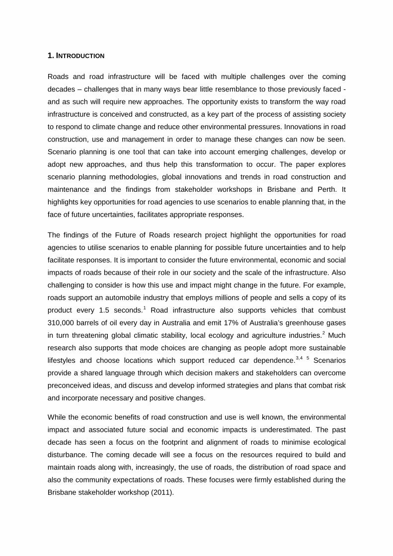
the last two decades. Understanding this, and seeking to inform efforts, Figure 1 shows a
stylistic representation of the changes that are likely to be experienced in transport agencies
in the coming two decades. The figure shows two circles for each division within a typical
transport agency. The unbroken line indicates the baseline and the broken like indicates the
level of additional focus that will be needed in this area in the coming decades. Each of the
three focuses of this project will provide valuable guidance in this process, namely:
highlighting opportunities to reduce carbon intensity of roads, informing efforts to monitor
and report on sustainability performance, and providing a structured approach to
interrogating trends to identify risks and develop strategies.
Figure 1: A stylistic representation of the potential changes in both focus and scope to the form of transport agencies in the coming decades (based on the structure of the Western
Australian and Queensland government)
This paper provides the background necessary for the third component of the ‘Future of
Roads’ project, strategic area three. The project developed and tested a scenario planning
methodology through which a range of scenarios can be created. These can consider the
availability, reliability, appropriateness and cost of existing and emerging options, and the
likelihood of adoption, in the context of various socio-economic and environmental
conditions. The findings highlight the opportunities for road agencies to use scenarios in
planning, given future uncertainties. This report is divided into 3 parts:
1. An overview of scenario planning methodology as applicable to a workshop style
format and to road agencies;
2. An outline of emerging global trends for the future of roads and automobile transport;
and
3. A report of the workshops conducted with stakeholders in Perth and Brisbane in April
2012.
The trend sheets constructed for the stakeholder engagement scenario planning workshops
are also provided in Appendix C.
PART 1: SCENARIO PLANNING METHODOLOGY
1. Introduction: Utilising scenario planning strategies
It is vital to consider the future environmental, economic and social impacts of roads given
their role in our society and the scale of the infrastructure involved, but it can also be very
difficult to do this. In this respect, scenario planning helps. Scenarios are stories of the
future. They are not predictions; rather, they are narratives aimed at developing constructive
thinking about the future. They support informed decision making, enabling analysis of
decisions, the understanding of relationships between issues, and the challenging of cultural
norms and assumptions. They are part art and part science. In the act of developing
scenarios, strategies and plans are created that address risk and incorporate necessary and
positive changes. The availability, reliability and cost of existing and emerging options are
considered, as well as the likelihood of adoption and the appropriateness of each option in
the context of various socio-economic and environmental conditions.
In order to enable scenario development specific to road agencies to occur, various scenario
planning methodologies were explored, and a scenario planning method for the future of
roads was developed. This was then tested in stakeholder and expert workshops conducted
by the research team in April 2012 in Perth and Brisbane (see Part 3), building on the
findings of prior stakeholder workshops in 2011. The workshops enabled the research team
to learn from the experiences of participants, identified a range of challenges for the team to
consider, and generated a strong understanding of how the research can directly support
and enhance industry and government practices and policies. Hence, the workshops were a
valuable opportunity for the research teams to engage with the project partners and experts
in the field so as to ensure that the projects are well informed and guided towards tangible
outcomes.
This discussion paper provides the initial scenario planning discussion for the third
component of the project. It does not focus on scenario modelling research, rather focuses
on scenario methodology that could be accomplished within the time frame and the
limitations of the project and also scenario methodologies that are applicable in a workshop
style framework. Furthermore, this review focuses not on the content of the scenarios but
rather on how they are developed. The primary disciplines investigated include futures
research, resource management and business, and sustainability based methods.
2. Scenario Planning
The process of developing scenarios is as important as the final scenarios themselves, in
that it facilitates active and interdisciplinary learning, and involves the deconstructing of
preconceived ideas about the future, as well as biases and cultural or institutional norms.
The process, therefore, enables positive, practical and proactive strategies to be developed.
Scenarios are stories of the future. They are not predictions. Rather, they are narratives
aimed at developing constructive thinking about the future;6 ‘a means of exploring a variety
of long-range alternatives’.7 ‘[W]hile we cannot know what will be, we can tell plausible and
interesting stories about what could be’.8
The scenario planning methods commonly used today started primarily in the 1970s, with
the Royal Dutch Shell (Shell) organization. Shell was concerned with increasing oil prices
and other uncertainties resulting from the formation of the Organization of Petroleum
Exporting Countries (OPEC) would impact on their business. In order to help reduce some of
the possible risks they developed a scenario plan addressing how they might respond. Thus,
when the oil price did rise in October 1973 Shell was prepared. Shell’s scenario planning
method uses a relatively qualitative technique designed to be conducted in a workshop, to
include various decision makers and to enable them to see beyond their preconceived ideas
of the future. The technique develops a small number of scenarios (usually 2 or 4) from a set
of critical uncertainties or key trends. Many of the current scenario planning methods have
been developed (or built upon) from the Shell’s scenario planning methods.
9
Scenarios need to represent a range of alternatives, not just the best and worst outcomes,
and their reliability is less important than the conversations, learnings and decisions
introduced to the discussions. The common generic types of scenarios are:
Inductive scenarios: These are stories about the future based on the critical
uncertainties developed from discussion and exploration of drivers and trends.
Deductive scenarios: These are scenarios created using two or more critical
uncertainties to structure scenarios.
Incremental scenarios: These are scenarios developed from one ‘official’ future and
two plausible alternatives.
Normative scenarios: These are visioning futures: they are the futures we want to
happen.10,11,12
The process of developing scenarios, usually conducted in a workshop setting lasting one to
three days, is as important as the final scenarios themselves. The process, through active
and interdisciplinary learning, allows for the deconstructing of preconceived ideas about the
future, and of biases and cultural or institutional norms. The process, therefore, enables
positive, practical and proactive strategies to be developed, rather than ‘reactive decision
making’.
13
Scenarios provide support for informed decision making, enabling analysis of decisions, the
understanding of relationships between issues, and the challenging of cultural norms and
assumptions. They enable strategies and plans to develop that combat risk and incorporate
necessary and positive changes. They are part art and part science.14,15
2.1 Uncertainties
Scenarios revolve around driving forces and critical uncertainties. These are the ‘on-going
forces that help to shape the future’ and the acronym STEEP identifies key aspects of
scenarios: social, technological, economic, environmental and political.16 The driving forces
that are most important trends to the focal issue and the most important and uncertain of
these are critical uncertainties. Driving forces can be predetermined, and certain or
uncertain. The critical uncertainties are the key driving forces, used to develop and shape
scenarios that can challenge current thinking and provide insight into how the future might
develop. Critical uncertainties can be weighted or grouped as appropriate to the
development of the scenario.17,18
Critical uncertainties do not have to be catastrophic events, although this is often the case,
with scenarios revolving around risk management or large-scale environmental or economic
disasters. There is a growing trend for scenarios concerned with global futures, particularly
around issues of climate change, population growth and the depletion of natural resources.
These scenarios usually depict alternative futures, offering either pessimistic or hopeful
worlds.
19
3. An Overview of a Scenario Planning Methodology as applicable for the future of roads
Common critical uncertainties, or drivers of change are discussed in section 6
below, including the drivers of change that emerged from the stakeholder workshops.
This project has determined that when developing scenarios on the future of roads, an
organisational situation and as identified through the stakeholder workshops, the scenarios
need to:
1. Provide a snap-shot of the future to guide future planning; and
2. Have a clear audit trail in order to facilitate future planning.
In addition, a scenario planning framework that is useable in a workshop situation is needed.
Therefore, a basic scenario planning framework could be considered to consist of the
following steps:20
1. Background preparation:
a. Conduct interviews with a wide range of stakeholders.

b. Develop an overview of current issues, trends, emerging technologies,
innovations and investments in the field.
c. Identify key issues.
2. Define a scenario question/problem/statement/focal issue.
3. Define a timeframe. (This could be a staged time frame, i.e. ten years, twenty years
and so forth).
4. Determine and discuss current trends. Make sure all participants understand the
trends. From these, determine what is certain (will apply regardless of what the
scenario is), what the driving forces and the critical uncertainties are, and any
relationships between these.
5. Work through the critical uncertainties and develop a basic scenario structure
(sometimes called mini-scenarios) for each scenario. This step can use various
structuring elements or frameworks such as:
a. Various inductive matrix tools, such as the 2x2 matrix;21 or the Millennium
project matrix.22 These can be simple as creating a table and placing the
chosen driving forces down the left-hand side and the columns for scenarios
placed along the top.23
b. Inductive or story telling approaches;
The driving force parameters are then assigned to the
scenarios looking at an appropriate range. This table produces the overall
parameters for the skeletal scenarios;
c. Normative approaches where you work backwards from a future you want to
happen;24
d. Shell’s branches of uncertainties;
25
e. CLA inflection; or
f. Grouping methods (i.e. enabling, unclear, absent and restrictive).
6. Test the scenario structure outcomes against the current trends, making sure the
scenarios are valid, internally consistent, relevant, and different enough from
each other to provoke useful dialogue. Determine whether any of the interactions
in the scenarios can be formalised via a quantitative model, and whether this
would be helpful
7. Develop the scenario details into a coherent story. This step should be done in
groups using the framework as a guide to create a narrative.
8. Construct a powerful title/metaphor for each scenario.
Identify strategies and action plans for each scenario. Determine the possible
strategic opportunities and barriers embedded in each scenario, and develop
action plans. This step looks at how the scenarios can be implemented and
developed, including the implications of each action.
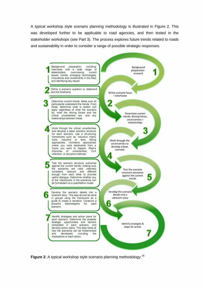
A typical workshop style scenario planning methodology is illustrated in Figure 2. This
was developed further to be applicable to road agencies, and then tested in the
stakeholder workshops (see Part 3). The process explores future trends related to roads
and sustainability in order to consider a range of possible strategic responses.
Figure 2: A typical workshop style scenario planning methodology.26
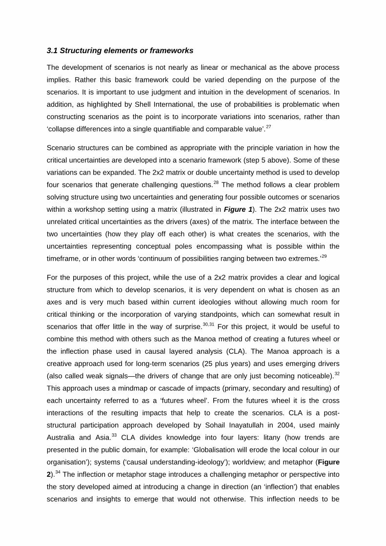
3.1 Structuring elements or frameworks
The development of scenarios is not nearly as linear or mechanical as the above process
implies. Rather this basic framework could be varied depending on the purpose of the
scenarios. It is important to use judgment and intuition in the development of scenarios. In
addition, as highlighted by Shell International, the use of probabilities is problematic when
constructing scenarios as the point is to incorporate variations into scenarios, rather than
‘collapse differences into a single quantifiable and comparable value’.27
Scenario structures can be combined as appropriate with the principle variation in how the
critical uncertainties are developed into a scenario framework (step 5 above). Some of these
variations can be expanded. The 2x2 matrix or double uncertainty method is used to develop
four scenarios that generate challenging questions.
28
Figure 1
The method follows a clear problem
solving structure using two uncertainties and generating four possible outcomes or scenarios
within a workshop setting using a matrix (illustrated in ). The 2x2 matrix uses two
unrelated critical uncertainties as the drivers (axes) of the matrix. The interface between the
two uncertainties (how they play off each other) is what creates the scenarios, with the
uncertainties representing conceptual poles encompassing what is possible within the
timeframe, or in other words ‘continuum of possibilities ranging between two extremes.’29
For the purposes of this project, while the use of a 2x2 matrix provides a clear and logical
structure from which to develop scenarios, it is very dependent on what is chosen as an
axes and is very much based within current ideologies without allowing much room for
critical thinking or the incorporation of varying standpoints, which can somewhat result in
scenarios that offer little in the way of surprise.
30,31 For this project, it would be useful to
combine this method with others such as the Manoa method of creating a futures wheel or
the inflection phase used in causal layered analysis (CLA). The Manoa approach is a
creative approach used for long-term scenarios (25 plus years) and uses emerging drivers
(also called weak signals—the drivers of change that are only just becoming noticeable).32
This approach uses a mindmap or cascade of impacts (primary, secondary and resulting) of
each uncertainty referred to as a ‘futures wheel’. From the futures wheel it is the cross
interactions of the resulting impacts that help to create the scenarios. CLA is a post-
structural participation approach developed by Sohail Inayatullah in 2004, used mainly
Australia and Asia.33
Figure 2
CLA divides knowledge into four layers: litany (how trends are
presented in the public domain, for example: ‘Globalisation will erode the local colour in our
organisation’); systems (‘causal understanding-ideology’); worldview; and metaphor (
).34 The inflection or metaphor stage introduces a challenging metaphor or perspective into
the story developed aimed at introducing a change in direction (an ‘inflection’) that enables
scenarios and insights to emerge that would not otherwise. This inflection needs to be

treated with some caution however so as not to produce scenarios that result in policy and
strategic insights that are hard to determine.
Figure 1: Example of the 2x2 matrix framework. Source: Example compiled and constructed from Global Business Network (2004)
Figure 2: CLA approach to scenario planning. Source: Redrawn and altered from Curry &
Schultz (2009)

3.2 Consistency and plausibility questions
It is important to check the scenarios for consistency and plausibility. This can be done
through asking:
a. Is the scenario relevant?
b. Does the scenario connect directly to the mental maps and concerns of users?
c. Is the scenario internally consistent, and is it perceived as consistent?
d. Are the scenarios archetypal (do they describe different futures, rather than just
variations on the one theme)?
e. Is the period of time for the scenario realistic? (Each scenario should describe an
equilibrium or a state in which the system might exist for some time, rather than a
highly transient state for which companies and organizations cannot prepare.)35
4. Common Drivers of Change used in Scenario Planning
There are common drivers (key trends) of change that emerge in many scenario planning
frameworks that worth consideration in the development of the critical uncertainties for
scenario development within the future of roads.
Some important ones are listed in Figure 5.
Figure 5: CLA approach to scenario planning. Source: Redrawn and altered from Curry &
Schultz (2009)
A key aim of the workshops is to allow the workshop findings to guide the scope and
structure of the SBEnrc project, ensuring that the project would deliver strategic benefits to
stakeholders and partners. This is discussed in the next section.
4.1 Potential drivers for scenario planning on the future of roads from the workshops
The ‘Contribution of Road Areas to the Mitigation of Climate Change’ strategic area
discussed in the stakeholder workshops identifies the opportunity for utilising road areas to
contribute to the mitigation of climate change and strengthening infrastructure resilience.
Potential drivers were determined to be: climate change and resource shortages (including
labour and skill shortages along with resources such as oil and water). The workshops also
identified key considerations for the development of future scenarios for roads and
considered aspects that would be critical for analysing the scenarios. Of particular interest to
the stakeholders was that the scenarios enable them to be able to deal with surprise
(environmentally and financially), to determine the appropriate response, enable them to
develop relationships (collaboration) across stakeholders and disciplines, inspiration,
enabling political frameworks to be respond to events beyond political timeframes, inform
risk identification/management and also illustrate a wider use and function of roads than is
currently considered within road agencies. Key critical topics for the development of
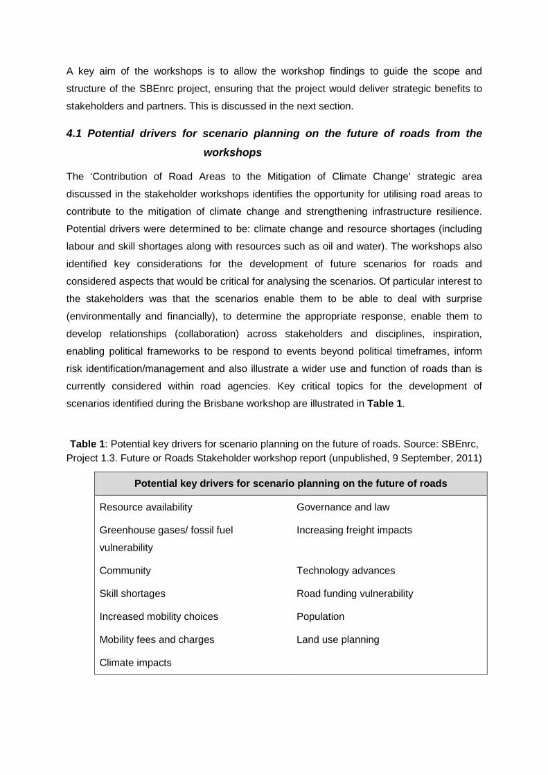
scenarios identified during the Brisbane workshop are illustrated in Table 1.
Table 1: Potential key drivers for scenario planning on the future of roads. Source: SBEnrc, Project 1.3. Future or Roads Stakeholder workshop report (unpublished, 9 September, 2011)
Potential key drivers for scenario planning on the future of roads
Resource availability Governance and law
Greenhouse gases/ fossil fuel
vulnerability
Increasing freight impacts
Community Technology advances
Skill shortages Road funding vulnerability
Increased mobility choices Population
Mobility fees and charges Land use planning
Climate impacts

In addition to the critical topics above, the workshops identified that a key ‘game changer’ is
that in the future the complexity of the whole transport system from road construction to road
use by all modes users will have to be planned comprehensively rather than in competing
objectives between the modes as it currently is. Furthermore, this is important because of
the changing societal expectations regarding mobility and mobility choices.
5. Future Research Needs and Directions
This discussion paper highlights the need for further research on integrating the use of
models within scenario planning. This research has focused on workshop style scenario
planning framework rather than those that use models, however, increasingly the use of
models is being incorporated into the development of scenarios. Modelling is particularly
helpful when looking at scenarios dealing with changes in population and the corresponding
changes in consumption (ecological footprints) and water use. In addition models are often
used in conservation to track the changes of vegetation and when investigating the possible
impacts of climate change, particularly sea level rise. Of particular interest to this project is
the Australian Stocks and Flows Framework (ASFF) modelling platform, which is an
interactive model looking at physical economies developed by CSIRO and ‘Whatif?
Technologies’. This is a growing area of research and requires integration with most
scenario planning literature focusing solely on creating qualitative narratives rather than on
quantitative modelling. This is a growing area of scenario planning.36
In addition the use of Collective Intelligence (CI) is an emerging field. CI creates intelligence
from synergies between data, information and software/hardware. It continually learns from
feedback and produces just-in-time knowledge. An example of CI would be Wikipedia. CI is
being explored by the Millennium Project, and possibly could create synergies in developing
scenarios.
6. Conclusion
Scenarios provide a shared language in which decision makers and stakeholders can
develop and discuss strategies for the future. They are not predictions. The scenario
planning method described here aims to provide a basis for a framework for the
development of an ‘Innovative Scenarios for Sustainable Road Infrastructure’ (ISSRI)
scenario planning methodology. Furthermore, the discussion outlines possible key drivers of
change and critical uncertainties from which scenarios on the future of roads can be
developed in order to facilitate adaptation and mitigation of climate change.
PART 2: EMERGING GLOBAL TRENDS FOR THE FUTURE OF ROADS AND AUTOMOBILE
TRANSPORT
1. Introduction: What are the emerging global trends?
There are a number of global trends emerging that will have an impact on road use,
construction, maintenance and distribution of space. Australian cities are facing increasing
pressure from climate change, population growth, infrastructure constraints, significant
changes to weather patterns, increases in energy and resource prices, resource shortages
and changing use and expectations of roads. Of particular importance are changing
community expectations regarding road space allocations and mode use. Car ownership is
declining and there is a growing shift towards more sustainable lifestyles and higher density
living in Australian and U.S. cities. Public transport use is rising. However, although car
ownership is declining, transport infrastructure as a whole (for both transit and roads) in
Australia is reaching capacity. Resources, particularly oil, but also water and aggregates, are
decreasing. These issues raise some interesting questions when looking at the future of
roads. . Global trends impacting on road infrastructure, use, maintenance and operation are
explored, looking first at general global trends and then at some specific trends impacting on
roads.
The Intergovernmental Panel on Climate Change (IPCC) Assessment Report concludes that
the ‘warming of the climate system is unequivocal’.37 The financial implications of the
impacts of this warming are significant. The average land temperature in Australia has risen
by 0.9°C since 1950. Average global temperatures will increase between 1.1 and 6.4°C by
210038 with Australia’s temperatures projected to increase by between 0.4°C and 2.0°C
above 1990 levels by 2030 and 1 to 6°C by 2070.39 These increases are causing the
established weather patterns to change and extreme weather events, such as flooding,
storm surges, droughts and heat waves, to become more common. Australian cities may be
affected more by tropical cyclones, heat waves and extreme precipitation that would degrade
infrastructure and have public health implications. Inland areas are expected to warm faster
than the global average, while coastal areas would warm at around the global average. This
warming will result in more extreme heat events, with the average number of days in which
the temperature exceeds 35°C expected to increase by 10 to 100% by 2030.40 Changes in
average precipitation are also expected to result in more extremes, with areas in which
rainfall increases are expected seeing more extremely wet years, and those in which the
rainfall is likely to decrease seeing more droughts. A further decline in average precipitation
in southwest and southeast Australia is predicted, with increases in precipitation in the
northwest. Sea level rise of between 8 and 88 centimetres along Australia’s coastlines,
where all the major cities are, is also predicted.41
Many natural resources are becoming constrained or negatively impacted by human
activities. Roads require a large amount of resources, particularly aggregates and water. A
typical two-lane bitumen road with an aggregate base can require up to 25,000 tonnes of
material per kilometre (km), but these resources are becoming scarcer with a major shortage
of quarry products. Water resources are also becoming difficult to utilise as Australia has
been experiencing droughts and increasing salinity in ground water and stricter regulations
on water use.
These changes indicate that extremes will
become more frequent and more severe resulting in more extreme weather events and have
significant implications for the future of road construction, maintenance and use.
Road construction also uses a lot of energy, much of which is derived from oil oil, which is
becoming increasingly scarce and expensive. There has been much debate about when the
geological peak of oil will happen, however in economic terms the peak occurred in 2005
when the production of conventional oil (cheap oil which can be produced under about
$65/bbl) peaked. The oil production of the five major oil companies peaked in their oil
production in 2005 and has gone down since. The production of unconventional oil (deep
water, remote and shale) is increasing, but this is very inefficient and expensive.
Furthermore many of the oil resources are located in conflict zones.
Much research indicates that mode choices are changing as people adopt more sustainable
lifestyles and choose locations that reduce car dependence.42,43,44 Thus levels of walking,
bicycling and public transport use are increasing, while kilometres travelled by private
vehicles are decreasing This is due to a number of factors including the negative impacts of
urban sprawl and traffic, particularly the environmental and social impacts, along with
negative impacts on human health, the rising cost of petrol, the adoption of sustainability or
‘green’ values, and a marked cultural shift of people moving to more urban locations. The car
fleet in the U.S. has peaked, with plunging car sales exacerbated by economic contraction.
Australia is following this trend, with public transport usage and cycling usage increases and
the use of private vehicles decreasing. From “2001 to 2009, the average annual number of
vehicle-miles travelled by young people (16 to 34 year olds) decreased from 10,300 miles to
7900 miles per capita – a drop of 23 per cent.”45 In the U.S. this trend is even more
pronounced with, “young people (16- to 34-year-olds) who lived in households with annual
incomes of over $70,000 increas[ing] their use of public transit by 100 per cent, biking by
122 per cent, and walking by 37%” from 2001 to 2009.46 The global cities data show that in
ten major U.S. cities from 1995 to 2005 transit boardings grew 12% from 60 to 67 per capita,
five Canadian cities grew 8% from 140 to 151, four Australian capital cities rose 6% from 90
to 96 boardings per capita, while four major European cities grew from 380 to 447 boardings
per capita or 18%.47
In addition to changing transportation use and requirements are planning programs based
on the idea of compactness. Compactness is a widely accepted planning policy in Europe
and is increasingly being implemented in an Australian and U.S. planning context.
In Perth the rail patronage grew from seven million passengers per year
to 60 million passengers per year. Furthermore, for the first time in history, the Australian
Federal Government funded more urban rail than roads. It is predicted that this trend will
continue.
48 A tighter
(or fine) urban grain enables cities to maintain continuity within a small area and be easily
accessible on foot and by bicycle. A sustainable city needs to be compact49 and
compactness has been shown to influence travel choices and to result in greenhouse gas
emission reductions more than sprawling cities.50,51
Furthermore, transport planning is becoming increasingly integrated and holistic and taking
into account social, economic and environmental drivers and outcomes. This can been seen
recent planning processes in relation to Hoddle Street in Melbourne and the South Road
Planning Strategy in Adelaide. Such processes are becoming mandatory as part of large
infrastructure projects, and are recommended by Infrastructure Australia and COAG. They
require that the wider impacts – particularly community impacts – of projects be considered,
including land development opportunities and needs, and the balancing of social, economic
and environmental needs.
All major metropolitan urban plans in
Australia have set targets of between 40 and 70% of residential development to be built in
developed areas (infill development) and around existing infrastructure. In the Perth
Metropolitan region 47% of development needs to be in existing urban areas. These plans
require compact urban development in appropriate locations, for example, close to public
transport, along urban corridors and near existing retail and employment centres. As a result
of these plans, as well as changing residential needs and lifestyle choices, densities are
increasing in Australia. As this occurs and road use declines, roads will be used for different
purposes, posing a challenge for road management.
In 2010, the Organisation for Economic Co-operation and Development’s Economic Survey
reported that Australia is suffering from an ‘infrastructure deficit’.52 Growing population and
lack of spending of transportation infrastructure have led to increased congestion on roads
and on rail lines. Public transport use has grown rapidly in recent years, as discussed above,
and is reaching capacity limits in most major cities, especially during peak hours.
Furthermore rail freight has also reached capacity. A recent Royal Automobile Club (RAC)
survey reported that in the last year 43,000 more cars came onto Western Australian roads
with 400,000 more cars are expected to be added to the Perth roads over next 10 years.53
Currently, during peak hours, drivers in WA are often delayed 45 seconds for every kilometre
they have to travel, Sydney residents add a minute to every kilometre (Association of
Australian and New Zealand road traffic and transport authorities). Yet our cities have limited
space in which to build bigger roads able to cope with increased growth and Australian cities
lack complete transit networks particularly in the outer areas. This trend has huge impacts
on the economy. The RAC report found that 70% of businesses surveyed found that road
congestion was adding to their business costs and was impacting on staff punctuality.
Furthermore one in five business owners said they can't take on more work because of
traffic gridlocks. The Bureau of Infrastructure, Transport and Regional Economics, in 2007
reported various costs of urban road congestion with some projections of up to $20 billion
per annum by 2020.54
The Australian road network spans a wide variety of geographic areas and according to the
Bureau of Infrastructure, Transport and Regional Economics (BITRE) it extends a distance
of 814,000 kms. Road maintenance costs are estimated to be $5 billion per year. However
these costs are expected to increase by over 30% by 2100. The climate change impacts of
hotter temperatures and changes in rainfall (both making some places in Australia wetter
and some places drier) will increase the cost of road maintenance, both by making road
maintenance harder to accomplish due to extreme weather and likely material and skill
shortages, and making it more necessary. A wetter climate will lead to a higher rate of
pavement deterioration, while higher average temperatures will increase the loss of volatiles
from bitumen, causing roads to lose elasticity, become brittle and have a shorter service life.
Increased temperatures will also accelerate the deterioration of seal binders and require
earlier surface dressings. Higher water tables will accelerate the rate of pavement
deterioration as capillary action will increase the moisture content of pavements. This means
roads will have to be thicker and have additional measures to cope with increased moisture.
However, material costs are rising, and if road surfaces are not suited to the future climate,
they will need more and more maintenance and cost more money.
Furthermore there are costs associated growing obesity related to
increased time spent commuting.
Freight is expected to increase rapidly, with some reports of a trebling of freight by 2050.
The freight task in Australia’s eight capital cities is expected to grow by 50-70% between the
years 2003 and 2020, with 60% of freight being moved by trucks rather than trains.
Furthermore, freight vehicles are becoming bigger and bigger. This has implications both for
space and also for road construction, maintenance and longevity. Freight transport already
accounts for 4% of Australia’s national emissions, and this is expected to increase to 13.5%
by 2020.
At a community level there is a growing trend more towards consuming less and sharing
more, primarily through the internet. Botsman and Rogers describe it as ‘collaborative
consumption’—the sharing of assets, both goods and knowledge, through the use of real-
time network technologies, such as Facebook, Twitter, or the trading or selling of goods over
the internet. In their word, “(w)here the 20th century was about hyper consumption, the 21st
century is about collaborative consumption…We have moved from the age of ownership to
the age of access…We are going back to old behaviour, reinvented for the Facebook age.
We are sharing, trading, swapping – all through social media.”55
However, there is a key opportunity for road designers to contribute to climate change
mitigation efforts through the use of innovative design and technologies and also reduce the
resource requirements.
They cite a survey
indicating that 75% of young people would rather own a smart phone than a car.
2. What are the emerging global trends that will impact on roads and on automobile transport?
This report looks at some of the emerging global trends that will impact the future of roads
and on automobile transport in cities. The report is structured around trends in various
themes:
• Road construction innovations:
o Repurposing Waste: Roads as Repositories for industrial, municipal and
agricultural waste; Roads constructed from plastic.
o Roads as repositories for carbon.
o Reducing carbon emissions.
• Generation of Renewable Energy:
o Solar roadways.
o The charging of electric vehicles through magnetic energy.
o Motion power.
o Electrokinetic generators.
o Piezoelectric material.
• Changes in vehicles and fuel use:
o Renewable transport (electric vehicles and smart electricity grids).
• Improving the efficiency of existing road infrastructure:
o Behaviour change.
o Technology innovations to improve efficiency of existing road infrastructure.
o Managed lanes and carpooling.
o Road pricing.
o Car restrictions through vehicle licensing.
o Bus Rapid transit.
• Sustainable streets and reclaiming public space:
o Shared streets
o Dismantling freeways
• Freight alternatives
3. Road construction innovations
Roads require a large amount of resources, particularly aggregates and water. A typical two-
lane bitumen road with an aggregate base can require up to 25,000 tonnes of material per
km. Road construction also uses a lot of energy, much of which is derived from oil. However,
there is a key opportunity for road designers to contribute to climate change mitigation efforts
through the use of innovative design and technologies and also to reduce resource
requirements.56
3.1 Repurposing waste: Roads as repositories for industrial, municipal and agricultural waste
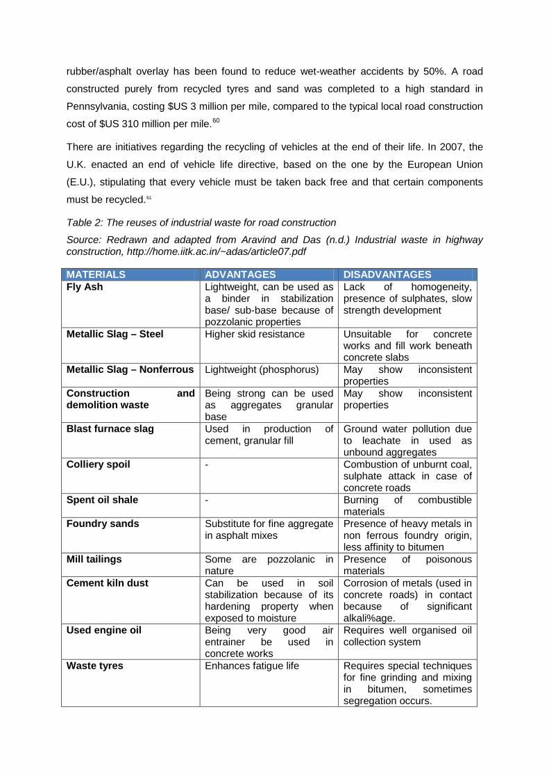
Road construction uses large amounts of quarried aggregates, however there is potential to
repurposed industrial, municipal and agricultural wastes, such as glass, steel, tyres and
plastics for the use as a secondary material in road construction. This process would reduce
the amount of virgin materials needed for road construction and decrease the amount of
waste needed to be disposed of. Recycled materials have generally been used in the lower
course material, but many countries are faced more with repair and maintenance work than
with the construction of new roads, and therefore the use of recycled materials in the surface
layers is an area that needs further exploration. Examples of this include the reuse of plastic
for road construction in India. The reuses of industrial waste for road construction was
investigated by Aravind and Das57 Table 2 and presented in . A United Kingdom (U.K.) study
determined that asphalt pavements containing 10-15% crushed glass in the surface course
mixture performed satisfactorily.58 Tyre rubber has also been used in asphalt mixtures to
reduce cracking, improve durability and mitigate noise.59 The use of tyres to create a 50 mm
rubber/asphalt overlay has been found to reduce wet-weather accidents by 50%. A road
constructed purely from recycled tyres and sand was completed to a high standard in
Pennsylvania, costing $US 3 million per mile, compared to the typical local road construction
cost of $US 310 million per mile.60
There are initiatives regarding the recycling of vehicles at the end of their life. In 2007, the
U.K. enacted an end of vehicle life directive, based on the one by the European Union
(E.U.), stipulating that every vehicle must be taken back free and that certain components
must be recycled.
61
Table 2: The reuses of industrial waste for road construction
Source: Redrawn and adapted from Aravind and Das (n.d.) Industrial waste in highway construction, http://home.iitk.ac.in/~adas/article07.pdf
MATERIALS ADVANTAGES DISADVANTAGES Fly Ash Lightweight, can be used as
a binder in stabilization base/ sub-base because of pozzolanic properties
Lack of homogeneity, presence of sulphates, slow strength development
Metallic Slag – Steel Higher skid resistance Unsuitable for concrete works and fill work beneath concrete slabs
Metallic Slag – Nonferrous Lightweight (phosphorus) May show inconsistent properties
Construction and demolition waste
Being strong can be used as aggregates granular base
May show inconsistent properties
Blast furnace slag Used in production of cement, granular fill
Ground water pollution due to leachate in used as unbound aggregates
Colliery spoil - Combustion of unburnt coal, sulphate attack in case of concrete roads
Spent oil shale - Burning of combustible materials
Foundry sands Substitute for fine aggregate in asphalt mixes
Presence of heavy metals in non ferrous foundry origin, less affinity to bitumen
Mill tailings Some are pozzolanic in nature
Presence of poisonous materials
Cement kiln dust Can be used in soil stabilization because of its hardening property when exposed to moisture
Corrosion of metals (used in concrete roads) in contact because of significant alkali%age.
Used engine oil Being very good air entrainer be used in concrete works
Requires well organised oil collection system
Waste tyres Enhances fatigue life Requires special techniques for fine grinding and mixing in bitumen, sometimes segregation occurs.

3.2 Repurposing waste: Plastic roads in India
In India, K.K. Plastic Waste Management has been building roads made out of recycled
plastic waste.62 In November 2009 they had built approximately 1,200 kms of roads,
primarily in the Bangalore region. The company create a compound called polymerized
bitumen by mixing the plastic with asphalt, and have found that although the material costs
about 3% more than traditional asphalt, the roads increase in longevity. The Chennai
Corporation plans to lay 371 kms of roads within Chennai with thin plastics mixed with
bitumen in order to increase the lifespan of the roads and to also help the city dispose of
plastic waste, however the project is now experiencing a plastic shortage.63
The National Rural Roads Development Agency (NRRDA) has formulated guidelines for the
use of plastic waste in rural roads construction, and in conjunction with Bangalore University
and the Council of Scientific and Industrial Research’s (CSIR) Central Road Research
Institute (CRRI),
The project is
estimated cost 110 crore.
64 they have constructed trails of plastic roads, finding that the ‘plastic roads’
have increased strength, are more water resistant, decrease the amount of bitumen needed,
increase the longevity of the road and reduce the amount of maintenance needed.65
3.3 Repositories for carbon in an aggregate
There is much discussion about roads acting as repositories for carbon in an aggregate
however there is not much reputable information available. Biochar is charcoalised woody
biomass is used as a soil improver, however its potential to be a storage for carbon in the
soil is being investigated.
3.4 Reducing and offsetting carbon
VicRoads undertook the first carbon neutral road construction project by a state road
agency, trialling the process on the Mickleham road duplication.66 To do this they calculated
the carbon footprint, looking at the GHG emissions generated during on-site electricity
production, fuel used during construction and transport of materials to the site and the
embodied carbon in the materials. From the footprinting exercise they determined that the
road created 1,751 tonnes of CO2-e, equating to 730 tonnes CO2-e per km of road built. 97%
of this carbon footprint came from the embodied carbon in the materials, particularly from the
use of concrete, cemented treated crushed rock and aggregate, and in the on-site
transportation. To off-set the road construction emissions, VicRoads sourced carbon credits
from an accredited offset provider, planting around 7,463 trees in the north west of Victoria.67
4. Generation of renewable energy
The ability of roads to produce electricity is currently being investigated. Research has been
conducted into using roads to produce solar energy, and also to implement road
infrastructure able to produce electricity from the motion created by road use, looking at
wireless magnetic recharging systems for electric vehicles, motion power which harnesses
the excess vehicle energy created when cars decelerate, articulated plates, capturing wind
created by vehicles as they move past a spot and piezoelectric crystals which could produce
electricity from the weight of vehicles. Many of these technologies are still in the testing
phase.
4.1 Solar roadways
Roads have the potential to produce solar energy by capturing heat, similar to solar hot
water systems. One of the current solutions RES® (Road Energy Systems) is a heat
exchanger that incorporates tubes in the asphalt pavement.68
Many roadways worldwide are being retrofitted with solar panels being used to produce
electricity to run the street lighting. The Oregon ‘Solar Highway’, implemented in 2009, has a
104 kilowatt (dc) ground-mounted solar array of 594 solar panels, offsetting about a third of
the energy needed for lighting.
This is known as an ‘asphalt
collector’ and has been used in The Netherlands. The technology has the potential to
transfer heat from the road surface making the road cooler in summer and warmer in winter,
making the application in areas with snow and ice a real possibility. Furthermore the
application of RES® has been found to result in reduced CO2 emissions and has been
successfully applied in The Netherlands, Belgium and Scotland.
69
4.2 Charging electric vehicles through magnetic energy
Roads also have the potential to be able to recharge electric vehicles whilst they are in
motion, from a strip embedded into the road surface. A Germany company, IAV, has
patented technology that would allow electric vehicles to be recharged wirelessly using
recessed electrical conductors that generate a magnetic field and are embedded into the
road surface and activated when an electric vehicle is detected.70 Evatra has developed
Plugless Power, a wireless charging system for electric vehicles embedded in a parking
spot. The vehicle parks over the pad which communicates with the vehicle using a SAE
J1772 protocol used in corded systems and automatically charges.71 The Plugless Power
wireless charging system is being tested by Duke Energy, Google, Clemson University and
Hertz Rent A Car amongst others with the product to be sold later this year. Similar
technology is being investigated by Stanford University and MIT in the US.
4.3 Motion power
Motion power is the harnessing of excess vehicle energy created when cars decelerate. New
Energy Technologies, Inc. is developing MotionPower™ technologies which are able to
harness this kinetic energy and convert it to sustainable power.72
4.4 Electrokinetic generators
These technologies get
installed in areas where the vehicle traffic must slow down, such as at traffic lights and
intersections. This is still very much in the testing phase.
Electrokinetic generators are articulated plates that can be places in the road surface that
generate energy when driven over through the up and down motion. These ramps are
capable of generating between 1-50 kW.
4.5 Wind energy
There has been much investigation into producing wind energy along the side of freeways,
utilizing the wind produced by vehicle movement. TAK Studio created a Turbine Light which
produces energy used to power lighting by the wind of vehicles moving past.73 A wind
turbine able to be fit onto highway billboards was developed by Arizona State University also
utilizing the wind created by passing cars.74
4.6 Piezoelectric material
Neither of these inventions have been
implemented, however they show potential and also innovation regarding the use of road
space.
Piezoelectric crystals could be used to absorb heavy traffic and to convert a 1 kilometre
stretch of highway into a 400 kW power plant. Piezoelectric materials, crystals and ceramics,
convert mechanical energy exerted by the weight of vehicles into electrical energy, with the
potential to generate 400 kW per 1 km or road. Tests of a piezoelectric generator are being
undertaken at the Hefer intersection on Route 4 in Israel. The test consisted of a 10m strip of
asphalt with generators installed underneath and a battery able to generate 2,000 watt-hours
of electricity.75
5. Changes in vehicles and fuel
Vehicles are increasingly being powered by alternative fuels and electricity. Plug-in Hybrid
Electric Vehicles (PHEVs), Battery Electric Vehicles and vehicles that run on alternative fuels
such as hydrogen or on electricity created through solar panels embedded into the structure
of the vehicle. Companies are looking into producing cars that can run on compressed air
and planes, trains and cars that run on solar electricity.
Indian company Zero Pollution Motors released a vehicle powered by compressed air and
able to run of speeds of 96 mph. Tata Motors, India’s biggest automobile manufacturer, is
gearing up to release a car that runs on compressed air, called the MiniCat. The car will be a
lightweight, fiberglass bodied, six-seater mini-van which uses compressed air stored in tanks
that push the engine’s pistons and create movement and will be able to run for 125 miles
and have a top speed of 68 mph.76
New developments in charging for electric vehicles are becoming more common, from more
advanced batteries to fast charging stations, wireless charging stations and charging strips
embedded in the road that are able to charge your electric car wirelessly while you drive.
Highway 101 between San Francisco and Los Angeles in California has been retrofitted as a
charging corridor with 5 electric charging stations, owned by SolarCity, enabling electric car
drivers to travel between the two major cities.
Electric solar panel planes are being trialled. The E430 electric plane created by Yuneec
International, weighs 2000 pounds, seats two and is powered by lithium polymer batteries.
The Solar Impulse, from Switzerland, is fitted with solar panels.
Many cars have been fitted with solar-panels, from smaller installations such as those in the
Toyota Prius which help to regulate the temperature inside the car, thus reducing air-
conditioning needs, to larger vehicles, many of which are in the testing phase.
5.1 Renewable transport
‘Renewable Transport’ refers to a new collection of technologies based on ’vehicle to grid’
(V2G) and plug-in hybrid electric vehicles (PHEV’s).77 V2G uses the electrical storage
capacity of PHEVs linked to a smart electricity grid to enable a larger amount of renewable
energy into the electricity network. V2G systems demonstration projects have been put in
place in Chicago and Kyoto.78
6. Improving the efficiency of existing roads
Australia has approximately 814,000 kilometres of road network, covering a wide variety of
geographic areas. Many urban roads are struggling to cope with increased traffic, and it is
therefore imperative to investigate how existing infrastructure can be made more efficient .
Some of the ways include behaviour change, technology such as innovative congestion
charging or traffic signaling devices, managed lanes and vehicle licencing measures, and
the prioritising of road infrastructure for public transport such as buses.
6.1 Behaviour change
Behaviour change has big potential, alongside technological innovation, to improve the
efficiency of existing roads.79 The capacity of existing infrastructure is being reached as
motor vehicles and congestion increase. Chapman estimates that for 40% of journeys a
viable alternative to car travel already exists and that with modest improvements a further
40% of journeys could be switched to a different mode. Complementing this is the growing
cultural shift towards more sustainable urban lifestyles and a reduction in car use in
developed countries.80,81,82 Chapman maintains that ultimately the number of cars on the
road need to be reduced.83
6.2 Technology innovations to improve efficiency of existing road infrastructure
Policies aimed at behaviour change have increasingly been
implemented, including such programs as TravelSmart, parking restriction policies(for
example, Copenhagen’s policy of reducing parking spaces by 2-3% per year in the city
centre), as well as congestion charges as in London, Singapore, Stockholm and recently
Milan.
Various technological innovations to improve the efficiency of existing road infrastructure are
being implemented and investigated. Some of these include traffic flow streaming (contra-
flows), and innovative congestion or road user charging. The Austrian Institute of Economic
Research looked at various measures at reducing CO2 emissions from road transport
determining that road pricing as the most effective.84
One innovative technology is driverless equipment for private vehicles which will potentially
be seen on roads by 2018.
85 Part of the efficiency improvements seen from driverless
vehicles are that the cars can operate closer together than human driven cars adding to the
capacity of roads. This technology was demonstrated in 1997 in California with eight
driverless cars successfully operated just one car length apart at 65 miles per hour and
again in 2007, when six driverless cars negotiated the Defense Advanced Research Projects
Agency Urban Challenge.86 As GIS technology improves, it can be utilized to keep the cars
in the require position, with reports of up to two centimetres in accuracy.87 Google was just
granted the first licence for a driverless vehicle by the State of Nevada in the US, enabling
the vehicle, a Toyota Prius, to be tested on public streets.88
The Terrafugia Transition was exhibited at the New York International Auto Show in April. It
is a two-seater airplane with foldable wings able to drive on any road surface. The vehicle is
currently in the testing phase, however, the company has had reservations on over 100
aircrafts with deliveries expected to begin next year. When the wings are folded the vehicle
is able to be parked in a standard parking space and/or a standard garage. Under the U.S.
regulatory system the Terrafugia Transition will require a Sport Pilot license in order to fly
and the company is pursuing regulation for the vehicle as a ‘Light Sport Aircraft’ and a
‘Multipurpose Passenger Vehicle’. The status outside of the US has not been confirmed.89
6.3 Traffic signalling to manage congestion
Increasingly freeways and highways worldwide are implementing coordinated ramp
metering, sometimes called ‘stop and go’ systems, which spreads the flow of vehicles
entering the freeway. These systems are very common in Southern California and have
been implemented in Victoria, Australia.
6.4 Managed lanes
Managing lanes enables existing road infrastructure to be used in a more effective manner.
This can be done through lanes used only for high occupancy vehicles, management traffic
direction through movable barriers or direction reversible roads and contra-flow systems.
Managing the occupancy of lanes has been very popular in the United States with high
occupancy vehicle (HOV) lanes (also known as T2/T3 lanes) that require vehicles traveling
in the lane to have a certain occupancy, usually one or two passengers. There are over 2119
miles of HOV lanes currently in the United States, however, data from the US 2000 Census
shows these lanes to be generally ineffective, and the lanes to be underused. Analysis of the
2001 National Household Travel Survey data illustrated that the majority of trips undertaken
in the HOV lanes were by families using the lanes for discretionary activity purposes.90 High
Occupancy Toll (HOT) lanes have been proposed as a viable alternative to the HOV lanes
and are lanes open to either high occupancy vehicles and to people that pay to use them.
The price of entering these lanes is usually adjusted depending on the congestion levels.
This aims to keep the lanes at an ‘optimum flow’ level.91 HOT lanes are often seen as a
precursor to implementing congestion zones, such as in London, Singapore and Milan.92
HOT managed lanes were implemented on the Katy Freeway in Houston93
Changing the direction of lanes through moveable barriers, where extreme one-direction
peak hour traffic flows occur, is a solution that has been used on many roads in the US. For
example, on the Golden Gate Bridge in San Francisco the two center lanes are southbound
during the morning rush hour and northbound during the evening rush hour, changed
through the use of vertical yellow markers placed manually in openings in the roadway. The
and the
possibility of implementing congestion charging through Global Positioning Systems (GPS)
or Closed Circuit Television (CCTV) is being looked at in Victoria, Australia.
Sydney Harbour Bridge in Sydney, New South Wales, uses a similar system reversing three
of its eight lanes daily at rush hour, as does Flagstaff Road in Adelaide, South Australia,
which has a reversible centre lane. This solution enables changing traffic flows to be
accommodated simply by reconfiguring the existing road system.
The whole Southern Expressway in Adelaide is a one-way reversible road. This 21 kilometre
expressway takes traffic into the city centre in the morning and then changes direction in the
evening to enable traffic to leave the city. . A similar road operates in Brazil: a 58.5 kilometre
road comprising four lanes, each of which can be reversed. Adelaide has also been
operating a temporary single-lane contra-flow system on Festival Drive loop road while
construction proceeds on the Adelaide Convention Centre.
6.5 Pricing congestion
There are numerous ways to implement congestion charges. Cordon charging is the most
common, and involves charging drivers to enter or leave a designated zone, usually the city
centre, during specific times This was implemented in Singapore in 1975, Bergen in 1986,
Oslo in 1990 and Trondheim in 1991, followed by schemes in London in 2003, Stockholm in
2007 and Milan in January 2012.94
Along with city wide congestion pricing, cities are looking into other possible pricing systems
to help relieve congestion, with much interest in a distance based charge. The Netherlands
has recently deferred a proposal to put a distance charge on all vehicles throughout the
country. The price per kilometre would vary depending on the vehicle, but the charge agreed
to by the Dutch Cabinet in 2008 averaged €0.03 per kilometre that year, with a planned
increase to €0.07 in 2017.
In London’s first year of congestion charging the number
of private cars entering the centre dropped by 34% and the number of buses increased 22%
and cyclists 28%. Drivers pre-pay a fee and failure to do so incurs a fine. Milan’s scheme,
which replaced the Ecopass pollution charge, consists of a flat fee of €5 regardless of
vehicle type and excludes electric vehicles, service vehicles, buses and taxis.
95 A Vehicle Miles Travelled (VMT) tax is being discussed in the
U.S., with proponents saying the charging system is a long term solution to help with
congestion and also to raise funds to fix the aging infrastructure.96
San Francisco has implemented demand-responsive vehicle parking fees in pilot areas to
reduce congestion from vehicles driving around to obtain parking and from double-parking.
The parking fees vary by block, time of day and day of week. The parking fees vary by block,
time of day and day of week. In areas of parking congestion rates increase until the
congestion eases, varying from $US0.25 an hour to $US6.00.
97 In addition, San Francisco
and the surround counties have made public transport free on days when extreme smog is
expected.98
6.6 Car restrictions through vehicle licensing
Car restrictions through vehicle licensing or licence plate numbers has been implemented in
numerous cities, including Sao Paulo, Brazil, ‘pico y placa’ in Bogota, Colombia, and in
Manila, The Philippines. Most of these programs operate by restricting vehicle use on certain
days depending on the last digit of the licence plate. Sao Paulo uses this licence plate
system to assign a day of the week when a vehicle cannot be used during rush hour.
6.7 Bus rapid transit lanes
Bus rapid transit (BRT) systems are becoming increasingly popular particularly in countries
with budget constraints, following the successful example of the system of Curitiba. , with
segregated lanes, and stations with pre-boarding fare collection to enable rapid boarding
and alighting. 99 BRT systems have great potential to reduce CO2 emissions. BRT systems
have great potential to reduce CO2 emissions.100
7. Sustainable streets and reclaiming public space
Globally there is a move towards reclaiming space that was for cars and car parking and to
turn this space into spaces for people.101,102 This process can be seen in the
pedestrianisation of city centres, the implementation of bicycle ways and in the reduction of
parking. Copenhagen in a global context is probably the most famous for following this
transport and land use planning trajectory,103 along with Melbourne and now Sydney in an
Australian context.104 This change is based on the realisation that city space is limited, and
planning decisions must reflect how we want to use that space. For example, inn Paris, 70%
of public space is devoted to traffic, of which 42% is for parking, and only 30% to
pedestrians.105
The vibrancy and economic benefits of walkable city centres are now well recognised.
106 The
changes in Copenhagen, including the turning of 22 parking lots and many central streets
into public spaces, show how the gradual expansion of public spaces dramatically increases
people’s use of city centres, leading to increased commercial activity..107 Furthermore, the
City of Copenhagen calculated that every kilometre cycled effectively yields the City
$U.S0.25 in health or road maintenance savings, whereas every kilometre driven costs the
City $U.S0.16..108
The biggest current example of a city implementing sustainable streets and reclaiming public
space is New York. The New York City Department of Transport (NYDOT) is using road
capacity more efficiently and cleanly, rapidly implementing changes to the street network,
the public realm and to the walking and cycling environment. The most visible changes
include new plazas at Times Square, Herald Square, Union Square and Madison Square,

the redevelopment of Broadway into a ‘Boulevard’, the introduction of a ‘Summer Streets’
programme.109,110,111 The summer streets programme aims to change how people use the
streets. The programme closes a number of streets during Saturdays in summer,
encouraging people to enjoy the streets, and implemented programmes such as dancing in
the street and ‘pop-up’ swimming/wading pools. In addition, the City and NYDOT have been
rapidly implementing cycle paths throughout the city, with over 200 miles (321.8 kilometres)
of cycle paths being added between June 2007 and November 2009, including protected
cycle lanes along Broadway and 8th and 9th Avenues. Part of these changes have also
included footpath extensions and many new seats throughout the city. Many of the changes
involved quick and simple infrastructure changes, such as repainting road surfaces and
separating car traffic and walking/staying spaces with bollards, planting boxes and fold-out
chairs, enabling changes to be tested for effectiveness and changed if necessary.112
On May 23rd, 2009, Broadway was closed to through traffic at Times Square and Herald
Square between 47th and 42nd Streets as an experiment. The trial closure was made
permanent in February 2010 after follow-up surveys showed “an overall seven%
improvement in traffic flow”,
113 with northbound taxi trips in West Midtown (as tracked by
their GPS units) 17% faster after the Broadway shutdown (comparing Fall 2009 to Fall
2008).114,115 The closure has shown an economic benefit, with 71% of businesses in Times
Square projecting revenue increases after the closure.116 The City is still surveying the
changes; however, some early results are dramatic. The above squares now accomodate
100,000 pedestrians a day and have created 11 times more space for “people activities”
within the city.117 Pedestrian injuries are also down in the project areas by 35% and 80%
fewer pedestrians walk in the roadway in Times Square.118,119 Between June 2007 and
November 2009, cycling to work doubled in New York, with commuter cycling increasing by
35% between 2007 and 2008.120
In an Australian context, the City of Melbourne have been doing the most along these lines
to implement a more stainable and people-focused city centre.
121 Since 1993, Danish
Architect and Urban Designer Jan Gehl (who also worked on the New York changes above),
along with the City of Melbourne, have been monitoring the results of incremental changes
to the public realm and people-first planning policies. The city has experienced a dramatic
growth in the number of city centre residents—from 1008 in 1992 to approximately 9,375 in
2002; an increase in pedestrian traffic of 98% on weekday evenings and 39% increase in
daytime pedestran traffic; an increase in public space by 71% via creation of new squares,
promenades and parks; and have revitalised their network of lanes and arcades.122
Furthermore, the City of Melbourne has taken a number of steps to restore and strengthen
the city’s traditional grid pattern, including activating mid-block alleys as pedestrian spaces.
The City of Melbourne has placed a 40-metre height limit on its core, ensuring that the city’s
public spaces receive adequate sunlight and has established policies to encourage mixed
use development, especially small business uses, outdoor cafés and restaurants, and to
encourage buildings to appropriately and openly connect with public spaces, and the
planting of many trees along the footpaths. Beatley and Newman contend that Melbourne
has emerged as “a remarkable case study in an emerging pedestrian city, having shown
some dramatic, positive change in its pedestrian character and public sphere in the relatively
short span of twenty years”.123
From all the public space changes Melbourne has become a ‘brand’. It is consistently named
in the top great cities of the world but not many people can say why it is famous. Now it is
famous for the experience of place and celebration of urban culture.
124 Gehl, in a StreetFilm
in 2008, asserts that the “overriding lesson” from Melbourne is “that even if you are a city in
the new world with wide streets, with a car culture, the whole thing geared for rushing from A
to B, if you are willing to give people the space they need, give the bicycles the space they
need, then you can have a complete change of behaviour”.125
7.1 Shared streets (naked streets)
‘Shared Streets’, also known as ‘Naked streets’, Woonerf, Winkelerf, Naked Streets, Home
Zone, Living Yard, Living Streets, Silent Streets, Shared Streets, DIY Streets or pedestrian
priority streets depending on the context,126
The method prioritises the social functions of the street, building on the idea that, “it is only
when the road is made more dangerous, when drivers stop looking at signs and start looking
at other people, that driving becomes safer”.
is a concept developed by Hans Monderman, a
Dutch traffic engineer, based on the idea of forced negotiation through the removal of
signage, barriers and traffic lights so drivers, cyclists and pedestrians are all forced to
negotiate with each other. When this was introduced in the Netherlands Monderman
discovered that it slowed down traffic.
127 The theory contends that conventional
pedestrian infrastructure is primarily established to stop the pedestrian from interrupting the
flow of motor vehicles, and to prevent accidents, but does not start from the perspective of
respect for the pedestrian..128,129
Naked Streets have been applied with great success in the United Kingdom particularly
along Kensington High Street in London, Exhibition Road in London and New Road in
Brighton, and in the Netherlands and Denmark. It has particularly been utilized in city
centres, such as the city centre of Copenhagen, and in residential streets, such as the home
zones in the U.K. Shared Space has been discovered to reduce traffic speed by about
50%.
130 Using this approach has been found to reduce the number of pedestrian motor

vehicle accidents, with Kensington High Street reporting a reduction of 40 to 60% after the
removal of pedestrian barriers based on research conducted two years before the redesign
of the space (1998-2000) and two years after the redesign (2003-2005).131 New Road, in
Brighton, was converted into a Shared Space in 2007 with no changes in pavement between
roadway and pedestrian infrastructure resulting in a 93% reduction in motor vehicle trips
through the space, lower driving speeds and a major increase in pedestrian activity, with
62% more people walking through the space, 22% more cycling activity and 600% more
staying activities after the project was implemented (2007).132
7.2 Dismantling freeways
Part of this reclamation of roads as public space is the dismantling of urban freeways. Much
US freeway infrastructure was built in the 1950s and 1960s and has reached the end of its
useful life, requiring either significant maintenance or dismantling. Many cities around the
world are opting to dismantle inner city freeways to return to an at-grade traditional street or
to create public space. This trend has been particularly noticeable in the US with the
freeways removed including Harbor Drive in Portland, the Westside Highway in New York,
the Embarcadero Freeway and part of the Central Freeway in San Francisco, and the Park
East Freeway in Milwaukee.133,134
The Chingong motorway was an elevated expressway which ran straight through the heart
of Seoul in South Korea. It was constructed during the late 1960s and by the 1990s was
seriously degraded. The mayor (who was originally in charge of building the expressway) ran
on a platform of sustainability to remove the freeway and restore the Cheonggyecheon River
which lay underneath. The demolition of the Cheonggye Elevated Highway began in 2005
and its removal and the restoration of the river, including a river park and the reintroduction
of plants and animal, have been a huge success. The mayor has now become the president
of South Korea.
Freeway removal can dramatically improve the amenity of
an area, as occurred in Seoul, South Korea, and Aarhus, Denmark, where freeway removal
led to the restoration of pre-existing rivers as valued public spaces.
The Boston freeway, once a surface expressway, was converted to an underground freeway
in order to rejuvenate the city centre. The project was one of the most ambitious freeway
removal projects in the world and took over 15 years and cost $US15 Billion.135
The removal of the Embarcadero freeway in San Francisco in the 1990’s is one of the most
famous examples of a freeway removal and restoration of a historic waterfront. The Loma
The project
converted a six-lane elevated freeway to an underground freeway of 8 and 10 lanes and
included two new bridges. The project opened up more than 300 acres of land and
reconnected the city centre to the waterfront.

Prieta earthquake in 1989 caused serious damage to three major freeways in the city
requiring them to be closed. Following this it was decided that the Embarcadero Freeway
that ran along the waterfront in downtown San Francisco and the Central Freeway would be
removed (the third freeway, the intersection of Interstate 280 and U.S. Highway 101 in the
south part of the city was repaired as it was a major junction of two freeway systems). The
Central Freeway was redesigned in 2005 into an at-grade boulevard. The Embarcadero
Freeway was originally designed to connect the Golden Gate Bridge and the Bay Bridge
along the waterfront with a two level elevated freeway, however as part of the ‘Freeway
revolt’ in the 1960s only a one mile stretch of it was built. This one mile carried 60,000 cars
per day. Following the earthquake, the freeway was demolished in 1991 with a six-lane
boulevard, a historic tram line and cycle paths. The demolition also allowed for the
restoration of the historic ferry terminal, which was once separated from the centre by the
freeway.136
8. Freight alternatives
As discussed earlier, the freight task in Australia’s capital cities is expected to grow by 50-
70% between the years 2003 and 2020, with 60% of freight being moved by trucks rather
than trains, while freight vehicles are becoming bigger and bigger. These trends have
implications both for space and for road construction, maintenance and longevity. Freight
transport already accounts for 4% of Australia’s emissions, and this is expected to increase
to 13.5% by 2020. Trucking has continued to grow faster than rail and water freight in most
of the International Energy Agency (IEA) countries despite the fact that the shift the other
way would reduce CO2 emissions from freight substantially.137
Practical freight alternatives
is an area that needs a lot more attention..
9. Conclusion
There are many innovations happening worldwide to enable roads and road infrastructure to
be able to address some of the emerging challenges such as significant changes to weather
patterns, increases in extreme weather events, predicted increases in energy and resource
prices, predicted resource shortages and changing use and expectations of roads. These
innovations illustrate that positive opportunities exists to transform the way road
infrastructure is constructed, maintained and used.
In particular trends show a change in the way that road space is being used. Many cities
around the world are changing the allocation of road space from private vehicles to people
walking and cycling, public transport infrastructure and to the creation of public space. Rapid

innovations seem to be happening in the way that road space is managed, particularly in city
centre, and include traffic signally, congestion charging systems, parking fee systems,
vehicle restriction schemes and ways to distribute road space to allow for the direction of
predominant vehicle movement, such as reversible roads or lanes that can change direction.
There are many changes in vehicle technology, including some ‘far-fetched’ trends towards
flying cars and driverless cars. Predominantly the technology innovations are focused on
improving the fuel efficiency of vehicles and on changing the fuel used to power vehicles
primarily towards electric powered vehicles. Furthermore, there have been advances in
using road space and/or materials to produce electricity, with motion power, electrokinetic
generators and solar roadways.
There are many investigations on the use of alternative and recycled materials in road
construction, including the use of recycled plastic as a road building material which is gaining
traction in India. This allows for the reuse of a waste material, thus freeing up landfill space
and has been found to increase the longevity of roads. Pavements developed from recycled
tyre rubber have also been found to improve the durability of roads and mitigate noise.
Road construction, maintenance and use innovations will be impacted by other global trends
further than those that focus directly on roads and road management themselves. In
particular the growing cultural shifts towards more sustainable lifestyles, the declining car
use and shift towards higher density cities, along with changing community expectations
regarding streets will have a big impact on how roads are managed. Further to this are the
rising costs of materials including oil and aggregates, population growth, climate changes
and infrastructure constraints. All of these issues, challenges and innovations raise some
interesting questions when looking at the future of roads and also importantly, offer some
potential opportunities.
REFERENCES AND NOTES
1 Worldmeters.Info (n.d.) ‘Cars produced in the world International Organization of Motor Vehicle
Manufacturers (OICA)’, www.worldmeters.info/cars, accessed 20 July 2011.
2 Australian Bureau of Statistics (2010) ‘Yearbook, Construction Activity’,
www.abs.gov.au/AUSSTATS/[email protected]/Lookup/EE3D1C74D28C102BCA25773700169C D5, accessed 20 July
2011.
3 Brookings Institution Metropolitan Program (2008) The Road…Less Traveled: An Analysis of Vehicle Miles
Traveled Trends in the U.S., Washington D.C., Brookings Institution Metropolitan Program.
4 Newman, C. E, & Newman, P (2006) ‘The Car and Culture’, In P. Beilhartz & T. Hogan (Eds.) Sociology: Place,
Time and Division Oxford University Press, South Melbourne.
5 Newman, P, & Kenworthy, J (2011) 'Peak car use': Understanding the demise of automobile dependence
World Transport Policy and Practice, 17, 2, 31-42
6 Schwartz, P. (1996) The Art of the Long View: Planning for the Future. Currency Doubleday, New York.
7 Raskin, P., Banuri, T., Gallopín, G., Gutman, P., Hammond, A., Kates, R. & Swart, R., (2002) Great Transition:
The Promise and Lure of the Times Ahead. A report of the Global Scenario Group. Stockholm Environment
Institute, Boston, p.14.
8 Raskin, P., Banuri, T., Gallopín, G., Gutman, P., Hammond, A., Kates, R. & Swart, R., (2002) Great Transition:
The Promise and Lure of the Times Ahead. A report of the Global Scenario Group. Stockholm Environment
Institute, Boston, p.14.
9 See for example: Dunlop, M (2001) ‘A Scenario Planning Framework for Australian Landscapes, CSIRO
Sustainable Ecosystems’, Paper presented at Landscape Futures: Social and Institutional Dimensions, 2nd
International Symposium on Landscape Futures, 4-6 December 2001, Institute for Rural Futures, Armidale;
Peterson, D.G., Cumming, G.S. & Carpenter S.R., (2003) ‘Scenario Planning: a Tool for Conservation in an
Uncertain World’, Conservation Biology, Vol 17, Iss 2, pp.358–366; Saul, P. (2010) ‘Australia 2025: Three Global
Scenarios: A Framework for Analysing Australia's Possible Future Workplaces and Workforce Development
Requirements’, Journal of Futures Studies, Vol 14, Iss 3, pp.129-146.
10 Davis, G. (2002) Scenarios as a Tool for the 21st Century, Shell International, The Hague.
11 Scearce, D., Fulton, K., & Global Business Network community (2004) ‘What if: The art of scenario thinking
for nonprofits’, Global Business Network Think Tank.
12 Shell International (2008) ‘An Explorer’s Guide’, Shell International, The Hague.
13 Dunlop, M (2001) ‘A Scenario Planning Framework for Australian Landscapes, CSIRO Sustainable
Ecosystems’, Paper presented at Landscape Futures: Social and Institutional Dimensions, 2nd International
Symposium on Landscape Futures, 4-6 December 2001, Institute for Rural Futures, Armidale, p.5.
14 Ringland, G. (2006) Scenario Planning: Managing for the Future, John Wiley & Sons Ltd, Chinchester.
15 Schoemaker, P. (1995) ‘Scenario Planning: A Tool for Strategic Thinking’, Sloan Management Review, Vol
Winter 36, Iss 2, pp.25-40.
16 Commonwealth of Australia (2000) ‘National Strategic Workshop on Genomics and Gene Technology – An
Alliance for the Future, March 2000, Australian Research Council (ARC) and Rural Research and Development
Corporations (RDCs)’, Commonwealth of Australia, Canberra, p.13.
17 Saaty, T (1995) ‘Transport planning with multiple criteria: The analytic hierarchy process applications and
progress review’, Journal of Advanced Transportation, Vol 29, Iss 1, pp.81–126.
18 Winebrake, J.J. & Creswick, B.P. (2003) ‘The future of hydrogen fueling systems for transportation: An
application of perspective- based scenario analysis using the analytic hierarchy process’, Technological
Forecasting and Social Change, Vol 70, Iss 4, pp.359-384.
19 Metz, B., Davidson, O.R., Bosch, P.R., Dave, R., & Meyer L.A. (Eds.) (2007) ‘Contribution of Working Group III
to the Fourth Assessment Report of the Intergovernmental Panel on Climate Change’, IPCC, Cambridge
University Press, Cambridge and New York.
20 The key reference that informed this list are: Business Council of Australia (2004) ‘Aspire Australia 2025’,
Business Council of Australia, Melbourne; Commonwealth of Australia (2000) ‘National Strategic Workshop on
Genomics and Gene Technology – An Alliance for the Future, March 2000, Australian Research Council (ARC)
and Rural Research and Development Corporations (RDCs)’, Commonwealth of Australia, Canberra, p.9; Davis,
G. (2002) Scenarios as a Tool for the 21st Century, Shell International, The Hague; Dunlop, M. (2001) ‘A
Scenario Planning Framework for Australian Landscapes, CSIRO Sustainable Ecosystems’, Paper presented at
Landscape Futures: Social and Institutional Dimensions, 2nd International Symposium on Landscape Futures, 4-
6 December 2001, Institute for Rural Futures, Armidale; Ellyard, P. (2011) ‘Designing 2050: Imagining and
Building a Global Sustainable Society’, Journal of Futures Studies, Vol 15, Iss 3, pp.175–190; Peterson, D.G.,
Cumming, G.S. & Carpenter S.R., (2003) ‘Scenario Planning: a Tool for Conservation in an Uncertain World’,
Conservation Biology, Vol 17, Iss 2, pp.358–366; Raskin P,. Banuri, T, et al. (2002) Great Transition: The Promise
and Lure of the Times Ahead. A report of the Global Scenario Group. Stockholm Environment Institute, Boston;
Ringland, G. (2006) Scenario Planning: Managing for the Future, John Wiley & Sons Ltd, Chinchester; Saul, P.
(2010) ‘Australia 2025: Three Global Scenarios: A Framework for Analysing Australia's Possible Future
Workplaces and Workforce Development Requirements’, Journal of Futures Studies, Vol 14, Iss 3, pp.129-146;
Scearce, D., Fulton, K., & Global Business Network community (2004) ‘What if: The art of scenario thinking for
nonprofits’, Global Business Network Think Tank; Shell International (2008) ‘An Explorer’s Guide’, Shell
International, The Hague; Schoemaker, P. (1995)
‘Scenario Planning: A Tool for Strategic Thinking’, Sloan Management Review, Vol Winter 36, Iss 2, pp.25-40;
and Schwartz, P. (1996) The Art of the Long View: Planning for the Future. Currency Doubleday, New York;
amongst others.
21 See for example: Curry, A. & Schultz, W. (2009) ‘Roads Less Travelled: Different Methods, Different Futures’,
Journal of Futures Studies, Vol 13, Iss 4, pp. 35-60; Ringland, G. (2006) Scenario Planning: Managing for the
Future, John Wiley & Sons Ltd, Chinchester; and Schwartz, P. (1996) The Art of the Long View: Planning for the
Future. Currency Doubleday, New York.
22 See for example: Glenn, J.C. (2008) ‘Overview of Millennium Project Scenarios Process’, The Millennium
Project; and the Millennium Project, The (2011) The Millennium Project [website], http://www.millennium-
project.org/, accessed 23 August, 2011.
23 Commonwealth of Australia (2000) ‘National Strategic Workshop on Genomics and Gene Technology – An
Alliance for the Future, March 2000, Australian Research Council (ARC) and Rural Research and Development
Corporations (RDCs)’, Commonwealth of Australia, Canberra, pp.11-17.
24 Shell International (2008) ‘An Explorer’s Guide’, Shell International, The Hague, p.44.
25 Shell International (2008) ‘An Explorer’s Guide’, Shell International, The Hague.
26 The key references that informed this list are: Business Council of Australia (2004) ‘Aspire Australia 2025’,
Business Council of Australia, Melbourne; Commonwealth of Australia (2000) ‘National Strategic Workshop on
Genomics and Gene Technology – An Alliance for the Future, March 2000, Australian Research Council (ARC)
and Rural Research and Development Corporations (RDCs)’, Commonwealth of Australia, Canberra, p.9; Davis,
G. (2002) Scenarios as a Tool for the 21st Century, Shell International, The Hague; Dunlop, M. (2001) ‘A
Scenario Planning Framework for Australian Landscapes, CSIRO Sustainable Ecosystems’, Paper presented at
Landscape Futures: Social and Institutional Dimensions, 2nd International Symposium on Landscape Futures, 4-
6 December 2001, Institute for Rural Futures, Armidale; Ellyard, P. (2011) ‘Designing 2050: Imagining and
Building a Global Sustainable Society’, Journal of Futures Studies, Vol 15, Iss 3, pp.175–190; Peterson, D.G.,
Cumming, G.S. and S.R. Carpenter (2003) ‘Scenario Planning: a Tool for Conservation in an Uncertain World’,
Conservation Biology, Vol 17, Iss 2, pp. 358–366; Raskin P,. Banuri, T. et al. (2002) Great Transition: The
Promise and Lure of the Times Ahead. A report of the Global Scenario Group. Stockholm Environment
Institute, Boston; Ringland, G. (2006) Scenario Planning: Managing for the Future, John Wiley & Sons Ltd,
Chinchester; Saul, P. (2010) ‘Australia 2025: Three Global Scenarios: A Framework for Analysing Australia's
Possible Future Workplaces and Workforce Development Requirements’, Journal of Futures Studies, Vol 14, Iss
3, pp.129-146; Scearce, D., Fulton, K., and Global Business Network community (2004) ‘What if: The art of
scenario thinking for nonprofits’, Global Business Network Think Tank; Shell International (2008) ‘An Explorer’s
Guide’, Shell International, The Hague; Schoemaker, P. (1995) ‘Scenario Planning: A Tool for Strategic
Thinking’, Sloan Management Review, Vol Winter 36, Iss 2, pp.25-40; and Schwartz, P. (1996) The Art of the
Long View: Planning for the Future. Currency Doubleday, New York; amongst others.
27 Shell International (2008) ‘An Explorer’s Guide’, Shell International, The Hague, p.44.
28 Curry, A. & Schultz, W. (2009) ‘Roads Less Travelled: Different Methods, Different Futures’, Journal of
Futures Studies, Vol 13, Iss 4, pp. 35-60.
29 Scearce, D., Fulton, K. & Global Business Network community (2004) ‘What if: The art of scenario thinking for
nonprofits’, Global Business Network Think Tank, p.28.
30 Curry and Schultz (2009) in their applications of this method maintain that ‘the 2x2 matrix generated
coherent, cohesive scenarios that offered enough difference from the present to generate strategic insights,
but were not different enough to startle or provoke: they didn't generate any big questions about
transformations in deep structures’. Curry, A. & Schultz, W. (2009) ‘Roads Less Travelled: Different Methods,
Different Futures’, Journal of Futures Studies, Vol 13, Iss 4, p.56.
31 Scearce, D., Fulton, K., & Global Business Network community (2004) ‘What if: The art of scenario thinking
for nonprofits’, Global Business Network Think Tank.
32 This step can be done by reviewing potential drivers and choosing those that are the ‘newest’ if the
emerging drivers of change are unclear. Curry, A. & Schultz, W. (2009) ‘Roads Less Travelled: Different
Methods, Different Futures’, Journal of Futures Studies, Vol 13, Iss 4, pp. 35-60.
33 Curry, A. & Schultz, W. (2009) ‘Roads Less Travelled: Different Methods, Different Futures’, Journal of
Futures Studies, Vol 13, Iss 4, pp. 35-60.
34 Curry, A. & Schultz, W. (2009) ‘Roads Less Travelled: Different Methods, Different Futures’, Journal of
Futures Studies, Vol 13, Iss 4, pp. 35-60.
35 Schoemaker, P (1995) ‘Scenario Planning: A Tool for Strategic Thinking’, Sloan Management Review, Vol
Winter 36, Iss 2, pp.25-40.
36 Metz, B., Davidson, O.R., Bosch, P.R., Dave, R., & L.A. Meyer (eds.) (2007) ‘Contribution of Working Group III
to the Fourth Assessment Report of the Intergovernmental Panel on Climate Change’, IPCC, Cambridge
University Press, Cambridge and New York.
37 Intergovernmental Panel on Climate Change (IPCC) (2007) Climate Change 2007: The Physical Basis, Working
Group I. Cambridge, UK: Cambridge University Press. (p. 1).
38 Intergovernmental Panel on Climate Change (IPCC) (2007) Climate Change 2007: Fourth Assessment Report
of the Intergovernmental Panel on Climate Change, http://www.ipcc.ch/
39 Preston, B.L. and Jones, R.N. (2006) A consultancy report for the Australian Business Roundtable on Climate
Change, CSIRO, http://www.csiro.au/files/files/p6fy.pdf

40 Preston, B.L. and Jones, R.N. (2006) A consultancy report for the Australian Business Roundtable on Climate
Change, CSIRO, http://www.csiro.au/files/files/p6fy.pdf
41 Preston, B.L. and Jones, R.N. (2006) A consultancy report for the Australian Business Roundtable on Climate
Change, CSIRO, http://www.csiro.au/files/files/p6fy.pdf
42 Brookings Institution Metropolitan Program (2008) The Road…Less Traveled: An Analysis of Vehicle Miles
Traveled Trends in the U.S., Washington D.C., Brookings Institution Metropolitan Program.
43 Newman, C. E, & Newman, P (2006) ‘The Car and Culture’, In P. Beilhartz & T. Hogan (Eds.) Sociology: Place,
Time and Division Oxford University Press, South Melbourne.
44 Newman, P., & Kenworthy, J (2011) 'Peak car use': Understanding the demise of automobile dependence
World Transport Policy and Practice, 17, 2, 31-42
45 The Fifth Estate (2012) News From the Front: Cars are so yesterday: young and rich leave guzzlers behind,
http://www.thefifthestate.com.au/
46 The Fifth Estate (2012) News From the Front: Cars are so yesterday: young and rich leave guzzlers behind,
http://www.thefifthestate.com.au/
47 Newman, N. & J. Kenworthy (2011) ‘Peak Car Use’: Understanding the Demise of Automobile Dependence,
World Transport Policy and Practice, 17 (2):31-42
48 Dulal, H. B., Bridnig, G., & Onoriose, C. (2011). Climate change mitigation in the transport sector through
urban planning: A review. Habitat International, 35(1): 494-500
49 Kenworthy, J. (2006). The Eco-City: Ten Key Transport and Planning Dimensions for Sustainable City
Development. Environment and Urbanisation, 18(1), 67-85.
50 Dulal, H. B., Bridnig, G., & Onoriose, C. (2011). Climate change mitigation in the transport sector through
urban planning: A review. Habitat International, 35(1): 494-500
51 Kenworthy, J. (2006). The Eco-City: Ten Key Transport and Planning Dimensions for Sustainable City
Development. Environment and Urbanisation, 18(1), 67-85.
52 Organisation for Economic Co-operation and Development (OECD) (2010) Economic Survey of Australia
2010, OECD, http://www.oecd.org/
53 Callaghan, R. (2012) The Congestion Question, Horizons [RAC Magazine], Februray-March 2012:14-17
54 Government of Australia (2011) National Land Freight Strategy, Infrastructure Australia
55 Blundell, L. (2012, 15 March) Green Cities – a return to community, but techno-charged, The Fifth Estate,
http://www.thefifthestate.com.au/archives/32889
56 Sherwood, P. T. (2005) Alternative materials in road construction, London: Thomas Telford Publications

57 Aravind, K. and A. Das (n.d.) Industrial waste in highway construction,
http://home.iitk.ac.in/~adas/article07.pdf
58 Huang, Y., R.N. Bird and O. Heidrich (2007) A review of the use of recycled solid waste materials in asphalt
pavements, Resources Conservation and Recycling 52(2007):58-73
59 Huang, Y., R.N. Bird and O. Heidrich (2007) A review of the use of recycled solid waste materials in asphalt
pavements, Resources Conservation and Recycling 52(2007):58-73
60 International Road Federation (2007) IRF Bulletin Special Edition: Environment, International Road
Federation
61 International Road Federation (2007) IRF Bulletin Special Edition: Environment, International Road
Federation
62 Khullar, M. (2009, 13 November) Plastic Roads Offer Greener Way to Travel in India, The New York Times,
http://www.nytimes.com/2009/11/14/business/global/14plastic.html?pagewanted=all
63 IBN Live South (2012, 7 January) Soon, drive on plastic roads, IBN Live South,
http://ibnlive.in.com/news/soon-drive-on-plastic-roads/217858-60-120.html
64 Council of Scientific and Industrial Research (2012) Central Road Research Institute, New Delhi,
http://www.crridom.gov.in/
65 Build India (2012, 30 January) India wakes up to plastic roads, Build India,
http://indiaconstructionupdate.blogspot.com.au/2012/01/india-wakes-up-to-plastic-roads.html
66 Institute of Public Works Engineering Australia (n.d.) Victoria’s first carbon neutral road construction
project,http://www.ipwea.com/Microsoft%20Word%20-
%20Carbon%20footprint%20of%20road%20construction%20-%20060308.pdf
67 Sustainability Victoria (2012) Vicroads - Mickleham Road duplication - A carbon-neutral road project,
ResourceSmart, http://municipal.resourcesmart.vic.gov.au/resources/vicroads---mickleham-road-
duplication---a-carbon-neutral-road-project.aspx
68 International Road Federation (2009) Innovative Practices for Greener Roads, IRF Geneva Programme
Center, Geneva, Switzerland
69 Office of Innovative Partnership and Alternative Funding (2011) The Oregon Solar Highway, Oregon
Department of Transport, http://www.oregon.gov/ODOT/HWY/OIPP/inn_solarhighway.shtml
70 IAV (2009) Electrical Power from the Road – charging EV’s wirelessly, Oct 2009, http://www.iav.com
71 Plugless Power (2012) http://www.pluglesspower.com/
72 New Energy Technologies, INC. (2012) Motion Power,
http://www.newenergytechnologiesinc.com/technology/motionpower
73 Schwartz, A. (2010, 5 February) Turbine Light Illuminates Highways with Wind, Inhabitat,
http://inhabitat.com/turbine-light-powers-highway-lights-with-wind/
74 Archinect (2007) Arizona State University (Joe), Archinect,
http://archinect.com/blog/article/21451130/here-goes-please-comment
75 The Green Optimistic (2009, 6 October) Israel Highway Equipped with Pilot Piezoelectric Generator System,
http://www.greenoptimistic.com/2009/10/06/israel-piezoelectric-highway/
76 Investment U (2012, 2 March) Tata Motors and Its Bet on Air Powered Cars,
http://www.investmentu.com/2012/March/tata-motors-air-powered-cars.html
77 Went, A., P. Newman and W. James (2011) Renewable Transport: How Renewable Energy and Electric
Vehicles using Vehicle to Grid technology can make Carbon Free Urban Development, CUSP Discussion
Paper, Curtin University Sustainability Policy Institute,
http://sustainability.curtin.edu.au/local/docs/cusp_discussion_paper.pdf
78 Tamura, H. (2012) Demonstrating EV Smart Charging in Japan and Spain by Establishing a Smart Community,
Mitsubishi Heavy Industries
79 Chapman, L. (2007) Transport and climate change: a review, Journal of Transport Geography 15:354-367
80 Brookings Institution Metropolitan Program. (2008). The Road…Less Traveled: An Analysis of Vehicle Miles
Traveled Trends in the U.S. Washington D.C.
81 Newman, P., & Kenworthy, J. (2011). 'Peak car use': Understanding the demise of automobile dependence.
World Transport Policy and Practice, 17, 31-42.
82 Newman, C.E., & Newman, P. (2006). The Car and Culture, In P. Beilhartz & T. Hogan (Eds.), Sociology: Place,
Time and Division. South Melbourne: Oxford University Press.
83 Chapman, L. (2007) Transport and climate change: a review, Journal of Transport Geography 15:354-367
84 International Road Federation (2009) Innovative Practices for Greener Roads, IRF Geneva Programme
Center, Geneva, Switzerland
85 OToole, R. (2010) Taking the Driver Out of the Car, CATO Institute,
www.cato.org/pub_display.php?pub_id=11633
86 OToole, R. (2010) Taking the Driver Out of the Car, CATO Institute,
www.cato.org/pub_display.php?pub_id=11633
87 OToole, R. (2010) Taking the Driver Out of the Car, CATO Institute,
www.cato.org/pub_display.php?pub_id=11633
88 Singh, T. (2012, 8 May) state of Nevada Issues Google the World’s first Driverless Vehicle License, Inhabitat,
http://inhabitat.com/state-of-nevada-issues-first-driverless-vehicle-licence/
89 Terrafugia (2012) Terrafugia, http://www.terrafugia.com/
90 Plotz, J., K.C. Konduri and R.M. Pendyala (2011) To What Extent Can High-Occupancy Vehicle Lanes Reduce
Vehicle Trips and Congestion? Transportation Research Record
91 Roth, G.J. (2006) Street smart: competition, entrepreneurship, and the future of roads , The Independent
Institute, Oakland CA
92 US Infrastructure (2009) Toll Story, US Infrastructure 2, http://www.americainfra.com/article/Toll-Story/
93 Harris County Toll Road Authority (n.d.) Managed Lanes: Smart for Houston. Good for You.
https://www.hctra.org/katymanagedlanes/managed_lane_benefits.html
94 Li, Z. & Hensher, D. (2012) Congestion charging and car use: A review of stated preference and opinion
studies and market monitoring evidence, Transport Policy, 20(2012): 47-61
95 Li, Z. & Hensher, D. (2012) Congestion charging and car use: A review of stated preference and opinion
studies and market monitoring evidence, Transport Policy, 20(2012): 47-61
96 US Infrastructure (2009) Toll Story, US Infrastructure 2, http://www.americainfra.com/article/Toll-Story/
97 San Francisco Municipal Transport Agency (2012) SFpark, http://sfpark.org/
98 Bay Area Air Quality Management District (2012) Spare the Air, http://www.sparetheair.org/
99 Wright, L. (2003) ‘Bus Rapid Transit’, Sustainable Transport: A Sourcebook for Policy-makers in Developing
Cities, GTZ Transport and Mobility Group, Eschborn, Germany
100 Vincent, W., & L.C. Jerram (2006) The Potential for Bus Rapid Transit to Reduce Transportation-Related CO2
Emissions, Journal of Public Transportation, 219-237,
http://www.indiaenvironmentportal.org.in/files/BTI_BRT_CO2_Journal_2006.pdf
101 Newman, P., & Kenworthy, J. (2011) 'Peak car use': Understanding the demise of automobile dependence
World Transport Policy and Practice, 17, 2, 31-42
102 Gehl, J. (2010) Cities for People Washington D.C., Island Press.
103 Gehl, J., & Gemzøe, L. (1996) Public Spaces and Public Life, Copenhagen 1996 Copenhagen, The Danish
Architectural Press.
104 Matan, A., and P. Newman (2012) Jan Gehl and new visions for walkable Australian cities, World Transport
Policy & Practice, 17(4):30-37.
105 International Road Federation (2007) IRF Bulletin Special Edition: Environment, International Road
Federation
106 Glaeser, E. (2011) The Triumph of the City: How Our Greatest Invention Makes Us Richer, Smarter, Healthier
and Happier, New York, Penguin Press.
107 Gehl, J. & Gemzøe, L. (1996) Public Spaces and Public Life, Copenhagen 1996 Copenhagen, The Danish
Architectural Press.
108 American Society of Landscape Architects, 2011, as cited by Matan, A (2011) Rediscovering Urban Design
through Walkability: An Assessment of the Contribution of Jan Gehl, Curtin University of Technology
109 New York City Department of Transport (2010) New York City Department of Transport (DOT),
http://www.nyc.gov/html/dot/html
110 Taddeo, L. (2010) The brightest: 15 geniuses who give us hope: Sadik-Khan: Urban reengineer. Esquire,
Hearst Digital Media, http://www.esquire.com/features/brightest-2010/janette-sadik-khan-1210
111 Matan, A. (2011) Rediscovering Urban Design through Walkability: An Assessment of the Contribution of
Jan Gehl, Curtin University of Technology
112 Matan, A. (2011) Rediscovering Urban Design through Walkability: An Assessment of the Contribution of
Jan Gehl, Curtin University of Technology
113 Gehl Architects (2011, 9 February) Making cities for people, http://gehlarchitects.wordpress.com/
114 New York City Department of Transport (2010) Green light for midtown: evaluation report. New York: New
York City Department of Transport.
115 City of New York (2011) The City of New York, from www.nyc.gov
116 Taddeo, L. (2010) The brightest: 15 geniuses who give us hope: Sadik-Khan: Urban reengineer. Esquire,
Hearst Digital Media, http://www.esquire.com/features/brightest-2010/janette-sadik-khan-1210
117 Gehl, J., personal communication, December 22, 2009, as cited in Matan, A. (2011) Rediscovering Urban
Design through Walkability: An Assessment of the Contribution of Jan Gehl, Curtin University of Technology
118 City of New York (2011) The City of New York, from www.nyc.gov
119 Taddeo, L. (2010) The brightest: 15 geniuses who give us hope: Sadik-Khan: Urban reengineer. Esquire,
Hearst Digital Media, http://www.esquire.com/features/brightest-2010/janette-sadik-khan-1210
120 New York City Department of Transport (2010) New York City Department of Transport (DOT),
http://www.nyc.gov/html/dot/html
121 Matan, A., and P. Newman (2012) Jan Gehl and new visions for walkable Australian cities, World Transport
Policy & Practice, 17(4):30-37.
122 Gehl Architects (2004) Places for People Melbourne 2004: Report for the City of Melbourne Melbourne, Gehl
Architects.
123 Beatley, T. & Newman, P. (2009) Green Urbanism Down Under: Learning from Sustainable Communities in
Australia Washington D.C., Island Press. P.134
124 Matan, A., and P. Newman (2012) Jan Gehl and new visions for walkable Australian cities, World Transport
Policy & Practice, 17(4):30-37.
125 Eckerson Jr, C. (Director) (2008) ‘Melbourne: A Pedestrian Paradise’ [Film] Street Films
126 Matan, A. (2011) Rediscovering Urban Design through Walkability: An Assessment of the Contribution of
Jan Gehl, Curtin University of Technology
127 Lyall, S. (2005, 22 January) A path to road safety with no signposts, The New York Times, p. 2,
http://www.nytimes.com/2005/01/22/international/europe/22monderman.html?pagewanted=1&ei=5090
&en=df658c80f6f9ed20&ex=1264136400&partner=rssuserland
128 Niven, S. (2002) Walking the sustainable city. In R. McGauran (Ed.), Urban solutions: Propositions for the
future Australian city. Red Hill, Australia: Royal Australian Institute of Architects
129 Matan, A. (2011) Rediscovering Urban Design through Walkability: An Assessment of the Contribution of
Jan Gehl, Curtin University of Technology
130 Engwicht,D. personal communication, November 13, 2009 as cited in Matan, A (2011) Rediscovering Urban
Design through Walkability: An Assessment of the Contribution of Jan Gehl, Curtin University of Technology
131 Hamilton-Baillie, B. (2005, November) Are we safer when hazards are removed and risk minimised? In
Shared Space Management Team & Shared Space Project (Eds.), Shared Space Newsletter, November.
Leeuwarden.
132 Gehl Architects (2011) Making cities for people, from http://gehlarchitects.wordpress.com/
133 F. Napolitan, F. and P.C. Zegras (2007) Shifting Urban Priorities: The Removal of Inner City Freeways in the
United States, Massachusetts Institute of Technology,
http://web.mit.edu/czegras/www/Napolitan_Zegras_FreewayRemoval_Final.pdf
134 Cervero, R. (2006) Freeway Deconstruction and Urban Regeneration in the United States, International
Symposium for the 1st Anniversary of the Cheonggyecheon Restoration Seoul, Korea
135 City of Seattle (2008) 6 Case Studies in Urban Freeway Removal, Seattle Urban Mobility Plan,
http://www.cityofseattle.net/transportation/docs/ump/06%20SEATTLE%20Case%20studies%20in%20urba
n%20freeway%20removal.pdf
136 City of Seattle (2008) 6 Case Studies in Urban Freeway Removal, Seattle Urban Mobility Plan,
http://www.cityofseattle.net/transportation/docs/ump/06%20SEATTLE%20Case%20studies%20in%20urba
n%20freeway%20removal.pdf
137 Eom, J. et al., (2012) We keep on truckin’: Trends in freight energy use and carbon emissions in 11 IEA
countries, Energy Policy, (2012, in press).