Embed Size (px)
Citation preview
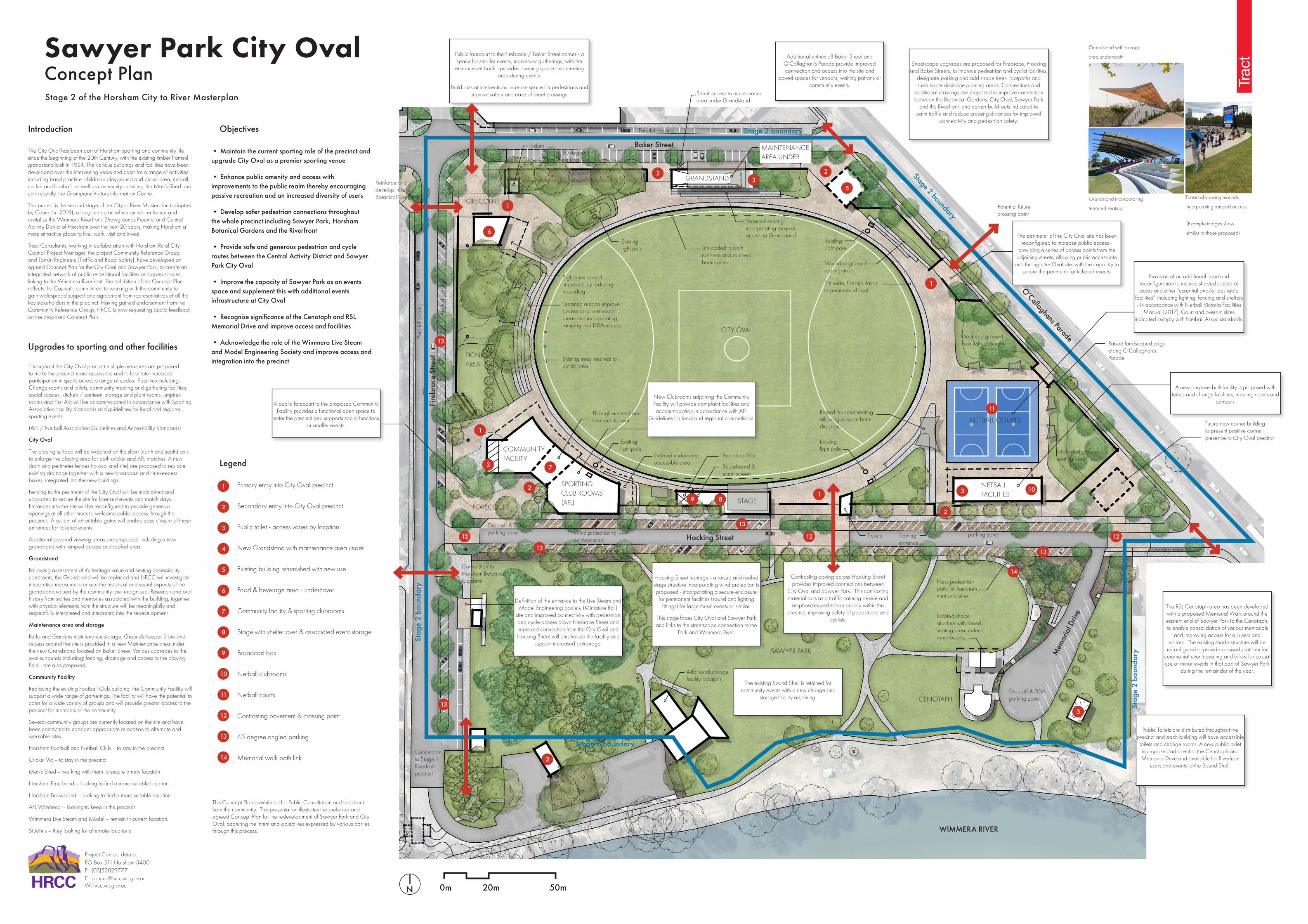
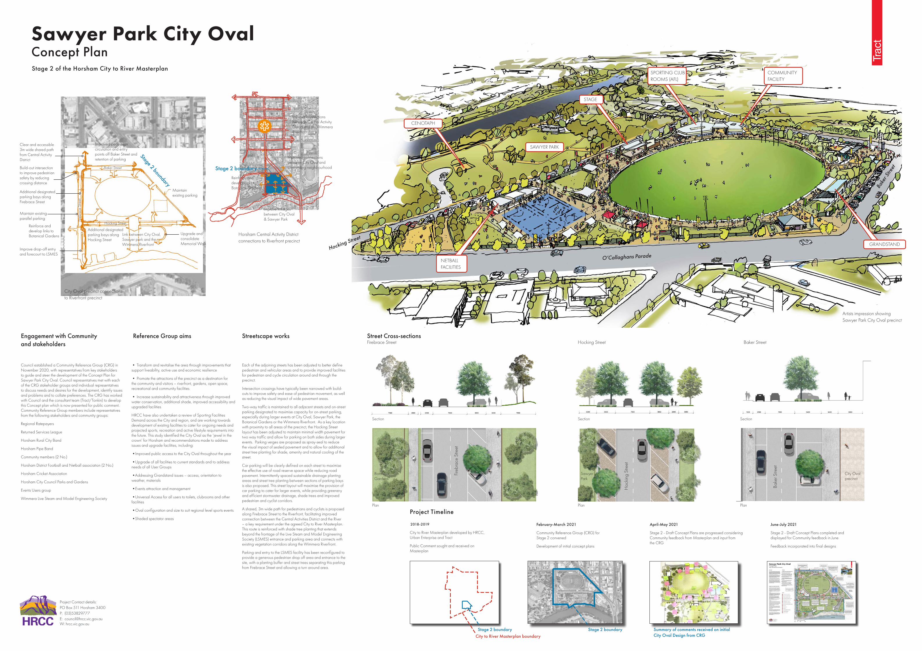
Sawyer Park City Oval Concept Plan
(Example images show
similar to those proposed)
Terraced viewing mounds
incorporating ramped accessGrandstand incorporating
terraced seating
Grandstand with storage
area underneath
The City Oval has been part of Horsham sporting and community life since the beginning of the 20th Century, with the existing timber framed grandstand built in 1924. The various buildings and facilities have been developed over the intervening years and cater for a range of activities including band practice, children’s playground and picnic area, netball, cricket and football, as well as community activities, the Men’s Shed and until recently, the Grampians Visitors Information Centre.
This project is the second stage of the City to River Masterplan (adopted by Council in 2019), a long-term plan which aims to enhance and revitalise the Wimmera Riverfront, Showgrounds Precinct and Central Activity District of Horsham over the next 20 years, making Horsham a more attractive place to live, work, visit and invest.
Tract Consultants, working in collaboration with Horsham Rural City Council Project Manager, the project Community Reference Group, and Tonkin Engineers (Traffic and Road Safety), have developed an agreed Concept Plan for the City Oval and Sawyer Park, to create an integrated network of public recreational facilities and open spaces linking to the Wimmera Riverfront. The exhibition of this Concept Plan reflects the Council’s commitment to working with the community to gain widespread support and agreement from representatives of all the key stakeholders in the precinct. Having gained endorsement from the Community Reference Group, HRCC is now requesting public feedback on the proposed Concept Plan.
Throughout the City Oval precinct multiple measures are proposed to make the precinct more accessible and to facilitate increased participation in sports across a range of codes. Facilities including; Change rooms and toilets, community meeting and gathering facilities, social spaces, kitchen / canteen, storage and plant rooms, umpires rooms and First Aid will be accommodated in accordance with Sporting Association Facility Standards and guidelines for local and regional sporting events.
(AFL / Netball Association Guidelines and Accessibility Standards)
City Oval
The playing surface will be widened on the short (north and south) axis to enlarge the playing area for both cricket and AFL matches. A new drain and perimeter fences (to oval and site) are proposed to replace existing drainage together with a new broadcast and timekeepers boxes, integrated into the new buildings.
Fencing to the perimeter of the City Oval will be maintained and upgraded to secure the site for licensed events and match days. Entrances into the site will be reconfigured to provide generous openings at all other times to welcome public access through the precinct. A system of retractable gates will enable easy closure of these entrances for ticketed events.
Additional covered viewing areas are proposed, including a new grandstand with ramped access and roofed area.
Grandstand
Following assessment of it’s heritage value and limiting accessibility constraints, the Grandstand will be replaced and HRCC will investigate interpretive measures to ensure the historical and social aspects of the grandstand valued by the community are recognised. Research and oral history from stories and memories associated with the building, together with physical elements from the structure will be meaningfully and respectfully interpreted and integrated into the redevelopment.
Maintenance area and storage
Parks and Gardens maintenance storage, Grounds Keeper Store and access around the site is provided in a new Maintenance area under the new Grandstand located on Baker Street. Various upgrades to the oval surrounds including; fencing, drainage and access to the playing field - are also proposed.
Community Facility
Replacing the existing Football Club building, the Community Facility will support a wide range of gatherings. The facility will have the potential to cater for a wide variety of groups and will provide greater access to the precinct for members of the community.
Several community groups are currently located on the site and have been contacted to consider appropriate relocation to alternate and workable sites.
Horsham Football and Netball Club – to stay in the precinct
Cricket Vic – to stay in the precinct
Men’s Shed – working with them to secure a new location
Horsham Pipe band – looking to find a more suitable location
Horsham Brass band – looking to find a more suitable location
AFL Wimmera – looking to keep in the precinct
Wimmera Live Steam and Model – remain in current location.
St Johns – they looking for alternate locations
SPORTING CLUB ROOMS (AFL)
COMMUNITY FACILITY
CITY OVAL
SAWYER PARK
CENOTAPH
PICNIC AREA
NETBALL COURTS
STAGEFORECOURT
FORECOURT
NETBALL FACILITIES
GRANDSTAND
MAINTENANCE AREA UNDER
Stage 2 of the Horsham City to River Masterplan
• Maintain the current sporting role of the precinct and upgrade City Oval as a premier sporting venue
• Enhance public amenity and access with improvements to the public realm thereby encouraging passive recreation and an increased diversity of users
• Develop safer pedestrian connections throughout the whole precinct including Sawyer Park, Horsham Botanical Gardens and the Riverfront
• Provide safe and generous pedestrian and cycle routes between the Central Activity District and Sawyer Park City Oval
• Improve the capacity of Sawyer Park as an events space and supplement this with additional events infrastructure at City Oval
• Recognise significance of the Cenotaph and RSL Memorial Drive and improve access and facilities
• Acknowledge the role of the Wimmera Live Steam and Model Engineering Society and improve access and integration into the precinct
Upgrades to sporting and other facilities
Public forecourt to the Firebrace / Baker Street corner - a space for smaller events, markets or gatherings, with the
entrance set back - provides queuing space and meeting area during events.
Build outs at intersections increase space for pedestrians and improve safety and ease of street crossings.
The perimeter of the City Oval site has been reconfigured to increase public access -
providing a series of access points from the adjoining streets, allowing public access into
and through the Oval site, with the capacity to secure the perimeter for ticketed events.
Streetscape upgrades are proposed for Firebrace, Hocking and Baker Streets, to improve pedestrian and cyclist facilities,
designate parking and add shade trees, footpaths and sustainable drainage planting areas. Connections and
additional crossings are proposed to improve connection between the Botanical Gardens, City Oval, Sawyer Park
and the Riverfront, and corner build-outs indicated to calm traffic and reduce crossing distances for improved
connectivity and pedestrian safety.
Additional entries off Baker Street and O’Callaghan’s Parade provide improved connection and access into the site and
paved spaces for vendors, waiting patrons or community events.
A public forecourt to the proposed Community Facility provides a functional open space to
enter the precinct and supports social functions or smaller events.
Public Toilets are distributed throughout the precinct and each building will have accessible
toilets and change rooms. A new public toilet is proposed adjacent to the Cenotaph and Memorial Drive and available for Riverfront
users and events to the Sound Shell.
The RSL Cenotaph area has been developed with a proposed Memorial Walk around the eastern end of Sawyer Park to the Cenotaph, to enable consolidation of various memorials
and improving access for all users and visitors. The existing shade structure will be
reconfigured to provide a raised platform for ceremonial events seating and allow for casual use or minor events in that part of Sawyer Park
during the remainder of the year.
Contrasting paving across Hocking Street provides improved connections between
City Oval and Sawyer Park. This contrasting material acts as a traffic calming device and
emphasizes pedestrian priority within the precinct, improving safety of pedestrians and
cyclists.
Legend
Definition of the entrance to the Live Steam and Model Engineering Society (Miniature Rail)
site and improved connectivity with pedestrian and cycle access down Firebrace Street and improved connection from the City Oval and Hocking Street will emphasize the facility and
support increased patronage.
New Clubrooms adjoining the Community Facility will provide complaint facilities and accommodation in accordance with AFL
Guidelines for local and regional competitions.
The existing Sound Shell is retained for community events with a new change and
storage facility adjoining.
Hocking Street frontage - a raised and roofed stage structure incorporating wind protection is proposed - incorporating a secure enclosure for permanent facilities (sound and lighting
fittings) for large music events or similar.
This stage faces City Oval and Sawyer Park and links to the streetscape connection to the
Park and Wimmera River.
A new purpose-built facility is proposed with toilets and change facilities, meeting rooms and
canteen.
Provision of an additional court and reconfiguration to include shaded spectator areas and other “essential and/or desirable
facilities”, including lighting, fencing and shelters - in accordance with Netball Victoria Facilities
Manual (2017). Court and overrun sizes indicated comply with Netball Assoc standards.
ObjectivesIntroduction
Primary entry into City Oval precinct
Secondary entry into City Oval precinct
Public toilet - access varies by location
New Grandstand with maintenance area under
Existing building refurnished with new use
Food & beverage area - undercover
Community facility & sporting clubrooms
Stage with shelter over & associated event storage
Broadcast box
Netball clubrooms
Netball courts
Contrasting pavement & crossing point
45 degree angled parking
Memorial walk path link
External undercover accessible area
Broadcast box
Scoreboard & event screen
New pedestrian path link between memorial sites
Rotated shade structure with raised seating area under - ramp access
Additional storage facility addition
Drop off & DDA parking zone
Drop off & DDA parking zone
Drop off & DDA parking zoneTraining
entranceTickets
Loading zone
Tickets
Through access from forecourt to oval
Connection to Horsham Botanical Gardens
Reinforce and develop links to Botanical Gardens
Wind protection to outdoor area
Connection to Stage 1 Riverfront precinct
Existing light pole
Existing light pole
Existing light pole
Terraced seating incorporating ramped access to Grandstand
Street access to maintenance area under Grandstand
Terraced area to improve access to current raked areas and incorporating ramping and DDA access
Sight lines to oval improved by reducing mounding
Ang
led
park
ing
Para
llel p
arki
ng
Parallel parking
Angled parking
90 degree parking
Angled parking
Existing trees retained to picnic area
3m added to both northern and southern boundaries
2m wide, flat circulation to perimeter of oval
Mounded grassed seating area
Mounded grassed seating area
Mounded grassed area with play zone
Existing light pole
Raised terraced seating allowing views in both directions
Raised landscaped edge along O’Callaghan’s Parade
Potential future crossing point
Future new corner building to present positive corner presence to City Oval precinct
This Concept Plan is exhibited for Public Consultation and feedback from the community. This presentation illustrates the preferred and agreed Concept Plan for the redevelopment of Sawyer Park and City Oval, capturing the intent and objectives expressed by various parties through this process.
Fire
brac
e St
reet
Mem
oria
l Driv
e
O’Callaghans Parade
Hocking Street
Baker Street
WIMMERA RIVER
1
1
1
1
2
2
2
2
3
3
3
3
35
6
810
7
9
11
12 12 12
1
2
3
4
5
6
8
10
7
9
11
12
13
13
13
13
13
13
14
14
N
Project Contact details:PO Box 511 Horsham 3400P: (03)53829777E: [email protected] W: hrcc.vic.gov.au
Stage 2 boundary
Stage 2 boundary
Stag
e 2
boun
dary
Stag
e 2
boun
dary
Stage 2 boundary
0m 20m 50m
Baker Street
Bake
r Stre
et
Hocking Street
Hoc
king
Stre
et
Firebrace Street
Fireb
race
Stre
et
Section Section Section
Plan Plan
Botanical Gardens
Sawyer Park
City Oval precinct
Plan
Street Cross-sectionsStreetscape works
Each of the adjoining streets has been adjusted to better define pedestrian and vehicular areas and to provide improved facilities for pedestrian and cycle circulation around and through the precinct.
Intersection crossings have typically been narrowed with build-outs to improve safety and ease of pedestrian movement, as well as reducing the visual impact of wide pavement areas.
Two-way traffic is maintained to all adjacent streets and on-street parking designated to maximise capacity for on-street parking, especially during larger events at City Oval, Sawyer Park, the Botanical Gardens or the Wimmera Riverfront. As a key location with proximity to all areas of the precinct, the Hocking Street layout has been adjusted to maintain minimal width pavement for two way traffic and allow for parking on both sides during larger events. Parking verges are proposed as spray-seal to reduce the visual impact of sealed pavement and to allow for additional street tree planting for shade, amenity and natural cooling of the street.
Car parking will be clearly defined on each street to maximise the effective use of road reserve space while reducing road pavement. Intermittently spaced sustainable drainage planting areas and street tree planting between sections of parking bays is also proposed. This street layout will maximise the provision of car parking to cater for larger events, while providing greenery and efficient stormwater drainage, shade trees and improved pedestrian and cyclist corridors.
A shared, 3m wide path for pedestrians and cyclists is proposed along Firebrace Street to the Riverfront, facilitating improved connection between the Central Activities District and the River – a key requirement under the agreed City to River Masterplan. This route is reinforced with shade tree planting that extends beyond the frontage of the Live Steam and Model Engineering Society (LSMES) entrance and parking area and connects with existing vegetation corridors along the Wimmera Riverfront.
Parking and entry to the LSMES facility has been reconfigured to provide a generous pedestrian drop off area and entrance to the site, with a planting buffer and street trees separating this parking from Firebrace Street and allowing a turn around area.
Stage 2 boundary Stage 2 boundary
April-May 2021
Stage 2 - Draft Concept Plans are progressed considering Community feedback from Masterplan and input from the CRG
June-July 2021
Stage 2 - Draft Concept Plans completed and displayed for Community feedback in June
Feedback incorporated into final designs
February-March 2021
Community Reference Group (CRG) for Stage 2 convened
Development of initial concept plans
MasterplanIndividual projects are subject to:
· Council endorsement and aresubject to detailed concept andschematic design, stakeholder andcommunity consultation; and
· Prioritisation and availability offunds as part of Council’s budgetplanning process and attractionof funding from other sources (e.g.government or private).
Project PrincipalCheckedDrawnDateRevisionDrawing No.Project NameDrawing Title
08.01.202002Horsham Riverfront MasterplanPhase 1 Concept Masterplan NPMFAR318-0995-00-L-00-DR02
A Masterplan for the study area has been prepared by landscape architects based on the vision, objectives and directions for the area.
The Masterplan shows the desired indicative long-term layout of the study area, in particular those areas that are proposed to transition from their existing uses to new or improved uses.
The Masterplan shows an indication of potential building locations, public realm upgrades, sporting precincts and other open space proposals, however the exact locations and layouts within each site may change depending on more detailed planning.
The most important role of the Masterplan is to show the desired long term direction for land within the area and an overarching physical aspiration that Council will seek to achieve through a range of actions, investment and partnerships over time.
Detailed elements of the Masterplan are shown on the following pages.
Individual projects are subject to:
• Council endorsement and are subject to detailed concept and schematic design, stakeholder and community consultation; and
• Prioritisation and availability of funds as part of Council’s budget planning process and attraction of funding from other sources (e.g. government or private).
Source: Tract, 201909 / Horsham: City to River Vision and Masterplan
Masterplan
City to River Masterplan boundary
Central Horsham
2018-2019
City to River Masterplan developed by HRCC, Urban Enterprise and Tract
Public Comment sought and received on Masterplan
Summary of comments received on initial City Oval Design from CRG
Project Timeline
• Transform and revitalise the area through improvements that support liveability, active use and economic resilience
• Promote the attractions of the precinct as a destination for the community and visitors – riverfront, gardens, open space, recreational and community facilities
• Increase sustainability and attractiveness through improved water conservation, additional shade, improved accessibility and upgraded facilities
HRCC have also undertaken a review of Sporting Facilities Demand across the City and region, and are working towards development of existing facilities to cater for ongoing needs and projected sports, recreation and active lifestyle requirements into the future. This study identified the City Oval as the ‘jewel in the crown’ for Horsham and recommendations made to address issues and upgrade facilities, including:
•Improved public access to the City Oval throughout the year
•Upgrade of all facilities to current standards and to address needs of all User Groups
•Addressing Grandstand issues – access, orientation to weather, materials
•Events attraction and management
•Universal Access for all users to toilets, clubrooms and other facilities
•Oval configuration and size to suit regional level sports events
•Shaded spectator areas
Council established a Community Reference Group (CRG) in November 2020, with representatives from key stakeholders to guide and steer the development of the Concept Plan for Sawyer Park City Oval. Council representatives met with each of the CRG stakeholder groups and individual representatives to discuss needs and desires for the development, identify issues and problems and to collate preferences. The CRG has worked with Council and the consultant team (Tract/Tonkin) to develop this Concept plan which is now presented for public comment. Community Reference Group members include representatives from the following stakeholders and community groups:
Regional Ratepayers
Returned Services League
Horsham Rural City Band
Horsham Pipe Band
Community members (2 No.)
Horsham District Football and Netball association (2 No.)
Horsham Cricket Association
Horsham City Council Parks and Gardens
Events Users group
Wimmera Live Steam and Model Engineering Society
Engagement with Community and stakeholders
Reference Group aims
Horsham Central Activity District connections to Riverfront precinct
Artists impression showing Sawyer Park City Oval precinct
City Oval precinct connections to Riverfront precinct
Improve connections between Central Activity District and the Wimmera Riverfront
Reinforce and develop links to Botanical Gardens
Improve linkages between City Oval & Sawyer Park
Improved connections between City Oval and surrounding neighbourhood
Sawyer Park City Oval Concept PlanStage 2 of the Horsham City to River Masterplan
Project Contact details:PO Box 511 Horsham 3400P: (03)53829777E: [email protected] W: hrcc.vic.gov.au
Stage 2 boundary
Stage 2 boundary
Baker Street
Hocking Street
Fire
brac
e St
reet
Clear and accessible 3m wide shared path from Central Activity District
Build-out intersection to improve pedestrian safety by reducing crossing distance
Additional designated parking bays along Firebrace Street
Additional designated parking bays along Hocking Street
Link between City Oval, Sawyer park and the Wimmera Riverfront
Maintain existing parallel parking
Maintain existing parking
Upgrade and consolidate Memorial Walk
Improve drop-off entry and forecourt to LSMES
Improved pedestrian circulation and entry points off Baker Street and retention of parking
Reinforce and develop links to Botanical Gardens
STAGE
SPORTING CLUB ROOMS (AFL)
COMMUNITY FACILITY
NETBALL FACILITIES
GRANDSTAND
SAWYER PARK
CENOTAPHFirebrace Street
O’Callaghans ParadeHocking Street
Bake
r Stre
et