Embed Size (px)
DESCRIPTION
Hiking in the Savoie
Citation preview
C
M
J
CM
MJ
CJ
CMJ
N
SMB_Couv_Rando(HD).pdf 21/05/08 12:00:53

22 3
3
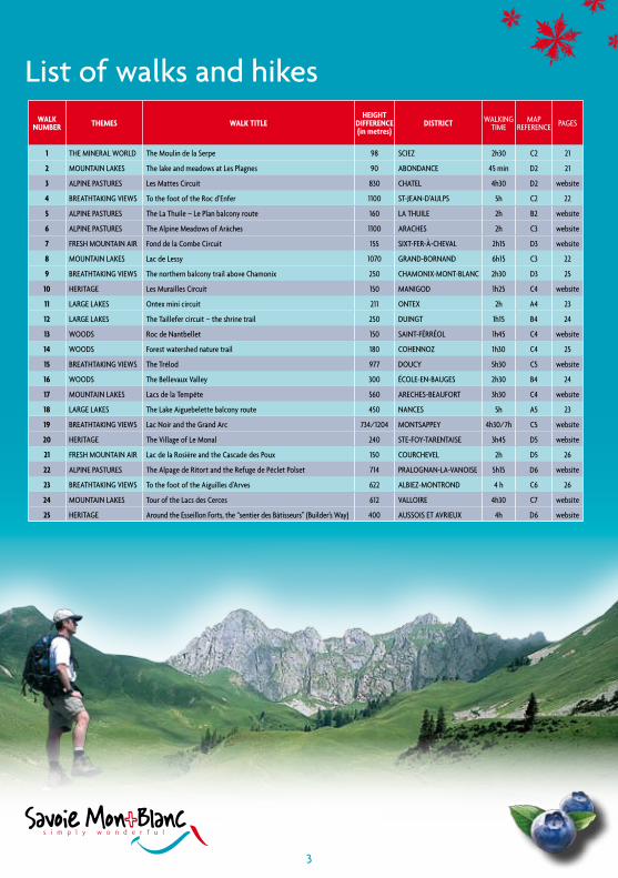
Walk number Themes Walk TiTle
heighT difference (in metres)
disTricT Walking time
map reference pageS
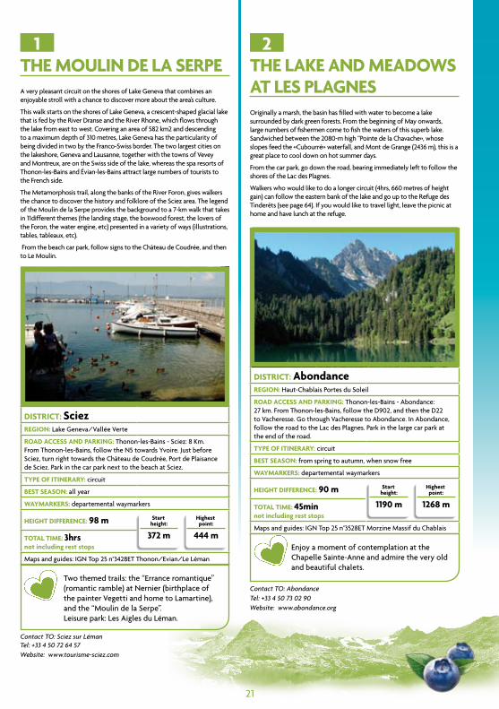
1 the mineral World the moulin de la Serpe 98 Sciez 2h30 c2 21
2 mountain lakeS the lake and meadows at les plagnes 90 abondance 45 min d2 21
3 alpine paStureS les mattes circuit 830 chatel 4h30 d2 website
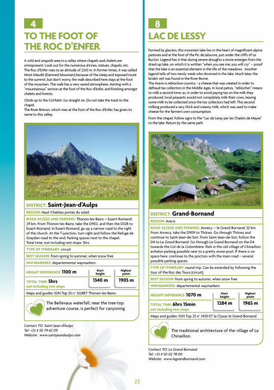
4 breathtaking vieWS to the foot of the roc d’enfer 1100 St-jean-d’aulpS 5h c2 22
5 alpine paStureS the la thuile – le plan balcony route 160 la thuile 2h b2 website
6 alpine paStureS the alpine meadows of arâches 1100 aracheS 2h c3 website
7 freSh mountain air fond de la combe circuit 155 Sixt-fer-à-cheval 2h15 d3 website
8 mountain lakeS lac de lessy 1070 grand-bornand 6h15 c3 22
9 breathtaking vieWS the northern balcony trail above chamonix 250 chamonix-mont-blanc 2h30 d3 25
10 heritage les murailles circuit 150 manigod 1h25 c4 website
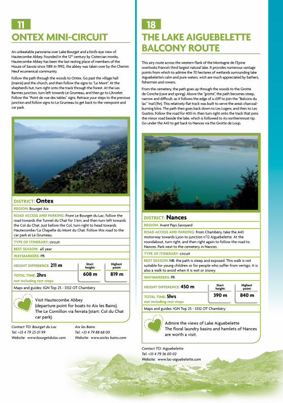
11 large lakeS ontex mini circuit 211 ontex 2h a4 23
12 large lakeS the taillefer circuit – the shrine trail 250 duingt 1h15 b4 24
13 WoodS roc de nantbellet 150 Saint-férréol 1h45 c4 website
14 WoodS forest watershed nature trail 180 cohennoz 1h30 c4 25
15 breathtaking vieWS the trélod 977 doucy 5h30 c5 website
16 WoodS the bellevaux valley 300 école-en-baugeS 2h30 b4 24
17 mountain lakeS lacs de la tempête 560 arecheS-beaufort 3h30 c4 website
18 large lakeS the lake aiguebelette balcony route 450 nanceS 5h a5 23
19 breathtaking vieWS lac noir and the grand arc 734/1204 montSappey 4h30/7h c5 website
20 heritage the village of le monal 240 Ste-foy-tarentaiSe 3h45 d5 website
21 freSh mountain air lac de la rosière and the cascade des poux 150 courchevel 2h d5 26
22 alpine paStureS the alpage de ritort and the refuge de péclet polset 714 pralognan-la-vanoiSe 5h15 d6 website
23 breathtaking vieWS to the foot of the aiguilles d’arves 622 albiez-montrond 4 h c6 26
24 mountain lakeS tour of the lacs des cerces 612 valloire 4h30 c7 website
25 heritage around the esseillon forts, the “sentier des bâtisseurs” (builder’s Way) 400 auSSoiS et avrieux 4h d6 website
3
List of walks and hikes
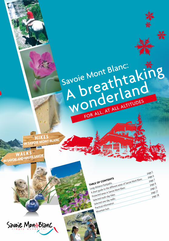
Savoie Mont Blanc:
A breathtaking
wonderland
For ALL, At ALL ALtitudeS
Table of conTenTs
Long-distance footpaths
page 5
A short guide to the different areas of Savoie Mont Blanc page 6
Protected areas in Savoie Mont Blanc
page 7
Selected multi-day hikes
page 8
Selected one-day walks
page 21
Practical information
page 27
Mountain huts
page 28
5
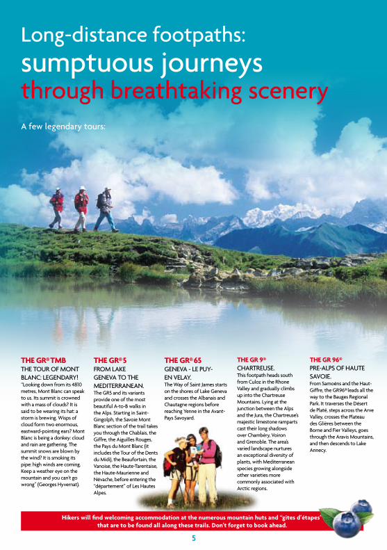
THe GR® TMb the tour oF Mont BLAnc: LegendAry! “Looking down from its 4810 metres, Mont Blanc can speak to us. its summit is crowned with a mass of clouds? it is said to be wearing its hat: a storm is brewing. Wisps of cloud form two enormous, eastward-pointing ears? Mont Blanc is being a donkey: cloud and rain are gathering. the summit snows are blown by the wind? it is smoking its pipe: high winds are coming. Keep a weather eye on the mountain and you can’t go wrong” (georges hyvernat).
THe GR® 5 FroM LAKe genevA to the MediterrAneAn.the gr5 and its variants provide one of the most beautiful A-to-B walks in the Alps. Starting in Saint-gingolph, the Savoie Mont Blanc section of the trail takes you through the chablais, the giffre, the Aiguilles rouges, the Pays du Mont Blanc (it includes the tour of the dents du Midi), the Beaufortain, the vanoise, the haute-tarentaise, the haute-Maurienne and névache, before entering the “département” of Les hautes Alpes.
THe GR® 65genevA - Le Puy-en veLAy.the Way of Saint James starts on the shores of Lake geneva and crosses the Albanais and chautagne regions before reaching yenne in the Avant-Pays Savoyard.
THe GR 9® chArtreuSe.this footpath heads south from culoz in the rhone valley and gradually climbs up into the chartreuse Mountains. Lying at the junction between the Alps and the Jura, the chartreuse’s majestic limestone ramparts cast their long shadows over chambéry, voiron and grenoble. the area’s varied landscape nurtures an exceptional diversity of plants, with Mediterranean species growing alongside other varieties more commonly associated with Arctic regions.
THe GR 96® Pre-ALPS oF hAute SAvoie. From Samoëns and the haut-giffre, the gr96® leads all the way to the Bauges regional Park. it traverses the désert de Platé, steps across the Arve valley, crosses the Plateau des glières between the Borne and Fier valleys, goes through the Aravis Mountains, and then descends to Lake Annecy.
Long-distance footpaths: sumptuous journeys through breathtaking scenery
Hikers will find welcoming accommodation at the numerous mountain huts and “gîtes d’étapes” that are to be found all along these trails. Don’t forget to book ahead.
A few legendary tours:
Savoie Mont Blanc:
A breathtaking
wonderland
5
Beaufortain
Ta re n t a i s e
M a u r i e n n e
Chartreuse
Bauges
LakeBourget
Vald’Arly
Bornes-Aravis
Albanais
Haut-Rhône Lake
Annecy Paysdu
Mont-Blanc
Genevois GrandMassif
Chablais
Portesdu Soleil
Faucigny
Avant-PaysSavoyard
Chautagne
Co m be deSavoie
Chambéry
Albertville
AnnecyChamonix
Aix-les-Bains
Thonon-les-Bains
Bourg-St-Maurice
Moutiers
St-Jean-de-Maurienne
Modane
Annemasse
L a k e G e n e v a
6
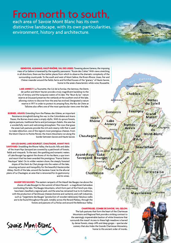
Genevois, albanais, HauT-RHône, val Des usses: towering above geneva, the imposing mass of Le Salève is traversed by the superbly panoramic “route des crêtes”. With views stretching in all directions, there are few better places from which to observe the dramatic complexity of the
surrounding countryside. to the south and west of Mont Salève, the rivers rhone, usses, Fier and chéran meander around the fields, farms and fortified houses of the “granary” of haute Savoie,
home to the area’s characteristic white wine, roussette.
From north to south, each area of Savoie Mont Blanc has its own distinctive landscape, with its own particularities, environment, history and architecture.
cHaRTReuse, coMbe De savoie, val Gelon: the lush pastures that form the heart of the chartreuse
Mountains and regional Park provide a striking contrast to the seemingly impenetrable bastion of white limestone that
surrounds the massif. Access to these high meadows is barred by dense forests, steep cliffs and deep gorges – spectacular
scenery that also hides the grande chartreuse Monastery, home to this ancient order of monks.
lake annecy: La tournette, the col de la Forclaz, the Semnoz, the dents de Lanfon and Mont veyrier provide a truly magnificent backdrop to the
city of Annecy and the turquoise waters of its lake. the “Bout du lac” nature reserve at doussard preserves the wetlands at the southern end of the lake, allowing visitors to discover how the area has evolved. designated a nature
reserve in 1977 in order to protect its amazing flora, the roc de chère at talloires also offers one of the most spectacular views over the lake.
aix-les-bains, lake bouRGeT, cHauTaGne, avanT Pays savoyaRD: Straddling the rhone valley, the bucolic hills and dales
of the Avant Pays Savoyard are covered by a patchwork of forests, fields and vineyards. to the east, the sparkling and romantic waters of Lake Bourget lap against the shores of Aix-les-Bains, a spa town and resort that has been awarded the prestigious “France Station
nautique” label. on its wilder western shore, the steeply forested slopes of the dent du chat plunge into the waters of the lake,
ensuring seclusion and tranquillity for the beautiful hautecombe Abbey. north of the lake, around the Savières canal, lie the alluvial
plains of La chautagne, an area that is renowned for its gastronomy and its wines.
Massif Des bauGes: the eastern ramparts of the Massif des Bauges rise above the shores of Lake Bourget to the summit of Mont revard – a magnificent belvedere
overlooking the lake. the Bauges Mountains, which form part of the French pre-Alps, have been classified a regional park, and the area has remained true to its traditions,
with the production of farmhouse cheeses (tomme and vacherin), and craft industries, such as “l’argenterie des Bauges” (production of wooden tableware). Fabulous walks
are to be found throughout the park, notably across the revard Plateau, through the forests and pastures of La Féclaz and around the Bellevaux valley.
boRnes, aRavis: extending from the Plateau des glières, an important resistance stronghold during the war, to the colombière and Aravis
Passes, the Bornes-Aravis area is simply idyllic. With its spruce forests, alpine pastures, traditional farms and picturesque chalets, the area has a wonderfully warm and welcoming atmosphere. the cows that graze the area’s lush pastures provide the rich and creamy milk that is used
to make reblochon, one of the region’s most prestigious cheeses. From the Mont charvin to Pointe Percée, the Aravis Mountains run along the
border between Savoie and haute Savoie.
Beaufortain
Ta re n t a i s e
M a u r i e n n e
Chartreuse
Bauges
LakeBourget
Vald’Arly
Bornes-Aravis
Albanais
Haut-Rhône Lake
Annecy Paysdu
Mont-Blanc
Genevois GrandMassif
Chablais
Portesdu Soleil
Faucigny
Avant-PaysSavoyard
Chautagne
Co m be deSavoie
Chambéry
Albertville
AnnecyChamonix
Aix-les-Bains
Thonon-les-Bains
Bourg-St-Maurice
Moutiers
St-Jean-de-Maurienne
Modane
Annemasse
L a k e G e n e v a
7
fauciGny, GRanD Massif, aRve valley, GiffRe: the gentle hills of the Faucigny form the gateway to the giffre and the grand Massif, which culminates in the 3096-m high Mont Buet. Wide fertile valleys, glacial cirques, waterfalls, mountain streams and gorges… this is the Alps in all its glory. the area also houses some unique treasures, such as the cirque du Fer à cheval, and the karsts of the désert de Platé.
cHablais, lake Geneva, Geneva alPs, PoRTes Du soleil: From the small harbours, vineyards and meadows that line the shores of Lake geneva to the fields and pastures of the Abondance valley and the rugged mountains of the Portes du Soleil, this is an area that has preserved its heritage. unspoilt villages have maintained their traditional chalets and farmhouses, and local producers still take great pride in their delicious Abondance cheese.
Pays Du MonT-blanc: Although its summits and climbs are legendary, the cradle of mountaineering also offers magnificent hikes through a landscape of forests, pastures, lakes, spectacular glaciers – including the Mer de glace – granite towers and crystalline summits that rise from 500 metres to 4810 metres above sea level. Four nature reserves and fourteen towns and villages complete the attractions of this truly exceptional corner of the world.
unspoilt countryside
beaufoRTain, val D’aRly: Wood and stone built chalets punctuate bright green pastures above the shores of deep-blue mountain lakes. this is the Beaufortain, an area where villages seem to cling to the steepest slopes and where lush alpine meadows provide perfect grazing for the cows that produce the milk used to make Beaufort, the “Prince of gruyère cheeses”. the val d’Arly, with its pretty floral chalets, forms the link between Savoie and the Pays du Mont Blanc and europe’s highest mountain dominates the view from many of the area’s summits.
TaRenTaise: every tributary of the tarentaise valley hides a forgotten corner, a rarely visited nook, that time and “progress” have passed by. And then there is the aptly named haute-tarentaise, in which experienced hikers can explore the high mountains between the Beaufortain, the italian Alps and the vanoise, a national park that has preserved unspoilt valleys and glorious peaks, such as the grande casse, Mont Pourri and the Sommet de Bellecôte.
MauRienne: one side of the Maurienne and haute-Maurienne valleys is lined with little known but magnificent mountains, such as the Aiguilles d’Arves and the Albaron. the other side of the valley contains the vanoise national Park, where gleaming glaciers drape the flanks of the dômes de chasseforêt, de l’Arpont, des nants and du génépy. the haute-Maurienne has a particularly rich history with traditional villages, such as Bonneval-sur-Arc, valloire and Albiez-Montrond, and quintessentially alpine landscapes. For walkers, the vanoise is undoubtedly the jewel in the area’s crown, with fabulous fauna and flora to observe.
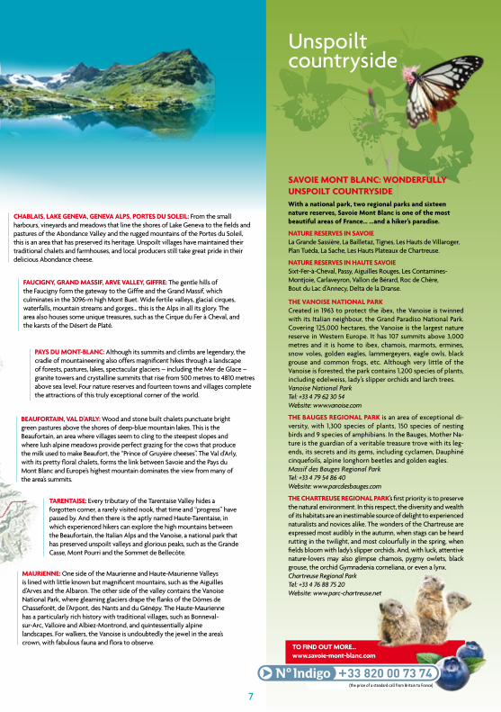
savoie MonT blanc: wonDeRfully unsPoilT counTRysiDewith a national park, two regional parks and sixteen nature reserves, savoie Mont blanc is one of the most beautiful areas of france… …and a hiker’s paradise.
naTuRe ReseRves in savoieLa grande Sassière, La Bailletaz, tignes, Les hauts de villaroger, Plan tuéda, La Sache, Les hauts Plateaux de chartreuse.
naTuRe ReseRves in HauTe savoieSixt-Fer-à-cheval, Passy, Aiguilles rouges, Les contamines-Montjoie, carlaveyron, vallon de Bérard, roc de chère, Bout du Lac d’Annecy, delta de la dranse.
THe vanoise naTional PaRkcreated in 1963 to protect the ibex, the vanoise is twinned with its italian neighbour, the grand Paradiso national Park. covering 125,000 hectares, the vanoise is the largest nature reserve in Western europe. it has 107 summits above 3,000 metres and it is home to ibex, chamois, marmots, ermines, snow voles, golden eagles, lammergeyers, eagle owls, black grouse and common frogs, etc. Although very little of the vanoise is forested, the park contains 1,200 species of plants, including edelweiss, lady’s slipper orchids and larch trees.Vanoise National ParkTel: +33 4 79 62 30 54Website: www.vanoise.com
THe bauGes ReGional PaRk is an area of exceptional di-versity, with 1,300 species of plants, 150 species of nesting birds and 9 species of amphibians. in the Bauges, Mother na-ture is the guardian of a veritable treasure trove with its leg-ends, its secrets and its gems, including cyclamen, dauphiné cinquefoils, alpine longhorn beetles and golden eagles.Massif des Bauges Regional ParkTel: +33 4 79 54 86 40Website: www.parcdesbauges.com
THe cHaRTReuse ReGional PaRk’s first priority is to preserve the natural environment. in this respect, the diversity and wealth of its habitats are an inestimable source of delight to experienced naturalists and novices alike. the wonders of the chartreuse are expressed most audibly in the autumn, when stags can be heard rutting in the twilight, and most colourfully in the spring, when fields bloom with lady’s slipper orchids. And, with luck, attentive nature-lovers may also glimpse chamois, pygmy owlets, black grouse, the orchid gymnadenia corneliana, or even a lynx.Chartreuse Regional ParkTel: +33 4 76 88 75 20Website: www.parc-chartreuse.net
To finD ouT MoRe…www.savoie-mont-blanc.com
(the price of a standard call from Britain to France)
Neydens
Le Chable
Chavannaz
Contamine-Sarzin
Marlioz
D
1
2
3
le Fier
ve
les Usses
le Rhône
le R
hône
A40
D910
D992
N206
N201
N508
N508
le GrandPiton
1375 m
Col Mont Sion
ANNECY
Bellegarde-sur-Valserine
St-Julien-en-Genevois
Seyssel
Frangy
Archamps
l
Chaumont
Minzier
Desingy
Etremb
Monnetier-Mornex
Clermont
Le Vuache
Mo
nt
Salè
ve
H A U TR H Ô N E
GR
65
St-J
acqu
esde
Compostelle
0 5 km
N
8
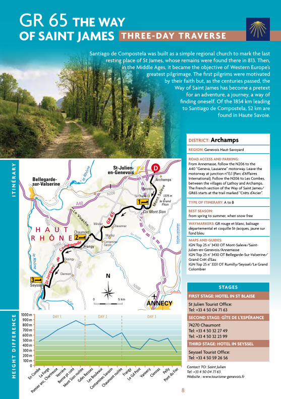
gr 65 THe wayof sainT JaMes THRee-Day TRaveRse
DisTRicT: archampsReGion: genevois haut-Savoyard
RoaD access anD PaRkinG: From Annemasse, follow the n206 to the A40 “geneva, Lausanne” motorway. Leave the motorway at junction n°13.1 (Parc d’Affaires international). Follow the n206 to Les combes, between the villages of Lathoy and Archamps. the French section of the Way of Saint James/gr65 starts at the trail marked “crêts d’Acier”.
TyPe of iTineRaRy: A to B
besT season: from spring to summer, when snow free
wayMaRkeRs: gr rouge et blanc, balisage départemental et coquille St-Jacques, jaune sur fond bleu
MaPs anD GuiDes: ign top 25 n° 3430 ot Mont-Saleve/Saint-Julien-en-genevois/Annemasseign top 25 n° 3430 ot Bellegarde-Sur-valserine/grand crêt d’eauign top 25 n° 3331 ot rumilly/Seyssel/Le grand colombier
sTaGes
fiRsT sTaGe: HoTel in sT blaise
St Julien tourist office: tel: +33 4 50 04 71 63
seconD sTaGe: GîTe De l’esPéRance
74270 chaumonttel: +33 4 50 32 27 49tel: +33 4 50 32 23 99
THiRD sTaGe: HoTel in seyssel
Seyssel tourist office: tel: +33 4 50 59 26 56
Santiago de compostela was built as a simple regional church to mark the last resting place of St James, whose remains were found there in 813. then,
in the Middle Ages, it became the objective of Western europe’s greatest pilgrimage. the first pilgrims were motivated
by their faith but, as the centuries passed, the Way of Saint James has become a pretext
for an adventure, a journey, a way of finding oneself. of the 1854 km leading to Santiago de compostela, 52 km are
found in haute Savoie.
He
iGH
T D
iff
eR
en
ce
iTin
éR
aR
y
Contact TO: Saint JulienTel: +33 4 50 04 71 63Website : www.tourisme-genevois.fr
9
THRee-Day TRaveRse
Day 1 les combes to the col du Mont sion
sTaRT HeiGHT: 474 mLes combes is the French and haute Savoie gateway to the gr65, which begins at St Peter’s cathedral in geneva. From the cathedral, the trail heads towards the border through the eastern part of the town of Saint-Julien-en-genevois, where the first gr65 sign is found.
Follow the road and track to go behind the international Business Park (Parc d’Affaires international). At the next road, turn right, go through Lathoy, and then head towards neydens. cross the footbridge over the motorway and follow the wide, rocky track. this flat section of the trail offers beautiful views of Mont Salève, to the east, and the Jura, to the north.
Follow signs to verrières, and then to Beaumont. From the church in Beaumont, head towards Jussy. continue to Les crêts, which forms the entrance to the chartreuse de Pomier. go through the chartreuse and back onto the road. Follow the path overlooking the orchards along the base of Mont Salève.
Follow the track on the right (waymarker). After going through a clearing that offers a wonderful view, rejoin the road at St Blaise cemetery. Follow the track to the col du Mt Sion. overnight stop.
HiGHesT PoinT: 885 m
HeiGHT DiffeRence: 450 m
ToTal TiMe: 4hrsnot including rest stops
Jussy and its superb lines of pear treas marking the entrance to the village. Many of the area’s orchards still grow traditional varieties. do not miss the exhibits about Mont Salève at the Maison du Salève. the museum explains the history and geography of man’s relationship with the mountain (permanent exhibition, temporary exhibition, shop, picnic room).
Day 3 from chaumont to Pont de fier
sTaRT HeiGHT: 560 mthe route to Seyssel offers some excellent views of the Montagne des Princes, the grand colombier and the meanders of the rhone. do not miss the beautiful houses in the two hamlets of Les côtes. Savour, in moderation, the still or sparkling white wines of Seyssel, which has enjoyed Appellation d’origine contrôlée status since 11th February 1942. the 60 hectares of vineyards that make up the Aoc lie in the districts of Seyssel (Ain), Seyssel (haute-Savoie) and corbonod. Wine has been produced here since the 11th century. today, the white grape varieties grown are roussette de Savoie (also known as Altesse), chasselas and Molette.
From the road, go down the track to the “vers rosset” bend. Bear right to cross the vineyards of roussette de Frangy, a local white wine. From the church in Frangy, cross the river usses and head towards désingy. go through champagne, tagny, vannecy, Pelly and Les côtes d’en haut to get to Seyssel. From Seyssel, follow the greenway beside the rhone to Pont du Fier.
Frangy has a number of shops (grocer’s, chemist’s, banks, tobacconist’s, bar, etc). Seyssel is unusual in that it is divided into separate towns by the rhone. the town on the left bank is in haute Savoie; the town on the right bank is in the Ain.
HiGHesT PoinT: 540 m
HeiGHT DiffeRence: 380 m
ToTal TiMe: 6hrsnot including rest stops
this leg of the trail goes through some wonderfully varied countryside and finishes at the lowest point in haute Savoie: the banks of the rhone at Seyssel, a mere 260 metres above sea level.
Day 2 col du Mont sion to chaumont
sTaRT HeiGHT: 785 mFrom the col du Mont Sion, start to the left of the road (on the opposite side to the “hamlet of Father christmas”) and follow the track uphill towards charly. this section of the gr65 follows the same route as the “Balcon du Léman” long-distance footpath: wonderful views over the vuache and La Mandallaz hills. in charly, make a short detour (5 min) to visit the chapelle de St-Jacques. Follow signs to La croix de la Biche, chez grésat, La Motte and chaumont.
in chaumont: Arbannaz waterfall and the restored remains of the old castle, which was pulled down in 1616 by henry 1st of genevois-nemours. due to its geographical position, chaumont was a town and a fortress in the Middle Ages.to get to the gîte in chaumont, head right, uphill, for 10min.overnight stop.
HiGHesT PoinT: 815 m
HeiGHT DiffeRence: 420 m
ToTal TiMe: 4hrs 20minnot including rest stops
Several views across the whole of the “Avant Pays Savoyard” region.
10
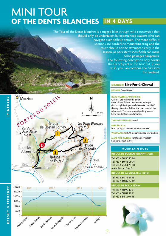
Mini tourof THe DenTs blancHes in 4 Days
DisTRicT: sixt-fer-à-chevalReGion: grand Massif
RoaD access anD PaRkinG: cluses – Les Allamands: 24 kmFrom cluses, follow the d902 to taninges. go through taninges, and then take the d907 through Samoëns. Follow the road towards Les Allamands. there are several parking spaces before and after Les Allamands.
TyPe of iTineRaRy: A to B
besT season: from spring to summer, when snow free
wayMaRkeRs: grP, départemental waymarkers
MaPs anD GuiDes: ign top 25 n°3530et Samoëns/haut-giffre
MounTain HuTs
RefuGe De bosTan-ToRnay 1763m
tel: +33 4 50 90 10 94tel: +33 4 50 45 09 74tel: +33 6 23 84 70 80 www.Bostan.free.fr
RefuGe De la voGealle 1901 m
tel: +33 6 60 16 27 55tel: +33 4 50 89 77 59
RefuGe De folly 1574 m
tel: +33 4 50 90 10 91tel: +33 4 50 89 42 71tel: +33 6 86 12 04 15
Refugede Bostan Tornay
Refugede Vogealle
Refugede Folly
Les Dents Blanches2711 mCol de
Joux-Plane1712 m
Samoëns
lesAllamands
1
2
3
D
Refugede Bostan Tornay
Refugede Vogealle
Refugede Folly
lesAllamands
leGiffr
e
D354
D907
Les Dents Blanches2711 mCol de
Joux-Plane1712 m
Samoëns
Morzine
Cirquedu
Fer à Cheval
P O R T E S D US OL E I L
0 2,5 km
N
the tour of the dents Blanches is a rugged hike through wild countryside that should only be undertaken by experienced walkers who can
navigate over difficult terrain. the more difficult sections are borderline mountaineering and the
route should not be attempted early in the season, as persistent snowfields can make
some passages dangerous. the following description only covers the French part of the tour but, if you
wish, you can continue the trail into Switzerland.
He
iGH
T D
iff
eR
en
ce
iTin
éR
aR
y
11
in 4 Days
Day 1 les allamands (samoëns) to the Refuge de bostan-Tornay
sTaRT HeiGHT: 1096 mFrom the final parking area after Les Allamands, turn right to follow the “tour des dents Blanches” local long-distance footpath (grP). At the “Le Plan” crossroads, go straight on towards the refuge de Bostan-tornay. the track winds up in a series of switchbacks through forests, over alpine pastures and past the chalets de Bostan. the trail climbs between the dents d’oddaz and the Avouille to the tiny plateau containing the refuge de Bostan-tornay.A short stage that provides a good warm-up for the rest of the tour. Added extra: retrace your steps from the refuge de Bostan-tornay, and then bear right to head up to the col de la golèse (30 minutes from the hut), from where there is an unbeatable view of Les terres Maudites, the refuge de golèse and the giffre and Morzine valleys. the tête de Bostan can be reached from the col in 2hrs 50min.
HiGHesT PoinT: 1963 m
HeiGHT DiffeRence: 766 m
ToTal TiMe: 2hrs 30minnot including rest stops
Superb views of the giffre valley, the Pointe de la golèse and the chalets de Bottière. An amazing area of rocky boulders, grassy meadows and alpine flowers.
Day 3 Refuge de la vogealle to the Refuge de folly (1574 m)
sTaRT HeiGHT: 1901 mFrom the refuge de la vogealle, retrace your footsteps towards the lake. After a steeper section, take the path on the left, signposted “refuge de Folly par le lac des chambres”, to the Pas de l’ours. the path winds up past a waterfall to the vallon de la vogeallette and then to the vallon des chambres (snow throughout the year). Just before the lake, bear right to follow the path (with in-situ hand line) that climbs above the ice and the turquoise waters. After a small plateau the path heads steeply down and crosses Les eaux Froides. A final scree chute and a grassy slope lead to the refuge de Folly.this stage can be quite difficult due to the exposed and technical section through the Pas de l’ours (slippery rocks), and the permanent snowfields of the combe des chambes. Many hikers will find walking poles useful.
HiGHesT PoinT: 2338 m
HeiGHT DiffeRence: 437 m
ToTal TiMe: 3hrs 30minnot including rest stops
grandiose scenery with colours ranging from the dark grey of the rocks to the turquoise of the mountain lakes. A high mountain atmosphere for this penultimate stage.
Day 2Refuge de bostan-Tornay to the Refuge de la vogealle via the col de bostan
sTaRT HeiGHT: 1763 mFrom the refuge de Bostan-tornay, go up the barren slopes of the combe des verdets, staying to the left of the Lac de verdets, to get to the col de Bostan. once at the col de Bostan, there are two alternatives: either continue along the Swiss section of the tour des dents Blanches, or stay in France and follow the route described here to the refuge de la vogealle. From the col, go over the golette de l’oule, and then the Pas du taureau (in-situ chain as a hand line), via the col du taureau. care required.Follow a path on the right towards the refuge de Folly. this takes you to a small plateau, from where you follow a grassy ridge along the combe de Praz riant to La combe aux Puaires. turn off the path to the refuge de Folly and head towards the refuge de la vogealle via the right bank of the eponymous lake.Some of the sections of this route are very steep and exposed, so a sure foot and good weather conditions are essential.
HiGHesT PoinT: 2638 m
HeiGHT DiffeRence: 875 m
ToTal TiMe: 5hrs 15minnot including rest stops
A high-mountain atmosphere, sections of scrambling with in-situ hand lines, magnificent views: cirque du Bout du Monde, Pointe rousse, Lac de la vogealle, dents Blanches, Pointe de Bostan
Day 4 Refuge de folly to les allamands
sTaRT HeiGHT: 1574 mFrom the refuge de Folly, leave the tête du Fer à cheval behind you and go down through the forest. cross the Pont des Barmes over the Landes rau stream. At the crossroads, take the track on the right to the dalle du tuet (rock climbing), and then follow a path (cable hand line) across the steep slopes. the angle eases as you reach the hamlet of Le crêt and the car park.As elsewhere on this tour, this leg crosses some very steep ground equipped with cable hand lines. this route is very slippery when wet. take care.
HiGHesT PoinT: 1574 m
HeiGHT DiffeRence: 241 m
ToTal TiMe: 2hrsnot including rest stops
this mini tour of the dents Blanches provides a total immersion in a wild, unspoilt and truly spectacular mountain range.
12
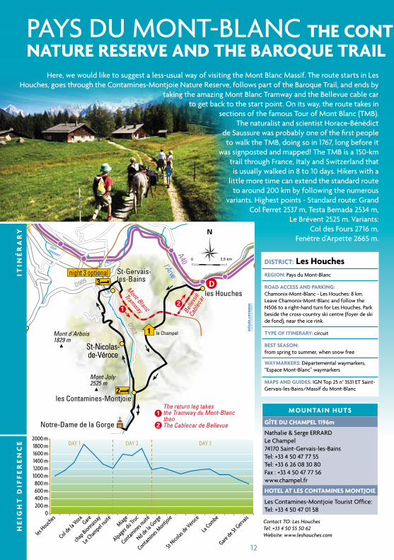
PAyS du Mont-BLAnc THe conT aMines-MonTJoienaTuRe ReseRve anD THe baRoque TRail
DisTRicT: les HouchesReGion: Pays du Mont-Blanc
RoaD access anD PaRkinG: chamonix-Mont-Blanc - Les houches: 8 km.Leave chamonix-Mont-Blanc and follow the n506 to a right-hand turn for Les houches. Park beside the cross-country ski centre (foyer de ski de fond), near the ice rink.
TyPe of iTineRaRy: circuit
besT season: from spring to summer, when snow free
wayMaRkeRs: départemental waymarkers, “espace Mont-Blanc” waymarkers
MaPs anD GuiDes: ign top 25 n° 3531 et Saint-gervais-les-Bains/Massif du Mont-Blanc
MounTain HuTs
GîTe Du cHaMPel 1196m
nathalie & Serge errArdLe champel74170 Saint-gervais-les-Bainstel: +33 4 50 47 77 55tel: +33 6 26 08 30 80Fax : +33 4 50 47 77 56www.champel.fr
HoTel aT les conTaMines MonTJoie
Les contamines-Montjoie tourist office: tel: +33 4 50 47 01 58
les Contamines-Montjoie
St-Gervais-les-Bains
St-Nicolas-de-Véroce
D
1
2
3night 3 optional
2
2
le Champel
1
1
l'ArveA40
D909
D902Mont-Blanc
Tramway Belle
vue
Cable
car
The return leg takesthe Tramway du Mont-BlancthenThe Cablecar de Bellevue
Mont Joly2525 m
Mont d'Arbois1829 m
les Contamines-Montjoie
les Houches
St-Gervais-les-Bains
Notre-Dame de la Gorge
St-Nicolas-de-VéroceSt-Nicolas-de-Véroce
0 2,5 km
N
here, we would like to suggest a less-usual way of visiting the Mont Blanc Massif. the route starts in Les houches, goes through the contamines-Montjoie nature reserve, follows part of the Baroque trail, and ends by
taking the amazing Mont Blanc tramway and the Bellevue cable car to get back to the start point. on its way, the route takes in
sections of the famous tour of Mont Blanc (tMB). the naturalist and scientist horace-Bénédict
de Saussure was probably one of the first people to walk the tMB, doing so in 1767, long before it
was signposted and mapped! the tMB is a 150-km trail through France, italy and Switzerland that is usually walked in 8 to 10 days. hikers with a
little more time can extend the standard route to around 200 km by following the numerous
variants. highest points - Standard route: grand col Ferret 2537 m, testa Bemada 2534 m,
Le Brévent 2525 m. variants: col des Fours 2716 m,
Fenêtre d’Arpette 2665 m.
Contact TO: Les HouchesTel: +33 4 50 55 50 62Website: www.leshouches.com
He
iGH
T D
iff
eR
en
ce
iTin
éR
aR
y
13
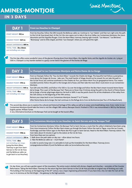
PAyS du Mont-BLAnc THe conT aMines-MonTJoienaTuRe ReseRve anD THe baRoque TRail in 3 Days
Day 1 from les Houches to champel
sTaRT HeiGHT: 992 mFrom les houches, follow the gr5 towards the Bellevue cable car. continue to “Les trabets”, and then turn right onto the path to the col de voza (snack bar). At the col, the view opens out to take in the Arve valley, Les contamines-Montjoie, the Aravis Mountains and the Aiguilles rouges. cross the Mont-Blanc tramway, bearing right towards “Les Maisons”, “Les Béttières”, “Bionnassay” and its little chapel, and then “Les champel”, where you will spend the night.HiGHesT PoinT: 1672 m
HeiGHT DiffeRence: 869 m
ToTal TiMe: 3hrs 30minnot including rest stops
this first day offers some wonderful views of the glaciers flowing down from Mont-Blanc, the Aiguille verte, and the Aiguille du goûter, etc. Lying at 1200 m, champel is a tiny hamlet nestled in a grassy corner below the glaciers of the domes de Miage.
Day 3 les contamines-Montjoie to les Houches via saint-Gervais and the baroque Trail
sTaRT HeiGHT: 1196 mFrom les contamines-Montjoie, follow the Baroque trail to Saint-gervais, a route that the valley’s inhabitants have been using from time immemorial. Follow the Bon nant stream, go through the forest, follow the road to tague, cross the Les crouets footbridge, and then follow signs to the Plaine des Praz to get to Saint gervais. head to the Mont-Blanc tramway station. the tram takes about 35 minutes to get to the station at the col de voza. From here there are two options: 1. Walk down the path taken on day one – allow about two hours. 2. take the Bellevue cable car – much faster!
in order to avoid a long wait, it is advisable to look up the timetables for the Mont-Blanc tramway (www.compagniedumontblanc.fr) and the Bellevue cable car (www.leshouches.com).
HiGHesT PoinT: 1196 m
HeiGHT DiffeRence: 250 m
ToTal TiMe: 6hrsnot including rest stops (using the Mont-Blanc tramway to get from Saint-gervais to the col de voza and the Bellevue cable car to get back to Les houches).
on day three, you will see a gentler aspect of the mountains. the entire route is dotted with shrines, chapels and churches – reminders of the counter reformation. taking the Mont-Blanc tramway for the return leg from Saint-gervais to the col de voza provides an original way of finishing your walk. the building of the tramway at the beginning of the 20th century was a major engineering achievement. if you have time, why not take the tram all the way to its terminus at the nid d’Aigle – the gateway to the high summits.
Day 2 le champel to les contamines-Montjoie and notre-Dame-de-la-Gorge
sTaRT HeiGHT: 1196 mFrom Le champel, follow the “tour du Mont-Blanc” towards the chalets de Miage. this beautiful trail follows a precipitous route above the gorges de gruvaz - take care. the small hamlet of Miage should not be missed. do not take the path to the col de tricot, but continue southwest to the chalets du truc, just below Mont truc (in geographical terms, truc means rounded summit). Follow the path to the granges de la Frasse, and then take the most direct route down to Les contamines-Montjoie.turn left onto the d902, and follow it for 500 m. go over the bridge and follow the Bon nant stream towards notre-dame-de-la-gorge. this is part of the Baroque trail. there are no fewer than 14 shrines along the path to the church of notre-dame-de-la-gorge, a former pilgrimage objective. re-built in 1699, it was the parish church for all the inhabitants of the valley from the 12th century to the beginning of the 19th century.retrace your steps back to Les contamines-Montjoie. Several 1* to 3* hotels.After notre-dame-de-la-gorge, the trail continues to the refuge de la croix du Bonhomme (see tour of the Beaufortain).
HiGHesT PoinT: 1751 m
HeiGHT DiffeRence: 949 m
ToTal TiMe: 4hrsnot including rest stops
this second day allows you to explore the cultural and historical heritage of this valley, as well as to enjoy some breathtaking views. every visitor to Les contamines-Montjoie should take the time to visit the village’s 18th century Baroque church. Finished in 1759, it was immortalised in 1802 by the famous english painter, William turner.A very informative brochure on the Baroque trail can be bought at the tourist office.
14
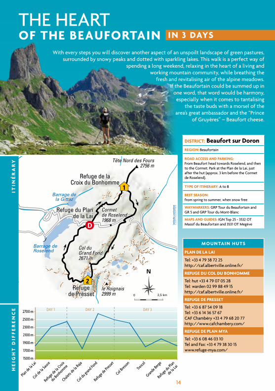
the heArt of THe beaufoRTain in 3 Days
DisTRicT: beaufort sur DoronReGion: Beaufortain
RoaD access anD PaRkinG: From Beaufort head towards roselend, and then to the cormet. Park at the Plan de la Lai, just after the hut (approx. 3 km before the cormet de roselend).
TyPe of iTineRaRy: A to B
besT season: from spring to summer, when snow free
wayMaRkeRs: grP tour du Beaufortain and gr 5 and grP tour du Mont-Blanc
MaPs anD GuiDes: ign top 25 - 3532 ot Massif du Beaufortain and 3531 ot Megève
Refuge de laCroix du Bonhomme
Refugede Presset
Refuge du Plande la Lai
le Roignais2999 m
Cormetde Roselend1968 m
1
D
2
Refuge du Plande la Lai
Refuge de laCroix du Bonhomme
Refugede Presset
Barrage deRoselend
Barrage dela Gittaz
Tête Nord des Fours2756 m
le Roignais2999 m
Col duGrand Fond2671 m
Cormetde Roselend1968 m
0 2,5 km
N
With every steps you will discover another aspect of an unspoilt landscape of green pastures, surrounded by snowy peaks and dotted with sparkling lakes. this walk is a perfect way of
spending a long weekend, relaxing in the heart of a living and working mountain community, while breathing the
fresh and revitalising air of the alpine meadows. if the Beaufortain could be summed up in
one word, that word would be harmony, especially when it comes to tantalising
the taste buds with a morsel of the area’s great ambassador and the “Prince
of gruyères” – Beaufort cheese.
He
iGH
T D
iff
eR
en
ce
iTin
éR
aR
y
MounTain HuTs
Plan De la lai
tel: +33 4 79 38 72 25http://caf.albertville.online.fr/
RefuGe Du col Du bonHoMMe
tel: hut +33 4 79 07 05 28 tel: warden 02 99 88 49 15 http://caf.albertville.online.fr/
RefuGe De PResseT
tel: +33 6 87 54 09 18 tel: +33 6 14 36 57 67 cAF chambéry +33 4 79 68 20 77http://www.cafchambery.com/
RefuGe De Plan Mya
tel: +33 6 08 46 03 10 tel and Fax: +33 4 79 38 30 15 www.refuge-mya.com/
15
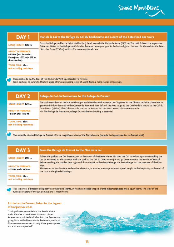
in 3 Days
Day 1 Plan de la lai to the Refuge du col du bonhomme and ascent of the Tête nord des fours
sTaRT HeiGHT: 1818 mFrom the refuge du Plan de la Lai (staffed hut), head towards the col de la Sauce (2307 m). the path follows the impressive crête des gittes to the refuge du col du Bonhomme. Leave your gear in the hut to lighten the load for the walk to the tête nord des Fours (2756 m), which offers an exceptional view.
HeiGHT DiffeRence: + 958 m (inc. Tête des fours) and - 323 m (+ 615 m direct to hut)
ToTal TiMe: 4hrsnot including rest stops
it is possible to do the tour of the rocher du vent (spectacular via ferrata).From pastures to summits, this first stage offers outstanding views of Mont Blanc, a mere stone’s throw away.
Day 3 from the Refuge de Presset to the Plan de la lai
sTaRT HeiGHT: 2514 mFollow the path to the col Bresson, just to the north of the Pierra Menta. go over the col to follow a path overlooking the Lac de roselend. At the junction with the path to the col du coin, turn right and go down towards the hamlet of treicol. Before reaching the hamlet, bear right to follow the gr to the grande Berge, the Petite Berge and the pastures of the Plan Mya.this route can also be done in the other direction, in which case it is possible to spend a night at the beginning or the end of the tour at the gîte de Plan Mya.
HeiGHT DiffeRence: + 238 m and - 1000 m
ToTal TiMe: 4hrsnot including rest stops
this leg offers a different perspective on the Pierra Menta, in which its needle-shaped profile metamorphoses into a squat tooth. the view of the turquoise waters of the Lac de roselend is magnificent.
Day 2 Refuge du col du bonhomme to the Refuge de Presset
sTaRT HeiGHT: 2433 mthe path starts behind the hut, on the right, and then descends towards Les chapieux. At the chalets de la raja, bear left to get to and follow the road to the cormet de roselend. turn left off the road to go up the combe de la neuva to the col du grand Fond (2671 m). the col overlooks the Lac de Presset and the Pierra Menta. go down to the hut.nB: the refuge de Presset only sleeps 24, so advance booking is essential.HeiGHT DiffeRence:
+ 881 m and - 890 m
ToTal TiMe: 6hrsnot including rest stops
the superbly situated refuge de Presset offers a magnificent view of the Pierra Menta. (include the legend: see Lac de Presset walk).
at the lac de Presset, listen to the legend of Gargantua who: “… tripped over a mountain in the Aravis, which, under the shock, burst into a thousand pieces. An enormous pointed rock shot into the Beaufortain, giving birth to the Pierre Menta. Fortunately without disastrous consequences, as only three grasshoppers and a rat were squashed”.
16
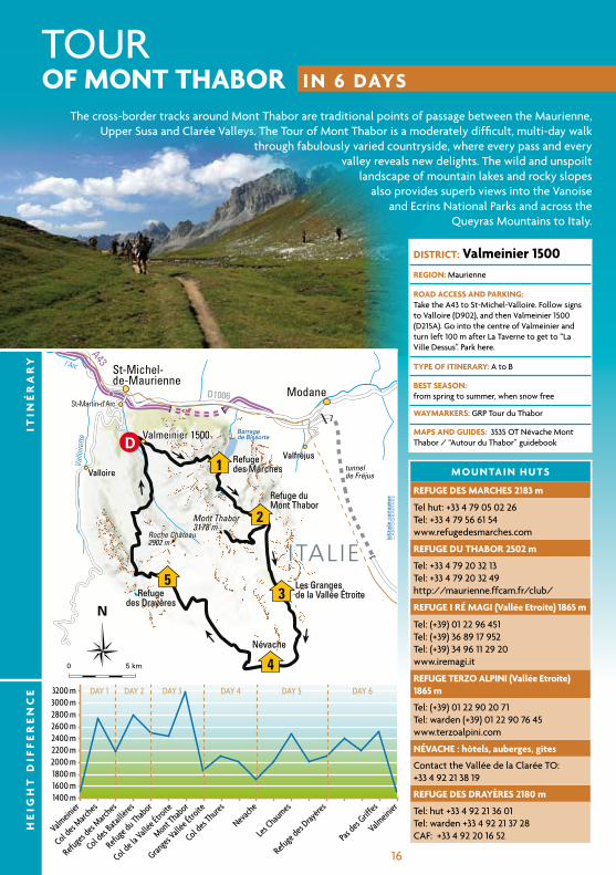
tour in 6 Days
DisTRicT: valmeinier 1500ReGion: Maurienne
RoaD access anD PaRkinG: take the A43 to St-Michel-valloire. Follow signs to valloire (d902), and then valmeinier 1500 (d215A). go into the centre of valmeinier and turn left 100 m after La taverne to get to “La ville dessus”. Park here.
TyPe of iTineRaRy: A to B
besT season: from spring to summer, when snow free
wayMaRkeRs: grP tour du thabor
MaPs anD GuiDes: 3535 ot névache Mont thabor / “Autour du thabor” guidebook
MounTain HuTs
RefuGe Des MaRcHes 2183 m
tel hut: +33 4 79 05 02 26 tel: +33 4 79 56 61 54 www.refugedesmarches.com
RefuGe Du THaboR 2502 m
tel: +33 4 79 20 32 13 tel: +33 4 79 20 32 49http://maurienne.ffcam.fr/club/
RefuGe i Ré MaGi (vallée etroite) 1865 m
tel: (+39) 01 22 96 451 tel: (+39) 36 89 17 952tel: (+39) 34 96 11 29 20 www.iremagi.it
RefuGe TeRzo alPini (vallée etroite) 1865 m
tel: (+39) 01 22 90 20 71 tel: warden (+39) 01 22 90 76 45 www.terzoalpini.com
névacHe : hôtels, auberges, gîtes
contact the vallée de la clarée to: +33 4 92 21 38 19
RefuGe Des DRayèRes 2180 m
tel: hut +33 4 92 21 36 01tel: warden +33 4 92 21 37 28cAF: +33 4 92 20 16 52
Valmeinier 1500
ITALIE
Refugedes Marches
Refuge duMont Thabor
Les Grangesde la Vallée Étroite
Névache
Refugedes Drayères
Barragede Bissorte
Valloire
Valfréjus
St-Martin-d'Arc
4
2
001D
35
Refugedes Marches
Refuge duMont Thabor
Les Grangesde la Vallée Étroite
Névache
Refugedes Drayères
l’Arc
Vallo
irette
Barragede Bissorte
A43
D1006
Mont Thabor3178 m
Roche Château2902 m
tunnelde Fréjus
Modane
St-Michel-de-Maurienne
Valloire
Valmeinier 1500
Valfréjus
St-Martin-d'Arc
ITALIE
0 5 km
N
the cross-border tracks around Mont thabor are traditional points of passage between the Maurienne, upper Susa and clarée valleys. the tour of Mont thabor is a moderately difficult, multi-day walk
through fabulously varied countryside, where every pass and every valley reveals new delights. the wild and unspoilt
landscape of mountain lakes and rocky slopes also provides superb views into the vanoise
and ecrins national Parks and across the Queyras Mountains to italy.
He
iGH
T D
iff
eR
en
ce
iTin
éR
aR
y
of MonT THaboR
17
in 6 Days
Day 1 from valmeinier 1500 to the Refuge des Marches
sTaRT HeiGHT: 1500 mthis variant on the gr follows the stream along the vallon des inversins to the col des Marches. From the pass at 2725 m, the path descends to the refuge des Marches, providing excellent views of the Lac de Bissorte.
HeiGHT DiffeRence: +1225m / – 542 m
ToTal TiMe: 5hrsnot including rest stops
A wild and airy route that finishes magnificently with a 360° panorama of the Maurienne valley and the ecrins Mountains.
Day 5 névache to the Refuge des Drayères
sTaRT HeiGHT: 1600 mgo up the clarée valley to the Pont du rately. cross the river and go up the switchbacks to the chalets de Biaune. Follow the chemin de ronde to the refuge des drayères.
HeiGHT DiffeRence: + 917 m / - 437 m
ToTal TiMe: 5hrs 45minnot including rest stops
the chemin de ronde was the path patrolled by Louis Xiv’s soldiers to protect the area from incursions from neighbouring Savoie and from pillagers.
Day 3 Refuge du Thabor to the Granges de la vallée etroite, including the ascent of Mont Thabor
sTaRT HeiGHT: 2502 mhead towards the col de la vallée etroite, and then follow the gr57. go past Lac Peyron, and over the col des Méandes. cross the plateau at the foot of the gully, and then take the path on the left onto the shoulder. Follow the way of the cross to the aptly named chapel of notre dame des douleurs (our Lady of the Pains). continue easily to the summit. Follow the same path back to the col des Méandes, then turn right and go down to the Prat du Plan. go past the Maison des chamois, a former iron mine, to get to the Pont de la Fonderie. Spend the night in one of the two huts (i ré Magi or terzo Alpini) at the granges de la vallée etroite.
HeiGHT DiffeRence: + 676 m / - 1313 m
ToTal TiMe: 7hrsnot including rest stops
this stage takes you to the summit of Mont thabor, from where you can enjoy one of the most spectacular views of the Alps, taking in prestigious peaks such as the grandes Jorasses, the Matterhorn, the grande casse, Mont Pourri, the ciamarella, Mont viso and the Aiguilles d’Arves.
Day 2 Refuge des Marches to the Refuge du Thabor
sTaRT HeiGHT: 2183 mthis stage could be called the “lake trail”. From the hut, follow the path under the roche noire and past the Lac des Bataillères to the col des Bataillères (2787 m), situated on the ridgeline that runs southwards from the crêtes des Sarrasins. As the path descends to the refuge du Mont thabor you can admire the reflection of the cheval Blanc in the clear waters of the Lacs de Sainte-Marguerite (Lac Long and Lac rond).
HeiGHT DiffeRence: + 604 m / - 297 m
ToTal TiMe: 3hrs 15minnot including rest stops
the tiny huts between the Lac de Bissorte and the Lac des Bataillères were built as shelters and rest stops for smugglers and their mules.
Day 6 Refuge des Drayères to valmeinier 1500
sTaRT HeiGHT: 2170 mthis leg brings you back from Les hautes Alpes to Savoie. cross the Seuil des rochilles and go past its three lakes (Lac de la clarée, Lac rond and Lac du grand Ban). the path then heads right over the Pas des griffes (2554 m) before descending to Les Arendiers. Follow the neuvache stream back to valmeinier.
HeiGHT DiffeRence: + 624 m / - 1304 m
ToTal TiMe: 8hrsnot including rest stops
this stage across alpine pastures is both varied and strenuous. Solitude is guaranteed as you follow a succession of ridges, small summits and passes; the only signs of human occupation being a few chalets, shepherd’s huts and an 18th century fort on the Plateau de la Plagnette.
Day 4 Granges de la vallée etroite to névache
sTaRT HeiGHT: 1765 mthe gr5/gr57 takes you to the col des thures, where the mountains of the three kings are reflected in the waters of Lac chavillon. Follow the valley to the chalets des thures (possible to climb the Aiguille rouge: 2hr round trip). As the path descends to névache, look out for the “hoodoos” (narrow pillars of rock supporting a cap of harder stone) on the left. Follow the roubion stream to the hamlet of the same name, and then follow the clarée valley to névache (hotels, gîtes, auberges, etc).
HeiGHT DiffeRence: + 406 m / - 571 m
ToTal TiMe: 5hrs 15minnot including rest stops
the vallée etroite has retained its undefinable italian charm. this leg gives a taste of the southern Alps.
18
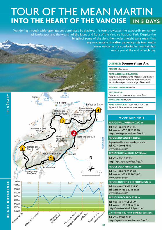
tour oF the MeAn MArtin inTo THe HeaRT of THe vanoise in 5 Days
DisTRicT: bonneval sur arcReGion: Maurienne
RoaD access anD PaRkinG: take the A43 motorway to Modane, and then go up the Maurienne valley to Bonneval-sur-Arc. Park in the car park on the edge of Bonneval
TyPe of iTineRaRy: circuit
besT season: from spring to summer, when snow free
wayMaRkeRs: Pr, gr5
MaPs anD GuiDes: ign top 25 - 3633 et tignes val d’isère - haute Maurienne
MounTain HuTs
RefuGe vallonbRun 2272 m
tel: hut +33 4 79 05 93 93 tel: warden +33 6 71 28 72 20http://refuge.vallonbrun.free.fr/
RefuGe Du cucHeT 2160 m
Supervised hut, no meals providedtel: +33 4 79 08 71 49www.vanoise.com
RefuGe Du Plan Du lac 2364 m
tel: +33 4 79 20 50 85 http://plandulac.refuge.free.fr
RefuGe De la feMMa 2352 m
tel: hut +33 4 79 05 45 40 tel: warden +33 4 79 20 33 00 www.vanoise.com
RefuGe Du fonD Des fouRs 2537 m
tel: hut +33 4 79 +33 6 16 90tel: warden +33 6 87 13 41 24www.vanoise.com
RefuGe Du caRRo 2759 m
tel: hut +33 4 79 05 95 79 tel: warden +33 6 74 57 63 72 http://www.clubalpinlyon.com
Gite d’étape du Petit bonheur (bessans)
tel: +33 4 79 05 06 71http://petitbonheur.bessans.free.fr/
Refuge duPlan du Lac
Refuge duFond des Fours
Refuge du Carro
Refuge Vallonbrun
Grande AiguilleRousse 3483 m
Col de l’Iseran2764 m
Pointe de la Sana3436 m
1
D
4
2
3
Refuge duPlan du Lac
Refuge duFond des Fours
Refuge du Carro
Refuge Vallonbrun
l’Arc
Isère
Lac duChevril
Lac deTignes
Lac dela Sassière
D902
D100
6
Grande AiguilleRousse 3483 m
Pointe deMean Martin
3330 m
Pointe de la Sana3436 m
Col de l’Iseran2764 m
Bessans
Lanslebourg-Mt-Cenis
Tignes
Val-d'Isère
Bonneval-sur-Arc
Lanslevillard
0 5 km
N
Wandering through wide-open spaces dominated by glaciers, this tour showcases the extraordinary variety of landscapes and the wealth of the fauna and flora of the vanoise national Park. despite the
length of some of the days, the modest height gains mean that any moderately fit walker can enjoy this tour. And a
warm welcome in a comfortable mountain hut awaits you at the end of each day.
He
iGH
T D
iff
eR
en
ce
iTin
éR
aR
y
19
inTo THe HeaRT of THe vanoise in 5 Days
Day 1 bonneval-sur-arc to the Refuge de vallonbrun
sTaRT HeiGHT: 1790 mFollow the chemin du Petit Bonheur (gr5), beside the river Arc, back down the valley. go through Le villaron and Bessans to the collet de la Madeleine. turn right and go up to the refuge de vallonbrun. this first stage, mostly along the valley floor, provides an excellent warm up for the rest of the tour.
HeiGHT DiffeRence: + 598 m / - 126 m
ToTal TiMe: 5hrsnot including rest stops
rock paintings at the rocher du château, between Bonneval-sur-Arc and Bessans. traditional houses at Le villaron.
Day 5 Refuge du carro to bonneval sur arc
sTaRT HeiGHT: 2759 mFollow the path down to the hamlet of ecot, going through the gorge below Le Montet. At La tullière, turn right onto the track to ecot and follow it all the way to Bonneval. variant: this stage can be extended by going over the col des Pariotes, and then following the path that leads to the source of the river Arc: + 2hrs.
HeiGHT DiffeRence: - 950 M
ToTal TiMe: 3hrsnot including rest stops
visit to the traditional hamlet of ecot, whose stone houses seem to emerge directly from the rock. tralenta boulder field (clapier de Fodan).
Day 3 Refuge du Plan du lac to the Refuge du fond des fours
sTaRT HeiGHT: 2364 mgo down to the chapel St Barthélémy. turn off the gr5 to follow the right-hand path to Plume Fine. go up the vallon de la rocheure to the refuge de la Femma (staffed hut that could be used to cut the stage in two). go up to the col de la rocheure (2911 m). nB: the route to the refuge du Fond des Fours is not easy to follow in poor visibility. in bad weather, it is better to follow the vallée des Pissets to Le Manchet (2000 m), and then go back up to the refuge du Fond des Fours (allow an extra 1hr 30min).
HeiGHT DiffeRence: + 737 m / - 564 m
ToTal TiMe: 6hrsnot including rest stops
Wild high-mountain scenery. the pastures and chapels at St-Barthélémy and St-Jacques.
Day 2 Refuge de vallonbrun to the Refuge du Plan du lac
sTaRT HeiGHT: 2272 mtraverse almost horizontally to the Plan de la cha, and then go past the refuge du cuchet (supervised hut but with no meals provided – possible stopping off point, depending on where you started). continue to Pré vaillant, and then go up to the turra de termignon. the gr5 continues to the car park at Bellecombe, and then to the refuge du Plan du Lac. After the Refuge du Villaron, it is possible to climb up to the Roche aux Pieds (rock carvings) + 1hr 30min
HeiGHT DiffeRence: + 690 m / - 600 m
ToTal TiMe: 6hrs 30minnot including rest stops
view of the glaciers de la vanoise. information panels at the Plan du Lac, next to the hut.
Day 4 Refuge du fond des fours to the Refuge du carro
sTaRT HeiGHT: 2537 mFollow the path to the col des Fours (2976 m), and then go down to the Pont de la neige, on the road to the col de l’iseran. go down the road to the Pont de l’oulietta, which marks the start of the “Sentier Balcon” that traverses across to the refuge du carro. (the tour can be cut short by following the vallon de la Lenta straight back to Bonneval: 4hrs 30min.)
HeiGHT DiffeRence: + 750 m
ToTal TiMe: 7hrsnot including rest stops
A panoramic footpath with outstanding views of the mountains on the Franco-italian border, including the Albaron and the Lévanna.
NB: A number of start points are possible (suggestions: Bessans, Bellecombe (Termignon), Le Manchet (Val d’Isère). The itinerary can easily be modified to suit the chosen start point).
20
21
Contact TO: Sciez sur LémanTel: +33 4 50 72 64 57Website: www.tourisme-sciez.com
THe Moulin De la seRPeA very pleasant circuit on the shores of Lake geneva that combines an enjoyable stroll with a chance to discover more about the area’s culture.
this walk starts on the shores of Lake geneva, a crescent-shaped glacial lake that is fed by the river dranse and the river rhone, which flows through the lake from east to west. covering an area of 582 km2 and descending to a maximum depth of 310 metres, Lake geneva has the particularity of being divided in two by the Franco-Swiss border. the two largest cities on the lakeshore, geneva and Lausanne, together with the towns of vevey and Montreux, are on the Swiss side of the lake, whereas the spa resorts of thonon-les-Bains and Évian-les-Bains attract large numbers of tourists to the French side.
the Metamorphosis trail, along the banks of the river Foron, gives walkers the chance to discover the history and folklore of the Sciez area. the legend of the Moulin de la Serpe provides the background to a 7-km walk that takes in 11different themes (the landing stage, the boxwood forest, the lovers of the Foron, the water engine, etc) presented in a variety of ways (illustrations, tables, tableaux, etc).
From the beach car park, follow signs to the château de coudrée, and then to Le Moulin.
DisTRicT: sciezReGion: Lake geneva/vallée verte
RoaD access anD PaRkinG: thonon-les-Bains - Sciez: 8 Km.From thonon-les-Bains, follow the n5 towards yvoire. Just before Sciez, turn right towards the château de coudrée, Port de Plaisance de Sciez. Park in the car park next to the beach at Sciez.
TyPe of iTineRaRy: circuit
besT season: all year
wayMaRkeRs: departemental waymarkers
HeiGHT DiffeRence: 98 m start height:
372 m
Highest point:
444 mToTal TiMe: 3hrs not including rest stops
Maps and guides: ign top 25 n°3428et thonon/evian/Le Léman
two themed trails: the “errance romantique” (romantic ramble) at nernier (birthplace of the painter vegetti and home to Lamartine), and the “Moulin de la Serpe”.Leisure park: Les Aigles du Léman.
1THe lake anD MeaDows aT les PlaGnes originally a marsh, the basin has filled with water to become a lake surrounded by dark green forests. From the beginning of May onwards, large numbers of fishermen come to fish the waters of this superb lake. Sandwiched between the 2080-m high “Pointe de la chavache», whose slopes feed the «cubourré» waterfall, and Mont de grange (2436 m), this is a great place to cool down on hot summer days.
From the car park, go down the road, bearing immediately left to follow the shores of the Lac des Plagnes.
Walkers who would like to do a longer circuit (4hrs, 660 metres of height gain) can follow the eastern bank of the lake and go up to the refuge des tinderêts (see page 64). if you would like to travel light, leave the picnic at home and have lunch at the refuge.
Contact TO: AbondanceTel: +33 4 50 73 02 90Website: www.abondance.org
DisTRicT: abondanceReGion: haut-chablais Portes du Soleil
RoaD access anD PaRkinG: thonon-les-Bains - Abondance: 27 km. From thonon-les-Bains, follow the d902, and then the d22 to vacheresse. go through vacheresse to Abondance. in Abondance, follow the road to the Lac des Plagnes. Park in the large car park at the end of the road.
TyPe of iTineRaRy: circuit
besT season: from spring to autumn, when snow free
wayMaRkeRs: departemental waymarkers
HeiGHT DiffeRence: 90 m start height:
1190 m
Highest point:
1268 mToTal TiMe: 45min not including rest stops
Maps and guides: ign top 25 n°3528et Morzine Massif du chablais
enjoy a moment of contemplation at the chapelle Sainte-Anne and admire the very old and beautiful chalets.
2
20
22
Contact TO: Saint-Jean-d’AulpsTel: +33 4 50 79 65 09Website: www.saintjeandaulps.com
To THe fooT of THe Roc D’enfeR A wild and unspoilt area in a valley where chapels and chalets are omnipresent. Look out for the numerous shrines, statues, chapels, etc. the roc d’enfer rises to an altitude of 2243 m. in former times, it was called Mont Maudit (damned Mountain) because of the steep and exposed route to the summit, but don’t worry, the walk described here stays at the foot of the mountain. the walk has a very varied atmosphere, starting with a “mountainous” section at the foot of the roc d’enfer, and finishing amongst chalets and forests.
climb up to the col ratti. go straight on. do not take the track to the chapel.the river Brévon, which rises at the foot of the roc d’enfer, has given its name to this valley.
DisTRicT: saint-Jean-d’aulpsReGion: haut-chablais portes du soleil
RoaD access anD PaRkinG: thonon-les-Bains – essert-romand: 29 km. From thonon-les-Bains, take the d902, and then the d328 to essert-romand. in essert-romand, go up a narrow road to the right of the church. At the t-junction, turn right and follow the refuge de graydon road to the end. Parking spaces next to the chapel.total time, not including rest stops: 5hrs
TyPe of iTineRaRy: circuit
besT season: from spring to summer, when snow free
wayMaRkeRs: departemental waymarkers
HeiGHT DiffeRence: 1100 m start height:
1340 m
Highest point:
1905 mToTal TiMe: 5hrsnot including rest stops
Maps and guides: ign top 25 n° 3228et thonon-les-Bains
the Bellevaux waterfall, near the tree-top adventure course, is perfect for canyoning
4
Contact TO: Le Grand Bornand Tel: +33 4 50 02 78 00Website: www.legrandbornand.com
lac De lessy Formed by glaciers, this mountain lake lies in the heart of magnificent alpine pastures and at the foot of the Pic de Jalouvre, just under the cliffs of Le Buclon. Legend has it that during severe droughts a stone emerges from the dried-up lake, on which it is written “when you see me, you will cry” – proof that the lake is an essential element in the life of the meadows. Another legend tells of two newly-weds who drowned in the lake. Much later, the bride’s veil was found in the river Borne. the Aravis is reblochon country - a cheese that was created in order to defraud tax collectors in the Middle Ages. in local patois, “reblocher” means to milk a second time, as, in order to avoid paying tax on the milk they produced, local peasants would not completely milk their cows, leaving some milk to be collected once the tax collectors had left. this second milking produced a very thick and creamy milk, which was used to make cheese for the farmer’s own consumption.
From the chapel, follow signs to the “Lac de Lessy par les chalets de Mayse” to the lake. return by the same path.
DisTRicT: Grand-bornandReGion: Aravis
RoaD access anD PaRkinG: Annecy – le grand-Bornand: 32 km.From Annecy, take the d909 to thônes. go through thônes and continue to Saint-Jean-de-Sixt. From Saint-Jean-de-Sixt, follow the d4 to Le grand Bornand. go through Le grand Bornand on the d4 towards the col de la colombière. Park in the old village of chinaillon: echelon parking possible next to a pretty stone pool. if there is no space here, continue to the junction with the main road – several possible parking spaces.
TyPe of iTineRaRy: round trip. can be extended by following the tour of the roc des tours (circuit)
besT season: from spring to autumn, when snow free
wayMaRkeRs: departemental waymarkers
HeiGHT DiffeRence: 1070 m start height:
1284 m
Highest point:
1965 mToTal TiMe: 6hrs 15minnot including rest stops
Maps and guides: ign top 25 n° 3430 et la clusaz le grand-Bornand
the traditional architecture of the village of Le chinaillon.
8
23
onTex Mini-ciRcuiT An unbeatable panorama over Lake Bourget and a bird’s-eye view of hautecombe Abbey. Founded in the 12th century by cistercian monks, hautecombe Abbey has been the last resting place of members of the house of Savoie since 1189. in 1992, the abbey was taken over by the chemin neuf ecumenical community.
Follow the path through the woods to ontex. go past the village hall (mairie) and the church, and then follow the signs to “Le Mont”. At the shepherd’s hut, turn right onto the track through the forest. At the Les Barmes junction, turn left towards Le grumeau, and then go to L’Arcelet. Follow the “Point de vue des tables” signs. retrace your steps to the previous junction and follow signs to Le grumeau to get back to the viewpoint and car park.
Contact TO: Bourget du LacTel: +33 4 79 25 01 99Website: www.bourgetdulac.com
Aix les BainsTel: +33 4 79 88 68 00Website: www.aixles bains.com
DisTRicT: ontex ReGion: Bourget Aix
RoaD access anD PaRkinG: From Le Bourget du Lac, follow the road towards the tunnel du chat for 3 km, and then turn left towards the col du chat. Just before the col, turn right to head towards hautecombe/La chapelle du Mont du chat. Follow this road to the car park at Le grumeau.
TyPe of iTineRaRy: circuit
besT season: all year
wayMaRkeRs: Pr
HeiGHT DiffeRence: 211 m start height:
608 m
Highest point:
819 mToTal TiMe: 2hrsnot including rest stops
Maps and guides: ign top 25 - 3332 ot chambéry
visit hautecombe Abbey (departure point for boats to Aix les Bains).the Le cornillon via ferrata (start: col du chat car park).
11THe lake aiGuebeleTTe balcony RouTe this airy route across the western flank of the Montagne de l’epine overlooks France’s third largest natural lake. it provides numerous vantage points from which to admire the 70 hectares of wetlands surrounding lake Aiguebelette’s calm and pure waters, wich are much appreciated by bathers, fishermen and rowers.
From the cemetery, the path goes up through the woods to the grotte de conche (cave and spring). Above the “grotte”, the path becomes steep, narrow and difficult, as it follows the edge of a cliff to join the “Balcons du lac” trail (1hr). this relatively flat track was built to serve the area’s charcoal-burning kilns. the path then goes back down to Les Logers, and then to Les gustins. Follow the road for 400 m, then turn right onto the track that joins the minor road beside the lake, which is followed to its northernmost tip. go under the A43 to get back to nances via the grotte de Loup.
DisTRicT: nancesReGion: Avant Pays Savoyard
RoaD access anD PaRkinG: From chambéry, take the A43 motorway towards Lyon to junction n°12 Aiguebelette. At the roundabout, turn right, and then right again to follow the road to nances. Park next to the cemetery in nances.
TyPe of iTineRaRy: circuit
besT season: nB: the path is steep and exposed. this walk is not suitable for young children or for people who suffer from vertigo. it is also a walk to avoid when it is wet or snowy.
wayMaRkeRs: Pr
HeiGHT DiffeRence: 450 m start height:
390 m
Highest point:
840 mToTal TiMe: 5hrsnot including rest stops
Maps and guides: ign top 25 - 3332 ot chambéry
Admire the views of Lake Aiguebelettethe floral laundry basins and hamlets of nances are worth a visit.
18
Contact TO: AiguebeletteTel: +33 4 79 36 00 02 Website: www.lac-aiguebelette.com
24
Contact TO: Rive Gauche du Lac d’AnnecyTel: +33 4 50 52 40 56Website: www.visit-lacannecy.fr et www.lac-annecy.com
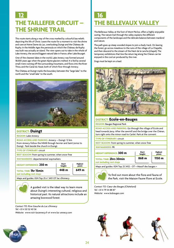
THe TaillefeR ciRcuiT – THe sHRine TRailthis route starts along a way of the cross marked by colourful bas-reliefs depicting the life of christ. Leave the route for a moment to visit the shrine and cave at notre dame du Lac, overlooking duingt and the château de ruphy. in the Middle Ages the peninsula on which the château de ruphy was built was actually an island. the view opens out to take in the whole of Lake Annecy, the second biggest natural lake in France, after Lake Bourget.
one of the cleanest lakes in the world, Lake Annecy was formed around 18,000 years ago when the great Alpine glaciers melted. it is fed by several small rivers running off the surrounding mountains, and flows into the river thiou and the canal du vassé, both of which flow through Annecy.
the château at duingt marks the boundary between the “large lake” to the north and the “small lake” to the south.
DisTRicT: DuingtReGion: Lake Annecy
RoaD access anD PaRkinG: Annecy – duingt: 12 km.From Annecy follow the n508 through Sevrier and Saint Jorioz to duingt. Park beside the church in duingt.
TyPe of iTineRaRy: circuit
besT season: from spring to summer, when snow free
wayMaRkeRs: departemental waymarkers
HeiGHT DiffeRence: 250 m start height:
448 m
Highest point:
649 mToTal TiMe: 1hr 15minnot including rest stops
Maps and guides: ign top 25 n° 3431 ot lac d’Annecy
A guided visit is the ideal way to learn more about duingt’s interesting cultural, religious and historical past. its natural attractions include an amazing boxwood forest.
12THe bellevaux valleythe Bellevaux valley, at the foot of Mont Pécloz, offers a highly enjoyable outing. the nature trail through the valley explains the different components of the landscape and the delicate balance between mankind and nature.
the path goes up steep wooded slopes to join a shady track. on leaving the forest, go across meadows to the ruins of the village of La chapelle, and then descend to the stream of the nant de la Lanche (chapel). the temporary exhibitions that line the return leg along the chéran can be enjoyed in the cool air produced by the river.
dogs must be kept on a lead.
DisTRicT: ecole-en-baugesReGion: Bauges regional Park
RoaD access anD PaRkinG: go through the village of ecole and head towards Jarsy. After the sawmill and the bridge over the chéran, turn right onto the minor road to carlet. Park at the convent.
TyPe of iTineRaRy: circuit
besT season: from spring to summer, when snow free
wayMaRkeRs: Pr
HeiGHT DiffeRence: 300 m start height:
868 m
Highest point:
1150 mToTal TiMe: 2hrs 30minnot including rest stops
Maps and guides: ign top 25 3432 - ot « Massif des bauges »
to find out more about the flora and fauna of the Park, visit the Maison Faune Flore at ecole.
16
Contact TO: Cœur des Bauges (Châtelard) Tel: +33 4 79 54 88 87Website: www.lesbauges.com
25
foResT waTeRsHeD naTuRe TRail Follow the trail of the “wood snail” through the marvellous nant cortay valley. the burbling of a multitude of mountain streams fills the air as you follow the nature trail explaining the relation between water and the forests of the Arly watershed.
From the car park, go along the road towards cernix and cross the stream. At the bend in the road, turn right to follow the path up the slope and through the forest. the descent starts next to some tables and chairs sculpted out of trees.
Contact TO: Crest Voland - CohennozTel: +33 4 79 31 62 57 Website: www.crestvoland-cohennoz.com
DisTRicT: cohennoz ReGion: val d’Arly
RoaD access anD PaRkinG: When coming from crest-voland, head towards cernix, and then to Les Panissats. go through Les Panissats and park 150 metres further on, on the right, just after the bridge over the nant cortay stream. When coming from cohennoz, park on the left 1 km after cohennoz, just before the bridge over the nant cortay stream.
TyPe of iTineRaRy: circuit
besT season: from spring to summer, when snow free
wayMaRkeRs: Pr
HeiGHT DiffeRence: 180 m start height:
980 m
Highest point:
1160 mToTal TiMe: 1hr 30minnot including rest stops
Maps and guides: ign : top 25 3531 ot Megève (nB: path not shown on the map)
A refreshing stroll through the heart of val d’Arly. cohennoz has a lovely little museum.
14
Contact TO: Chamonix Mont-BlancTel: +33 4 50 53 00 24Website: www.chamonix.com
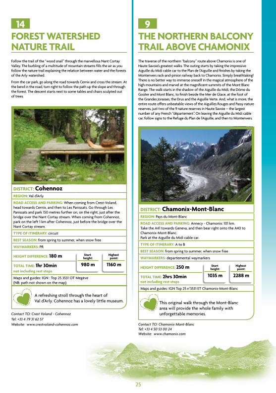
THe noRTHeRn balcony TRail above cHaMonixthe traverse of the northern “balcony” route above chamonix is one of haute Savoie’s greatest walks. the outing starts by taking the impressive Aiguille du Midi cable car to the Plan de l’Aiguille and finishes by taking the Montenvers rack-and-pinion railway back to chamonix. Simply breathtaking!there is no better way to immerse oneself in the magical atmosphere of the high mountains and marvel at the magnificent summits of the Mont Blanc range. the walk starts in the shadow of the Aiguille du Midi, the dôme du goûter and Mont Blanc, to finish beside the Mer de glace, at the foot of the grandes Jorasses, the drus and the Aiguille verte. And, what is more, the entire route offers unbeatable views of the Aiguilles rouges and Passy nature reserves, just two of the 9 nature reserves in haute Savoie – the largest number of any French “département”. on leaving the Aiguille du Midi cable car, follow signs to the refuge du Plan de l’Aiguille, and then to Montenvers.
DisTRicT: chamonix-Mont-blancReGion: Pays du Mont-Blanc
RoaD access anD PaRkinG: Annecy - chamonix: 101 km.take the A41 towards geneva, and then bear right onto the A40 to chamonix-Mont-Blanc.Park at the Aiguille du Midi cable car.
TyPe of iTineRaRy: A to B
besT season: from spring to summer, when snow free
wayMaRkeRs: departemental waymarkers
HeiGHT DiffeRence: 250 m start height:
1035 m
Highest point:
2288 mToTal TiMe: 2hrs 30minnot including rest stops
Maps and guides: ign top 25 n°3531 et chamonix-Mont-Blanc
this original walk through the Mont-Blanc area will provide the whole family with unforgettable memories.
9
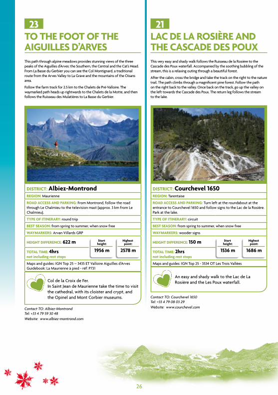
To THe fooT of THe aiGuilles D’aRves this path through alpine meadows provides stunning views of the three peaks of the Aiguilles d’Arves: the Southern, the central and the cat’s head. From La Basse du gerbier you can see the col Montignard, a traditional route from the Arves valley to La grave and the mountains of the oisans area.
Follow the farm track for 2.5 km to the chalets de Pré-valloire. the waymarked path heads up rightwards to the chalets de la Motte, and then follows the ruisseau des Mulatières to La Basse du gerbier.
Contact TO: Albiez-Montrond Tel: +33 4 79 59 30 48 Website: www.albiez-montrond.com
DisTRicT: albiez-MontrondReGion: Maurienne
RoaD access anD PaRkinG: From Montrond, follow the road through Le chalmieu to the television mast (approx. 3 km from Le chalmieu).
TyPe of iTineRaRy: round trip
besT season: from spring to summer, when snow free
wayMaRkeRs: Arvan villards grP
HeiGHT DiffeRence: 622 m start height:
1956 m
Highest point:
2578 mToTal TiMe: 4hrsnot including rest stops
Maps and guides: ign top 25 – 3435 et valloire Aiguilles d’Arvesguidebook: La Maurienne à pied - réf: P731
col de la croix de Fer.in Saint Jean de Maurienne take the time to visit the cathedral, with its cloister and crypt, and the opinel and Mont corbier museums.
23
Contact TO: Courchevel 1650Tel: +33 4 79 08 03 29 Website: www.courchevel.com
lac De la RosièRe anD THe cascaDe Des Pouxthis very easy and shady walk follows the ruisseau de la rosière to the cascade des Poux waterfall. Accompanied by the soothing bubbling of the stream, this is a relaxing outing through a beautiful forest.
After the cabin, cross the bridge and take the track on the right to the nature trail. the path climbs through a magnificent pine forest. Follow the path on the right back to the valley. once back on the track, go up the valley on the left towards the cascade des Poux. the return leg follows the stream to the lake.
DisTRicT: courchevel 1650ReGion: tarentaise
RoaD access anD PaRkinG: turn left at the roundabout at the entrance to courchevel 1650 and follow signs to the Lac de la rosière. Park at the lake.
TyPe of iTineRaRy: circuit
besT season: from spring to summer, when snow free
wayMaRkeRs: wooder signs
HeiGHT DiffeRence: 150 m start height:
1536 m
Highest point:
1686 mToTal TiMe: 2hrsnot including rest stops
Maps and guides: ign top 25 - 3534 ot Les trois vallées
An easy and shady walk to the Lac de La rosière and the Les Poux waterfall.
21
26
27
getting the most from your walksPractical information:
before going to the hut
telephone the warden to book your stay. check the weather forecast, access routes and opening dates for the hut.Pack a head torch and a change of warm clothing. A sleeping bag is not necessary, but take a sleeping-bag liner (available from most outdoor shops), or sew two sheets together. duvets, blankets and pillows are provided. Some huts will rent sheets or sell disposable sheets.
a mountain hut is not a hotel
the hut warden is there to welcome hikers and climbers and to do the cooking; however, it is customary for “guests” to help with chores, such as clearing tables and folding blankets. hut users are also expected to respect certain rules (meal times, lights out times, etc). the warden will also be happy to give advice on walks and climbs in the area around the hut.
at the hut
on arrival, hut users should “check in” with the warden. on entering the hut, take off outdoor shoes and put on the slippers provided by the hut – this is essential to keep the hut clean and ensure everyone’s comfort. Store your gear in the places provided.respect the timings (meals, lights out) set by the warden.For everyone’s welfare, huts are non-smoking
Does everyone sleep in the same room?
every hut is different, but an increasing number of huts have rooms for 4, or even 2 people, rather than dormitories. rooms for snorers may also be designated.earplugs are nevertheless recommended!
Telephone there is usually mobile phone reception but this may depend on your operator.the hut phone is for hut use only (bookings, rescue, information)
electricity the hut’s low-power solar electricity supply cannot be used to recharge mobile phones, cameras, or video recorders, etc.
Prevent wasteShowers are a luxury, so do not empty the hot water tank or gas supply. do not throw rubbish down the toilet; take it home with you.Ask about possible restrictions on camping/bivouacking and cooking fires. Whatever you do, respect the environment.
PasTou dogs PAStou dogs are used to protect flocks and herds. they are trained to chase off any intruders (wild animals, errant dogs, people). if you are too close to a flock, the PAStou will try to frighten, or even attack you. if you come across sheep, cows or goats, give them a wide berth. if a PAStou comes towards you, stay calm – a passive attitude should reassure him. do not try to stroke him, feed him or photograph his flock – he may see that as a threat. in areas where dogs are allowed, and if you have your dog with you, keep it on a tight leash.
Tips for staying in a mountain hut
27
MeTeo france+33 892 68 02 74+33 892 68 02 73
websites:www.chamonix-meteo.comwww.meteo.frwww.pleinchamps.frtourist offices and many accommodation providers also post weather forecasts. it is vital to check the weather before setting off.
national union of Walking guides for Savoie (SnAM73)+33 4 79 55 45 [email protected]
national union of Walking guides for haute Savoie (SnAM74)+33 4 50 53 54 [email protected]
national union of Mountain guides (SngM)+33 4 79 68 51 05www.sngm.com – email: [email protected]
haute Savoie nature reserve Management (ASterS)+ 33 4 50 66 47 51www.asters.asso.fr or www.gypaete-barbu.com
vanoise national Park (Pnv)+33 4 79 62 30 54 www.vanoise.com
Bauges regional Park (PnrMB)+ 33 4 79 54 86 40www.parcdesbauges.com
Put the emergency services number in your mobile. in case of an accident, call 112 (european emergency number)
useful contacts
28
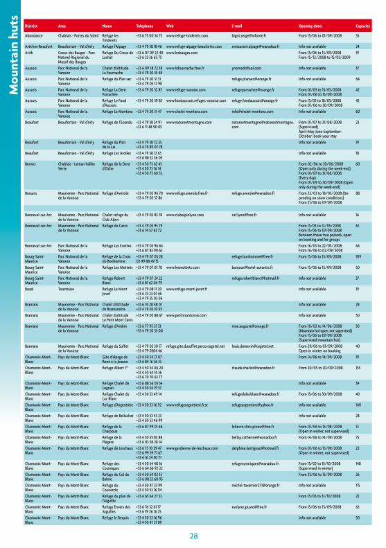
district area name Telephone Web e-mail Opening dates capacity
abondance chablais - portes du Soleil refuge les tinderets
+33 6 75 00 34 73 www.refuge-tinderets.com [email protected] from 15/06 to 01/09/2008 55
arêches-beaufort beaufortain - val d’arly refuge l’alpage +33 4 79 38 18 46 www.refuge-alpage-beaufortin.com [email protected] info not available 24arith coeur des bauges - parc
naturel régional du massif des bauges
refuge du creux de lachat
+33 6 07 09 22 40 +33 6 23 36 65 75
www.lesbauges.com from 15/06 to 15/09/2008from 15/12/2008 to 15/03/2009
19
aussois parc national de la vanoise
chalet d’altitude la fournache
+33 6 09 38 72 38+33 4 79 20 35 48
www.lafournache.free.fr [email protected] info not available 37
aussois parc national de la vanoise
refuge du plan sec +33 4 79 20 31 31+33 4 79 05 12 90
[email protected] info not available 64
aussois parc national de la vanoise
refuge la dent parrachée
+33 4 79 20 32 87 www.refuge-vanoise.com [email protected] from 01/03 to 15/05/2008from 01/06 to 15/09/2008
42
aussois parc national de la vanoise
refuge le fond d’aussois
+33 4 79 20 39 83 www.fondaussois.refuges-vanoise.com [email protected] from 15/03 to 18/05/2008from 01/06 to 30/09/2008
42
aussois parc national de la vanoise
refuge le montana +33 4 79 20 31 47 www.chalet-montana.com [email protected] info not available 60
beaufort beaufortain - val d’arly refuge de l’econdu +33 4 79 38 34 91+33 6 11 48 90 05
www.natureetmontagne.com [email protected]
from 01/07 to 31/08/2008 (Supervised)april-may-june-September-october: book your stay
23
beaufort beaufortain - val d’arly refuge du plan de la lai
+33 4 79 38 72 25+33 4 79 89 07 78
info not available 19
beaufort beaufortain - val d’arly refuge les arolles +33 4 79 38 12 63 +33 6 88 32 56 05
info not available 18
bernex chablais - léman vallée verte
refuge de la dent d’oche
+33 4 50 73 62 45 +33 4 50 73 16 14+33 4 50 73 60 53
from 02/06 to 30/06/2008 (open only during the week-end)from 01/07 to 31/08/2008 (every day)from 01/09 to 30/09/2008 (open only during the week-end)
60
bessans maurienne - parc national de la vanoise
refuge d’avérole +33 4 79 05 96 70+33 4 79 05 37 86
www.refuge.averole.free.fr [email protected] from 22/03 to 18/05/2008 (de-pending on snow conditions)from 21/06 to 07/09/2008
88
bonneval-sur-arc maurienne - parc national de la vanoise
chalet refuge du club alpin
+33 4 79 05 83 78 www.clubalpinlyon.com [email protected] info not available 16
bonneval-sur-arc maurienne - parc national de la vanoise
refuge du carro +33 4 79 05 95 79 +33 6 74 57 63 72
from 15/03 to 12/05/2008from 15/06 to 07/09/2008between those two periods, open on booking and for groups
61
bonneval-sur-arc parc national de la vanoise
refuge les evettes +33 4 79 05 96 64 +33 6 87 83 90 62
from 16/03 to 22/05/2008from 16/06 to 02/09/2008
64
bourg-Saint-maurice
parc national de la vanoise
refuge de la croix du bonhomme
+33 4 79 07 05 28 02 99 88 49 15
[email protected] from 15/06 to 15/09/2008 109
bourg-Saint-maurice
parc national de la vanoise
refuge les mottets +33 4 79 07 01 70 www.lesmottets.com [email protected] from 15/06 to 15/09/2008 50
bourg-Saint-maurice
parc national de la vanoise
refuge robert blanc
+33 4 79 07 24 22 +33 6 81 62 04 79
[email protected] info not available 37
bozel tarentaise refuge le mont jovet
+33 4 79 08 11 20 +33 6 23 23 01 46 +33 4 79 55 03 06
www.refuge-mont-jovet.fr info not available 19
bramans maurienne - parc national de la vanoise
chalet d’altitude de bramanette
+33 6 74 28 48 01 +33 4 79 05 10 93
info not available 28
bramans maurienne - parc national de la vanoise
chalet d’altitude le petit mont cenis
+33 4 79 05 88 67 www.petitmontcenis.com info not available 50
bramans maurienne - parc national de la vanoise
refuge d’ambin +33 6 77 95 21 33+33 4 79 20 35 00
[email protected] from 10/02 to 14/06/2008 (mountain hut open, not supervised)from 15/06 to 07/09/2008 (Supervised mountain hut)
30
bramans maurienne - parc national de la vanoise
refuge du Suffet +33 4 79 05 30 17 +33 4 79 0504 46
refuge.gite.dusuffet.perso.cegetel.net [email protected] from 29/06 to 01/09/2008open in winter on booking
40
chamonix-mont-blanc
pays du mont-blanc gîte d’alpage de rené à la jeanne
+33 4 50 54 17 07 +33 6 84 16 36 33
from 14/06 to 14/09/2008 19
chamonix-mont-blanc
pays du mont-blanc refuge albert 1er +33 4 50 54 06 20 +33 4 50 54 14 36 +33 6 70 70 63 77
[email protected] from 20/05 to 20/09/2008 153
chamonix-mont-blanc
pays du mont-blanc refuge chalet de lognan
+33 6 88 56 03 54 +33 4 50 54 19 57
info not available 39
chamonix-mont-blanc
pays du mont-blanc refuge chalet du lac blanc
+33 4 50 53 49 14 [email protected] from 15/06 to 30/09/2008 40
chamonix-mont-blanc
pays du mont-blanc refuge d’argentière +33 4 50 53 16 92 www.refugeargentiere.fr.st [email protected] info not available 140
chamonix-mont-blanc
pays du mont-blanc refuge de bellachat +33 4 50 53 43 23 +33 4 50 53 46 99
info not available 28
chamonix-mont-blanc
pays du mont-blanc refuge de la charpoua
+33 6 87 99 01 66 [email protected] from 01/06 to 15/08/2008 (open in winter, not supervised)
12
chamonix-mont-blanc
pays du mont-blanc refuge de la flégère
+33 4 50 55 85 88+33 6 03 58 28 14
[email protected] from 14/06 to 14/09/2008 75
chamonix-mont-blanc
pays du mont-blanc refuge de leschaux +33 6 73 10 29 47 +33 6 99 59 71 67 +33 6 16 24 50 71
www.gardienne-de-leschaux.com [email protected] from 01/06 to 15/09/2008 (open in winter, not supervised)
22
chamonix-mont-blanc
pays du mont-blanc refuge des cosmiques
+33 4 50 54 40 16 +33 6 64 66 92 22
[email protected] from 15/02 to 15/10/2008 (Supervised in winter)
148
chamonix-mont-blanc
pays du mont-blanc refuge du col de balme
+33 4 50 54 02 33 +33 6 08 32 60 95
from 25/06 to 15/09/2008 26
chamonix-mont-blanc
pays du mont-blanc refuge du couvercle
+33 4 50 47 23 99 +33 4 50 53 16 94
[email protected] info not available 115
chamonix-mont-blanc
pays du mont-blanc refuge du plan de l’aiguille
+33 6 65 64 27 53 from 15/05 to 31/10/2008 23
chamonix-mont-blanc
pays du mont-blanc refuge envers des aiguilles
+33 6 76 52 61 17+33 6 19 26 16 25
[email protected] from 15/06 to 15/09/2008 63
chamonix-mont-blanc
pays du mont-blanc refuge le requin +33 4 50 53 16 96 +33 4 50 47 21 89
info not available 50
Mou
ntai
n hu
ts
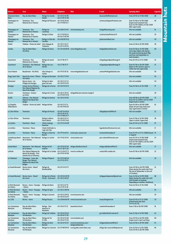
28 29
district area name Telephone Web e-mail Opening dates capacity
chamonix-mont-blanc
pays du mont-blanc refuge les grands mulets
+33 4 50 53 16 98 +33 6 72 81 22 08
[email protected] from 29/03 to 17/08/2008 68
champagny-en-vanoise
tarentaise - parc national de la vanoise
refuge de plaisance +33 4 79 62 30 54 +33 4 79 08 76 17
[email protected] from 15/06 to 15/09/2008 (Supervised mountain hut)from 16/09/2008 to 14/06/2009 (not supervised)
46
champagny-en-vanoise
tarentaise - parc national de la vanoise
refuge du laisonnay
+33 6 08 54 34 61 www.laisonnay.com [email protected] info not available 16
champagny-en-vanoise
tarentaise - parc national de la vanoise
refuge la glière +33 4 79 09 85 53 +33 6 63 73 60 96
[email protected] info not available 20
champagny-en-vanoise
tarentaise - parc national de la vanoise
refuge le plan des gouilles
+33 6 08 98 19 02 [email protected] info not available 40
châtel chablais - portes du Soleil gîte d’alpage de trebentaz
+33 4 50 73 26 17 +33 6 07 14 49 34
from 25/06 to 10/09/2008 28
cordon pays du mont-blanc - val d’arly
refuge de doran +33 4 50 58 08 00 www.refugedoran.com [email protected] from 01/06 to 15/09/2008 every days (open only during the week-end during april-may and from mid-September to mid-october)
60
courchevel tarentaise - parc national de la vanoise
refuge de grand plan
+33 6 17 85 01 71 [email protected] from 01/01 to 31/12/2008 25
courchevel tarentaise - parc national de la vanoise
refuge des lacs merlet
+33 6 17 85 01 71 [email protected] from 01/06 to 30/09/2008 (open in the summer, open in winter but not supervised)
14
crest-voland beaufortain - val d’arly gîte d’étape le lachat
+33 4 79 31 87 36 www.refugedulachat.com [email protected] info not available 50
dingy-Saint-clair massif des aravis- thônes-val-Sulens
refuge du parmelan +33 4 50 27 29 45 info not available 50
entremont bornes aravis - les villages du faucigny
refuge les man-geurs de lune
+33 4 50 22 47 22 +33 4 50 03 53 03
info not available 40
faverges autour du lac d’annecy - parc naturel régional du massif des bauges
refuge de la Servaz +33 4 50 44 50 25 from 01/06 to 15/10/2008 19
granier tarentaise - granier-sur-aime
refuge de la coire +33 6 82 12 40 42 +33 4 79 09 70 92
refugedelacoire.monsite.orange.fr info not available 40
gruffy albanais - parc naturel régional du massif des bauges
refuge du Semnoz +33 4 50 52 50 18 from 09/06 to 30/09/2008from 20/12/2008 to 30/03/2009 (Supervised in winter)
25
la chapelle-d’abondance
chablais - portes du Soleil refuge de bise +33 4 50 73 11 73 +33 4 50 78 18 28
from 01/06 to 30/09/2008 (open all year long: book your stay. Supervised in winter)
62
la côte-d’aime tarentaise refuge de presset +33 6 87 54 09 18 +33 6 14 36 57 67 +33 4 79 68 20 77
[email protected] info not available 22
la côte-d’aime tarentaise refuge la balme pierra menta
+33 6 84 35 07 41 +33 4 79 09 70 62
from 15/06 to 15/09/2008open in winter. Supervised
28
la léchère tarentaise - naves chalet auberge desevlaz
+33 4 79 24 44 09 from 01/01 to 31/12/2008 19
la léchère tarentaise - naves chalet d’altitude le logis des fées
[email protected] info not available 21
la léchère tarentaise - naves refuge le nant du beurre
+33 4 79 24 40 13 www.naves-savoie.com [email protected] from 01/01 to 31/12/2008 (closed in august)
19
lanslebourg-mont-cenis
maurienne - parc national de la vanoise
refuge le cuchet +33 4 79 62 30 54 www.vanoise.com [email protected] from 01/07 to 31/08/2008 (Supervised mountain hut)from 01/09/2008 to 30/06/2009 (not supervised)
24
lanslevillard maurienne - parc national de la vanoise
refuge de val-lonbrun
+33 4 79 05 93 93 +33 6 71 28 72 20
refuge.vallonbrun.free.fr [email protected] info not available 27
lathuile parc naturel régional du massif des bauges - rive gauche du lac d’annecy
refuge de la combe +33 6 22 06 07 73 +33 4 79 01 49 98
www.la-combe.net [email protected] from 01/06 to 28/09/2008 25
le châtelard chautagne - coeur des bauges parc naturel régional du massif des bauges
refuge d’orgeval +33 4 79 54 80 44 +33 4 79 52 18 72
info not available 20
le grand-bornand bornes aravis - massif des aravis
refuge de bombardellaz
+33 6 07 44 32 73 from 20/06 to 20/09/2008 (open during the week-ends from the end of September to the end of october)
32
le grand-bornand bornes aravis - massif des aravis
refuge de la pointe percée - gramusset
+33 4 50 02 40 90 +33 4 50 23 40 67
[email protected] from 14/06 to 14/09/2008 (open during the week-ends until mid-october on booking. depending on weather conditions)
48
le petit-bornand-les-glières
bornes - aravis - faucigny - glières
refuge de maize +33 4 50 22 47 15 +33 6 72 91 21 38
from 25/05 to 15/10/2008 19
le petit-bornand-les-glières
bornes - aravis - faucigny - glières
refuge de Spee +33 4 50 22 80 46 info not available 30
le petit-bornand-les-glières
bornes - aravis - faucigny - glières
refuge le Savarne +33 4 50 25 09 18 +33 4 50 03 56 07
www.lesavarne.com info not available 20
les clefs bornes - aravis refuge rosairy +33 6 08 84 86 90 www.la-tournette.com [email protected] from 01/01 to 31/12/2008 (closed each year from 15/11 to 15/12)
20
les contamines-montjoie
pays du mont-blanc - val montjoie
refuge - gîte équestre la roselette
+33 4 50 47 13 31 laroselette.free.fr [email protected] from 1/06 to 30/09/2008 18
les contamines-montjoie
pays du mont-blanc - val montjoie
refuge de la balme +33 4 50 47 03 54 +33 4 50 47 17 05
[email protected] from 15/06 to 15/09/2008 62
les contamines-montjoie
pays du mont-blanc - val montjoie
refuge de tré la tête
+33 4 50 47 01 68 +33 4 50 47 73 44
www.trelatete.com from 29/03 to 30/09/2008 (Supervised in april and may)
80
les contamines-montjoie
pays du mont-blanc - val montjoie
refuge du nant borrant
+33 4 50 47 03 57 www.lescontamines.com/ refugenantborrant
[email protected] from 07/06 to 19/09/2008 35
les contamines-montjoie
pays du mont-blanc - val montjoie
refuge les conscrits +33 4 79 89 09 03 www.guides-mont-blanc.com [email protected] from 15/03 to 12/05/2008from 30/05 to 28/09/2008
84
Mou
ntai
n hu
ts
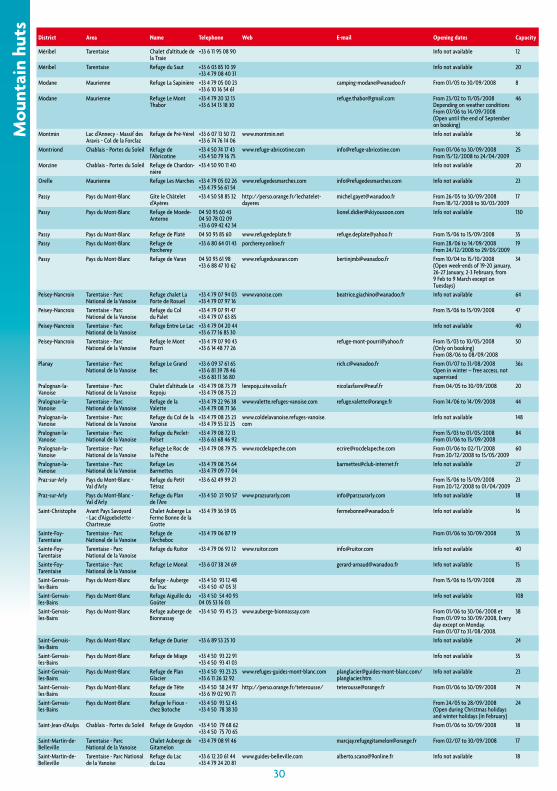
30
district area name Telephone Web e-mail Opening dates capacity
méribel tarentaise chalet d’altitude de la traie
+33 6 11 95 08 90 info not available 12
méribel tarentaise refuge du Saut +33 6 03 85 10 39 +33 4 79 08 40 31
info not available 20
modane maurienne refuge la Sapinière +33 4 79 05 00 23 +33 6 10 16 54 61
[email protected] from 01/05 to 30/09/2008 8
modane maurienne refuge le mont thabor
+33 4 79 20 32 13 +33 6 34 13 18 30
[email protected] from 23/02 to 11/05/2008 depending on weather conditionsfrom 07/06 to 14/09/2008 (open until the end of September on booking)
46
montmin lac d’annecy - massif des aravis - col de la forclaz
refuge de pré-vérel +33 6 07 13 50 72 +33 6 74 76 14 06
www.montmin.net info not available 36
montriond chablais - portes du Soleil refuge de l’abricotine
+33 4 50 74 17 43 +33 4 50 79 16 75
www.refuge-abricotine.com [email protected] from 01/06 to 30/09/2008from 15/12/2008 to 24/04/2009
25
morzine chablais - portes du Soleil refuge de chardon-nière
+33 4 50 90 11 40 info not available 20
orelle maurienne refuge les marches +33 4 79 05 02 26 +33 4 79 56 61 54
www.refugedesmarches.com [email protected] info not available 23
passy pays du mont-blanc gîte le châtelet d’ayères
+33 4 50 58 85 32 http://perso.orange.fr/lechatelet-dayeres
[email protected] from 26/05 to 30/09/2008from 18/12/2008 to 30/03/2009
17
passy pays du mont-blanc refuge de moede-anterne
04 50 93 60 43 04 50 78 02 09 +33 6 09 42 42 34
[email protected] info not available 130
passy pays du mont-blanc refuge de platé 04 50 93 85 60 www.refugedeplate.fr [email protected] from 15/06 to 15/09/2008 35passy pays du mont-blanc refuge de
porcherey+33 6 80 64 01 43 porcherey.online.fr from 28/06 to 14/09/2008
from 24/12/2008 to 29/03/200919
passy pays du mont-blanc refuge de varan 04 50 93 61 98 +33 6 88 47 10 62
www.refugeduvaran.com [email protected] from 10/04 to 15/10/2008 (open week-ends of 19-20 january, 26-27 january, 2-3 february, from 9 feb to 9 march except on tuesdays)
34
peisey-nancroix tarentaise - parc national de la vanoise
refuge chalet la porte de rosuel
+33 4 79 07 94 03 +33 4 79 07 97 16
www.vanoise.com [email protected] info not available 64
peisey-nancroix tarentaise - parc national de la vanoise
refuge du col du palet
+33 4 79 07 91 47 +33 4 79 07 63 85
from 15/06 to 15/09/2008 47
peisey-nancroix tarentaise - parc national de la vanoise
refuge entre le lac +33 4 79 04 20 44 +33 6 77 16 85 30
info not available 40
peisey-nancroix tarentaise - parc national de la vanoise
refuge le mont pourri
+33 4 79 07 90 43 +33 6 14 48 77 26
[email protected] from 15/03 to 10/05/2008 (only on booking)from 08/06 to 08/09/2008
50
planay tarentaise - parc national de la vanoise
refuge le grand bec
+33 6 09 37 61 65 +33 6 81 39 78 46 +33 6 83 11 36 80
[email protected] from 01/07 to 31/08/2008open in winter – free access, not supervised
36s
pralognan-la-vanoise
tarentaise - parc national de la vanoise
chalet d’altitude le repoju
+33 4 79 08 73 79 +33 4 79 08 75 23
lerepoju.site.voila.fr [email protected] from 04/05 to 30/09/2008 20
pralognan-la-vanoise
tarentaise - parc national de la vanoise
refuge de la valette
+33 4 79 22 96 38 +33 4 79 08 71 36
www.valette.refuges-vanoise.com [email protected] from 14/06 to 14/09/2008 44
pralognan-la-vanoise
tarentaise - parc national de la vanoise
refuge du col de la vanoise
+33 4 79 08 25 23 +33 4 79 55 32 25
www.coldelavanoise.refuges-vanoise.com
info not available 148
pralognan-la-vanoise
tarentaise - parc national de la vanoise
refuge du peclet-polset
+33 4 79 08 72 13 +33 6 63 68 46 92
from 15/03 to 01/05/2008from 01/06 to 15/09/2008
84
pralognan-la-vanoise
tarentaise - parc national de la vanoise
refuge le roc de la pêche
+33 4 79 08 79 75 www.rocdelapeche.com [email protected] from 01/06 to 02/11/2008from 20/12/2008 to 15/05/2009
60
pralognan-la-vanoise
tarentaise - parc national de la vanoise
refuge les barmettes
+33 4 79 08 75 64 +33 4 79 09 77 04
[email protected] info not available 27
praz-sur-arly pays du mont-blanc - val d’arly
refuge du petit tétraz
+33 6 62 49 99 21 from 15/06 to 15/09/2008from 20/12/2008 to 01/04/2009
23
praz-sur-arly pays du mont-blanc - val d’arly
refuge du plan de l’are
+33 4 50 21 90 57 www.prazsurarly.com [email protected] info not available 18
Saint-christophe avant pays Savoyard - lac d’aiguebelette - chartreuse
chalet auberge la ferme bonne de la grotte
+33 4 79 36 59 05 [email protected] info not available 16
Sainte-foy-tarentaise
tarentaise - parc national de la vanoise
refuge de l’archeboc
+33 4 79 06 87 19 from 01/06 to 30/09/2008 35
Sainte-foy-tarentaise
tarentaise - parc national de la vanoise
refuge du ruitor +33 4 79 06 92 12 www.ruitor.com [email protected] info not available 40
Sainte-foy-tarentaise
tarentaise - parc national de la vanoise
refuge le monal +33 6 07 38 24 69 [email protected] info not available 15
Saint-gervais-les-bains
pays du mont-blanc refuge - auberge du truc
+33 4 50 93 12 48 +33 4 50 47 05 31
from 15/06 to 15/09/2008 28
Saint-gervais-les-bains
pays du mont-blanc refuge aiguille du goûter
+33 4 50 54 40 93 04 05 53 16 03
info not available 108
Saint-gervais-les-bains
pays du mont-blanc refuge auberge de bionnassay
+33 4 50 93 45 23 www.auberge-bionnassay.com from 01/06 to 30/06/2008 et from 01/09 to 30/09/2008, every day except on monday.from 01/07 to 31/08/2008.
38
Saint-gervais-les-bains
pays du mont-blanc refuge de durier +33 6 89 53 25 10 info not available 24
Saint-gervais-les-bains
pays du mont-blanc refuge de miage +33 4 50 93 22 91 +33 4 50 93 41 03
info not available 35
Saint-gervais-les-bains
pays du mont-blanc refuge de plan glacier
+33 4 50 93 23 25 +33 6 11 26 32 92
www.refuges-guides-mont-blanc.com [email protected]/planglacier.htm
info not available 23
Saint-gervais-les-bains
pays du mont-blanc refuge de tête rousse
+33 4 50 58 24 97 +33 6 19 02 90 71
http://perso.orange.fr/teterousse/ [email protected] from 01/06 to 30/09/2008 74
Saint-gervais-les-bains
pays du mont-blanc refuge le fioux - chez botoche
+33 4 50 93 52 43 +33 4 50 78 38 30
from 24/05 to 28/09/2008 (open during christmas holidays and winter holidays (in february)
24
Saint-jean-d’aulps chablais - portes du Soleil refuge de graydon +33 4 50 79 68 62 +33 4 50 75 70 65
from 01/06 to 30/09/2008 18
Saint-martin-de-belleville
tarentaise - parc national de la vanoise
chalet auberge de gitamelon
+33 4 79 08 91 46 [email protected] from 02/07 to 30/09/2008 17
Saint-martin-de-belleville
tarentaise - parc national de la vanoise
refuge du lac du lou
+33 6 12 20 61 44 +33 4 79 24 20 81
www.guides-belleville.com [email protected] info not available 18
Mou
ntai
n hu
ts
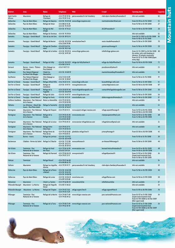
30
district area name Telephone Web e-mail Opening dates capacity
Saint-Sorlin-d’arves
maurienne refuge de l’etendard
+33 4 79 59 74 96 +33 4 79 59 72 43
perso.wanadoo.fr/caf-chambery [email protected] info not available 82
Sallanches pays du mont-blanc refuge de mayères +33 4 50 78 29 28 www.refuge-mayeres.com [email protected] from 03/05 to 31/10/2008 55Sallanches pays du mont-blanc refuge de véran +33 6 88 63 15 28
+33 4 50 93 76 39from 15/06 to 15/09/2008 27
Sallanches pays du mont-blanc refuge du nid d’aigle
+33 4 50 47 76 23 [email protected] from 14/06 to 30/09/2008 20
Sallanches pays du mont-blanc refuge du tornieux +33 4 50 93 78 54 info not available 52Samoëns faucigny - grand massif gîte du lac de gers +33 4 50 89 55 14 from 18/12/2007 to 01/05/2008
from 15/06 to 15/10/200818
Samoëns faucigny - grand massif refuge de bostan +33 4 50 90 10 94 +33 6 23 84 70 80
www.bostan.free.fr [email protected] from 15/06 to 15/09/2008 70
Samoëns faucigny - grand massif refuge de chardon-nière
+33 6 81 35 67 34 +33 4 50 90 11 40
[email protected] from 15/06 to 14/09/2008 20
Samoëns faucigny - grand massif refuge de la golèse +33 4 50 90 59 53 +33 4 50 34 91 28
www.refuge-golese.com [email protected] from 22/12/2007 to 30/04/2008 (in winter, only with booking in advance. 20 people maximum)from 01/07 to 31/08/2008 (open every day)
80
Samoëns faucigny - grand massif refuge du folly +33 4 50 90 10 91 +33 6 86 12 04 15
refuge-du-folly.9online.fr [email protected] from 10/06 to 30/09/2008 72
Serraval bornes - aravis - thônes-val-Sulens
gîte d’alpage les praz dzeures
+33 6 11 49 71 21 [email protected] info not available 23
Seythenex parc naturel régional du massif des bauges
chalet les marmottes
+33 4 50 44 68 59 [email protected] info not available 18
Seythenex parc naturel régional du massif des bauges
gîte d’alpage le drizon
+33 6 14 50 45 89 +33 4 50 32 48 67
from 15/06 to 15/10/2008 19
Sixt-fer-à-cheval faucigny - grand massif refuge alfred Wills +33 6 70 63 12 45 www.refuge-wills.com [email protected] from 15/06 to 15/09/2008 53Sixt-fer-à-cheval faucigny - grand massif refuge de
grenairon+33 4 50 34 47 31 www.grenairon.com [email protected] from 01/06 to 30/09/2008 87
Sixt-fer-à-cheval faucigny - grand massif refuge de la vogealle
+33 6 20 60 91 40 +33 4 50 58 29 49
www.refugedelavogealle.com [email protected] from 15/06 to 15/09/2008 50
Sixt-fer-à-cheval faucigny - grand massif refuge de Sales +33 4 50 34 47 01 www.refugedesales.com from 15/06 to 15/09/2008 56Sixt-fer-à-cheval faucigny - grand massif refuge les fonts +33 4 50 34 12 41 www.lesfonts.com [email protected] from 15/06 to 15/09/2008 37Sollières-Sardières maurienne - parc national
de la vanoise relais le monolithe +33 4 79 20 50 55
+33 4 79 20 50 90info not available 50
talloires lac d’annecy - massif des aravis - rive plein Soleil
refuge la tournette +33 4 50 68 98 41 +33 4 50 67 46 47
info not available 23
termignon maurienne - parc national de la vanoise
refuge de l’arpont +33 4 79 20 51 51 www.arpont.refuges-vanoise.com [email protected] from 14/03 to 04/05/2008from 07/06 to 20/09/2008
92
termignon maurienne - parc national de la vanoise
refuge de la femma
+33 4 79 05 45 40 +33 4 79 20 33 00 +33 6 81 85 28 69
www.vanoise.com [email protected] from 14/03 to 12/05/2008from 13/06 to 30/09/2008
68
termignon maurienne - parc national de la vanoise
refuge de la leisse +33 4 79 05 45 33 www.vanoise-refugelaleisse.com [email protected] info not available 32
termignon maurienne - parc national de la vanoise
refuge entre deux eaux
+33 4 79 05 27 13 +33 4 79 20 50 24
info not available 60
termignon maurienne - parc national de la vanoise
refuge porte de plan du lac
+33 4 79 20 50 85 +33 4 79 05 81 33
plandulac.refuge.free.fr [email protected] from 01/06 to 30/09/2008 42
thônes bornes - aravis refuge de larrieux +33 4 50 02 19 52 +33 4 50 60 34 09
from 15/05 to 15/10/2008 30
vacheresse chablais - portes du Soleil refuge le c’maclie +33 4 50 73 12 98 +33 4 50 26 22 12 +33 4 50 81 04 34
www.anthonon.fr [email protected] from 15/06 to 15/09/2008 40
val-d’isère tarentaise - parc national de la vanoise
refuge du fond des fours
+33 4 79 06 16 90 +33 6 87 13 41 24
www.vanoise.com [email protected] from 16/03 to 18/05/2008from 14/06 to 28/09/2008
48
val-d’isère tarentaise - parc national de la vanoise
refuge du prariond +33 4 79 06 06 02 +33 4 79 07 21 31
www.prariond.fr [email protected] from 21/03 to 12/05/2008 (Supervised mountain hut) from 15/06 to 15/09/2008
36
valezan tarentaise refuge penuel +33 4 79 07 66 48 +33 6 89 89 62 70
info not available 16
valloire maurienne refuge les aiguilles d’arves
+33 4 79 59 01 77 perso.wanadoo.fr/caf-chambery [email protected] info not available 39
vallorcine pays du mont-blanc refuge de la pierre à bérard
+33 4 50 54 62 08 +33 4 50 54 63 45 +33 4 50 54 06 98
from 15/06 to 30/09/2008 40
vallorcine pays du mont-blanc refuge de loriaz +33 4 50 54 06 45 +33 6 89 33 83 68
www.loriaz.com [email protected] from 14/06 to 21/09/2008 50
valmeinier maurienne chalet la tanière +33 4 79 56 80 29 www.skiworld.be [email protected] info not available 37villarodin-bourget maurienne - la norma refuge de l’aiguille
doran+33 6 80 72 46 63 info not available 34
villarodin-bourget maurienne - la norma refuge de l’orgère +33 4 79 05 11 65 +33 4 79 05 11 29
refuge.orgere.free.fr [email protected] from 31/05 to 30/09/2008 70
villaroger tarentaise - parc national de la vanoise
refuge de la martin +33 4 79 08 71 49 +33 4 79 06 44 32
www.refuges-vanoise.com [email protected] from 01/07 to 31/08/2008 (Supervised mountain hut)from 01/09/2008 to 30/06/2009 (not supervised)
34
villaroger tarentaise - parc national de la vanoise
refuge de la turia +33 4 79 08 71 49 +33 4 79 62 30 54
www.refuges-vanoise.com [email protected] from 01/07 to 31/08/2008 (Supervised mountain hut)from 01/09/2008 to 30/06/2009 (not supervised)
34
Mou
ntai
n hu
ts
31
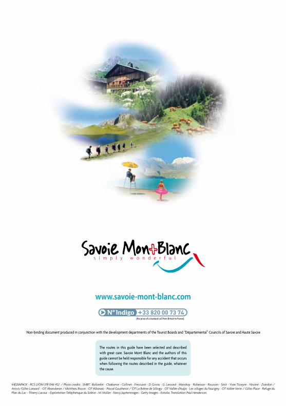
non-binding document produced in conjunction with the development departments of the tourist Boards and “départemental” councils of Savoie and haute Savoie
www.savoie-mont-blanc.com
MEDIAPACK - RCS LYON 378 046 452 / Photo credits : SMBT : Ballanfat - Chabance - Collinet - Frescurat - D. Givois - G. Lansard - Mandray - Robesson - Rousson - Smit - Yvan Tisseyre - Vincent - Zvardon / Aravis/Gilles Lansard - OT Abondance / Matthieu Bozon - OT Albanais - Pascal Gautherot / OT La Balme de Sillingy - OT Vallée d’Aulps - Les villages du Faucigny - OT Vallée Verte / Gilles Place - Refuge du Plan du Lac - Thierry Lacour - Exploitation Téléphérique du Salève - M. Muller - Fancy Jupiterimages - Getty Images - Fotolia. Translation: Paul Henderson.
the routes in this guide have been selected and described with great care. Savoie Mont Blanc and the authors of this guide cannot be held responsible for any accident that occurs when following the routes described in the guide, whatever the cause.
(the price of a standard call from Britain to France)