Embed Size (px)
Citation preview

Satellite Data Utilization Satellite Data Utilization and and
Meteorological Hazard PreventionMeteorological Hazard PreventionIn the PhilippinesIn the Philippines
Flaviana Flaviana D. D. HilarioHilarioClimatologyClimatology and and Agrometeorology Agrometeorology BranchBranch
PAGASA/DOSTPAGASA/DOST
Joint Integrated Global Water Cycle Observing(IGWCO)/Joint Integrated Global Water Cycle Observing(IGWCO)/Coordinated Enhanced Observing Period (CEOP) WorkshopCoordinated Enhanced Observing Period (CEOP) Workshop
28 Feb. – 4 March 2005, Tokyo, Japan

PPhilippineAAtmosphericGGeophysicalAAstronomicalSServicesAAdministration
The Philippines, through the PAGASA, is a Member of the World Meteorological Organization (WMO), a specialized body of the United Nations
The nation’s meteorological service and public weather service provider

OFFICE OF THE DIRECTOROFFICE OF THE DIRECTOR
ADMINISTRATIVE ADMINISTRATIVE DIVISIONDIVISION
FINANCE & MANAGEMENTFINANCE & MANAGEMENTDIVISIONDIVISION
ENGINEERING & ENGINEERING & MAINTENANCE DIVISIONMAINTENANCE DIVISION
Human ResourcesManagement Section
General ServicesSection
RecordsManagementSection
Management ServicesSection
BudgetSection
AccountingSection
Electronics &CommunicationsEngineeringSection
Mechanical-Electrical &InfrastructureSection
MeteorologicalEquipmentMaintenanceSection
WEATHERWEATHERBRANCHBRANCH
FLOODFLOODFORECASTINGFORECASTING
BRANCHBRANCH
CLIMATOLOGY &CLIMATOLOGY &AGROMETEOROLOGYAGROMETEOROLOGY
BRANCHBRANCH
ATMOSPHERIC,ATMOSPHERIC,GEOPHYSICAL &GEOPHYSICAL &SPACE SCIENCESSPACE SCIENCES
BRANCHBRANCH
NATURALNATURALDISASTERDISASTER
REDUCTIONREDUCTIONBRANCHBRANCH
Weather ForecastingSection
MeteorologicalTelecommunication Section
TechniquesDevelopmentSection
HydrometeorologicalInvestigation &Special StudiesSection
Flood Forecasting& WarningSection
TelemetrySystemsServiceSection
Farm WeatherServicesSection
AgrometeorologyApplicationsSection
AgrometeorologyResearch & DevelopmentSection
ClimateData Section
ClimateImpact Assessments & ApplicationsSection
ClimateResearch &DevelopmentSection
Atmospheric,Geophysical &Space SciencesTraining Section
Atmospheric,Geophysical &Space SciencesResearch & Development Section
AstronomyResearch &DevelopmentSection
TyphoonResearchSection
Disaster Mitigation& Weather ModificationResearch Section
InformationSystem &DevelopmentSection
Field Services
FIELDOPERATIONS
CENTER
GeostationaryMeteorologicalSection
Aviation MeteorologicalService Office

Sources of Data
• Synoptic, Agromet, Telemetering and Rain Stations
•Geostationary Meteorological Satellites
•Land-based Weather Radar

ITBAYAT
BASCO
CALAYAN
APARRI LAOAG
TUGUEGARAO
PALANAN
CASIGURAN
VIGAN
BAGUIODAGUPAN
BALERCLSU-MUNOZCABANATUANIBA
SUBIC CLARK
CAVITE ALABAT
JOMALIG
DAETTAGAYTAY
AMBULONG
INFANTA
CSSAC-PILIVIRAC
LEGASPICATARMAN
MASBATEROMBLON
SN. FRANCISCO
CALAPAN
SAN JOSE
CORON
PTO. PRINCESA
BORONGANCATBALOGAN
GUIUANTACLOBAN
MACTAN
ROXASILOILO
MAASIN
TAGBILARANSIARGAO
SURIGAOBUTUAN
HINATUANCAG. DE ORODIPOLOG
MALAYBALAY
COTABATO DAVAOZAMBOANGA
GEN. SANTOS
BALABAC
EXISTING SURFACE SYNOPTIC STATION
AUTOMATIC WEATHER STATION
PAGASA SURFACE SYNOPTIC STATIONS
Operational: 60Closed: 8

MMSU-BATAC
BSU-LA TRINIDAD
CSSAC-PILI
VISCA-BAYBAY
CLSU-MUNOZ
PAGASA AGRO-MET STATIONS
SPCP-ABORLAN
DA-BASCO
NVSIT-BAYOMBONG
ISU-ECHAGUE
DMMMSU-LA UNION
UPLB-NASTAGAYTAY
CENTRAL AGROMET-QUEZON CITY
HA. LUISITA-TARLAC
BVHS-BULAN UEP-CATARMAN
PSPC-MAMBUSAO
MSU-MARAWI
TRRC-TAGUM
PCA-BAGO OSHIRO
Operational: 21
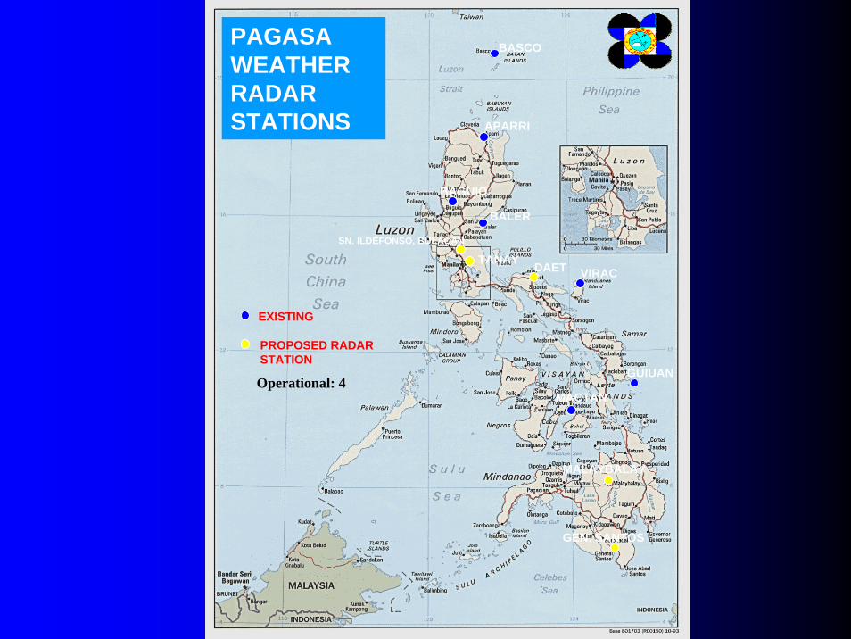
BASCO
APARRI
BAGUIO
BALER
DAET VIRAC
GUIUAN
MACTAN
SN. ILDEFONSO, BULACAN
TANAY
MALAYBALAY
GEN. SANTOS
EXISTING
PROPOSED RADAR STATION
PAGASA WEATHER RADAR STATIONS
Operational: 4

LAOAG
BAGUIO
LEGASPI
MACTAN
TANAY
DAVA0
EXISTING, USES GPS/ELECTRONIC TRANSMITTERS
PAGASA UPPER-AIR STATIONS
PTO. PRINCESA
EXISTING, USES PILOT BALOON-THEODOLITE METHOD
EXISTING, USES WIND-FINDING RADAR

Fig. 1 Location of Major Reservoirs in the Philippines

Angat River Basin


The products issued by PAGASA to various clients or users are the following:
• Daily weather forecasts and advisories• Daily farm weather forecasts and advisories• Typhoon and flood warnings• Monthly Weather Situation and Outlook• Seasonal Climate Outlook• Drought/La Niña Advisories
The clients include the general public, tri-media (radio, television and print), water, agriculture, health and tourism sectors.

SATELLITE DATA UTILIZATIONSATELLITE DATA UTILIZATION• WEATHER FORECASTING AND
MONITORING
•TROPICAL CYCLONE MONITORING
•RAINFALL ESTIMATION
•VOLCANIC ERUPTION
•FLOOD MONITORING
•VEGETATION AND SOIL MOISTURE MAPPING

Flood Monitoring
Using
ERS-1 Data

Vegetation and Vegetation and Soil Moisture Soil Moisture
Mapping Using Mapping Using MERIS and MERIS and ASAR Data ASAR Data
from ENVISATfrom ENVISAT””

Vegetation and Vegetation and Soil Moisture Soil Moisture
Mapping Using Mapping Using MERIS and MERIS and ASAR Data ASAR Data
from ENVISATfrom ENVISAT””
ASAR Image of Iloilo
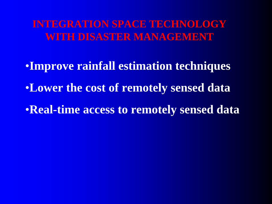
INTEGRATION SPACE TECHNOLOGY WITH DISASTER MANAGEMENT
•Improve rainfall estimation techniques
•Lower the cost of remotely sensed data
•Real-time access to remotely sensed data

CONCLUDING REMARKS
• The use of space systems, meteorological satellites in particular, has been found to be indispensable for cyclone monitoring and warning in the Philippines.
• The use remotely sensed data to monitoring of floods and other related disasters would improve warnings and would help in disaster mitigation and preparedness program of the government.

For more information, VISIT us at
http://www.philonline.com/~cabhttp://www.pagasa.dost.gov.ph
Thank you