Embed Size (px)
Citation preview
San Ramon City Center - City of San Ramon Draft Subsequent EIR Land Use
Michael Brandman Associates 4.8-29 H:\Client (PN-JN)\2491\24910007\DSEIR\24910007_Sec04-08 Land Use.doc
Goal/ Policy No. Applicable Policy Consistency Determination
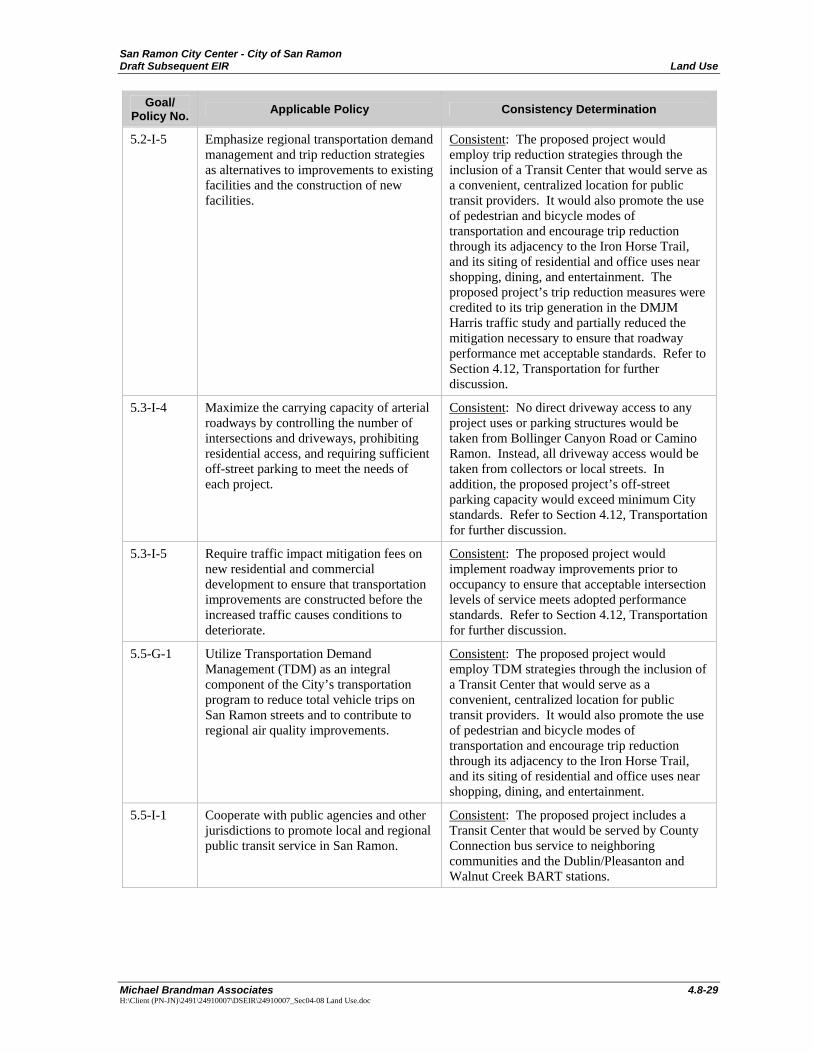
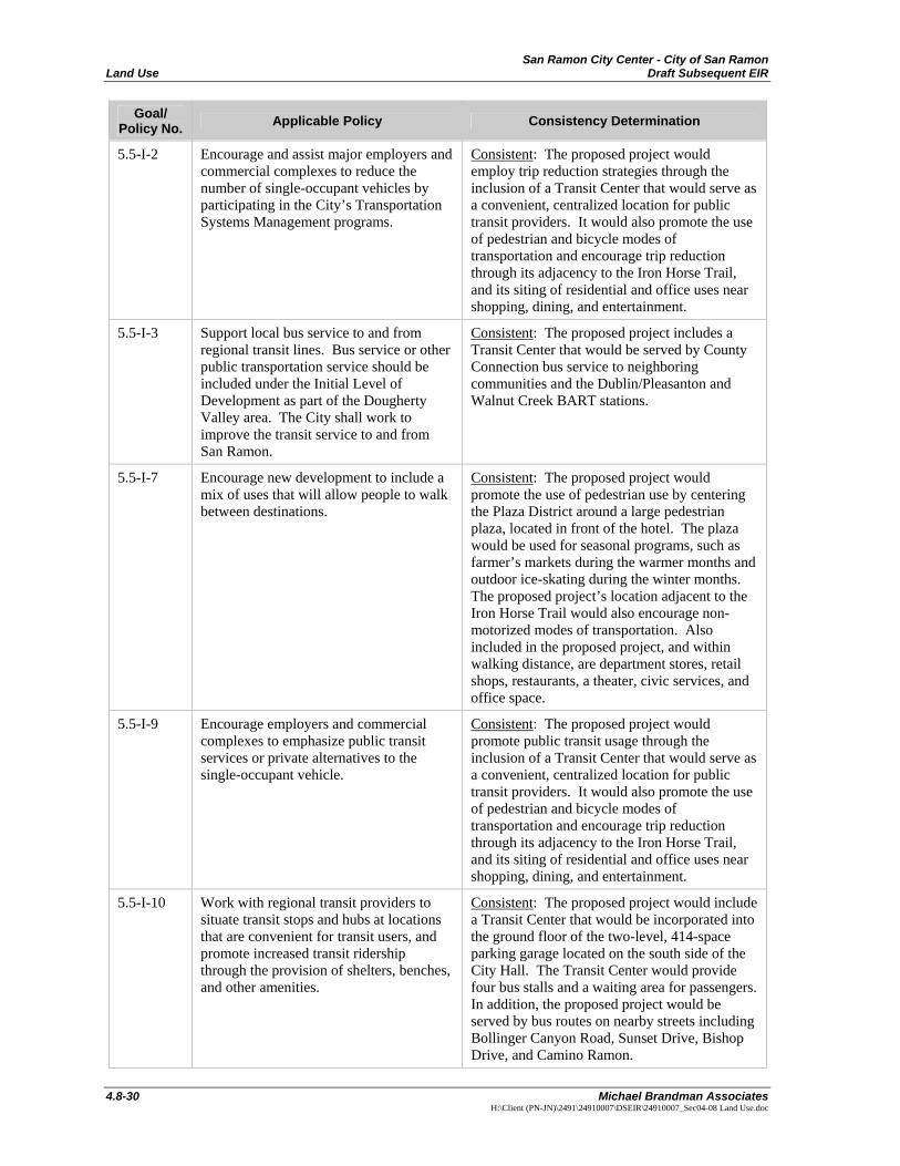
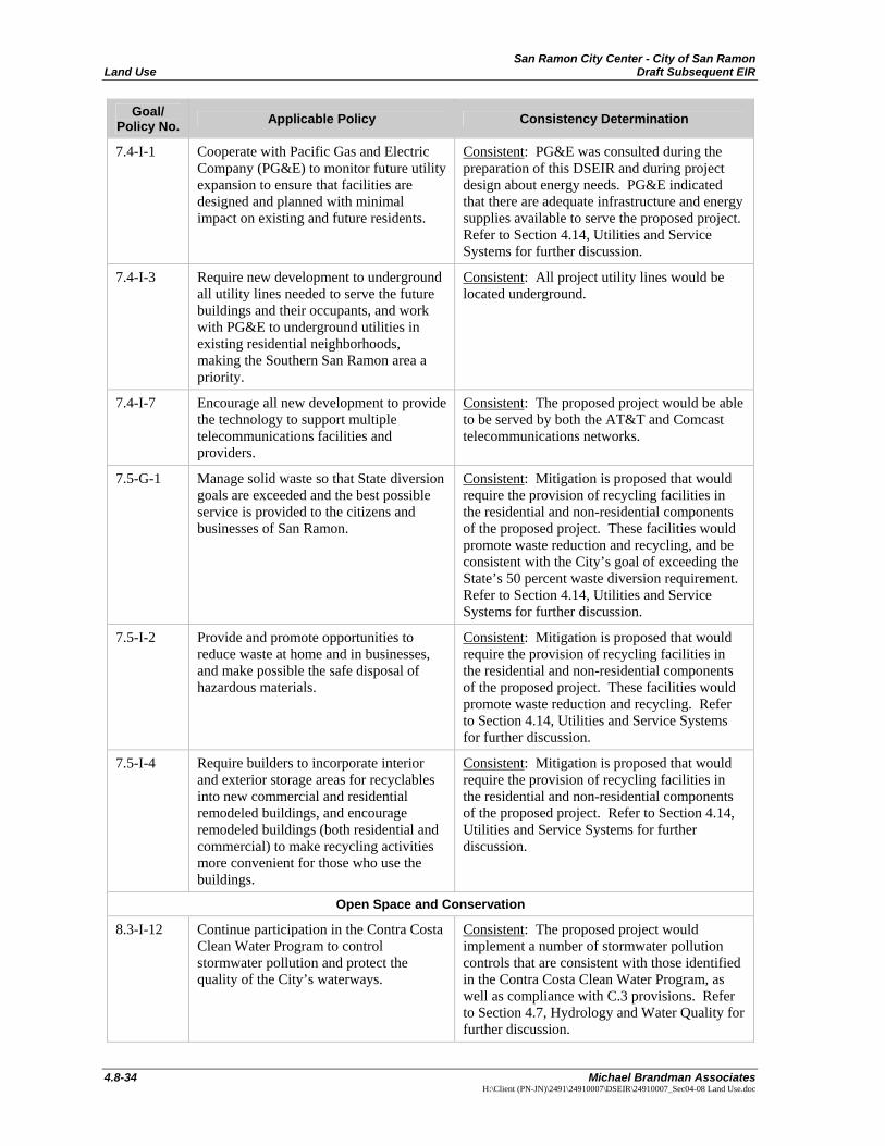
5.2-I-5 Emphasize regional transportation demand management and trip reduction strategies as alternatives to improvements to existing facilities and the construction of new facilities.
Consistent: The proposed project would employ trip reduction strategies through the inclusion of a Transit Center that would serve as a convenient, centralized location for public transit providers. It would also promote the use of pedestrian and bicycle modes of transportation and encourage trip reduction through its adjacency to the Iron Horse Trail, and its siting of residential and office uses near shopping, dining, and entertainment. The proposed project’s trip reduction measures were credited to its trip generation in the DMJM Harris traffic study and partially reduced the mitigation necessary to ensure that roadway performance met acceptable standards. Refer to Section 4.12, Transportation for further discussion.
5.3-I-4 Maximize the carrying capacity of arterial roadways by controlling the number of intersections and driveways, prohibiting residential access, and requiring sufficient off-street parking to meet the needs of each project.
Consistent: No direct driveway access to any project uses or parking structures would be taken from Bollinger Canyon Road or Camino Ramon. Instead, all driveway access would be taken from collectors or local streets. In addition, the proposed project’s off-street parking capacity would exceed minimum City standards. Refer to Section 4.12, Transportation for further discussion.
5.3-I-5 Require traffic impact mitigation fees on new residential and commercial development to ensure that transportation improvements are constructed before the increased traffic causes conditions to deteriorate.
Consistent: The proposed project would implement roadway improvements prior to occupancy to ensure that acceptable intersection levels of service meets adopted performance standards. Refer to Section 4.12, Transportation for further discussion.
5.5-G-1 Utilize Transportation Demand Management (TDM) as an integral component of the City’s transportation program to reduce total vehicle trips on San Ramon streets and to contribute to regional air quality improvements.
Consistent: The proposed project would employ TDM strategies through the inclusion of a Transit Center that would serve as a convenient, centralized location for public transit providers. It would also promote the use of pedestrian and bicycle modes of transportation and encourage trip reduction through its adjacency to the Iron Horse Trail, and its siting of residential and office uses near shopping, dining, and entertainment.
5.5-I-1 Cooperate with public agencies and other jurisdictions to promote local and regional public transit service in San Ramon.
Consistent: The proposed project includes a Transit Center that would be served by County Connection bus service to neighboring communities and the Dublin/Pleasanton and Walnut Creek BART stations.
San Ramon City Center - City of San Ramon Land Use Draft Subsequent EIR
4.8-30 Michael Brandman Associates
H:\Client (PN-JN)\2491\24910007\DSEIR\24910007_Sec04-08 Land Use.doc
Goal/ Policy No. Applicable Policy Consistency Determination
5.5-I-2 Encourage and assist major employers and commercial complexes to reduce the number of single-occupant vehicles by participating in the City’s Transportation Systems Management programs.
Consistent: The proposed project would employ trip reduction strategies through the inclusion of a Transit Center that would serve as a convenient, centralized location for public transit providers. It would also promote the use of pedestrian and bicycle modes of transportation and encourage trip reduction through its adjacency to the Iron Horse Trail, and its siting of residential and office uses near shopping, dining, and entertainment.
5.5-I-3 Support local bus service to and from regional transit lines. Bus service or other public transportation service should be included under the Initial Level of Development as part of the Dougherty Valley area. The City shall work to improve the transit service to and from San Ramon.
Consistent: The proposed project includes a Transit Center that would be served by County Connection bus service to neighboring communities and the Dublin/Pleasanton and Walnut Creek BART stations.
5.5-I-7 Encourage new development to include a mix of uses that will allow people to walk between destinations.
Consistent: The proposed project would promote the use of pedestrian use by centering the Plaza District around a large pedestrian plaza, located in front of the hotel. The plaza would be used for seasonal programs, such as farmer’s markets during the warmer months and outdoor ice-skating during the winter months. The proposed project’s location adjacent to the Iron Horse Trail would also encourage non-motorized modes of transportation. Also included in the proposed project, and within walking distance, are department stores, retail shops, restaurants, a theater, civic services, and office space.
5.5-I-9 Encourage employers and commercial complexes to emphasize public transit services or private alternatives to the single-occupant vehicle.
Consistent: The proposed project would promote public transit usage through the inclusion of a Transit Center that would serve as a convenient, centralized location for public transit providers. It would also promote the use of pedestrian and bicycle modes of transportation and encourage trip reduction through its adjacency to the Iron Horse Trail, and its siting of residential and office uses near shopping, dining, and entertainment.
5.5-I-10 Work with regional transit providers to situate transit stops and hubs at locations that are convenient for transit users, and promote increased transit ridership through the provision of shelters, benches, and other amenities.
Consistent: The proposed project would include a Transit Center that would be incorporated into the ground floor of the two-level, 414-space parking garage located on the south side of the City Hall. The Transit Center would provide four bus stalls and a waiting area for passengers. In addition, the proposed project would be served by bus routes on nearby streets including Bollinger Canyon Road, Sunset Drive, Bishop Drive, and Camino Ramon.
San Ramon City Center - City of San Ramon Draft Subsequent EIR Land Use
Michael Brandman Associates 4.8-31 H:\Client (PN-JN)\2491\24910007\DSEIR\24910007_Sec04-08 Land Use.doc
Goal/ Policy No. Applicable Policy Consistency Determination
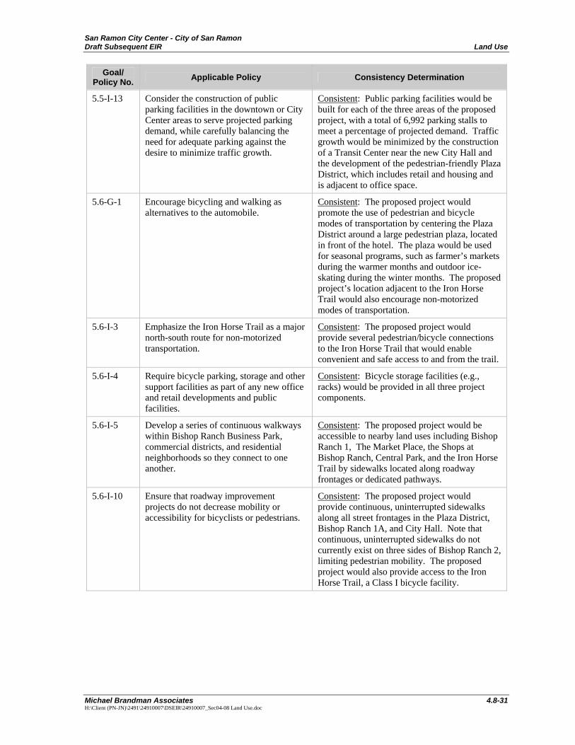
5.5-I-13 Consider the construction of public parking facilities in the downtown or City Center areas to serve projected parking demand, while carefully balancing the need for adequate parking against the desire to minimize traffic growth.
Consistent: Public parking facilities would be built for each of the three areas of the proposed project, with a total of 6,992 parking stalls to meet a percentage of projected demand. Traffic growth would be minimized by the construction of a Transit Center near the new City Hall and the development of the pedestrian-friendly Plaza District, which includes retail and housing and is adjacent to office space.
5.6-G-1 Encourage bicycling and walking as alternatives to the automobile.
Consistent: The proposed project would promote the use of pedestrian and bicycle modes of transportation by centering the Plaza District around a large pedestrian plaza, located in front of the hotel. The plaza would be used for seasonal programs, such as farmer’s markets during the warmer months and outdoor ice-skating during the winter months. The proposed project’s location adjacent to the Iron Horse Trail would also encourage non-motorized modes of transportation.
5.6-I-3 Emphasize the Iron Horse Trail as a major north-south route for non-motorized transportation.
Consistent: The proposed project would provide several pedestrian/bicycle connections to the Iron Horse Trail that would enable convenient and safe access to and from the trail.
5.6-I-4 Require bicycle parking, storage and other support facilities as part of any new office and retail developments and public facilities.
Consistent: Bicycle storage facilities (e.g., racks) would be provided in all three project components.
5.6-I-5 Develop a series of continuous walkways within Bishop Ranch Business Park, commercial districts, and residential neighborhoods so they connect to one another.
Consistent: The proposed project would be accessible to nearby land uses including Bishop Ranch 1, The Market Place, the Shops at Bishop Ranch, Central Park, and the Iron Horse Trail by sidewalks located along roadway frontages or dedicated pathways.
5.6-I-10 Ensure that roadway improvement projects do not decrease mobility or accessibility for bicyclists or pedestrians.
Consistent: The proposed project would provide continuous, uninterrupted sidewalks along all street frontages in the Plaza District, Bishop Ranch 1A, and City Hall. Note that continuous, uninterrupted sidewalks do not currently exist on three sides of Bishop Ranch 2, limiting pedestrian mobility. The proposed project would also provide access to the Iron Horse Trail, a Class I bicycle facility.
San Ramon City Center - City of San Ramon Land Use Draft Subsequent EIR
4.8-32 Michael Brandman Associates
H:\Client (PN-JN)\2491\24910007\DSEIR\24910007_Sec04-08 Land Use.doc
Goal/ Policy No. Applicable Policy Consistency Determination
Parks and Recreation
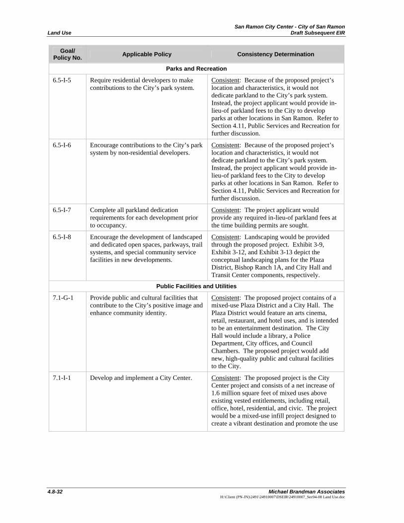
6.5-I-5 Require residential developers to make contributions to the City’s park system.
Consistent: Because of the proposed project’s location and characteristics, it would not dedicate parkland to the City’s park system. Instead, the project applicant would provide in-lieu-of parkland fees to the City to develop parks at other locations in San Ramon. Refer to Section 4.11, Public Services and Recreation for further discussion.
6.5-I-6 Encourage contributions to the City’s park system by non-residential developers.
Consistent: Because of the proposed project’s location and characteristics, it would not dedicate parkland to the City’s park system. Instead, the project applicant would provide in-lieu-of parkland fees to the City to develop parks at other locations in San Ramon. Refer to Section 4.11, Public Services and Recreation for further discussion.
6.5-I-7 Complete all parkland dedication requirements for each development prior to occupancy.
Consistent: The project applicant would provide any required in-lieu-of parkland fees at the time building permits are sought.
6.5-I-8 Encourage the development of landscaped and dedicated open spaces, parkways, trail systems, and special community service facilities in new developments.
Consistent: Landscaping would be provided through the proposed project. Exhibit 3-9, Exhibit 3-12, and Exhibit 3-13 depict the conceptual landscaping plans for the Plaza District, Bishop Ranch 1A, and City Hall and Transit Center components, respectively.
Public Facilities and Utilities
7.1-G-1 Provide public and cultural facilities that contribute to the City’s positive image and enhance community identity.
Consistent: The proposed project contains of a mixed-use Plaza District and a City Hall. The Plaza District would feature an arts cinema, retail, restaurant, and hotel uses, and is intended to be an entertainment destination. The City Hall would include a library, a Police Department, City offices, and Council Chambers. The proposed project would add new, high-quality public and cultural facilities to the City.
7.1-I-1 Develop and implement a City Center. Consistent: The proposed project is the City Center project and consists of a net increase of 1.6 million square feet of mixed uses above existing vested entitlements, including retail, office, hotel, residential, and civic. The project would be a mixed-use infill project designed to create a vibrant destination and promote the use
San Ramon City Center - City of San Ramon Draft Subsequent EIR Land Use
Michael Brandman Associates 4.8-33 H:\Client (PN-JN)\2491\24910007\DSEIR\24910007_Sec04-08 Land Use.doc
Goal/ Policy No. Applicable Policy Consistency Determination
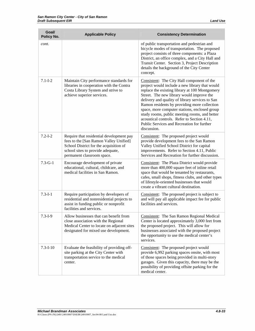
cont. of public transportation and pedestrian and bicycle modes of transportation. The proposed project consists of three components: a Plaza District, an office complex, and a City Hall and Transit Center. Section 3, Project Description details the background of the City Center concept.
7.1-I-2 Maintain City performance standards for libraries in cooperation with the Contra Costa Library System and strive to achieve superior services.
Consistent: The City Hall component of the project would include a new library that would replace the existing library at 100 Montgomery Street. The new library would improve the delivery and quality of library services to San Ramon residents by providing more collection space, more computer stations, enclosed group study rooms, public meeting rooms, and better acoustical controls. Refer to Section 4.11, Public Services and Recreation for further discussion.
7.2-I-2 Require that residential development pay fees to the [San Ramon Valley Unified] School District for the acquisition of school sites to provide adequate, permanent classroom space.
Consistent: The proposed project would provide development fees to the San Ramon Valley Unified School District for capital improvements. Refer to Section 4.11, Public Services and Recreation for further discussion.
7.3-G-1 Encourage development of private educational, cultural, childcare, and medical facilities in San Ramon.
Consistent: The Plaza District would provide more than 400,000 square feet of inline retail space that would be tenanted by restaurants, cafes, small shops, fitness clubs, and other types of lifestyle-oriented businesses that would create a vibrant cultural destination.
7.3-I-1 Require participation by developers of residential and nonresidential projects to assist in funding public or nonprofit facilities and services.
Consistent: The proposed project is subject to and will pay all applicable impact fee for public facilities and services.
7.3-I-9 Allow businesses that can benefit from close association with the Regional Medical Center to locate on adjacent sites designated for mixed use development.
Consistent: The San Ramon Regional Medical Center is located approximately 3,000 feet from the proposed project. This will allow for businesses associated with the proposed project the opportunity to use the medical center’s services.
7.3-I-10 Evaluate the feasibility of providing off-site parking at the City Center with transportation service to the medical center.
Consistent: The proposed project would provide 6,992 parking spaces onsite, with most of those spaces being provided in multi-story garages. Given this capacity, there may be the possibility of providing offsite parking for the medical center.
San Ramon City Center - City of San Ramon Land Use Draft Subsequent EIR
4.8-34 Michael Brandman Associates
H:\Client (PN-JN)\2491\24910007\DSEIR\24910007_Sec04-08 Land Use.doc
Goal/ Policy No. Applicable Policy Consistency Determination
7.4-I-1 Cooperate with Pacific Gas and Electric Company (PG&E) to monitor future utility expansion to ensure that facilities are designed and planned with minimal impact on existing and future residents.
Consistent: PG&E was consulted during the preparation of this DSEIR and during project design about energy needs. PG&E indicated that there are adequate infrastructure and energy supplies available to serve the proposed project. Refer to Section 4.14, Utilities and Service Systems for further discussion.
7.4-I-3 Require new development to underground all utility lines needed to serve the future buildings and their occupants, and work with PG&E to underground utilities in existing residential neighborhoods, making the Southern San Ramon area a priority.
Consistent: All project utility lines would be located underground.
7.4-I-7 Encourage all new development to provide the technology to support multiple telecommunications facilities and providers.
Consistent: The proposed project would be able to be served by both the AT&T and Comcast telecommunications networks.
7.5-G-1 Manage solid waste so that State diversion goals are exceeded and the best possible service is provided to the citizens and businesses of San Ramon.
Consistent: Mitigation is proposed that would require the provision of recycling facilities in the residential and non-residential components of the proposed project. These facilities would promote waste reduction and recycling, and be consistent with the City’s goal of exceeding the State’s 50 percent waste diversion requirement. Refer to Section 4.14, Utilities and Service Systems for further discussion.
7.5-I-2 Provide and promote opportunities to reduce waste at home and in businesses, and make possible the safe disposal of hazardous materials.
Consistent: Mitigation is proposed that would require the provision of recycling facilities in the residential and non-residential components of the proposed project. These facilities would promote waste reduction and recycling. Refer to Section 4.14, Utilities and Service Systems for further discussion.
7.5-I-4 Require builders to incorporate interior and exterior storage areas for recyclables into new commercial and residential remodeled buildings, and encourage remodeled buildings (both residential and commercial) to make recycling activities more convenient for those who use the buildings.
Consistent: Mitigation is proposed that would require the provision of recycling facilities in the residential and non-residential components of the proposed project. Refer to Section 4.14, Utilities and Service Systems for further discussion.
Open Space and Conservation
8.3-I-12 Continue participation in the Contra Costa Clean Water Program to control stormwater pollution and protect the quality of the City’s waterways.
Consistent: The proposed project would implement a number of stormwater pollution controls that are consistent with those identified in the Contra Costa Clean Water Program, as well as compliance with C.3 provisions. Refer to Section 4.7, Hydrology and Water Quality for further discussion.
San Ramon City Center - City of San Ramon Draft Subsequent EIR Land Use
Michael Brandman Associates 4.8-35 H:\Client (PN-JN)\2491\24910007\DSEIR\24910007_Sec04-08 Land Use.doc
Goal/ Policy No. Applicable Policy Consistency Determination
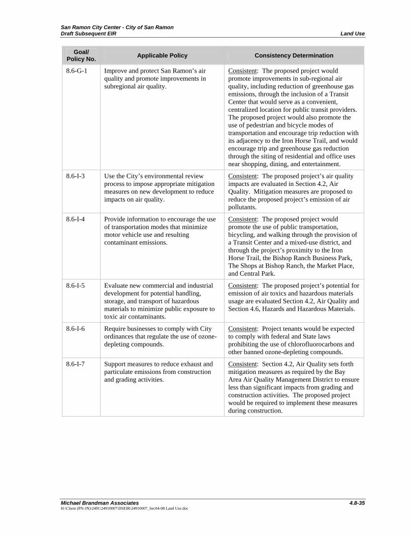
8.6-G-1 Improve and protect San Ramon’s air quality and promote improvements in subregional air quality.
Consistent: The proposed project would promote improvements in sub-regional air quality, including reduction of greenhouse gas emissions, through the inclusion of a Transit Center that would serve as a convenient, centralized location for public transit providers. The proposed project would also promote the use of pedestrian and bicycle modes of transportation and encourage trip reduction with its adjacency to the Iron Horse Trail, and would encourage trip and greenhouse gas reduction through the siting of residential and office uses near shopping, dining, and entertainment.
8.6-I-3 Use the City’s environmental review process to impose appropriate mitigation measures on new development to reduce impacts on air quality.
Consistent: The proposed project’s air quality impacts are evaluated in Section 4.2, Air Quality. Mitigation measures are proposed to reduce the proposed project’s emission of air pollutants.
8.6-I-4 Provide information to encourage the use of transportation modes that minimize motor vehicle use and resulting contaminant emissions.
Consistent: The proposed project would promote the use of public transportation, bicycling, and walking through the provision of a Transit Center and a mixed-use district, and through the project’s proximity to the Iron Horse Trail, the Bishop Ranch Business Park, The Shops at Bishop Ranch, the Market Place, and Central Park.
8.6-I-5 Evaluate new commercial and industrial development for potential handling, storage, and transport of hazardous materials to minimize public exposure to toxic air contaminants.
Consistent: The proposed project’s potential for emission of air toxics and hazardous materials usage are evaluated Section 4.2, Air Quality and Section 4.6, Hazards and Hazardous Materials.
8.6-I-6 Require businesses to comply with City ordinances that regulate the use of ozone-depleting compounds.
Consistent: Project tenants would be expected to comply with federal and State laws prohibiting the use of chlorofluorocarbons and other banned ozone-depleting compounds.
8.6-I-7 Support measures to reduce exhaust and particulate emissions from construction and grading activities.
Consistent: Section 4.2, Air Quality sets forth mitigation measures as required by the Bay Area Air Quality Management District to ensure less than significant impacts from grading and construction activities. The proposed project would be required to implement these measures during construction.
San Ramon City Center - City of San Ramon Land Use Draft Subsequent EIR
4.8-36 Michael Brandman Associates
H:\Client (PN-JN)\2491\24910007\DSEIR\24910007_Sec04-08 Land Use.doc
Goal/ Policy No. Applicable Policy Consistency Determination
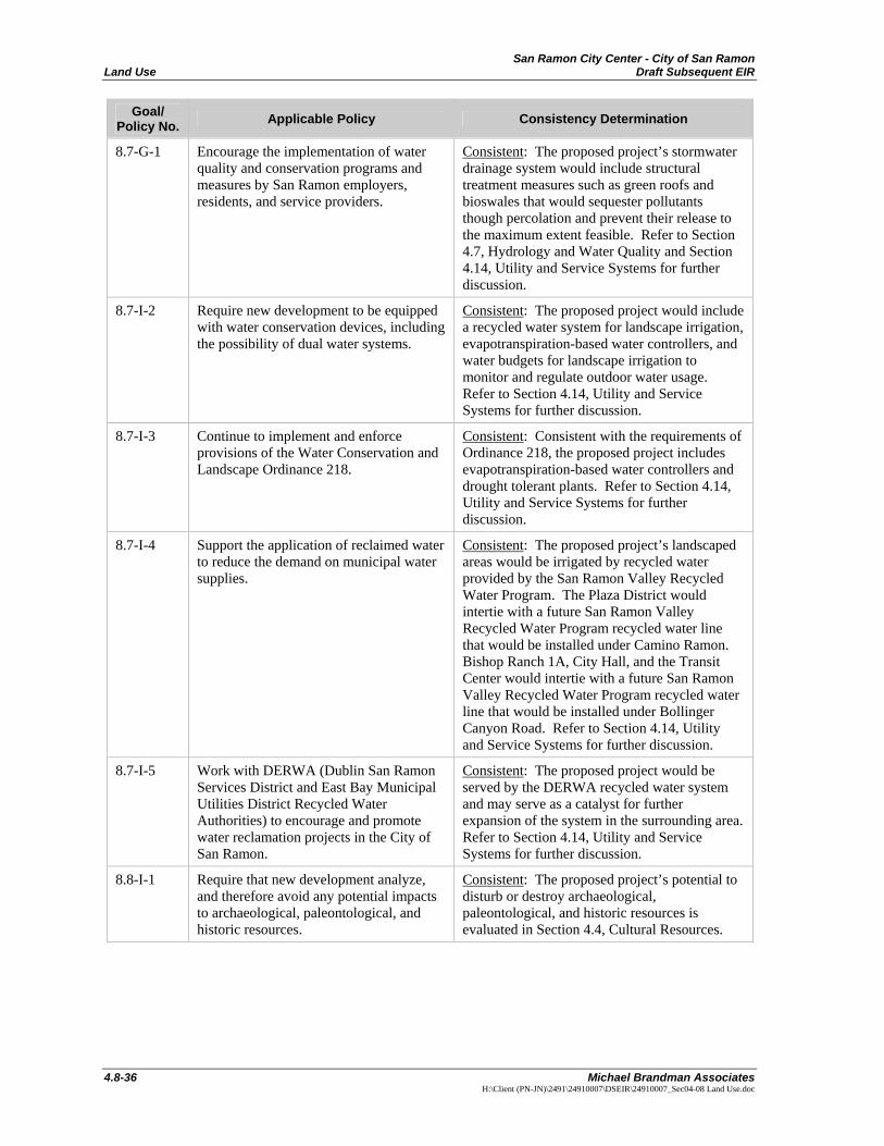
8.7-G-1 Encourage the implementation of water quality and conservation programs and measures by San Ramon employers, residents, and service providers.
Consistent: The proposed project’s stormwater drainage system would include structural treatment measures such as green roofs and bioswales that would sequester pollutants though percolation and prevent their release to the maximum extent feasible. Refer to Section 4.7, Hydrology and Water Quality and Section 4.14, Utility and Service Systems for further discussion.
8.7-I-2 Require new development to be equipped with water conservation devices, including the possibility of dual water systems.
Consistent: The proposed project would include a recycled water system for landscape irrigation, evapotranspiration-based water controllers, and water budgets for landscape irrigation to monitor and regulate outdoor water usage. Refer to Section 4.14, Utility and Service Systems for further discussion.
8.7-I-3 Continue to implement and enforce provisions of the Water Conservation and Landscape Ordinance 218.
Consistent: Consistent with the requirements of Ordinance 218, the proposed project includes evapotranspiration-based water controllers and drought tolerant plants. Refer to Section 4.14, Utility and Service Systems for further discussion.
8.7-I-4 Support the application of reclaimed water to reduce the demand on municipal water supplies.
Consistent: The proposed project’s landscaped areas would be irrigated by recycled water provided by the San Ramon Valley Recycled Water Program. The Plaza District would intertie with a future San Ramon Valley Recycled Water Program recycled water line that would be installed under Camino Ramon. Bishop Ranch 1A, City Hall, and the Transit Center would intertie with a future San Ramon Valley Recycled Water Program recycled water line that would be installed under Bollinger Canyon Road. Refer to Section 4.14, Utility and Service Systems for further discussion.
8.7-I-5 Work with DERWA (Dublin San Ramon Services District and East Bay Municipal Utilities District Recycled Water Authorities) to encourage and promote water reclamation projects in the City of San Ramon.
Consistent: The proposed project would be served by the DERWA recycled water system and may serve as a catalyst for further expansion of the system in the surrounding area. Refer to Section 4.14, Utility and Service Systems for further discussion.
8.8-I-1 Require that new development analyze, and therefore avoid any potential impacts to archaeological, paleontological, and historic resources.
Consistent: The proposed project’s potential to disturb or destroy archaeological, paleontological, and historic resources is evaluated in Section 4.4, Cultural Resources.
San Ramon City Center - City of San Ramon Draft Subsequent EIR Land Use
Michael Brandman Associates 4.8-37 H:\Client (PN-JN)\2491\24910007\DSEIR\24910007_Sec04-08 Land Use.doc
Goal/ Policy No. Applicable Policy Consistency Determination
Safety
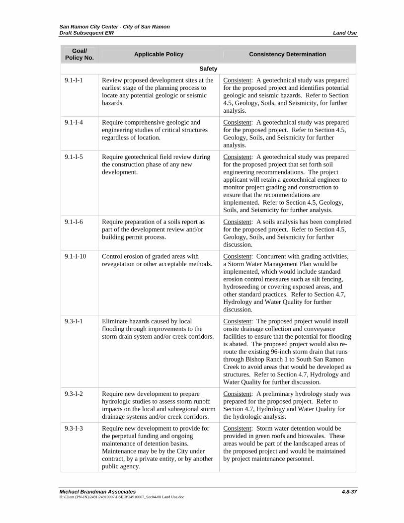
9.1-I-1 Review proposed development sites at the earliest stage of the planning process to locate any potential geologic or seismic hazards.
Consistent: A geotechnical study was prepared for the proposed project and identifies potential geologic and seismic hazards. Refer to Section 4.5, Geology, Soils, and Seismicity, for further analysis.
9.1-I-4 Require comprehensive geologic and engineering studies of critical structures regardless of location.
Consistent: A geotechnical study was prepared for the proposed project. Refer to Section 4.5, Geology, Soils, and Seismicity for further analysis.
9.1-I-5 Require geotechnical field review during the construction phase of any new development.
Consistent: A geotechnical study was prepared for the proposed project that set forth soil engineering recommendations. The project applicant will retain a geotechnical engineer to monitor project grading and construction to ensure that the recommendations are implemented. Refer to Section 4.5, Geology, Soils, and Seismicity for further analysis.
9.1-I-6 Require preparation of a soils report as part of the development review and/or building permit process.
Consistent: A soils analysis has been completed for the proposed project. Refer to Section 4.5, Geology, Soils, and Seismicity for further discussion.
9.1-I-10 Control erosion of graded areas with revegetation or other acceptable methods.
Consistent: Concurrent with grading activities, a Storm Water Management Plan would be implemented, which would include standard erosion control measures such as silt fencing, hydroseeding or covering exposed areas, and other standard practices. Refer to Section 4.7, Hydrology and Water Quality for further discussion.
9.3-I-1 Eliminate hazards caused by local flooding through improvements to the storm drain system and/or creek corridors.
Consistent: The proposed project would install onsite drainage collection and conveyance facilities to ensure that the potential for flooding is abated. The proposed project would also re-route the existing 96-inch storm drain that runs through Bishop Ranch 1 to South San Ramon Creek to avoid areas that would be developed as structures. Refer to Section 4.7, Hydrology and Water Quality for further discussion.
9.3-I-2 Require new development to prepare hydrologic studies to assess storm runoff impacts on the local and subregional storm drainage systems and/or creek corridors.
Consistent: A preliminary hydrology study was prepared for the proposed project. Refer to Section 4.7, Hydrology and Water Quality for the hydrologic analysis.
9.3-I-3 Require new development to provide for the perpetual funding and ongoing maintenance of detention basins. Maintenance may be by the City under contract, by a private entity, or by another public agency.
Consistent: Storm water detention would be provided in green roofs and bioswales. These areas would be part of the landscaped areas of the proposed project and would be maintained by project maintenance personnel.
San Ramon City Center - City of San Ramon Land Use Draft Subsequent EIR
4.8-38 Michael Brandman Associates
H:\Client (PN-JN)\2491\24910007\DSEIR\24910007_Sec04-08 Land Use.doc
Goal/ Policy No. Applicable Policy Consistency Determination
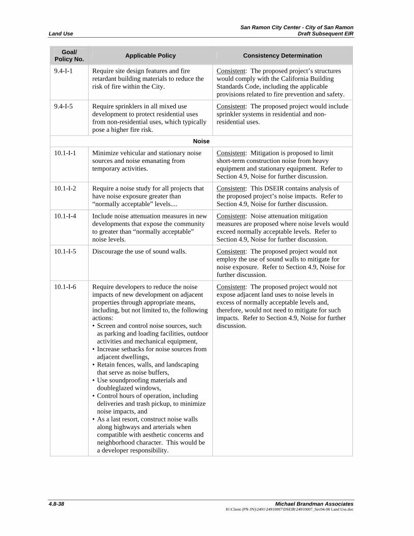
9.4-I-1 Require site design features and fire retardant building materials to reduce the risk of fire within the City.
Consistent: The proposed project’s structures would comply with the California Building Standards Code, including the applicable provisions related to fire prevention and safety.
9.4-I-5 Require sprinklers in all mixed use development to protect residential uses from non-residential uses, which typically pose a higher fire risk.
Consistent: The proposed project would include sprinkler systems in residential and non-residential uses.
Noise
10.1-I-1 Minimize vehicular and stationary noise sources and noise emanating from temporary activities.
Consistent: Mitigation is proposed to limit short-term construction noise from heavy equipment and stationary equipment. Refer to Section 4.9, Noise for further discussion.
10.1-I-2 Require a noise study for all projects that have noise exposure greater than “normally acceptable” levels....
Consistent: This DSEIR contains analysis of the proposed project’s noise impacts. Refer to Section 4.9, Noise for further discussion.
10.1-I-4 Include noise attenuation measures in new developments that expose the community to greater than “normally acceptable” noise levels.
Consistent: Noise attenuation mitigation measures are proposed where noise levels would exceed normally acceptable levels. Refer to Section 4.9, Noise for further discussion.
10.1-I-5 Discourage the use of sound walls. Consistent: The proposed project would not employ the use of sound walls to mitigate for noise exposure. Refer to Section 4.9, Noise for further discussion.
10.1-I-6 Require developers to reduce the noise impacts of new development on adjacent properties through appropriate means, including, but not limited to, the following actions: • Screen and control noise sources, such
as parking and loading facilities, outdoor activities and mechanical equipment,
• Increase setbacks for noise sources from adjacent dwellings,
• Retain fences, walls, and landscaping that serve as noise buffers,
• Use soundproofing materials and doubleglazed windows,
• Control hours of operation, including deliveries and trash pickup, to minimize noise impacts, and
• As a last resort, construct noise walls along highways and arterials when compatible with aesthetic concerns and neighborhood character. This would be a developer responsibility.
Consistent: The proposed project would not expose adjacent land uses to noise levels in excess of normally acceptable levels and, therefore, would not need to mitigate for such impacts. Refer to Section 4.9, Noise for further discussion.
San Ramon City Center - City of San Ramon Draft Subsequent EIR Land Use
Michael Brandman Associates 4.8-39 H:\Client (PN-JN)\2491\24910007\DSEIR\24910007_Sec04-08 Land Use.doc
Goal/ Policy No. Applicable Policy Consistency Determination
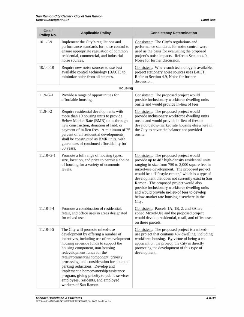
10.1-I-9 Implement the City’s regulations and performance standards for noise control to ensure appropriate regulation of common residential, commercial, and industrial noise sources.
Consistent: The City’s regulations and performance standards for noise control were used as the basis for evaluating the proposed project’s noise impacts. Refer to Section 4.9, Noise for further discussion.
10.1-I-10 Require new noise sources to use best available control technology (BACT) to minimize noise from all sources.
Consistent: Where such technology is available, project stationary noise sources uses BACT. Refer to Section 4.9, Noise for further discussion.
Housing
11.9-G-1 Provide a range of opportunities for affordable housing.
Consistent: The proposed project would provide inclusionary workforce dwelling units onsite and would provide in-lieu of fees.
11.9-I-2 Require residential developments with more than 10 housing units to provide Below Market Rate (BMR) units through new construction, donation of land, or payment of in-lieu fees. A minimum of 25 percent of all residential developments shall be constructed as BMR units, with guarantees of continued affordability for 50 years.
Consistent: The proposed project would provide inclusionary workforce dwelling units onsite and would provide in-lieu of fees to develop below-market rate housing elsewhere in the City to cover the balance not provided onsite.
11.10-G-1 Promote a full range of housing types, size, location, and price to permit a choice of housing for a variety of economic levels.
Consistent: The proposed project would provide up to 487 high-density residential units ranging in size from 750 to 2,000 square feet in mixed-use development. The proposed project would be a “lifestyle center,” which is a type of development that does not currently exist in San Ramon. The proposed project would also provide inclusionary workforce dwelling units and would provide in-lieu-of fees to develop below-market rate housing elsewhere in the City.
11.10-I-4 Promote a combination of residential, retail, and office uses in areas designated for mixed use.
Consistent: Parcels 1A, 1B, 2, and 3A are zoned Mixed-Use and the proposed project would develop residential, retail, and office uses on these parcels.
11.10-I-5 The City will promote mixed-use development by offering a number of incentives, including use of redevelopment housing set-aside funds to support the housing component, non-housing redevelopment funds for the retail/commercial component, priority processing, and consideration for potential parking reductions. Develop and implement a homeownership assistance program, giving priority to public services employees, residents, and employed workers of San Ramon.
Consistent: The proposed project is a mixed-use project that contains 487 dwelling, including workforce housing. By virtue of being a co-applicant on the project, the City is directly promoting the development of this type of development.
San Ramon City Center - City of San Ramon Land Use Draft Subsequent EIR
4.8-40 Michael Brandman Associates
H:\Client (PN-JN)\2491\24910007\DSEIR\24910007_Sec04-08 Land Use.doc
Goal/ Policy No. Applicable Policy Consistency Determination
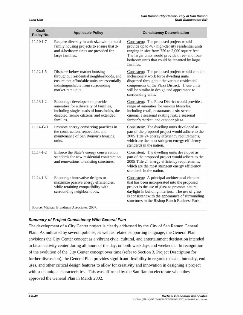
11.10-I-7 Require diversity in unit-size within multi-family housing projects to ensure that 3- and 4-bedroom units are provided for large families.
Consistent: The proposed project would provide up to 487 high-density residential units ranging in size from 750 to 2,000 square feet. The larger units would provide three- and four-bedroom units that could be tenanted by large families.
11.12-I-5 Disperse below-market housing throughout residential neighborhoods, and ensure that affordable units are essentially indistinguishable from surrounding market-rate units.
Consistent: The proposed project would contain inclusionary work force dwelling units dispersed throughout the various residential components of the Plaza District. These units will be similar in design and appearance to surrounding units.
11.13-I-2 Encourage developers to provide amenities for a diversity of families, including single heads of households, the disabled, senior citizens, and extended families.
Consistent: The Plaza District would provide a range of amenities for various lifestyles, including retail, restaurants, a six-screen cinema, a seasonal skating rink, a seasonal farmer’s market, and outdoor plaza.
11.14-G-1 Promote energy conserving practices in the construction, renovation, and maintenance of San Ramon’s housing units.
Consistent: The dwelling units developed as part of the proposed project would adhere to the 2005 Title 24 energy efficiency requirements, which are the most stringent energy efficiency standards in the nation.
11.14-I-2 Enforce the State’s energy conservation standards for new residential construction and renovations to existing structures.
Consistent: The dwelling units developed as part of the proposed project would adhere to the 2005 Title 24 energy efficiency requirements, which are the most stringent energy efficiency standards in the nation.
11.14-I-3 Encourage innovative designs to maximize passive energy efficiencies, while retaining compatibility with surrounding neighborhoods.
Consistent: A principal architectural element that has been incorporated into the proposed project is the use of glass to promote natural daylight in building interiors. The use of glass is consistent with the appearance of surrounding structures in the Bishop Ranch Business Park.
Source: Michael Brandman Associates, 2007.
Summary of Project Consistency With General Plan The development of a City Center project is clearly addressed by the City of San Ramon General Plan. As indicated by several policies, as well as related supporting language, the General Plan envisions the City Center concept as a vibrant civic, cultural, and entertainment destination intended to be an activity center during all hours of the day, on both weekdays and weekends. In recognition of the evolution of the City Center concept over time (refer to Section 3, Project Description for further discussion), the General Plan provides significant flexibility in regards to scale, intensity, end uses, and other critical design features to allow for creativity and innovation in designing a project with such unique characteristics. This was affirmed by the San Ramon electorate when they approved the General Plan in March 2002.
San Ramon City Center - City of San Ramon Draft Subsequent EIR Land Use
Michael Brandman Associates 4.8-41 H:\Client (PN-JN)\2491\24910007\DSEIR\24910007_Sec04-08 Land Use.doc
The proposed project meets the General Plan’s conceptual objectives for the City Center. It provides a City Hall with a Council Chamber, library, and police headquarters that satisfy the civic hub component of the City Center vision. The project would provide a Plaza District with a cinema, retail uses, and an outdoor plaza that fulfill the objective of creating a vibrant cultural and entertainment destination. The residential, office, and hotel uses of the project complement this component and create a constituency of patrons for the Plaza District, thereby enhancing the viability of the project as a daytime and nighttime destination throughout the week. Overall, while the General Plan did not place any prescriptive limits on the intensity of the City Center, proposed project is within the foreseeable range of development intensity implied by General Plan’s conceptual objectives for the City Center.
In summary, the proposed project is consistent with the General Plan’s vision of a City Center. Impacts would be less than significant.
Level of Significance Before Mitigation Less than significant impact.
Mitigation Measures No mitigation is necessary.
Level of Significance After Mitigation Less than significant impact.
Zoning Ordinance Consistency
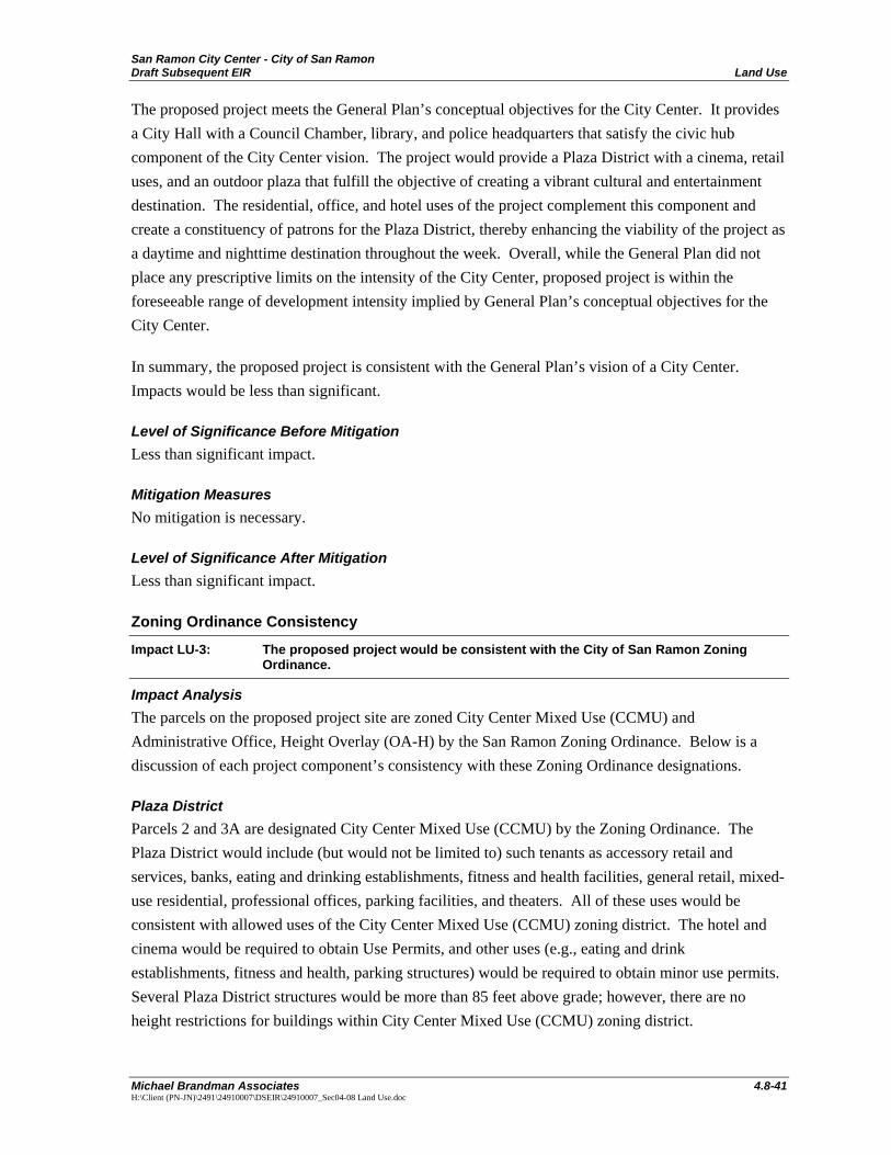
Impact LU-3: The proposed project would be consistent with the City of San Ramon Zoning Ordinance.
Impact Analysis The parcels on the proposed project site are zoned City Center Mixed Use (CCMU) and Administrative Office, Height Overlay (OA-H) by the San Ramon Zoning Ordinance. Below is a discussion of each project component’s consistency with these Zoning Ordinance designations.
Plaza District Parcels 2 and 3A are designated City Center Mixed Use (CCMU) by the Zoning Ordinance. The Plaza District would include (but would not be limited to) such tenants as accessory retail and services, banks, eating and drinking establishments, fitness and health facilities, general retail, mixed-use residential, professional offices, parking facilities, and theaters. All of these uses would be consistent with allowed uses of the City Center Mixed Use (CCMU) zoning district. The hotel and cinema would be required to obtain Use Permits, and other uses (e.g., eating and drink establishments, fitness and health, parking structures) would be required to obtain minor use permits. Several Plaza District structures would be more than 85 feet above grade; however, there are no height restrictions for buildings within City Center Mixed Use (CCMU) zoning district.

San Ramon City Center - City of San Ramon Land Use Draft Subsequent EIR
4.8-42 Michael Brandman Associates
H:\Client (PN-JN)\2491\24910007\DSEIR\24910007_Sec04-08 Land Use.doc
Bishop Ranch 1A The City-owned portion of Parcel 1A is designated City Center Mixed Use (CCMU), and the Sunset Development-owned portion is designated Administrative Office, Height Overlay (OA-H). The Bishop Ranch 1A office structures would be developed on the City-owned portion of Parcel 1A. Professional office space is an allowed use within the City Center Mixed Use (CCMU) zoning district. The Bishop Ranch 1A office structures would be approximately110 feet above grade; however, there are no height restrictions for buildings within the City Center Mixed Use (CCMU) zoning district.
The Bishop Ranch 1 and the Bishop Ranch 1A parking structures would be developed on the Sunset Development-owned portion of Parcel 1A. Parking structures are an allowed use within the Administrative Office (OA) designation with a minor use permit. The parking structures, including one additional future shared structure, would be approximately 40 feet above grade, which is within the 55-foot height limit of the Administrative Office (OA) zoning district, and they would not require the benefit associated with a height overlay.
City Hall and Transit Center Parcel 1B is designated City Center Mixed Use (CCMU). City Hall would contain government offices and a public safety facility (the Police Department), which are allowed uses within the City Center Mixed Use (CCMU) zoning district. The Transit Center would contain a public parking facility and a transit station, which are also allowed uses within the City Center Mixed Use (CCMU) zoning district. The parking facility would be required to obtain a minor use permit. The City Hall would be approximately 70 feet above grade and the Transit Center would be approximately 28 feet above grade; however, there are no height restrictions for buildings within the City Center Mixed Use (CCMU) zoning district.
Density Bonus The proposed project has a 1.27 FAR. The Zoning Ordinance establishes 0.70 FAR for City Center Mixed Use (CCMU) zone, but allows a density bonus of up to 1.35 FAR if affordable housing and significant public benefits or amenities such as public art and plazas, public facilities, or a transit facility are included. The proposed project would meet the requirements for the density bonus because it would include affordable housing, a public plaza, a City Hall with a Council Chamber, library, and police headquarters, and a transit center. Therefore, the proposed project’s 1.27 FAR is consistent with the Zoning Ordinance provisions.
Other Zoning Requirements The Zoning Ordinance establishes various additional requirements for the City Center Mixed Use (CCMU) zone:
• Setbacks from Residential Zoning Districts • Design considerations, including:
San Ramon City Center - City of San Ramon Draft Subsequent EIR Land Use
Michael Brandman Associates 4.8-43 H:\Client (PN-JN)\2491\24910007\DSEIR\24910007_Sec04-08 Land Use.doc
- Internal compatibility between residential and non-residential uses - Ensuring that residential uses are protected from light, glare, and noise - Pedestrian accessibility - Compatibility with surround land uses
The proposed project’s mixed-uses are not adjacent to any residential zoning district and, therefore, no set backs are required. In regards to the design considerations, these issues are addressed in further detail in Section 4.1, Aesthetics, Light, and Glare; Section 4.9, Noise; and Section 4.12 Transportation. In all cases, the proposed project would be consistent with these requirements.
Impacts would be less than significant.
Level of Significance Before Mitigation Less than significant impact.
Mitigation Measures No mitigation is necessary.
Level of Significance After Mitigation Less than significant impact.

San Ramon City Center - City of San Ramon Draft Subsequent EIR Noise
Michael Brandman Associates 4.9-1 H:\Client (PN-JN)\2491\24910007\DSEIR\24910007_Sec04-09 Noise.doc
4.9 - Noise
4.9.1 - Introduction This section describes the existing noise setting and potential effects from project implementation on the site and its surrounding area. Descriptions and analysis in this section are based on information contained in the Noise Impact Analysis prepared in June 2007 by Michael Brandman Associates. The entirety of the Noise Impact Analysis is contained in Appendix G.
As explained in Section 1, Introduction, where applicable, this project-level Draft Subsequent Environmental Impact Report (DSEIR) tiers off and incorporates by reference information and analysis contained in the City of San Ramon General Plan EIR and the San Ramon City Civic Center EIR, certified by the San Ramon City Council in 2001 and 2003, respectively. The General Plan EIR contemplated buildout of the General Plan at a programmatic level and concluded that all noise impacts were less than significant after mitigation in Section 4.8 of the document. The General Plan EIR found that some new development proposed by the General Plan may be in areas with ambient noise levels in excess of what is normally considered acceptable for sensitive receptors, including mixed use sites such as the City Center, but concluded that after mitigation, the impact would be less than significant. See General Plan EIR, Impacts 4.8-a through 4.8-c and Figure 4.8-2.
The City Civic Center EIR provided project-level analysis of the smaller and less intense City Civic Center project and concluded that all noise impacts were less than significant after mitigation in Section 4.4 of the document. This DSEIR also incorporates by reference the City of San Ramon Zoning Ordinance Final Negative Declaration and the Addendum to the City of San Ramon Zoning Ordinance Final Negative Declaration, both of which were certified by the San Ramon City Council in 2006.
This DSIER accounts for modifications to the baseline conditions that have occurred since certification of the previous EIRs and changes that have increased the size and intensity of the proposed project. Accordingly, not all of the conclusions in the previous EIRs are applicable to the proposed project and new analysis is provided for potential impacts not previously considered in those documents.
4.9.2 - Environmental Setting Noise Fundamentals Noise is defined as unwanted sound. Sound becomes unwanted when it interferes with normal activities, when it causes actual physical harm or when it has adverse effects on health. Sound is produced by the vibration of sound pressure waves in the air. Sound pressure levels are used to measure the intensity of sound and are described in terms of decibels. The decibel (dB) is a logarithmic unit that expresses the ratio of the sound pressure level being measured to a standard reference level. A-weighted decibels (dBA) approximate the subjective response of the human ear to a broad frequency noise source by discriminating against very low and very high frequencies of the
San Ramon City Center - City of San Ramon Noise Draft Subsequent EIR
4.9-2 Michael Brandman Associates
H:\Client (PN-JN)\2491\24910007\DSEIR\24910007_Sec04-09 Noise.doc
audible spectrum. They are adjusted to reflect only those frequencies that are audible to the human ear.
Noise Descriptors Noise-equivalent sound levels are not measured directly, but are calculated from sound pressure levels typically measured in A-weighted decibels. The equivalent sound level (Leq) represents a steady state sound level containing the same total energy as a time varying signal over a given sample period. The peak traffic hour Leq is the noise metric used by California Department of Transportation (Caltrans) for all traffic noise impact analyses.
The Day-Night Average Level (Ldn) is the weighted average of the intensity of a sound, with corrections for time of day, and averaged over 24 hours. The time of day corrections require the addition of ten decibels to sound levels at night between 10 p.m. and 7 a.m. The Community Noise Equivalent Level (CNEL) is similar to the Ldn, except that it has another addition of 4.77 decibels to sound levels during the evening hours between 7 p.m. and 10 p.m. These adjustments are made to the sound levels at these time periods because during the evening and nighttime hours, when compared to daytime hours, there is a decrease in the ambient noise levels, which creates an increased sensitivity to sounds. For this reason, the sound appears louder in the evening and nighttime hours and is weighted accordingly. The City of San Ramon relies on the CNEL noise standard to assess transportation-related impacts on noise-sensitive land uses.
Traffic Noise Propagation Traffic noise is analyzed as a line source noise, where the noise levels are normalized throughout a roadway segment. In order to assess the noise levels at different locations near the roadway, the roadway noise, the trajectory of the path from the source to receiver, and the location of the receiver are all considered in the noise prediction analysis. This analysis method is known as the source-path-receiver concept. In general, noise control measures can be applied to each of these three elements.
Ground Absorption The sound drop-off rate is highly dependent on the conditions of the land between the noise source and receiver. To account for this ground-effect attenuation (absorption), two types of site conditions are commonly used in traffic noise models: soft-site and hard-site conditions. Soft-site conditions account for the sound propagation loss over natural surfaces such as normal earth and ground vegetation. For traffic, a drop-off rate of 4.5 dBA per doubling of distance is typically observed over soft ground with landscaping, compared with a 3.0 dBA drop-off rate over hard ground such as asphalt, concrete, stone and very hard, packed earth. Caltrans research has shown that the use of soft-site conditions is more appropriate for the application of the Federal Highway Administration (FHWA) traffic noise prediction model used in this analysis.
San Ramon City Center - City of San Ramon Draft Subsequent EIR Noise
Michael Brandman Associates 4.9-3 H:\Client (PN-JN)\2491\24910007\DSEIR\24910007_Sec04-09 Noise.doc
Traffic Noise Prediction The level of traffic noise depends on the three primary factors: (1) the volume of the traffic, (2) the speed of the traffic, and (3) the number of trucks in the flow of traffic. Generally, the loudness of traffic noise is increased by heavier traffic volumes, higher speeds, and a greater number of trucks. Vehicle noise is a combination of the noise produced by the engine, exhaust, and tires.
Because of the logarithmic nature of traffic noise levels, a doubling of the traffic noise (acoustic energy) results in a noise-level increase of 3 dBA. Based on the FHWA community noise assessment criteria, this change is “barely perceptible.” In other words, doubling the traffic volume (assuming that the speed and truck mix do not change) results in a noise increase of 3 dBA. The truck mix on a given roadway also has an effect on community noise levels. As the number of heavy trucks increases and becomes a larger percentage of the vehicle mix, adjacent noise levels increase.
Noise Barrier Attenuation Effective noise barriers can reduce noise levels by 10 to 15 dBA, cutting the loudness of traffic noise in half. For a noise barrier to work, it must be high enough and long enough to block the view of a road. A noise barrier is most effective when placed close to the noise source or receiver. A noise barrier can achieve a 5-dBA noise-level reduction when it is tall enough to break the line of sight. When the noise barrier is a berm instead of a wall, the noise attenuation can be increased by another 3 dBA.
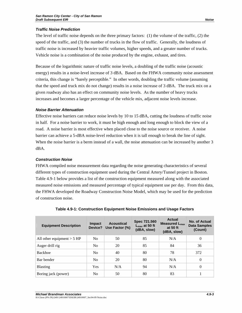
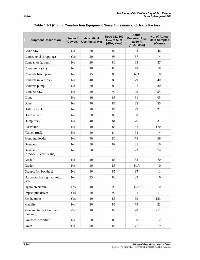
Construction Noise FHWA compiled noise measurement data regarding the noise generating characteristics of several different types of construction equipment used during the Central Artery/Tunnel project in Boston. Table 4.9-1 below provides a list of the construction equipment measured along with the associated measured noise emissions and measured percentage of typical equipment use per day. From this data, the FHWA developed the Roadway Construction Noise Model, which may be used for the prediction of construction noise.
Table 4.9-1: Construction Equipment Noise Emissions and Usage Factors
Equipment Description Impact Device?
Acoustical Use Factor (%)
Spec 721.560 Lmax at 50 ft (dBA, slow)
Actual Measured Lmax
at 50 ft (dBA, slow)
No. of Actual Data Samples
(Count)
All other equipment > 5 HP No 50 85 N/A 0
Auger drill rig No 20 85 84 36
Backhoe No 40 80 78 372
Bar bender No 20 80 N/A 0
Blasting Yes N/A 94 N/A 0
Boring jack (power) No 50 80 83 1
San Ramon City Center - City of San Ramon Noise Draft Subsequent EIR
4.9-4 Michael Brandman Associates
H:\Client (PN-JN)\2491\24910007\DSEIR\24910007_Sec04-09 Noise.doc
Table 4.9-1 (Cont.): Construction Equipment Noise Emissions and Usage Factors
Equipment Description Impact Device?
Acoustical Use Factor (%)
Spec 721.560 Lmax at 50 ft (dBA, slow)
Actual Measured Lmax
at 50 ft (dBA, slow)
No. of Actual Data Samples
(Count)
Chain saw No 20 85 84 46
Clam shovel (dropping) Yes 20 93 87 4
Compactor (ground) No 20 80 83 57
Compressor (air) No 40 80 78 18
Concrete batch plant No 15 83 N/A 0
Concrete mixer truck No 40 85 79 40
Concrete pump No 20 82 81 30
Concrete saw No 20 90 90 55
Crane No 16 85 81 405
Dozer No 40 85 82 55
Drill rig truck No 20 84 79 22
Drum mixer No 50 80 80 1
Dump truck No 40 84 76 31
Excavator No 40 85 81 170
Flatbed truck No 40 84 74 4
Front-end loader No 40 80 79 96
Generator No 50 82 81 19
Generator (<25KVA, VMS signs)
No 50 70 73 74
Gradall No 40 85 83 70
Grader No 40 85 N/A 0
Grapple (on backhoe) No 40 85 87 1
Horizontal boring hydraulic jack
No 25 80 82 6
Hydra break ram Yes 10 90 N/A 0
Impact pile driver Yes 20 95 101 11
Jackhammer Yes 20 85 89 133
Man lift No 20 85 75 23
Mounted impact hammer (hoe ram)
Yes 20 90 90 212
Pavement scarafier No 20 85 90 2
Paver No 50 85 77 9
San Ramon City Center - City of San Ramon Draft Subsequent EIR Noise
Michael Brandman Associates 4.9-5 H:\Client (PN-JN)\2491\24910007\DSEIR\24910007_Sec04-09 Noise.doc
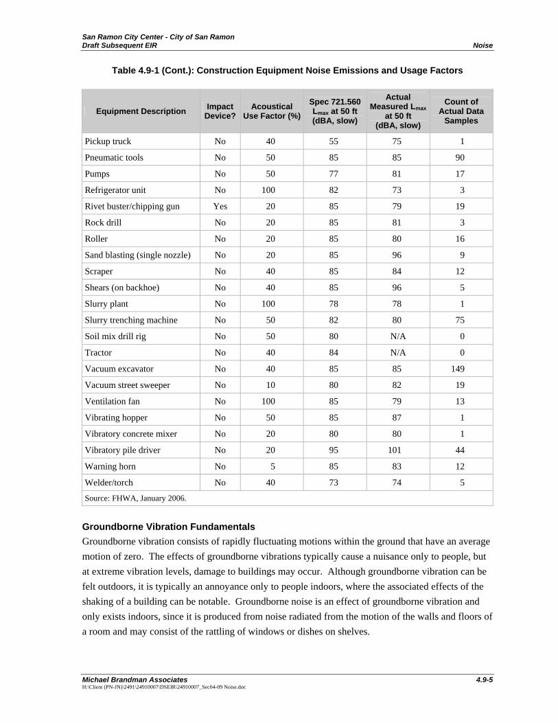
Table 4.9-1 (Cont.): Construction Equipment Noise Emissions and Usage Factors
Equipment Description Impact Device?
Acoustical Use Factor (%)
Spec 721.560 Lmax at 50 ft (dBA, slow)
Actual Measured Lmax
at 50 ft (dBA, slow)
Count of Actual Data
Samples
Pickup truck No 40 55 75 1
Pneumatic tools No 50 85 85 90
Pumps No 50 77 81 17
Refrigerator unit No 100 82 73 3
Rivet buster/chipping gun Yes 20 85 79 19
Rock drill No 20 85 81 3
Roller No 20 85 80 16
Sand blasting (single nozzle) No 20 85 96 9
Scraper No 40 85 84 12
Shears (on backhoe) No 40 85 96 5
Slurry plant No 100 78 78 1
Slurry trenching machine No 50 82 80 75
Soil mix drill rig No 50 80 N/A 0
Tractor No 40 84 N/A 0
Vacuum excavator No 40 85 85 149
Vacuum street sweeper No 10 80 82 19
Ventilation fan No 100 85 79 13
Vibrating hopper No 50 85 87 1
Vibratory concrete mixer No 20 80 80 1
Vibratory pile driver No 20 95 101 44
Warning horn No 5 85 83 12
Welder/torch No 40 73 74 5
Source: FHWA, January 2006.
Groundborne Vibration Fundamentals Groundborne vibration consists of rapidly fluctuating motions within the ground that have an average motion of zero. The effects of groundborne vibrations typically cause a nuisance only to people, but at extreme vibration levels, damage to buildings may occur. Although groundborne vibration can be felt outdoors, it is typically an annoyance only to people indoors, where the associated effects of the shaking of a building can be notable. Groundborne noise is an effect of groundborne vibration and only exists indoors, since it is produced from noise radiated from the motion of the walls and floors of a room and may consist of the rattling of windows or dishes on shelves.
San Ramon City Center - City of San Ramon Noise Draft Subsequent EIR
4.9-6 Michael Brandman Associates
H:\Client (PN-JN)\2491\24910007\DSEIR\24910007_Sec04-09 Noise.doc
Vibration Descriptors Vibration is quantified through the measurement of the motion of a particular point on the ground or structure. Since the current available vibration measurement devices measure either the velocity or acceleration of the ground or structure, vibratory motion is commonly described by identifying the peak particle velocity (PPV) or peak particle acceleration (PPA). The PPV is generally accepted as the most appropriate descriptor for evaluating the potential for building damage. However, for human response, an average vibration amplitude is more appropriate, since it takes time for the human body to respond to the vibration. Since the average particle velocity over time is zero, the root-mean-square amplitude of the vibration velocity is typically used to assess human response. The root-mean-square values are always less than PPV, and for typical single-frequency conditions, the root-mean-square value is about 70 percent of the PPV.
Because of the typically small amplitudes of vibrations, vibration velocity is often expressed in decibels, is denoted as Lv, and is based on the root-mean-square velocity amplitude. A commonly used abbreviation is VdB, which, in this text, is Lv based on the reference quantity of 1 micro-inch per second.
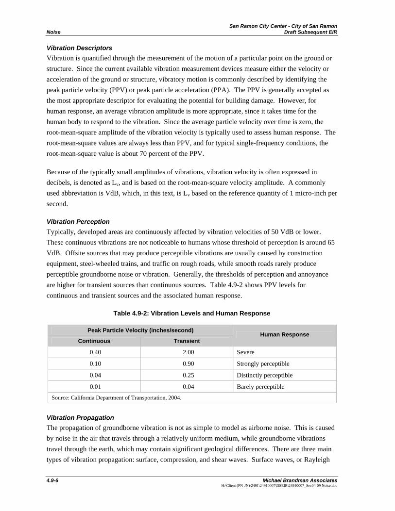
Vibration Perception Typically, developed areas are continuously affected by vibration velocities of 50 VdB or lower. These continuous vibrations are not noticeable to humans whose threshold of perception is around 65 VdB. Offsite sources that may produce perceptible vibrations are usually caused by construction equipment, steel-wheeled trains, and traffic on rough roads, while smooth roads rarely produce perceptible groundborne noise or vibration. Generally, the thresholds of perception and annoyance are higher for transient sources than continuous sources. Table 4.9-2 shows PPV levels for continuous and transient sources and the associated human response.
Table 4.9-2: Vibration Levels and Human Response
Peak Particle Velocity (inches/second)
Continuous Transient Human Response
0.40 2.00 Severe
0.10 0.90 Strongly perceptible
0.04 0.25 Distinctly perceptible
0.01 0.04 Barely perceptible
Source: California Department of Transportation, 2004.
Vibration Propagation The propagation of groundborne vibration is not as simple to model as airborne noise. This is caused by noise in the air that travels through a relatively uniform medium, while groundborne vibrations travel through the earth, which may contain significant geological differences. There are three main types of vibration propagation: surface, compression, and shear waves. Surface waves, or Rayleigh
San Ramon City Center - City of San Ramon Draft Subsequent EIR Noise
Michael Brandman Associates 4.9-7 H:\Client (PN-JN)\2491\24910007\DSEIR\24910007_Sec04-09 Noise.doc
waves, travel along the ground’s surface. These waves carry most of their energy along an expanding circular wave front, similar to ripples produced by throwing a rock into a pool of water. P-waves, or compression waves, are body waves that carry their energy along an expanding spherical wave front. The particle motion in these waves is longitudinal (i.e., in a “push-pull” fashion). P-waves are analogous to airborne sound waves. S-waves, or shear waves, are also body waves that carry energy along an expanding spherical wave front. However, unlike P-waves, the particle motion is transverse or side-to-side and perpendicular to the direction of propagation.
As vibration waves propagate from a source, the vibration energy decreases in a logarithmic nature, and the vibration levels typically decrease by 6 VdB per doubling of the distance from the vibration source. As stated above, this drop-off rate can vary greatly depending on the soil but has been shown to be effective enough for screening purposes, in order to identify potential vibration impacts that may need to be studied through actual field tests.
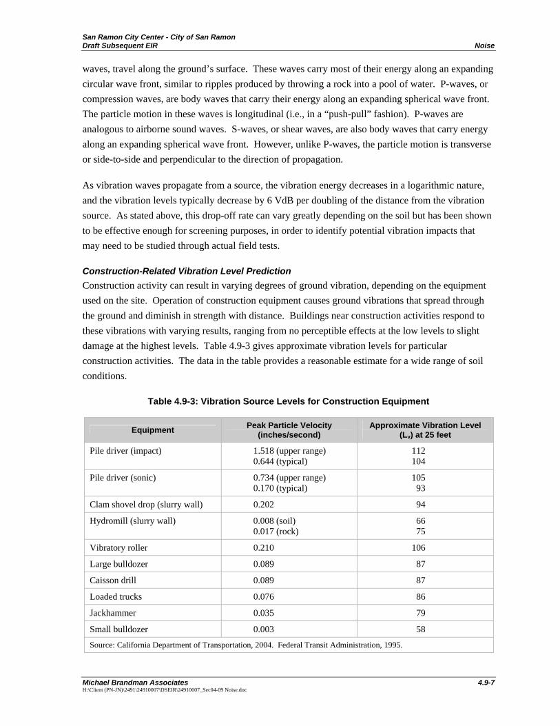
Construction-Related Vibration Level Prediction Construction activity can result in varying degrees of ground vibration, depending on the equipment used on the site. Operation of construction equipment causes ground vibrations that spread through the ground and diminish in strength with distance. Buildings near construction activities respond to these vibrations with varying results, ranging from no perceptible effects at the low levels to slight damage at the highest levels. Table 4.9-3 gives approximate vibration levels for particular construction activities. The data in the table provides a reasonable estimate for a wide range of soil conditions.
Table 4.9-3: Vibration Source Levels for Construction Equipment
Equipment Peak Particle Velocity (inches/second)
Approximate Vibration Level (Lv) at 25 feet
Pile driver (impact) 1.518 (upper range) 0.644 (typical)
112 104
Pile driver (sonic) 0.734 (upper range) 0.170 (typical)
105 93
Clam shovel drop (slurry wall) 0.202 94
Hydromill (slurry wall) 0.008 (soil) 0.017 (rock)
66 75
Vibratory roller 0.210 106
Large bulldozer 0.089 87
Caisson drill 0.089 87
Loaded trucks 0.076 86
Jackhammer 0.035 79
Small bulldozer 0.003 58
Source: California Department of Transportation, 2004. Federal Transit Administration, 1995.

San Ramon City Center - City of San Ramon Noise Draft Subsequent EIR
4.9-8 Michael Brandman Associates
H:\Client (PN-JN)\2491\24910007\DSEIR\24910007_Sec04-09 Noise.doc
Existing Noise Environment To determine the existing noise environment, short-term, peak-hour noise measurements were taken at nine locations in the project study area, and 24-hour noise measurements were taken at two locations on the project site in June 2007. These measurements were then used to calculate ambient noise levels, both on and around the project site.
Noise Measurement Locations The project site is located in a developed area. The project site is generally bounded by Bishop Drive and Bishop Ranch 3 to the north, Iron Horse Trail, the Market Place and the Reflections Condominiums to the east, a Bishop Ranch 1 surface parking area and single-family residential area to the south, and Chevron Park, Sunset Drive, and the Shops at Bishop Ranch to the west. Besides the local roadways, the project site is primarily impacted by noise from Interstate 680 (I-680), which is located approximately 1,400 feet west of Bishop Ranch 2.
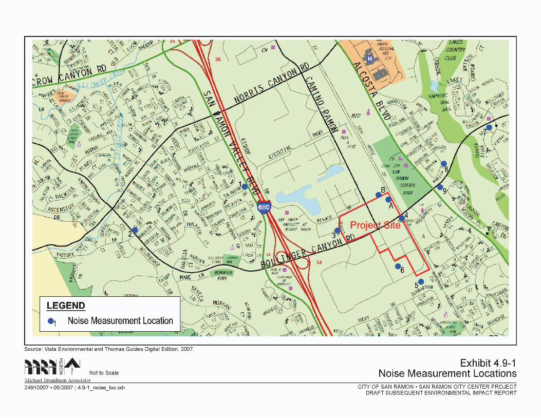
The offsite, short-term, peak-hour noise monitoring locations were selected on basis of the potential for impacts from noise level increases that are due to the development of the proposed project. Each site is described below. The short-term measurement locations are shown on Exhibit 4.9-1.
• Site 1 is located approximately 50 feet west of the centerline of San Ramon Valley Boulevard, approximately 25 feet north of the centerline of Talavera Drive, and approximately 120 feet west of the right-of-way for I-680.
• Site 2 is located approximately 50 feet west of the centerline of Bollinger Canyon Road and approximately 25 feet north of the centerline of Aranda Drive.
• Site 3 is located approximately 50 feet west of the centerline of Sunset Drive and approximately 50 feet south of The Shops at Bishop Ranch.
• Site 4 is located approximately 100 feet south of the centerline of Bollinger Canyon Road and approximately 50 feet east of the centerline of Bishop Ranch East.
• Site 5 is located in the southwest Bishop Ranch 1 surface parking area near Chevron Park.
• Site 6 is located approximately 20 feet north of the water feature located in Bishop Ranch 1.
• Site 7 is located approximately 90 feet south of the centerline of Bollinger Canyon Road and approximately 240 feet west of Canyon Lakes Drive.
• Site 8 is located approximately 50 feet southeast of the centerline of Woodview Circle and approximately 250 feet northwest of the centerline of Bollinger Canyon Road.
• Site 9 is located approximately 200 feet northeast of the centerline of Alcosta Boulevard and approximately 50 feet southeast of the centerline of Bollinger Canyon Road.

San Ramon City Center - City of San Ramon Draft Subsequent EIR Noise
Michael Brandman Associates 4.9-11 H:\Client (PN-JN)\2491\24910007\DSEIR\24910007_Sec04-09 Noise.doc
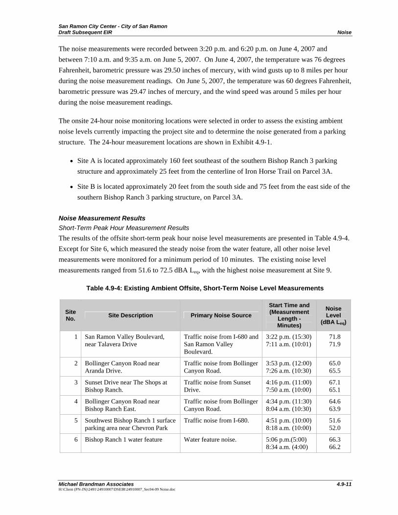
The noise measurements were recorded between 3:20 p.m. and 6:20 p.m. on June 4, 2007 and between 7:10 a.m. and 9:35 a.m. on June 5, 2007. On June 4, 2007, the temperature was 76 degrees Fahrenheit, barometric pressure was 29.50 inches of mercury, with wind gusts up to 8 miles per hour during the noise measurement readings. On June 5, 2007, the temperature was 60 degrees Fahrenheit, barometric pressure was 29.47 inches of mercury, and the wind speed was around 5 miles per hour during the noise measurement readings.
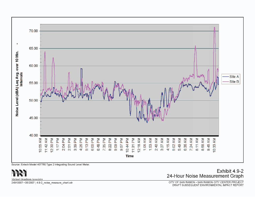
The onsite 24-hour noise monitoring locations were selected in order to assess the existing ambient noise levels currently impacting the project site and to determine the noise generated from a parking structure. The 24-hour measurement locations are shown in Exhibit 4.9-1.
• Site A is located approximately 160 feet southeast of the southern Bishop Ranch 3 parking structure and approximately 25 feet from the centerline of Iron Horse Trail on Parcel 3A.
• Site B is located approximately 20 feet from the south side and 75 feet from the east side of the southern Bishop Ranch 3 parking structure, on Parcel 3A.
Noise Measurement Results Short-Term Peak Hour Measurement Results The results of the offsite short-term peak hour noise level measurements are presented in Table 4.9-4. Except for Site 6, which measured the steady noise from the water feature, all other noise level measurements were monitored for a minimum period of 10 minutes. The existing noise level measurements ranged from 51.6 to 72.5 dBA Leq, with the highest noise measurement at Site 9.
Table 4.9-4: Existing Ambient Offsite, Short-Term Noise Level Measurements
Site No. Site Description Primary Noise Source
Start Time and (Measurement
Length - Minutes)
Noise Level
(dBA Leq)
1 San Ramon Valley Boulevard, near Talavera Drive
Traffic noise from I-680 and San Ramon Valley Boulevard.
3:22 p.m. (15:30) 7:11 a.m. (10:01)
71.8 71.9
2 Bollinger Canyon Road near Aranda Drive.
Traffic noise from Bollinger Canyon Road.
3:53 p.m. (12:00) 7:26 a.m. (10:30)
65.0 65.5
3 Sunset Drive near The Shops at Bishop Ranch.
Traffic noise from Sunset Drive.
4:16 p.m. (11:00) 7:50 a.m. (10:00)
67.1 65.1
4 Bollinger Canyon Road near Bishop Ranch East.
Traffic noise from Bollinger Canyon Road.
4:34 p.m. (11:30) 8:04 a.m. (10:30)
64.6 63.9
5 Southwest Bishop Ranch 1 surface parking area near Chevron Park
Traffic noise from I-680. 4:51 p.m. (10:00) 8:18 a.m. (10:00)
51.6 52.0
6 Bishop Ranch 1 water feature Water feature noise. 5:06 p.m.(5:00) 8:34 a.m. (4:00)
66.3 66.2
San Ramon City Center - City of San Ramon Noise Draft Subsequent EIR
4.9-12 Michael Brandman Associates
H:\Client (PN-JN)\2491\24910007\DSEIR\24910007_Sec04-09 Noise.doc
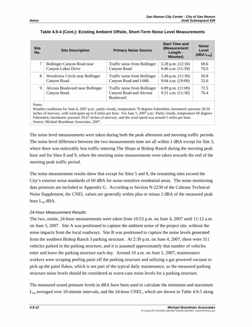
Table 4.9-4 (Cont.): Existing Ambient Offsite, Short-Term Noise Level Measurements
Site No. Site Description Primary Noise Source
Start Time and (Measurement
Length - Minutes)
Noise Level
(dBA Leq)
7 Bollinger Canyon Road near Canyon Lakes Drive
Traffic noise from Bollinger Canyon Road.
5:28 p.m. (12:30) 8:46 a.m. (11:59)
69.6 70.0
8 Woodview Circle near Bollinger Canyon Road.
Traffic noise from Bollinger Canyon Road and I-680.
5:49 p.m. (11:30) 9:04 a.m. (10:00)
50.8 52.6
9 Alcosta Boulevard near Bollinger Canyon Road.
Traffic noise from Bollinger Canyon Road and Alcosta Boulevard.
6:09 p.m. (11:00) 9:21 a.m. (11:30)
72.5 70.4
Notes: Weather conditions for June 4, 2007 p.m.: partly cloudy, temperature 76 degrees Fahrenheit, barometric pressure 29.50 inches of mercury, with wind gusts up to 8 miles per hour. For June 5, 2007 a.m.: Partly cloudy, temperature 60 degrees Fahrenheit, barometric pressure 29.47 inches of mercury, and the wind speed was around 5 miles per hour. Source: Michael Brandman Associates, 2007.
The noise level measurements were taken during both the peak afternoon and morning traffic periods. The noise level difference between the two measurements time are all within 1 dBA except for Site 3, where there was noticeably less traffic entering The Shops at Bishop Ranch during the morning peak hour and for Sites 8 and 9, where the morning noise measurements were taken towards the end of the morning peak traffic period.
The noise measurement results show that except for Sites 5 and 8, the remaining sites exceed the City’s exterior noise standards of 60 dBA for noise-sensitive residential areas. The noise monitoring data printouts are included in Appendix G. According to Section N-2230 of the Caltrans Technical Noise Supplement, the CNEL values are generally within plus or minus 2 dBA of the measured peak hour Leq dBA.
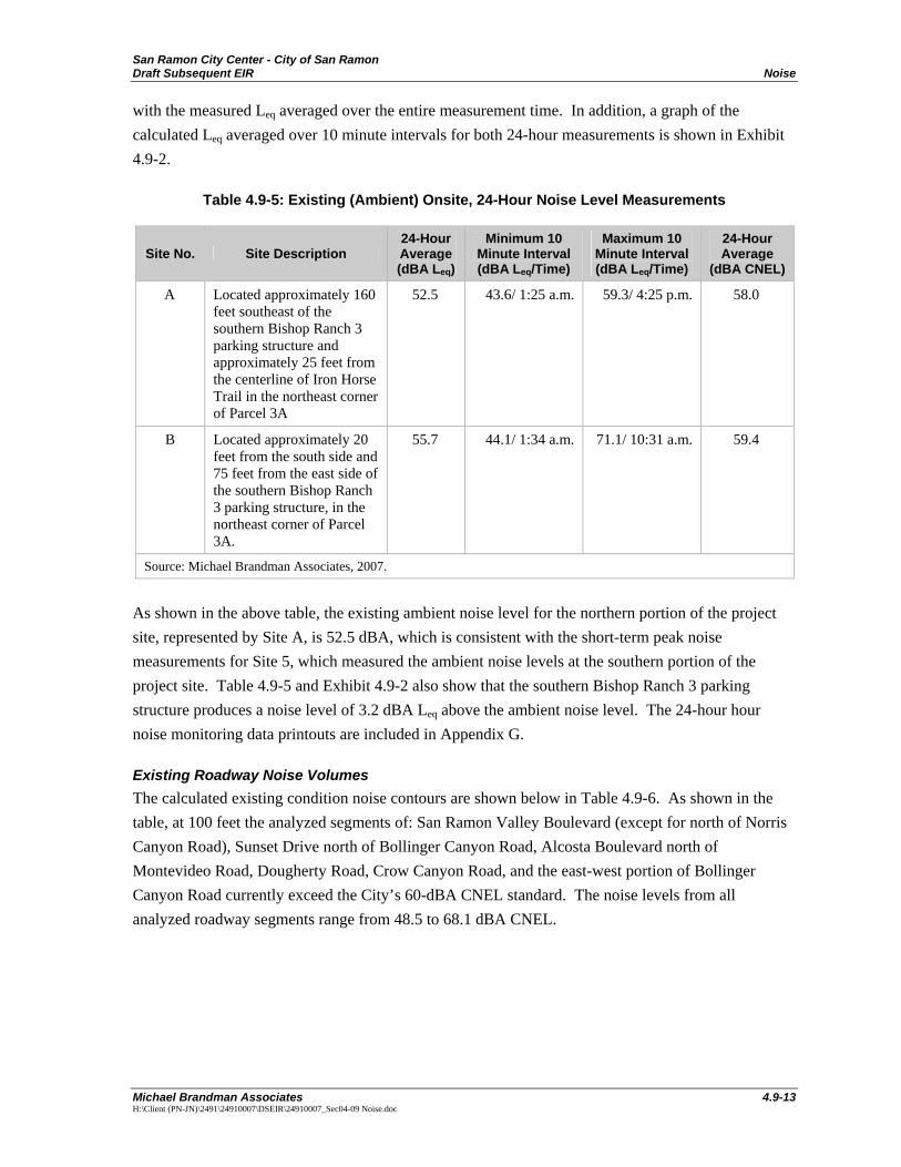
24-Hour Measurement Results The two, onsite, 24-hour measurements were taken from 10:53 p.m. on June 4, 2007 until 11:12 a.m. on June 5, 2007. Site A was positioned to capture the ambient noise of the project site, without the noise impacts from the local roadways. Site B was positioned to capture the noise levels generated from the southern Bishop Ranch 3 parking structure. At 2:30 p.m. on June 4, 2007, there were 311 vehicles parked in the parking structure, and it is assumed approximately that number of vehicles enter and leave the parking structure each day. Around 10 a.m. on June 5, 2007, maintenance workers were scraping peeling paint off the parking structure and utilizing a gas powered vacuum to pick up the paint flakes, which is not part of the typical daily maintenance, so the measured parking structure noise levels should be considered as worst-case noise levels for a parking structure.
The measured sound pressure levels in dBA have been used to calculate the minimum and maximum Leq averaged over 10-minute intervals, and the 24-hour CNEL, which are shown in Table 4.9-5 along
San Ramon City Center - City of San Ramon Draft Subsequent EIR Noise
Michael Brandman Associates 4.9-13 H:\Client (PN-JN)\2491\24910007\DSEIR\24910007_Sec04-09 Noise.doc
with the measured Leq averaged over the entire measurement time. In addition, a graph of the calculated Leq averaged over 10 minute intervals for both 24-hour measurements is shown in Exhibit 4.9-2.
Table 4.9-5: Existing (Ambient) Onsite, 24-Hour Noise Level Measurements
Site No. Site Description 24-Hour Average (dBA Leq)
Minimum 10 Minute Interval(dBA Leq/Time)
Maximum 10 Minute Interval (dBA Leq/Time)
24-Hour Average
(dBA CNEL)
A Located approximately 160 feet southeast of the southern Bishop Ranch 3 parking structure and approximately 25 feet from the centerline of Iron Horse Trail in the northeast corner of Parcel 3A
52.5 43.6/ 1:25 a.m. 59.3/ 4:25 p.m. 58.0
B Located approximately 20 feet from the south side and 75 feet from the east side of the southern Bishop Ranch 3 parking structure, in the northeast corner of Parcel 3A.
55.7 44.1/ 1:34 a.m. 71.1/ 10:31 a.m. 59.4
Source: Michael Brandman Associates, 2007.
As shown in the above table, the existing ambient noise level for the northern portion of the project site, represented by Site A, is 52.5 dBA, which is consistent with the short-term peak noise measurements for Site 5, which measured the ambient noise levels at the southern portion of the project site. Table 4.9-5 and Exhibit 4.9-2 also show that the southern Bishop Ranch 3 parking structure produces a noise level of 3.2 dBA Leq above the ambient noise level. The 24-hour hour noise monitoring data printouts are included in Appendix G.
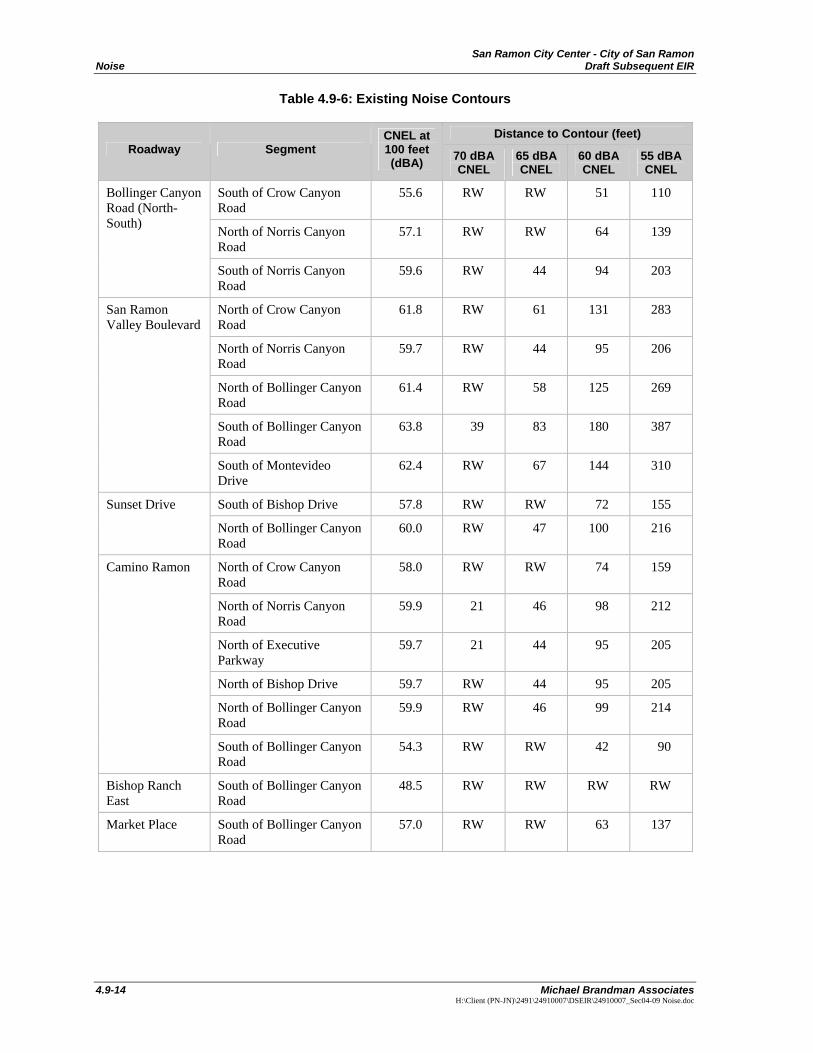
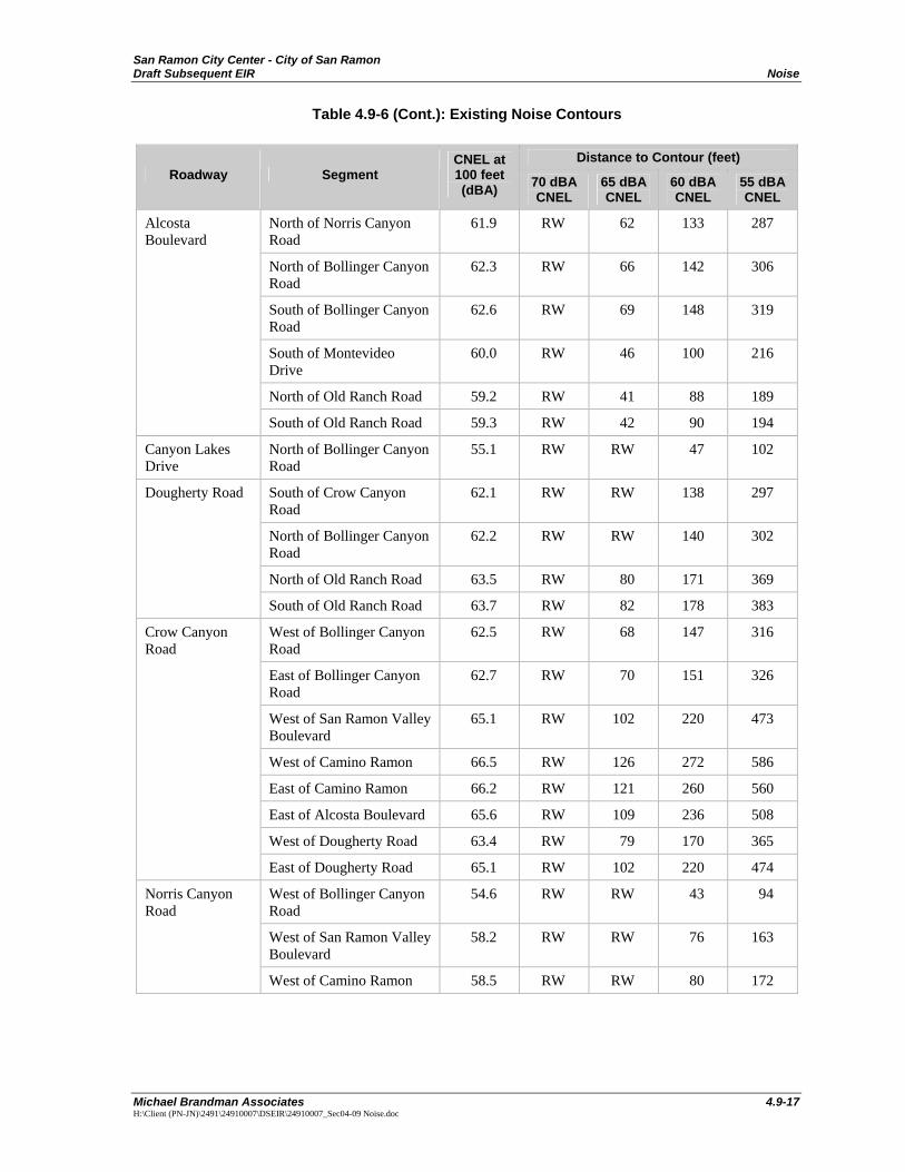
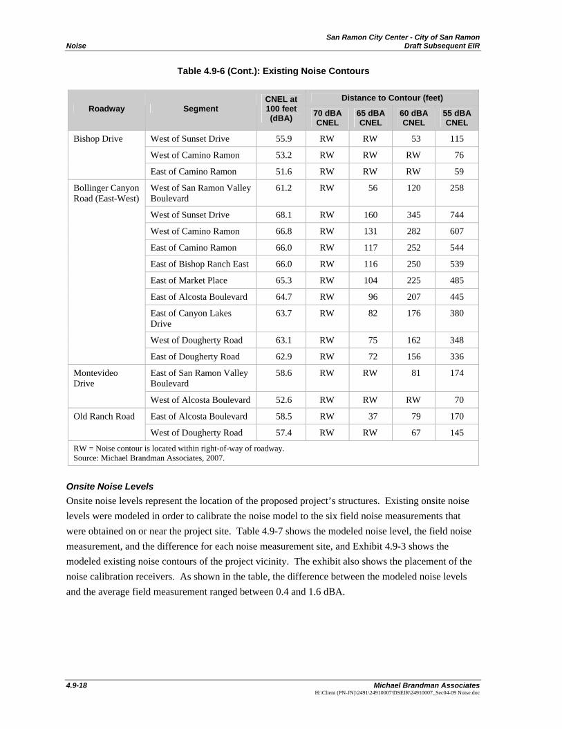
Existing Roadway Noise Volumes The calculated existing condition noise contours are shown below in Table 4.9-6. As shown in the table, at 100 feet the analyzed segments of: San Ramon Valley Boulevard (except for north of Norris Canyon Road), Sunset Drive north of Bollinger Canyon Road, Alcosta Boulevard north of Montevideo Road, Dougherty Road, Crow Canyon Road, and the east-west portion of Bollinger Canyon Road currently exceed the City’s 60-dBA CNEL standard. The noise levels from all analyzed roadway segments range from 48.5 to 68.1 dBA CNEL.
San Ramon City Center - City of San Ramon Noise Draft Subsequent EIR
4.9-14 Michael Brandman Associates
H:\Client (PN-JN)\2491\24910007\DSEIR\24910007_Sec04-09 Noise.doc
Table 4.9-6: Existing Noise Contours
Distance to Contour (feet) Roadway Segment
CNEL at 100 feet (dBA) 70 dBA
CNEL 65 dBA CNEL
60 dBA CNEL
55 dBA CNEL
South of Crow Canyon Road
55.6 RW RW 51 110
North of Norris Canyon Road
57.1 RW RW 64 139
Bollinger Canyon Road (North-South)
South of Norris Canyon Road
59.6 RW 44 94 203
North of Crow Canyon Road
61.8 RW 61 131 283
North of Norris Canyon Road
59.7 RW 44 95 206
North of Bollinger Canyon Road
61.4 RW 58 125 269
South of Bollinger Canyon Road
63.8 39 83 180 387
San Ramon Valley Boulevard
South of Montevideo Drive
62.4 RW 67 144 310
South of Bishop Drive 57.8 RW RW 72 155 Sunset Drive
North of Bollinger Canyon Road
60.0 RW 47 100 216
North of Crow Canyon Road
58.0 RW RW 74 159
North of Norris Canyon Road
59.9 21 46 98 212
North of Executive Parkway
59.7 21 44 95 205
North of Bishop Drive 59.7 RW 44 95 205
North of Bollinger Canyon Road
59.9 RW 46 99 214
Camino Ramon
South of Bollinger Canyon Road
54.3 RW RW 42 90
Bishop Ranch East
South of Bollinger Canyon Road
48.5 RW RW RW RW
Market Place South of Bollinger Canyon Road
57.0 RW RW 63 137

San Ramon City Center - City of San Ramon Draft Subsequent EIR Noise
Michael Brandman Associates 4.9-17 H:\Client (PN-JN)\2491\24910007\DSEIR\24910007_Sec04-09 Noise.doc
Table 4.9-6 (Cont.): Existing Noise Contours
Distance to Contour (feet) Roadway Segment
CNEL at 100 feet (dBA) 70 dBA
CNEL 65 dBA CNEL
60 dBA CNEL
55 dBA CNEL
North of Norris Canyon Road
61.9 RW 62 133 287
North of Bollinger Canyon Road
62.3 RW 66 142 306
South of Bollinger Canyon Road
62.6 RW 69 148 319
South of Montevideo Drive
60.0 RW 46 100 216
North of Old Ranch Road 59.2 RW 41 88 189
Alcosta Boulevard
South of Old Ranch Road 59.3 RW 42 90 194
Canyon Lakes Drive
North of Bollinger Canyon Road
55.1 RW RW 47 102
South of Crow Canyon Road
62.1 RW RW 138 297
North of Bollinger Canyon Road
62.2 RW RW 140 302
North of Old Ranch Road 63.5 RW 80 171 369
Dougherty Road
South of Old Ranch Road 63.7 RW 82 178 383
West of Bollinger Canyon Road
62.5 RW 68 147 316
East of Bollinger Canyon Road
62.7 RW 70 151 326
West of San Ramon Valley Boulevard
65.1 RW 102 220 473
West of Camino Ramon 66.5 RW 126 272 586
East of Camino Ramon 66.2 RW 121 260 560
East of Alcosta Boulevard 65.6 RW 109 236 508
West of Dougherty Road 63.4 RW 79 170 365
Crow Canyon Road
East of Dougherty Road 65.1 RW 102 220 474
West of Bollinger Canyon Road
54.6 RW RW 43 94
West of San Ramon Valley Boulevard
58.2 RW RW 76 163
Norris Canyon Road
West of Camino Ramon 58.5 RW RW 80 172
San Ramon City Center - City of San Ramon Noise Draft Subsequent EIR
4.9-18 Michael Brandman Associates
H:\Client (PN-JN)\2491\24910007\DSEIR\24910007_Sec04-09 Noise.doc
Table 4.9-6 (Cont.): Existing Noise Contours
Distance to Contour (feet) Roadway Segment
CNEL at 100 feet (dBA) 70 dBA
CNEL 65 dBA CNEL
60 dBA CNEL
55 dBA CNEL
West of Sunset Drive 55.9 RW RW 53 115
West of Camino Ramon 53.2 RW RW RW 76
Bishop Drive
East of Camino Ramon 51.6 RW RW RW 59
West of San Ramon Valley Boulevard
61.2 RW 56 120 258
West of Sunset Drive 68.1 RW 160 345 744
West of Camino Ramon 66.8 RW 131 282 607
East of Camino Ramon 66.0 RW 117 252 544
East of Bishop Ranch East 66.0 RW 116 250 539
East of Market Place 65.3 RW 104 225 485
East of Alcosta Boulevard 64.7 RW 96 207 445
East of Canyon Lakes Drive
63.7 RW 82 176 380
West of Dougherty Road 63.1 RW 75 162 348
Bollinger Canyon Road (East-West)
East of Dougherty Road 62.9 RW 72 156 336
East of San Ramon Valley Boulevard
58.6 RW RW 81 174 Montevideo Drive
West of Alcosta Boulevard 52.6 RW RW RW 70
East of Alcosta Boulevard 58.5 RW 37 79 170 Old Ranch Road
West of Dougherty Road 57.4 RW RW 67 145
RW = Noise contour is located within right-of-way of roadway. Source: Michael Brandman Associates, 2007.
Onsite Noise Levels Onsite noise levels represent the location of the proposed project’s structures. Existing onsite noise levels were modeled in order to calibrate the noise model to the six field noise measurements that were obtained on or near the project site. Table 4.9-7 shows the modeled noise level, the field noise measurement, and the difference for each noise measurement site, and Exhibit 4.9-3 shows the modeled existing noise contours of the project vicinity. The exhibit also shows the placement of the noise calibration receivers. As shown in the table, the difference between the modeled noise levels and the average field measurement ranged between 0.4 and 1.6 dBA.
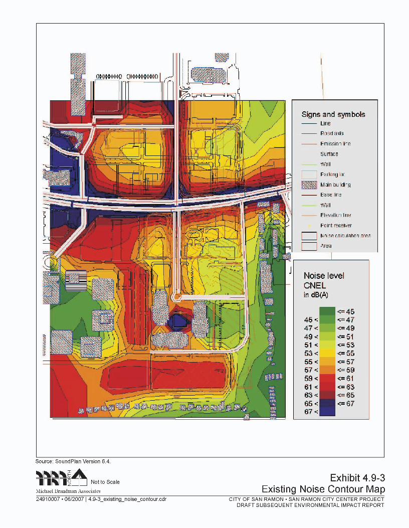

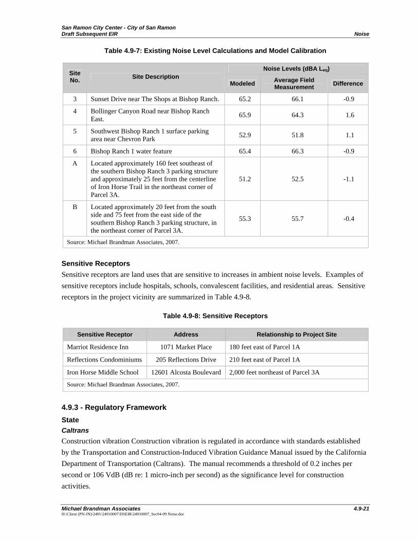
San Ramon City Center - City of San Ramon Draft Subsequent EIR Noise
Michael Brandman Associates 4.9-21 H:\Client (PN-JN)\2491\24910007\DSEIR\24910007_Sec04-09 Noise.doc
Table 4.9-7: Existing Noise Level Calculations and Model Calibration
Noise Levels (dBA Leq) Site No. Site Description
Modeled Average Field Measurement Difference
3 Sunset Drive near The Shops at Bishop Ranch. 65.2 66.1 -0.9
4 Bollinger Canyon Road near Bishop Ranch East. 65.9 64.3 1.6
5 Southwest Bishop Ranch 1 surface parking area near Chevron Park 52.9 51.8 1.1
6 Bishop Ranch 1 water feature 65.4 66.3 -0.9
A Located approximately 160 feet southeast of the southern Bishop Ranch 3 parking structure and approximately 25 feet from the centerline of Iron Horse Trail in the northeast corner of Parcel 3A.
51.2 52.5 -1.1
B Located approximately 20 feet from the south side and 75 feet from the east side of the southern Bishop Ranch 3 parking structure, in the northeast corner of Parcel 3A.
55.3 55.7 -0.4
Source: Michael Brandman Associates, 2007.
Sensitive Receptors Sensitive receptors are land uses that are sensitive to increases in ambient noise levels. Examples of sensitive receptors include hospitals, schools, convalescent facilities, and residential areas. Sensitive receptors in the project vicinity are summarized in Table 4.9-8.
Table 4.9-8: Sensitive Receptors
Sensitive Receptor Address Relationship to Project Site
Marriot Residence Inn 1071 Market Place 180 feet east of Parcel 1A
Reflections Condominiums 205 Reflections Drive 210 feet east of Parcel 1A
Iron Horse Middle School 12601 Alcosta Boulevard 2,000 feet northeast of Parcel 3A
Source: Michael Brandman Associates, 2007.
4.9.3 - Regulatory Framework State Caltrans Construction vibration Construction vibration is regulated in accordance with standards established by the Transportation and Construction-Induced Vibration Guidance Manual issued by the California Department of Transportation (Caltrans). The manual recommends a threshold of 0.2 inches per second or 106 VdB (dB re: 1 micro-inch per second) as the significance level for construction activities.
San Ramon City Center - City of San Ramon Noise Draft Subsequent EIR
4.9-22 Michael Brandman Associates
H:\Client (PN-JN)\2491\24910007\DSEIR\24910007_Sec04-09 Noise.doc
Government Code Section 65302 Government Code Section 65302 mandates that the legislative body of each county and city in California adopt a noise element as part of its comprehensive general plan. The local noise element must recognize the land use compatibility guidelines published by the State Department of Health Services. The guidelines rank noise land use compatibility in terms of “normally acceptable,” “conditionally acceptable,” “normally unacceptable,” and “clearly unacceptable.” The City of San Ramon’s adopted land use compatibility guidelines are discussed below.
Local City of San Ramon The project site is located in the jurisdiction of the City of San Ramon, which has separate standards for transportation, stationary, and construction noise and vibration sources. The following provides a discussion of the standards for these types of noise and vibration sources.
Transportation-Related Noise To control transportation-related noise sources such as arterial roads, freeways, airports, and railroads, the City has established guidelines for acceptable community noise levels in the General Plan Noise Element. The Noise Element outlines the land use compatibility for community noise exposure by land use category. For development of a site with exterior noise levels less than 65 dBA CNEL, commercial development is normally acceptable, with typically no noise analysis or mitigation required. For development of a site with exterior noise levels in the 65- to 78-dBA CNEL range, commercial development is conditionally acceptable upon further analysis through a noise impact analysis and possible mitigation. For development of a site with exterior noise levels in the 75- to 85-dBA CNEL range, commercial-retail development is normally unacceptable. Exhibit 4.9-4 provides the Land Use Compatibility Matrix that identifies compatibility of land uses with noise levels.
For the residential portion of the proposed project, the General Plan Noise Element provides an interior noise level standard of 45 dBA CNEL or less and no noise standard for the commercial portion of the proposed project. For the surrounding noise-sensitive residential uses, the General Plan Noise Element provides an exterior noise level standard of 60 dBA CNEL or less for the outdoor living areas and an interior noise level standard of 45 dBA CNEL or less. In the context of this noise impact analysis, the noise impacts from transportation-related noise associated with the proposed project are controlled by the City Noise Element.
In community noise assessment, changes in noise levels less than 3 dBA are often identified as “barely perceptible,” while changes of 5 dBA or greater are “readily perceptible.” The range of 1 dBA to 3 dBA may be perceived by people who are very sensitive to noise as a slight change in noise level. It is recognized that an increase in noise level of 3 dBA is considered just perceptible in a community noise environment and an increase of 5 dBA would be readily perceptible. An increase above ambient noise levels between 3 dBA and 5 dBA would result in an adverse, but not significant
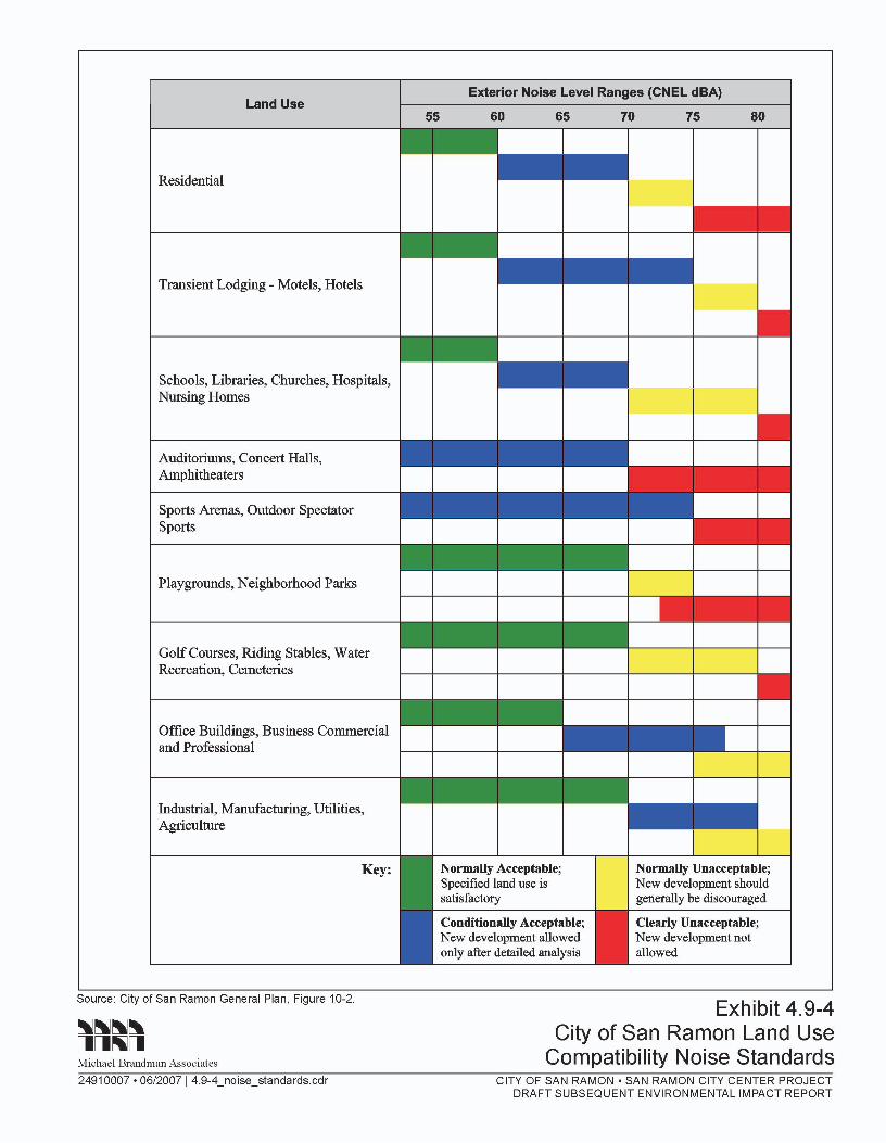

San Ramon City Center - City of San Ramon Draft Subsequent EIR Noise
Michael Brandman Associates 4.9-25 H:\Client (PN-JN)\2491\24910007\DSEIR\24910007_Sec04-09 Noise.doc
impact, while an increase in noise level greater than 5 dBA when the community noise level already exceeds the City’s 60-dBA CNEL standard for noise-sensitive land uses would be considered a significant impact.
Stationary Noise and Vibration The City Code has established exterior noise level performance standards to control stationary source/non-transportation related noise impacts. The performance standards do not provide quantitative noise limits; instead, they provide operating rules, which are presented below from Municipal Code Chapter V Noise Control B6-101, Business and Residential Relationships:
• Store deliveries by any vehicle in the area between the business and residences is prohibited between 10 p.m. and 6:30 a.m. weekdays and between 10 p.m. and 8 a.m. on weekend and federal holidays. Delivery vehicles will have their engines turned off during deliveries.
• Garbage disposal, construction and maintenance by power equipment in the area between the business and residences is prohibited between 10 p.m. and 6:30 a.m. weekdays and between 10 p.m. and 8 a.m. on weekends and federal holidays.
• Pedestrian, cycle or unauthorized vehicle traffic in the area between the business and residences is prohibited between 10 p.m. and 8 a.m.
In addition to the standards shown above, the City’s General Plan Noise Element also provides a 45-dBA Leq noise level threshold for the interior living areas of all residences.
Construction Noise and Vibration To control construction-related noise and vibration, the City has derived standards specifically for construction noise and vibration, because of their short-term nature. The City standards are specified in the General Plan Noise Element and Noise Ordinance.
The City of San Ramon’s City Code Chapter V Noise Control, B6-100 requires that construction in residential zoning districts be limited to the hours of 7:30 a.m. and 6:00 p.m. Monday through Friday and holidays, and 9:00 a.m. and 6:00 p.m. on Saturday and Sunday.
Since the City of San Ramon does not have specific vibration impact criteria for construction-related vibration levels, Caltrans’ vibration impact thresholds presented in the Transportation- and Construction-Induced Vibration Guidance Manual were utilized.
4.9.4 - Methodology Michael Brandman Associates prepared a Noise Impact Analysis, dated June 2007, to determine the offsite and onsite noise impacts associated with the proposed project.
San Ramon City Center - City of San Ramon Noise Draft Subsequent EIR
4.9-26 Michael Brandman Associates
H:\Client (PN-JN)\2491\24910007\DSEIR\24910007_Sec04-09 Noise.doc
Existing Noise Levels To ascertain the existing noise at and adjacent to the project site, field monitoring was conducted from Monday, June 4, 2007 to Tuesday, June 5, 2007. The field survey noted that noise within the proposed project area is generally characterized by vehicle traffic on the local roadways and from I-680. No noise impacts from aircraft were observed during the measurements.
Noise monitoring was performed using two different styles of noise meters for the short-term peak hour measurements and the 24-hour measurements, which are described below.
Short-Term Peak Hour Noise Measurements The short-term peak hour noise measurements were taken using a Larson-Davis Model 824 Type 1 precision sound level meter programmed in “slow” mode to record noise levels in “A” weighted form. The sound level meter and microphone were mounted on a tripod five feet above the ground and were equipped with a windscreen during all measurements. The sound level meter was calibrated before and after the monitoring using a Larson-Davis calibrator, Model CAL 200. The accuracy of the calibrator is maintained through a program established through the manufacturer and is traceable to the National Bureau of Standards. The unit meets the requirements of ANSI Standard S1.4-1984 and IEC Standard 942: 1988 for Class 1 equipment. All noise level measurement equipment meets American National Standards Institute (ANSI) specifications for sound level meters (S1.4-1983 identified in Chapter 19.68.020.AA).
All noise measurement durations were measured according to the standards stated in Section N-3320 of Caltrans Technical Noise Supplement, which specifies that the measurements be a duration of at least 10 minutes and shall be continued past 10 minutes until the fluctuations in the displayed Leq are less than 0.5 dBA.
24-Hour Noise Measurements The 24-hour noise measurements were taken using an Extech Model 407780 Type 2 integrating sound level meter programmed in “slow” mode to record the sound pressure level at 5-second intervals for 24 hours in “A” weighted form. In addition, the Leq averaged over the entire measuring time was also recorded. The sound level meter and microphone were mounted on a tripod five feet above grade and was equipped with a windscreen during all measurements. The sound level meter was calibrated before and after the monitoring using an Extech calibrator, Model 407766. All noise level measurement equipment meets American National Standards Institute (ANSI) specifications for sound level meters (S1.4-1983 identified in Chapter 19.68.020.AA).
Onsite Noise Levels In order to provide a more detailed noise analysis of the project vicinity, calculations of the expected future exterior noise levels were made using SoundPlan Version 6.4 noise modeling software. The following section describes the noise analysis methodologies, which includes a discussion of the software and modeling input parameters used in this analysis.
San Ramon City Center - City of San Ramon Draft Subsequent EIR Noise
Michael Brandman Associates 4.9-27 H:\Client (PN-JN)\2491\24910007\DSEIR\24910007_Sec04-09 Noise.doc
SoundPlan Noise Modeling Software Because of the project site’s proximity to I-680, which is a significant source of traffic noise, and since the project vicinity is impacted by multiple roadways and existing and proposed parking lots, the SoundPlan Version 6.4 noise modeling software was used. SoundPlan’s road noise algorithms are based on the FHWA Traffic Noise Model (FHWA TNM Model) and SoundPlan’s parking lot noise algorithms are based on the international standard ISO 9613-2, since no national standard for parking lot noise currently exists. The SoundPlan Model requires the input of roadways, parking lots, and the locations of the noise measurement receivers. In addition, sound barriers, terrain contour lines, building placement, and specific ground coverage zones may be incorporated as well. The site plan along with scaled aerial photographs, were used to determine the placement of the roadways, parking lots, structures, and key contour lines to establish the terrain in project vicinity. Except for the roadways and buildings that were analyzed as “hard” site conditions, the remainder of the area was analyzed as “soft” site conditions. The default temperature and humidity were used in the analysis. The SoundPlan Model printouts are provided in Appendix G and the following describes the roadway, parking lot, and receiver assumptions used.
Roadway Assumptions The model analyzed the noise impacts from I-680, Sunset Drive, West Street (proposed), Camino Ramon, East Street (proposed), Bishop Ranch East, Bishop Drive (includes extension), Bollinger Canyon Road, and the road into the City Hall parking structure. Each direction of travel for I-680, Bollinger Canyon Road, and Camino Ramon south of Bollinger Canyon Road was analyzed separately, while the remaining roadways were analyzed based on a single-lane equivalency. The CNEL noise levels were calculated for the existing condition, Year 2020 baseline (without project), and Year 2020 with project scenarios. The average daily traffic volumes were obtained from the Traffic Operations Evaluation, except for West Street (proposed), East Street (proposed), and the road into City Hall parking structure, which were not analyzed by the Traffic Operations Evaluation and were assumed to have average daily traffic volumes of 2,000 vehicles for the Year 2020 with project scenario.
The model requires the separate input of autos, medium trucks, and heavy trucks. For the local roadways, the vehicle mix was based on the roadway’s General Plan classification vehicle mix shown. The collector vehicle mix was used for those roadways that do not have a General Plan classification. For I-680, the vehicle mix was obtained from the 2005 Annual Average Daily Truck Traffic on the California Highway System, prepared by State of California Department of Transportation, November 2006, and is shown below in Table 4.9-9. The roadway speeds were based on the posted speed limits.
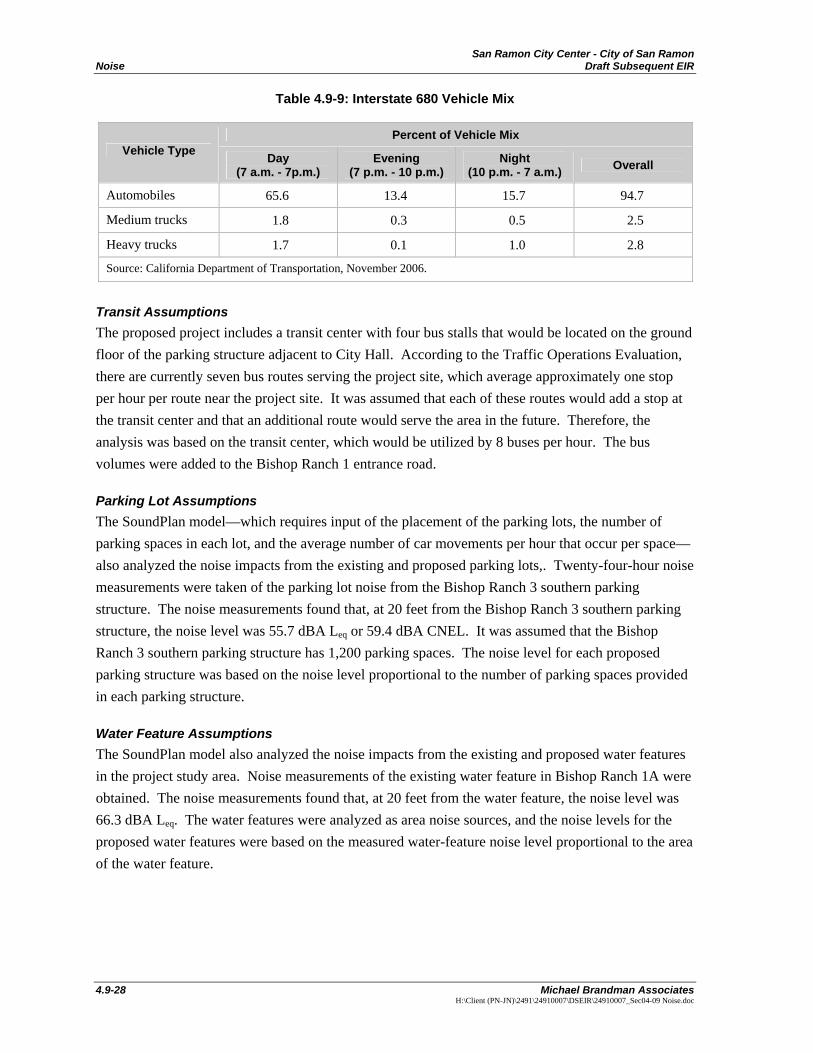
San Ramon City Center - City of San Ramon Noise Draft Subsequent EIR
4.9-28 Michael Brandman Associates
H:\Client (PN-JN)\2491\24910007\DSEIR\24910007_Sec04-09 Noise.doc
Table 4.9-9: Interstate 680 Vehicle Mix
Percent of Vehicle Mix Vehicle Type Day
(7 a.m. - 7p.m.) Evening
(7 p.m. - 10 p.m.) Night
(10 p.m. - 7 a.m.) Overall
Automobiles 65.6 13.4 15.7 94.7
Medium trucks 1.8 0.3 0.5 2.5
Heavy trucks 1.7 0.1 1.0 2.8
Source: California Department of Transportation, November 2006.
Transit Assumptions The proposed project includes a transit center with four bus stalls that would be located on the ground floor of the parking structure adjacent to City Hall. According to the Traffic Operations Evaluation, there are currently seven bus routes serving the project site, which average approximately one stop per hour per route near the project site. It was assumed that each of these routes would add a stop at the transit center and that an additional route would serve the area in the future. Therefore, the analysis was based on the transit center, which would be utilized by 8 buses per hour. The bus volumes were added to the Bishop Ranch 1 entrance road.
Parking Lot Assumptions The SoundPlan model—which requires input of the placement of the parking lots, the number of parking spaces in each lot, and the average number of car movements per hour that occur per space—also analyzed the noise impacts from the existing and proposed parking lots,. Twenty-four-hour noise measurements were taken of the parking lot noise from the Bishop Ranch 3 southern parking structure. The noise measurements found that, at 20 feet from the Bishop Ranch 3 southern parking structure, the noise level was 55.7 dBA Leq or 59.4 dBA CNEL. It was assumed that the Bishop Ranch 3 southern parking structure has 1,200 parking spaces. The noise level for each proposed parking structure was based on the noise level proportional to the number of parking spaces provided in each parking structure.
Water Feature Assumptions The SoundPlan model also analyzed the noise impacts from the existing and proposed water features in the project study area. Noise measurements of the existing water feature in Bishop Ranch 1A were obtained. The noise measurements found that, at 20 feet from the water feature, the noise level was 66.3 dBA Leq. The water features were analyzed as area noise sources, and the noise levels for the proposed water features were based on the measured water-feature noise level proportional to the area of the water feature.
San Ramon City Center - City of San Ramon Draft Subsequent EIR Noise
Michael Brandman Associates 4.9-29 H:\Client (PN-JN)\2491\24910007\DSEIR\24910007_Sec04-09 Noise.doc
Receiver Assumptions Receivers were placed at the field noise measurements locations; in the offsite structures with noise sensitive uses; and onsite, where residential uses are proposed. The receivers were placed either 5 feet above ground level or 5 feet above floor level for the residential structure receivers.
4.9.5 - Thresholds of Significance According to the CEQA Guidelines’ Appendix G Environmental Checklist, to determine whether noise impacts are significant environmental effects, the following questions are analyzed and evaluated: Would the project result in:
a.) Exposure of persons to or generation of noise levels in excess of standards established in the local general plan or noise ordinance, or applicable standards of other agencies?
b.) Exposure of persons to or generation of excessive groundborne vibration or groundborne noise levels?
c.) A substantial permanent increase in ambient noise levels in the project vicinity above levels existing without the project?
d.) A substantial temporary or periodic increase in ambient noise levels in the project vicinity above levels existing without the project?
e.) For a project located within an airport land use plan or, where such a plan has not been adopted, within two miles of a public airport or public use airport, would the project expose people residing or working in the project area to excessive noise levels? (Refer to Section 7, Effects Found Not To Be Significant.)
f.) For a project within the vicinity of a private airstrip, would the project expose people residing or working in the project area to excessive noise levels? (Refer to Section 7, Effects Found Not To Be Significant.)
4.9.6 - Project Impacts and Mitigation Measures This section discusses potential impacts associated with the development of the project and provides mitigation measures where appropriate.
Construction Noise
Impact NOI-1: The proposed project would generate substantial construction noise that may adversely impact nearby noise-sensitive land uses.
Impact Analysis Construction noise and vibration represent a short-term increase in ambient noise levels. Noise impacts from construction activities associated with the proposed project would be functions of the noise generated by construction equipment, equipment location, sensitivity of nearby land uses, and the timing and duration of the construction activities.
San Ramon City Center - City of San Ramon Noise Draft Subsequent EIR
4.9-30 Michael Brandman Associates
H:\Client (PN-JN)\2491\24910007\DSEIR\24910007_Sec04-09 Noise.doc
The construction activities for the proposed project are anticipated to include demolition of 194,652 square feet of office space spread among four, two-story office structures; ground clearing, excavation, and grading of approximately 44 acres of land; and construction of more than 2.1 million square feet of mixed uses. The following describes the anticipated construction schedule:
Plaza District: • Construction starts in fall 2008 and ends with construction completion and opening in
November 2010. Bishop Ranch 1A
• The first Bishop Ranch 1A office building starts in mid-2008 with a construction period of 14 months.
• Bishop Ranch 1A parking structure starts in mid-2008 with a construction period of 10 months.
• The second office building starts mid-2009 with a construction period of 14 months.
• Bishop Ranch 1 parking structure starts in mid-2009 with a construction period of 10 months.
• The third office building starts in mid-2010 with a construction period of 14 months. City Hall and Transit Center
• Construction begins mid-2009 with a construction period of 18 months. Short-term noise impacts could occur during construction activities either from the noise impacts created from the noise generated onsite during demolition, ground clearing, excavation, grading, and construction activities, or from the transport of workers and movement of construction materials to and from the project site. Onsite and offsite construction noise are discussed separately.
Onsite Construction Noise Onsite construction noise is of the greatest concern as it relates to nearby noise-sensitive land uses. The nearest noise-sensitive land uses include a Marriott Residence Inn, located approximately 180 feet east of the nearest construction activity on Parcel 1A, and the Reflections Condominiums, located approximately 210 feet east of the nearest construction activity on Parcel 1A. In addition, the nearest Iron Horse Middle School classrooms are approximately 2,000 feet from the northeast corner of Parcel 3A. Commercial and office developments and parks are not considered noise-sensitive land uses.
The Marriott Residence Inn would experience the greatest noise impact during the construction of the three Bishop Ranch 1A office buildings, which would be phased in between mid-2008 and 2011. The Reflections Condominiums would experience the greatest noise impact during the construction of the Bishop Ranch 1 parking structure, which is anticipated to start in mid-2009 and last for 10 months. Iron Horse Middle School would experience the greatest noise impacts during the construction of
San Ramon City Center - City of San Ramon Draft Subsequent EIR Noise
Michael Brandman Associates 4.9-31 H:\Client (PN-JN)\2491\24910007\DSEIR\24910007_Sec04-09 Noise.doc
Block F of the Plaza District, which is anticipated to start in the fall of 2008 and be completed by November 2010.
Construction noise impacts onto the nearby sensitive receptors have been calculated according to the methodology discussed previously and through the use of the Roadway Construction Noise Model. Pile drivers may be used during the construction of Bishop Ranch 1A office buildings, the Bishop Ranch 1 parking structure, and Block F of the Plaza District, which would be the noisiest phase of construction. Along with the operation of a pile driver, it was assumed that the simultaneous operation of an excavator and a front-end loader would occur. The individual noise levels of the various types of equipment have been previously shown above in Table 4.9-1. The results of the construction noise impacts are shown below in Table 4.9-10. The Roadway Construction Noise Model printouts are provided in Appendix G.
Table 4.9-10: Construction Noise Impacts
Combined Equipment Noise Level Land Use Distance to Nearest
Construction Noise Source dBA Lmax dBA Leq
Marriot Residence Inn 180 90.1 83.3
Reflections Condominiums 210 88.8 81.9
Iron Horse Middle School 2,000 69.2 62.4
Source: FHWA Roadway Construction Noise Model Version 1.0.
Table 4.9-10 shows that the Marriot Residence Inn, located approximately 180 feet east of the nearest construction noise source will experience the greatest construction noise impact from the proposed project with combined maximum average noise levels from construction equipment of 83.3 dBA Leq.
Since construction noise is of a temporary nature, it is exempt from compliance with the City’s land use compatibility guidelines shown in Exhibit 4.9-4. However, the City Code does require construction-related operational considerations such as limitation on the hours of construction and proper maintenance of sound attenuation devices on construction equipment. These requirements are incorporated into the project as mitigation. The implementation of the construction noise control mitigation measures would reduce potential impacts to a level of less than significant.
Offsite Construction Noise The transport of workers and movement of construction materials could incrementally increase the noise levels along nearby roadways. In order for offsite roadway noise impacts created by construction trips associated with the proposed project to be considered significant, the offsite roadway noise levels would have to increase by 5 dBA CNEL, and the resulting noise level would have to exceed the City’s 60 dBA CNEL exterior noise standard for noise-sensitive uses. The greatest construction-related offsite noise impact is expected to occur when the existing 194,652 square feet of the Bishop Ranch 2 office complex is demolished and the debris is hauled offsite.
San Ramon City Center - City of San Ramon Noise Draft Subsequent EIR
4.9-32 Michael Brandman Associates
H:\Client (PN-JN)\2491\24910007\DSEIR\24910007_Sec04-09 Noise.doc
According to the URBEMIS2002 Model default settings for air quality analysis, this would require haul trucks to make approximately 45 round-trips per day for 20 days.
As discussed in Section 4.12, Transportation, mitigation is proposed that would limit construction traffic to the streets along the project site frontage. Truck traffic would not be permitted east of the Bollinger Canyon Road and Bishop Ranch East intersection or north of the Camino Ramon intersection with Bishop Drive. With this limitation, no offsite noise-sensitive land uses would be impacted by the construction-related traffic. Therefore, no significant impact is anticipated from construction noise impacts that would occur off the project site.
Level of Significance Before Mitigation Potentially significant impact.
Mitigation Measures MM NOI-1 All construction activities shall adhere to the following requirements:
• All construction equipment shall use noise reduction features (e.g., mufflers and engine shrouds) that are no less effective than those originally installed by the manufacturer.
• Construction staging and heavy equipment maintenance activities shall be performed a minimum distance of 300 feet from either the Residence Inn or the Reflections Condominiums, unless safety or technical feasibility takes precedence.
• Stationary combustion equipment such as pumps or generators operating within 500 feet of the Residence Inn or the Reflections Condominiums shall be shielded from these noise-sensitive land uses with a noise protection barrier.
Level of Significance After Mitigation Less than significant impact.
Vibration
Impact NOI-2: Operational vibration associated with the proposed project may subject project residents to substantial vibration.
Impact Analysis This impact assesses the proposed project’s potential to expose persons and structures to substantial vibration from construction and operational activities. Because the City of San Ramon does not have any adopted vibration exposure threshold criteria, the thresholds presented in the Caltrans’ Transportation- and Construction-Induced Vibration Guidance Manual were used in this analysis.

San Ramon City Center - City of San Ramon Draft Subsequent EIR Noise
Michael Brandman Associates 4.9-33 H:\Client (PN-JN)\2491\24910007\DSEIR\24910007_Sec04-09 Noise.doc
Construction Vibration Construction activities can produce vibration that may be felt by adjacent uses. The primary sources of vibration during construction will potentially be from pile drivers, which are known to generate substantial vibration levels. As shown previously in Table 4.9-3, an impact pile driver truck generates the most amount of vibration of any piece of construction equipment with an upper range of 1.518 PPV or 112 VdB at 25 feet.
The nearest sensitive receptor to pile driving activities would be the Marriott Residence Inn, located approximately 180 feet east of the Bishop Ranch 1A construction footprint. It is anticipated that the vibration levels created at the Residence Inn caused by an impact pile driver operating on the eastern portion of the Bishop Ranch 1A site would be around 95 VdB. This vibration level is below the 106-VdB significance level. Therefore, construction-related vibration from the proposed project would not result in a significant vibration impact. Impacts would be less than significant.
Operational Vibration The proposed project would result in the operation of a total of more than 2.1 million square feet of mixed uses, including retail, office, hotel, residential, and civic, on the project site. The commercial uses would require the use of delivery trucks that may create vibration. In addition, in Blocks A, D, and E of the Plaza District, proposed parking and residential uses will be present on the same floor levels, which may create vibration impacts to the proposed residential uses. For the purposes of evaluating operational vibration, a threshold of 0.25 inches per second was used as the significance level for ongoing, operation-related impacts, which was obtained from the Caltrans Transportation- and Construction-Induced Vibration Guidance Manual.
The nearest offsite sensitive receptor to the proposed project would be the Residence Inn, located approximately 150 feet east of the northbound lane of the Bishop Ranch 1 East road, which would be the nearest path of travel for delivery trucks. As shown in Table 4.9-3, a large bulldozer, which would be comparable to a tractor-trailer, generates 87 VdB at 25 feet. Since the Residence Inn would be 6 times that distance from the nearest truck path, operational vibration from truck movements on the Bishop Ranch 1 East road would not be expected to be felt by occupants. Therefore, no offsite vibration impacts are anticipated from the operation of delivery trucks.
Detailed architectural plans are not yet available for Blocks A, D, and E of the Plaza District to adequately analyze the potential vibration impacts that may be created by the proposed parking and residential uses on the same floor levels. This vibration may result in a significant impact to the proposed residential units in Block A, D, and E of the Plaza District.
The incorporation of the following mitigation measures would reduce the possibly significant, onsite, long-term vibration impacts to a less than significant level.
Level of Significance Before Mitigation Potentially significant impact.
San Ramon City Center - City of San Ramon Noise Draft Subsequent EIR
4.9-34 Michael Brandman Associates
H:\Client (PN-JN)\2491\24910007\DSEIR\24910007_Sec04-09 Noise.doc
Mitigation Measures MM NOI-2 Upon completion of the architectural plans for Block A, D, and E of the Plaza
District and prior to the issuance of a building permit, the applicant shall retain a qualified acoustical consultant to prepare a vibration analysis to assess the potential vibration impacts onto the proposed residential units. If the vibration analysis indicates that residential units would be exposed to vibration greater than 0.25 PPV, the analysis shall provide vibration-attenuation recommendations that shall be incorporated into the project design. The City shall review and approve the vibration analysis.
Level of Significance After Mitigation Less than significant impact.
Operational Noise - Offsite Impacts
Impact NOI-3: Operational activities associated with the proposed project would not create any substantial offsite noise impacts.
Impact Analysis The ongoing operation of the proposed project would result in a long-term increase in ambient noise levels. Potential noise impacts associated with the operations of the proposed project are a result of project-generated vehicular traffic on the project vicinity roadways. An analysis of potential offsite noise impacts associated with the ongoing operations of the proposed project follows.
Potential Offsite Vehicular Noise Impacts The potential offsite noise impacts caused by the increase in vehicular traffic from the ongoing operations of the proposed project to the project study area roadways have been analyzed for the following scenarios:
• Existing Plus Project: This scenario refers to the existing traffic noise conditions based on the site’s current conditions plus the additional noise generated by the project. Note that the existing noise conditions presented previously constitute the without project scenario.
• Year 2020 Without Project: This scenario refers to the future traffic noise conditions based on the assumed regional growth shown in the Contra Costa Transportation Authority Countywide Travel Demand Model.
• Year 2020 With Project: This scenario refers to the Year 2020 baseline (without project) condition with the addition of traffic from the proposed condition.
In order to quantify the traffic noise impacts along the analyzed roadways, the roadway noise contours were calculated. Noise contours represent the distance to noise levels of a constant value and are measured from the center of the roadway. For analysis comparison purposes, the Ldn and CNEL noise levels are calculated at 100 feet from the centerline. In addition, the distance from the
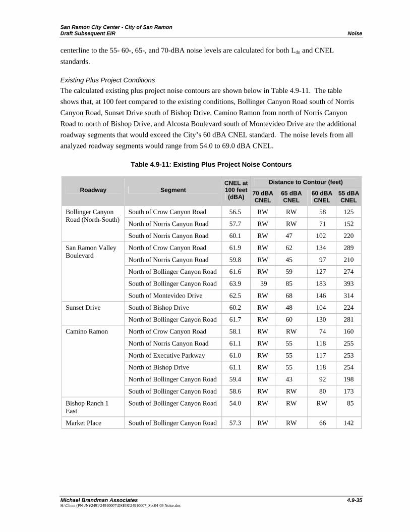
San Ramon City Center - City of San Ramon Draft Subsequent EIR Noise
Michael Brandman Associates 4.9-35 H:\Client (PN-JN)\2491\24910007\DSEIR\24910007_Sec04-09 Noise.doc
centerline to the 55- 60-, 65-, and 70-dBA noise levels are calculated for both Ldn and CNEL standards.
Existing Plus Project Conditions The calculated existing plus project noise contours are shown below in Table 4.9-11. The table shows that, at 100 feet compared to the existing conditions, Bollinger Canyon Road south of Norris Canyon Road, Sunset Drive south of Bishop Drive, Camino Ramon from north of Norris Canyon Road to north of Bishop Drive, and Alcosta Boulevard south of Montevideo Drive are the additional roadway segments that would exceed the City’s 60 dBA CNEL standard. The noise levels from all analyzed roadway segments would range from 54.0 to 69.0 dBA CNEL.
Table 4.9-11: Existing Plus Project Noise Contours
Distance to Contour (feet) Roadway Segment
CNEL at 100 feet (dBA) 70 dBA
CNEL 65 dBA CNEL
60 dBA CNEL
55 dBA CNEL
South of Crow Canyon Road 56.5 RW RW 58 125
North of Norris Canyon Road 57.7 RW RW 71 152
Bollinger Canyon Road (North-South)
South of Norris Canyon Road 60.1 RW 47 102 220
North of Crow Canyon Road 61.9 RW 62 134 289
North of Norris Canyon Road 59.8 RW 45 97 210
North of Bollinger Canyon Road 61.6 RW 59 127 274
South of Bollinger Canyon Road 63.9 39 85 183 393
San Ramon Valley Boulevard
South of Montevideo Drive 62.5 RW 68 146 314
South of Bishop Drive 60.2 RW 48 104 224 Sunset Drive
North of Bollinger Canyon Road 61.7 RW 60 130 281
North of Crow Canyon Road 58.1 RW RW 74 160
North of Norris Canyon Road 61.1 RW 55 118 255
North of Executive Parkway 61.0 RW 55 117 253
North of Bishop Drive 61.1 RW 55 118 254
North of Bollinger Canyon Road 59.4 RW 43 92 198
Camino Ramon
South of Bollinger Canyon Road 58.6 RW RW 80 173
Bishop Ranch 1 East
South of Bollinger Canyon Road 54.0 RW RW RW 85
Market Place South of Bollinger Canyon Road 57.3 RW RW 66 142
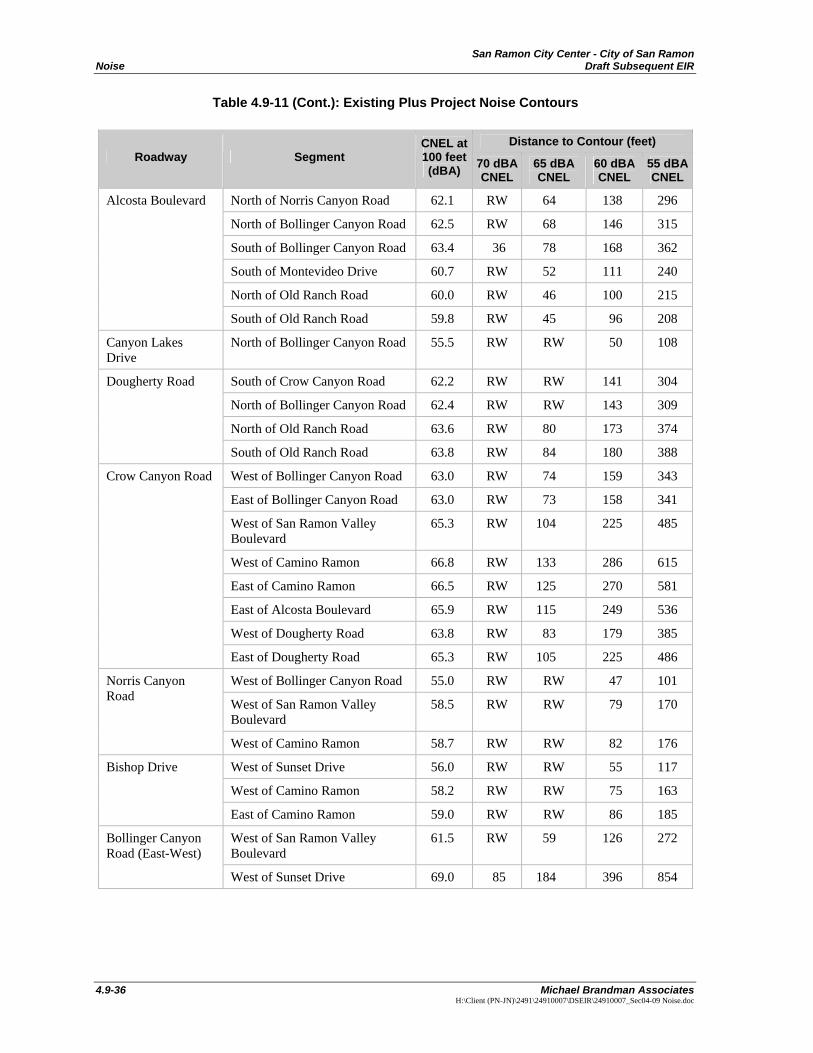
San Ramon City Center - City of San Ramon Noise Draft Subsequent EIR
4.9-36 Michael Brandman Associates
H:\Client (PN-JN)\2491\24910007\DSEIR\24910007_Sec04-09 Noise.doc
Table 4.9-11 (Cont.): Existing Plus Project Noise Contours
Distance to Contour (feet) Roadway Segment
CNEL at 100 feet (dBA) 70 dBA
CNEL 65 dBA CNEL
60 dBA CNEL
55 dBA CNEL
North of Norris Canyon Road 62.1 RW 64 138 296
North of Bollinger Canyon Road 62.5 RW 68 146 315
South of Bollinger Canyon Road 63.4 36 78 168 362
South of Montevideo Drive 60.7 RW 52 111 240
North of Old Ranch Road 60.0 RW 46 100 215
Alcosta Boulevard
South of Old Ranch Road 59.8 RW 45 96 208
Canyon Lakes Drive
North of Bollinger Canyon Road 55.5 RW RW 50 108
South of Crow Canyon Road 62.2 RW RW 141 304
North of Bollinger Canyon Road 62.4 RW RW 143 309
North of Old Ranch Road 63.6 RW 80 173 374
Dougherty Road
South of Old Ranch Road 63.8 RW 84 180 388
West of Bollinger Canyon Road 63.0 RW 74 159 343
East of Bollinger Canyon Road 63.0 RW 73 158 341
West of San Ramon Valley Boulevard
65.3 RW 104 225 485
West of Camino Ramon 66.8 RW 133 286 615
East of Camino Ramon 66.5 RW 125 270 581
East of Alcosta Boulevard 65.9 RW 115 249 536
West of Dougherty Road 63.8 RW 83 179 385
Crow Canyon Road
East of Dougherty Road 65.3 RW 105 225 486
West of Bollinger Canyon Road 55.0 RW RW 47 101
West of San Ramon Valley Boulevard
58.5 RW RW 79 170
Norris Canyon Road
West of Camino Ramon 58.7 RW RW 82 176
West of Sunset Drive 56.0 RW RW 55 117
West of Camino Ramon 58.2 RW RW 75 163
Bishop Drive
East of Camino Ramon 59.0 RW RW 86 185
West of San Ramon Valley Boulevard
61.5 RW 59 126 272 Bollinger Canyon Road (East-West)
West of Sunset Drive 69.0 85 184 396 854
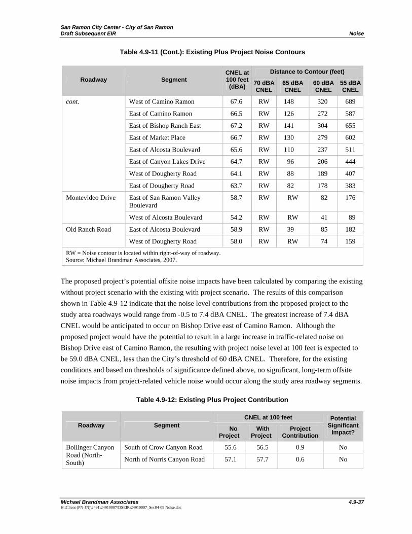
San Ramon City Center - City of San Ramon Draft Subsequent EIR Noise
Michael Brandman Associates 4.9-37 H:\Client (PN-JN)\2491\24910007\DSEIR\24910007_Sec04-09 Noise.doc
Table 4.9-11 (Cont.): Existing Plus Project Noise Contours
Distance to Contour (feet) Roadway Segment
CNEL at 100 feet (dBA) 70 dBA
CNEL 65 dBA CNEL
60 dBA CNEL
55 dBA CNEL
West of Camino Ramon 67.6 RW 148 320 689
East of Camino Ramon 66.5 RW 126 272 587
East of Bishop Ranch East 67.2 RW 141 304 655
East of Market Place 66.7 RW 130 279 602
East of Alcosta Boulevard 65.6 RW 110 237 511
East of Canyon Lakes Drive 64.7 RW 96 206 444
West of Dougherty Road 64.1 RW 88 189 407
cont.
East of Dougherty Road 63.7 RW 82 178 383
East of San Ramon Valley Boulevard
58.7 RW RW 82 176 Montevideo Drive
West of Alcosta Boulevard 54.2 RW RW 41 89
East of Alcosta Boulevard 58.9 RW 39 85 182 Old Ranch Road
West of Dougherty Road 58.0 RW RW 74 159
RW = Noise contour is located within right-of-way of roadway. Source: Michael Brandman Associates, 2007.
The proposed project’s potential offsite noise impacts have been calculated by comparing the existing without project scenario with the existing with project scenario. The results of this comparison shown in Table 4.9-12 indicate that the noise level contributions from the proposed project to the study area roadways would range from -0.5 to 7.4 dBA CNEL. The greatest increase of 7.4 dBA CNEL would be anticipated to occur on Bishop Drive east of Camino Ramon. Although the proposed project would have the potential to result in a large increase in traffic-related noise on Bishop Drive east of Camino Ramon, the resulting with project noise level at 100 feet is expected to be 59.0 dBA CNEL, less than the City’s threshold of 60 dBA CNEL. Therefore, for the existing conditions and based on thresholds of significance defined above, no significant, long-term offsite noise impacts from project-related vehicle noise would occur along the study area roadway segments.
Table 4.9-12: Existing Plus Project Contribution
CNEL at 100 feet Roadway Segment No
Project With
Project Project
Contribution
Potential Significant
Impact?
South of Crow Canyon Road 55.6 56.5 0.9 No Bollinger Canyon Road (North-South) North of Norris Canyon Road 57.1 57.7 0.6 No
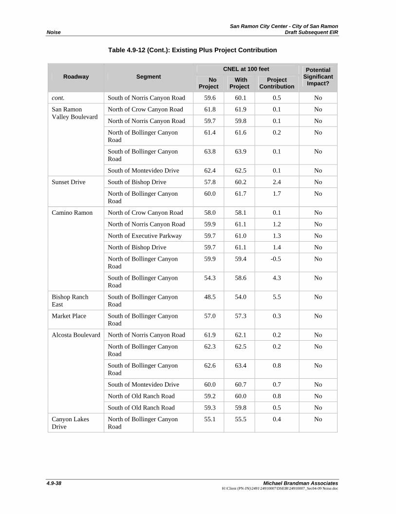
San Ramon City Center - City of San Ramon Noise Draft Subsequent EIR
4.9-38 Michael Brandman Associates
H:\Client (PN-JN)\2491\24910007\DSEIR\24910007_Sec04-09 Noise.doc
Table 4.9-12 (Cont.): Existing Plus Project Contribution
CNEL at 100 feet Roadway Segment No
Project With
Project Project
Contribution
Potential Significant
Impact?
cont. South of Norris Canyon Road 59.6 60.1 0.5 No
North of Crow Canyon Road 61.8 61.9 0.1 No
North of Norris Canyon Road 59.7 59.8 0.1 No
North of Bollinger Canyon Road
61.4 61.6 0.2 No
South of Bollinger Canyon Road
63.8 63.9 0.1 No
San Ramon Valley Boulevard
South of Montevideo Drive 62.4 62.5 0.1 No
South of Bishop Drive 57.8 60.2 2.4 No Sunset Drive
North of Bollinger Canyon Road
60.0 61.7 1.7 No
North of Crow Canyon Road 58.0 58.1 0.1 No
North of Norris Canyon Road 59.9 61.1 1.2 No
North of Executive Parkway 59.7 61.0 1.3 No
North of Bishop Drive 59.7 61.1 1.4 No
North of Bollinger Canyon Road
59.9 59.4 -0.5 No
Camino Ramon
South of Bollinger Canyon Road
54.3 58.6 4.3 No
Bishop Ranch East
South of Bollinger Canyon Road
48.5 54.0 5.5 No
Market Place South of Bollinger Canyon Road
57.0 57.3 0.3 No
North of Norris Canyon Road 61.9 62.1 0.2 No
North of Bollinger Canyon Road
62.3 62.5 0.2 No
South of Bollinger Canyon Road
62.6 63.4 0.8 No
South of Montevideo Drive 60.0 60.7 0.7 No
North of Old Ranch Road 59.2 60.0 0.8 No
Alcosta Boulevard
South of Old Ranch Road 59.3 59.8 0.5 No
Canyon Lakes Drive
North of Bollinger Canyon Road
55.1 55.5 0.4 No

San Ramon City Center - City of San Ramon Draft Subsequent EIR Noise
Michael Brandman Associates 4.9-39 H:\Client (PN-JN)\2491\24910007\DSEIR\24910007_Sec04-09 Noise.doc
Table 4.9-12 (Cont.): Existing Plus Project Contribution
CNEL at 100 feet Roadway Segment No
Project With
Project Project
Contribution
Potential Significant
Impact?
South of Crow Canyon Road 62.1 62.2 0.1 No
North of Bollinger Canyon Road
62.2 62.4 0.2 No
North of Old Ranch Road 63.5 63.6 0.1 No
Dougherty Road
South of Old Ranch Road 63.7 63.8 0.1 No
West of Bollinger Canyon Road
62.5 63.0 0.5 No
East of Bollinger Canyon Road 62.7 63.0 0.3 No
West of San Ramon Valley Boulevard
65.1 65.3 0.2 No
West of Camino Ramon 66.5 66.8 0.3 No
East of Camino Ramon 66.2 66.5 0.3 No
East of Alcosta Boulevard 65.6 65.9 0.3 No
West of Dougherty Road 63.4 63.8 0.4 No
Crow Canyon Road
East of Dougherty Road 65.1 65.3 0.2 No
West of Bollinger Canyon Road
54.6 55.0 0.4 No
West of San Ramon Valley Boulevard
58.2 58.5 0.3 No
Norris Canyon Road
West of Camino Ramon 58.5 58.7 0.2 No
West of Sunset Drive 55.9 56.0 0.1 No
West of Camino Ramon 53.2 58.2 5.0 No
Bishop Drive
East of Camino Ramon 51.6 59.0 7.4 No
West of San Ramon Valley Boulevard
61.2 61.5 0.3 No
West of Sunset Drive 68.1 69.0 0.9 No
West of Camino Ramon 66.8 67.6 0.8 No
East of Camino Ramon 66.0 66.5 0.5 No
East of Bishop Ranch East 66.0 67.2 1.2 No
East of Market Place 65.3 66.7 1.4 No
Bollinger Canyon Road (East-West)
East of Alcosta Boulevard 64.7 65.6 0.9 No
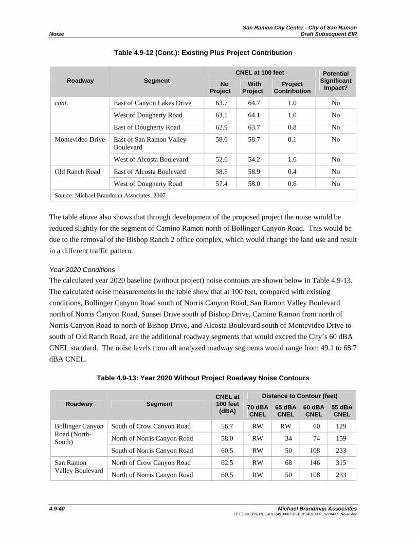
San Ramon City Center - City of San Ramon Noise Draft Subsequent EIR
4.9-40 Michael Brandman Associates
H:\Client (PN-JN)\2491\24910007\DSEIR\24910007_Sec04-09 Noise.doc
Table 4.9-12 (Cont.): Existing Plus Project Contribution
CNEL at 100 feet Roadway Segment No
Project With
Project Project
Contribution
Potential Significant
Impact?
East of Canyon Lakes Drive 63.7 64.7 1.0 No
West of Dougherty Road 63.1 64.1 1.0 No
cont.
East of Dougherty Road 62.9 63.7 0.8 No
East of San Ramon Valley Boulevard
58.6 58.7 0.1 No Montevideo Drive
West of Alcosta Boulevard 52.6 54.2 1.6 No
East of Alcosta Boulevard 58.5 58.9 0.4 No Old Ranch Road
West of Dougherty Road 57.4 58.0 0.6 No
Source: Michael Brandman Associates, 2007.
The table above also shows that through development of the proposed project the noise would be reduced slightly for the segment of Camino Ramon north of Bollinger Canyon Road. This would be due to the removal of the Bishop Ranch 2 office complex, which would change the land use and result in a different traffic pattern.
Year 2020 Conditions The calculated year 2020 baseline (without project) noise contours are shown below in Table 4.9-13. The calculated noise measurements in the table show that at 100 feet, compared with existing conditions, Bollinger Canyon Road south of Norris Canyon Road, San Ramon Valley Boulevard north of Norris Canyon Road, Sunset Drive south of Bishop Drive, Camino Ramon from north of Norris Canyon Road to north of Bishop Drive, and Alcosta Boulevard south of Montevideo Drive to south of Old Ranch Road, are the additional roadway segments that would exceed the City’s 60 dBA CNEL standard. The noise levels from all analyzed roadway segments would range from 49.1 to 68.7 dBA CNEL.
Table 4.9-13: Year 2020 Without Project Roadway Noise Contours
Distance to Contour (feet) Roadway Segment
CNEL at 100 feet (dBA) 70 dBA
CNEL 65 dBA CNEL
60 dBA CNEL
55 dBA CNEL
South of Crow Canyon Road 56.7 RW RW 60 129
North of Norris Canyon Road 58.0 RW 34 74 159
Bollinger Canyon Road (North-South)
South of Norris Canyon Road 60.5 RW 50 108 233
North of Crow Canyon Road 62.5 RW 68 146 315 San Ramon Valley Boulevard North of Norris Canyon Road 60.5 RW 50 108 233
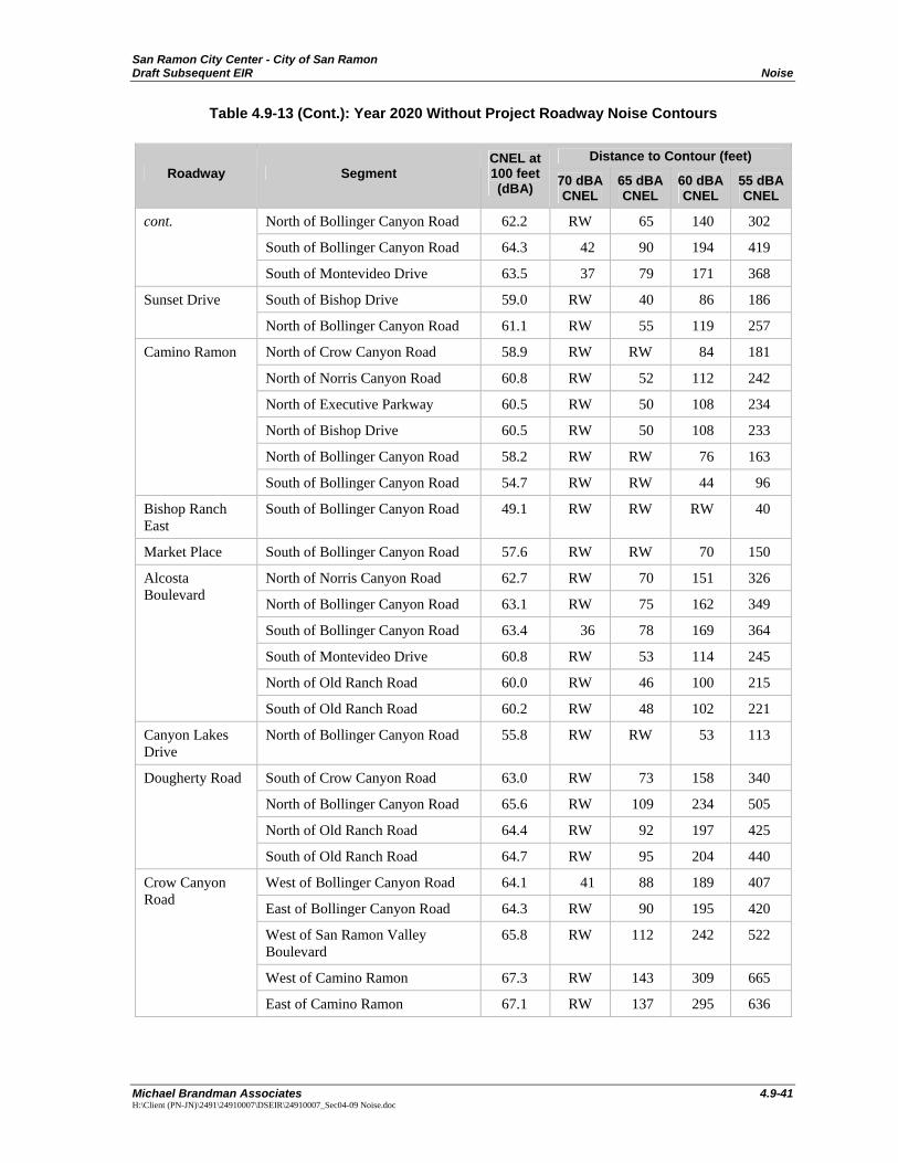
San Ramon City Center - City of San Ramon Draft Subsequent EIR Noise
Michael Brandman Associates 4.9-41 H:\Client (PN-JN)\2491\24910007\DSEIR\24910007_Sec04-09 Noise.doc
Table 4.9-13 (Cont.): Year 2020 Without Project Roadway Noise Contours
Distance to Contour (feet) Roadway Segment
CNEL at 100 feet (dBA) 70 dBA
CNEL 65 dBA CNEL
60 dBA CNEL
55 dBA CNEL
North of Bollinger Canyon Road 62.2 RW 65 140 302
South of Bollinger Canyon Road 64.3 42 90 194 419
cont.
South of Montevideo Drive 63.5 37 79 171 368
South of Bishop Drive 59.0 RW 40 86 186 Sunset Drive
North of Bollinger Canyon Road 61.1 RW 55 119 257
North of Crow Canyon Road 58.9 RW RW 84 181
North of Norris Canyon Road 60.8 RW 52 112 242
North of Executive Parkway 60.5 RW 50 108 234
North of Bishop Drive 60.5 RW 50 108 233
North of Bollinger Canyon Road 58.2 RW RW 76 163
Camino Ramon
South of Bollinger Canyon Road 54.7 RW RW 44 96
Bishop Ranch East
South of Bollinger Canyon Road 49.1 RW RW RW 40
Market Place South of Bollinger Canyon Road 57.6 RW RW 70 150
North of Norris Canyon Road 62.7 RW 70 151 326
North of Bollinger Canyon Road 63.1 RW 75 162 349
South of Bollinger Canyon Road 63.4 36 78 169 364
South of Montevideo Drive 60.8 RW 53 114 245
North of Old Ranch Road 60.0 RW 46 100 215
Alcosta Boulevard
South of Old Ranch Road 60.2 RW 48 102 221
Canyon Lakes Drive
North of Bollinger Canyon Road 55.8 RW RW 53 113
South of Crow Canyon Road 63.0 RW 73 158 340
North of Bollinger Canyon Road 65.6 RW 109 234 505
North of Old Ranch Road 64.4 RW 92 197 425
Dougherty Road
South of Old Ranch Road 64.7 RW 95 204 440
West of Bollinger Canyon Road 64.1 41 88 189 407
East of Bollinger Canyon Road 64.3 RW 90 195 420
West of San Ramon Valley Boulevard
65.8 RW 112 242 522
West of Camino Ramon 67.3 RW 143 309 665
Crow Canyon Road
East of Camino Ramon 67.1 RW 137 295 636
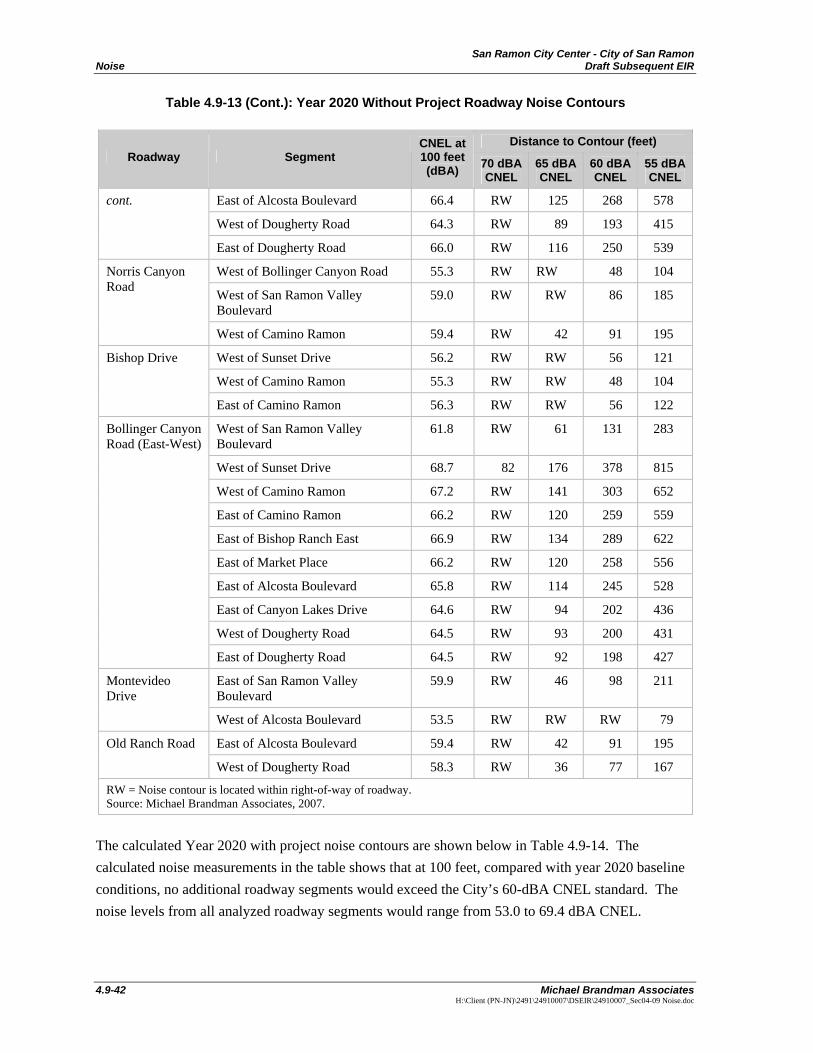
San Ramon City Center - City of San Ramon Noise Draft Subsequent EIR
4.9-42 Michael Brandman Associates
H:\Client (PN-JN)\2491\24910007\DSEIR\24910007_Sec04-09 Noise.doc
Table 4.9-13 (Cont.): Year 2020 Without Project Roadway Noise Contours
Distance to Contour (feet) Roadway Segment
CNEL at 100 feet (dBA) 70 dBA
CNEL 65 dBA CNEL
60 dBA CNEL
55 dBA CNEL
East of Alcosta Boulevard 66.4 RW 125 268 578
West of Dougherty Road 64.3 RW 89 193 415
cont.
East of Dougherty Road 66.0 RW 116 250 539
West of Bollinger Canyon Road 55.3 RW RW 48 104
West of San Ramon Valley Boulevard
59.0 RW RW 86 185
Norris Canyon Road
West of Camino Ramon 59.4 RW 42 91 195
West of Sunset Drive 56.2 RW RW 56 121
West of Camino Ramon 55.3 RW RW 48 104
Bishop Drive
East of Camino Ramon 56.3 RW RW 56 122
West of San Ramon Valley Boulevard
61.8 RW 61 131 283
West of Sunset Drive 68.7 82 176 378 815
West of Camino Ramon 67.2 RW 141 303 652
East of Camino Ramon 66.2 RW 120 259 559
East of Bishop Ranch East 66.9 RW 134 289 622
East of Market Place 66.2 RW 120 258 556
East of Alcosta Boulevard 65.8 RW 114 245 528
East of Canyon Lakes Drive 64.6 RW 94 202 436
West of Dougherty Road 64.5 RW 93 200 431
Bollinger Canyon Road (East-West)
East of Dougherty Road 64.5 RW 92 198 427
East of San Ramon Valley Boulevard
59.9 RW 46 98 211 Montevideo Drive
West of Alcosta Boulevard 53.5 RW RW RW 79
East of Alcosta Boulevard 59.4 RW 42 91 195 Old Ranch Road
West of Dougherty Road 58.3 RW 36 77 167
RW = Noise contour is located within right-of-way of roadway. Source: Michael Brandman Associates, 2007.
The calculated Year 2020 with project noise contours are shown below in Table 4.9-14. The calculated noise measurements in the table shows that at 100 feet, compared with year 2020 baseline conditions, no additional roadway segments would exceed the City’s 60-dBA CNEL standard. The noise levels from all analyzed roadway segments would range from 53.0 to 69.4 dBA CNEL.
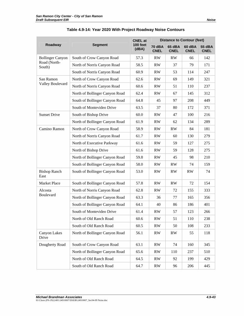
San Ramon City Center - City of San Ramon Draft Subsequent EIR Noise
Michael Brandman Associates 4.9-43 H:\Client (PN-JN)\2491\24910007\DSEIR\24910007_Sec04-09 Noise.doc
Table 4.9-14: Year 2020 With Project Roadway Noise Contours
Distance to Contour (feet) Roadway Segment
CNEL at 100 feet (dBA) 70 dBA
CNEL 65 dBA CNEL
60 dBA CNEL
55 dBA CNEL
South of Crow Canyon Road 57.3 RW RW 66 142
North of Norris Canyon Road 58.5 RW 37 79 171
Bollinger Canyon Road (North-South)
South of Norris Canyon Road 60.9 RW 53 114 247
North of Crow Canyon Road 62.6 RW 69 149 321
North of Norris Canyon Road 60.6 RW 51 110 237
North of Bollinger Canyon Road 62.4 RW 67 145 312
South of Bollinger Canyon Road 64.8 45 97 208 449
San Ramon Valley Boulevard
South of Montevideo Drive 63.5 37 80 172 371
South of Bishop Drive 60.0 RW 47 100 216 Sunset Drive
North of Bollinger Canyon Road 61.9 RW 62 134 289
North of Crow Canyon Road 58.9 RW RW 84 181
North of Norris Canyon Road 61.7 RW 60 130 279
North of Executive Parkway 61.6 RW 59 127 275
North of Bishop Drive 61.6 RW 59 128 275
North of Bollinger Canyon Road 59.8 RW 45 98 210
Camino Ramon
South of Bollinger Canyon Road 58.0 RW RW 74 159
Bishop Ranch East
South of Bollinger Canyon Road 53.0 RW RW RW 74
Market Place South of Bollinger Canyon Road 57.8 RW RW 72 154
North of Norris Canyon Road 62.8 RW 72 155 333
North of Bollinger Canyon Road 63.3 36 77 165 356
South of Bollinger Canyon Road 64.1 40 86 186 401
South of Montevideo Drive 61.4 RW 57 123 266
North of Old Ranch Road 60.6 RW 51 110 238
Alcosta Boulevard
South of Old Ranch Road 60.5 RW 50 108 233
Canyon Lakes Drive
North of Bollinger Canyon Road 56.1 RW RW 55 118
South of Crow Canyon Road 63.1 RW 74 160 345
North of Bollinger Canyon Road 65.6 RW 110 237 510
North of Old Ranch Road 64.5 RW 92 199 429
Dougherty Road
South of Old Ranch Road 64.7 RW 96 206 445
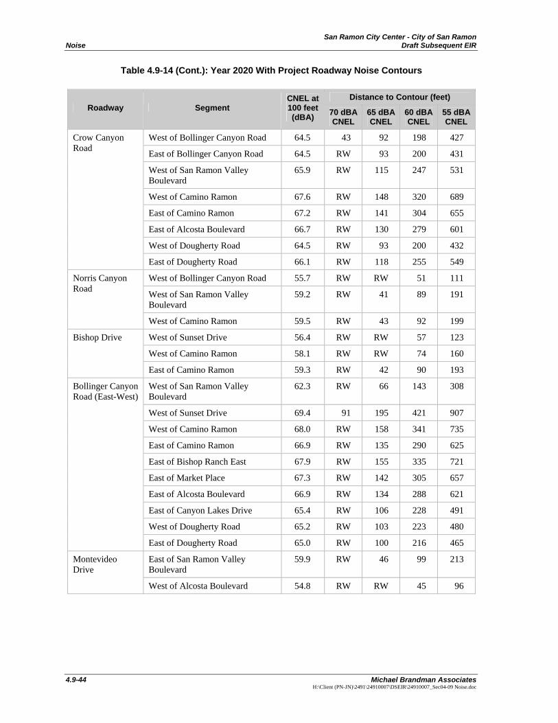
San Ramon City Center - City of San Ramon Noise Draft Subsequent EIR
4.9-44 Michael Brandman Associates
H:\Client (PN-JN)\2491\24910007\DSEIR\24910007_Sec04-09 Noise.doc
Table 4.9-14 (Cont.): Year 2020 With Project Roadway Noise Contours
Distance to Contour (feet) Roadway Segment
CNEL at 100 feet (dBA) 70 dBA
CNEL 65 dBA CNEL
60 dBA CNEL
55 dBA CNEL
West of Bollinger Canyon Road 64.5 43 92 198 427
East of Bollinger Canyon Road 64.5 RW 93 200 431
West of San Ramon Valley Boulevard
65.9 RW 115 247 531
West of Camino Ramon 67.6 RW 148 320 689
East of Camino Ramon 67.2 RW 141 304 655
East of Alcosta Boulevard 66.7 RW 130 279 601
West of Dougherty Road 64.5 RW 93 200 432
Crow Canyon Road
East of Dougherty Road 66.1 RW 118 255 549
West of Bollinger Canyon Road 55.7 RW RW 51 111
West of San Ramon Valley Boulevard
59.2 RW 41 89 191
Norris Canyon Road
West of Camino Ramon 59.5 RW 43 92 199
West of Sunset Drive 56.4 RW RW 57 123
West of Camino Ramon 58.1 RW RW 74 160
Bishop Drive
East of Camino Ramon 59.3 RW 42 90 193
West of San Ramon Valley Boulevard
62.3 RW 66 143 308
West of Sunset Drive 69.4 91 195 421 907
West of Camino Ramon 68.0 RW 158 341 735
East of Camino Ramon 66.9 RW 135 290 625
East of Bishop Ranch East 67.9 RW 155 335 721
East of Market Place 67.3 RW 142 305 657
East of Alcosta Boulevard 66.9 RW 134 288 621
East of Canyon Lakes Drive 65.4 RW 106 228 491
West of Dougherty Road 65.2 RW 103 223 480
Bollinger Canyon Road (East-West)
East of Dougherty Road 65.0 RW 100 216 465
East of San Ramon Valley Boulevard
59.9 RW 46 99 213 Montevideo Drive
West of Alcosta Boulevard 54.8 RW RW 45 96