Embed Size (px)
Citation preview
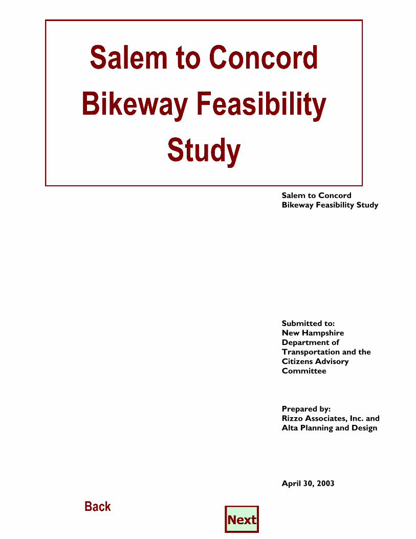
Salem to Concord Bikeway Feasibility Study
Submitted to: New Hampshire Department of Transportation and the Citizens Advisory Committee Prepared by: Rizzo Associates, Inc. and Alta Planning and Design
April 30, 2003
Salem to Concord, New Hampshire Bikeway Feasibility Study
Table of Contents
Executive Summary ..................................................................................................i
1.0 Introduction.................................................................................................1
2.0 Public and Agency Involvement...............................................................3
3.0 Project Purpose and Need.......................................................................7
4.0 Options.........................................................................................................8
4.1 Interstate 93 Bicycle Path ...........................................................8
4.2. The Manchester and Lawrence Railroad Corridor ........... 19
4.2.1 Description of Existing Corridor................................. 20
4.2.2 Design............................................................................. 28
4.3 Concord – Portsmouth Railroad Corridor ......................... 41
4.3.1 Description of Existing Corridor................................. 41
4.3.2 Design ................................................................................ 42
4.4 New Hampshire Heritage Trail Segments ........................... 47
4.4.1 Manchester........................................................................ 47
4.4.2. Hooksett........................................................................... 48
4.5 Continuous On-Road Option between Salem and Concord ...................................................................................... 50
4.5.1 Description of Existing Roadways............................ 55
4.5.2 On-Road Bicycle and Pedestrian Facility Design............................................................................. 62
4.6 Other On-Road Links/Considered/Suggested .................... 65
5.0 Recommended Route............................................................................. 67
6.0 Project Phasing......................................................................................... 73

Salem to Concord, New Hampshire Bikeway Feasibility Study
List of Tables
Table 1 I–93 Bikeway Summary by Segment ........................................................ 18
Table 2 Rail Trail/Roadway Grade Crossings and On-road Segments (Manchester –- Lawrence Branch)........................................................... 33
Table 3 Rail Structures (Manchester – Lawrence Branch)................................ 38
Table 4 Trail Segments (Manchester – Lawrence Branch) .............................. 40
Table 5 Rail Trail/Roadway Grade Crossings and On-road Segments (Concord – Portsmouth Branch)............................................................. 45
Table 6 Rail Structures (Concord – Portsmouth Branch) ................................ 45
Table 7 Trail Segments (Concord – Portsmouth Branch) ................................ 46
Table 8 On Road Option Summary of Roadway Segment by Town .............. 51
Table 9 Road Segments Requiring Improvements and Estimated Construction Costs..................................................................................... 64
Table 10 Alternatives Analysis – Evaluation Summary ......................................... 70
Table 11 Summary of Recommended Route.......................................................... 71
List of Figures
Figure 1 Salem – Concord Bikeway Feasibility Study Limits .............................iii
Figure 2-9 Salem – Concord Pedestrian /Bicycle Corridor Options ...................9
Figure 10 Typical Cross Section I-93 Path............................................................. 17
Figure 11 Rail to Trail Typical Section: Cost Estimate by Linear Foot ........... 39
Figure 12 Heritage Trail, Downtown Manchester............................................... 47
Figure 13 Heritage Trail, Hooksett ......................................................................... 49
Figure 14 Typical Roadway Sections....................................................................... 63
List of Appendices
Appendix A Meeting Minutes
Salem to Concord, New Hampshire Bikeway Feasibility Study
Page i
Executive Summary
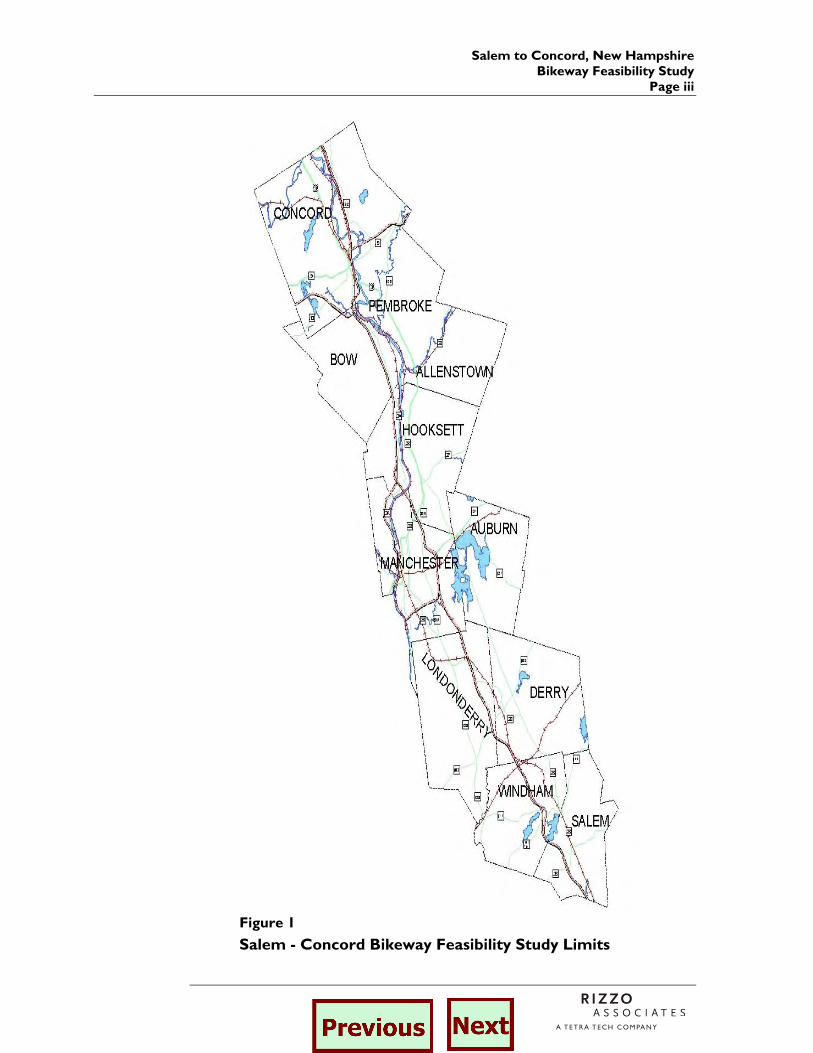
As part of the Salem to Manchester I-93 widening project, it was suggested that bicycle and pedestrian travel between Salem and Manchester be evaluated. The NHDOT developed a conceptual plan for a shared use path within the I-93 right-of-way (ROW), however, the public requested that alternative routes be identified. Subsequently, Rizzo Associates, Inc. and Alta Planning + Design were retained by the NHDOT to identify, evaluate and compare three basic options for accommodating bicycle and pedestrian routes within the Salem-Concord corridor. The three options included the previously considered shared use path within the I-93 ROW, constructing a shared use path within abandoned railroad corridors and upgrading existing roads to better accommodate bicyclists and pedestrians. The methodology and results of this evaluation are summarized in this feasibility study. Public and Agency Involvement Public involvement was extensive throughout the course of the study and included the formation of a Citizen’s Advisory Committee (CAC). The CAC included members from eleven communities (as shown in Figure 1) within the Salem-Concord corridor and representatives from the Bicycle/Pedestrian Transportation Advisory Board, Rockingham, Central New Hampshire and Southern New Hampshire Planning Commissions, Department of Resource and Economic Development, Department of Historical Resources and the New Hampshire Department of Transportation. The CAC guided the study process and met on four occasions. Additionally four public information meetings were held. At these meetings presentations of the options were made and representatives from the CAC and the consultants listened to public comments on the project. Based on recommendations and technical data provided by the consultants, the CAC made the final selection of an option to be considered for further development for a bicycle/pedestrian connection between Salem and Concord. Project Purpose and Need
Critical to the study process was a clear understanding of the project’s need and purpose. The Project Purpose and Need Statement was

Salem to Concord, New Hampshire Bikeway Feasibility Study Page ii
developed by the NHDOT, the CAC and the consultants with public input and is as follows:
The purpose of the study is to identify a feasible alternative transportation corridor (facility) for pedestrians and bicyclists between Salem and Concord. This facility would provide for non-motorized travel within and between communities along the Interstate 93 (I-93) corridor between Salem and Concord. In an effort to reduce the dependence on motor vehicle trips on I-93 and other roadways, this alternate corridor (facility) should encourage and provide a transportation link for both work and non-work related trips, and be desirable for a wide range of bicyclists and pedestrians. Potential options for a north-south alternative transportation facility in the corridor include a bicycle path in portions of the I-93 right-of-way between Salem and Londonderry, use of existing roadways and use of abandoned or active rail corridors.
Options
Options evaluated as part of this study included both off road and on road alternatives such as the proposed I-93 shared use path, the abandoned Manchester - Lawrence Railroad Corridor, the abandoned Concord – Portsmouth Railroad Corridor, segments of the New Hampshire Heritage Trail and on-road options. The following briefly describes each of these options. I-93 Shared Use Path. This 13 mile path would begin at Route 97 (Exit 2) and end at Route 28 in Londonderry (Exit 5). It does not provide a complete connection between Salem and Concord and thus may only be considered for the Salem to Londonderry portion of the study area. The proposed path is currently designed as a ten foot wide paved path with two-foot wide gravel shoulders. The path is no closer than 30 feet from the nearest edge of travel way on the highway and in most cases is located at the bottom of the highway fill slopes. Manchester - Lawrence Railroad Corridor. The Manchester - Lawrence Railroad corridor is 23.6 miles long, connects Salem and Manchester and travels through Windham, Derry and Londonderry. In Salem, the corridor is unimproved and the former railroad rails and ties remain. Through most of Windham the corridor has been improved to accommodate a dirt trail used primarily by All Terrain Vehicles (ATVs). Dirt trails and paved pathways have been constructed along segments in Derry and Londonderry. The corridor includes 35 at grade
Salem to Concord, New Hampshire Bikeway Feasibility Study
Page iii
Figure 1
Salem - Concord Bikeway Feasibility Study Limits
Salem to Concord, New Hampshire Bikeway Feasibility Study Page iv
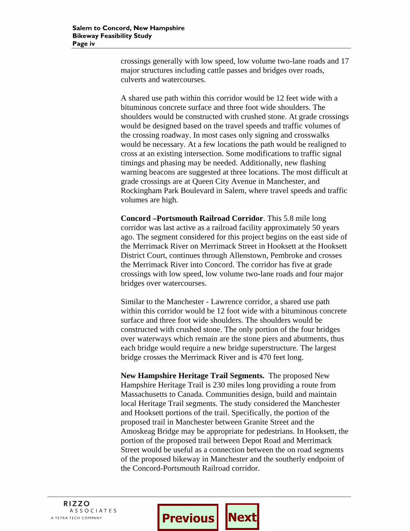
crossings generally with low speed, low volume two-lane roads and 17 major structures including cattle passes and bridges over roads, culverts and watercourses. A shared use path within this corridor would be 12 feet wide with a bituminous concrete surface and three foot wide shoulders. The shoulders would be constructed with crushed stone. At grade crossings would be designed based on the travel speeds and traffic volumes of the crossing roadway. In most cases only signing and crosswalks would be necessary. At a few locations the path would be realigned to cross at an existing intersection. Some modifications to traffic signal timings and phasing may be needed. Additionally, new flashing warning beacons are suggested at three locations. The most difficult at grade crossings are at Queen City Avenue in Manchester, and Rockingham Park Boulevard in Salem, where travel speeds and traffic volumes are high. Concord –Portsmouth Railroad Corridor. This 5.8 mile long corridor was last active as a railroad facility approximately 50 years ago. The segment considered for this project begins on the east side of the Merrimack River on Merrimack Street in Hooksett at the Hooksett District Court, continues through Allenstown, Pembroke and crosses the Merrimack River into Concord. The corridor has five at grade crossings with low speed, low volume two-lane roads and four major bridges over watercourses. Similar to the Manchester - Lawrence corridor, a shared use path within this corridor would be 12 foot wide with a bituminous concrete surface and three foot wide shoulders. The shoulders would be constructed with crushed stone. The only portion of the four bridges over waterways which remain are the stone piers and abutments, thus each bridge would require a new bridge superstructure. The largest bridge crosses the Merrimack River and is 470 feet long. New Hampshire Heritage Trail Segments. The proposed New Hampshire Heritage Trail is 230 miles long providing a route from Massachusetts to Canada. Communities design, build and maintain local Heritage Trail segments. The study considered the Manchester and Hooksett portions of the trail. Specifically, the portion of the proposed trail in Manchester between Granite Street and the Amoskeag Bridge may be appropriate for pedestrians. In Hooksett, the portion of the proposed trail between Depot Road and Merrimack Street would be useful as a connection between the on road segments of the proposed bikeway in Manchester and the southerly endpoint of the Concord-Portsmouth Railroad corridor.
Salem to Concord, New Hampshire Bikeway Feasibility Study
Page v
Continuous On-Road Option between Salem and Concord. Evaluation of an on road option began with a study of The New Hampshire Regional Bicycle Maps. The on-road option is 36 miles long and encompasses 18 roadway links. Major roadway segments include Route 39, Pleasant Street and North Policy Road in Salem, Route 111 and North Lowell Street in Windham, Ash Street in Derry, Route 28 and Mammoth Road in Londonderry, Mammoth Road in Manchester, Route 28A/Route 28, Main Street and Pine Street in Hooksett, Bow Bog Road and Logging Hill Road in Bow and South Street in Concord. To accommodate bicyclists, many of these roads would require widening to provide a minimum 4 foot shoulder on both sides, and sidewalks would be constructed for pedestrians. Other On Road Options. Several roadway links were identified by the CAC, the public at-large and by the consultants as augmenting the three major options for a continuous path between Salem and Concord. These links are located in Bow, Manchester, Hooksett, Pembroke and Concord. Recommended Route. A recommendation for a preferred route was based on a comprehensive evaluation of each option based on criteria set forth by the CAC. The criteria included determining how well the option met the goals of the purpose and need statement, design and construction issues, costs, resource impacts and compatibility with community plans. As part of this process the “Rail Trail Alternative” was developed and is a combination of the other three options. It encompasses the two abandoned rail corridors, connected by an on-road option in Manchester and portions of the proposed Hooksett Heritage Trail. It was this combination alternative that was found to most closely meet the criteria of the CAC. A detailed description of the route follows:
Segment Name Facility Type From To
Manchester-Lawrence Railroad
Shared use path (rail to trail) and on-road segment around Manchester Airport Hampshire Road, Salem Depot Street, Manchester
Depot Street, Canal Street and River Road (Manchester) Bicycle route (on road) and sidewalk
Concord Railroad crossing of Depot Street (Manchester) Hooksett Town Line
Heritage Trail Shared use path Depot Road, Hooksett Merrimack Street, Hooksett
Merrimack Street (Hooksett) Bicycle route (on road) Heritage Trail at proposed crossing of Merrimack River
Southerly end of Concord – Portsmouth Railroad
Concord – Portsmouth Railroad Shared use path (rail to trail) Merrimack Street, Hooksett
Westerly bank of Merrimack River
Hall Street Bicycle route and sidewalk (on road) Merrimack River, Concord Downtown Concord
Salem to Concord, New Hampshire Bikeway Feasibility Study Page vi
Phasing Phasing for the development of the Salem – Concord Bikeway is broken into short-term, mid-term and long-term components. In the short term, efforts should be made to secure land not currently owned by municipalities or the state. Design and construction of the portion of the trail located within the Manchester–Lawrence abandoned rail corridor would follow. Lastly, the design and construction of the portions of the trail north of Manchester including the Concord –Portsmouth corridor and Hooksett Heritage Trail would be completed.
Salem to Concord, New Hampshire Bikeway Feasibility Study
Page 1
1.0 Introduction
The New Hampshire Department of Transportation (NHDOT) is studying the feasibility of improving bicycle/pedestrian accommodations in the Salem – Concord corridor. The corridor is within the Merrimack River Valley and includes the Interstate 93 (I-93) transportation facility. As part of a project to widen I-93, the public suggested that the NHDOT not only consider motor vehicle needs but also the movement of bicyclists and pedestrians within the corridor. As a result, the NHDOT developed a conceptual plan and profile for a shared use path (bicycle and pedestrian) within the I-93 right-of-way (ROW). Some felt that the so-called “I-93 bicycle path” was not the best option for accommodating bicycle and pedestrian travel within the corridor. Thus, the NHDOT retained Rizzo Associates, Inc. and Alta Planning + Design to identify and evaluate alternative bicycle and pedestrian routes within the Salem – Concord corridor. This study examines three basic options for accommodating bicycle and pedestrian travel within the Salem – Concord corridor:
1. Constructing a shared use path within the I-93 corridor 2. Constructing a shared use path within abandoned railroad corridors 3. Using existing roads “as is” or improving them to better
accommodate bicycles and pedestrians The first option includes a path within the I-93 ROW from Salem to Londonderry. The second option includes portions of the abandoned Manchester – Lawrence Railroad from Salem to Manchester and the abandoned Portsmouth – Concord Railroad from Hooksett to Concord. The third option includes a series of state and local roads that were designated as state or regional bike routes on the New Hampshire Regional Bicycle Map. Within options two and three are use of segments of the New Hampshire Heritage Trail in Manchester and Hooksett. Although these three basic options were identified early in the process, it was also deemed necessary to consider and evaluate combinations of these options. In fact, combinations of the three basic options were essential to create continuous routes between Salem and Concord. The study included field reconnaissance of the I-93 corridor and certain parallel state and local roads. An inventory of the abandoned railroad corridors was also conducted. Geographic information system (GIS) data on wetlands, surface water, roads and publicly owned recreation and conservation properties was obtained and used to create a project map series. Alignments of the various alternatives were digitized and printed in color on

Salem to Concord, New Hampshire Bikeway Feasibility Study Page 2
aerial photography of the corridor. The overall and detailed maps of the corridor are included in the report and project website. Detailed valuation plans (val plans) prepared for both railroads in 1914 were obtained and consulted during the preparation of this study. The val plans show the extent of the railroad right-of-way, bridge types and dimensions, and buildings that existed at the time near the railroad.
Salem to Concord, New Hampshire Bikeway Feasibility Study
Page 3
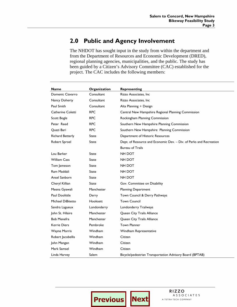
2.0 Public and Agency Involvement
The NHDOT has sought input in the study from within the department and from the Department of Resources and Economic Development (DRED), regional planning agencies, municipalities, and the public. The study has been guided by a Citizen’s Advisory Committee (CAC) established for the project. The CAC includes the following members:
Name Organization Representing
Domenic Ciavarro Consultant Rizzo Associates, Inc
Nancy Doherty Consultant Rizzo Associates, Inc
Paul Smith Consultant Alta Planning + Design
Catherine Coletti RPC Central New Hampshire Regional Planning Commission
Scott Bogle RPC Rockingham Planning Commission
Peter Reed RPC Southern New Hampshire Planning Commission
Quazi Bari RPC Southern New Hampshire Planning Commission
Richard Betterly State Department of Historic Resources
Robert Sproel State Dept. of Resource and Economic Dev. – Div. of Parks and Recreation
Bureau of Trails
Lou Barker State NH DOT
William Cass State NH DOT
Tom Jameson State NH DOT
Ram Maddali State NH DOT
Ansel Sanborn State NH DOT
Cheryl Killian State Gov. Committee on Disability
Meena Gyawali Manchester Planning Department
Paul Doolittle Derry Town Council & Derry Pathways
Michael DiBitetto Hooksett Town Council
Sandra Lagueux Londonderry Londonderry Trailways
John St. Hilaire Manchester Queen City Trails Alliance
Bob Menefra Manchester Queen City Trails Alliance
Kerrie Diers Pembroke Town Planner
Wayne Morris Windham Windham Representative
Robert Jacobellis Windham Citizen
John Mangan Windham Citizen
Mark Samsel Windham Citizen
Linda Harvey Salem Bicycle/pedestrian Transportation Advisory Board (BPTAB)
Salem to Concord, New Hampshire Bikeway Feasibility Study Page 4
Detailed minutes are provided in the Appendix for each of these meetings. A brief summary of the key points of discussion at each of the meetings follows. First Citizens Advisory Committee Meetings (December 12, 2002) The Salem – Concord Bikeway CAC first met on December 12, 2002 in Manchester at the offices of the Southern New Hampshire Planning Commission. The NHDOT and its consultants presented initial research on potential options including a bicycle and pedestrian path within the I-93 right-of-way (ROW) and a path within two abandoned rail road ROWs. All terrain vehicles (ATV) use on the Windham portion of the Lawrence – Manchester abandoned rail corridor will need to be addressed. The committee requested that the consultants meet with the Manchester and Hooksett Planning Departments on the location and status of each community’s portion of a proposed New Hampshire Heritage Trail. The Heritage Trail generally follows the easterly bank of the Merrimack River through Manchester and Hooksett and may provide a good option for portions of the Salem-Concord bikeway. Second Citizens Advisory Committee Meeting (January 23, 2003) At the second meeting, the NHDOT and its consultants presented more detailed research on the potential options. A concept for the trail alignment was presented for the segment that passes around the Manchester Airport. Initial concepts for bicycle and pedestrian connections from the rail corridor to I-93 park-and-ride lots were also discussed. Concerns were raised regarding wetlands and ATV use in Windham, a gas line in Londonderry and ROW encroachments. For the northerly portion of the trail within the rail corridor, the bridges on the Soucook River, Suncook River, Allenstown canal and Merrimack River were identified as key structures requiring significant reconstruction. Discussion of the I-93 option raised concerns regarding air quality and a lack of connections to town roads. On road options were presented and the committee felt that the slopes, trucks and traffic volumes on some the roads may discourage bicyclists. During this meeting the CAC discussed and developed a format for the Public Information Meetings. Public Information Meetings (February 11 and 13, 2003) The first set of public information meetings were held in Derry on February 11 and in Hooksett on February 13, 2003. At each meeting a one-hour presentation was made on project options and potential combinations of:
Salem to Concord, New Hampshire Bikeway Feasibility Study
Page 5
1. I-93 bicycle and pedestrian path 2. Shared roadway option 3. Railroad corridor option
The technical team answered questions and listened to public comments for an additional hour or more. Issues raised by the attendees included trail users, trail surface, the opportunities and/or conflicts presented by the bicycle/pedestrian mode and other modes such as rail and ATV, funding and maintenance. Lists of positive and negative attributes for each option were developed and are summarized in the meeting notes. Third Citizens Advisory Committee Meeting (February 27, 2003) The focus of this meeting was to discuss the comments received during the public information meetings and to develop a recommendation for a preferred alternative. Specifically a format for evaluating each alternative was developed. Public Information Meetings (April 1 and 3, 2003) The second set of public information meetings were held in Windham on April 1, 2003 and in Pembroke on April 3, 2003. A presentation was made by NHDOT and the consultants at each of these meetings. The presentation included a summary of the comments and public input received at the first set of public meetings, description of the recommended route, quantitative analysis of the options, analysis of resource and community compatibility and discussion of future steps. Issues raised by attendees included ATV displacement and trail replacement, snowmobile use, town liability and responsibilities, funding, land purchase and trail surface. John St. Hilaire of the Queen City Trail Alliance is organizing a “Corridor Committee” to work on the Salem to Concord bikeway implementation. The committee will be a strong advocate for this project. He had sign up sheets available. Fourth Citizens Advisory Committee Meeting (April 15, 2003) The fourth and final CAC meeting was held in April to discuss comments received from the public, the preferred alternative, project phasing and future steps. The committee agreed that the preferred route includes both abandoned rail corridors, portions of the New Hampshire Heritage Trail and short roadway segments in Manchester and Hooksett. Although three options were considered for connection to downtown Concord, the committee favors the trail crossing the Merrimack River and connecting to Hall Street in Concord, as strongly supported at the Pembroke Public Information Meeting.
Salem to Concord, New Hampshire Bikeway Feasibility Study Page 6
As part of the discussion on the preferred alternative the surface of the trail was raised as a key design issue. During the public information meetings people spoke in support for both a paved surface and an unpaved surface. The pavement surface does have an effect on different types of trail users. The CAC expressed a preference for a paved path but felt that surface treatment should be discussed at the local level during project development. It was requested that this feasibility study present both the positive and negative aspects of both surfaces (see Chapter 5.0 – Recommended Route). Linda Harvey, the Salem representative reported that preliminary discussion with town officials indicate that an overpass of the trail at the Rockingham Boulevard/Route 28 intersection may be required. Obtaining funding for the trail was discussed. July 31, 2003 is the deadline for submitting an application to the Congestion Mitigation and Air Quality Improvement Program (CMAQ) for funding. The application is submitted through the regional planning commissions. If the application is approved by the planning commissions and submitted to the state, the earliest funding for design and construction may not be available until later than 2005. Moreover, the funding would cover only 80 percent of the design and construction costs. Funding for the remaining 20 percent matching funds would need to be provided at the local and state levels.
Salem to Concord, New Hampshire Bikeway Feasibility Study
Page 7
3.0 Project Purpose and Need
The first step in the Salem – Concord Bikeway Feasibility Study was the development of a project purpose and need statement. The Purpose and Need Statement sets the benchmark by which the various options will be evaluated. For this study an iterative process was used to develop and refine the purpose and need statement. The final Project Purpose and Need Statement as developed by the NHDOT, Citizens Advisory Committee and consultants with public input is as follows:
The purpose of the study is to identify a feasible alternative transportation corridor (facility) for pedestrians and bicyclists between Salem and Concord. This facility would provide for non-motorized travel within and between communities along the Interstate 93 (I-93) corridor between Salem and Concord. In an effort to reduce the dependence on motor vehicle trips on I-93 and other roadways, this alternate corridor (facility) should encourage and provide a transportation link for both work and non-work related trips, and be desirable for a wide range of bicyclists and pedestrians. Potential options for a north-south alternative transportation facility in the corridor include a bicycle path in portions of the I-93 right-of-way between Salem and Londonderry, use of existing roadways and use of abandoned or active rail corridors.
Salem to Concord, New Hampshire Bikeway Feasibility Study Page 8
4.0 Options
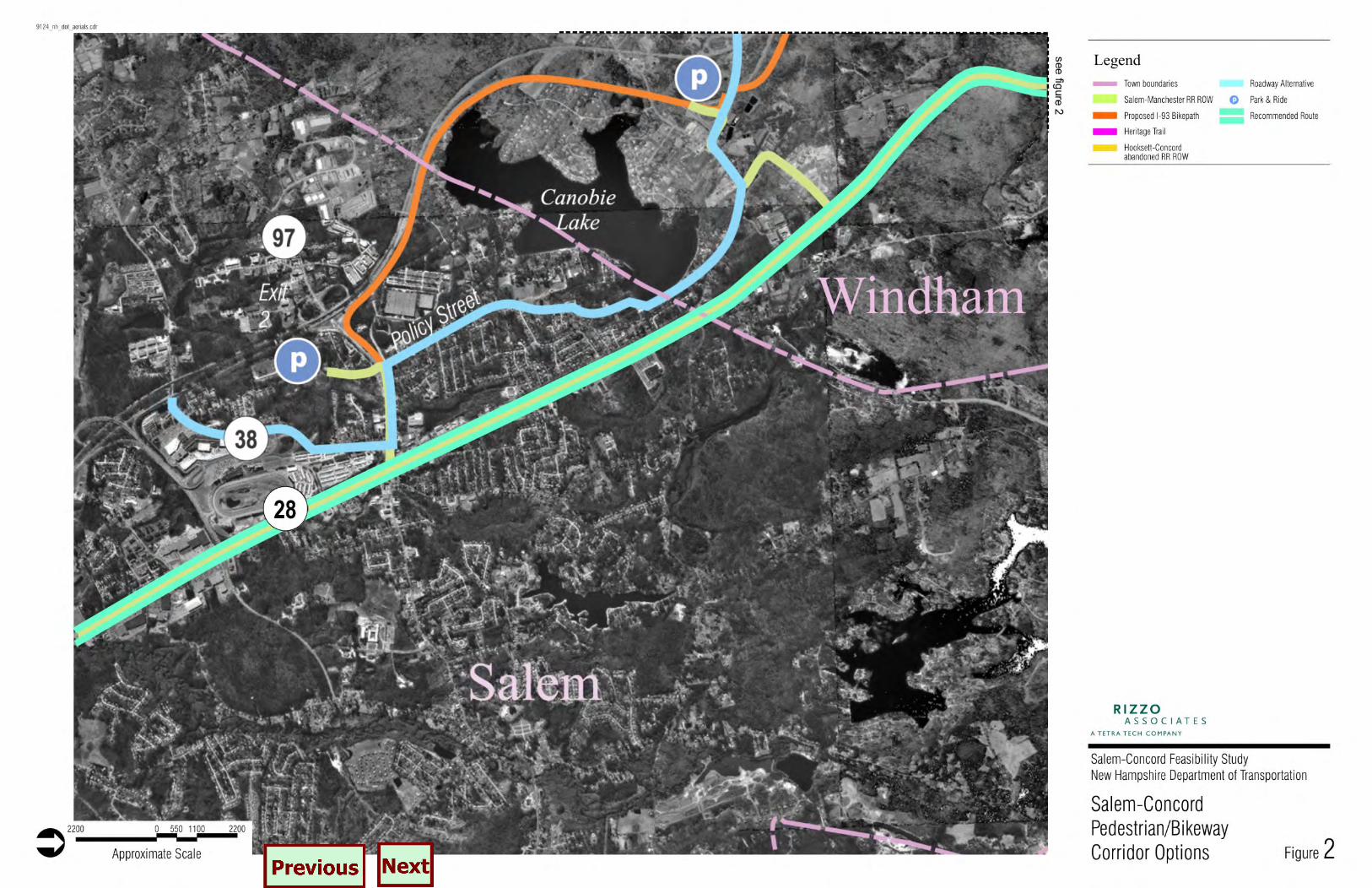
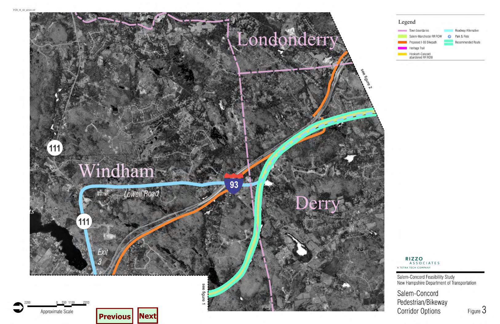
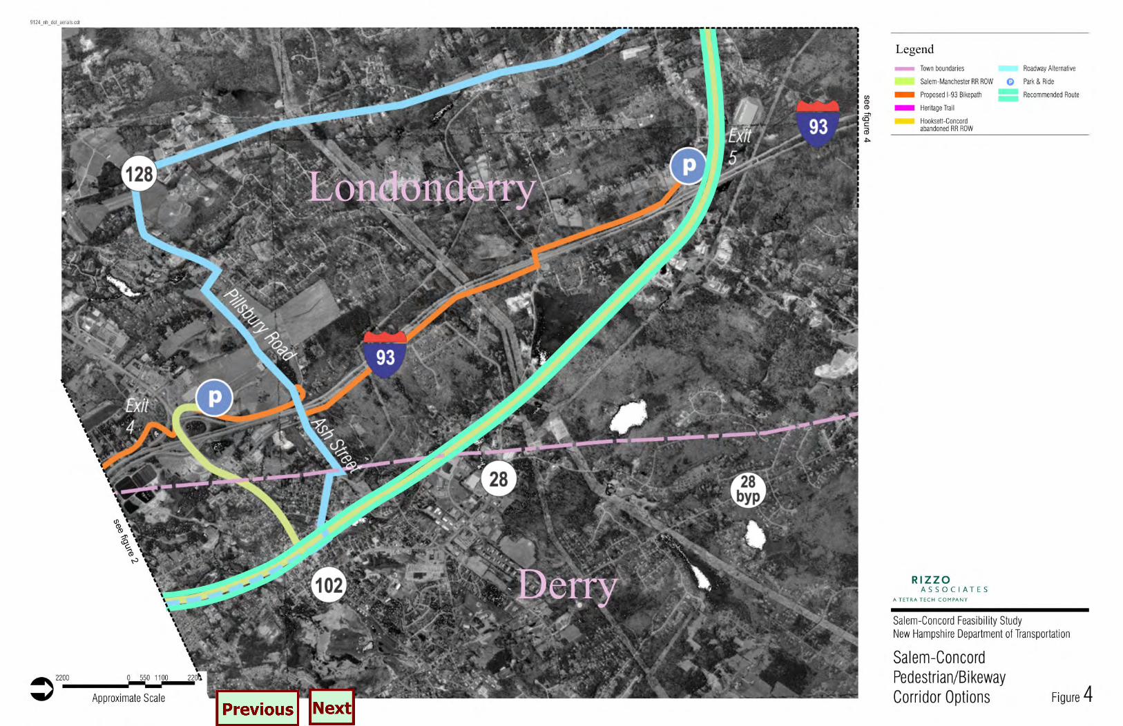
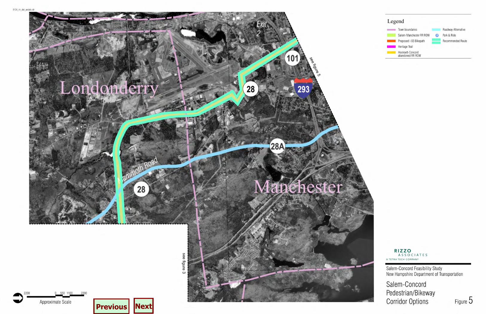
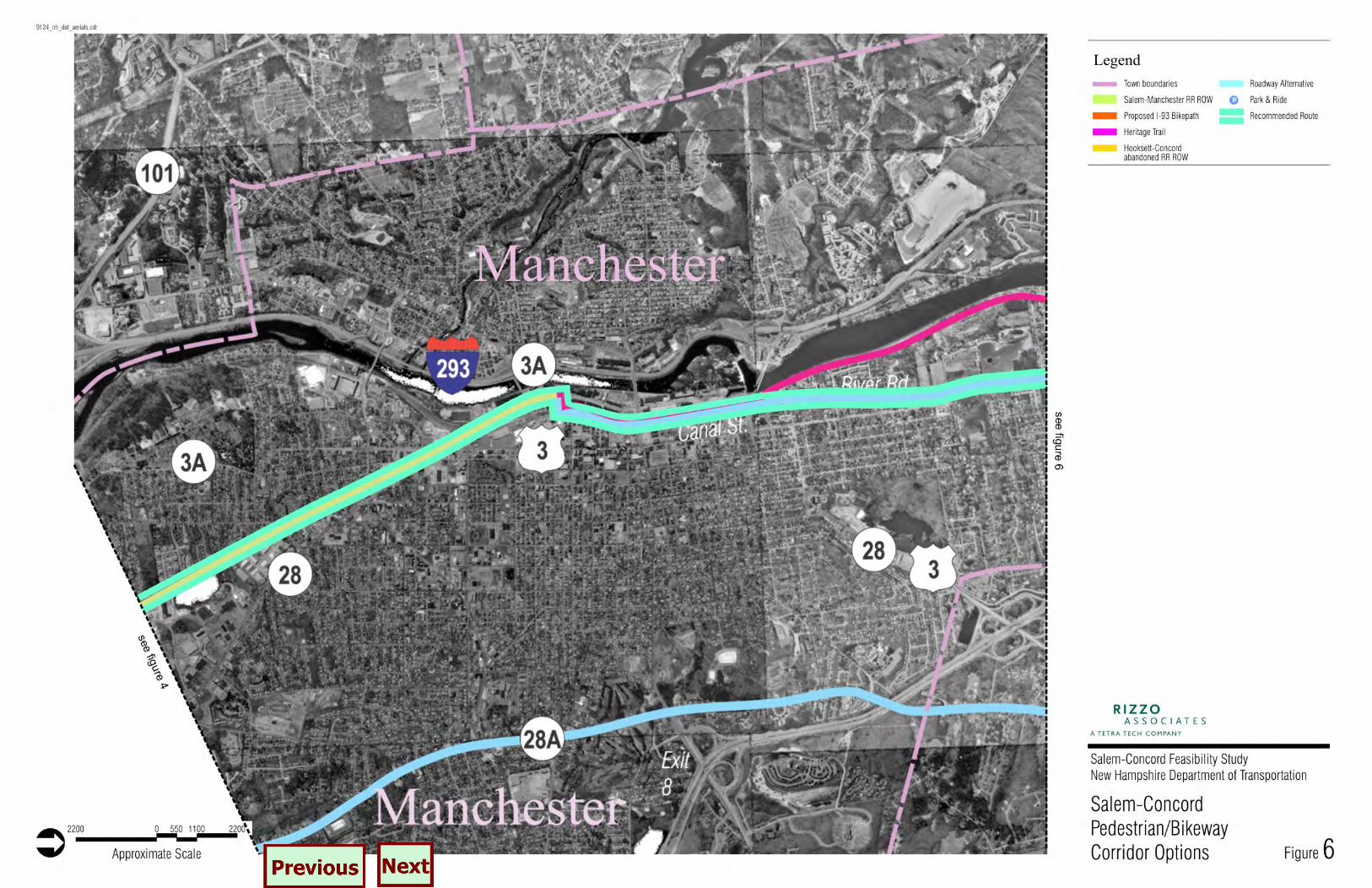
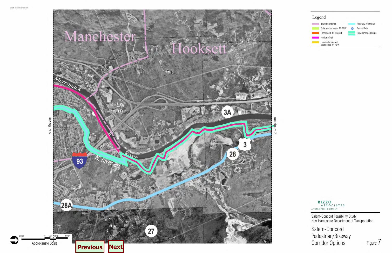
Several options for bicycle and pedestrian travel between Salem and Concord were identified as part of this study and are summarized in this chapter. The options include both off road and on road alternatives such as the proposed I-93 bicycle path, abandoned railroad corridors, segments of the New Hampshire Heritage Trail, existing roadways, and combinations of the same. For the I-93 option and the Heritage Trail segments a description of the proposed design is presented. For the two abandoned railroad corridors, the existing conditions are identified followed by a section on design issues related to creating the bicycle/pedestrian shared use trail. Each of the options is shown on Figures 2 through 9. These figures are based on aerial photographs of the Salem/Concord corridor.
4.1 Interstate 93 Bicycle Path
In an effort to encourage multiple modes of transportation and reduce the dependence on motor vehicle travel, a bicycle/pedestrian path is being considered as part of the Interstate 93 widening project from Salem to Manchester. The proposed path would be for exclusive bicycle and pedestrian use. It would be located adjacent to I-93, within the existing and proposed right-of-way limits of the highway. The approximately 13 mile path begins in Salem near Exit 2 (Route 97) and ends in Londonderry near Exit 5 (Route 28). This option does not provide a complete trail to Concord and thus may only be considered for the Salem to Londonderry portion of the corridor. The proposed design of the facility includes a ten foot paved path with 2-foot gravel shoulders on each side. The path would be located no closer than 30 feet from the nearest edge of travel lane on the highway and in most cases will be located at the bottom of the highway fill slopes. Figure 10 depicts a typical cross sectional view of the path. The following section describes in detail the proposed route of the I-93 bike path. The facility begins at the intersection of Pelham Road and North Policy Street in Salem on the east side of I-93. The path continues north adjacent to the northbound on-ramp. Continuing to the north, the path is located at the bottom of the slope adjacent to I-93. The path crosses under Brookdale Road and continues to the Windham town line between the highway and Canobie Lake.

Salem to Concord, New Hampshire Bikeway Feasibility Study
Page 17
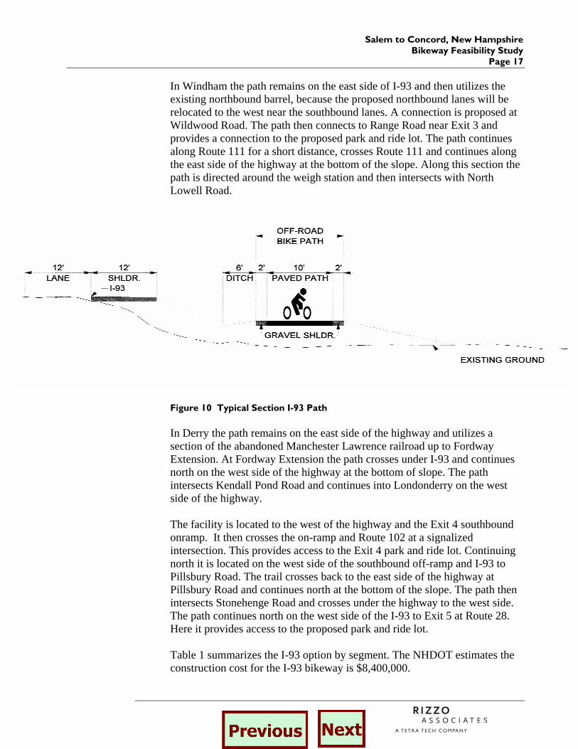
In Windham the path remains on the east side of I-93 and then utilizes the existing northbound barrel, because the proposed northbound lanes will be relocated to the west near the southbound lanes. A connection is proposed at Wildwood Road. The path then connects to Range Road near Exit 3 and provides a connection to the proposed park and ride lot. The path continues along Route 111 for a short distance, crosses Route 111 and continues along the east side of the highway at the bottom of the slope. Along this section the path is directed around the weigh station and then intersects with North Lowell Road.
Figure 10 Typical Section I-93 Path In Derry the path remains on the east side of the highway and utilizes a section of the abandoned Manchester Lawrence railroad up to Fordway Extension. At Fordway Extension the path crosses under I-93 and continues north on the west side of the highway at the bottom of slope. The path intersects Kendall Pond Road and continues into Londonderry on the west side of the highway. The facility is located to the west of the highway and the Exit 4 southbound onramp. It then crosses the on-ramp and Route 102 at a signalized intersection. This provides access to the Exit 4 park and ride lot. Continuing north it is located on the west side of the southbound off-ramp and I-93 to Pillsbury Road. The trail crosses back to the east side of the highway at Pillsbury Road and continues north at the bottom of the slope. The path then intersects Stonehenge Road and crosses under the highway to the west side. The path continues north on the west side of the I-93 to Exit 5 at Route 28. Here it provides access to the proposed park and ride lot. Table 1 summarizes the I-93 option by segment. The NHDOT estimates the construction cost for the I-93 bikeway is $8,400,000.
Salem to Concord, New Hampshire Bikeway Feasibility Study Page 18
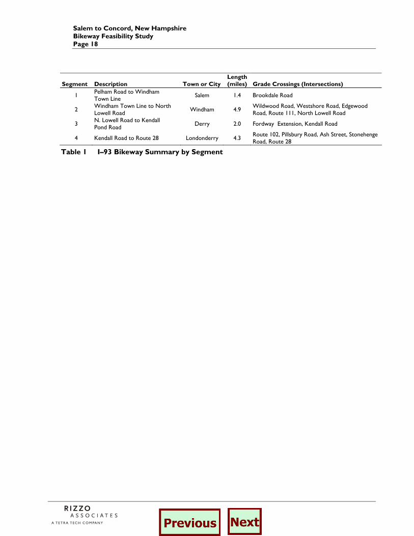
Table 1 I–93 Bikeway Summary by Segment
Segment Description Town or CityLength (miles) Grade Crossings (Intersections)
1 Pelham Road to Windham Town Line
Salem 1.4 Brookdale Road
2 Windham Town Line to North Lowell Road
Windham 4.9 Wildwood Road, Westshore Road, Edgewood Road, Route 111, North Lowell Road
3 N. Lowell Road to Kendall Pond Road
Derry 2.0 Fordway Extension, Kendall Road
4 Kendall Road to Route 28 Londonderry 4.3 Route 102, Pillsbury Road, Ash Street, Stonehenge Road, Route 28
Salem to Concord, New Hampshire Bikeway Feasibility Study
Page 19
4.2. The Manchester and Lawrence Railroad Corridor
An off road option is provided by the existing Manchester - Lawrence Railroad corridor. Specifically, the 23.6 mile segment between Hampshire Road in Salem to Depot Street in Manchester was identified as a possible segment of the Salem-Concord Bikeway. On the Boston and Maine Railroad, branch lines like the Manchester and Lawrence more often linked two (or more) cities that already were served by other rail connections. The Manchester and Lawrence Branch was constructed in 1847 to 1849 when cities north of Boston were experiencing the industrial revolution. The first train ran the entire railroad on November 13, 1849. A segment of the railroad in Windham was the most expensive to construct because extensive cutting through ledge and filling of lowlands was necessary for a distance of three miles. In downtown Manchester, the Manchester and Lawrence Branch was constructed parallel and west of Canal Street. The branch joined the Concord Railroad several hundred feet north of Granite Street.1 All segments of the railroad have been abandoned and most are publicly owned. The short stretch (less than one mile) south of the Spicket River in Salem is still owned by Guilford Transportation. Most of the alignment is now owned by the State of New Hampshire. All but two segments in Derry and Manchester are owned by those municipalities. Delaware Rock, Inc. owns the 1.6 mile former rail corridor between North High Street in Derry and Route 28 in Londonderry. The railroad corridor through Manchester Airport is owned by the airport. Alta Planning + Design staff walked the railroad corridor from Kelley Road in Salem to Mammoth Road in Londonderry on October 29-30, 2002. Additional portions of the corridor were investigated in December 2002 and January 2003. The field reconnaissance, interviews with local and state officials, and additional research has been used to assess the feasibility of constructing a shared use path for bicycle and pedestrian use in the former railroad corridor. It should be noted that this feasibility analysis considers construction of a non-motorized rail-trail and not a rail with trail. Given the presence of extensive wetland areas adjacent to the trail particularly in Windham and Derry, it would be difficult to construct a trail with adequate separation from an active rail line.
1 Richard A. Hoisington, “This Train Does Not Stop at Nutt’s Pond: A History of the B&M’s Manchester & Lawrence Branch,” The New England States Limited (Spring 1978).
Salem to Concord, New Hampshire Bikeway Feasibility Study Page 20
The following section describes the corridor from south to north and is divided into 18 segments. Major features within each segment are discussed, and a limited number of photographs are provided. Following the segment descriptions is a discussion of the feasibility of constructing a rail to trail within the 23.6 mile corridor from Hampshire Road in Salem to Depot Street in Manchester. Three major tables are included at the end of the section summarizing the analysis of the grade crossings, structures and trail segments. Order-of-magnitude construction cost estimates are included in the summary table.
4.2.1 Description of Existing Corridor
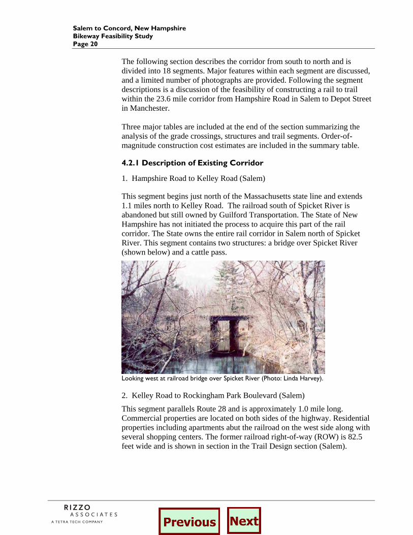
1. Hampshire Road to Kelley Road (Salem) This segment begins just north of the Massachusetts state line and extends 1.1 miles north to Kelley Road. The railroad south of Spicket River is abandoned but still owned by Guilford Transportation. The State of New Hampshire has not initiated the process to acquire this part of the rail corridor. The State owns the entire rail corridor in Salem north of Spicket River. This segment contains two structures: a bridge over Spicket River (shown below) and a cattle pass.
Looking west at railroad bridge over Spicket River (Photo: Linda Harvey). 2. Kelley Road to Rockingham Park Boulevard (Salem)
This segment parallels Route 28 and is approximately 1.0 mile long. Commercial properties are located on both sides of the highway. Residential properties including apartments abut the railroad on the west side along with several shopping centers. The former railroad right-of-way (ROW) is 82.5 feet wide and is shown in section in the Trail Design section (Salem).

Salem to Concord, New Hampshire Bikeway Feasibility Study
Page 21
Looking north at Hagop Road crossing of rail corridor paralleling Route 28 (Photo: Linda Harvey). 3. Rockingham Park Boulevard to Main Street (Salem)
The segment from Rockingham Park Boulevard to Main Street is approximately 1.0 mile long. Rockingham Park Boulevard crosses the railroad corridor with nine lanes (see photo below) separated by medians adjacent to Route 28. This roadway design is evident on the railroad valuation plans prepared in 1914. Rockingham Park Boulevard leads to Exit 1 of Interstate 93. North of this intersection the railroad corridor abuts Rockingham Park, the horse track, including the entrance commonly used to bring horses into the park.
Rail crossing at Rockingham Boulevard Approaching Main Street, Salem
4. Main Street to Route 111 (Salem) The Salem Depot is located along the railroad at Main Street in Salem. Main Street leads to Exit 2 on Interstate 93. North of the Salem Depot, portions of the rail corridor are used by Dodge Grain for storage and loading. North of Willow Street the railroad corridor abuts wetlands and includes drainage structures under the railroad. The railroad corridor abuts residential properties on the west, north of the crossing of Old Rockingham Road. The segment from Main Street to Route 111 is approximately 1.8 miles long.
Salem to Concord, New Hampshire Bikeway Feasibility Study Page 22
Culvert north of Willow Street Residences on Old Rockingham Road
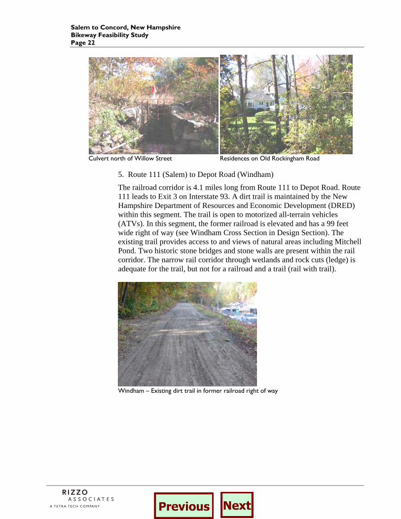
5. Route 111 (Salem) to Depot Road (Windham)
The railroad corridor is 4.1 miles long from Route 111 to Depot Road. Route 111 leads to Exit 3 on Interstate 93. A dirt trail is maintained by the New Hampshire Department of Resources and Economic Development (DRED) within this segment. The trail is open to motorized all-terrain vehicles (ATVs). In this segment, the former railroad is elevated and has a 99 feet wide right of way (see Windham Cross Section in Design Section). The existing trail provides access to and views of natural areas including Mitchell Pond. Two historic stone bridges and stone walls are present within the rail corridor. The narrow rail corridor through wetlands and rock cuts (ledge) is adequate for the trail, but not for a railroad and a trail (rail with trail).
Windham – Existing dirt trail in former railroad right of way
Salem to Concord, New Hampshire Bikeway Feasibility Study
Page 23
Historic stone arch bridge View of Mitchell Pond from rail corridor
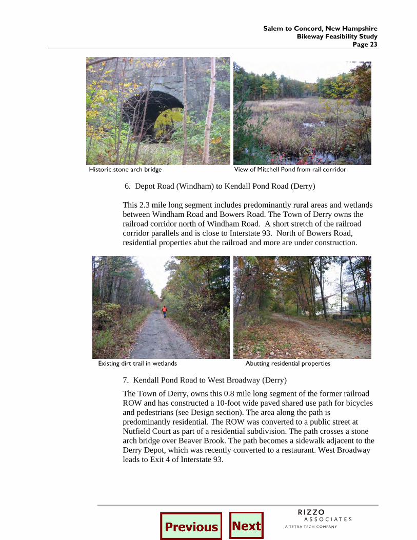
6. Depot Road (Windham) to Kendall Pond Road (Derry) This 2.3 mile long segment includes predominantly rural areas and wetlands between Windham Road and Bowers Road. The Town of Derry owns the railroad corridor north of Windham Road. A short stretch of the railroad corridor parallels and is close to Interstate 93. North of Bowers Road, residential properties abut the railroad and more are under construction.
Existing dirt trail in wetlands Abutting residential properties
7. Kendall Pond Road to West Broadway (Derry)
The Town of Derry, owns this 0.8 mile long segment of the former railroad ROW and has constructed a 10-foot wide paved shared use path for bicycles and pedestrians (see Design section). The area along the path is predominantly residential. The ROW was converted to a public street at Nutfield Court as part of a residential subdivision. The path crosses a stone arch bridge over Beaver Brook. The path becomes a sidewalk adjacent to the Derry Depot, which was recently converted to a restaurant. West Broadway leads to Exit 4 of Interstate 93.

Salem to Concord, New Hampshire Bikeway Feasibility Study Page 24
Existing paved path in Derry Derry Depot under renovation in October 2002
8. West Broadway to North High Street (Derry)
The former railroad alignment includes a wide crosswalk on West Broadway and brick sidewalks along Manning Street to the north. After Manning Street dead ends, the railroad corridor contains a dirt trail. The trail continues over Hornes Pond on a stone arch railroad bridge. The trail runs through a new residential development just south of North High Street. This segment of the railroad corridor is 0.6 miles long. 9. North High Street (Derry) to Rockingham Road, Route 28 (Londonderry)
According to data provided by NHDOT, this segment of the former Lawrence and Manchester Branch railroad is owned by Delaware Rock, Inc. The corridor remains intact with no buildings or other intrusions. A short stretch of a cut section of the railroad corridor was filled to create an at-grade crossing of B Street where a structure had been previously. This segment of the railroad corridor is 1.1 miles long. 10. Route 28, Rockingham Road to Auburn Road (Londonderry)
This 1.6 mile segment is predominantly rural. It ends at an industrial area where the trail parallels Independence Drive.
Existing dirt trail in Londonderry at milepost 9 (9 miles south of Manchester Depot).
Salem to Concord, New Hampshire Bikeway Feasibility Study
Page 25
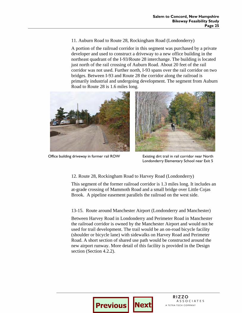
11. Auburn Road to Route 28, Rockingham Road (Londonderry)
A portion of the railroad corridor in this segment was purchased by a private developer and used to construct a driveway to a new office building in the northeast quadrant of the I-93/Route 28 interchange. The building is located just north of the rail crossing of Auburn Road. About 20 feet of the rail corridor was not used. Further north, I-93 spans over the rail corridor on two bridges. Between I-93 and Route 28 the corridor along the railroad is primarily industrial and undergoing development. The segment from Auburn Road to Route 28 is 1.6 miles long.
Office building driveway in former rail ROW Existing dirt trail in rail corridor near North
Londonderry Elementary School near Exit 5
12. Route 28, Rockingham Road to Harvey Road (Londonderry)
This segment of the former railroad corridor is 1.3 miles long. It includes an at-grade crossing of Mammoth Road and a small bridge over Little Cojas Brook. A pipeline easement parallels the railroad on the west side.
13-15. Route around Manchester Airport (Londonderry and Manchester)
Between Harvey Road in Londonderry and Perimeter Road in Manchester the railroad corridor is owned by the Manchester Airport and would not be used for trail development. The trail would be an on-road bicycle facility (shoulder or bicycle lane) with sidewalks on Harvey Road and Perimeter Road. A short section of shared use path would be constructed around the new airport runway. More detail of this facility is provided in the Design section (Section 4.2.2).
Salem to Concord, New Hampshire Bikeway Feasibility Study Page 26
Harvey Road Area between Willow Street and airport
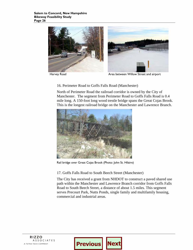
16. Perimeter Road to Goffs Falls Road (Manchester)
North of Perimeter Road the railroad corridor is owned by the City of Manchester. The segment from Perimeter Road to Goffs Falls Road is 0.4 mile long. A 150-foot long wood trestle bridge spans the Great Cojas Brook. This is the longest railroad bridge on the Manchester and Lawrence Branch.
Rail bridge over Great Cojas Brook (Photo: John St. Hilaire)
17. Goffs Falls Road to South Beech Street (Manchester)
The City has received a grant from NHDOT to construct a paved shared use path within the Manchester and Lawrence Branch corridor from Goffs Falls Road to South Beech Street, a distance of about 1.5 miles. This segment serves Precourt Park, Nutts Ponds, single family and multifamily housing, commercial and industrial areas.
Salem to Concord, New Hampshire Bikeway Feasibility Study
Page 27
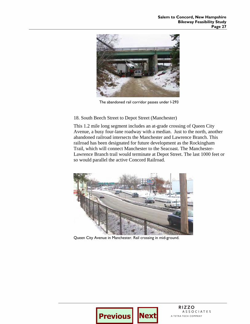
The abandoned rail corridor passes under I-293
18. South Beech Street to Depot Street (Manchester)
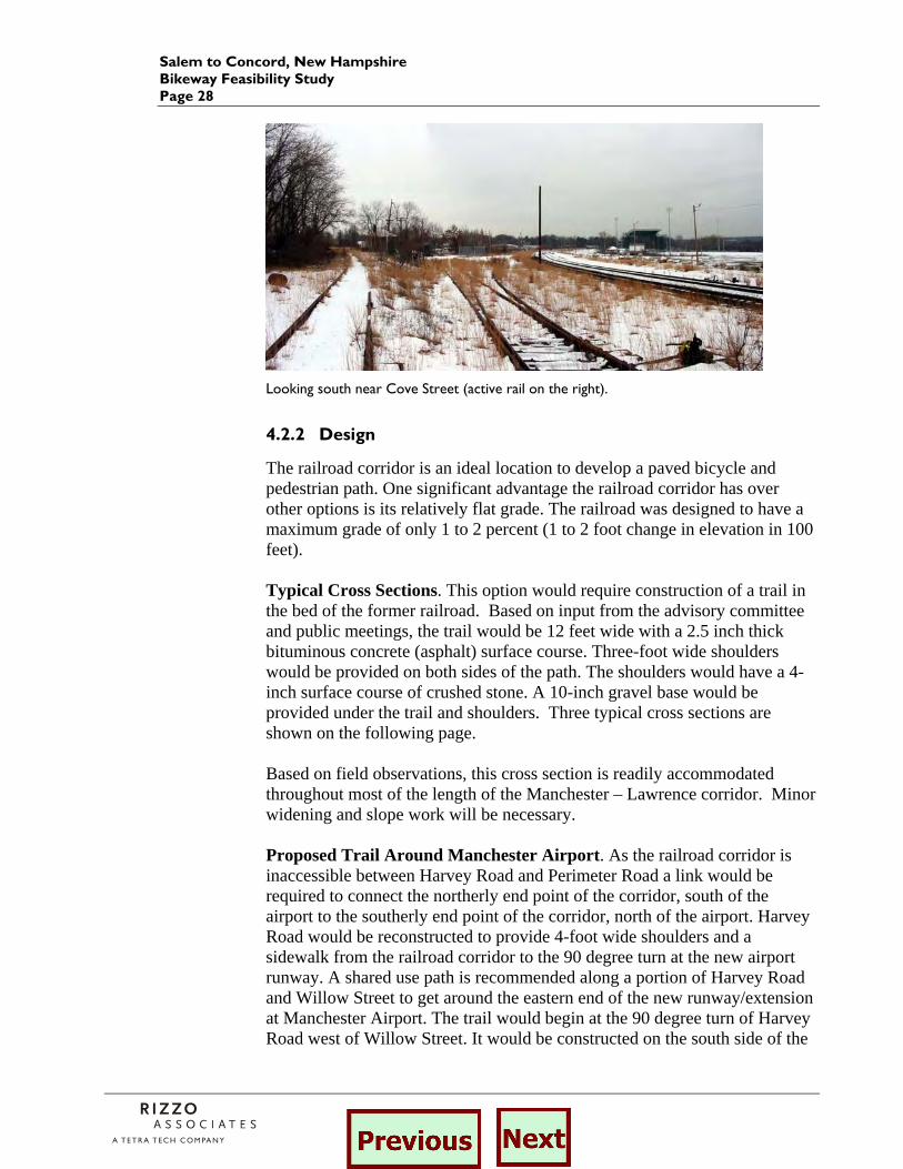
This 1.2 mile long segment includes an at-grade crossing of Queen City Avenue, a busy four-lane roadway with a median. Just to the north, another abandoned railroad intersects the Manchester and Lawrence Branch. This railroad has been designated for future development as the Rockingham Trail, which will connect Manchester to the Seacoast. The Manchester-Lawrence Branch trail would terminate at Depot Street. The last 1000 feet or so would parallel the active Concord Railroad.
Queen City Avenue in Manchester. Rail crossing in mid-ground.
Salem to Concord, New Hampshire Bikeway Feasibility Study Page 28
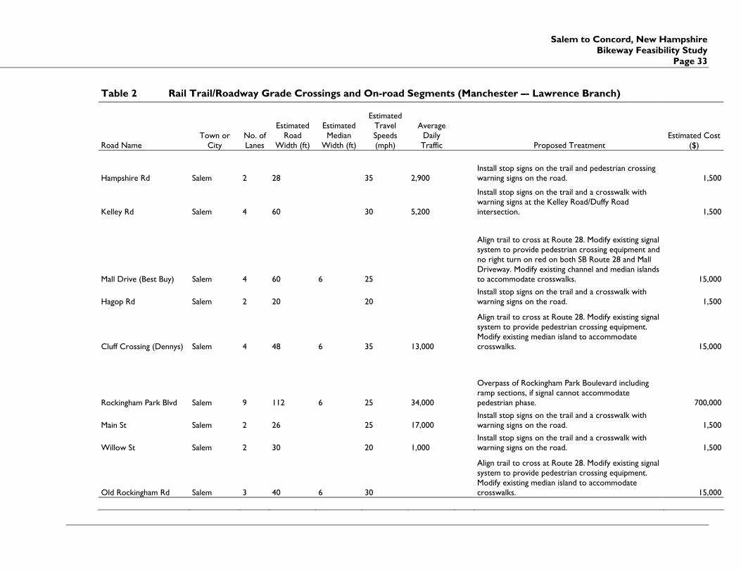
Looking south near Cove Street (active rail on the right).
4.2.2 Design
The railroad corridor is an ideal location to develop a paved bicycle and pedestrian path. One significant advantage the railroad corridor has over other options is its relatively flat grade. The railroad was designed to have a maximum grade of only 1 to 2 percent (1 to 2 foot change in elevation in 100 feet). Typical Cross Sections. This option would require construction of a trail in the bed of the former railroad. Based on input from the advisory committee and public meetings, the trail would be 12 feet wide with a 2.5 inch thick bituminous concrete (asphalt) surface course. Three-foot wide shoulders would be provided on both sides of the path. The shoulders would have a 4-inch surface course of crushed stone. A 10-inch gravel base would be provided under the trail and shoulders. Three typical cross sections are shown on the following page. Based on field observations, this cross section is readily accommodated throughout most of the length of the Manchester – Lawrence corridor. Minor widening and slope work will be necessary. Proposed Trail Around Manchester Airport. As the railroad corridor is inaccessible between Harvey Road and Perimeter Road a link would be required to connect the northerly end point of the corridor, south of the airport to the southerly end point of the corridor, north of the airport. Harvey Road would be reconstructed to provide 4-foot wide shoulders and a sidewalk from the railroad corridor to the 90 degree turn at the new airport runway. A shared use path is recommended along a portion of Harvey Road and Willow Street to get around the eastern end of the new runway/extension at Manchester Airport. The trail would begin at the 90 degree turn of Harvey Road west of Willow Street. It would be constructed on the south side of the

Salem to Concord, New Hampshire Bikeway Feasibility Study
Page 29
Salem – Proposed typical cross section in level terrain with existing rails still in place.
Windham –Proposed typical section in elevated terrain with existing dirt trail

Salem to Concord, New Hampshire Bikeway Feasibility Study Page 30
Derry – Proposed typical section in level terrain with existing paved path fence along the runway and may require a retaining wall. The path would be offset from the edge of road by at least five feet. The path would turn and go north along Willow Street on the east side of the runway fence. The path would turn back to the west and follow the north side of the runway fence to the 90 degree turn of Perimeter Road. Perimeter Road would be restriped to provide 4-foot wide shoulders or bicycle lanes and a sidewalk from the 90 degree turn at the airport runway to the railroad corridor. At-Grade Crossings. Crossings of the proposed trail within the former railroad ROW with roadways at the same elevation (at grade) require evaluation and design. Most of the 35 roadways which the trail would cross are low speed, low volume two-lane roads. However, other roadways that the trail would intersect carry more traffic at higher speeds. Evaluation of trail crossings involves analysis of traffic patterns of vehicles as well as trail users. This includes traffic speeds, street width, traffic volumes (average daily traffic, and peak hour), line of sight, and trail user characteristics. This study identifies potential crossing treatments given available information, which must be verified and/or refined during the design and construction document stage. Table 2 summarizes this data and the proposed treatment for each of the at-grade intersections. The proposed systems approach in this report is based on established standards, published technical reports, and the experiences on existing

Salem to Concord, New Hampshire Bikeway Feasibility Study
Page 31
facilities. Generally speaking, there are four types of improvements to consider for trail/roadway intersections:
Basic Crossing Prototypes
Unsignalized mid-block crossings of residential, collector, and sometimes major arterial streets.
Routed to Existing Intersection - Bikeways which emerge near existing intersections may be routed to these locations.
Signalized/Controlled – Bikeway crossings which require installation of traffic signals or other control measures due to traffic volumes, speeds, and trail usage.
Grade separated – Bridges or underpasses which provide the maximum level of safety but also generally are the most expensive and have right of way, maintenance, and other public safety considerations.
Most of the 35 crossings fall into one of the first two categories. Typical treatments included at unsignalized mid-block crossings are a striped crosswalk with advance warning signs on the road and stop signs on the trail. It is important that these crossings be installed where motorists have sufficient stopping sight distance. Many of the crossings in Salem are appropriate for routing the trail to the adjacent intersection with Route 28. A crosswalk will need to be installed in locations where one does not presently exist. If the intersection is signalized, then changes in signal timing and phasing may be appropriate. Three locations are recommended for consideration for flashing warning beacons over crosswalks. These are at the rail trail crossing of Windham Road in Windham, at the intersection of Sanborn Road and Route 28 in Londonderry, and at the 90 degree turn of Harvey Road in Manchester. The most difficult trail/roadway intersections in the 23.6 mile corridor are the intersection of the rail trail and Queen City Avenue in Manchester and at Rockingham Park Boulevard in Salem. It is recommended that a traffic signal warrant analysis be conducted for Queen City Avenue in Manchester. The analysis should consider traffic operations at the two closest signalized intersections on Queen City Avenue at Willow Street and Elm Street. If warranted a pedestrian actuated traffic signal system should be installed at the trail/roadway intersection. If the signal is not warranted or if it is determined that signalization of the crossing would cause significant traffic congestion, then a grade-separated trail crossing should be constructed. This would most likely be a bicycle/pedestrian bridge over the roadway.

Salem to Concord, New Hampshire Bikeway Feasibility Study Page 32
Based on comments and feedback from Salem officials, the introduction of a pedestrian phase to the Rockingham Boulevard intersection will likely result in a degradation of the overall operations at this location. The intersection is currently at or exceeding capacity, resulting in long delays and vehicle stacking. Here again an analysis is suggested to determine if the at grade intersection can accommodate a pedestrian phase, however, for this study, we have assumed a grade separated trail crossing. This would most likely be a bicycle/pedestrian bridge over the roadway. Structures. Seventeen (17) major structures are located within the railroad corridor. They can be classified as follows:
a) Five (5) road bridges over the railroad b) Two (2) cattle passes c) Two (2) railroad bridges over dirt roads d) Two (2) large culverts under roadways (installed after railroad
operations ceased) e) Six (6) railroad bridges over watercourses
Salem to Concord, New Hampshire Bikeway Feasibility Study
Page 33
Table 2 Rail Trail/Roadway Grade Crossings and On-road Segments (Manchester –- Lawrence Branch)
Road Name Town or
City No. of Lanes
Estimated Road
Width (ft)
Estimated Median
Width (ft)
Estimated Travel Speeds (mph)
Average Daily Traffic Proposed Treatment
Estimated Cost ($)
Hampshire Rd Salem 2 28 35 2,900 Install stop signs on the trail and pedestrian crossing warning signs on the road. 1,500
Kelley Rd Salem 4 60 30 5,200
Install stop signs on the trail and a crosswalk with warning signs at the Kelley Road/Duffy Road intersection. 1,500
Mall Drive (Best Buy) Salem 4 60 6 25
Align trail to cross at Route 28. Modify existing signal system to provide pedestrian crossing equipment and no right turn on red on both SB Route 28 and Mall Driveway. Modify existing channel and median islands to accommodate crosswalks. 15,000
Hagop Rd Salem 2 20 20 Install stop signs on the trail and a crosswalk with warning signs on the road. 1,500
Cluff Crossing (Dennys) Salem 4 48 6 35 13,000
Align trail to cross at Route 28. Modify existing signal system to provide pedestrian crossing equipment. Modify existing median island to accommodate crosswalks. 15,000
Rockingham Park Blvd Salem 9 112 6 25 34,000
Overpass of Rockingham Park Boulevard including ramp sections, if signal cannot accommodate pedestrian phase. 700,000
Main St Salem 2 26 25 17,000 Install stop signs on the trail and a crosswalk with warning signs on the road. 1,500
Willow St Salem 2 30 20 1,000 Install stop signs on the trail and a crosswalk with warning signs on the road. 1,500
Old Rockingham Rd Salem 3 40 6 30
Align trail to cross at Route 28. Modify existing signal system to provide pedestrian crossing equipment. Modify existing median island to accommodate crosswalks. 15,000
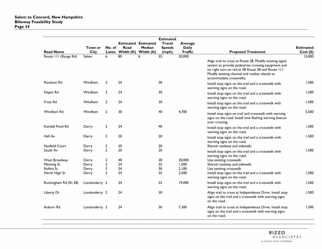
Salem to Concord, New Hampshire Bikeway Feasibility Study Page 34
Road Name Town or
City No. of Lanes
Estimated Road
Width (ft)
Estimated Median
Width (ft)
Estimated Travel Speeds (mph)
Average Daily
Traffic Proposed Treatment Estimated
Cost ($) Route 111 (Range Rd) Salem 6 80 6 35 20,000
Align trail to cross at Route 28. Modify existing signal system to provide pedestrian crossing equipment and no right turn on red at SB Route 28 and Route 111. Modify existing channel and median islands to accommodate crosswalks.
15,000
Roulston Rd Windham 2 24 30
Install stop signs on the trail and a crosswalk with warning signs on the road.
1,500
Depot Rd Windham 2 24 30
Install stop signs on the trail and a crosswalk with warning signs on the road.
1,500
Frost Rd Windham 2 24 30
Install stop signs on the trail and a crosswalk with warning signs on the road.
1,500
Windham Rd Windham 2 30 40 4,700
Install stop signs on trail and crosswalk with warning signs on the road. Install new flashing warning beacon over crossing.
5,500
Kendall Pond Rd Derry 2 24 40
Install stop signs on the trail and a crosswalk with warning signs on the road.
1,500
Hall Av Derry 2 20 20
Install stop signs on the trail and a crosswalk with warning signs on the road.
1,500
Nutfield Court Derry 2 20 20 Shared roadway and sidewalk. South Av Derry 2 20 20
Install stop signs on the trail and a crosswalk with warning signs on the road.
1,500
West Broadway Derry 2 40 30 20,000 Use existing crosswalk Manning St Derry 2 24 25 1,500 Shared roadway and sidewalk. Rollins St Derry 2 24 30 2,100 Use existing crosswalk North High St Derry 2 24 35 2,500
Install stop signs on the trail and a crosswalk with warning signs on the road.
1,500
Rockingham Rd (Rt 28) Londonderry 2 24 35 19,000
Install stop signs on the trail and a crosswalk with warning signs on the road.
1,500
Liberty Dr Londonderry 2 24 30
Align trail to cross at Independence Drive. Install stop signs on the trail and a crosswalk with warning signs on the road.
1,500
Auburn Rd Londonderry 2 24 30 7,300
Align trail to cross at Independence Drive. Install stop signs on the trail and a crosswalk with warning signs on the road.
1,500
Salem to Concord, New Hampshire Bikeway Feasibility Study
Page 35
Road Name Town or
City No. of Lanes
Estimated Road
Width (ft)
Estimated Median
Width (ft)
Estimated Travel Speeds (mph)
Average Daily
Traffic Proposed Treatment Estimated Cost ($)
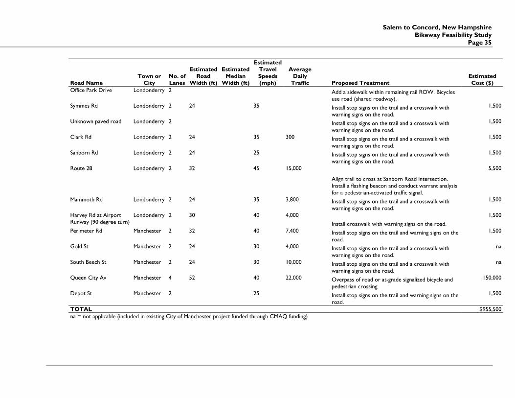
Office Park Drive Londonderry 2
Add a sidewalk within remaining rail ROW. Bicycles use road (shared roadway).
Symmes Rd Londonderry 2 24 35
Install stop signs on the trail and a crosswalk with warning signs on the road.
1,500
Unknown paved road Londonderry 2
Install stop signs on the trail and a crosswalk with warning signs on the road.
1,500
Clark Rd Londonderry 2 24 35 300
Install stop signs on the trail and a crosswalk with warning signs on the road.
1,500
Sanborn Rd Londonderry 2 24 25
Install stop signs on the trail and a crosswalk with warning signs on the road.
1,500
Route 28 Londonderry 2 32 45 15,000
Align trail to cross at Sanborn Road intersection. Install a flashing beacon and conduct warrant analysis for a pedestrian-activated traffic signal.
5,500
Mammoth Rd Londonderry 2 24 35 3,800
Install stop signs on the trail and a crosswalk with warning signs on the road.
1,500
Harvey Rd at Airport Runway (90 degree turn)
Londonderry 2 30 40 4,000
Install crosswalk with warning signs on the road.
1,500
Perimeter Rd Manchester 2 32 40 7,400
Install stop signs on the trail and warning signs on the road.
1,500
Gold St Manchester 2 24 30 4,000
Install stop signs on the trail and a crosswalk with warning signs on the road.
na
South Beech St Manchester 2 24 30 10,000
Install stop signs on the trail and a crosswalk with warning signs on the road.
na
Queen City Av Manchester 4 52 40 22,000
Overpass of road or at-grade signalized bicycle and pedestrian crossing
150,000
Depot St Manchester 2 25
Install stop signs on the trail and warning signs on the road.
1,500
TOTAL $955,500 na = not applicable (included in existing City of Manchester project funded through CMAQ funding)
Salem – Concord Bikeway, New Hampshire Bikeway Feasibility Study Page 36
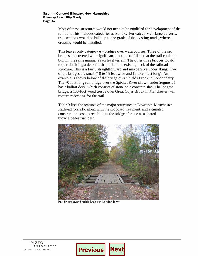
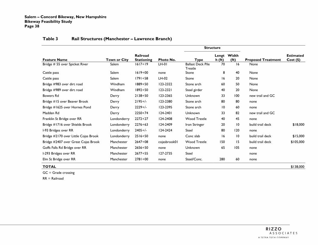
Most of these structures would not need to be modified for development of the rail trail. This includes categories a, b and c. For category d - large culverts, trail sections would be built up to the grade of the existing roads, where a crossing would be installed. This leaves only category e – bridges over watercourses. Three of the six bridges are covered with significant amounts of fill so that the trail could be built in the same manner as on level terrain. The other three bridges would require building a deck for the trail on the existing deck of the railroad structure. This is a fairly straightforward and inexpensive undertaking. Two of the bridges are small (10 to 15 feet wide and 16 to 20 feet long). An example is shown below of the bridge over Shields Brook in Londonderry. The 70 foot long rail bridge over the Spicket River shown under Segment 1 has a ballast deck, which consists of stone on a concrete slab. The longest bridge, a 150-foot wood trestle over Great Cojas Brook in Manchester, will require redecking for the trail. Table 3 lists the features of the major structures in Lawrence-Manchester Railroad Corridor along with the proposed treatment, and estimated construction cost, to rehabilitate the bridges for use as a shared bicycle/pedestrian path.
Rail bridge over Shields Brook in Londonderry.

Salem to Concord, New Hampshire Bikeway Feasibility Study
Page 37
Rail bridge over Great Cojas Brook in Manchester (Photo: John St. Hilaire)
Construction Cost. As stated in the previous section, the Manchester – Lawrence railroad corridor is an ideal location to develop a paved bicycle and pedestrian path. The corridor is relatively flat and is about 82 to 100 feet wide. The path could be developed with a paved surface for bicycling and wheelchairs and crushed-stone shoulders for walking and jogging. The path connects residential areas to commercial, industrial and institutional land uses and would serve commuting and other utilitarian travel needs. A path within this railroad corridor would be relatively straight and direct. It connects town centers in Salem, Derry and Manchester.
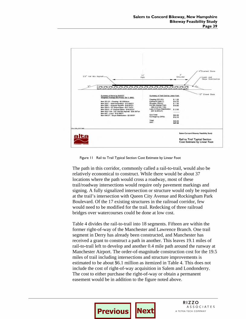
The order-of-magnitude construction cost for construction of the trail within the Manchester – Lawrence Railroad corridor is estimated to be $47.00 per linear foot based on the design illustrated in Figure 11 and NHDOT weighted average bid prices for the third quarter of 2002.
Salem – Concord Bikeway, New Hampshire Bikeway Feasibility Study Page 38
Table 3 Rail Structures (Manchester – Lawrence Branch)
Structure
Feature Name Town or City Railroad Stationing Photo No. Type
Length (ft)
Width (ft) Proposed Treatment
Estimated Cost ($)
Bridge # 55 over Spicket River Salem 1617+19 LH-01 Ballast Deck Pile Trestle
70 16 None
Cattle pass Salem 1619+00 none Stone 8 40 None
Cattle pass Salem 1791+58 LH-02 Stone 16 20 None
Bridge #983 over dirt road Windham 1889+50 123-2322 Stone arch 60 50 None
Bridge #989 over dirt road Windham 1892+50 123-2321 Steel girder 40 20 None
Bowers Rd Derry 2138+50 123-2365 Unknown 33 100 new trail and GC
Bridge #15 over Beaver Brook Derry 2195+/- 123-2380 Stone arch 80 80 none
Bridge #1625 over Hornes Pond Derry 2229+/- 123-2395 Stone arch 10 60 none
Madden Rd Derry 2250+74 124-2401 Unknown 33 82 new trail and GC
Franklin St Bridge over RR Londonderry 2272+27 124-2408 Wood Trestle 40 45 none
Bridge #1716 over Shields Brook Londonderry 2276+63 124-2409 Iron Stringer 20 10 build trail deck $18,000
I-93 Bridges over RR Londonderry 2405+/- 124-2424 Steel 80 120 none
Bridge #2170 over Little Cojas Brook Londonderry 2516+50 none Conc slab 16 10 build trail deck $15,000
Bridge #2407 over Great Cojas Brook Manchester 2647+08 cojasbrook01 Wood Trestle 150 15 build trail deck $105,000
Goffs Falls Rd Bridge over RR Manchester 2656+50 none Unknown 65 105 none
I-293 Bridges over RR Manchester 2677+55 127-2735 Steel none
Elm St Bridge over RR Manchester 2781+00 none Steel/Conc. 280 60 none
TOTAL $138,000
GC = Grade crossing
RR = Railroad
Salem to Concord Bikeway, New Hampshire Bikeway Feasibility Study
Page 39
Figure 11 Rail to Trail Typical Section Cost Estimate by Linear Foot
The path in this corridor, commonly called a rail-to-trail, would also be relatively economical to construct. While there would be about 37 locations where the path would cross a roadway, most of these trail/roadway intersections would require only pavement markings and signing. A fully signalized intersection or structure would only be required at the trail’s intersection with Queen City Avenue and Rockingham Park Boulevard. Of the 17 existing structures in the railroad corridor, few would need to be modified for the trail. Redecking of three railroad bridges over watercourses could be done at low cost. Table 4 divides the rail-to-trail into 18 segments. Fifteen are within the former right-of-way of the Manchester and Lawrence Branch. One trail segment in Derry has already been constructed, and Manchester has received a grant to construct a path in another. This leaves 19.1 miles of rail-to-trail left to develop and another 0.4 mile path around the runway at Manchester Airport. The order-of-magnitude construction cost for the 19.5 miles of trail including intersections and structure improvements is estimated to be about $6.1 million as itemized in Table 4. This does not include the cost of right-of-way acquisition in Salem and Londonderry. The cost to either purchase the right-of-way or obtain a permanent easement would be in addition to the figure noted above.
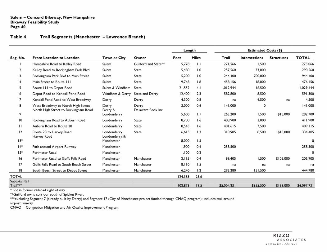
Salem – Concord Bikeway, New Hampshire Bikeway Feasibility Study Page 40
Table 4 Trail Segments (Manchester – Lawrence Branch)
Length Estimated Costs ($)
Seg. No. From Location to Location Town or City Owner Feet Miles Trail Intersections Structures TOTAL
1 Hampshire Road to Kelley Road Salem Guilford and State** 5,778 1.1 271,566 1,500 273,066
2 Kelley Road to Rockingham Park Blvd Salem State 5,480 1.0 257,560 33,000 290,560
3 Rockingham Park Blvd to Main Street Salem State 5,200 1.0 244,400 700,000 944,400
4 Main Street to Route 111 Salem State 9,748 1.8 458,156 18,000 476,156
5 Route 111 to Depot Road Salem & Windham State 21,552 4.1 1,012,944 16,500 1,029,444
6 Depot Road to Kendall Pond Road Windham & Derry State and Derry 12,400 2.3 582,800 8,500 591,300
7 Kendall Pond Road to West Broadway Derry Derry 4,300 0.8 na 4,500 na 4,500
8 West Broadway to North High Street Derry Derry 3,000 0.6 141,000 0 141,000
9 North High Street to Rockingham Road Derry &
Londonderry Delaware Rock Inc.
5,600 1.1 263,200 1,500 $18,000 282,700
10 Rockingham Road to Auburn Road Londonderry State 8,700 1.6 408,900 3,000 411,900
11 Auburn Road to Route 28 Londonderry State 8,545 1.6 401,615 7,500 409,115
12 Route 28 to Harvey Road Londonderry State 6,615 1.3 310,905 8,500 $15,000 334,405
13* Harvey Road Londonderry &
Manchester 8,000 1.5 0
14* Path around Airport Runway Manchester 1,900 0.4 258,500 258,500
15* Perimeter Road Manchester 1,100 0.2 0
16 Perimeter Road to Goffs Falls Road Manchester Manchester 2,115 0.4 99,405 1,500 $105,000 205,905
17 Goffs Falls Road to South Beech Street Manchester Manchester 8,110 1.5 na na na na
18 South Beech Street to Depot Street Manchester Manchester 6,240 1.2 293,280 151,500 444,780
TOTAL 124,383 23.6 Subtotal Rail Trail*** 102,873 19.5 $5,004,231 $955,500 $138,000 $6,097,731 * not in former railroad right of way **Guilford owns corridor south of Spicket River. ***excluding Segment 7 (already built by Derry) and Segment 17 (City of Manchester project funded through CMAQ program); includes trail around airport runway.
CMAQ = Congestion Mitigation and Air Quality Improvement Program
Salem to Concord Bikeway, New Hampshire Bikeway Feasibility Study
Page 41
4.3 Concord – Portsmouth Railroad Corridor
Much of the abandoned Concord – Portsmouth line between Hooksett and the Merrimack River in Concord was either walked or observed from nearby access points. This abandoned rail corridor passes through portions of Hooksett, Allenstown, Pembroke and Concord for a distance of 5.8 miles. All segments of the railroad have been abandoned and are either publicly or privately owned. The following section describes the corridor from south to north and is divided into four segments. Three tables are provided at the end of this section summarizing the analysis of the grade crossings, structures, and trail segments.
4.3.1 Description of Existing Corridor
1. Hooksett This section begins in Hooksett on the east side of the Merrimack River at the Hooksett District Court located on Merrimack Street. The active B & M Railroad continues at this point on the west side of the Merrimack River and the old piers for the abandoned rail are still in place in the river. The abandoned rail corridor continues north in Hooksett for approximately one mile along the east bank of the river. Current ownership of the abandoned corridor includes the Town of Hooksett at the southerly limit, the Hooksett Land Trust, and one private owner in the northerly end. There are no grade crossings, or intersections with existing streets along this section of the corridor and the only access point is Merrimack Street at the Court House. There are also no major structures required along this segment of the corridor 2. Allenstown This section begins at the Hooksett townline and continues north through Allenstown for a distance of just over 0.6 miles. The corridor is located a good distance east of the river. The corridor is well defined and graded until it enters the Mill Building area of Suncook Village. For a short distance it is located within the right-of-way of Canal Street. North of Canal Street the abandoned railroad corridor crosses the Allenstown Canal. The granite abutments remain intact for this fifty foot crossing, but the bridge has been removed. The Pembroke townline is located midway across the Suncook River and again the granite abutments remain intact for this 100-foot crossing, but the bridge has been removed. In Allenstown the right-of-way is currently privately owned by both Levi Ladd and Hodgson and Sons.
Salem – Concord Bikeway, New Hampshire Bikeway Feasibility Study Page 42
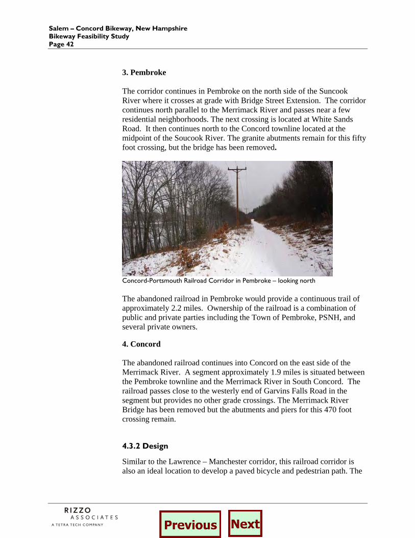
3. Pembroke The corridor continues in Pembroke on the north side of the Suncook River where it crosses at grade with Bridge Street Extension. The corridor continues north parallel to the Merrimack River and passes near a few residential neighborhoods. The next crossing is located at White Sands Road. It then continues north to the Concord townline located at the midpoint of the Soucook River. The granite abutments remain for this fifty foot crossing, but the bridge has been removed.
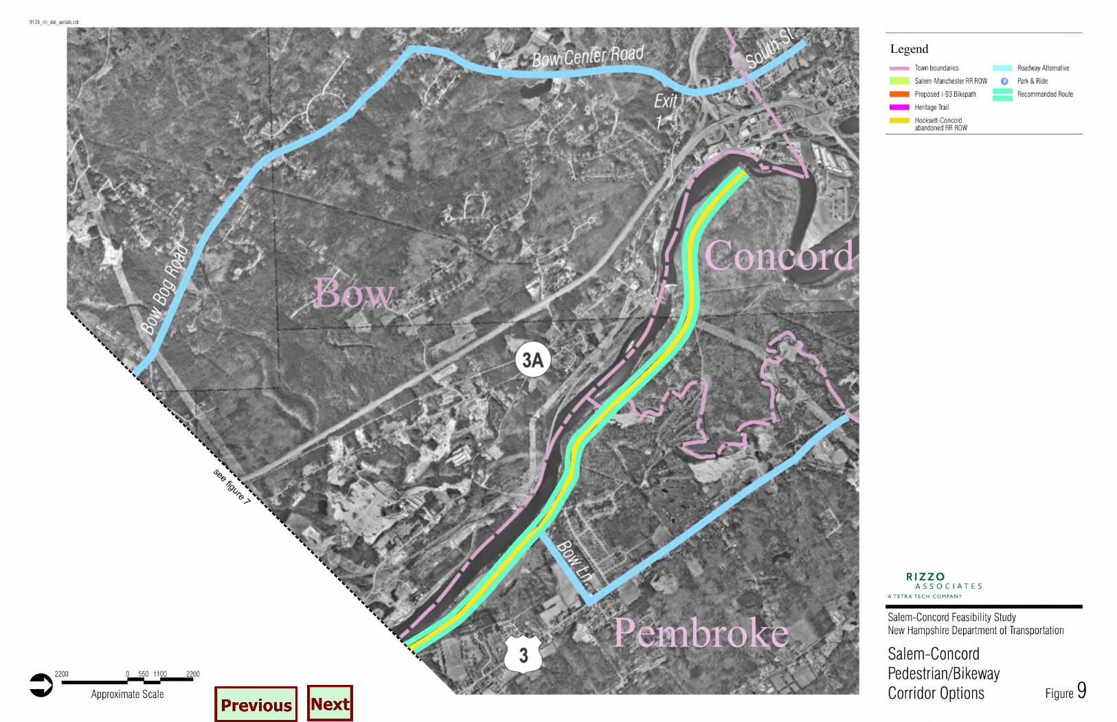
Concord-Portsmouth Railroad Corridor in Pembroke – looking north The abandoned railroad in Pembroke would provide a continuous trail of approximately 2.2 miles. Ownership of the railroad is a combination of public and private parties including the Town of Pembroke, PSNH, and several private owners. 4. Concord The abandoned railroad continues into Concord on the east side of the Merrimack River. A segment approximately 1.9 miles is situated between the Pembroke townline and the Merrimack River in South Concord. The railroad passes close to the westerly end of Garvins Falls Road in the segment but provides no other grade crossings. The Merrimack River Bridge has been removed but the abutments and piers for this 470 foot crossing remain.
4.3.2 Design
Similar to the Lawrence – Manchester corridor, this railroad corridor is also an ideal location to develop a paved bicycle and pedestrian path. The
Salem to Concord Bikeway, New Hampshire Bikeway Feasibility Study
Page 43
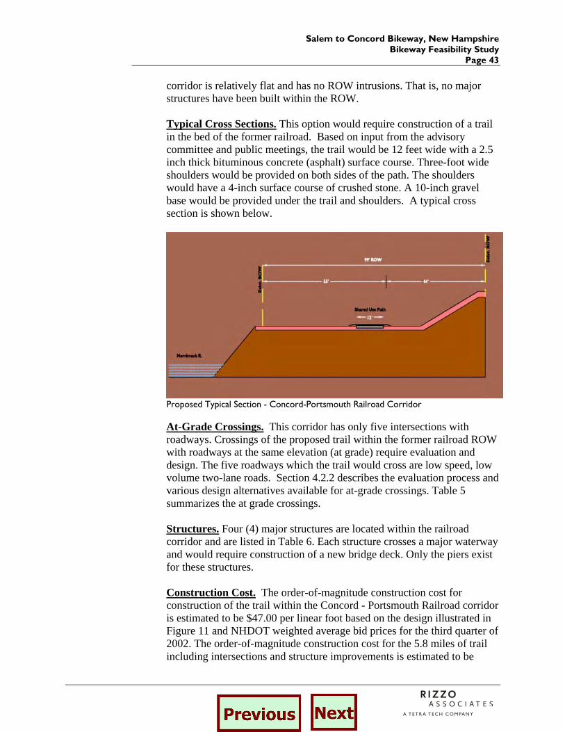
corridor is relatively flat and has no ROW intrusions. That is, no major structures have been built within the ROW. Typical Cross Sections. This option would require construction of a trail in the bed of the former railroad. Based on input from the advisory committee and public meetings, the trail would be 12 feet wide with a 2.5 inch thick bituminous concrete (asphalt) surface course. Three-foot wide shoulders would be provided on both sides of the path. The shoulders would have a 4-inch surface course of crushed stone. A 10-inch gravel base would be provided under the trail and shoulders. A typical cross section is shown below.
Proposed Typical Section - Concord-Portsmouth Railroad Corridor At-Grade Crossings. This corridor has only five intersections with roadways. Crossings of the proposed trail within the former railroad ROW with roadways at the same elevation (at grade) require evaluation and design. The five roadways which the trail would cross are low speed, low volume two-lane roads. Section 4.2.2 describes the evaluation process and various design alternatives available for at-grade crossings. Table 5 summarizes the at grade crossings. Structures. Four (4) major structures are located within the railroad corridor and are listed in Table 6. Each structure crosses a major waterway and would require construction of a new bridge deck. Only the piers exist for these structures. Construction Cost. The order-of-magnitude construction cost for construction of the trail within the Concord - Portsmouth Railroad corridor is estimated to be $47.00 per linear foot based on the design illustrated in Figure 11 and NHDOT weighted average bid prices for the third quarter of 2002. The order-of-magnitude construction cost for the 5.8 miles of trail including intersections and structure improvements is estimated to be

Salem – Concord Bikeway, New Hampshire Bikeway Feasibility Study Page 44
about $2.8 million as itemized in Table 7. This figure does not include the cost of right-of-way acquisition or obtaining permanent easements over the many segments currently in private ownership.
Salem to Concord Bikeway, New Hampshire Bikeway Feasibility Study
Page 45
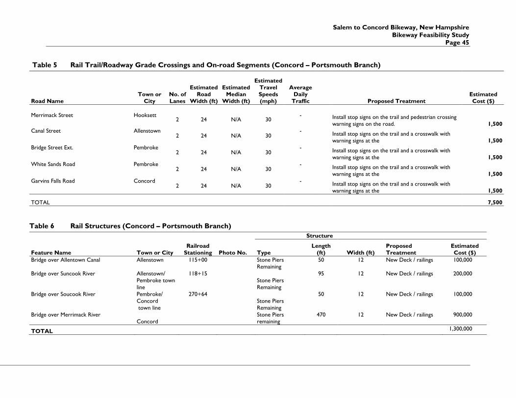
Table 5 Rail Trail/Roadway Grade Crossings and On-road Segments (Concord – Portsmouth Branch)
Road Name Town or
City No. of Lanes
Estimated Road
Width (ft)
Estimated Median
Width (ft)
Estimated Travel Speeds (mph)
Average Daily
Traffic Proposed Treatment Estimated Cost ($)
Merrimack Street Hooksett
2 24 N/A 30 -
Install stop signs on the trail and pedestrian crossing warning signs on the road. 1,500
Canal Street Allenstown 2 24 N/A 30
-
Install stop signs on the trail and a crosswalk with warning signs at the 1,500
Bridge Street Ext. Pembroke 2 24 N/A 30
-
Install stop signs on the trail and a crosswalk with warning signs at the 1,500
White Sands Road Pembroke 2 24 N/A 30
-
Install stop signs on the trail and a crosswalk with warning signs at the 1,500
Garvins Falls Road Concord 2 24 N/A 30
-
Install stop signs on the trail and a crosswalk with warning signs at the 1,500
TOTAL 7,500
Table 6 Rail Structures (Concord – Portsmouth Branch) Structure
Feature Name Town or City Railroad
Stationing Photo No. Type Length
(ft) Width (ft) Proposed Treatment
Estimated Cost ($)
Bridge over Allentown Canal Allenstown 115+00 Stone Piers Remaining
50 12 New Deck / railings 100,000
Bridge over Suncook River Allenstown/ Pembroke town line
118+15 Stone Piers Remaining
95 12 New Deck / railings 200,000
Bridge over Soucook River Pembroke/ Concord town line
270+64 Stone Piers Remaining
50 12 New Deck / railings 100,000
Bridge over Merrimack River Concord
Stone Piers remaining
470 12 New Deck / railings 900,000
TOTAL 1,300,000
Salem – Concord Bikeway, New Hampshire Bikeway Feasibility Study Page 46
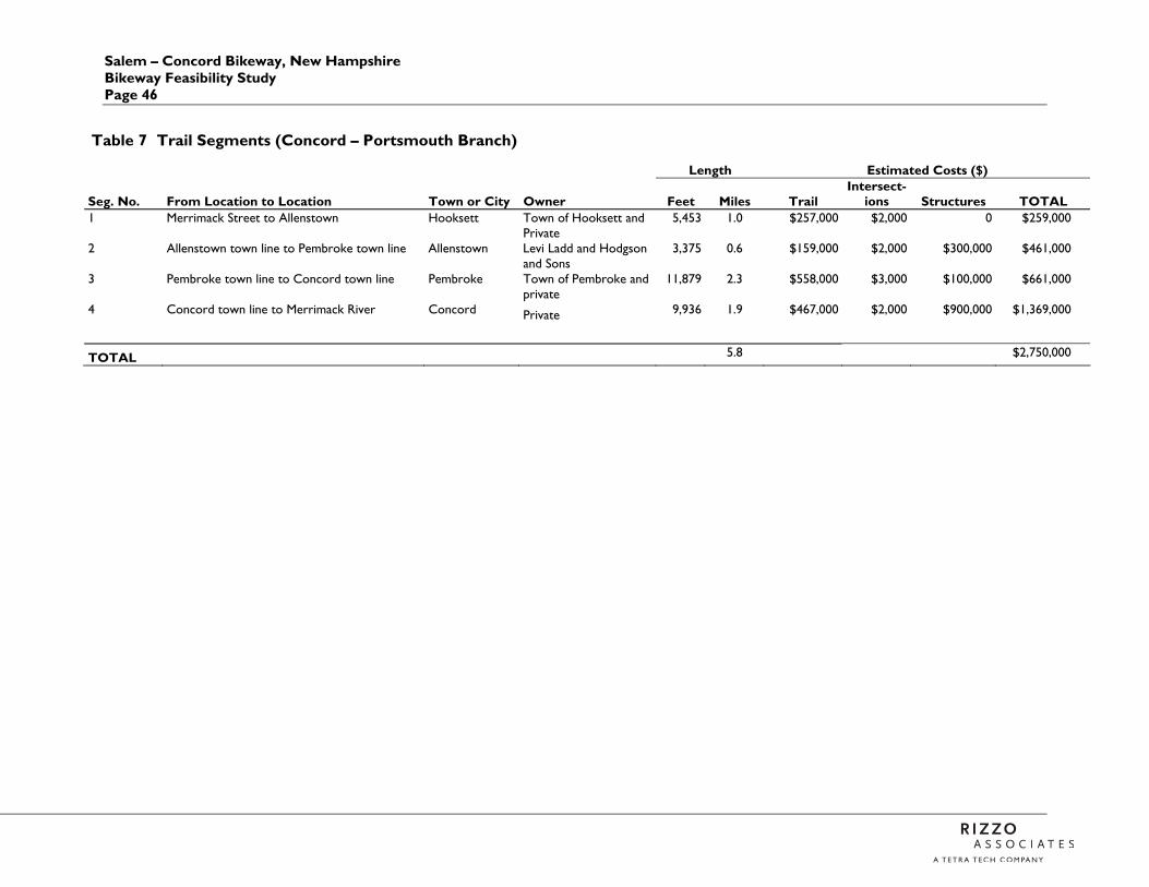
Table 7 Trail Segments (Concord – Portsmouth Branch)
Length Estimated Costs ($)
Seg. No. From Location to Location Town or City Owner Feet Miles Trail Intersect-
ions Structures TOTAL 1 Merrimack Street to Allenstown Hooksett Town of Hooksett and
Private 5,453 1.0 $257,000 $2,000 0 $259,000
2 Allenstown town line to Pembroke town line Allenstown Levi Ladd and Hodgson and Sons
3,375 0.6 $159,000 $2,000 $300,000 $461,000
3 Pembroke town line to Concord town line Pembroke Town of Pembroke and private
11,879 2.3 $558,000 $3,000 $100,000 $661,000
4 Concord town line to Merrimack River Concord Private 9,936 1.9 $467,000 $2,000 $900,000 $1,369,000
TOTAL 5.8 $2,750,000
Salem to Concord, New Hampshire Bikeway Feasibility Study
Page 47
4.4 New Hampshire Heritage Trail Segments
The New Hampshire Heritage Trail is a proposed 230 mile trail traversing the length of the state from Massachusetts to Canada. It would connect diverse landscapes and communities. A preliminary corridor has been chosen running north from Massachusetts along the Merrimack River to Franklin where it joins the Pemigewasset River and goes through Franconia Notch to Lancaster, then follows the Connecticut River to Canada. Hiking is envisioned throughout the trail with other uses including bicycling at the option of each community. Communities design, build and maintain local Heritage Trail segments. Overall trail development is guided by the statewide Heritage Trail Advisory Committee in cooperation with the NH Department of Resources and Economic Development.2
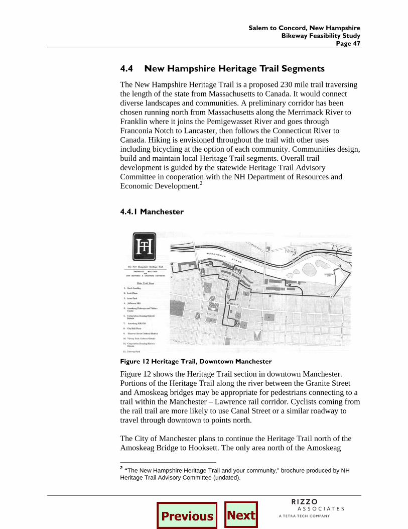
4.4.1 Manchester
Figure 12 Heritage Trail, Downtown Manchester
Figure 12 shows the Heritage Trail section in downtown Manchester. Portions of the Heritage Trail along the river between the Granite Street and Amoskeag bridges may be appropriate for pedestrians connecting to a trail within the Manchester – Lawrence rail corridor. Cyclists coming from the rail trail are more likely to use Canal Street or a similar roadway to travel through downtown to points north. The City of Manchester plans to continue the Heritage Trail north of the Amoskeag Bridge to Hooksett. The only area north of the Amoskeag
2 “The New Hampshire Heritage Trail and your community,” brochure produced by NH Heritage Trail Advisory Committee (undated).
Salem to Concord, New Hampshire Bikeway Feasibility Study Page 48
Bridge owned by the City is at Stark Park. The State of New Hampshire Health and Human Services Department has a memorandum of understanding with the City for trail use at the Youth Development Center. Further north, the City has a license agreement with Derryfield School and an encroachment agreement with NHDOT for property under Interstate 93. The City does not have any agreements for portions of the trail between the Amoskeag Bridge and Stark Park.3
4.4.2. Hooksett
The Hooksett portion of the Heritage Trail is currently being developed by the Hooksett Heritage Trail Committee. A preliminary route has been identified (see Figure 13) and the committee, with assistance from the town, is in the process of acquiring property easements along the proposed route. The following describes the current route of the Hooksett Heritage Trail and possible connections to the on-road segments of the proposed bikeway in Manchester and to the southerly endpoint of the Concord-Portsmouth Railroad. The proposed rail-trail option would join the Hooksett Heritage Trail at the bend on Depot Road, located approximately 700 feet north of the Manchester/Hooksett town line. The trail leaves Depot Road and continues through undeveloped land for a distance of 3 miles where is intersects Dale Road. The trail travels along Dale Road (0.7 miles) to the northerly endpoint of Dale Road and then turns west towards the active rail corridor along undeveloped land. The trail follows the easterly layout line of the rail corridor for approximately one half mile where it crosses the Merrimack River on the Lilac Bridge. At this point the Heritage Trail provides an option of remaining on the east side of the river and proceeding onto Merrimack Street. It is suggested that the Merrimack Street option be utilized in order to provide access the to the southerly end point of the Concord-Portsmouth Railroad corridor located approximately 0.8 miles north of the Merrimack Street/Main Street intersection.
3 E-mail from Ronald Johnson, Manchester Department of Parks, Recreation and Cemeteries, February 24, 2003.
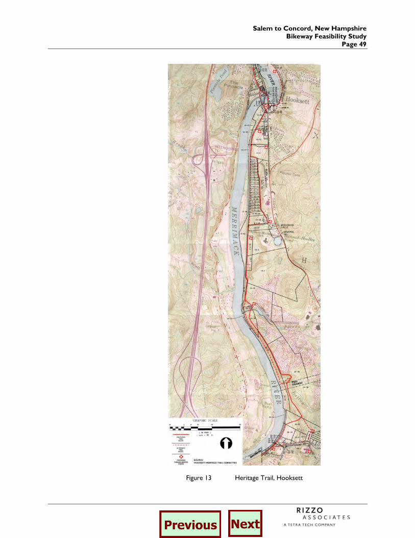
Salem to Concord, New Hampshire Bikeway Feasibility Study
Page 49
Figure 13 Heritage Trail, Hooksett
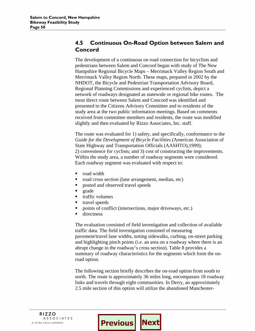
Salem to Concord, New Hampshire Bikeway Feasibility Study Page 50
4.5 Continuous On-Road Option between Salem and Concord
The development of a continuous on road connection for bicyclists and pedestrians between Salem and Concord began with study of The New Hampshire Regional Bicycle Maps – Merrimack Valley Region South and Merrimack Valley Region North. These maps, prepared in 2002 by the NHDOT, the Bicycle and Pedestrian Transportation Advisory Board, Regional Planning Commissions and experienced cyclists, depict a network of roadways designated as statewide or regional bike routes. The most direct route between Salem and Concord was identified and presented to the Citizens Advisory Committee and to residents of the study area at the two public information meetings. Based on comments received from committee members and residents, the route was modified slightly and then evaluated by Rizzo Associates, Inc. staff.
The route was evaluated for 1) safety, and specifically, conformance to the Guide for the Development of Bicycle Facilities (American Association of State Highway and Transportation Officials (AASHTO),1999); 2) convenience for cyclists; and 3) cost of constructing the improvements. Within the study area, a number of roadway segments were considered. Each roadway segment was evaluated with respect to:
road width road cross section (lane arrangement, median, etc) posted and observed travel speeds grade traffic volumes travel speeds points of conflict (intersections, major driveways, etc.) directness
The evaluation consisted of field investigation and collection of available traffic data. The field investigation consisted of measuring pavement/travel lane widths, noting sidewalks, curbing, on-street parking and highlighting pinch points (i.e. an area on a roadway where there is an abrupt change in the roadway’s cross section). Table 8 provides a summary of roadway characteristics for the segments which form the on-road option. The following section briefly describes the on-road option from south to north. The route is approximately 36 miles long, encompasses 18 roadway links and travels through eight communities. In Derry, an approximately 2.5 mile section of this option will utilize the abandoned Manchester-
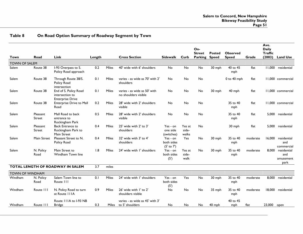
Salem to Concord, New Hampshire Bikeway Feasibility Study
Page 51
Table 8 On Road Option Summary of Roadway Segment by Town
Town Road Link Length Cross Section Sidewalk Curb
On-Street Parking
Posted Speed
Observed Speed Grade
Ave. Daily Traffic (2003) Land Use
TOWN OF SALEM Salem Route 38 I-93 Overpass to S.
Policy Road approach 0.2 Miles 40' wide with 6' shoulders No No No 30 mph 40 to 45
mph flat 11,000 residential
Salem Route 38 Through Route 38/S. Policy Road intersection
0.1 Miles varies - as wide as 70' with 2' shoulders
No No No 0 to 40 mph flat 11,000 commercial
Salem Route 38 End of S. Policy Road intersection to Enterprise Drive
0.1 Miles varies - as wide as 50' with no shoulders visible
No No No 30 mph 40 mph flat 11,000 commercial
Salem Route 38 Enterprise Drive to Mall Road
0.2 Miles 28' wide with 2' shoulders visible
No No No 35 to 40 mph
flat 11,000 commercial
Salem Pleasant Street
Mall Road to back entrance to Rockingham Park
0.5 Miles 28' wide with 2' shoulders visible
No No No 35 to 40 mph
flat 5,000 residential
Salem Pleasant Street
Back Entrance to Rockingham Park to Main Street
0.4 Miles 25' wide with 2' to 3' shoulders
Yes - on one side
(switches)
Yes at side-walks
No 30 mph flat 5,000 residential
Salem Main Street Pleasant Street to N. Policy Road
0.4 Miles 32' wide with 3' to 4' shoulders
Yes - on both sides (5' to 7')
Yes No 30 mph 35 to 40 mph
moderate 16,000 residential and
commercial Salem N. Policy
Road Main Street to Windham Town line
1.8 Miles 24' wide with 1' shoulders Yes - on both sides
(5')
Yes at side-walk
No 30 mph 35 to 40 mph
moderate 8,000 residential and
amusement park
TOTAL LENGTH OF ROADWAY IN SALEM 3.7 miles
TOWN OF WINDHAM Windham N. Policy
Road Salem Town line to Route 111
0.1 Miles 24' wide with 1' shoulders Yes - on both sides
(5')
Yes No 30 mph 35 to 40 mph
moderate 8,000 residential
Windham Route 111 N. Policy Road to turn at Route 111A
0.9 Miles 26' wide with 1' to 2' shoulders visible
No No No 35 mph 35 to 40 mph
moderate 18,000 residential
Windham Route 111 Route 111A to I-93 NB Bridge 0.3 Miles
varies - as wide as 45' with 3' to 5' shoulders No No No 40 mph
40 to 45 mph flat 23,000 open

Salem to Concord, New Hampshire Bikeway Feasibility Study Page 52
Town Road Link Length Cross Section Sidewalk Curb
On-Street Parking
Posted Speed
Observed Speed Grade
Ave. Daily Traffic (2003) Land Use
Windham Route 111
I-93 NB Bridge to beginning of Commons Area 1.3 Miles 42' with 5' to 7' shoulders No No No 40 mph
40 to 45 mph moderate 23,000 retail
Windham Route 111 Beginning of Commons Area to Church Street 0.3 Miles
varies - as wide as 58' with no shoulders No No No 40 mph
40 to 45 mph moderate 23,000 retail
Windham Route 111 Church Street to N. Lowell Street 0.2 Miles 44' wide with 6' shoulders No No No 40 mph moderate 23,000 residential
Windham N. Lowell Street
Route 111 to junction with rail line 2.8 Miles 25' wide with 1' to 2' shoulders No No No 35 mph
35 to 40 mph moderate 5,000
wooded/ residential
TOTAL LENGTH OF ROADWAY IN WINDHAM 5.9 miles
TOWN OF DERRY
Derry Rollins Street
Begin at RR and Hood Park to Maple Street 0.1 Miles
24' wide travel way with 0'-2' shoulders no No No 30 mph 30 mph moderate 2,100 mix-urban
Derry Maple Street Rollins Street to Ash Street 0.1 Miles
22'-24' wide with no shoulders no No No 30 mph 30 mph steep 2,000 mix-urban
Derry Ash Street
Maple Street to Town Line (includes Ash Street Ext) 0.8 Miles
24' wide travel way with 0-2' shoulders no No No 35 mph
35 to 40 mph moderate 6,700 residential
TOTAL LENGTH OF ROADWAY IN DERRY 1.0 miles
TOWN OF LONDONDERRY
Londonderry Ash St
Londonderry/Derry town line to Pillsbury Street 1.3 Miles 22'-24' wide with 0' shoulders No No No 35 mph
30 to 45 mph moderate 6,100
commercial and residential
Londonderry Pillsbury St Ash Street to Route 128 1.4 Miles 22'-24' wide with 0' shoulders No No No
30 to 45 mph steep 6,000
commercial and residential
Londonderry Route 128 Pillsbury Street to Route 28 3.2 Miles
varies - as wide as 28' with 0' to 10' shoulders No No No
25 mph - 50 mph
20 to 60 mph steep 11,000 commercial

Salem to Concord, New Hampshire Bikeway Feasibility Study
Page 53
Town Road Link Length Cross Section Sidewalk Curb
On-Street Parking
Posted Speed
Observed Speed Grade
Ave. Daily Traffic (2003) Land Use
London- derry
Mammoth Rd
Route 28 to Manchester/Londonderry town line
1.5 Miles varies - as wide as 60' with 0' to 4' shoulders
No No No 40 mph 40 to 50 mph
flat 15,100 commercial
TOTAL LENGTH OF ROADWAY IN LONDONDERRY
7.4 Miles
CITY OF MANCHESTER
Manchester Mammoth Rd
Town Line to I-293 1.7 Miles varies - wide travel way with 2' shoulders
No No No 35 mph 35 to 40 mph
moderate 10,000 residential
Manchester Mammoth Rd
I-293 to Huse Road 0.8 Miles 24' travel way with 0-2' shoulders
Yes Yes No 35 mph 35 mph moderate 11,000 residential/ urban
Manchester Mammoth Rd
Huse Road to Bridge Street
1.7 Miles Variable width, turn lanes, 0-2' shoulder, traffic signals
Yes Yes No 30 mph 30 to 35 mph
moderate 17,000 urban/mix
Manchester Mammoth Rd
Bridge Street to town line
1.6 Miles Variable width, wide travel way, 0-8' shoulder
Yes Yes No 30 mph 35 to 40 mph
moderate/ steep
13,000 residential
TOTAL LENGTH OF ROADWAY IN MANCHESTER
5.8 Miles
TOWN OF HOOKSETT Hooksett Route 28A/
Route 28 Hooksett/Manchester town line to Main Street
4.3 Miles varies - as wide as 60' with 0' to 5' shoulders
Only near the Man-chester line
Yes -at side-walks
No 35 mph - 45 mph
near Man-
chester line
30 to 60 mph
moderate 6,000 to 32,000
commercial
Hooksett Main Street Route 28 to Pine Street
0.8 Miles 25' wide with 0' to 2' shoulders
Yes - on bridge over the river
Yes No 30 mph - 20 mph
at school
30 mph moderate 6,300 residential
Hooksett Pine Street Main Street to town line
0.9 Miles 25' wide with 0' to 2' shoulders
No No No 30 mph 30 mph moderate 2,200 residential
TOTAL LENGTH OF ROADWAY IN HOOKSETT
6.0 Miles

Salem to Concord, New Hampshire Bikeway Feasibility Study Page 54
Town Road Link Length Cross Section Sidewalk Curb
On-Street Parking
Posted Speed
Observed Speed Grade
Ave. Daily Traffic (2003) Land Use
TOWN OF BOW
Bow Bow Bog Rd Bow/Hooksett town line to Bow Center Road
3.4 Miles 27' wide with 0' to 3' shoulders
No No No 30 mph 35 to 40 mph
moderate 2,200 residential
Bow Bow Center Rd
Bow Bog Road to Logging Hill Road
1.8 Miles 30' wide with 2' to 8' shoulders
No No No 35 mph - 25 mph
at school
35 to 45 mph
moderate residential
Bow Logging Hill Rd
Bow Center Road to I89
1.3 Miles 30' wide with 2' to 4' shoulders
No No Yes 35 mph 45 mph steep 7,300 residential
Bow South St I-89 to Bow/Concord town line
0.2 Miles 20'-22' wide with 1' shoulders
No No No 30 mph 0 to 40 mph
moderate 8,100 commercial
TOTAL LENGTH OF ROADWAY IN BOW 6.7 miles
CITY OF CONCORD Concord South St Bow/Concord town
line to Iron Works Road
0.9 Miles 24' wide with 1' to 2' shoulders
Yes - east side only
Yes -at side-walks
No 30 mph 40 mph flat 4,700 residential
TOTAL LENGTH OF ROADWAY IN CONCORD
0.9 miles
TOTAL LENGTH OF ON-ROAD OPTION 35.8 miles
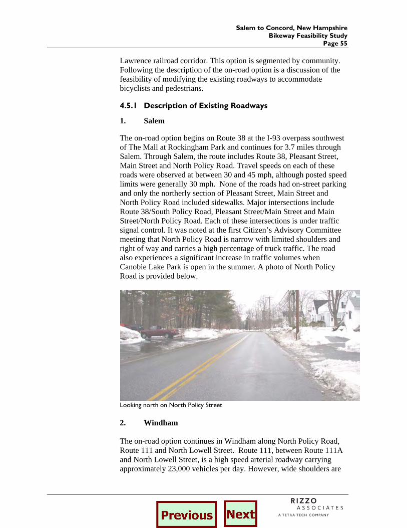
Salem to Concord, New Hampshire Bikeway Feasibility Study
Page 55
Lawrence railroad corridor. This option is segmented by community. Following the description of the on-road option is a discussion of the feasibility of modifying the existing roadways to accommodate bicyclists and pedestrians.
4.5.1 Description of Existing Roadways
1. Salem
The on-road option begins on Route 38 at the I-93 overpass southwest of The Mall at Rockingham Park and continues for 3.7 miles through Salem. Through Salem, the route includes Route 38, Pleasant Street, Main Street and North Policy Road. Travel speeds on each of these roads were observed at between 30 and 45 mph, although posted speed limits were generally 30 mph. None of the roads had on-street parking and only the northerly section of Pleasant Street, Main Street and North Policy Road included sidewalks. Major intersections include Route 38/South Policy Road, Pleasant Street/Main Street and Main Street/North Policy Road. Each of these intersections is under traffic signal control. It was noted at the first Citizen’s Advisory Committee meeting that North Policy Road is narrow with limited shoulders and right of way and carries a high percentage of truck traffic. The road also experiences a significant increase in traffic volumes when Canobie Lake Park is open in the summer. A photo of North Policy Road is provided below.
Looking north on North Policy Street 2. Windham The on-road option continues in Windham along North Policy Road, Route 111 and North Lowell Street. Route 111, between Route 111A and North Lowell Street, is a high speed arterial roadway carrying approximately 23,000 vehicles per day. However, wide shoulders are
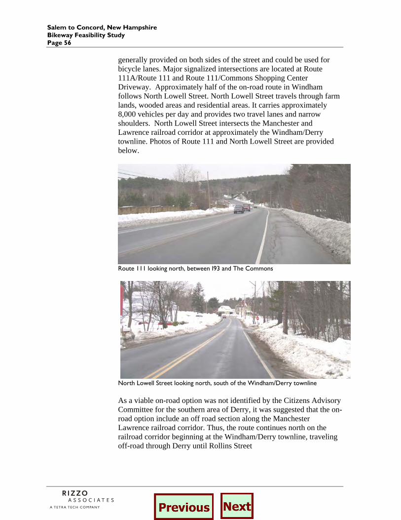
Salem to Concord, New Hampshire Bikeway Feasibility Study Page 56
generally provided on both sides of the street and could be used for bicycle lanes. Major signalized intersections are located at Route 111A/Route 111 and Route 111/Commons Shopping Center Driveway. Approximately half of the on-road route in Windham follows North Lowell Street. North Lowell Street travels through farm lands, wooded areas and residential areas. It carries approximately 8,000 vehicles per day and provides two travel lanes and narrow shoulders. North Lowell Street intersects the Manchester and Lawrence railroad corridor at approximately the Windham/Derry townline. Photos of Route 111 and North Lowell Street are provided below.
Route 111 looking north, between I93 and The Commons
North Lowell Street looking north, south of the Windham/Derry townline As a viable on-road option was not identified by the Citizens Advisory Committee for the southern area of Derry, it was suggested that the on-road option include an off road section along the Manchester Lawrence railroad corridor. Thus, the route continues north on the railroad corridor beginning at the Windham/Derry townline, traveling off-road through Derry until Rollins Street
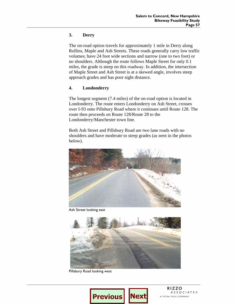
Salem to Concord, New Hampshire Bikeway Feasibility Study
Page 57
3. Derry The on-road option travels for approximately 1 mile in Derry along Rollins, Maple and Ash Streets. These roads generally carry low traffic volumes; have 24 foot wide sections and narrow (one to two foot) or no shoulders. Although the route follows Maple Street for only 0.1 miles, the grade is steep on this roadway. In addition, the intersection of Maple Street and Ash Street is at a skewed angle, involves steep approach grades and has poor sight distance. 4. Londonderry The longest segment (7.4 miles) of the on-road option is located in Londonderry. The route enters Londonderry on Ash Street, crosses over I-93 onto Pillsbury Road where it continues until Route 128. The route then proceeds on Route 128/Route 28 to the Londonderry/Manchester town line. Both Ash Street and Pillsbury Road are two lane roads with no shoulders and have moderate to steep grades (as seen in the photos below).
Ash Street looking east
Pillsbury Road looking west
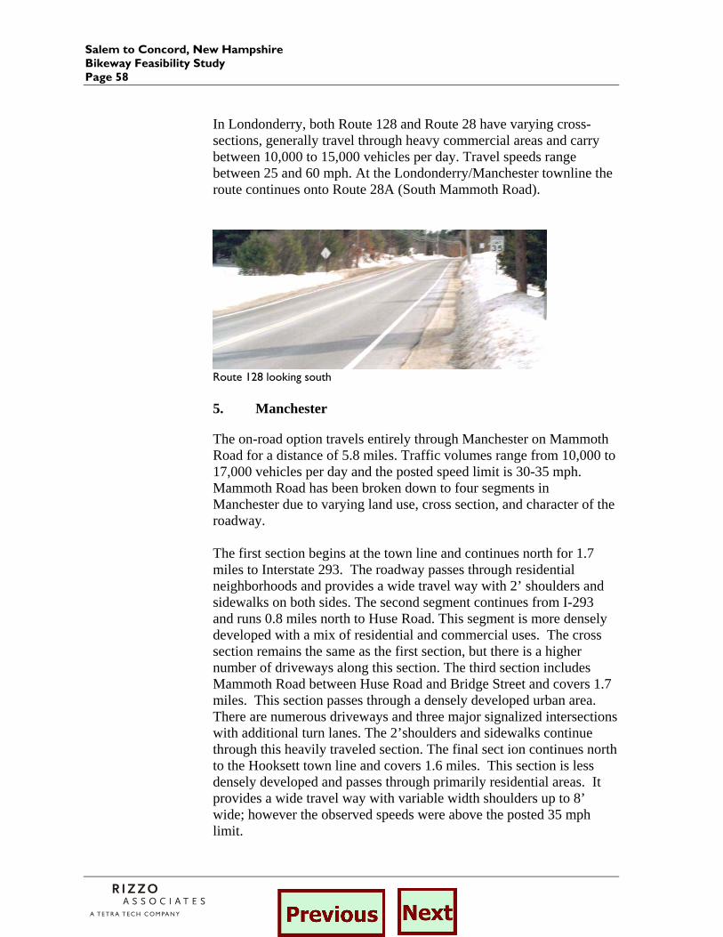
Salem to Concord, New Hampshire Bikeway Feasibility Study Page 58
In Londonderry, both Route 128 and Route 28 have varying cross-sections, generally travel through heavy commercial areas and carry between 10,000 to 15,000 vehicles per day. Travel speeds range between 25 and 60 mph. At the Londonderry/Manchester townline the route continues onto Route 28A (South Mammoth Road).
Route 128 looking south 5. Manchester
The on-road option travels entirely through Manchester on Mammoth Road for a distance of 5.8 miles. Traffic volumes range from 10,000 to 17,000 vehicles per day and the posted speed limit is 30-35 mph. Mammoth Road has been broken down to four segments in Manchester due to varying land use, cross section, and character of the roadway. The first section begins at the town line and continues north for 1.7 miles to Interstate 293. The roadway passes through residential neighborhoods and provides a wide travel way with 2’ shoulders and sidewalks on both sides. The second segment continues from I-293 and runs 0.8 miles north to Huse Road. This segment is more densely developed with a mix of residential and commercial uses. The cross section remains the same as the first section, but there is a higher number of driveways along this section. The third section includes Mammoth Road between Huse Road and Bridge Street and covers 1.7 miles. This section passes through a densely developed urban area. There are numerous driveways and three major signalized intersections with additional turn lanes. The 2’shoulders and sidewalks continue through this heavily traveled section. The final sect ion continues north to the Hooksett town line and covers 1.6 miles. This section is less densely developed and passes through primarily residential areas. It provides a wide travel way with variable width shoulders up to 8’ wide; however the observed speeds were above the posted 35 mph limit.

Salem to Concord, New Hampshire Bikeway Feasibility Study
Page 59
Mammoth Road between I-293 and Huse Road
Mammoth Road between Huse Road and Bridge Street
Mammoth Road between Bridge Street and the Hooksett town line 6. Hooksett Through Hooksett, the on-road option travels along Route 28A (Mammoth Road), Martins Ferry Road, Route 28 Bypass, Route 28, Main Street and Pine Street. The southerly portion of Route
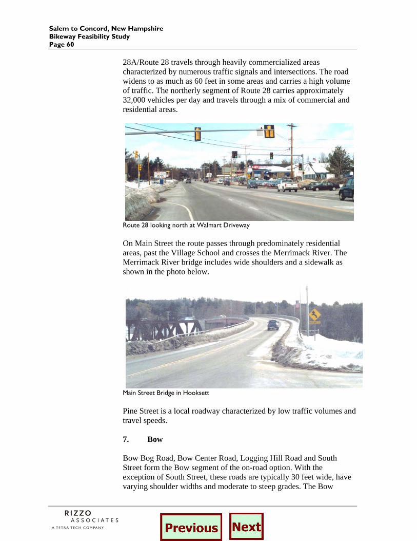
Salem to Concord, New Hampshire Bikeway Feasibility Study Page 60
28A/Route 28 travels through heavily commercialized areas characterized by numerous traffic signals and intersections. The road widens to as much as 60 feet in some areas and carries a high volume of traffic. The northerly segment of Route 28 carries approximately 32,000 vehicles per day and travels through a mix of commercial and residential areas.
Route 28 looking north at Walmart Driveway On Main Street the route passes through predominately residential areas, past the Village School and crosses the Merrimack River. The Merrimack River bridge includes wide shoulders and a sidewalk as shown in the photo below.
Main Street Bridge in Hooksett Pine Street is a local roadway characterized by low traffic volumes and travel speeds. 7. Bow Bow Bog Road, Bow Center Road, Logging Hill Road and South Street form the Bow segment of the on-road option. With the exception of South Street, these roads are typically 30 feet wide, have varying shoulder widths and moderate to steep grades. The Bow
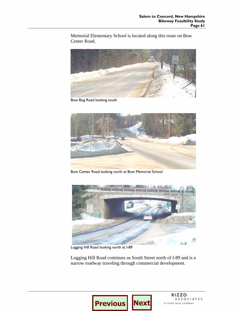
Salem to Concord, New Hampshire Bikeway Feasibility Study
Page 61
Memorial Elementary School is located along this route on Bow Center Road.
Bow Bog Road looking south
Bow Center Road looking north at Bow Memorial School
Logging Hill Road looking north at I-89 Logging Hill Road continues as South Street north of I-89 and is a narrow roadway traveling through commercial development.
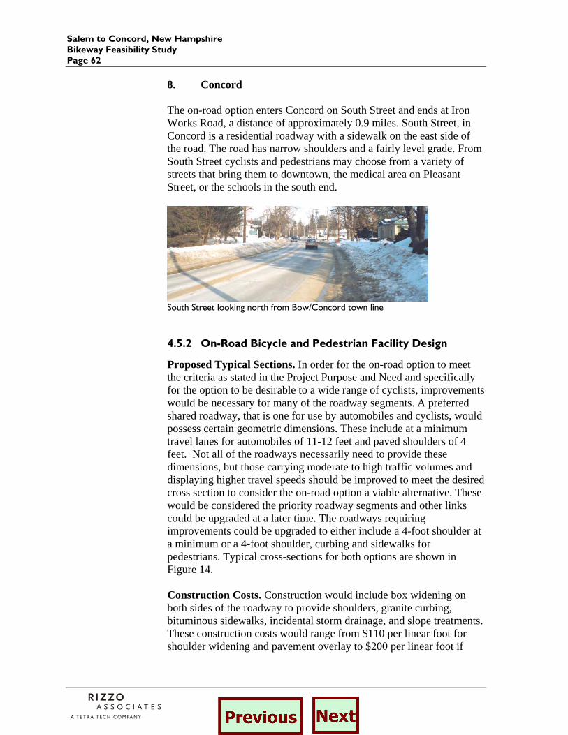
Salem to Concord, New Hampshire Bikeway Feasibility Study Page 62
8. Concord The on-road option enters Concord on South Street and ends at Iron Works Road, a distance of approximately 0.9 miles. South Street, in Concord is a residential roadway with a sidewalk on the east side of the road. The road has narrow shoulders and a fairly level grade. From South Street cyclists and pedestrians may choose from a variety of streets that bring them to downtown, the medical area on Pleasant Street, or the schools in the south end.
South Street looking north from Bow/Concord town line
4.5.2 On-Road Bicycle and Pedestrian Facility Design
Proposed Typical Sections. In order for the on-road option to meet the criteria as stated in the Project Purpose and Need and specifically for the option to be desirable to a wide range of cyclists, improvements would be necessary for many of the roadway segments. A preferred shared roadway, that is one for use by automobiles and cyclists, would possess certain geometric dimensions. These include at a minimum travel lanes for automobiles of 11-12 feet and paved shoulders of 4 feet. Not all of the roadways necessarily need to provide these dimensions, but those carrying moderate to high traffic volumes and displaying higher travel speeds should be improved to meet the desired cross section to consider the on-road option a viable alternative. These would be considered the priority roadway segments and other links could be upgraded at a later time. The roadways requiring improvements could be upgraded to either include a 4-foot shoulder at a minimum or a 4-foot shoulder, curbing and sidewalks for pedestrians. Typical cross-sections for both options are shown in Figure 14. Construction Costs. Construction would include box widening on both sides of the roadway to provide shoulders, granite curbing, bituminous sidewalks, incidental storm drainage, and slope treatments. These construction costs would range from $110 per linear foot for shoulder widening and pavement overlay to $200 per linear foot if
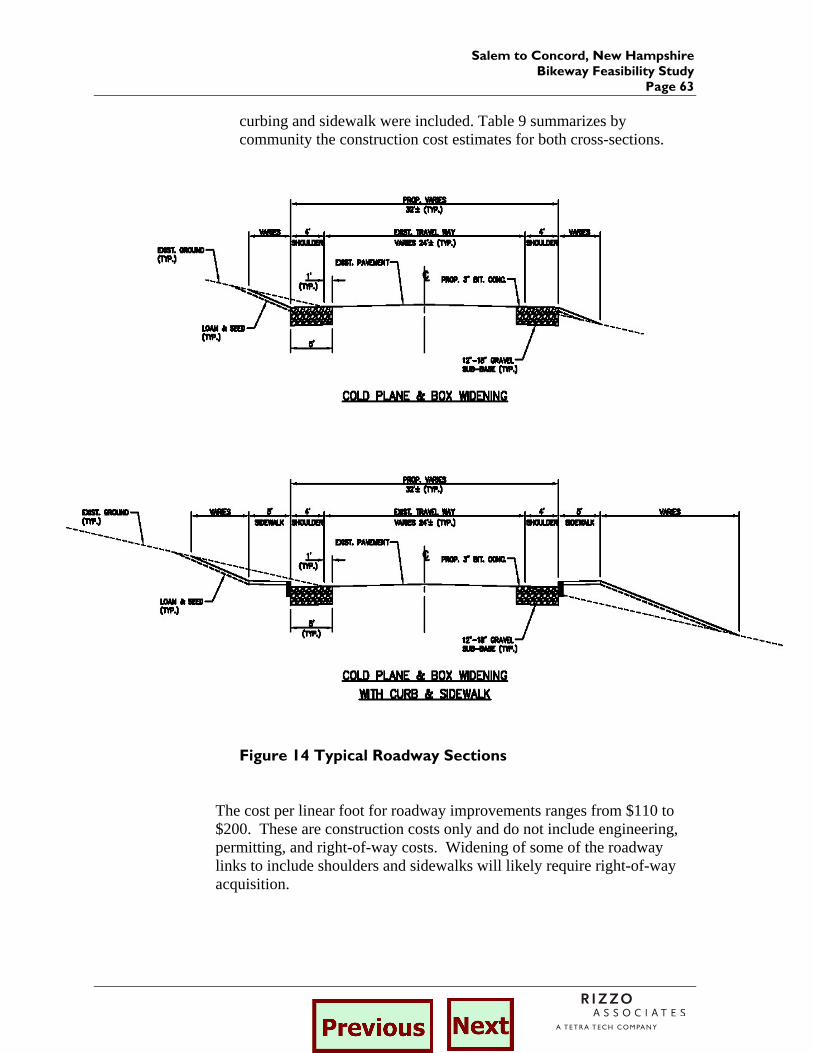
Salem to Concord, New Hampshire Bikeway Feasibility Study
Page 63
curbing and sidewalk were included. Table 9 summarizes by community the construction cost estimates for both cross-sections.
Figure 14 Typical Roadway Sections
The cost per linear foot for roadway improvements ranges from $110 to $200. These are construction costs only and do not include engineering, permitting, and right-of-way costs. Widening of some of the roadway links to include shoulders and sidewalks will likely require right-of-way acquisition.
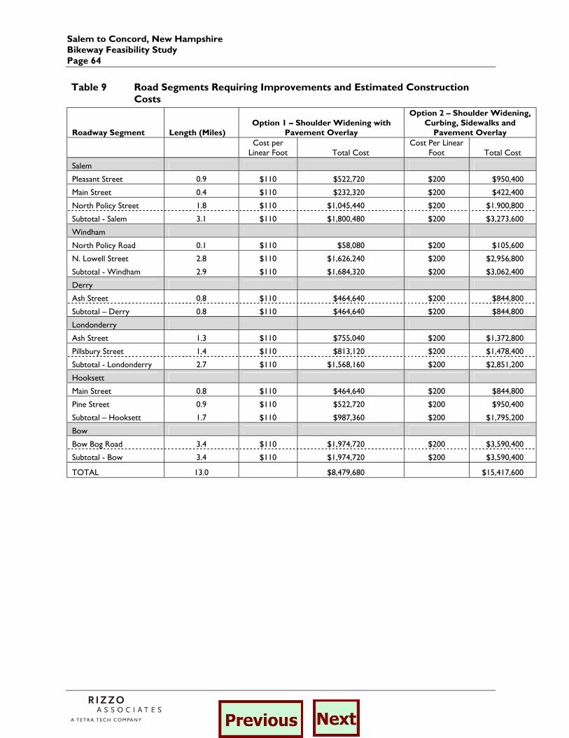
Salem to Concord, New Hampshire Bikeway Feasibility Study Page 64
Table 9 Road Segments Requiring Improvements and Estimated Construction Costs
Roadway Segment Length (Miles) Option 1 – Shoulder Widening with
Pavement Overlay
Option 2 – Shoulder Widening, Curbing, Sidewalks and
Pavement Overlay
Cost per
Linear Foot Total Cost Cost Per Linear
Foot Total Cost
Salem
Pleasant Street 0.9 $110 $522,720 $200 $950,400
Main Street 0.4 $110 $232,320 $200 $422,400
North Policy Street 1.8 $110 $1,045,440 $200 $1.900,800
Subtotal - Salem 3.1 $110 $1,800,480 $200 $3,273,600
Windham
North Policy Road 0.1 $110 $58,080 $200 $105,600
N. Lowell Street 2.8 $110 $1,626,240 $200 $2,956,800
Subtotal - Windham 2.9 $110 $1,684,320 $200 $3,062,400
Derry
Ash Street 0.8 $110 $464,640 $200 $844,800
Subtotal – Derry 0.8 $110 $464,640 $200 $844,800
Londonderry
Ash Street 1.3 $110 $755,040 $200 $1,372,800
Pillsbury Street 1.4 $110 $813,120 $200 $1,478,400
Subtotal - Londonderry 2.7 $110 $1,568,160 $200 $2,851,200
Hooksett
Main Street 0.8 $110 $464,640 $200 $844,800
Pine Street 0.9 $110 $522,720 $200 $950,400
Subtotal – Hooksett 1.7 $110 $987,360 $200 $1,795,200
Bow
Bow Bog Road 3.4 $110 $1,974,720 $200 $3,590,400
Subtotal - Bow 3.4 $110 $1,974,720 $200 $3,590,400
TOTAL 13.0 $8,479,680 $15,417,600

Salem to Concord, New Hampshire Bikeway Feasibility Study
Page 65
4.6 Other On-Road Links/Considered/Suggested
Through field observation and feedback from the Advisory Committee and the public at-large, several alternative roadway links were identified and considered. In addition, the off-road option on abandoned railroads required on-road links to provide a continuous route. Bow. In Bow, it was suggested that Edgewater and River Road be considered in lieu of Bow Bog Road and Bow Center Road. Edgewater Road is signed as no-trespassing, and therefore Johnson Road was considered. The route would continue in to Bow as previously described and enter into Bow on Route 3A for a very short distance to Johnson Road. The option would continue north on Johnson Road for 0.7 miles. The roadway is 24’ wide with little or no shoulders, very low traffic volumes and sparsely developed. Continuing onto River Road for a distance of 2.9 miles and join back onto Route 3A in the northerly end of Bow near Grappone Junction. River Road provides 24’ of pavement with little or no shoulder on a relatively flat grade. Manchester. In Manchester, an on-road option was considered beginning at the northerly end of the Manchester Lawrence Railroad. This on-road link includes Depot Street, Canal Street, and River Road. Depot Street provides wide travel lanes with no shoulder or sidewalks, and carries low traffic volumes. Canal Street parallels Elm Street and passes through the Mill District for a distance of 1.3 miles. It provides a four lane median divided cross section with sidewalk on the east side. It is posted at 30 mph, carries high volumes of traffic and passes through several signalized intersections. The on-road option continues on River Road for a distance of 3.0 miles to the Hooksett town line. The roadway passes through residential areas and is posted at 30 mph. The cross section includes wide travel lanes (28’ +/-) with sidewalks on both sides. Hooksett. This on-road option continues into Hooksett on North River Road. Continuing northerly for a distance of 0.5 miles, the roadway provides two 12’ lanes with little or no shoulder and no sidewalks. It passes through residential neighborhoods and both the Derryfield High School and Southern NH University. From North River Road, the option turns onto Depot Road and continues for 0.2 miles to the Hooksett Heritage Trail network. Depot Road is a narrow single lane roadway providing access to one business. On the northern end of the Heritage trail in Hooksett, an on-road option or link is again required to connect to the abandoned railroad to the north. This option includes Merrimack Street from Main Street to the Hooksett Town Courthouse, a distance of 0.8 miles. Merrimack Street is
Salem to Concord, New Hampshire Bikeway Feasibility Study Page 66
posted at 30 mph, provides two 12 travel lanes with no shoulder. The roadway is posted for no parking, however many homes are located close the edge of pavement and many driveways exist along this section. Pembroke/Concord. The final alternate on-road link is in Pembroke and Concord. This link provides options to continue north from the abandoned rail corridor. White Sands Road intersects the abandoned railroad corridor at the White Sands Conservation Area in Pembroke. The on-road option would begin here and continue on White Sands Road for a very short distance (less than 0.1 miles) to Bow Lane. Bow Lane is residential neighborhood street approximately 20 feet wide. It is posted at 25 mph and carries very low volumes fro a distance of 0.7 miles. Bow Lane Road continues to Route 3. Route 3 provides two travel lanes with 8’ shoulders and sidewalks along a portion of the road. Speeds were observed in excess of the posted 35 mph limit, and traffic volumes are relatively high. Route 3 continues into Concord, where users will have the ability to access the downtown and other points of interest on a variety of roadway links. Another option to connect the abandoned rail in Concord to the roadway network occurs at Garvins Falls Road. Garvins Falls Road is a narrow, steep residential street that runs from the railroad and Merrimack River north to Route 3. Traffic volumes and travel speeds are very low on this roadway link.
Salem to Concord, New Hampshire Bikeway Feasibility Study
Page 67
5.0 Recommended Route
A series of options for a continuous bicycle facility from Salem to Concord were identified and analyzed in the previous chapter. The options fall within three broad categories:
1. Interstate 93 bicycle path 2. Other off-road options 3. On-road options
In addition to each stand alone option, combinations of the three were also evaluated. Each option provided a certain degree of advantages and disadvantages as noted by the CAC and the general public at the public meetings. The following provides a summary of the general advantages and disadvantages of the options. I-93 Bike Path Advantages: – exclusive paved pathway – connections to future park and ride lots – maximum grade of 5 percent Disadvantages: – access/connections to neighborhoods – difficult intersections at interchanges
- proximity to highway - services only a portion of the corridor
Abandoned Railroad Corridors Advantages: – continuous facility from Salem to Concord – appropriate for basic cyclists and pedestrians
– good access to neighborhoods, businesses and recreation
– flat grade of less than 2 percent Disadvantages: – large number of trail/roadway intersections – private ownership, especially north of Manchester
– potential reactivation of rail service in the corridor
On-road Advantages: – direct route along corridor – access to neighborhoods, business, schools, etc – many links are low volume/low speed
Salem to Concord, New Hampshire Bikeway Feasibility Study Page 68
– the network exists today Disadvantages: – only serves advanced cyclists
– major intersections and numerous points of conflict
– cost and impact of widening and sidewalk construction
– many segments are on steep grades The CAC developed a range of evaluation criteria for each of the options or combination of options. The criteria included a measure of achievement of the stated project purpose, design and construction issues, costs, resource impacts, and compatibility with community plans. In the technical analysis and public involvement process, combinations of the options were also considered. One combination alternative would use the two abandoned rail corridors and connect them with an on-road option in Manchester and portions of the proposed Heritage Trail in Hooksett. This combination option, called the “Rail Trail Alternative”, is compared to the I-93 bicycle path alternative and a continuous on-road alternative on the evaluation matrix provided in Table 10 on the following page. The analysis shows that the rail-trail option best meets all of the objectives stated in the project purpose. The on-road option meets some of the objectives, but fails to provide for a wide range of cyclists as it was only deemed an appropriate route for experienced cyclists. The I-93 route provided a route for a wide range of cyclists, but many expressed concern regarding it’s proximity to the Interstate highway, and this option did not continue north of Londonderry. The rail-trail option was also shown to require limited right-of-way to the south of Manchester, and relatively straight forward design. Right-of-way acquisition or easements must be obtained for the abandoned Concord – Portsmouth rail corridor. The rail trail option provided a pathway with flat grades making the option desirable to more cyclists. With a construction cost of nearly $9 million it was the lowest cost option for the entire Salem to Concord route. The on-road option could potentially have right-of-way issues depending upon the constraints to widening for shoulders and sidewalks. The estimated construction costs to upgrade approximately one third of the on-road links is $15.5 million. Right-of-way and impact mitigation would require additional funds. The I-93 option is similar to the rail-trail option in that design and row issues are minimal, however the construction costs for the 13 mile path are $8.4 million.
Salem to Concord, New Hampshire Bikeway Feasibility Study
Page 69
A topic of much debate centered on trail surface and maintenance costs. Discussions on trail surface will continue at the local level within each community. This study was completed under the premise that a paved trail might be a preference. The evaluation of maintenance costs for the options does vary as it relates to community costs. The I-93 bike path, located within the I-93 ROW would be maintained by the State. On-road facilities and the rail-trail options would require local maintenance.
With regard to impacts to natural resources, safety, compatibility with community plans, and universal accessibility, the rail-trail again ranked higher than the two other options. The on-road option was not ranked as high because of the potential limited use to that of experienced cyclists. Although the I-93 option provides what could be the best connection between the proposed park and ride lots, it was not considered as compatible with community plans and was deemed a more utilitarian corridor. Connections and access to and from neighborhoods, recreation, businesses, schools and other facilities such as the park and ride lots was determined to be an important factor and one that could have the greatest effect on the utilization of this facility. The rail-trail option, although within a dedicated right-of-way, is not located in secluded undeveloped areas. In fact, it passes through or adjacent to a wide range of developed areas including residential neighborhoods retail and commercial areas, recreation areas, and schools. The proposed park and ride lots along I-93 are located a short distance from the rail trail and can be readily accessed by on-road links. The proposed park and ride lot at Exit 5 in Londonderry is actually adjacent to the rail corridor.
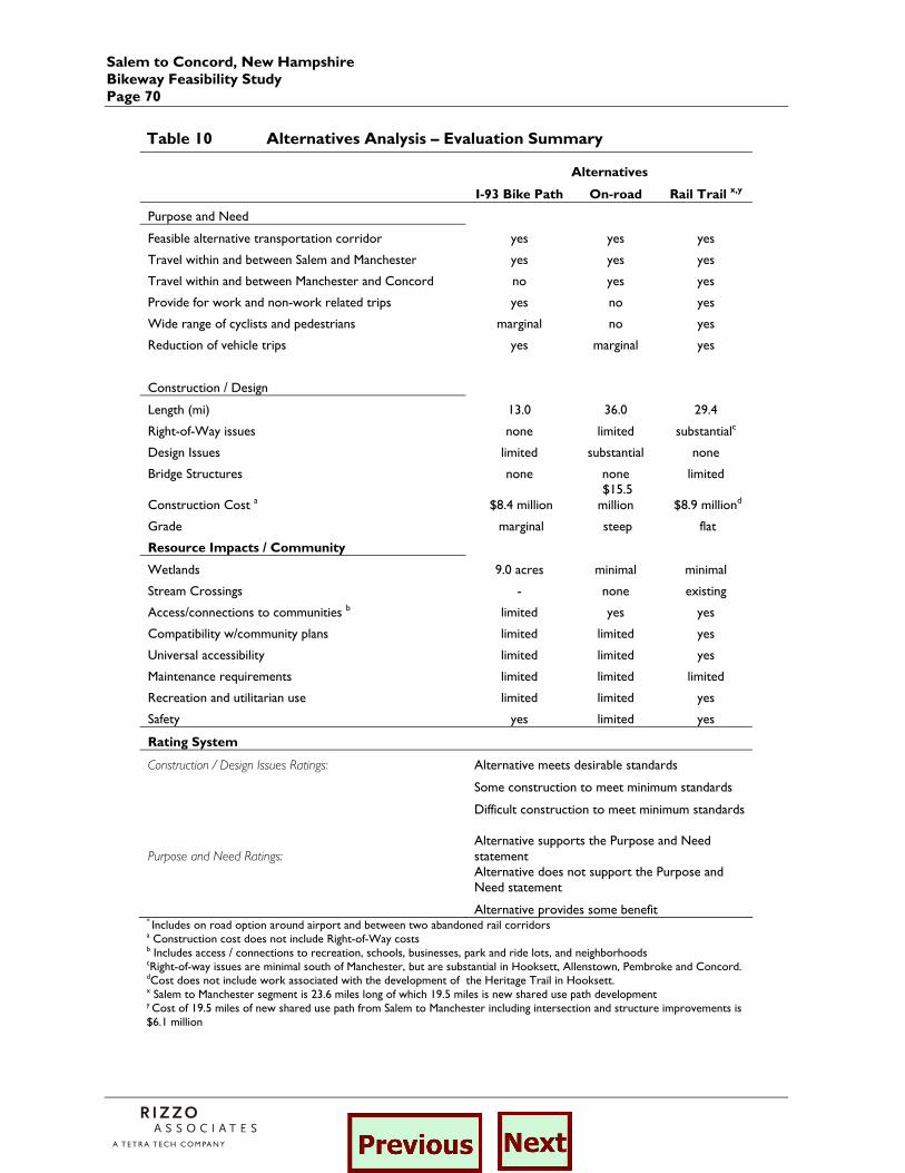
Salem to Concord, New Hampshire Bikeway Feasibility Study Page 70
Table 10 Alternatives Analysis – Evaluation Summary
Alternatives
I-93 Bike Path On-road Rail Trail x,y
Purpose and Need
Feasible alternative transportation corridor yes yes yes
Travel within and between Salem and Manchester yes yes yes
Travel within and between Manchester and Concord no yes yes
Provide for work and non-work related trips yes no yes
Wide range of cyclists and pedestrians marginal no yes
Reduction of vehicle trips yes marginal yes
Construction / Design
Length (mi) 13.0 36.0 29.4
Right-of-Way issues none limited substantialc
Design Issues limited substantial none
Bridge Structures none none limited
Construction Cost a $8.4 million $15.5 million $8.9 milliond
Grade marginal steep flat
Resource Impacts / Community
Wetlands 9.0 acres minimal minimal
Stream Crossings - none existing
Access/connections to communities b limited yes yes
Compatibility w/community plans limited limited yes
Universal accessibility limited limited yes
Maintenance requirements limited limited limited
Recreation and utilitarian use limited limited yes
Safety yes limited yes
Rating System
Construction / Design Issues Ratings: Alternative meets desirable standards
Some construction to meet minimum standards
Difficult construction to meet minimum standards
Purpose and Need Ratings: Alternative supports the Purpose and Need statement
Alternative does not support the Purpose and Need statement
Alternative provides some benefit * Includes on road option around airport and between two abandoned rail corridors a Construction cost does not include Right-of-Way costs b Includes access / connections to recreation, schools, businesses, park and ride lots, and neighborhoods cRight-of-way issues are minimal south of Manchester, but are substantial in Hooksett, Allenstown, Pembroke and Concord. dCost does not include work associated with the development of the Heritage Trail in Hooksett. x Salem to Manchester segment is 23.6 miles long of which 19.5 miles is new shared use path development y Cost of 19.5 miles of new shared use path from Salem to Manchester including intersection and structure improvements is $6.1 million
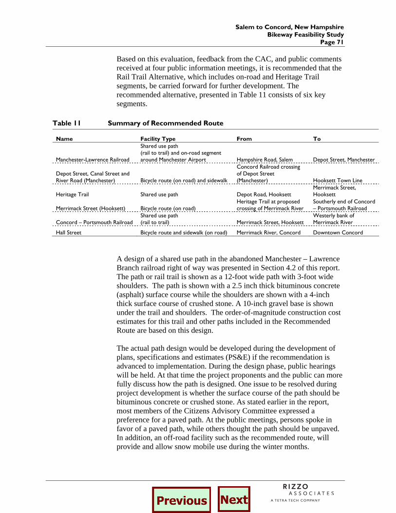
Salem to Concord, New Hampshire Bikeway Feasibility Study
Page 71
Based on this evaluation, feedback from the CAC, and public comments received at four public information meetings, it is recommended that the Rail Trail Alternative, which includes on-road and Heritage Trail segments, be carried forward for further development. The recommended alternative, presented in Table 11 consists of six key segments.
Table 11 Summary of Recommended Route
Name Facility Type From To
Manchester-Lawrence Railroad
Shared use path (rail to trail) and on-road segment around Manchester Airport Hampshire Road, Salem Depot Street, Manchester
Depot Street, Canal Street and River Road (Manchester) Bicycle route (on road) and sidewalk
Concord Railroad crossing of Depot Street (Manchester) Hooksett Town Line
Heritage Trail Shared use path Depot Road, Hooksett Merrimack Street, Hooksett
Merrimack Street (Hooksett) Bicycle route (on road) Heritage Trail at proposed crossing of Merrimack River
Southerly end of Concord – Portsmouth Railroad
Concord – Portsmouth Railroad Shared use path (rail to trail) Merrimack Street, Hooksett
Westerly bank of Merrimack River
Hall Street Bicycle route and sidewalk (on road) Merrimack River, Concord Downtown Concord
A design of a shared use path in the abandoned Manchester – Lawrence Branch railroad right of way was presented in Section 4.2 of this report. The path or rail trail is shown as a 12-foot wide path with 3-foot wide shoulders. The path is shown with a 2.5 inch thick bituminous concrete (asphalt) surface course while the shoulders are shown with a 4-inch thick surface course of crushed stone. A 10-inch gravel base is shown under the trail and shoulders. The order-of-magnitude construction cost estimates for this trail and other paths included in the Recommended Route are based on this design. The actual path design would be developed during the development of plans, specifications and estimates (PS&E) if the recommendation is advanced to implementation. During the design phase, public hearings will be held. At that time the project proponents and the public can more fully discuss how the path is designed. One issue to be resolved during project development is whether the surface course of the path should be bituminous concrete or crushed stone. As stated earlier in the report, most members of the Citizens Advisory Committee expressed a preference for a paved path. At the public meetings, persons spoke in favor of a paved path, while others thought the path should be unpaved. In addition, an off-road facility such as the recommended route, will provide and allow snow mobile use during the winter months.
Salem to Concord, New Hampshire Bikeway Feasibility Study Page 72
A paved path will better serve the design users as defined earlier in the report (bicyclists, wheelchair users and pedestrians, including walkers, runners, and people with baby strollers, etc.). This includes commuters and other utilitarian cyclists who ride touring or road bikes (i.e., bicycles with narrow tires). As the name implies, these bicycles are used by most touring cyclists who ride long distances, stay overnight and contribute to the tourism economy of the state. A crushed stone surface will more likely create a drag on the cycle, making it more difficult to cycle on the path. Commuters and other utilitarian cyclists generally prefer paved trail surfaces for ease of riding. During rainy weather, these cyclists are more likely to get dirty or muddy riding on an unpaved trail. In their Guide for the Development of Bicycle Facilities published in 1999, the American Association of State Highway and Transportation Officials (AASHTO) discusses ways that an unpaved surface affects their design criteria for shared use paths. AASHTO recommends a maximum grade of 5 percent for paved paths. However they state: “grades steeper than 3 percent may not be practical for shared use paths with crushed stone or other unpaved surfaces for both handling and drainage reasons.” AASHTO also states: “Since bicycles have a tendency to skid on unpaved surfaces, horizontal curvature design should take into account lower coefficients of friction.” AASHTO recommends a lower design speed for unpaved paths. Generally, unpaved paths will require substantially more maintenance since the crushed stone surface is subject to rutting and washouts resulting from rainstorms. The less stable surface is less comfortable for young bicyclists, persons in wheelchairs and those pushing baby strollers. The shoulders of the shared use path, which are shown with a crushed stone surface in the example in Section 4.2, might be widened to 4 feet to better accommodate joggers and other non-motorized users who may prefer a giving trail surface.
Salem to Concord, New Hampshire Bikeway Feasibility Study
Page 73
6.0 Project Phasing
The recommended route for the Salem – Concord Bikeway makes use of two former railroad corridors:
1. The Manchester – Lawrence Branch from Salem to Manchester
2. The Concord – Portsmouth Railroad from Hooksett to Concord Due to the length of the project and the lack of public ownership in some segments of the former railroad corridors, bikeway development would need to be phased. In the initial phases, the public would seek to acquire fee simple ownership or easements in those portions of the corridors not now owned by municipalities or the State of New Hampshire. Where there is public ownership, local government support and funding, then segments of the bikeway can proceed into design and construction. A potential sequence for implementing the Salem – Concord Bikeway is as follows: Short term
Salem – The 160-acre Rockingham Race Track property is in the early stages of redevelopment which could include constructing portions of the rail trail. Sections along Route 28 may be constructed in advance of other rail-trail segments.
Manchester – Lawrence Corridor– Investigate possibility of
acquiring an easement or fee simple ownership for segment owned by Delaware Rock (Derry and Londonderry).
Manchester – Lawrence Corridor – Acquire segment owned by
Boston and Maine Railroad (Guilford) between Spicket River and state line in Salem.
Concord – Portsmouth Corridor – Investigate the possibility of
acquiring easements or fee simple ownership for segment between the Hooksett District Court and Concord including the Merrimack River crossing.
Hooksett Heritage Trail – Acquire necessary easements for
segment between North River Road and Merrimack Street.
Salem to Concord, New Hampshire Bikeway Feasibility Study Page 74
Mid term Manchester – Lawrence Corridor – Design and construct rail-to-
trail project between New Hampshire/Massachusetts State line and Depot Street in Manchester.
Long term
Hooksett Heritage Trail – Design and construct Heritage Trail between North River Road and Merrimack Street
Concord – Portsmouth Corridor – Design and construct rail-to-
trail project between the Hooksett District Court and Concord including the Merrimack River crossing.
This feasibility study documents and confirms the feasibility of developing a suggested bicycle and pedestrian facility or route from Salem to Concord. Implementation of the route as described in this chapter requires community involvement and ownership. In order for the project to move beyond the feasibility study, it must be shown to be technically feasible, which has largely been demonstrated herein, environmentally sound, affordable, and supported locally. Communities will have to continue to discuss the project issues and make a series of difficult choices. The NH Department of Transportation will assist the communities interested in moving forward on this important project.

![1 1 STATE OF NEW HAMPSHIRE Concord, New Hampshire 5 6 10 of hearing... · [Public statement hearing - Concord] 1 plan is to run an integrated fiber optic network within 2 their network](https://img.pdfslide.us/doc/110x75/5e45ec0b5271f14e413d66b2/1-1-state-of-new-hampshire-concord-new-hampshire-5-6-10-of-hearing-public.jpg)