Embed Size (px)
Citation preview
SAFETY ELEMENT
DEPARTMENT OF CITY PLANNING LOS ANGELES, CALIFORNIA
i
SAFETY ELEMENTOF THE LOS ANGELESCITY GENERAL PLAN
City Plan Case No. 95-0371Council File No. 86-0662
Relates to Natural Hazards,Not Police MattersReplaces the 1975 Safety,1974 Seismic Safety and 1979Fire Protection & PreventionElements
Approved bythe City Planning CommissionAugust 8, 1996
Adopted bythe City CouncilNovember 26, 1996

ii
iii
CITY OF LOS ANGELESRichard Riordan, Mayor
CITY COUNCIL1st District - Mike Hernandez
2nd District - Joel Wachs3rd District - Laura N. Chick
4th District - John Ferraro5th District - Michael Feuer6th District - Ruth Galanter
7th District - Richard Alarcón8th District - Mark Ridley-Thomas
9th District - Rita Walters10th District - Nate Holden
11th District - Marvin Braude12th District - Hal Bernson
13th District - Jackie Goldberg14th District - Richard Alatorre15th District - Rudy Svorinich
CITY PLANNING COMMISSIONRobert L. Scott, President
Anthony N. R. Zamora, Vice PresidentLes Hamasaki
Marna SchnabelPeter Weil
LOS ANGELES CITY PLANNING DEPARTMENTCon Howe, Director of Planning
Franklin P. Eberhard, Deputy Director, Project PlanningGordon B. Hamilton, Deputy Director, Administration
Robert H. Sutton, Deputy Director, Community Planning
CITYWIDE PLANNING DIVISIONR. Ann Siracusa, AICP, Principal City Planner
SAFETY ELEMENT REVISION STAFFAnne V. Howell, City Planner
GRAPHICS SERVICES SECTIONRey Hernandez, Graphic Designer III
Michael Uhlenkott, Graphic Designer II

iv
v
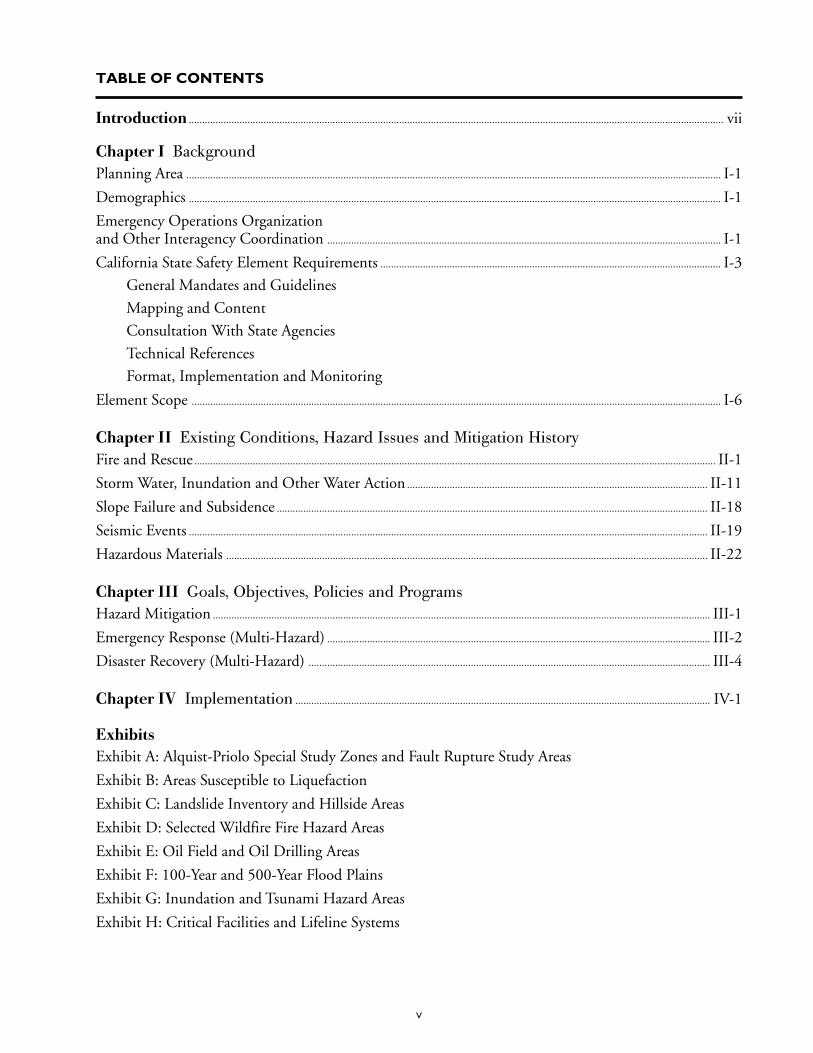
TABLE OF CONTENTS
Introduction ......................................................................................................................................................................................................... vii
Chapter I BackgroundPlanning Area ......................................................................................................................................................................................................... I-1
Demographics ........................................................................................................................................................................................................ I-1
Emergency Operations Organizationand Other Interagency Coordination .................................................................................................................................................... I-1
California State Safety Element Requirements ................................................................................................................................ I-3
General Mandates and Guidelines
Mapping and Content
Consultation With State Agencies
Technical References
Format, Implementation and Monitoring
Element Scope ....................................................................................................................................................................................................... I-6
Chapter II Existing Conditions, Hazard Issues and Mitigation HistoryFire and Rescue .................................................................................................................................................................................................... II-1
Storm Water, Inundation and Other Water Action ................................................................................................................. II-11
Slope Failure and Subsidence .................................................................................................................................................................. II-18
Seismic Events ................................................................................................................................................................................................... II-19
Hazardous Materials ..................................................................................................................................................................................... II-22
Chapter III Goals, Objectives, Policies and ProgramsHazard Mitigation ........................................................................................................................................................................................... III-1
Emergency Response (Multi-Hazard) ................................................................................................................................................ III-2
Disaster Recovery (Multi-Hazard) ....................................................................................................................................................... III-4
Chapter IV Implementation ............................................................................................................................................................ IV-1
ExhibitsExhibit A: Alquist-Priolo Special Study Zones and Fault Rupture Study Areas
Exhibit B: Areas Susceptible to Liquefaction
Exhibit C: Landslide Inventory and Hillside Areas
Exhibit D: Selected Wildfire Fire Hazard Areas
Exhibit E: Oil Field and Oil Drilling Areas
Exhibit F: 100-Year and 500-Year Flood Plains
Exhibit G: Inundation and Tsunami Hazard Areas
Exhibit H: Critical Facilities and Lifeline Systems

vi
vii
1Adopted by the City Council on September 19, 1975, January16, 1979 and September 10, 1974, respectively.
INTRODUCTIONState law since 1975 has required city general plansto include a safety element which addresses the is-sue of protection of its people from unreasonablerisks associated with natural disasters, e.g., fires,floods, earthquakes. It did not intend that a safetyelement address police matters, except in thecontext of natural disasters. In 1984, the Statedeleted the seismic safety element from its list ofmandated general plan elements and incorporatedthe seismic provisions under the safety elementprovisions. The subject Safety Element provides acontextual framework for understanding the rela-tionship between hazard mitigation, response to anatural disaster and initial recovery from a naturaldisaster. It replaces three previously adopted elementsof the City’s General Plan: the Safety Element, FireProtection and Prevention Element, and SeismicSafety Element.1 All three have been revised andcombined into the subject Element. Drainage,water and fire facilities will be addressed in greaterdetail by facilities or infrastructure elements of theGeneral Plan.
An important premise of the Safety Element is thatLos Angeles is a built city that is integrally connectedto its neighbors geographically and by naturaldisasters which recognize no boundaries. Therefore,the Element outlines the historic evolution in LosAngeles of local, state and federal roles, particularlyrelative to mitigation of and response to naturaldisasters. The last section of the Element containsgoals, objectives, policies and broadly stated pro-grams. The programs outlined are programs of theCity Emergency Operations Organization (EOO).The EOO is the City agency (program) whichimplements the Safety Element.
Following the 1994 Northridge and 1995 Kobe,Japan earthquakes a variety of studies and coopera-tive information exchange ventures were initiatedto expand knowledge concerning earthquakes so thatpeople could be better protected in the event offuture significant seismic events. Kobe, Northridgeand other seismic event information is being usedin formulating methodologies for strengtheningbuildings and structures to more successfully with-stand severe damage and to better protect occupantsand equipment during various types and degrees ofseismic events.
The California State Geologist’s Seismic HazardsMapping Program is preparing the State’s officialseismic hazard maps. The maps will identify ampli-fied shaking, liquefaction and landslide hazard zones.Once the maps become available they will be usedin revising the City’s building, zoning and othercodes, plans, standards, procedures and/or develop-ment permit requirements.
Chapters I and III of this Safety Element outlinethe scope of the EOO’s on-going efforts to useexperiences and new information to improvethe City’s hazard program. Chapter II outlines theCity’s historic commitment to improving its pre-vention of controllable disasters, mitigation of im-pacts associated with disasters and response to di-saster events.

viii
I-1
CHAPTER I - BACKGROUND
2The figure is consistant with the estimate used by the SouthernCalifornia Association of Governments.
PLANNING AREAThe Safety Element relates to the entire City of LosAngeles. Within the City’s boundaries are approxi-mately 465 square miles of land area, includingapproximately 214 square miles of hills and moun-tains. The San Gabriel and Santa Susana Mountainsbound the City on the north, the Santa MonicaMountains extend across the middle of the City. ThePalos Verdes Hills and Pacific Ocean are on the southand west. Because flood, fire and seismic events,geologic features and potential hazards relate to eachother and transcend the City’s boundaries, thisElement takes into account other jurisdictions andgovernmental entities.
DEMOGRAPHICSThe 1990 Federal census estimated that the City’spopulation was 3,485,399 individuals. The 1995General Plan “Framework” element estimated thatthe population of Los Angeles City would be in-creased by approximately 820,000 people to4,306,5642 and that employment would be increasedby an estimated 390,000 jobs by the year 2010.
EMERGENCY OPERATIONSORGANIZATION AND OTHERINTERAGENCY COORDINATIONEmergency Operations Organization (EOO).The EOO is the City agency that implements theSafety Element. Therefore, it is the only “program”identified by the Element. The EOO is a uniqueCity department, as indicated in the following.
EOO background and history. After every sig-nificant emergency, City personnel evaluate theeffectiveness of response, ways to improve responseand how to reduce potential loss of life, injury andproperty damage in future similar events. Naturaldisasters within the City, as well as disasters in otherparts of the world, have added to existing knowl-edge about disaster preparedness. Historically mostjurisdictions rely on emergency personnel (police,fire, gas and water) to respond to and handle
emergencies. In many jurisdictions, emergency agen-cies work independently of one another; situationwhich can lead to command and effectuationconflicts and inefficiencies.
In the late 1970s it was recognized that Los Angelesenjoyed a significant number of public and privateresources which could be mobilized to respond toemergencies and provide assistance to victims. How-ever, most of the services operated independently ofeach other. To evaluate how to make better use ofgovernment and private resources, Mayor TomBradley convened a task force to study the situationand recommend a plan of action. The task forcerecommended establishment of a unified, stream-lined chain of command to maximize the limitedCity resources which were available for response toemergency situations. To accomplish this goal theCity, in 1980, adopted the Emergency OperationsOrdinance (Ordinance No. 153,772) which estab-lished a multi-agency Emergency OperationsOrganization (EOO) under the direction of theMayor and administration of an EmergencyOperations Board (EOB). At the time, it was theonly city organization of its kind in the United States.
EOO description. The EOO is an operationaldepartment of the City pursuant to City Adminis-trative Code Division 8, Chapter 3. It is a “depart-ment without walls” which is comprised of allagencies of the City’s government. However, unliketraditional departments, the EOO is not locatedphysically in any one place. It is a chain ofcommand and protocols which integrate the City’semergency operations into a single operation. Itcentralizes command and information coordinationso as to enable the chain of command to operateefficiently and effectively in deploying resources.
The Emergency Operations Board (EOB) supervisesthe EOO (i.e., City) emergency preparedness,response and recovery. It is comprised of the headsof the City’s critical emergency operations agencies,e.g., Board Public Works, Fire and Police depart-ments, etc. The Chief of Police is chair of the EOB,the City Administrative Officer is the vice chairresponsible for coordinating non-emergency EOOactivities and the City Attorney is the legal advisor
I-2
to the EOB. The Mayor, in time of emergency,directs the 13 operational divisions of the EOO.Each division is responsible for carrying outspecific tasks for coordinating emergency actionswhich are essential in abating the impacts andlimiting the scope of a catastrophe; responding tolife threatening situations and safety needs of thepopulation; maintaining and reestablishing essen-tial services, transportation and communicationnetworks; aiding dislocated people; and planningfor recovery. Various City agencies are responsiblefor coordinating the activities of their assigneddivisions. For example, the EOO ordinance speci-fies that the Transportation Division is under theresponsibility of the general manager of the CityDepartment of Transportation and is responsible fordeveloping plans
“for the maintenance of traffic control devices,emergency travel routes to be used in the event ofan emergency, placement of barricades as neces-sary or as directed by the chiefs of the Police andFire Suppression and Rescue Divisions, directionand control of traffic and coordination with allother agencies supplying common carrier services.”
An Emergency Management Committee (EMC)provides staff to support the EOB. Over two dozenCity agencies, other governmental agencies and pri-vate organizations participate in activities of theEMC. The EMC develops plans and programs andconducts training exercises to promote integrateddisaster planning, response and mitigation efforts.
An Emergency Operations Center (EOC) of theEOO provides a centralized coordination facility foremergency response activities. The EOC is locatedfour floors underground and is equipped with vitalcommunications and backup power, food and othersupplies necessary to provide for the needs of theEOO emergency response coordinating team forapproximately two weeks. A mobile EOC unit isavailable in the event the primary center is inacces-sible or to provide additional disaster responsecoordination capability. It is comprised of a fleet ofvehicles which contain portable offices, communi-cations, self-sustaining power, rest rooms and otherresources to enable the mobile EOC unit to operateat any location to which it is sent.
To enhance communications and provide additionalcommunications back-up, the City, as a member of
the Operational Area Satellite Information System(OASIS), through the EOO is linked to theGovernor’s Office of Emergency Services (OES) bysatellite. At the time this Element was prepared, LosAngeles was the only city participating in OASIS.OASIS interconnects all of the counties within theState to the OES which in turn is linked to nationalcommunications systems.
In the event of a disaster or emergency, the Mayorassumes emergency powers, as defined by law. Cityagencies follow procedures contained in their emer-gency plans, under the direction of the Mayor andChief of Police, pursuant to EOO protocols set forthin the EOO ordinance and plans.
The EOO Master Plan and individual agency“Emergency Response Plans” set forth proceduresfor City personnel to follow in the event of an emer-gency. “Annexes” to the Master Plan includehazard-specific plans (e.g., flood), situationalcontingency plans for known or anticipated events(e.g., annual L.A. Marathon) and pre- and post-eventplans (e.g., “Recovery and Reconstruction Plan”).
Other interagency coordination. Individual ju-risdictions long have cooperated with one anotherin responding to emergency incidents. At one timeemergency response personnel had to remain at theirown boundaries, unable to respond to fires or otheremergencies across their borders due to territorialrequirements. Such territorial limitations wererecognized as unacceptable for maintaining publichealth and safety and resulted in informal andformal aid arrangements between agencies andjurisdictions. These typically enabled the closestavailable unit to respond to an emergency incident.The agreements usually provided for compensationof the responding jurisdiction for services rendered.Interjurisdictional assistance to assure public safety,protection and other assistance services todaygenerally are in the form of “mutual aid” agreements.
Mutual aid and other agreements provide forvoluntary cooperative efforts and for provision orreceipt of services and aid to or from other agenciesor jurisdictions when local capabilities are exceededby an emergency event. Through mutual aid agree-ments, the EOO and individual City agenciescoordinate emergency response planning withadjacent cities, the County of Los Angeles, the State,federal agencies and other public and private
I-3
3For more about the Incident Command System, see Chapter II:Fire and Rescue.
organizations, such as the Los Angeles UnifiedSchool District and the American Red Cross. Inaddition they share information so as to improvehazard mitigation efforts and coordinate resourcesfor disaster response and recovery. For example, inthe event of a disaster, Los Angeles County isrequired by State law to provide the City with coro-ner, health, mental health, prosecutorial, court andchildren’s services. The OES is designated by law toprovide coordination and State resources to regionsor local areas which are declared disaster areas bythe Governor. The Federal Emergency ManagementAgency (FEMA) is designated by federal law tocoordinate and provide Federal resources to stateand local government relative to disasters declaredby the President. To facilitate rapid response to wildfires in brush and forest areas, the U.S. Forest Ser-vice has agreements with the County and City fireservices for simultaneous dispatch of personnel andequipment to fight fires in designated geographicareas (“Initial Action Zone”). The Public WorksMutual Aid Agreement, conceived by Los AngelesCounty in the late 1980s, provides for sharing ofpersonnel and public works equipment betweensignatory cities and counties within the State dur-ing times of emergency. In addition, sometimes theCity provides a specific service by contract toanother jurisdiction. For example, for a set fee, theCity provides fire and emergency medical servicesto the City of San Fernando which is geographi-cally surrounded by Los Angeles.
Following the disastrous Oakland-East Bay Hills fireof 1991 the State legislature directed the OES, incoordination with other State agencies and inter-ested local emergency management agencies, toestablish by regulation the Standardized EmergencyManagement System (SEMS). The SEMS becameeffective September 1994 (Government Code Sec-tion 8607). It is a command management systemwhich is based upon the Incident Command Sys-tem (ICS).3 Like ICS, the SEMS is not a physicalagency, it is a procedure for integrating emergencyresponse functions. It sets forth a system and frame-work within which response agencies which utilizethe SEMS can function in an integrated fashion, ineffect becoming a single response entity. The SEMS
outlines a chain of authority (command) for orga-nization of all public emergency response functionswithin the State. As its name implies, the SEMSprovides guidelines for standardization of proceduresand approaches to emergency response; facilitationof the flow of information and resources betweenorganizational levels (field, local government,operation area, regional and state); coordinationbetween responding agencies; and rapid mobiliza-tion, deployment, use and tracking of resources.Cities and counties are encouraged to utilize theSEMS in order to qualify for State funds for emer-gency response activities. At the time this SafetyElement was under preparation the EOO was reor-ganizing so as to implement the SEMS for the Cityof Los Angeles.
In addition to agreements between governmententities, private organizations play a key role indisaster planning and response. In particular, theAmerican Red Cross, Salvation Army, churches andother non-profit organizations provide food, shel-ter, clothing, health care, volunteer labor and otheremergency services to disaster victims, in coordina-tion with the governmental agencies. A variety ofprivate sector organizations have been formed tocoordinate community emergency preparednessefforts, to heighten public awareness and under-standing of the need for disaster preparedness andto encourage private disaster preparedness activities.Los Angeles Unified School District and City parkfacilities are the designated assembly and coordina-tion locations for emergency sheltering and assis-tance efforts coordinated by the Red Cross, the Stateand/or FEMA. In addition, the Red Cross providesinteragency emergency response planning and train-ing support.
CALIFORNIA STATESAFETY ELEMENT REQUIREMENTSGeneral mandates and guidelines. City andcounty general plans are required to contain a safetyelement which addresses natural disaster hazards.This Safety Element fulfills this State requirement.It should be noted that the term “safety” does notmean “police.” Safety, in the context of the GeneralPlan law and the subject Safety Element, addressesnatural hazards associated with fire, flood, earth-quake, landslides and other hazards generally asso-
I-4
ciated with or compounded by natural events. Statelaw also indicates that hazardous materials shouldbe addressed by a safety element. In this Element,hazardous materials are addressed primarily in rela-tion to natural disaster hazards, e.g., release of storedchemicals as a result of fire or earthquake. Otherelements of the General Plan address other hazard-ous materials issues.
Local officials have the authority to declare a localemergency and to invoke emergency regulations tofacilitate response to the emergency. Planning andpreparedness are critical in mitigating the extent ofthe impacts of a disaster, through pre-disaster abate-ment, pre-disaster response preparation and post-disaster recovery plans. The State identifies localsafety elements as key tools for assisting local juris-dictions in organizing their hazard mitigation,disaster response and recovery efforts.
In 1975, the State mandated that general plans con-tain safety elements. The general plan law wasamended in 1984 to remove seismic elements fromthe list of required elements and to incorporate seis-mic provisions within the safety element provisions.The amended law (California Government CodeSection 65302.g) requires that a city’s general plancontain a
“safety element for the protection of the commu-nity from any unreasonable risks associated withthe effects of seismically induced surface rupture,ground shaking, ground failure, tsunami, seiche,and dam failure; slope instability leading to mudslides and landslides; subsidence and other geo-logic hazards known to the legislative body; flood-ing; and wild land and urban fires.”
These components need not be contained withinthe same general plan document. Other componentsmay be added, as deemed appropriate by a localjurisdiction. A city within a county may adopt byreference all or part of the county’s safety element,providing that the county element is sufficientlydetailed to apply to the City.
The intent of the State in requiring mandatory plan-ning was to reduce deaths, injuries, property dam-age and economic and social dislocation resultingfrom “natural hazards.” A safety element is intendedto be the primary vehicle for relating local safetyplanning to land use planning and decisions.
Jurisdictional infrastructures, such as roads andemergency services, have become increasingly inter-related. Therefore, local jurisdictions are encouragedby the State to coordinate their general plans withneighboring jurisdictions. The Los Angeles CountySafety Element includes all of the cities and unin-corporated areas within the County and interrelatesthe critical service systems, evacuation routes, etc.for the entire county. The subject Element and itsassociated graphic exhibits utilize and are consistentwith the County Safety Element.
State required mapping and content. Relative tofire and geologic hazards, a safety element is to takeinto account maps of known seismic and other geo-logic hazards and to address peak load water supplyrequirements, minimum road widths (for evacua-tion purposes) and clearances around structures (foremergency access). For information about seismicand landslide hazards mapping, see Chapter II, “Seis-mic Events.”
Dam failure inundation diagrams are encouragedby the Governor’s Office of Planning and Researchto be incorporated into a safety element. The dia-grams are to show the areas of potential flooding inthe event of dam failure. In addition, pursuant tothe State Emergency Services Act (GovernmentCode Section 8550), the City Department of Wa-ter and Power provides dam failure inundation mapsto the State Office of Emergency Services via theCounty of Los Angeles. These maps are the basis ofthe County inundation maps which were a resourcefor preparation of the inundation exhibit which is apart of this Element (Exhibit G).
Landslide hazard identification maps are encouragedby the State Office of Planning and Research to beconsidered in a safety element. A landslide exhibitis included in the attached exhibits (Exhibit C).
State required consultation. Pursuant to Govern-ment Code Section 65302g, staff on January 6,1994, prior to proceeding with the preparation ofthe subject element, contacted the State Division ofMines and Geology and the State Office of Emer-gency Services to advise them that preparation ofthe City Safety Element was about to commenceand to solicit advice concerning plan preparation.Staff was advised by these offices that the County ofLos Angeles Safety Element provided research data
I-5
in its technical appendices, including geologic, seis-mic, wildfire, critical facilities (e.g., evacuation route)and other exhibits, which adequately covered theCity of Los Angeles. They advised that the Countyreports provided an adequate technical basis andcould be utilized by reference for the City’s element.
Technical references. The City Planning Depart-ment reviewed the County Safety Element and de-cided that it did not contain sufficient City-orientedinformation to be adopted as the City’s safetyelement. The background data and informationconcerning the character of natural hazards andhistory of natural disasters and events relative to theCounty and its immediate environs provided excel-lent technical information. However, it did notprovide adequate specific information about thehistory of disaster mitigation in the City. Further,the goals, objectives, policies and programs con-tained in the County element generally did notapply to the City. Therefore, the City decided toprepare its own safety element and to use the “Tech-nical Appendix to the Safety Element of the LosAngeles County General Plan: Hazard Reductionin Los Angeles County” as a technical resource andits exhibits as a basis for some of the exhibitscontained in the City’s element. The County Tech-nical Appendix was prepared by Leighton andAssociates, Incorporated in cooperation with SedwayCooke Associates and William Spangle and Associ-ates, December 1990.
The principal data source for the City Safety Ele-ment was the Los Angeles City General Plan Frame-work 1994 Draft Environmental Impact Report(DEIR). In addition to the County TechnicalAppendix and Framework DEIR, additional infor-mation was secured from City historic records, avariety of informational sources and oral interviewswith technical staff of various City and other agen-cies. The exhibits which accompany the Elementwere based primarily on the County TechnicalAppendix exhibits and Framework DEIR exhibits,for which the County Technical Appendix was aresource. The City’s Safety Element exhibits includeinformation required by the State. They are compa-rable to and consistent with the County SafetyElement exhibits which were deemed by the Stateto be in compliance with its requirements.
State required format, implementation and moni-toring. In addition to State law, the Governor’s Of-fice of Planning and Research issues “General PlanGuidelines.” The document provides guidance forpreparation of local general plans. The 1990 Guide,under which this Safety Element was prepared,advises that a general plan contain goals, objectives,policies, programs and implementation monitoring.The goals are to be general and abstract, suggestingspecific actions for achievement. Objectives are toexpress intermediate steps for achieving goals.Policies are to guide decision making. Each policyis to have at least one corresponding implementa-tion measure.
Los Angeles was the first city in the State to estab-lish an “Emergency Operations Organization”(EOO). The City, through its EOO has developedintegrated operational, contingency and long rangeplans to address all aspects of potential emergencyand disaster situations. Therefore, Los Angelesalready goes far beyond the intent of the Stategeneral plan law and Governor’s guidelines relativeto a comprehensive City safety element. In keepingwith the national, State and City efforts to stream-line emergency operations, including planning, theSafety Element complies with the State’s general planlaws without creating a new bureaucratic layer orcausing duplication of government work. To this endit identifies only one implementation program, theEOO.
The three Safety Element goals parallel three of theprimary phases of disaster planning: hazard mitiga-tion (pre-disaster), emergency response (disasterevent) and recovery (post-disaster). For the purposesof this Element, planning and training are incorpo-rated under each of these phases. The three catego-ries identify the three steps needed for urban safetyrelative to potential natural disasters: (1) pre-disas-ter mitigation of potential hazards which could causeloss of life and property damage during a disaster,procedures for mitigating disruption, provisions forback-up systems necessary for keeping essential Cityservices and systems operational in the event of adisaster; (2) protection of life and property andprovision of temporary assistance to disaster victimsduring and immediately following a disaster; and(3) post-disaster elimination of disaster-createdhazards, re-establishment of private and publicservices and systems and general recovery.
I-6
The policies to achieve Element objectives areadministrative. They generally provide broad guide-lines for program formulation. Given the complex-ity of Los Angeles City government, often more thanone EOO program emanates from a policy or morethan one policy guides program formulation. Everypolicy contained herein is implemented by at leastone EOO program or protocol, i.e., a program whichis administered by the EOO or one or more of itsmember City agencies. The broadly stated programsof this element describe the type of EOO programswhich implement each policy of the Safety Element.
The Element complies with State law by providinga contextual framework and overview of the City’snatural hazards, hazard mitigation and emergencyresponse operations. It is not as comprehensive asthe EOO establishing ordinance, Master Plan,Master Plan Annexes and associated plans insofaras the Element is informational rather than opera-tional document and generally does not addresssocial and police issues (e.g., crowd control andriots). The EOO Master Plan and its related docu-ments provide comprehensive (including police)operational protocols and plans. They are reviewedand approved not only by the EOO Board but bythe Mayor and City Council and, therefore, are Citypolicy. More importantly, they are operational docu-ments, not just planning documents, and they areupdated continuously.
The Safety Element is listed as a program of theEOO “Recovery and Reconstruction Plan” (aka “an-nex”). Therefore, the EOO’s periodic monitoringof that annex will include a review of the SafetyElement for purposes of recommending revisions.The Safety Element format, programs and moni-toring are in compliance with State law and stategeneral plan guidelines.
ELEMENT SCOPEPrior General Plan elements. The Safety Elementis less complex than the former safety, seismic andfire elements of the General Plan which wereprepared in the 1970s. It simplifies goals and poli-cies and identifies program categories. It generallydoes not contain standards and technical guidelinesbecause these already are contained in City codesand administrative procedures which implement theEOO plans.
Jurisdiction. Element implementation involvesonly those programs which are within the authorityand responsibility of the City of Los Angeles.
Police. The Element addresses only natural hazardissues. Therefore it does not address police matters,except in relation to natural disasters, e.g., trafficsafety during or following a disaster.
Wind. No wind hazard section is contained in theElement. Generally the most severe wind conditionscome in the autumn when the dry Santa Ana or“devil” winds contribute to wild land (brush fire)conditions or cause localized minor damage. Thesewinds rarely reach a velocity of more than 75 milesper hour. Wind hazards, such as tornadoes, are rareand in recent history have resulted in relativelyminor, localized impact. The most damagingtornado recorded in Los Angeles occurred in 1983.It traveled several miles, moving north from SouthCentral Los Angeles and the vicinity of the Con-vention Center in the Central City. Vehicles wereturned over and many homes and other structures,including the Convention Center, were damaged.There is no record of a hurricane having struck theCity in modern times. The City does not have largeareas of flat agricultural or vacant lands whichnecessitate wind barrier protection. The anchoringof structures pursuant to seismic safety requirementsassumes anchoring needed for wind considerations.
Assumptions. The City’s EOO programs, includ-ing the subject Element, emphasize mitigation ofpotential hazard impacts, rather than avoidancethrough land use prohibitions, except as requiredby State flood and seismic regulations. This isbecause, by and large, the City is a built city anddamage due to disasters such as fire, seismic eventor hazardous materials release could occur anywherein the city regardless of distance from identifiedmajor earthquake fault rupture zones, forested areasor concentrations of hazardous materials. Theassumption is that hazard mitigation strategies, suchas building design, and pre-event training and plan-ning can reduce damage, disruption, injury and costsresulting from natural disasters and will facilitatemore rapid short and long term recovery followinga disaster.
II-1
CHAPTER II - EXISTING CONDITIONS,HAZARD ISSUES AND MITIGATION HISTORY
4A primary source used in in the preparation of this Element relativeto Fire Department history, especially early history, was Paul C.Ditzel’s L.A.F.D. Centennial Edition, Jostens Printing andPublishing Co., Visalia, California, 1986.
Much of the City of Los Angeles is built within oldflood plains and mountains or adjacent to thePacific Ocean. The population is concentratedwithin urban centers which are interspersed by lowdensity residential neighborhoods. Most of the flatlands of the City have been developed with someland use. Remaining open space tends to be con-centrated within flood plains or along steep hillsideand drainage water courses which typically have beendesignated as public park land, recreational, floodcontrol or low intensity uses, consistent with Statelaw. Vulnerability to fire and flood has increased asdevelopment has encroached into remaining openspace areas. Concentration of development andinfrastructure has increased the vulnerability ofgreater numbers of people, businesses and facilitiesto seismic, fire and flood events while at the sametime providing greater resources for responding tosuch events.
When a catastrophic natural disaster strikes, it maytrigger secondary events. An earthquake may trig-ger a landslide or cause rupture of gas mains or haz-ardous materials enclosures. Disruption of gas mainscould contribute to or cause fires. If winds arepresent, fires could become wild fires. Fires candenude hillsides and, thereby, exacerbate potentialflood hazard and inundation conditions. Forpurposes of evaluating natural hazards addressed bythis Safety Element, the following sections providea brief history of the measures taken to mitigateindividual natural hazards in Los Angeles.
FIRE AND RESCUE4
Fire was the first “natural” hazard to be addressedby El Pueblo de Los Angeles which was founded in1781. The hot, arid climate, especially during thesummer and fall, dried out vegetation. Dry brushwas prone to fires caused by lightning strikes andspontaneous combustion. Nature adjusted to thisphenomenon by making some of the native chapar-
ral (vegetation) dependent on fires for regeneration.Their seed cases opening only when heated by fire.New sources of fire came with the advent of humanhabitation. By the early 1800s Los Angeles was anagricultural community with a small population.Buildings generally were constructed of adobe andtile. Individual properties experienced fires such ashay mounds igniting spontaneously, roofs being setafire by sparks from cooking stoves or fires due tocarelessness. The primary fire hazard was storage oflarge quantities of hay. No fire bells or alarmsexisted. Instead someone would shoot a gun in theair repeatedly to attract assistance and volunteersformed leather bucket brigades to douse fires. Asthe City grew and buildings were established in closeproximity to each other, entire blocks could burn ina matter of hours due to the lack of adequate waterstorage and delivery systems. Given these potentiallycatastrophic hazards it is not surprising that someof the earliest City building regulations addressedfire hazards.
Fire Department established. In 1869, officialsand interested men met at Billy Buffum’s Saloonand formed the City’s first informal volunteer firedepartment. They convinced the City Council tolevy fines on alleged arsonists so as to raise moneyfor equipment. Because the levies also were used todrive unwanted elements, such as prostitutes andimmigrants, from the City, not much money wasraised. After the disastrous Chicago fire of 1871,the Volunteer Fire Department was recognized for-mally and the City Council allocated money forconstruction of a fire house. Water delivery was amajor problem in the early years due to feuds withthe local water company, lack of water supplies andlack of an integrated water system. The volunteerspleaded for pumping and other equipment but theCity Council was reluctant to expend moneybecause fires were deemed an inconsequential prob-lem. To secure equipment, the volunteers soliciteddonations. In 1872 they purchased the City’s firstpiece of modern fire fighting equipment, anAmoskeag steam pump. The City’s first paid firefighting employee was an engineer hired by the CityCouncil at $100 a month to operate the pump and
II-2
help manage the firehouse. The heavy pump had tobe pulled by the volunteers to fires because the Coun-cil refused to allocate funds to purchase horses.Sometimes the pump became bogged down in sandand never made it to a fire site. In 1874 the volun-teers became so upset over the Council’s failure tobuy horses that they threatened to quit. Thisprompted another meeting at Buffum’s. After themeeting, town leaders convinced the City Councilto turn over the new fire station to the volunteersand to provide horses for the pumper. But it wasnot until 1875 that funds were appropriated for twohorses. In that year, the volunteers began usingchemicals (carbon dioxide) to help extinguish fires.By 1881 demand for fire fighting still was small. Ofthe 33 fire calls, 15 were false alarms and only $950was sustained in fire damage. Sometimes monthswent by when no fire calls were received. Major fireswere rare but the potential for major disaster soonbecame apparent.
In September 1883 the Los Angeles area experiencedthe worst brush fire it had known to that date. Itwas centered in the Coldwater Canyon area, eightmiles west of the city limits. It burned for three days,destroying acres of watershed as well as cottages,barns, farmhouses, entire ranches, a bee farm,haystacks and crops. Although County personnelfought the fire, the City Council realized the Citywas vulnerable to a similar catastrophe. Subse-quently, it took steps to improve the fire protectionsystem, including a review of ways to improve thefire alarm system which still was comprised of peopleshooting guns in the air and ringing church andother bells. The old firehouse was replaced in 1884by a new Plaza Firehouse, which still stands in theEl Pueblo de Los Angeles State Historic Park nearthe civic center. In 1885, instead of constructing analarm bell system, the Council voted to establish aCity Fire Department with paid fire fighters.
The Department was established on February 1,1886. Walter S. Moore, who had served three non-consecutive terms as volunteer fire chief and as presi-dent of the City Council for a term, was hired at$125 per month as the first salaried Chief Engineer.Thirty fire fighters, most of them former volunteers,were hired to man four leased firehouses. In addi-tion, volunteer units were retained in the less popu-lated areas outside the central city, including the SanFernando Valley. In 1898 a $150,000 bond issue
was approved for purchase of the first city-ownedfire station sites, construction of 12 stations andestablishment of a more efficient alarm systemusing new telephone and telegraph technology.Engine Company No. 1, the first City-owned sta-tion, became operational in 1887 at the site of whattoday is the Fire Department’s supply and mainte-nance facility. A unique feature of the station was ahanging harness developed by one of the firemen.Horses were trained to walk under the harness uponhearing the fire bell so the harness could be quicklylowered and strapped onto them. This time savinginnovation was adopted by stations across thenation.
From the beginning the Department was an inno-vative, progressive agency which sought to securethe latest equipment, utilize the latest techniquesand to develop better methods for fire fighting andprevention. The 1920s was a period in which theFire Department grew and developed into a pre-mier fire fighting force. It explored and experimentedwith new techniques and received considerable pub-lic support for purchase of modern equipment andexpansion of its stations and personnel. By 1921the Department had become fully motorized. Rec-ognizing that costly property loses were occurringdue to smoke, falling debris and water damage, theDepartment experimented with salvage techniques.In 1923 it became the first major fire department inthe nation to operate its own fleet of salvage rigs.Salvage teams were assigned throughout the City.At fire sites they covered furniture and valuables withtarpaulins while the fire fighters fought the fires. Thistactic significantly reduced property damage andimproved insurance ratings for the City. A Demoli-tion Corps of personnel who were trained in han-dling explosives was established for such duties asdynamiting fire or flood damaged structures, pre-paring fire breaks and combating gas fires. Around1924 the Department became the first major fireagency in the nation to equip all of its vehicles withtwo-way radios.
Fire Department expansion almost halted duringthe period of the Great Depression due to a lack ofmonetary resources. During the early 1940s, train-ing and procedural changes reflected war concerns,including response to possible air raid attacks. Aspecial Mountain Patrol was established to monitorpotential targets of anticipated incendiary bombs.
II-3
After World War II the Department expanded dra-matically in response to a commercial, industrial andpopulation boom. Passage of a $4.5 million bondissue in 1947 enabled the construction or upgrad-ing of 35 stations and purchase of new, modernapparatus. Upgrading of its services earned theDepartment its first national Board of Fire Under-writers “Class I” rating (1947).
Fire prevention. Fire prevention long has been rec-ognized as the best method for reducing fire inci-dence and devastation. As the Fire Department be-came more organized and better accepted, the Cityadopted fire regulations and authorized fire fight-ers, police and other officials to enforce them. In-creasingly comprehensive ordinances were passed toregulate building design, materials and occupanciesso as to better contain fires and reduce fire hazards.
The first regulations applied to Fire Districts whichwere established in 1869 in the most densely devel-oped sections of the City. By 1874 the amount ofhay, gun powder and kerosene which could be storedin buildings was regulated, outside walls and roofswere required to be made of noncombustible mate-rial and stoves to be surrounded by masonry. In the1880s concern regarding spread of fire and loss oflife resulted in requirements for separate exits forlarge assembly halls, fire walls between adjoiningbuildings, exit aisles and swinging doors. In somedistricts, such as what is now the Central City,wooden structures were prohibited and masonrystructures were required. Wood remained the mostcommon construction material for buildings out-side of the downtown fire districts. In 1907 waterconnections were mandated for new and existinghomes. With the advent of electrical wiring, firehazards increased, leading to the establishment ofelectrical safety codes.
Around the turn of the century, insurance compa-nies played a significant role in the improvement offire standards throughout the nation. Facing highcosts from poorly managed fire systems, the fireunderwriters joined together in an association whichestablished fire rating systems to assess efficiency andeffectiveness of local fire hazard mitigation and firefighting agencies. Insurance rates were establishedaccordingly. Cities could lower their fire insurancerates if they improved their hazard mitigation andfire fighting systems. This economic incentive
spurred nationwide interest in fire prevention andsuppression and continues to do so to this day.
In 1916 a Fire Prevention Bureau was established tocarry the message of prevention to the general pub-lic, encourage voluntary hazard prevention measures,enforce hazard mitigation ordinances and improveprevention regulations and methods. The Bureauquickly inaugurated its first public informationprogram. It was aimed at the general public andespecially at children because fires set by childrenplaying with matches was one of the major causesof fires. Public education was recognized as animportant fire prevention tool. Programs, likefiremen’s musters (skills demonstrations) weredesigned to interest the public in fire prevention andto recruit young men into the volunteer fire service.Firemen visited schools to demonstrate their equip-ment and techniques and to present a fire preven-tion message. By 1929 Los Angeles boasted anaverage $1.05 per capita loss due to fire incidents,compared to the $2.10 national average. This wasdue in large part to the Department’s aggressiveefforts to improve its own resources, techniques,equipment and response as well to the upgrading offire prevention and suppression regulations,strengthening of enforcement and improving thepublic’s fire prevention awareness.
In 1942 a Junior Fire Department was establishedin conjunction with the city schools. Not only didit inculcate good fire prevention awareness but itprovided a sort of Little League for fire service byproviding a career development program. School andcommunity fire prevention programs to this day arean important means of encouraging the public toexercise fire prevention in their daily lives.
Fire prevention measures often were adopted fol-lowing fires which resulted in loss of life or signifi-cant property loss so as to prevent similar occur-rences in the future. Sometimes it took more thanone tragic event to trigger public support for changes.This was due to conflicts between life safety issuesand costs to property owners who would be requiredto implement safety features. For example, as earlyas 1912, a fire in the St. George Hotel in the down-town raised the issue of the danger of open stair-wells in spreading fires. However, no action wastaken. In 1928 open stairwells contributed to a firein the Ponet Square Hotel in the Central City area.
II-4
In 1952 seven people were killed in a second St.George Hotel fire. Following this fire, The LosAngeles Daily News ran an exposé which revealed that248 hotels and apartment buildings (10,000 units)had fire violations and open stairwells which madethem firetraps. Nevertheless, a proposed stairenclosure ordinance was not adopted. It took thetragic second Ponet Square Hotel fire of 1970, inwhich 19 residents lost their lives, to provide theimpetus for passage of an ordinance. The PonetSquare Ordinance included requirements for stairshaft enclosures, self-closing doors and one-hour firedoors. It applied retroactively to pre-1943 structuresof three or more stories in height. A four-year graceperiod was allowed for compliance. Over 1,200 ofthe 1,487 buildings affected by the retrofitting pro-visions were located in the older Central City area.
A major multi-casualty fire occurred in the StratfordApartments (Westlake community) in 1973. It tookthe lives of 25 of the 120 tenants, including ninechildren. The Stratford was a pre-1943 buildingwhich had not been retrofitted. Following the fire,the Ponet Square Ordinance compliance graceperiod was rescinded. The 1983 Dorothy Mae Apart-ments fire resulted in the loss of 25 civilian lives in abuilding which had been retrofitted to comply withthe Ponet Square ordinance. Most victims lost theirlives in the hallways at stairwell exits due to flashover situations. To prevent similar tragedies, a ret-roactive ordinance was adopted for pre-1943 apart-ment and hotel buildings of three or more stories. Itrequired automatic sprinklers in common areas andinside entry doors to each residential unit and man-dated installation of fire alarm systems.
The Department has not waited for fires to happen.It has been aggressive in researching and evaluatingfires. Operation School Burning was instituted bythe Department in 1958 following the Chicago OurLady of the Angeles parochial school fire which killed95 children and teachers. The program utilized avacated school facility to monitor scientifically thepropagation and spread of fires and methodologiesfor preventing, suppressing and containing fires andsaving people. From this program came supervisedschool fire drills to train students and teachers torespond appropriately and without panic to a firesituation. In addition, new regulations were devel-oped to make schools safer.
A similar program was utilized in 1977-78 to evalu-ate house fires and to develop and field test preven-tion and suppression measures. It demonstrated theeffectiveness of early warning, sprinkler systems andsmoke detectors in homes and dramatically changedavailable information about the time/temperaturecurve for fire development. Findings were utilizedby private industry in product development.
Fire prevention and enforcement measures accountfor a continuing reduction in deaths and injuriesassociated with fires related to structures. Forexample in 1983-4 the Fire Department respondedto 5,620 structural fires. In 1992-3 it responded to4,010 structural fires even though the City’s popu-lation had increased by 17% (500,000 people), newconstruction had increased substantially and agreater intensity of development had taken place,e.g., multi-story and high rise buildings had replacedlow density structures.
Training. Unlike fire agencies in many other juris-dictions, all Fire Department emergency personnel,including fire fighters, inspectors and an increasingnumber of emergency medical personnel, are trainedfire fighters and all are given emergency medicaltraining. This enables an efficient mobilization inevent of major emergencies and has resulted in adepartment in which fire fighters are multi-skilled.Fire fighters receive on-going skills training tofamiliarize them with new techniques and equip-ment and to refresh their skills.
The Department long has been known for its inno-vative leadership in the field of fire fighting tech-niques and strategies. In the early days, firemenresponded in an ad hoc fashion to fire incidents.They used their muscle, agility and quick wits toassess and respond to a situation, often operatingindependently of each other. The ad hoc approachto fire fighting was inefficient and sometimesresulted in injury to firemen. To improve efficiency,safety and effectiveness the Department establisheda unique Fire College. The program included class-room training as well as exercises under simulatedemergency and fire conditions. It was the first sucheducational program in the nation. Instructors wererequired to have at least seven years of fire fightingexperience and a teaching credential from the Uni-versity of California at Los Angeles. The first classgraduated in 1925. The Fire College transformed
II-5
the Department into one of the most professionalin the nation and was credited with a significantreduction in property losses and loss of life due tofire. It was so successful that in 1931 the FederalBoard of Vocational Education incorporated theCollege’s curriculum into a standard curriculum forfire personnel. Fire College instructors were hiredby the International Association of Fire Chiefs andNational Board of Fire Underwriters to help otherdepartments establish similar training programs.
In 1957 the Emergency Operational ProceduresManual was developed to provide coordinatedground and air procedures for fighting brush fires.The manual was the precursor of the Incident Com-mand System which provides coordinated proce-dures for multi-unit response to emergency events.Exercises were conducted to assure that personnelwere familiar with the procedures, thereby increas-ing efficiency and effectiveness.
Coordination/mutual assistance. Because the Citysurrounds other cities, e.g., Beverly Hills and WestHollywood, and adjoins other cities as well as county,state and federally controlled lands, it has joined ina variety of agreements with other jurisdictions forcooperative response and management of fires andother emergency incidents. Containment and sup-pression of a fire within an adjoining jurisdictionprotects the City from encroachment and damagefrom the fire, thereby protecting the population asa whole. Most of the agreements are voluntary. Ser-vices are accepted and rendered at the discretion ofthe respective jurisdictions, depending upon factorssuch as availability of personnel and equipment.Under such agreements, usually the nearest fire units,regardless of jurisdictional boundaries, respond tofire or emergency medical calls. For example, since1952 the Department has participated in a memo-randum of understanding with the U.S. ForestryService to render “all reasonable assistance” in sup-pressing fires along or near the National Forestboundary. It participates in automatic responseagreements with the County and adjoining cities ofBeverly Hills, Burbank, El Segundo and SantaMonica for fires within specific geographic areas ofeach jurisdiction and in contract agreements to pro-vide services to the City of San Fernando and thecommunity of Bell Canyon (in Ventura County).Under mutual aid agreements, personnel and equip-ment sometimes are loaned to jurisdictions experi-
encing major incidents which exceed their resources.For example, when an area experiences major brushfires, crews and equipment sometimes are sent fromnot only other California jurisdictions but otherstates as well, through agreements coordinated bythe Governor’s Office of Emergency Services or theFederal Emergency Management Agency. In recentyears, City fire fighters have assisted in suppressionof brush fires in the immediate region and as faraway as Mammoth Lakes in the High Sierras andMt. Palomar in San Diego County.
When a major disaster strikes, local, state, federaland private agencies respond under mutual aid agree-ments and federal, state and local disaster responseprocedures. The City’s Emergency OperationsOrganization is the primary City organizationunder which City agencies join together in emer-gency preparation, response and recovery planning.In addition, the fire and police departments andother emergency response personnel participate withlike agencies in other jurisdictions in training exer-cises and network coordination. Following the Wattscivil disturbance in 1965 the Fire Departmentdeveloped a task force procedure for more efficientdeployment of personnel and equipment in responseto emergencies. Civil disturbances and increasedviolence have resulted in cooperative proceduresbetween state and local law enforcement agenciesand the Fire Department to protect fire fighting andrescue personnel.
Coordination sometimes has been hampered by alack of compatible communications systems, utili-zation of different terms for agency functions and aconfusing variety of local agency organizationalstructures. These factors hampered communicationsand sharing of resources to fight a series of devastat-ing fires in the Southern California region during1970. The experience resulted in establishment bythe U.S. Forestry Service of a partnership of local,state and federal fire agencies to develop improvedcoordination for fire suppression management andemergency response. The partnership evolved intothe Fire Resources of Southern California Organizedfor Potential Emergencies (FIRESCOPE) program.FIRESCOPE5 developed the Incident Command
5When FIRESCOPE became state wide, the word ‘Southern’subsequently was dropped but the acronym ‘FIRESCOPE’ wasretained.
II-6
System (ICS) and Multi-Agency Coordination Sys-tem (MACS) which were designed to improve multi-agency response to multi-hazard events, includingearthquakes, floods and fires. The Los Angeles CityFire Department was a leader in developing theseprograms and one of the first to make them opera-tional. The programs established plans and proce-dures for improved interagency coordination,including common terminology, organizationalstructures (chain of command) and response proce-dures and for compatible communications (e.g.,radio frequencies) and equipment systems (e.g., hoseconnections). The goal was to make agency person-nel and equipment readily interchangeable withinand between jurisdictions and command levels soas to facilitate effective deployment and efficientutilization of limited resources between federal, state,regional, district and local agencies and operationallevels. When incidents exceed or are anticipated toexceed the resources at a particular response level,assistance is requested from the next level which inturn evaluates the needs and assembles and allocatespersonnel and other resources. The ICS and MACSprocedures were incorporated into the City’s firefighting program where they were tested in mockand real situations. The State’s Standardized Emer-gency Management System (SEMS) regulations of1994 was patterned in part after the ICS and MACSprograms in response to the Oakland-Eastbay firein northern California. The SEMS encourages com-patibility between all emergency agencies operatingwithin the State. The agreements described aboveare but a few of the cooperative agreements in whichthe Fire Department is a party.
Brush fires. Brush fires continue to be a majorthreat to life and property throughout the regiondue to unique fuel, terrain and climatic conditions.The hazard is especially great when the dry “SantaAna” winds arrive, usually in the fall and winter sea-sons. The desert blown Santa Anas turn vegetationto tinder and spread localized fires quickly. A brushclearance program was instituted in 1920 using paidcivilians to clear vacant lots of debris and rubbish.The program significantly reduced brush fires. In1924 a civilian Mountain Fire Patrol was establishedto improve fire safety in hillside areas. The Patrolcounseled private property owners in fire preven-tion and encouraged them to maintain burlap bagsand other fire fighting material to protect their
homes which often were distant from fire stationsor were not served by adequate roads. Boxes of firefighting tools were placed at strategic locations alongMulholland Drive and fire breaks, fire trails and fireroads were maintained to slow movement of firesand provide access for fire fighters. However, thefire breaks proved ineffective with major fires. Windconditions, including those generated by a fire, couldcarry burning embers and materials far beyond firebreaks. In 1958 the City banned incinerator andopen burning to reduce fire hazards and improveair quality. The ban resulted in the lowest incidenceof fires in 14 years.
To date, the 1961 Bel Air fire storm in the SantaMonica Mountains is ranked as the City’s most costlybrush fire. The 50 mile an hour Santa Ana winds,combined with fire-generated winds, carried burn-ing debris and set new fires far from the main front.Within the first six hours, before defensive proce-dures became effective, 484 homes and other struc-tures were destroyed. The fire lasted two days,destroyed over 500 structures and burned 6,090acres of watershed within a 19-mile perimeter. Evenwith this loss, 78% of all the homes within theperimeter were saved. A direct result of the fire wasthe phasing out of the Mountain Fire Patrol, rebuild-ing the two existing fire stations and constructingtwo new stations along Mulholland Drive, the roadwhich runs along the ridge of the Santa MonicaMountains. In addition, the Mountain Fire Districtand Buffer Zone boundaries were expanded toinclude a greater area and a Department Brush Clear-ance Unit was established to enforce brush clear-ance regulations in the Districts and Zones. ThePublic Works Department’s Bureau of Street Main-tenance took over the responsibility of enforcingbrush clearance on vacant lots within other areas ofthe City.
Devastating brush fires have resulted in establish-ment of more fire stations and facilities in hillsideareas and in more stringent requirements for firehydrant installation, hillside brush clearance, fireaccess road systems, home sprinklers, fire resistantconstruction and landscaping materials, and devel-opment of improved fire fighting strategies andequipment. In 1962 the Department acquired itsfirst helicopter with water dropping capability. Sub-sequently, air craft became important equipment forfighting brush fires. They were used for dropping
II-7
water and chemicals on targeted fire areas. Flam-mable roofs long had been identified by fire agen-cies as major contributors to property damage andthe spreading of fire storms in developed areas nearbrush lands. In 1970, following the Chatsworth firein which 113 homes were damaged or destroyed,the City required that new homes in Mountain FireDistricts treat combustible roof materials so as tomake them more resistant to fire. Following the dev-astating December 1989 Sesnon (Granada Hills) firewhich destroyed or damaged 30 dwellings, combus-tible roofing material was banned from use in con-struction of new homes in Mountain Fire Districts.
Between October 25 and November 10, 1993 anunprecedented series of 22 devastating wild firesoccurred in the six county Southern Californiaregion (from Ventura to San Diego County). Thefires were caused by arson (12 fires), arcing powerlines (6), campfires (2) and undetermined sourcesand were fanned by Santa Ana winds and fueled bya combination of dead undergrowth resulting froma seven-year drought and heavy new growth causedby recent rains. The fires burned 197,277 acres,destroyed over 1,170 structures and killed threepeople. They were battled by a force of 9,476 firefighting personnel from 458 agencies from aroundthe nation. The last and largest of the fires was inthe Topanga-Malibu area (November 2-7). The fireburned 18,000 acres, destroyed 384 structures andkilled three civilians. Fire fighters were shifted bythe FIRESCOPE center in Riverside County fromother fire sites to Malibu-Topanga and placedunder the command of the Los Angeles County FireDepartment. The largest commitment of fire per-sonnel in fire fighting history, 7,136 fire fighters,were involved in battling the Topanga portion ofthe fire and a total of over 9,000 personnel battledboth segments. The fire was an extremely danger-ous, rapidly changing, fast moving fire. Fire fight-ing was hampered by steep hillside terrain, narrowmountain roads, falling debris dislodged by the fireand shifting winds which sent flames up to 200 feetin the air and carried burning embers which ignitednew fires. Resources were deployed to protectstructures and to contain and eventually suppressthe fire. Fixed wing and helicopter aircraft were usedto battle fires.
The 22 fires, especially the Topanga-Malibu fire,successfully tested FIRESCOPE. Different agencies
interacted and combined into a single force under aunified command system as planned by theFIRESCOPE protocols. The fires also tested theprocesses and procedures of individual agencies tocombat and manage major fires and proved theeffectiveness of the City’s hillside brush clearancelaw. Clearance of brush within 100 feet of struc-tures in Mountain Fire Districts not only protectedthe structures but enabled fire fighters to battle fireswithout having to stand in fuel (brush). Followingthe fires, the Governor’s Office of Emergency Ser-vices convened a survey team to review all of thefires and recommend additional procedures andmeasures to improve response and coordination. Adirect result of the Topanga-Malibu fire was the sign-ing of a cooperative agreement for use of planes (“Su-per Scoopers”) which could scoop water from theocean and drop it on brush fires. The Super Scooperagreement marked the first time that federal, state,county and a city had joined in a cooperative agree-ment with another nation (Canada) and a privatemanufacturer to test new equipment in the field asa means of exploring new fire fighting tools.Another direct result of the fire was the Department’sdecision to secure syphon ejectors, pumps and otherequipment to enable utilization of water fromprivate swimming pools for fire fighting.
High rise and complex structural fires. Improvedbuilding construction engineering, materials andmechanisms made possible construction of increas-ingly taller buildings. Lighter materials, such as as-bestos was used instead of brick for fire proofing.The first four-story wood frame building was con-structed in Los Angeles in 1882. By 1888 seven storybuildings with brick bearing walls were permittedand fire escapes were required for buildings four sto-ries or more in height. With the advent of elevatorsand minimal masonry reinforcement, the City in1903 allowed the construction of its first 13-storyoffice building. In 1905 the fire escape ordinancewas made retroactive and enforcement was delegatedto the Building Department. Subsequently, waterconnections were required in new multi-story build-ings to facilitate fire fighting. In 1910 the heightlimit was set at 150 feet (13 stories) for steel frameoffice buildings, the maximum possible under thenavailable engineering techniques, and five stories forresidential buildings, including hotels. After build-ing technological advances enabled construction of
II-8
taller buildings, the height limit was retained to as-sure that the proposed City Hall would be the City’stallest building. City Hall was dedicated in 1928and at 452 feet in height (over 28 stories) it remainedthe tallest building until the 1957 floor area ratioordinance replaced the height ordinance. The 1957ordinance allowed unlimited height with a maxi-mum floor area in order to encourage provision ofopen space and more imaginative building design.In 1962 the 32-story Occidental Tower (laterTransAmerica Building) was constructed in theCentral City community. It became the first build-ing to exceed the height of City Hall. Hundreds ofhigh rise buildings have since been constructed inthe City. This has necessitated entirely new tech-niques for fire mitigation, suppression and rescue.
In 1964 Operation High Rise was instituted. It usedempty buildings to study the propagation, effectsand spread of fires and to develop systematicresponse and suppression procedures for high risefires. Procedures developed by this unique programand subsequent programs have been used by emer-gency response agencies throughout the world. Thefirst significant local test of Operation High Risewas in 1968 for a fire in the 9-story U.S. Borax andChemical Corporation building in the Westlake area.Heat activated elevator buttons caused elevators tobe called to and to remain at the fire involved floor,resulting in the death of one fire fighter. Emergencyalarm systems failed to work and hand held walkietalkies proved ineffective inside the building. Outof this tragedy came new building construction re-quirements and fire fighting procedures, includingbanning of heat activated elevator buttons by LosAngeles and establishment of a new Departmentprocedure requiring fire fighters to use stairs insteadof elevators to gain access to a fire involved floor.The first major high rise fire in the nation, the OneNew York Plaza fire of 1970, triggered a nationalreview of hazards associated with high rise build-ings. The California State Legislature in 1974adopted high rise fire safety regulations whichincluded requirements for automatic sprinkler sys-tems in any new buildings which were 75 or morefeet in height.
Revised procedures were successfully used in the1971 Westwood Center Building (Glendon Avenue,Westwood community) fire. The Departmentquickly contained the fire and suppressed it within
half an hour. In 1976 the new Incident CommandSystem (ICS) was instituted. It was designed toimprove operations and coordinate fire suppressionresources. Its first major test was the 1976 fire onthe 20th floor of the Occidental Tower building.The success of ICS resulted in adoption of the ICSmethodology by other emergency response agenciesaround the world.
The 1979 fire on the 11th floor of the Bunker HillWest Tower (Hope and Third Streets, Central City)was the City’s first major fire in a residential highrise building. Residents were phoned and urged toremain in their rooms so that opening of doorswould not spread the fire and so that residents wouldnot become victims of smoke inhalation. One coupledied when they were literally blown off a balconyledge when the fire burned from the open roomacross the hall, through the door to their unit, caus-ing a blast of heated air. Following this tragedy, res-cue procedures were improved and, in 1980, smokedetectors were required in all new residential highrise buildings and any high rise buildings which wereissued remodeling permits.
In 1984 the Department’s improved ICS procedureswere successfully used in responding to the 12-storyFickett Towers (Van Nuys community) senior citi-zen building fire. The fire was knocked down in 71minutes and all 230 of the elderly and infirm ten-ants were successfully evacuated.
The most materially damaging high rise fire in Cityhistory occurred in 1988 in the 62-story First Inter-state Bank Building fire (Wilshire Boulevard at HopeStreet, Central City) which claimed the life of onecivilian. The fire began on the 12th floor and movedupwards to the 16th floor before it was containedand suppressed. Following the Interstate fire, theCity Council required fire sprinklers in the 363existing commercial and office buildings constructedbefore the State sprinkler regulations became effec-tive. The fire also underscored to private industrythe need for private back-up systems and facilitiesto enable continuance of business operations fol-lowing a fire.
One of the most complex and difficult fires everfought by the Department was the 1986 CentralLibrary fire (5th Street at Grand Avenue, CentralCity). The open book stacks, narrow corridors, cir-cuitous stairways, interference of the thick walls with
II-9
the walkie-talkies, lack of windows and ventilation,dense smoke, intense heat (estimated as high as 2500degrees in some areas), limited access and fire fighterexhaustion due to heat and exertion made the firedifficult to attack. Extensive pre-planning for apotential fire in the historic structure resulted in anorderly evacuation of library staff and patrons andinvaluable familiarity of the fire commanders withthe building and its unique fire suppressiondemands. Salvage units quickly instituted proceduresto protect the 1.2 million books and documentsfrom smoke and water damage. Ingenious methodswere devised to direct smoke from the building andrelay fire fighters in and out of the fire areas. Afterseven hours and thirty-eight minutes the fire wasbrought under control. It took another five days tomop up the hot spots and for the building to cooldown. The 350 fire fighters saved over a millionbooks. Only 350,000 books were fire or water dam-aged and only 4% of the $500 million value of thestructure was lost.
Harbor and airport emergencies. With the an-nexation of San Pedro and Wilmington in 1909,including property which would become the futurePort of Los Angeles, the Department began todevelop capabilities for fighting dock and other har-bor fires. Two private tugs for ocean vessel and pierfire fighting were replaced in 1916 by a motor launchfire boat and two steam pumpers on a barge. In 1919the City’s first fire fighting vessel was commissioned.A subsequent 1924 bond issue enabled the construc-tion of one of the world’s most powerful fireboats.Its “guns” could deliver 10,200 gallons of water perminute to douse waterfront and harbor fires and ithad a unique stationary tower which could beextended to 44 feet above the water line. Three morefire boats were added in 1928. In the 1960s, self-contained underwater breathing apparatus equip-ment enabled more effective response to underwa-ter fires, spills and other emergency incidents in thePort. To facilitate response, the Department hasentered into cooperative arrangements with federal,state, county and the adjoining Port of Long Beachfor response to fires, hazardous materials spills andother emergencies in the harbor area.
Airport expansion resulted in the establishment offire stations at the Los Angeles International (LAX)and Van Nuys airports in 1956. As with the harboroperations, special equipment, tactics and training
were instituted to prevent, suppress and contain firesand to rescue potential victims. The first major aircrash took place in 1978 when a Continental Air-lines DC-10 crashed on take-off at LAX. LAX Firepersonnel quickly suppressed the blaze and savedthe lives of all but three of the 198 passengers andcrew. Due to the quick response, the emergency wasover in less than six minutes. Today both the portand airports have on-site fire fighting operations andspecial equipment designed for the unique needs ofthose facilities.
Arson fires. Arson is a major cause of fire, averag-ing 10 incidents per day in 1994-95 with an esti-mated $23 million property loss (18% of the totalloss due to all fires). Arson first was recognized as amajor issue in 1887 when a spate of arson fires asso-ciated with anti-Chinese civil unrest in Los Angelescaused San Francisco insurance companies to can-cel policies for properties in the old Chinatown area(roughly from what is now Union Station to the ElPueblo de Los Angeles Plaza). In 1918 the ArsonBureau was established to investigate suspicious fires.The squad was so effective in identifying and bring-ing arsonists to conviction during the Prohibitionera (1920-35) that during the Depression (1927-37) Los Angeles was not plagued by the rash of setfires which was experienced by many other jurisdic-tions. Arson investigations also led to a betterunderstanding of the causes and propagation of firesand, thereby, assisted and continues to assist in thedevelopment of better prevention measures. By 1978arson had become the fastest growing crime in theUnited States. To combat the crime, federal agen-cies joined with local agencies to establish task forces.In Los Angeles the Arson Suppression Task Forceconsists of representatives from federal agencies, theFire Department and the Police Department.Arson Section investigations have resulted in a highrate of arrests and convictions, including convictionsof the Dorothy Mae and Ponet Square arsonists. Of148 arson related cases involving adults which weresent to the County District Attorney in 1991-92,109 cases resulted in commitment of arsonists toimprisonment or mental health facilities or place-ment under supervised probation.
Hazardous materials mitigation and response. SeeHazardous Materials section.
Rescue/medical. Rescue and provision of medicalcare to victims of fires always has been an impor-
II-10
tant function of the Department. A Rescue Squadbegan operating in 1922 to provide breathingapparatus and to attend to fire fighters at fire scenes.In 1930 a fleet of six ambulances was purchased totransport injured firemen to hospitals. The servicesoon was expanded to serve civilian fire victims. By1957 the fleet included Department ambulances andambulances operated by private companies. The firstparamedic ambulance service was established in1970. In that year, other City operated ambulancesand their crews were transferred to the Fire Depart-ment by executive order of Mayor Sam Yorty. TheDepartment reorganized the service and reassignedambulances and crews to all areas of the City so asto facilitate efficient response. By 1973 all contractservices with private ambulance companies had beenphased out and the Department had assumedauthority over all first care (response) medical ser-vice within the City. The operation was upgradedand became the Bureau of Emergency Medical Ser-vices. All of the Department’s fire fighting person-nel are trained in emergency medical skills so as toenable any fire fighting team to respond to an emer-gency medical call. By the 1990s more calls werereceived for medical services than for fire fightingservices, e.g., approximately 77 percent of the all callsreceived in 1993-94 were for medical services.
Following the collapse in 1963 of the Baldwin HillsDam, the Department’s new helicopter was used torescue stranded and endangered victims. The suc-cess of the helicopter operation resulted in purchaseof a fleet of helicopters. Following the 1992 drown-ing of a teenage boy in the Los Angeles River chan-nel, the Los Angeles River Rescue Task Force pro-gram was established in cooperation with the ArmyCorps of Engineers and the County of Los Angelesto develop strategies for rescuing people who mightbecome trapped in the over 400 miles of the floodcontrol channels which exist within the City.
The Department has been called upon to respondto several major earthquake related emergenciesbeginning with the 1933 Long Beach quake. Fol-lowing the 1971 San Fernando (aka Sylmar) earth-quake the Department developed an EarthquakeResponse Plan which was utilized during the 1994Northridge quake. The Department and other emer-gency professionals also evaluate response of otherjurisdictions to major emergencies in other cities,states and nations so as to assess how to better pre-
pare for local emergencies. Following the 1985Mexico City and 1987 Whittier earthquakes, theCity recognized that its personnel alone were insuf-ficient to provide all assistance needed during andfollowing a major disaster. To address this issue aDisaster Preparedness Division was establishedwithin the Fire Department to train City and pri-vate sector personnel in disaster response techniquesand procedures. One of the programs is the Com-munity Emergency Response Program (CERT)which trains volunteer community, business andCity employee representatives in earthquake aware-ness, disaster fire suppression techniques, light searchand rescue operations and team organization andmanagement. The goal of CERT is to create a well-trained civilian emergency work force as an adjunctto professional forces. CERT trains people to estab-lish neighborhood self-sufficiency during extendedemergencies (such as earthquakes) and in situationswhere the numbers and scope of events overwhelmsgovernment emergency forces. The volunteers aretrained to perform independently, to train otherneighborhood or work area volunteers, to operateteams within their work areas or communities andto work with professional forces in other disasterareas to which they might be assigned. As of 1994the CERT Program had trained over 12,000 peopleand its techniques had been adopted by other agen-cies, including FEMA, to train volunteers through-out the nation.
Following the 8.1 magnitude 1985 Mexico Cityearthquake, the Department recognized the need forequipment to facilitate rescue of victims trapped instructures and to stabilize hazardous structures. Withthe support of the City’s Emergency OperationsOrganization, the Department purchased betterequipment, including diamond blade power sawsand air lifting bags. The equipment proved invalu-able in rescuing victims following the 1993Northridge earthquake.
In 1990, FEMA sponsored a conference in Seattle,Washington for the purpose of developing a nationalUrban Search and Rescue (US&R) response plan.This led to the formation of 25 Federal EmergencyManagement Agency (FEMA) US&R Task Forceswhich are located throughout the nation. Each ofthe 25 fully equipped, 62-person US&R teams canoperate self-sufficiently for 72 hours. They aretrained to a high level of expertise in rescue, medi-

II-11
cal and technical skills and are equipped with spe-cialized equipment capable of dealing with difficulttypes of building and structural collapses in whichpeople are trapped. The teams rotate the initialon-call responsibility. However, more than one teammay be called to assist in a disaster situation. In amajor disaster all might be called. The Los AngelesFire Department is one of the 25 participants inthis program. Its FEMA US&R team is maintainedin addition to the US&R operations which are partof the Department’s on-going US&R program.
Urban development in proximity to brush and hill-side terrain makes containment of wild fires diffi-cult. The density and variety of urban developmentfrom low rise to high rise structures, traditionalcommercial and industrial to harbor and airportfacilities poses unique fire response and suppressionchallenges for the City’s emergency forces. The broadscope of potential hazards is depicted on Exhibit D,“Selected Wildfire Fire Hazard Areas.” The City’sfire safety program addresses the broad scope of fireprevention and suppression and emergency responseoperations.
STORM WATER, INUNDATION ANDOTHER WATER ACTIONThe water-related hazard programs associated withthe Safety Element relate only to those matters whichare within the authority and responsibility of theCity. However, it is important to understand thecontext within which the City operates. Wateraction hazards include major and localized flood-ing, erosion and landslides as well as potentialinundation from water storage facility failure,seiches, mud and debris flows, tsunamis and otherocean wave related hazards. These hazards generallyare depicted on Exhibits C (landslide), F (floodplains) and G (inundation and tsunami). Mitiga-tion of water action hazards is a cooperative, multi-jurisdictional effort. It also is related to geologicconditions, seismic, fire and hazardous materialsmitigation. To merely set forth the City’s specificmitigation responsibilities would leave gaps and raisequestions about how related hazards are addressed.Therefore, to provide a comprehensive overview, thissection provides a summary of the historic evolu-tion of the roles of various levels of government andhow Los Angeles City fits into the overall hazardmitigation efforts.
In general, flood control authority can be summa-rized as follows: (1) the United States Army Corpsof Engineers oversees construction of projects asso-ciated with navigable bodies of water, including theLos Angeles River-related flood control systems andocean harbors; (2) the Los Angeles County Depart-ment of Public Works oversees construction ofancillary Los Angeles County Flood Control Dis-trict facilities and designs and/or maintains the floodcontrol drainage facilities, including the Los Ange-les River system (under the guidance of the ArmyCorps) to mitigate 100- and 500-year storms; and(3) the City Bureau of Engineering oversees con-struction and maintenance of the City’s storm drain-age system which is designed to mitigate 50-yearmagnitude storms. Various City agencies implementdevelopment permit, slope stability and watershedprotection regulations.
The flood control and storm drainage systems arecomprised of the following principal features: (1)debris basins at the mouths of canyons to slow theflow of water and trap boulders, rocks and debrisand to prevent clogging of the flow channels; (2)flood control basins (dams) at the upstream por-tions of the rivers to contain water and regulatedownstream flow; (3) containment of over 400 milesof river and tributary systems within mostly openconcrete flood control channels; (4) streets, guttersand catch basins to collect and route surface flowsto storm drains which carry urban run-off to largertributary systems and, ultimately, to the flood con-trol channels and ocean; (5) spreading grounds inthe San Fernando Valley to impound storm waterand allow it to percolate into the ground where itreplenishes the underground water system; and (6)associated bridges, reservoirs and water storagefacilities. The purpose of the flood control system isto carry storm waters as quickly as possible to theSanta Monica and San Pedro (harbor area) bays toprevent flooding.
Before the flood control system was built, the LosAngeles River and its tributaries flowed freely fromthe Santa Susana, Santa Monica and San GabrielMountains to the sea, flooding large portions of thebasins south of the mountains. The Los Angelesbasin between the Santa Monica Mountains andWilmington-San Pedro (future site of the harbor)was dotted with swamp lands and marshes fed bythe rivers and streams. Local Spanish names derive
II-12
from this marshy landscape including “arroyo” (wa-ter course), “cienega” (marsh), “zanja” (ditch) and“redondo” (willow). A swamp existed in what is nowthe Central City. Figueroa Street was called Grass-hopper Street and the area became known as “Grass-hopper Gulch” due to the insects which lived in theswamp and plagued that part of the community.Today ground water still is very close to the surfacein the Wilshire District, feeding the La Brea tar pits,which once entrapped pre-historic animals, andrequiring special building design considerations toprotect against flooding of subsurface structures.“Brea” is Spanish for “tar.”
Capital floods. Major storms which cause a highmagnitude of water flow can be devastating to a widegeographic area. They are the most dramatic andpotentially the most hazardous water activity con-fronting the City. The Los Angeles region is a semi-arid region with rainfall which averages 15 inchesper year but can vary from 8 to 30 inches per year.Rains tend to occur in heavy, short duration stormsbetween November and April. In a 100-year storm(Exhibit F), 10 to 24 inches of rain may fall within24-hours or as much as one inch of rain a minutefor a brief duration. Severe storms are periodic andmay not occur for several years. Paving of the Citywith structures and impermeable surfaces has elimi-nated natural ponding areas which allowed water topercolate into the soil. This has facilitated water run-off and velocity of runoff thereby increasing thepotential for flooding. Water rushes from streets andother impermeable surfaces along the path of leastresistance to the ocean.
Between 1815 and 1938 seventeen major floods wererecorded. The 1815 flood cut across what is nowthe Central City, diverting the Los Angeles River tothe Pacific Ocean via Ballona Creek. The flood of1825 diverted the river from Ballona Creek to itspresent course. After the 1825 flood, the City wasreestablished in the 1815 flood plain withoutthought of potential future flooding. The floods of1867-8 destroyed the City’s new water system,including a reservoir and a dam intended to divertwater for domestic and irrigation needs, changedthe course of the San Gabriel River and convincedthe City Council to hire the first City Engineer. The1865-71 droughts devastated farms and the cattleranches which had characterized the region for acentury. To recover losses, ranches, orchards and
farms were subdivided and sold. The smaller plotsbegan to be developed with homes, businesses andurban infrastructure. Railroads were extended intothe region in 1865, spurring a development boomand accelerating in-migration from the easternUnited States. Prior to 1914 there was little interestin providing protection from flooding because theCity was rural in character, development was dis-persed and major permanent infrastructures had notbeen constructed. Flooding tended to be localizedor occurred in areas not yet inhabited or utilized. AsLos Angeles became more urbanized, permanentstructures were installed, the population becamemore concentrated, impermeable surfaces causedmore and swifter runoff and flooding increased thethreat to life and property.
The first public program in the area to address flood-ing was the Los Angeles harbor construction projectof 1898 which included flood water and siltdiversion to protect the harbor. On December 31,1898 the Army Corps of Engineers, which wascharged with the responsibility of improving navi-gable waterways of the United States, established a19 man team to plan and build a deep water harborfor the City.
Flood control initially was not within the authorityof the Corps, except as it pertained to harbor im-provement. The harbor project was completed in1914. In 1914 over 19 inches of rain fell in fourdays causing streams and rivers to overflow, turningsections of the Los Angeles basin into islands, sever-ing communications and causing $10 million inproperty damage, including damage to the harbor.In response, the State, in 1915, created the Los An-geles County Flood Control District to prepare andcarry out a flood control plan. Major flooding in1916 resulted in passage of a County bond issue forthe Army Corps to construct the first phase of theflood control system. The project, the DominguezNarrows by-pass, was completed in 1921. It divertedLos Angeles River flood waters and eliminated har-bor silting by emptying flood waters into what isnow the Long Beach harbor. Between 1917 and1939, dams, reservoirs and debris basins were con-structed in local mountains, along with some riverchannel enclosures, but the construction did notkeep pace with the explosion in urban growth andwas not sufficient to protect the populace. A seriesof devastating floods between 1921 and 1938 dem-
II-13
onstrated the need to establish and carry out a com-prehensive flood control plan and resulted in aseries of federal acts which gradually expanded therole of the Army Corps and provided funds to con-struct local drainage systems. The most devastatingflood ever experienced by Los Angeles occurred onMarch 2, 1938. Two days of flooding caused over$40 million in damage and the deaths of 113 people,disrupted the City and again severed communica-tions systems. The disaster resulted in establishmentof the first local emergency plan (to aid victims andcontrol looters and sightseers) and adoption of theDrainage Act of 1938 which mandated the ArmyCorps to prepare a flood control plan for the entireLos Angeles County Drainage Area. The plan wasadopted by Congress in 1941 and construction ofthe system was authorized.
Between 1935 and 1970 the Army Corps oversawthe construction of a system of drainage projectsdesigned to contain the Los Angeles, San Gabriel,Rio Hondo and Santa Ana Rivers as well as BallonaCreek, the Dominguez Channel and other water-ways so as to prevent future flooding in the Los An-geles basin from 100-year and 500-year magnitudestorms. Two three-day storms in 1943 led to enact-ment of the National Flood Control Act of 1948which permitted construction of small flood con-trol projects and performance of emergency workwithout authorization of Congress. As each phaseof the flood control system was completed, exceptfor the dams and dam basins, it was placed underthe authority of the Los Angeles County Flood Con-trol District which was charged with maintainingthe system (including 58 miles of the Los AngelesRiver which runs through 13 cities from Calabasasto Long Beach). The principal function of this mas-sive system was to prevent flooding by channelingstorm waters so they would be carried as quickly aspossible to the sea.
Fire-flood cycles in recent years have increased floodhazards. Rains regenerate growth of vegetation onhillside slopes. The hot summer climate dries outvegetation, creating fuel for fires which destroy thevegetation. Lacking vegetation to slow water flowand enhance water absorption, rain water rushesunimpeded down the fire denuded slopes causingerosion and flooding. Such cycles in 1968-69, 1977-78, 1979-80, 1982-83 and 1994-95 resulted inflooded and washed out streets, destruction of
bridges, loss of life, landslides which destroyed hill-side and coastal properties, localized but destruc-tive flooding and mud and debris flow inundationof properties below denuded areas.
Since 1940, the City and County have becomeincreasingly urbanized, adding more impermeablesurfaces which have increased storm water runoffwhich in turn has taxed the capacity of the currentsystem during major storms. In 1980 a levee of theLos Angeles River flood control channel near theCity of Long Beach was threatened with overtop-ping by flood waters. This raised concerns aboutthe adequacy of the capacity of the southernsections of the channel to protect adjacent cities.Destructiveness of recent floods and the issue ofsystem capacity have contributed to a re-evaluationof the flood control system by the Army Corps andCounty Department of Public Works (which in1985 took over the Flood Control District). Theycurrently are preparing plans to increase the capac-ity of the Los Angeles River channel in order to meetFederal Emergency Management Agency (FEMA)guidelines for protecting downstream cities fromflooding.
Drainage. Within the broad context of regionalflood control the City’s role is relatively small butcritical. It is responsible for construction and main-tenance of a storm drainage system within the City’sboundaries. The first drainage system was con-structed by settlers after the City was established in1784. Zanjas (ditches) were dug to trap and guidewater for drinking, irrigation and drainage. Duringthe 19th Century, wooden (typically redwood) andpottery pipes were added. The first large publiclyconstructed drainage system may have been the sys-tem installed by the Army Corps during the CivilWar to drain ponds and wet lands and supply waterto the Army’s Drum Barracks at Wilmington.
Los Angeles City committed itself to constructionof a drainage system after the devastating floods of1867-68. Contrary to common practice of the time,the storm drainage system was separated from thesewer (i.e., waste water) system and remains sepa-rate today, except for treated waste water which isdischarged into the flood control system or directlyinto the ocean. The separation was established fol-lowing an 1870 report by Frank Lecouvreur, theCity’s first Engineer, that separation would prevent
II-14
overwhelming of the sewer system by flood watersassociated with periodic major storms. By 1879 asewer system to take waste water from what is nowthe civic center to the ocean was under construc-tion. In addition, Lecouvreur designed an east-weststreet system to assist the flow of rain waters via astreet gutter system. The gutters carried storm anddaily run off water via the zanjas to ponds and othernatural collection areas or to rivers.
The City Bureau of Engineering is charged withoverseeing construction of the City’s storm drain-age system. In addition, the Bureau, under contractto the County, sometimes designs and constructssections of the County Flood Control system. TheCity’s storm drainage system is integrated with theCounty Flood Control system and drainage systemsof neighboring jurisdictions. The City system con-sists of streets (including gutters), approximately1,500 miles of storm drains beneath the streets,approximately 50,000 catch basins which collectrunoff from the streets, several large spreadinggrounds and several pumping facilities. It is designedto accommodate 50-year magnitude storms. Dur-ing dry weather the combined County and Citystorm drainage systems carry tens of millions of gal-lons of runoff (e.g., treated waste water, lawn irriga-tion, etc.) daily. During storms it carries billions ofgallons of storm runoff per day. Runoff is carriedvia open flood control channels directly to the oceanor to collection systems, as envisioned by Lecouvreurin 1870.
Until recent times, the drainage system primarilywas financed with public funds or by bond programs.The State Subdivision Map Act of 1907 providedfor dedication of land for public purposes. In 1911the State Improvement Act empowered local gov-ernments to use easements, eminent domain, assess-ment districts and subdivision procedures to securestreets, sewers, drainage and other infrastructure sys-tems. The Subdivision Map Act was amended in1921 to allow cities to require easements for drain-age purposes but legal challenges prevented themfrom exacting land from property owners. There-fore, dedication of land for public purposes gener-ally continued to be voluntary or was securedthrough purchase following costly and often lengthycondemnation proceedings. With limited fundingavailable for purchase of easements and construc-tion, development of the system was slow until the
Great Depression when federal and state publicworks programs for the unemployed provided mil-lions of dollars for system construction.
A City’s right to withhold building permits for non-compliance with public dedication requirements wasupheld by the California Supreme Court in 1966(Southern Pacific Railroad versus the City of Los An-geles). This decision strengthened the City’s abilityto secure drainage facilities in conjunction with newdevelopment. Local authority was further strength-ened by the California Environmental Quality Actof 1971 which required development projects tomitigate potential environmental impacts of pro-posed projects. Under the State Subdivision MapAct (California Government Code Sections66410ff ), environmental mitigation and City regu-lations, the City in recent times has required own-ers of proposed development projects to constructdrainage systems to accommodate runoff associatedwith a project and/or to protect a project and adja-cent properties from storm water related hazardsassociated with the project. This has resulted in asystematic construction of drainage facilities inassociation with new development projects.
Drainage facilities are built to design specificationsdetermined by the City’s Bureau of Engineering. TheBureau in the 1920s established a hydrologic test-ing laboratory, later called the Hydraulic ResearchLaboratory. Using mathematical models anddynamic physical models, the lab developed andrefined drainage system design and design standards.For specific projects its models were designed to takeinto account particular site specific factors such asdegree of slope, susceptibility to flooding, anticipatedvelocity of water. The lab also designed associatedequipment, including an efficient grate configura-tion for catch basin grates so grates would not behazardous to bicyclists, and developed engineeringaids such as hydraulic tables, charts and graphs. Inthe 1980s and 1990s the lab focused on designingwastewater related hydraulic structures. Thelaboratory incorporated computer technology toassist in hydraulic analysis. However, despite tremen-dous advances, computer modeling technology isnot yet able to achieve the detail and accuracyprovided by the lab’s physical models. The lab’s de-sign innovations and standards have been used notonly in development of the Los Angeles storm waterand waste water systems and by the City’s engineers
II-15
but have been used by other jurisdictions andprivate engineers.
Land use planning. Land use planning is impor-tant in protecting the public from storm waterrelated hazards. The State Subdivision Map Actallows local jurisdictions to disapprove permits forconstruction of structures in flood hazard or inun-dation areas if the hazards cannot be mitigatedadequately. The Flood Control Act of 1960 autho-rized the Army Corps to provide flood maps andinformation to local jurisdictions to assist them inland use planning. Subsequent federal and state(Cobey-Alquist Flood Plain Management Act,Water Code Section 8401c) legislation encouragedlocal land use planning, regulations and enforcementin flood prone areas by linking insurance rates andflood management funding to the adequacy of localregulations.
Flood hazard areas, or flood plains which are sub-ject to 100-year floods (Exhibit F), compriseapproximately 30 square miles of the City. Theseareas were mapped by the Federal Emergency Man-agement Agency (FEMA), which deemed thatapproximately 15 square miles of the hazard areaswere buildable. FEMA estimated that over 48,000structures were located in the hazard areas. To com-ply with the Flood Disaster Protection Act of 1973,which increased the insurance rates set forth in theNational Flood Insurance Act of 1968 and requiredlocal floodplain regulations to have enforcementprovisions, the City of Los Angeles adopted the 1980Flood Hazard Management Specific Plan (amendedin 1988 by Ordinance 163,913). The ordinanceestablishes annexation procedures and permit reviewand mitigation procedures for issuance of develop-ment permits in areas prone to flooding, mud flowor coastal inundation. It also specifies the responsi-bilities of City agencies which process the permits.Mitigation measures include relocation of structureswithin a property, increased base elevation, addi-tional structural reinforcement, anchoring, andinstallation of protective barriers. A permit can bedenied if mitigation is deemed insufficient to pro-tect human life. Compliance with the NationalFlood Insurance Act makes the City eligible forFEMA funds and reduced federal flood insurancerates. In addition, the General Plan community planelements establish land use designations (zoningcategories) for all properties within the City, in com-
pliance with State land use requirements. Floodinundation areas generally are classified in the low-est density zoning categories.
Mud and debris slides and localized flooding. Wa-tershed protection is a primary concern of the City,especially in hillside areas (Exhibit C). Permeablesoil soaks up rain and irrigation water, proper grad-ing and drainage systems channel and collect waterto protect slopes from saturation and slippage, catchbasins divert surface water to street gutters whichdivert the water to storm drains and flood controlchannels so as to reduce erosion and flooding. TheBureau of Engineering, Building and Safety Depart-ment, Planning Department and Fire Departmentcoordinate development permit review and issuanceto assure proper grading, drainage, irrigation andlandscaping so as to preserve slope stability, provideerosion control and reduce potential for floodingand fire hazard.
Following major brush fires, federal or state agen-cies typically seed denuded areas with wild plantseeds which rapidly germinate thereby encouragingregeneration of vegetation which will hold the soiland protect the watershed from erosion. Remedialmeasures, such as sandbagging and erection of tem-porary erosion control measures, are instituted inanticipation of storms so as to protect road systemsand property from potential landslides, flooding andmud and debris flows. To reduce fire hazards andprotect slopes, the City requires vegetation clear-ance and encourages hillside property owners toplant appropriate vegetation and to implementproper irrigation and slope maintenance measures.
Beach erosion. Beach erosion mitigation is underthe auspices of the Army Corps. Taming of floodwaters of the Los Angeles River and draining ofmarshes, dredging, construction of breakwaters andcreation of new land masses for development of theharbors changed ocean wave action and reduced theflow of natural sediments (sand) to the sea. Changein wave action and lack of sand to replenish beachesresulted in erosion of the coastline, undermining ofcliffs and reducing or eliminating beaches. Under-mining of cliffs sometimes resulted in landslides andloss of homes and property. Initially local jurisdic-tions were responsible for beach protection. In the1930s the Bureau of Engineering HydraulicResearch Laboratory evaluated sand migration to
II-16
identify causes of erosion and means of mitigatingerosion and protecting roadways and properties. Itbecame clear the that primary cause of beach ero-sion was due to the breakwaters and other ArmyCorps constructed modifications of wave actionalong the coast. Mitigation generally was beyondthe expertise and resources of local jurisdictions. In1956 damage had become so serious that Congressexpanded the role of the Corps to include responsi-bility for beach erosion management, e.g., beachprotection and replenishment.
Tsunamis and large ocean waves. Tsunamis arelarge ocean waves which are generated by major seis-mic events. Storms at sea also can generate heavywaves. Both have the potential of causing floodingof low lying coastal areas. Exhibit G depicts poten-tial tsunami hazard areas. Hazardous tsunamis arerare along the Los Angeles coast. However, stormgenerated waves have caused considerable damageto property and beaches along the ocean perimeter.The City Flood Hazard Specific Plan sets forthdesign criteria for development in coastal zones,including increased base building elevations. TheArmy Corps is responsible for constructing andmaintaining the breakwaters which are designed tomitigate damaging wave action, particularly in theharbor area. The Harbor Department works coop-eratively with the Army Corps relative to mainte-nance and protection of the breakwater facilities.Along with the fire and police departments, it par-ticipates in the federal tsunami alert program towarn potentially affected properties and harbortenants of tsunami threats and to advise themconcerning protective response actions.
Seiches and inundation (water storage facilities).A seiche is a surface wave created when a body ofwater is shaken. Seiches are of concern relative towater storage facilities because inundation from aseiche can occur if the wave overflows a contain-ment wall, such as the wall of a reservoir, waterstorage tank, dam or other artificial body of water.Mitigation of potential seiche action has been imple-mented by the Department of Water and Powerthrough regulation of the level of water in its stor-age facilities and providing walls of extra height tocontain seiches and prevent overflow. Dams and res-ervoirs are monitored during storms and measuresare instituted in the event of potential overflow.These measures apply to facilities within the City’s
borders and facilities owned and operated by theCity within other jurisdictions.
Inundation due to water storage facility failure alsois a potential hazard. The Baldwin Hills dam failureof December 14, 1963 and near collapse of the VanNorman Dam during the 1971 San Fernando earth-quake resulted in strengthening of the federal, stateand local design standards and retrofitting of exist-ing facilities. Thirteen dams in the greater Los An-geles area moved or cracked during the 1994Northridge earthquake. The most seriously damagedwas the Pacoima Dam which was located approxi-mately eight miles from the epicenter. However,none were severely damaged. This low damage levelwas due in part to completion of the retrofitting ofdams and reservoirs pursuant to the 1972 State DamSafety Act following the San Fernando quake. TheAct also required the preparation of inundationmaps. Significant potential inundation hazard areasare depicted on Exhibit G.
Ecological systems. Environmental considerationsare an important part of flood control systems. Asthe Los Angeles flood control system neared comple-tion and public demand for water supplies, recre-ation and beautification increased, Congress pro-vided for multiple use of facilities. By the 1960swatershed protection, electrical power, recreation,agriculture and water storage were integral second-ary uses of flood control systems and considerationsin flood control systems planning. Paving of the LosAngeles River bottom, and City in general, reducedground water recharge. To compensate for the loss,water spreading grounds were established to replen-ish underground aquifers. Three sections of the LosAngeles River have unpaved bottoms partially dueto the existence of natural springs. These sectionsand dam basins provide natural habitats for wildanimals and birds. The dam basins also provide landfor recreation and agricultural uses. Sand bars, treesand heavy marsh growth provide protected habitatsfor water birds. Fish live in the river channel. Until1984, the Los Angeles River channel, except for theunpaved sections, virtually was dry except duringthe rainy season. Upon completion of the SanFernando Valley Donald C. Tillman WastewaterReclamation Plant (1984) a continuous flow ofreclaimed water was sent down the channelcreating a year round stream which has regeneratedplant and animal life along the entire channel. Some
II-17
hiking, equine and bicycle trails exist and are plannedfor expansion along the edges of some flood controlchannels.
Water quality. Water quality relative to drainagewas an early consideration of the City. Public fundsbegan to be expended in the late 1880s for con-struction of public works, including streets with gut-ters and associated drains. The sewage and waterdrainage systems were separated so as to keep stormand drainage water from entering the sewage sys-tem and to enable large quantities of rain water tobe carried rapidly to the ocean without necessity oftreatment. In the 1920s sewer maintenance holecovers near gutters were sealed to keep out stormwater and an inspection unit was established to iden-tify and cite property owners for illegal connectionsfrom roofs, yards, wash racks and the like into thesewer system. In recent years pollution of drainagewater has become an increasing concern.
Prior to 1958 the primary concern relative to waterpollution related to pollution of ocean and beachesdue to oil tanker spills. Such spills were regulatedby federal agencies. Beginning with the Water Pol-lution Control Act of 1956, the federal governmentbegan to address the problem of pollution dischargeinto navigable waters, such as the Pacific Ocean.Initially, this resulted in regulations of discharge ofwaste water (sewage). More recently, federal regula-tions have focused on storm water, urban runoff anddumping of pollutants into storm drainage systems.Daily runoff in dry or wet periods washes residuesfrom the land, including deposits from vehicles, petwaste, pesticides and street litter. Illegal dumping ofwaste into the storm drainage system adds to therun-off stream. The first rains of the season washaccumulated pollutants from streets, vegetation androof tops into the drainage system. Even natural seep-age, such as from the La Brea tar pit area or other oiland gas deposits which underlay large sections ofthe City, or from microorganisms in the soil, con-tribute pollutants. Pollutants also are washed fromthe air onto the land and into the run-off stream.Air quality aspects of pollution are addressed in theGeneral Plan Air Quality Element.
Storms result in inflow and infiltration into sewagesystems and have caused release into the ocean ofpartially treated sewage. Sometimes dischargewashed into the ocean during storms has resulted in
temporary beach closure due to potential healthhazards associated with harmful bacteria fromhuman and animal waste and decomposed plantmaterial which is washed from land surfaces intothe ocean by storms or which results from leakincidents. There also is concern that storm relatedresidues may contribute damage to the ecology ofthe local bays, estuaries and natural water supportedhabitats.
To address potential hazards of discharge and run-off, the Federal Clean Water Act (i.e., Water Pollu-tion Control Act) was amended in 1972 making itunlawful to discharge water borne pollutants intonavigable waters of the United States from any pointsource, except as allowed by a National PollutantDischarge Elimination System (NPDES) permit. A“point source” being an identifiable source ofdischarge such as from a ship, pipe, fissure, orcontainer, as opposed to non-point sources, such aswater borne run-off containing pollutants fromsources which are not readily identifiable. In 1973the Federal Environmental Protection Agency (EPA)issued regulations to implement the Act andspecifically exempted urban runoff that was notcontaminated by industrial or commercial sources.The State Water Resources Control Board and itsregional boards were charged with enforcing theregulations and issuing the permits. In Los Angeles,the regulations were interpreted to apply to Citysewage and industrial waste water discharges intothe Pacific Ocean and not to storm water or urbanrunoff.
To more clearly address the issue of storm water andurban runoff, the Clean Water Act was amended in1987 to require NPDES permits for any dischargeinto navigable waters of the United States. Theintent of the amendment was to address non-pointsources and general urban and storm water runoff,especially residues from routine industrial and com-mercial activity. Such residues are washed by stormwater from surfaces and the land and are carried viathe drainage systems to the ocean. There was recog-nition in broadening the regulations that it was dif-ficult to assess non-point source pollution and thatfurther data and evaluation of run-off was needed.
In 1988-90 the EPA issued storm water dischargeregulations to implement the 1987 amendments.The City joined with Los Angeles County and other
II-18
municipalities within the County in ubmitting ajoint NPDES permit which was approved by theLos Angeles Regional Water Quality Control Boardin June 1990. The permit was applicable for fiveyears. The involved jurisdictions were in the pro-cess of renewing the permit at the time this SafetyElement was being prepared. Water pollution issuesand programs are addressed more comprehensivelyby other elements of the General Plan.
SLOPE FAILURE AND SUBSIDENCELos Angeles is a part of the Pacific Coastal Region,a huge geologic region which stretches from Alaskato the tip of South America. The region consists ofyoung geologic areas in which the mountains stillare in the process of growing and shaping the Cali-fornia land form. Los Angeles is one of the few majorcities in the world with a mountain range (the SantaMonica Mountains) bisecting its land area. In addi-tion, it is bounded by the Santa Susana and VerdugoMountains and the Palos Verdes Hills. The BeverlyHills and Baldwin Hills bound or cross othersections of the City. The Pacific Ocean interacts withthe coastal boundaries of these ranges to createseaside cliffs and beaches. Under natural conditions,slopes often give way, resulting in landslides.Exhibit C generally depicts some of the significantpotential landslide hazard areas. As City develop-ment spread from the flat lands of what is now theCentral City and the San Fernando Valley into thehillsides and along the bases of slopes, unstable soiland erosion sometimes contributed to landslides andmud and debris flows which impacted development,especially following rain storms. Landslides can betriggered by natural causes such as earthquakes,ocean wave action or saturation by storm, or can beinduced by the undercutting of slopes during con-struction, improper artificial compaction or satura-tion from sprinkler systems or broken pipes.
The principal tool for mitigation of geologic haz-ards is the City Grading Code. In 1929 the Build-ing and Safety Department began to compile andcorrelate data on soil conditions for distribution torealtors, builders and prospective property buyers.In 1952 hillside grading provisions were added tothe Building Code. Los Angeles was the first city inthe nation to have such provisions. Storms of 1957-58 caused extensive damage in hillside areas and led
to adoption of the 1963 Grading Code. It was thefirst such legislation in the nation and served as amodel for other jurisdictions. A unique feature ofthe Code was a requirement that professionalgeologists supervise hillside grading. Under the Codethe Department of Building and Safety has theauthority to withhold building permit issuance if aproject cannot mitigate potential hazards to theproject or which are associated with the project. Aproperty owner may be required to install pilings toanchor a structure to bedrock, to construct retain-ing walls, build drainage systems or implement othermitigation measures. If, after a project is constructed,potential slope stability hazards are identified, theCity can require implementation of stabilizationmeasures. The Grading Code periodically is revisedto reflect new technology and improve standards andrequirements. Pursuant to the State Hazard Map-ping Act, the State Geologist is preparing mapswhich identify potential landslide hazard areas. Adescription of this program is contained in the “Seis-mic Events” section of this Element.
To regulate subsurface extraction activities, the Cityestablished Oil Drilling District procedures in 1948and Rock and Gravel District procedures in 1951.The latter was superseded in 1976 by the SurfaceMining District ordinance which brought the Cityinto compliance with the California Surface Min-ing and Reclamation Act of 1975. The former hasbeen amended several times to improve protectiveand procedural measures and, in 1971, to includeoffshore oil drilling. Both contain provisions formonitoring and imposing mitigation measures toprevent significant subsidence relative to oil and gasextraction and mining activities. The districts (Ex-hibit E) are established as overlay zones and areadministered by the City Planning Department withthe assistance of other City agencies. The City OilAdministrator of the Office of the City Administra-tive Officer is responsible for monitoring oil extrac-tion activities and has the authority to recommendadditional mitigation measures to the PlanningCommission after an Oil Drilling District is estab-lished. The Planning Department Office of ZoningAdministration issues and administers oil drillingpermits and may impose additional mitigation mea-sures, as deemed necessary, after a permit has beengranted, such as measures to address subsidence.
II-19
SEISMIC EVENTS
The programs associated with this Safety Elementemphasize seismic safety issues because seismic eventspresent the most widespread threat of devastationto life and property. With an earthquake, there isno containment of potential damage, as is possiblewith a fire or flood. Unlike a fire or flood whosepath often can be generally measured and predicted,quake damage and related hazard events may bewidespread and, at present, are unpredictable.Related hazard events could occur anywhere in thequake area including inundations from damagedreservoirs or release of hazardous materials, such asgas, which in turn could lead to fires or form toxicclouds.
Since 1800 there have been approximately 60 dam-aging seismic events, or “earthquakes,” in the LosAngeles region. After a brief hiatus between majorevents (circa 1940-1972), the greater Los Angelesarea has experienced a number of moderate eventswhich have resulted in considerable disruption ofthe infrastructure, impact on social and economiclife, loss of lives and extensive property damagewithin the City, the greater metropolitan area andthe adjacent region. The most recent of these wasthe 6.7 magnitude 1994 Northridge earthquakewhich was centered in the northwest part of the City,in the general vicinity of the 1971 San Fernando(aka Sylmar) quake.
The U.S. Geological Survey has estimated the prob-ability of a ten to thirty percent potential for a 7.5or more magnitude quake along the southern por-tion of the San Andreas fault within the next five tothirty years. The Alquist-Priolo Act requires the StateGeologist to map active earthquake fault zones.Those faults in the Los Angeles area typically arevisible, above ground faults, e.g., the San Andreasfault. The fault zones located within the City aredepicted on Exhibit A. However, it is the quakesalong the unmapped faults, such as the blind thrustfault associated with the Northridge earthquake, thatincreasingly are becoming the focus of study andconcern. The concept of blind thrust faults has beenrecognized only recently by seismologists. Theeffect of such faults may dominate the geology ofthe Los Angeles basin in a way not previously known.
Seismic mitigation is relatively new, compared toflood and fire mitigation. Every major seismic event
in the United States and abroad has provided valu-able data for evaluating existing standards and tech-niques and improving hazard mitigation. The 6.3magnitude Long Beach earthquake of 1933 killed115 people and caused approximately $48 millionin property damage. It demonstrated the vulnerabil-ity of unreinforced masonry structures and the haz-ards of parapets and unanchored facade decorations.In response, the State legislature adopted the FieldAct of 1934 which set seismic building standards.Locally the reinforcement and parapet standardswere adopted for new construction. The nature ofdamage to Seattle, Washington, due to the 1949earthquake, persuaded Los Angeles to requireremoval of parapets and decorative appendages soas to prevent unreinforced masonry and concretefrom falling onto streets and sidewalks during aquake. The ordinance was applicable to some 30,000pre-1933 buildings which were located predomi-nantly in the Central City area. The 1985 MexicoCity earthquake prompted the City to upgrade andexpand its urban search and rescue program (see FireSection).Following the 1971 San Fernando quake,the City required improved anchoring of newtilt-up (concrete walls poured and tilted-up on thesite) structures and retroactive reinforcement ofunreinforced masonry structures. A seismic retrofittilt-up ordinance was developed and made retroac-tive two weeks after the 1994 Northridgeearthquake. Subsequently, the City adopted a seriesof ordinances which required retrofitting of certainexisting structures (e.g., foundation anchoring ofhillside dwellings) and for new construction, as wellas an ordinance which required evaluation ofstructures by a structural engineer during theconstruction process. The Northridge quake under-scored the need for thorough, on-going buildinginspections to assure construction of buildingsaccording to Code.
Although the Northridge earthquake was listed byseismologists as a moderate quake, it was the mostcostly seismic event in the United States since the1906 San Francisco earthquake. Within the City andsurrounding region, approximately 72 people diedas a result of the quake (including by heart attackassociated with the quake experience), thousandswere physically injured, and the direct and indirectpsychological toll was incalculable. Property dam-age was in the billions of dollars. An estimated
II-20
93,000 (as of June 1996) buildings were damagedin the City, some requiring demolition. Approxi-mately 5,800 buildings had to be partially or totallyvacated, including approximately 25,640 mostlymultiple-residential dwelling units. By the autumnfollowing the quake, some 27,000 units weredeemed in danger of being lost because owners haddifficulty financing repair costs.
In addition, the infrastructure (Exhibit H) of themetropolitan area was severely disrupted. Freewayscollapsed, the power systems for the City and linkedcommunities as far away as Oregon were tempo-rarily “blacked out” and communications were dis-rupted. Due to abatement measures, planning, train-ing and inter-agency and inter-jurisdictional coor-dination, response was much more efficient than in1971 following the San Fernando quake. Strongerbuilding codes and required retrofitting followingthe San Fernando quake contributed to a reductionin damage to structures and buildings and resultedin better containment of hazardous materials.Coordinated response resulted in more rapid iden-tification of damage sites, extinguishing of fires,addressing of fire hazards, administering, often frombattle-field like temporary facilities, to the injuredand displaced and initiation of work to restore thedisrupted cities and region. Closure of businesses,disruption of services and dislocation of people hada significant domino effect on the economy of theregion, state and nation. The economic impactwould have been greater had the quake been moresevere or had disruption of the infrastructure con-tinued for a longer period of time.
The fact that the Northridge event occurred at 4:31a.m. January 17, 1994 on the Martin Luther KingJr. national holiday may have been the primary rea-son for so little loss of life and human injury. A lownumber of commuters were traveling on the free-ways and streets and few people were in offices,industrial, commercial buildings, public garages andshopping centers, many of which suffered severestructural and non-structural damage. Many emer-gency and seismic experts believe that had the quakeoccurred at midday, instead of during the predawn,the loss of life and injury figures would have beensubstantially higher. Nevertheless, emergency forceswere severely challenged by the event.
The Northridge quake was one of the most mea-sured earthquakes in history due to extensive seis-
mic instrumentation in buildings and on the groundthroughout the region. Information from seismo-logical instruments, damage reports and other dataprovided a wealth of information for experts to ana-lyze. Traditional theories about land use siting andexisting building code provisions were called intoquestion. It is known that the complex Los Angelesfault system interacts with the alluvial soils and othergeologic conditions in the hills and basins. Thisinteraction appears to pose a potential seismic threatfor every part of the City, regardless of the underly-ing geologic and soils conditions. Structural dam-age does not occur due to any one factor. The dura-tion and intensity of the shaking, distance from theepicenter, composition of the soil and type of con-struction, all are factors in determining the extentof damage which may occur. Alluvial and artificiallyuncompacted soils tend to amplify the shaking. Shal-low ground water, combined with uncompacted soilscan result in liquefaction (quicksand effect) duringa strong quake. Therefore, it is difficult to escapethe impacts of a quake. During the Northridgequake, damage appeared to have a more directrelationship to building construction than did prox-imity to the epicenter. Largely as a result of theNorthridge earthquake, the national Uniform Build-ing Code was amended in 1994 to require that newdevelopment projects provide geotechnical reportswhich assess potential consequences of liquefactionand soil strength loss and propose appropriate miti-gation measures, e.g., walls supported by continu-ous footings, steel reinforcement of floor slabs, etc.These provisions were incorporated into the LosAngeles City Building Code, effective January 1996.Exhibit B identifies, in a general manner, areassusceptible to liquefaction. It was prepared for theGeneral Plan Framework Element environmentalimpact report and is based on the County of LosAngeles 1990 Safety Element liquefaction exhibit.It identifies areas deemed to be liquefaction orpotential liquefaction areas, based on occurrencesof shallow ground water together with recentalluvial deposits.
One of the surprising findings following theNorthridge quake was that many steel frame build-ings, believed before the quake to be the safest struc-tures, suffered unexpected welding joint damage.Such damage resulted in the evacuation of an 11-story building in West Los Angeles several months
II-21
after the quake when it was determined that thedamage to building joints had dangerously weak-ened the building structure. The building waslocated miles from Northridge, in the basin on theother side (south) of the Santa Monica Mountains.At the time this Safety Element was under prepara-tion experts had not determined an acceptablemethod for retrofitting such buildings.
These are important findings for Los Angeles be-cause Los Angeles is a built city. Few large tracts ofland remain which have not already been developedwith some use. Many key facilities, such as freeways,already follow fault lines through mountain passes.Buildings already are built on uncompacted and al-luvial soils. Part of the downtown center, includingits many high rise buildings, is built near the ElysianPark blind thrust fault which many seismologistsbelieve could be the source of a major seismic eventin the not so distant future. Physical expansion andchange in the City will occur primarily throughrehabilitation of existing structures and redevelop-ment of existing neighborhoods. The City’s biggestchallenge is how to protect an existing city and itsinhabitants from future damage. Many believe thisshould be accomplished through improved build-ing design instead of prohibition of construction.At the time this Element was under preparation,the City was retrofitting City Hall and some Port ofLos Angeles facilities with base isolators to make thestructures less prone to failure during strong groundshaking. This type of retrofitting is a step in address-ing the strengthening of built structures.
Pre-seismic event land use planning with a view toreconfiguring the devastated areas though post-eventchanges in land use, intensity of development, etc.generally are not included as programs of this SafetyElement. It has been the City’s experience that theunpredictability of seismic events, both as tolocation and damage, renders such planningimpractical. Devastation, while widespread, gener-ally does not completely destroy entire blocks, neigh-borhoods or large geographic areas. Therefore,rebuilding tends to be more of an infill activity thanan urban clearance and reconstruction enterprise.However, traditional redevelopment programs areincluded in the optional tools available for recon-struction of severely damaged areas and are beingused to rebuild neighborhoods devastated by theNorthridge quake.
Hazard assessment. The State Public ResourcesCode Section 2699 requires that a safety element“take into account” available seismic hazard mapsprepared by the State Geologist pursuant to theAlquist-Priolo Earthquake Fault Zoning Act of1972, subsequently amended (Public ResourcesCode Sections 2621-2630, originally known as theAlquist-Priolo Special Studies Zones Act) and theSeismic Hazard Mapping Act of 1990, subsequentlyamended (Public Resources Code Sections 2690-2699.6 and 3720-3725). The Alquist-Priolo Act wasestablished as a direct result of the 1971 SanFernando earthquake. It requires that the StateGeologist map active faults throughout the State.Those maps which are applicable to the City of LosAngeles are incorporated into Exhibit A of this SafetyElement.
The Hazard Mapping Act requires the State Geolo-gist to map areas subject to amplified ground shak-ing (or conditions which have potential for ampli-fied ground shaking), liquefaction and landslidehazard areas. Following the 1994 Northridge earth-quake, the hazard mapping program was revised andaccelerated. The maps were under preparation con-currently with the preparation of this Safety Ele-ment. The first liquefaction and landslide hazardmaps are scheduled to be released in 1996. Groundshaking maps are scheduled for release beginning in1997. The entire mapping program is expected tobe completed around 1999. Local jurisdictions arerequired by the Mapping Act to require additionalstudies and appropriate mitigation measures fordevelopment projects in areas identified as poten-tial hazard areas by the maps. As maps are releasedfor Los Angeles they will be utilized by the Buildingand Safety Department in helping to identify areaswhere additional soils and geology studies are neededfor evaluation of hazards and imposition of appro-priate mitigation measures prior to issuance of build-ing permits. Once the entire set of maps for LosAngeles is complete it will be used to revise the soilsand geology exhibits of this Safety Element. Themaps, along with information being developed byprivate technical organizations, such as the South-ern California Earthquake Center and CaliforniaInstitute of Technology, will assist the City in evalu-ating how to strengthen its land use and develop-ment codes and development permit procedures soas to better protect life and property from seismic
II-22
hazards. The Building Code already has been revisedutilizing data secured relative to the Northridge andother recent significant seismic events. The subjectSafety Element fulfills current requirements, basedupon available official maps and reliable data, rela-tive to fault zones (Exhibit A), liquefaction areas(Exhibit B) and slope failure (Exhibit C). Theseexhibits will be revised following receipt of the reli-able new information. In addition to the hazardmapping provisions, the State requires that prop-erty sellers or agents disclose to potential propertybuyers geotechnical reports and their contents.
HAZARDOUS MATERIALSHazardous materials have been a concern since 1900when the City experienced its first major oil indus-try fire. Extraction of oil and gas deposits began in1896 when Edward Doheny discovered oil at Sec-ond Street and Glendale Boulevard (Westlake com-munity). By 1900 he had erected over 600 woodenoil rigs and installed hundreds of storage tanks andrelated facilities. In that year a family bonfireignited the oil field at Bixel Street. An estimated10,000 gallons of blazing oil spilled down the hillsbut was diverted and suppressed before it reachedthe densely built Central City. The saving of thedowntown from a potential disaster prompted theCity to purchase more fire suppression equipmentand to expand the number of fire stations and per-sonnel. Subsequent oil field fires in the Doheny andother fields throughout the City resulted in regula-tions to assure containment of oil fires in oil fields,refineries and oil and gas storage facilities.
Much of the area south of the Santa Monica Moun-tains is underlain by gas and oil deposits. Suchdeposits exist under other areas of the City as well(Exhibit E). Natural gas, crude oil and hydrogensulfide can work their way to the surface or infil-trate structures, causing potential fire and healthhazards. In addition, landfills are sources of meth-ane gas. The existence of underground gas andhazardous materials deposits requires monitoring ofexcavations and known seepage areas. A major inci-dent occurred in 1971 during the tunneling for theFeather River Project when a methane explosionkilled 18 workers. Incidents relating to the gas seep-age caused temporary safety shutdowns of the MetroRail subway tunneling in 1993-95.
In the 1920s the use of chemicals and hazardousmaterials in the City’s expanding manufacturing andcommercial sectors increased the hazards for bothworkers and the general populace. A series of moviestudio back lot fires and film processing laboratoryfires occurred in the late 1920s. These incidents ledto the enactment of City regulations to protect work-ers and the public from fires and fumes associatedwith highly flammable film and chemicals used infilm processing as well as from hazards associatedwith flammable movie sets.
Today hazardous materials are used in commercial,industrial, institutional and agricultural enterprisesas well as households throughout the City. Los An-geles operates both a major international airport anda major harbor within its boundaries and operatesother airport facilities within and outside its bound-aries. Hazardous and highly flammable materials areshipped through, stored and used (especially fuels)at these facilities. They also are transported alongfreeways and highways and are stored in facilitiesthroughout the City. Many hazardous materials, ifreleased by accident or catastrophic event, couldcause severe damage to human life and health andto the facilities and could disrupt activities within aradius of several miles around the release site.
During the 1994 Northridge earthquake, over 100incidents of quake related release of hazardousmaterials were reported. Of these, 23 involvedrelease of natural gas, 10 involved release of gasesand liquid chemicals at educational institutions and8 involved release of hazardous materials at medicalfacilities. Gas leaks or chemical reactions triggeredfires which destroyed or damaged nine universityscience laboratories. Rupture of a high pressure natu-ral gas line under Balboa Boulevard in Granada Hillsresulted in a fire which damaged utility lines andadjacent homes. Petroleum pipeline leaks released4,000 barrels of crude oil into the Santa Clara Rivernorth of Los Angeles and caused fires in the Mis-sion Hills section of the City.
Fires can damage labeling and warning signs whichare posted on chemical and fuel containers and onstructures to identify presence of hazardous materi-als. Identification of hazardous materials, storage andhandling sites and information about containmentfacilities and/or procedures are important to pro-tect emergency personnel as well as employees and
II-23
the adjacent community during a spill incident andincident clean-up.
Hazardous materials management is regulated byfederal and state codes. Within the City, the FireDepartment is designated as the enforcement agencyfor the City, state and federal hazardous materialsregulations. City regulations include spill mitigationand containment and securing of hazardous mate-rials containers to prevent spills. In addition, theState Fire Marshall enforces oil and gas pipelinesafety regulations and the federal governmentenforces hazardous materials transport pursuant toits interstate commerce regulation authority. At thetime this Safety Element was under preparationcooperative interjurisdictional efforts were under-way to evaluate the Northridge, Kobe and otherseismic experiences and to develop methods forreducing potential hazardous materials spills andrelated damage associated with seismic events.
In 1976 the bulk oil tanker S.S. Sansinena explodedin the Port of Los Angeles killing nine people,injuring 46 and causing an estimated $21.6 millionin damage. The tanker was empty. Poor maintenanceand operating procedures on board the ship wereidentified as the cause of the explosion. In responseto this incident, the City Council adopted a uniqueordinance which required the Fire Department toinspect all tanker ships in the Port prior to loadingand unloading so as to assure compliance with Cityfire prevention and safety measures and regulations.Los Angeles is the only City in the nation which hasestablished such a program.
The Fire Department works cooperatively with theUnited States Coast Guard, the State and Los An-geles County in responding to off-shore emergencyincidents including responding to, containing andcleaning-up off-shore oil spills. The City’s authorityis to protect the shoreline (on-shore). In accordancewith a mutual aid agreement with the U.S. CoastGuard, the Fire Department provides the initialresponse to any spill in the harbor or off-shore. Itsresponsibility is to contain the initial spill and keepthe situation from getting worse. The County isresponsible for coordinating clean-up efforts. At thetime this Safety Element was being prepared, theState was preparing a statewide Coastal Oil SpillContingency Plan to establish administrative pro-cedures (e.g.,chain of command) for responding to
spills and providing clean-up, including training andutilization of volunteers in clean-up operations. TheFire Department’s spill contingency plan will beincorporated into the State plan.
As noted above, this Safety Element primarilyaddresses hazardous materials relative to otherpotential natural hazards. Landfill monitoring isaddressed by another element of the General Planand by the City’s Integrated Solid Waste Manage-ment Plan.
III-1
CHAPTER III - GOALS, OBJECTIVES AND POLICIES
The Safety Element goals, objectives, policies and programs are broadly stated to reflect the comprehensivescope of the Emergency Operations Organization (EOO). The EOO is the only program that implementsthe Element. The Element’s policies outline administrative considerations which are addressed by EOOprocedures, including its Master Plan, or which are observed in the carrying out of the Plan. All Cityagencies are part of the EOO. All City emergency preparedness, response and recovery programs are inte-grated into EOO operations and are reviewed and revised continuously.
Because City codes and regulations contain standards for water, streets, etc., the Safety Element programsgenerally do not contain specific standards. An exception is the Fire Code policy which contains standardswhich, at the time this Element was under preparation, were contained only in the 1979 Fire Protectionand Prevention Element of the General Plan. Until the standards are incorporated into the Fire Code orother regulations or plans, this is the only place where they are located. They are needed to guide Citydevelopment actions. Other standards which were listed in the 1979 Fire Protection and PreventionElement have been incorporated into City Codes or superseded by other regulations or procedures.
HAZARD MITIGATION
GOAL 1A city where potential injury, loss of life, property damage and disruption of the social and economic lifeof the City due to fire, water related hazard, seismic event, geologic conditions or release of hazardousmaterials disasters is minimized.
Objective 1.1Implement comprehensive hazard mitigation plans and programs that are integrated with each other andwith the City’s comprehensive emergency response and recovery plans and programs.
Policies
1.1.1 Coordination. Coordinate information gathering, program formulation and programimplemen tation between City agencies, other jurisdictions and appropriate public and privateentities to achieve the maximum mutual benefit with the greatest efficiency of funds and staff.[All EOO hazard mitigation programs involving cooperative efforts between entitiesimplement this policy.]
1.1.2 Disruption reduction. Reduce, to the greatest extent feasible and within the resources available,potential critical facility, governmental functions, infrastructure and information resourcedisruption due to natural disaster. [All EOO programs involving mitigation of disruption ofessential infrastructure, services and governmental operations systems and prepare personnel forquickly reestablishing damaged systems implement this policy.]
1.1.3 Facility/systems maintenance. Provide redundancy (back-up) systems and strategies forcontinuation of adequate critical infrastructure systems and services so as to assure adequatecirculation, communications, power, transportation, water and other services for emergencyresponse in the event of disaster related systems disruptions. [All EOO programs that involveprovision of back up systems and procedures for reestablishment of essential infrastructure,services and governmental operations which are disrupted implement this policy.]
III-2
1.1.4 Health/environmental protection. Protect the public and workers from the release of hazardousmaterials and protect City water supplies and resources from contamination resulting fromaccidental release or intrusion resulting from a disaster event, including protection of theenvironment and public from potential health and safety hazards associated with programimplementation. [All EOO hazardous materials hazard and water pollution mitigation programsimplement this policy.]
1.1.5 Risk reduction. Reduce potential risk hazards due to natural disaster to the greatest extentfeasible within the resources available, including provision of information and training. [Allprograms that incorporate current data, knowledge and technology in revising and implementingplans (including this Safety Element), codes, standards and procedures that are designed to reducepotential hazards and risk from hazards potentially associated with natural disasters implementthis policy.]
1.1.6 State and federal regulations. Assure compliance with applicable state and federal planning anddevelopment regulations, e.g., Alquist-Priolo Earthquake Fault Zoning Act, State Mapping Actand Cobey-Alquist Flood Plain Management Act. [All EOO natural hazard enforcement andimplementation programs relative to non-City regulations implement this policy.]
EMERGENCY RESPONSE (Multi-Hazard)
GOAL 2A city that responds with the maximum feasible speed and efficiency to disaster events so as to minimizeinjury, loss of life, property damage and disruption of the social and economic life of the City and itsimmediate environs.
Objective 2.1Develop and implement comprehensive emergency response plans and programs that are integrated witheach other and with the City’s comprehensive hazard mitigation and recovery plans and programs.
Policies
2.1.1 Coordination. Coordinate program formulation and implementation between City agencies,adjacent jurisdictions and appropriate private and public entities so as to achieve, to the greatestextent feasible and within the resources available, the maximum mutual benefit with the greatestefficiency of funds and staff. [All EOO response programs involving cooperative effortsbetween entities implement this policy.]
2.1.2 Health and environmental protection. Develop and implement procedures to protect theenvironment and public, including animal control and care, to the greatest extent feasible withinthe resources available, from potential health and safety hazards associated with hazard mitigationand disaster recovery efforts. [All EOO emergency response and recovery programs thatmitigate environmental impacts or provide care and control of animals injured or released by anemergency situation implement this policy.]
2.1.3 Information. develop and implement, within the resources available, training programs andinformational materials designed to assist the general public in handling disaster situations in lieuof or until emergency personnel can provide assistance. [All EOO response programs involvingtraining, collection and dissemination of warning, guidance and assistance information tothe public implement this policy.]
III-3
2.1.4 Interim procedures. Develop and implement pre-disaster plans for interim evacuation, shelteringand public aid for disaster victims displaced from homes and for disrupted businesses, withinthe resources available. Plans should include provisions to assist businesses which providesignificant services to the public and plans for reestablishment of the financial viability of theCity. [All EOO response and recovery programs involving evacuation and provision oftemporary services to victims of an emergency event and any planning and training relatedthereto implement this policy.]
2.1.5 Response. Develop, implement and continue to improve the City’s ability to respond toemergency events. [All EOO emergency response programs and all hazard mitigation anddisaster recovery programs related to protecting and reestablishing communications and otherinfrastructure, service and governmental operations systems implement this policy.]
2.1.6 Standards/fire. Continue to maintain, enforce and upgrade requirements, procedures andstandards to facilitate more effective fire suppression. [All peak load water and other standards,code requirements (including minimum road widths, access, clearances around structures) andother requirements or procedures related to fire suppression implement this policy.]
The Fire Department and/or appropriate City agencies shall revise regulations or procedures toinclude the establishment of minimum standards for location and expansion of fire facilities,based upon fire flow requirements, intensity and type of land use, life hazard, occupancy anddegree of hazard so as to provide adequate fire and emergency medical event response. At aminimum, site selection criteria should include the following standards which were contained inthe 1979 General Plan Fire Protection and Prevention Plan:6
• Fire stations should be located along improved major or secondary highways. If, in a givenservice areas, the only available site is on a local street, the site must be on a street which leadsdirectly to an improved major or secondary highway.
• Fire station properties should be situated so as to provide drive-thru capability for heavyfire apparatus.
• If a fire station site is on the side of a street or highway where the flow of traffic is toward asignalized intersection, the site should be at least 200 feet from that intersection in order toavoid blockage during ingress and egress.
• The total number of companies which would be available for dispatch to first alarms wouldvary with the required fire flow and distance as follows: (a) less than 2,000 g.p.m. would requirenot less than 2 engine companies and 1 truck company; (b) 2,000 but less than 4,500 g.p.m.,not less than 2 or 3 engine companies and 1 or 2 truck companies; and (c) 4,500 or moreg.p.m., not less than 3 engine companies and 2 truck companies.
[These provisions, in full or in part, shall be deemed deleted from the Safety Element uponincorporation of these or substitute provisions into the Fire Code, Fire Chief Regulations, otherappropriate regulations or procedures or another General Plan element.]
2.1.7 Volunteers. Develop and implement, within the resources available, strategies for involvingvolunteers and civic organizations in emergency response activities. [All EOO response programsinvolving volunteers implement this policy.]
6These provisions of the 1979 Plan were modified by the Fire Department for purposes of clarification .
III-4
DISASTER RECOVERY (Multi-Hazard)
GOAL 3A city where private and public systems, services, activities, physical condition and environmentare reestablished as quickly as feasible to a level equal to or better than that which existed prior tothe disaster.
Objective 3.1Develop and implement comprehensive disaster recovery plans which are integrated with each other andwith the City’s comprehensive hazard mitigation and emergency response plans and programs.
Policies
3.1.1 Coordination. Coordinate with each other, with other jurisdictions and with appropriate privateand public entities prior to a disaster and to the greatest extent feasible within the resourcesavailable, to plan and establish disaster recovery programs and procedures which will enablecooperative ventures, reduce potential conflicts, minimize duplication and maximize theavailable funds and resources to the greatest mutual benefit following a disaster. [All EOOrecovery programs involving cooperative efforts between entities implement this policy.]
3.1.2 Health/safety/environment. Develop and establish procedures for identification and abatementof physical and health hazards which may result from a disaster. Provisions shall include measuresfor protecting workers, the public and the environment from contamination or other healthand safety hazards associated with abatement, repair and reconstruction programs. [All EOOhazard mitigation, response, recovery programs involving identification and mitigation of releaseof hazardous materials and protection of the public and emergency personnel from hazardousmaterials implement this policy.]
3.1.3 Historic/cultural. Develop procedures which will encourage the protection and preservation ofCity-designated historic and cultural resources to the greatest extent feasible within the resourcesavailable during disaster recovery. [All EOO recovery programs that encourage protection andpreservation of historic and cultural resources implement this policy.]
3.1.4 Interim services/systems. Develop and establish procedures prior to a disaster for immediatereestablishment and maintenance of damaged or interrupted essential infrastructure systems andservices so as to provide communications, circulation, power, transportation, water and othernecessities for movement of goods, provision of services and restoration of the economic andsocial life of the City and its environs pending permanent restoration of the damaged systems.[All EOO response, recovery programs involving restoration of the City’s infrastructure andessential services and service systems implement this policy.]
3.1.5 Restoration. Develop and establish prior to a disaster short- and long-term procedures for securingfinancial and other assistance, expediting assistance and permit processing and coordinatinginspection and permitting activities so as to facilitate the rapid demolition of hazards and therepair, restoration and rebuilding, to a comparable or a better condition, those parts of the privateand public sectors which were damaged or disrupted as a result of the disaster. [All EOO recoveryprograms involving financial planning, permit expediting and legislative and administrativeactions to facilitate post-disaster recovery implement this policy.]
IV-1
CHAPTER IV - IMPLEMENTATION
An Implementation program is an action, procedure, program or technique that carries out general planpolicy. The Emergency Operations Organization (EOO) is the program that implements the Safety Ele-ment. The EOO is a City department comprised of all City agencies, pursuant to City AdministrativeCode, Division 8, Chapter 3. The Administrative Code, EOO Master Plan and associated EOO plansestablish the chain of command, protocols and programs for integrating all of the City’s emergency opera-tions into one unified operation. Each City agency in turn has operational protocols, as well as plans andprograms, to implement EOO protocols and programs. A particular emergency or mitigation triggers aparticular set of protocols which are addressed by implementing plans and programs. The City’s emergencyoperations program encompasses all of these protocols, plans and programs. Therefore, its programs are notcontained in one comprehensive document. The Safety Element goals, objectives and policies are broadlystated to reflect the comprehensive scope of the EOO.

IV-2
As a covered entity under Title II ofthe Americans with Disabilities Act,the City of Los Angeles does notdiscriminate on the basis of disability,and upon request, will provide reasonableaccomodation to ensure equal access to itsprograms, services and activities.

IV-3
EXHIBITS
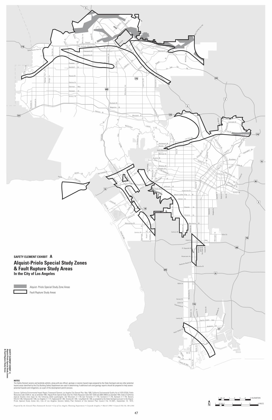
47
Bl
5
210
118
5
405
101
170
134
2
110
10
60
5
10
90
710
105
91
405
110
47
Colorado Bl
Polk St
Sayre S
t
Can
oga
Av
De
Soto
Av
Win
netk
a A
v
Val le
yCi
rcle
Bl
Topa
nga
Cyn
Bl
Av
Sep
ulve
da
Bl
Van
Nuy
s
B l
Laur
el C
yn B
l
Vine
land
Av
Lankershim B l
Ventura B l
Magnol ia Bl
Burbank Bl
Victory Bl
Vanowen St
Sherman Way
Sat icoy St
Roscoe Bl
Nordhoff St
Devonshire St
Chatsworth St
Rinaldi St
La Tuna CynRd
Sunland
Bl
St
Foothill
Bl
Mt G
leas
on
Av
Santa Susana Pass Rd
Glenoaks Bl
San Fernando Rd
Mulhol land
Beve
rlyG
len
B l
B l
Dr
Verm
ont
Av
Wes
tern
Av
Cre
nsha
w
Bl
Mart in Luther King Jr B l
Vernon Av
Slauson Av
Florence Av
Venice
Bl
Washington Bl
Jefferson B l
Rodeo Rd
Hol lywood Bl
Sunset B l
Santa Monica Bl
Melrose Av
Bever ly B lThi rd St
Bl
Bl
Pico
Bl
Col
dwat
er C
yn Cyn
Bl
Los Fel i z Bl
Manchester B l
Century Bl
Redondo Beach Bl
Alondra Bl
Rosecrans Av
El Segundo Bl
Sepulveda Bl
223rd St
Carson St
Reseda
Wentworth
B igTu
jun ga
CynRd
Woo
dlak
e A
v
Fall
broo
k A
v
D r
CahuengaBlS
epul
v eda
Imper ia l
190th St
Lomita Bl
Palos Verdes Dr
Paseo del Mar Paci
fic
Av
Gaf
fey
St
S t
25th
9th St
Har
bor
Bl
Western
Av
Anaheim St
Paci f ic Coast
Ala
med
a St
Figu
eroa
St
Ava
lon
Bl
Hwy
Nor
man
die
Av
Verm
ont
Av
103rd St
Wilm
ingt
on
Av
Cent
ral A
v
Com
pton
Av
Broa
dway
Mai
n St
San
Pedr
o St
Aval
on B
l
Exposi t ion Bl
Ala
med
aSt
Sant
a Fe
Av
Soto
St
O lympic Bl
Lore
na S
t
4 th St
F i rst St
Valley Bl
Main
St
Broadway
San Fernando Rd
Figueroa
St
Tam
pa
Hoo
ver
St
Hwy
Plummer St
Bl
Bl
Brand Bl
Osborne
St
St
Si lver la
keBl G
lendaleB
l
Mon
tere
y
Rd
Huntington Dr
San Vicente Bl
Bundy Dr
Westw
oodBl
O lympicSan Vicente Bl
Mission
Rd
Lincoln BlPacific Av
Centinela Av
Culv
er
Bl
Jefferson Bl
La Cienega
Bl
Fai r
fax
A
v
Robertson B
l
Wilshire
Whitt ier B l
Sep
ulve
daB
l
Woo
dman
A
v
Cesar Chavez Av
Sunset Bl
Balb
oaB
l
Whi
te O
ak
Av
Laurel
PacificCoast Hwy
Avi
atio
n
Bl
Century Bl
Air
port
B
lVista del Mar
Manchester BlEa
gle
Rock
Bl
York Bl
Temple St
Verdugo Rd
Moorpark St
Vine
St
San Fernando Mission
Sheldon
Prepared by the General Plan Framework Section • City of Los Angeles Planning Department • Citywide Graphics • March 1994 • Council File No. 89-21040 11/41/21 2 3 4 MILES
01/21 1 2 3 4 5 KILOMETERS
Alquist-Priolo Special Study Zones& Fault Rupture Study AreasIn the City of Los Angeles
Sources: California Environmental Impact Report, Framework Element, Los Angeles City General Plan, May 1995; California Environmental Quality Act of 1970 (CEQA), PublicResources Code 21000 et. seq. as amended 1992, Alquist-Priolo Special Study Zone Act, Public Resources Code 2621-2630 and 2690-2699.6 as amended 1993, State of CaliforniaSpecial Studies Zone maps for the following USGS quadrangles: Oat Mountain (1-1-76) San Fernando (1-1-79), Sunland (1-1-79), Burbank (1-1-79), BeverlyHills (6-1-86), Hollywood (6-1-86), Los Angeles (1-1-77), Inglewood (6-1-86), Torrance (6-1-86), Long Beach (6-1-86), as prepared by the State Geologist pursuant to the Alquist-Priolo Special Study Zones Act, City of Los Angeles Seismic Safety Plan Element of the General Plan Council file 74-3401, September 10, 1975.
Alquist-� Priolo Special Study Zone Areas
Fault Rupture Study Areas
N
SAFETY ELEMENT EXHIBIT ASA
FETY ELEMEN
T EXHIB
IT AA
lquist-Priolo Special Study Zones&
Fault Rupture Study Areas
NOTESThe Safety Element seismic and landslide exhibits, along with any official geologic or seismic hazard maps prepared by the State Geologist and any other potentialhazard areas identified by the City Building Safety Department are used in determining if additional soils and geology reports should be prepared to help assesspotential hazards and mitigations, as a part of the development permit process.

48
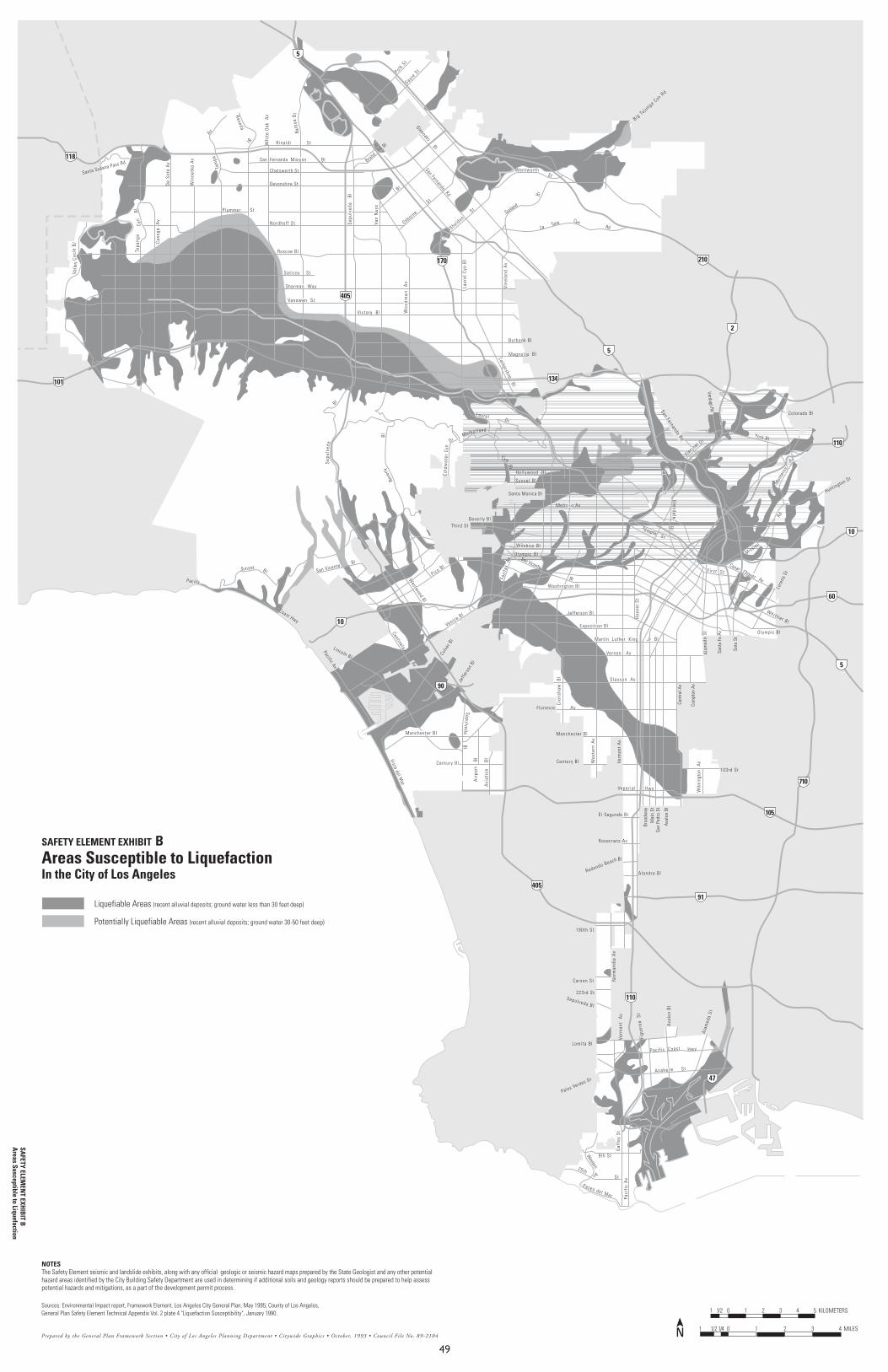
49
5
210
118
5
405
101
170
134
2
110
10
90
405
Colorado Bl
Polk St
Sayre S
t
Can
oga
Av
De
Soto
Av
Win
netk
a A
v
Val l e
yCi
rcle
B l
Topa
nga
Cyn
Bl
Av
Sep
ulve
da
Bl
Van
Nuy
s
B l
Laur
el C
yn B
l
Vine
land
Av
Lankershim B l
Magnol ia Bl
Burbank Bl
Victory Bl
Vanowen St
Sherman Way
Sat icoy St
Roscoe Bl
Nordhoff St
Devonshire St
Chatsworth St
Rinaldi St
La Tuna CynRd
Sunland
Bl
StSanta Susana Pass Rd
Glenoaks Bl
San Fernando RdMulho l land
Beve
rlyB
l
B l
Dr
Cre
nsha
w
Bl
F lorence Av
Venice Bl Jefferson B
Hol lywood Bl
Sunset Bl
Santa Monica Bl
Melrose Av
Bever ly Bl
Bl
Bl
Pico Bl
Col
dwat
er C
yn
Cyn
Bl
Manchester Bl
Century Bl
Re
Sepulveda B
223rd
Carson S
Reseda
Wentworth
Big Tu junga Cyn R
d
Dr
Sep
ulv e
da
190th
Lomita B
Palos Verdes D
Pas
25th
We
Expo
San Fernando Rd
Tam
paP lummer St
Bl
San Fernando Mission Bl
Bl
Brand
Osborne
St
SheldonSt
Fletcher Dr
Rd
San Vicente Bl
Westw
ood Bl
O lympicSan Vicente
Bl
Lincoln Bl
Pacific Av
Centinela Av
Culv
er B
l
Jeffe
rson
Bl
Fair
fax
Av
Wilshire
SepulvedaB
l
Woo
dman
A
v
Sunset Bl
Balb
oaB
l
Whi
te O
ak
Av
Laurel
Pacific
Coast Hwy
Avi
atio
n
Bl
Century Bl
Air
port
B
lVista del Mar
Manchester Bl
York Bl
Verdugo Rd
Th i rd St
Washington Bl
Prepared by the General Plan Framework Section • City of Los Angeles Planning Department • Citywide Graphics • October, 1993 • Council File No. 89-2104
Areas Susceptible to LiquefactionIn the City of Los Angeles
Sources: Environmental Impact report, Framework Element, Los Angeles City General Plan, May 1995; County of Los Angeles,General Plan Safety Element Technical Appendix Vol. 2 plate 4 "Liquefaction Susceptibility", January 1990.
Liquefiable Areas (recent alluvial deposits; ground water less than 30 feet deep)
Potentially Liquefiable Areas (recent alluvial deposits; ground water 30-50 feet deep)
SAFETY ELEMENT EXHIBIT BSA
FETY ELEMEN
T EXHIB
IT BA
reas Susceptible to Liquefaction
NOTESThe Safety Element seismic and landslide exhibits, along with any official geologic or seismic hazard maps prepared by the State Geologist and any other potentialhazard areas identified by the City Building Safety Department are used in determining if additional soils and geology reports should be prepared to help assesspotential hazards and mitigations, as a part of the development permit process.
10
60
5
710
105
91
110
47
Verm
ont
Av
Wes
tern
Av
Mart in Luther King Jr Bl
Vernon Av
Slauson Av
l
dondo Beach Bl
Alondra Bl
Rosecrans Av
El Segundo Bl
l
St
t
Imper ia l
St
l
r
eo del Mar Paci
fic
Av
Gaf
fey
St
S t
9th St
sternAv
Anaheim St
Paci f ic Coast
Ala
med
a St
Figu
eroa
St
Ava
lon
Bl
Hwy
Nor
man
die
Av
Verm
ont
Av
103rd St
Wilm
ingt
on
Av
Cent
ral A
v
Com
pton
Av
Broa
dway
Mai
n St
San
Pedr
o St
Aval
on B
l
s i t ion Bl
Ala
med
aSt
Sant
a Fe
Av
Soto
St
O lympic Bl
Lore
na S
tF i rst St
Hoo
ver
St
Hwy
Glendale
Bl
Mon
tere
y
Huntington Dr
Mission
Rd
Whit t ier Bl
Cesar Chavez Av
N
Temple St
0 11/41/21 2 3 4 MILES
01/21 1 2 3 4 5 KILOMETERS
N

50
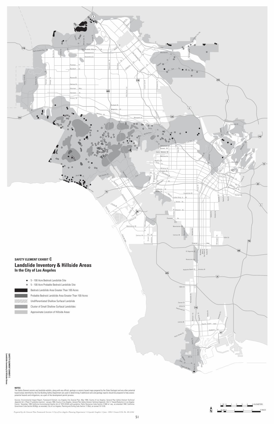
51
5
210
118
5
405
101
170
134
2
110
10
60
5
10
90
710
105
91
405
110
47
Colorado BlPolk
StSayr
e St
Can
oga
Av
De
Soto
Av
Win
netk
a A
v
Val l e
yCi
rcle
B l
Topa
nga
Cyn
Bl
Av
Sep
ulve
da
Bl
Van
Nuy
s
B l
Laur
el C
yn B
l
Vine
land
Av
Lankershim B l
Ventura B l
Magnol ia Bl
Burbank Bl
Vanowen St
Sherman Way
Sat icoy St
Roscoe Bl
Nordhoff St
Devonshire St
Chatsworth St
Rinaldi St
La Tuna CynRd
Sunland
Bl
St
Foothill
Bl
Mt G
leas
on A
v
Santa Susana Pass Rd
Glenoaks Bl
San Fernando RdMulho l land
Beve
rly
Gle
nBl
B l
Dr
Verm
ont
Av
Wes
tern
Av
Cre
nsha
w
Bl
Mart inLuther King Jr B l
Vernon Av
Slauson Av
Florence Av
Venice
Bl
Washington Bl
Jefferson B l
Rodeo Rd
Hol lywood Bl
Sunset B l
Santa Monica Bl
Melrose Av
Bever ly B lThi rd St
Bl
Bl
Pico
Bl
Col
dwat
er C
ynCyn
Bl
Los Fel i z Bl
Manchester Bl
Century Bl
Alondra Bl
Rosecrans Av
El Segundo Bl
Sepulveda Bl
223rd St
Carson St
Reseda
Wentworth
B igTu
jun ga
CynRd
Woo
dlak
e A
v
Fall
broo
k A
v
D r
Bl
C ah uengaSep
ulv e
da
Imper ia l
190th St
Lomita Bl
Palos Verdes Dr
Paseo del Mar Paci
fic
Av
Gaf
fey
St
S t
25th
9th St
Har
bor
Bl
Western
Av
Anaheim St
Paci f ic Coast
Ala
med
a St
Figu
eroa
St
Ava
lon
Bl
Hwy
Nor
man
die
Av
Verm
ont
Av
103rd St
Wilm
ingt
on
Av
Cent
ral A
v
Broa
dway
Mai
n St
San
Pedr
o St
Aval
on B
l
Exposi t ion Bl
Ala
med
aSt
Sant
a Fe
Av
Soto
St
O lympic Bl
Lore
na S
t
4 th St
Valley Bl
Broadway
San Fernando Rd
Figueroa
St
Tam
pa
Hoo
ver
St
Hwy
Plummer St
Bl
San Fernando Mission Bl
Bl
Brand
Osborne
St
Sheldon
St
Si lver la
keBl
Fletcher Dr
Glendale
Bl
Mon
tere
y
Rd
Huntington Dr
San Vicente Bl
Bundy Dr
Westw
oodBl
O lympicSan Vicente Bl
Mission
Rd
Lincoln BlPacific Av
Centinela Av
Culv
er
Bl
Jefferson Bl
La Cienega
Bl
Fai r
fax
A
v
Robertson Bl
Wilshire
Whitt ier B l
SepulvedaB
l
Woo
dman
A
v
Cesar Chavez Av
Sunset Bl
Balb
oaB
l
Whi
te O
ak
Av
Laurel
N
Pacific
Coast Hwy
Avi
atio
n
Bl
Century Bl
Air
port
B
lVista del Mar
Manchester Bl
Redondo Beach Bl
Eagl
eRo
ck B
l
York Bl
Verdugo Rd
Vic tory B l
Com
pton
Av
F i rs t St
Main
St
Moorpark St
Vine
St
Vine
St
Prepared by the General Plan Framework Section • City of Los Angeles Planning Department • Citywide Graphics • June, 1994 • Council File No. 89-21040 11/41/21 2 3 4 MILES
01/21 1 2 3 4 5 KILOMETERS
Sources: Environmental Impact Report, Framework Element, Los Angeles City General Plan, May 1995; County of Los Angeles, General Plan Safety Element TechnicalAppendix Vol. 2 Plate 5 "Landslide inventory", January 1990; County of Los Angeles, General Plan Safety Element Technical Appendix (Vol.1), "Hazard Reduction in Los AngelesCounty," December 1990 California Environmental Quality Act of 1970 (CEQA) with guideline, Public Resources Code Section 21000 et. seq., as amended 1992; CaliforniaGovernment Code Section 6530(g), as amended; City of Los Angeles, Planning and Zoning Code Section 17.05(c), as revised 10-13-93.
N
SAFETY ELEM
ENT EXH
IBIT C
Landslide Inventory & H
illside Areas
Landslide Inventory & Hillside AreasIn the City of Los Angeles
5 - 100 Acre Bedrock Landslide Site
5 - 100 Acre Probable Bedrock Landslide Site
Bedrock Landslide Area Greater Than 100 Acres
Probable Bedrock Landslide Area Greater Than 100 Acres
Undifferentiated Shallow Surfacal Landslide
Cluster of Small Shallow Surfacal Landslides
Approximate Location of Hillside Areas
SAFETY ELEMENT EXHIBIT C
NOTESThe Safety Element seismic and landslide exhibits, along with any official geologic or seismic hazard maps prepared by the State Geologist and any other potentialhazard areas identified by the City Building Safety Department are used in determining if additional soils and geology reports should be prepared to help assesspotential hazards and mitigations, as a part of the development permit process.

52
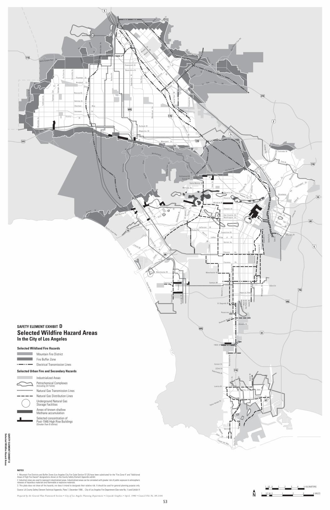
53
5
210
118
5
405
101
170
134
2
110
10
60
5
10
90
710
105
91
405
110
47
Colorado BlPolk
St
Sayre S
t
Can
oga
Av
De
Soto
Av
Win
netk
a A
v
Val l e
yCi
rcle
B l
Topa
nga
Cyn
Bl
Av
Sep
ulve
da
Bl
Van
Nuy
s
B l
Laur
el C
yn
Bl
Vine
land
Av
Lankershim B l
VenturaMagnol ia Bl
Burbank Bl
Victory
Vanowen St
Sherman Way
Sat icoy St
Roscoe Bl
Nordhoff St
Devonshire St
Chatsworth St
La Tuna CynRd
Sunland
Bl
Foothill
B l
Santa Susana Pass Rd
Glenoaks Bl
San Fernando Rd
Mulhol land
Beve
rlyG
len
B lB l
Dr
Verm
ont
Av
Wes
tern
Av
Cre
nsha
w
Mart inLuther King Jr B l
Slauson Av
Florence Av
Venice
Bl
Jefferson B lRodeo Rd
Hol lywood BlSunset Bl
Santa Monica Bl
Melrose Av
Bever ly Bl
Bl
Pico
Bl
Col
dwat
er C
yn Cyn
Bl
Los Fel i z Bl
Manchester Bl
Century Bl
Redondo Beach Bl
Alondra Bl
Rosecrans Av
El Segundo Bl
Sepulveda Bl
223rd St
Carson St
Reseda
B igTu
jun ga
CynRd
Woo
dlak
e A
v
Fall
broo
k A
v
D r
Bl
C ah uenga
Sep
ulv e
da
Imper ia l
190th St
Lomita Bl
Palos Verdes Dr
Paseo del Mar Paci
fic
Av
Gaf
fey
St
S t
25th
9th St Har
bor
Bl
Western
Av
Anaheim St
Paci f ic Coast
Ala
med
a St
Figu
eroa
St
Ava
lon
Bl
Hwy
Nor
man
die
Av
Verm
ont
Av
103rd St
Wilm
ingt
on
Av
Cent
ral A
v
Com
pton
Av
Broa
dway
Mai
n St
San
Pedr
o St
Aval
on B
l
Exposi t ion Bl
Ala
med
aSt
Sant
a Fe
Av
Soto
St
O lympic Bl
Lore
na S
t
4 th St
Valle
y Bl
Broadway
San Fernando Rd
Figuero
a
St
Tam
pa
Hwy
Plummer St
Bl Bl
Brand
Osborne
St
SheldonSt
Si lver la
keBl
FletcherDr
Glendale
Bl
Mon
tere
y
Rd
Huntington Dr
San Vicente Bl
Bundy Dr
Westw
oodBl
O lympic
Rd
Lincoln BlPacific Av
Centinela Av
Culv
er
Jefferson Bl
La Cienega
Bl
Fai r
fax
A
v
Robe
rtso
n Bl
Whit t ier B l
Woo
dman
A
v
Cesar Chavez Av
Sunset Bl
Whi
te O
ak
Av
Laurel
N
Pacific Coast Hwy
Avi
atio
n B
l
Century Bl
Air
port
Bl
Vista del Mar
Manchester BlEa
gle
Rock
Bl
York Bl
Temple St
Verdugo Rd
Moorpark St
Vine
St
Bal
boa
Bl
RinaldiSt
Bl
B l
Thi rd St
Wilshi re Bl
Washington BlSan Vicente Bl
Vernon Av Bl
Bl
Sep
ulve
da
B
l
0 11/41/21 2 3 4 MILES
01/21 1 2 3 4 5 KILOMETERS
NPrepared by the General Plan Framework Section • City of Los Angeles Planning Department • Citywide Graphics • April, 1996 • Council File No. 89-2104
Selected Wildfire Hazard AreasIn the City of Los Angeles
NOTES
1. Mountain Fire Districts and Buffer Zones (Los Angeles City Fire Code Section 57.25) have been substituted for the "Fire Zone 4" and "AdditionalAreas of High Fire Hazard" designations shown on the County Safety Element Appendix exhibit.2. Industrial zones are used to represent industrialized areas. Industrialized areas can be correlated with greater risk of public exposure to atmosphericreleases of hazardous materials and flammable or explosive materials.3. This plate does not show all fire hazards, nor does it intend to designate their relative risk. It should be used for general planning purpose only.
Source: LA County Safety Element Technical Appendix, Plate 7, December 1990. , City of Los Angeles Fire Department (See note No. 1) and Exhibit H
Mountain Fire District
Fire Buffer Zone
Electrical Transmission Lines
Industrialized Areas
Petrochemical Complexes(Including Oil Fields)
Natural Gas Transmission Lines
Natural Gas Distribution Lines
Underground Natural GasStorage Facilities
Areas of known shallowMethane accumulation
Selected concentration ofPost-1946 High Rise Buildings(Greater than 8 stories)
Selected Wildland Fire Hazards
Selected Urban Fire and Secondary Hazards
SAFETY ELEM
ENT EXH
IBIT D
Selected Wildfire H
azard Areas
SAFETY ELEMENT EXHIBIT D

54
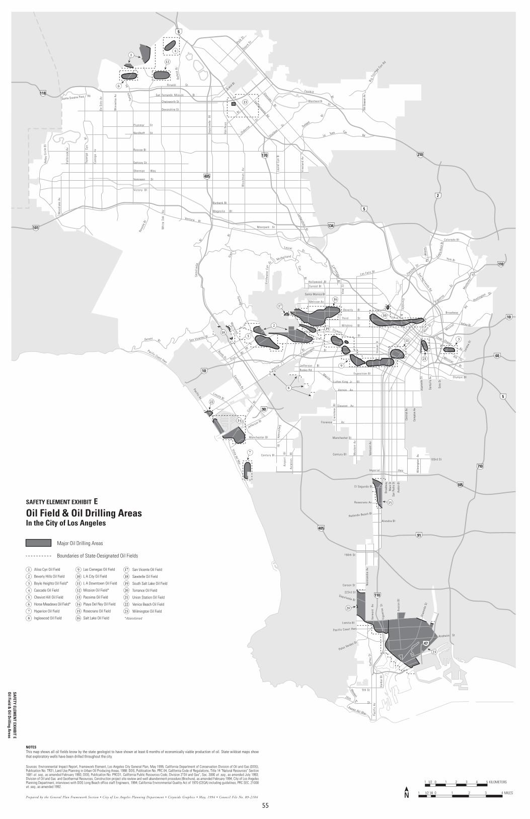
55
5
210
118
5
405
101
170
134
2
110
10
60
5
10
90
710
105
91
405
110
47
Colorado BlPolk
StSayr
e St
Can
oga
Av
De
Soto
Av
Win
netk
a A
v
Val l e
yCi
rcle
B l
Topa
nga
Cyn
Bl
Av
Sep
ulve
da
Bl
Van
Nuy
s
B l
Laur
el C
yn B
l
Vine
land
Av
Lankershim B l
Ventura B l
Magnol ia Bl
Burbank Bl
Victory Bl
Vanowen St
Sherman Way
Sat icoy St
Roscoe Bl
Nordhoff St
Devonshire St
Chatsworth St
Rinaldi St
La Tuna CynRd
Sunland
Bl
St
Foothill
Bl
Mt G
leas
on A
v
Santa Susana Pass Rd
Glenoaks Bl
San Fernando RdMulho l land
Beve
rly
Gle
nBl
B l
Dr
Verm
ont
Av
Wes
tern
Av
Cre
nsha
w
Bl
Mart inLuther King Jr B l
Vernon Av
Slauson Av
Florence Av
Venice
Bl
WashingtonBl
Jefferson B l
Rodeo Rd
Hol lywood Bl
Sunset Bl
Santa Monica Bl
Melrose Av
Bever ly B l
Bl
Bl
PicoBl
Col
dwat
er C
yn Cyn
Bl
Los Fel i z Bl
Manchester Bl
Century Bl
Redondo Beach Bl
Alondra Bl
Rosecrans Av
El Segundo Bl
Sepulveda Bl
223rd St
Carson St
Wentworth
B igTu
jun ga
CynRd
Woo
dlak
e A
v
Fall
broo
k A
v
D r
Bl
C ah uengaSep
ulv e
da
Imper ia l
190th St
Lomita Bl
Palos Verdes Dr
Paseo del Mar Paci
fic
Av
Gaf
fey
St
S t
25th
9th St
Har
bor
Bl
Western
Av
Anaheim St
Paci f ic Coast Hwy
Ala
med
a St
Figu
eroa
St
Ava
lon
Bl
Nor
man
die
Av
Verm
ont
Av
103rd St
Wilm
ingt
on
Av
Cent
ral A
v
Com
pton
Av
Broa
dway
Mai
n St
San
Pedr
o St
Aval
on B
l
Exposi t ion Bl
Ala
med
aSt
Sant
a Fe
Av
Soto
St
O lympic Bl
Lore
na S
t
4 th St
Valley Bl
Main
St
Broadway
San Fernando Rd
Figueroa
St
Tam
pa
Hoo
ver
St
Hwy
Plummer St
San Fernando Mission Bl
Brand Bl
Osborne
St
Sheldon
St
FletcherDr
Glendale
Bl
Mon
tere
y
Rd
Huntington Dr
San Vicente Bl
Bundy Dr
Westw
ood
Bl
O lympicMission
Rd
Lincoln Bl
Pacific Av
Centinela Av
Culv
er
Bl
Jefferson Bl
Wilshire
Whitt ier B l
SepulvedaB
l
Woo
dman
A
v
Cesar Chavez Av
Sunset Bl
Balb
oaB
l
Whi
te O
ak
Av
Laurel
N
Pacific Coast Hwy
Avi
atio
n
Bl
Century Bl
Air
port
B
l
Vista del Mar
Manchester BlEa
gle
Rock
Bl
York Bl
Verdugo Rd
Moorpark St
Vine
St
Rese
da B
l
S tThi rd
Prepared by the General Plan Framework Section • City of Los Angeles Planning Department • Citywide Graphics • May, 1994 • Council File No. 89-21040 11/41/21 2 3 4 MILES
01/21 1 2 3 4 5 KILOMETERS
Oil Field & Oil Drilling AreasIn the City of Los Angeles
NOTESThis map shows all oil fields know by the state geologist to have shown at least 6 months of economically viable production of oil. State wildcat maps showthat exploratory wells have been drilled throughout the city.
Sources: Environmental Impact Report, Framework Element, Los Angeles City General Plan, May 1995; California Department of Conservation Division of Oil and Gas (DOG),Publication No. TR31, Land Use Planning in Urban Oil Producing Areas, 1988: DOG, Publication No. PRC 04, California Code of Regulations, Title 14 "Natural Resources" Section1681 et. seq., as amended February 1993; DOG, Publication No. PRCO1, California Public Resources Code, Division 3"Oil and Gas", Sec. 3000 et. seq., as amended July 1993;Division of Oil and Gas and Geothermal Resources, Construction project site review and well abandonment procedure (Brochure), as amended February 1994; City of Los AngelesPlanning Department, interviews with DOG Long Beach office staff Engineers, 1994; California Environmental Quality Act of 1970 (CEQA) including guidelines, PRC SEC. 21000et. seq., as amended 1992.
Major Oil Drilling Areas
Boundaries of State-Designated Oil Fields
N
Aliso Cyn Oil Field
Beverly Hills Oil Field
Boyle Heights Oil Field*
Cascade Oil Field
Cheviot Hill Oil Field
Horse Meadows Oil Field*
Hyperion Oil Field
Inglewood Oil Field
Las Cienegas Oil Field
L A City Oil Field
L A Downtown Oil Field
Mission Oil Field*
Pacoima Oil Field
Playa Del Rey Oil Field
Rosecrans Oil Field
Salt Lake Oil Field
San Vicente Oil Field
Sawtelle Oil Field
South Salt Lake Oil Field
Torrance Oil Field
Union Station Oil Field
Venice Beach Oil Field
Wilmington Oil Field
1
2
3
4
5
6
7
8 16
9
10
11
12
13
14
15
17
18
19
20
21
22
23
1
6
12
4
13
185
2
17
16
19
10
3
21
11
9
22
14
7
8
15
20
23
*Abandoned
SAFETY ELEMENT EXHIBIT ESA
FETY ELEMEN
T EXHIB
IT EO
il Field & O
il Drilling A
reas

56
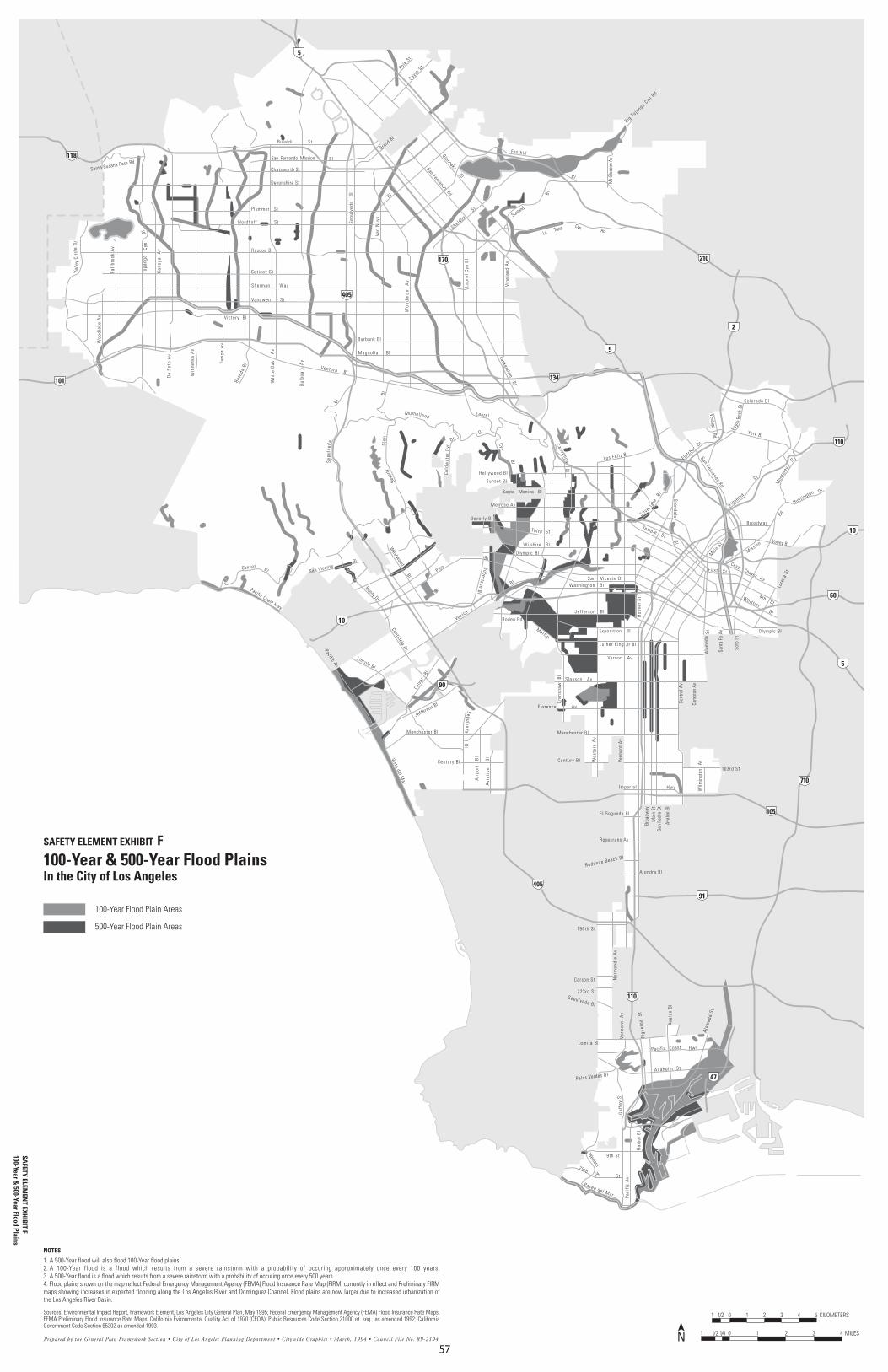
57
5
210
118
5
405
101
170
134
2
110
10
60
5
10
90
710
105
91
405
110
47
Colorado BlPolk
StSayr
e St
Can
oga
Av
De
Soto
Av
Win
netk
a A
v
Val l e
yCi
rcle
B l
Topa
nga
Cyn
Bl
Sep
ulve
da
Bl
Van
Nuy
s
B l
Laur
el C
yn B
l
Vine
land
Av
Lankershim B l
Ventura B l
Magnol ia Bl
Burbank Bl
Victory Bl
Vanowen St
Sherman Way
Sat icoy St
Roscoe Bl
Nordhoff St
Devonshire St
Chatsworth St
Rinaldi St
La Tuna CynRd
Sunland
Bl
Foothill
Bl
Mt G
leas
on A
v
Santa Susana Pass Rd
Glenoaks Bl
San Fernando Rd
Mulhol land
Beve
rlyG
len
B l
B l
Dr
Verm
ont
Av
Wes
tern
Av
Cre
nsha
w
Bl
Mart in
Luther King Jr Bl
Vernon Av
Slauson Av
Florence Av
Venice
Bl
Jefferson B l
Rodeo Rd
Hol lywood Bl
Sunset Bl
Santa Monica Bl
Melrose Av
Bever ly Bl
Bl
Bl
Pico
Bl
Col
dwat
er C
yn
Cyn
Bl
Los Fel i z Bl
Manchester Bl
Century Bl
Redondo Beach Bl
Alondra Bl
Rosecrans Av
El Segundo Bl
Sepulveda Bl
223rd St
Carson St
Rese
da B
l
B ig Tu ju
nga Cyn R
dW
oodl
ake
Av
Fall
broo
k A
v
D r
Bl
C ah uengaSep
ulv e
da
Imper ia l
190th St
Lomita Bl
Palos Verdes Dr
Paseo del Mar Paci
fic
Av
Gaf
fey
St
S t
25th
9th St
Har
bor
Bl
Western
Av
Anaheim St
Paci f ic Coast
Ala
med
a St
Figu
eroa
St
Ava
lon
Bl
Hwy
Nor
man
die
Av
Verm
ont
Av
103rd St
Wilm
ingt
on
Av
Cent
ral A
v
Com
pton
Av
Broa
dway
Mai
n St
San
Pedr
o St
Aval
on B
l
Exposi t ion B l
Ala
med
aSt
Sant
a Fe
Av
Soto
St
O lympic Bl
Lore
na S
t
4 th St
F i rst St
Valley Bl
Main
St
Broadway
San Fernando Rd
Figueroa
St
Hoo
ver
St
Hwy
Plummer St
San Fernando Mission Bl
Brand Bl
Sheldon
St
Si lver la
keBl
FletcherDr
Glendale
B l
Mon
tere
y
Rd
Huntington Dr
San Vicente Bl
Bundy Dr
Westw
oodBl
O lympic Mission
Rd
Lincoln Bl
Pacific Av
Centinela Av
Culv
er
Bl
Jefferson Bl
Robertson Bl
Wilshire
Whitt ier B l
SepulvedaB
l
Woo
dman
A
v
Cesar Chavez Av
Sunset Bl
Whi
te O
ak
A
v
Laurel
N
Pacific Coast Hwy
Avi
atio
n
Bl
Century Bl
Air
port
B
lVista del Mar
Manchester BlEa
gle
Rock
Bl
York Bl
Temple St
Verdugo Rd
Tam
pa A
v
Bal
boa
A
v
Th i rd St
San Vicente BlWashington B l
Prepared by the General Plan Framework Section • City of Los Angeles Planning Department • Citywide Graphics • March, 1994 • Council File No. 89-21040 11/41/21 2 3 4 MILES
01/21 1 2 3 4 5 KILOMETERS
NOTES
1. A 500-Year flood will also flood 100-Year flood plains.2. A 100-Year flood is a flood which results from a severe rainstorm with a probability of occuring approximately once every 100 years.3. A 500-Year flood is a flood which results from a severe rainstorm with a probability of occuring once every 500 years.4. Flood plains shown on the map reflect Federal Emergency Management Agency (FEMA) Flood Insurance Rate Map (FIRM) currently in effect and Preliminary FIRMmaps showing increases in expected flooding along the Los Angeles River and Dominguez Channel. Flood plains are now larger due to increased urbanization ofthe Los Angeles River Basin.
Sources: Environmental Impact Report, Framework Element, Los Angeles City General Plan, May 1995; Federal Emergency Management Agency (FEMA) Flood Insurance Rate Maps;FEMA Preliminary Flood Insurance Rate Maps; California Evironmental Quality Act of 1970 (CEQA), Public Resources Code Section 21000 et. seq., as amended 1992; CaliforniaGovernment Code Section 65302 as amended 1993.
SAFETY ELEM
ENT EXH
IBIT F
100-Year & 500-Year Flood Plains
100-Year & 500-Year Flood PlainsIn the City of Los Angeles
100-Year Flood Plain Areas
500-Year Flood Plain Areas
SAFETY ELEMENT EXHIBIT F

58
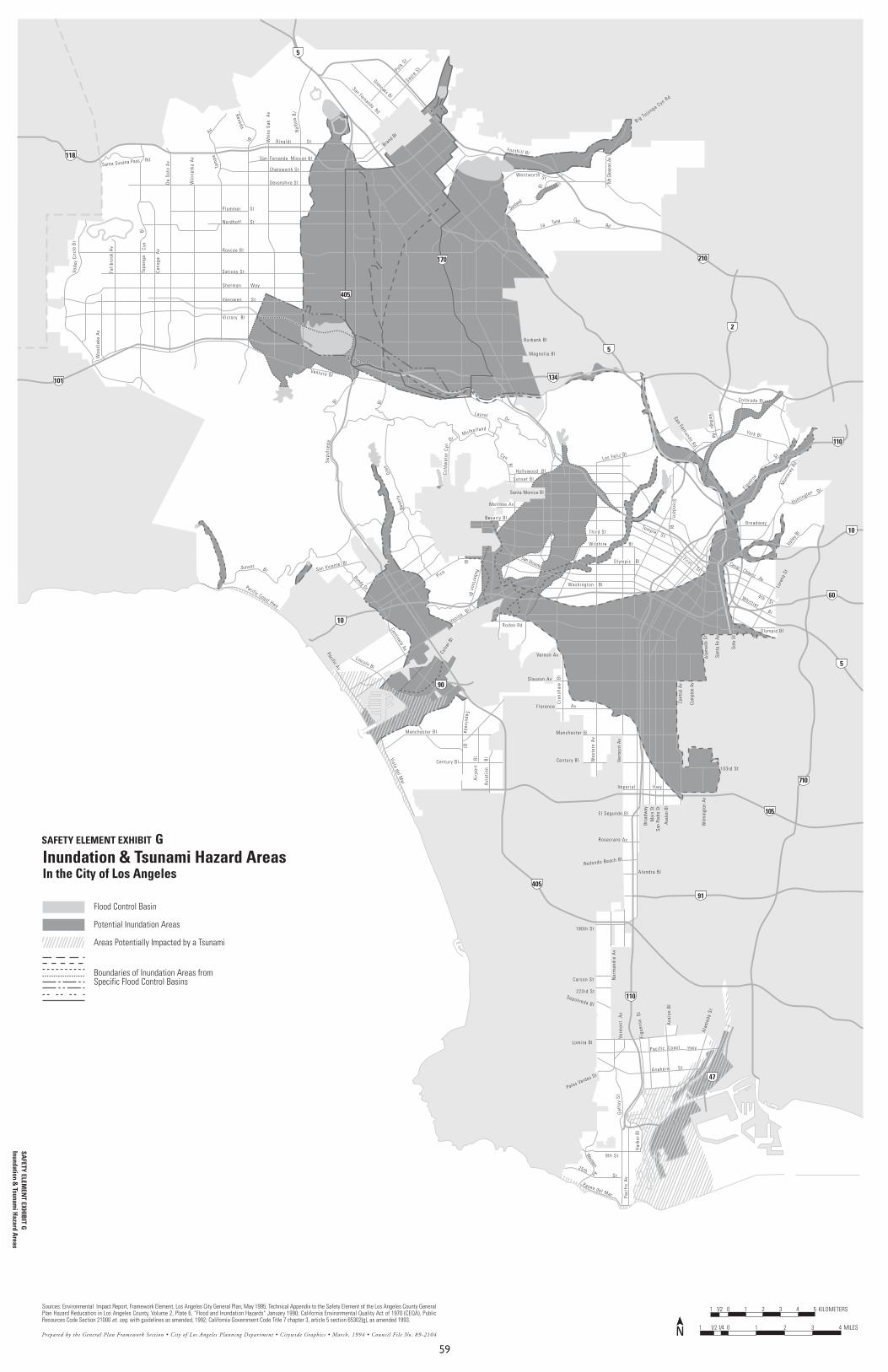
59
5
210
118
5
101 134
2
110
10
60
5
10
90
710
105
91
405
110
47
Colorado BlPolk
StSayr
e St
Can
oga
Av
De
Soto
Av
Win
netk
a A
v
Val l e
yCi
rcle
B l
Topa
nga
Cyn
Bl
Av
Ventura Bl
Magnol ia Bl
Burbank Bl
Victory Bl
Vanowen St
Sherman Way
Sat icoy St
Roscoe Bl
Nordhoff St
Devonshire St
Chatsworth St
Rinaldi St
La Tuna CynRd
Sunland
Bl
St
Foothi l l B l
Mt G
leas
on A
v
Santa Susana Pass Rd
Glenoaks Bl
San Fernando Rd
Mulho l land
Beve
rly
Glen
BlB l
Dr
Verm
ont
Av
Wes
tern
Av
Cre
nsha
w
Bl
Vernon Av
Slauson Av
Florence Av
VeniceBl
Rodeo Rd
Hol lywood Bl
Sunset Bl
Santa Monica Bl
Melrose Av
Bever ly Bl
Bl
Bl
Pico
Bl
Col
dwat
er C
yn
Cyn
Bl
Los Fel i z Bl
Manchester Bl
Century Bl
Redondo Beach Bl
Alondra Bl
Rosecrans Av
El Segundo Bl
Sepulveda Bl
223rd St
Carson St
Reseda
Wentworth
Big Tu junga Cyn RdW
oodl
ake
Av
Fall
broo
k A
v
D r
Sep
ulv e
da
Imper ia l
190th St
Lomita Bl
Palos Verdes Dr
Paseo del Mar Paci
fic
Av
Gaf
fey
St
S t
25th
9th St
Har
bor
Bl
Western
Av
Anaheim St
Paci f ic Coast
Ala
med
a St
Figu
eroa
St
Ava
lon
Bl
Hwy
Nor
man
die
Av
Verm
ont
Av
103rd St
Wilm
ingt
on A
v
Cent
ral A
v
Com
pton
Av
Broa
dway
Mai
n St
San
Pedr
o St
Aval
on B
l
Ala
med
a St
Sant
a Fe
Av
Soto
St
O lympic Bl
Lore
na S
t
4 th St
Fi rst St
Valle
y Bl
Broadway
San Fernando Rd
Figuero
a
St
Tam
pa
Hwy
Plummer St
Bl
San Fernando Mission Bl
Brand Bl
Glendale
Bl
Mon
tere
y Rd
Huntington Dr
San Vicente Bl
Bundy Dr
OlympicSan Vicente
Lincoln Bl
Pacific Av
Centinela Av
Culv
er B
l
Robertson Bl
Whit t ier B l
SepulvedaB
l
Cesar Chavez Av
Sunset Bl
Balb
oaB
l
Whi
te O
ak
Av
Laurel
N
Pacific Coast Hwy
Avi
atio
n
Bl
Century Bl
Air
port
B
lVista del Mar
Manchester Bl
York Bl
Temple St
Verdugo Rd
Th i rd St
Wilshire
Washington B l
Prepared by the General Plan Framework Section • City of Los Angeles Planning Department • Citywide Graphics • March, 1994 • Council File No. 89-21040 11/41/21 2 3 4 MILES
01/21 1 2 3 4 5 KILOMETERSSources: Environmental Impact Report, Framework Element, Los Angeles City General Plan, May 1995; Technical Appendix to the Safety Element of the Los Angeles County GeneralPlan Hazard Reducation in Los Angeles County, Volume 2, Plate 6, "Flood and Inundation Hazards" January 1990; California Environmental Quality Act of 1970 (CEQA), PublicResources Code Section 21000 et. seq. with guidelines as amended, 1992; California Government Code Title 7 chapter 3, article 5 section 65302(g), as amended 1993.
N
405
170
Inundation & Tsunami Hazard AreasIn the City of Los Angeles
Flood Control Basin
Potential Inundation Areas
Areas Potentially Impacted by a Tsunami
Boundaries of Inundation Areas fromSpecific Flood Control Basins
SAFETY ELEMENT EXHIBIT GSA
FETY ELEMEN
T EXHIB
IT GInundation &
Tsunami H
azard Areas

60
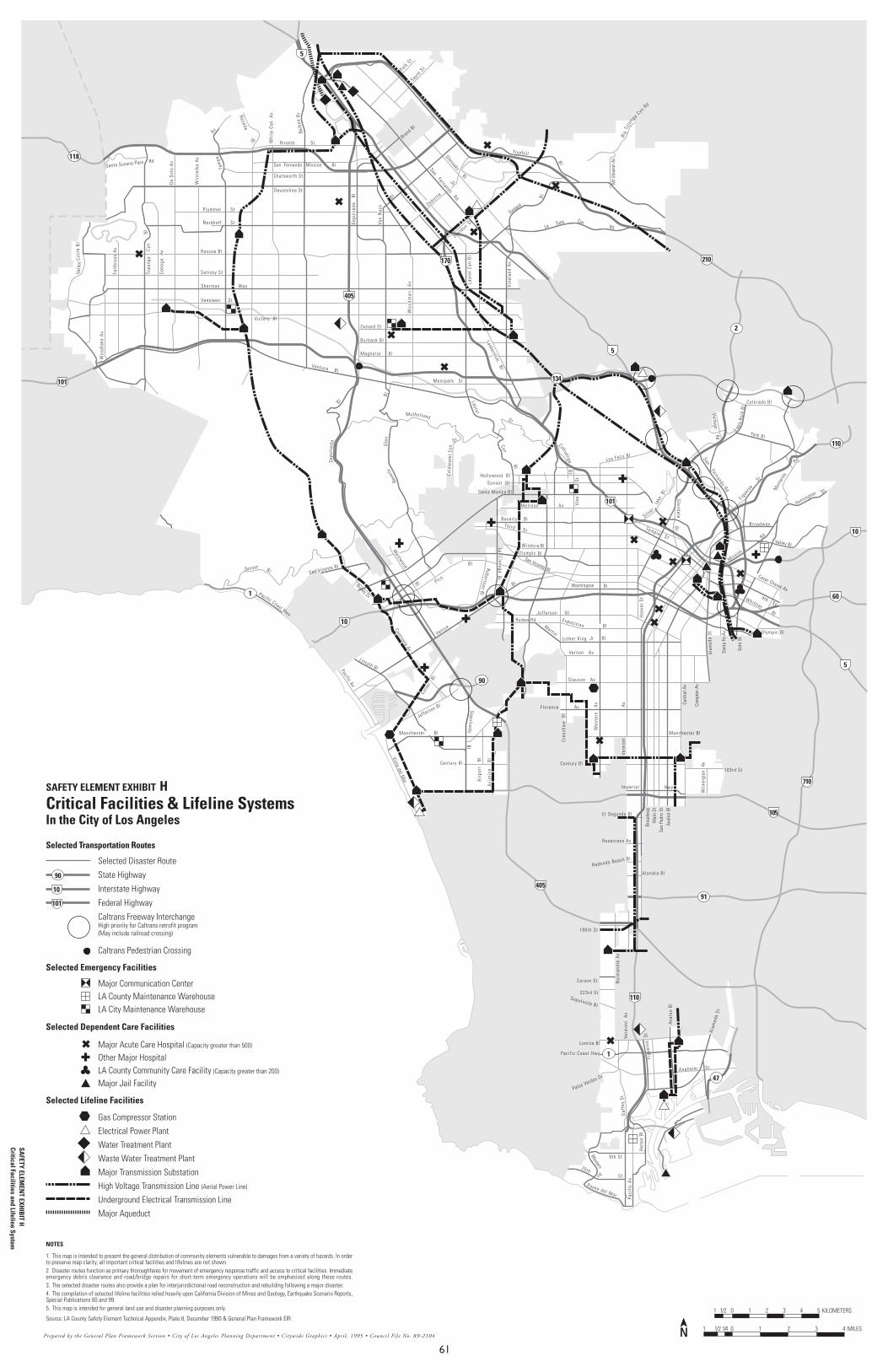
61
210
5
60
5
10
710
105
405
110
118
2
90
91
101
90
101
10
Colorado BlPolk
StSayr
e St
Can
oga
Av
De
Soto
Av
Win
netk
a A
v
Val l e
yCi
rcle
B l
Topa
nga
Cyn
Bl
Av
Sep
ulve
da
Bl
Van
Nuy
s
B l
Laur
el C
yn B
l
Vine
land
Av
Lankershim B lVentura B l
Magnol ia Bl
Burbank Bl
Victory Bl
Vanowen St
Sherman Way
Sat icoy St
Roscoe Bl
Nordhoff St
Devonshire St
Chatsworth St
Rinaldi St
La Tuna CynRd
Sunland
Bl
Foothill
Bl
Mt G
leas
on A
v
Santa Susana Pass Rd
Glenoaks Bl
San Fernando Rd
Mulhol land
Beve
rlyG
len
B l
B l
Dr
Verm
ont
A
v
Wes
tern
A
v
Cre
nsha
w
Bl
Mart inLuther King Jr B l
Vernon Av
Slauson Av
Florence Av
Venice
Bl Washington Bl
Jefferson B lRodeo Rd
Hol lywood Bl
Sunset B l
Santa Monica Bl
Melrose Av
Bever ly B lThi rd St
Bl
Bl
Pico
Bl
Col
dwat
er C
yn
Cyn
Bl
Los Fel i z Bl
Manchester Bl
Century Bl
Redondo Beach Bl
Alondra Bl
Rosecrans Av
El Segundo Bl
Sepulveda Bl
223rd St
Carson St
Reseda
B igTu
jun ga
CynRd
Woo
dlak
e A
v
Fall
broo
k A
v
D r
Bl
C ah uengaSep
ulv e
da
Imper ia l
190th St
Lomita Bl
Palos Verdes Dr
Paseo del Mar Paci
fic
Av
Gaf
fey
St
S t
25th
9th St
Har
bor
Bl
Western
Av
Anaheim St
Paci f ic Coast Hwy
Ala
med
a St
Figu
eroa
St
Ava
lon
Bl
Nor
man
die
Av
Verm
ont
Av
103rd St
Wilm
ingt
on
Av
Cent
ral A
v
Com
pton
Av
Broa
dway
Mai
n St
San
Pedr
o St
Aval
on B
l
Exposi t ion
Ala
med
aSt
Sant
a Fe
Av
Soto
St
O lympic Bl
4th St
Valley Bl
Broadway
San Fernando Rd
Figue
roa
St
Tam
pa
Hoo
ver
St
Hwy
Plummer St
Bl
San Fernando Mission Bl
Brand Bl
Osborne
St
SheldonSt
Si lver
lake
Bl
Glendale
Bl
Mon
tere
y
Rd
Huntington Dr
San Vicente Bl
Bundy Dr
Westw
ood
Bl
O lympicSan Vicente Bl
Mission
Rd
Lincoln BlPacific Av
Centinela Av
Culv
er
Bl
Jefferson Bl
La Cienega
Bl
Robertson Bl
Wilshire
Whitt ier B l
SepulvedaB
l
Woo
dman
A
v
Cesar Chavez Av
Sunset Bl
Balb
oaB
l
Whi
te O
ak
Av
Laurel
N
Pacific Coast Hwy
Avi
atio
n
Bl
Century Bl
Air
port
B
lVista del Mar
Manchester B lEa
gle
Rock
Bl
York Bl
Temple St
Verdugo Rd
Moorpark St
Vine
St
Oxnard St
Bl
Prepared by the General Plan Framework Section • City of Los Angeles Planning Department • Citywide Graphics • April, 1995 • Council File No. 89-21040 11/41/21 2 3 4 MILES
01/21 1 2 3 4 5 KILOMETERS
Critical Facilities & Lifeline SystemsIn the City of Los Angeles
NOTES
1. This map is intended to present the general distribution of community elements vulnerable to damages from a variety of hazards. In orderto preserve map clarity, all important critical facilities and lifelines are not shown.2. Disaster routes function as primary thoroughfares for movement of emergency response traffic and access to critical facilities. Immediateemergency debris clearance and road/bridge repairs for short-term emergency operations will be emphasized along these routes.3. The selected disaster routes also provide a plan for interjurisdictional road reconstruction and rebuilding following a major disaster.4. The compilation of selected lifeline facilities relied heavily upon California Division of Mines and Geology, Earthquake Scenario Reports,Special Publications 60 and 99.5. This map is intended for general land use and disaster planning purposes only.
Source: LA County Safety Element Technical Appendix, Plate 8, December 1990 & General Plan Framework EIR.
Selected Disaster Route
State Highway
Interstate Highway
Federal Highway
Caltrans Freeway InterchangeHigh priority for Caltrans retrofit program(May include railroad crossing)
Caltrans Pedestrian Crossing
Major Communication CenterLA County Maintenance WarehouseLA City Maintenance Warehouse
Major Acute Care Hospital (Capacity greater than 500)
Other Major HospitalLA County Community Care Facility (Capacity greater than 200)
Major Jail Facility
Gas Compressor Station
Electrical Power Plant
Water Treatment Plant
Waste Water Treatment Plant
Major Transmission Substation
High Voltage Transmission Line (Aerial Power Line)
Underground Electrical Transmission Line
Major Aqueduct
N
5
170
405
110
10
134
1
1
47
101
Selected Transportation Routes
Selected Emergency Facilities
Selected Dependent Care Facilities
Selected Lifeline Facilities
SAFETY ELEM
ENT EXH
IBIT H
Critical Facilities and Lifeline System
SAFETY ELEMENT EXHIBIT H