Embed Size (px)
Citation preview
8/12/2019 SACAA ATPL Navigation Syllabus
http://slidepdf.com/reader/full/sacaa-atpl-navigation-syllabus 1/3
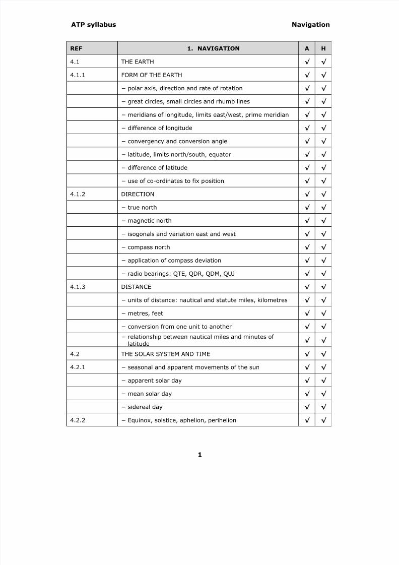
ATP syllabus Navigation
REF 1. NAVIGATION A H
4.1 THE EARTH √ √
4.1.1 FORM OF THE EARTH √ √
− polar axis, direction and rate of rotation √ √
− great circles, small circles and rhumb lines √ √
− meridians of longitude, limits east/west, prime meridian √ √
− difference of longitude √ √
− convergency and conversion angle √ √
− latitude, limits north/south, equator √ √
−
difference of latitude √ √
− use of co-ordinates to fix position √ √
4.1.2 DIRECTION √ √
− true north √ √
− magnetic north √ √
− isogonals and variation east and west √ √
− compass north √ √
− application of compass deviation √ √
− radio bearings: QTE, QDR, QDM, QUJ √ √
4.1.3 DISTANCE √ √
− units of distance: nautical and statute miles, kilometres √ √
− metres, feet √ √
− conversion from one unit to another √ √
−
relationship between nautical miles and minutes oflatitude √ √
4.2 THE SOLAR SYSTEM AND TIME √ √
4.2.1 − seasonal and apparent movements of the sun √ √
− apparent solar day √ √
− mean solar day √ √
− sidereal day √ √
4.2.2 − Equinox, solstice, aphelion, perihelion √ √
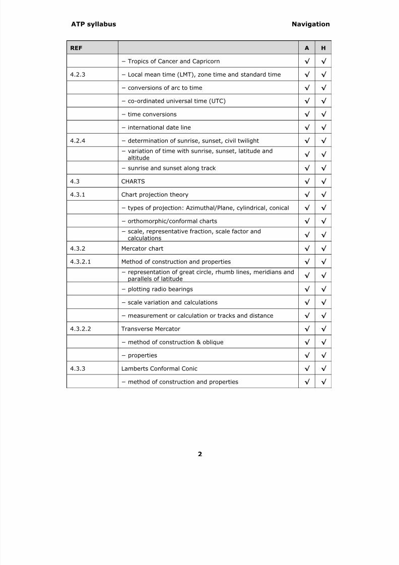
8/12/2019 SACAA ATPL Navigation Syllabus
http://slidepdf.com/reader/full/sacaa-atpl-navigation-syllabus 2/3
ATP syllabus Navigation
REF A H
− Tropics of Cancer and Capricorn √ √
4.2.3 − Local mean time (LMT), zone time and standard time √ √
− conversions of arc to time √ √
− co-ordinated universal time (UTC) √ √
− time conversions √ √
− international date line √ √
4.2.4 − determination of sunrise, sunset, civil twilight √ √
− variation of time with sunrise, sunset, latitude andaltitude
√ √
− sunrise and sunset along track √ √
4.3 CHARTS √ √
4.3.1 Chart projection theory √ √
− types of projection: Azimuthal/Plane, cylindrical, conical √ √
− orthomorphic/conformal charts √ √
− scale, representative fraction, scale factor andcalculations
√ √
4.3.2 Mercator chart √ √
4.3.2.1 Method of construction and properties √ √
− representation of great circle, rhumb lines, meridians andparallels of latitude
√ √
− plotting radio bearings √ √
− scale variation and calculations √ √
− measurement or calculation or tracks and distance √ √
4.3.2.2 Transverse Mercator √ √
− method of construction & oblique √ √
− properties √ √
4.3.3 Lamberts Conformal Conic √ √
− method of construction and properties √ √
8/12/2019 SACAA ATPL Navigation Syllabus
http://slidepdf.com/reader/full/sacaa-atpl-navigation-syllabus 3/3
ATP syllabus Navigation
3
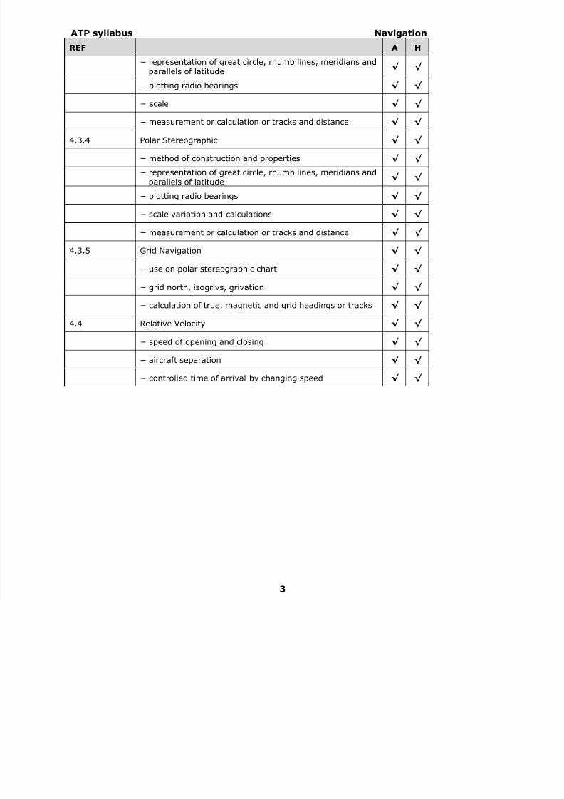
REF A H
− representation of great circle, rhumb lines, meridians andparallels of latitude
√ √
− plotting radio bearings √ √
− scale √ √
− measurement or calculation or tracks and distance √ √
4.3.4 Polar Stereographic √ √
− method of construction and properties √ √
− representation of great circle, rhumb lines, meridians and
parallels of latitude√ √
− plotting radio bearings √ √
− scale variation and calculations √ √
− measurement or calculation or tracks and distance √ √
4.3.5 Grid Navigation √ √
− use on polar stereographic chart √ √
− grid north, isogrivs, grivation √ √
− calculation of true, magnetic and grid headings or tracks √ √
4.4 Relative Velocity √ √
− speed of opening and closing √ √
− aircraft separation √ √
− controlled time of arrival by changing speed √ √