Embed Size (px)
Citation preview
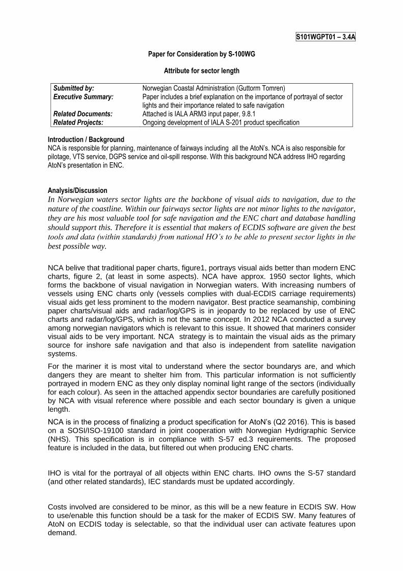
S101WGPT01 – 3.4A
Paper for Consideration by S-100WG
Attribute for sector length
Submitted by: Norwegian Coastal Administration (Guttorm Tomren) Executive Summary: Paper includes a brief explanation on the importance of portrayal of sector
lights and their importance related to safe navigation Related Documents: Attached is IALA ARM3 input paper, 9.8.1 Related Projects: Ongoing development of IALA S-201 product specification
Introduction / Background NCA is responsible for planning, maintenance of fairways including all the AtoN’s. NCA is also responsible for pilotage, VTS service, DGPS service and oil-spill response. With this background NCA address IHO regarding AtoN’s presentation in ENC.
Analysis/Discussion
In Norwegian waters sector lights are the backbone of visual aids to navigation, due to the
nature of the coastline. Within our fairways sector lights are not minor lights to the navigator,
they are his most valuable tool for safe navigation and the ENC chart and database handling
should support this. Therefore it is essential that makers of ECDIS software are given the best
tools and data (within standards) from national HO’s to be able to present sector lights in the
best possible way.
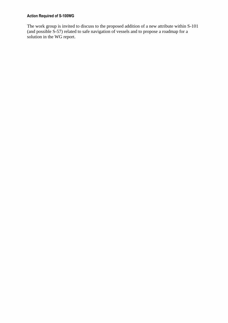
NCA belive that traditional paper charts, figure1, portrays visual aids better than modern ENC charts, figure 2, (at least in some aspects). NCA have approx. 1950 sector lights, which forms the backbone of visual navigation in Norwegian waters. With increasing numbers of vessels using ENC charts only (vessels complies with dual-ECDIS carriage requirements) visual aids get less prominent to the modern navigator. Best practice seamanship, combining paper charts/visual aids and radar/log/GPS is in jeopardy to be replaced by use of ENC charts and radar/log/GPS, which is not the same concept. In 2012 NCA conducted a survey among norwegian navigators which is relevant to this issue. It showed that mariners consider visual aids to be very important. NCA strategy is to maintain the visual aids as the primary source for inshore safe navigation and that also is independent from satellite navigation systems.
For the mariner it is most vital to understand where the sector boundarys are, and which dangers they are meant to shelter him from. This particular information is not sufficiently portrayed in modern ENC as they only display nominal light range of the sectors (individually for each colour). As seen in the attached appendix sector boundaries are carefully positioned by NCA with visual reference where possible and each sector boundary is given a unique length.
NCA is in the process of finalizing a product specification for AtoN’s (Q2 2016). This is based on a SOSI/ISO-19100 standard in joint cooperation with Norwegian Hydrigraphic Service (NHS). This specification is in compliance with S-57 ed.3 requirements. The proposed feature is included in the data, but filtered out when producing ENC charts.
IHO is vital for the portrayal of all objects within ENC charts. IHO owns the S-57 standard (and other related standards), IEC standards must be updated accordingly.
Costs involved are considered to be minor, as this will be a new feature in ECDIS SW. How to use/enable this function should be a task for the maker of ECDIS SW. Many features of AtoN on ECDIS today is selectable, so that the individual user can activate features upon demand.

Conclusions NCA consider ENC charts and AtoNs to be vital to the mariner, any improvement in portrayal performance related to safe navigation should be adapted.
Recommendations Add one additional attribute to S-101 LIGHTS (and possible S-57), length of {1, , n} sectorline
Justification and Impacts
Individual sector line length will give the mariner useful information regarding the
intent/purpose of the corresponding sector light, which dangers are the sector lines intended to
shelter the mariner from.
NCA do not have knowledge regarding the workload/timeframe such a addition to S-57
Lights attributes requires.
Table below is a list regarding number of sector lights in a few IALA member states, this
shows that sector lights is dominantly used in Scandinavian country’s.
Country Norway Sweden Finland Denmark Germany USA Canada UK Australia Ireland Scotland
Sectorlights 1925 1242 396 85 49 14 65 15 100 26 52
Attached images show paper chart layout in Scandinavian country’s, which show similar
features used in all country’s papercharts.
Courtesy of DMA.

Courtesy of SFV
Courtesy of FTA
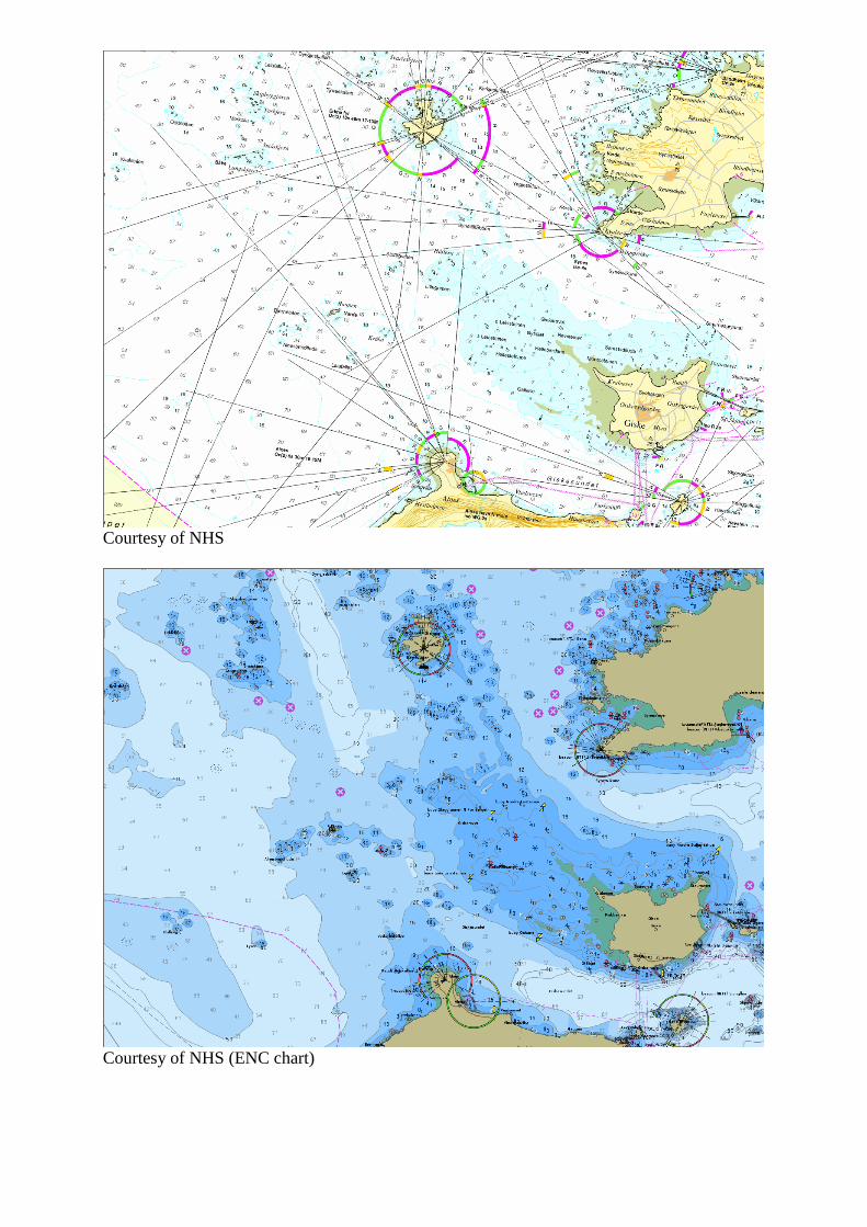
Courtesy of NHS
Courtesy of NHS (ENC chart)
Action Required of S-100WG
The work group is invited to discuss to the proposed addition of a new attribute within S-101
(and possible S-57) related to safe navigation of vessels and to propose a roadmap for a
solution in the WG report.