Embed Size (px)
Citation preview
Hikingin Provinois, Bassée-Montois and Morin
LUISETAINESLuisetaines,
the Marshlands of Auxence
This beautiful hike will allow you to admireseveral points of view on the borders of Bassée
and Montois, and the astonishing Paroy church.
10 km
Duration : 3h20
Blue
Easy
PROVINS
A5
A5A6
N4
N4 N4
D231
D231
D934
D934
D934
A104
LA FERTÉ-GAUCHER
Rebais
Jouy-le-Châtel
NangisMELUND408
D408
D402
D402
N36
N36
N36
A4
A4A4
N4
BRAY-SUR-SEINE
D403
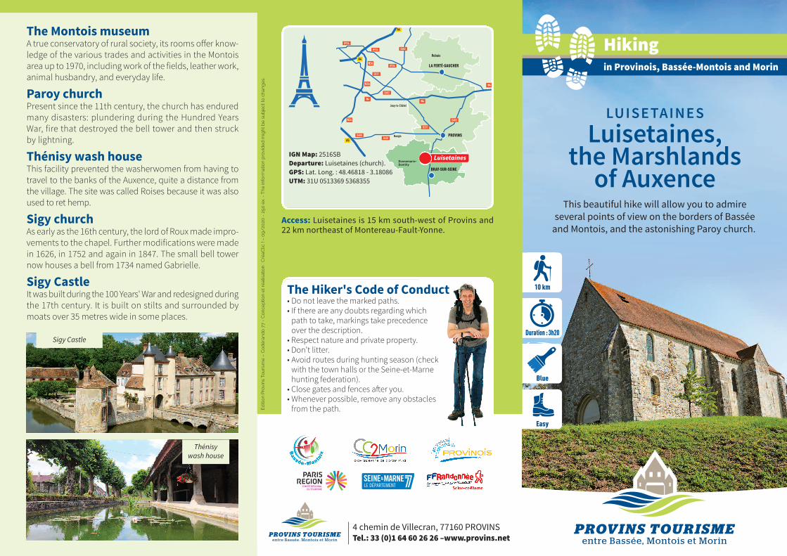
D412IGN Map: 2516SBDeparture: Luisetaines (church).GPS: Lat. Long. : 48.46818 - 3.18086UTM: 31U 0513369 5368355
The Hiker's Code of Conduct• Do not leave the marked paths.• If there are any doubts regarding which
path to take, markings take precedence over the description.
• Respect nature and private property.• Don't litter.• Avoid routes during hunting season (check
with the town halls or the Seine-et-Marne hunting federation).
• Close gates and fences after you.• Whenever possible, remove any obstacles
from the path.
Access: Luisetaines is 15 km south-west of Provins and22 km northeast of Montereau-Fault-Yonne.
Luisetaines
4 chemin de Villecran, 77160 PROVINSTel.: 33 (0)1 64 60 26 26 –www.provins.net
The Montois museumA true conservatory of rural society, its rooms offer know-ledge of the various trades and activities in the Montoisarea up to 1970, including work of the fields, leather work,animal husbandry, and everyday life.
Paroy churchPresent since the 11th century, the church has enduredmany disasters: plundering during the Hundred YearsWar, fire that destroyed the bell tower and then struckby lightning.
Thénisy wash houseThis facility prevented the washerwomen from having totravel to the banks of the Auxence, quite a distance fromthe village. The site was called Roises because it was alsoused to ret hemp.
Sigy churchAs early as the 16th century, the lord of Roux made impro-vements to the chapel. Further modifications were madein 1626, in 1752 and again in 1847. The small bell towernow houses a bell from 1734 named Gabrielle.
Sigy CastleIt was built during the 100 Years' War and redesigned duringthe 17th century. It is built on stilts and surrounded bymoats over 35 metres wide in some places.
Éditi
on
Pro
vins
Touris
me –
Codéra
ndo 7
7 -
Conc
eptio
n et
réal
isat
ion
: Cré
aClic
! –
09/2
020
- 2
50 e
x. -
The
info
rmat
ion
pro
vided m
ight
be s
ubje
ct to
cha
nges.
Thénisy wash house
Sigy Castle

Luisetaines, the Auxence MarshlandFrom the Luisetaines church, follow Grand-Rue southwards
then turn left on Rue de la Plaine, which turns into a path. At theroad, turn right to reach the hamlet of Servigny.
Take the path on the left towards the Auxence marshes.Cross the stream on a culvert to the right of the ford. Thenwalk to the left to follow the edge of the wood. At the cross-roads, turn left and walk to a small road. Follow it to the left,cross D77 and then D77b.
Take the path opposite. It leads to D403. Follow it a fewmeters to the left before walking up to the right towards thechurch of Paroy, alone on the hillock.
Go back down on D403, follow it to the right and at thebend, walk down the path to the right. It leads to a large path.Follow it to the left to the entrance of Thénisy. Then turn right,walk along the cemetery to the centre of Thénisy. In the village,turn right onto Rue Grande (beautiful renovated wash-house)then left on Ruelle de l’Eglise.
Turn right on Rue de l'Eglise, then left on Rue de Bourgogneand, shortly thereafter, turn right onto a path leading to Rue del'Abreuvoir. Cross Route de Mons and continue opposite on apath that crosses Mons brook. Climb up to a ridge overlookingThénisy and the Auxence marshes.
At the top, walk down to the left on a path running parallelto the valley which leads to a road. Turn right onto the roadand cross D403.
Continue opposite on the small road that crosses theAuxence marshes and come to Sigy.
In the village, follow D77b to the right and then a path tothe left. At the end, turn left and then right to go up the hill toa wood and join a path. Follow it to the left to walk aroundthe reservoir then walk down to the right towards Luisetaines.At the path, turn left and left again at the crossroads left toreturn to the church of Luisetaines.
1
2
3
4
5
6
7
8
The trail markings on this route are installed and maintained by 250 footpath wardens from the Seine-et-Marne departmental hiking committee. (Codérando 77). It is part of a network of 4,500 km of walking and hiking trails in the department.If you notice any irregularities during your hikes (errors or lack of markings, poor maintenance, illegal waste disposal), please inform Codérando 77 via the websitehttp://sentinelles.sportsdenature.fr/ by selecting the “hiking” activity.
300 m
Continuestraight
Turnleft
Turn right
Wrong way
Trailmarkings