Embed Size (px)
Citation preview
291
Important Bird Areas in Africa and associated islands – Ethiopia
■■■■■ ETHIOPIAETHIOPIAN WILDLIFE AND NATURAL HISTORY SOCIETY
GENERAL INTRODUCTION
The Federal Democratic Republic of Ethiopia is located between03°N and 15°N, and 33°E and 48°E, and occupies some1,104,300 km². It is bordered by Sudan to the west, Eritrea andDjibouti to the north-east, Somalia to the east and Kenya to thesouth. It is a land of great geographical diversity, characterizedprimarily by variations in altitude. Elevations range from 116 mbelow sea-level in the Afar depression, to a number of peaks inexcess of 4,000 m, of which the highest is Ras Dejen, rising to4,620 m, in the Simen mountains. Much of the country compriseshighland plateaus and mountain ranges that are dissected bynumerous streams and rivers. There is a greater area of land above1,500 m in Ethiopia than in any other African country. The GreatRift Valley divides the mountainous topography of the countryinto two main blocks, the western and northern highlands, and thesouth-eastern and eastern highlands. These highlands graduallydescend to lowland areas in the east, west and south of the country.The principal rivers are the Abbay or Blue Nile, the Wabi Shebeelle,the Genale–Dawa–Weyb system, the Awash, the Tekezze–Angerebsystem, the Omo–Gibe system and the Baro–Akobo system. Thesource of the Abbay is Lake Tana in the north-west of the country;there is also a series of large lakes in the floor of the Rift Valley.
Ethiopia has five climatic zones, defined by altitude andtemperature. The hot, arid zone covers the desert lowlands below500 m, where average annual rainfall is less than 400 mm andaverage annual temperatures range between 28°C and 34°C orhigher. The warm to hot, semi-arid zone includes those areas withan altitude of 500–1,500 m, average annual rainfall generally ofaround 600 mm (but as high as 1,600 mm in the western lowlandsof Gambella), and an average annual temperature range of 20–28°C. The warm to cool, semi-humid zone covers the temperatehighlands between 1,500 and 2,500 m. Average annual temperaturesvary between 16°C and 20°C, and annual rainfall is generally around1,200 mm, reaching 2,400 mm in the south-west. The cool to coldhumid zone includes the temperate highlands between 2,500 and
3,200 m, where average temperatures range between 10°C and 16°C,with an annual rainfall of c.1,000 mm and up to 2,000 mm in higherareas. The cold, moist temperate zone covers the Afro-alpine areason the highest plateaus between 3,200 and 3,500 m; averagetemperatures are below 10°C and annual rainfall averages less than800 mm.
The vegetation in Ethiopia can be divided into eight major types:
• Desert and semi-desert scrubland: characterized by highlydrought-tolerant woody plants such as Acacia, Commiphora,Boscia, Cadaba, Maerua and Zizyphus spp., succulent speciesof Euphorbia and Aloe, and grasses including Dactylocteniumaegyptium and Panicum turgidum.
• Small-leaved, deciduous woodland of Acacia–Commiphora:drought-tolerant tree species and shrubs, with either smalldeciduous leaves or leathery, persistent ones characterize thisvegetation-type and typical species include Acacia tortilis, A.mellifera and Balanites aegyptiaca together with various speciesof Commiphora, Capparis, Combretum and Terminalia. Theground layer includes the herbs Acalypha and Barleria spp.
• Moist evergreen forest: this vegetation-type is characterized bytall and medium-sized emergents, and understorey shrubs.Emergents include Aningeria adolfi-friedericii, Albiziagummifera, A. grandeabracteata, Macaranga capensis and Ocoteakenyensis. Typical understorey shrubs include Chionanthusmildbraedii and Psychotria orophila.
• Lowland semi-evergreen forest: characterized by a range ofmainly semi-deciduous tree and shrub species. Woody speciesinclude the emergent trees Celtis toka, Diospyros abyssinica,Malacantha alnifolia and Zanha golugensis, while shrubby speciesinclude Alchornea laxiflora, Oncoba spinosa and Whitfieldiaelongata.
• Broadleaved, deciduous woodland of Combretum–Terminalia:tree species in these woodlands are small in size with fairly largedeciduous leaves and an understorey of herbs and grasses. Thedominant trees and shrubs are Combretum and Terminalia spp.,Boswellia papyrifera, Lannea schimperi, Anogeissus leiocarpus
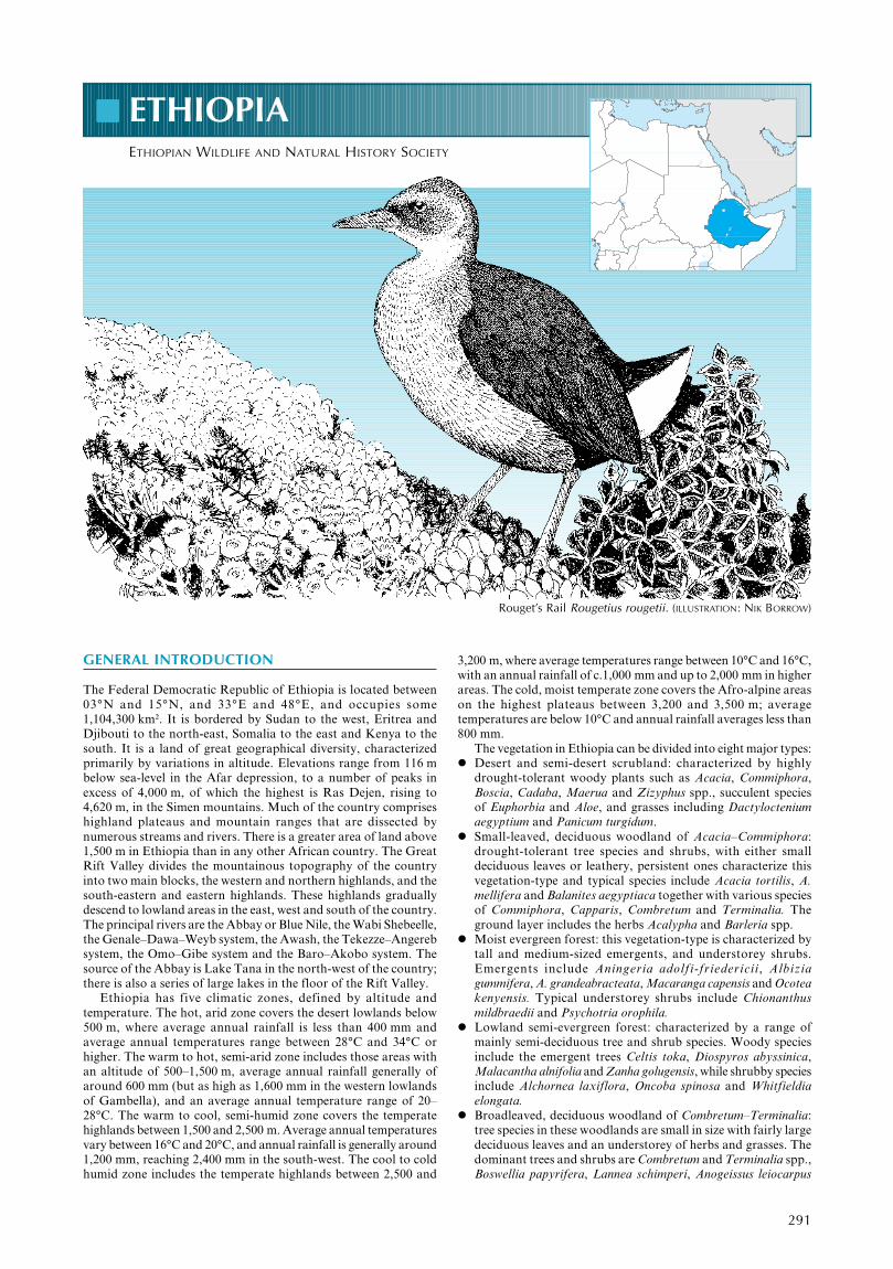
Rouget’s Rail Rougetius rougetii. (ILLUSTRATION: NIK BORROW)
292
Important Bird Areas in Africa and associated islands – Ethiopia
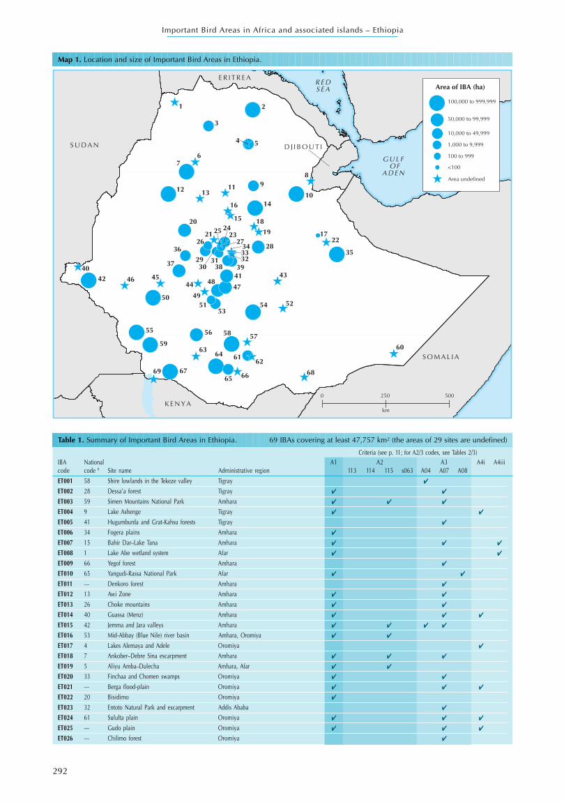
Table 1. Summary of Important Bird Areas in Ethiopia. 69 IBAs covering at least 47,757 km² (the areas of 29 sites are undefined)
Criteria (see p. 11; for A2/3 codes, see Tables 2/3)IBA National A1 A2 A3 A4i A4iiicode code 1 Site name Administrative region 113 114 115 s063 A04 A07 A08
ET001 58 Shire lowlands in the Tekeze valley Tigray ✔
ET002 28 Dessa’a forest Tigray ✔ ✔
ET003 59 Simen Mountains National Park Amhara ✔ ✔ ✔
ET004 9 Lake Ashenge Tigray ✔ ✔
ET005 41 Hugumburda and Grat-Kahsu forests Tigray ✔
ET006 34 Fogera plains Amhara ✔
ET007 15 Bahir Dar–Lake Tana Amhara ✔ ✔ ✔
ET008 1 Lake Abe wetland system Afar ✔ ✔
ET009 66 Yegof forest Amhara ✔
ET010 65 Yangudi-Rassa National Park Afar ✔ ✔
ET011 — Denkoro forest Amhara ✔
ET012 13 Awi Zone Amhara ✔ ✔
ET013 26 Choke mountains Amhara ✔ ✔
ET014 40 Guassa (Menz) Amhara ✔ ✔ ✔
ET015 42 Jemma and Jara valleys Amhara ✔ ✔ ✔ ✔
ET016 53 Mid-Abbay (Blue Nile) river basin Amhara, Oromiya ✔ ✔
ET017 4 Lakes Alemaya and Adele Oromiya ✔
ET018 7 Ankober–Debre Sina escarpment Amhara ✔ ✔ ✔
ET019 5 Aliyu Amba–Dulecha Amhara, Afar ✔ ✔
ET020 33 Finchaa and Chomen swamps Oromiya ✔ ✔
ET021 — Berga flood-plain Oromiya ✔ ✔ ✔
ET022 20 Bisidimo Oromiya ✔
ET023 32 Entoto Natural Park and escarpment Addis Ababa ✔
ET024 61 Sululta plain Oromiya ✔ ✔ ✔
ET025 — Gudo plain Oromiya ✔ ✔ ✔
ET026 — Chilimo forest Oromiya ✔
Map 1. Location and size of Important Bird Areas in Ethiopia.
1 2
3
4 5
67
89
101112 13
14
15
16
1719
20
2122
232425
26 2728
2930
31 323334
3536
37 38 39404142 43
444546
4748
495051 52
5354
55 56 5758
59 6061
62
6364
65 6667 6869
18
S U D A N
G U L F O F
A D E N
E R I T R E A
S O M A L I A
K E N Y A
D J I B O U T I
R E DS E A Area of IBA (ha)
<100
100 to 999
1,000 to 9,999
10,000 to 49,999
50,000 to 99,999
100,000 to 999,999
Area undefined
0 250
km
500
293
Important Bird Areas in Africa and associated islands – Ethiopia
and Stereospernum kunthiamum; the bamboo Oxytenantheraabyssinica is prominent in western river valleys. The grasses aredominated by species of Cymbopogon, Hyparrhenia,Echinocholoa, Sorghum and Pennisetum.
• Dry evergreen montane forest and grassland complex: this typeis characterized by trees of various sizes and extensive grasslandsthat are rich in legumes. Common tree species include Juniperusprocera, Olea europaea, Celtis africana, Euphorbia ampliphylla,Mimusops kummel and Ekebergia capensis. Typical shrubsinclude Dracaena spp., Carissa edulis and Rosa abyssinica, whilecommon grass species belong to the genera Hyparrhenia,Eragrostis, Panicum, Sporobolus, Eleusine and Pennisetum, andthe legumes include Trifolium, Eriosema and Crotalaria spp. Theforest–grassland ecotone is occupied by Acacia woodland withA. abyssinica, A. negrii and A. pilispina the commonest trees.
• Afro-alpine and sub-Afro-alpine vegetation: this vegetation-typeis characterized by small trees, shrubs and shrubby herbs at loweraltitudes and, at higher altitudes, herbs and tuussock-forminggrasses. Typical tree and shrub species include Erica arborea,E. trimera and Hypericum revolutum. Among herbs in this zone
are the giant lobelia Lobelia rhynchopetalum, Kniphofia foliosa,Bartsia petitiana and various Alchemilla species. Festuca, Poaand Agrostis spp. are typical grasses.
• Riparian and swamp vegetation: typical tree species includeCeltis africana, Ficus sycamorus, Mimusops kummel, Tamarindusindica, Maytenus senegalensis, Acacia spp., Kigelia aethiopiumand Syzygium guineense. Swamps are dominated by sedges(especially species of Eleocharis and Scirpus), grasses(particularly Echinochloa spp.) and many herbs.
The human population of Ethiopia, which includes 81 indigenousethnic groups, was estimated to be 60,148,000 (1997 UN estimate),of which just 15% live in urban areas. Ethiopia is divided into 14administrative regions that have legislative, executive and judicialpowers. Coffee is Ethiopia’s major cash-crop, grown mostly in thesouthern and south-western parts of the country. Agriculture inthe highlands is based largely on the production of barley, wheatand teff (Eragrostis tef), whereas in the arid areas of the country,especially in the extreme south, the south-east, east and north-east,pastoralism is the major activity.
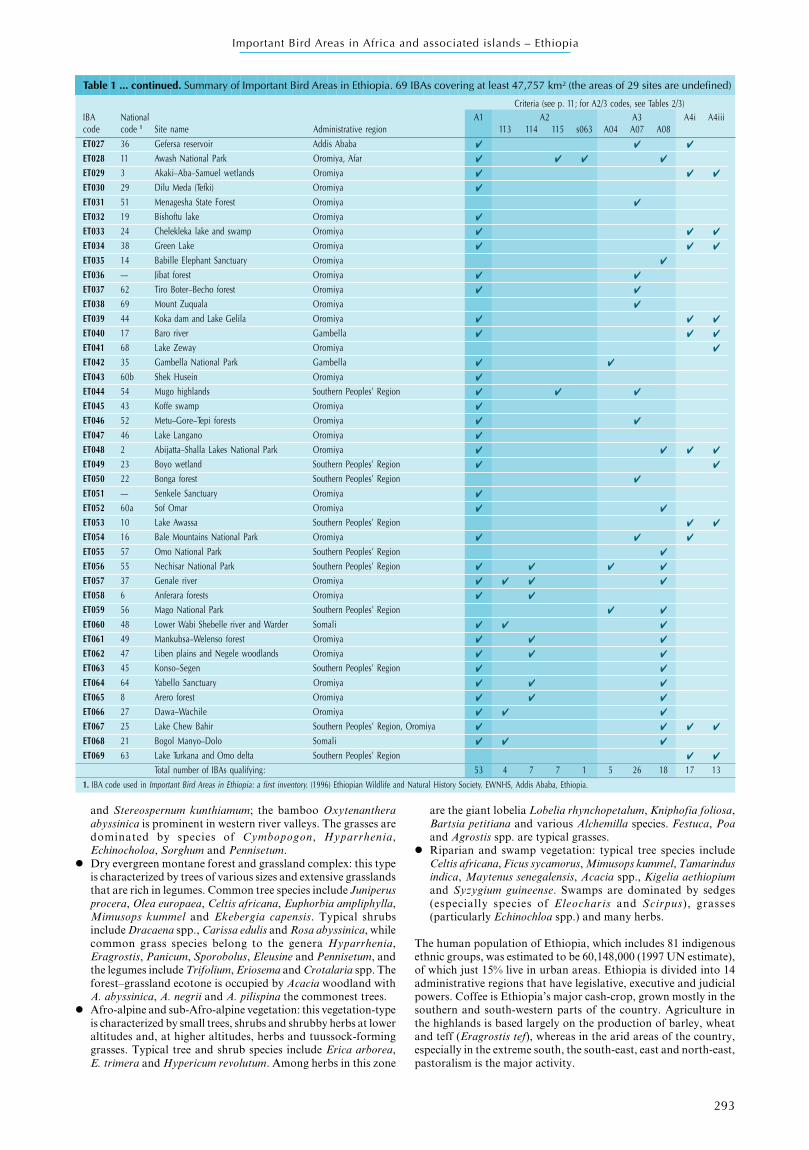
Table 1 ... continued. Summary of Important Bird Areas in Ethiopia. 69 IBAs covering at least 47,757 km² (the areas of 29 sites are undefined)
Criteria (see p. 11; for A2/3 codes, see Tables 2/3)IBA National A1 A2 A3 A4i A4iiicode code 1 Site name Administrative region 113 114 115 s063 A04 A07 A08ET027 36 Gefersa reservoir Addis Ababa ✔ ✔ ✔
ET028 11 Awash National Park Oromiya, Afar ✔ ✔ ✔ ✔
ET029 3 Akaki–Aba–Samuel wetlands Oromiya ✔ ✔ ✔
ET030 29 Dilu Meda (Tefki) Oromiya ✔
ET031 51 Menagesha State Forest Oromiya ✔
ET032 19 Bishoftu lake Oromiya ✔
ET033 24 Chelekleka lake and swamp Oromiya ✔ ✔ ✔
ET034 38 Green Lake Oromiya ✔ ✔ ✔
ET035 14 Babille Elephant Sanctuary Oromiya ✔
ET036 — Jibat forest Oromiya ✔ ✔
ET037 62 Tiro Boter–Becho forest Oromiya ✔ ✔
ET038 69 Mount Zuquala Oromiya ✔
ET039 44 Koka dam and Lake Gelila Oromiya ✔ ✔ ✔
ET040 17 Baro river Gambella ✔ ✔ ✔
ET041 68 Lake Zeway Oromiya ✔
ET042 35 Gambella National Park Gambella ✔ ✔
ET043 60b Shek Husein Oromiya ✔
ET044 54 Mugo highlands Southern Peoples’ Region ✔ ✔ ✔
ET045 43 Koffe swamp Oromiya ✔
ET046 52 Metu–Gore–Tepi forests Oromiya ✔ ✔
ET047 46 Lake Langano Oromiya ✔
ET048 2 Abijatta–Shalla Lakes National Park Oromiya ✔ ✔ ✔ ✔
ET049 23 Boyo wetland Southern Peoples’ Region ✔ ✔
ET050 22 Bonga forest Southern Peoples’ Region ✔
ET051 — Senkele Sanctuary Oromiya ✔
ET052 60a Sof Omar Oromiya ✔ ✔
ET053 10 Lake Awassa Southern Peoples’ Region ✔ ✔
ET054 16 Bale Mountains National Park Oromiya ✔ ✔ ✔
ET055 57 Omo National Park Southern Peoples’ Region ✔
ET056 55 Nechisar National Park Southern Peoples’ Region ✔ ✔ ✔ ✔
ET057 37 Genale river Oromiya ✔ ✔ ✔ ✔
ET058 6 Anferara forests Oromiya ✔ ✔
ET059 56 Mago National Park Southern Peoples’ Region ✔ ✔
ET060 48 Lower Wabi Shebelle river and Warder Somali ✔ ✔ ✔
ET061 49 Mankubsa–Welenso forest Oromiya ✔ ✔ ✔
ET062 47 Liben plains and Negele woodlands Oromiya ✔ ✔ ✔
ET063 45 Konso–Segen Southern Peoples’ Region ✔ ✔
ET064 64 Yabello Sanctuary Oromiya ✔ ✔ ✔
ET065 8 Arero forest Oromiya ✔ ✔ ✔
ET066 27 Dawa–Wachile Oromiya ✔ ✔ ✔
ET067 25 Lake Chew Bahir Southern Peoples’ Region, Oromiya ✔ ✔ ✔ ✔
ET068 21 Bogol Manyo–Dolo Somali ✔ ✔ ✔
ET069 63 Lake Turkana and Omo delta Southern Peoples’ Region ✔ ✔
Total number of IBAs qualifying: 53 4 7 7 1 5 26 18 17 131. IBA code used in Important Bird Areas in Ethiopia: a first inventory. (1996) Ethiopian Wildlife and Natural History Society. EWNHS, Addis Ababa, Ethiopia.
294
Important Bird Areas in Africa and associated islands – Ethiopia
Ethiopia, like a number of African countries, is experiencingserious environmental problems as a result of deforestation,overgrazing, agricultural encroachment and the unregulated useof agrochemicals. In addition, the country is facing recurrentdrought (approximately every seven years) which claims millionsof human lives. Arable land, especially in the highlands, is over-utilized, and the lack of soil-conservation schemes has resulted in aserious decline in agricultural output. This in turn is forcing farmersto exploit land on which the few remaining forests and woodlandspersist, primarily within government reserves. Most of the country’sNational Parks are in the lowlands where grazing land is becomingscarce due to overgrazing and clearance for agriculture. Wildlife insuch areas is considered to be in direct competition with humansand their cattle. Pastoralists try to eliminate the wildlife wheneverthe opportunity arises, such as during the change in government in1991. This problem is further exacerbated by the government’sreluctance to recognize officially, and gazette, all nine NationalParks, rather than just two.
ORNITHOLOGICAL IMPORTANCE
Some 816 species of bird have been recorded from Ethiopia, ofwhich at least 596 are resident and 224 are regular seasonal migrants,including 176 from the Palearctic. Sixteen species are endemic toEthiopia and a further 13 are shared only with Eritrea. Thirty-onespecies of global conservation concern have been recorded. Of these,five (Sarothrura ayresii, Tauraco ruspolii, Heteromirafrasidamoensis, Serinus flavigula, Serinus ankoberensis) are classifiedas Endangered, 12 as Vulnerable (Aythya nyroca, Aquila clanga, A.heliaca, Falco naumanni, F. fasciinucha, Francolinus harwoodi, Gruscarunculatus, Crex crex, Mirafra degodiensis, Hirundo megaensis,Serinus xantholaema, Zavattariornis stresemanni) and 14 are NearThreatened (Balaeniceps rex, Phoenicopterus minor, Circusmacrourus, Rougetius rougetii, Eupodotis humilis, Gallinago media,Glareola nordmanni, Streptopelia reichenowi, Mirafra pulpa,Macronyx flavicollis, Cercomela dubia, Acrocephalus griseldis,
Sylvietta philippae and Emberiza cineracea; of these, A. nyroca, A.clanga, A. heliaca, F. naumanni, C. crex, C. macrourus, G. media,G. nordmanni and A. griseldis are non-breeding migrants from thePalearctic while Phoenicopterus minor is a non-breeding visitor fromelsewhere in the Afrotropics; the remainder are resident).
Parts or all of three Endemic Bird Areas (EBAs) lie withinEthiopia. The Jubba and Shabeelle valleys EBA (EBA 113) is sharedwith Somalia and three of its four species occur, the whole of theSouth Ethiopian highlands EBA (EBA 114) falls within its borders(all five species occur) while most of the Central Ethiopian highlandsEBA (EBA 115) does so and all its four species occur (see Table 2).There is also one Secondary Area—Northern Ethiopia (s063),defined by the distribution of Cercomela dubia.
Parts of four biome-restricted assemblages are present. Theseare: the Sahel biome (A03), in a small area of the far north (eight ofthe 16 species that are restricted to this biome have been recordedin Ethiopia); the Sudan–Guinea Savanna biome (A04) whichoccupies much of the west of the country (16 of its 54 species havebeen recorded); the Afrotropical Highlands biome (A07) whichstraddles large parts of the centre of Ethiopia (49 species inEthiopia); and, across the east and remaining central parts, theSomali–Masai biome (A08; 98 species occur).
There are numerous wetlands of importance for birds. Theseinclude the lakes of the Rift Valley and, elsewhere, montane marshesand bogs and, particularly in the west, lowland swamps.
CONSERVATION INFRASTRUCTURE ANDPROTECTED-AREA SYSTEM
The designation and management of protected areas used to be thesole mandate of the Ethiopian Wildlife Conservation Organization(EWCO), while the management of the priority forest areas wasthe responsibility of the Ministry of Agriculture’s ForestryDepartment. However, excepting Awash and Yangudi RasaNational Parks, EWCO currently has no direct control over thenation’s parks, game reserves, controlled-hunting areas andsanctuaries, as these are now being run by the Agricultural Officesof the respective regional governments.
The following categories of protected area are recognized in thecountry:
• National Park—areas set aside for the purpose of conservingand protecting wildlife and objects of aesthetic, ecological andscientific interest. Prohibited activities (unless written permissionfrom the wildlife conservation authority is obtained) includehunting, cultivation, grazing cattle or livestock, felling trees,burning vegetation, residing in, or exploiting natural resourcesin any manner unless these activities are for the developmentand management of the park.
• Game Reserve—prohibited activities include possession offirearms and the hunting of animals, unless acting in accordancewith the conditions of a game-capture permit, or with writtenpermission. Persons are also prohibited from residing in gamereserves without written permission from the wildlifeconservation authority, excepting public officers on duty andpersons resident prior to declaration. Persons authorized toreside in game reserves have the right to cultivate their land andto pasture and water domestic animals therein.
• Sanctuary—prohibited activities include grazing cattle,settlement and hunting of animals, unless acting in accordancewith the conditions of a permit, or with written permission.
• Controlled Hunting Area—prohibited activities include grazingcattle, settlement, and the hunting of animals unless acting inaccordance with the conditions of a permit.
National Parks and other strict nature reserves cover 161,600 km²or 13.5% of Ethiopia’s land area, and include nearly all the majorhabitat-types to be found in the country. However, only Awashand Simen Mountains National Parks have been formally gazettedand legally recognized.
A large portion of the forests that remain outside the protected-area system are designated as priority forest areas. The mainobjectives of the priority forest area scheme are to promote soilconservation, watershed (and climatic) stabilization and the in situpreservation of indigenous plant species.
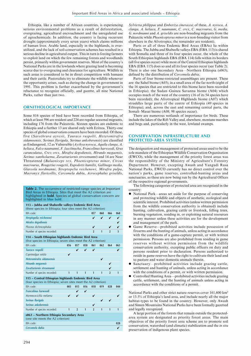
Table 2. The occurrence of restricted-range species at ImportantBird Areas in Ethiopia. Sites that meet the A2 criterion arehighlighted in bold. Species of global conservation concern arehighlighted in blue bold.
113 – Jubba and Shabeelle valleys Endemic Bird Area(three species in Ethiopia; four sites meet the A2 criterion)IBA code: 057 060 066 068Streptopelia reichenowi ✔ ✔ ✔ ✔
Mirafra degodiensis ✔
Ploceus dichrocephalus ✔ ✔ ✔
Number of species recorded: 2 1 2 3
114 – South Ethiopian highlands Endemic Bird Area(five species in Ethiopia; seven sites meet the A2 criterion)IBA code: 056 057 058 061 062 064 065Tauraco ruspolii ✔ ✔ ✔ ✔
Caprimulgus solala ✔
Heteromirafra sidamoensis ✔
Hirundo megaensis ✔
Zavattariornis stresemanni ✔
Number of species recorded: 1 1 1 1 1 2 1
115 – Central Ethiopian highlands Endemic Bird Area(four species in Ethiopia; seven sites meet the A2 criterion)IBA code: 003 015 016 018 019 028 044Francolinus harwoodi ✔ ✔
Myrmecocichla melaena ✔ ✔ ✔ ✔
Serinus flavigula ✔ ✔
Serinus ankoberensis ✔
Number of species recorded: 1 2 1 2 1 1 1
s063 – Northern Ethiopia Secondary Area(one site meets the A2 criterion)
IBA code: 028Cercomela dubia ✔
295
Important Bird Areas in Africa and associated islands – Ethiopia
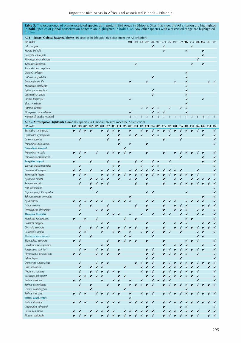
Table 3. The occurrence of biome-restricted species at Important Bird Areas in Ethiopia. Sites that meet the A3 criterion are highlightedin bold. Species of global conservation concern are highlighted in bold blue. Any other species with a restricted range are highlightedin blue.
A04 – Sudan–Guinea Savanna biome (16 species in Ethiopia; five sites meet the A3 criterion)IBA code: 001 004 006 007 015 019 028 032 037 039 042 055 056 059 061 064Falco alopex ✔ ✔ ✔
Merops bulocki ✔ ✔ ✔
Cossypha albicapilla ✔
Myrmecocichla albifrons ✔
Turdoides tenebrosus ✔ ✔ ✔
Turdoides leucocephalusCisticola ruficeps ✔
Cisticola troglodytes ✔ ✔
Eremomela pusilla ✔ ✔ ✔ ✔ ✔ ✔
Muscicapa gambagae ✔
Pytilia phoenicoptera ✔ ✔
Lagonosticta larvata ✔ ✔
Estrilda troglodytes ✔ ✔ ✔
Vidua interjecta ✔
Petronia dentata ✔ ✔ ✔ ✔ ✔ ✔ ✔
Plocepasser superciliosus ✔ ✔ ✔ ✔ ✔
Number of species recorded: 3 1 1 2 6 2 3 1 1 1 11 2 1 4 1 1
A07 – Afrotropical Highlands biome (49 species in Ethiopia; 26 sites meet the A3 criterion)IBA code: 002 003 005 007 009 011 012 013 014 015 018 020 021 023 024 025 026 027 031 036 037 038 044 046 050 054Bostrychia carunculata ✔ ✔ ✔ ✔ ✔ ✔ ✔ ✔ ✔ ✔ ✔ ✔ ✔ ✔ ✔ ✔ ✔ ✔ ✔ ✔ ✔ ✔
Cyanochen cyanopterus ✔ ✔ ✔ ✔ ✔ ✔ ✔ ✔ ✔ ✔ ✔
Buteo oreophilus ✔ ✔ ✔ ✔ ✔ ✔
Francolinus psilolaemus ✔ ✔ ✔ ✔
Francolinus harwoodi ✔
Francolinus erckelii ✔ ✔ ✔ ✔ ✔ ✔ ✔ ✔ ✔ ✔ ✔ ✔ ✔ ✔ ✔ ✔ ✔ ✔
Francolinus castaneicollis ✔ ✔ ✔ ✔
Rougetius rougetii ✔ ✔ ✔ ✔ ✔ ✔ ✔ ✔ ✔ ✔ ✔
Vanellus melanocephalus ✔ ✔ ✔ ✔ ✔ ✔ ✔
Columba albitorques ✔ ✔ ✔ ✔ ✔ ✔ ✔ ✔ ✔ ✔ ✔ ✔ ✔ ✔ ✔ ✔ ✔ ✔ ✔
Streptopelia lugens ✔ ✔ ✔ ✔ ✔ ✔ ✔ ✔ ✔ ✔ ✔ ✔ ✔ ✔ ✔ ✔ ✔ ✔ ✔ ✔ ✔ ✔
Agapornis taranta ✔ ✔ ✔ ✔ ✔ ✔ ✔ ✔ ✔ ✔ ✔ ✔ ✔ ✔ ✔ ✔ ✔
Tauraco leucotis ✔ ✔ ✔ ✔ ✔ ✔ ✔ ✔ ✔ ✔ ✔ ✔ ✔ ✔ ✔ ✔
Asio abyssinicus ✔ ✔
Caprimulgus poliocephalus ✔ ✔ ✔ ✔ ✔
Schoutedenapus myoptilus ✔ ✔ ✔
Apus niansae ✔ ✔ ✔ ✔ ✔ ✔ ✔ ✔ ✔ ✔ ✔ ✔ ✔ ✔ ✔ ✔ ✔ ✔ ✔ ✔
Lybius undatus ✔ ✔ ✔ ✔ ✔ ✔ ✔ ✔ ✔ ✔ ✔ ✔
Dendropicos abyssinicus ✔ ✔ ✔ ✔ ✔ ✔ ✔ ✔ ✔ ✔ ✔ ✔
Macronyx flavicollis ✔ ✔ ✔ ✔ ✔ ✔ ✔ ✔ ✔ ✔ ✔ ✔ ✔ ✔
Monticola rufocinereus ✔ ✔ ✔ ✔ ✔ ✔ ✔ ✔
Zoothera piaggiae ✔ ✔ ✔ ✔ ✔ ✔ ✔ ✔ ✔ ✔
Cossypha semirufa ✔ ✔ ✔ ✔ ✔ ✔ ✔ ✔ ✔ ✔ ✔ ✔ ✔ ✔ ✔ ✔ ✔ ✔ ✔
Cercomela sordida ✔ ✔ ✔ ✔ ✔ ✔ ✔ ✔ ✔ ✔ ✔ ✔ ✔ ✔ ✔
Myrmecocichla melaena ✔ ✔ ✔ ✔ ✔ ✔ ✔
Thamnolaea semirufa ✔ ✔ ✔ ✔ ✔ ✔ ✔ ✔ ✔ ✔ ✔ ✔ ✔
Pseudoalcippe abyssinica ✔ ✔ ✔ ✔ ✔ ✔ ✔ ✔ ✔
Parophasma galinieri ✔ ✔ ✔ ✔ ✔ ✔ ✔ ✔ ✔ ✔ ✔ ✔ ✔ ✔ ✔ ✔ ✔
Phylloscopus umbrovirens ✔ ✔ ✔ ✔ ✔ ✔ ✔ ✔ ✔ ✔ ✔ ✔ ✔ ✔ ✔
Sylvia lugens ✔ ✔ ✔ ✔
Dioptrornis chocolatinus ✔ ✔ ✔ ✔ ✔ ✔ ✔ ✔ ✔ ✔ ✔ ✔ ✔ ✔ ✔ ✔ ✔ ✔
Parus leuconotus ✔ ✔ ✔ ✔ ✔ ✔ ✔ ✔ ✔ ✔ ✔ ✔ ✔ ✔ ✔ ✔ ✔
Nectarinia tacazze ✔ ✔ ✔ ✔ ✔ ✔ ✔ ✔ ✔ ✔ ✔ ✔ ✔ ✔ ✔ ✔ ✔ ✔
Zosterops poliogaster ✔ ✔ ✔ ✔ ✔ ✔ ✔ ✔ ✔ ✔ ✔ ✔ ✔ ✔ ✔ ✔ ✔
Serinus nigriceps ✔ ✔ ✔ ✔ ✔ ✔ ✔ ✔ ✔ ✔ ✔ ✔ ✔
Serinus citrinelloides ✔ ✔ ✔ ✔ ✔ ✔ ✔ ✔ ✔ ✔ ✔ ✔ ✔ ✔ ✔ ✔ ✔ ✔ ✔
Serinus xanthopygius ✔ ✔ ✔
Serinus tristriatus ✔ ✔ ✔ ✔ ✔ ✔ ✔ ✔ ✔ ✔ ✔ ✔ ✔ ✔ ✔ ✔ ✔ ✔ ✔ ✔ ✔ ✔
Serinus ankoberensis ✔
Serinus striolatus ✔ ✔ ✔ ✔ ✔ ✔ ✔ ✔ ✔ ✔ ✔ ✔ ✔ ✔ ✔ ✔ ✔ ✔ ✔ ✔ ✔ ✔ ✔
Cryptospiza salvadorii ✔ ✔ ✔ ✔ ✔ ✔
Passer swainsonii ✔ ✔ ✔ ✔ ✔ ✔ ✔ ✔ ✔ ✔ ✔ ✔ ✔ ✔ ✔ ✔ ✔ ✔ ✔ ✔ ✔ ✔
Ploceus baglafecht ✔ ✔ ✔ ✔ ✔ ✔ ✔ ✔ ✔ ✔ ✔ ✔ ✔ ✔ ✔ ✔ ✔ ✔ ✔ ✔ ✔ ✔ ✔
296
Important Bird Areas in Africa and associated islands – Ethiopia
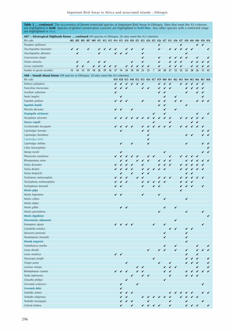
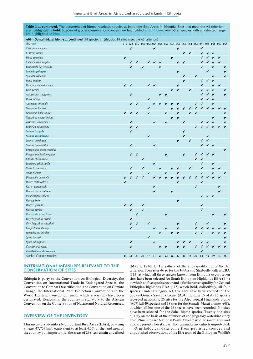
Table 3 ... continued. The occurrence of biome-restricted species at Important Bird Areas in Ethiopia. Sites that meet the A3 criterionare highlighted in bold. Species of global conservation concern are highlighted in bold blue. Any other species with a restricted rangeare highlighted in blue.
A07 – Afrotropical Highlands biome ... continued (49 species in Ethiopia; 26 sites meet the A3 criterion)IBA code: 002 003 005 007 009 011 012 013 014 015 018 020 021 023 024 025 026 027 031 036 037 038 044 046 050 054Poeoptera stuhlmanni ✔ ✔ ✔ ✔
Onychognathus tenuirostris ✔ ✔ ✔ ✔ ✔ ✔ ✔ ✔ ✔ ✔ ✔ ✔ ✔ ✔ ✔ ✔ ✔
Onychognathus albirostris ✔ ✔ ✔ ✔ ✔ ✔ ✔
Cinnyricinclus sharpii ✔ ✔ ✔ ✔ ✔ ✔ ✔ ✔
Oriolus monacha ✔ ✔ ✔ ✔ ✔ ✔ ✔ ✔ ✔ ✔ ✔ ✔ ✔ ✔
Corvus crassirostris ✔ ✔ ✔ ✔ ✔ ✔ ✔ ✔ ✔ ✔ ✔ ✔ ✔ ✔ ✔ ✔ ✔ ✔ ✔ ✔
Number of species recorded:: 15 34 12 19 18 26 29 16 27 14 24 18 18 33 25 7 34 20 27 33 32 22 28 26 15 43
A08 – Somali–Masai biome (98 species in Ethiopia; 18 sites meet the A3 criterion)IBA code: 010 028 035 048 052 055 056 057 059 060 061 062 063 064 065 066 067 068Melierax poliopterus ✔ ✔ ✔ ✔ ✔ ✔ ✔ ✔ ✔ ✔ ✔ ✔ ✔ ✔
Francolinus leucoscepus ✔ ✔ ✔ ✔ ✔ ✔ ✔ ✔ ✔ ✔ ✔ ✔
Acryllium vulturinum ✔ ✔ ✔ ✔ ✔ ✔
Neotis heuglini ✔ ✔ ✔ ✔
Eupodotis gindiana ✔ ✔ ✔ ✔ ✔ ✔ ✔ ✔ ✔ ✔ ✔
Eupodotis humilis ✔ ✔ ✔
Pterocles decoratus ✔ ✔ ✔ ✔ ✔
Streptopelia reichenowi ✔ ✔ ✔ ✔
Poicephalus rufiventris ✔ ✔ ✔ ✔ ✔ ✔ ✔ ✔ ✔ ✔ ✔ ✔ ✔ ✔ ✔ ✔
Tauraco ruspolii ✔ ✔ ✔ ✔
Corythaixoides leucogaster ✔ ✔ ✔ ✔ ✔ ✔ ✔ ✔ ✔ ✔ ✔ ✔ ✔ ✔ ✔
Caprimulgus fraenatus ✔ ✔ ✔ ✔ ✔
Caprimulgus donaldsoni ✔ ✔ ✔ ✔ ✔
Caprimulgus solala ✔
Caprimulgus stellatus ✔ ✔ ✔ ✔ ✔ ✔
Colius leucocephalus ✔
Merops revoilii ✔ ✔ ✔ ✔
Phoeniculus somaliensis ✔ ✔ ✔ ✔ ✔ ✔ ✔ ✔ ✔ ✔ ✔ ✔
Rhinopomastus minor ✔ ✔ ✔ ✔ ✔ ✔ ✔ ✔ ✔ ✔ ✔ ✔ ✔
Tockus flavirostris ✔ ✔ ✔ ✔ ✔ ✔ ✔ ✔ ✔ ✔ ✔ ✔ ✔
Tockus deckeni ✔ ✔ ✔ ✔ ✔ ✔ ✔ ✔ ✔ ✔ ✔ ✔ ✔ ✔
Tockus hemprichii ✔ ✔ ✔ ✔ ✔ ✔
Tricholaema melanocephala ✔ ✔ ✔ ✔ ✔ ✔ ✔ ✔ ✔ ✔ ✔ ✔ ✔
Trachyphonus erythrocephalus ✔ ✔ ✔ ✔ ✔ ✔ ✔ ✔ ✔ ✔ ✔
Trachyphonus darnaudii ✔ ✔ ✔ ✔ ✔ ✔ ✔ ✔ ✔
Mirafra pulpa ✔
Mirafra hypermetra ✔ ✔ ✔ ✔
Mirafra collaris ✔ ✔
Mirafra alopexMirafra gilletti ✔ ✔ ✔ ✔
Mirafra poecilosterna ✔ ✔ ✔
Mirafra degodiensis ✔
Heteromirafra sidamoensis ✔
Eremopterix signata ✔ ✔ ✔ ✔ ✔ ✔ ✔
Calandrella somalica ✔ ✔ ✔ ✔
Spizocorys personata ✔ ✔
Pseudalaemon fremantlii ✔ ✔
Hirundo megaensis ✔
Tmetothylacus tenellus ✔ ✔ ✔ ✔
Lanius dorsalis ✔ ✔ ✔ ✔ ✔ ✔ ✔ ✔
Lanius somalicus ✔ ✔ ✔ ✔
Dryoscopus pringlii ✔ ✔ ✔ ✔ ✔
Tchagra jamesi ✔ ✔ ✔ ✔ ✔ ✔ ✔
Laniarius ruficeps ✔ ✔ ✔ ✔ ✔ ✔ ✔
Rhodophoneus cruentus ✔ ✔ ✔ ✔ ✔ ✔ ✔ ✔ ✔ ✔ ✔ ✔
Turdus tephronotus ✔ ✔ ✔ ✔ ✔ ✔ ✔
Oenanthe phillipsi ✔ ✔
Cercomela scotocerca ✔ ✔ ✔
Cercomela dubia ✔
Turdoides aylmeri ✔ ✔ ✔ ✔ ✔ ✔ ✔ ✔ ✔ ✔
Turdoides rubiginosus ✔ ✔ ✔ ✔ ✔ ✔ ✔ ✔ ✔ ✔ ✔ ✔
Turdoides leucopygius ✔ ✔ ✔ ✔ ✔ ✔ ✔
Cisticola bodessa ✔ ✔ ✔ ✔ ✔ ✔ ✔ ✔ ✔ ✔ ✔
297
Important Bird Areas in Africa and associated islands – Ethiopia
INTERNATIONAL MEASURES RELEVANT TO THECONSERVATION OF SITES
Ethiopia is party to the Convention on Biological Diversity, theConvention on International Trade in Endangered Species, theConvention to Combat Desertification, the Convention on ClimateChange, the International Plant Protection Convention and theWorld Heritage Convention, under which seven sites have beendesignated. Regionally, the country is signatory to the AfricanConvention on the Conservation of Nature and Natural Resources.
OVERVIEW OF THE INVENTORY
This inventory identifies 69 Important Bird Areas (IBAs), coveringat least 47,757 km², equivalent to at least 4.3% of the land area ofthe country but, importantly, the areas of 29 sites remain undefined
(Map 1, Table 1). Fifty-three of the sites qualify under the A1criterion. Four sites do so for the Jubba and Shabeelle valleys EBA(113) at which all three species known from Ethiopia occur, sevensites have been selected for South Ethiopian Highlands EBA (114)at which all five species occur and a further seven qualify for CentralEthiopian highlands EBA (115) which hold, collectively, all fourspecies. Under Category A3, five sites have been selected for theSudan–Guinea Savanna biome (A04), holding 15 of its 16 speciesrecorded nationally, 26 sites for the Afrotropical Highlands biome(A07) (all 49 species) and 18 sites for the Somali–Masai biome (A08),at which all but one of the 98 species have been recorded. No siteshave been selected for the Sahel biome species. Twenty-one sitesqualify on the basis of the numbers of congregatory waterbirds theyhold. Nine sites are National Parks, two are wildlife sanctuaries andnine are priority forest areas. The remainder are entirely unprotected.
Ornithological data come from published sources andunpublished observations of the IBA team of the Ethiopian Wildlife
Table 3 ... continued. The occurrence of biome-restricted species at Important Bird Areas in Ethiopia. Sites that meet the A3 criterionare highlighted in bold. Species of global conservation concern are highlighted in bold blue. Any other species with a restricted rangeare highlighted in blue.
A08 – Somali–Masai biome ... continued (98 species in Ethiopia; 18 sites meet the A3 criterion)IBA code: 010 028 035 048 052 055 056 057 059 060 061 062 063 064 065 066 067 068Cisticola cinereolus ✔ ✔ ✔ ✔
Cisticola nanus ✔ ✔ ✔ ✔ ✔
Prinia somalica ✔ ✔ ✔ ✔ ✔ ✔
Calamonastes simplex ✔ ✔ ✔ ✔ ✔ ✔ ✔ ✔ ✔ ✔ ✔
Eremomela flavicrissalis ✔ ✔ ✔ ✔ ✔ ✔
Sylvietta philippae ✔ ✔ ✔
Sylvietta isabellina ✔ ✔ ✔ ✔
Sylvia boehmi ✔ ✔ ✔ ✔
Bradornis microrhynchus ✔ ✔ ✔ ✔ ✔ ✔ ✔ ✔
Batis perkeo ✔ ✔ ✔ ✔ ✔ ✔ ✔
Anthoscopus musculus ✔ ✔ ✔ ✔ ✔ ✔ ✔
Parus thruppi ✔ ✔ ✔ ✔
Anthreptes orientalis ✔ ✔ ✔ ✔ ✔ ✔ ✔ ✔ ✔ ✔
Nectarinia hunteri ✔ ✔ ✔ ✔ ✔ ✔ ✔ ✔ ✔ ✔ ✔
Nectarinia habessinica ✔ ✔ ✔ ✔ ✔ ✔ ✔ ✔ ✔
Nectarinia nectarinioides ✔ ✔ ✔ ✔
Zosterops abyssinicus ✔ ✔ ✔ ✔ ✔ ✔ ✔ ✔
Emberiza poliopleura ✔ ✔ ✔ ✔ ✔ ✔ ✔ ✔
Serinus flavigula ✔ ✔
Serinus xantholaema ✔ ✔ ✔
Serinus donaldsoni ✔ ✔ ✔ ✔
Serinus dorsostriatus ✔ ✔ ✔ ✔ ✔
Uraeginthus cyanocephalus ✔
Uraeginthus ianthinogaster ✔ ✔ ✔ ✔ ✔ ✔ ✔ ✔
Estrilda charmosyna ✔ ✔ ✔
Lonchura griseicapilla ✔ ✔ ✔
Vidua hypocherina ✔ ✔ ✔ ✔ ✔ ✔ ✔ ✔ ✔
Vidua fischeri ✔ ✔ ✔ ✔ ✔ ✔ ✔
Dinemellia dinemelli ✔ ✔ ✔ ✔ ✔ ✔ ✔ ✔ ✔ ✔ ✔ ✔ ✔ ✔ ✔ ✔
Passer castanopterus ✔ ✔ ✔
Passer gongonensis ✔ ✔ ✔
Plocepasser donaldsoni ✔ ✔ ✔
Pseudonigrita cabanisi ✔ ✔ ✔
Ploceus bojeri ✔
Ploceus galbula ✔ ✔ ✔ ✔
Ploceus spekei ✔ ✔ ✔
Ploceus dichrocephalus ✔ ✔ ✔ ✔
Onychognathus blythii ✔
Onychognathus salvadorii ✔ ✔ ✔ ✔ ✔ ✔ ✔
Lamprotornis shelleyi ✔ ✔ ✔ ✔ ✔ ✔ ✔ ✔ ✔ ✔
Speculipastor bicolor ✔ ✔ ✔ ✔ ✔ ✔ ✔ ✔
Spreo fischeri ✔ ✔
Spreo albicapillus ✔ ✔ ✔ ✔ ✔ ✔ ✔ ✔
Cosmopsarus regius ✔ ✔ ✔ ✔ ✔ ✔ ✔ ✔ ✔ ✔ ✔
Zavattariornis stresemanni ✔
Number of species recorded: 23 51 27 20 17 31 25 22 28 47 30 18 26 63 43 49 35 36
298
Important Bird Areas in Africa and associated islands – Ethiopia
■ SITE ACCOUNTS
Shire lowlands in the Tekeze valley ET001Admin region TigrayCoordinates 14°00’N 37°00’E A3 (A04)Area Undefined Altitude 600–1,900 m Unprotected
■■■■■ Site descriptionThe moist, fertile Shire lowlands are in the Western Zone. They are inthe lower reaches of the wide Tekeze valley (at 600 m) between EndaSelassie at 1,900 m on the northern rim of the Tekeze gorge, Sheraroto the north-west and Birkuta to the west, near the border with Eritrea.Enda Selassie is c.200 km north of Gondar and 50 km west of Axum.The Shire lowlands are relatively under-populated compared to therest of Tigray Region. They represent the easternmost extension ofthe Sudano–Sahelian zone. The higher, eastern section of Shire is onthe western extension of the plateau where the terrain is flat toundulating. Towards the Tekeze and its larger tributaries, fairly deepvalleys break the land, and several have cut through thick layers ofred fossil soils which are almost sterile and support little or novegetation. The lower western Shire lowlands, towards the border withEritrea, comprise flatter plains, but with some higher hills such asTsada Emba (White mountain).
The area supports a range of vegetation-types. On the higher easternplateau, now mostly cultivated, wooded grassland thrives. Marshes withpatches of tall sedges and bulrushes are formed in the shallow valleyswhere drainage is impeded. Forest patches are found above 1,000 mand comprise broad- to fine-leaved deciduous species. Most of the areason broken terrain below 1,500 m are covered in Acacia–Combretumwoodland with large trees of baobab Adansonia digitata and Tamarindusindica. Important species include the threatened African blackwoodDalbergia melanoxylon, the economically exploited frankincense treeBoswellia papyrifera, and the source of gum arabic, Acacia senegal. Muchof the remaining area would naturally be covered in edaphic tallgrassland, with some patches of woody species such as Balanitesaegyptiaca. The Kunama people have long inhabited this area: theyused to be hunter-gatherers until other groups recently moved into thearea, and they then adopted a more sedentary, cultivation-orientedexistence. The other traditional groups of the whole western lowlands
and Natural History Society, and from other contacts. Data onmany species, including those of global conservation concern, areextremely inadequate, while many sites detailed here are in urgentneed of monitoring and, where necessary, of action on the groundif they are to retain their conservation importance. It is alsoimportant to conduct surveys in areas such as the Ogaden andAssosa that have never been explored properly.
COMMENTS ON THE INVENTORY
The list of IBAs in this inventory differs somewhat from thatpublished previously (Ethiopian Wildlife and Natural HistorySociety 1996) as it includes several sites (ET011, ET021, ET025,ET026, ET036, ET051, ET053) that have been identified andsurveyed since the appearance of the first inventory, while one site,the Awash river valley (012 in the previous volume), has beendropped, since, upon re-evaluation, it was decided that it was neitherdefinable nor defensible as a site. The opportunity has been takento update information for a number of sites which also appear hererenumbered, according to the international convention adopted.
ACKNOWLEDGEMENTS
The Ethiopian IBA inventory was prepared by: (editors) Solomon Tilahun, SueEdwards and Tewolde Berhan Gebre Egziabher; and (contributors) AntenehShimelis, Gary Allport, John Atkins, Lincoln Fishpool, Mengistu Wondafrash,Peter Robertson, Sebsebe Demissew, Sileshi Dejene, Sue Edwards, Tadesse WoldeMariam, Tilye Nigussie and Yilma Dellelegn. However, many people andorganizations contributed to the IBA project in Ethiopia and these areacknowledged in full in the national inventory (Ethiopian Wildlife and Natural
History Society 1996). The Executive Committee and staff of the EthiopianWildlife and Natural History Society (EWNHS) provided the institutional basefor the project, and technical and management support came from the Secretariatof BirdLife International. The work was funded from the European Union BudgetLine B7–5040. The Ethiopian government, through a memorandum ofunderstanding between EWNHS and the Ethiopian Wildlife ConservationOrganization (EWCO), endorsed the IBA programme. EWCO staff at variousNational Parks were extremely helpful and supportive to IBA survey teammembers, as were government officials in the various Regional, Zonal andWoreda Agricultural Offices. For their support and permissions in the trainingand fieldwork components of the project we would like to thank: the BritishEmbassy (Overseas Development Administration), British Council, CARE-Ethiopia, the Addis Ababa University Faculty of Science and NationalHerbarium, Redd Barna, Addis Ababa Water and Sewage Authority.Compilation of sites accounts was made possible through the cooperation andhelp of library staff at: the Secretariat of BirdLife International in Cambridge(UK), the Ministry of Water Resources, the International Livestock ResearchInstitute, the Ethiopian Heritage Trust, the Ministry of Agriculture and theNational Herbarium. For their time and expertise on the project we especiallythank Philip Atkinson, Margaret Carswell, Ron Demey, Peter Hayman, AndrewPierce, Peter Robertson, Ato Abdurahman Kubsa, Ato Abera Woldegiorgis,Ato Akale Yemane, John Ash, Assefa Megrate, Nonie Coulthard, Sarah Crouch,Lieuwe Dijksen, Ato Engeda Bayu, Atu Girma Demissie, Ato Gizachew Assefa,Ato Medfin Anbesse, Ato Million Alemayehu, Ato Minassie Gashaw, AtoMohammed Ibrahim, Ato Sharew Desta, Ato Shimellis Chernet, Ato SissayNune, Per Ole Syvertsen, Ato Tewabe Ashenafi, Ato Yilma Tesfaye, Ato YoditTewolde and Ato Zelealem Tefera.
GLOSSARY
Wereda an administrative district.
are pastoralists; these include the Beni Amer based to the north inEritrea, and the Benshangul and Gumuz peoples to the south. Thesegroups bring large numbers of sheep, goats, cattle and camels into theTekeze lowlands to make use of seasonal grazing/browsing. The flatterareas on both the plateau and the lowlands towards the Eritrea andSudan borders are extensively cultivated, primarily for cotton, sorghumand sesame, and mostly by people from the highlands.
■■■■■ BirdsSee Box and Table 3 for key species. The avifauna at this site is poorlyknown. A survey in 1992 recorded 152 species, including several speciesof the Somali–Masai biome, such as Uraeginthus cyanocephalus andVidua fischeri. Other interesting birds include Falco ardosiaceus,Ptilopachus petrosus, Pluvianus aegyptius, Merops orientalis,Phoeniculus purpureus and Laniarius erythrogaster.
Key speciesA3 (A04) Sudan–Guinea Savanna biome: Three of the 16 species of this biome known
from Ethiopia have been recorded at this site; see Table 3.
■■■■■ Other threatened/endemic wildlifeA record of the snake Naja haje represents the first for Ethiopia. Theforests and woodlands in the area support the endemic tree Albiziamalacophylla malacophylla and the threatened African blackwoodDalbergia melanoxylon.
■■■■■ Conservation issuesThe Shire lowlands have long been used as an area in which to huntlarge mammals. There are records from the Ptolemaic period over2,000 years ago of hunting parties targeting elephant. This traditionwas continued until the early part of the twentieth century, withhunting parties of highlanders visiting the area. Until at least the 1940s,in spite of the hunting, much wildlife persisted in the area. However,populations of the large mammals and the smaller antelopes andgazelle have now been decimated by habitat destruction anduncontrolled hunting. The instability that existed in northern Ethiopiauntil the early 1990s, coupled with the ready access to firearms, hasmade it all too easy for people to kill wild animals. The instability
299
Important Bird Areas in Africa and associated islands – Ethiopia
also hampered plans to develop a Wildlife Reserve in the Shirelowlands. However, with the current peaceful situation, the RegionalGovernment in Tigray is again very interested in establishing a refugefor the wildlife.
■■■■■ Further readingCossins (undated), Imperial Ethiopian Government (1973), Olson (1976),Pankhurst (1996).
Dessa’a forest ET002Admin region TigrayCoordinates 13°45’N 39°43’EArea 120,026 ha A1, A3 (A07)Altitude 1,500–2,500 m National Forest Priority Area
■■■■■ Site descriptionDessa’a forest is on the eastern escarpment, north-east of Mekele andc.20 km south-east of Agula town, Eastern Zone. The topography inDessa’a is varied and includes some flatter areas and gentle slopes aswell as steep scarps. The forest extends in an easterly direction alongand down the escarpment, and forms a climatic buffer zone betweenthe cool highlands of Tigray and the hot lowlands in Afar Region.Generally, rainfall along this part of the escarpment is marginal fortree growth. However, it seems likely that the forest abstracts moisturefrom the clouds that build up along the escarpment. Close to the forestthere is a valley where one of the oldest irrigation systems in the countrystill functions. The soils in the valley are deep and fertile with bothgrassy and somewhat swampy patches as well as cultivated fields. Mostof the trees in the forest are found at the higher altitudes, and relativelyundisturbed forest exists only on the steep eastern slopes. A detailedstudy of the vegetation has not been made, but the species compositionis most likely similar to that of the escarpment forests in Eritrea. Thedominant tree species is Juniperus procera, with some patches of Oleaeuropaea cuspidata; at lower altitudes Juniperus procera tends to bereplaced by Acacia spp. including A. origena, a species only found onthe eastern escarpment of Ethiopia and Eritrea, and in Yemen. A rangeof small understorey trees and bushes are likely to occur. Particularlycharacteristic of such dry montane forests are Barbeya oleoides (amonotypic family), Cadia purpurea, Berberis holstii and Tarchonanthuscamphoratus. The plateau above the escarpment is heavily cultivatedand the forest provides valuable grazing, particularly in the dry season.A major feature of the forest is the centuries-old track that passesthrough it, used by camel trains bringing blocks of salt up from theAfar.
■■■■■ BirdsSee Box and Table 3 for key species. This is the only known locationin Ethiopia for Emberiza cineracea, whose range within Africaotherwise extends only to Eritrea. However, the species is known onlyfrom one record of a single bird. Circus macrourus has also beenrecorded. A total of 42 bird species have been recorded from the forestand 67 from the plateau directly west of the forest. The combinedtotal includes 15 species belonging to the Afrotropical Highlandsbiome of which one, Serinus nigriceps, is an Ethiopian endemic nearthe edge of its range. Below 1,800 m, two Somali–Masai biome speciesoccur, namely Tockus flavirostris and Uraeginthus ianthinogaster. Theeastern escarpment in this area is a distinct flyway for migrating eagles,with up to 50 Aquila nipalensis recorded on one day in October 1995.
Key speciesA1 Circus macrourus Rougetius rougetiiA3 (A07) Afrotropical Highlands biome: 15 of the 49 species of this biome known from
Ethiopia have been recorded at this site; see Table 3.
■■■■■ Other threatened/endemic wildlifeNone known to BirdLife International.
■■■■■ Conservation issuesIt appears that there is currently no natural forest regeneration.Grazing by domestic animals is given as a main cause for this, but thearea is now very dry and climatic changes should not be ruled out.Many of the trees are old, and many of those at the top of the forestnext to the plateau support a heavy growth of a dwarf mistletoe,
Arceuthobium juniperi-procerae. A big fire in 1969 destroyed a largepart of the forest. The areas most seriously affected were colonized byevergreen bushland species, particularly Dodonea angustifolia andEuclea spp. However, recent reports suggest that there is some forestregeneration in these areas. A survey in 1992 found that c.30% of thearea was still forested. The plateau is heavily farmed and the traditionalirrigation system has been somewhat damaged. It should be studiedand repaired before irreparable damage occurs. It would be beneficialto integrate both the plateau and the Dessa’a forest in anyconservation-oriented activities.
■■■■■ Further readingDijksen (1996), Friis (1992), Tadesse (1992), Teklu (1992).
Simen Mountains National Park ET003Admin region AmharaCoordinates 13°10’N 38°10’E A1, A2 (115), A3 (A07)Area 19,000 ha Altitude 1,900–4,430 m National Park
■■■■■ Site descriptionSimen Mountains National Park is on the northern edge of the Ethiopiancentral plateau, overlooking the Tekeze gorge. It is 132 km from Gondar,the capital for North Gondar Zone. The park is scenically dramatic,and comprises a narrow strip of land along the top of the cliffs (at 3,300–3,800 m), the cliffs themselves, with sheer drops of c.1,000 m, andanother strip of land at the bottom (down to c.1,900 m). The highestpeak in the park is 4,430 m. The main habitats are: Afro-alpine grasslandon the highest areas; ericaceous forest below 3,500 m and, on the steepslopes at the top of the gorge, a mixture of tussock-grasses; cliff-hangingherbs and small shrubs on the cliffs; and montane coniferous forest andgrassland at the lowest altitudes. There are also fast-flowing, permanentstreams, very high waterfalls and rocky areas. The Afro-alpine flora isimportant because it contains a high proportion of regional and localendemics. For example, 10 species of grass (19%) recorded from theSimen area are endemics. The grassland is dominated by tussock-grassesincluding Festuca gilbertiana, which is only known from the Geechplateau in Simen. The most conspicuous plants at these high altitudes(all Afro-alpine endemics) are giant Lobelia species and Kniphofia foliosa.A stonecrop, Rosularia semiensis, is also endemic to the Simenmountains. The dominant tree of the ericaceous belt is Erica arboreawith patches of Hypericum revolutum and H. quartinianum. Few areasof pristine Erica forest (i.e. where trees meet overhead and the groundis covered with grasses and other herbs) remain. Those that do are wherethe slopes are too steep for men to climb down and cut trees. Crops arecultivated and domestic animals graze throughout the area, even onthe steep slopes. On the plateau, barley is the only crop grown, while atlower altitudes the cereals are more typical of the highlands. The villagersof Geech weave traditional cotton cloth, and the park employs a numberof local people.
■■■■■ BirdsSee Box and Tables 2 and 3 for key species. Over 137 species are knownto occur within the park, including a high proportion of theAfrotropical Highlands biome assemblage such as Francolinuscastaneicollis, Agapornis taranta, Tauraco leucotis, Thamnolaeasemirufa, Psuedoalcippe abyssinica, Onychognathus albirostris andOriolus monacha. Below the escarpment four Somali–Masai biomespecies and one Sudan–Guinea Savanna species have been recorded.The park is thought to support important populations of Vanellusmelanocephalus on the Geech plateau and, on the cliffs, Columbaalbitorques , Thamnolaea semirufa and the restricted-rangeMyrmecocichla melaena. During the 1960s it was suggested thatVanellus melanocephalus bred on the Geech plateau, but there are norecent reports to confirm this. A small population of Macronyxflavicollis is known to be present. A small population of Pyrrhocoraxpyrrhocorax lives on the Geech plateau, apparently entirely separatefrom the population in the Bale mountains, the only other populationof this bird in the region. This area is particularly rich in raptors andvultures. Small numbers of Circus macrourus are recorded seasonallyand Gypaetus barbatus and Buteo augur are generally commonthroughout the park. Other spectacular species include Aquilawahlbergi, A. verreauxii, Polemaetus bellicosus, Spizaetus africanus,Accipiter rufiventris, Falco alopex, Bubo capensis and Asio abyssinicus.
300
Important Bird Areas in Africa and associated islands – Ethiopia
Key speciesA1 Circus macrourus Macronyx flavicollisA2 (115) Central Ethiopian highlands EBA: One of the four species of this EBA has
been recorded at this site; see Table 2.A3 (A07) Afrotropical Highlands biome: 34 of the 49 species of this biome known from
Ethiopia have been recorded at this site; see Table 3.
■■■■■ Other threatened/endemic wildlifeThe most abundant large mammal is the endemic Theropithecus gelada(LR/nt). Other large herbivores include Capra walia (CR) and theendemic Tragelaphus scriptus meneliki. There are also numerousrodents, including two endemic species of rat, that live in the Afro-alpine grasslands. Canis simensis (CR) also occurs. A number ofendemic plants are mentioned above under ‘Site description’.
■■■■■ Conservation issuesThe Simen Mountains National Park was gazetted in 1969—one ofonly two National Parks to be gazetted in Ethiopia. It was set upprimarily to protect Capra walia and the impressive, rugged scenery. In1978, the park was recognized as a UNESCO World Heritage Site.During the first 15 years of its establishment, a park-managementstructure was created, staff living-quarters built, staff employed, andsome of the more destructive activities of the local people controlled.By the early 1980s, as a consequence of these efforts, the population ofCapra walia had risen to around 500 and it was easy for any visitor tosee these animals. However, between 1984 and 1991, the civil war in thenorth-east of the country spread to the Simen area. Staff were drivenout, living quarters were destroyed and the large mammals (includingCapra walia) were shot at and scared away or killed. In 1994, a count ofCapra walia found only 62 animals inside the park (with greater numbersfound outside). It is estimated that only 12–24 Canis simensis remain inthe Simen area. A survey in 1995 estimated that 11,000 people now livein and around the park, at least 72% of these inside it. A large part ofthe park has now been devastated by cultivation and grazing activities.Other problems include fires and the construction of an all-weatherroad through the park to Mekane Birhan. All the resources in the parkare threatened, and urgent conservation action is needed. In 1995, theRegional Government, with concerned local and international NGOs,started the process of developing a management strategy for the parkand its surrounding area based on community participation. There isnow much interest from the Amhara Regional Government, CentralGovernment and international authorities to assist in the rehabilitationand conservation of this important area.
■■■■■ Further readingDrake (undated), Dunbar and Dunbar (1974), Edwards (1996), Hillman (1993),Hurni (1986), Klotzli (1975), Lilyestrom (1974), Ministry of Natural ResourcesDevelopment (MoNRDEP) et al. (1995), Nievergelt (1981).
Lake Ashenge ET004Admin region TigrayCoordinates 12°35’N 39°30’E A1, A4iArea Undefined Altitude 2,400–3,000 m Unprotected
■■■■■ Site descriptionLake Ashenge is in Ofla Woreda of the Southern Zone. The nearesttown is Korem, about 120 km south of the regional capital Mekele.The lake and its surrounding area occupy an old volcanic craterbetween the Ambalagie range to the north and the Alamata mountainsto the south. The altitude at the lake is 2,400 m while the mountainsto the north rise to over 3,000 m. The lake is fed by a number of smallstreams from the surrounding areas, and as far as is known there is nodrainage out of it. The crater rim forms steep cliffs all around, exceptin the north-east where there is a long valley. Korem is situated in along valley to the south. The area surrounding the lake is relativelyflat, producing extensive areas of shoreline, and large areas ofmarshland extend into the valley to the north-east. The lake has asurface area around 14,000 ha, a mean depth of c.14 m and a maximumdepth of 25.5 m. The water is slightly saline. Villages are situated onthe flatter land at the foot of the cliffs, but all of the surrounding landis used for agriculture. The valley in the north-east is an importantgrazing area, particularly through the dry season. Land is divided
between villages and access to the grazing area is carefully managed.The flora of this area has never been documented. Some trees arefound in the area, often confined to domestic gardens, including Acaciashrubs, Croton macrostachyus, Vernonia amygdalina and Buddlejapolystachya. Additionally, some forest trees are found around churchesand in Muslim graveyards: species include Acacia abyssinica, A.pilispina, Ekbergia capensis, Juniperus procera and Olea europaeacuspidata. Mixed agriculture dominates the area, with cereals andpulses the main crops, and cattle and sheep the main domestic animals.Fish were introduced into the lake, but for unknown reasons theharvest has not been sustainable.
■■■■■ BirdsSee Box for key species. The lake probably holds 20,000 waterbirdson a regular basis: a total of 17,000+ was recorded in January 1995.At least 30 Aythya nyroca have been recorded. A small number ofAfrotropical Highlands biome species occur including the endemicSerinus nigriceps, Columba albitorques, Onychognathus albirostris andCorvus crassirostris. Other interesting species include Bubo capensisand Turdoides tenebrosus, the latter a species of the Sudan–GuineaSavanna biome; see Table 3.
Key speciesA1 Aythya nyroca Rougetius rougetiiA4i Breeding (pairs) Non-breeding
Bostrychia carunculata — 133+
■■■■■ Other threatened/endemic wildlifeNone known to BirdLife International.
■■■■■ Conservation issuesLake Ashenge is a closed ecosystem. Recent efforts to increase cropproduction through the use of high-yielding varieties, which requirehigh doses of fertilizers and pesticides, have targeted Ofla Woreda, asits main crops, maize and wheat, respond well to such a system. Theresulting accumulation of chemical residues in the lake could have aserious negative impact on the productivity of this wetland. Thus,appropriate monitoring schemes should be initiated to track the situationclosely. A project has recently been started in Tigray Region aimed atencouraging organic farming methods as a means of increasing foodproduction (and reducing the introduction of chemicals to theenvironment). A village next to Lake Ashenge has joined this project.
■■■■■ Further readingDodman and Taylor (1995).
Hugumburda and Grat-Kahsu forests ET005Admin region TigrayCoordinates 12°32’N 39°34’EArea 40,000 ha A3 (A07)Altitude 1,600–2,600 m National Forest Priority Area
■■■■■ Site descriptionHugumburda and Grat-Kahsu are two contiguous forests situatedbetween the towns of Mai Chew and Alamata, Southern Zone. Thewhole Alamata mountain area comprises volcanic rock. There is adistinctive flora associated with this rock that includes the rare endemicDelosperma abyssinica (a succulent mesembryanthemum) and theshrub Cadia purpurea. The forest block starts at the foot of theescarpment to the west of the Raya plain and continues up over verybroken terrain onto the Alamata mountains, up to c.2,600 m. Theforest is dry evergreen/coniferous with Juniperus procera, Oleaeuropaea cuspidata and some Podocarpus falcatus in the highersections. Lower down, Millettia ferruginea, Croton macrostachyus,Celtis africana, Ekebergia capensis, Prunus africana, Cordia africanaand Ficus spp. are more common. Hugumburda and Grat-Kahsuforests represent the only significant expanse of dry coniferous forestin the region. No detailed study of the species composition has beencarried out. The area includes c.1,200 ha of exotic tree plantation.
■■■■■ BirdsSee Box and Table 3 for key species. The avifauna at this site is poorlyknown. A preliminary survey found 58 species, of which 12 were
301
Important Bird Areas in Africa and associated islands – Ethiopia
Afrotropical Highlands biome species, including the endemicParophasma galinieri. Further surveys would undoubtedly find morespecies of this biome, and possibly some from the Somali–Masaibiome. Over 100 Bostrychia carunculata have been reported from thenearby Lake Ashenge (site ET004) and local reports suggest that manyof these roost in at least two places within the forest. The survey inOctober 1995 also recorded 13 Palearctic migrant species, includingSylvia nisoria.
Key speciesA3 (A07) Afrotropical Highlands biome: 12 of the 49 species of this biome known from
Ethiopia have been recorded at this site; see Table 3.
■■■■■ Other threatened/endemic wildlifeNone known to BirdLife International.
■■■■■ Conservation issuesLocal people make extensive use of any easily accessible areas of forestto provide fuelwood and construction materials. However, parts ofthese forests are on very broken terrain with sheer cliffs separatingisolated blocks that retain good vegetation cover. Such areas couldprovide important refuges for the indigenous wildlife. Until the early1990s, this part of Tigray was better known for its huge camps offamine victims than its natural resources, so it is not surprising thatthe forests have not been properly managed, and there continues tobe insufficient manpower and funds to develop an appropriatemanagement plan. Afforestation activities on the more accessibleslopes began in the early 1970s, and the regional government is nowhelping to expand these further. Three tree nurseries—in Korem,Ashenge and Addis-Fana—are producing exotic species for theafforestation programme.
■■■■■ Further readingDijksen (1995), Teklu (1992).
Fogera plains ET006Admin region AmharaCoordinates 11°57’N 37°42’E A1Area Undefined Altitude 1,750 m Unprotected
■■■■■ Site descriptionThe Fogera plains lie to the east of Lake Tana, near the town of Woretaon the road from Bahir Dar to Gondar, c.582 km from Addis Ababa.This area mainly consists of a flat, open plain across which the Ribriver flows into Lake Tana. The Gumera river forms the southernboundary. Both rivers originate on the high plateau to the east, andas they reach the plains the gradient decreases and they form meanders.During and after the rainy season, as the Rib river approaches thelevel of Lake Tana, water overflows its banks and floods thesurrounding area. The perennial Gumera river also overflows its banksas it approaches the lake, but causes less flooding than the Rib. Aperennial swamp has been formed around the mouths of these rivers.Lake Tana, which forms the western boundary of this area, also floodsup to 1.5 km inland during the rainy season. During the dry season,the water retreats and the flooded area is used for seasonal grazingand retreat cultivation. The extent of the marsh depends on the amountof rain, as no other surface water feeds it. The shoreline of the lakesupports well-established papyrus beds 4 m tall. Further inland thevegetation is dominated by sedges, reed grasses and bulrushes, alongwith swamp grasses such as Echinochloa spp. and Cynodon aethiopicusthat make very good grazing in the dry season. Patches of mixed small-and broadleaved trees and bushes are found around churches on small,rocky hills near the lake shore. These patches contain trees such asAlbizia spp., Croton macrostachyus, Cordia africana, Olea europaeacuspidata, figs and Phoenix reclinata. The more shrubby areas comprisespecies typical of degraded forest, with Carissa edulis, small Acaciaspp., Rosa abyssinica and Dodonea angustifolia. A variety of plantsare found in and around homesteads, including Arundo donax, Guizotiascabra, Solanum spp. and other broadleaved plants. Papyrus is essentialfor making the local reed boats called ‘tankwas’. Other reeds andbulrushes are used for matting, fencing and roofing, but as soon asfarmers can afford it they use corrugated iron or aluminium sheetsfor roofing. The plains support a large population of an indigenous
breed of cattle, Fogera, named after the area. Cattle-farming is still amajor activity, but crop cultivation has become increasingly important.In the 1970s, an agricultural research station was established at Woretato promote rice as a crop. Although the rice grew well, there was littlemarket for it, as local mills were not equipped to husk it. However,farmers have expanded cultivation of other crops, particularly shallotsand other vegetables, which are otherwise traditionally grown withsupplementary irrigation.
■■■■■ BirdsSee Box for key species. This site is important for a number of globallythreatened species: Falco naumanni and Circus macrourus, which occuron spring and autumn migration; Grus carunculatus, which isuncommon; and Phoenicopterus minor, whose numbers fluctuateunpredictably. A survey in March 1996 found Gallinago media in theswampy grasslands, and it may also be expected on autumn migrationwhen the habitat would be more suitable. The marshes are importantfor waterbirds including Grus pavonina and G. grus, and may also besuitable for Sarothrura rufa and Sarothrura ayresi. Fig trees at thesite are popular with Poicephalus flavifrons. In addition, one speciesof the Sudan–Guinea Savanna biome occurs; see Table 3.
Key speciesA1 Falco naumanni Phoenicopterus minor
Grus carunculatus Circus macrourus
■■■■■ Other threatened/endemic wildlifeNone known to BirdLife International.
■■■■■ Conservation issuesThe marshes have decreased in extent due to drainage and the recentexpansion of seasonal cultivation. The forest patches are severelyimpacted by heavy human use. Local farmers consider the waterbirdsto be pests, and will use any means to try and eradicate them. Thisnegative attitude towards birds in general, and in particular cranesand geese, stems from their links with crop damage: Grus grus canstrip fields of ripe sorghum bare, and geese will systematically cropfields of sprouting cereals. Farmers also believe that bird droppingsfoul their water supply.
■■■■■ Further readingAnon. (undated), Masselli-Novelli (1986).
Bahir Dar–Lake Tana ET007Admin region AmharaCoordinates 11°37’N 37°25’E A1, A3 (A07), A4iiiArea c.500,000 ha Altitude 1,800 m Unprotected
■■■■■ Site descriptionLake Tana is in the north-west corner of the Ethiopian plateau,c.350 km north-west of Addis Ababa. The Lake is the largest inEthiopia, being c.68 km wide and 73 km long, but only a maximumof 14 m deep. There are 37 islands in the Lake, many of them sites forancient churches and monasteries, others supporting large coloniesof birds. Bahir Dar, the capital of Amhara Region, is on the southernshore of the lake where the Abbay (Blue Nile) river flows out. TheLake Tana basin has a catchment of 150,000 km². It is fed by over 60rivers (the major ones are the Gilgel Abbay, Megech, Gumara andRib) and streams flowing from the Simen mountains to the north, thelarge central plateau to the east and the gentler sloping land to thewest. The variation in annual water-level is c.1.6 m. The major habitatsaround Lake Tana are farmland, grassland, forest, rocky areas, marsh,reedbeds and the lake itself. Water retention is high, making the areaprone to inundation. The Bahir Dar area is particularly well knownfor oil crops and Carthamus tinctorius. The flat land, particularly wherewater lies in the rainy season, is grassland with a mixture of palatableindigenous grasses and legumes. The marshes support a variety ofgrasses, sedges and climbers. The mixed forests comprise figs, Syzygiumguineense, Cordia africana, Albizia spp., Prunus africana and theendemic Millettia ferruginea as common trees, a well-developed shrublayer and woody climbers. Huge figs, Ficus vasta, are also found asisolated trees in farmland and on the lake shore. The Zege peninsulais home to a distinctive coffee variety that grows in the shade of Acacia
302
Important Bird Areas in Africa and associated islands – Ethiopia
and Millettia ferruginea trees. One of the most striking features ofLake Tana is the extensive Papyrus beds from which the local boats,‘tankwa’, are made. Other large plants in the reedbeds are Typha,Echinochloa spp. grasses and Polygonum. Several aquatic plants,including Nymphaea coerulea, are noticeable. Fortunately, the invasiveEichhornia crassipes is not present. The human population of BahirDar is growing quickly as the city develops, now having two institutesof tertiary education and a large school-age population. Farming andfishing are the most common occupations outside the town and thereare many priests, monks and nuns associated with the churches aroundthe lake and on several of the larger islands.
■■■■■ BirdsSee Box and Table 3 for key species. This site is particularly importantfor waterbirds, some of which occur in large numbers. In combination,numbers are thought to exceed 20,000 seasonally. A detailed countwas made in December 1993. Species that occurred in particularlyhigh numbers included Phalacrocorax carbo, Anhinga rufa (98+),Mesophoyx intermedia, Threskiornis aethiopicus, Dendrocygna bicolorand D. viduata. Other waterbirds of interest noted in substantialnumbers include Anastomus lamelligerus and Grus grus. Grus pavonina,Larus ichthyaetus, Larus cachinnans and Egretta gularis occur insmaller numbers, and both Botaurus stellaris and Podica senegalensishave been recorded. In addition Bahr Dar has the most northerlyrecords in Ethiopia of Sarothrura rufa. A number of globallythreatened species occur: Grus carunculatus, seen irregularly in smallnumbers; Phoenicopterus minor, whose numbers fluctuateunpredictably; Rougetius rougetii, resident in small numbers; Circusmacrourus, fairly common during migration time, with a fewoverwintering; and Aquila clanga, recorded at the site but rare. Asurvey in March 1996 recorded 217 species, and more are known tooccur. Asio abyssinicus, Parus leuconotus, Serinus xanthopygius andLybius undatus are notable among the Afrotropical Highlandsbiome species. In addition, two Sudan–Guinea Savanna biome specieshave been recorded; see Table 3. Other species of interest includeNectarinia kilimensis, which has been reported on a number ofoccasions, and Lagonosticta rufopicta, which is fairly common.Ceratogymna brevis nests in the large figs around the lake, includingin the grounds of the larger hotels in Bahr Dar, and both Picoidesobsoletus and Cisticola eximia are known from the area to the west ofLake Tana.
Key speciesA1 Grus carunculatus Phoenicopterus minor
Circus macrourus Rougetius rougetiiA3 (A07) Afrotropical Highlands biome: 19 of the 49 species of this biome known from
Ethiopia have been recorded at this site; see Table 3.A4iii The site is estimated to hold a minimum of 20,000 waterbirds on a seasonal
basis.
■■■■■ Other threatened/endemic wildlifeNone known to BirdLife International.
■■■■■ Conservation issuesAs Bahir Dar is the administrative centre for the region and has alarge student population, there is a great need and opportunity forboth formal and informal environmental education; the Bahir DarTeacher’s College developed an Environmental and Family LifeEducation Centre in recognition of this need. As a consequence of thegrowing human population, the important area of forest on the Zegepeninsula is fast being destroyed. Bahir Dar gets some of its fuelwoodfrom this forest, but more is now being brought from areas furtheraway to the west of Lake Tana. This ‘imported’ wood is brought toZege and sent to Bahir Dar on ‘tankwas’. So far, there is little use ofagrochemicals, so the lake remains free of such contamination.However, there is a growing industrial sector in Bahir Dar that useswater from the Abbay river and returns the spent water to the samesource. It is hoped that the government will be able to get factoryowners to control the quality of the effluent from their plants beforeindustrial pollution becomes a serious issue. Farmers persecute thebirds that damage their crops, in particular the cranes and geese.
■■■■■ Further readingHughes and Hughes (1992), Japan International Cooperation Agency (JICA)(1977).
Lake Abe wetland system ET008Admin region AfarCoordinates 11°16’N 41°45’E A1, A4iiiArea Undefined Altitude 240 m Unprotected
■■■■■ Site descriptionThe Awash river ends in a chain of saline lakes of which the largestare Gamari, Afambo, Bario and Abe. These all lie to the east of Asaita,the regional capital. Lake Afambo is about 30 km east of Asaita, andLake Abe is on the eastern border with Djibouti, 600 km north-eastof Addis Ababa. On the ground it is difficult to distinguish Lake Abefrom Lake Afambo. Lake Abe comprises 34,000 ha of open waterand 11,000 ha of the surrounding saltflats that can extend for 10 kmfrom the edge of the water. Records give a maximum depth of 37 m(mean 8.6 m). However, the water-level is gradually dropping due todroughts and abstraction of water upstream. The Awash enters LakesAbe and Afambo on their north-western shores and is the only sourceof fresh water for these lakes. Very little is known of the vegetationexcept that the surrounding shrubs and bushes are all highly salt-tolerant.
■■■■■ BirdsSee Box for key species. Only a small percentage of the site has beenproperly surveyed, but good numbers of many congregatory wetlandspecies are known to use the area, including Dendrocygna viduata,Pelecanus onocrotalus, Ardeola ralloides, Bubulcus ibis, Egretta garzettaand Leptoptilos crumeniferus. The site is also an important stagingpoint on the migration route to and from the Arabian peninsula, andthus is used by many Palearctic species both in spring and autumn.Such species include Acrocephalus griseldis, although its current statusat the site is unknown. This area is known to support populations ofa number of the Somali–Masai biome species
Key speciesA1 Acrocephalus griseldisA4iii The site is estimated to hold a minimum of 20,000 waterbirds.
■■■■■ Other threatened/endemic wildlifeGazella spekei (VU), Gazella dorcas (VU) and Dorcatragus megalotis(VU) all occur in the Lakes Abe and Afambo area.
■■■■■ Conservation issuesThe main problem affecting this area is the development of irrigatedfarms further up the Awash valley leading to a reduced inflow of waterand consequent reduction in the size of the lakes. The area is alsobeing opened up with new roads that may attract more people withan inevitable impact on the ecology of the area.
Yegof forest ET009Admin region AmharaCoordinates 11°06’N 39°45’EArea 18,000 ha A3 (A07)Altitude 2,000–3,000 m National Forest Priority Area
■■■■■ Site descriptionYegof forest is in South Welo Zone, on a steep mountain ridgeoverlooking Kombolcha town, 395 km north of Addis Ababa. It iscomposed of natural highland forest and plantations of fast-growingexotic trees. The natural forest, which once covered Mt Yegof,comprised dry evergreen, and mixed conifer and broadleaved trees. Itis dominated by Juniperus procera. Other characteristic tree speciesare Olea europaea cuspidata, Erica arborea and Hypericum revolutum,with H. quartinianum at the higher altitudes. Lower down are variousAcacia spp., Bersama abyssinica, Croton macrostachyus, Syzygiumguineense, Rhus vulgaris, tree Euphorbia spp., Albizia spp. and (evenlower) Cordia africana.
■■■■■ BirdsSee Box and Table 3 for key species. A survey in April 1996 recorded62 species at the site. Parophasma galinieri was particularly numerous.Dendropicos abyssinicus was found nesting and Laniarius aethiopicuswas seen collecting nesting material. Other species of interest include
303
Important Bird Areas in Africa and associated islands – Ethiopia
Columba arquatrix and Centropus monachus. The Phoeniculuspurpureus seen here have entirely red bills.
Key speciesA3 (A07) Afrotropical Highlands biome: 18 of the 49 species of this biome known from
Ethiopia have been recorded at this site; see Table 3.
■■■■■ Other threatened/endemic wildlifeThe endemic subspecies Tragelaphus scriptus meneliki occurs.
■■■■■ Conservation issuesNatural forest returned after the 1973–1974 famine when the mountainwas protected. This could form an exciting precedent for the protectionand subsequent regeneration of other highland areas that have lostall their natural vegetation. Human encroachment into Yegof foresthas started again, with farmers residing inside the forest boundaries.This is the major threat to the natural forest. In spite of the presenceof guards, extraction of wood for construction and fuel still occurs.The plantation of exotic species was started in 1973. The plantation isthinned on an irregular basis, and several firebreaks have beenestablished. Grazing and illegal cutting do occur within the plantation,but encroachment has been controlled.
■■■■■ Further readingMinistry of Agriculture (1980).
Yangudi-Rassa National Park ET010Admin region AfarCoordinates 10°52’N 41°15’E A1, A3 (A08)Area 473,100 ha Altitude 400–1,459 m National Park
■■■■■ Site descriptionYangudi-Rassa National Park is in the centre of the Afar Region (in thenorthern section of the Rift Valley) between the towns of Gewani andMille, and 500 km from Addis Ababa. Yangudi mountain lies on itssouth-eastern boundary, and is surrounded by the Rassa plains. Habitatsinclude riverine forests along the Awash river, marshes and small lakes,dry riverbeds, rocky hills, sandy semi-desert and wooded grasslands.The sandy semi-desert and wooded grassland make up the largest portionof the park. The two main ethnic groups inhabiting this area are theAfars and the Issas. Ethnic feuds have been frequent between them, butmost of the park happens to be in an area where they avoid each other.
■■■■■ BirdsSee Box and Table 3 for key species. More than 230 species have beenrecorded in this area. Being situated on an important migration flyway,many migratory species have been found including Falco naumanniand Circus macrourus, both of which are recorded regularly onmigration and during the winter. Other species of interest includePhoenicopterus minor, Petronia brachydactyla and Ardeotis arabs (morecommon here than A. kori).
Key speciesA1 Falco naumanni Circus macrourusA3 (A08) Somali–Masai biome species: 23 of the 98 species of this biome known from
Ethiopia have been recorded at this site; see Table 3.
■■■■■ Other threatened/endemic wildlifeThe park supports an important population of Equus africanus (CR),and at least 35 other species of mammal.
■■■■■ Conservation issuesThe park was proposed in 1977 specifically to protect Equus africanus.Besides the wildlife, the park is also important for safeguarding a 50-km strip of rich archaeological remains along the eroded hills nearthe Awash river. Active management of the park’s resources is minimal,with protection arising primarily as a result of the extremely harshenvironment and its position as a no-man’s land between rivalpastoralists/ethnic groups. The military has previously killed largenumbers of herbivores within the park.
■■■■■ Further readingDellelegn (1989), Hillman (1993), Stephenson (1978).
Denkoro forest ET011Admin region AmharaCoordinates 10°52’N 38°46’EArea Undefined A3 (A07)Altitude 2,300–3,665 m National Forest Priority Area
■■■■■ Site descriptionDenkoro forest is in Debresina District of South Wollo Zone. It is 30 kmfrom the District town, Mekane Selam, and 215 km from Dessie. Denkorois a forest remnant on the eastern side of Denkoro river gorge. Theforested area lies between 2,400 and 3,000 m. The lowest part is dominatedby Podocarpus falcatus, with Juniperus procera, Olea europaea cuspidataand Olinia rochetiana coming in as the altitude increases. Above this,Rapanea and Dombeya begin to dominate along with Hagenia abyssinica.Erica arborea and Hypericum revolutum are present midway up throughthe forest, and gradually dominate near the top. At around 3,000 m, theforest is a pure stand of Erica, gradually changing to Festuca-dominatedAfro-alpine grassland with some scattered giant Lobelia, Kniphofia sp.and also some scattered shrubby Erica arborea.
■■■■■ BirdsSee Box and Table 3 for key species. During a three-day survey of asmall portion of this forest, 77 species were recorded, among whichwere many Afrotropical Highlands biome species. Species of particularinterest include Gypaetus barbatus, Gyps rueppellii, Stephanoaetuscoronatus, Columba larvata and Apaloderma narina.
Key speciesA3 (A07) Afrotropical Highlands biome: 26 of the 49 species of this biome known from
Ethiopia have been recorded at this site; see Table 3.
■■■■■ Other threatened/endemic wildlifeThe area supports populations of many mammal species includingCanis simensis (CR), Theropithecus gelada (LR/nt), Papio hamadryas(LR/nt) and the endemic Tragelaphus scriptus meneliki.
■■■■■ Conservation issuesDenkoro Forest National Forest Priority Area faces a number of threats.Of particular importance is the heavy grazing of the understorey(compounded by natural events such as drought), the cutting of trees(which is often selective) for construction, farm tools and fuel, and theexpansion of cultivated areas. The Afro-alpine grassland ecosystem isimpacted by fire, hunting and illegal grazing. Cattle-grazing within theforest area has had a profound impact on forest regeneration. Thereare almost no seedlings or saplings in the forest understorey, climbersare very rare, and the herbaceous ground-cover has been grazed downto soil level. The long-term fate of the forest will be dependent on theintensity of this grazing pressure. The Forest and Wildlife Conservationsection of the Agriculture Office monitors the forest and grassland.Around 37 guards patrol the area during the day. Grazing is allowed inthe forest area, but totally prohibited in the Afro-alpine grassland.However, the local community is allowed to cut the Festuca grass every1–2 years. It is used in construction (walls and roofing), for rope, baskets,bedding, etc. Local people are also allowed to gather dead/fallen woodfrom the forest. Honey is an important non-timber forest product inthis area, with farmers suggesting that it is the major off-farm source ofincome; Erica and Dombeya are the two most important plant groupsfor the honeybees. Participatory resource management is being taughtto the local community through social gatherings (the church, etc.) andprearranged target group meetings.
■■■■■ Further readingLarsson (1998), Marino et al. (1999).
Awi Zone ET012Admin region AmharaCoordinates 10°51’N 36°47’E A1, A3 (A07)Area 131,844 ha Altitude 2,300–2,500 m Unprotected
■■■■■ Site descriptionAwi Zone is an autonomous administrative unit within AmharaRegion and is governed by its local people, the Agaw, who speak
304
Important Bird Areas in Africa and associated islands – Ethiopia
Awgni. The Zone is on the western side of the central plateau inAnkasha and Banja Weredas of what used to be called Agaw Medirnear the town of Finote Selam. Agaw Medir is relatively flat and fertilewith an altitude of c.2,300 m. The lowest parts are at 1,800 m and thehighest at 3,100 m on the nearby hills and mountains. The area iscrossed by about nine permanent rivers that drain into the Abbay(Blue Nile) and has two crater lakes, Zengena and Tirba.
The Agaw have practised a land-management system for manycenturies which is well adapted to the local ecology. They plough withhorses, make extensive use of irrigation and plant live hedges roundtheir fields. They also use a wide variety of field and homestead cropsand have developed local varieties to suit their conditions. Use ofcommunal resources, particularly water and forests, is carefullycontrolled by the local communities. These practices have enabled theAgaw to sustain the fertility of the soil and minimize erosion so thatthis area is recognized as one of the most productive in the AmharaRegion.
Four sites, each with different qualities and habitat-types were visitedin this Zone. Each has characteristics that contribute to the overallrichness of the natural biodiversity in Agaw.
Zimbiri marsh is located 5 km south-west of Addis Kidan, a townon the Kosso Ber–Bahir Dar road, at an altitude of 2,300–2,350 m.The vegetation includes short annual grasses, sedges, bulrushes and sometrees such as Croton macrostachyus. The marshy area is very extensive,encircling a number of peasant associations that are on the slightly higherand drier ground. In some places there are narrow paths across themarsh between groups of houses, but further down the shallow valleythe wet ground is extensive and forms an impassable barrier.
Zengena lake is a crater lake, 6 km south of Kosso Ber and onlyabout 300 m from the main road. The average altitude at the rim is2,480 m and there is a drop of nearly 1,000 m down to the bottom ofthe crater. Vegetation around the crater rim is dominated by a plantationof Cupressus lusitanica which is managed by the Agricultural Bureauin Kosso Ber. Some poorly developed natural vegetation existsinside the crater on the steeply sloping sides. The lake at the bottom isalmost inaccessible, but can be reached by those who are sure-footed.The water is fresh. Excessive algal growth was not observed whenlooking down from the top. The lake is found in the vicinity of a rapidlygrowing town.
Dukima and Apini forests are located at 5 km on either side ofKidamaja town, 33 km from Kosso Ber on the Kosso Ber to Chagniroad. The average altitude of the sites is 2,500 m. The plant species arediverse and indicate that the forest is disturbed or well used. Trees includeacacias, figs and Croton macrostachyus; Rosa abyssinica and other shrubstypical of disturbed forest are common. The undergrowth on the upperparts of the hills is dense and forms thickets difficult or impossible topenetrate. Streams spring from the hills and join a small river at thebottom. The forests are surrounded by agricultural land that is graduallyexpanding on to the gentler slopes. Although the forests on the hillsface a threat from expanding small-holder agriculture and grazing bydomestic stock, it is interesting to note that the vegetation has existedto this date and is still in good condition. The conservation of the forestsappears to be a result of traditional land management.
Goobil forest and pond is 8 km south of Kosso Ber town, beside thesmall town of Kesa. The natural forest is found on a dome-shaped hillat 2,400–2,500 m which is completely covered by various tree species(especially Cupressus lusitanica, Cordia africana and Crotonmacrostachyus) and a fairly dense undergrowth. There is a pond at thefoot and partly encircling the eastern side of the hill. The forest and thepond have agricultural and grazing land on the western side and thesmall town of Kesa on the east. Cattle and other domestic stock use themountain for grazing; several footpaths and cut trees are evidence thatthe forest is an important source of wood for the town below. The forestis managed by Ankesha Woreda Agriculture Bureau in Kesa town.
■■■■■ BirdsSee Box and Table 3 for key species. During a survey of Awi Zone inOctober 1995, a total of 214 species was recorded, of which 28 belongto the Afrotropical Highlands biome. Two globally threatened specieswere recorded, Rougetius rougetii and the Ethiopian endemicMacronyx flavicollis. Other Ethiopian endemics recorded wereDendropicos abyssinicus and Parophasma galinieri, both highlandspecies. Two Somali–Masai biome species, Turdoides leucopygius andPetronia dentata were noted, as well as a number of Palearctic species.Zimbiri marsh could form a suitable habitat for cranes, especially Grus
carunculatus. Notable birds recorded from the Dukima and Apiniforests were two Afrotropical Highlands biome species—Zootherapiaggiae and Cryptospiza salvadorii. An additional three sites at FinoteSelam were also surveyed, with total numbers of species as follows:Bir Sheleko State Farm 57 species (including three AfrotropicalHighlands biome species), Kere State Forest 42 (1) and Geray marshand dam 96 (2). The most striking thing about the avifauna is thevery low number of highland species compared with the less-disturbedsites. Perhaps this is an indication of the vulnerability of the biomespecies once modern farming techniques and other developments areintroduced.
Key speciesA1 Rougetius rougetii Macronyx flavicollisA3 (A07) Afrotropical Highlands biome: 29 of the 49 species of this biome known from
Ethiopia have been recorded at this site; see Table 3.
■■■■■ Other threatened/endemic wildlifeNone known to BirdLife International.
■■■■■ Conservation issuesThe four natural sites are not contiguous and could probably not betreated as one IBA. However, they represent diverse habitats and havea rich birdlife to justify their protection from (especially human-induced) dangers, and a closer analysis could enable at least three ofthe sites to qualify as IBAs in their own right. Zimbiri marsh, Dukimaand Apini forests and Goobil forest and pond have a good number ofAfrotropical Highlands biome species with two endemic species inthe forests. Zengena forms a good site for locating a recreation centreor lodge for visitors in nice surroundings, and this idea is beingcontemplated by the local administration and business people.
■■■■■ Further readingMolla (1994).
Choke mountains ET013Admin region AmharaCoordinates 10°42’N 37°52’E A1, A3 (A07)Area Undefined Altitude 2,800–4,070 m Unprotected
■■■■■ Site descriptionThe Choke mountains are to the south of Lake Tana in the centre ofGojam. The nearest large towns are Bahir Dar to the north and DebreMarkos to the south. The small towns of Bichena and Mota lie to theeast. This large mountain block rises gradually from the surroundingplateau to around 2,800 m, with the highest peak, Mt Choke, at4,070 m. The Abbay river has cut a deep valley that defines the easternlimits of the area. The area has an inactive volcanic centre composedof basalt with a very thin cover of pyroclastic materials (volcanicashes). Erosion has resulted in numerous, deeply incised valleys, whichwere covered with glaciers during the last ice-age. Many small streamsoriginate in the mountains. The most remarkable feature of thesemountains is the virtual absence of forest. The major natural habitatsare moist moorland with giant Lobelia spp., Alchemilla spp., sedgesand tussocks of Festuca spp. and other grasses, montane grasslandsand meadows, cliffs and rocky areas. Woody plants, Erica spp.,Hypericum revolutum and Arundinaria alpina are only found in patches.Agricultural activity is extensive, with cultivation up to 3,000 m.
■■■■■ BirdsSee Box and Table 3 for key species. A survey in October 1995 recorded49 species. Species of particular note (and characteristic of openhighland habitats) are Bostrychia carunculata , Vanellusmelanocephalus, Columba albitorques, Macronyx flavicollis(uncommon), Corvus crassirostris and Serinus nigriceps.
Key speciesA1 Macronyx flavicollisA3 (A07) Afrotropical Highlands biome: 16 of the 49 species of this biome known from
Ethiopia have been recorded at this site; see Table 3.
■■■■■ Other threatened/endemic wildlifeNone known to BirdLife International.
305
Important Bird Areas in Africa and associated islands – Ethiopia
■■■■■ Conservation issuesThe mountains are totally unprotected and are severely threatened bythe rapid agricultural expansion, overgrazing and excessive soil erosion.
Guassa (Menz) ET014Admin region AmharaCoordinates 10°22’N 39°48’E A1, A3 (A07), A4iArea 106,000 ha Altitude 3,200–3,600 m Unprotected
■■■■■ Site descriptionThe Guassa area of Menz is in North Shewa Zone, east of the roadthat leads from Mezezo to Mehal Meda. The area forms part of thehigh-altitude plateau of the central Ethiopian highlands at the edgeof the Rift Valley escarpment. The Guassa range is a water catchmentarea for many streams and rivers draining into the low-lying areas ofNorth Shewa. It provides water to two major river systems, namelythe Abbay (Blue Nile) to the west and the Awash to the east. The areacomprises hills and valleys interspersed with swamps and open areasof montane and alpine grassland. The vegetation is Afro-montanewith a diverse herb complement including tussock-grasses such asFestuca spp. (the Amharic name for which is Guassa). Other plantsfound in the area include Erica spp., Helichrysum spp., Lobeliarhynchopetalum, Thymus spp. and Alchemilla spp.
■■■■■ BirdsSee Box and Table 3 for key species. This area is particularly importantfor Rougetius rougetii and Macronyx flavicollis, both of which occurcommonly. A recent survey recorded 136 Vanellus melanocephalusforaging on the Afro-montane grasslands of Guassa; it was predictedthat greater numbers were present. Four of the Afrotropical Highlandsbiome species known from the site are Ethiopian endemics, namelyVanellus melanocephalus, Macronyx flavicollis, Parophasma galinieriand Serinus nigriceps. Other species of interest include Bubo capensisand Cyanochen cyanopterus (for which there is a breeding record).
Key speciesA1 Rougetius rougetii Macronyx flavicollisA3 (A07) Afrotropical Highlands biome: 27 of the 49 species of this biome known from
Ethiopia have been recorded at this site; see Table 3.A4i Breeding (pairs) Non-breeding
Vanellus melanocephalus — 136
■■■■■ Other threatened/endemic wildlifeThis is one of the last refuges in Northern Shewa Zone for the mammalCanis simensis (CR).
■■■■■ Conservation issuesThe communities around Guassa have been implementing a traditionalconservation system for hundreds of years. Under this system an areais protected from all types of interference for 4–5 years, after which thecommunities in the neighbourhood decide that members be allowed tocut the grass for thatching and other purposes. After this, all thecommunities around Guassa enter the site freely and graze their cattleuntil the community elder closes the site again. During the period 1991to 1996, this well-organized traditional conservation system broke down,with people continuing to graze their animals in what were supposed tobe closed areas. The local communities have conserved this area ofmontane grassland largely for grazing purposes, but the rich growth ofgrass is also used for thatching and domestic products such as baskets,rope, mats and mattresses.
■■■■■ Further readingTefera (1995).
Jemma and Jara valleys ET015Admin region AmharaCoordinates 10°07’N 38°56’E A1, A2 (115), A3 (A04, A07)Area Undefined Altitude 1,300–2,000 m Unprotected
■■■■■ Site descriptionThe Jemma and Jara are permanent rivers that flow through Northern
Shewa Zone down from Were Illu, through Merhabete and then asthe Jemma river into a large gorge beside Debre Libanos and Fiche.The Jemma joins the Wenchit before reaching the Abbay (Blue Nile)(site ET016). By road and track the area is c.180 km north of AddisAbaba. The Jemma and Jara rivers are mainly difficult of access, atthe bottom of steep-sided gorges that have been cut through basalt toexpose the underlying large blocks of limestone and sandstone. Thebottoms the valleys comprise gently sloping land, and the rivers havecreated gravel flood-plains of varying width. The altitude at the Jemmariver-crossing is 1,300 m, and 2,000 m at the top of the gorge. Habitatscomprise: the rivers, which are fairly fast-flowing; Typha spp. bedsbeside the permanent rivers; blocks of limestone that support Sterculiaafricana trees, Tamarindus indica and Ficus thonningii; the endemicAloe schelpii; and acacia woodland away from the rivers and on thesides of the gorge. The sides of the gorge support extensive areas ofgrassland. Acacia woodland, the dominant vegetation in this area, isboth denser and more extensive in the Jara than in the Jemma valley.There are small to medium-sized trees of Acacia seyal, Commiphoraspp., Ziziphus spina-christi, Combretum spp., Terminalia brownii,Grewia bicolor and other Grewia spp., Balanites aegyptica andMaytenus spp. There are some large figs and larger trees of Cordiaafricana and Syzygium guineense by the river as well as on the slopingareas at the base of the cliffs. There is no well-developed riverine forest.Much of the valley bottom and sloping sides are cultivated withsorghum and sesame. Tef Eragrostis tef becomes increasinglycommon with altitude. The extent of cultivation is relatively smallerin Afer Bayene and Jara than in Jemma valley, where 80% of the areasurveyed was cultivated. After the rainy season, when the water-levelhas dropped, farmers burn off the bulrushes and plant additionalsorghum and some cotton in the moist black soil.
BirdsSee Box and Tables 2 and 3 for key species. A survey in May 1996found Francolinus harwoodi to be (apparently) more widely distributedin the Jemma valley and adjacent river systems of North Shewa Zonethan was previously thought, and the species may well extend intoWere Ilo, South Wello Zone; it is abundant in at least some parts ofits range, with sizeable populations recorded at Jara valley (1,450–1,500 m) and Afer Bayene (1,800 m); until recently it was believedthat beds of Typha spp. provided crucial habitat for it, but recentobservations suggest this is not so. A small population of the restricted-range Myrmecocichla melaena is present on the precipitous, rockyescarpment sides. This area supports an interesting cross-section ofbiome-restricted species, including those listed below and six Somali–Masai biome species. Birds of particular interest, whose distributionsextend along lowland river systems far into the highland massif, includevarious species normally considered restricted to the lower lands tothe west of the rift, namely Streptopelia vinacea, Cisticola troglodytes,Sporopipes frontalis, Lamprotornis chloropterus and Lagonostictalarvata. Additionally, Ptilopachus petrosus frequents the rocky slopes,Onychognathus albirostris is fairly common on the cliffs of theescarpment and Serinus xanthopygius can also be found in the area.
Key speciesA1 Francolinus harwoodiA2 (115) Central Ethiopian highlands EBA: Two of the four species of this EBA have
been recorded at this site; see Table 2.A3 (A04) Sudan–Guinea Savanna biome species: Six of the 16 species of this biome
known from Ethiopia have been recorded at this site; see Table 3.A3 (A07) Afrotropical Highlands biome: 14 of the 49 species of this biome known from
Ethiopia have been recorded at this site; see Table 3.
■■■■■ Other threatened/endemic wildlifeNone known to BirdLife International.
■■■■■ Conservation issuesHabitat destruction is the major threat to Francolinus harwoodi. Thebirds are also hunted for food as their meat is prized both for its flavourand because it is believed to have medicinal value. There has beenconsiderable clearance of trees and bushes to enable cultivation, andto provide wood for fuel and construction. Other natural vegetationhas been cleared to reduce populations of crop-pests, particularlyQuelea and rodents. Typha beds are burned annually to clear thegrowth so the farmers can plant cotton in the moist soil. Thesebulrushes are also cut to provide material for thatching, mats and
306
Important Bird Areas in Africa and associated islands – Ethiopia
fencing, and although they have considerable powers of regeneration,the bulrush beds are being reduced.
■■■■■ Further readingAsh (1978), Ash and Gullick (1989), Atkins and Edwards (1995), Cheesmanand Sclater (1935), Robertson et al. (1997).
Mid-Abbay (Blue Nile) river basin ET016Admin region Amhara, OromiyaCoordinates 10°15’N 38°52’E A1, A2 (115)Area Undefined Altitude 490–4,230 m Unprotected
■■■■■ Site descriptionThe Abbay (Blue Nile) is Ethiopia’s largest river. It originates at LakeTana on the central plateau, leaving the lake at Bahir Dar (site ET007)and flowing for 32 km before plunging over the basalt at Tis-Isat falls.It flows through a deep, narrow gorge that runs south and east aroundthe Choke mountains, and then turns west into the Mid-Abbay. TheMid-Abbay flows through a magnificent gorge that widens and narrowsand widens again. It crosses the border into the Sudan near Bumbadi inBenshangul-Gumuz Region. The gorge effectively divides the centralplateau of Ethiopia into two blocks. The Mid-Abbay river forms theboundary between Amhara and Oromiya Regions. Major rivers thatfeed into the Abbay are the Bir, Temcha and Beles from the north, theDidessa, Finchaa, Guder, Muger and Wenchit from the south and theBeshlo from the east. The Jemma river (site ET015) is a tributary of theWenchit. The vegetation of the Mid-Abbay has never been well studied,but satellite photographs show extensive areas of forest and woodland.The trees in the riverine forest of the Didessa river, at c.1,300 m, compriseFicus vallis-choudae, Mimusops kummel, Tichilia emetica, Cordia africanaand Phoenix reclinata. The smaller trees include Sapium ellipticum,Dracaena steudneri and several woody climbers. It is likely that riverineforest of similar composition is found beside the Abbay river, with theaddition of extensive tamarind groves and undergrowth of Ficuscapreaefolia.
■■■■■ BirdsSee Box and Table 2 for key species. No comprehensive species list existsfor this area. However, Francolinus harwoodi is known to occur at anumber of locations in the Mid-Abbay basin (in various places in gorgesthat join the river) and it may be expected to occur elsewhere in the riversystem in suitable scrub and thicket on hillsides. Ptilopachus petrosus islikely to occur on the rocky slopes. The Abbay river system is likely tobe important for Sudan–Guinea Savanna biome species and others fromthe lowlands, as is the case with the Jemma and Jara valleys. For example,Cisticola troglodytes, Serinus leucopygius, Streptopelia vinacea,Sporopipes frontalis and Plocepasser superciliosus are expected to occur.
Key speciesA1 Francolinus harwoodiA2 (115) Central Ethiopian highlands EBA: One of the four species of this EBA has
been recorded at this site; see Table 2.
■■■■■ Other threatened/endemic wildlifeAn endemic cricket occurs in this area, the population of which canreach pest proportions at which point it will attack cereal crops.
■■■■■ Conservation issuesThe Mid-Abbay is poorly known because most of the area has beeninaccessible to motor vehicles. It used to be mostly uninhabited becauseit is hot and malaria is prevalent. However, population pressure inthe highlands is now forcing people to expand agricultural activitiesin the gorge and, wherever a road passes through, charcoal productionis adopted as a major income-earner for the local people. A large sugarestate has been developed on the Finchaa river, and other areas arelikely to be developed in the future. There have been proposals toestablish four or five Game Reserves in the Abbay basin, but nonehas been officially designated, and there are currently no activeconservation initiatives in the Mid-Abbay basin.
■■■■■ Further readingCheesman and Sclater (1935), Clark and Greenhigh (1952), Friis (1992), USDepartment of the Interior, Bureau of Reclamation (1964).
Lakes Alemaya and Adele ET017Admin region OromiyaCoordinates 09°24’N 42°00’E A4iAreas: 772 ha Altitude 2,000 m Unprotected
■■■■■ Site descriptionLakes Alemaya (472 ha) and Adele (300 ha) are in Haramaya Wereda,East Harerghe Zone. Alemaya is 21 km and Adele 5 km west of the cityof Harar, and both are to the north of the main Harar road. LakeAlemaya is the largest in a series of shallow lakes that include Horajutu,Adele and Finkile. These lakes formed in depressions on the otherwiserelatively flat plateau. Finkile overflows seasonally into Lake Alemayawhilst Lake Adele is separated by a 15-km-wide strip of cultivated land.The lakes are surrounded by small hills and derive their water directlyfrom rainfall and from several small streams that drain catchments tothe west and north; floods from adjacent watersheds also occur. Thelake shores are gently sloping so that a considerable area of land canbecome shallowly inundated during and immediately after the rainyseason. During the 1960s, the area around much of Lake Alemayasupported thick vegetation, predominantly bushes and climbers, andthe lake itself had extensive beds of sedges, reeds and bulrushes.However, most of this vegetation has been lost to agricultural conversionand the sedge/reedbeds have been greatly reduced. The major habitatsnow comprise open water, some areas of Cyperaceae along the shore,and extended, shallowly inundated areas that can be cultivated withvegetables. Surrounding areas have short-grass grazing-meadows andcultivated fields of sorghum. There are also some large Eucalyptus treesand clusters of palm trees. Water from Lake Alemaya is abstracted forirrigating perennial crops, particularly Catha edulis, locally distinctcultivars of Coffea arabica, and sugar-cane (the main rain-fed cereal issorghum). The lake also supplies drinking water for the local people,their animals, the city of Harar and Alemaya University. The lakesupports some local fishing and recreation.
■■■■■ BirdsSee Box for key species. Numbers of Fulica cristata appear to be indecline, and at least fluctuate seasonally. Up to 10,000 were recordedin September 1971, many of them on nests, but only 1,000 were foundin May and August of that year. A survey in October 1995 estimateda population of 300. Other waterbirds are well represented at the site,with Phoenicopterus ruber (1,650) and P. minor (1,050), a smallpopulation of Porphyrio porphyrio and Podiceps nigricollis beingseasonally common. Additional counts include Pelecanus onocrotalus(57), Alopochen aegyptiacus (350), Anas clypeata (60), Himantopushimantopus (40), Recurvirostra avosetta (120), Limosa limosa (550),Calidris minuta/temminckii (180) and Philomachus pugnax (150). Thesurrounding area is known for its hybrid crows Corvus edithae × alba.
Key speciesA4i Breeding (pairs) Non-breeding
Fulica cristata — 1,000–10,000
■■■■■ Other threatened/endemic wildlifeNone known to BirdLife International.
■■■■■ Conservation issuesThe area around the lakes has been almost totally converted toagriculture, and this has been to the detriment of the local wildlife. Withno controls on the farming practices (e.g. to conserve soil or water),what little soil cover there is is being eroded, resulting in the siltation ofthe lake. The situation is being exacerbated by the increasing abstractionof water (over 30 pumps have been installed) for irrigation, and anapparent reduction in annual rainfall. The result is that the area of LakeAlemaya in particular is diminishing. Farmers are now using areaspreviously covered by water to cultivate vegetables. The area betweenFinkile and Alemaya is naturally a haven for waterbirds, but when thelevel of the water decreases, the land is used for intensive grazing andagriculture. Direct disturbance has the potential to affect some species,in particular Alopochen aegyptiacus and Fulica cristata that areconsidered pests by local farmers. The threats to this area have beenrecognized by the local authorities who have recommended controls onthe activities of farmers around the lake and the instigation ofenvironmental rehabilitation activities, particularly physical andbiological measures to reduce the rate of soil erosion and siltation.
307
Important Bird Areas in Africa and associated islands – Ethiopia
Ankober–Debre Sina escarpment ET018Admin region AmharaCoordinates 09°43’N 39°46’EArea Undefined A1, A2 (115), A3 (A07)Altitude 1,650–3,700 m National Forestry Priority Area
■■■■■ Site descriptionThis site comprises the extremely steep escarpment and a narrow stripof the plateau overlooking the Afar, from just north of Ankober, northto the area above Debre Sina in the vicinity of the Tarma Ber. Ankoberis on an ancient route from the lowlands of the Afar up onto the centralEthiopian plateau. The topography of the area is steep and dissectedby ravines and gorges through which rivers and streams tumble downthe eastern escarpment of the Great Rift Valley. The altitude rangesfrom 1,650 m near Tach Gorebela to 3,700 m near Kundi on theplateau. Man has for a long time heavily impacted the naturalvegetation of most of this area. What little natural vegetation remainsis to be found on the very steep sides of cliffs and inaccessible valleybottoms. Gosh Meda is a narrow strip at the eastern edge of theplateau, where the land is mostly over 2,800 m and peaks rise to3,500 m. The eastern escarpment begins dramatically with sheer cliffsand steep slopes up to 1,000 m high. The vegetation is moist to dryAfro-alpine moorland with some stunted Erica arborea and shrubbyHelichrysum spp. in sheltered places between rocks. In the open areas,over rocks and on the cliffs, many plants (such as Festuca spp., othergrasses and Sedum spp.) grow in clumps, tussocks or cushions as anadaptation to the extreme of climate. Until recently, most of the areawas used only for grazing cattle and sheep. However, since the 1970s,increasing expanses of moorland have been cultivated for barley.
The best-preserved area of natural forest is in the valleys of Wof-Washa. Wof-Washa forest lies between Debre Sina and Ankober inNorth Shewa Zone. It covers 13,000 ha in Baso, Werana and AnkoberWeredas. The forest is on very steep slopes in (mostly east-facing)narrow valleys, with altitudes ranging from 2,000 m to 3,730 m. Wof-Washa is a montane, mixed (broadleaved and conifer) forest, the mainspecies being Hagenia abyssinica, Olea europaea cuspidata andJuniperus procera at the higher altitudes, with Podocarpus falcatusand Allophylus abyssinicus lower down. At c.3,000 m, Erica arborea,Hypericum revolutum and giant Lobelia spp. replace the large trees.There are also extensive patches of the endemic Kniphofia foliosa, andclumps of Helichrysum spp. and Festuca grass. The herb layer withinthe forest is rich in species. Attempts have been made to build a loggingroad, but these have failed and the only timber taken out is what peoplecan carry. When farmers are very busy with their cultivated crops,cattle are turned into the forest to range unattended; this representsthe main use of the forest. Above the forest, the main activity issubsistence farming (barley, sheep and cattle). The cultivation of fieldsfor barley has now expanded onto the steepest slopes that used to becovered with Afro-alpine vegetation.
■■■■■ BirdsSee Box and Tables 2 and 3 for key species. This site supports theonly known population of Serinus ankoberensis, a species confined toareas between 2,800 m and 3,750 m along the escarpment rim fromAnkober to Tarma Ber, a distance of c.20 km. S. ankoberensis istypically not uncommon along the broken hilltops, and on the steeplyshelving, near-vertical cliffs of the escarpment. The species also makesuse of land adjacent to the escarpment edge, feeding on the uneventerrain of recently ploughed land. Breeding occurs at Gosh Medabetween October and February, but it may breed in any seasonfollowing heavy rain. The restricted-range Myrmecocichla melaenaoccurs in small numbers on rocky terrain adjacent to Gosh Meda,and in ravines and gorges at other points along the escarpment edge.Other species of interest recorded at this site include Gypaetus barbatus,Buteo oreophilus, Falco peregrinus, Accipiter rufiventris, Tachymarptismelba, Schoutedenapus myoptilus, Hirundo rupestris and Monticolasolitarius.
Key speciesA1 Serinus ankoberensisA2 (115) Central Ethiopian highlands EBA: Two of the four species of this EBA have
been recorded at this site; see Table 2.A3 (A07) Afrotropical Highlands biome: 24 of the 49 species of this biome known from
Ethiopia have been recorded at this site; see Table 3.
■■■■■ Other threatened/endemic wildlifeTheropithecus gelada (LR/nt) is still numerous at the top of the cliffs.A population of Canis simensis (CR) in the high-altitude area ofAnkober was last recorded in 1991.
■■■■■ Conservation issuesThe main conservation issue of the area is the destruction of the remainingnatural vegetation on the steep slopes of the mountains at the top of theescarpment. Once cleared for cropping, soil is soon washed away. Erosionstarted at the top could have a devastating effect on the ecosystemsbelow. However, the farmers appear to have little choice: populationpressure is forcing them constantly to expand their cropped area. Thepractice of planting exotic trees, particularly Eucalyptus, now animportant cash-crop in the high-altitude areas, is further reducing theavailable habitat for indigenous flora and fauna. Considerable potentialexists for cooperation in the conservation of the very steep slopes of therift wall and adjacent natural vegetation above the escarpment rim.This could cover many aspects of natural forest conservation: communityforestry, watershed management, soil conservation, fuelwood supply,recreation and tourism. Should the opportunity arise, the area wouldbe ideal for the reintroduction of Capra walia (CR).
■■■■■ Further readingAsh (1979), Ash and Gullick (1989), Atkins (1992), Collar and Stuart (1985),Gunther (1993), Ministry of Agriculture (1980).
Aliyu Amba–Dulecha ET019Admin region Amhara, AfarCoordinates 09°32’N 39°56’E A1, A2 (115)Area Undefined Altitude 1,050–1,680 m Unprotected
■■■■■ Site descriptionThis area is on the western edge of the Afar depression at the bottomof the Ankober escarpment. Aliyu Amba is a small town situated inAnkober Wereda. Dulecha is the Wereda capital of Zone 3 in Afar,38 km from Ankober. The Melka Jebdu river flows between the twotowns, 3 km from Aliyu Amba, with the area of importance beingwhere the river runs alongside and then crosses the road. The Gachaniand Dulecha rivers also cross this area. The main vegetation shouldbe Acacia-dominated woodland, but the site is highly degraded withonly a few bushes, strips of grass and farm plots. Even the riverineforest has been reduced to patches.
■■■■■ BirdsSee Box and Table 2 for key species. This site supports a small, butapparently stable population of Serinus flavigula. Little is known of theecology or distribution of this species nor whether the population atthis site is contiguous with that on Fantalle mountain in Awash NationalPark (site ET028). Aliyu Amba–Dulecha is home to at least 15 Somali–Masai biome species, and six Afrotropical Highlands biome species, aswell two species of the Sudan–Guinea Savanna biome; see Table 3.Cercomela dubia and Petronia brachydactyla have been found nearbyat slightly lower altitudes and may occur in suitable habitat at this site.
Key speciesA1 Serinus flavigulaA2 (115) Central Ethiopian highlands EBA: One of the four species of this EBA has
been recorded at this site; see Table 2.
■■■■■ Other threatened/endemic wildlifeNone known to BirdLife International.
■■■■■ Conservation issuesAccording to local information, no protection measures were takenin the past or have been proposed. The woodland is under high threatfrom fire for clearing and conversion to farmland. The wetlands ofDulecha are already under maize cultivation supplemented withirrigation. The riverine forests found along the banks of the rivers arepotentially rich for bird species, although increased pressure from useby local people have reduced them to small patches.
■■■■■ Further readingAsh and Gullick (1990a).
308
Important Bird Areas in Africa and associated islands – Ethiopia
Finchaa and Chomen swamps ET020Admin region OromiyaCoordinates 09°34’N 37°21’E A1, A3 (A07)Area c.60,000 ha Altitude 2,200 m Unprotected
■■■■■ Site descriptionFinchaa and Chomen swamps are on the eastern border of East WelegaZone. The Zonal capital is Nekemte, 331 km west of Addis Ababa.The road to Finchaa leaves the Addis–Nekemte road at Gedo, 80 kmwest of Ambo town. This freshwater wetland complex is made up oftwo shallow swamps, Finchaa to the north and Chomen to the south,on a flat plateau. A low ridge separates them, with water flowing fromChomen into Finchaa through the ridge. Finchaa covers c.28,000 haand Chomen an even larger area. North of Finchaa a series of smallridges separates the swamp from the Aleltu river and its tributaries,which run parallel from west to east before dropping over the basaltshelf into the Abbay gorge. The western edge of the plateau isdelimited by a ridge of highland that runs north-west–south-east anddivides the watershed of the Didessa river to the east from the Finchaaand Chomen swamps. A lower ridge on the east separates the swampsfrom the Guder river basin. The encircling highlands limit the extentof the swamps during the rainy season. The only outlet is at the north-east corner of Finchaa, where the Finchaa river falls in a long dropof nearly 500 m into the Abbay gorge. The streams flowing intoFinchaa and Chomen swamps are all short, thus direct rainfall is avital source of their water. In the dry season the water-level in theswamps is less than 1 m, but in the rainy season the level rises to2–3 m. Water is released from the swamps at a rate controlled by theFinchaa channel between the swamp outlet and the falls. Floatingvegetation covers both swamps. The most important species is theperennial stoloniferous grass Panicum hygrocharis, which formsfloating islands. There are beds of short sedges and rushes around theswamp edges and aquatic plants such as Nymphaea coerulea andPersicaria spp. in patches of open water. The surrounding land is quiteheavily cultivated, but there are extensive areas of grassland whereclumps of Phoenix reclinata are a conspicuous feature on the ridges.Higher areas have remnant forest patches (some now reduced to lonetrees) with Podocarpus falcatus, Cordia africana and large Ficus vasta.In the gorge, the vegetation changes into woodland of Combretumspp., Terminalia spp. and other small trees, with large stands ofOxytenanthera abyssinica. Immediately below Finchaa this vegetationhas been cleared for large-scale sugar-cane agriculture. The localOromo farmers keep large numbers of cattle. No use of the swampsby the local people has been reported. Finchaa has developed into asmall town associated with one of the country’s most importanthydroelectric power plants. The dam and power-station were built inthe early 1970s.
■■■■■ BirdsSee Box and Table 3 for key species. This site is primarily importantfor Grus carunculatus. Reports from local people suggest that Gruscarunculatus may breed in the swamps of Finchaa and Chomen. Duringa recent survey, two Grus carunculatus were noted, but numbers maybe considerably higher, since only a small area of the swamp wassurveyed. Small numbers of Rougetius rougetii are resident in the area.The Afrotropical Highlands biome species known from the areainclude Cyanochen cyanopterus and Oriolus monacha. Other interestingspecies recorded recently are Gypaetus barbatus, Pandion haliaetus andBalearica pavonina.
Key speciesA1 Grus carunculatus Rougetius rougetiiA3 (A07) Afrotropical Highlands biome: 18 of the 49 species of this biome known from
Ethiopia have been recorded at this site; see Table 3.
■■■■■ Other threatened/endemic wildlifeNone known to BirdLife International.
■■■■■ Conservation issuesAlthough the swamps cover a large area, they are very shallow andany disturbance that reduced the flow of water into them and/orincreased evapotranspiration from the area would have seriousconsequences for the swamp, its wildlife and the surroundingagriculture. Expanding the area of cultivation poses the threat of
increased siltation that would reduce the water-holding capacity ofthe area. The increased use of fertilizer and other agrochemicalsrequires careful monitoring as this could have devastating effects onthe ecological balance of this aquatic system.
■■■■■ Further readingEthiopian Wildlife and Natural History Society Survey Team (1996), HarzaEngineering Company (1966).
Berga flood-plain ET021Admin region OromiyaCoordinates 09°16’N 38°23’E A1, A3 (A07), A4iArea Undefined Altitude 2,450–2,500 m Unprotected
■■■■■ Site descriptionBerga flood-plain is in Ada Berga District (Wereda) of West ShoaZone. It lies 75 km west of Addis Ababa and c.24 km north of Holetatown. It is part of the vast plains on the Central plateau of Shoa, inthe Ethiopian North-western Highlands. The Berga river, the maintributary of the Awash river, drains the plain. The vegetation of theBerga flood-plain comprises grasses, sedges and other plantspeculiar to these areas, e.g. Trifolium spp. (including the endemicT. schimperi and T. calancephalum), Haplocarpha schimperi, H. hastata,a Cerastium sp., Cyperus spp. (including C. dichroostachyus,C. atronervatus and C. atroviridis), Ranunculus multifidus, R. simensis,Rumex natalensis, R. marginulata, Uebelinia kigesiensis, Schoenopletuscorymbosus, Vossia cuspidata and Habenaria filicornis. The mostimportant and palatable grasses in this area are species of Pennisetumand Andropogon. As on the Sululta plain (site ET024), there are placeswhere water lies up to 50 cm deep, and such areas are often coveredwith floating grasses, particularly Odontelytrum abyssinicum, andpondweeds Potamogeton spp., and often have the purple flower spikesof Aponogeton abyssinicus emerging from the surface.
■■■■■ BirdsSee Box and Table 3 for key species. This site is important for a numberof globally threatened species, but is particularly so for Sarothruraayresi. Currently, Sululta plain (site ET024) and Berga flood-plainare the only known locations for this species in Ethiopia, and togetheraccount for over 65% of the global population. The species wasrediscovered at Sululta in 1995 and then at this site in 1997, when 200adults were estimated to be present. The first ever nest (with six eggs)was found in August 1999, confirming that the species breeds at thissite. Other threatened species include Grus carunculatus (uncommon,with a pair recorded in August 1998), Rougetius rougetii (an uncommonresident on the river banks), Macronyx flavicollis (not uncommon)and Gallinago media (autumn passage migrant of unknownabundance). The open plains are a very important feeding and breedingarea for Cyanochen cyanopterus, with more than 260 recorded inAugust 1998. Vanellus melanocephalus also occurs in good numbersas the plains dry out. More than 700 Bostrychia carunculata have beencounted in parts of the plains during the 1998 waterfowl census. Over100 species have been recorded at this site.
Key speciesA1 Sarothrura ayresi Rougetius rougetii
Grus carunculatus Macronyx flavicollisA3 (A07) Afrotropical Highlands biome: 18 of the 49 species of this biome known from
Ethiopia have been recorded at this site; see Table 3.A4i Breeding (pairs) Non-breeding
Bostrychia carunculata — 700Cyanochen cyanopterus — 260
■■■■■ Other threatened/endemic wildlifeNone known to BirdLife International.
■■■■■ Conservation issuesUnlike neighbouring valleys, the valley where Sarothrura ayresi hasbeen found is not cropped for hay. Whether there are factors thatmake harvesting in this area problematic is unknown, but any changesin land-use could have severe implications for the productivity ofSarothrura ayresi. Chicks hatched at the end of the rainy season areparticularly vulnerable.
309
Important Bird Areas in Africa and associated islands – Ethiopia
■■■■■ Further readingAtkinson et al. (1996), Collar and Stuart (1985), Collar et al. (1994), Masselli-Novelli (1986), Mengistu and Tadesse (1998), Taylor (1997).
Bisidimo ET022Admin region OromiyaCoordinates 09°11’N 42°17’E A1Area Undefined Altitude 1,400 m Unprotected
■■■■■ Site descriptionBisidimo is in East Hararghe Zone. It lies in the Erer valley, about 22 kmESE of Harar town at the end of a turnoff from the road to Jigjiga. Thearea is a semi-arid plain at around 1,400 m surrounded by a chain ofrocky hills. The vegetation of the area was probably Acacia woodlandand grassland on the plain, and Acacia bushland on the slopes. However,no systematic study of the plants of the area has ever been carried out.The non-native Lantana camera, Opuntia ficus-indica and O. dilleni haveinvaded large sections of the hillsides. In the early 1970s, there werefairly extensive beds of Typha spp. by the Erer river, but these havenow been reduced to a small area and nearly the whole valley in thevicinity of Bisidimo is cultivated or occupied by the settlement associatedwith the nearby leprosarium. The local people are mainly Muslims.
■■■■■ BirdsSee Box for key species. Serinus xantholaema was collected at this sitein 1912, but has not been recorded since. A survey in 1995 recorded83 species, of which nine were Somali–Masai biome species. A longersurvey would undoubtedly increase the species list.
Key speciesA1 Serinus xantholaema
■■■■■ Other threatened/endemic wildlifeNone known to BirdLife International.
■■■■■ Conservation issuesMost, if not all, of the Bisidimo area has been turned into farmlandand settlements. Many of the woody plants have been removed forconstruction and firewood, and field clearance. Exotic plants such asCeiba pentandra and those mentioned above have been introduced tothe area. Use of pesticides for killing mosquitoes and Quelea queleahas probably adversely affected the fauna. However, the local peopleare strongly against the killing of birds. The local ecology will havechanged significantly since Serinus xantholaema was collected in 1912.
■■■■■ Further readingAsh and Gullick (1989), Collar and Stuart (1985), Erard (1974), von Madarasz(1912).
Entoto Natural Park and escarpment ET023Admin region Addis AbabaCoordinates 09°11’N 38°45’E A3 (A07)Area 13,000 ha Altitude 2,600–3,100 m Private Reserve
■■■■■ Site descriptionEntoto Natural Park lies on the south-eastern slopes of Mt Entoto,between the northern limit of the city of Addis Ababa (at c.2,600 m),and the track along the mountain ridge (at over 3,100 m). This trackforms the border between Addis Ababa and Oromiya Regions, anddivides two large watersheds, that of the Abbay (Blue Nile) to thenorth and the Awash to the south. The mountain is formed from atilted block of bedrock that has left very steep, soil-less slopes andcliffs on the northern side, and much longer, shallower slopes on thesouth-eastern side. The natural vegetation is Afro-montane forest and,where drainage is impeded, woodland with open meadows. The forestwould have been dominated by Juniperus procera with groves of Oleaeuropaea cuspidata, scattered Hagenia abyssinica, Hypericumrevolutum, H. quartinianum, Podocarpus falcatus and Acacia abyssinica,with A. negrii in some of the more disturbed valleys. Erica arboreaappears at altitudes above 3,000 m. Shrubby areas include species withfleshy fruits like Rosa abyssinica and Carissa edulis, which attract fruit-
eating birds. The number of herbs, both in the undergrowth of theforest and in the meadows, is very large and includes a number ofendemics, particularly clovers. The whole Entoto mountain range (andmany of those around it) has been covered with Eucalyptus plantations.Farmers on Entoto cultivate barley and raise cattle and sheep. Despitethe close proximity to the city, their system of farming has been littleaffected by modern inputs. Thus the habitats in the park are diverse:forest, bushland, cultivated fields, grassy meadows, rocky slopes andcliffs, streams and marshes.
■■■■■ BirdsSee Box and Table 3 for key species. So far, 115 species have beenrecorded from Entoto Natural Park and escarpment (although over200 are known or likely to occur). Two of these, Dendropicosabyssinicus and Parophasma galinieri, are Ethiopian endemics. Vanellusmelanocephalus, Macronyx flavicollis and Serinus nigriceps may occuroccasionally in the montane grasslands, as they are known from similarhabitat nearby. Also, as the natural vegetation is restored, it is likelythat more species, such as Poicephalus flavifrons, which is known fromnearby Menagesha State Forest (site ET031), will move into the park.The park is an excellent place for watching vultures (with five speciespresent), as well as eagles, buzzards and hawks, larks and ravens. Ofparticular interest are Gypaetus barbatus (a notable population existsin the Entoto and Gorfu hills), Buteo oreophilus, Bubo capensis(historical records only), Aquila wahlbergi and Accipiter rufiventris.There is a substantial Gyps rueppellii roost. Many Palearctic and intra-African migrant species use the park.
Key speciesA3 (A07) Afrotropical Highlands biome: 33 of the 49 species of this biome known from
Ethiopia have been recorded at this site; see Table 3.
■■■■■ Other threatened/endemic wildlifeNone known to BirdLife International.
■■■■■ Conservation issuesThe Ethiopian Heritage Trust runs the park, having leased the areafrom Addis Ababa Region (in 1995) on the understanding that the Trustwill develop the area as a natural park to be used by the people ofAddis Ababa as well as visitors. However, as the park is not part of thegovernment’s official protected-area system, the Trust has to raise allthe funds needed to develop and run it. The fast-growing Eucalyptustrees suppress the growth of nearly all the indigenous woody andherbaceous plants and severely reduce the biodiversity of any area wherethey are planted in dense stands. Removal of timber, twigs and leaves(for fuel and to sell—this is the main source of fuel for Addis Ababa)has left the soil in many areas of the park greatly impoverished andvulnerable to erosion. Eucalyptus trees demand large quantities of water,and areas that were previously seasonally wet and supporting adistinctive flora and fauna have now dried up. Streams used to beperennial, but now they only flow for a short period after the rainsstop. One of the aims of the Ethiopian Heritage Trust is to restore anenriched natural forest in the park area, and the rainy seasons of 1995and 1996 have seen extensive plantings of indigenous tree seedlings.The northern slopes and cliffs of Entoto are currently outside the parkboundaries, but it is hoped that they will be incorporated into the parksometime in the future. Many people depend on the park for theirlivelihood; their needs will have to be accommodated as the parkdevelops.
■■■■■ Further readingAtkins (1996b), Blanck and Englund (1995).
Sululta plain ET024Admin region OromiyaCoordinates 09°12’N 38°43’E A1, A3 (A07), A4iArea Undefined Altitude 2,500 m Unprotected
■■■■■ Site descriptionThe Sululta plain is on the north-east side of Entoto mountain in NorthShewa Zone. The village of Sululta is about 20 km north of AddisAbaba. The plain is a wide, shallow valley almost completelysurrounded by mountains from which many small rivers drain, feeding
310
Important Bird Areas in Africa and associated islands – Ethiopia
the Muger river that flows north-west into the Abbay (Blue Nile). Sulultaplain is swampy with some quite large areas of open water in the rainyseason, but it reverts to grazing land during the dry months. Thesurrounding mountainsides were covered with forest dominated byJuniperus procera, and the lower slopes supported groves of Acacia spp.However, most of the hillsides around Sululta are now covered withplantations of Eucalyptus, with only odd native trees remaining, exceptfor the groves protected by the Ethiopian Orthodox Church. Thevegetation on the Sululta plain comprises grasses, sedges and otherspecies such as the endemic Trifolium schimperi, Haplocarpha schimperiand Cerastium spp. The most important grasses are Pennisetum spp.and Andropogon spp. In some areas the water reaches 50 cm deep, andsuch areas are often covered with floating grasses, particularlyOdontelytrum abyssinicum, Potamogeton spp. and Aponogetonabyssinicus. The riverbanks are better drained than the surroundingareas and thus support small bushes, scramblers and the occasionaltree. The highland areas surrounding the valleys are intensively cropped.Crop production is heavily dependent on a large population of cattle,which provide oxen for ploughing, and manure that is put on selectedfields. The wide valleys provide these cattle with important grazing.Sedges and rushes are used extensively to cover the floors of houses. InSululta, the farmers cut and bale the mixture of grasses, sedges andherbs, and sell it to the numerous dairy farmers in Addis Ababa.
■■■■■ BirdsSee Box and Table 3 for key species. Between July and October, 10–15 pairs of Sarothrura ayresi breed at one seasonal wetland, the onlylocation currently known for the species in Ethiopia. Rougetius rougetiiis an uncommon resident which has apparently declined, possibly dueto changing land-use. However, the population of Macronyx flavicollisis stable, and the bird is not uncommon. Gallinago media occurs onpassage from July to October in the flooded grassland, with Crex crexoccasionally recorded in autumn from less flooded areas. Circusmacrourus is fairly common on spring and autumn passage, with smallnumbers wintering. Sululta is an important feeding area for Cyanochencyanopterus, with between 35 and 850 recorded. Up to 120 Vanellusmelanocephalus have been found as the plains dry out, especiallybetween October and January. More than 150 Bostrychia carunculatahave been counted in some areas, although many more may be presentat times. Between October and February, there are 2,000–4,000waterbirds in one small area of inundation. Other species includeParophasma galinieri. Hirundo lucida breeds, and there is a goodpassage of Emberiza hortulana in October–November.
Key speciesA1 Sarothrura ayresi Gallinago media
Rougetius rougetii Macronyx flavicollisCircus macrourus
A3 (A07) Afrotropical Highlands biome species: 25 of the 49 species of this biomeknown from Ethiopia have been recorded at this site; see Table 3.
A4i Breeding (pairs) Non-breedingBostrychia carunculata — 150+Cyanochen cyanopterus — 850Sarothrura ayresi 10–15 —Vanellus melanocephalus — 120
■■■■■ Other threatened/endemic wildlifeNone known to BirdLife International.
■■■■■ Conservation issuesThe farmers of Sululta use modern machinery to harvest the vegetationin the short period after the rains when the soil has dried out enoughand the grasses have started flowering, but before the frost burns theplants (which can happen as early as the end of October). The valleywhere Sarothrura ayresi has been found is not harvested in this way,but it may only be a matter of time before it is, which will in turncompromise the survival of chicks hatched at the end of the rainyseason. The Sululta wetland has become an important environmentaleducation area for high-school students and teachers, althougheducational activities need to be developed with the local people tohelp ensure the long-term survival of the avifauna.
■■■■■ Further readingAtkinson et al. (1996), Collar and Stuart (1985), Collar et al. (1994), Masselli-Novelli (1986, 1988), Taylor (1996).
Gudo plain ET025Admin region OromiyaCoordinates 09°08’N 38°35’E A1, A3 (A07), A4iArea Undefined Altitude 2,760 m Unprotected
■■■■■ Site descriptionGudo plain is in Welmera District (Wereda) of West Shoa Zone. It isc.25 km west of Addis Ababa, and just 12 km north-west of GefersaReservoir (site ET027). Gudo plain is part of the vast plains on theCentral plateau of Shoa, in the Ethiopian North-western Highlands.Small streams, tributaries of the Sibilu river, drain this marshy area.The Sibilu drains into the Muger river. The vegetation of Gudo plaincomprises grasses, sedges and other plants peculiar to these areas,such as Trifolium spp. (including the endemic T. schimperi andT. calancephalum), Haplocarpha schimperi, H. hastata, a Cerastium sp.and various Cyperus spp. Chains of wetlands close to Gudo (namelyKiro, Danisa and Riqate), offer similar habitats, and are equallythreatened.
■■■■■ BirdsSee Box and Table 3 for key species. This site is of particularimportance for its large population of Vanellus melanocephalus.Rougetius rougetii is resident but in small numbers, and Macronyxflavicollis is considered fairly uncommon.
Key speciesA1 Rougetius rougetii Macronyx flavicollisA3 (A07) Afrotropical Highlands biome: Seven of the 49 species of this biome known
from Ethiopia have been recorded at this site; see Table 3.A4i Breeding (pairs) Non-breeding
Vanellus melanocephalus — 210
■■■■■ Other threatened/endemic wildlifeNone known to BirdLife International.
■■■■■ Conservation issuesGudo and the other nearby valley-bottom marshes are heavily grazed.The plain is divided into small plots among community members. Cattleare confined to their owners’ plots during the rainy season, but animalsgraze throughout the area during the dry season. Horses are allowed tograze freely. As grazing is constant, no hay crop is (or can be) taken.
Chilimo forest ET026Admin region OromiyaCoordinates 09°05’N 38°10’E A3 (A07)Area 2,400 ha Altitude 2,300–3,000 m National Forest Priority Area
■■■■■ Site descriptionChilimo forest is in Western Shoa Zone close to Ghinchi town, Capitalof Dendi District, and 90 km west of Addis Ababa. This area is at thewestern end of a chain of hills and ridges that stretches 200 km fromnorth of Addis Ababa westwards up to the Ghedo Highlands. Rivervalleys and gorges cut through the hills. Chilimo forest is one of the fewremnants of dry Afro-montane forest that remain on Ethiopian CentralPlateau. The vegetation throughout this area has been subject to humanimpact for over 2,000 years (longer than in any other East Africancountry), and the rate of deforestation has been extremely high, withsignificant changes in forest cover observed even since the 1970s. Theforest is montane mixed broadleaf–coniferous, although coniferspredominate. The main species in the canopy are Juniperus procera,Podocarpus falcatus, Prunus africana, Olea europaea cuspidata, Apodytesdimidiata and Ficus spp. Historically, this entire upland area is thoughtto have been covered by Juniperus–Podocarpus forest, but most of theforest has been cleared for agriculture, and this encroachment continues.Selective cutting of trees for commercial use stopped about 1973, butillegal cutting by the local people continues. Various types of shrublandnow dominate the landscape. The forest is important to local peoplefor grazing their animals. A few shrub species dominate, such as Myrsineafricana, with others like Maytenus arbutifolia and Rubus apetalusabundant indicators of forest disturbance. Small patches of plantationforests, initiated by the Forestry Department of the State in 1976, arepresent within the forested lands. Indigenous and exotic species are
311
Important Bird Areas in Africa and associated islands – Ethiopia
used, the main exotic species being Eucalyptus saligna, E.camaldulensis, Pinus patula and Cupressus lusitanica, with indigenousones including Juniperus procera, Hagenia abyssinica and Podocarpusfalcatus. Chilimo forest is threatened by excessive exploitation andconversion to other land-uses.
■■■■■ BirdsSee Box and Table 3 for key species. A total of 150 bird species hasbeen recorded at this site, five of which are Ethiopian endemics, andmany more are Afrotropical Highlands biome species. Of interestamong the biome species are Bostrychia carunculata, Agapornistaranta, Tauraco leucotis, Lybius undatus, Zoothera piaggiae,Pseudoalcippe abyssinica, Parophasma galinieri, Parus leuconotus,Oriolus monacha, Corvus crassirostris, Poeoptera stuhlmanni,Onychognathus tenuirostris, Cinnyricinclus sharpii, Cryptospizasalvadorii and Serinus nigriceps. Chilimo forest supports populationsof many other important birds including Accipiter melanoleucus, A.tachiro, Buteo buteo, B. oreophilus, Aquila pomarina, A. verreauxii,the poorly known Kaupifalco monogrammicus and the forest specialistStephanoaetus coronatus.
Key speciesA3 (A07) Afrotropical Highlands biome: 34 of the 49 species of this biome known from
Ethiopia have been recorded at this site; see Table 3.
■■■■■ Other threatened/endemic wildlifeThe endemic Tragelaphus scriptus meneliki occurs. A significant numberof Afro-montane endemic tree and shrub species occur at this site, alongwith the Ethiopian endemics Erythrina brucei, a tree species which occursin more open and inhabited areas, and the shrub Acanthus sennii.
■■■■■ Conservation issuesChilimo forest was heavily exploited during the 1940s. There were aboutsix sawmills in the area, at Jumjum, Gaji, Bejiro and Chilimo, and as aconsequence there is virtually no forest at any of these sites except forChilimo and part of Gaji. In 1982, a large area of land embracingChilimo, the nearby Gaji forest and surrounding woodland weredesignated as Chilimo-Gaji National Forest Priority. However,conversion of forest to other land-uses and illegal cutting of trees forlocal use and timber remain the major threats. In 1982, the forest areawas surveyed at 22,000 ha. A recent (late 1990s) inventory by the ForestInventory Team of Oromiya Natural Resources Development andEnvironmental Protection (NRDEP) Bureau suggested the total hadbeen reduced to c.12,000 ha. This reduction is confirmed by acomparison of aerial photos from 1980 and 1994 that revealed a loss ofc.50% of forested land. The actual forest-cover of Chilimo area is nowonly c.2,400 ha.
■■■■■ Further readingDemel (1996), Ethiopian Wildlife and Natural History Society Survey Team(1996), FARM Africa (1996), Tadesse (1998), Tadesse et al. (1999), Tamrat(1993, 1994), Zerihun and Backäus (1991).
Gefersa reservoir ET027Admin region Addis AbabaCoordinates 09°03’N 38°38’E A1, A3 (A07), A4iArea 5,700 ha Altitude 2,600 m Enclosed: officially protected
■■■■■ Site descriptionGefersa reservoir is 18 km west of Addis Ababa (by road) in WestShewa Zone. Although within Oromiya Region, Addis Ababa Waterand Sewage Authority have administrative control of the area. Thereservoir is in a shallow basin about 10 km wide, stretching betweenthe Wechacha and Entoto mountains. The Gefersa river and its feederstreams are part of the Akaki river catchment. The reservoir formedbehind a main dam built in 1938 (and modified in 1954) and a second,smaller dam, built in 1966, upstream from the main dam; the water-storage capacities are c.6,500,000 m3 and c.1,500,000 m3 respectively,and the two dams control a catchment area of c.5,700 ha. Thereservoirs supply treated water to Addis Ababa. The reservoirsthemselves are virtually free of large aquatic plants, probably due tothe constantly fluctuating water-level. Patches of sedge occur wherepermanent streams flow into the reservoirs, and on the western and
southern sides of the main reservoir, long, shallow valleys with smallstreams support swampy vegetation. The area immediately aroundthe dam and on the northern side of the reservoir is enclosed andsupports well-established exotic trees of Eucalyptus globulus, Cupressuslusitanica, Pinus patula and P. sylvestris. Meadows in this enclosurehave been protected from grazing for many years and have developeda flora quite different from the heavily used areas outside. Much ofthe area surrounding the reservoirs has been closely planted withEucalyptus, although there are some patches of small trees, e.g. Maesalanceolata, Buddleja polystachya and Maytenus obscura, the climbersClematis simensis and Jasminum abyssinicum and also bushes of Rosaabyssinica. All other areas are densely inhabited and farmed. The valleybottoms are used as pastureland that floods in the rainy season, whilethe higher slopes are cultivated, with barley and wheat the main crops,and smaller areas of pulses (field pea and faba bean) and oil crops(niger seed and linseed).
■■■■■ BirdsSee Box and Table 3 for key species. Sarothrura ayresi occurred beforethe swamp was developed into a reservoir, but it almost certainly nolonger does so. Rougetius rougetii is present in small numbers, however.The edges of the reservoir form a good habitat and suitable feedingground for a sizable population of Cyanochen cyanopterus. Away fromthe water, grassland species such as Macronyx flavicollis can be seen(in small numbers), and Serinus nigriceps often occurs. The woodlandaround the reservoir supports a further range of AfrotropicalHighlands biome species. A good variety of Palearctic and Afro-tropical ducks and geese occur at Gefersa, the most commonAfrotropical species being Cyanochen cyanopterus (maximum monthlyaverage, August, 154).
Key speciesA1 Rougetius rougetii Macronyx flavicollisA3 (A07) Afrotropical Highlands biome: 20 of the 49 species of this biome known from
Ethiopia have been recorded at this site; see Table 3.A4i Breeding (pairs) Non-breeding
Cyanochen cyanopterus — 100+
■■■■■ Other threatened/endemic wildlifeNone known to BirdLife International.
■■■■■ Conservation issuesThe site supplies the water needs of Addis Ababa and is officiallyprotected by Addis Ababa Water and Sewage Authority. In the past,the main reservoir was completely enclosed by a wire fence, with peopleand domestic animals forbidden to enter. However, farmers in thesurrounding area felt they had been deprived of water-use and grazingrights, and now herds of domestic animals graze around the reservoir.Agricultural activities on a small scale are also seen in the area. Bothgrazing and cultivation around the reservoir are a health hazard, andtherefore undesirable. The farmers greatly resent geese and ducks,which come to their fields and feed on cereal crops. The high rate ofsiltation is a major long-term problem for the reservoir, as it severelyaffects the capacity of the reservoirs and results in a shortage of usablewater for Addis Ababa. Effective erosion control would have to beimplemented throughout the catchment area. The Eucalyptus globulusplantations are also a problem: the species is well known to depletesoil and groundwater by absorbing it with its wide lateral and deepvertical roots.
■■■■■ Further readingUrban (1991).
Awash National Park ET028Admin region Oromiya, AfarCoordinates 09°00’N 39°55’E A1, A2 (115, s063), A3 (A08)Area 75,240 ha Altitude 750–2,007 m National Park
■■■■■ Site descriptionAwash National Park lies either side of the main Addis Ababa–Assabhighway between the towns of Metahara and Awash Station. Most ofthe park, including the headquarters, is in Arsi Zone of OromiyaRegion, but a northern section extends into Afar Region. The

312
Important Bird Areas in Africa and associated islands – Ethiopia
headquarters are 95 km east of Nazaret and 225 km east of AddisAbaba. Fantalle mountain, a semi-dormant (but still smoking) volcanorising to 2,007 m, dominates the northern half of the park. Themountain is bounded by the Sabober plains (at about 900 m) to thewest, the Addis Ababa–Assab highway and Awash river to the southand east, and the Filwoha springs and Kesem river to the north. AwashNational Park is in one of the most geologically active regions of theworld. The results of eruptions from Fantalle mountain dominate thepark landscape. Lava-flows, cinder cones, deep fissures, steam ventsand other volcanic features can be seen throughout. Recent volcanicactivity has resulted in the eruption of fresh lava from several fissures,and one such lava-flow crosses the main highway near Lake Beseka.Grassland, savanna and shrubland dominate the park. Grasslandsare found within the crater and on the slopes of Fantalle mountain aswell as on the surrounding plains. Inside the crater and on the craterrim the dominant grass is the tall tussocks of Cymbopogon sp.,intermixed with small shrubs including a Lavandula sp., a favouritefood of the endemic Serinus flavigula. The perennial tussock-grassChrysopogon plumulosus, a highly palatable and important species fordomestic and wild grazing animals, dominates all the remaininggrassland areas. Much of the grassland in the north and west of thepark is overgrazed, resulting in up to 50% bare soil and rock and thedomination of invasive, unpalatable species such as needle grassAristida spp. Lowland Acacia spp. (A. tortilis, A. senegal, A. nilotica)and Balanites aegyptiaca are the most common of the large treesin the savanna, while the shrubby and very spiny small Acacia spp.(A. nubica and A. mellifera) dominate overgrazed areas. Shrubby areasaround the grassland are more mixed with some Acacia, Grewia spp.,Psiadia incana and Vernonia sp. The riverine forest supports figs,Dobera glabra and Syzygium guineense, which have large fruitsattracting many birds and mammals. The Filwoha hot springs aresurrounded by an almost pure stand of Hyphaene thebaica withSporobolus consimilis and S. spicatus on the saline soil. On the nearbylava-flows are several trees of the Somali–Masai restricted species,Moringa peregrina. In the early 1970s, Lake Beseka covered only3.3 km². By 1990 it measured 35 km² with a maximum depth of10–12 m. This recent steady increase has required the road and raillines on the lake’s northern side to be raised several times, andhistorically the lake has expanded to more than 10 times its presentsize. The present increase has been attributed to an inflow of freshwater from irrigation and rainwater run off. Details of the park’svegetation, birds and socio-economics are documented in Jacobs andSchloeder (1993).
■■■■■ BirdsSee Box and Tables 2 and 3 for key species. Over 460 species havebeen recorded. Serinus flavigula is not uncommon (over 35 birds) onFantalle mountain where a very small population of Cercomela dubiacan also be found. Both Falco naumanni and Circus macrourus occurin small numbers during spring and autumn passage, with someindividuals of both species overwintering. Other passage speciesinclude Aquila heliaca (rare) and Acrocephalus griseldis (uncommon).Nearly half the Somali–Masai biome species occur in the park. Ofparticular note are Pterocles decoratus, Caprimulgus stellatus, Mirafragilletti, Cisticola cinereolus, Cisticola bodessa, Lanius somalicus andOnychognathus salvadorii. The park is situated on a major flyway forPalearctic migrants, with large numbers of warblers and other speciesmoving south through the area in September. Many species, and largenumbers, of waterbirds have been recorded from the park—thoughsome of these were probably recorded from Lake Besaka which, whenit was much smaller and probably less chemically contaminated, wasmore productive than it is currently. During the early 1970s, the easternside of the lake was sometimes covered in flamingoes. The presence ofan as-yet-undescribed Hirundo cliff swallow, and an unidentifiedSerinus (with a white rump) suggests that the avifauna of the park isfar from completely known. In addition, three species of the Sudan–Guinea Savanna biome also occur; see Table 3.
Key speciesA1 Falco naumanni Cercomela dubia
Circus macrourus Serinus flavigulaA2 (115) Central Ethiopian highlands EBA: One of the four species of this EBA has
been recorded at this site; see Table 2.A2 (s063) Northern Ethiopia Secondary Area: Cercomela dubia has been recorded at
this site.
A3 (A08) Somali–Masai biome species: 51 of the 98 species of this biome known fromEthiopia have been recorded at this site; see Table 3.
■■■■■ Other threatened/endemic wildlifeA total of 76 mammal species (including bats) has been recorded.Alcelaphus buselaphus swaynei (EN) was reintroduced in 1974.Equus grevyi (EN) used to occur but its current status is unknown.Papio hamadryas (LR/nt) occurs, interbreeding with Papio anubis ina 5-km-long hybrid zone along the Awash river (above the Awashfalls).
■■■■■ Conservation issuesAwash National Park was established in 1966 (primarily to protectthe threatened mammals) and received legal status in 1969. The areahas received much attention in the past and now has c.180 km of tracks,an airstrip, headquarters (including a small museum), staff buildings,a caravan hotel and a campsite to cater for visitors. Unlike many ofthe other parks, the infrastructure at this site was not destroyed duringthe upheavals in 1991, largely due to the efforts of the park staff todevelop a healthy dialogue with the local peoples. However, the parkmanagement faces many problems of which the most important hasbeen and still is the inter-tribal conflict between the traditional rightsof the Kerreyu, Afar and Itu pastoralists for dry-season grazing andaccess to water, and the absence of adequate alternatives orcompensation for these people. Human pressure is escalating (thereare several permanent settlements in the park), and the various tribalgroups and their animals have moved into much of the park (butmostly on the west and northern sides). Fires are frequent. Pollutionof the Awash river and Lake Beseka from a sugar estate and otherlarge-scale irrigated farms upstream is a problem and needs to bemonitored. Similarly, the road and the railway, which bisect the park,are hazardous for the animals, provide easy access for poachers, andshould be monitored.
■■■■■ Further readingAtkins and Harvey (1994, 1996), Balcha et al. (1984), Berhanu et al. (1976),Gibson (1967), Hillman (1993), Jacobs and Schloeder (1993), Madge andRedman (1989), Woodroofe and Associates (1990), Stephenson (1976).
Akaki–Aba-Samuel wetlands ET029Admin region OromiyaCoordinates 08°52’N 38°04’E A1, A4i, A4iiiArea 12,068 ha Altitude 1,900 m Unprotected
■■■■■ Site descriptionThe Akaki–Aba-Samuel wetlands are part of the Awash rivercatchment, c.20 km south-east of Addis Ababa. The wetlands consistof Aba-Samuel reservoir and an adjacent area that is inundated mostof the year. The Akaki river consists of two main branches, theconfluence of which is at the Aba-Samuel reservoir. The westernbranch of the river rises north-west of Addis Ababa on the flanks ofWechacha mountain and flows for c.40 km before it reaches thereservoir. The eastern branch of the river rises north-east of AddisAbaba and flows into Aba-Samuel reservoir after c.53 km. Thereservoir was created in 1939 to produce electricity for Addis Ababa,and production continued until 1970 when the machinery became tooold to maintain and the plant stopped working. Aba-Samuel reservoircatchment area is 1,495 km², and includes the catchment of the LegeDadi dam. The reservoir originally had an area of 12,068 km², butthe catchment has suffered much erosion resulting in silt depositionin the reservoir that has also been invaded by Eichhornia crassipes.Both of these factors have severely reduced the area of open water.The area around Akaki–Aba-Samuel is permanently marshy with smallephemeral lakes. The fringe of the marsh has some tall sedges, grassesand reeds. The rest of the area is farmland and grassland with a fewscattered trees, mostly Faidherbia albida and figs.
■■■■■ BirdsSee Box for key species. Akaki is important for wintering waterbirds,over 20,000 occasionally being present, with high numbers noted forPhilomachus pugnax (max. 3,671), Anas clypeata (max. 1,119) andPhoenicopterus minor (1,750). Resident waterbirds occurring in
313
Important Bird Areas in Africa and associated islands – Ethiopia
numbers include Pelecanus onocrotalus, Mycteria ibis, Phoenicopterusruber, Alopochen aegyptiacus, Anas undulata, Himantopus himantopusand Vanellus spinosus. Balearica pavonina also occurs at Akaki, andEupodotis melanogaster can occasionally be seen in the area,particularly from May to July. Globally threatened species includeCrex crex (rare), Aquila clanga (rare), Falco naumanni (present in smallnumbers on passage, with a few possibly overwintering) and Gruscarunculatus (present occasionally, in small numbers). At least sevenAfrotropical Highlands biome species are known to occur at Akaki.However, the most important species is Grus grus, which has awintering population that uses the area for roosting and feeding,especially from November to late February/March. Up to 8,600individuals have been recorded at Akaki. The population of G. grus isnot limited to the Akaki lakes: other substantial numbers occur in theDebre Zeit and Koka lake areas. These probably form part of thesame population as is found at Akaki, with birds foraging on post-harvest crop stubble as far away as Melka Konture and Bu-i to thewest, Koka lake in the south, and north/north-east of Debre Zeit.
Key speciesA1 Phoenicopterus minor Grus carunculatusA4i Breeding (pairs) Non-breeding
Bostrychia carunculata — 100+Grus grus — 8,600
A4iii More than 20,000 waterbirds have been recorded at this site.
■■■■■ Other threatened/endemic wildlifeNone known to BirdLife International.
■■■■■ Conservation issuesThis site is unprotected. Most of the vegetation cover has either beencleared for cultivation or is intensively grazed. This has resulted inhigh erosion rates and the consequent silting up of the reservoir. Theareas closest to Akaki town are being used for irrigated agriculture,particularly vegetables for the growing urban market. This is aprofitable use of land and is likely to expand at the expense of thewetlands. Local farmers dislike Grus grus as flocks arrive when cerealcrops are close to being harvested. Cranes can decimate some crops,and are particularly fond of sorghum, to such an extent that farmersin areas where cranes are regular visitors have had to abandon sorghumcultivation and use other crops such as maize. Farmers also dislikeducks and geese, particularly Alopochen aegyptiacus, which feed onyoung cereal crops and leafy vegetables. Any conservation activitywill have to help the farmers either protect their crops or obtaincompensation for damage from waterfowl and cranes.
■■■■■ Further readingENEL CIE/TO-Italy (1987), Syvertsen (1995a, b, 1996).
Dilu Meda (Tefki) ET030Admin region OromiyaCoordinates 08°53’N 38°27’E A1Area c.9,000 ha Altitude 2,080 m Unprotected
■■■■■ Site descriptionDilu Meda is east of the Addis–Woliso road, 35 km south-west ofAddis Ababa in the Becho plains, West Shewa Zone. The Zonal capitalis Ambo, 125 km due west of Addis Ababa. Tefki is a village on asmall raised area next to the road that crosses the plains. Dilu Medaand an adjacent area, the Geber Meda, are basins within the widerBecho plains. They comprise flat, seasonally inundated land crossedby the Awash river and surrounded by volcanic hills. Two peaks, WatoDalecha (2,505 m) and Debel (2,421 m) are situated to north and southrespectively of Dilu Meda. Two small rivers, the Sendafa and DuloloDilu, feed directly into Dilu Meda. Flood water from the Awash andHoleta rivers covers a large area of the basin from July to September.There are no sizeable beds of bulrush or tall sedges, but a variety ofsmaller sedges have been found in flooded areas along withPotamogeton spp. and Persicaria spp. Uncultivated grassland aroundthe flooded areas is rich in species, including a number of endemicTrifolium spp. The farming community has developed a sophisticatedsystem for using this difficult area. The soils, with the annual enrichmentof silt and alluvium, are rich and can be cropped year after year with
cereals, particularly teff and durum wheat. Other crops well adapted togrow on residual moisture are chickpea and grass-pea.
■■■■■ BirdsSee Box for key species. This site has been extremely important forGrus carunculatus, with most sightings at Dilu Meda during July–November. In the 1960s, large numbers were occasionally recorded,with up to 63 noted on one occasion, but most often 10–15 birds werepresent. More recently the numbers have decreased, with maximumcounts of six in 1992 and eight in 1993. In August–September 1996,no birds were found, in spite of extensive searches, though four wereseen in November that year. The large rodent population in the dryseason attracts raptors. Circus macrourus is fairly common duringspring and autumn passage, and some birds overwinter with C.pygargus. Small numbers of Falco naumanni pass through on springand autumn passage, with a few apparently wintering. Buteo augurand Falco tinnunculus are present nearly all year. There is one recordof Aquila clanga. Other birds known to occur, particularly during July–September, when the Awash river floods, include Pelecanus onocrotalus(in substantial numbers), Platalea alba and Mycteria ibis. The area isalso important for a variety of other wading birds as the waters recede.From late October, up to several hundred Grus grus forage on cropstubble. Small numbers of Balearica pavonina are regularly recorded,and the site is visited by migrant Ciconia nigra. Small numbers ofMacronyx flavicollis are resident.
Key speciesA1 Grus carunculatus Macronyx flavicollis
Circus macrourus
■■■■■ Other threatened/endemic wildlifeNone known to BirdLife International.
■■■■■ Conservation issuesBoth Grus carunculatus and G. grus feed on ripe grain (teff) in October–November and are chased from crop fields during this time. Theinundation of Dilu Meda during the main rainy season is hazardousfor the people and reduces the total amount of land available tocultivation. The Dilu Meda area is now densely settled and intensivelyused. A management feasibility study of the Becho plains has suggesteda range of options to control flooding and increase the area availablefor cultivation. The option that may be implemented involvesconstructing a dyke, widening existing river channels, improving theDulolo river flow and creating a drainage network in Dilu Meda.Complete drainage would reduce the area of suitable land available toGrus carunculatus and other waterbirds. It is currently understood thatflood-control measures will only be implemented on Dilu Meda, leavingGeber Meda intact. The almost total destruction of the grassland andswamp has encouraged the spread of invasive weeds such as Amaranthusspinosus, which has vicious spines on both the plant and the fruit and isa major hazard to the feet of people and animals.
Menagesha State Forest ET031Admin region OromiyaCoordinates 08°50’N 38°34’E A3 (A07)Area 9,248 ha Altitude 2,200–3,385 m Natural Forest Priority Area
■■■■■ Site descriptionMenagesha State Forest is in West Shewa Zone. It is on the south-western slopes of Mt Wechecha and can be reached via either the Jimmaor Ambo roads. Mt Wechecha is a massive (3,385 m) extinct volcano.The mountainsides are generally steep with ravines cut by streams andrivers. The southern base of the mountain is at c.2,200 m and flanks theBecho plains. Menagesha State Forest covers 9,248 ha, and in 1990plantation forest comprised 1,316 ha and natural forest 2,720 ha, theremainder being open farmland, grazing and bare land. The naturalforest is dominated by Juniperus procera that grows to c.30 m, and formsa relatively open canopy. Olea europaea cuspidata, Allophylus abyssinicus,Maytenus spp. and Euphorbia ampliphylla form the understorey, andsome Podocarpus falcatus trees are scattered throughout the forest. Athigher altitudes, smaller Juniperus procera are mixed with Erica arborea,Rosa abyssinica and the endemic Jasminum stans. Two giant herbs,Lobelia gibberoa and Solanecio gigas dominate the sides of the valleys,
314
Important Bird Areas in Africa and associated islands – Ethiopia
while the striking Scadoxus multiflorus carpets the forest floor. Thearea all around Menagesha forest is intensively but traditionallyfarmed, for livestock and crops. The forest is popular with visitors.
■■■■■ BirdsSee Box and Table 3 for key species. The site holds a particularly highnumber of Afrotropical Highlands biome species, among which arethree Ethiopian endemics, Agapornis taranta, Dendropicos abyssinicusand Parophasma galinieri. Other highland species of interest includeTauraco leucotis, Lybius undatus, Zoothera piaggiae, Pseudoalcippeabyssinica, Oriolus monacha, Cinnyricinclus sharpii and Onychognathustenuirostris. Also of notes are Stephanoaetus coronatus (which breeds),Apaloderma narina and Poicephalus flavifrons.
Key speciesA3 (A07) Afrotropical Highlands biome: 27 of the 49 species of this biome known from
Ethiopia have been recorded at this site; see Table 3.
■■■■■ Other threatened/endemic wildlifeNone known to BirdLife International.
■■■■■ Conservation issuesDue to its close proximity to Addis Ababa, Menagesha State Foresthas a long history of exploitation and reforestation. As early as thefifteenth century the forest was degraded and then replanted withJuniperus procera on the orders of Emperor Zera Yacob. In the 1900s,large-scale removal of wood for fuel and construction was noted, withlogging continuing until 1955, at which time strict protection was putin place and had been maintained until recently. Reforestation startedas early as 1949, when logging operations were still in full swing. Since1991, local people have increasingly exploited the forest. Uncontrolledfelling of trees continues unabated and is of major concern for theconservation of the forest. The wood is sold in the nearby towns ofSebeta and Holeta. Wood for construction and fuel is taken to AddisAbaba where there is a high demand. Ironically, the recentlyrehabilitated Menagesha Forestry Training Centre, in the middle ofthe forest, is being used to train regional forestry staff in forestconservation and management. Other groups also use the centre forworkshops, and with improved (all-weather) access to the forest it couldbe used throughout the year as a major environmental education centrefor Addis Ababa. The 1-ha tree nursery in the village of Suba producesseedlings (both exotic and indigenous) to replant the forest andsurrounding areas.
■■■■■ Further readingForest Inventory, Demarcation and Management Plan Division (1991),Demissew (1988), Gilbert (1970), Hillman (1993).
Bishoftu lake ET032Admin region OromiyaCoordinates 08°48’N 39°00’E A1Area 93 ha Altitude 1,800–1,900 m Unprotected
■■■■■ Site descriptionBishoftu is one of a number of crater lakes near Debre Zeit in EastShewa Zone, 50 km west of the zonal capital, Nazaret. Like all of thevolcanic crater lakes in this area, Bishoftu is a closed system,surrounded by very steep and rocky hills and cliffs. The lake is feddirectly by rain and by water flowing down from the crater rims. Themaximum and minimum depths are 87 m and 55 m respectively. Thewater is alkaline, with the erosion of basaltic and hyper-alkaline rockssurrounding the lake playing an important role in increasing thealkalinity of the water. The lake does not have enough of a shorelineto attract wading birds. Cliffs and scattered trees that grow on thesecliffs make up the major habitats surrounding the lake. Thephytoplankton is dominated by blue-green algae, particularlyMicrocystis aeruginosa and Oscillatoria spp., and there are some fish,although not much fishing is done. Drier slopes around the lakesupport various Acacia spp. where disturbance and grazing areminimal. Severely eroded areas are either bare or carry highly drought-tolerant shrubs, scramblers and succulents, the most conspicuous ofwhich are Carissa edulis, Euphorbia tirucalli, Pterolobium stellatum,Caesalpina spinosa and Opuntia ficus-indica. Debre Zeit is an important
town, with a local agriculture-based economy. The market is a majorfeeder market for Addis Ababa. The town has a number of trainingand research centres, with the Air Force, the Ethiopian ManagementInstitute Conference Centre, National Veterinary Institute, Facultyof Veterinary Medicine of Addis Ababa University, and AlemayaUniversity of Agriculture all represented. A flourmill, a tannery, anda number of modern agricultural enterprises, particularly for chickenand egg production, have been established, and the area is a popularweekend resort for people from Addis Ababa.
■■■■■ BirdsSee Box for key species. Bishoftu is one of the most important of thecrater lakes in the Debre Zeit area. It supports, along with the otherlakes, a wintering population of 10–15 Aythya nyroca. Two surveysin January 1996 recorded 50 species, including Phoenicopterus minor,Netta erythrophthalma, Anas clypeata and a number of migrantpasserine species. Gyps rueppellii roost, and are believed to nest, inthe rocky hills that surround the lake. In addition, one species of theSudan–Guinea Savanna biome also occurs; see Table 3.
Key speciesA1 Aythya nyroca Phoenicopterus minor
■■■■■ Other threatened/endemic wildlifeNone known to BirdLife International.
■■■■■ Conservation issuesBishoftu Lake is used as a waste outlet for effluent from a newlyinstalled tannery, which is also pumping water from the lake. A deep-water well has been dug within the compound of the tannery, and it isfeared that this may slowly drain the lake from underground. Thelegality of the well has been questioned. The tannery and a new hotelwere built on sites that were previously designated ‘green areas’, inspite of the availability of other more convenient sites in the immediatevicinity. Some of the houses built around the crater rim, and the hotel,release their waste-water and sewage into the lake. However, peoplestill swim and wash their clothes at various sites round the shore.
■■■■■ Further readingBelay et al. (1986), Brook Lemma (1994), Ministry of Natural ResourcesDevelopment (1995), Mohr (1961), Talling and Wood (1988).
Chelekleka lake and swamp ET033Admin region OromiyaCoordinates 08°51’N 38°58’E A1, A4i, A4iiiArea Undefined Altitude 1,800–1,900 m Unprotected
■■■■■ Site descriptionChelekleka is a seasonally inundated pan, the western and south-westernsides of which form the periphery of Debre Zeit town. Debre Zeit is inEast Shewa Zone, 50 km west of the zonal capital, Nazaret. Cheleklekais in a shallow pan into which fresh water seeps and flows from thesurrounding cultivated slopes. Water fills the muddy depression duringthe rainy season and persists well into the dry season. The two highlandranges of Teltele and Sofa, on the north-eastern side of the swamp, arethe main catchments for Chelekleka. Because of its shallow nature, thelake’s shoreline is wide. The size of the inundated area variesdramatically from year to year, although recently the size of the swamphas been reduced through the construction of flood-control dykes inthe feeder streams, and channeling run-off from the town into Bishoftulake (site ET032). The swamp is relatively rich in aquatic vegetation,with Typha spp., sedges, rushes, Potamogeton spp., Persicaria spp. andthe floating grass Odontelytrum abyssinicum. The area around the lakeis intensively used. As the waters retreat, peasant farmers cultivatevegetables on the rich alluvial soils left behind on its northern and easternsides, and it is not uncommon to see some cultivation throughout theyear. A thriving private citrus farm exists on the lake’s southern side.This wetland is also an important watering point for cattle in the area.Debre Zeit is an important town (see site ET032).
■■■■■ BirdsSee Box for key species. This lake is important for the largeconcentrations of waterfowl that it supports on a seasonal basis,
315
Important Bird Areas in Africa and associated islands – Ethiopia
including a substantial wintering population Grus grus that is assumedto be part of a larger population wintering in the Debre Zeit, Kokaand Akaki area. Chelekleka supports, along with the other Debre Zeitlakes, a wintering population of 10–15 Aythya nyroca. Numbers ofPhoenicopterus minor present on the lake are known to fluctuateunpredictably. Circus macrourus is fairly common on spring andautumn passage, with small numbers overwintering. Aquila heliacaand Aquila pomarina have been reported during autumn migration. Asurvey in February 1996 recorded substantial numbers of waterbirds,including Tachybaptus ruficollis (150+), Bubulcus ibis (1,800+),Phoenicopterus minor (3,000+), Alopochen aegyptiacus (1,000+),Plectropterus gambensis (250+), Fulica cristata (300+), Philomachuspugnax (500+), Anas acuta (300+), Anas querquedula (200+), Anasclypeata (500+) and Netta erythrophthalma (150+), as well as smallernumbers of Nettapus auritus and Thalassornis leuconotus. There is onerecord of Vanellus leucurus from Chelekleka.
Key speciesA1 Aythya nyroca Phoenicopterus minor
Circus macrourusA4i Breeding (pairs) Non-breeding
Grus grus — 2,500+A4iii The site is estimated to hold a minimum of 20,000 waterbirds seasonally.
■■■■■ Other threatened/endemic wildlifeNone known to BirdLife International.
■■■■■ Conservation issuesThe swamp is filling with silt from the surrounding farmland, and thetotal amount of water reaching the lake has been reduced because floodsfrom the town that used to end in Chelekleka have now been divertedto Bishoftu lake (site ET032). It is likely that fertilizer and pesticideresidues pollute the water and mud of Chelekleka (as a result of farmersbeing encouraged to change their production techniques). The high-yielding crop varieties currently being promoted require high doses ofartificial fertilizer and crop-protection chemicals that could easilybecome concentrated in the water and mud of the lake and swamp.Several large-scale poultry farms are now established to the west of thelake. It is not known how and where the effluent and other wastematerials from these farms are being disposed of. If they are dischargedinto Chelekleka, this could be a major threat to the people, animals andwildlife that use the area. The practice of capturing wildfowl, especiallyAlopochen aegyptiacus, to sell to non-Ethiopians has been going on formany years, but may be increasing now as more expatriate visitors areseen in the area. It has also been suggested that a few people hunt cootand ducks. However, the majority of Ethiopians follow the OrthodoxChristian or Muslim faiths that prohibit the eating of waterbirds.
■■■■■ Further readingBelay et al. (1986), Brook Lemma (1994), Ministry of Natural ResourcesDevelopment (1995), Mohr (1961), Talling and Wood (1988).
Green Lake ET034Admin region OromiyaCoordinates 08°51’N 39°06’E A1, A4i, A4iiiArea 54 ha Altitude 1,800–1,900 m Unprotected
■■■■■ Site descriptionGreen Lake is one of a number of crater lakes near Debre Zeit in EastShewa Zone, 50 km west of the zonal capital, Nazaret. Like all of thevolcanic crater lakes in this area, Green Lake is a closed system, beingfed directly by rain and by water flowing down from the crater rims.The maximum depth is 32 m, and the water is highly alkaline. Thelake is encircled by an almost continuous crater wall with steep and,in places, precipitous slopes rising almost 200 m above the water. Cliffsand scattered trees that grow on these cliffs make up the major habitatssurrounding the lake. Drier slopes around the lake support variousAcacia spp. where disturbance and grazing are minimal. Severelyeroded areas are either bare or carry highly drought-tolerant shrubs,scramblers and succulents, the most conspicuous of which are Carissaedulis, Euphorbia tirucalli, Pterolobium stellatum, Caesalpina spinosaand Opuntia ficus-indica. The water exclusively supports an abundantpopulation of the blue-green alga Spirulina platensis, as a result of
which the water appears green (hence the name of the lake). The densealgal growth in the lake produces a huge amount of oxygen duringthe day, but at night photosynthesis ceases, the algae use up the oxygen,and the lake becomes almost completely anaerobic by daybreak. Thisphenomenon partly explains the absence of fish from the lake. DebreZeit is an important town (see site ET032).
■■■■■ BirdsSee Box for key species. This lake is important for the largeconcentrations of waterfowl that it supports on a seasonal basis. Recentsurveys have recorded c.80 species, including a range of Palearctic andAfrotropical waders, ducks and geese. Green Lake supports, along withthe other Debre Zeit lakes, a wintering population of 10–15 Aythyanyroca. Of particular importance are the substantial numbers ofPhoenicopterus minor known to use the lake: over 25,000 (including2,000 dead birds) were recorded during a survey in November 1995,though a second survey in October 1996 found only 25. Other significantwaterbird counts include Tachybaptus ruficollis (500 in 1995, 250 in1996), Anas clypeata (700) and Himantopus himantopus (300).
Key speciesA1 Aythya nyroca Phoenicopterus minorA4i Breeding (pairs) Non-breeding
Phoenicopterus minor — 25,000A4iii The site is estimated to hold a minimum of 20,000 waterbirds seasonally.
■■■■■ Other threatened/endemic wildlifeNone known to BirdLife International.
■■■■■ Conservation issuesIncreasing numbers of people and cattle from the surrounding areaare using Green Lake, accelerating erosion and degradation of thecrater’s steep slopes, and there is now excessive disturbance of thebirds. There is also an increasing level of deliberate persecution ofbirds by local herdsmen, but whether this is responsible for the 2,000dead Phoenicopterus minor noted in 1995 has not been confirmed. Thedramatic decline in numbers of P. minor noted between 1995 and 1996,combined with the die-off noted above, is a serious cause for concern,and one that should be investigated to determine the cause. The localfarmers would prefer to avoid the steep and treacherous descent tothe lake for their cattle if alternative sources of water were available.During the rainy season they take their cattle to other watering points,away from the lake, suggesting that if there were an alternativewatering-site for cattle, the farmers would not interfere with the wildlifeof the Green Lake area.
■■■■■ Further readingBelay et al. (1986), Brook Lemma (1994), Ministry of Natural ResourcesDevelopment (1995), Mohr (1961), Talling and Wood (1988).
Babille Elephant Sanctuary ET035Admin region OromiyaCoordinates 08°45’N 42°38’E A3 (A08)Area 678,900 ha Altitude 1,000–1,750 m Wildlife Sanctuary
■■■■■ Site descriptionBabille Elephant Sanctuary lies between Harar City and Jijiga town(22 km east of the city) in East Harerghe Zone. This huge Sanctuaryextends south from the small town of Babille in the direction of Fik.Five major rivers, the Gobele, Erer, Dakota, Borale and Fafen, flowsouthwards through the Sanctuary to drain into the Wabi Shebelleriver. The valleys formed by the Erer, Dakota and Fafen rivers aresignificant physical features within the Sanctuary. There are also ridgesand small plateaus, or plains, between the watersheds. Most of thearea comprises sandstone with limestone in places, as around Fik.The Fafen and other river valleys were apparently once covered indense bushland, but this has been cleared or much reduced as moreand more pastoralists have taken up crop cultivation. The people inthis area are traditionally pastoralists, but population pressure isforcing increasing numbers into a more sedentary existence. In the1960s, there were some swampy patches beside the rivers, but asubsequent major lowering of the water-table in many of the valleyshas probably adversely affected these wetlands. The hillsides and small
316
Important Bird Areas in Africa and associated islands – Ethiopia
plateaus are covered in Acacia bushland mixed with succulents suchas Euphorbia spp. and Adenia aculeata, particularly on the limestone.The plateaus are mainly covered in grasses with scattered bushes.
■■■■■ BirdsSee Box and Table 3 for key species. A preliminary survey in 1995found 106 species, including 24 Somali–Masai biome species, of whichMirafra gilletti and the little-known Turdoides aylmeri are the mostnoteworthy. The threatened Serinus xantholaema is known from twospecimens collected nearby at Bisidimo, but its presence has not yetbeen confirmed within the sanctuary. However, local people recognizethe species from illustrations, and claim to know it well from areas inthe sanctuary adjacent to Fik.
Key speciesA3 (A08) Somali–Masai biome species: 27 of the 98 species of this biome known from
Ethiopia have been recorded at this site; see Table 3.
■■■■■ Other threatened/endemic wildlifeAn endemic elephant subspecies, Loxodonta africana orleansi (EN)occurs in the sanctuary. The lions Panthera leo (VU) are notable fortheir black manes.
■■■■■ Conservation issuesThe Sanctuary was set up in the late 1970s to provide protection to theendemic elephant subspecies and other large mammals. Even though itis one of the largest officially protected areas in Ethiopia, the protectionand management it has received has been minimal. The elephants havecontinuously been disturbed and, in the past, damage to local farmshas resulted in their persecution. Incursions of refugees and theirlivestock from neighbouring Somalia are also threatening the naturalresources of the area. Much of the area has now been taken over byfarming communities and large fruit farms are seen along the valleys.Tree-cutting is another threat to the site. Many of the local people areaware of the deterioration of their resources, but with increasing numbersof refugees to accommodate there appear to be few alternatives.
■■■■■ Further readingAsh and Gullick (1989), Collar and Stuart (1985), Erard (1974), ImperialEthiopian Government Natural Resources Commission (1974), von Madarasz(1912), Osborne (1990), Sime (1993), Tilahun et al. (1996).
Jibat forest ET036Admin region OromiyaCoordinates 08°42’N 37°22’EArea 32,000 ha A1, A3 (A07)Altitude 2,000–3,000 m National Forest Priority Area
■■■■■ Site descriptionJibat forest is in Nono District of Western Shoa Zone, c.200 km westof Addis Ababa. The majority of the forest is at 2,000–3,000 m,although the south-western portion extends to lower altitudes wherethe forest takes the form of a mosaic of small woodlands and farmland.The forest is believed to be secondary in nature, primarily due to theexistence of a ruined palace found in bamboo forest near the top,which probably dates back to settlers who lived there during thefifteenth century. The forest has also been heavily exploited in morerecent years for commercial timber production, although the sawmillin the forest now lies disused. Continued illegal logging and totaldeforestation of some areas by settlers from the north is causingsignificant damage and is preventing the forest from achieving itsnatural climax state. The two dominant tree species in this area areJuniperus procera and Podocarpus falcatus. Additionally, Hagenia andRapanea species, characteristic of the highest-altitude forest zone, arewell developed in this forest. At the forest edge, where human influenceis the most pronounced, pioneer tree species such as Bersama abyssinicaand Clausena anisata are common.
■■■■■ BirdsSee Box and Table 3 for key species. At least 81 species are known tooccur in Jibat forest and surrounding areas. This total includes Rougetiusrougetii and significant numbers of biome-restricted species. Species ofparticular interest include Buteo oreophilus, Poicephalus flavifrons,
Tauraco leucotis, Lybius undatus, Dendropicos abyssinicus andParophasma galinieri.
Key speciesA1 Rougetius rougetiiA3 (A07) Afrotropical Highlands biome: 33 of the 49 species of this biome known from
Ethiopia have been recorded at this site; see Table 3.
■■■■■ Other threatened/endemic wildlifeNone known to BirdLife International.
■■■■■ Conservation issuesJibat forest is considered one of the National Forest Priority Areas.The remnant forest should be protected to ensure the integrity of thewatershed. However, Jibat is one of the most highly exploited forestsin the Central highlands. It was the main source of timber for thesawmill in Ambo town, the zonal capital, and still suffers a high levelof illegal cutting (for local use and timber) and conversion to otherland-uses. Settlers from northern Ethiopia have clear-cut areas in thesouth-western part of the forest.
■■■■■ Further readingTamrat (1993, 1994).
Tiro Boter–Becho forest ET037Admin region OromiyaCoordinates 08°10’N 37°10’EArea 85,804 ha A1, A3 (A07)Altitude 1,650–3,018 m National Forest Priority Area
■■■■■ Site descriptionTiro Boter–Becho forest lies in Tiro–Afeta and Limu–Kosa Weredasof Jimma Zone, 80 km south-west of Welkite town, which in turn is150 km from Addis Ababa. It lies along a volcanic mountain ridge,running almost north to south, and rising to a series of small peaks, thehighest of which is 3,018 m. The mountains are drained by the GilgelGibe to the west, which forms a wide valley supporting the lower partsof the forest, and the main Gibe river to the north and east. The TiroBoter–Becho forest is a mixed coniferous–broadleaf forest, fairly species-rich, and structurally diverse. Acacia woodland dominates the lowestaltitudes, with high montane forest on the slopes and in the valleys upto around 2,500 m. Above this is a mixed coniferous forest, comprisingJuniperus procera, Hagenia abyssinica and other small trees, that gradesinto an open Erica arborea zone around 3,000 m. There are some patchesof Arundinaria alpina in wet, sheltered valleys. Aningeria adolfi-fridericiare the largest trees and are sought-after for their timber. Although theTiro Boter–Becho forest covers 85,804 ha of forest and forest land, in1988 only 15,957 ha was undisturbed forest, the remainder comprising23,289 ha of disturbed forest and 46,558 ha of plantation and bushland.
■■■■■ BirdsSee Box and Table 3 for key species. So far 122 species have beenrecorded. Macronyx flavicollis is uncommon, being restricted to a fewsmall grassland patches. Notable among the biome-restricted speciesare Dendropicos abyssinicus, Pseudoalcippe abyssinica, Cryptospizasalvadorii, the little-recorded Poeoptera stuhlmanni, Onychognathustenuirostris, Cinnyricinclus sharpii and Serinus xanthopygius. Otherspecies of interest include Accipiter rufiventris, Apaloderma narina andfour little-recorded species, Emberiza affinis, Schoenicula brevirostris,Coracina pectoralis and Lagonosticta rubricata. In addition, one speciesof the Sudan–Guinea Savanna biome has been recorded; see Table 3.
Key speciesA1 Macronyx flavicollisA3 (A07) Afrotropical Highlands biome species: 32 of the 49 species of this biome
known from Ethiopia have been recorded at this site; see Table 3.
■■■■■ Other threatened/endemic wildlifeNone known to BirdLife International.
■■■■■ Conservation issuesSince 1984, the Tiro Boter–Becho Integrated Forest Development andUtilization Project has aimed to ensure optimum protection,
317
Important Bird Areas in Africa and associated islands – Ethiopia
conservation and utilization of the natural forest based on the principleof sustained yield production for the benefit of local use and thenational economy. The project is one of the few well-managed forestryprojects in Ethiopia, and offers practical training across the full rangeof forestry activities. One part of the natural forest has been set asidefor total protection, being used only as a reference area for studyingthe flora and fauna and making comparisons with the areas underforest management. However, the forest has been exploited since 1951,with 5,400–6,400 ha of Juniperus procera already harvested. Currentthreats to the vegetation come from neighbouring communities, withpeople grazing livestock in the forest, clearing areas for cultivationand cutting trees for construction timber and fuel (for their own useand to sell). The practice of planting fast-growing exotic trees in thegrassland and woodland areas also represents a threat.
■■■■■ Further readingChaffey (1978), Forest Management Planning Division (1989), Friis (1992),Pettersson (1986).
Mount Zuquala ET038Admin region OromiyaCoordinates 08°32’N 38°51’E A3 (A07)Area 42,580 ha Altitude 2,000–3,000 m Unprotected
■■■■■ Site descriptionMount Zuquala is in East Shewa Zone, 74 km south-south-east ofAddis Ababa. It is an isolated volcanic cone which rises to 3,000 mfrom the surrounding plain at around 2,000 m. This extinct volcano ison the western edge of the Great Rift Valley, and can be seen easilyfrom Addis Ababa. A monastery is situated in the north-eastern portionof the caldera. There is a lake at the bottom, and the surrounding slopessupport dry montane forest dominated by Juniperus procera, with somepatches of Olea africana cuspidata and grassland. The extent of forestis c.197 ha, the grassland c.31 ha and the lake surface c.39 ha. The lakeis surrounded by Typha spp., sedges and rushes, and is only disturbedwhere the monks and nuns collect water. The grassland along the eastshore is seasonally inundated and the grasses grow tall before being cutfor thatch. There is also an area of dry grassland, rich in grass and herbspecies. The forest is diverse, with 217 species of flowering plants andferns recorded. The forest adjacent to the grassland is the richest, withseveral tree species beside the dominant Juniperus procera and Oleaafricana cuspidata, namely Ilex mitis, Pittosporum viridiflorum, Buddlejapolystachya and Maytenus obscura. The canopy is open, providing lightfor a rich herb flora as well as the climbers. Only Juniperus procera isfound on the steeper slopes and this gives way to Erica arborea on thewestern half of the crater rim. Near the monastery there are trees up to25 m tall and on the southern side some trees reach 35 m, but elsewherethey are more stunted. The forest is rich in epiphytic lichens that collectmoisture from the mist that often gathers around the summit of themountain. The outer slopes near the top of the mountain are more gentlysloping and support grassland, farming activities and a villagecommunity. Lower down, the slopes become very steep and are brokenup by a series of ravines. There is a small plantation of exotic trees onthe eastern slope, but otherwise the only trees are those in the village,on some terraces between older fields, and in the ravines. The rest ofthe area comprises heavily grazed shrubby grassland.
■■■■■ BirdsSee Box and Table 3 for key species. The site holds a particularly highnumber of Afrotropical Highlands biome species including Bostrychiacarunculata, Cyanochecn cyanopterus, Agapornis taranta, Tauracoleucotis, Lybius undatus, Dendropicos abyssinicus, Thamnolaeasemirufa, Parophasma galinieri, Parus leuconotus, Onychognathustenuirostris, O. albirostris and Cinnyricinculus sharpii. Other birds ofinterest include small numbers of Oxyura maccoa and several otherAfrotropical waterfowl species, small numbers of various Palearcticducks and small wintering populations of various Palearctic passerinemigrants. There is a small roosting population of Gyps rueppellii, andAquila verreauxii, Jynx ruficollis and Monticola solitarius occur.
Key speciesA3 (A07) Afrotropical Highlands biome species: 22 of the 49 species of this biome
known from Ethiopia have been recorded at this site; see Table 3.
■■■■■ Other threatened/endemic wildlifeNone known to BirdLife International.
■■■■■ Conservation issuesThe Orthodox monastery dedicated to Abba Gebre Menfes Kidus(usually called Abbo) protects the area inside the crater, including thelake. The local farming community was also involved in protectingthe area until the mid-1970s, but they are now somewhat in conflictwith the monastery on the use of the forest and access to the lake andits surrounding grassland. After this conflict arose, more people movedinto the village and the area of cultivation outside the crater wasincreased. People also started to encroach on the forest, grazing theiranimals and cutting down the smaller trees to build houses, as aconsequence of which there is now little evidence of Juniperus proceraregeneration in the forest. The people’s greatest need is wood forbuilding and fuel; a small plantation of some 18 ha has been created,but many more fast-growing trees are needed. The Orthodoxmonastery is anxious to get more support for its conservation work.In 1995, the Ethiopian Evangelical Church Mekane Yesus and theLutheran World Federation/World Service had an integrated ruraldevelopment project for the Zuquala area.
■■■■■ Further readingHylander and Hylander (1995).
Koka dam and Lake Gelila ET039Admin region OromiyaCoordinates 08°30’N 39°00’E A1, A4i, A4iiiArea 18,400 ha Altitude 1,750 m Unprotected
■■■■■ Site descriptionKoka dam and Lake Gelila are on the Awash river in East Shewa Zone,75 km south-east of Addis Ababa. The road to the dam is a 10-kmtrack to the south of the main Mojo–Nazaret road. The shores of LakeGelila can be reached via the Great Rift Valley road from Mojo toMeki, which passes over the Awash river about 20 km south of Mojo.Koka dam was built to provide hydroelectric power and came intooperation in 1960. The resulting freshwater lake, Lake Gelila, has anarea of c.180 km², and originally had a storage capacity of 1,850 millionm3, although sedimentation has reduced this by 35%. The other mainhabitats are the surrounding farmland, an area of partly protectedwoodland beside the dam site, and the river and hot-spring area belowthe dam. Lake Gelila and its shoreline used to be fairly clear ofvegetation, but Eichhornia crassipes has invaded the area and isspreading rapidly. As a result of crop cultivation the only large treesthat are left in the area are figs, e.g. Ficus vasta and a few others generallyassociated with churches or other ceremonial places. The main activityin the area is farming and the most widely grown crop is Eragrostis tef.The farmers using the alluvial soil around the lake also growhorticultural crops and pulses, particularly haricot beans.
■■■■■ BirdsSee Box for key species. Falco naumanni and Circus macrourus occuron spring and autumn passage, the latter fairly commonly. Numbers ofPhoenicopterus minor fluctuate unpredictably. Several thousand Grusgrus overwinter on the adjacent open plain and arable farmland.Acrocephalus griseldis was recorded regularly in small numbers between1969 and 1976. Other species include Phoenicopterus ruber, Recurvirostraavosetta and Charadrius asiaticus. Larus cachinnans and L. ichthyaetusoccur in small numbers, while tens of thousands of Motacilla flava andHirundo rustica use the site. In addition, one species of the Sudan–Guinea Savanna biome has been recorded at this site (see Table 3).
Key speciesA1 Phoenicopterus minor Acrocephalus griseldis
Circus macrourusA4i Breeding (pairs) Non-breeding
Grus grus — 1,000+A4iii The site is estimated to hold a minimum of 20,000 waterbirds on a regular
basis.
■■■■■ Other threatened/endemic wildlifeNone known to BirdLife International.
318
Important Bird Areas in Africa and associated islands – Ethiopia
■■■■■ Conservation issuesThe greatest threat to Lake Koka itself is sedimentation. Recent studiesshow the rate of sedimentation to be 25 million m3 annually. The highlypolluted Great and Little Akaki rivers are considered serious threatsto the fisheries of Lake Gelila. Water from the Akaki river collects inthe now-disused Abamuel reservoir and thus some of the pollutantsmay settle out before the water is discharged into the Awash river andthen into Gelila. Over-fishing is an increasing problem. Hippopotamusamphibius, baboons and jackals are regarded as pests that damagecrops. Grus grus is also seen as a serious pest as it arrives when cropsare ripe and can strip fields of their grain. The people used to growsorghum, but this has had to be abandoned because of the crane.Alopochen aegyptiacus is also a pest of cereals.
■■■■■ Further readingHalcrow and Partners (1989a, b).
Baro river ET040Admin region GambellaCoordinates 08°20’N 33°37’E A1, A4i, A4iiiArea Undefined Altitude 400–850 m Unprotected
■■■■■ Site descriptionThe site is the course and flood-zone of the 448 km Baro river. Alongwith its tributaries, the river dominates Gambella Region. The Barois the only navigable river in the country: during the rainy seasontraders used to travel by boat between Gambella town and Khartoumin the Sudan. The Baro meets the Pibor river to the west of Jikawo.During the rainy season the river floods to form the huge inundatedarea to the east and south of Jikawo, previously penetrating as far asAbobo and Gog to the east and south-east.
■■■■■ BirdsSee Box for key species. In the dry season, when the Baro river is low,huge numbers of storks and other waterbirds (including pelicans,herons, egrets, etc.) gather to rest on sandbars in the river. A flock of500 Glareola nordmanni, apparently wintering, was noted at Jikawoin January 1970. Balaeniceps rex was recorded from swamps 20 kmwest of Gambella in the early 1960s, and was also found 60 km west ofthe western perimeter of Gambella National Park, west of Gog, in 1973.There is an unconfirmed 1996 report of B. rex breeding in the vicinityof Nasir in West Nile province, Sudan, adjacent to Jikawo, and largenumbers have been reported from the Baro river system in Sudan,suggesting that the species may be present on the Ethiopian side of theborder close to Nasir. During March 1976, thousands of Anastomuslamelligerus were recorded between Itang and Jikawo, and similarnumbers of Ciconia abdimii were found between Pukwo and Jikawo.The latter species is thought to be an irregular non-breeding visitor.
Key speciesA1 Balaeniceps rex Glareola nordmanniA4i Breeding (pairs) Non-breeding
Anastomus lamelligerus — 1,000+A4iii The site is estimated to hold a minimum of 20,000 waterbirds on a seasonal
basis.
■■■■■ Other threatened/endemic wildlifeNone known to BirdLife International.
■■■■■ Conservation issuesThe water of the Gambella plain rivers is of sufficiently high quality tobe considered suitable for domestic water-supply and agriculturalirrigation. There is currently only limited water abstraction, primarilyfor domestic purposes. A large and detailed master plan for the Baro–Akobo basin has been developed and some aspects are beingimplemented. The plan focuses on the development of irrigatedagriculture for industrial crops like sugar-cane and cotton, and theapplication of fertilizers, herbicides and pesticides will result in the build-up of chemical residues in the soil and river/swamp water. The masterplan suggests several mitigation measures such as the establishment ofwater-conservation zones and bank-protection strips to reduce run-offentering the river system. It also recommends the treatment of domesticand industrial sewage and waste-water. Such measures must be
implemented, and their efficacy monitored if an ecological disaster(such as is happening in the lower Awash river) is to be avoided.
■■■■■ Further readingDuckworth (1974a, b), Ethiopian Valleys Development Authority (1988, 1990),Urban (1967).
Lake Zeway ET041Admin region OromiyaCoordinates 07°59’N 38°49’E A4iiiArea 65,400 ha Altitude 1,636 m Unprotected
■■■■■ Site descriptionLake Zeway is a slightly alkaline lake in the central section of theEthiopian Great Rift Valley. It lies to the east of Zeway town, c.115 kmsouth-west of the East Shewa Zone capital, Nazaret. It is within abroad, down-faulted basin that to the south, and within the samedrainage, includes Lakes Abijatta, Langano and Shalla. Also to thesouth, the landscape is dominated by Mt Aleltu (c.1,880 m). Within10 km to the east and west of the lake are higher faulted ridges. Tothe north, the land rises gently to 1,670 m where it meets the watershedof the Awash river and Koka dam reservoir. The lake is c.29 km longand 20 km wide, with a maximum depth of 8 m (mean c.2.5 m), and aseasonal variance of 0.5–1.2 m. There are several islands, someinhabited, the largest probably for 1,000 years and supporting anOrthodox Christian community. The Lake Zeway catchment is7,025 km², fed by a number of rivers, of which the Meki and Catarare most significant. The Meki drains the Gurage mountains to thewest and north-west of the lake, and the Catar rises in the Arsihighlands to the east. Lake Zeway drains into Lake Abijatta via theBulbula river. Lake Zeway is for the most part bordered by swamp:discontinuous blocks of Typha spp. and Cyperus papyrus fringe theshoreline, the latter being used to build boats similar to those foundin Lake Tana. However, much of the shoreline and open water hasnow been invaded by Eicchornia crassipes. Narrow thickets ofAeschynomene elaphroxylon (which provides a light balsa wood usedto build boats) are found in areas subject to flooding and along thebanks of the Bulbula river. Immediately inland, and especially alongthe western shoreline, there are expanses of Cynodon plectstachyusand the endemic C. aethiopicus which provide valuable grazing whenthe lake is low. However, where there is alkaline seepage, vegetationcover may be sparse and largely confined to low tussocks of theunpalatable grass Sporobolus spicatus. Most of the area around LakeZeway used to be covered in Acacia woodland, although much of thishas now been cleared for farmland, especially large-scale irrigated fieldsproducing export crops and cut flowers. Lake Zeway has a thriving,traditional fishing industry utilizing small boats, nets and lines. Themain market for the catch is Addis Ababa.
■■■■■ BirdsSee Box for key species. Lake Zeway may support over 20,000 waterbirdson a seasonal basis. The most common species are Pelecanus onocrotalus,Leptoptilos crumeniferus (which roosts in large numbers by the lake,adjacent to town), Dendrocygna bicolor, D. viduata, Larus ridibundus,L. cirrocephalus, Chlidonias hybridus and C. leucopterus. There is also amixed roost of several thousand Phalacrocorax carbo and P. africanusclose to the fisheries jetty. Other interesting species include Thalassornisleuconotus, Nettapus auritus and Gallinula angulata (in small numbers),Sterna caspia and S. sandvicensis (isolated records only) and Phalaropuslobatus. Large numbers of Hirundo rustica and Motacilla flava havebeen seen close by and may roost at the site.
Key speciesA4iii The site is thought to hold a minimum of 20,000 waterbirds on a seasonal
basis.
■■■■■ Other threatened/endemic wildlifeEight species of fish are known, one of which, a barbel Barbus zwaicus,is probably endemic.
■■■■■ Conservation issuesThe town of Zeway is expanding rapidly as it develops into a majortransport and marketing centre. All the water for the town comes from
319
Important Bird Areas in Africa and associated islands – Ethiopia
the lake. The expansion of irrigated, intensive agriculture (producingfruit, vegetables and cut flowers) has introduced chemical fertilizersand pesticides into the ecosystem, and a decline in waterbirds andlarge fish has been noted in recent years. The recent invasion ofEicchornia crassipes is undoubtedly having an adverse effect on thebreeding grounds of the fish. Increasing demands are being made onthe water and other natural resources of Lake Zeway: Typha spp. andCyperus papyrus are cut (and sold) for thatching houses; birds arecaught to sell, and tourists shoot some for sport. Increasing numbersof people use the lake for recreational purposes causing disturbanceto feeding and roosting birds. Goats were recently introduced to Gelilaand Debre Sina islands, seriously affecting the native trees and grasses.
■■■■■ Further readingHughes and Hughes (1992), Makin et al. (1976), Syvertsen (1995a), Tefera(undated).
Gambella National Park ET042Admin region GambellaCoordinates 07°52’N 34°00’E A1, A3 (A04)Area 506,100 ha Altitude 500 m Proposed National Park
■■■■■ Site descriptionGambella National Park is in the centre of Gambella Region. It liesbetween the Baro and Gilo rivers, the Baro river forming the northernboundary, c.15 km south of Gambella town. The centre of the park,Abobo, is 82 km south of Gambella town. The park is the largestprotected area in Ethiopia. The general topography is flat with someareas of higher ground where deciduous woodland and savanna occur.The higher areas are often rocky with large termite mounds. The parkalso supports extensive areas of wet grassland and swamps with grassesgrowing over 3 m tall. Other important habitats include the rivers,their banks and the oxbow lakes. Traditionally, the Nilotic peopleswho live in the area graze their animals throughout the park, grow afew crops on the riverbanks and hunt for game-meat. Presently manyrefugees from southern Sudan have moved into the park, and some ofthe settlements set up for the highland people brought to the Gambellaplains after the 1984–1985 drought and famine have remainedpopulated.
■■■■■ BirdsSee Box and Table 3 for key species. More than 230 species have beenrecorded in the park. Balaeniceps rex was recorded in the early 1960s,20 km west of Gambella. There are recent anecdotal reports of thespecies breeding in the Abobo area, suggesting that it may be presentseasonally in swamps within the park. Acrocephalus griseldis wasrecorded regularly between 1969 and 1976, but its current status isunknown. Sudan–Guinea Savanna biome species include: Meropsbulocki, Eremomela pusilla, Cisticola ruficeps, C. troglodytes,Plocepasser superciliosus, Lagonosticta larvata and Vidua interjecta,the last-named being known in Ethiopia only from around Gambella.Three Afrotropical Highlands and four Somali–Masai biome specieshave been recorded. Other species include Platalea leucorodia (rarelyrecorded from the south and west of Ethiopia), Kaupifalcomonogrammicus (little-known in Ethiopia), Campethera cailliautii andAcrocephalus melanopogon. The only Ethiopian record of Vanelluscrassirostris is from Gambella.
Key speciesA1 Balaeniceps rex Acrocephalus griseldisA3 (A04) Sudan–Guinea Savanna biome species: 11 of the 16 species of this biome
known from Ethiopia have been recorded at this site; see Table 3.
■■■■■ Other threatened/endemic wildlifeNone known to BirdLife International.
■■■■■ Conservation issuesThis park was proposed to help protect the diverse and abundantwildlife, particularly the thousands of Kobus kob that migrated to andfrom the park each year. Even though proposals to set up thisconservation area have been planned since 1973, there has been almostno development activity. The area proposed is very large and theavailable infrastructure is completely inadequate to manage it
effectively. Excessive hunting seriously affects the larger mammals inthe area. The civil war in Sudan has made firearms readily available,and large numbers of refugees have moved into the park. Local peopletraditionally use bush-meat, and formerly hunted only with spears, traps,etc. Now both the local and commercial hunters use rifles and automaticweapons. The woodlands and forests within the park are being cut,with the wood sold in Gambella town for construction and fuel. Visitorshave reported a noticeable reduction in the woody vegetation both insideand outside the park. The park is frequently burnt: the fires are startedwhen the ground is still moist to control the long grass and thus openup access to the new growth for cattle to graze. The biggest threat tothe park is the Alwero dam and the proposed expansion of irrigatedfarms to areas currently inside the park.
■■■■■ Further readingDuckworth (1974a, b), Hillman (1993), Urban (1967).
Shek Husein ET043Admin region OromiyaCoordinates 07°50’N 40°35’E A1Area Undefined Altitude c.1,200 m Unprotected
■■■■■ Site descriptionShek Husein is about 80 km north of Ginir. It is in a limestone gorge,but this is broader than that at Sof Omar (site ET052). The riverrunning through the valley (a tributary of the Wabi Shebelle) ischaracterized by large boulders and pools. The vegetation comprisesmixed Acacia and deciduous woodland, but overall the site is lessheavily wooded than at Sof Omar. The area has been little visited byornithologists in recent years because of security problems. However,it is one the most important Muslim shrines in the country and twicea year thousands of pilgrims make their way to the old settlement.
■■■■■ BirdsSee Box for key species. This is an important site for Serinusxantholaema, most recently seen in 1990. The Somali–Masai biomespecies Cisticola bodessa is among the other birds recorded in the area.
Key speciesA1 Serinus xantholaema
■■■■■ Other threatened/endemic wildlifeNone known to BirdLife International.
■■■■■ Conservation issuesUnknown.
■■■■■ Further readingAsh and Gullick (1989).
Mugo highlands ET044Admin region Southern Peoples’ RegionCoordinates 07°45’N 37°48’E A1, A2 (115), A3 (A07)Area Undefined Altitude 2,400–3,100 m Unprotected
■■■■■ Site descriptionThe Mugo highlands are 35 km north of Hosana town in Gurage Zone.The zonal capital is Wolkite. The highland area runs north–south,forming part of the western edge to the Great Rift Valley, and thewatershed between the Great Rift Valley Lakes region to the east andthe Omo river basin to the west. The highlands are characterized bysteep slopes and deep gorges (200–400 m deep, cut by streams andrivers) rising from 2,400 m to a relatively level top which peaks at3,100 m. A recent survey visited a deep valley that contained degradedmontane woodland with shrubs of Erica arborea and Rosa abyssinicaand a few trees including Hagenia abyssinica, Juniperus procera,Schefflera abyssinica, Croton macrostachyus and Ekebergia capensis.Occasional isolated large Podocarpus falcatus trees indicate that thearea was previously covered with mixed montane forest. The mostwidely planted exotic throughout the area is currently Eucalyptusglobulus. Areas outside the steep valley were covered in grasses and
320
Important Bird Areas in Africa and associated islands – Ethiopia
other herbs grazed to a short turf, or had been converted to fields forcrops.
■■■■■ BirdsSee Box and Tables 2 and 3 for key species. This site supports asubstantial number of Afrotropical Highlands biome species, includingMacronyx flavicollis and Myrmecocichla melaena, both of which areuncommon. Four Ethiopian endemics have been recorded, namelyDendropicos abyssinicus, Macronyx flavicollis, Parophasma galinieriand Serinus nigriceps.
Key speciesA1 Macronyx flavicollisA2 (115) Central Ethiopian highlands EBA: One of the four species of this EBA has
been recorded at this site; see Table 2.A3 (A07) Afrotropical Highlands biome species: 28 of the 49 species of this biome
known from Ethiopia have been recorded at this site; see Table 3.
■■■■■ Other threatened/endemic wildlifeNone known to BirdLife International.
■■■■■ Conservation issuesThe forest areas within the deep valleys (such as the one describedabove) have been protected by their relative inaccessibility. However,these areas are close to human settlements where few plants remain.The whole area is seriously threatened by conversion to agriculture,deforestation, overgrazing and resultant excessive soil erosion. Thehuman population is increasing rapidly, and the total conversion ofthe site into agricultural land is a real possibility. Hosana is animportant regional town, with a large high school and many primaryand secondary schools. There is also a special school for the deaf andanother for training medical auxiliaries. An effective environmentaleducation programme could help create local awareness of theimportance of forest and woodland remnants, and of the animalsassociated with them.
■■■■■ Further readingSutcliffe et al. (1988).
Koffe swamp ET045Admin region OromiyaCoordinates 07°45’N 36°30’E A1Area Undefined Altitude 1,650–1,670 m Unprotected
■■■■■ Site descriptionKoffe swamp is 7 km south-west of Jimma, the capital of Jimma Zone.It is on the Jimma–Seka road in an area of relatively flat land,surrounded by small hills. Small rivers in the area include the Kiloand Melka Faki. Koffe swamp supports significant expanses of Typhasp., but there is no further information on vegetation. However, atJimma Airport, the swamp near the road also comprises Persicariaspp. and Alisma plantago-aquatica, while the meadow around theairport has several species of grasses up to 1 m tall. Areas of shortgrassland, which are intensively grazed, contain Cynodon dactylon andsome clumps of Hyparrhenia sp. The dominant crop is maize, but thefarmers also grow root and other crops.
■■■■■ BirdsSee Box for key species. Koffe swamp is believed to be a breedinglocation for Grus carunculatus, with at least 10 present in December1995. According to local inhabitants, the species breeds in the wetlandsof the Koffe Peasants’ Association, with birds also seen on the nearbyJimma Airport wetland. Macronyx flavicollis also occurs (at least10 birds), as do small numbers of various Palearctic and Afrotropicalducks and geese. In all, 78 species have been recorded at the site.Sarothrura rufa is also known to occur in Koffe swamp, and variousPalearctic crake species may use the site seasonally.
Key speciesA1 Grus carunculatus Macronyx flavicollis
■■■■■ Other threatened/endemic wildlifeNone known to BirdLife International.
■■■■■ Conservation issuesKoffe swamp is totally unprotected, although it is part of an areacontrolled by the Koffe Peasants’ Association. A disturbing reportwas that the eggs of Grus carunculatus are being collected and sold.The farmers view these birds as pests because they voraciously eatEragrostis tef, particularly when it is about to mature. There is a small-scale industry in the area making red-clay bricks from soil dug out ofthe swamp area. The area under crops is expanding at the expense ofthe few remaining patches of natural forest and woodland.
■■■■■ Further readingEthiopian Wildlife and Natural History Society Survey Team (1995).
Metu–Gore–Tepi forests ET046Admin region OromiyaCoordinates 07°42’N 35°15’E A1, A3 (A07)Area Undefined Altitude 500–2,600 m Natural Forest Priority Areas
■■■■■ Site descriptionMetu–Gore–Tepi is a general name used for the forests found alongthe western edge of the plateau between Metu and Tepi in IllubaborZone. Metu is the zonal capital. The area includes the followingNational Forest Priority Areas: Syllem–Wangas, Sheko, Yeki andGodere. Between Metu and Tepi, the western edge of the plateau dropsfrom 2,600 m in a series of escarpments down to 1,000 m at the edgeof the Gambella plains. Most of the area is formed of black basalt.The Baro and Gilo rivers have their headwaters in these forests andhave cut deep valleys through the escarpment. The main habitats alongthe escarpment are forest, grassland, wetland and cultivated areas.There are two types of wet forest on the western escarpment:transitional forest at 500–1,500 m and Afromontane forest at 1,500–2,600 m. The transitional forest is a humid, broadleaf forest, rich intree species (at least 90). A number of these trees are found in Ethiopiaonly in this forest-type, the most important of these being Aningeriaaltissima. In the Afromontane forest, Aningeria adolfi-friederici is thelargest and most important timber species, with some Podocarpusfalcatus found at the higher altitudes. Floristically this is the richestforest-type in Ethiopia, with over 100 tree species and a diverseunderstorey. Forest cover is not continuous and, particularly on theflatter areas, there are extensive areas of grassland. Various Acacia spp.dominate the forest–grassland ecotone. Basalt forms an impervious edgeto several of the valleys resulting in swamps and lakes (e.g. LakeBishanwaha) which add considerably to the area’s biodiversity. Severalaquatic plant species are found only in these wetlands. The biggestemployers in the area are the coffee and tea estates. However, most ofthe area is occupied by peasant farmers who cultivate maize and rootcrops, keep bees, and collect and/or cultivate forest species, particularlycoffee and the endemic spice Aframomum corrorima.
■■■■■ BirdsSee Box and Table 3 for key species. Due to their isolation, the forestsof south-west Ethiopia are relatively depauperate in terms of theiravifauna. However, small populations of Rougetius rougetii andMacronyx flavicollis occur, along with many other AfrotropicalHighlands biome species. Two Ethiopian endemics, Poicephalus flavifronsand Dendropicos abyssinicus have been recorded. Species otherwise rarelyrecorded in Ethiopia include Podica senegalensis (at Lake Bishanwaha),Cossypha niveicapilla, Nectarinia chloropygia and Euplectes gierowii.
Key speciesA1 Rougetius rougetii Macronyx flavicollisA3 (A07) Afrotropical Highlands biome: 26 of the 49 species of this biome known from
Ethiopia have been recorded at this site; see Table 3.
■■■■■ Other threatened/endemic wildlifeNone known to BirdLife International.
■■■■■ Conservation issuesThe greatest threat to these forests is the development of estatesgrowing cash-crops. Forest near Gore has been cleared and replacedby tea plantations, and near Tepi the coffee estates started in the 1970sare expanding. There is now a proposal to clear another area ofprimary forest near Tepi for a rubber estate. In the 1980s, local villages
321
Important Bird Areas in Africa and associated islands – Ethiopia
expanded with settlers from northern Ethiopia. This not only increasedthe population, but also introduced new skills and attitudes such asthe increased use of timber for making household items to sell in theexpanding urban centres. There are at least five sawmills in the regionand the forests are being logged without any management plan havingbeen made. Increased access to a cash economy has also affected thetraditional use of the wetlands. In the past, the areas around the lakesand swamps were cultivated only as the water dropped naturallythrough the dry season. However, valleys are now being drained sothat vegetable crops can be grown more continuously and over a widerarea in order to supply the markets in Metu and Jimma.
■■■■■ Further readingFriis (1992), Osborne (1981), Russ and Wolde (1979).
Lake Langano ET047Admin region OromiyaCoordinates 07°37’N 38°46’E A1Area 65,400 ha Altitude 1,580 m Unprotected
■■■■■ Site descriptionLake Langano is in East Shewa Zone. It is one of a group of lakes inthe middle of the Ethiopian Great Rift Valley, about 55 km south ofZeway. The main source of water, via several small rivers, is from theArsi mountains (which form the eastern wall of the Great Rift Valley).Water flows from the lake via the Horo Kelo river into nearby LakeAbijatta (within Abijatta–Shalla Lakes National Park, site ET048).The lake is 23 km long, has a maximum width of 16 km, and is up to46 m deep. There are two islands, one with hot springs, and both visitedregularly by people. The lake is alkaline. Seasonal variation in thewater-level is less than 1 m. Much of the shore comprises rocky orpebble beaches (devoid of vegetation), particularly on the eastern side,with a number of swampy bays in the north and south. The sandybeaches frequented by visitors are mostly on the western shore. Sedgesand rushes fringe some parts of the lake and cover many of the smallswampy bays. Ceratophyllum demersum and Potamogeton spp. areimportant submerged aquatics. The area between Lakes Langano andAbijatta is naturally open Acacia woodland and bush, but many ofthe trees have been cut and much of the land cleared for cultivation.The eastern side of the lake, where the streams enter, retains sometrees, especially Ficus sp. and small Sesbania sp. On the southern andsouth-eastern shores there are dense thickets of Acacia, other spinybushes, climbers and large Ficus vasta and F. sycomorus trees. Thesurrounding slopes, within Munessa State Forest, are dominated byPodocarpus falcatus. The lake is much used for recreational activities.
■■■■■ BirdsSee Box for key species. Falco naumanni and Circus macrourusoverwinter in small numbers, with others occurring on spring andautumn passage. Phoenicopterus minor numbers fluctuate unpredictably.Large numbers of waterfowl use the lake, including Pelecanusonocrotalus (regularly 150–200 birds) and Phalocrocorax carbo (smallnumbers breed on the islands). A number of waders, terns and gullsalso frequent the lake. An apparently undescribed Hirundo sp. has beenrecorded from the cliffs at the southern end of the lake, from wherethere have also been records of an unidentified Serinus sp. Huge numbersof Motacilla flava and Hirundo rustica pass along the western side ofthe lake, as do a number of migratory raptors. Other species presentaround the lake (and in the Munessa State Forest) include a substantialnumber of the Somali–Masai and Afrotropical Highlands biome species.Aquila verreauxii, Caprimulgus tristigma and Pytilia phoenicoptera havealso been recorded.
Key speciesA1 Falco naumanni Phoenicopterus minor
Circus macrourus
■■■■■ Other threatened/endemic wildlifeNone known to BirdLife International.
■■■■■ Conservation issuesLoss of soil through wind erosion is an increasing problem (preventingregeneration or rehabilitation) as the vegetation around the lake is
removed or degraded. This is especially the case between LakesLangano and Abijatta. Another threat is the development ofgeothermal power, to the north of the lake, that has the potential tointroduce super-hot water into the lake system. Tourism, althoughnot currently a problem, is growing and may have an increasing impactif not managed with environmental considerations in mind. A localorganization, FARM Africa, has started a community-basedecotourism project on the eastern shore of the lake, including a tentedcamp with solar-powered lighting and cooking.
■■■■■ Further readingEthiopian Tourism Commission (undated a), Hughes and Hughes (1992), Madgeand Redman (1989), Talling and Wood (1988), Urban (1970), Vittery (1983).
Abijatta–Shalla Lakes National Park ET048Admin region OromiyaCoordinates 07°30’N 38°30’E A1, A3 (A08), A4i, A4iiiArea 88,700 ha Altitude 1,500–1,700 m Proposed National Park
■■■■■ Site descriptionThe National Park is a combination of Lakes Abijatta and Shalla,and the land between and around them, in East Shewa Zone. Thepark is 56 km south-west of Lake Ziway and to the west of the mainMojo–Moyale road. Both lakes are without outlets, and the water isalkaline. Lake Abijatta is very shallow (up to 14 m), while Lake Shalla,in the crater of an extinct volcano, is very deep (up to 266 m). Threerivers, the Gogessa, Bulbula and Hora Kelo, feed Lake Abijatta. Thelake had an area of 19,600 ha, a shoreline of 60 km and was full offish, but by 1995, it had shrunk dramatically and no fish-eating birdswere seen. Water is being removed from the lake to feed a soda-ashextraction plant, and from the Bulbula river for irrigation. Fish andaquatic plants now regularly occur only around the mouth of theBulbula and Hora Kelo rivers. The shoreline is gently sloping. Thenearby Acacia woodland used to have a more or less continuous (25-m-high) canopy, but most of the trees have been felled and turnedinto charcoal or sold as fuelwood. Lake Shalla is south of LakeAbijatta and divided from it by a narrow strip of higher land, part ofthe old crater rim. Two rivers feed the lake. It has an area of c.33,000 haand a shoreline of 118 km. It has several hot, somewhat sulphuroussprings around the shore, and nine islands of which at least four areimportant breeding sites for birds. Bulrushes grow where the hotsprings and rivers enter the lake, but most of the shore comprises steepcliffs, thus there is little place for wading birds and there are no fish.The vegetation to the east and south of the lake is Acacia–Euphorbiasavanna, the most common trees being the woodland Acacia spp. (A.etbaica and A. tortilis) and Euphorbia abyssinica, and bushes ofMaytenus senegalensis. The woodland around the lakes is importantin keeping the highly fragile soil structure intact. In undisturbed/ungrazed areas there is a rich grass and herb flora.
■■■■■ BirdsSee Box and Table 3 for key species. Over 400 species have been recordedfrom the park. The park is at one of the narrowest parts of the GreatRift Valley, a major flyway for both Palearctic and African migrants,particularly raptors, flamingos and other waterbirds. Among theglobally threatened species known from the park are: Aquila heliaca (arare passage migrant); Falco naumanni (an uncommon passage migrantwith a few wintering); Circus macrourus (fairly common passage migrant,with a few wintering); and Acrocephalus griseldis (status unknown).Glareola nordmanni has also been recorded. Fish-eating birds havemostly abandoned the park since the fish in Lake Abijatta died out.However, huge numbers of many wetland species remain, such asPhoenicopterus ruber, P. minor (the numbers of which fluctuate), Anasclypeata and Charadrius pecuarius. The fringes of Lake Abijatta forman important feeding and resting ground for waders and ducks,particularly Anas clypeata, Recurvirostra avosetta, Calidris minuta andPhilomachus pugnax. Smaller insectivores, such as Motacilla flava andHirundo rustica, have also been recorded in massive numbers. The islandsof Lake Shalla used to be important breeding sites for cormorants, storksand pelicans, and colonies of Phalacrocorax carbo and small numbersof Pelecanus onocrotalus still occur. One endemic, Poicephalus flavifrons,and five Afrotropical Highlands biome species have also been recorded.Among the unusual visitors to Lake Abijatta are Calidris alpina, C.
322
Important Bird Areas in Africa and associated islands – Ethiopia
melanotos, Charadrius mongolus, C. alexandrinus, Pluvialis fulva, P.squatorola, Phalaropus lobatus, Glareola nordmanni, Grus carunculatus(five in 1991–1992), Netta erythropthalma, Larus ichthyaetus and L.cachinnans.
Key speciesA1 Phoenicopterus minor Grus carunculatus
Circus macrourusA3 (A08) Somali–Masai biome species: 20 of the 98 species of this biome known from
Ethiopia have been recorded at this site; see Table 3.A4i Breeding (pairs) Non-breeding
Podiceps nigricollis — up to 700Phoenicopterus ruber — 59,000Phoenicopterus minor — 100,000–230,000Anas clypeata — 43,736Himantopus himantopus — 4,000Recurvirostra avosetta — 12,000–17,200Charadrius pecuarius — 10,968Calidris minuta — 36,272Philomachus pugnax — 35,819Sterna nilotica — 650Chlidonias leucopterus — 2,500
A4iii The site holds more than 20,000 waterbirds on a regular basis.
■■■■■ Other threatened/endemic wildlifeNone known to BirdLife International.
■■■■■ Conservation issuesThe National Park was proposed because of the diverse avifauna, inparticular waterbirds, and the scenic beauty of the area. During the1980s, the park developed well. Staff were properly housed, much ofthe area was well controlled, and well visited (being adjacent to a majorrecreation resort, Lake Langano). However, this was all without thesupport of the local people, and during the early 1990s the park wentinto decline. By the end of 1996, the rehabilitation of the park was underway and there are plans for active integration of local communities inits future planning and development. Despite the unsuitability of thesoils for agriculture and grazing, local people use the area for both ofthese activities. Additionally, much of the Acacia woodland surroundingAbijatta has been cut down for charcoal. People from the urban centresnorth and south of the area (many probably unemployed) used to comeand fish illegally in Lake Abijatta. Currently, small groups come andremove the Acacia trees and are even removing the salty soil from theshoreline to sell. However, the soda-ash extraction plant on the north-eastern side of Lake Abijatta probably has the greatest impact on thearea. Since the plant was set up, the lake area has diminished and manyfish have died. The effect of climate change is unclear, althoughgeological records from the area show that there have been greathistorical fluctuations in lake-levels. Abijatta–Shalla used to supportone of the largest African colonies of Pelecanus onocrotalus: the birdsbred on an island in Lake Shalla and fed their chicks on fish caught inLake Abijatta. The pelicans along with other fish-eating birds desertedthe area due to the declining fish stocks in the lake. This situation appearsto be reversible: in December 1996 the lake-level rose (due to heavyrains), and there were reports of fish in the lake as well as a group ofpelicans apparently fishing. Key development requirements are: anintegrated water-management and monitoring programme; directionof revenue from the growing tourist industry to the wildlife authority;integration of local people in the development of the park; and controlof the use of and access to the woodlands.
■■■■■ Further readingHillman (1988, 1993), Shibru Tedla (1995), Stephenson (1978), Syvertsen(1995a), Urban (1984), Zerihun Woldu and Mesfin Tadesse (1990).
Boyo wetland ET049Admin region Southern Peoples’ RegionCoordinates 07°29’N 38°03’E A1, A4iiiArea Undefined Altitude 1,880 m Controlled Hunting Area
■■■■■ Site descriptionBoyo Wetland is 26 km north of Alaba Kulito, Hadiya Zone. It is inthe Bilate river basin that drains from the Gurage highlands south
into Lake Abaya. The two main tributaries of the Bilate river, theGuder (which originates in the mountains near the zonal capitalHosana) and the Weira, merge at Boyo wetland. The vegetation ofthis wetland has not been studied. The site is within one of the mostintensely cultivated areas in the country. It is self-supporting in foodcrops and many other items, and produces much for Addis Ababa.
■■■■■ BirdsSee Box for key species. Small numbers of Falco naumanni appear topass through the site on spring and autumn passage and a few mayoverwinter. Circus macrourus is fairly common on spring and autumnpassage, with small numbers overwintering. Boyo wetland supports ahigh concentration of waterbirds. During a one-day survey in April1996, 62 Grus carunculatus and three Balearica pavonina were recorded.During the same survey, other waterbird counts included Ardeolaralloides (40+), Bubulcus ibis (3,000+), Mesophoyx intermedia (300+),Mycteria ibis (80+), Plegadis falcinellus (1,200+), Threskiornisaethiopicus (150+), Plectropterus gambensis (75+) and several thousandPalearctic waders of various species. Counts covered a maximum of10% of the total area, and the total number of waterbirds was thusestimated to exceed 20,000.
Key speciesA1 Grus carunculatus Circus macrourusA4iii The site is known to hold a minimum of 20,000 waterbirds, on a seasonal
basis.
■■■■■ Other threatened/endemic wildlifeNone known to BirdLife International.
■■■■■ Conservation issuesThe Boyo wetland is listed as a Controlled Hunting Area forHippopotamus amphibius. The area around the wetland, especially thewestern side, is being used as range- and farmland, and the hills aredenuded of trees and grass cover. As a consequence, the land is severelyeroded and the lake is silting up. Other threats include humansettlement and the introduction of exotic tree species. Silt depositshave attracted people to expand cultivation in the area, and farmersare planting Eucalyptus globulus, an exotic tree species well knownfor drying out soils. Birds face disturbance from people and domesticstock.
■■■■■ Further readingNational Water Resources Commission (1987).
Bonga forest ET050Admin region Southern Peoples’ RegionCoordinates 07°17’N 36°15’EArea 161,423 ha A3 (A07)Altitude 1,000–3,400 m National Forest Priority Area
■■■■■ Site descriptionBonga forest is in Keficho-Shekicho Zone, south-west Ethiopia. Thezonal capital, Bonga, is c.100 km south-west of Jimma. Bonga forestcloaks the highland area to the east of the Dincha river. The areacomprises ridges and valleys through which the Guma, Sheko, Bittnoand Ihina rivers and several small streams drain into the Dincha.Habitats include rivers and streams with riverine forest, uplandmontane forest and an Erica arborea zone above 3,000 m. The mainforested area is broadleaf (Afro-montane) forest, which lies between1,500 and 2,500 m and has many large tree species forming a canopy10–30 m high. The tallest trees are Aningeria adolfi-friderici. Othercanopy species include Ocotea kenyensis, Olea capensis, Sapiumellipticum, Macaranga capensis, several species of Albizia, Euphorbiaampliphylla, Polyscias fulva, Schefflera abyssinica and several differentFicus spp. There is a rich understorey that includes the tree-fern Cyatheamanniana found in moist ravines and near waterfalls, Dracaena steudneriand Coffea arabica. The higher parts of the forest support smaller treessuch as Hagenia abyssinica and Prunus africana. Bonga forest has longbeen exploited for its large timber species and this is continuing. Someareas have been left to regenerate naturally, but over 2,000 ha havebeen planted with exotic and native species such as Eucalyptus, Hageniaabyssinica, Cordia africana, Cuppressus, Grevillea and Pinus patula.
323
Important Bird Areas in Africa and associated islands – Ethiopia
Local people make extensive use of the forest and many non-timberforest products are collected, particularly coffee and honey.
■■■■■ BirdsSee Box and Table 3 for key species. The forest avifauna in south-west Ethiopia is less diverse than in the country’s bushland habitats.During surveys in December 1995, 100 species were recorded at thissite. Afrotropical Highlands biome species include Lybius undatus andgood numbers of Poeoptera stuhlmanni. Other interesting forest speciespresent are Apaloderma narina and Coracina caesia. Cisticolatroglodytes has also been recorded from the area.
Key speciesA3 (A07) Afrotropical Highlands biome species: 15 of the 49 species of this biome
known from Ethiopia have been recorded at this site; see Table 3.
■■■■■ Other threatened/endemic wildlifeAlthough there are no endemic tree species in these forests,undergrowth and epiphyte diversity is high and includes endemics suchas cardamom Aframomum corrorima.
■■■■■ Conservation issuesHigh-altitude forest is severely threatened in Ethiopia. AlthoughBonga forest is designated a National Forest Priority Area, little hasbeen done to enforce the existing legislation. The current forest extentis unknown, but it has decreased since the 1970s. The forest is next totwo major roads, making the removal of timber relatively easy. Themore accessible parts of the forest are highly disturbed and nowcomprise thick undercover that could certainly be a hindrance to thelarger mammals reported to occur. The fact that any forest remains isalmost certainly due to the broken terrain within the Dincha watershed.Major threats include the introduction of exotic tree plantations,clearance for agriculture, and some grazing. The effect of grazing iscurrently not serious, but could become so, severely affecting thepotential for forest regeneration. The forest coffee, Coffea arabica, ofBonga is genetically important, as it was from this area, nearWushwush, that the first plants with natural resistance to coffee berrydisease were identified. Tree-ferns Cyathea manniana are known fromonly a few locations in Ethiopia; they require well-shaded and moistconditions to grow and would disappear if the forest were destroyed.
■■■■■ Further readingBrown and Urban (1970), Chaffey (1979), Friis (1992).
Senkele Sanctuary ET051Admin region OromiyaCoordinates 07°12’N 38°17’E A1Area 3,640 ha Altitude 2,020–2,120 m Wildlife Sanctuary
■■■■■ Site descriptionSenkele Sanctuary is in East Shoa Zone, 53 km south of Shashemene,and c.300 km south of Addis Ababa. The vegetation in the sanctuaryis best described as montane savanna, and comprises various differenthabitat associations such as savanna woodland, natural grassland(with fewer trees and shrubs) and, in the valleys, rich shrubland. Inthe surrounding area, livestock and crop production are the majorsources of income. The Sanctuary is the only available grazing landin the Zone, and over 10,000 cattle depend on the area during therainy season. The resultant reduction in space and the poor quality ofgrazing land have forced the livestock and native mammals to compete.It has also compromised the integrity of feeding and breeding habitatsfor many bird species. Since the early 1990s, a large portion of theSanctuary has been cultivated under maize Zea mays and beansPhaseolus vulgaris, which has severely reduced the amount of landavailable to wildlife.
■■■■■ BirdsSee Box for key species. Among the 191 bird species recorded fromthe sanctuary are nine Afrotropical Highlands biome species, fourSomali–Masai biome species, and two globally threatened species, ofwhich one is Aquila clanga. Birds of particular note include Mycteriaibis, Bostrychia carunculata, Gyps africanus, Circaetus gallicus,Terathopius ecaudatus, Melierax metabates, Buteo rufinus, Aquila
pomarina, Accipiter castanilius (representing probably the firstEthiopian record), Numida meleagris, Ardeotis kori and Eupodotismelanogaster (common).
Key speciesA1 Circus macrourus
■■■■■ Other threatened/endemic wildlifeNone known. However, the Senkele Sanctuary was established toconserve the threatened endemic subspecies Alcephalus buselaphusswaynei (EN), which is present along with populations of at least 37other mammal species.
■■■■■ Conservation issuesDuring the 1990s, the area came under increasing human pressure,significantly impacting the habitat available to the native wildlife.Many new settlements (over 1,400 huts) have been established in andimmediately around the Sanctuary. Although efforts have been madeto prevent habitat loss, a lack of law enforcement, the volatile politicalconditions and a lack of alternatives available to the local people haveresulted in continuing encroachment and habitat conversion. Localpeople cut shrubs and trees (e.g. Acacia spp., Terminalia glaucescens,Albizia schimperiana) for house construction and firewood. In July1999, over 100 women (each with a donkey) were seen collectingfirewood from inside the Sanctuary, an activity that apparently occurson two days each week. The dominant grass species, Pennisetumschimperi, is harvested for use in house construction. The protectedstatus of this Sanctuary urgently needs upgrading within thegovernment system. Recommendations have been made to establisha more effective, multiple-use system of wildlife conservation andhuman land-use. Zoning within the Sanctuary has been proposed asfollows: a wildlife zone reserved for the exclusive use of the wildlife,and within which there is no human utilization of the resources; agrazing zone where limited grazing would be allowed during the wetseason; a sylvi-pastoral zone for limited grazing and limited utilizationof the woody vegetation; and a buffer zone between the Sanctuaryand the surrounding crop land.
■■■■■ Further readingHarries (1989), Hillman (1993), Lewis and Wilson (1977, 1979), Messana andBereket (1994).
Sof Omar ET052Admin region OromiyaCoordinates 06°54’N 40°47’E A1, A3 (A08)Area Undefined Altitude 1,150–1,450 m Unprotected
■■■■■ Site descriptionSof Omar is in the middle of Bale Zone, 120 km east of zonal capitalGoba. With over 15 km of passages, Sof Omar is Ethiopia’s longestcave system. The Weyb river flows from its source in the Balemountains, through the caves, finally joining the Genale river at Doloon the border with Somalia. Before entering the caves, the river passesthrough a valley cut into the limestone. The sides of the valley, whichcomprise large fossil-rich limestone blocks, are covered with a widevariety of small trees, bushes and climbers. The more level areas andborder of the river are covered in fine black soil that supports somelarger Acacia and fig trees. The vegetation-type is described asCommiphora–Kirkia–Acacia woodland and bushland. Many species,such as the shrubs Commiphora monoica and Euphorbia baleënsis, anda crustacean are only known from this area (some also occurring atShek Husein, site ET043). There are almost certainly as-yet-undescribed species in this isolated limestone area. The caves and theentrance area are a shrine named after the Muslim saint Shek SofOmar. The shrine is well-visited by pilgrims, and is becomingincreasingly popular with tourists. Many of the trees in the area,although small, produce hardwood prized for making charcoal, orcoloured woods that are carved into household items. There is somecultivation, particularly in the higher-rainfall areas towards Ginir.
■■■■■ BirdsSee Box and Table 3 for key species. Sof Omar is an important sitefor Serinus xantholaema. The narrow limestone gorge adjacent to the
324
Important Bird Areas in Africa and associated islands – Ethiopia
cave entrance is where most recent records of this rare species originate.Records (between 1989 and 1996) of up to eight birds both from withinthe gorge and up to 8 km west of the bottom of the gorge suggest thatthe population is stable. Other species include the biome-restrictedSpreo fischeri and Onychognathus salvadori (the first breeding recordof which came from this site), and the uncommon Cercomelascotocerca.
Key speciesA1 Serinus xantholaemaA3 (A08) Somali–Masai biome species: 17 of the 98 species of this biome known from
Ethiopia have been recorded at this site; see Table 3.
■■■■■ Other threatened/endemic wildlifeNone known to BirdLife International.
■■■■■ Conservation issuesMuslim pilgrims have been coming to Sof Omar for many centuriesand the paths down to and around the cave entrance are well worn.However, the pilgrims and the local people share a common lifestylethat has not made excessive demands on the local resources. Withincreasing numbers of tourists this status quo is changing. Apart fromcamping, there is no provision for tourists to stay in the valley. Shoulda hotel or similar facility be planned for the area it will need to becarefully sited to avoid interfering with the habitats of the rare birdsand plants found in the area.
■■■■■ Further readingAsh and Gullick (1989), Catlin et al. (1973), Robertson (1994), Robson (1977),Smith and Smith (1996).
Lake Awassa ET053Admin region Southern Peoples’ RegionCoordinates 07°03’N 38°25’E A4i, A4iiiArea 12,900 ha Altitude 1,700 m Unprotected
■■■■■ Site descriptionLake Awassa lies to the west of Awassa town, the capital of theSouthern Peoples’ Region, and c.275 km south of Addis Ababa. TheAwassa basin is in an old caldera in the middle of the Ethiopian RiftValley, between the Abijata–Shalla basin to the north and that ofLakes Abaya and Chamo to the south. The walls of the caldera formsteep walls to the north and east of the basin while most of the flatterareas are intensively cultivated. Lake Awassa is in the lowest portionof the caldera, along with a previously extensive wetland, Lake Shalloand the Shallo swamp. The swamp drains into Lake Awassa througha small river called Tiqur Wuha, which means ‘black water’. Thereare no outlets from the lake, but water may seep away through theunderlying volcanic ash and pumice. Awassa is a freshwater lake, eventhough the system appears to be closed. The level of the lake variesconsiderably from year to year and a dyke has been built to preventthe town from flooding. The surface area ranges between 8,500 and9,000 ha and the maximum depth is c.18–22 m. The shoreline variesbetween 50 and 65 km in length. Awassa is the smallest of the RiftValley lakes, but is highly productive. It has a rich phytoplankton(over 100 species have been identified) and zooplankton that supportlarge populations of six fish species. The most important commercialspecies is Oreochromis niloticus, but there are also good populationsof catfish and Barbus. The shoreline is gently sloping and mostlycovered with vegetation that can extend 50 m or more into the lake.There are extensive beds of Cyperaceae and Typha spp. The dominantfloating aquatic grass is Paspalidium geminatum, with other floatingplants including Nymphaea coerulea, Pistia stratiotes and the smallestflowering plant in the world, Wolffia arrhiza. The lake supplies Awassawith all its water, and supports a thriving local fishery. The town andlake of Awassa form a popular resort for local and foreign visitors.
■■■■■ BirdsSee Box for key species. Significant numbers of congregatorywaterbirds occur on the lake, with c.20,000 birds counted along lessthan 25% of the shoreline in January 1999. It is particularly importantfor Fulica cristata. Over 300 Leptoptilos crumeniferus (and 120 nests)were counted in November 1997, the largest concentration of this
species in Ethiopia. The population of this species (and of otherwaterbirds such as cormorants and pelicans) has risen steadily duringthe 1990s, probably due to the decline in fish populations in LakeAbijata (site ET048). Other waterbirds occurring in good numbersinclude Alopochen aegyptiacus (1,464), Dendrocygna viduata (900),Plectropterus gambensis (712) and Threskiornis aethiopicus (311). Otherspecies of interest include Nettapus auritus, Ephippiorhynchussenegalensis, Circaetus cinereus, Falco ardosiaceus, Prodotiscuszambesiae, Centropus monachus, Salpornis spilonotus and Lagonostictarubricata. Two Ethiopian endemics occur, Poicephalus flavifrons andLybius undatus, along with at least seven Afrotropical Highlands biomespecies: Oriolus monacha, Lybius undatus, Nectarinia tacazze, Corvuscrassirostris, Agapornis taranta, Passer swainsonii, Serinus citrinelloidesand S. striolatus.
Key speciesA4i Breeding (pairs) Non-breeding
Fulica cristata — 13,000A4iii The site is estimated to hold a minimum of 20,000 waterbirds on a seasonal
basis.
■■■■■ Other threatened/endemic wildlifeNone known to BirdLife International.
■■■■■ Conservation issuesAwassa is the regional capital, and the site for an importantAgricultural College that includes fisheries biology in its curriculum.The college will soon become part of a new University of SouthernEthiopia, the administrative centre for which will be in Awassa. TheUniversity complex will include Wondo Genet College of Forestryand the Arba Minch Water Technology Institute. There is seriousinterest being expressed in introducing biodiversity subjects into thecurriculum. Awassa could also prove a good site for formal birdstudies. As Awassa is a closed ecosystem, it will be important tomonitor the effects of a rapidly expanding urban centre and touristindustry on the natural history of the area. Shallo swamp feeds LakeAwassa, and thus the lake and indeed the town depend on the swamp,which in turn is in urgent need of detailed surveys.
■■■■■ Further readingEthiopian Tourism Commission (undated a), Hughes and Hughes (1992),Kebede and Humber (1989), Syvertsen (1995a), Wood and Talling (1988).
Bale Mountains National Park ET054Admin region OromiyaCoordinates 06°45’N 39°43’E A1, A3 (A07), A4iArea 247,000 ha Altitude 1,500–4,300 m National Park
■■■■■ Site descriptionBale Mountains National Park is on the south-east Ethiopian plateau,in Bale Zone of Oromiya Region. The zonal capital, Goba, is on thenorth-eastern side of the park. The park headquarters are on thenorthern border at Dinsho, 400 km by road from Addis Ababa. TheBale mountains are formed of ancient volcanic rocks that are nowdissected by rivers and streams that have cut deep gorges, in someplaces resulting in beautiful waterfalls. The mountains rise from the2,500-m plateau to the west, north and east of the park. The Sanettiplateau, which dominates the northern section of the park, reaches3,800–4,200 m on top of the mountain block, and is broken by severalpeaks including Tullu Deemtu (4,377 m), the highest mountain insouthern Ethiopia and second-highest in the country. Small lakes formin the numerous shallow depressions on the Sanetti plateau duringthe wet season. Larger, permanent lakes like Garba Guracha, HoraBacha and Halla Wenz, are mostly found on the eastern side of theplateau. The northern section of the park covers the valleys of theWeb and Danka rivers. The northern highland block is separated fromthe Harenna forest by the spectacular Harenna escarpment that runsdiagonally from west to east across the middle of the park. Thesouthern border of the park, at 1,600 m, represents the southern limitsof the Harenna forest, the largest intact forest block in the country.Bale Mountains National Park supports a wide range of habitats andencompasses the largest tract of Afro-alpine vegetation in continentalAfrica. The Harenna forest increases in species-richness from the low-
325
Important Bird Areas in Africa and associated islands – Ethiopia
altitude, open-canopy dry forest at 1,500 m to the very moist, oftencloud/mist-covered forest at and above 2,400 m. At these higheraltitudes the trees support a high density of epiphytes and woodyclimbers and, as the canopy is not very dense, a rich herb layer ispresent. Juniperus procera forest is found in the northern parts of thepark and also on the east around and above Goba. Around Gobathere are also patches of Olea europaea cuspidata. The tree-heathersErica arborea and E. trimera form a forest (up to 8 m tall) that replacesJuniperus procera at c.3,200 m. Such forest is best-developed on thetop of the Harenna escarpment where the trees are festooned withlichens, particularly Usnea. Above this, only the tree-heathers persist,and then only as scrub 1–3 m tall. This vegetation continues up to theAfro-alpine moorland at 3,800 m. The Afro-alpine moorland in thispark is extremely rich in endemic plants, with predictions of 30% highlyplausible. The most striking plants are the giant Lobelia spp. andcushions of everlasting flowers Helichrysum spp., particularly H.citrispinum and H. splendidum. A shrubby lady’s mantle Alchemillahaumannii that is endemic to the mountains in southern Ethiopia isalso present. The park is used for grazing domestic animals, andconsequently fire is used to control the growth of woody vegetation(Erica spp.) and to stimulate new growth for grazing. The parkcontains hot (mineral) springs that the farmers value for their animals.There is also some cultivation of barley to c.3,000 m (sometimes to3,500 m). The forests are traditionally used for gathering honey andother forest products, and for grazing.
■■■■■ BirdsSee Box and Table 3 for key species. Bale Mountains National Parkis extremely important for its avifauna. Over 265 species have beenrecorded, including six Ethiopian endemics (Vanellus melanocephalus,Poicephalus flavifrons, Dendropicos abyssinicus, Macronyx flavicollis,Parophasma galinieri and Serinus nigriceps) and many threatenedspecies. Due to its unique diversity and density (4,000 kg/ha) of rodents,the Bale mountains are very important for wintering (and passage)raptors. Both Aquila clanga and A. heliaca are uncommon migrantswith some birds wintering. Aquila nipalensis, A. rapax and A. pomarinahave all been recorded on passage and/or wintering. Circus macrourusis ‘not uncommon’ on the moorlands of the Sanetti plateau duringpassage and in winter, and small numbers of Falco naumanni havebeen recorded at similar times. The area supports the only sub-Saharanpopulation of Aquila chrysaetos. Rougetius rougetii and Macronyxflavicollis are ‘not uncommon’ residents. The wetlands and moorlandsof the Sanetti plateau are particularly important for small numbers(1–4 pairs) of Grus carunculatus. Breeding attempts have been reportedon the tarns of Sanetti (at c.4,000 m) in the wet season between Juneand September, with birds leaving the high plateau in the dry season. Aunique, isolated sub-Saharan breeding population (c.30–80 birds) ofTadorna ferruginea exists on tarns on the Sanetti plateau. The breedingpopulation of 60+ Pyrrhocorax pyrrhocorax is the southernmostpopulation in Africa. The endemic subspecies Sylvia lugens griseiventrisfrequents the low, scrubby junipers above Goba and elsewhere, andCorvus ruficollis edithae occurs, particularly around Goba.
Key speciesA1 Aquila heliaca Rougetius rougetii
Circus macrourus Macronyx flavicollisGrus carunculatus
A3 (A07) Afrotropical Highlands biome: 43 of the 49 species of this biome known fromEthiopia have been recorded at this site; see Table 3.
A4i Breeding (pairs) Non-breedingVanellus melanocephalus 50+ —
■■■■■ Other threatened/endemic wildlifeBale Mountains National Park was established to protect two endemicmammals: Tragelaphus buxtoni (EN) and Canis simensis (CR).Tragelaphus buxtoni, an endemic antelope discovered in 1910, thrivedunder the protection, with the population increasing to c.2,000 by1990. Canis simensis also thrived. However, during the political turmoilof 1991, many Tragelaphus buxtoni were killed as some local peopledemonstrated their resentment of the park. By the end of 1991 thepopulation of this species in the park had been reduced to c.200animals. Canis simensis also suffered and continues to be persecuted.The park supports 68 mammal species (including bats). Other notabletaxa include the endemic Tachyoryctes macrocephalus, known onlyfrom the Sanetti plateau, and Tragelaphus scriptus meneliki. The few
collections of reptiles and amphibians from the park have found newrecords for Ethiopia, as well as undescribed species.
■■■■■ Conservation issuesThe park was set up in 1970, but has not been legally gazetted. Afterthe population of T. buxtoni was devastated in 1991, a local councilwas established and the killing was stopped. However, cattle wereallowed to graze in the Gaysay flats and T. buxtoni continues to bedisturbed. Canis simensis is reportedly hunted on the Sanetti plateauwhere it is easily accessible from the road that passes through the park.The population is also affected by interbreeding with local dogs, andthis has caused canine distemper and rabies. Local people have alwaysused the park, particularly the Sanetti plateau and Harenna forest,but in the 1970s few people lived in the park and now more than 2,500people and their livestock are resident, particularly in the fertile rivervalleys in the north and on the Sanetti plateau. Burning of Erica spp.has increased, and the grazing pressure on the Afro-alpine moorland isvery high. It is hoped that the local council set up to help develop plansfor the park will be able to reduce the pressure from human usage onthis unique and fragile area. In the Harenna forest there is a conflictbetween the need for lumber for the wood industry, and the need toconserve the part of the forest that is within the park boundaries.However, a sawmill has been installed at Mena, to the south of theHarenna forest, and the large timber trees are being logged out. Thereis also an increasing use of the forest to supply construction material,fuel and charcoal for the expanding urban populations in the area.
■■■■■ Further readingAsh (1977), Clouet and Barrau (1993), Clouet et al. (1995), Dorst and Roux(1972), Ethiopian Tourism Commission (undated a), Gottelli and Sillero (1992),Hedberg (1957), Hillman (1985, 1993), Kidan (1996), Malcolm (1982), Mieheand Miehe (1994), Sorenson et al. (1996), Waltermire (1973).
Omo National Park ET055Admin region Southern Peoples’ RegionCoordinates 06°05’N 35°40’E A3 (A08)Area 406,800 ha Altitude 450–1,540 m National Park
■■■■■ Site descriptionOmo National Park is on the west bank of the Omo river in the lowerOmo valley. The park is c.140 km long, stretching from the Neruzeriver in the south to the Sharum plain in the north, and up to 60 kmwide where the Park Headquarters are situated. Major land featuresinclude the Omo river on the east, the Maji mountains and the Sharumand Sai plains in the north and west, and the Lilibai plains and DirgaHills to the south. There are three hot springs, and the park is crossedby a number of rivers, all of which drain into the Omo. The importantMui river crosses the middle of the park. Much of the park is at c.800 mbut the southern part by the Neruze river drops to 450 m. The highestpeak in the Maji mountains is 1,541 m. The edges of the Omo river,which borders the park along its length to the east, are covered byclose stands of tall trees including Tamarindus indica, Ficus sycamorusand F. salicifolia, Kigelia aethiopium, Phoenix reclinata, Terminaliabrownii, Acacia polyacantha and others. A well-developed shrub layercombined with woody and herbaceous climbers provides dense coveralong the edge of the river which, however, is frequently broken byincoming streams and the activities of the local people and animals(particularly Hippopotamus amphibius). Away from the river edge,dense stands of Euphorbia tirucalli abound, the canopies shadingstanding water long after the rains have abated. The park alsoembraces extensive open grasslands interspersed with stands ofwoodland species, and bush vegetation.
The park is home to the Surma, Kwegu and Dizi peoples, with theBume making much use of areas in the south and the Mursi crossingthe Omo river from the east. These people are pastoralists and hunter-gatherers, but also cultivate a few crops on the river levees, and makeextensive use of the river’s resources. They hunt wild animals for meat,skins and items to sell, in particular elephant tusks. The lower Omovalley as a whole, including Omo and Mago National Parks, is one ofthe least-developed in terms of modern-day investments. The poorroad network in the region is perhaps one reason why the area hasstayed intact. This has assisted in delaying the destruction of thelifestyles of the people who live there as well as the balance of natural
326
Important Bird Areas in Africa and associated islands – Ethiopia
resources on which they depend. The track from Jinka in the east tothe edge of the Omo river is only accessible in the dry season (August–February). Another track, from Maji to the Omo National Park onthe west, is almost impassable and is mostly used only by OmoNational Park vehicles and a few other adventurous visiting groups.Omo National Park was established to conserve the area’s rich wildlifeand develop the area for tourism. However, the potential of the Omoriver (between the two parks) for recreation and tourism activities hasnot been fully realized. Since the mid-1970s, the National Parks—Omo to the west and Mago to the east of the river—have not beenable to attract many visitors, largely as a result of the communicationbarrier created by the Omo river and the very poor tourist facilities inthe parks. This is now being remedied. A ferryboat is being refurbishedto take people and vehicles across the river near to the Omo NationalPark headquarters. As from 1993, the number of visitors coming tothe lower Omo has been increasing: private tour companies bringtourists to the edge of the river in the dry seasons. The visitors cometo enjoy the wildlife, to meet the Mursi and some of the other ethnicgroups, and even to white-water raft on the Omo. A former huntingcamp along the high banks of the Omo, in Murle, now serves as awell-maintained safari lodge.
■■■■■ BirdsSee Box and Table 3 for key species. The current bird list for the parkis 312 species. The riverine forest along the Omo river is importantfor several different bird groups, including herons and egrets,kingfishers, barbets, chats and thrushes, woodpeckers, pigeons,shrikes, warblers and flycatchers. Halcyon malimbica is a recentdiscovery in these forests. Somali–Masai biome species includeLaniarius ruficeps, Turdus tephronotus, Cisticola bodessa, Lonchuragriseicapilla and Plocepasser donaldsoni. Phoeniculus damarensis,Turdoides tenebrosus and T. plebejus are also present. Palearctic species,especially waders, are fond of the hot springs at Illibai. In the drygrassland around these springs Cercopsis egregia has been recorded,one of the few places known for the species in southern Ethiopia. Inaddition, two species of the Sudan–Guinea Savanna biome have beenrecorded at this site; see Table 3.
Key speciesA3 (A08) Somali–Masai biome species: 31 of the 98 species of this biome known from
Ethiopia have been recorded at this site; see Table 3.
■■■■■ Other threatened/endemic wildlifeNone known to BirdLife International. The current mammal list forthe park is 73 species, and the reptile diversity is reportedly high.
■■■■■ Conservation issuesOmo National Park is vitally important for the diverse and abundantwildlife, yet it does not have legal status. It was established in 1966for wildlife protection and until the mid-1970s the park developedsuccessfully. However, during the subsequent 20 years, both theinfrastructure and staff morale deteriorated dramatically, and lack ofnecessary infrastructure, particularly roads, has hampered any recentprogress. The European Union has started a pilot development schemein the region to enhance tourism potential and the capacity of parkpersonnel. The negative impact of fires lit by neighbouring pastoralistcommunities to clear dense bush has been overstated, even thoughsuch fires have sometimes burnt uncontrolled across large areas. Thethreat posed by shifting cultivation as practised by the local people isdebatable as the areas they clear can become too densely covered withthorny and unpalatable plants for either wildlife or domestic animalsto penetrate. Other conservation problems include intensivesubsistence and commercial hunting, and a lack of dialogue betweenthe authorities trying to establish the park and the people for whomthe area is home. The Omo riverbanks are used for flood-retreatcultivation more by the Bodi, Mursi, Bume and Dasenetch peoplesthan the other ethnic groups. This kind of cultivation is practised afterthe river waters recede during September. The principal crop issorghum and the average plot size is c.0.25 ha per household.
■■■■■ Further readingAsh (1976), Enawgaw (1996), Erickson (1982), Ethiopian TourismCommission (undated b), Fetwi et al. (1986), Hillman (1993), Kaji (1979),Netsereab et al. (1996), Ono and Doi (1983), Stephenson and Mizuno (1978),Tefera (1994).
Nechisar National Park ET056Admin region Southern Peoples’ RegionCoordinates 06°00’N 37°45’E A1, A2 (114), A3 (A04, A08)Area 51,400 ha Altitude 1,108–1,650 m Proposed National Park
■■■■■ Site descriptionNechisar National Park is in eastern North Omo Zone. The zonalcapital, Arba Minch, is on the western border of the park. Arba Minchis 279 km south-west of the regional capital Awassa and 90 km northof Konso. Nechisar is named after the white grass that covers theundulating Nechisar plains and contrasts with the black basalt rocksof the Amaro mountains to the east, and the black soils of the plains.Around 15% of the park comprises portions of Lakes Abaya to thenorth and Chamo to the south. The water of Lake Abaya is alwaysbrown or red-brown, in contrast with Lake Chamo which has strikinglyblue water and white sandy beaches. The park also covers the neck ofland between the lakes which supports groundwater forest. The Kulforiver connects the two lakes. At the foot of Mt Tabala in the south-east there are hot springs. The altitude ranges from 1,108 m at the shoreof Lake Chamo to 1,650 m on Mt Kalia in the north-east. The mainhabitats of Nechisar National Park are the lakes, their shorelines, thegroundwater forest and connecting river, the dry grassy plains, thickbushland and the wooded valleys and foothills of the Amaro mountains.Most of the park is covered in bushland, which is thick and impenetrablein places, the taller trees including Combretum spp., Dichrostachyscinerea, Acacia tortilis, Balanites aegyptiaca and occasional Acacianilotica. In the southern part of the park, Dobera glabra and Acaciatortilis form open woodland. The grassland is edaphic, the underlyingsoil being calcareous black clay. The most widespread grass species isChrysopogon aucheri. The forest between the two lakes and by the Kulforiver is dominated by Ficus sycamorus up to 30 m tall. This same areasupports a number of shrubs and scramblers, but few herbs on the forestfloor. The freshwater swamps at the mouth of the Kulfo river and inLake Chamo are dominated by Typha angustifolia, tall waterside grasses,e.g. Saccharum spontaneum, and the small leguminous trees, Sesbaniasesban and Aeschynomene elaphroxylon. Arba Minch is an importantregional centre and meeting place for people from the southern parts ofthe Great Rift Valley. There is a crocodile farm near Lake Abaya. Bothlakes have good populations of fish, including nile perch, and there is asmall, modern fishing industry. Crocodiles thrive in Lake Chamo andare being culled commercially for their highly prized skins. The localpeople living on the islands and around the lakes are the Ganjule andGuji. They are variously farmers, pastoralists and fishermen. They useboats made of Aeschynomene elaphroxylon. Extensive areas to the westof Lake Abaya were cleared in the 1960s and 1970s to establish large-scale mechanized farms for cotton and other lowland crops.
■■■■■ BirdsSee Box and Tables 2 and 3 for key species. Falco naumanni occurs onpassage, with a few birds possibly wintering. Similarly, Circus macrourusis fairly common on passage, with some wintering. Small numbers ofPhoenicopterus minor occur on Lakes Chamo and Abaya. Somali–Masaibiome species typical of bushland habitats include Phoeniculussomaliensis, Lanius dorsalis and Cisticola bodessa. The open plainssupport three species that are little known in Ethiopia: an isolatedpopulation of Mirafra albicauda (unknown elsewhere in Ethiopia), theendemic Caprimulgus solala (known from just one record) and the rareC. stellatus. The plains support populations of two other nightjars,Caprimulgus fraenatus and C. donaldsoni. The south-western corner ofLake Abaya supports one of only two Ethiopian populations ofMyrmecocichla albifrons. Other notable species include Avicedacuculoides, Macheiramphus alcinus, Chelictinia riocourii, Gypaetusbarbatus, Accipiter ovampensis, Francolinus levaillantii, Podicasenegalensis, Schoutedenapus myoptilus, Coracina caesia and Serinusreichardi.
Key speciesA1 Circus macrourus Phoenicopterus minorA2 (114) South Ethiopian highlands EBA: One of the five species of this EBA has been
recorded at this site; see Table 2.A3 (A04) Sudan–Guinea Savanna biome species: One of the 16 species of this biome
known from Ethiopia has been recorded at this site; see Table 3.A3 (A08) Somali–Masai biome species: 25 of the 98 species of this biome known from
Ethiopia have been recorded at this site; see Table 3.
327
Important Bird Areas in Africa and associated islands – Ethiopia
■■■■■ Other threatened/endemic wildlifeNechisar National Park was established to protect the threatenedmammal subspecies Alcephalus buselaphus swaynei (EN), as well asfor its scenic beauty, and supports populations of at least 37 mammalspecies.
■■■■■ Conservation issuesThe National Park was proposed in 1967 and has been underdevelopment since 1972. It is still waiting to be gazetted. Until 1991,the park was one of the best-protected areas in the country, withminimal human use of its resources. The situation has since altereddramatically and heavy resource use now threatens its future. Thefast growth of Arba Minch town has caused the rapid loss of trees,particularly from the groundwater forest, both for fuel andconstruction. Other problems include grazing by domestic stock onthe eastern boundary of the park, and illegal fishing in the parts ofthe lakes adjoining the park. Nechisar was previously administeredfrom Addis Ababa with minimal interaction with local people andauthorities. Arba Minch is the zonal administrative centre andhouses two institutions of tertiary education: Arba Minch WaterTechnology Institute and a Teacher Training Institute. More directinvolvement of the town and these institutions in activities toconserve and protect the flora and fauna of Nechisar could domuch to improve the attitude of the local people towards the park.Arba Minch Water Technology Institute trains water engineersfor work throughout Ethiopia. The park includes the waters of bothLakes Abaya and Chamo and offers a good opportunity tointroduce both formal and informal environmental education activitiesfor the students of this institution and that of the Teacher TrainingInstitute.
■■■■■ Further readingAsh (1992), Duckworth et al. (1992), Hillman (1993), Safford (1993), Saffordet al. (1993, 1994), Tesfaye (1985).
Genale river ET057Admin region OromiyaCoordinates 05°44’N 39°32’E A1, A2 (113, 114), A3 (A08)Area Undefined Altitude 800–1,500 m Unprotected
■■■■■ Site descriptionThis site comprises the middle section of the Genale river which formsthe border between Bale and Borena Zones, and lies to the east of theBorena Zonal capital, Negele. This section of the river stretches as farnorth as the Sidamo–Bale bridge, where the track from Goba crossesthe river, and south to the Baratieri falls, where the river crosses intoEl Kere Zone of Somali Region. The Genale river forms a major partof the Genale–Dawa–Weyb basin, the third-largest in the country interms of land area, draining 168,000 km² of southern Ethiopia. Theriver rises in the Sidamo highlands, flowing south-east to Dolo on theSomalia border. The major tributaries are the Welmel, Dumal andWeb, all originating in the Bale mountains. The lower section of theGenale river valley is described under Bogol Manyo–Dolo (siteET068). The Sidamo–Bale bridge, at 1,200 m, is at the head of a wide,gently sloping valley over 100 km long, which ends with the Baratierifalls at c.800 m. The sides of the valley rise to over 1,500 m and areespecially steep on the western side towards Negele. Little is knownabout the vegetation in this area. Open woodland dominated by variousAcacia spp. prevails in the middle Genale basin, and riparian vegetationoccupies a narrow strip along the river. The largest trees are probablyFicus sycamorus, Mimusops kummel and Tamarindus indica. There areprobably also reedbeds and other aquatic plants in the riverbed. Thegently sloping valley floor is used for rain-fed and irrigated cropproduction, and many domestic animals graze in the valley.
■■■■■ BirdsSee Box and Tables 2 and 3 for key species. This area is important forTauraco ruspolii and Streptopelia reichenowi. Tauraco ruspolii has beenfound in the north of the site, near where the Goba–Negele road crossesthe Genale river. Both Streptopelia reichenowi and Ploceusdichrocephalus are suspected to occur beside and along the riverbed.A survey in July 1996 recorded 97 species, including P. dichrocephalus.Accipiter ovampensis is also known to occur.
Key speciesA1 Tauraco ruspolii Streptopelia reichenowiA2 (113) Jubba and Shabeelle valleys EBA: Two of the three species of this EBA that
occur in Ethiopia have been recorded at this site; see Table 2.A2 (114) South Ethiopian highlands EBA: One of the five species of this EBA has been
recorded at this site; see Table 2.A3 (A08) Somali–Masai biome species: 22 of the 98 species of this biome known from
Ethiopia have been recorded at this site; see Table 3.
■■■■■ Other threatened/endemic wildlifeNone known to BirdLife International.
■■■■■ Conservation issuesConversion to agriculture, especially beside and along the riverbed(the suspected habitat of Streptopelia reichenowi and Ploceusdichrocephalus), is the most critical problem. Deforestation is also asignificant problem. The valley is a natural border between thesouthern slopes of the Bale massif and the Ogaden, and the Sidamoand Borena areas. How people use this section of the Genale riverneeds to be determined if a sustainable conservation programme forthe ecosystem is to be formulated.
■■■■■ Further readingEthiopian Wildlife and Natural History Society Survey Team (1996).
Anferara forests ET058Admin region OromiyaCoordinates 05°43’N 38°59’EArea 106,568 ha A1, A2 (114)Altitude 1,400–2,250 m National Forest Priority Area
■■■■■ Site descriptionThe Anferara forests are around Negele–Borena, 310 km south-eastof Awassa and 470 km from Addis Ababa, in Borena Zone. This areaencompasses the Anferara–Wadera forest and the adjacent Bore–Anferara forest which together represent the majority of the high-elevation forest in southern Ethiopia. These forests are on thehighlands between two big river systems: the Genale to the east andthe Awata (a major tributary of the Dawa river) on the west. Thetopography is rugged and broken, with many hills and ridges makingit unsuitable for agriculture. However, the Kebre Mengist–BogolManyo (in the Genale river basin) road crosses the area. The forestsare not uniform. In the north, towards Agere Selam and KebreMengist, the largest tree is Podocarpus falcatus, growing with a rangeof broadleaved species such as Croton macrostachyus, Hageniaabyssinica, Ilex mitis, Olea capensis, Schefflera abyssinica andSyzygium guineese afromontanum. Further south, where the rainfallis higher, Aningeria adolfi-friderici is found; this is the tallest and mostimportant tree of these forests. The canopy below comprises Albiziagummifera and other Albizia spp., Celtis africana, Ekbergia capensis,Fagaropsis angolensis, Ocotea kenyensis, Olea capensis, Phoenixreclinata, Polyscias fulva and Prunus africana. There are also manysmaller trees and shrubs making this wet forest floristically rich. NearNegele the vegetation is dry montane forest that used to be dominatedby Juniperus procera, although this has nearly all been cut leavingscrub and a few trees of other species, primarily Barbeya oleoides,Catha edulis, Olea europaea cuspidata, Pistacia aethiopica, Pittosporumspp. and Schrebera alata. The forest here is very open, verging onwoodland or scrub. All the forested areas are fringed with woodlandsthat are described under the Liben plains and Negele woodlands (siteET062).
■■■■■ BirdsSee Box and Table 2 for key species. The northern distribution ofTauraco ruspolii encompasses parts of both Anferara–Wadera forestand the adjacent Bore–Anferara forest. Together, these forests arethought to hold the majority of the species’ population. Tauracoruspolii appears to be a forest margin and woodland species typicallyoccurring between 1,400 and 1,850 m. Most observations were closeto 1,500 m, where its preferred habitats are forest margins andwoodlands as well as Juniperus. Other species of note are Serinusxantholaema (very uncommon) and Emberiza affinis.
328
Important Bird Areas in Africa and associated islands – Ethiopia
Key speciesA1 Tauraco ruspolii Serinus xantholaemaA2 (114) South Ethiopian highlands EBA: One of the five species of this EBA has been
recorded at this site; see Table 2.
■■■■■ Other threatened/endemic wildlifeNone known to BirdLife International.
■■■■■ Conservation issuesThe Anferara forests are both designated as National Forest PriorityAreas (NFPA). However, this does not mean that the area is conserved.An NFPA is defined as an area from where local people and theiranimals should be excluded, and neither has been practical in thiscase. The Anferara forests are currently one of the main sources fortimber of Aningeria adolfi-friderici and Podocarpus gracilior, whichare being harvested with sawmills in the forest. Although someattempts to introduce sustainable harvesting methods have been madeon paper, in practice the areas harvested are usually clear-felled, leavinginsufficient cover for regeneration of tall forest trees, particularlyAningeria adolfi-friderici. The primary threat to the area is the rapidlyincreasing (8.3% per year) human population (16,900 people in 1,600households during 1990) living within the forest. These people makea living from cutting trees for charcoal, timber or fuel. They also clearthe forest for cropland and grazing. Honey production has also proveddestructive: large areas of forest have been burnt when fires used tosmoke the hives during honey collection burn out of control. Open-cast gold mining poses an additional threat to the ecosystem. Acomprehensive land-use plan is urgently needed for both Anferaraforests, accommodating the various interests of the local people andthe government in the uses of the forest and associated woodlands.As the only protected areas in the country supporting these forest-types (and associated species), there may be significant ecotourismpotential for the site, a proposition that may be attractive to theRegional and Zonal Governments.
■■■■■ Further readingBorghesio (1997a, b), Friis (1992), Haugen and Torstein (1992).
Mago National Park ET059Admin region Southern Peoples’ RegionCoordinates 05°38’N 36°09’E A3 (A04, A08)Area 216,200 ha Altitude 400 m National Park
■■■■■ Site descriptionMago National Park is in South Omo Zone, 35 km south-west of Jinka,the administrative centre of the Zone. The park lies to the north of alarge 90° bend in the Omo river. To the west is the Tama WildlifeReserve, with the Tama river forming the boundary. South of the Omoriver is the Murle Controlled Hunting Area, with an importantwetland—Lake Dipa—beside the river. The Mago river flows throughthe centre of the park and joins the Neri river at Mago swamp, beforecontinuing southwards as the Usno to join the Omo river. The river,which is 760 km long, originates in the central, south-westernhighlands of Ethiopia, where it is known as the Gibe. Its finaldestination is Lake Turkana, close to the Kenyan border. The altitudeat the edge of the park is c.400 m. To the east are the Mursi Hills,rising to over 1,600 m. North of the Neri river are the Mago mountainswith the highest point, Mt Mago, at 2,528 m. The south-eastern quarterof the park is crossed by many small streams and rivers. Theheadquarters for the park are by the Neri river, near the entrancefrom Jinka. The main habitats of the park and surrounding area arethe rivers and riverine forest, the wetlands of Mago swamp and LakeDipa, the bushland, savanna grassland and open grassland on themore level areas, and bushland and scrub on the sides of the hills.Open grassland comprises just c.9% of the area, the rest of the areabeing described as ‘very dense’. The largest trees are found in theriverine forest beside the Omo, Mago and Neri. Areas along the lowerOmo (within the park) are populated with a rich diversity of ethnicgroups including the Ari, Banna, Bongoso, Hamer, Karo, Kwegu,Male and Mursi peoples. A number of these groups live beside theriver and make extensive use of its natural resources and its levees togrow crops.
■■■■■ BirdsSee Box and Table 3 for key species. The park list currently stands at301 species, including Somali–Masai biome species such as Acrylliumvulturinum, Trachyphonus darnaudii, T. erythrocephalus, Mirafrahypermetra, M. poecilosterna, Tchagra jamesi, Lanius dorsalis, Priniasomalica, Nectarinia nectarinioides, Plocepasser donaldsoni andSpeculipastor bicolor. Sudan–Guinea Savanna biome species arerepresented by the extremely uncommon Turdoides tenebrosus in denseriparian thicket at Lake Dipa and elsewhere, and Estrilda troglodytesin rank grass along streams and swamp edges. Other species of interestinclude Phoeniculus damarensis, which has a very limited distributionin the south of the country, Porphyrio alleni (at least 50) and Butoridesstriatus (80+) at Lake Dipa, Pluvianus aegypticus and Scotopelia pelialong the Omo river and Cossypha niveicapilla in the undergrowth ofriverine forest.
Key speciesA3 (A04) Sudan–Guinea Savanna biome species: Four of the 16 species of this biome
known from Ethiopia have been recorded at this site; see Table 3.A3 (A08) Somali–Masai biome species: 28 of the 98 species of this biome known from
Ethiopia have been recorded at this site; see Table 3.
■■■■■ Other threatened/endemic wildlifeThe park was established to conserve large animals of the open plain,particularly Damaliscus lunatus korrigum (VU) and Alcelaphusbuselaphus lelwel (LR/cd). A total of 56 species of mammal have beenrecorded.
■■■■■ Conservation issuesThroughout the lower Omo basin, including Mago and Omo NationalParks, subsistence agriculture, shifting and flood-retreat cultivation,pastoralism, wildlife conservation, tourism and mechanized farmingcomprise the most significant forms of land use. With increasingpopulation pressure exacerbated by the occasional inflow of peoplesfrom neighbouring areas, there are severe conflicts of interest for theuse of the natural resources.
■■■■■ Further readingAtkins (1996a), Demeke (1996), Erickson (1982), Fetwi et al. (1986), Hillman(1993), Netsereab et al. (1996), Ono and Doi (1983), Shimelis and Sileshi (1998),Stephenson and Mizuno (1978), Turton (1995).
Lower Wabi Shebelle river ET060and WarderAdmin region SomaliCoordinates 05°21’N 44°39’E A1, A2 (113), A3 (A08)Area Undefined Altitude 250–1,000 m Unprotected
■■■■■ Site descriptionThe Wabi Shebelle is the main river in central Somali Region. Risingbetween the Arsi and Bale mountains, it curves round the Bale massifand flows south-east to Somalia. This site, i.e. the lower section of theWabi Shebelle, starts at Imi. It then continues for more than 300 kmthrough Gode, Kelafo and Mustahil, dropping gradually to c.250 mnear the Somalia border. In this area, the Wabi Shebelle and its mainseasonal tributary from the east, the Fafen, cut through a series ofwide, flat shelves of sedimentary rock. These are often overlain, as inthe Gode valley, by deep, alluvial soils. The highest areas, at around1,000 m, are east of the Fafen river. Between Imi and Kugno, Tamarixspp. and Terminalia brevipes grow together. Below this, and towardsKelafo, the river flows through a flat plain where the riverbanks andadjacent land are subject to seasonal inundation. Such areas are oftencovered in a tangled growth of small bushes and herbs that includewild relatives of cotton. At Kelafo, the river cuts through and runsparallel to a low limestone ridge with Acacia–Commiphora –Boswelliabushland on it. In the Mustahil area, the river forms flood-plains:these are covered with tall herbaceous vegetation comprising varioussalt-tolerant species, e.g. Schoenoplectus maritimus and other sedges,Limonium spp., shrubby Indigofera spp., climbers, and various grasses.Grasses dominate the areas around the flood-plains. Away from theriver basin, the vegetation is mostly Acacia–Commiphora–Boswelliabushland. This association contains some interesting succulents, notleast several endemic species of Jatropha and Euphorbia.
329
Important Bird Areas in Africa and associated islands – Ethiopia
■■■■■ BirdsSee Box and Tables 2 and 3 for key species. Within this area Eupodotishumilis is not uncommon, and Streptopelia reichenowi is locally fairlycommon. Sylvietta philippae is considered rare, and is only knownfrom Warder. The site supports a number of Somali–Masai biomespecies that are little known or relatively uncommon elsewhere inEthiopia. In addition to the three species mentioned above, biomespecies include Merops revoilii, Pseudalaemon fremantlii, Eremopterixsignata, Neotis heuglinii, Oenanthe phillipsi, Nectarinia hunteri, N.nectarinioides, Ploceus bojeri, Passer castanopterus, P. gongonensis andSpeculipastor bicolor. Spizocorys personata, Mirafra collaris andTmetothylacus tenellus have also been recorded. Other species ofinterest include Charadrius mongolus, Rhinoptilus chalcopterus andTurdoides squamulatus. There is also an as-yet-unidentified greenbulliving in the riverine thickets, and if Laniarius liberatus were to befound in Ethiopia then this would be the most likely site.
Key speciesA1 Eupodotis humilis Sylvietta philippae
Streptopelia reichenowiA2 (113) Jubba and Shabeelle valleys EBA: One of the three species of this EBA that
occur in Ethiopia has been recorded at this site; see Table 2.A3 (A08) Somali–Masai biome species: 47 of the 98 species of this biome known from
Ethiopia have been recorded at this site; see Table 3.
■■■■■ Other threatened/endemic wildlifeWhat little is known of the vegetation in this area is sufficient to showthat there are many species restricted to these arid areas which areeither very poorly known, or new to science. Examples includeBoswellia ogadensis, first collected from Kelafo, and not known fromany other locality, and Acacia pseudonigrescens, known only frombetween Kelafo and Mustahil. Several species of Jatropha andEuphorbia are endemic to this part of Somali Region in Ethiopia, oralso to neighbouring areas of Somalia.
■■■■■ Conservation issuesAway from the river, very little is known about the flora or fauna ofthis area. It is quite possible that vegetation through much of thearea has come under increasingly severe pressure as a result ofpopulation increases, particularly from refugees, as well asfrom agricultural development schemes. The most important plantin the area is Cordeauxia edulis, a small tree (up to 2.5 m) that cangrow on almost pure sand with less than 200 mm of rain a year. It hasa highly nutritious fruit that is much prized by the local people.Once ripe, the nuts are collected and boiled or roasted topreserve them. Nothing has been done to determine the status of thisplant, or indeed ensure its conservation. There is much to be done todocument the wildlife, and determine conservation priorities inthis area.
■■■■■ Further readingFrench Ministry of Foreign Affairs and National Water Resources Commission(1973, 1974).
Mankubsa–Welenso forest ET061Admin region OromiyaCoordinates 05°15’N 39°33’EArea 17,780 ha A1, A2 (114), A3 (A08)Altitude 1,400–1,650 m National Forest Priority Area
■■■■■ Site descriptionMankubsa–Welenso forest is near the Negele–Arero track between20 and 40 km south of Negele town, the capital of Borana Zone. Negeleis over 310 km south-east of Awassa. The area is on a plateau at thewestern edge of the Liben plains (site ET062). The forest is dominatedby Juniperus procera, which forms a relatively open canopy at 25 m.Juniperus procera dominated forests are more usually found at higheraltitudes than at Mankubsa–Welenso. Other species that form a lowerstratum include various Acacia spp., Olea europea cuspidata,Combretum spp., Maytenus sp., and Rhus sp. A ground-cover of tallgrasses includes Hyparrhenia spp. and Cympopogon spp. The soils inthis area are shallow sands and gravels, and as a consequence areeasily eroded.
■■■■■ BirdsSee Box and Tables 2 and 3 for key species. Tauraco ruspolii andSerinus xantholaema both occur, but are uncommon. Among Somali–Masai biome species known from the area are Calandrella somalica,Cisticola bodessa, Sylvia boehmi and Sylvietta isabellina. Other speciesof interest recorded from the site include Accipiter ovampensis andNectarinia erythrocerca. In addition, one species of the Sudan–GuineaSavanna biome has been recorded at this site; see Table 3.
Key speciesA1 Tauraco ruspolii Serinus xantholaemaA2 (114) South Ethiopian highlands EBA: One of the five species of this EBA has been
recorded at this site; see Table 2.A3 (A08) Somali–Masai biome species: 30 of the 98 species of this biome known from
Ethiopia have been recorded at this site; see Table 3.
■■■■■ Other threatened/endemic wildlifeNone known to BirdLife International.
■■■■■ Conservation issuesMankubsa is formally protected as a National Forest Priority Area.However, the removal of trees and crop cultivation has reduced theextent of the forest, and overgrazing hampers natural regeneration.Trees are cut for timber and fuel, both being sold in nearby Negeletown. Borano–Oromo pastoralists use fire to eradicate ticks from theforest and improve grazing for their animals, further threatening theintegrity of the forest.
■■■■■ Further readingEthiopian Wildlife and Natural History Society Survey Team (1996), Syvertsen(1990), Wirtu and Meskek (1992).
Liben plains and Negele woodlands ET062Admin region OromiyaCoordinates 05°15’N 39°41’E A1, A2 (114), A3 (A08)Area Undefined Altitude 1,000–2,000 m Unprotected
■■■■■ Site descriptionThe Liben plains are an extensive area of flat land that stretches eastand south of Negele, the capital of Borana Zone. Negele is over 310 kmsouth-east of Awassa. The plains have formed over an area of bedrock(which includes limestone) between the Genale and Dawa rivers.Excepting some artificial ponds, there are no significant water-bodiesin this area. Starting at 1,000 m at the edge of the Genale river gorge,the ground rises gently to over 2,000 m. The site is centred on a flatarea at 1,500–1,550 m, 10–40 km south-east of Negele town.Woodlands (comprising small trees and shrubs) border the area, morethan 95% of which is covered with long grass and scattered Acaciabushes. Little is known of the plant species involved. The plains havepreviously been used as a military training site and had a militaryairport.
■■■■■ BirdsSee Box and Tables 2 and 3 for key species. Heteromirafra sidamoensisis known only from this area. It has been found 12 km south-east and2 km south of Negele. Birds probably referring to this species havebeen seen at other locations nearby on the tracks to Arero and Filtu.A survey in June 1996 recorded 44 species, including Calandrellasomalica, Cisticola nanus and Neotis heuglinii. Other Somali–Masaibiome species known to occur include Nectarinia hunteri,Tmetothylacus tenellus, Batis perkeo and Laniarius ruficeps. Spreoalbicapillus and Passer motitensis have been recorded breeding. Thesite is also a known location for the uncommon Francolinus coqui.
Key speciesA1 Heteromirafra sidamoensisA2 (114) South Ethiopian highlands EBA: One of the five species of this EBA has been
recorded at this site; see Table 2.A3 (A08) Somali–Masai biome species: 18 of the 98 species of this biome known from
Ethiopia have been recorded at this site; see Table 3.
■■■■■ Other threatened/endemic wildlifeNone known to BirdLife International.

330
Important Bird Areas in Africa and associated islands – Ethiopia
■■■■■ Conservation issuesThe Liben plains and Negele woodlands are unprotected. The majorthreats to the site are from the development of new settlements.However, there are plans to develop part of the area as a new airportfor Negele. The Borana–Oromo pastoralists use the area to graze theiranimals, the woodlands being important to them in the dry season.However, the woodlands can also harbour ticks, hence, before thevegetation dries, the Borana burn the area to control the ticks withoutdestroying the trees and bushes.
■■■■■ Further readingAsh and Gullick (1989), Ash and Olson (1985), Collar and Stuart (1985), Erard(1975b), Ethiopian Wildlife and Natural History Society Survey Team (1996),Friis (1992), Haugen and Torstein (1992), Robertson (1995).
Konso–Segen ET063Admin region Southern Peoples’ RegionCoordinates 05°15’N 37°45’E A1, A3 (A08)Area Undefined Altitude 800–2,000 m Unprotected
■■■■■ Site descriptionKonso is a special Wereda in North Omo Zone. The main village ofthe Konso people is Karat, 90 km south of Arba Minch. The seasonalSegen river (which originates in Lake Chamo) flows through Konso(1,640 m) on its way to join the Weyto, and then terminating in LakeChew Bahir. The Segen river circles the Konso hills. Segen village sitson top of a highland area c.40 km north of Konso. The Konso hills arean old volcanic area that contains large blocks of marble. The hills arehighly dissected and covered with scrubby vegetation, largely comprisingbroadleaved species. The most common small trees and shrubs areCombretum spp. and Terminalia spp. There are also several species ofAcacia. The most disturbed areas have only bushes and often get coveredwith aggressive climbers like Pterollobium stellatum. On exposed rockyareas there are clumps of Aloe spp. Bushland and thickets are found onthe lower parts of the Konso hills and in patches in the Segen valley.Acacia and Commiphora spp. are common, along with some Grewiaspp. Where they have not been cleared, the banks of the Segen haveluxuriant riverine vegetation with tall trees of Ficus sycamorus,Tamarindus indica, Mimusops kummel and Garcinia buchananii, andmany small trees and shrubs, all of which can be festooned with climbers,particularly cucurbits and the intriguing legume, Clitoria ternatea. TheKonso people have a unique and sustainable agricultural system thatinvolves the building and maintaining of stone terraces and carefulfertilization (with manure) of the fields. A central feature of their fieldsis the endemic tree crop called Moringa stenopetala. The main annualcrop is sorghum, along with some root crops and cotton. The womenmaintain the stone walls and care for the crops, while the men buildand maintain the houses, spin and weave, and carve.
■■■■■ BirdsSee Box and Table 3 for key species. The site supports at least 120species, many of which are Somali–Masai biome species. The northernside of the Segen river is the type- and only locality for Mirafra pulpain Ethiopia. The species has not been recorded since it was firstcollected in 1912. Other species of interest are Gypaetus barbatus,Melierax metabates, Lonchura griseicapilla, which has a distributionlimited to the south of the country, and Serinus reichardi. In this areaPycnonotus barbatus schoanus of the western highlands and Great RiftValley is replaced by P. barbatus dodsoni, which occurs across toYabello and the east. There appears to be no hybrid zone, suggestingspecies-level status for each taxon. However, the situation regardingthese two forms requires further study in the area. It is also possiblethat Melierax canorus and M. metabates occur more or less alongsideeach other in this area, with M. metabates occurring to the west andM. canorus to the south-east of the Konso hills.
Key speciesA1 Mirafra pulpaA3 (A08) Somali–Masai biome species: 26 of the 98 species of this biome known from
Ethiopia have been recorded at this site; see Table 3.
■■■■■ Other threatened/endemic wildlifeNone known to BirdLife International.
■■■■■ Conservation issuesHunting, clearance for agriculture, overgrazing and excessive soilerosion are major threats to the biodiversity of the area. Undisturbedwoodlands cannot be found in the Konso area. It is possible that theincrease in population has put great demand on the trees of the area.However, the most likely cause of deforestation is the demand forfuelwood and charcoal in expanding centres like Arba Minch, and theintroduction of a cash economy to the Konso peoples. The demand forwood for carving could rise dramatically, as Konso is an area attractingincreasing numbers of adventurous tourists. The wooden totem figuresmade to commemorate the dead are particularly sought after.
■■■■■ Further readingAsh (1992), Syvertsen (1995b).
Yabello Sanctuary ET064Admin region OromiyaCoordinates 04°55’N 38°25’E A1, A2 (114), A3 (A08)Area c.250,000 ha Altitude 1,430–2,000 m Wildlife Sanctuary
■■■■■ Site descriptionYabello Sanctuary lies 10 km east of Yabello town in Borana Zone,with the Yabello–Arero road passing through its southern part. Preciseboundaries for this protected area have not been set. Most of the areais at c.1,700 m, although the topography is broken and varies between1,430 and 2,000 m. The area is notable for its red soils which have littleorganic matter. The general vegetation-type is Acacia savanna, the majortrees being A. drepanolobium on black cotton soil, and A. brevispicaand A. horrida on the slopes. There are also patches of Balanitesaegyptiaca, and several species of Commiphora and Terminalia are foundat the lower altitudes. The higher parts of the hills used to be coveredwith Juniperus procera and Olea europaea cuspidata forest. However,only a few patches remain, most of the trees having been cut and thewood taken for construction and other purposes. The dominant land-use is pastoralism, as practised by the Borana people.
■■■■■ BirdsSee Box and Tables 2 and 3 for key species. Yabello Sanctuary is animportant protected area for Hirundo megaenis and Zavattariornisstresemanni, both of which are fairly common, but are confined tothis general area. The two species occupy similar habitats, namelyopen, arid, short-grass country with scattered low Acacia bushes and,in spite of recent land-use changes, neither appears to be under anyparticular threat. Hirundo megaenis breeds in the main rainy seasonduring April–May, with nests found on rafters inside traditional housesin the Yabello area. There are old records of Falco fasciinucha fromthe Yabello hills, but none since 1942. During a brief survey in June1996, 210 species were recorded in the area, including 56 Somali–Masaibiome species, many of which appear to be very common. Otherinteresting species include Francolinus levaillantoides, Campetheracailliautii and Anthus caffer. Caprimulgus donaldsoni and C. stellatusmay also occur within the area. In addition, one species of the Sudan–Guinea Savanna biome has been recorded at this site; see Table 3.
Key speciesA1 Hirundo megaensis Zavattariornis stresemanniA2 (114) South Ethiopian highlands EBA: Two of the five species of this EBA have been
recorded at this site; see Table 2.A3 (A08) Somali–Masai biome species: 63 of the 98 species of this biome known from
Ethiopia have been recorded at this site; see Table 3.
■■■■■ Other threatened/endemic wildlifeAlcelaphus buselaphus swaynei (EN) is apparently still present,although very few have been found since 1970. Surveys in 1990recorded 25 mammal species.
■■■■■ Conservation issuesThe Sanctuary was set up to afford protection to the endemic Alcelaphusbuselaphus swaynei. Although designated as part of the official protected-area system, very little has been done to develop the infrastructure ofthe Sanctuary. For example, all the park staff live 10 km away in thetown of Yabello. Responsibility for conservation of such areas nowresides with the Regional Government, so it is hoped that more
331
Important Bird Areas in Africa and associated islands – Ethiopia
attention can be given to developing such areas through collaborationamong the Regional and Zonal Bureau, and the local communities.
■■■■■ Further readingAsh and Gullick (1989), Boka (1996), Collar and Stuart (1985), Collar et al.(1994), Dellelegn (1990), Haugen and Torstein (1992), Hillman (1993),Hundessa (1991), Syvertsen (1991), Syvertsen and Dellelegn (1991), Yigezu(1996).
Arero forest ET065Admin region OromiyaCoordinates 04°47’N 38°52’EArea 10,650 ha A1, A2 (114), A3 (A08)Altitude 1,500–1,740 m National Forest Priority Area
■■■■■ Site descriptionThe site is located around Arero town in the centre of Borena Zone.Arero is about halfway along the track from Negele to Yabello, and660 km from Addis Ababa. The topography of the area is undulating,with some hills and gorges. Arero forest is the most southerly of thehigh forests of Ethiopia and is one of the few places in Borena Zonewhere there are well-grown trees of Juniperus procera. Podocarpusoracilior and J. procera are the largest trees and are found withbroadleaved species, e.g. Prunus africana, Teclea nobilis, Crotonmacrostachyus, Olea capensis, Acacia and figs. This forest also containsseveral species of small tree characteristic of the Somali–Masaivegetation of Somalia, eastern Kenya and northern Tanzania.Examples are Fagaropsis hildebrandtii and the yellow-flowered Ochnainsculpta. In Ethiopia, Ochna insculpta is only known from the Areroforest. Several tall grasses (Andropogon sp., Hyparrhenia spp. andCymbopogon spp.) grow in the periphery of the forest and in woodland.In 1992 this area comprised 5,437 ha of closed-canopy forest, 2,389 haof medium-density forest and 2,823 ha of open forest.
■■■■■ BirdsSee Box and Tables 2 and 3 for key species. Arero forest was previouslythe most important known site for Tauraco ruspolii (and possiblyrepresents the type-locality), although the species has now been foundat Negele, Wadera, Genale and Kibre Mengist. Although forest at thissite is being lost, the area still supports a small population, thesouthernmost in the species’ range, and is believed to be more or lesscontiguous with that of the Anferera forests (site ET058); together theseencompass the species’ full range. Another important bird found at thesite is Serinus xantholaema, which although uncommon has recentlybeen found breeding at Arero, the first breeding record for Ethiopia. Arecent survey recorded 168 species at the site, of which 43 were Somali–Masai biome species including Turdus tephronotus, Cisticola bodessa,Sylvia boehmi, Cisticola nanus, Batis perkeo, Turdoides aylmeri, Parusthruppi, Dryoscopus pringlii, Onychognathus salvadorii, Lamprotornisshelleyi, Pseudonigrita cabanisi and Serinus donaldsoni.
Key speciesA1 Tauraco ruspolii Serinus xantholaemaA2 (114) South Ethiopian highlands EBA: One of the five species of this EBA has been
recorded at this site; see Table 2.A3 (A08) Somali–Masai biome species: 43 of the 98 species of this biome known from
Ethiopia have been recorded at this site; see Table 3.
■■■■■ Other threatened/endemic wildlifeNone known to BirdLife International.
■■■■■ Conservation issuesThe forest is heavily populated and is connected to expanding urbancentres (e.g. Metagefersa) by road. Consequently there is heavy loggingof the large trees (with truckloads of timber being seen taken from theforest), while the smaller ones are taken for local construction, fuel andcharcoal production. Although the forest is a National Forest PriorityArea, and therefore should play an important role in protectingendangered species, the protection afforded the area is not sufficient toprevent the cutting, clearing for settlements and fires that currentlythreaten the forest. Where forest cover has been removed, the soil hasdried out and no forest regeneration can be seen. There also seems tohave been a lowering of the water-table in the Arero area. In an effort
towards conservation, a Eucalyptus camaldulensis and Juniperus proceraplantation was established in 1982. However, the survival rate of thesespecies was very low and further efforts have not been attempted. Amanagement plan for the forest has been prepared, but control measuresurgently need to be put in place if the forest is to be saved.
■■■■■ Further readingBorghesio (1997a, b), Friis (1992), Moreau (1958), Torstein (1992), Wirtu andMeskel (1992), Yilma (1991).
Dawa–Wachile ET066Admin region OromiyaCoordinates 04°43’N 39°11’E A1, A2 (113), A3 (A08)Area Undefined Altitude 1,000–1,100 m Unprotected
■■■■■ Site descriptionThe Dawa river and Wachile plains are in southern Borena Zone. Abridge crosses the Dawa river on the Negele–Arero road, 50 km fromWachile. Wachile village is a natural meeting place for traders andtravellers in the area with Mega, Moyale, Arero and Negele all within150 km. The topography of the site is a combination of very flat plains,river valley and some hills. The Dawa river is the largest tributary ofthe Genale river and forms part of the Genale–Dawa basin. It drainsnearly a third of Genale’s 168,000 km² basin area and has a total lengthof 450 km. The flow of the river, like the rains over the catchment, ishighly seasonal. The Dawa river starts as the Mormora and Awata riversthat flow down the eastern slopes of the Sidamo mountains (that supportthe Anferara forests, site ET058) between Dila and Bore. The Dawariver then loops round in a south-easterly direction until it joins theEthiopia–Kenya border near Melka Mure and continues east along theborder for 150 km until joining the Genale river at Dolo on the Ethiopia–Somalia border. A number of seasonal rivers and streams feed into theDawa. The largest trees in the riverine forest along this lower section ofthe Dawa river are Diospyros mespliformis, Ficus sycamorus, Mimusopskummel, Tamarindus indica and African mahogany Trichilia emetica.Shrubs of Ficus capreaefolia cover much of the bank, and there arereedbeds in the river. The Wachile plain is mostly covered with bushlandand thickets. Most of the species remain bare during the long dry seasonmaking evergreen species such as Acokanthera schimperi, Dobera glabra,Euclea racemosa schimperi and Salvadora persica highly conspicuous.The more numerous deciduous species primarily comprise Acacia spp.,Commiphora spp., Boswellia microphylla and B. neglecta. Some treesemerge above these bushes. Species of particular interest in this areaare Delonix elata, Kirkia tenuifolia, Melia volkensii and Terminaliaorbicularis, with Terminalia polycarpa on the rocky slopes. The wholearea is too dry for crops to grow, and consequently the Borena peoplehave formed a highly developed pastoralist society. There are manysmall ponds built by the local people to provide water over a wide areafor their animals. They also have very deep hand-dug wells that tapunderground water. The other important economic activity throughoutthe dry southern parts of Borena is the collection of gums and resins,particularly from trees of Commiphora and Boswellia.
■■■■■ BirdsSee Box and Tables 2 and 3 for key species. This area is important forStreptopelia reichenowi, which is found along the Dawa river,particularly to the north of the bridge, where more than 30 have beenrecorded in stands of riverine trees. Ploceus dichrocephalus is found inthe same area as S. reichenowi, breeding in the reedbeds along theDawa river. So far, 45 Somali–Masai biome species are known fromthe site. During a survey in June 1996, Tmetothylacus tenellus,Dryoscopus pringlii, Laniarius ruficeps, Turdus tephronotus, Cisticolananus, Batis perkeo, Nectarinia hunteri and Nectarinia nectarinioideswere all found in the arid Acacia bush and scrub habitats of the Wachileplains. A yet-to-be-identified species of babbler has been found in theriverine thicket below the Dawa river bridge.
Key speciesA1 Streptopelia reichenowiA2 (113) Jubba and Shabeelle valleys EBA: Two of the three species of this EBA that
occur in Ethiopia have been recorded at this site; see Table 2.A3 (A08) Somali–Masai biome species: 49 of the 98 species of this biome known from
Ethiopia have been recorded at this site; see Table 3.
332
Important Bird Areas in Africa and associated islands – Ethiopia
■■■■■ Other threatened/endemic wildlifeNone known to BirdLife International.
■■■■■ Conservation issuesNo conservation efforts have been noted in this area. The Borenabreeds of cattle and sheep are highly prized, both nationally and asexport products. The vegetation has been managed in a sustainablefashion (i.e. without overgrazing) for a long time by the Borenapastoralists, but development programmes that were designed andimplemented without any real understanding of Borena society andits traditional management practices have to some extent created theproblems now faced by these people and this area (such as overgrazing,inappropriate irrigation initiatives and gold mining). Any attemptsto introduce irrigated agriculture using the very variable flow of theDawa river or groundwater could have very marked negative effectson the ecological balance in the area. Panning for gold, which is beingconducted intensively along the banks of Dawa river, is a significantpotential threat to the river and its associated flora and fauna.
■■■■■ Further readingBoka (1996), Ethiopian Wildlife and Natural History Society Survey Team(1996), Friis (1992), Munoz (1976), Robertson (1994), Smith and Smith (1996),Sorenson et al. (1996), Syvertsen (1995b), Torstein (1992), Water ResourcesDevelopment Authority (1976, 1987), Yigezu (1996).
Lake Chew Bahir ET067Admin region Southern Peoples’ Region, OromiyaCoordinates 04°43’N 36°50’E A1, A3 (A08), A4i, A4iiiArea 112,500 ha Altitude 520 m Wildlife Reserve
■■■■■ Site descriptionLake Chew Bahir is at the end of the Ethiopian section of the GreatRift Valley. It lies across the border of South Omo Zone of SouthernNation, Nationalities and Peoples’ Region to the west, and the BorenaZone of Oromiya Region to the east. The southern tip of the lakecrosses the border into Kenya. The nearest settlement to the lake,Arbore, is in South Omo Zone, over 130 km south-east of the zonalcapital Jinka. The Lake lies in a basin primarily composed of the flood-plains of the Gelana Dulei river, itself formed by the confluence ofthe Segen and Weyto rivers. Chew Bahir basin and the Gelana Duleiand Weyto valleys are flanked on the west by steep, finely dissected,scarps rising to 1,600 m, the result of large-scale faulting. Lake ChewBahir is subject to substantial changes in area as a result of variationsin river discharge. It often dries out, but the lowest part in the north-east is always moist. As there is no outlet, all water entering the lake islost by evaporation. Over the past century, Chew Bahir has variedfrom swamp to shallow open water with a maximum depth of 7.5 mand a surface area of up to 2,000 km². The water of Chew Bahir is sohighly saline that it cannot be used for either irrigation or domesticpurposes. However, to the south-east across the mudflats lie a seriesof springs: some occur around the base of rock outcrops, but othersare isolated on the flats where they support a dense growth of coarse,salt-tolerant sedge. The site supports a range of habitats, includingmarsh, open water, mudflats, springs, Acacia–Euphorbia bushland,mixed broadleaved scrub with Terminalia spp., scattered Acacia andAcacia scrub. There is a sparse vegetation of salt-tolerant plantsthroughout the basin. Particularly common is the tall coarse grass,Sporobolus consimilis and the mat-forming Sporobolus spicatus.There are a number of Cyperus species which are also highly salt-tolerant. However, where fresh water enters there are rich swampyareas and pools which are said to have tall Echinochloa spp., otherCyperus spp. and Nymphaea spp. The marshes support a highpopulation of amphibians and snails. The Weyto valley has a veryopen, dry Acacia savanna, the main trees being A. senegal andA. polyacantha, with A. mellifera forming dense stands along withspiny capparid species and Cadaba rotundifolia. Ground-cover issparse, comprising a few perennial grasses, some interesting succulentssuch as Caralluma spp., many opportunistic annuals and somegeophytes such as Pancratium tenuifolium which only appears afterheavy rain. The Arbore, Tsemay and Hamer peoples inhabit the Weytovalley and Chew Bahir basin. They are basically pastoralists, but growsome crops opportunistically. Access to the freshwater springs in andbeside the lake is disputed.
■■■■■ BirdsSee Box and Table 3 for key species. Estimates of Phoenicopterus minorvary between 4,000 in 1975, to ‘hundreds of thousands’ in 1969. Aminimum of 300 (but probably nearer 1,000) Anastomus lamelligeruswere noted in a small area of marsh. Substantial numbers of Palearcticwaders, and presumably ducks, occur seasonally. Other abundantwaterbirds include Sterna nilotica, and various Afrotropical ducksincluding Dendrocygna bicolor and D. viduata. Significant populationsof Porphyrio alleni (more than 20 in one small area) and Charadriuspecuarius occur. The Somali–Masai biome species include Mirafrapoecilosterna, Turdoides aylmeri, Batis perkeo, Nectarinia hunteri,Plocepasser donaldsoni, Lamprotornis shelleyi, Speculipastor bicolor,Merops revoilii, Passer gongonensis and Lonchura griseicapilla.
Key speciesA1 Phoenicopterus minorA3 (A08) Somali–Masai biome species: 35 of the 98 species of this biome known from
Ethiopia have been recorded at this site; see Table 3.A4i Breeding (pairs) Non-breeding
Anastomus lamelligerus — 1,000+Phoenicopterus minor — 20,000+
A4iii The site holds in excess of 20,000 waterbirds on a regular basis.
■■■■■ Other threatened/endemic wildlifeThe plains around the lake support populations of many mammalspecies including Equus grevyi (EN). The Chew Bahir basin is animportant type-locality for a number of species endemic to the aridand semi-arid conditions of the Ethiopian–Kenyan border area.
■■■■■ Conservation issuesThe lake is situated within the Chew Bahir Wildlife Reserve, whichcovers an area of c.273,000 ha, although (as far as is known) noconservation activities have ever been implemented in the reserve. Itis even unclear whether the reserve has been formally designated assuch. The Weyto valley and the lower Omo have been important forbig-game hunting.
■■■■■ Further readingBirchall et al. (1975), Bolton (1970), Coppock (1994), Hughes and Hughes(1992), Talling and Wood (1988), Tyler (1975).
Bogol Manyo–Dolo ET068Admin region SomaliCoordinates 04°31’N 41°32’E A1, A2 (113), A3 (A08)Area Undefined Altitude 350–450 m Unprotected
■■■■■ Site descriptionBogol Manyo is in the Genale river basin in El Kere Zone, and close tothe junction of the Ethiopian, Kenyan and Somalia borders. The areais crossed by the track from Negele to Dolo on the border with Somalia.The site covers the area from c.30 km north-west of Bogol Manyo(towards Filtu), to Dolo, south-east of Bogol Manyo on the borderwith Somalia. The area is dry, with an annual rainfall of around 200 mm,most of which falls in April or May. The underlying rock and outcropsare limestone. Small trees (3–4 m high) and shrubs cover much of thearea, but for most of the year the plants are leafless and the ground haslittle cover. This apparent bareness and uniformity hides a considerablediversity in the flora, much of which is unique to this area of Ethiopia,Somalia and Kenya. For example, one of the most important groups inthe area is Commiphora, the diverse group of trees that produces gumsand resins such as kerbie or myrrh. In many species the resin is heavilyscented and burnt as incense, although in some it is poisonous and usedon arrows or to remove external parasites, particularly ticks, from cattle.The Somali peoples that inhabit the area are pastoralists, depending oncamels, cattle, sheep and goats. The other major economic activity inthe area is the collection of gums and resins from the variousCommiphora and Boswellia species.
■■■■■ BirdsSee Box and Tables 2 and 3 for key species. The site holds the onlyknown population of Mirafra degodiensis. The species was describedfrom birds collected in 1971 at a site 11 km east of Bogol Manyo onthe road to Dolo, and small numbers have subsequently been found
333
Important Bird Areas in Africa and associated islands – Ethiopia
BIBLIOGRAPHY
ANON. (undated) Preliminary study for the proposed Institute of AnimalSciences. Vol. 3: Site demarcation and land use plan. Addis Ababa. (Unpubl.report.)
ASH, J. S. (1976) Birds at Omo National Park, 10–17 August 1976. (Unpubl.report.)
ASH, J. S. (1977) First known breeding of the Ruddy Shelduck Tadornaferruginea south of the Sahara. Bull. Brit. Orn. Club 97: 56–59.
ASH, J. S. (1978) The undescribed female of Harwood’s Francolin (Francolinusharwoodi) and other observations on the species. Bull. Brit. Orn. Club 98:1–15.
ASH, J. S. (1979) A new species of Serin from Ethiopia. Ibis 121: 1–7.
ASH, J. S. (1982) The Somali Short-billed Crombec Sylvietta philippae inSomalia and Ethiopia. Bull. Brit. Orn. Club 102: 89–92.
ASH, J. S. (1992) Northern White-tailed Bush Lark Mirafra albicauda, SingingBush Lark M. cantillans and Friedmann’s Bush Lark, M. pulpa in Ethiopia.Bull. Brit. Orn. Club 112: 247–250.
ASH, J. S. AND GULLICK, T. M. (1989) The present situation regarding theendemic breeding birds of Ethiopia. Scopus 13: 90–96.
ASH, J. S. AND GULLICK, T. M. (1990a) Serinus flavigula rediscovered. Bull.Brit. Orn. Club 110: 81–83.
ASH, J. S. AND GULLICK, T. M. (1990b) Field observations of the Degodi LarkMirafra degodiensis. Bull. Brit. Orn. Club 110: 90–93.
ASH, J. S. AND OLSON, S. L. (1985) A second specimen of Mirafra(Heteromirafra) sidamoensis Erard. Bull. Brit. Orn. Club 105: 141–143.
ATKINS, J. D. (1992) A new location for the Ankober Serin Serinus ankoberensisnear Debre Sina Ethiopia. Scopus 16: 90–96.
ATKINS, J. D. (1996a) Birds in Mago National Park, 29 July–3 August 1996.(Unpubl. report.)
ATKINS, J. D. (1996b) The birds of Entoto Natural Park: a list of recorded andpossible species. (Unpubl. report.)
ATKINS, J. D. AND EDWARDS, S. (1995) The Jemma valley. (Unpubl. report.)ATKINS, J. D. AND HARVEY, W. G. (1994) Further sightings of an unnamed
cliff swallow Hirundo sp. in Ethiopia. Scopus 18: 52–54.
15 and 17 km east of Bogol Manyo. Streptopelia reichenowi occursalong the Genale river, but is uncommon, and Sylvietta philippae,known from only three locations in Ethiopia, is considered rare, havingbeen seen only two or three times at this site. Somali–Masai biomespecies found at this site include Ploceus dichrocephalus, Meropsrevoilii, Turdoides aylmeri, Tmetothylacus tenellus and Nectarinianectarinioides. Colius leucocephalus, Uraeginthus cyanocephalus andSpreo fischeri are all known from the Dolo area. Burhinus vermiculatusis expected to occur in the site along the Genale river.
Key speciesA1 Streptopelia reichenowi Sylvietta philippae
Mirafra degodiensisA2 (113) Jubba and Shabeelle valleys EBA: All three of the species of this EBA that
occur in Ethiopia have been recorded at this site; see Table 2.A3 (A08) Somali–Masai biome species: 36 of the 98 species of this biome known from
Ethiopia have been recorded at this site; see Table 3.
■■■■■ Other threatened/endemic wildlifeThe lower Genale river basin supports a diverse endemic flora.
■■■■■ Conservation issuesThe extreme dryness and absence of permanent water has probablyprevented the expansion of settlements in the area. However,pastoralists and their herds use it extensively, which, in combinationwith the growing demand for fuelwood and particularly charcoal fromthe urban centres (as well as the refugee camps) is expected to have anegative effect on the ecological balance of the whole area. Acacia ispreferred for charcoal and could be cut out, and the trees supplyinggums and resins could be over-exploited. It is likely that this fragileecosystem would not be able to recover if it was once destroyed. Thereis currently no conservation action being taken in the area. Furtherfieldwork is needed to determine the range and status of the poorlyknown Mirafra degodiensis and other threatened bird species.
■■■■■ Further readingAsh (1982), Ash and Gullick (1990b), Erard (1975a), Vollesen (1989), Webband Smith (1996).
Lake Turkana and Omo delta ET069Admin region Southern Peoples’ RegionCoordinates 04°28’N 36°15’E A4i, A4iiiArea Undefined Altitude 375 m Unprotected
■■■■■ Site descriptionLake Turkana lies across the Ethiopia–Kenya border in South OmoZone. Omo Rate is the closest settlement, 70 km north of Lake Turkana.Omo Rate is the lowest ferry-crossing on the Omo river and comprisesa police post and a village of the Geleb people. The lake takes its namefrom the Turkana people who live round it (although it has previouslybeen called Rudolph). The main part of the lake is in Kenya. Only thenorthern arc with about 52 km of shoreline is within Ethiopia. There isno direct access by road to the western shores of Lake Turkana from
the Ethiopian side. The maximum depth of the lake is c.114 m. Thewater-level in the lake is largely determined by the rainfall in south-west Ethiopia. The main source of water is thus the Omo river thataccounts for 98% of the riverine inflow. Before reaching the lake, theOmo river forms a wide delta where much of the silt load is deposited.Very little is known about the vegetation and flora on the Ethiopianside of the lake—the trees and shrubs have not been documented. TheOmo delta could be expected to support riverine forest or woodland.The lake is said to have extensive reedbeds; whether Typha spp. or sedgesand rushes or both is not known, but Cyperus papyrus is apparentlyabsent from the lake. South Omo is one of the most culturally diverseregions of Ethiopia. The people of the area are hunter-gatherers,fishermen and pastoralists. An attempt to establish a mechanized farmfor growing cotton on the Omo flood-plain has been abandoned. Somecrops are grown on the levees beside the river upstream of the lake.
■■■■■ BirdsSee Box for key species. Lake Turkana is clearly important for birds,with over 350 species recorded from the Kenyan side. However, theEthiopian portion is poorly known: 64 species were recorded duringsurveys in February 1996, including two Circus macrourus. Otherspecies of note include: 750 Sterna albifrons/saundersi, S. caspia(common) and 300–800 Glareola pratincola.
Key speciesA4i Breeding (pairs) Non-breeding
Rynchops flavirostris — 1,000+A4iii The site is estimated to hold a minimum of 20,000 waterbirds on a regular
basis.
■■■■■ Other threatened/endemic wildlifeThe lake supports 48 fish species, of which 10 are endemic and eighthave restricted distributions.
■■■■■ Conservation issuesOmo Rate is associated with an abandoned cotton farm that wasestablished on 1,350 ha of land. If communications with the lowerOmo river are improved, attempts may be made to re-start this farm.Large-scale cotton farms make use of large quantities of chemicals,particularly pesticides and fertilizers. The effects on the water in theOmo delta and upper section of Lake Turkana would need to becarefully monitored. The pastoralist groups in the lower Omo valleyand around Lake Turkana keep large numbers of cattle, andovergrazing is a potential threat for the area. Also, as a result ofdisturbances in Somalia, Somali people and their animals have spreadalong the border area with Kenya where they have come into conflictfor resources with the local peoples. On the Kenyan side of the lakethere are important archaeological sites where early hominid fossilshave been found, and there is some conservation activity. Importantfossil deposits in the lower Omo valley also hold remains of mankind’searliest ancestors dating back over two million years, but it appearsthat little is being done to conserve these sites.
■■■■■ Further readingHughes and Hughes (1992).
334
Important Bird Areas in Africa and associated islands – Ethiopia
ATKINS, J. D. AND HARVEY, W. G. (1996) A new site for, and observations onSerinus flavigula in Ethiopia, with comments on its taxonomic status. Bull.Brit. Orn. Club 116: 52–58.
ATKINSON, P., ROBERTSON, P., YILMA DELLELEGN, MENGISTU WONDEFRASH
AND ATKINS, J. (1996) The recent rediscovery of White-winged Flufftailsin Ethiopia. Bull. Afr. Bird Club 3: 34–36.
BALCHA, B., ADEFRIS, T., KEBEDE, E. AND ABUNIE, L. (1984) Proposal for thedelimitation of a Biosphere Reserve in the northern Ethiopian rift. Reportfor the Ethiopian Science and Technology Commission, Addis Ababa.
BELAY, A., HUMBER, D. AND KEBEDE, E. (1986) The explosion crater lakes ofDebrezeit. Walia 9: 11–15.
BIRCHALL, C. J., KINGHAM, T. J., MAKIN, M. J., TAMMENE TEFFERA AND
WADDEMS, A. E. (1975) Development prospects in the southern RiftValley, Ethiopia. UK: Land Resources Division, Ministry of OverseasDevelopment.
BLANCK, H. AND ENGLUND, P. (1995) Entoto Natural Park. Swedish Universityof Agricultural Sciences International Rural Development Center.
BOKA, A. (1996) Forms of community participation in pastoral areas withparticular emphasis on Boran society. Pp. 9–13 In: Ministry ofAgriculture.Conference on Pastoralism in Ethiopia, 4–6 February 1993.Addis Ababa.
BOLTON, M. (1970) Rift Valley ecological survey report, 3: Lake Stephanie.In: M. Bolton. WLCO Reports, 1.
BORGHESIO, L. (1997a) Field observations on Prince Ruspoli’s Turaco Tauracoruspolii. Scopus 19: 83–91.
BORGHESIO, L. (1997b) Observations on the ecology of Tauraco ruspolii andT. leucotis in southern Ethiopia. Bull. Brit. Orn. Club 117: 11–18.
BROOK LEMMA (1994) Changes in limnological behaviour of a tropical Africanexplosion crater lake: Lake Hora-Kilole, Ethiopia. Limnologia 24: 57–70.
BROWN, L. H. AND URBAN, E. K. (1970) Bird and mammal observations fromthe forests of southwest Ethiopia. Walia 2.
CATLIN, D. ET AL. (1973) The caves of Ethiopia: the 1972 British speleologicalexpedition to Ethiopia. Trans. Cave Research Group of Britain 15:107–168.
CHAFFEY, D. R. (1978) Southwest Ethiopia forest inventory project: an inventoryof Tiro forest. UK: Land Resources Development Centre, Ministry ofOverseas Development (Project Report 30).
CHAFFEY, D. R. (1979) Southwest Ethiopia forest inventory project: areconnaissance inventory of forests in southwest Ethiopia. UK: LandResources Development Centre, Ministry of Overseas Development(Project Report 31).
CHEESMAN, R. E. AND SCLATER, W. L. (1935) On a collection of birds fromnorth-western Abyssinia. Ibis 13: 151–191.
CLARK, T. A. AND GREENHIGH, W. H. (1952) Reconnaissance report on thewater resources of the Blue Nile basin in Ethiopia. Washington, D.C.: Bureauof Reclamation, US Department of the Interior.
CLOUET, M. AND BARRAU, C. (1993) L’aigle royal Aquila chrysaetos dans lemassif du Balé (Éthiopia). Alauda 61: 200–201.
CLOUET, M., BARRAU, C. AND GOAR, J.-L. (1995) Le peuplement d’oiseaux del’étage Afro-Alpin du Massif du Balé (Ethiopie). Alauda 63: 281–290.
COLLAR, N. J. AND STUART, S. N. (1985) Threatened birds of Africa and relatedislands: the ICBP/IUCN Red Data Book. Cambridge, UK: InternationalCouncil for Bird Preservation and International Union for Conservationof Nature and Natural Resources.
COLLAR, N. J., CROSBY, M. J. AND STATTERSFIELD, A. J. (1994) Birds to watch2: the world list of threatened birds. Cambridge, UK: BirdLife International(BirdLife Conservation Series 4).
COPPOCK, D. L., ED. (1994) The Borana plateau of southern Ethiopia: synthesisof pastoral research, development and change. Addis Ababa: ILCA.
COSSINS, N. J. (undated) A study of people and their cattle in the Shire lowlands.Addis Ababa: ILCA. (Unpubl. report.)
DELLELEGN, Y. (1989) Birds of the Yangudi–Rassa National Park andsurrounding wildlife reserves. Walia 12: 35–41.
DELLELEGN, Y. (1990) Survey of the birds of Yabello Wildlife Sanctuary. AddisAbaba: Ethiopian Wildlife Conservation Organization. (Unpubl.)
DELLELEGN, Y. (1991) Prince Ruspoli’s Turaco. Walia 13: 29–35.
DEMEKE, Y. (1996) The birds of Mago Park. Walia 17: 37–44.
DEMEL, T. (1996) Seed ecology and regeneration in dry Afromontane forestsof Ethiopia. Doctoral thesis, Umeå.
DEMISSEW, S. (1988) The floristic composition of the Menagesha State Forestand the need to conserve such forests in Ethiopia. Mountain Res. and Dev.8 (2–3).
DIJKSEN, L. (1995) A preliminary list of birds of Hugumburda State Forest.(Unpubl. report.)
DIJKSEN, L. (1996) A preliminary list of species of Dese’a State Forest, andlist of birds seen in the highlands directly West of Dese’a. (Unpubl.)
DODMAN, T. AND TAYLOR, V. (1995) African Waterfowl Census 1995.Slimbridge, UK: International Waterfowl Research Bureau.
DORST, J. AND ROUX, F. (1972) An ecological sketch of the avifauna of theBale mountains. L’Oiseau et RFO 42: 203–240.
DOWSETT-LEMAIRE, F. AND DOWSETT, R. J. (1993) Bird checklist: Ethiopia.Tauraco Research Rep. 5: 118–125.
DRAKE, E. (undated) Simyen: the roof of Africa. Addis Ababa: EthiopianTourism Commission.
DUCKWORTH, F. W. (1974a) Gambella 1973: a wildlife report. Walia 5: 9–11.
DUCKWORTH, F. W. (1974b) The Whale-headed Stork in Ethiopia. Bull. Brit.Orn. Club 94: 3–4.
DUCKWORTH, J. W., EVANS, M. I., SAFFORD, R. J., TELFER, M. G., TIMMINS,R. J. AND ZEWDIE, C. (1992) A survey of Nechisar National Park, Ethiopia.Cambridge, UK: International Council for Bird Preservation (Study Rep.50).
DUNBAR, R. P. (1974) Mammals and birds of the Simien Mountains NationalPark. Walia 5: 4–5.
DUNBAR, R. AND DUNBAR, P. (1974) Mammals and birds of the SimienMountains National Park. Walia 5: 4–5.
EDWARDS, S. (1996) The case for including Mt Bwahit in the conservationprogramme for Simen Mountains National Park. SINET: Ethiop. J. Sci.19(1): 149–156.
ENAWGAW, C. (1996) Distribution, abundance and age structure of elephantsin Omo National Park, Ethiopia. Walia 17: 17–26.
ENEL CIE/TO-ITALY (1987) Aba-Samuel Rehabilitation Study. Addis Ababa,Ethiopia: EELPA.
ERARD, C. (1974) Taxonomie des serins à gorge jaune d’Ethiopie. L’Oiseau etRFO 44: 308–323.
ERARD, C. (1975a) Une nouvelle alouette du sud de l’Ethiopie. Alauda 43:115–124.
ERARD, C. (1975b) Variation géographique de Mirafra gilletti Sharpe,description d’une espèce jumelle. Oiseau et RFO 45: 293–312.
ERICKSON, W. (1982) Bird and mammal observations from southern andwestern Ethiopia. Walia 8: 37–42.
ETHIOPIAN TOURISM COMMISSION (undated a) Northern lakes of Ethiopia’sRift Valley. (Unpubl. pamphlet.)
ETHIOPIAN TOURISM COMMISSION (undated b) Omo: unique wilderness.(Unpubl. pamphlet.)
ETHIOPIAN WILDLIFE AND NATURAL HISTORY SOCIETY (1996) Important BirdAreas of Ethiopia: a first inventory. Addis Ababa: Ethiopian Wildlife andNatural History Society.
ETHIOPIAN WILDLIFE AND NATURAL HISTORY SOCIETY SURVEY TEAM (1995)List of birds at Jimma Airport [and Koffe swamp], 13–14 December 1995.(Unpubl. report.)
ETHIOPIAN WILDLIFE AND NATURAL HISTORY SOCIETY SURVEY TEAM (1996)Bird species recorded from the Liben plains, 29–30 June 1996. (Unpubl.report.)
ETHIOPIAN WILDLIFE AND NATURAL HISTORY SOCIETY SURVEY TEAM (1996)Bird species recorded from Mankubsa–Welenso National Forest PriorityArea, 27–28 June 1996. (Unpubl. report.)
FAO (1984a) Vegetation and their natural regions and their significance forland-use planning based on the work of Sture E. Marklund and Victor A.O. Odenyo. Assistance to Land-use Planning in Ethiopia: AG:DP/ETH/78/003. Techn. Rep. 4.
FAO (1984b) Agroclimatic resources inventory for land-use planning basedon the work of Wolfgang Goebel and Victor A. O. Odenyo. Assistance toland-use Planning in Ethiopia: AG:DP/ETH/78/003. Techn. Rep. 2 (1–3).
FARM AFRICA (undated) The East Langano Development and ConservationProject and Ecotourism Camp. (Unpubl. executive summary.)
FARM AFRICA (1996) FARM Africa Shewa joint forest management pilotproject. Addis Ababa: FARM Africa.
FETWI, F., ABEBE, F., PARIS, S. AND ESTIFANOS, T. (1986) Exploratoryassessment of resources and landuse of Omo and Mago National Parks andadjacent areas. Addis Ababa: Ministry of Agriculture. NRCDMD, LandusePlanning and Regulatory Dept.
FOREST INVENTORY, DEMARCATION AND MANAGEMENT PLAN DIVISION (1991)Management plan for Menagesha Suba State Forest. Addis Ababa: StateForest Conservation and Development Department.
FOREST MANAGEMENT PLANNING DIVISION (1989). Management Plan for TiroBotor–Becho State Forest Project for the period of 1989/90–1993/94 (1982–1986 E.C.). Addis Ababa: SFCDD / NRCDMD.
FRENCH MINISTRY OF FOREIGN AFFAIRS AND NATIONAL WATER RESOURCES
COMMISSION (1973) Wabeshebele Survey, 5: the soils of the WabeshebeleBasin Management and Utilisation with a soil map at 1:1,000,000. France:ORSTOM.
FRENCH MINISTRY OF FOREIGN AFFAIRS AND NATIONAL WATER RESOURCES
COMMISSION (1974) Wabeshebele Survey, 6: botany (wildlife). France:ORSTOM.
FRIIS, I. (1992) Forests and forest trees of north-east tropical Africa. Kew Bull.Additional Ser. 15: 1–396.
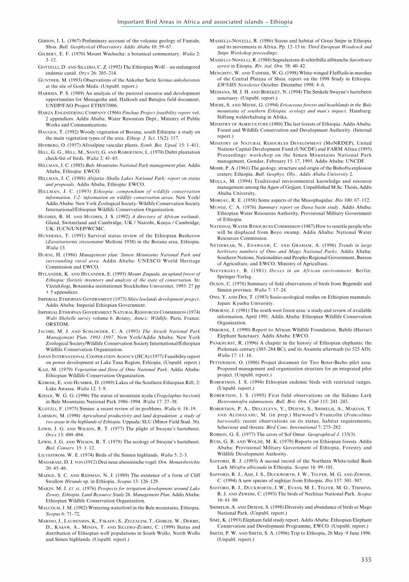
335
Important Bird Areas in Africa and associated islands – Ethiopia
GIBSON, I. L. (1967) Preliminary account of the volcanic geology of Fantale,Shoa. Bull. Geophysical Observatory Addis Ababa 10: 59–67.
GILBERT, E. F. (1970) Mount Wechecha: a botanical commentary. Walia 2:3–12.
GOTTELLI, D. AND SILLERO, C. Z. (1992) The Ethiopian Wolf—an endangeredendemic canid. Oryx 26: 205–214.
GUNTHER, M. (1993) Observations of the Ankober Serin Serinus ankoberensisat the site of Gosh Meda. (Unpubl. report.)
HARRIES, P. S. (1989) An analysis of the pastoral resource and developmentopportunities for Menagesha and, Haikoch and Butajira field document,UNDP/FAO Project ETH/87/006.
HARZA ENGINEERING COMPANY (1966) Finchaa Project feasibility report vol.2 appendices. Addis Ababa: Water Resources Dept., Ministry of PublicWorks and Communications.
HAUGEN, T. (1992) Woody vegetation of Borana, south Ethiopia: a study onthe main vegetation types of the area. Ethiop. J. Sci. 15(2): 117.
HEDBERG, O. (1957) Afroalpine vascular plants. Symb. Bot. Upsal. 15: 1–411.
HILL, G. G., HILL, M., SANTI, G. AND ROBERTSON, L. (1970) Dubti plantationcheck-list of birds. Walia 2: 41–65.
HILLMAN, J. C. (1985) Bale Mountains National Park management plan. AddisAbaba, Ethiopia: EWCO.
HILLMAN, J. C. (1988) Abijatta–Shalla Lakes National Park: report on statusand proposals. Addis Ababa, Ethiopia: EWCO.
HILLMAN, J. C. (1993) Ethiopia: compendium of wildlife conservationinformation, 1-2: information on wildlife conservation areas. New York/Addis Ababa: New York Zoological Society–Wildlife Conservation SocietyInternational/Ethiopian Wildlife Conservation Organization.
HUGHES, R. H. AND HUGHES, J. S. (1992) A directory of African wetlands.Gland, Switzerland and Cambridge, UK / Nairobi, Kenya / Cambridge,UK: IUCN/UNEP/WCMC.
HUNDESSA, T. (1991) Survival status review of the Ethiopian Bushcrow(Zavattariornis stresemanni Moltoni 1938) in the Borana area, Ethiopia.Walia 13.
HURNI, H. (1986) Management plan: Simen Mountains National Park andsurrounding rural area. Addis Ababa: UNESCO World HeritageCommission and EWCO.
HYLANDER, K. AND HYLANDER, E. (1995) Mount Zuquala, an upland forest ofEthiopia: floristic inventory and analysis of the state of conservation. In:Växtekilogi, Botaniska institutionen Stockholms Universitet, 1995: 27 pp+ 5 appendices.
IMPERIAL ETHIOPIAN GOVERNMENT (1973) Shire lowlands development project.Addis Ababa: Imperial Ethiopian Government.
IMPERIAL ETHIOPIAN GOVERNMENT NATURAL RESOURCES COMMISSION (1974)Wabi Shebelle survey volume 6. Botany, Annex: Wildlife. Paris, France:ORSTOM.
JACOBS, M. J. AND SCHLOEDER, C. A. (1993) The Awash National ParkManagement Plan, 1993–1997. New York/Addis Ababa: New YorkZoological Society/Wildlife Conservation Society International/EthiopianWildlife Conservation Organization.
JAPAN INTERNATIONAL COOPERATION AGENCY (JICA) (1977) Feasibility reporton power development at Lake Tana Region, Ethiopia. (Unpubl. report.)
KAJI, M. (1979) Vegetation and flora of Omo National Park. Addis Ababa:Ethiopian Wildlife Conservation Organization.
KEBEDE, E. AND HUMBER, D. (1989) Lakes of the Southern Ethiopian Rift, 2:Lake Awassa. Walia 12: 3–9.
KIDAN, W. G. G. (1996) The status of mountain nyala (Tragelaphus buxtoni)in Bale Mountains National Park 1986–1994. Walia 17: 27–38.
KLOTZLI, F. (1975) Simien: a recent review of its problems. Walia 6: 18–19.
LARSSON, M. (1998) Agricultural productivity and land degradation: a study oftwo areas in the highlands of Ethiopia. Uppsala: SLU (Minor Field Stud. 36).
LEWIS, J. G. AND WILSON, R. T. (1977) The plight of Swayne’s hartebeest.Oryx 13: 490–494.
LEWIS, J. G. AND WILSON, R. T. (1979) The ecology of Swayne’s hartebeest.Biol. Conserv. 15: 1–12.
LILYESTROM, W. E. (1974) Birds of the Simien highlands. Walia 5: 2–3.
MADARASZ, D. J. VON (1912) Drei neue abessinische vogel. Orn. Monatsberichte20: 45–46.
MADGE, S. C. AND REDMAN, N. J. (1989) The existence of a form of CliffSwallow Hirundo sp. in Ethiopia. Scopus 13: 126–129.
MAKIN, M. J. ET AL. (1976) Prospects for irrigation development around LakeZeway, Ethiopia. Land Resource Study 26. Management Plan. Addis Ababa:Ethiopian Wildlife Conservation Organization.
MALCOLM, J. M. (1982) Wintering waterfowl in the Bale mountains, Ethiopia.Scopus 6: 71–72.
MARINO, J., LAURENSON, K., FIKADU, S., ZELEALEM, T., GOBEZE, W., DERBIE,D., KASAW, A., MINDA, T. AND SILLERO-ZUBIRI, C. (1999) Status anddistribution of Ethiopian wolf populations in South Wollo, North Wolloand Simen highlands. (Unpubl. report.)
MASSELLI-NOVELLI, R. (1986) Status and habitat of Great Snipe in Ethiopiaand its movements in Africa. Pp. 12–15 in: Third European Woodcock andSnipe Workshop proceedings.
MASSELLI-NOVELLI, R. (1988) Segnalazione di schiribilla alibianche Sarothruraayresi in Etiopia. Riv. ital. Orn. 58: 40–42.
MENGISTU, W. AND TADESSE, W. G. (1998) White-winged Flufftails in marshesof the Central Plateau of Shoa: report on the 1998 Study in Ethiopia.EWNHS Newsletter October–December 1998: 4–6.
MESSANA, M. J. H. AND BEREKET, N. (1994) The Senkele Swayne’s hartebeestsanctuary. (Unpubl. report.)
MIEHE, S. AND MIEHE, G. (1994) Ericaceous forests and heathlands in the Balemountains of southern Ethiopia: ecology and man’s impact. Hamburg:Stiftung walderhaltung in Afrika.
MINISTRY OF AGRICULTURE (1980) The last forests of Ethiopia. Addis Ababa:Forest and Wildlife Conservation and Development Authority. (Internalreport.)
MINISTRY OF NATURAL RESOURCES DEVELOPMENT (MoNRDEP), UnitedNations Capital Development Fund (UNCDF) and FARM Africa (1995)Proceedings: workshop on the Simen Mountains National Parkmanagement, Gondar, February 15–17, 1995. Addis Ababa: UNCDF.
MOHR, P. A. (1961) The geology, structure and origin of the Bishoftu explosioncraters: Ethiopia. Bull. Geophys. Obs., Addis Ababa University 2.
MOLLA, M. (1994) Traditional environmental knowledge and resourcemanagement among the Agaw of Gojjam. Unpublished M.Sc. Thesis, AddisAbaba University.
MOREAU, R. E. (1958) Some aspects of the Musophagidae. Ibis 100: 67–112.
MUNOZ, C. A. (1976) Summary report on Dawa basin study. Addis Ababa:Ethiopian Water Resources Authority, Provisional Military Governmentof Ethiopia.
NATIONAL WATER RESOURCES COMMISSION (1987) How to resettle people whowill be displaced from Boyo swamp. Addis Ababa: National WaterResources Commission.
NETSEREAB, N., ENAWGAW, C. AND GRAHAM, A. (1996) Trends in largeherbivore numbers of Omo and Mago National Parks. Addis Ababa:Southern Nations, Nationalities and Peoples Regional Government, Bureauof Agriculture, and EWCO, Ministry of Agriculture.
NIEVERGELT, B. (1981) Ibexes in an African environment. Berlin:Springer-Verlag.
OLSON, C. (1976) Summary of field observations of birds from Begemdir andSimien province. Walia 7: 17–24.
ONO, Y. AND DOI, T. (1983) Socio-ecological studies on Ethiopian mammals.Japan: Kyushu University.
OSBORNE, J. (1981) The south west forest area: a study and review of availableinformation, April 1991. Addis Ababa: Ethiopian Wildlife ConservationOrganization.
OSBORNE, J. (1990) Report to African Wildlife Foundation. Babile (Harrar)Elephant Sanctuary. Addis Ababa: EWCO.
PANKHURST, R. (1996) A chapter in the history of Ethiopian elephants: thePtolemaic century (305–284 BC), and its Axumite aftermath (to 525 AD).Walia 17: 11–16.
PETTERSSON, O. (1986) Project document for Tiro Boter-Becho pilot area.Proposed management and organization structure for an integrated pilotproject. (Unpubl. report.)
ROBERTSON, I. S. (1994) Ethiopian endemic birds with restricted ranges.(Unpubl. report.)
ROBERTSON, I. S. (1995) First field observations on the Sidamo LarkHeteromirafra sidamoensis. Bull. Brit. Orn. Club 115: 241–243.
ROBERTSON, P. A., DELLELEYN, Y., DEJENE, S., SHIMELIS, A., MARIAM, T.AND ALEMAYAHU, M. (in prep.) Harwood’s Francolin (Francolinusharwoodi): recent observations on its status, habitat requirements,behaviour and threats. Bird Cons. International 7: 275–282.
ROBSON, G. E. (1977) The caves of Sof Omar. Geographical J. 133(3).
RUSS, G. R. AND WOLDE, M. K. (1979) Reports on Ethiopian forests. AddisAbaba: Provisional Military Government of Ethiopia, Forestry andWildlife Development Authority.
SAFFORD, R. J. (1993) A second record of the Northern White-tailed BushLark Mirafra albicauda in Ethiopia. Scopus 16: 99–101.
SAFFORD, R. J., ASH, J. S., DUCKWORTH, J. W., TELFER, M. G. AND ZEWDIE,C. (1994) A new species of nightjar from Ethiopia. Ibis 137: 301–307.
SAFFORD, R. J., DUCKWORTH, J. W., EVANS, M. I., TELFER, M. G., TIMMINS,R. J. AND ZEWDIE, C. (1993) The birds of Nechisar National Park. Scopus16: 61–80.
SHIMELIS, A. AND DEJENE, S. (1998) Diversity and abundance of birds at MagoNational Park. (Unpubl. report.)
SIME, K. (1993) Elephant field study report. Addis Ababa: Ethiopian ElephantConservation and Development Programme, EWCO. (Unpubl. report.)
SMITH, P. W. AND SMITH, S. A. (1996) Trip to Ethiopia, 20 May–9 June 1996.(Unpubl. report.)
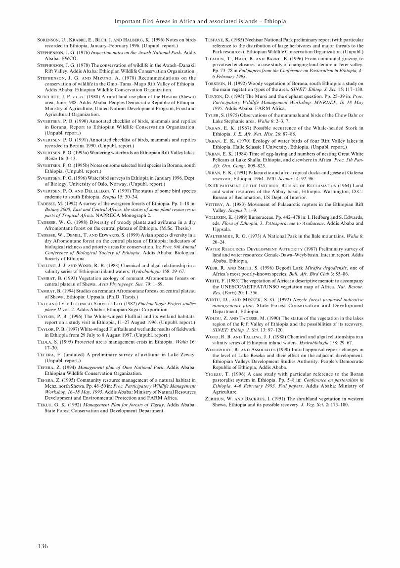
336
Important Bird Areas in Africa and associated islands – Ethiopia
SORENSON, U., KRABBE, E., BECH, J. AND HALBERG, K. (1996) Notes on birdsrecorded in Ethiopia, January–February 1996. (Unpubl. report.)
STEPHENSON, J. G. (1976) Inspection notes on the Awash National Park. AddisAbaba: EWCO.
STEPHENSON, J. G. (1978) The conservation of wildlife in the Awash–DanakilRift Valley. Addis Ababa: Ethiopian Wildlife Conservation Organization.
STEPHENSON, J. G. AND MIZUNO, A. (1978) Recommendations on theconservation of wildlife in the Omo–Tama–Mago Rift Valley of Ethiopia.Addis Ababa: Ethiopian Wildlife Conservation Organization.
SUTCLIFFE, J. P. ET AL. (1988) A rural land use plan of the Hosana (Shewa)area, June 1988. Addis Ababa: Peoples Democratic Republic of Ethiopia,Ministry of Agriculture, United Nations Development Program, Food andAgricultural Organization.
SYVERTSEN, P. O. (1990) Annotated checklist of birds, mammals and reptilesin Borana. Report to Ethiopian Wildlife Conservation Organization.(Unpubl. report.)
SYVERTSEN. P. O. (1991) Annotated checklist of birds, mammals and reptilesrecorded in Borana 1990. (Unpubl. report.)
SYVERTSEN, P. O. (1995a) Wintering waterbirds on Ethiopian Rift Valley lakes.Walia 16: 3–13.
SYVERTSEN, P. O. (1995b) Notes on some selected bird species in Borana, southEthiopia. (Unpubl. report.)
SYVERTSEN, P. O. (1996) Waterbird surveys in Ethiopia in January 1996. Dept.of Biology, University of Oslo, Norway. (Unpubl. report.)
SYVERTSEN, P. O. AND DELLELEGN, Y. (1991) The status of some bird speciesendemic to south Ethiopia. Scopus 15: 30–34.
TADESSE, M. (1992) A survey of the evergreen forests of Ethiopia. Pp. 1–18 in:Botany 2000, East and Central Africa: the status of some plant resources inparts of Tropical Africa. NAPRECA Monograph 2.
TADESSE, W. G. (1998) Diversity of woody plants and avifauna in a dryAfromontane forest on the central plateau of Ethiopia. (M.Sc. Thesis.)
TADESSE, W., DEMEL, T. AND EDWARDS, S. (1999) Avian species diversity in adry Afromontane forest on the central plateau of Ethiopia: indicators ofbiological richness and priority areas for conservation. In: Proc. 9th AnnualConference of Biological Society of Ethiopia. Addis Ababa: BiologicalSociety of Ethiopia.
TALLING, J. J. AND WOOD, R. B. (1988) Chemical and algal relationship in asalinity series of Ethiopian inland waters. Hydrobiologia 158: 29–67.
TAMRAT, B. (1993) Vegetation ecology of remnant Afromontane forests oncentral plateau of Shewa. Acta Phytogeogr. Sue. 79: 1–59.
TAMRAT, B. (1994) Studies on remnant Afromontane forests on central plateauof Shewa, Ethiopia: Uppsala. (Ph.D. Thesis.)
TATE AND LYLE TECHNICAL SERVICES LTD. (1982) Finchaa Sugar Project studiesphase II vol. 2. Addis Ababa: Ethiopian Sugar Corporation.
TAYLOR, P. B. (1996) The White-winged Flufftail and its wetland habitats:report on a study visit in Ethiopia, 11–27 August 1996. (Unpubl. report.)
TAYLOR, P. B. (1997) White-winged Flufftails and wetlands: results of fieldworkin Ethiopia from 29 July to 8 August 1997. (Unpubl. report.)
TEDLA, S. (1995) Protected areas management crisis in Ethiopia. Walia 16:17–30.
TEFERA, F. (undated) A preliminary survey of avifauna in Lake Zeway.(Unpubl. report.)
TEFERA, Z. (1994) Management plan of Omo National Park. Addis Ababa:Ethiopian Wildlife Conservation Organization.
TEFERA, Z. (1995) Community resource management of a natural habitat inMenz, north Shewa. Pp. 48–50 in: Proc. Participatory Wildlife ManagementWorkshop, 16–18 May, 1995. Addis Ababa: Ministry of Natural ResourcesDevelopment and Environmental Protection and FARM Africa.
TEKLU, G. K. (1992) Management Plan for forests of Tigray. Addis Ababa:State Forest Conservation and Development Department.
TESFAYE, K. (1985) Nechisar National Park preliminary report (with particularreference to the distribution of large herbivores and major threats to thePark resources). Ethiopian Wildlife Conservation Organization. (Unpubl.)
TILAHUN, T., HADJ, B. AND BARRE, B. (1996) From communal grazing toprivatised enclosures: a case study of changing land tenure in Jerer valley.Pp. 73–78 in Full papers from the Conference on Pastoralism in Ethiopia, 4–6 February 1993.
TORSTEIN, H. (1992) Woody vegetation of Borana, south Ethiopia: a study onthe main vegetation types of the area. SINET: Ethiop. J. Sci. 15: 117–130.
TURTON, D. (1995) The Mursi and the elephant question. Pp. 25–39 in: Proc.Participatory Wildlife Management Workshop. MNRDEP, 16–18 May1995. Addis Ababa: FARM Africa.
TYLER, S. (1975) Observations of the mammals and birds of the Chow Bahr orLake Stephanie area. Walia 6: 2–3, 7.
URBAN, E. K. (1967) Possible occurrence of the Whale-headed Stork inEthiopia. J. E. Afr. Nat. Hist. 26: 87–88.
URBAN, E. K. (1970) Ecology of water birds of four Rift Valley lakes inEthiopia. Haile Selassie I University, Ethiopia. (Unpubl. report.)
URBAN, E. K. (1984) Time of egg-laying and numbers of nesting Great WhitePelicans at Lake Shalla, Ethiopia, and elsewhere in Africa. Proc. 5th Pan-Afr. Orn. Congr. 809–823.
URBAN, E. K. (1991) Palaearctic and afro-tropical ducks and geese at Gafersareservoir, Ethiopia, 1964–1970. Scopus 14: 92–96.
US DEPARTMENT OF THE INTERIOR, BUREAU OF RECLAMATION (1964) Landand water resources of the Abbay basin, Ethiopia. Washington, D.C.:Bureau of Reclamation, US Dept. of Interior.
VITTERY, A. (1983) Movement of Palaearctic raptors in the Ethiopian RiftValley. Scopus 7: 1–9.
VOLLESEN, K. (1989) Burseraceae. Pp. 442–478 in: I. Hedberg and S. Edwards,eds. Flora of Ethiopia, 3. Pittosporaceae to Araliaceae. Addis Ababa andUppsala.
WALTERMIRE, R. G. (1973) A National Park in the Bale mountains. Walia 6:20–24.
WATER RESOURCES DEVELOPMENT AUTHORITY (1987) Preliminary survey ofland and water resources: Genale-Dawa–Weyb basin. Interim report. AddisAbaba, Ethiopia.
WEBB, R. AND SMITH, S. (1996) Degodi Lark Mirafra degodiensis, one ofAfrica’s most poorly-known species. Bull. Afr. Bird Club 3: 85–86.
WHITE, F. (1983) The vegetation of Africa: a descriptive memoir to accompanythe UNESCO/AETFAT/UNSO vegetation map of Africa. Nat. Resour.Res. (Paris) 20: 1–356.
WIRTU, D., AND MESKEK, S. G. (1992) Negele forest proposed indicativemanagement plan . State Forest Conservation and DevelopmentDepartment, Ethiopia.
WOLDU, Z. AND TADESSE, M. (1990) The status of the vegetation in the lakesregion of the Rift Valley of Ethiopia and the possibilities of its recovery.SINET: Ethiop. J. Sci. 13: 97–120.
WOOD, R. B. AND TALLING, J. J. (1988) Chemical and algal relationships in asalinity series of Ethiopian inland waters. Hydrobiologia 158: 29–67.
WOODROOFE, R. AND ASSOCIATES (1990) Initial appraisal report: changes inthe level of Lake Beseka and their effect on the adjacent development.Ethiopian Valleys Development Studies Authority. People’s DemocraticRepublic of Ethiopia, Addis Ababa.
YIGEZU, T. (1996) A case study with particular reference to the Boranpastoralist system in Ethiopia. Pp. 5–8 in: Conference on pastoralism inEthiopia, 4–6 February 1993. Full papers. Addis Ababa: Ministry ofAgriculture.
ZERIHUN, W. AND BACKÄUS, I. (1991) The shrubland vegetation in westernShewa, Ethiopia and its possible recovery. J. Veg. Sci. 2: 173–180.