Embed Size (px)
Citation preview
Rural Roads Safety Plan | 1
Rural Roads Safety Plan
April 2021
Prepared by
Driscoll Engineering Services Pty Ltd
Rural Roads Safety Plan | 2
Acknowledgements
This Rural Roads Safety Plan has been developed with assistance, direction and advice from a number of
individuals and organisations.
Northern Grampians Shire Council
Regional Roads Victoria
Victoria Police
Community members who provided feedback
Driscoll Engineering Services Pty Ltd
Schedule of Changes and Amendments
Version Date Draft Report 25 February 2021 Draft prepared in 2020/21 by Driscoll Engineering Services Pty Ltd
Revision 1 22 April 2021 Revised report completed by Driscoll Engineering Services Pty Ltd
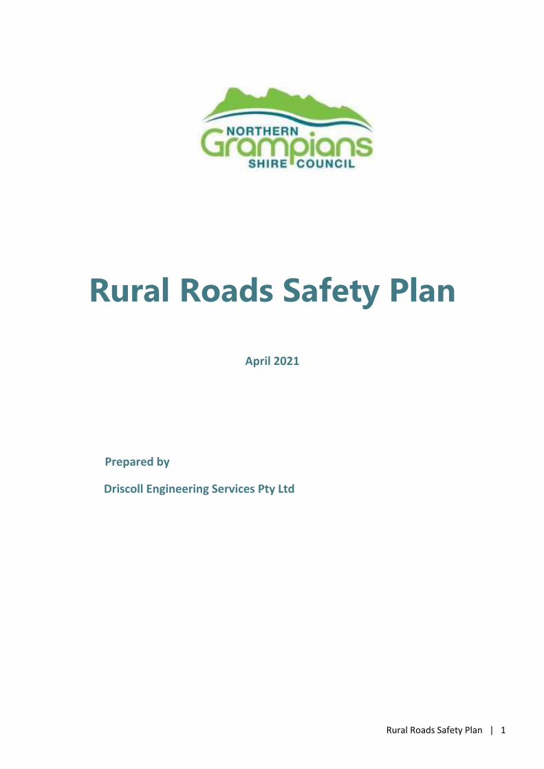
Napier St and Alma St Intersection, St Arnaud
Rural Roads Safety Plan | 3
Contents Acknowledgements ................................................................................................................................................................................... 2 Contents .................................................................................................................................................................................................... 3 1. Introduction / Background ............................................................................................................................................................... 4
1.1 Northern Grampians Shire ................................................................................................................................... 4
1.2 Strategy Context ................................................................................................................................................ 6
1.3 Regional Roads Victoria Role ................................................................................................................................ 7 Victorian Community Road Safety Grants Program .................................................................................................................................... 8
1.4 Victoria’s Road Safety Strategy 2013-2022, Safe Roads for all Victorians ........................................................................ 9
1.5 The Safe System .............................................................................................................................................. 10 2. Road Safety Performance ............................................................................................................................................................... 13
2.1 Overview ........................................................................................................................................................ 13
2.2 Comparison of Casualty Rates ............................................................................................................................. 15
2.3 Key Findings .................................................................................................................................................... 16
2.4 Crash Types .................................................................................................................................................... 17
2.5 Crash Locations ............................................................................................................................................... 18 3. Community Engagement ................................................................................................................................................................ 23
3.1 Community Questionnaire ................................................................................................................................. 23 4. Key Focus Areas .............................................................................................................................................................................. 25
4.1 Rural Road Safety ............................................................................................................................................. 26
4.2 Safety Around Schools ...................................................................................................................................... 36
4.3 Safer Speeds ................................................................................................................................................... 37
4.4 Motorcyclists .................................................................................................................................................. 37
4.5 Tourists and Tourist Areas .................................................................................................................................. 38
4.6 Young Drivers and Passengers ............................................................................................................................. 39
4.7 Older Drivers ................................................................................................................................................... 40
4.8 Bicyclists, Motorised Scooter Riders and Pedestrians ............................................................................................... 40
4.9 Emergency Access ............................................................................................................................................ 42 5. Action Plan 2015-2020 .................................................................................................................................................................... 43
5.1 Background Considerations ................................................................................................................................ 43
5.2 Rural Road Safety ............................................................................................................................................. 45
5.3 Safety Around Schools ...................................................................................................................................... 49
5.4 Bicycles and Pedestrians .................................................................................................................................... 50
5.5 Safer Speeds ................................................................................................................................................... 51
5.6 Motorcylists .................................................................................................................................................... 52
5.7 Tourists and Tourist Areas .................................................................................................................................. 53
5.8 Young Drivers and Passengers ............................................................................................................................. 54
5.9 Older Drivers ................................................................................................................................................... 55
5.10 Halls Gap, St Arnaud and Stawell ......................................................................................................................... 56
5.11 Emergency Access ............................................................................................................................................ 57
5.12 Action Plan Management ................................................................................................................................... 58 6. Stakeholders and Responsibilities ................................................................................................................................................... 59
Rural Roads Safety Plan | 4
1. Introduction / Background
1.1 Northern Grampians Shire
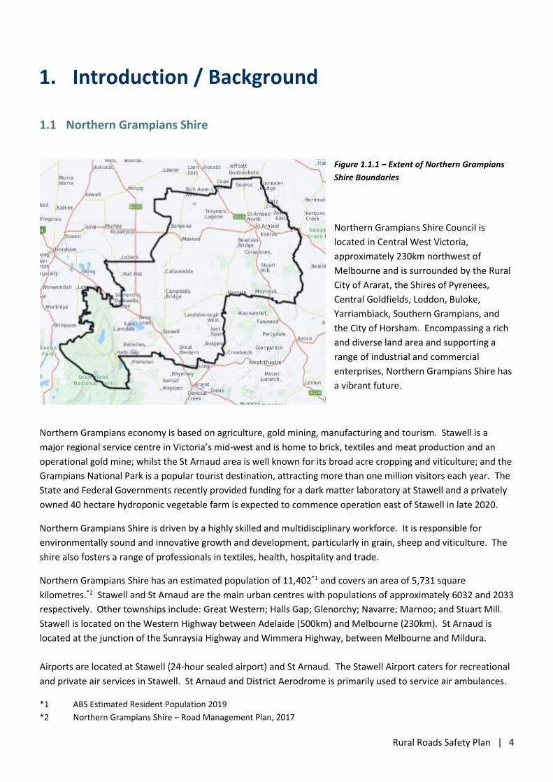
Figure 1.1.1 – Extent of Northern Grampians
Shire Boundaries
Northern Grampians Shire Council is
located in Central West Victoria,
approximately 230km northwest of
Melbourne and is surrounded by the Rural
City of Ararat, the Shires of Pyrenees,
Central Goldfields, Loddon, Buloke,
Yarriambiack, Southern Grampians, and
the City of Horsham. Encompassing a rich
and diverse land area and supporting a
range of industrial and commercial
enterprises, Northern Grampians Shire has
a vibrant future.
Northern Grampians economy is based on agriculture, gold mining, manufacturing and tourism. Stawell is a
major regional service centre in Victoria’s mid-west and is home to brick, textiles and meat production and an
operational gold mine; whilst the St Arnaud area is well known for its broad acre cropping and viticulture; and the
Grampians National Park is a popular tourist destination, attracting more than one million visitors each year. The
State and Federal Governments recently provided funding for a dark matter laboratory at Stawell and a privately
owned 40 hectare hydroponic vegetable farm is expected to commence operation east of Stawell in late 2020.
Northern Grampians Shire is driven by a highly skilled and multidisciplinary workforce. It is responsible for
environmentally sound and innovative growth and development, particularly in grain, sheep and viticulture. The
shire also fosters a range of professionals in textiles, health, hospitality and trade.
Northern Grampians Shire has an estimated population of 11,402*1 and covers an area of 5,731 square
kilometres.*2 Stawell and St Arnaud are the main urban centres with populations of approximately 6032 and 2033
respectively. Other townships include: Great Western; Halls Gap; Glenorchy; Navarre; Marnoo; and Stuart Mill.
Stawell is located on the Western Highway between Adelaide (500km) and Melbourne (230km). St Arnaud is
located at the junction of the Sunraysia Highway and Wimmera Highway, between Melbourne and Mildura.
Airports are located at Stawell (24-hour sealed airport) and St Arnaud. The Stawell Airport caters for recreational
and private air services in Stawell. St Arnaud and District Aerodrome is primarily used to service air ambulances.
*1 ABS Estimated Resident Population 2019
*2 Northern Grampians Shire – Road Management Plan, 2017
Rural Roads Safety Plan | 5
Stawell is in a key strategic position on some of Victoria's most important freight, tourist and commuter transport
routes, including the:
National Rail Network that connects Stawell to Adelaide, Melbourne, Geelong and Portland;
Western Highway, the main freight route from Melbourne to Adelaide and Perth;
Donald Stawell Road, connects Stawell with St Arnaud, Donald and the central north of the state;
Stawell Warracknabeal Road, connects Stawell with Warracknabeal and the north west of the state;
Stawell Avoca Road, connects Stawell with Navarre, Avoca and Maryborough and central Victoria;
Grampians Road and Pomonal Road which connect Stawell with Halls Gap and the Grampians.
The Wimmera Highway is an important east-west route that crosses the northern part of the municipality
between Horsham and St Arnaud, and connects the township of Marnoo with St Arnaud.
St Arnaud is in a key strategic position on important freight, tourist and commuter transport routes, including the:
Sunraysia Highway which travels north-south and connects St Arnaud with Ballarat and Mildura;
Wimmera Highway which connects the St Arnaud with Horsham to the west and Bendigo to the east.
Ararat St Arnaud Road and Charlton St Arnaud Road, connecting St Arnaud with Ararat and Portland to
the south and Charlton and the Murray River to the north.
St Arnaud Wycheproof Road connects St Arnaud with Seal Lake and the Calder Highway to the north.
Northern Grampians Shire maintains a variety of roads in terms of condition, design parameter and physical
condition. Due to the limited funding for road maintenance and construction, economic pressures have
necessitated a review of road management in regard to the asset life, function and the required ‘day to day’
maintenance requirements. Within the municipality, Council maintains approximately 791km of sealed local
roads and 2,194km of gravel roads with another 438km of formed roads and tracks.*3
*3 Northern Grampians Shire – Road Management Plan, 2017
Table 1.1 – Road Types within Northern Grampians Shire
Road Type Road Length (km) Percentage of Council Maintained Total Length
Highways and Arterial Roads -
Sealed Local Roads 791 23.1%
Unsealed Local Roads 2194 64.1%
Formed Roads 438 12.8%
Total Length maintained by Council 3423 100%
National and State Highways, Arterial Roads and Non-Arterial State Roads, Tourist Roads, Fire Roads / Tracks and
Forest Roads are all managed by other Road Authorities such as Regional Roads Victoria, the CFA, Parks Victoria,
DEPI and GWM Water and are not part of the Municipal Roads network.
Highways
These roads are maintained by Regional Roads Victoria and their contractors and include the Western Highway,
Sunraysia Highway and the Wimmera Highway.
Rural Roads Safety Plan | 6
Arterial Roads
Declared arterial roads are currently maintained by Regional Roads Victoria and their contractors and include:
Ararat Pomonal Road
Ararat St Arnaud Road
Ararat Stawell Road
Charlton St Arnaud Road
Donald Stawell Road
Grampians Road
Maryborough St Arnaud Road
Northern Grampians Road (Mt Victory Road)
Pomonal Road
St Arnaud Wycheproof Road
Stawell Avoca Road
Stawell Warracknabeal Road
1.2 Strategy Context
Northern Grampians Shire - Revised Council Plan 2017 – 2021, provides strategic direction to Council through the
identification of a vision, goals and objectives relating to four key areas: Enhance Lifestyle and Community; Boost
Economic Growth; Provide Sustainable Infrastructure; and Improve Organisational Effectiveness. Council’s Rural
Roads Safety Plan will link into this plan through the strategic vision for both the Enhance Lifestyle and the
Community and Provide Sustainable Infrastructure in Northern Grampians Shire.
As well as links to the Northern Grampians Council Plan, the Rural Roads Safety Plan will be supported by a
hierarchy of State and National Road Safety programs. At the State level, the various support programs are
outlined in the next section.
The following key state strategies and frameworks will also inform decision making in the development of the Rural Roads Safety Plan:
- Victorian Freight Plan 2018: Delivering the Goods
- Towards Zero 2016-2020 Road Safety Strategy and Action Plan
- Regional Network Development Plan 2016
- Victorian Visitor Economy Strategy 2016
- Movement and Place framework
- Victorian Cycling Strategy 2018-2028.
TAC Funding
Northern Grampians Shire secured funding for the development of a Rural Roads Safety Plan through the
Transport Accident Commission (TAC) Community Road Safety Grants Program and therefore it is a requirement
that this strategy is consistent with Victoria’s Road Safety Strategy 2013-2022, Safe Roads for all Victorians.
Rural Roads Safety Plan | 7
1.3 Regional Roads Victoria Role
Regional Roads Victoria (RRV) has responsibility for the state road network. As part of this role, RRV has
established a number of strategies, policies and programs relating to improving road safety in Victoria. Whilst all
funding applications are required to demonstrate a significant benefit to cost ratio and are ranked competitively
against other applications, the potential benefit to the community establishes that it is worthwhile for Northern
Grampians Shire to pursue such applications for potential funding. The programs relevant to Northern Grampians
are outlined below.
Road Safety Funding Programs
The Safer Roads Program
As part of Towards Zero, the Victorian Government is investing $1.4 billion into new technology and road safety
infrastructure to work towards a future where no one is seriously injured or killed on our roads. Mistakes happen
and can’t always be avoided, however the Safer Roads program aims to build a more forgiving environment
through infrastructure so that when a mistake happens on the road, it doesn’t cost a life.
The Safer Road program aims to reduce the incidence and severity of crashes along roads with a relatively high
number of serious casualty crashes. The safety features to be installed are designed to prevent crashes from
happening, or reduce their severity when they are unavoidable. These features have been proven to reduce the
risk and severity of the most common types of crashes, including:
lane departure crashes (run off road crashes and head-on collisions);
side-impacts at intersections; and
collisions with pedestrians and cyclists.
The road infrastructure that is being delivered under the Safer Roads program is helping to reduce road trauma in
Victoria. Flexible safety barriers have been hit more than 5,400 times from 2016 to December 2019 on the first
20 high-risk roads that were upgraded – each time potentially saving lives or preventing serious injuries. “From
January 2016 to December 2019 there has been:
a 55% reduction in reported crashes;
a 15% reduction in fatal crashes; and
a 65% reduction in fatal and serious injury crashes.
During this time, the total number of deaths and serious injuries caused by head-on and run-off-road crashes has
dropped by 66% on these roads – from 120 people in 2015 to 41 people in 2019.” *1
*1 VicRoads website – Road Safety Programs – The Safer Roads Program
Blackspot Program
The Black Spot Program makes an important contribution in reducing the national road toll under the National
Road Safety Action Plan 2018-2020. As part of the Local and State Government Road Safety Package announced
in the 2019-20 Budget, the Australian Government has committed an additional $50 million per year to the Black
Spot Program, commencing 2019-20. The Government will provide $1.0 billion to the Black Spot Program until
the 2022-23 financial year, with an on-going commitment of $110 million each year following. Road crashes are a
major cost to Australians every year. Black Spot projects target those road locations where crashes are occurring.
Rural Roads Safety Plan | 8
By funding measures such as traffic signals and roundabouts ad dangerous locations, the program reduces the risk
of crashes. Programs of this sort are every effective, saving the community many times the cost of the relatively
minor road improvements that are implemented.
The Black Spot eligibility criteria advises that funding is mainly available for the treatment of Black Spot sites, or
road lengths, with a proven history of crashes. Project proposals should be able to demonstrate a benefit to cost
ratio of at least 2 to 1. For individual sites such as intersections, mid-block or short road sections, there should be
history of at least three casualty crashes over a five-year period. For length of road, there should be an average
of 0.2 casualty crashes per kilometre per annum over the length in question over five years. The requirement of a
history of crashes ensures that those sites that have a recurrent problem are targeted first for treatment.
The Black Spot Program also recognises that there are road locations that could be considered as ‘accidents
waiting to happen’. Therefore, some program funds may be used to treat sites where road traffic engineers have
completed a Road Safety Audit and found that remedial work is necessary. This allows an opportunity for
proactive safety works to be undertaken before casualties occur.
Infrastructure Improvement Projects - Motorcycle Safety Levy
The Motorcycle Safety Levy (MSL) is collected as part of the Transport Accident Commission (TAC) premium in
registrations for motorcycles. This levy contributes to projects that improve the safety of motorcycle riders and
contribute towards the vision zero goal. One of the most important initiatives funded by the Motorcycle Safety
Levy, aims to improve road conditions at blackspot locations where multiple motorcycle crashes have occurred, or
on routes where motorcyclists are most at risk. The improvements are specifically developed by engineers and
expert riders to address the types of crashes riders have experienced at these locations.
There are three components to the program involving road treatments:
At blackspots or black lengths with high rates of motorcycle loss of control crashes;
At intersections with high rates of motorcycle crashes; and
Along popular motorcycle routes to improve the consistency of the road environment for motorcyclists.
Infrastructure improvements represent the largest area of investment from the Levy and include measures such
as improved curve alignment signage and delineation, rub-rail protection at the base of the barriers, bell mouth
sealing, post cushions and surface improvements.
Another initiative funded by the Motorcycle Safety Levy is the “Every second, always on” campaign which
encourages riders to brush up on their safe riding skills and knowledge, including an online quiz to test and
refresh motorcyclists’ knowledge of safe riding behaviour and road rules. The campaign highlights the need for
motorcyclists to be constantly vigilant and focuses on key contributors to crashes including:
Speed;
Cornering;
Road positioning;
Road hazards; and
Other road users.
Victorian Community Road Safety Grants Program
The Victorian Community Road Safety Grants Program provides an avenue for community involvement in
addressing priority local road safety issues within the framework of Victoria's Road Safety Strategy. The Program
Rural Roads Safety Plan | 9
seeks to foster ongoing relationships between all stakeholders and the community to assist in the development
and implementation of effective community road safety programs.
This program provides $1.5 million in funding to empower communities to prevent and reduce the number of
lives lost and serious injuries on Victoria’s roads. Funding is provided through two streams:
Standard Program; and the Community Road Safety Grants Program: This program.
Standard Program (provides $1.5 million in funding for community road safety education programs); and
Towards Zero Challenge (The Towards Zero Challenge provides one-off grants of up to $50,000 to support
the development and implementation of new creative and innovative approaches to address driver
distraction and drowsiness at a community level.)
Previously Northern Grampians Shire has received funding through the TAC Community Road Safety grants
program, to develop a road safety brochure aimed at helping culturally diverse people better understand
Victoria’s road rules and behaviours.
1.4 Victoria’s Road Safety Strategy 2013-2022, Safe Roads for all Victorians
Victoria’s Road Safety Strategy 2013-2022 and its action plans, align with the National Road Safety Strategy, which
sets a target of reducing deaths and serious injuries by at least 30 percent. The target for the next ten years is to:
reduce the number of people who die on our roads, by more than 30%; and
reduce the number of people who are seriously injured on roads by more than 30%.
The strategy identifies that achievement of the 10-year casualty reduction targets will require a range of specific road safety actions or interventions. These actions are grouped under the following four areas of the strategy:
Safe roads
(i.e. designing and maintaining roads and roadsides to reduce risk to as low as reasonably practical);
Safe speeds
(i.e. setting speed limits according to the safety of the road and roadside);
Safe vehicles
(i.e. encouraging consumers to purchase safer vehicles with primary safety features that reduce crash likelihood,
such as electronic stability control, and secondary safety features that reduce injury severity in a crash, such as
curtain side airbags);
Safe people
(i.e. advising, educating and encouraging road users to comply with road rules, be unimpaired and alert, and drive
according to the prevailing conditions).
Both the Victorian and National strategy are founded on the internationally recognised ‘Safe System’ approach.
This approach accepts that people using the road network will make mistakes and therefore the whole system
needs to be more forgiving of those errors. This means there must be a focus on roads, speeds, vehicles and road
user behaviour as well as a range of associated activities, including performance monitoring and reporting. The
Rural Roads Safety Plan | 10
Safe System approach aims to design and build a road system that will protect responsible road users and reduce
the number of deaths and serious injuries.
Under the Safe System approach, the proposed interventions will provide safety improvements for everyone
using or interacting with the road system: including while walking, cycling, riding motorcycles or scooters,
travelling in cars and other light vehicles, and in heavy vehicles. In some cases additional or specific actions are
included to address a particular at-risk group or risk factor, such as novice drivers, or travel in remote areas.
The strategy includes a matrix to identify the direction that will be taken to reduce death and injury on Victoria’s
roads, particularly in key areas such as speed, drink driving and driving under the influence of drugs.
1.5 The Safe System
“Safer roads help to protect people when the unexpected happens – but road infrastructure is only one part of
the solution. The Safer Roads program is underpinned by the Safe System, a holistic approach to reducing road
trauma that recognises that we as humans are vulnerable and make mistakes that shouldn’t cost us our lives.
The Safe System identifies four factors that work together to protect people from being killed or seriously injured
on the road: Safer Roads; Safer Vehicles; Safer Speeds; and Safer People.
The human body can only tolerate certain amounts of force, so by implementing safer speeds we can dramatically
improve our chances of survival and avoid serious injuries when crashes occur. Advances in vehicle technology
help prevent road crashes and protect people if a crash does occur. If more people drove safer vehicles, then
road trauma would be significantly reduced. We all need to acknowledge that being safer people when travelling
on roads is key to reducing road trauma. Following the road rules, remaining alert and avoiding distractions can
be the difference between arriving home to our families or not.
Road safety is a shared responsibility. This means that we need to be safer drivers, be driving safer cars, be
travelling at safer speeds on safer roads.“*1
*1 VicRoads website – Road Safety Programs – The Safer Roads Program
“The Safe System is a road safety philosophy that requires roads to be designed and managed so that death and
serious injury are avoidable. The basic principles are:
1. Humans are fallible and will inevitably make mistakes when driving, riding or walking.
2. Despite this, road trauma should not be accepted as inevitable. No one should be killed or seriously
injured on our roads.
3. To prevent serious trauma, the road system must be forgiving, so that the forces of collisions do not
exceed the limits that the human body can tolerate.
The Safe System philosophy underpins Victoria’s strategic approach to road safety. It is commonly divided into
four core interrelated pillars: safer roads, safer speeds, safer vehicles and safer road users. A fifth pillar, post-
crash response, has been identified by the World Health Organisation (2011).

Rural Roads Safety Plan | 11
Figure 1.5.1 – The Pillars of the Safe
System, Towards Zero 2016/2020
Victoria’s Road Safety Strategy &
Action Plan
Safer Roads Relates to both the road itself and the roadside. This considers ways to design, operate
and maintain the road network to reduce the chance of a crash occurring as well as the
consequence when one does occur.
Safer Speeds Relates to the speed at which vehicles are likely to travel on the road. Factors that
influence operating speeds include posted speed limits, the level of compliance with the
speed limit and physical constraints. Unsafe speeds can increase both the likelihood and
consequence of a crash.
Safer Vehicles Relates to the safety features, including intelligent technologies that are incorporated into
vehicles of different types, which contribute to crash avoidance and/or reducing the
severity of crashes.
Safer Road Users Relates to road user behaviour, driver / rider training and licensing, levels of compliance
and personal safety equipment, particularly in the case of vulnerable road users such as
cyclists and motorcyclists.
Post Crash Response Relates to emergency medical and rescue response, trauma care (both at the scene and in
hospital) and injury rehabilitation.
Additional Safe System Components
A Safe System Assessmemt is primarily focussed on road and roadside infrastrucure and speed. However, the
framework also includes consideration of the other pillars that comprise the Safe System (i.e. road users and
vehicles). Consideration is also given to post-crash care, which is often recognised as the fifth pillar of the Safe
System. “ *2
*2 VicRoads – Safe System Assessment Guidelines, Version 1.1, April 2019
The table below identifies questions to be considered in undertaking a Safe System Assessment of any section of
road or network.
Rural Roads Safety Plan | 12
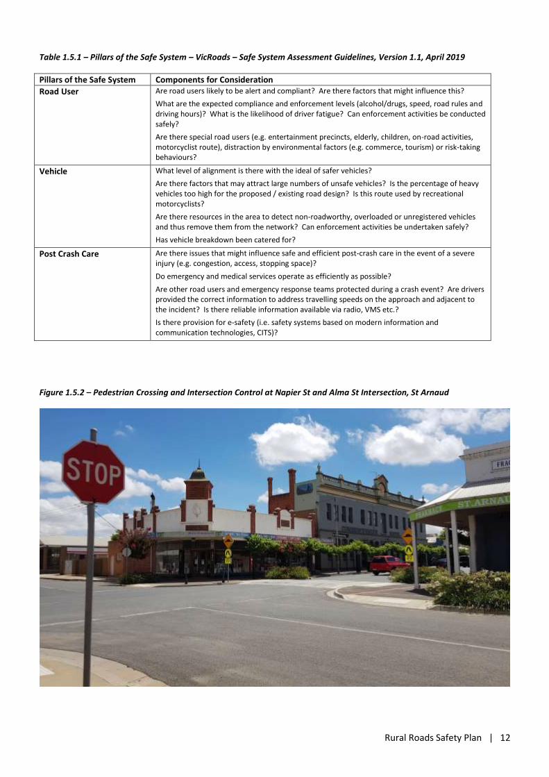
Table 1.5.1 – Pillars of the Safe System – VicRoads – Safe System Assessment Guidelines, Version 1.1, April 2019
Pillars of the Safe System Components for Consideration
Road User Are road users likely to be alert and compliant? Are there factors that might influence this?
What are the expected compliance and enforcement levels (alcohol/drugs, speed, road rules and driving hours)? What is the likelihood of driver fatigue? Can enforcement activities be conducted safely?
Are there special road users (e.g. entertainment precincts, elderly, children, on-road activities, motorcyclist route), distraction by environmental factors (e.g. commerce, tourism) or risk-taking behaviours?
Vehicle What level of alignment is there with the ideal of safer vehicles?
Are there factors that may attract large numbers of unsafe vehicles? Is the percentage of heavy vehicles too high for the proposed / existing road design? Is this route used by recreational motorcyclists?
Are there resources in the area to detect non-roadworthy, overloaded or unregistered vehicles and thus remove them from the network? Can enforcement activities be undertaken safely?
Has vehicle breakdown been catered for?
Post Crash Care Are there issues that might influence safe and efficient post-crash care in the event of a severe injury (e.g. congestion, access, stopping space)?
Do emergency and medical services operate as efficiently as possible?
Are other road users and emergency response teams protected during a crash event? Are drivers provided the correct information to address travelling speeds on the approach and adjacent to the incident? Is there reliable information available via radio, VMS etc.?
Is there provision for e-safety (i.e. safety systems based on modern information and communication technologies, CITS)?
Figure 1.5.2 – Pedestrian Crossing and Intersection Control at Napier St and Alma St Intersection, St Arnaud
Rural Roads Safety Plan | 13
2. Road Safety Performance
2.1 Overview
For the five-year period from 1 January 2015 to 31 December 2019 there were 194 crashes in Northern
Grampians Shire which resulted in either an injury or a fatality. These crashes resulted in 13 deaths, 74 people
with serious injuries and 198 people sustaining minor injuries with an additional 119 people not injured. In total,
404 people were involved in crashes in Northern Grampians Shire during this five-year period. In addition,
despite the reduced number of vehicles on the road and reduced overall number of crashes, a further four fatal
crashes occurred in the short period from January to the end of July 2020.
Previous road safety strategies have been successful in reducing the road toll; however, the crash history
demonstrates that there are still issues to be addressed.
On average one person was killed every 20 weeks on a road in Northern Grampians Shire over the five years
from January 2015 to December 2019.
On average every 25 days someone was seriously injured and
Every 7 days someone suffered injuries serious enough to require medical treatment.
285 people were injured in Northern Grampians between 2015 and 2019 inclusive, including 13 deaths and
74 serious injuries.
In regard to passengers, it was found that the largest group that are killed or injured in crashes in the Northern
Grampians Shire are aged between 18 and 25 (38%), followed by those aged less than 18 (21%). These young
people potentially have the longest to live with acquired injuries from motor vehicle trauma and are the most
dependent on other drivers for transport options.
Northern Grampians Shire is predominantly a rural municipality, and as such, residents remain dependant on
their motor vehicle with limited use of public transport. The 2016 Census showed that approximately 69.6% of
the total workforce travelled to work in a private vehicle as either a driver or passenger, whilst only 0.6% of the
population travelled to work by public transport, as compared to all of Victoria where similarly 68.3% of the
workforce used a private vehicle but 12.6% of the population travelled to work by public transport. The 2016
Census also showed that 32.1% of homes have one motor vehicle, 34.7% of homes have two motor vehicles and
21.4% of homes have three or more motor vehicles, which is higher than the Victorian average of 17.7% and the
national average of 18.1%.
Analysis of the Crash History
As previously noted, during the five-year period there were 194 casualty crashes in Northern Grampians Shire
that resulted in 13 people losing their lives, 74 people being seriously injured and 198 people sustaining minor
injuries. Of these crashes, 118 (61%) occurred on arterial roads in Northern Grampians Shire and 8 of the 10 fatal
crashes in the five-year period were on the arterial road network. However, Northern Grampians Shire can play a
significant part in reducing crashes given that 39% of reported crashes over this time occurred on local roads in
the municipality.
Over one third (36%) of the crashes resulted in either a fatal (5%) or serious injury (31%). The data also
indicates that:
Rural Roads Safety Plan | 14
approximately 71%, occurred in daylight hours;
approximately 89% occurred in dry conditions; and
approximately 60% of the crashes occurred in a 100km/h speed zone.
VicRoads Road Safety Performance Information for Northern Grampians Shire indicates that the riskiest time to
travel is between 3:30pm and 4:30pm, lunch time, 11:30am to 12:30pm and then 9:30am to 10:30am. The
riskiest day to travel is Saturday, followed closely by Friday and Sunday, supporting the community concern for
tourists that more frequently visit on weekends.
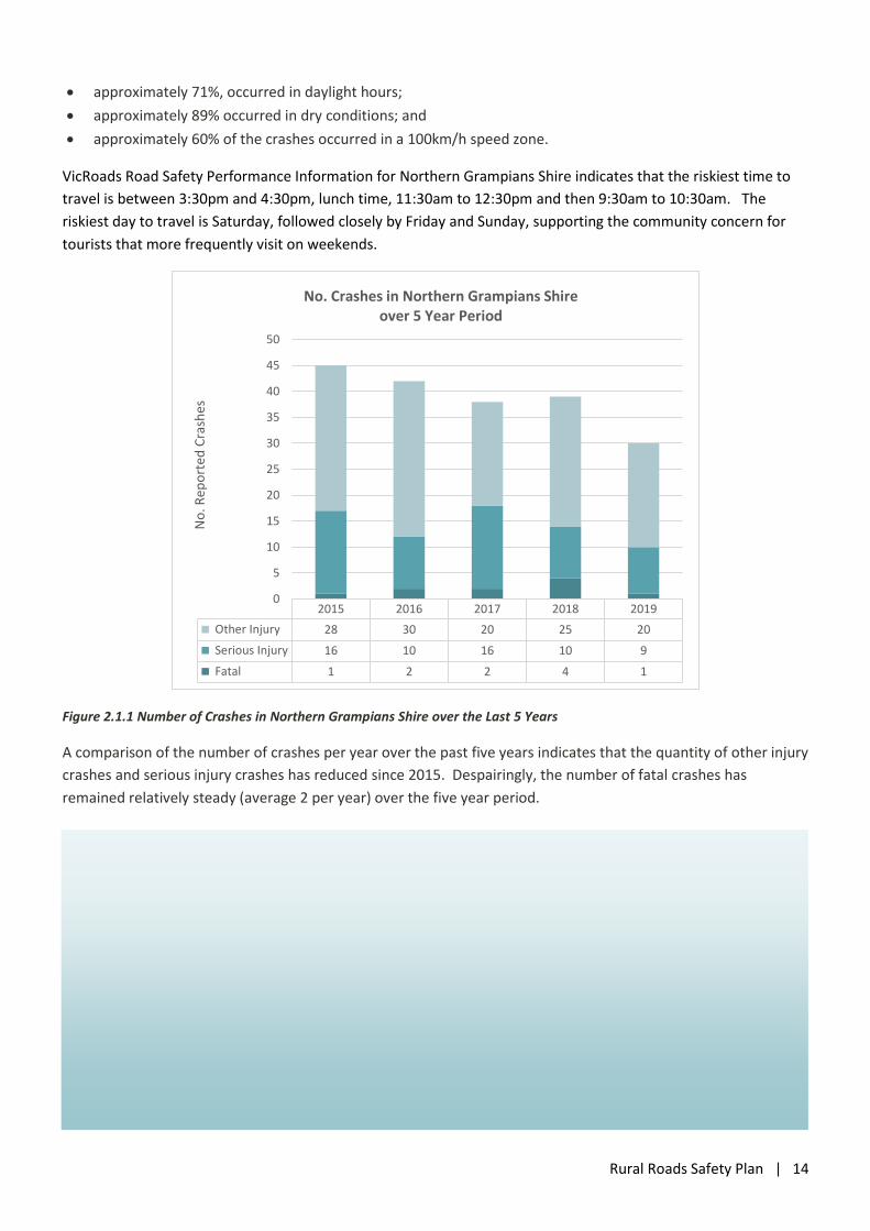
Figure 2.1.1 Number of Crashes in Northern Grampians Shire over the Last 5 Years
A comparison of the number of crashes per year over the past five years indicates that the quantity of other injury
crashes and serious injury crashes has reduced since 2015. Despairingly, the number of fatal crashes has
remained relatively steady (average 2 per year) over the five year period.
2015 2016 2017 2018 2019
Other Injury 28 30 20 25 20
Serious Injury 16 10 16 10 9
Fatal 1 2 2 4 1
0
5
10
15
20
25
30
35
40
45
50
No
. Rep
ort
ed C
rash
es
No. Crashes in Northern Grampians Shire over 5 Year Period
Rural Roads Safety Plan | 15
2.2 Comparison of Casualty Rates
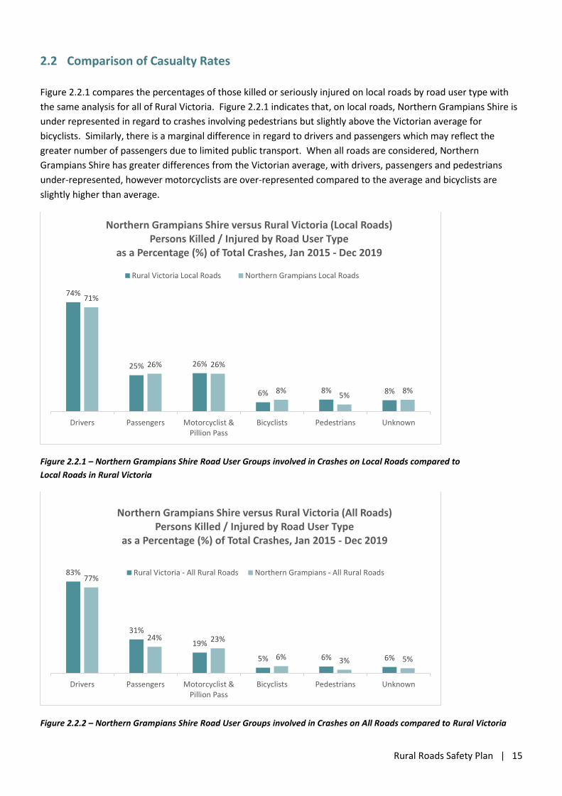
Figure 2.2.1 compares the percentages of those killed or seriously injured on local roads by road user type with
the same analysis for all of Rural Victoria. Figure 2.2.1 indicates that, on local roads, Northern Grampians Shire is
under represented in regard to crashes involving pedestrians but slightly above the Victorian average for
bicyclists. Similarly, there is a marginal difference in regard to drivers and passengers which may reflect the
greater number of passengers due to limited public transport. When all roads are considered, Northern
Grampians Shire has greater differences from the Victorian average, with drivers, passengers and pedestrians
under-represented, however motorcyclists are over-represented compared to the average and bicyclists are
slightly higher than average.
Figure 2.2.1 – Northern Grampians Shire Road User Groups involved in Crashes on Local Roads compared to
Local Roads in Rural Victoria
Figure 2.2.2 – Northern Grampians Shire Road User Groups involved in Crashes on All Roads compared to Rural Victoria
74%
25% 26%
6% 8% 8%
71%
26% 26%
8%5%
8%
Drivers Passengers Motorcyclist &Pillion Pass
Bicyclists Pedestrians Unknown
Northern Grampians Shire versus Rural Victoria (Local Roads) Persons Killed / Injured by Road User Type
as a Percentage (%) of Total Crashes, Jan 2015 - Dec 2019
Rural Victoria Local Roads Northern Grampians Local Roads
83%
31%
19%
5% 6% 6%
77%
24% 23%
6% 3% 5%
Drivers Passengers Motorcyclist &Pillion Pass
Bicyclists Pedestrians Unknown
Northern Grampians Shire versus Rural Victoria (All Roads) Persons Killed / Injured by Road User Type
as a Percentage (%) of Total Crashes, Jan 2015 - Dec 2019
Rural Victoria - All Rural Roads Northern Grampians - All Rural Roads
Rural Roads Safety Plan | 16
2.3 Key Findings
Some key findings are evident from a review of the casualty crash data for Northern Grampians Shire for the
period from January 2015 to July 2020.
The highest number of casualty crashes (88 crashes, 43.5%) occurred as a result of vehicles leaving the
road, either on a straight (46 crashes, 22.8%) or on a curve (42 crashes, 20.8%).
Young drivers aged 18 to 25 years represent 25% of all driver casualties but this age group only represents
approximately 9.1% of the population.
Drivers in the 26-29 are also at high risk, representing 8.5% of all driver casualties which is higher than the
5.7% that their age group represents in the population.
Older drivers in the 70+ year age groups are the next most at risk group, representing 12.5% of all driver
casualties which is higher than the 10.7% that their age groups represent in the population.
Motorcyclists account for 11.5% of all casualties with more than 93% being male and the highest risk
group are older male motorcyclists aged 50 to 59 years followed by males aged 18 to 25 years, 60 to 69
years, 40 to 49 years and 30 to 39 years that all had similar numbers of crashes.
There was at least 1 pedestrian casualty per year on average. The highest risk groups are older (70+ year
old) pedestrians and school aged children.
On average there are two crashes per year involving bicyclists and the highest risk group are male cyclists
in the 49 to 59 year age group, followed by teenage male cyclists.
There were 116 passengers injured, approximately 21 per year and the highest risk group were
passengers in the 18–25 year age group followed by young passengers aged 0–17.
Approximately two-thirds (60%) of the crashes occurred in a 100km/h speed zone, the type of crashes
which generally impart the greatest severity of the injuries to road users.
The crash analysis indicates that male motorcyclists are significantly higher represented (15 times) in crashes in
Northern Grampians Shire than females. Similarly, all but one of the bicycle crashes involved male cyclists and
overall there have been more than three times the number of male drivers (213) than female drivers (68)
involved in the reported crashes from January 2015 to July 2020. Therefore, it is appropriate that one method of
delivery for driver and rider behavioural programs may be through predominantly male sporting and social clubs,
for example cycling clubs, cricket and football clubs, trail bike motor cycle clubs, men’s sheds etc.
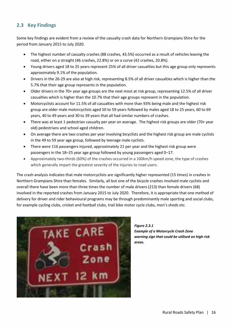
Figure 2.3.1
Example of a Motorcycle Crash Zone
warning sign that could be utilised on high risk
areas.
Rural Roads Safety Plan | 17
2.4 Crash Types
Crashes can be grouped based on the type of movements being undertaken by the vehicles involved at the time
of the crash. Definitions for Classifying Accidents (DCA) are recognised and adopted descriptions used to record
crash characteristics. To identify the most common types of crash that occurred in Northern Grampians Shire
over the period from January 2015 to July 2020, the following categories have been used to separate ‘crash
types’.
Pedestrian – DCA 100-109
Vehicles from Adjacent Directions at Intersections (Predominantly Side Impact) - DCA 110, 111, 113, 114,
116, 121 and 122 plus 112 and Location Type = Intersection.
Head On – DCA 120 plus 129
Rear End – DCA 130-132
Manoeuvring – DCA 140-148
Overtaking – DCA 150-159
Struck Object – DCA 160-166
Struck Animal – DCA 167
Run Off Road – DCA 151, 170-173 (Off Path on Straight) and 180-183 (Off Path on Curve)
Out of Control on Carriageway – DCA 174 and 184
Off End of Road (Intersection) – DCA 175
Passengers and Miscellaneous – DCA 190-199
Other – those crashes that are not included above.
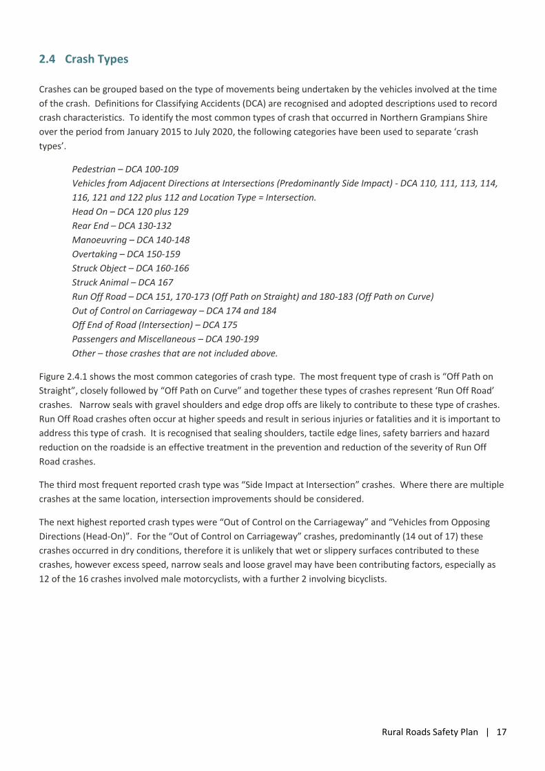
Figure 2.4.1 shows the most common categories of crash type. The most frequent type of crash is “Off Path on
Straight”, closely followed by “Off Path on Curve” and together these types of crashes represent ‘Run Off Road’
crashes. Narrow seals with gravel shoulders and edge drop offs are likely to contribute to these type of crashes.
Run Off Road crashes often occur at higher speeds and result in serious injuries or fatalities and it is important to
address this type of crash. It is recognised that sealing shoulders, tactile edge lines, safety barriers and hazard
reduction on the roadside is an effective treatment in the prevention and reduction of the severity of Run Off
Road crashes.
The third most frequent reported crash type was “Side Impact at Intersection” crashes. Where there are multiple
crashes at the same location, intersection improvements should be considered.
The next highest reported crash types were “Out of Control on the Carriageway” and “Vehicles from Opposing
Directions (Head-On)”. For the “Out of Control on Carriageway” crashes, predominantly (14 out of 17) these
crashes occurred in dry conditions, therefore it is unlikely that wet or slippery surfaces contributed to these
crashes, however excess speed, narrow seals and loose gravel may have been contributing factors, especially as
12 of the 16 crashes involved male motorcyclists, with a further 2 involving bicyclists.
Rural Roads Safety Plan | 18
Figure 2.4.1 – Northern Grampians Shire - Crashes by Crash Type
2.5 Crash Locations
Over the period from January 2015 to July 2020, more than one third of the reported crashes (80 or40%) occurred
on local roads in Northern Grampians Shire. Therefore, it is imperative that road safety on local roads be
addressed and that Northern Grampians Shire submit strong Black Spot Programme applications targeted at
locations with the most crashes.
The crashes have occurred throughout the municipality, however there are a couple of noticeable concentration
of crashes:
The Grampians area is the location of a large proportion of the total crashes, particularly on Northern
Grampians Road (Mt Victory Road) and Grampians Road which had 14 and 11 crashes respectively.
A high number of the crashes also occurred on the main arterial roads in Northern Grampians Shire,
namely the Western Highway (33), the Wimmera Highway (15), the Sunraysia Highway (11) and Stawell
Avoca Road (8) and Ararat St Arnaud Road (8).
6
27
17
14
7
2
4
9
46
42
17
3
4
4
0 5 10 15 20 25 30 35 40 45 50
Pedestrian
Vehicles from Adjacent Directions at Intersections(Predominantly Side Impact)
Vehicles from Opposing Directions (Head On)
Vehicles from Same Direction (Rear End)
Manoeuvring
Overtaking
Struck Object on Carriageway
Struck Animal
Off Path on Straight (ROR: 170 - 173)
Off Path on Curve (ROR: 180 - 183)
Out of Control on Carriageway (Straight and Curve) 174, 184
Off End of Road (Intersection) 175
Passengers and Miscellaneous
Other
Northern Grampians Shire Reported Crashes by Crash Type
(Jan 2015- July 2020)
Rural Roads Safety Plan | 19
Figure 2.5.1 – Crashes within the St Arnaud Township (January 2015 to December 2019)
Figure 2.5.2 – Crashes within the Stawell Township (January 2015 to December 2019)
Rural Roads Safety Plan | 20
Figure 2.5.3 – Crashes within the Halls Gap Area (January 2015 to December 2019)
Figure 2.5.4 – Local Road Crashes within Northern Grampians Shire – St Arnaud Area (January 2015 to December 2019)
Rural Roads Safety Plan | 21
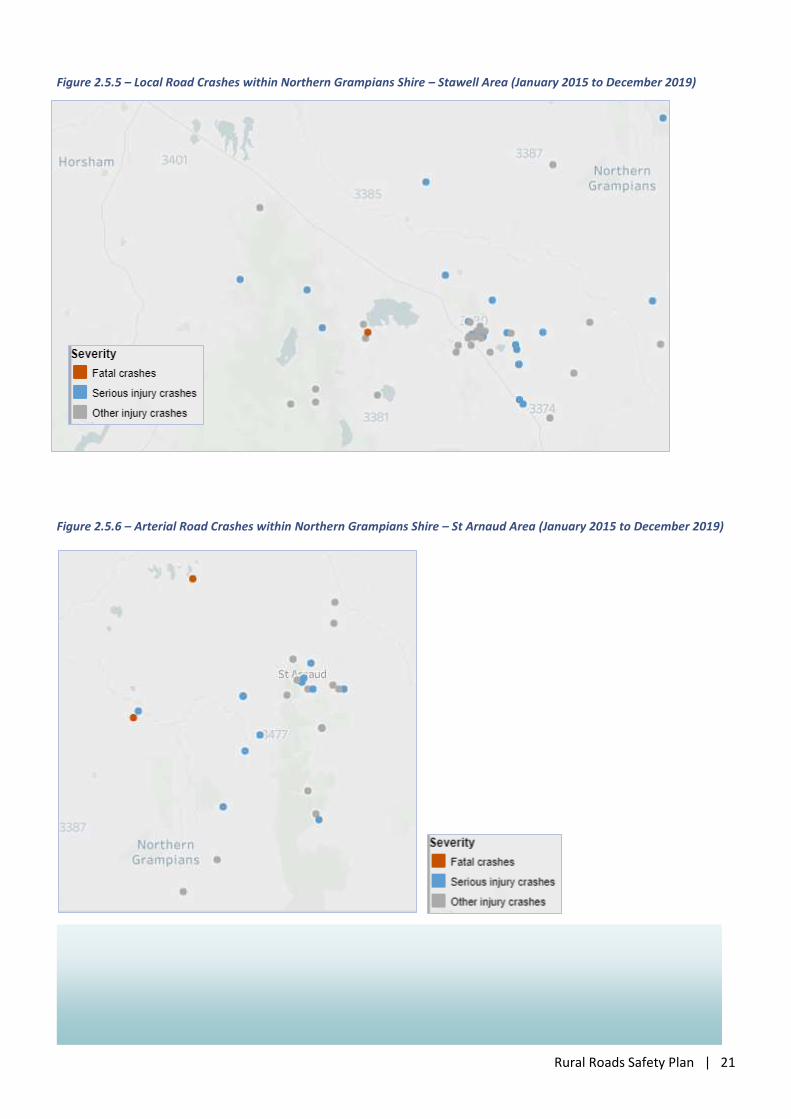
Figure 2.5.5 – Local Road Crashes within Northern Grampians Shire – Stawell Area (January 2015 to December 2019)
Figure 2.5.6 – Arterial Road Crashes within Northern Grampians Shire – St Arnaud Area (January 2015 to December 2019)
Rural Roads Safety Plan | 22
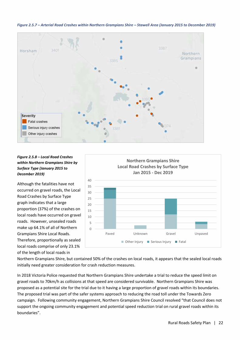
Figure 2.5.7 – Arterial Road Crashes within Northern Grampians Shire – Stawell Area (January 2015 to December 2019)
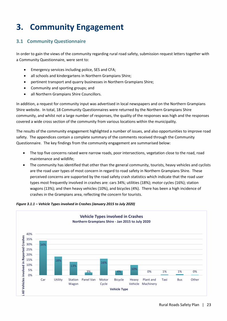
Figure 2.5.8 – Local Road Crashes
within Northern Grampians Shire by
Surface Type (January 2015 to
December 2019)
Although the fatalities have not
occurred on gravel roads, the Local
Road Crashes by Surface Type
graph indicates that a large
proportion (37%) of the crashes on
local roads have occurred on gravel
roads. However, unsealed roads
make up 64.1% of all of Northern
Grampians Shire Local Roads.
Therefore, proportionally as sealed
local roads comprise of only 23.1%
of the length of local roads in
Northern Grampians Shire, but contained 50% of the crashes on local roads, it appears that the sealed local roads
initially need greater consideration for crash reduction measures.
In 2018 Victoria Police requested that Northern Grampians Shire undertake a trial to reduce the speed limit on
gravel roads to 70km/h as collisions at that speed are considered survivable. Northern Grampians Shire was
proposed as a potential site for the trial due to it having a large proportion of gravel roads within its boundaries.
The proposed trial was part of the safer systems approach to reducing the road toll under the Towards Zero
campaign. Following community engagement, Northern Grampians Shire Council resolved “that Council does not
support the ongoing community engagement and potential speed reduction trial on rural gravel roads within its
boundaries”.
0
5
10
15
20
25
30
35
40
Paved Unknown Gravel Unpaved
Northern Grampians Shire Local Road Crashes by Surface Type
Jan 2015 - Dec 2019
Other Injury Serious Injury Fatal
Rural Roads Safety Plan | 23
3. Community Engagement
3.1 Community Questionnaire
In order to gain the views of the community regarding rural road safety, submission request letters together with
a Community Questionnaire, were sent to:
Emergency services including police, SES and CFA;
all schools and kindergartens in Northern Grampians Shire;
pertinent transport and quarry businesses in Northern Grampians Shire;
Community and sporting groups; and
all Northern Grampians Shire Councillors.
In addition, a request for community input was advertised in local newspapers and on the Northern Grampians
Shire website. In total, 18 Community Questionnaires were returned by the Northern Grampians Shire
community, and whilst not a large number of responses, the quality of the responses was high and the responses
covered a wide cross section of the community from various locations within the municipality.
The results of the community engagement highlighted a number of issues, and also opportunities to improve road
safety. The appendices contain a complete summary of the comments received through the Community
Questionnaire. The key findings from the community engagement are summarised below:
The top five concerns raised were narrow roads, poor intersections, vegetation close to the road, road
maintenance and wildlife;
The community has identified that other than the general community, tourists, heavy vehicles and cyclists
are the road user types of most concern in regard to road safety in Northern Grampians Shire. These
perceived concerns are supported by the road safety crash statistics which indicate that the road user
types most frequently involved in crashes are: cars 34%; utilities (18%); motor cycles (16%); station
wagons (13%); and then heavy vehicles (10%), and bicycles (4%). There has been a high incidence of
crashes in the Grampians area, reflecting the concern for tourists.
Figure 3.1.1 – Vehicle Types involved in Crashes (January 2015 to July 2020)
34%
18%
13%
3%
16%
4%10%
0% 1% 1% 0%0%
5%
10%
15%
20%
25%
30%
35%
40%
Car Utility StationWagon
Panel Van MotorCycle
Bicycle HeavyVehicle
Plant andMachinery
Taxi Bus Other
% A
ll V
eh
icle
s in
volv
ed
in R
ep
ort
ed
Cra
she
s
Vehicle Type
Vehicle Types involved in CrashesNorthern Grampians Shire - Jan 2015 to July 2020
Rural Roads Safety Plan | 24
Various locations were identified as having high priority safety issues. Predominantly these were:
intersections with sight distance issues; sections of road with narrow seals and mixed traffic usage (i.e.
heavy vehicles and cyclists); and sections of road with significant amounts of wildlife.
The need for additional pedestrian facilities and bicycle facilities, both off road and on road, in the
Grampians Road was raised as a concern.
The occurrence of motorcycle crashes on tourist roads in the Grampians National Parks is a concern, in
particular in the Zumsteins area. This concern is in line with the crash statistics that have a high number
of crashes (14) on Northern Grampians Road (Mt Victory Road), with 9 of the 14 crashes involving a
motorcycle and a further two crashes involving a bicycle.
Figure 3.1.2 - Predominant Road User Types that the community identified as of concern in Northern Grampians Shire.
Figure 3.1.3 - Summary of Safety Concerns as raised by the Northern Grampians Shire community.
0
1
2
3
4
5
6
7
8
9
Road User Types of concernraised by the Community
0
5
10
15
Road Concerns raised by Community
Rural Roads Safety Plan | 25
4. Key Focus Areas
The accident records show that all age groups and demographics are represented in the collision data and that
different ages/demographics pose different risks. Similarly, the public engagement process has identified a
variety of issues, relating to various groups within the community.
This strategy addresses nine key areas of particular relevance and importance to Northern Grampians Shire that
fall within the key pillars in a Safe System.
Key Action Areas
Safer Road Network and Safer Speeds
Rural road safety;
o Narrow Roads
o Wildlife Areas
o Road and roadside maintenance
o Gravel Roads
o Intersections
o Signage and Delineation
o Overtaking Opportunities
Safety around schools;
Safer Speeds
Safer Road User
Bicyclists and Pedestrians;
Motorcyclists;
Tourists and Tourist Areas;
Young Drivers and Passengers;
Older Drivers;
Safer Vehicles
Post Crash Response
Emergency Access;
For each of the key action areas, a number of improvement projects and proposed driver behaviour programs
have been identified for implementation across the municipality. The key action areas are outlined below. This
will be complemented by ongoing road safety initiatives on a regional and state wide basis by the Department of
Transport, Victoria Police and others.
Rural Roads Safety Plan | 26
4.1 Rural Road Safety
On average, more than 10 crashes per year occur on the Western Highway, Wimmera Highway and Sunraysia
Highway within Northern Grampians Shire, with approximately 16 people per year injured or killed on these three
roads annually. Two other arterial roads, Northern Grampians Road (Mt Victory Road) and Grampians Road also
have significant numbers of crashes, with greater than four crashes per year and approximately 6 people per year
injured or killed on these two tourist roads annually.
It is apparent from Figure 2.4.1 that the most common type of crash reported in Northern Grampians Shire were
‘run off road‘ crashes (DCA 151, 170-173 and 180-183) which make up almost 44% of all crashes. The ‘out of
control on the carriageway’ vehicles make up a further 8% of the crashes and are in a similar DCA category to the
run off road crashes, with likely similar causes. Predominantly the run off road crashes involve vehicles ‘leaving
the carriageway on a straight’ (DCA Code 170 – 179) and then vehicles ‘leaving the carriageway on a curve’ (DCA
Code 180 – 189). Narrow seals with gravel shoulders and edge drop offs are likely to contribute to these type of
crashes. Run Off Road crashes often occur at higher speeds and result in serious injuries or fatalities and it is
important to address this type of crash. It is recognised that sealing shoulders, tactile edge lines, safety barriers
and hazard reduction on the roadside is an effective treatment in the prevention and reduction of the severity of
Run Off Road crashes.
‘Head-on crashes’ make up approximately 8% of the total crashes in Northern Grampians Shire.
Crashes at intersections between vehicles from adjacent directions are the third most frequent reported crash
type and make up 13% of crashes, however there have been fewer fatalities and serious injuries from these
crashes as they tend to occur at lower speeds. Where there are multiple crashes at the same location,
intersection improvements should be considered.
The next highest reported crash type was “Out of Control on the Carriageway”. Predominantly (14 out of 16)
these crashes occurred in dry conditions, therefore it is unlikely that wet or slippery surfaces contributed to these
crashes, however excess speed, narrow seals and loose gravel may have been contributing factors, especially as
12 of the 16 crashes involved male motorcyclists, with a further 2 involving bicyclists.
Approximately two thirds 60% of the crashes occurred in a 100km/h speed zone, and high speed crashes
generally impart the greatest severity of the injuries to road users. The high number of ‘run off road’ crashes that
involve a vehicle hitting a fixed object (69 crashes or 34% of all crashes) indicates that the provision of a more
forgiving roadside (safety barrier, clear zone etc.) would have a significant impact on reducing the severity of
crashes in the municipality.
The results of the community consultation highlighted a number of issues of concern, and also opportunities to
improve road safety and these issues are summarised in the following sections. Almost all of the comments are
relevant to the rural roads, however where they are pertaining to a particular group, i.e. cyclists, the comments
are only included in that section.
Rural Roads Safety Plan | 27
Community Concerns / Ideas:
4.1.1 Narrow Roads
The most frequently raised safety concerns by the community are in regard to roads with narrow seals. The
issues raised can be summarised as follows.
The narrow width of the seal on various roads, particularly where there is mixed traffic involving tourists
towing large camper trailers and caravans, heavy vehicles and cyclists is a safety concern. There are
locations where it is simply too narrow. For example, Grampians Road carries heavy vehicles and many
caravans/campervans, but has a number of lengths that are too narrow and/or has vegetation too close
to the road.
There are roads in Northern Grampians Shire that are too narrow to safely cater for the volume of traffic
and road cyclists trying to exercise. There are insufficient safe roads for cyclists in the Northern
Grampians.
There are narrow, windy tourist roads on which there are no safe areas to pull over/park on the roadside.
These roads require the construction of pull over areas to improve safety.
Where there is a narrow seal and a deep drop off or loose gravel on the shoulder, it is dangerous for cars
and cyclists, especially when passing trucks, as there is insufficient room for both vehicles on the seal.
Roads with narrow seals that are impacted by larger machinery and trucks (resulting in potholes, edge
breaks and shoulder deterioration), are dangerous to travel on, particularly when passing other vehicles,
when it is wet, or at night.
Over time the transport industry has evolved and bigger, heavier and longer trucks are now being utilised.
The narrow width of some roads no longer safely caters for these heavy vehicles and the mix of traffic.
A number of roads are not suitable for the heavy vehicle volumes they carry. The quantity of heavy
vehicles, coupled with inadequate pavement width and strength and the high speed zones all result in
increased road safety risk.
With increased traffic volumes there is increased exposure and therefore increased risk with regard to:
vehicles colliding with wildlife; inexperienced drivers; and tourists that are unfamiliar with the road. In
this regard, roads in the Halls Gap area pose a concern, with the high traffic volumes culminating in higher
risk of collision.
Many roads need to be widened, to provide sufficient width sealed shoulders and proper drainage.
A widening of the narrow seals would allow tactile edge lines which may reduce run off road incidents. In
addition, wider seals would allow for the installation of centre lines, edge lines and raised reflective
pavement markers which would greatly improve delineation at night.
Specific Locations Identified
Location Issue
Grampians Road This road has been identified as in need of rehabilitation or resurfacing and widening to improve safety. This is a high tourist area and for tourists towing large camper trailers and caravans the road is simply too narrow. It is considered that the speed zone of 100km/h is too high for this road in its current state.
Rural Roads Safety Plan | 28
Location Issue
Grampians Road The splitter island on Grampians Road near the Halls Gap Hotel is considered a danger to cyclists as vehicles try to pass cyclists at this location and the road narrow at the island
St Arnaud Charlton Road There are steep edge drop offs on this road, that are dangerous when vehicles meet oncoming traffic.
Stawell Pomonal Road The speed of heavy vehicles is damaging the road, in particular the shoulder. This is exacerbated when traffic is diverted from the Western Highway. The road is narrow and there is loose deep gravel on the shoulder.
Stawell Pomonal Road Narrow shoulder with loose deep gravel is dangerous for cars and cyclists, particularly when passing heavy vehicles as there is insufficient seal width to stay on the seal.
Sunraysia Highway Narrow road width in some sections is a hazard for heavy vehicles passing each other. Some widened sections have a change in crossfall on the shoulder, which is dangerous for trucks and towing vehicles. Medlyn’s corner and the narrow bridge has also been identified as a safety concern.
Banyena Road (Ch: 30.280km to Donald Stawell Road)
Identified as requiring pavement widening in the WSMRTG Strategy 2020.
Banyena Pimpinio Road (Ch: 7.562km to Ch: 8.241km Burrum Lawler Rd)
Identified as requiring pavement widening in the WSMRTG Strategy 2020.
Banyena Silo Road (Ch: 5.332km to Ch:6.554km)
Identified as requiring pavement widening in the WSMRTG Strategy 2020.
Burrumbite Road (Batters Rd Ch: 8.286km to Ch: 9.94km Cope Cope)
Identified as requiring pavement widening in the WSMRTG Strategy 2020.
Moyston Great Western Road, Bridge at Ch: 2.770km.
Identified as a narrow bridge on a busy road that requires widening in the WSMRTG Strategy 2020.
Moyston Great Western Road, Bridge at Ch: 2.375km.
Identified as a narrow bridge on a busy road that requires widening in the WSMRTG Strategy 2020.
4.1.2 Intersections
In recent years, Northern Grampians Shire, in partnership with VicRoads, has undertaken a program of improving
/ re-aligning dangerous ‘Y’ intersections in the municipality. This program has proactively addressed road safety
issues and similar programs are encouraged to continue.
Having noted that a number of intersections have already been addressed, the community has identified further
safety concerns in regard to a number of intersections in Northern Grampians Shire that are perceived to be
dangerous. The issues raised can be summarised as follows.
Rumble strips on the approaches and the installation of large signage at dangerous or significant
intersections within Northern Grampians Shire would be an appropriate safety improvement strategy. It
is noted that some intersections have had this treatment and this program should be extended.
Investment in roundabouts at higher risk intersections would be valuable as whilst there not been many
reported collisions, there have been numerous near misses. Regional Roads Victoria investment would be
required. One example of such an intersection is the Western Highway and Seaby St in Stawell.
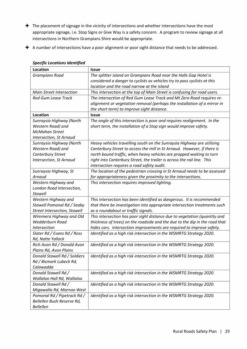
Rural Roads Safety Plan | 29
The placement of signage in the vicinity of intersections and whether intersections have the most
appropriate signage, i.e. Stop Signs or Give Way is a safety concern. A program to review signage at all
intersections in Northern Grampians Shire would be appropriate.
A number of intersections have a poor alignment or poor sight distance that needs to be addressed.
Specific Locations Identified
Location Issue
Grampians Road The splitter island on Grampians Road near the Halls Gap Hotel is considered a danger to cyclists as vehicles try to pass cyclists at this location and the road narrow at the island
Main Street Intersection This intersection at the top of Main Street is confusing for road users.
Red Gum Lease Track The intersection of Red Gum Lease Track and Mt Zero Road requires re-alignment or vegetation removal (perhaps the installation of a mirror in the short term) to improve sight distance.
Location Issue
Sunraysia Highway (North Western Road) and McMahan Street Intersection, St Arnaud
The angle of this intersection is poor and requires realignment. In the short term, the installation of a Stop sign would improve safety.
Sunraysia Highway (North Western Road) and Canterbury Street Intersection, St Arnaud
Heavy vehicles travelling south on the Sunraysia Highway are utilising Canterbury Street to access the mill in St Arnaud. However, if there is north bound traffic, when heavy vehicles are propped waiting to turn right into Canterbury Street, the trailer is across the rail line. This intersection requires a road safety audit.
Sunraysia Highway, St Arnaud
The location of the pedestrian crossing in St Arnaud needs to be assessed for appropriateness given the proximity to the intersections.
Western Highway and London Road Intersection, Stawell
This intersection requires improved lighting.
Western Highway and Stawell Pomonal Rd / Seaby Street Intersection, Stawell
This intersection has been identified as dangerous. It is recommended that there be investigation into appropriate intersection treatments such as a roundabout or traffic signals.
Wimmera Highway and Old Wedderburn Road Intersection
This intersection has poor sight distance due to vegetation (quantity and thickness of trees) on the roadside and the due to the dip in the road that hides cars. Intersection improvements are required to improve safety.
Slater Rd / Evans Rd / Ross Rd, Natte Yallock
Identified as a high risk intersection in the WSMRTG Strategy 2020.
Rich Avon Rd / Donald Avon Plains Rd, Avon Plains
Identified as a high risk intersection in the WSMRTG Strategy 2020.
Donald Stawell Rd / Soldiers Rd / Bismark Lubeck Rd, Calawadda
Identified as a high risk intersection in the WSMRTG Strategy 2020.
Donald Stawell Rd / Wallaloo Hall Rd, Wallaloo
Identified as a high risk intersection in the WSMRTG Strategy 2020.
Donald Stawell Rd / Migawalla Rd, Marnoo West
Identified as a high risk intersection in the WSMRTG Strategy 2020.
Pomonal Rd / Pipetrack Rd / Bellellen Bush Reserve Rd, Bellellen
Identified as a high risk intersection in the WSMRTG Strategy 2020.
Rural Roads Safety Plan | 30
4.1.3 Wildlife Areas
The community has raised safety concerns in regard to the presence of wildlife on many roads in Northern
Grampians Shire and vehicles colliding with wildlife. Wildlife concerns was one of the top five issues raised by the
community and the issues raised can be summarised as follows.
Wildlife on roads in Northern Grampians Shire is a significant concern for drivers at particular times of the
day and at particular locations on the network. In some locations, there is a significant risk of animals
appearing from the scrub/behind bushes and being hit by vehicles, with a further risk of collisions with
other vehicles as drivers attempt to avoid wildlife.
There is increased risk in regard to wildlife, tourists, and through traffic in high traffic volume areas such
as around Halls Gap. As the traffic volume increases, the risk of collision also increases.
Wildlife, in particular kangaroos, are a real safety issue and more driver awareness is required, either
though signage or a State Government Program to make drivers aware. Tourists are susceptible to
swerving to miss wildlife so the “stay straight and brake” campaign would be a great initiative to
continue.
Install sensible speed guidelines for back roads or roads where wildlife is common.
Kangaroo warning sign locations are out of date in many areas, and need to be relocated to locations
where the kangaroos (and other wildlife) are currently located and becoming more of a problem.
Kangaroo-proof fences are needed in some areas to prevent kangaroos causing traffic accidents. This is
particularly an issue on parts of the Western Highway with the Dadswells Bridge area having had many
recent near misses.
Specific Locations Identified
Location Issue
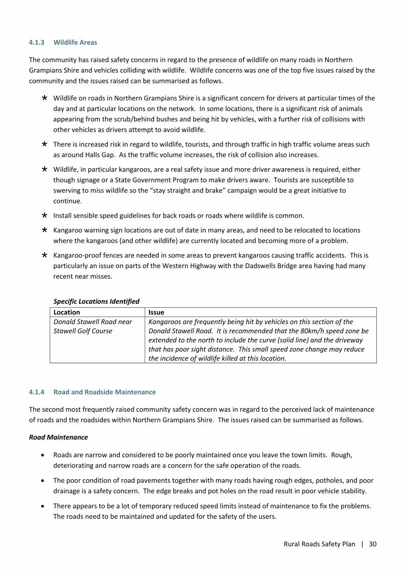
Donald Stawell Road near Stawell Golf Course
Kangaroos are frequently being hit by vehicles on this section of the Donald Stawell Road. It is recommended that the 80km/h speed zone be extended to the north to include the curve (solid line) and the driveway that has poor sight distance. This small speed zone change may reduce the incidence of wildlife killed at this location.
4.1.4 Road and Roadside Maintenance
The second most frequently raised community safety concern was in regard to the perceived lack of maintenance
of roads and the roadsides within Northern Grampians Shire. The issues raised can be summarised as follows.
Road Maintenance
Roads are narrow and considered to be poorly maintained once you leave the town limits. Rough,
deteriorating and narrow roads are a concern for the safe operation of the roads.
The poor condition of road pavements together with many roads having rough edges, potholes, and poor
drainage is a safety concern. The edge breaks and pot holes on the road result in poor vehicle stability.
There appears to be a lot of temporary reduced speed limits instead of maintenance to fix the problems.
The roads need to be maintained and updated for the safety of the users.
Rural Roads Safety Plan | 31
The overall standard of the line marking needs improvement as it is difficult to see at night and in misty
rain. Paint with longer life or greater reflectivity and raised reflective permanent markers (RRPM’s)
should be investigated for widespread installation.
The deteriorating condition of our road networks is a concern, with roads becoming excessively rough and
potholes forming quicker than they are being repaired. The poor road condition is causing excessive and
unnecessary wear and tear on heavy vehicles, resulting in hefty repair bills for the drivers.
In some areas where there has been road widening, the widened section on the edge has sunk causing a
ridge along the outside of the lane. This type of failure is dangerous for towing and heavy vehicles
because the trailer can behave quite erratically and pull sideways. Road widening needs to be adequately
constructed such that the widened section follows the same cross section as the existing road surface.
The recent increase in rainfall/possible flooding has damaged the road network and an increase in
maintenance is required, particularly on the local road network.
Northern Grampians Shire needs more funding to carry out the necessary road maintenance. Repeated
short term repairs are not the answer and only lead to more significant road failures. The repair method
for potholes needs to be more effective.
Roadside Vegetation
There are many roads where the vegetation is close to road surface and there is potential for collision
with roadside trees.
The vegetation envelope difficult to maintain under the current state legislation which perhaps should be
relaxed to address road safety issues.
There are roads where vegetation is close to the road and poses a fire risk.
Farm equipment continues to increase in size and moving this equipment on roads where there is close
vegetation poses safety issues and can result in damage to this expensive equipment.
There are intersections where vegetation impedes visibility and sight distance, such as where there is
poor visibility due to trees too close to the road or where vegetation is too high for the average sedan
driver to see over/around.
Specific Locations Identified
Location Issue
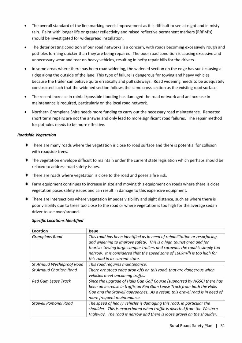
Grampians Road This road has been identified as in need of rehabilitation or resurfacing and widening to improve safety. This is a high tourist area and for tourists towing large camper trailers and caravans the road is simply too narrow. It is considered that the speed zone of 100km/h is too high for this road in its current state.
St Arnaud Wycheproof Road This road requires maintenance.
St Arnaud Charlton Road There are steep edge drop offs on this road, that are dangerous when vehicles meet oncoming traffic.
Red Gum Lease Track Since the upgrade of Halls Gap Golf Course (supported by NGSC) there has been an increase in traffic on Red Gum Lease Track from both the Halls Gap and the Stawell approaches. As a result, this gravel road is in need of more frequent maintenance.
Stawell Pomonal Road The speed of heavy vehicles is damaging this road, in particular the shoulder. This is exacerbated when traffic is diverted from the Western Highway. The road is narrow and there is loose gravel on the shoulder.
Rural Roads Safety Plan | 32
4.1.5 Gravel Roads
The community has raised a number of safety concerns in regard to gravel roads in Northern Grampians Shire.
The issues raised represent a range of views and can be summarised as follows.
Gravel roads not well maintained, with iinsufficient grading of gravel roads.
Gravel roads are always a challenge to maintain, long dry spells make them difficult and expensive to
maintain, however Northern Grampians Shire is fortunate to have good gravel supplies.
Previously an 80km/h speed limit was proposed by Victoria Police for gravel roads in Northern Grampians
Shire. This proposal was not acceptable to the community and where there are repeated trips on gravel
roads, it may add significantly to the travel time when the whole of travel is considered. Rural areas are
already isolated without reducing the speed limit on roads.
4.1.6 Overtaking Opportunities
The community has raised safety concerns in regard to a lack of overtaking opportunities on tourist road and
busier roads. The issues raised can be summarised as follows.
♦ Many of the roads have narrow seals, making overtaking of slower vehicles dangerous and often where
the seal has been widened to provide adequate width, there is a double painted centre line that restricts
the passing vehicles.
♦ Where overtaking lanes are constructed, they are often the minimum standard and insufficient in length.
Heavy vehicles, which are speed limited, take more time to pass and therefore require a longer overtaking
lane. To provide for the safer passing of heavy vehicles, longer overtaking lanes are required.
♦ There are narrow, windy tourist roads on which there are no safe areas to pull over/park on the roadside.
These roads require the construction of pull over areas to facilitate vehicle passing and improve safety.
♦ Slower moving vehicles (for example caravans and buses) lead to risk taking by other drivers attempting
to overtake these vehicles. There are not many opportunities to safely overtake on the secondary road
network in Northern Grampians Shire and the construction of some strategically placed overtaking lanes
would improve safety.
♦ Safe overtaking requires an understanding the speed differential between vehicles and good judgment.
Inexperience drivers and drivers unfamiliar with rural driving may have difficulty safely overtaking other
vehicles.
Specific Locations Identified
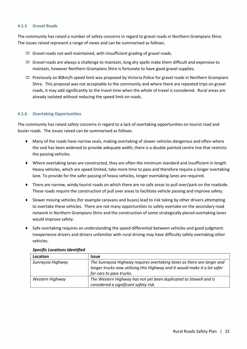
Location Issue
Sunraysia Highway The Sunraysia Highway requires overtaking lanes as there are larger and longer trucks now utilising this Highway and it would make it a lot safer for cars to pass trucks.
Western Highway The Western Highway has not yet been duplicated to Stawell and is considered a significant safety risk.
Rural Roads Safety Plan | 33
4.1.7 Signage and Delineation
The community has raised safety concerns in regard to signage within Northern Grampians Shire. The issues
raised can be summarised as follows.
There is a need for better and more modern signage - eye catching signs instead of the boring old ones
that are frequently ignored.
The installation of advisory signs that highlight the need to pay more attention to the road rules, and to
other road users, may improve safety in tourist areas. These signs would be aimed at tourists.
The locations of a number of kangaroo warning signs is no longer relevant. These warning signs need to
be relocated to areas where kangaroos (and other wildlife) are currently located and a road safety
concern.
The placement of signs in the vicinity of intersections is a road safety concern, particularly for heavy
vehicles. Drivers in cars are able to look underneath many signs to see approaching traffic, however from
higher vehicles and often further back from the intersection, some signs are installed where they block
drivers vision and requiring vehicles to enter the intersection in order to see around it.
4.1.8 Miscellaneous
The community has raised a number of miscellaneous safety concerns for Northern Grampians Shire. These
issues are summarised as follows.
Roadside Hazards / Safety Barrier
There are some areas throughout the municipality where additional safety barriers need to be installed,
even on Regional Roads Victoria roads, one example is on the Stawell Warracknabeal Road between the
Western Highway and Glenorchy.
Inexperienced / Fatigued Drivers
The location of Northern Grampians Shire and the long distances travelled within the municipality results
in the potential for drivers to be fatigued.
Tourism in the Grampians area brings to the municipality a number of inexperienced drivers and often
city people who do not have rural/long distance driving experience. Road safety needs to be enhanced to
ensure that these travellers get home safely.
There are instances of truck drivers intimidating car drivers through tailgating. This issue needs to be
addressed through further education of heavy vehicle drivers.
4.1.9 Improvement Ideas
Over the period from January 2015 to July 2020, more than one third of the reported crashes (80 crashes or 40%)
occurred on local roads in Northern Grampians Shire. Therefore, it is imperative that road safety on local roads
be addressed and that Northern Grampians Shire submit strong Black Spot Programme applications targeted at
locations with the most crashes.
The community has raised the following ideas that may be appropriate for trial / implementation on rural roads in
Northern Grampians Shire.
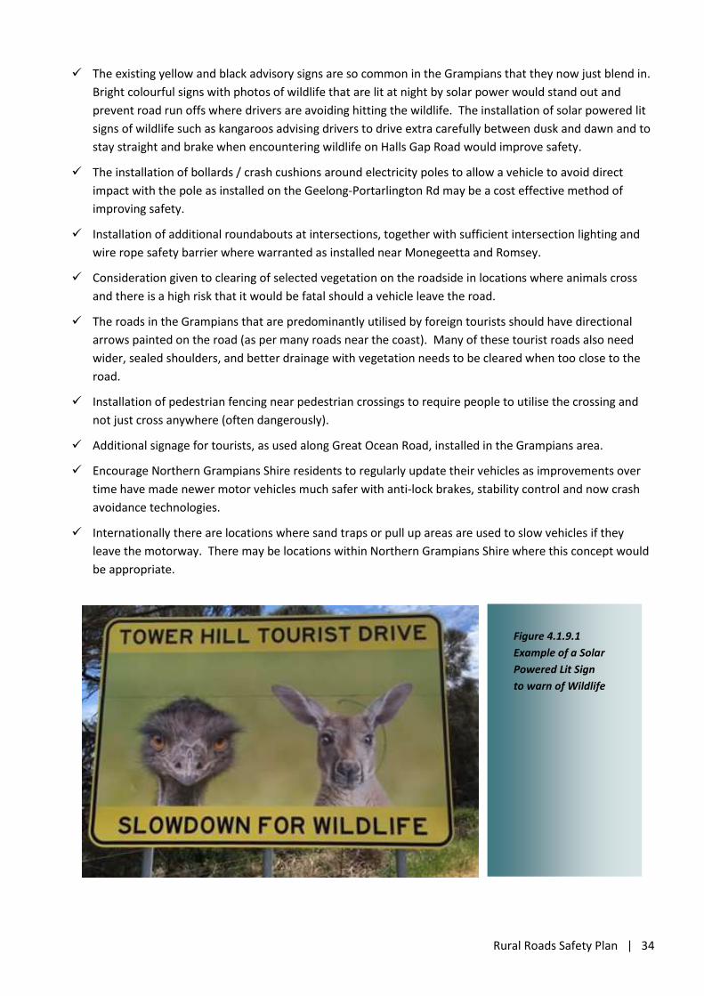
Rural Roads Safety Plan | 34
The existing yellow and black advisory signs are so common in the Grampians that they now just blend in.
Bright colourful signs with photos of wildlife that are lit at night by solar power would stand out and
prevent road run offs where drivers are avoiding hitting the wildlife. The installation of solar powered lit
signs of wildlife such as kangaroos advising drivers to drive extra carefully between dusk and dawn and to
stay straight and brake when encountering wildlife on Halls Gap Road would improve safety.
The installation of bollards / crash cushions around electricity poles to allow a vehicle to avoid direct
impact with the pole as installed on the Geelong-Portarlington Rd may be a cost effective method of
improving safety.
Installation of additional roundabouts at intersections, together with sufficient intersection lighting and
wire rope safety barrier where warranted as installed near Monegeetta and Romsey.
Consideration given to clearing of selected vegetation on the roadside in locations where animals cross
and there is a high risk that it would be fatal should a vehicle leave the road.
The roads in the Grampians that are predominantly utilised by foreign tourists should have directional
arrows painted on the road (as per many roads near the coast). Many of these tourist roads also need
wider, sealed shoulders, and better drainage with vegetation needs to be cleared when too close to the
road.
Installation of pedestrian fencing near pedestrian crossings to require people to utilise the crossing and
not just cross anywhere (often dangerously).
Additional signage for tourists, as used along Great Ocean Road, installed in the Grampians area.
Encourage Northern Grampians Shire residents to regularly update their vehicles as improvements over
time have made newer motor vehicles much safer with anti-lock brakes, stability control and now crash
avoidance technologies.
Internationally there are locations where sand traps or pull up areas are used to slow vehicles if they
leave the motorway. There may be locations within Northern Grampians Shire where this concept would
be appropriate.
Figure 4.1.9.1
Example of a Solar
Powered Lit Sign
to warn of Wildlife
Rural Roads Safety Plan | 35
4.1.10 Driver Behaviour Programs
A response from Victoria Police in the municipality advised that the majority of collisions police respond to are
single vehicle, off road/path.
To address road safety, Victoria Police focus on changing driver behaviour. “Risks related to fatigue, driver
distraction (mobile phone use for example), speeding/hoon driving behaviour, drug/alcohol affected, safe driving
practices (wear seat belts, allow enough room to take safe evasive action if needed, take regular breaks on long
trips), and swerving to avoid wildlife always form part of our activities related to road policing.”
There are a number of existing education/awareness programs that are run by the TAC, VicRoads and Victoria
Police, however the community has raised the following Driver Behaviour Program ideas that may be appropriate
for trial / implementation on rural roads in Northern Grampians Shire.
The term “Drive to the Conditions” is often used but it is not widely promoted state wide as a safety
strategy. This concept could be better promoted throughout the state with electric variable message
signs along strategic routes and/or smaller signs for less travelled roads.
An education campaign with a focus on the use of headlights would improve safety. Whether it’s dawn,
dusk, fog or overcast rainy days many people use only their park lights or no lights and are not visible to
other drivers.
An education campaign on respect for cyclists as legitimate road users would be beneficial in Northern
Grampians Shire.
Educating drivers on giving trucks time and space in traffic situations would improve road safety.
In regional areas road safety issues often seem to be about:
o Driver fatigue;
o Alcohol; and
o Drugs.
As the younger age group is overrepresented in road safety statistics, target education programs towards
this demographic.
Wildlife (and swerving to avoid) pose a significant risk for drivers in the Northern Grampians, particularly
for visitors and tourists. Increased signage and an education program on driving carefully between dawn
and dusk on country roads, together with teaching drivers to avoid hitting wildlife without swerving,
would improve rural safety.
Fatigue is another significant risk for drivers in the Northern Grampians, particularly for locals returning
home after holiday/long weekend away. Driver behaviour education on fatigue avoidance would improve
safety on rural roads.
Prior to each harvest season, a regular advertising campaign on the TV and radio, that makes drivers
aware of seasonal traffic and that a truck requires a lot more room to stop, pass and turn would improve
rural road safety.
A driver behavioural program reminding drivers to slow down on gravel roads when other vehicles
approaching would improve safety on gravel roads. Enforcement of road rules on the busier gravel roads
by police (random patrols) may be appropriate.
Send brochures on updates to road rules to clubs for discussion and dissemination (especially for senior
citizens) as not all residents have readily available internet access.
Rural Roads Safety Plan | 36
A driver behaviour program encouraging people to “Leave home 10 minutes early” would encourage
drivers to adhere to the speed limits and drive safety rather than speeding because they are running late.
If they left just 10 mins early they could watch out for wildlife, travel at the correct speed, watch out for
tourists and any short delays won’t make them late. If they arrive 10 mins early they will be less stressed
and impress others.
Provide road workers with grader driver training and current road maintenance techniques training to
ensure that the best practice is being implemented in Northern Grampians Shire.
Provide advertising and signage campaigns to ensure that everyone, including truck drivers, respect
residents and do not use unnecessary loud engine braking in the townships.
4.2 Safety Around Schools
An analysis of ‘Child Pedestrian and Cyclist Safety’ in the vicinity of three schools in St Arnaud was undertaken in
September 2019, identifying issues and improvements to improve the safety. The three schools considered were:
St Arnaud Primary School;
St Patrick’s Primary School; and
St Arnaud Secondary College.
Prior to this analysis, the three St Arnaud schools had approached Northern Grampians Shire seeking advice and
assistance to improve the level of safety for their pedestrian and cyclist students and it was considered that a
more structured approach was warranted to provide an overall better outcome. The identified safety measures
and treatments from the analysis have been included in the report actions.
Safety around schools is a major concern for the community. Schools are often where some of the most
vulnerable road users can be found in high concentrations. Issues raised by the community relating safety around
schools include:
Pedestrian safety;
School crossings;
Pedestrian refuges;
Parking and Manoeuvring; and
Cycling.
Specific Locations Identified
Location Issue
St Arnaud Charlton Road, St Arnaud at St Arnaud Primary School
The WSMRTG Strategy 2020 has identified the need to upgrade the school zone from Passive to Active at this location to counteract the increase in heavy vehicles from the new hay facility.
Rural Roads Safety Plan | 37
4.3 Safer Speeds
As mentioned in Section 1.5, The Safe System identifies four main elements that work together to protect people
from being killed or seriously injured on the road: Safer Roads; Safer Vehicles; Safer Speeds; and Safer People.
Unsafe speeds can increase both likelihood and consequence of a crash. The human body can only tolerate
certain amounts of force, so by implementing safer speeds we can dramatically improve our chances of survival
and avoid serious injuries when crashes occur. Approximately two-thirds (60%) of the crashes occurred in a
100km/h speed zone, the type of crashes which generally impart the greatest severity of the injuries to road
users.
Safer Speeds: Relates to the speed at which vehicles are likely to travel on the road. Factors that influence
operating speeds include posted speed limits, the level of compliance with the speed limit and physical
constraints.
The community has raised safety concerns in regard to the speed of vehicles within Northern Grampians Shire,
particularly in the Grampians area. The issues raised can be summarised as follows.
Vehicles speeding and not driving to the conditions, i.e. taking into consideration the weather, road
conditions, other traffic and wildlife has been identified as a significant road safety issue in Northern
Grampians Shire. Analysis of the number of collisions with kangaroos and the associated vehicle damage,
injuries and deaths, may instigate a major reconsideration of speed guidelines.
Dangerous overtaking and high-speed travel is a significant road safety issue in Northern Grampians Shire
as drivers tend to travel at the maximum speed limit.
The speed at which traffic travels at dawn and dusk is often too great and sensible speed guidelines are
required on back roads or roads where wildlife is common.
Drivers also need to be conscious that they are not posing a road hazard by driving too slow, particularly
when travelling in farm vehicles on busy highways.
“Perhaps 80 km/h in the farm ute is not safe on a 100 km/h highway.”
Hoon behaviour by a number of younger drivers needs to be addressed within the municipality.
Driver education is required on the need to indicate and be courteous to other drivers.
4.4 Motorcyclists
On average approximately 9 motorcyclists or pillion passengers are injured in Northern Grampians Shire each
year. Approximately 48% of the motorcycle crashes in Northern Grampians Shire, in the period from January
2015 to July 2020, occurred on local roads. The majority of motorcycle crashes were concentrated in the
Grampians area, particularly on Northern Grampians Road (Mt Victory Road). It appears that the majority of
these motorcyclist casualties are as a result of recreational riding as approximately 75% of the crashes in the
Grampians area occurred on a Friday, Saturday or Sunday.
Motorcyclists account for 11.5% of all casualties with more than 93% being male and the highest risk group are
older motorcyclists aged 50 to 59 years followed by males aged 18 to 25 years, 60 to 69 years, 40 to 49 years and
30 to 39 years that all had similar number of crashes.
Rural Roads Safety Plan | 38
The crash analysis indicates that male motorcyclists are significantly higher represented (15 times) in crashes in
Northern Grampians Shire than females. Similarly, all but one of the bicycle crashes involved male cyclists and
overall there have been more than three times the number of male drivers (213) than female drivers (68)
involved in the reported crashes from January 2015 to July 2020. Therefore, it is appropriate that one method of
delivery for driver and rider behavioural programs may be through predominantly male sporting and social clubs,
for example cycling clubs, cricket and football clubs, trail bike motor cycle clubs, men’s sheds etc.
4.5 Tourists and Tourist Areas
In the period from January 2015 to July 2020, the reported crashes have been widespread throughout the
municipality, however there are a couple of noticeable concentration of crashes.
The Grampians area is the location of a large proportion of the total crashes, particularly on Northern
Grampians Road (Mt Victory Road) and Grampians Road which had 14 and 11 crashes respectively.
A high number of the crashes also occurred on the main arterial roads in Northern Grampians Shire,
namely the Western Highway (33), the Wimmera Highway (15), the Sunraysia Highway (11) and Stawell
Avoca Road (8) and Ararat St Arnaud Road (8).
It is likely that many of these crashes, particularly in the Grampians area, have involved tourists or visitors to
Northern Grampians Shire. In addition, the community has raised safety concerns in regard to tourists within
Northern Grampians Shire, particularly in the Grampians area. The issues raised can be summarised as follows.
International drivers have posed road safety issues in the past due to their limited knowledge of Victorian
road rules. Tourists are not used to our road rules, particularly driving on the left. A brochure or
telephone app with multiple languages could be developed over time to address this concern. It will
probably be sometime before international visitors return because of Covid19, however it would be
useful to have this type of product available.
Some tourists, especially within the Grampians area, drive as if they are the only people on the road,
causing traffic flow problems in some areas, crossing over the centre line unnecessarily and in some cases
dangerously, and even driving on the wrong side of the road. Tourists have been observed just stopping
in the middle of the road, watching wildlife or following their GPS. Observation areas in high wildlife
areas may address some of this need to simply stop.
Tourists are susceptible to swerving to miss wildlife so the “stay straight and brake” campaign would be a
great initiative to continue.
Specific Locations Identified
Location Issue
Stawell – Various Locations Mixed Traffic in Stawell Township
Large trucks travelling through Stawell often make dangerous turns or travel too fast. Tourists bring their vans through the main street of Stawell (Seaby Street) and have difficulty manoeuvring and parking in this area.
Grampians Road, Halls Gap The WSMRTG Strategy 2020 has identified the need for arterial road realignment of Grampians Road to transform Halls Gap into a ‘walking village’ to improve safety and amenity for tourists and visitors.
Rural Roads Safety Plan | 39
Previous TAC Community Grant Program Funding
Through funding from the TAC Community Road Safety grants program, Northern Grampians Shire Council has
developed a road safety brochure aimed at helping culturally diverse people, coming to the Shire to visit or work,
understand Victoria’s road rules and behaviours. The brochure has been produced in Chinese and contains
information on basic Australian road rules, drink driving, fatigue, licensing and much more. Completed by NGSC
Community Development team in conjunction with VicRoads, Stawell Secondary College (Chinese exchange
program) and Stawell Police, the brochure is now available from Northern Grampians Shire Council customer
service centres, visitor information centres, the Stawell Secondary College website and some local businesses.
4.6 Young Drivers and Passengers
State wide, young people aged 18-24 are significantly over represented in crash statistics and it is widely
appreciated that inexperience, distractions, speed and alcohol are key contributors to these statistics.
Approximately 14 casualties per year are young drivers under 30 years of age, with approximately 11 of those
casualties per year being drivers aged 25 or less. Drivers aged 25 or less represent 26% of all driver casualties in
Northern Grampians Shire, despite Census data showing that the municipality has approximately 25.8% aged 25
or less, lower than the national average of 32.8%.
Young drivers aged 18 to 25 years represent 25% of all driver casualties in Northern Grampians Shire however this
age group only represents approximately 9.1% of the population. Male drivers under 25 are almost two times
more likely to be injured in a crash than females of the same age (Male 63%, Female 36%) and this difference
increases to greater than three times (Male 75%, Female 24%) when all the casualties are considered.
Young drivers may benefit from Road User Programs that cover topics such as ‘driver distraction dangers’ such as
mobile phone use whilst driving or walking and the ‘dangers of drugs and alcohol with driving’.
There were 116 passengers injured over the period from Jan 2015 to July 2020, approximately 21 per year. The
highest risk group were passengers in the 18–25 year age group (39%) followed by young passengers aged 0–17
(21%). In regard to passengers, it was found that the largest group that are killed or injured in crashes in
Northern Grampians Shire are aged less than 21. These young people potentially have the longest to live with
acquired injuries from motor vehicle trauma and are the most dependent on other drivers for transport options.
Analysis of the passenger casualties aged 21 or less, indicated that 71% were in a vehicle being driven by a driver
aged 25 or less. However, for the 18-21 year old passenger casualties, 89% were in a vehicle being driven by a
driver aged 25 or less, demonstrating the risky combination of passengers with inexperienced drivers. Almost
half (10 of 22) of these crashes occurred in the dark, with another at dusk, indicating that young people may be
sharing rides for sensible reasons such as avoiding drink driving, reducing vehicle running costs or simply having a
way to access locations. Adding to the problem is the lack of readily available public transport in rural areas. A
road user program that highlights the risk of being a passenger with an inexperienced driver may improve this
conundrum.
Also of particular concern were the two crashes where the driver was aged less than 18 and the passenger age
indicates that there was not a fully licensed driver in the vehicle.
Rural Roads Safety Plan | 40
4.7 Older Drivers
The crash statistics indicated that older drivers in the 70+ year age groups are a high risk group, representing
12.5% of all driver casualties in Northern Grampians Shire which is higher than the 10.7% that their age groups
represent in the population.
Unless there is intervention, this issue is likely to continue as the Census data shows that Northern Grampians
Shire has a higher than average older population compared to the Australian average, with:
♦ Approximately 33.2% in the 60+ age group which is significantly greater than the Victorian average of 21%
and the national average of 21.4%; and
♦ A median age of 48 which is significantly higher than the median age of 37 for Victoria and 38 for
Australia.
One safety concern raised by the community is that “some older drivers (in their 70's or older) ignore some road
rules and fail to give way at intersections.” This anecdotal evidence, together with the crash statistics and
population age data indicates that refresher driver education programs aimed at senior citizens in Northern
Grampians Shire would be appropriate.
As drivers become older some may have slower reaction times and/or diminished sight and hearing leading to
less awareness of their surroundings. As this process continues it is important that drivers stay within their
capability limits and consider utilising public transport or other alternatives to avoid driving in stressful situations.
Northern Grampians Shire needs to ensure that alternative transport options remain available throughout the
municipality.
4.8 Bicyclists, Motorised Scooter Riders and Pedestrians
On average are two crashes per year involving bicyclists and the highest risk group are male cyclists in the 49 to
59 year age group followed by teen male cyclists. In addition, there was 1 pedestrian casualty per year. The
highest risk groups for pedestrians are older (70+ year old) pedestrians and school aged children.
The community has raised safety concerns in regard to signage within Northern Grampians Shire. The issues
raised can be summarised as follows.
Northern Grampians Shire has a lot of narrow roads that are far too narrow for both the amount of traffic
and cyclists trying to exercise. There are no safe roads for cyclists in the Northern Grampians.
The combination of narrow shoulders on some roads and the speed and size of trucks is a significant road
safety issue for cyclists. Improvements need to be made so that cyclists can safely use the roads as well
as the heavy vehicles.
Anecdotally many bicycle riders ignore the road rules and there are a large number of cyclists using rural
roads, often riding in a dangerous manner.
In general, road cyclists will not use special bike paths or shared bike paths such as at Halls Gap that
weave around under trees etc., as the path surfaces are not suitable for road bicycles and tend to
accumulate leaves, twigs and litter. Share bike paths and bike paths like those leading into Halls Gap are
suitable for mum, dad and the kids type riders, or those with mountain bikes, but most road cyclists want
to sit on 30kph or more and shared paths are not suitable for that sort of speed. Road cyclists believe
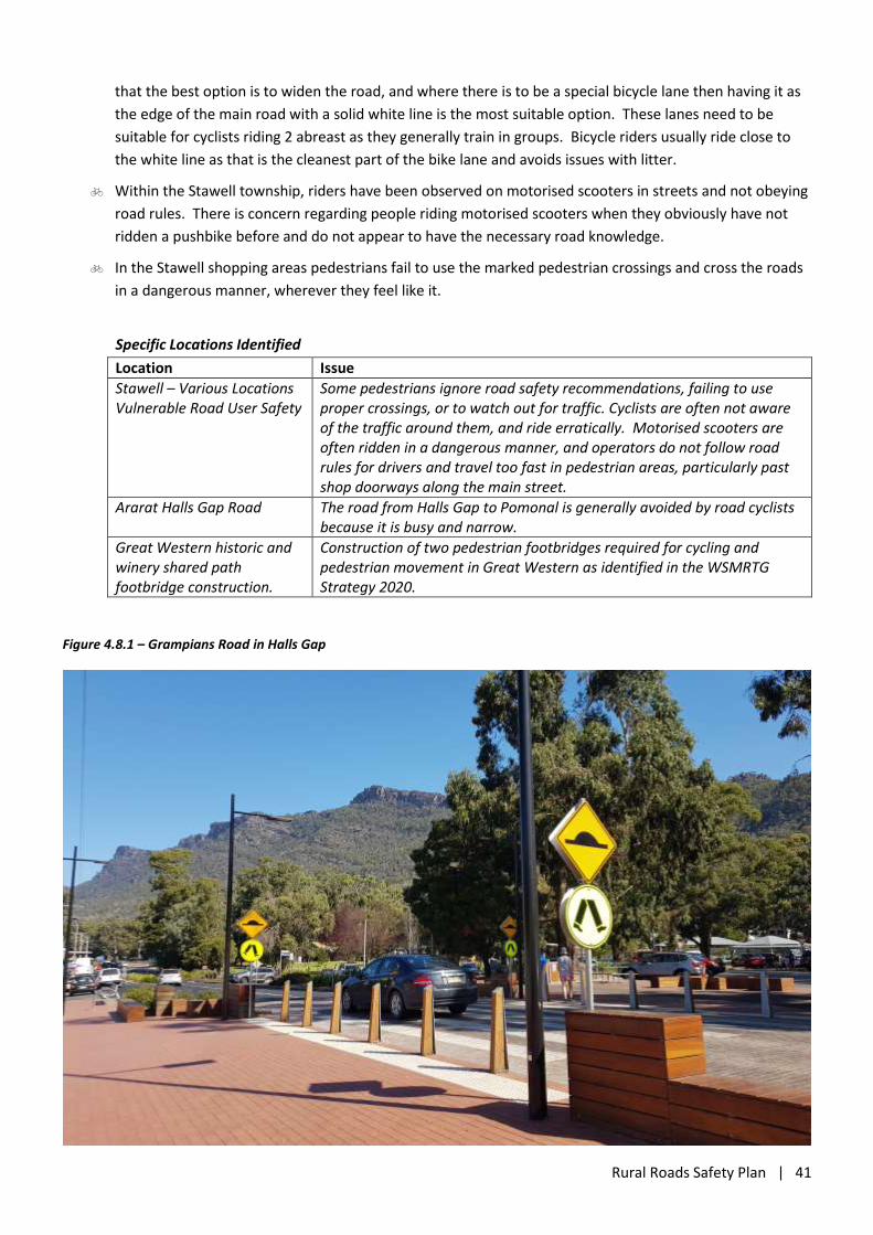
Rural Roads Safety Plan | 41
that the best option is to widen the road, and where there is to be a special bicycle lane then having it as
the edge of the main road with a solid white line is the most suitable option. These lanes need to be
suitable for cyclists riding 2 abreast as they generally train in groups. Bicycle riders usually ride close to
the white line as that is the cleanest part of the bike lane and avoids issues with litter.
Within the Stawell township, riders have been observed on motorised scooters in streets and not obeying
road rules. There is concern regarding people riding motorised scooters when they obviously have not
ridden a pushbike before and do not appear to have the necessary road knowledge.
In the Stawell shopping areas pedestrians fail to use the marked pedestrian crossings and cross the roads
in a dangerous manner, wherever they feel like it.
Specific Locations Identified
Location Issue
Stawell – Various Locations Vulnerable Road User Safety
Some pedestrians ignore road safety recommendations, failing to use proper crossings, or to watch out for traffic. Cyclists are often not aware of the traffic around them, and ride erratically. Motorised scooters are often ridden in a dangerous manner, and operators do not follow road rules for drivers and travel too fast in pedestrian areas, particularly past shop doorways along the main street.
Ararat Halls Gap Road The road from Halls Gap to Pomonal is generally avoided by road cyclists because it is busy and narrow.
Great Western historic and winery shared path footbridge construction.
Construction of two pedestrian footbridges required for cycling and pedestrian movement in Great Western as identified in the WSMRTG Strategy 2020.
Figure 4.8.1 – Grampians Road in Halls Gap
Rural Roads Safety Plan | 42
4.9 Emergency Access
As previously mentioned the Safe System identifies four main elements that work together to protect people
from being killed or seriously injured on the road: Safer Roads; Safer Vehicles; Safer Speeds; and Safer People.
A fifth element, post-crash response, has been identified by the World Health Organisation (2011).
Post Crash Response Relates to emergency medical and rescue response, trauma care (both at the scene and in
hospital) and injury rehabilitation.
Post crash care considerations include:
Are there issues that might influence safe and efficient postcrash care in the event of a severe injury (e.g.
congestion, access, stopping space)?
Do emergency and medical services operate as efficiently as possible?
Are other road users and emergency response teams protected during a crash event?
Are drivers provided the correct information to address travelling speeds on the approach and adjacent
to the incident?
Is there reliable information available via radio, VMS etc.?
Is there provision for e-safety (i.e. safety systems based on modern information and communication
technologies, CITS)?
Consideration of post crash care is a particular concern in the Grampians area and other more remote locations
within Northern Grampians Shire, particularly with regard to quick access to medical assistance and
communication issues where there are mobile telephone blackspots.
Recently constructed mobile telephone towers in the Landsborough, Navarre, Marnoo and Wallaloo areas will
assist with post crash care, however there is still a need for improved mobile telephone communication within
the municipality, particularly in the Grampians area. Telstra’s mobile network coverage maps indicated that there
are gaps in the network coverage (3G, 4G and 5G) in areas such as: Bulgana; Callawadda, Wal Wal; Kanya,
Paradise, Winjallok and Carapooee; Slaty Creek; and the State and National Parks in the municipality, critically the
Grampians. The ability for people that are first on the scene to telephone for assistance and have emergency
services arrive quickly is critical to the survival of road users involved in serious crashes.
In addition to pro-active road safety measures, the following scenario is an example of where improvements to
post crash care should be considered. The location is near Zumsteins in the Grampians.
The Grampians area attracts large volumes of domestic and international tourists;
Northern Grampians Road (Mt Victory Road) in the Zumsteins area is a windy mountainous road and a
known high risk location for motorcycle crashes;
Crashes involving motorcycles are almost always serious;
Zumsteins does not have mobile telephone coverage (according to the Telstra coverage map) for first on
the scene responders to contact emergency services;
Emergency services have significant time travel to reach the area and there is limited ability to protect
other road users and emergency response teams;
There is significant travel time for an ambulance to reach a hospital from Zumsteins.
Planning for improved post crash care including the construction of reliable mobile network coverage and
construction of emergency helicopter landing sites, i.e. near Zumsteins and other high risk areas in the
Grampians, may reduce the severity of road trauma in the municipality.
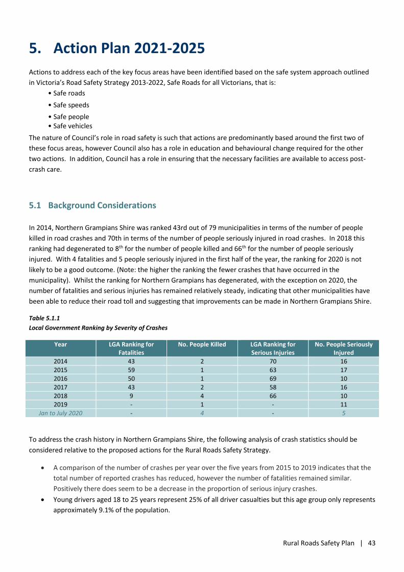
Rural Roads Safety Plan | 43
5. Action Plan 2021-2025
Actions to address each of the key focus areas have been identified based on the safe system approach outlined
in Victoria’s Road Safety Strategy 2013-2022, Safe Roads for all Victorians, that is:
• Safe roads
• Safe speeds
• Safe people • Safe vehicles
The nature of Council’s role in road safety is such that actions are predominantly based around the first two of
these focus areas, however Council also has a role in education and behavioural change required for the other
two actions. In addition, Council has a role in ensuring that the necessary facilities are available to access post-
crash care.
5.1 Background Considerations
In 2014, Northern Grampians Shire was ranked 43rd out of 79 municipalities in terms of the number of people
killed in road crashes and 70th in terms of the number of people seriously injured in road crashes. In 2018 this
ranking had degenerated to 8th for the number of people killed and 66th for the number of people seriously
injured. With 4 fatalities and 5 people seriously injured in the first half of the year, the ranking for 2020 is not
likely to be a good outcome. (Note: the higher the ranking the fewer crashes that have occurred in the
municipality). Whilst the ranking for Northern Grampians has degenerated, with the exception on 2020, the
number of fatalities and serious injuries has remained relatively steady, indicating that other municipalities have
been able to reduce their road toll and suggesting that improvements can be made in Northern Grampians Shire.
Table 5.1.1
Local Government Ranking by Severity of Crashes
Year LGA Ranking for Fatalities
No. People Killed LGA Ranking for Serious Injuries
No. People Seriously Injured
2014 43 2 70 16
2015 59 1 63 17
2016 50 1 69 10
2017 43 2 58 16
2018 9 4 66 10
2019 - 1 - 11
Jan to July 2020 - 4 - 5
To address the crash history in Northern Grampians Shire, the following analysis of crash statistics should be
considered relative to the proposed actions for the Rural Roads Safety Strategy.
A comparison of the number of crashes per year over the five years from 2015 to 2019 indicates that the
total number of reported crashes has reduced, however the number of fatalities remained similar.
Positively there does seem to be a decrease in the proportion of serious injury crashes.
Young drivers aged 18 to 25 years represent 25% of all driver casualties but this age group only represents
approximately 9.1% of the population.
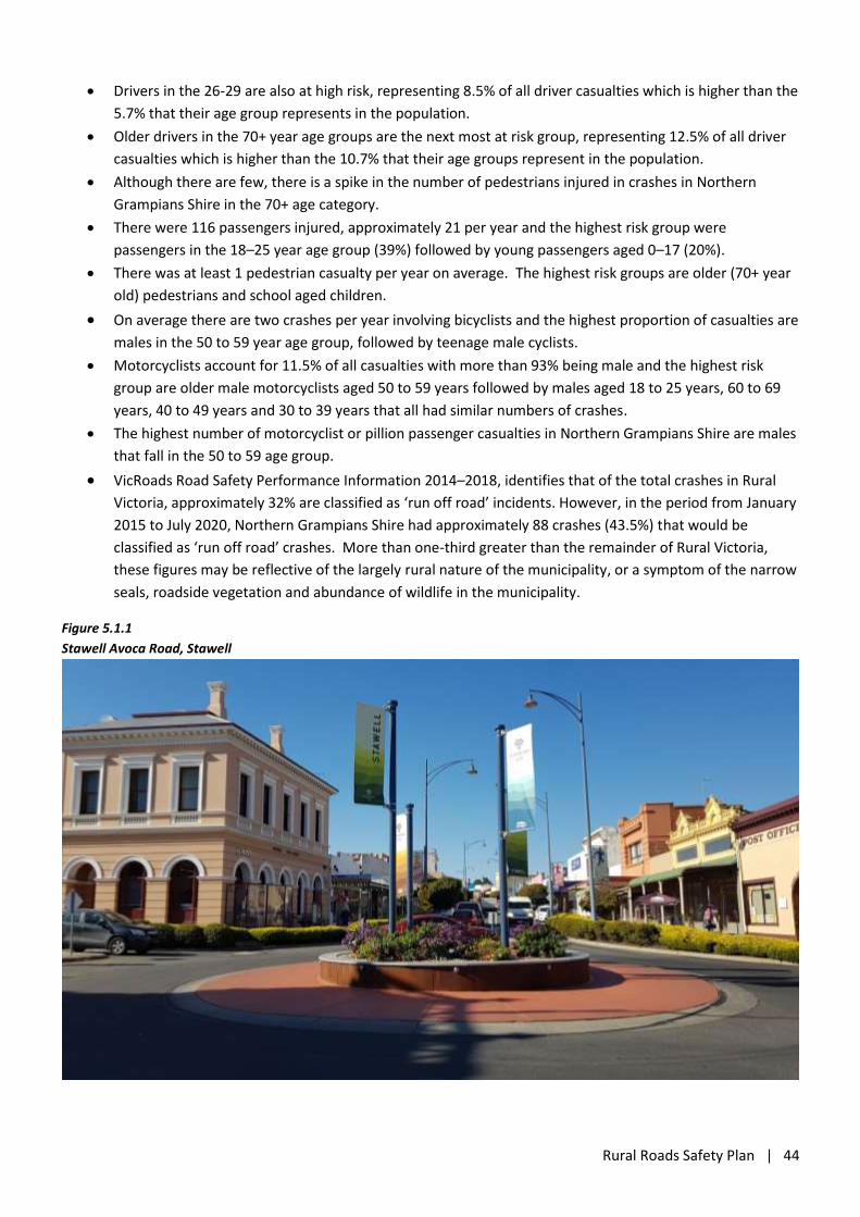
Rural Roads Safety Plan | 44
Drivers in the 26-29 are also at high risk, representing 8.5% of all driver casualties which is higher than the
5.7% that their age group represents in the population.
Older drivers in the 70+ year age groups are the next most at risk group, representing 12.5% of all driver
casualties which is higher than the 10.7% that their age groups represent in the population.
Although there are few, there is a spike in the number of pedestrians injured in crashes in Northern
Grampians Shire in the 70+ age category.
There were 116 passengers injured, approximately 21 per year and the highest risk group were
passengers in the 18–25 year age group (39%) followed by young passengers aged 0–17 (20%).
There was at least 1 pedestrian casualty per year on average. The highest risk groups are older (70+ year
old) pedestrians and school aged children.
On average there are two crashes per year involving bicyclists and the highest proportion of casualties are
males in the 50 to 59 year age group, followed by teenage male cyclists.
Motorcyclists account for 11.5% of all casualties with more than 93% being male and the highest risk
group are older male motorcyclists aged 50 to 59 years followed by males aged 18 to 25 years, 60 to 69
years, 40 to 49 years and 30 to 39 years that all had similar numbers of crashes.
The highest number of motorcyclist or pillion passenger casualties in Northern Grampians Shire are males
that fall in the 50 to 59 age group.
VicRoads Road Safety Performance Information 2014–2018, identifies that of the total crashes in Rural
Victoria, approximately 32% are classified as ‘run off road’ incidents. However, in the period from January
2015 to July 2020, Northern Grampians Shire had approximately 88 crashes (43.5%) that would be
classified as ‘run off road’ crashes. More than one-third greater than the remainder of Rural Victoria,
these figures may be reflective of the largely rural nature of the municipality, or a symptom of the narrow
seals, roadside vegetation and abundance of wildlife in the municipality.
Figure 5.1.1
Stawell Avoca Road, Stawell
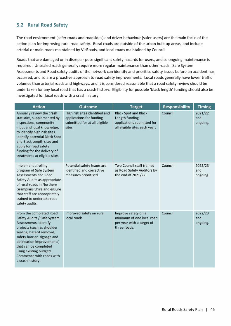
Rural Roads Safety Plan | 45
5.2 Rural Road Safety
The road environment (safer roads and roadsides) and driver behaviour (safer users) are the main focus of the
action plan for improving rural road safety. Rural roads are outside of the urban built up areas, and include
arterial or main roads maintained by VicRoads, and local roads maintained by Council.
Roads that are damaged or in disrepair pose significant safety hazards for users, and so ongoing maintenance is
required. Unsealed roads generally require more regular maintenance than other roads. Safe System
Assessments and Road safety audits of the network can identify and prioritise safety issues before an accident has
occurred, and so are a proactive approach to road safety improvements. Local roads generally have lower traffic
volumes than arterial roads and highways, and it is considered reasonable that a road safety review should be
undertaken for any local road that has a crash history. Eligibility for possible ‘black length’ funding should also be
investigated for local roads with a crash history.
Action Outcome Target Responsibility Timing
Annually review the crash statistics, supplemented by inspections, community input and local knowledge, to identify high risk sites. Identify potential Black Spot and Black Length sites and apply for road safety funding for the delivery of treatments at eligible sites.
High risk sites identified and applications for funding submitted for at all eligible sites.
Black Spot and Black Length funding applications submitted for all eligible sites each year.
Council 2021/22 and ongoing.
Implement a rolling program of Safe System Assessments and Road Safety Audits as appropriate of rural roads in Northern Grampians Shire and ensure that staff are appropriately trained to undertake road safety audits.
Potential safety issues are identified and corrective measures prioritised.
Two Council staff trained as Road Safety Auditors by the end of 2021/22.
Council 2022/23 and ongoing.
From the completed Road Safety Audits / Safe System Assessments, identify projects (such as shoulder sealing, hazard removal, safety barrier, signage and delineation improvements) that can be completed using existing budgets. Commence with roads with a crash history.
Improved safety on rural local roads.
Improve safety on a minimum of one local road per year with a target of three roads.
Council 2022/23 and ongoing.
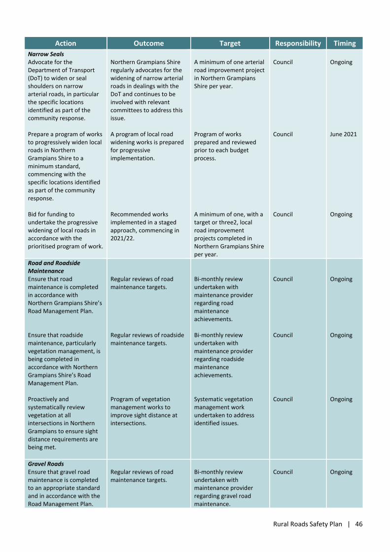
Rural Roads Safety Plan | 46
Action Outcome Target Responsibility Timing
Narrow Seals Advocate for the Department of Transport (DoT) to widen or seal shoulders on narrow arterial roads, in particular the specific locations identified as part of the community response. Prepare a program of works to progressively widen local roads in Northern Grampians Shire to a minimum standard, commencing with the specific locations identified as part of the community response. Bid for funding to undertake the progressive widening of local roads in accordance with the prioritised program of work.
Northern Grampians Shire regularly advocates for the widening of narrow arterial roads in dealings with the DoT and continues to be involved with relevant committees to address this issue. A program of local road widening works is prepared for progressive implementation. Recommended works implemented in a staged approach, commencing in 2021/22.
A minimum of one arterial road improvement project in Northern Grampians Shire per year. Program of works prepared and reviewed prior to each budget process. A minimum of one, with a target or three2, local road improvement projects completed in Northern Grampians Shire per year.
Council Council Council
Ongoing June 2021 Ongoing
Road and Roadside Maintenance Ensure that road maintenance is completed in accordance with Northern Grampians Shire’s Road Management Plan. Ensure that roadside maintenance, particularly vegetation management, is being completed in accordance with Northern Grampians Shire’s Road Management Plan. Proactively and systematically review vegetation at all intersections in Northern Grampians to ensure sight distance requirements are being met.
Regular reviews of road maintenance targets. Regular reviews of roadside maintenance targets. Program of vegetation management works to improve sight distance at intersections.
Bi-monthly review undertaken with maintenance provider regarding road maintenance achievements. Bi-monthly review undertaken with maintenance provider regarding roadside maintenance achievements. Systematic vegetation management work undertaken to address identified issues.
Council Council Council
Ongoing Ongoing Ongoing
Gravel Roads Ensure that gravel road maintenance is completed to an appropriate standard and in accordance with the Road Management Plan.
Regular reviews of road maintenance targets.
Bi-monthly review undertaken with maintenance provider regarding gravel road maintenance.
Council
Ongoing
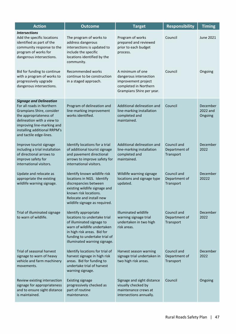
Rural Roads Safety Plan | 47
Action Outcome Target Responsibility Timing
Intersections Add the specific locations identified as part of the community response to the program of works for dangerous intersections. Bid for funding to continue with a program of works to progressively upgrade dangerous intersections.
The program of works to address dangerous intersections is updated to include the specific locations identified by the community. Recommended works continue to be construction in a staged approach.
Program of works prepared and reviewed prior to each budget process. A minimum of one dangerous intersection improvement project completed in Northern Grampians Shire per year.
Council Council
June 2021 Ongoing
Signage and Delineation For all roads in Northern Grampians Shire, consider the appropriateness of delineation with a view to improving line-marking and installing additional RRPM’s and tactile edge-lines. Improve tourist signage including a trial installation of directional arrows to improve safety for international visitors. Update and relocate as appropriate the existing wildlife warning signage. Trial of illuminated signage to warn of wildlife. Trial of seasonal harvest signage to warn of heavy vehicle and farm machinery movements. Review existing intersection signage for appropriateness and to ensure sight distance is maintained.
Program of delineation and line-marking improvement works identified. Identify locations for a trial of additional tourist signage and pavement directional arrows to improve safety for international visitors. Identify known wildlife risk locations in NGS. Identify discrepancies between existing wildlife signage and known risk locations. Relocate and install new wildlife signage as required. Identify appropriate locations to undertake trial of illuminated signage to warn of wildlife undertaken in high risk areas. Bid for funding to undertake trial of illuminated warning signage. Identify locations for trial of harvest signage in high risk areas. Bid for funding to undertake trial of harvest warning signage. Existing signage progressively checked as part of routine maintenance.
Additional delineation and line-marking installation completed and maintained. Additional delineation and line-marking installation completed and maintained. Wildlife warning signage locations and signage type updated. Illuminated wildlife warning signage trial undertaken in two high risk areas. Harvest season warning signage trial undertaken in two high risk areas. Signage and sight distance visually checked by maintenance crews at intersections annually.
Council Council and Department of Transport Council and Department of Transport Council and Department of Transport Council and Department of Transport Council
December 2022 and Ongoing December 2022 December 20222 December 2022 December 2022 Ongoing
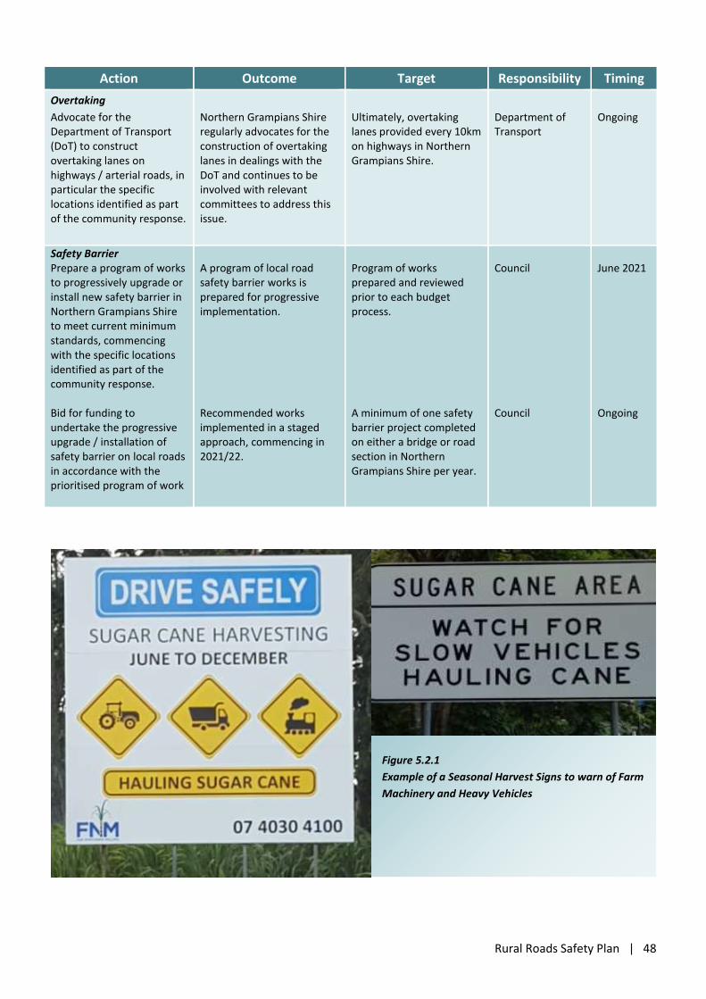
Rural Roads Safety Plan | 48
Action Outcome Target Responsibility Timing
Overtaking
Advocate for the Department of Transport (DoT) to construct overtaking lanes on highways / arterial roads, in particular the specific locations identified as part of the community response.
Northern Grampians Shire regularly advocates for the construction of overtaking lanes in dealings with the DoT and continues to be involved with relevant committees to address this issue.
Ultimately, overtaking lanes provided every 10km on highways in Northern Grampians Shire.
Department of Transport
Ongoing
Safety Barrier Prepare a program of works to progressively upgrade or install new safety barrier in Northern Grampians Shire to meet current minimum standards, commencing with the specific locations identified as part of the community response. Bid for funding to undertake the progressive upgrade / installation of safety barrier on local roads in accordance with the prioritised program of work
A program of local road safety barrier works is prepared for progressive implementation. Recommended works implemented in a staged approach, commencing in 2021/22.
Program of works prepared and reviewed prior to each budget process. A minimum of one safety barrier project completed on either a bridge or road section in Northern Grampians Shire per year.
Council Council
June 2021 Ongoing
Figure 5.2.1
Example of a Seasonal Harvest Signs to warn of Farm
Machinery and Heavy Vehicles
Rural Roads Safety Plan | 49
5.3 Safety Around Schools
The Action Plan to improve safety around schools includes both infrastructure (safer roads and roadsides) and
education-based (safer users) recommendations.
Schools are ideally placed to instil good road safety awareness and behaviours into children from a young age,
and there are a range of resources suitable for use in both primary and secondary schools. For primary schools,
these include:
Kids on the Move - TAC Safety education resource for primary schools;
Safety Squad - RACV
For secondary schools there are a wide range of road safety education resources/programs available, including:
Road Smart VCAL Road Safety Units
Fit to Drive (F2D) RACV Safe Mates Program
Looking after our mates
Teaching cycling and pedestrian safety in secondary schools.
Schools also have the opportunity to include road safety messages and images in school newsletters and on
posters around the school. Regularly changing the posters / messages (i.e. monthly) would enable the messages
to stay fresh and for a range of topics to be covered each year.
An analysis of ‘Child Pedestrian and Cyclist Safety’ in the vicinity of three schools in St Arnaud was undertaken in
September 2019, identifying issues and improvements to improve the safety. The identified safety measures and
treatments from the analysis have been included in the actions below.
Action Outcome Target Responsibility Timing
Undertake works to improve traffic management around schools, based on the Child Pedestrian and Cyclist Safety Analysis – St Arnaud Schools and safety reviews.
Corrective measures are implemented to improve the road environment around schools and encourage safe behaviour.
Recommended works implemented in a staged approach, commencing in 2021/22.
Council 2021/22 and ongoing
Provide information and guidance to rural schools to assist in the development of transport management plans in consultation with Council.
Council and schools identify suitable arrangements for pick up/drop off, road crossing, school bus travel etc. and take responsibility for implementation and education.
Each school has developed a transport management plan by the end of 2022.
Council Schools Department of Transport
2022
Review traffic management arrangements and devices around rural schools in the municipality. Consider parking arrangements, crossing points (including disabled access), manoeuvring spaces and visibility of school speed zone signage.
Potential safety issues are identified and corrective measures prioritised to allow funding to be sought.
Undertake traffic management study around all schools within Northern Grampians Shire to feed into budget planning for 2022/2023.
Council 2021/2022
Rural Roads Safety Plan | 50
Action Outcome Target Responsibility Timing
Request schools to include safety messages and images in their newsletters and to put up posters supporting these messages.
All schools to receive road safety information bi-monthly.
Each school to include relevant safety messages in school newsletter.
Council and All Schools
2021/2022
5.4 Bicycles and Pedestrians
The road environment (safer roads and roadsides) and cyclist behaviour (safer users) are the main focus of the
action plan for improving cyclists and pedestrian safety. One of the aims of these actions is to provide the
infrastructure and facilities that support the whole community to walk and/or cycle safely in Northern Grampians.
Action Outcome Target Responsibility Timing
Identify the roads that are widely utilised by road cyclists and prepare a program of improvement works to allow cyclists to safely share the roads with existing traffic. Bid for funding to complete cyclist safety improvement works.. Advocate for cyclist safety improvements on arterial and tourist roads.
Identified program of road cyclist safety improvement works. Road cyclist safety improvement works funded. Cyclist safety improvement works funded.
Recommended works implemented in a staged approach, commencing in 2022/23.
Council Council Council Department of Transport
December 2022 Ongoing Ongoing
Identify a program of works to construct shared paths for bicyclists and pedestrians to separate vulnerable road users from traffic. Program of works to included specific locations identified by the community and consider routes to schools. Bid for funding to progressively construct the shared paths.
Identified program of pedestrian and bicyclist improvement works. Pedestrian and bicyclist improvement works funded.
Recommended works implemented in a staged approach, commencing in 2022/23.
Council Council
December 2022 Ongoing
In partnership with the schools, continue to undertake bicycle safety and motorised scooter education and promote the wearing of bicycle helmets.
Bicycle and motorised scooter safety education undertaken.
One week of bicycle safety and motorised scooter education provided annually. One promotion on bicycle and motorised scooter safety undertaken annually.
Council Police
2022 and Ongoing
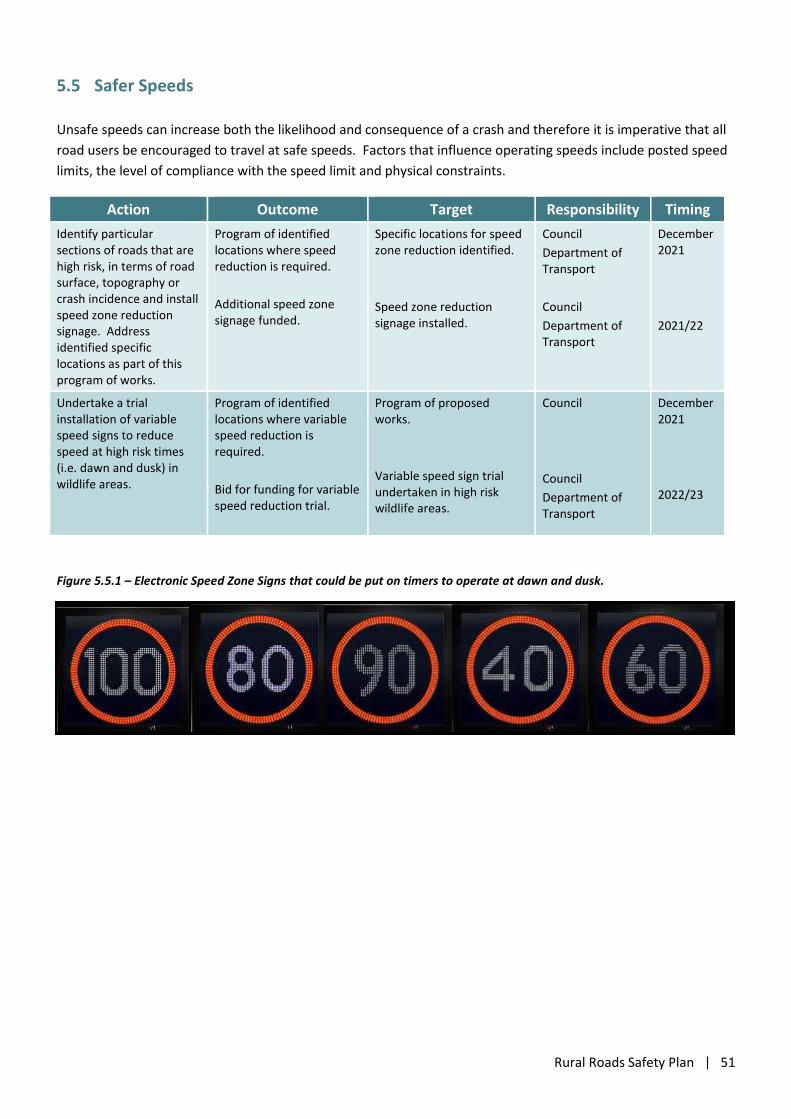
Rural Roads Safety Plan | 51
5.5 Safer Speeds
Unsafe speeds can increase both the likelihood and consequence of a crash and therefore it is imperative that all
road users be encouraged to travel at safe speeds. Factors that influence operating speeds include posted speed
limits, the level of compliance with the speed limit and physical constraints.
Action Outcome Target Responsibility Timing
Identify particular sections of roads that are high risk, in terms of road surface, topography or crash incidence and install speed zone reduction signage. Address identified specific locations as part of this program of works.
Program of identified locations where speed reduction is required.
Additional speed zone signage funded.
Specific locations for speed zone reduction identified.
Speed zone reduction signage installed.
Council
Department of Transport
Council
Department of Transport
December 2021
2021/22
Undertake a trial installation of variable speed signs to reduce speed at high risk times (i.e. dawn and dusk) in wildlife areas.
Program of identified locations where variable speed reduction is required.
Bid for funding for variable speed reduction trial.
Program of proposed works.
Variable speed sign trial undertaken in high risk wildlife areas.
Council
Council
Department of Transport
December 2021
2022/23
Figure 5.5.1 – Electronic Speed Zone Signs that could be put on timers to operate at dawn and dusk.
Rural Roads Safety Plan | 52
5.6 Motorcyclists
On average approximately 9 motorcyclists or pillion passengers are injured in Northern Grampians Shire each
year. Approximately 48% of the motorcycle crashes in Northern Grampians Shire, in the period from January
2015 to July 2020, occurred on local roads. The majority of motorcycle crashes were concentrated in the
Grampians area, particularly on Northern Grampians Road (Mt Victory Road). It appears that the majority of
these motorcyclist casualties are as a result of recreational riding as approximately 75% of the crashes in the
Grampians area occurred on a Friday, Saturday or Sunday.
Motorcyclists account for 11.5% of all casualties with more than 93% being male and the highest risk group are
older motorcyclists aged 50 to 59 years followed by males aged 18 to 25 years, 60 to 69 years, 40 to 49 years and
30 to 39 years that all had similar number of crashes.
The crash analysis indicates that male motorcyclists are significantly higher represented (15 times) in crashes in
Northern Grampians Shire than females. Similarly, all but one of the bicycle crashes involved male cyclists and
overall there have been more than three times the number of male drivers (213) than female drivers (68)
involved in the reported crashes from January 2015 to July 2020. Therefore, it is appropriate that one method of
delivery for driver and rider behavioural programs may be through predominantly male sporting and social clubs,
for example cycling clubs, cricket and football clubs, trail bike motor cycle clubs, men’s sheds etc.
Roadworks and maintenance activities can create hazardous situations for motorcyclists, who are particularly
vulnerable to slight changes in surface type and level, and other features which are much less of an issue for cars
and trucks. Greater focus on the hazards to motorcyclists from Council maintenance crews may reduce the
possibility that such hazards are created (safer roads and roadsides).
Action Outcome Target Responsibility Timing
Ensure that the road condition and repair processes consider the needs of motorcyclists.
Roadworks and repairs consider the needs of motorcyclists.
Incorporate available resources on roadworks hazards for motorcyclists into Council work crew toolbox meetings or training programs.
Council Ongoing.
Education and enforcement campaigns targeted at motorcyclists, including trail bike riders.
Riders are educated about the risks associated with riding motorcycles, particularly trail bikes in remote areas.
Education program run at male dominated sporting clubs within Northern Grampians Shire. One program run per annum.
Council in collaboration with Victoria Police.
2022 and Ongoing
Educate and encourage motorcyclists to adopt safe riding behaviours.
Ensure that where required, there is appropriate warning signage for motorcyclists and trail bike riders.
Install additional warning and advisory signage on the tourist roads in the Grampians area to encourage/remind motorcyclists to adopt safe riding behaviours.
Council and Regional Roads Victoria
2021 and Ongoing
Rural Roads Safety Plan | 53
5.7 Tourists and Tourist Areas
Tourists bring significant economic opportunities to the region and
Tourism not only contributes a significant amount to Northern Grampians economy, but has facilitated the
development of many businesses and attractions in the region. With the Grampians National Park attracting
more than one million visitors each year it is vital that tourists can safely travel on our roads. Unfortunately it is
likely that many of the crashes, particularly in the Grampians area, have involved tourists or visitors to Northern
Grampians Shire. In addition, the community has raised a number of safety concerns in regard to tourists within
Northern Grampians Shire and addressing these concerns would benefit all.
Action Outcome Target Responsibility Timing
Signage (included above) Improve tourist signage including a trial installation of directional arrows to improve safety for international visitors.
Identify locations for a trial of additional tourist signage and pavement directional arrows to improve safety for international visitors.
Additional delineation and line-marking installation completed and maintained.
Council and Department of Transport
December 2022
Support the Driver Reviver program and use these opportunities to disseminate information on safe driving.
Safe behaviour by drivers is encouraged.
Driver Reviver locations established for over significant public holiday periods.
SES
Victoria Police
2021/22 and ongoing.
Provide convenient and appropriate parking spaces for tourists with caravans and recreational vehicles.
Locations identified in townships and parking for towing vehicles and recreational vehicles constructed. Bid for funding to construct parking areas.
Progressively construct parking areas, constructing at least one area annually, commencing July 2022.
Council 2022 and ongoing.
Provide observation areas in picturesque locations with significant wildlife to enable tourists to safely pull off the road and enjoy the wildlife and scenery.
Locations identified and observation areas constructed for tourists.
Bid for funding to construct observation areas.
Progressively construct observation areas, constructing at least one area annually, commencing July 2023.
Council and
Parks Victoria
2023 and ongoing.
Educate local and visiting drivers to “stay straight and brake” when encountering wildlife.
“Stay straight and brake” campaign conducted.
Undertake a promotion on “stay straight and brake”.
Council in collaboration with
Victoria Police
2022
Develop a brochure / mobile telephone app in multiple languages to assist international tourists to understand Victorian road rules.
Safe behaviour by drivers is encouraged.
Advocate for the Department of Transport to develop a mobile telephone app / brochure that is advertised on social media and/or disseminated via visitor information centres.
Council in collaboration with the Department of Transport
2023
Rural Roads Safety Plan | 54
5.8 Young Drivers and Passengers
Education (safe users) is the key focus of actions for improving safety of younger drivers. It is critical that
engagement with young drivers occurs before they commence driving, and continues while they progress
throughout the process of learning to drive and obtaining a full drivers licence. Schools have a role to play in this,
however it needs to be recognised that road safety is also an OH&S issue and employers have a role in the
inclusion of road safety in their OH&S discussions and training, particularly for young people.
Driving lessons are expensive and recognising that learner drivers are now required to have 120 hours of driving
experience before they can apply for a probationary licence, there is an opportunity to work with schools and the
community to provide support for this process. Opportunities may include:
raising awareness of the information available on saferpplaters.com.au
holding parent education sessions about teaching driving;
working with clubs and organisations to subsidise lessons.
The Australian Bureau of Statistics demographic information from the 2016 Census indicates that the Northern
Grampians community is a ‘low socio-economic group’. The median family income for Northern Grampians Shire
is $1,257, well below the Victorian average of $1,715, therefore budgets are likely to be tight for families when
purchasing a vehicle for their young driver.
Parents tend to update to the later model cars while teen drivers usually get the hand-me-downs or what they can afford - older vehicles with little or no safety gear to protect them in a crash. The Australasian New Car Assessment Program (ANCAP) demonstrates that in a crash in an older vehicle, with three safety stars or fewer, occupants have twice the chance of being killed or seriously injured. Teenagers or P-platers are over-represented among the crashes on our roads and young drivers need to be encouraged to look for vehicles with as close to five stars as possible in the ANCAP safety rating. Typically, these cars will have at least two airbags, anti-lock brakes and preferably electronic stability control, which has been shown to prevent single vehicle accidents where the driver skids and loses control. This became mandatory in 2008.
An awareness program that gets parents questioning “What price do you place on the safety of your children?”
may improve safety for young drivers in the municipality.
Action Outcome Target Responsibility Timing
Support driver education programs for 16 – 18 year old’s and their parents, through VicRoads, Police and the RACV.
Parents are equipped to teach their children to drive. Young drivers are equipped with safe driving skills and knowledge when they get their licence.
Two programs run by the end of 2021/22. Encourage St Arnaud Secondary College and Stawell Secondary College to run the ‘Fit to Drive’ workshop every year.
Schools, VicRoads RACV and Police Schools
2021/22 and ongoing. 2021/22 and ongoing.
Advocate for the TAC, in partnership with Victoria Police, to run advertising and information campaigns to promote safe driving with emphasis on driver concentration and risks associated with distractions such as mobile telephone use.
Greater awareness of the dangers of driver distraction.
One campaign run by the end of 2022. In collaboration with the TAC, distribute 1000 Mobile Phone distraction information cards to residents throughout the municipality.
Council, TAC and Victoria Police in partnership. Council
2022/23 and ongoing. 2022
Rural Roads Safety Plan | 55
Action Outcome Target Responsibility Timing
Advocate for the TAC to run an awareness program based on safe vehicle selection for new drivers.
Greater awareness of the need for safe vehicle selection for new drivers.
One program run by the end of 2023.
Council and TAC in partnership.
2022/23 and ongoing.
5.9 Older Drivers
Education (safe users) is the key focus of actions for improving safety of older drivers. Mature drivers have
generally held their licence for some time and some engagement with older drivers to ensure that their
knowledge and skills are current and that they are aware of their capabilities and limitations may reduce the road
safety risk for this age group.
Drivers in these age categories may benefit from Road User Programs that cover topics such as: ‘fatigue
awareness’; ‘teaching learner drivers’; ‘driver distraction dangers’ such as mobile phone use whilst driving; the
‘dangers of drugs (including prescription drugs) and alcohol with driving’; ‘refreshing your skills’ and ‘driver
awareness for older drivers’.
Action Outcome Target Responsibility Timing
Run education programs targeted at older drivers that promotes safe driving. Consider topics such as: refreshing your road rules; complacency; fatigue; driver distraction; the dangers of drugs and alcohol including prescription drugs; strategies to combat impaired ability as a result of aging.
Older drivers are more aware of their driving skills and possible limitations.
Education programs run at senior citizens clubs and locations that attract mature drivers on an annual basis.
Council 2022/23 and ongoing.
Increase availability of public transport options and community transport in the rural areas of Northern Grampians Shire to reduce older driver reliance on their own vehicle.
Gaps in rural public transport identified and a solution for public transport or community transport provided.
Additional public transport routes identified by December 2022. Transport plan devised by July 2023.
Council Department of Transport
2022/23 and ongoing.
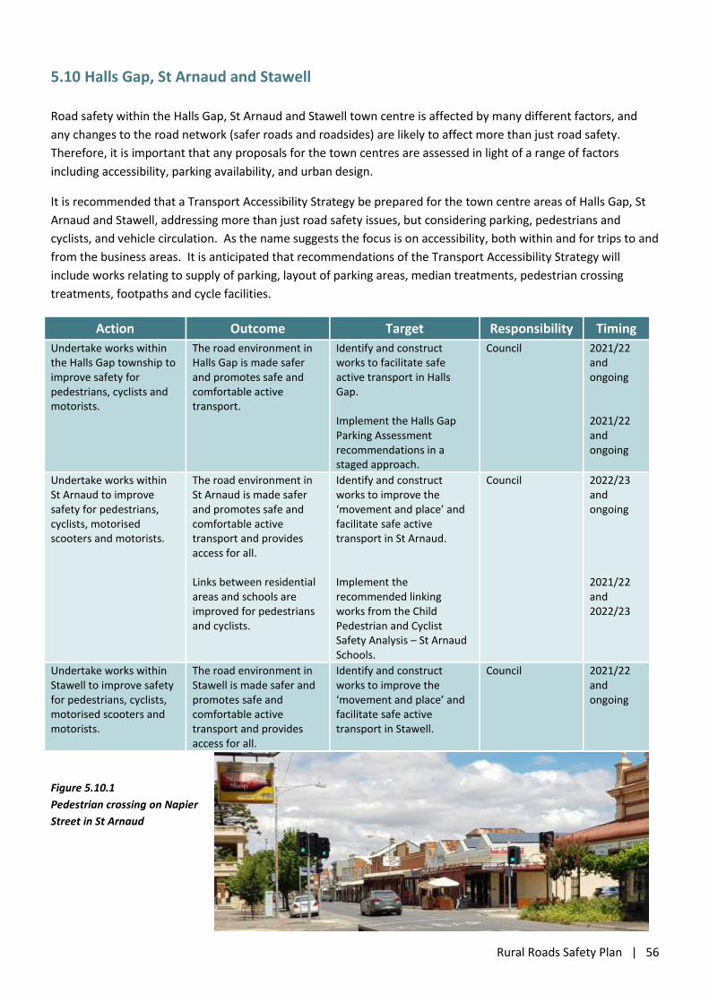
Rural Roads Safety Plan | 56
5.10 Halls Gap, St Arnaud and Stawell
Road safety within the Halls Gap, St Arnaud and Stawell town centre is affected by many different factors, and
any changes to the road network (safer roads and roadsides) are likely to affect more than just road safety.
Therefore, it is important that any proposals for the town centres are assessed in light of a range of factors
including accessibility, parking availability, and urban design.
It is recommended that a Transport Accessibility Strategy be prepared for the town centre areas of Halls Gap, St
Arnaud and Stawell, addressing more than just road safety issues, but considering parking, pedestrians and
cyclists, and vehicle circulation. As the name suggests the focus is on accessibility, both within and for trips to and
from the business areas. It is anticipated that recommendations of the Transport Accessibility Strategy will
include works relating to supply of parking, layout of parking areas, median treatments, pedestrian crossing
treatments, footpaths and cycle facilities.
Action Outcome Target Responsibility Timing
Undertake works within the Halls Gap township to improve safety for pedestrians, cyclists and motorists.
The road environment in Halls Gap is made safer and promotes safe and comfortable active transport.
Identify and construct works to facilitate safe active transport in Halls Gap. Implement the Halls Gap Parking Assessment recommendations in a staged approach.
Council 2021/22 and ongoing 2021/22 and ongoing
Undertake works within St Arnaud to improve safety for pedestrians, cyclists, motorised scooters and motorists.
The road environment in St Arnaud is made safer and promotes safe and comfortable active transport and provides access for all. Links between residential areas and schools are improved for pedestrians and cyclists.
Identify and construct works to improve the ‘movement and place’ and facilitate safe active transport in St Arnaud. Implement the recommended linking works from the Child Pedestrian and Cyclist Safety Analysis – St Arnaud Schools.
Council 2022/23 and ongoing 2021/22 and 2022/23
Undertake works within Stawell to improve safety for pedestrians, cyclists, motorised scooters and motorists.
The road environment in Stawell is made safer and promotes safe and comfortable active transport and provides access for all.
Identify and construct works to improve the ‘movement and place’ and facilitate safe active transport in Stawell.
Council 2021/22 and ongoing
Figure 5.10.1
Pedestrian crossing on Napier
Street in St Arnaud
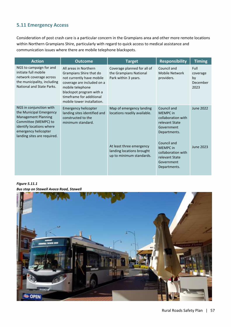
Rural Roads Safety Plan | 57
5.11 Emergency Access
Consideration of post crash care is a particular concern in the Grampians area and other more remote locations
within Northern Grampians Shire, particularly with regard to quick access to medical assistance and
communication issues where there are mobile telephone blackspots.
Action Outcome Target Responsibility Timing
NGS to campaign for and initiate full mobile network coverage across the municipality, including National and State Parks.
All areas in Northern Grampians Shire that do not currently have mobile coverage are included on a mobile telephone blackspot program with a timeframe for additional mobile tower installation.
Coverage planned for all of the Grampians National Park within 3 years.
Council and Mobile Network providers.
Full coverage by December 2023
NGS in conjunction with the Municipal Emergency Management Planning Committee (MEMPC) to identify locations where emergency helicopter landing sites are required.
Emergency helicopter landing sites identified and constructed to the minimum standard.
Map of emergency landing locations readily available.
At least three emergency landing locations brought up to minimum standards.
Council and MEMPC in collaboration with relevant State Government Departments.
Council and MEMPC in collaboration with relevant State Government Departments.
June 2022
June 2023
Figure 5.11.1
Bus stop on Stawell Avoca Road, Stawell
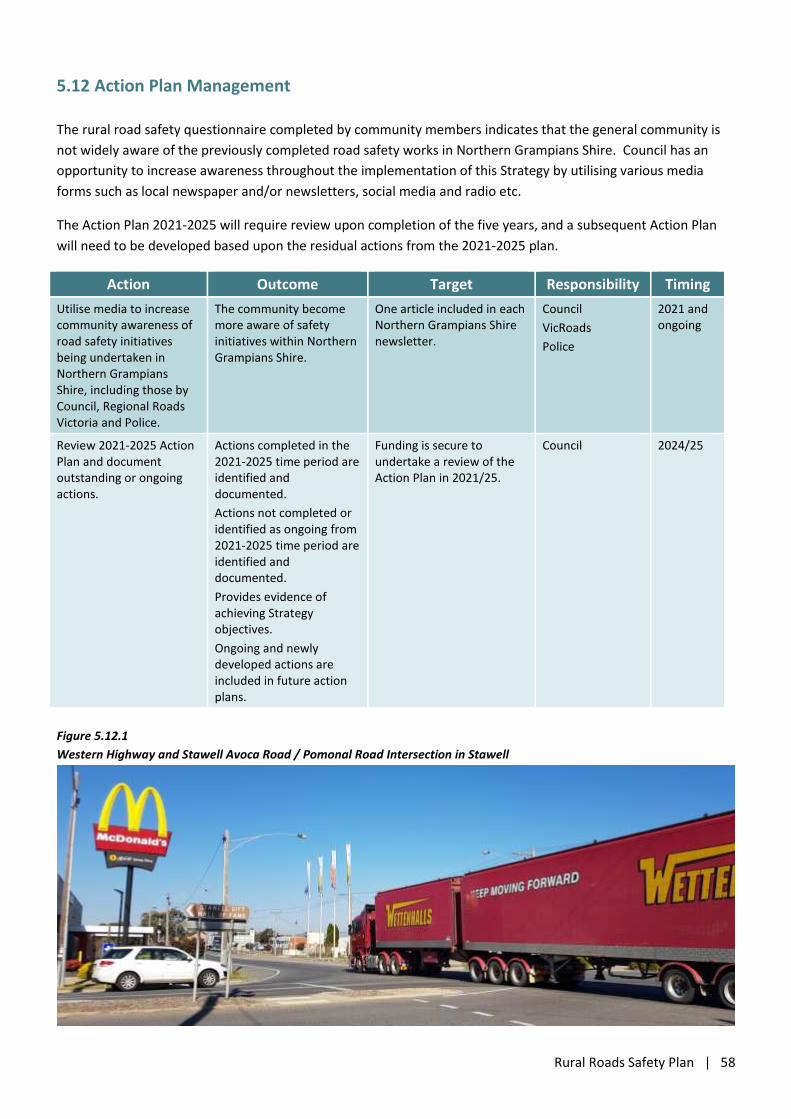
Rural Roads Safety Plan | 58
5.12 Action Plan Management
The rural road safety questionnaire completed by community members indicates that the general community is
not widely aware of the previously completed road safety works in Northern Grampians Shire. Council has an
opportunity to increase awareness throughout the implementation of this Strategy by utilising various media
forms such as local newspaper and/or newsletters, social media and radio etc.
The Action Plan 2021-2025 will require review upon completion of the five years, and a subsequent Action Plan
will need to be developed based upon the residual actions from the 2021-2025 plan.
Action Outcome Target Responsibility Timing
Utilise media to increase community awareness of road safety initiatives being undertaken in Northern Grampians Shire, including those by Council, Regional Roads Victoria and Police.
The community become more aware of safety initiatives within Northern Grampians Shire.
One article included in each Northern Grampians Shire newsletter.
Council
VicRoads
Police
2021 and ongoing
Review 2021-2025 Action Plan and document outstanding or ongoing actions.
Actions completed in the 2021-2025 time period are identified and documented.
Actions not completed or identified as ongoing from 2021-2025 time period are identified and documented.
Provides evidence of achieving Strategy objectives.
Ongoing and newly developed actions are included in future action plans.
Funding is secure to undertake a review of the Action Plan in 2021/25.
Council
2024/25
Figure 5.12.1
Western Highway and Stawell Avoca Road / Pomonal Road Intersection in Stawell
Rural Roads Safety Plan | 59
6. Stakeholders and Responsibilities
The success of this Road Safety Strategy depends on the active involvement of a number of organisational and
individual stakeholders, to:
Initiate, facilitate and complete the various actions identified in this Strategy;
Consider the funding, resourcing and time implications of the actions for organisational budgets, works
programs and policy;
Set targets for each action in this Strategy, and review progress against those targets on a regular basis;
Champion the Road Safety Strategy through obstacles that might arise to obstruct, delay or otherwise
impede its implementation; and
Identify further opportunities to improve road safety in Northern Grampians Shire that follow on from or
compliment this current Strategy.
Key stakeholders in the implementation of this Road Safety Strategy include:
Northern Grampians Shire Council
Councillors
Chief Executive Officer
Manager Infrastructure
Victoria Police
Regional Roads Victoria
Parks Victoria
Department of Environment, Land, Water and Planning
Schools
The Northern Grampians Shire community.
It is vital that stakeholders communicate regularly and effectively on the status of the Strategy and the actions
that are underway to identify and resolve any problems that may arise, and to maintain momentum for the
implementation of the Strategy. Progress of this Strategy should be reviewed after 12 months, used as an
opportunity to refocus as required, and to identify any issues or problems that have been identified as the
Strategy has been implemented.
Evaluation of the success of this Rural Roads Safety Strategy will be undertaken by a number of methods.
1. It is proposed that the progress against each of the identified actions be reported using the identified
Performance Measure.
2. The most recent Road Safety Performance Information for Northern Grampians Shire will be reviewed
annually to identify trends in the municipal crash history and determine if the identified actions in this
Strategy are effective.
3. At the end of the five year period (2021 – 2025) for which this Strategy is applicable, an updated Strategy will
review progress against the various actions and determine, if overall, the Strategy has been effective in
reducing the risk of injury on the roads in Northern Grampians Shire.