Embed Size (px)
Citation preview
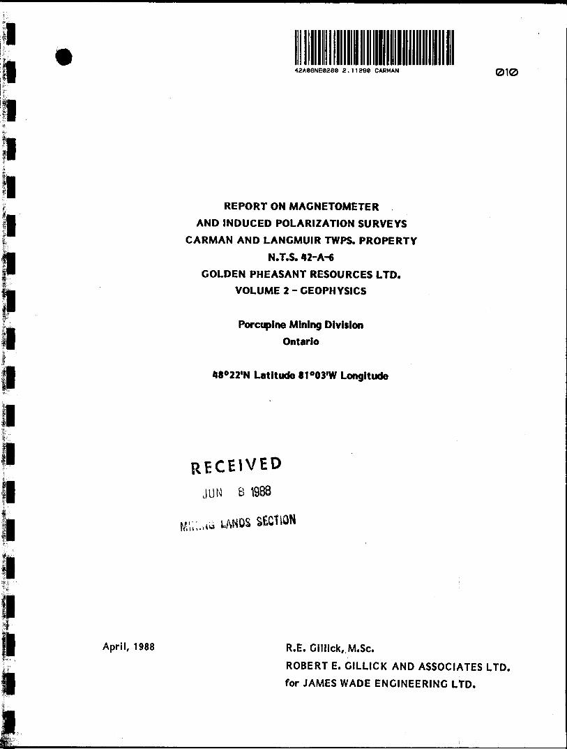
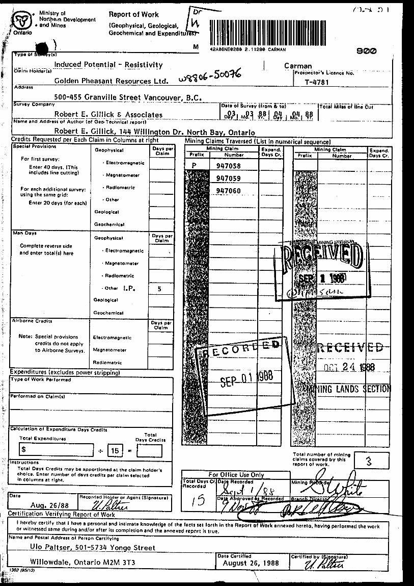
42Ae6NE0288 2 .11290 CARMAN 010
REPORT ON MAGNETOMETER
AND INDUCED POLARIZATION SURVEYS
CARMAN AND LANGMUIR TWPS. PROPERTY
N.T.S. 42-A-6GOLDEN PHEASANT RESOURCES LTD.
VOLUME 2 - GEOPHYSICS
Porcupine Mining Division
Ontario
48022'N Latitude 81 003'W Longitude
RECEIVED
JUN B 1988
SECtiON
April, 1988 R.E. Cillick, M.Sc.
ROBERT E. GILLICK AND ASSOCIATES LTD.
for JAMES WADE ENGINEERING LTD.

TABLE OF42Ae6NE026e 2.11290 CARMAN
Page1.0 SUMMARY l
2.0 INTRODUCTION 2
3.0 PROPERTY DESCRIPTION, LOCATION AND ACCESS 2
Figure No. l - Location Map 3
Figure No. 2 - Claim Sketch 4
A.O TOPOGRAPHY AND VEGETATION 5
5.0 PREVIOUS WORK 5
6.0 REGIONAL GEOLOGY AND ECONOMIC MINERALIZATION 6
7.0 PROPERTY GEOLOGY 8
8.0 DESCRIPTION OF GEOPHYSICAL PROGRAM 9
9.0 RESULTS AND INTERPRETATION 11
10.0 CONCLUSIONS AND RECOMMENDATIONS 16
11.0 REFERENCES 18
010C
APPENDICES
A CERTIFICATE OF QUALIFICATIONS
B TECHNICAL DATA STATEMENT
C IP PSEUDOSECTIONS
Back of report
tt it
II
II
II
II
TABLE OF CONTENTS (Cont'd)
LIST OF DRAWINGS
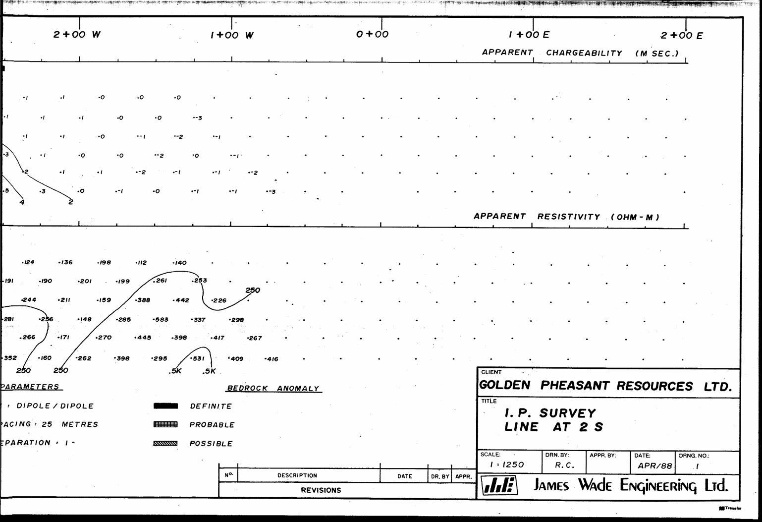
DRAWING No. 1: IP PSEUDOSECTION - LINE 2 S
DRAWING No. 2: IP PSEUDOSECTION - LINE l N
DRAWING No. 3: IP PSEUDOSECTION - LINE 3 N
DRAWING No. 4: IP PSEUDOSECTION - LINE 5 N
DRAWING No. 5: IP PSEUDOSECTION - LINE 6 N
DRAWING No. 6: IP PSEUDOSECTION - LINE 7 N
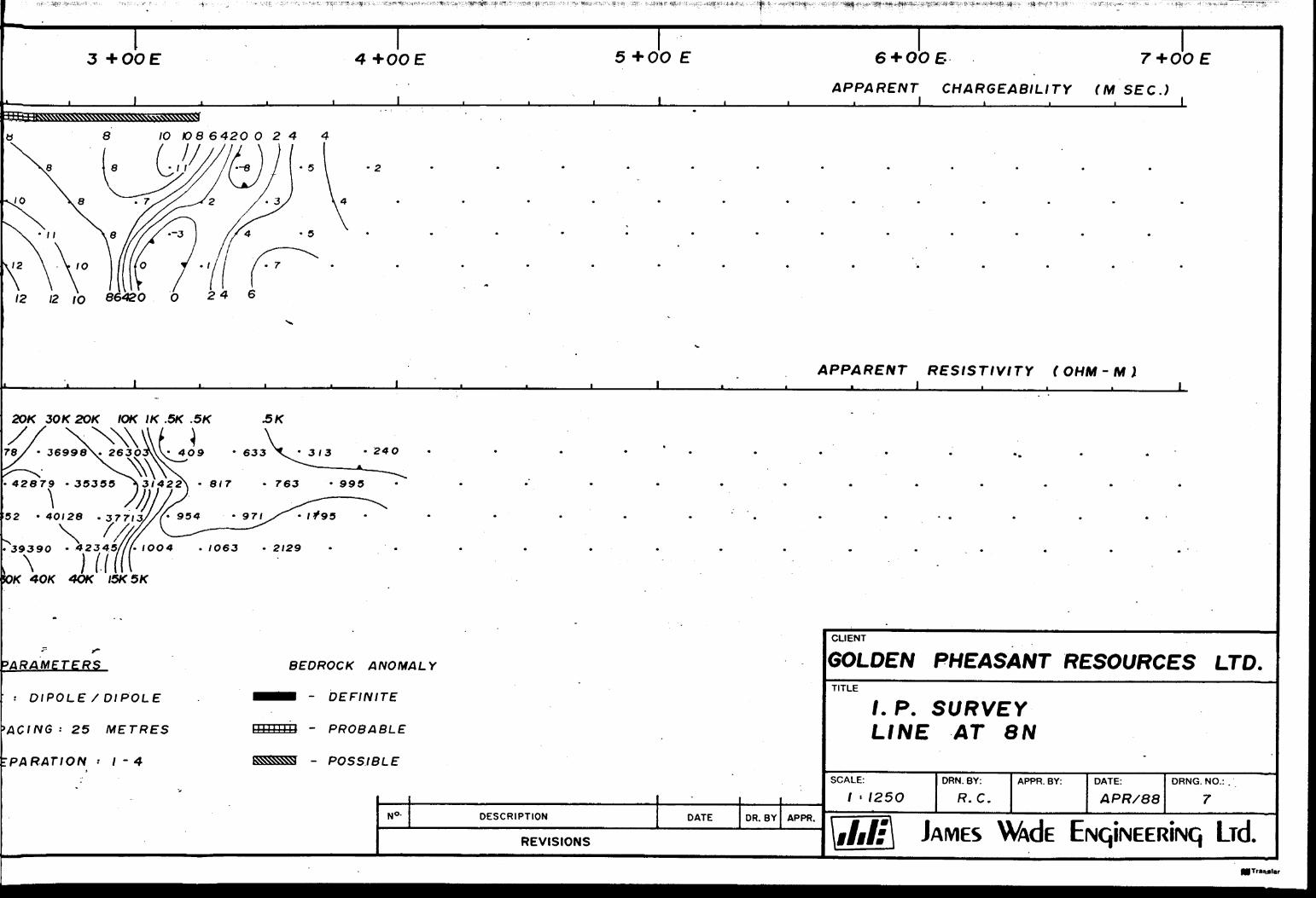
DRAWING No. 7: IP PSEUDOSECTION - LINE 8 N
DRAWING No. 8: IP PSEUDOSECTION - LINE 9 N
DRAWING No. 9: IP PSEUDOSECTION - LINE 12 N
DRAWING No.10: IP PSEUDOSECTION - LINE 14 N
DRAWING No.11: IP PSEUDOSECTION - LINE 15 N
DRAWING No.12: IP PSEUDOSECTION - LINE 16 N
DRAWING No.13: IP PSEUDOSECTION - LINE 17 NDRAWING No.14: IP COMPILATION MAP
DRAWING No.15: CONTOURED TOTAL FIELD MAGNETICS
DRAWING No.16: POSTED TOTAL FIELD MAGNETIC VALUES
APPENDIXit
ii
n
H
n
n
n
11
H
n
n
n
C11
It
II
tt
tt
II
11
II
It
II
It
t!
in map pocket n H n
1.0 SUMMARY
Eight chargeability anomalies selected from the IP results
are interpreted as representing sulfide zones with potential
for gold mineralization. At least one of the zones (line 16 N,
0+45 W S line 17 N, 0+65 W) may be related to iron formation.
Other zones are located within mafic to intermediate volcanics
and may represent sulfide emplacement associated with faulting
or shearing.
The magnetics survey has delineated a northeast striking ridge
of high magnetic response located near the new baseline. The
feature is believed to represent iron formation. A linear
north-south striking magnetic low, interpreted as a fault,
appears to terminate or offset the iron formation at its
northern extremity.
Trenching or drilling of selected IP anomalous zones is re
commended. In addition, it is highly recommended that the
magnetic trend interpreted as iron formation be thoroughly in
vestigated on surface. If the presence of iron formation is
confirmed, the zone should be prospected and drilled.
l 2.0 INTRODUCTION
The following report describes ground geophysical surveys (induced polarization and magnetics) carried out during March and April, 1988, over parts of the Carman and Langmuir Property of Golden Pheasant Resources Ltd. in the Timmins area of northern Ontario.
3.0 PROPERTY DESCRIPTION. LOCATION AND ACCESS
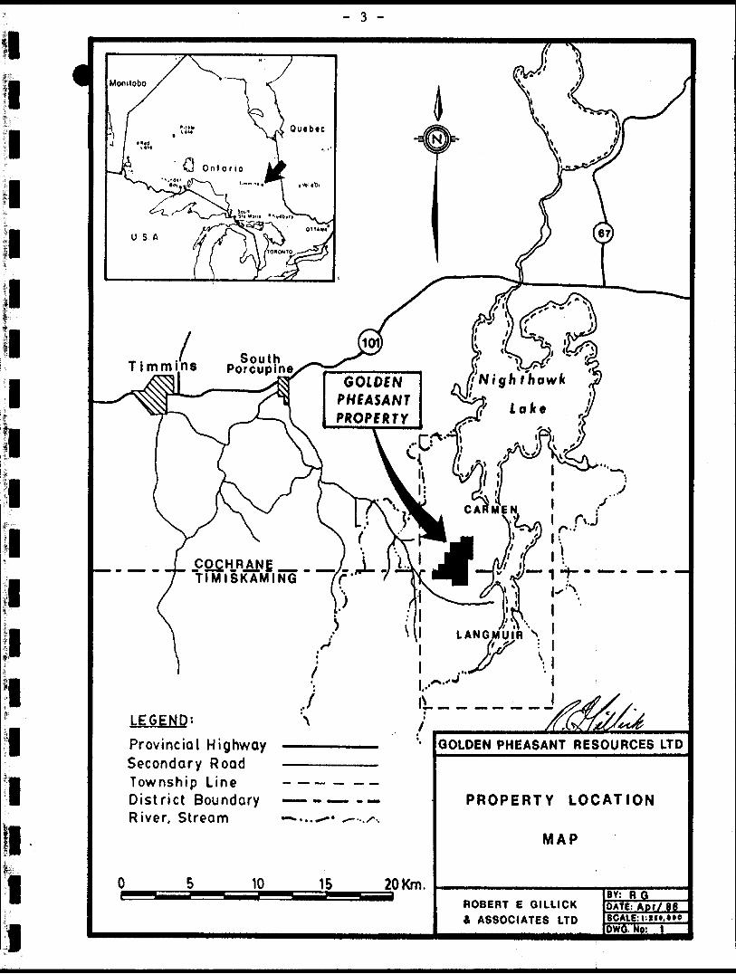
The Golden Pheasant property consists of a block of 36 con tiguous unpatented mining claims located approximately 25 kilometres southeast of the municipality of Timmins in northern Ontario. The claim block is located near the southwest corner of Carman Township and northwest corner of Langmuir Township (Fig. No. 1).
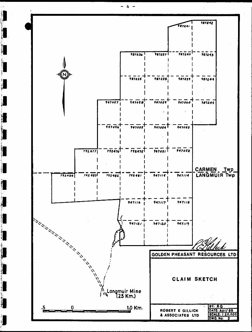
The claims comprising the property are as follows (Fig. No. 2):
Claim Number Recording DateP 792475 - 792477 (3) March 12, 1984P 792481 - 792484 (4) March 29, 1984P 947051 - 947060 (10) September 16, 1986P 947114 - 947121 (8) September 16, 1986P 987235 - 987245 (11) May 26, 1987
Total 36 Claims
The property is accessible by an all-season gravel road from the town of South Porcupine located on highway 101 to the north, By proceeding southeastwards along the gravel road for about 18 kilometres and then taking the Langmuir Mine branch road for an additional 5 kilometres, one passes within about 700 metres of the southern part of the Golden Pheasant property. From this point, the claims are accessible on foot or by snow machine.
The property can also be reached by helicopter from Timmins.
- 3 -
fc
South Porcupine
, TimminsG01DCN
PHEASANT
LEGEND". \Provincial Highway -———————-Secondary Road ———————Township Line - —— — — —District Boundary —— --—- * —River, Stream —-...*-* ^--.x--.
10 15 20 Km.
GOLDEN PHEASANT RESOURCES LTD
PROPERTY LOCATION
MAP
ROBERT E GILLICK A ASSOCIATES LTD
BY: RGDATE: Apf/SCALE:!.***,*'"
90723* 1
* i"O* ---9.727,-j-
1
1. ——————— —— - -J- .
11
4- 4- -9*70*4^ 9470MT'
1 1
......,, .... 1 4- -792477) 79247*' 79247f'
111
. . - -— . ..... . ~l m m— m ——— l-
1
1
1
1 i
907217
^tZ 907242
907240 "" F07245
— ——..— — — — -L — — — -. 907218 907239J 907244
.
l 1947059 9470*0 907249
'
1
,..^ r 9470ft
"t
. i . .M. . . ~
1 j ____ —J— — — — -h— — — -f — ~~ ~~ ~\ — - ————— — ' —— ' —— 7 147ff* j
l |
| |N Lj i
X\ A """ \^\s LJf |
^^ ls^ 1N \\
KXN iv\ i
^ .^..Langmuir Mine ' ^ ( 25 Km,)
.5 0 1.0 Km.
Y-47//7
— — — "194 7/2,0 i
1
947/Xfl
— ——— i —— ——— —
CARMEN TwpLANGMUIR Twp
/2/flf?^ 's
At^JdLKc*''GOLDEN PHEASANT RESOURCES LTD
CLAIM SKETCH
I BV: RG DATE: Apr/ SB
- . . .... ... . .... .SCALE: l". 20. 000IOWQ.NP: 2
l't
l
- 5 -
No bodies of water large enough to permit the landing and
take-off of ski- or float-equipped fixed-wing aircraft occur
on the property.
4.0 TOPOGRAPHY AND VEGETATION
Approximately 6(^ to 70/5 of the property area is low-lying and
covered by swamp or muskeg. Over the remainder of the property,
topographic relief is variable ranging from several metres to
a maximum of about 20 metres. The relief is relatively abrupt
in places especially over diabase dikes where differential
weathering has left the hard dike rock prominently exposed.
Vegetation is generally mixed. Cedar is common in the swampy
areas with black spruce -and balsam fir occurring in the regions
of muskeg. Stands of birch, poplar and pine occur along the
ridges and in the dryer parts of the property.
5.0 PREVIOUS WORK
Although no documented evidence is available in assessment files
indicating work on the Golden Pheasant property prior to the
1960's, old pits and trenches located on the property suggest
that some work may have been carried out.
In 1962, Dumont Nickel Corporation of Quebec, drilled a single
hole (602') on the property in the west central part of present
claim 792481. The hole reportedly intersected several bands
of siliceous pyrite-bearing iron formation. One of the bands
assayed 0.67 ounces gold per ton over a core length of 6 feet.
In 1974, T. K. Dowe drilled a single hole (146 1 ) in the north
east corner of present claim 792481. Banded iron formation
was intersected near the bottom of the hole. No significant
gold assays were reported.
- 6 -
In 1982, Rio Tinto Canadian Exploration Ltd. carried out
magnetometer and VLF-EM surveys over the southern part of the
present property. One hole was drilled to a depth of 372 feet
in the east central part of present claim 792482, The hole
reportedly intersected several bands of siliceous iron forma
tion well-mineralized (5-1051) with pyrrhotite and pyrite and
containing up to several percent chalcopyrite in places. No
gold assays were published for this hole.
In 1984/85, J.K. Filo and M. C. Kean staked seven claims co
vering and surrounding the Dumont drill hole. VLF-EM surveying
and geological mapping were carried out.
In 1986, Golden Pheasant Resources Ltd. optioned the Filo-Kean
claims. During the latter part of 1986 and early part of 1987,
29 additional claims were staked contiguous to the original
block to form the present 36 claims. During the early part of
1987, Golden Pheasant commissioned geophysical surveying (HLEM,
magnetometer, IP) and geological mapping over the southern
25 claims of the block.
6.0 REGIONAL GEOLOGY AND ECONOMIC MINERALIZATION
The Timmins area lies within the Abitibi Volcanic Belt which
forms a sub-province of the Superior Province of the Canadian
Shield. The belt is characterized by a predominance of Archean
metavolcanic/metasedimentary rock types intruded by numerous
felsic to ultramafic bodies. Six major gold/base metal mining
camps are located along this belt making it one of the most
productive mining regions in the world.
The Timmins area is located near the western extremity of the
Abitibi Belt. Volcanic rocks within this sub-region have
been divided into the Tisdale and Deloro groups. The Tisdale
group consists of a basal formation of predominantly ultra-
r ~t - 7 -
mafic volcanic rocks (komatiites) overlying tholeiitic basalts
which in turn are overlain by volcaniclastic rocks of calc-
alkaline dacite composition. The Deloro group is composed of
andesitic and basaltic flows overlain by dacitic flows and
and dacitic and rhyolitic pyroclastics. Iron formation com
monly occurs near the top of the Deloro sequence. Both groups
are overlain by interlayered and intercalated metasediments
consisting of wacke, siltstone and, to a lesser extent, conglo
merate. The regional metamorphic grade is lower to middle
greenschist facies. Both groups have been intruded by numerous
north and north-east trending diabase dikes.
The Destor-Porcupine Fault forms a major structural break in
the Timmins area striking northeasterly between the Tisdale
group and the Deloro group. The vast majority of gold deposits
in the area are hosted in the lower volcanic rocks of the
Tisdale sequence immediately to the north of the Destor-Porcu
pine Fault.
The Shaw Dome forms the main structural feature associated with
the Deloro volcanic group. The easterly dip and northerly
strike of the rocks on the Golden Pheasant property are due to
their location along the eastern margin of the Shaw Dome.
Over 49 gold mines have operated in the Timmins area producing
a combined total of 65 million ounces of gold from ore with an
average grade of 0.254 ounces gold per ton. The majority of
gold in the Timmins camp has been hosted in quartz-carbonate
veins within volcanic rocks in the lower part of the Tisdale
sequence. Most of the deposits are in close spatial association
with ultramafic volcanic rocks suggesting that this latter rock
type may have been the source rock for the gold.
Two iron formation hosted gold deposits are located within the
Deloro volcanics about 2.5.kilometres northwest of the Golden
- 8, -
Pheasant property. The Carshaw and Malga deposits are re
ported to host 247,000 tons of ore with a combined average
grade of 0.249 ounces gold per ton. Gold mineralization in
both these deposits is associated with quartz veining and
attendant pyrite replacement of magnetite-rich mesobands. The
mineralization appears to have been emplaced by the percolation
and precipitation of exotic gold and sulfur bearing hydrother
mal solutions within fracture systems formed by the brittle
deformation of the iron formation. ;
The Langmuir Mine, a former nickel producer, is located about
2.5 kilometres southeast of the Golden Pheasant property.
Between 1973 and 1977, 1.1 million tons of ore grading l.5%
nickel were mined from this ultramafic hosted deposit.
7.0 PROPERTY GEOLOGY
The southeast portion of the Golden Pheasant property is under
lain by ultramafic intrusive rock identified as serpentinized
dunite or peridotite. Most of the western and northern parts
of the 1987 gridded portion of the property are underlain by
intermediate volcanics intercalated with thin mafic flows.
Several outcrops of quartz-feldspar-porphry occur in the west
near line 1+00 N at approximately 10+00 W. A large east-west
trending carbonatized zone has been identified at 0+25 S, 4+00 W,
Large diabase intrusives transect the property in both northerly
and northeasterly directions.
Two zones of siliceous oxide iron formation were delineated
during the 1987 mapping program. One zone is located between
lines 1+00 N and 2+00 N at 1+50 W and the second zone strikes
northeasterly across lines 5+00 N and 6+00 N at 9+00 E. The
iron formation is reported to exhibit intense local folding and
contain variable quantities of sulfide mineralization. The
hole drilled by Dumont in 1962 intersected the western zone of
- 9 -
iron formation indicating it to be composed of two separate
bands, the westernmost band being auriferous and 'well-mineral
ized 1 with pyrite.
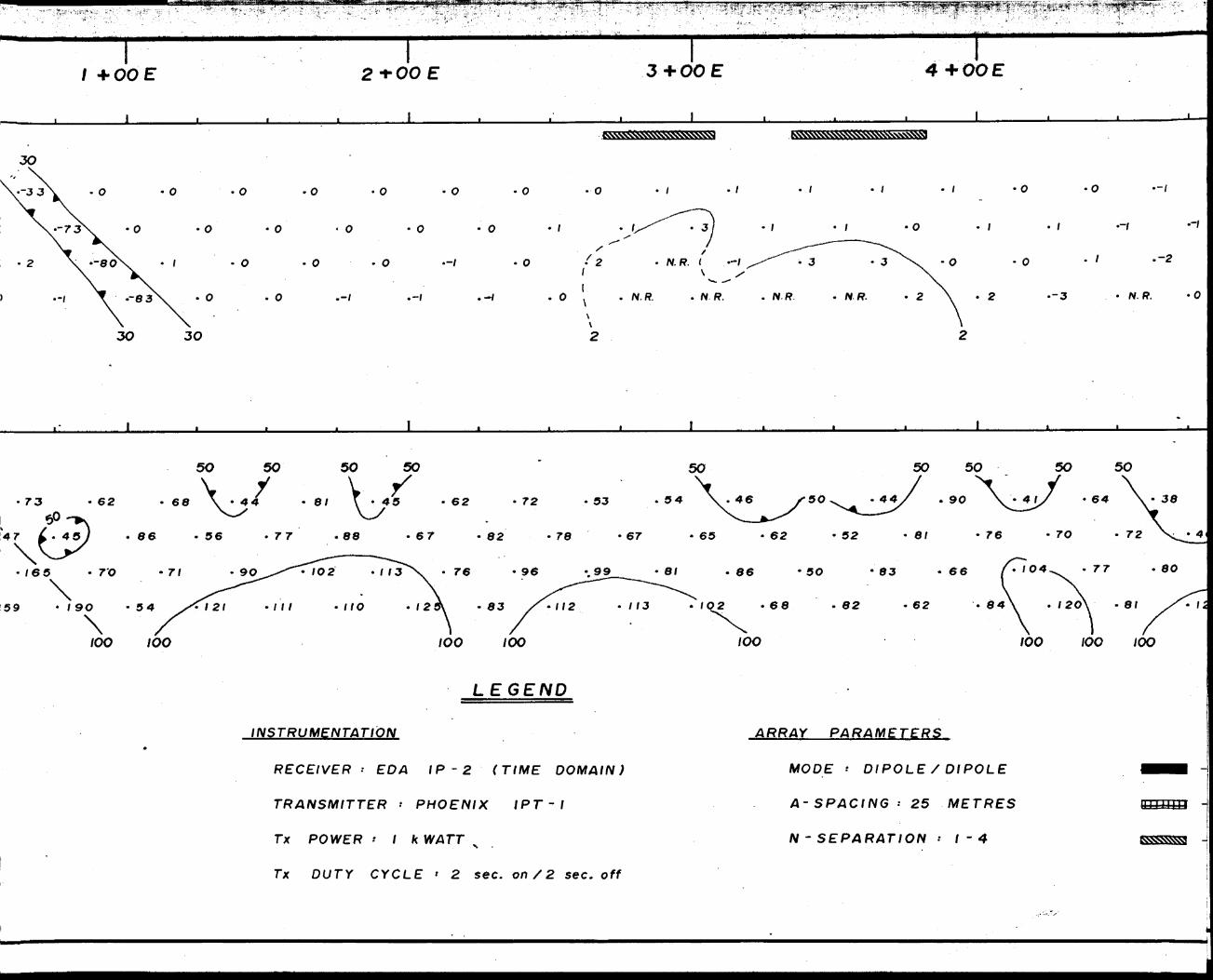
8.C DESCRIPTION OF GEOPHYSICAL PROGRAM
Between the dates of March 3 and March 30, 1988, inclusive,
23.95 kilometres (14.89 miles) of line were cut over 11 claims
comprising the northern part of the Golden Pheasant property.
A baseline oriented at an azimuth of 34" was cut across the
central part of the claim group and crosslines oriented per
pendicular to the baseline were cut at 100 metre intervals to
cover the claims. Labelled pickets were erected at 25 metre
intervals along all crosslines and the baseline.
The linecutting was carried out by Mr. N. Wabie of Notre Dame
du Nord, Quebec.
Between the dates of March 10 and April 4, 1988, inclusive,
magnetometer and induced polarization surveying was carried
out on the property by Robert E. Gillick S Associates Ltd. of
North Bay, Ontario. Total mileages surveyed were as follows:
Magnetometer survey 20.16 kilometres
IP survey ' 10.50 " (n-1 to 4).65 " (n-1 to 6)
The personnel involved in the geophysical surveys were:
R. E. Gillick North Bay, Ont. March 10 - April 4
P. Butler North Bay, Ont. March 10 - March 27
T. Howe North Bay, Ont. March 10 - March 27
The magnetometer survey was carried-,out exclusively on the
newly cut grid lines covering the 11 northern claims of the
property. The survey was performed using two EDA OMNI IV
- 10 -
proton precession magnetometers with memory capability. One magnetometer was used as a recording basestation unit to mon itor drift/diurnal changes while the other was used to take field readings along the grid lines. The instruments were syn chronized each day prior to commencement of the survey. The basestation magnetometer was set up at a fixed location near the survey area and programmed to take readings at one minute intervals. The 'roving 1 magnetometer was used to take readings of the total magnetic field at 25 or 12.5 metre intervals along the grid lines. At the end of each survey day, the two instru ments were interfaced and field data was automatically correct ed and dumped.
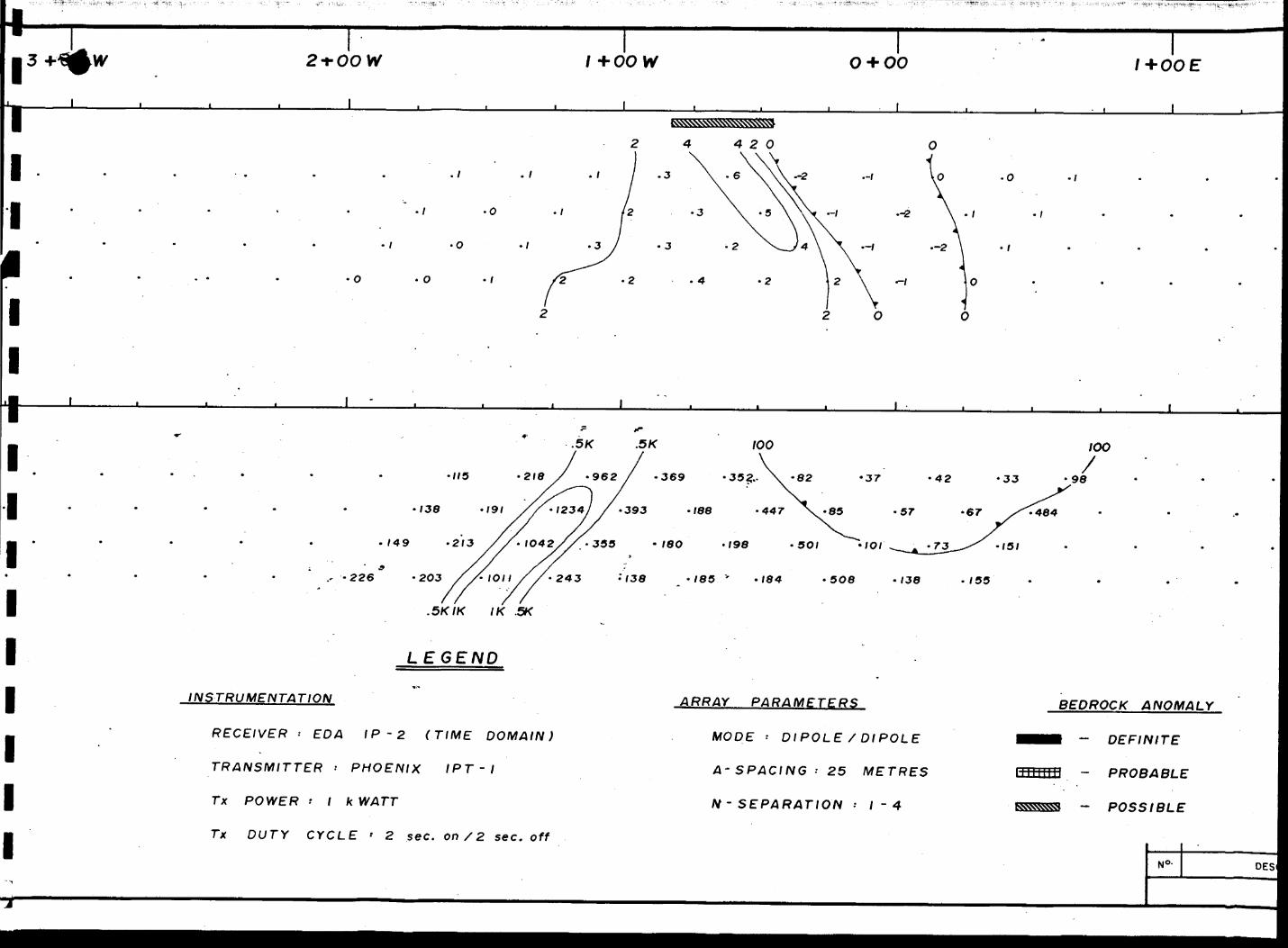
The IP survey was performed using an EDA IP-2 time-domain re ceiver in conjunction with a Phoenix l kilowatt IPT-1 trans mitter. A two second on/off reversing polarity transmitted waveform was employed.
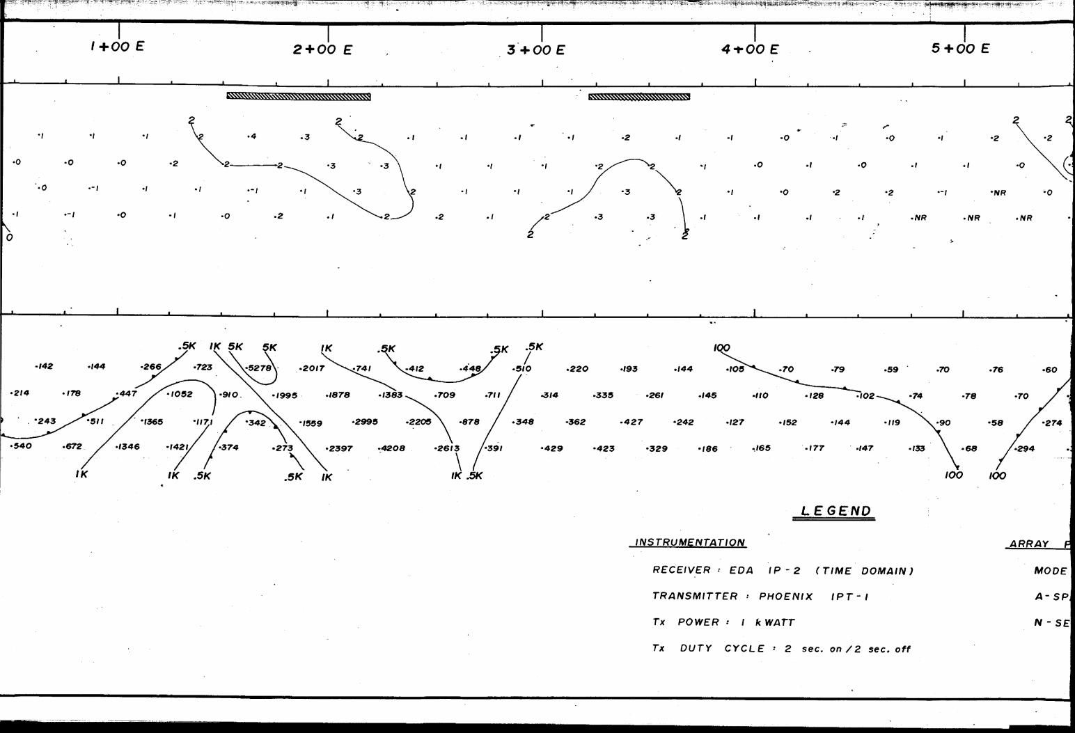
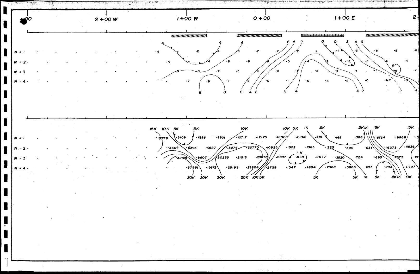
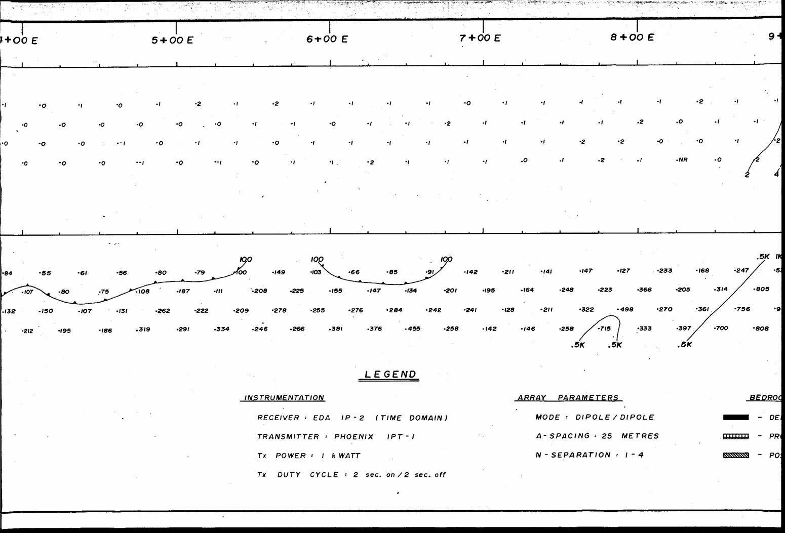
The survey was carried out using the dipole-dipole electrode array with an a-spacing of 25 metres. Dipole separations of n s l to 4 were used on all lines surveyed except line 2 S where readings were taken at separations of n* l to 6. The IP coverage included parts of both the old and the new grids. The lines read were as follows:
Old (1987)grid -
Line 2 S 6+25 W to 0+25 ELine l N 5+50 W to 7+25 ELine 3 N 4+25 W to 10+25 ELine 5 N 3+75 W to 2+50 ELine 6 N 2+50 W to 3+75 ELine 7 N 1+75 W to 11+00 ELine 8 N 1+25 W to 4+25 ELine 9 N 0+75 W to 11+75 E
New (1988) grid -
Line 12 N 3+25 W to 3+00 ELine 14 N 4+50 W to 3+00 ELine 15 N 5+50 W to 0+25 ELine 16 N 5+50 W to 5+75 ELine 17 N 2+75 W to 1+00 E

- li -
The coverages indicated above are determined by the stations occupied by current or potential electrodes at the extremities of the surveyed portion of each line. The line coverage of the IP survey totalled 11.15 kilometres over a period of 13.5 pro duction days, giving an average coverage of 826 metres per day. Although noise levels were generally low during the survey al lowing relatively rapid reading times, survey speed was hamper ed somewhat due to difficulties encountered with electrode em placement in areas of frozen swamp and outcrop.
9.0 RESULTS AND INTERPRETATION
a) Induced Polarization Results:
The results of the induced polarization survey are presented in pseudosection form in Drawings l through 13. A compilation of the IP anomalies picked is shown in Drawing 14.
The IP anomalies have been categorized as follows:
i) DEFINITE BEDROCK ANOMALY
This is an anomaly which has a known geological source as proven by drilling and/or surface geology, OR, an anomaly whose signature and correlation with other geophysical and/or geological data indicate a bedrock source even though the exact nature of the source is unknown.
ii) PROBABLE BEDROCK ANOMALY
This is an anomaly whose signature OR correlation with other geophysical/geological data suggest a bedrock source.
iii) POSSIBLE BEDROCK ANOMALY
This category includes generally low amplitude char geability anomalies with poor signatures and weak or nil correlation with other data.
- 12 -
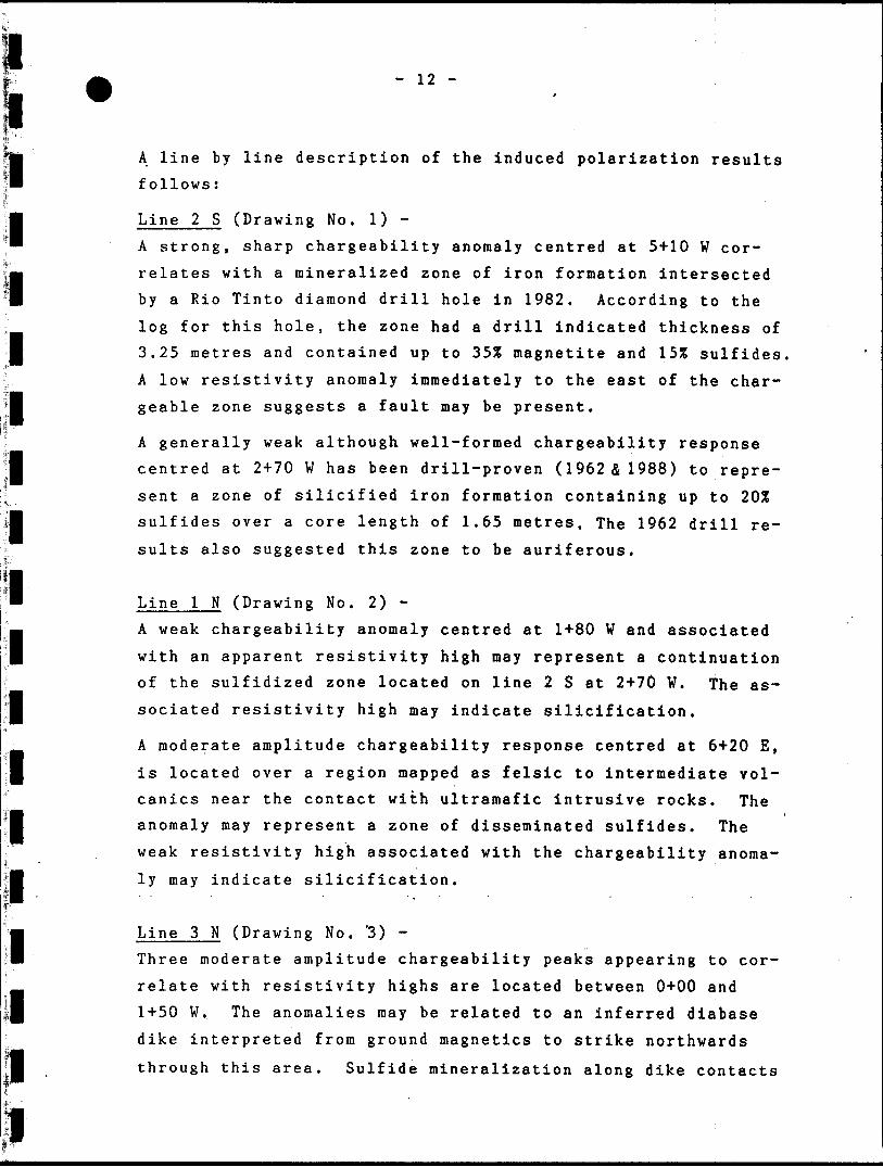
A line by line description of the induced polarization results
follows:
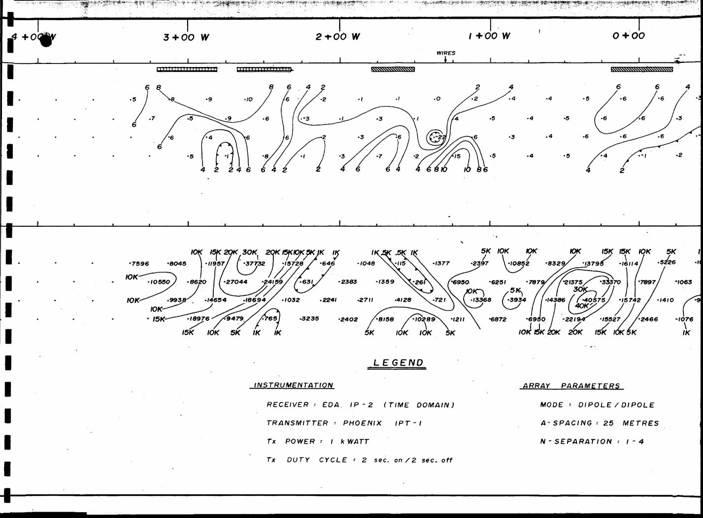
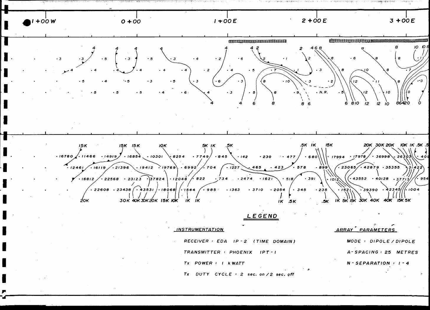
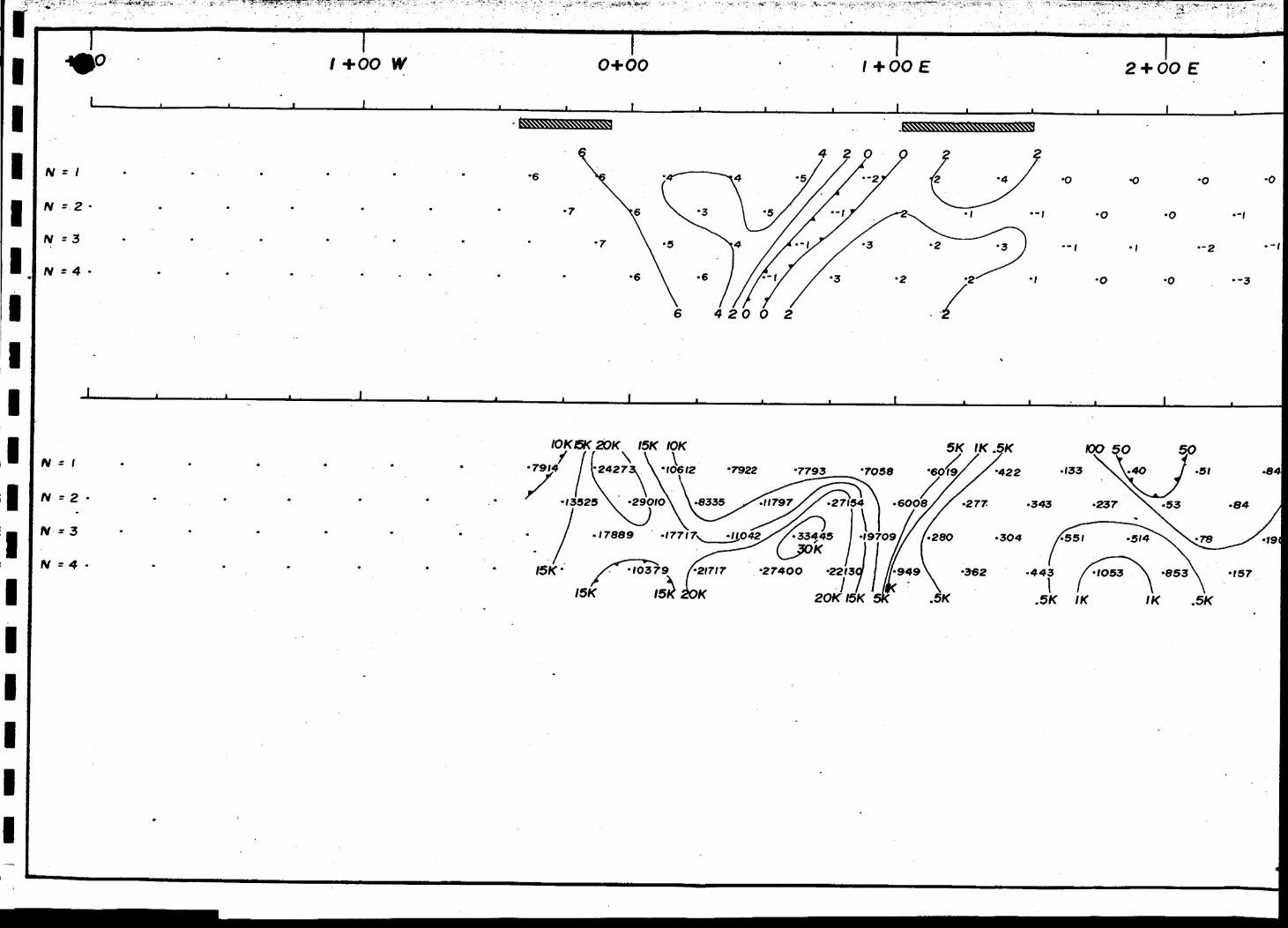
Line 2 S (Drawing No. 1) -
A strong, sharp chargeability anomaly centred at 5+10 W cor
relates with a mineralized zone of iron formation intersected
by a Rio Tinto diamond drill hole in 1982. According to the
log for this hole, the zone had a drill indicated thickness of
3.25 metres and contained up to 3 5% magnetite and 1555 sulfides.
A low resistivity anomaly immediately to the east of the char
geable zone suggests a fault may be present.
A generally weak although well-formed chargeability response
centred at 2+70 W has been drill-proven (1962 S 1988) to repre
sent a zone of silicified iron formation containing up to 20%
sulfides over a core length of 1.65 metres. The 1962 drill re
sults also suggested this zone to be auriferous.
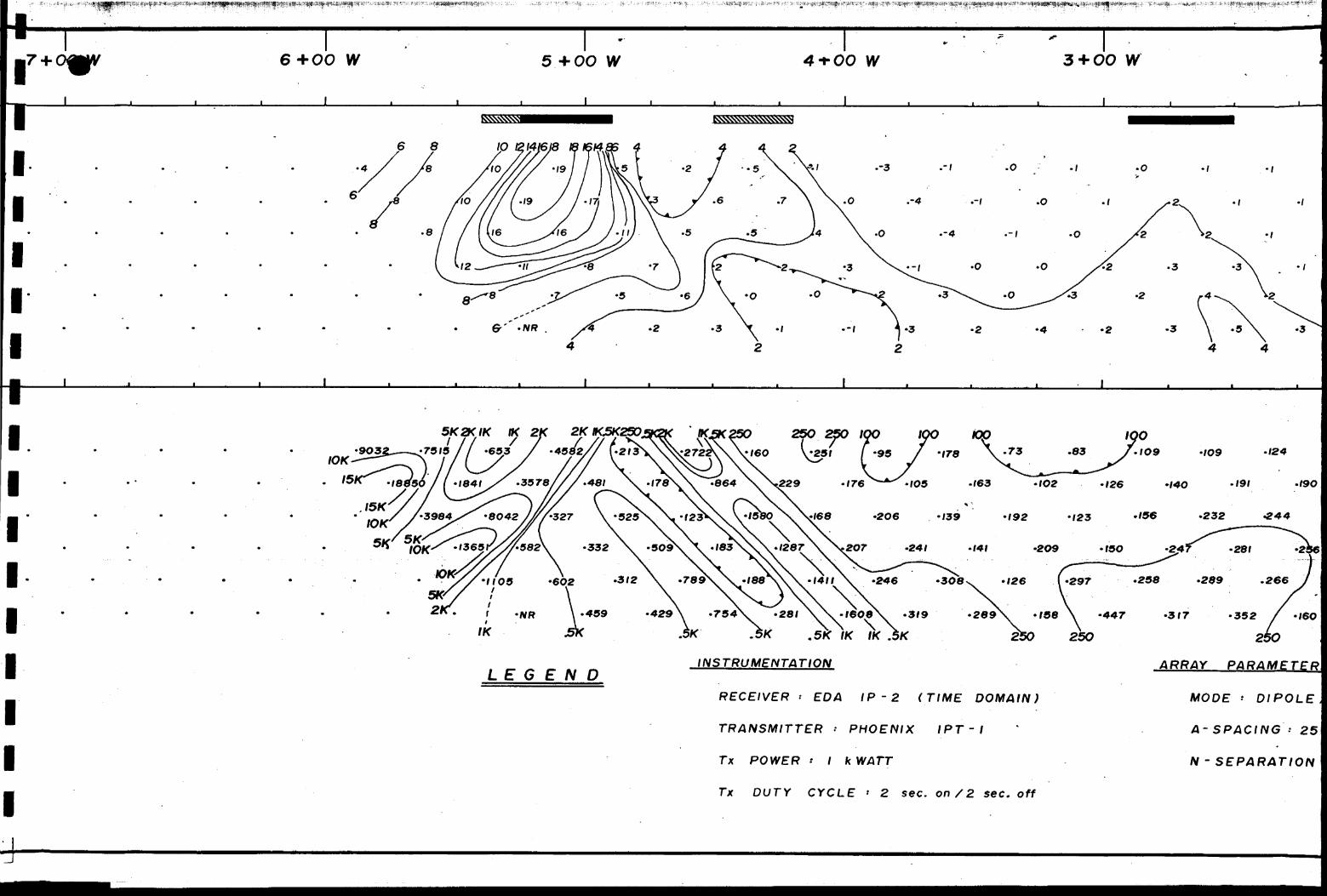
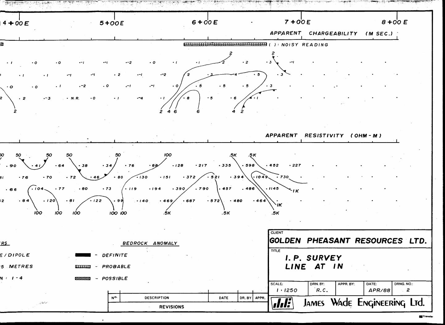
Line l N (Drawing No. 2) -
A weak chargeability anomaly centred at 1+80 W and associated
with an apparent resistivity high may represent a continuation
of the sulfidized zone located on line 2 S at 2+70 W. The as
sociated resistivity high may indicate silicification.
A moderate amplitude chargeability response centred at 6+20 E,
is located over a region mapped as felsic to intermediate vol
canics near the contact with ultramafic intrusive rocks. The
anomaly may represent a zone of disseminated sulfides. The
weak resistivity high associated with the chargeability anoma
ly may indicate silicification.
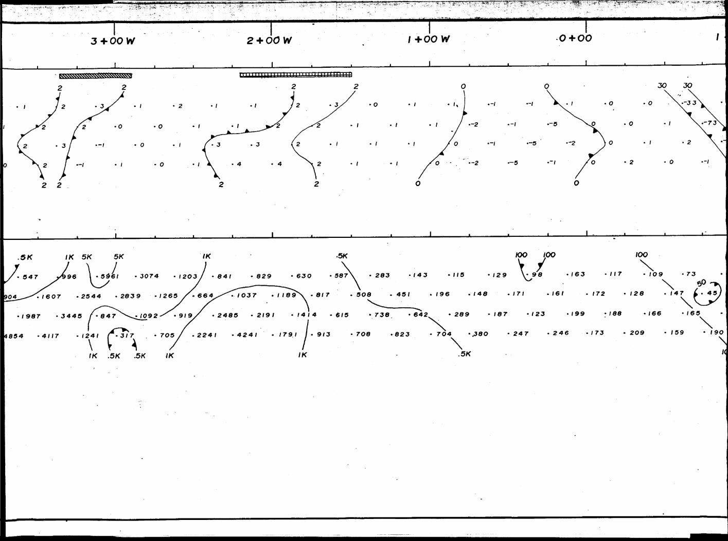
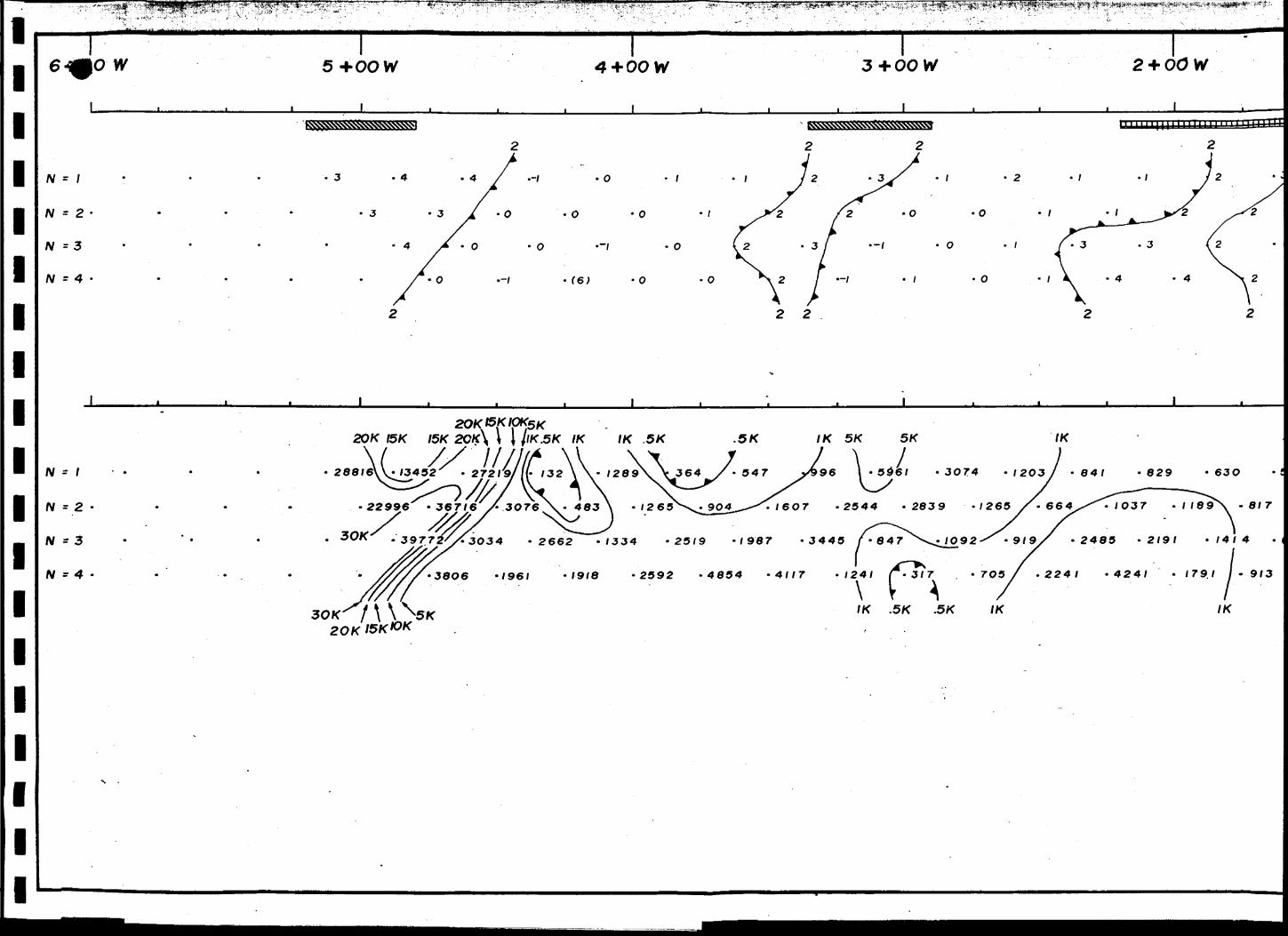
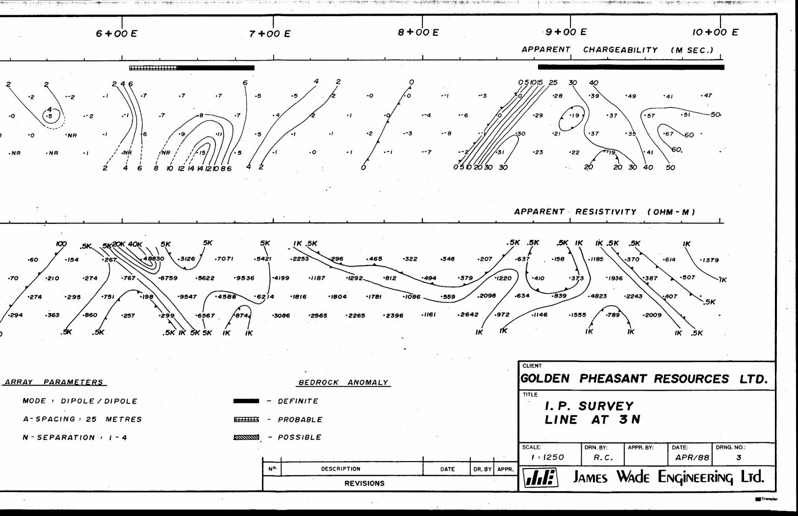
Line 3 N (Drawing No. '3) -
Three moderate amplitude chargeability peaks appearing to cor
relate with resistivity highs are located between 0+00 and
1+50 W. The anomalies may be related to an inferred diabase
dike interpreted from ground magnetics to strike northwards
through this area. Sulfide mineralization along dike contacts
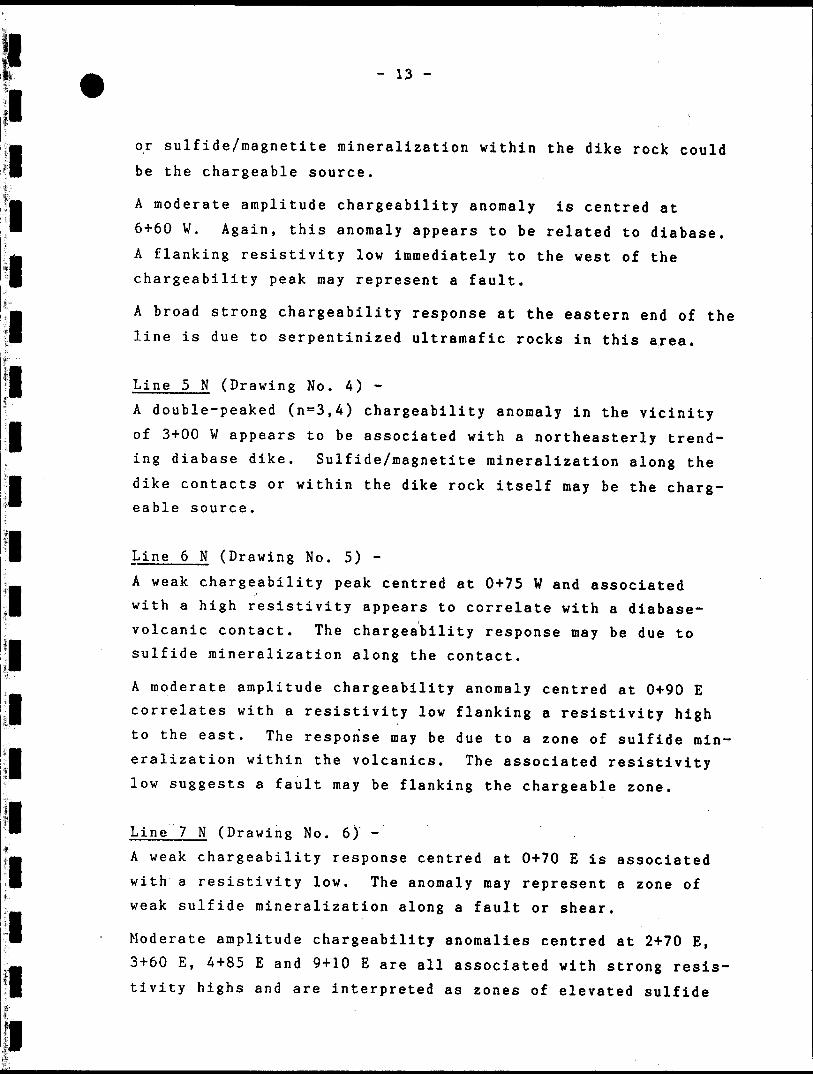
- 13 -
or sulfide/magnetite mineralization within the dike rock could be the chargeable source.
A moderate amplitude chargeability anomaly is centred at 6+60 W. Again, this anomaly appears to be related to diabase. A flanking resistivity low immediately to the west of the chargeability peak may represent a fault.
A broad strong chargeability response at the eastern end of the line is due to serpentinized ultramafic rocks in this area.
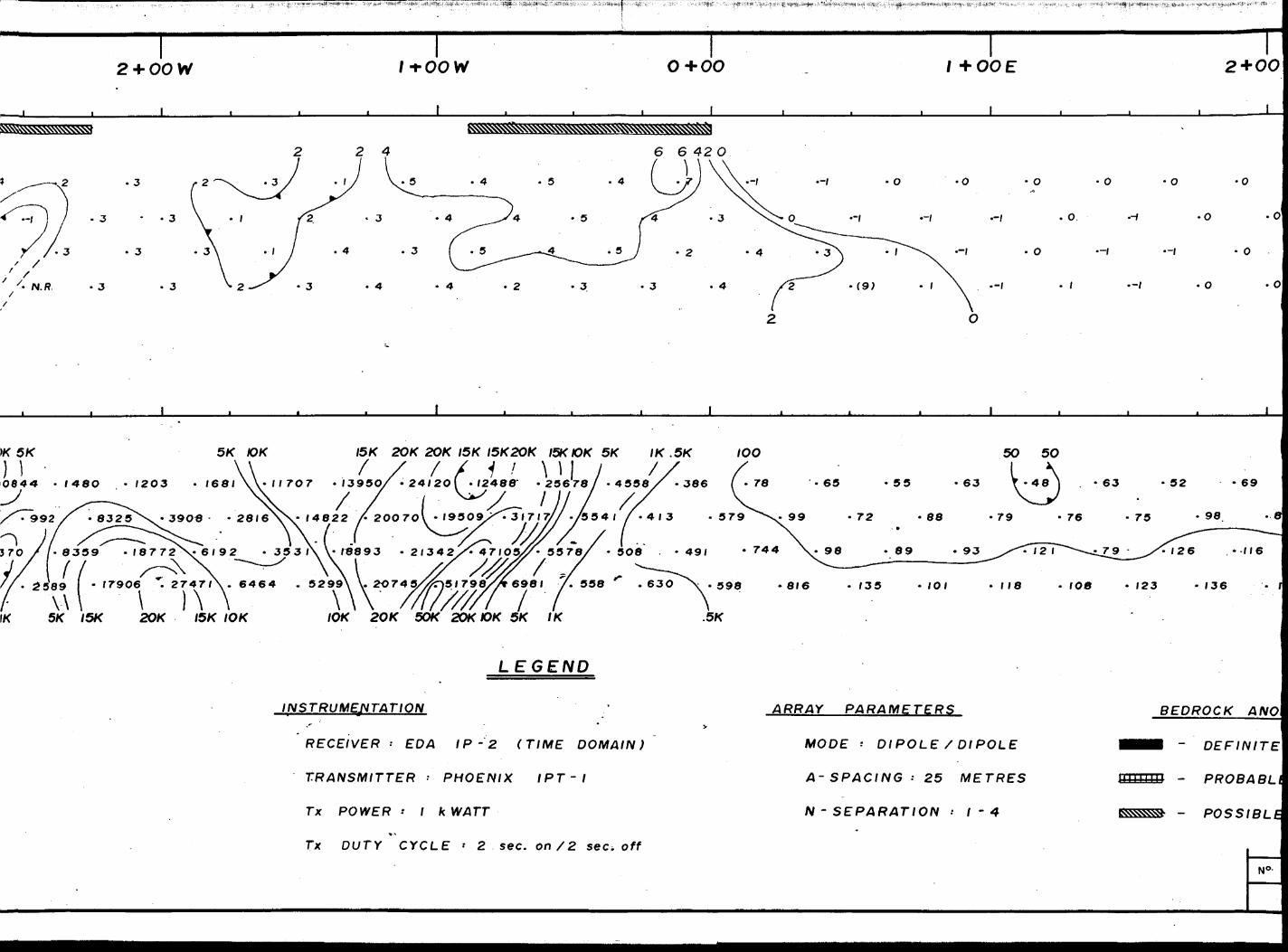
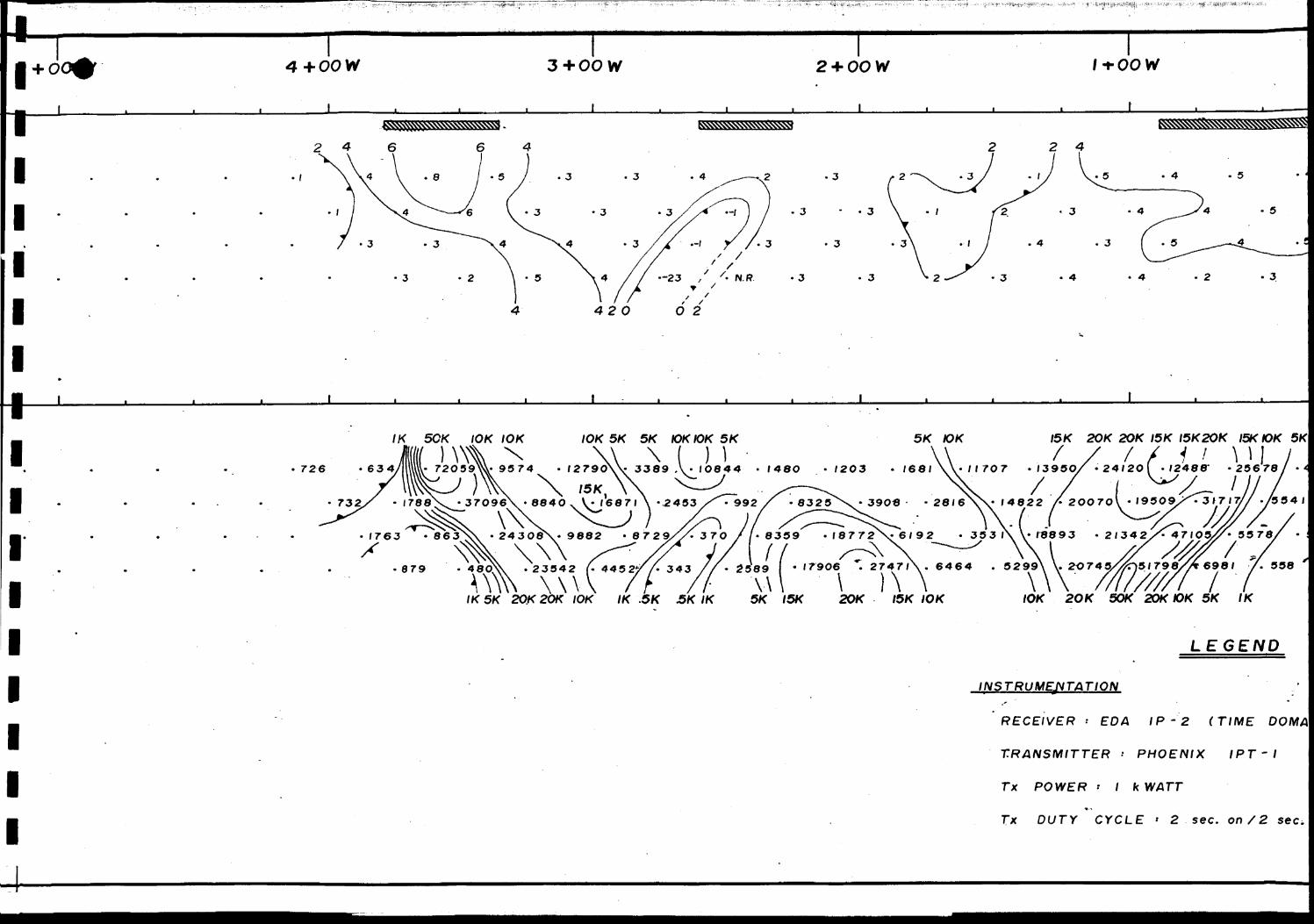
Line 5 N (Drawing No. 4) -A double-peaked (na 3,4) chargeability anomaly in the vicinity of 3+00 W appears to be associated with a northeasterly trend ing diabase dike. Sulfide/magnetite mineralization along the dike contacts or within the dike rock itself may be the charg eable source.
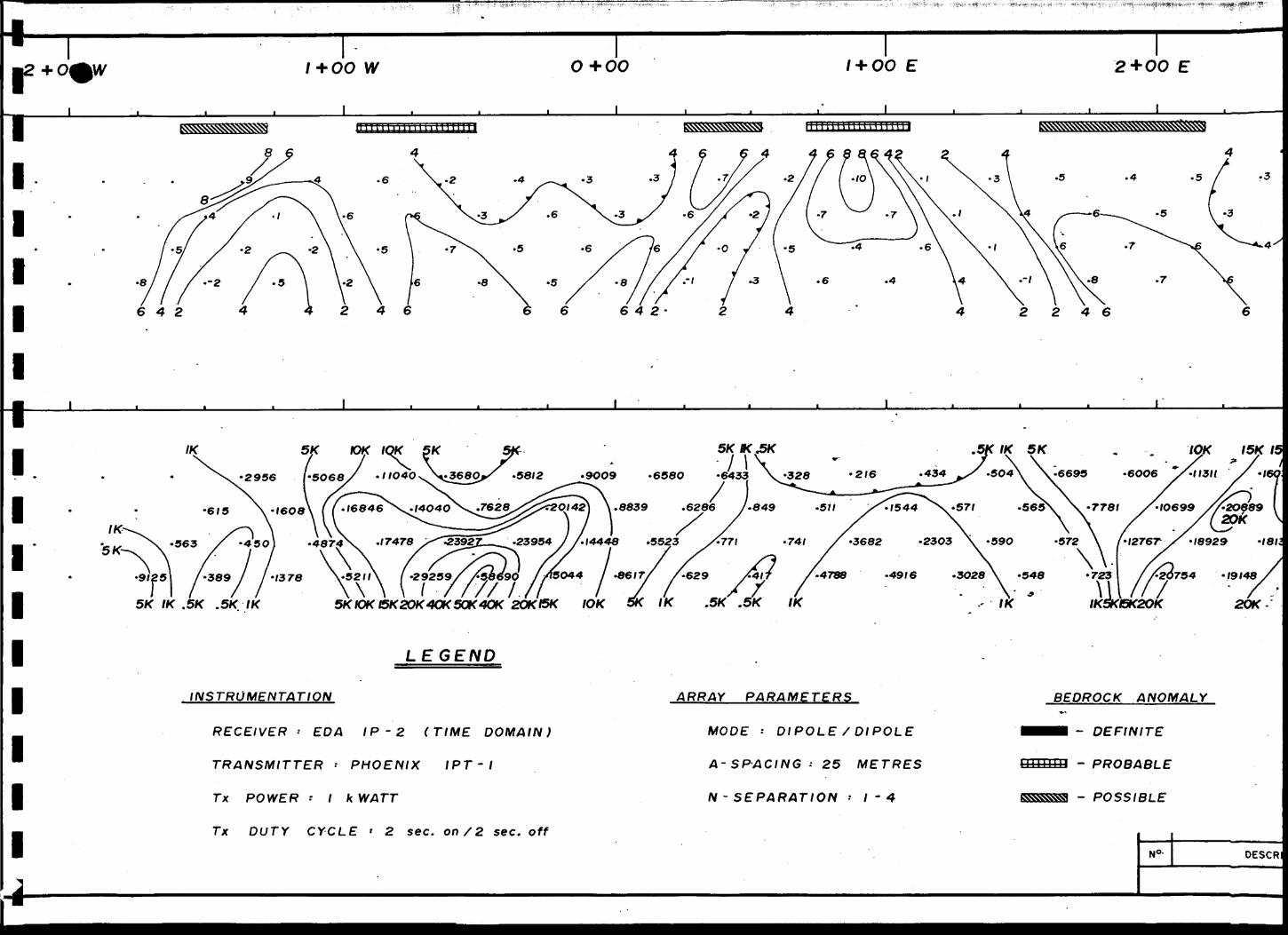
Line 6 N (Drawing No. 5) -
A weak chargeability peak centred at 0+75 W and associated with a high resistivity appears to correlate with a diabase- volcanic contact. The chargeability response may be due to sulfide mineralization along the contact.
A moderate amplitude chargeability anomaly centred at 0+90 E correlates with a resistivity low flanking a resistivity high to the east. The response may be due to a zone of sulfide min eralization within the volcanics. The associated resistivity low suggests a fault may be flanking the chargeable zone.
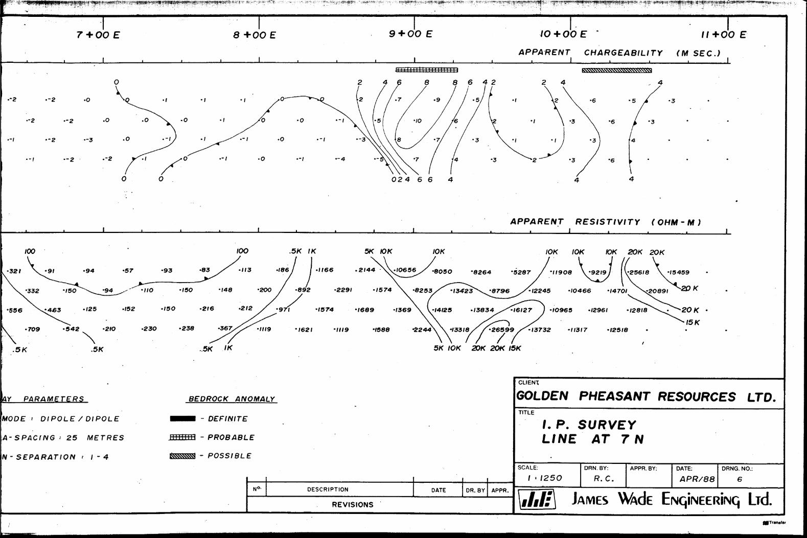
Line 7 N (Drawing No. 6) -A weak chargeability response centred at 0+70 E is associated with a resistivity low. The anomaly may represent a zone of weak sulfide mineralization along a fault or shear.
Moderate amplitude chargeability anomalies centred at 2+70 E, 3+60 E, 4+85 E and 9+10 E are all associated with strong resis tivity highs and are interpreted as zones of elevated sulfide
- 1A -
or magnetite content within a broad easterly striking diabase dike inferred from ground magnetics and geological mapping to underlie most of the eastern half of line 7 N.
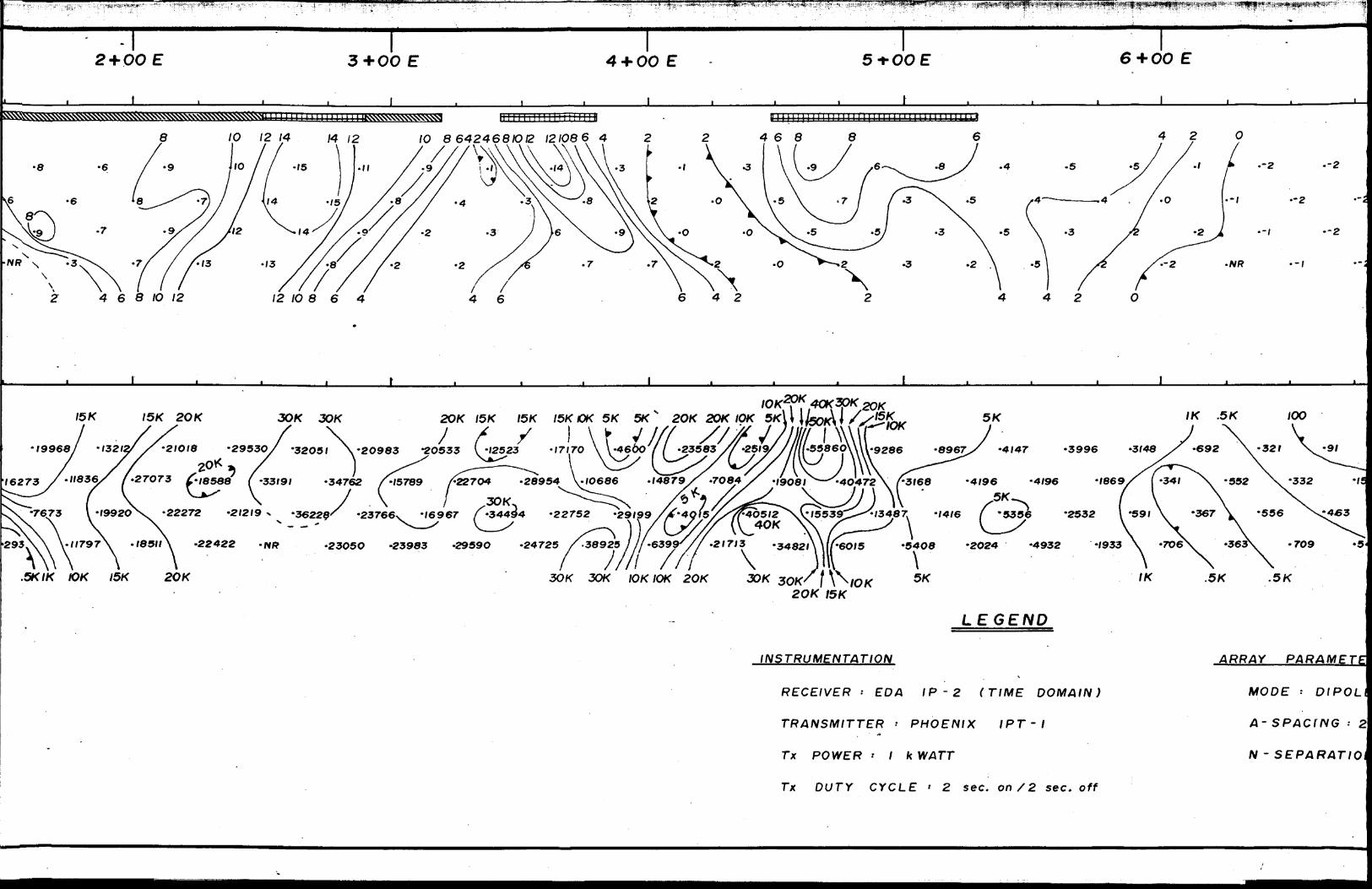
Line 8 N (Drawing No. 7) -
A weak to moderate amplitude chargeability anomaly centred at 1+35 E exhibits flanking correlation with a resistivity low to the east. The response may indicate a zone of weak sulfide mineralization flanking a fault or shear.
A moderate amplitude chargeability anomaly centred at 2-1-45 E is associated with a strong resistivity high. The response may represent a zone of disseminated sulfide mineralization within mafic to intermediate volcanic rocks.
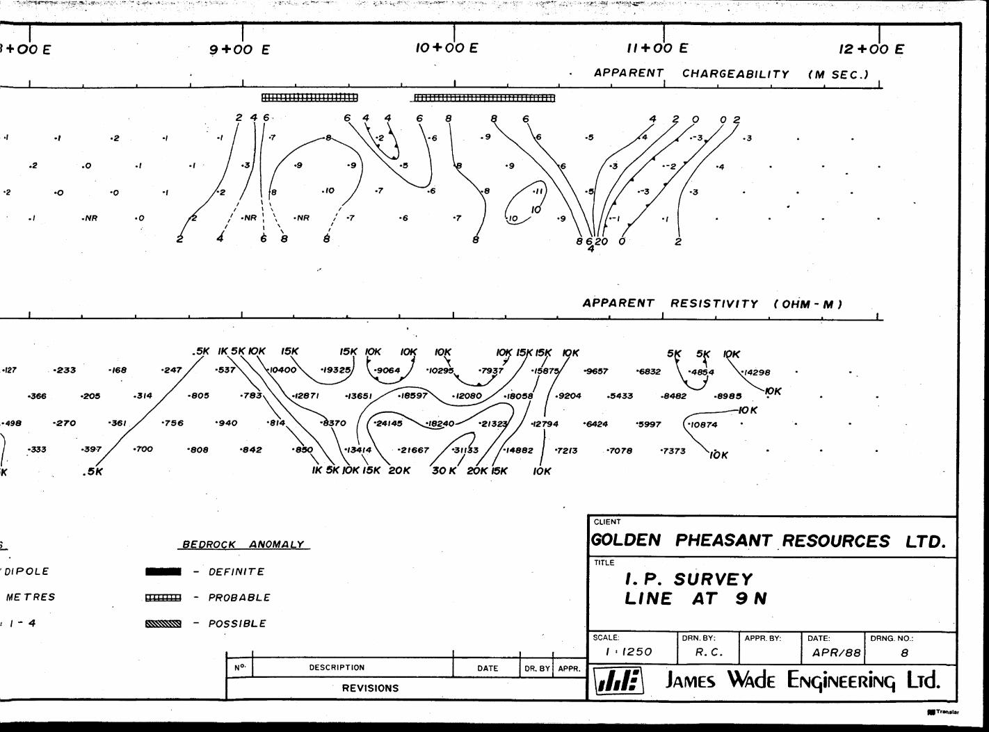
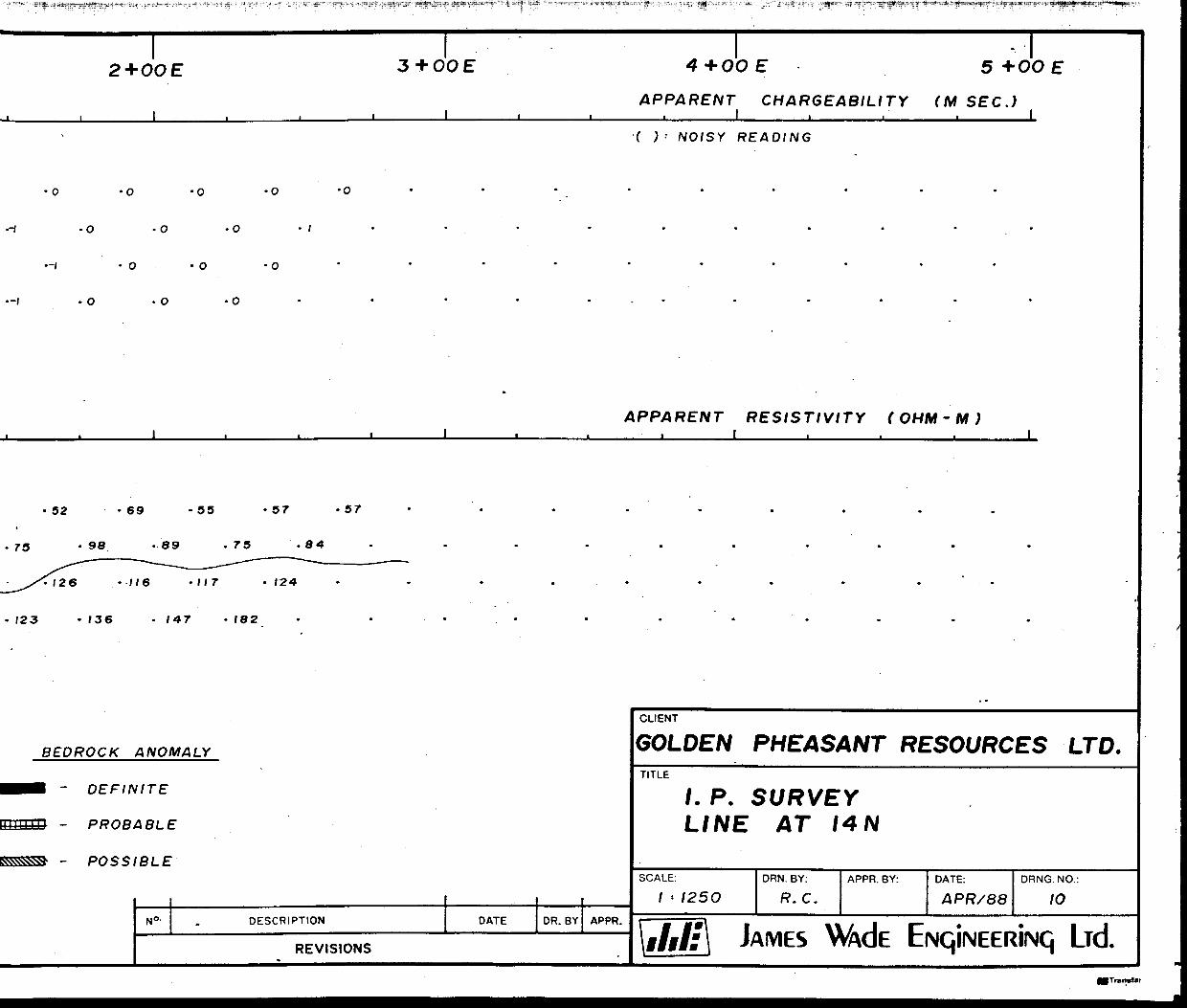
Line 9 N (Drawing No. 8) -
Two moderate amplitude chargeability anomalies located at the eastern end of the line and associated with a broad resistivity high may represent zones of sulfide/magnetite mineralization within diabase or at the contact of diabase and volcanic rock.f
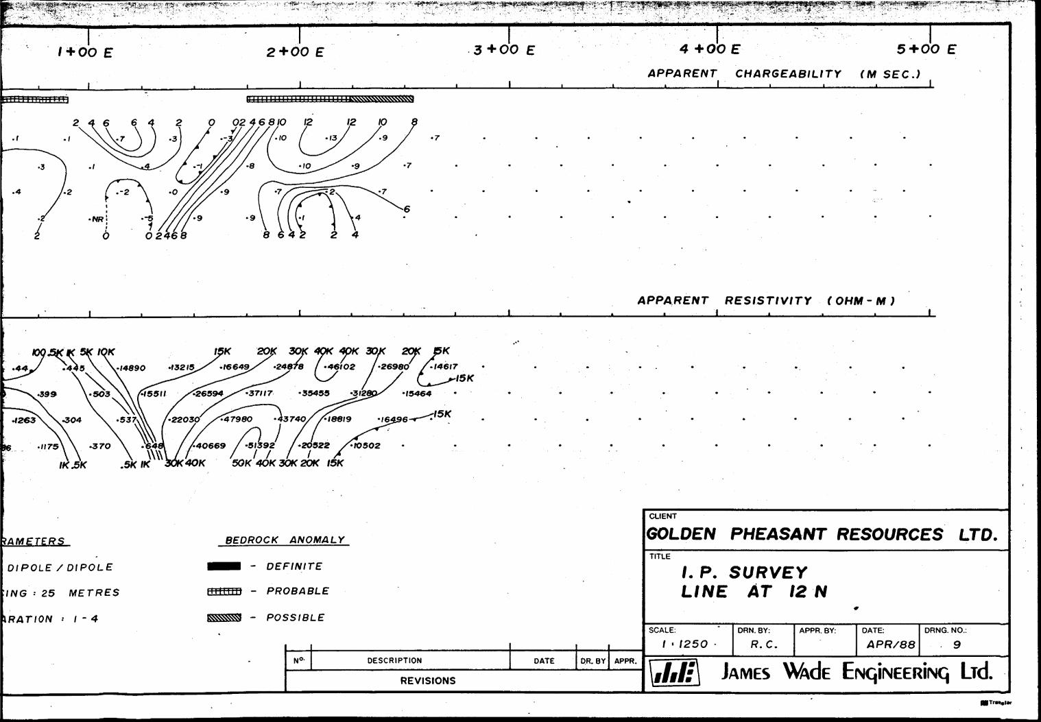
Line 12 N (Drawing No. 9) -
A weak chargeability response centred at 0+70 E is associated with a moderate amplitude well-formed high resistivity anomaly. The zone is located within a region mapped as mafic to inter mediate volcanics. The high chargeability - high resistivity combination is similar to the response over the sulfidized and silicified zone located at 2+70 W on line 2 S. A similar geo logical source may be present on line 12 N.
A moderate amplitude chargeability response centred at 2+00 E and associated with a strong resistivity high is believed to correlate with diabase. A zone of disseminated sulfide or mag netite within the dike or at the dike contact may be the causa tive source.
- 15 -
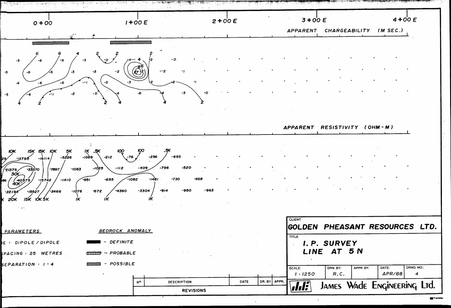
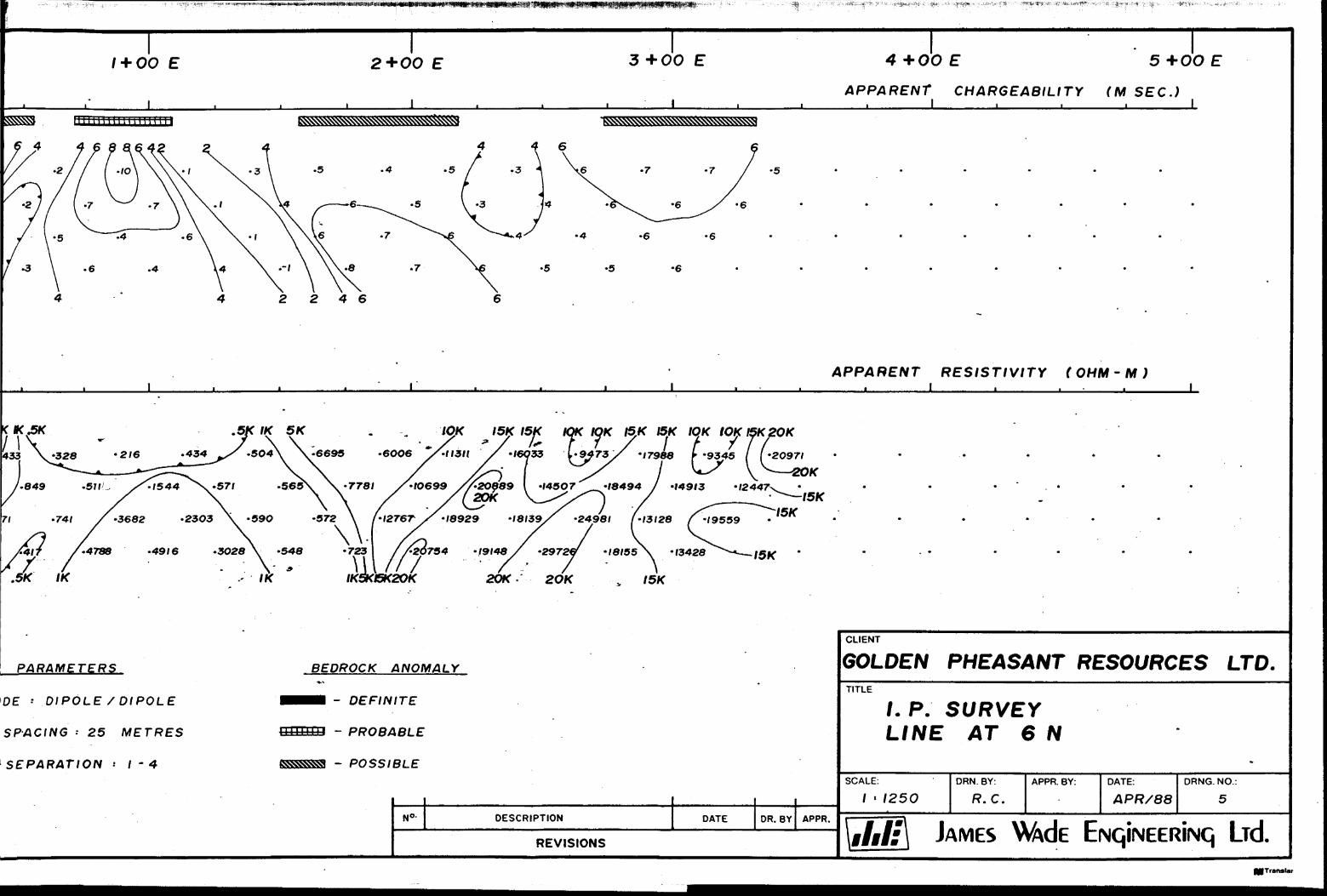
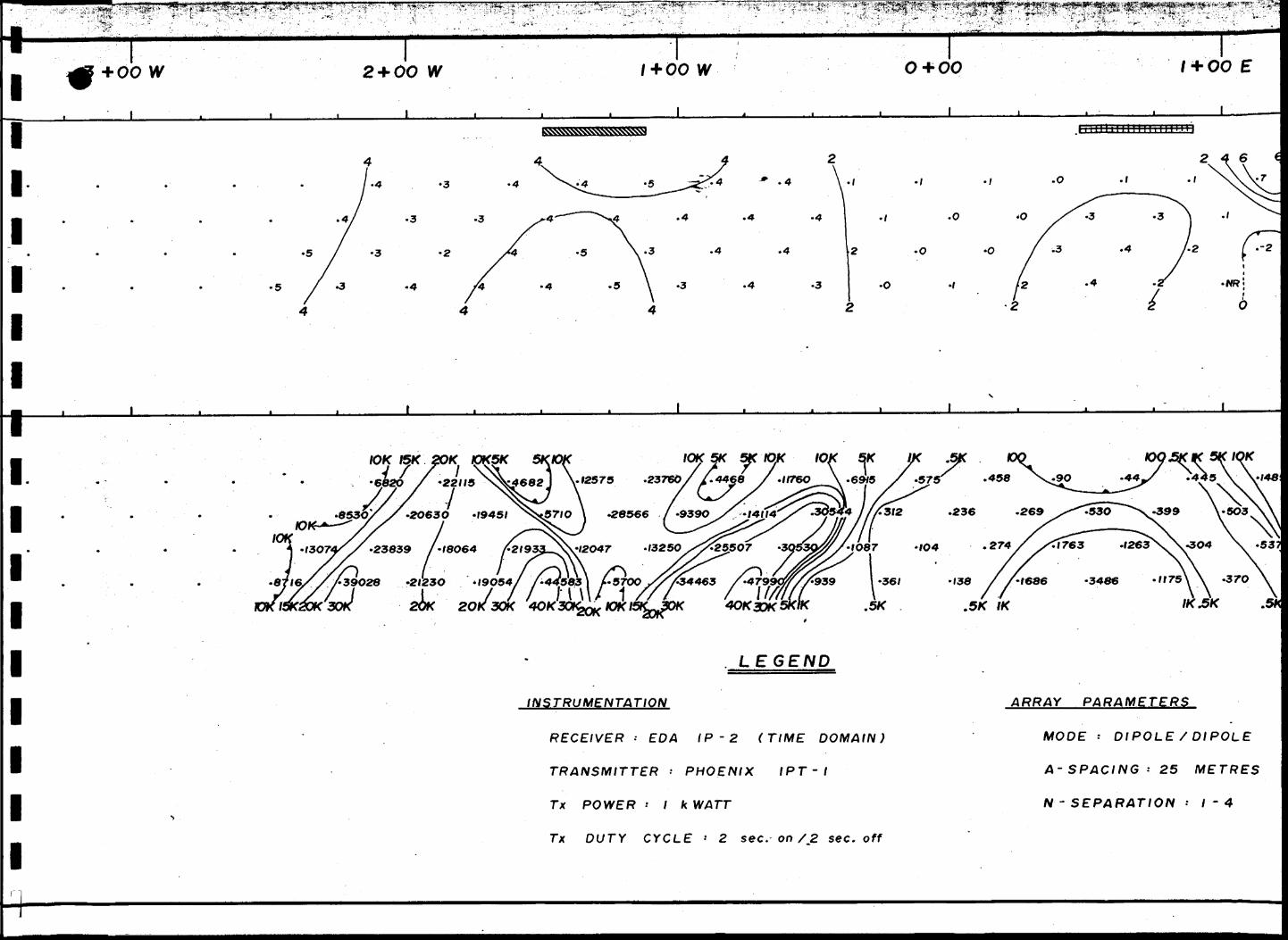
Line 14 N (Drawing No. 10) -
Two weak poorly-formed chargeability anomalies centred at
3+55 W and 0+45 W correlate with linear magnetic features be
lieved to represent a. diabase dike and iron formation, respectively
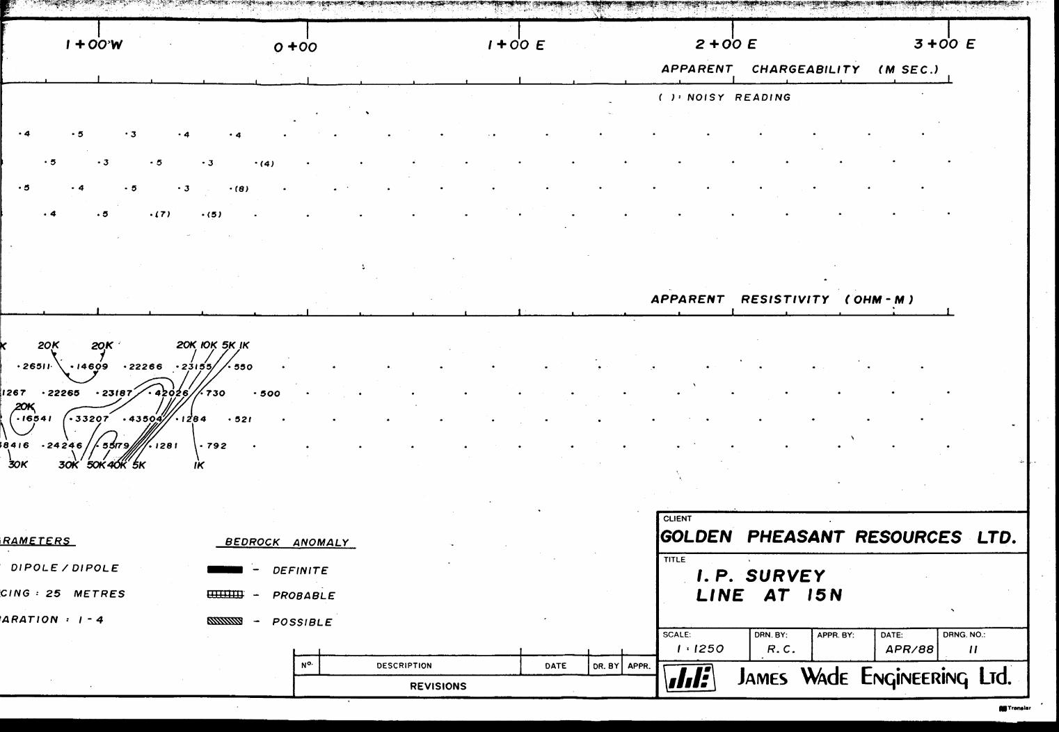
Line 15 N (Drawing No. 11) -
Two unusual anomalies are present on this line. A weak charg
eability anomaly centred at 3+75 Wand responsive on n" 1,2
only, is accompanied by sharp low resistivities on n"3,4. The
higher chargeabilities may be due to weak sulfide or magnetite
mineralization in the upper part of a diabase dike which is in
dicated to strike northwards through this area by the ground
magnetics. The low resistivities may indicate the presence of
of a fault along the dike contact. The sharpness of the resis
tivity low at n z 4 is unusual. A second chargeability anomaly
centred at 2+25 W is expressed as an extremely sharp negative
chargeability on n 8*!^. There is no associated resistivity an
omaly. The chargeability response is similar to that which
may occur over a buried wire or pipe. Alternatively, the res
ponse could be due to a very shallow vein of sulfide of very
limited depth extent.
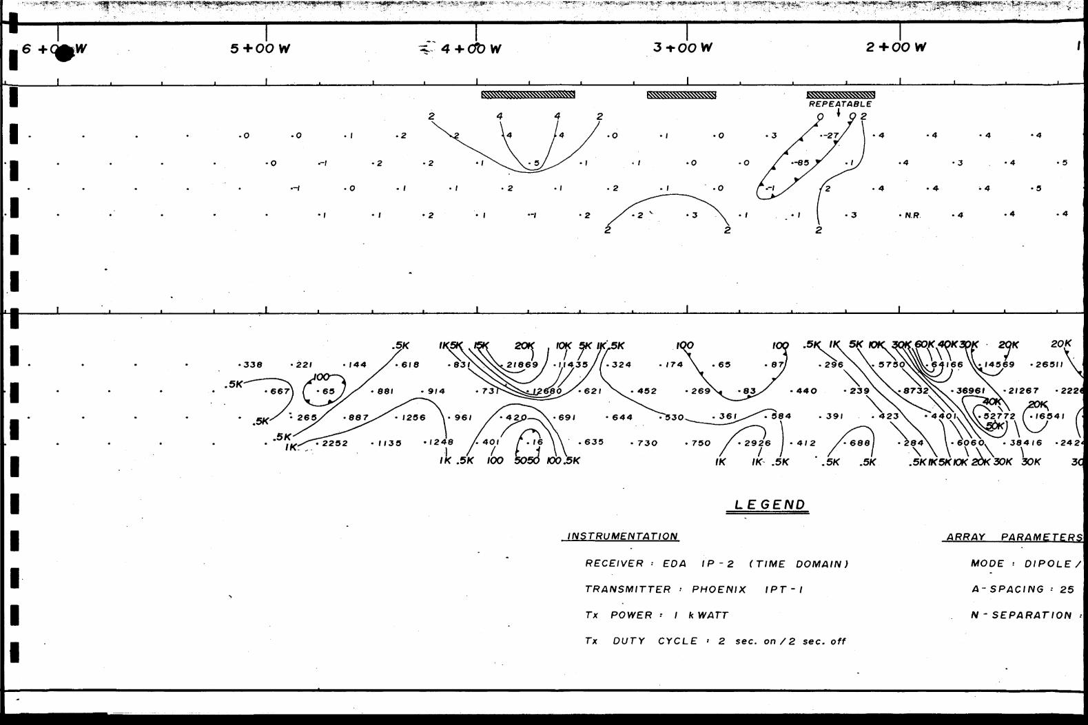
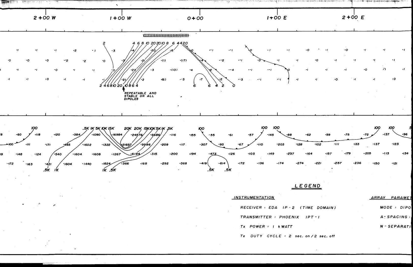
Line 16 N Drawing No. 12) -
A single anomaly centred at 0+45 W has been located on this
line. The chargeability response is unusually shaped consist
ing of a sharp positive peak flanked to the east by a low zone
of abnormally noisy readings. The resistivity data indicates
a contrast suggesting a contact. The zone is associated with
a sharp strong linear magnetic feature on a northeasterly strike.
The zone may represent sulfidized iron formation along a geo
logic contact.
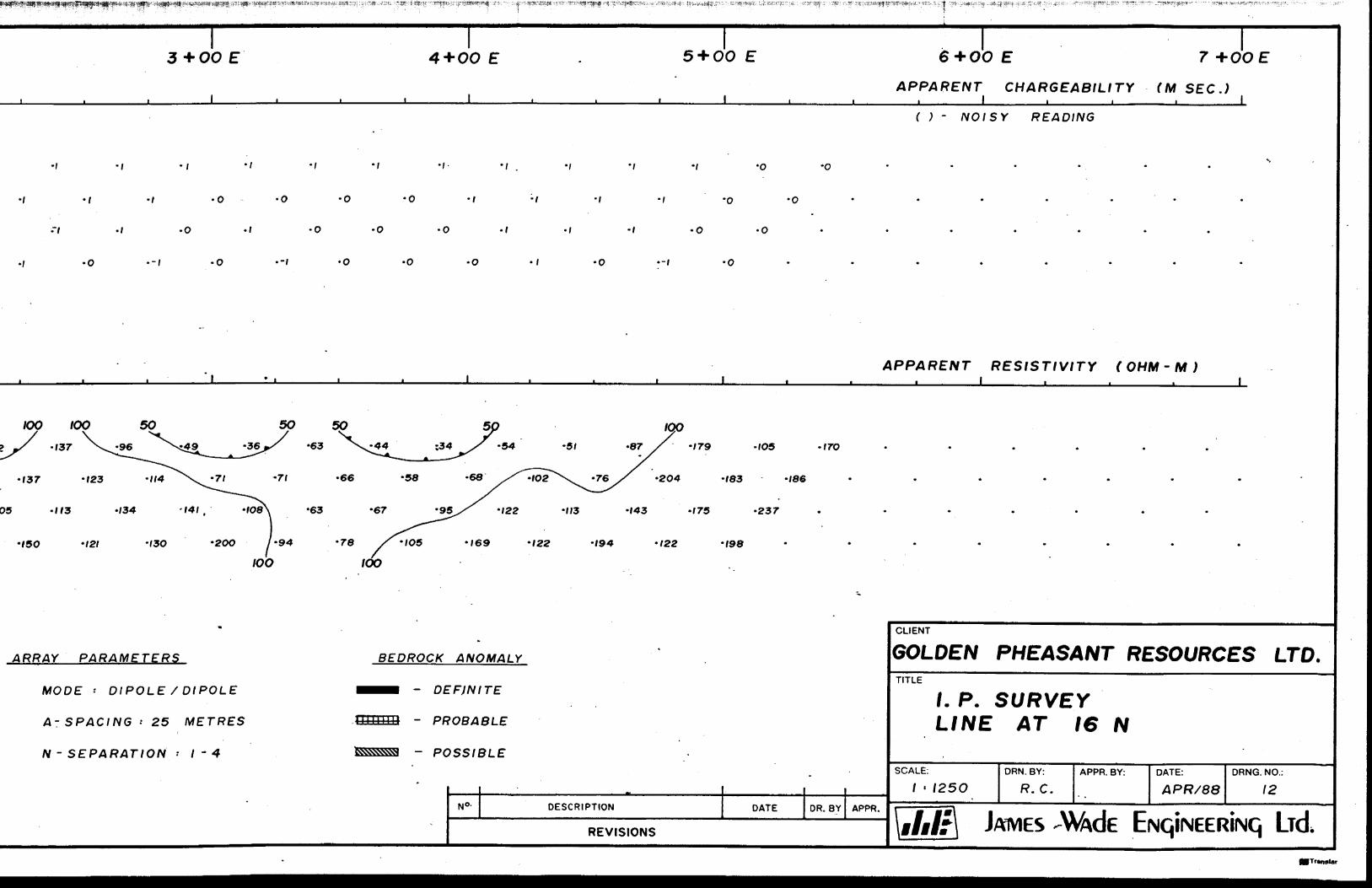
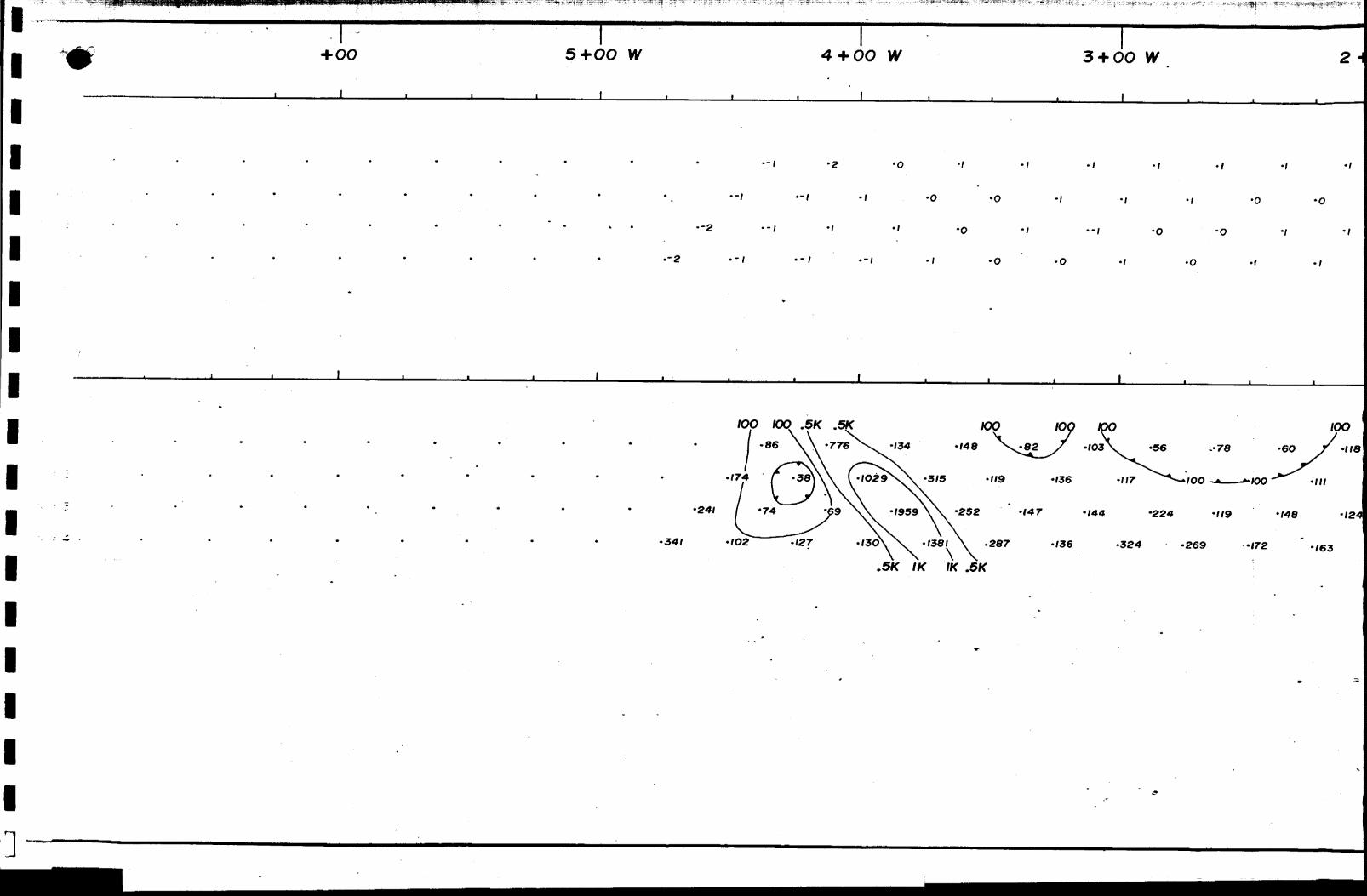
Line 17 N (Drawing No. 13) -
A weak chargeability response centred at 0+65 W is associated
with a dipolar magnetic anomaly. The response may be due to
if 1
l
- 1.6 -
weak sulfides associated with lean iron formation.
b) Magnetometer Survey Results:
The contoured results of the magnetometer survey on the newly
cut grid covering the northern part of the Golden Pheasant
property are presented on Drawing No. 15.
A strong narrow magnetic linear srtiking northwards near the
western boundary of the property is believed to represent a
diabase dike.
Regions of active magnetics in the eastern and northern parts
of the property are believed to be underlain by ultramafic
intrusive rocks perhaps accompanied by diabase intrusions.
A strong narrow magnetic linear on a northeasterly strike near
the grid baseline is interpreted to be iron formation. The
feature exhibits an apparent strike length of at least 600
metres extending-from line 13 N to line 19 N. A narrow magne
tic low trending northwards from line 14 N at 3+25 E to line
22 N at 3+25 W may represent a fault or shear which has ter
minated or displaced the interpreted iron formation.
10.0 CONCLUSIONS AND RECOMMENDATIONS
A number of zones of anomalous chargeability have been located
on the Golden Pheasant property. More than half of these
zones appear to be associated with diabase dikes and are not
considered to warrant further work at this time. The char
geable zones not associated with diabase may contain sulfide
mineralization emplaced along faults or shears. Several of
these latter zones correlate with weak to moderate resistivity
highs suggesting that silicification may be present. Three
chargeable zones located near the baseline of the new grid may
be associated with iron formation.
- 17 -
The following IP zones are considered to have potential for gold mineralization and should be investigated by trenching
or diamond drilling:
a) Line l N, 1+80 W
b) Line 6 N, 0+90 E
c) Line 7 N, 0+70 E
d) Line 8 N, 1+35 E and 2+45 E
e) Line 12 N, 0+70 E
f) Line 16 N, 0+45 W
g) Line 17 N, 0+65 W
In addition to delineating a diabase dike near the western
boundary of the property and magnetically active regions in the north and east parts of the grid, believed to be underlain by
ultramafic intrusive rocks, the magnetics survey has defined
a narrow northeast striking magnetic linear, located near the grid baseline, which may be iron formation. This latter trend
extends from line 13 N to line 19 N where it appears to be
fault terminated or offset. Since iron formation is known to host gold mineralization on the property, it is recommended that this zone be thoroughly investigated on the surface and,
if the presence of iron formation is confirmed, the zone should be diamond drilled.
Respectfully submitted,
R. E. Gillick, M.Se.ROBERT E. GILLICK S ASSOCIATES LTD.
for
JAMES WADE ENGINEERING LTD.

- 18 -
11.0 REFERENCES
D. R. Pyke, 1982, OGS Report 219, Geology of the Timmins Area, District of Cochrane.
S. A. Ferguson, 1968, ODM Geological Report 58, Geology and Ore Deposits of Tisdale Township.
J. A. Fyon, J. H. Crocket, H. P. Schwarcz, 1983, The Carshaw and Malga Iron-Formation-Hosted Gold Deposits of the Timmins Area, in OGS Misc. Paper 110 - The Geology of Gold in Ontario.
C. J. Hodgson, 1983, The Structure and Geological Development of the Porcupine Camp - A Re-Evaluation, in, OGS Mise Paper 110 - The Geology of Gold in Ontario.
R. W. Stevenson, 1987, Geological Report on the Carman fi Langmuir Townships Property, Porcupine Mining Division for Golden Pheasant Resources Ltd.
G. Hodges,1987, A Report on the Total Field Magnetics Survey on the Carman and Langmuir Townships Property of Golden Pheasant Resources Ltd.
,'
G. Hodges, 1987, A Report on the Electromagnetic and Induced Polarization Surveys on the Carman and Langmuir Townships Property of Golden Pheasant Resources Ltd.
A. Moore, 1987, Geological Report on the Property of Golden Pheasant Resources Ltd. in Langmuir and Carman Townships, Porcupine Mining Division.
R. J. Anderson, personal communication.
APPENDIX A
CERTIFICATE OF QUALIFICATIONS
l
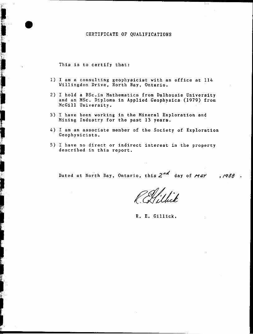
CERTIFICATE OF QUALIFICATIONS
This is to certify that:
1) I ara a consulting geophysicist with an office at 114 Willingdon Drive, North Bay, Ontario.
2) I hold a BSc.in Mathematics from Dalhousie Universityand an MSc. Diploma in Applied Geophysics (1979) fromMcGill University.
3) I have been working in the Mineral Exploration and Mining Industry for the past 13 years.
4) I am an associate member of the Society of Exploration Geophysicists.
5) I have no direct or indirect interest in the property described in this report.
Dated at North Bay, Ontario, this 2 " d ay of A?x?X
R. E. Gillick.
APPENDIX B
TECHNICAL DATA STATEMENT
Ministry ofNorthern Developmentand Mines
AssessmentWorkBreakdown
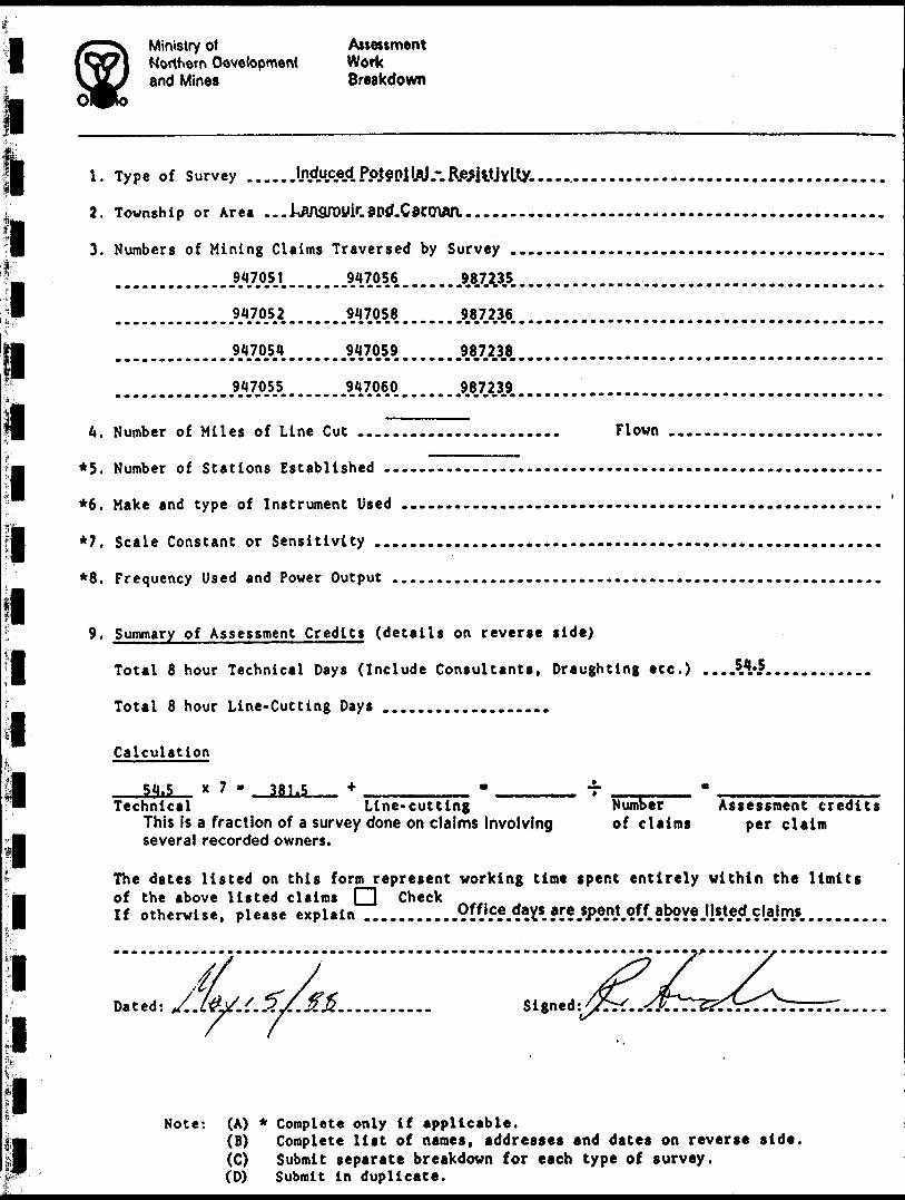
1. Type of Survey ...,.
2. Township or Area ...J^3royir.aDd.Car.man.-...
3. Numbers of Mining Claims Traversed by Survey
A17.0A2. . . . . . . .947054 947059 987238
947055 947060 .9.8.7.239
U. Number of Miles of Line Cut ..
*5. Number of Stations Established -.
*6. Make and type bf Instrument Used
*7. Scale Constant or Sensitivity ...
*8. Frequency Used and Power Output .
Flown
i i
9. Summary of Assessment Credits (details on reverse side)
Total 8 hour Technical Days (Include Consultants, Draughting etc.)
Total 8 hour Line-Cutting Days ...................
Calculation
54.5 x 7 381.5Technical Line-cutting
This is a fraction of a survey done on claims involving several recorded owners.
Number of claims
Assessment credits per claim
The dates listed on this form represent working time spent entirely within the limits of the above listed claims il Check If otherwise, please explain . .........
Dated: Signed
Note: (A) * Complete only if applicable.(B) Complete l ist of names, addresses and dates on reverse side,(C) Submit separate breakdown for each type of survey.CD) Submit i n duplicate.
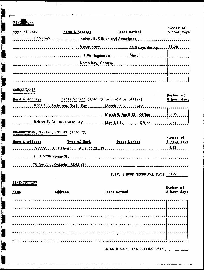
Type of Work Name 6 Address Daces WorkedNumber of 8 hour days
. OWN. CW V. AW*....
CONSULTANTS
""~~~ " Number of Kame 6 Address Dates Worked (specify In field or office) 8 hour days
6....FJSW........... .......
.........A*IL........OCOce......... JL51....
DRAUGHTSMAN. TYPING. OTHERS (specify)
Number of Name 6 Address Type of Work Dates Worked 8 hour days
....April.22Jfc,.U...............................,.3;?5....
TOTAL 8 HOUR TECHNICAL DAYS S4.S- - -
LINE-CUTTING
Number of Name Address Dates Worked 8 hour days
TOTAL 8 HOUR LINE-CUTTING DAYS
APPENDIX C
IP PSEUDOSECTIONS
2 + OO W /+OO W O+OO 1 + O
APPARENTL ———— i ____ ____ i ———— t ———— i ———— ———— i ———— i —— . — i ———— i ———— i ———— i ———— i ————
0 E 2+OO E
CHARGEABILITY (MSEC.)1
•o
•l
—3
—Z '-l
APPARENT RESISTIVITY (OHM-M)
• 124 - /36 - 198 '112 -I4O
'191 .I9O -201
•244250
250 250 .SK .SK
yARAMfiTERS
: DIPOLE / DIPOLE BHBl DEFINI
•AGING : 25 METRES H++++++I PROBA
-pARATION ' l - JES^^ POSSIB
BEDROCK ANOMALY
TE
BLE
ILE
N 0- DESCRIPTION DATE DR. BY APPR.
REVISIONS
CLIENT
GOLDEN PHEASANT RESOURCES LTD.TITLE
f. P. SURVEY LINE AT 2 S
SCALE: DRN. BY: APPR. BY: DATE: DRNG. NO.:
1 ' I25O R. C. APR/88 1
\ilil:\ JAMES W\dE EwqiNEERiNq Lid.MTr*Mla
- Jvi-^? ^---^^ftjf^J-flf*'-^ ~ i ft- A- 1- 2w
iT l l l l l
6+OO IV 5+00 W 4 f 00 W 3 + OO W
t6-' - NR .
4
5K2KIK IK
258 .289 .266
LEGENDINSTRUMENTATION
RECEIVER * EOA /P-2 f T/ME DOMAIN)
TRANSMITTER ' P HOENIX IPT~I
Tx POWER i l k WATT
Tx DUTY CYCLE ' 2 s ec. on/2 sec. off
/6O
ARRAY PARAMETER
MODE t DIPOLE
A- SPACING ; 25
N - SEPARATION
4+00 E 5+OOE 6+OOE 7+OOE 8+OOE
APPARENT CHARGEABILITY (M SEC.)._____t i
-o —l —2
li 1111111H 1111 ftl 111 nTiTi H tin 11 ri 111 iTFPq ( ) : NOISY READING
2 2l
-2 - 3
/ -t -2
.-2 - o
N.R. - O - ;
•-2
246 4 2
APPARENT RESISTIVITY ( OHM - M )
50 5O .SK .5 K
452 -227128 - 2/7
7O - 72
77 -SO 39O/ - 790 l- 457 . 486
991 -/4O * 469/ -687 -572\ - 48O -464\\-i2
V'- 8 4\ . 1 20\ ' 81
IOO IOO IOO
E/DIPOLE ^mm - DE.
b METRES l i li inn - Ph
IV -- 1 ' 4 ^^SSS - PC
-'•*--'
\ 1 7 \IOO IOO .5K .5K
BEDROCK ANOMALY
'FINITE
'OBABLE
SSIBLE
N 0- DESCRIPTION DATE DR. BY APPR.
REVISIONS
\x/*
.5K
CLIENT
GOLDEN PHEASANT RESOURCES LTD.TITLE
/.P. S URVEY LINE AT IN
SCALE; DRN.BY: APPR. BY: DATE: DRNG. NO.:
1 ' 1250 R. C. APR/88 2
li /i //l JAMES W\ck EuqiNEERiNq Lrd.(Tramlar
":: S^'v j:;^*^^r:;sfF^;^3''^
l + OOE 2+00 E 3+OOEl
4 +OOE
J____________L.
• O l -l 'l -l
-l . o
3O
. N .R. . N R. . N.R
IOO IOO lOO
LEGEND
INSTRUMENTATION ARRAY PARAMETERS
RECEIVER ' EDA IP -2 (TIME DOMAIN) MODE ' DIPOLE / DIPOLE
TRANSMITTER * PHOENIX IPT-I A-SPACING i 25 METRES li r i 1.1 r i i —t^n *-l l 13
Tx POWER t l k WATT N ' SEPARATION -- l - 4
Tx DUTY CYCLE ' 2 sec. on/2 sec. off
l3 4- 00 W 2 + OOW + OOW O+OO
l ' l
2 2
'l -l / —2 ~-l -~5 XP . O
l 'l /O '-l —5 -~2 ) O -l
30 3O
.SK IK SK SK
l
l
l
l
l
l
l
l
l
l
l
l
l
l
l
l
l
l
l
-J.-yV - -* f1?VT ' '-J ' -l'-*.*"' " .
^:iiH^!^*^3^^
w 5+OOW 4+OOW OOV/
J——————————L.
/V
W
W
/V
f
2
3
4
/v ^
N *
N r
z3
4
20Kl5KlpK5K 2OK I5K I5K 2OK\ \ \ y IK IK .SK .SK
288/6 ^
IK SK SK
lIK
96 \ -596l - 3O74 -/203/ -84/ -829 - 63O
/O37 - / /89 \ -8/7- 483 \ - /265'vv^. 904^^--". /6O7 -2544 -2839 /265X-664J
. 3OK' '39772^/^3034 - 2662 -/334 -25/9 - / 987 -3445 f '847 "^^JO92-^ ~919/ - 2485 ' 2191 -1414
:~*s -
58O6 -/96/ -1-918 -2592 -4854 -4^7 -/24/ C '317 - 7O5 7 -224/ -424/ - /79/ j -913
IK .SK .SK IK IK30K^t \ \ 2OK
6 + OOE 7+00 E 8 + OOE 9 + OO E lO+OO E
APPARENT CHARGEABILITY (M SEC.). _____l ______.______,______L
4 2
-2
•-2
•NR
• NR -;
IO 12 14 I4I2IO86
051015, 25 30 40•28 '41 '47
-4
-3
-l "7
20 2O 30 4O SO
APPARENT RESISTIVITY ( OHM - M )
.SK .SK .5JC IK IK .SK .SK
•2O7 y -637 . ./58 \ \ -H85
IK
-1379
4/99 - 1187
\ 'f lSK IK IK
•1816 - /8O4
3O86 -2565 -2265
IK .SK
ARRAY PARAMETERS
MODE : DIPOLE / DIPOLE
A-SPACING i 25 METRES
N - SEPARATION * ; - .4
BEDROCK ANOMALY
- DEFINITE
HiillllH - PROBABLE
- POSSIBLE
DESCRIPTION
REVISIONS
DATE DR. BY APPR.
CLIENT
GOLDEN PHEASANT RESOURCES LTD.TITLE
/. P. SURVEY LINE AT 3N
SCALE:
125 ODRN. BY:
R. C.APPR. BY: DATE:
APR/88DRNG. NO.:
3
/j JAMES W\dE ENqiNEERJNq Lrd.ITrantlar
;-;^^
/+OO E 2 + OO E 3+OOE 4 + OO E 5+OO E
•J———————————L. J—————-J- J__________L. J—————l.
i .; - i -i -2 -i
•l -l
•l -l
• l --I\ o
-O ' l 'O -l
•l .1
•NR
• NR -NR -NR
SK IK SK SK IK
723 \\-5278\ -2O/7 79 -59 -TO -76 -6O-22O -/93 -/44
9*O. \ -/995 -/878 -/383^ -7O9 -711 f -314 -335 -26f -*45 -flO -128 '/O2-^ -74 -78 -7O
/559 -2995 -2205 \ -878 f - 348 -362 -427 -242 -/27 -/52 -/44 - 119 \-9O -58 / -274
374 .273 \ -2397 -42O8 -26/3 /-39/ -429 -423 -329 -/86 -.'65 -f 77 -747 -;33 \ -68 /*294
IK .SK .SK IK IK .SK 'OO IOO
LEGEND
INSTRUMENTATION
RECEIVER i EDA IP-2 (TIME DOMAIN)
TRANSMITTER * PHOENIX IPT'I
Tx POWER : l k WATT
ARRAY F
MODE
A- SP
N - SE
Tx DUTY CYCLE ' 2 s ec. on /2 sec. off
ci y
S/
01
-O* til
M 04
2 it ro
2 •i2
2
it n
*
(ri (ri
IV)
01 Ol
01 01
(tt 01
OJ 4-
O
O rv* * O o O- o o.
o
-R^^ ^
o + oo f+OOE 2+00 E 3 + OOE 4+OOE
APPARENT CHARGEABILITY (M SEC.)——i_____l_____,______,_____,_____L
APPARENT RESISTIVITY ( OHM - M )
K)K I5K I5K IQK SKX'13795 -
IK ,5K 100 IQOI6II4/ '0^26 -IO8B \ '2/2 \ '76 J -256 / - 693
• rO25 \. - 112 - 409^/ -796 -52O7897V *IO63
86 7 f ~4O575S -15742 f 'I4IO x" *95/
•15527 7 7-2466 -;O76 -672
•655
C 2O^ I5K IOK5K
436O -33O4 7 '9/4
PARAMETERS
E - DIPOLE /DIPOLE
PACING i 25 METRES
SEPARATION -- l - 4
BEDROCK ANOMALY
- DEFINITE
Jl IH'l l II — PROBABLE
- POSSIBLE
NO- DESCRIPTION DATE DR. 8Y APPR,
REVISIONS
CLIENT
GOLDEN PHEASANT RESOURCES LTD.TITLE
L P. SURVEY LINE AT 5 N
SCALE:
1250DRN. BY:
R. C.APPR. BY: DATE:
APR/88DRNG. NO.:
4
\ilil:\ JAMES WxdE ENqiNEEmuq Lid
:Bfnp^ - J - ~- W i " i^*h^3J!^(^'^([^:vj^^|^^^!!^
l
W/ 3+OO W 2+OO W l + OO W ooWIRES
l
l
l
l
l
l
i i r r i i . . i r T ^m i in q U-U3JLfcU^JLJ-LJL l l l
6 8
.4
4 2 246 642
tSKIOKSKlK IK 15728 S -646
5K IOK IOK
•2397 \ -7O852
IOK I5K I5K IOK SK'522613795 -16114
fOfC
•2383
•IO32 - 2247 -2777
•65J -3235 -2402
IK IK
•695O '6251 '787 7997 'IO63
IOK GK 2OK 2OK I5K IOK SK
•75742 X - 1410
•15527 S 7-2466 -7O76
LEGEND
INSTRUMENTATION
RECEIVER i EDA. IP -2 (TIME DOMAIN)
TRANSMITTER * PHOENIX IPT'.l
Tx POWER - l k WATT
ARRAY PARAMETERS
MODE i DIPOLE / DIPOLE
A-SPACING i 25 METRES
N ~ SEPARATION * l - 4
Tx DUTY CYCLE ' 2 sec. on/2 sec. off
OO E 2+OO E 3 +00 E 4+OOE 5+OOE
APPARENT CHARGEABILITY (M SEC J
2246
APPARENT RESISTIVITY ( OHM - M )
IOK &K I5K IOK IOKISK2OK
17988 L "9345 { (-2O97I \*-x^
1544 \ '571 '-20889 l -I45O7'-18494 -14913 -12447
•I276T -X - 18929 -I8I39/ -24981 -13128 f -19559
•20754 -19148 18155 \ -13428
2OK - 2OK
I5K '
I5K
PARAMETERS
DE -' D/POLE/D/POLE
SPACING - 25 METRES
SEPARATION - l - 4
BEDROCK ANOMALY
- DEFINITE
11 ITTt Tn - PROBABLE
- POSSIBLE
H0' DESCRIPTION DATE DR. BY APPR.
REVISIONS
CLIENT
GOLDEN PHEASANT RESOURCES LTD.TITLE
/. P. SURVEY LINE AT 6 N
SCALE:
1250DRN. BY:
R. C.APPR. BY: DATE:
APR/88DRNG. NO.:
5
\ilil:\ JAMES Lid.HgTramlar
T l l l l l
/+OO W o+oo OO E 2+OO E
•t
l l l l l l l l l
642
2956
I5K 15
I6O8
'9l2i
SK IK .SK .SK IK
1378
SK tOK
-6695 -6006 X - l 1311
•86 1 T/ 7 -629
IK5K&K2OK5KIOKI5K2OK4OK5OK4OK 2OKI5K IOK 20K
LEGEND
INSTRUMENTATION
RECEIVER ' EDA IP -2 (TIME DOMAIN)
TRANSMITTER ' PHOENIX IPT-I
Tx POWER - l k WATT
Tx DUTY CYCLE ' 2 s ec. on/2 sec. off
ARRAY PARAMETERS
MODE i DIPOLE X D IPOLE
A-SPACING - 25 METRES
N ~ SEPARATION -- l - 4
BEDROCK ANOMALY
~ DEFINITE
- PROBABLE
- POSSIBLE
DESCRI
^-.,-.-.^ .'! .JEj*!ca-.---J3-. w ^:p- r^;|a*f -- ' - " ' " - - " ' " " ~ - ~ ~ ~ - ~ '
7+00 E 8 +OOE 9 + 00 E /O + OOE II+OO E
iAPPARENT CHARGEABILITY (M SEC.)
O
J4-M-4M.UI iimmrpi
46 8 8642 2 4
•6
\ 4
APPARENT RESISTIVITY ( OHM - M )
IOO .5K IK SK K)K IOK IOK (OK IOK 2OK 2OK
2O K
si** /oese -eoso -eze* -5287 - ii9oe -92i9i ivzseie \-i9459
•12245 -IO4S6 -I47OI xxr2O89/
IO960 -12961 -128181689 -f369
-709 - 542 '210 -2244 -/33f8 13732 -11317
SK IOK 2DK 2OK I5K
PARAMETERS
MODE i DIPOLE / DIPOLE
A-SPACfNG -- 25 METRES
N - SEPARATION * l - 4
BEDROCK ANOMALY
- DEFINITE
- PROBABLE
- POSSIBLE
NO- DESCRIPTION DATE DR. BY APPR.
REVISIONS
CLIENT
GOLDEN PHEASANT RESOURCES LTD.TITLE
f. P. SURVEY LINE AT 7 N
SCALE:
1250DRN. BY:
R. C.APPR. BY: DATE:
APR/88DRNG. NO.:
6
lf/fl/1 JAMES W\ck Lid.
2 + OOE 3+00 E 4 + OO E 5 i-00 E 6+OO E
mil iiiiiiliriTnHi
8 /O 1 2 14 14 12 10 8642468IO2 121066 42 2 4 68 8 4 2
•8 .-2 --2
•-2
2OK I5K I5K I5K KX 5K SK* 2OK 2OK IOK SKi f s15 K l SK 2O K 3QK 3OK
•19968S - /32/2/X -2/0/8 - 2953O/ -32O5I \-2O983 -2O533 {-12523
16273 7 -//836/ /-27O73 f-;8588 ( -33191 -34762
•76.73 \ -I992O\ -22272 -2/2/9 x -3622B/ -23766V '/6967 /'•344^4 -22752 -29/
IK .5K IOO
293\ • II797\ - /85//X -22422
\ \ \ IOK I5K 2OK
bO'23S83'2Sl9 /.5586O\\\l-9286 -8967^/ -4/47 -3996
7O84 X '/9O8/
54O8 -2O24 -4932 -/933•23O5O -23983 -2959O -24725 S - 38925
3OK 3CK IOK IK .SK .SK
/5/C
LEGE/VD
PARAMETE
RECEIVER ' EDA IP-2 (TIME DOMAIN)
TRANSMITTER t PHOENIX IPT-I
Tx POWER - l k WATT
MODE - O\POL\
A-SPACING - 2
N - SEPARATIOi
Tx DUTY CYCLE ' 2 s ec. o n /2 sec. o ff
l l l l l l l l l l l l l l l l l l
2+OOVy I+OOWl
o + oo OO E
Jl__________L J——————————L.
N = l
N : 2
N = 3
N = 4
g-UJ-l ' l l l l l H i l l l l H l l IHP1
642 O O 246
8
N * l
W.^ 2 -
N * 3
N = 4 -
/5K IO K 5K SK
N •15378 IO928' -2268 X -5/9
•/502 - 1383 -1223 -5O9
3OK 20K 2OK
•23854
/2OK IOK5K
3 +OOE 4+00 E 5 +OO E 6 + OOE 7+OOE
APPARENT CHARGEABILITY (M SEC.).______l______,______.______,
8 IO tO 8 6420 024 4
12 12 10 8642O O 246
APPARENT RESISTIVITY ( OHM - M l
2OK 30K 2OK IOK IK .5K .SK SK
633 X. ' 3/3 - 24O
•42879 -35355
52 - 40/28 .
*OO4 . /O63 -2/29
JOK 40K 4OK
PARAMETERS
i DIPOLE / DIPOLE
*ACING i 25 METRES
-.PARATION
BEDROCK ANOMALY
- D EFINITE
niiiini - PROBABLE
- POSSIBLE
DESCRIPTION
REVISIONS
DATE DR. BY APPR.
CLIENT
GOLDEN PHEASANT RESOURCES LTD.TITLE
/. P. SURVEY L/NE AT 8 N
SCALE:
f ' /25ODRN. BY:
R. C.
APPR. BY: DATE:
APR/88DRNG. NO.:
7
\ilil:\ JAMES WdE ENqiiMEERJNq Lid.ITrai,*lar
l
ll +OOW o+oo 00 E 2 + OOE 3 +OOE
l l l l l lt l
4 4
'5 - 4
6 8/O 12 12 10 86420 O
l
l SK ISK IS K IOK
I678O y - l 1466 - I49I9/ -16854^ - /O30/ \-8254
- /246/
SK IK .5K .5K IK ISK 2OK 3OK 2OK IOK IK .SK .5
/ 17994 ' 17978.
- 21396 \' 19412 -"/9769V -6992
22568 - 23/23 -}37824 \ - I2O48 /' 822
'^ l ) l |/226O8 - 23438 f - 4353/ /' I 8O68 l- 1544\\n J i l- i3OK 4OK30K20K ISK IOK IK IK
N\\V\( \\. 263O3\Ov* ^OJ
79 - 35355 ^3/422^^
y/40128 . 377I3//?' 934
3939O ' 4 2345/X/. I OO4
SK 15k 3OK 4OK 4OK ISK SK
LEGEND
INSTRUMENTATION
RECEIVER - EDA IP -2 (TIME DOMAIN)
TRANSMITTER * PHOENIX IPT-I
Tx POWER ' l k WATT
ARRAY PARAMETERS
MODE -- DIPOLE / DIPOLE
A-SPACING i 25 METRES
N - SEPARATION - l - 4
Tx DUTY CYCLE ' 2 s ec. on /2 sec. o ff
9+OO E /0 + OOE // + OO E /2+00 EAPPARENT CHARGEABILITY (M SEC.)
.2
-NR
rmimiimiiniiiiiB iiiiiiiiiiiiiiiiiiiiiiiiiiiimiffl
246 6 44 6 8
8 6 20 O 4
APPARENT RESISTIVITY ( OHM - M )
.SK IK SK IOK I5K I5K K3K IOK /O!•127 •233 -168
-366 -2O5
•498 -27O
-333 -397
IQKlSKtSK IOK SK SK IOKIO4OOV •*9325/ \ -9OB4 J - /O295. -7937 7 - I587S/ -9657 -6832 \ -48S4 V/4298
x -J34/4\\\ \ .IK5KIOKI5K 20K
IOK
3OK 2OK tSK IOK
L BEDROCK ANOMALY
'DIPOLE miiltm . DEFiNITE
METRES H UMIN - PROBABLE
i 1 ' 4 ESS^SS ~ POSSIBLE
N 0- DESCRIPTION
REVISIONS
DATE DR. BY APPR.
CLIENT
GOLDEN PHEASANT RESOURCES LTD.TITLE
/.P. SURVEY LINE AT 9N
SCALE:
; ' I 25ODRN. BY:
R. C.APPR. BY: DATE:
APt
\tlil:\ JAMES W\ck ENqir
DRNG. NO.:
7/88 8
^EERiiMq Lid.ITratular
J + 00 E 5 + 00 E"l
7 + 00 E 8 + OO E
• Q 'l 'Q -l '2 -l -2 */ - l 'l -l * O
•O -O -O -O 'O -O -l -l 'O -l 'l 'Z
•o 'O '-i - o -; */ -o -r -i " i -i -i
•o -o *o — i -o —i "O -i 'i . - 2 -; -; -;
'i -i -l -l
•l - l • l -2 . O
•i -i
.o .1 -O
•84 -55 -61 •/49 -211 - f4l -'47 -127 -233 - 168
187 -III '2O8 -225 - ISS -l 47 -134 -2OI -199 - 164 -248 '223 -366 -2O5 -3/4 / -80S
.132 -ISO . /O7 -f3/ -262 -222 -2O9 -278 -255 -276 -284 -242 -24/ -128 '211 -322 - 498 -27O -36/ X -756 "9
LEGEND
INSTRUMENTATION
RECEIVER t EDA IP -2 (TIME DOMAIN)
TRANSMITTER ' PHOENIX \PT~I
Tx POWER i l k WATT
ARRAY PARAMETERS
MODE - DIPOLE / DIPOLE
A-SPACING : 25 METRES
N - SEPARATION * l - 4
BEDROt
- DE
H i H H H ~ PR*
Tx DUTY CYCLE * 2 sec. on/2 sec. off

/+OOE 2 + OO E 3+OOE 4 + OO E
•o •o •i •i
l '-l -O ~O '-l 'O - O -O -O -O - -t -O -O -O
•~/ -( *~2 *~/ -O */ *~/ *O -O .'O *O 'O
•-3 --3 —2 "Z —2
42 O O 2
•7922 -7793 '7058
335
/OO
-2O3T ./99 -/4O
243 -2/6 -24f -347
6f
75
19O -233 -296 -23/ -17-1 - 132 -ISO -IO7
1717 /94 -195 *237 -J82 -3O9 -242 -2/2 -f 95 -/86
i i i i i i i i i i i i i i i i i i
/v
IV
N
/V
. 2
3
+OO w O-I-OO OOE 2 + OO E
-o •-3
6 4 2 0 O 2
N
N = 2
N
IOK6K20K I5K IOK
•791* l 1-24273; \ ' IO6IZ '7322 84
I5K 157
I5K .5K IK IK .SK
"^fWtfSS"**ff PK
/•f-OO E 2+00 E 3+00 E 4 -f'.OO E
APPARENT CHARGEABILITY
l5+OO E
(M SECJ
n 11111111111
6
2 4
APPARENT RESISTIVITY ( OHM - M )
2Q0r 30K 4pK 4pK 3(WC 20fC BK
•46102 /-2698O A/46J7
3OK2OK I5K
1AMETERS
DIPOLE / DIPOLE
-- 25 M ETRES
\RATION : l - 4
BEDROCK ANOMALY
- DEFINITE
Illlll. II - PROBABLE
- POSSIBLE
NO- DESCRIPTION DATE DR. BY APPR.
REVISIONS
CLIENT
GOLDEN PHEASANT RESOURCES LTD.TITLE
/. P. SURVEY L/NE AT /2 N
SCALE:
1250DRN. BY:
R. CAPPR. BY: DATE:
APR/88DRNG. NO.:
9
\ilil:\ JAMES Lid.
'- ,- f f- . -*-* rf. . " - -:*"1 -"- ' ST'*" """• : ' - ' ' "*- "' - '--" ' -~'- ? " -**-*if 1"' r*' ; ** • 1 v-: i -;"'i !S'-l-' j *.' " -'
+ OO W 2 + OO W /+00 Wlo+oo /•HOC E
l
l
l
l
l
l
t
l
l
l
l
l
l
l
l
4 4,4 -3 -4 ^"s-4 -5 ^-^-4
•3 • 4
.4
• O
K?K SK 20K74822*15 XW682 VI2575 -23760
•/945/ ^^57/0 \ -28566
J5K .5*
LEGEND
INSTRUMENTATION
RECEIVER -- EDA IP -2 (TIME DOMAIN)
TRANSMITTER ' PHOENIX IPT-I
Tx POWER : l k WATT
Tx DUTY CYCLE ' 2 sec. on /2 sec. off
ARRAY PARAMETERS
MODE .- D IPOLE / DIPOLE
A-SPACING i 25 METRES
N~ SEPARATION * l -4
vtr wtaB3fconeii?"'niii^r
2 + OOE 3+OOE 4 +OO E - 5 + OOE
APPARENT CHARGEABILITY (M SEC.)..^.—^—l______,______, ______,______l
•O 'O -O " O 'O
•-I - O -O *O -/
•~l * O -O 'O
• -I .Q -O -O
f ; ' N OISY READING
APPARENT RESISTIVITY ( OHM - M )
•52-69 -55 -57 -57
. 75 . 98. -89 . 75 - 84 -
^^-XX(26 - 1 16 -117 - 124 -
- 1 23 - 136 - / 47 - 182 - - . *
BEDROCK ANOMALY
Itl.I'M'f1 - PROBABLE
RW*^^ - POSSIRI F
N 0- . DESCRIPTION DATE DR. BY APPR.
REVISIONS
* * * * .
m v * * * *
" * * * *
CLIENT
GOLDEN PHEASANT RESOURCES LTD.TITLE
f. P. SURVEY LINE AT I4N
SCALE: DRN. BY: APPR. BY: DATE: DRNG. NO.:
f - I25O R. C. APR/88 IO
\ilil: JAMES W\dE EwqiNEERiNq Lid.)Tran*lar
2 4-00 W /•i-OOW O+OO +OOE 2 + OO
xf
N.R,
•O - O •O
. O.
- o
•-i
IK SK) }0844
K)K I5K 2OK 2OK I5K I5K2OK \5KtOK SK IK .SK IOO SO SO
-63 -52 -69-88 -79 -76 -75 -98. -81
1 2 O 3 - ;68;\\-ll7O7 - /395O - 24/2OI - /2488" - 256 4558 - 386
28*6 V 14822 2OO7O
J 2 f ^--^ 79 /- l 2 6
IK 5K 15K 2OK I5K IOK /OK 2OK 50K 2OKIOK 5K IK
LEGE/VD
.SK
RECEIVER ' EDA IP-2 (TIME DOMAIN)
TRANSMITTER ' PHOENIX l PT'
Tx POWER * l k WATT
Tx DUTY CYCLE ' 2 sec. on/2 sec. off
ARRAY PARAMETERS
MODE '- DIPOLE / DIPOLE
A-SPACING : 25 METRES
N - SEPARATION i l -
BEDROCK ANO
- DEFINITE
JHiniii - PROBABLE
- POSSIBLE
N o.
J.4+OOW
t3+OOW OOW
T l l l l lt
2 4
. 2
r
726
/K 5CK IOK IOK
6 3 4/ \\V\V- 72059W 9574
IOK SK SK K)K IOK SK
\ l MSK IOK I5K 20K 20K I5K I5K20K I5K K)K SK
. f /. f f/395O - 24/2OI - 12488' - 256
308X- 9882
f2790\\- 3389 A - IO844 - f48O
23542
. . .. \ \ \ . . . .IK SK 2OK 2OK IOK IK .SK J5K IK
\\\ //i///// .IOK 2OK 5OK 2OK IOK SK IK
558
LEGEND
INSTRUMENTATION
RECEIVER r EDA IP -2 (TIME DOMA
TRANSMITTER * PHOENIX IPT'I
Tx POWER t l k WATT
Tx DUTY CYCLE ' 2 s ec. on/2 sec.
~M, .^yy.
(8)
(S)
r t i/+OOW 0+00
. ———— 1 ————— 1 ————— 1 ————— 1 ————— 1 — 1 _____ 1 _____ 1
/+OOE
i
2 * OO E
APPARENT CHARGEABILITYl
l 3+00 E
(M SEC.)l
( ) * NOISY READING
APPARENT RESISTIVITY ( OHM - M )
20 K 20 K
•26311- \ - /46O9 -22266
1267 -2226320*
l - 1654?\o18416 -24246//-5i
30K 30K 5QK* '
20K /OK SK IK350
m
S2I
500
792
5/C IK
RAMETERS
DIPOLE X D IPOLE
CING i 25 METRES
'ARATION '1-4
BEDROCK ANOMALY
- DEFINITE
I'll i nil - PROBABLE
SSSSSSSSSi - POSSIBLE
N o. DESCRIPTION DATE DR. BY APPR.
REVISIONS
CLIENT
GOLDEN PHEASANT RESOURCES LTD.TITLE
/.P. SURVEY L/NE AT I 5N
SCALE:
/25ODRN. BY:
R. C.APPR. BY: DATE:
APR/88DRNG. NO.:
\ilil:\ JAMES W\dE Lid.ITramlar
t
l
mi',' •'iyi.tf^^n-.j-f,,^ - - • •...-i—z—y. - '^j^ s . , •^.,:,'i.; j-s-. '-f*** r*'^-, -^ : ^j^4^- f -.-y ^-r?.^ ~ -' rVC1 ' \. - "R. * : - :*. .-/T- - !-" "if ' r *-
5+00 W ^ 4+CfoW 3+OOW 2+OOW
l l l l l l t l l l l l l l l l
REPEATABLE
2
N.R. - 4
.SK l
338 - 221
20K
26511
'K
21267 - 222t
f ./654/ f
\^ (6'Q6OV -38416 -242
30K5KIK5KK3K2OK3OK 3C
LEGEND
INSTRUMENTATION
RECEIVER - EDA IP -2 (TIME DOMAIN)
TRANSMITTER - P HOENIX IPT~I
Tx POWER t l k WATT
Tx DUTY CYCLE ' 2 sec. on /2 sec. off
ARRAY PARAMETERS
MODE i DIPOLE/
A- SPACING i 25
N - SEPARATION
3+OOE 4 + OO E 5 + OO E 6+OO E 7 + OOE
APPARENT CHARGEABILITY (M SEC.)
( ) - NOISY READING
•i -i i •l •i -i . -i -i •o
'i -t - O -O -O ' O 'l -l -l 'l "O 'O
~l -l -O 'l -O "O - O - l -l -l - O -O
• o '-i '-l •o l
APPARENT RESISTIVITY ( OHM - M )
too too IQO
os
ARRAY PARAMETERS
MODE -- DIPOLE / DIPOLE
A-SPACING i 25 METRES
- SEPARATION - l ' 4
BEDROCK ANOMALY
- DEFINITE
iiiiinii - PROBABLE
— POSSIBLE
NO- DESCRIPTION DATE DR. BY APPR.
REVISIONS
CLIENT
GOLDEN PHEASANT RESOURCES LTD.TITLE
f. P . SURVEY LINE AT 16 N
SCALE:
I25ODRN. BY:
R. C.APPR. BY: DATE:
APR/88DRNG. NO.:
12
\ilils\ JAMES -WxdE ENqiNEERJNq Lid,
2+OO W 1+00 W OO OO E 2+00 E
J__________L J___________L.
•i -l
4 6 8 10 2020IO 8 6 442O:6' •l -l
l -l -l 'l
-l -l
•l -l •O •l 'l
REPEATABLE AND STABLE ON ALL DIPOLES
•540 X -/604 -/60819 /34
.SK IK
LEGEND
INSTRUMENTATION
RECEIVER ' EDA IP-2 (TIME DOMAIN)
TRANSMITTER * P HOENIX IPT-I
Tx POWER ' l k WATT
ARRAY PA R AM E
MODE - DIPO
A- SPACING i
N ~ SEPARATI
Tx DUTY CYCLE ' 2 sec. on/2 sec. off
l
l
l
l
l
l
l
l
l
l
l
l
l
l
l
l
l
l
+ 00 5+OO W 4+OO W 3 + OO W 2 -
J___________U J__________L.
— l •l -l 'l -l • l 'l 'l
--l -l -O -O -7 -; */ *0 -O
—2 --I -l -l 'O 'l "l - O 'O ' l 'l
•-2 • l •f
100 /OQ .SK .SK • 86
• /74
•241
•341 -IO2
se --re
100
too•60 7 -\\B
•224 - 119 -148 -124
136 -324 -269 -172 •/63
.5K IK IK .SK
a: t* r; . -
/+OOE 2 + OOE + OOE 4+00 E
APPARENT CHARGEABILITY (M SEC.)
APPARENT RESISTIVITY ( OHM - M )
100yx4
i BEDROCK ANOMALY
m - DEFINITE
- PROBABLE
S ~ POSSIBLE
NO- DESCRIPTION DATE DR. BY APPR.
REVISIONS
CLIENT
GOLDEN PHEASANT RESOURCES LTD.TITLE
/. P. SURVEY LINE AT I7N
SCALE:
I25ODRN. BY:
R. C.APPR. BY: DATE:
APR/88DRNG. NO.:
13
JAMES W\dE Lid.
iB 2 + OOW l +OOW O + OO I+OOE
ll l
420
• 2
•-t
•-2 \ - l
.5K .SK 100
138
149
•369 '352.. \ - 82 -37 -42
188 -447 \ -85
I8O -198 -SOI -IOI
•98
IOO
X
ISI
' J* 226 -203 / /~ 10 H X / -243 -/38 - 185 * -184 - S O8 -138 -ISO
.5KIK IK .SK
LEGEND
INSTRUMENTATION
RECEIVER ' EDA IP -2 (TIME DOMAIN)
TRANSMITTER - PHOENIX IPT-I
Tx POWER - l k WATT
Tx DUTY CYCLE ' 2 sec. on / 2 sec. off
ARRAY PARAMETERS
MODE -- D IPOLE / DIPOLE
A-SPACING - 25 M ETRES
N-SEPARATION - l - 4
BEDROCK ANOMALY
~ DEFINITE
- PROBABLE
~ POSSIBLE
N0- DES'
Ministry of Report of WorkNorthe.-n Development
* and Mines (Geophysical, Geological, ' Ontario Geochemical and ExpendituT
42A06NE8260 2 .11290 CARMAN 900ype o
Potsn i ~Holders. -
Golden Pheasant Resources Ltd..cyCAd i*y*o w
,-500%
CarmanProspector's Licence No.
T-/I781Address
500-455 Granville Street Vancouver, B.C.Survey Company
Robert E. Gillick S AssociatesName and Address of Author (of Geo-Technical report)
Robert E. Gillick, 1M WHIinqton Dr. North Bay, Ontario
Cite of Survey (from ii to) ffiiM8!l.*?].ffl[j..!S.
f oiai MJlei'of line CuT
Credits Requested per Each Claim in Columns at rightSpecial Provisions
For first survey:Enter 40 days. (This includes line cutting)
For each additional survey: using the same grid:
Enter 20 days (for each)
Man Days
Complete reverse side and enter total (s) here
Airborne Credits
Note: Special provisions credits do not apply to Airborne Surveys,
Geophysical
- Electromagnetic
- Magnetometer
- Radiometric
- Other
Geological
Geochemical
Geophysical
- Electromagnetic
- Magnetometer
- Radiometric
-Other J. p.
Geological
Geochemical
Electromagnetic
Magnetometer
Radiometric
Days per Claim
Days per Claim
v
5
Days per Claim
Expenditures (excludes power stripping)Type Of Work Performed
Performed on Claim(s)
Calculation of Expenditure Days Credits
Total ExpendituresTotal
Days Credits
InstructionsTotal Days Credits may be apportioned at the claim holder's choice. Enter number of days credits per claim selected in columns at right.
Date
Aug. 26/88Recorded Holder or Agent (Signature)
Certification Verifying Report of Work
Mining Claims Traversed (List in numerical sequence)
Total number of mining claims covered by this report of work.
l hereby certify that l have a personal and intimate knowledge of the facts set forth in the Report of Work annexed hereto, having performed the work or witnessed same during and/or after its completion and the annexed report is true.Name and Postal Address of Person Certifying
____Ulo Paltser, 501-5734 Yonge Street
Willowdale, Ontario M2M 3T3Date Certified
August 26, 1988Certified by ure)
Ontario
Ministry ofNorthern Developmentand MinesMinistere du Developpement du Nord et des Mines
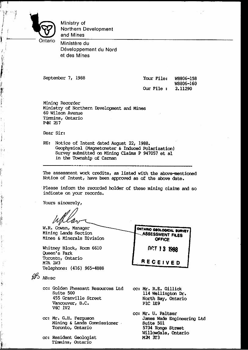
September 7, 1988 Your File: W8806-158 W8806-160
Our File : 2.11290
Mining RecorderMinistry of Northern Development and Mines60 Wilson AvenueTimmins, OntarioP4N 2S7
Dear Sir:
RE: Notice of Intent dated August 22, 1988.Geophysical (Magnetometer z Induced Polarization) Survey submitted on Mining Claims P 947057 et al in the Township of Carman
The assessment work credits, as listed with the above-mentioned Notice of Intent, have been approved as of the above date.
Please inform the recorded holder of these mining claims and so indicate on your records.
Yours sincerely,
W.R. Cowan, Manager Mining Lands Section Mines s Minerals Division
Whitney Block, Rocm 6610Queen's ParkToronto, OntarioM7A 1W3Telephone: (416) 965-4888
AB: se
cc: Golden Pheasant Resources Ltd Suite 500455 Granville Street Vancouver, B.C. V6C 1V2
cc: Mr. G.H. FergusonMining St Lands Commissioner Toronto, Ontario
cc: Resident Geologist rimmins, Ontario
ONTAWO OfOLOOICAl ASSESSMENT
OWCE
HOT J 3 1988
RECEIVED
cc: Mr. R.E. Gillick 114 Wellington Dr. North Bay/ Ontario PIC 1E9
cc: Mr. U. PaltserJames Wade Engineering Ltd Suite 501 5734 Yonge Street Willowdale, Ontario M2M 3T3
Ministry ofNorthern Development
inesOntario
an^Wir
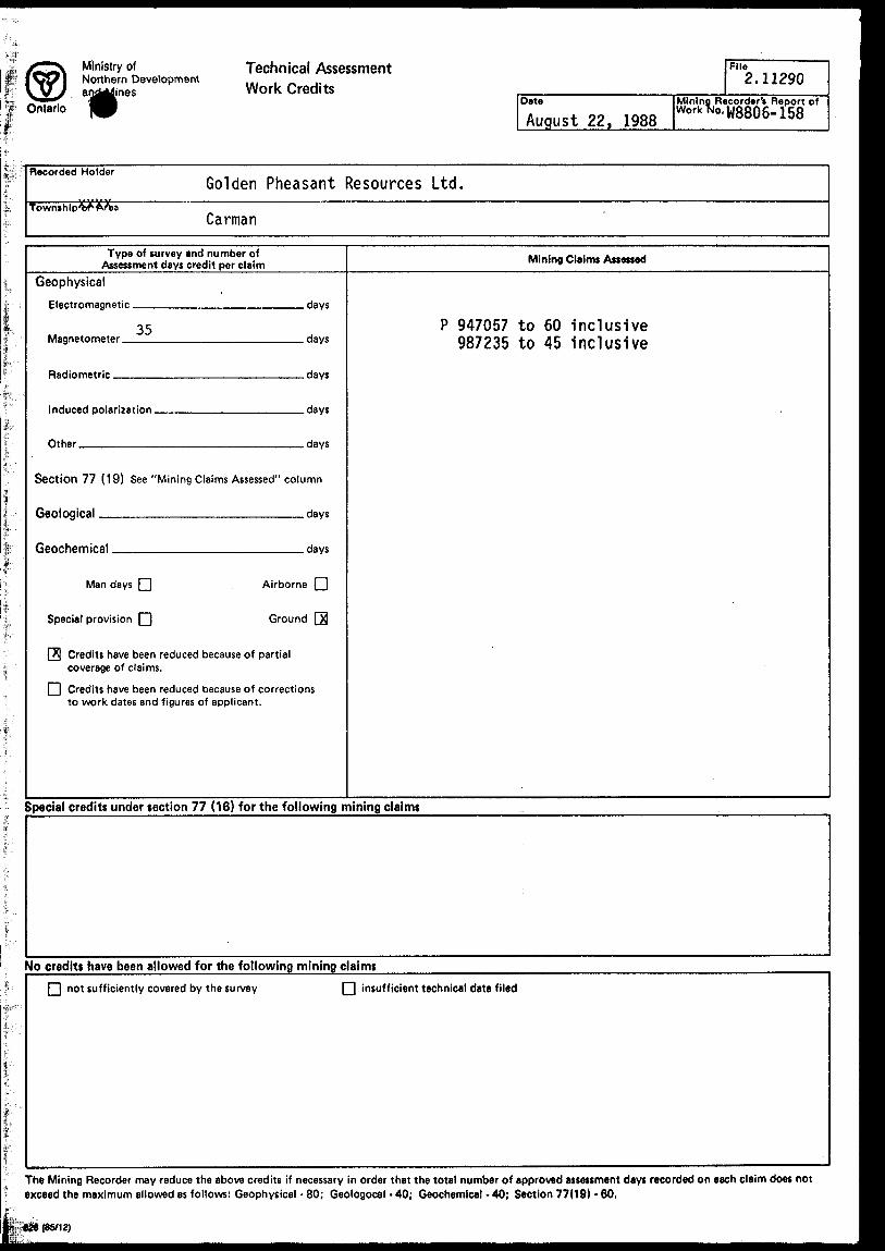
Technical Assessment Work Credits
Date
August 22, 1988
File2.11290
Mining Recorder's Report ofwork *o. W88o6- 158
Recorded HolderGolden Pheasant Resources Ltd.
Township'0^Carman
Type of survey and number of Assessment days credit per claim Mining Claims Assessed
Geophysical
Electromagnetic.
Magnetometer.
Radiometric —
35
Induced polarization.
Other.——————
.days
.days
.days
.days
.days
P 947057 to 60 inclusive 987235 to 45 Inclusive
Section 77 (19) See "Mining Claims Assessed" column
Geological _____________________days
Geochemical ________________ days
Man days | |
Special provision Q)
Airborne l l
Ground [53
|A| Credits have been reduced because of partial coverage of claims.
fi Credits have been reduced because of corrections to work dates and figures of applicant.
Special credits under section 77 (16) for the following mining claims
No credits have been allowed for the following mining claims
not sufficiently covered by the survey Q insufficient technical data filed
The Mining Recorder may reduce the above credits if necessary in order that the total number of approved assessment days recorded on each claim does not exceed the maximum allowed as follows: Geophysical - 80; Geologocal - 40; Geochemical - 40; Section 77(19) - 60.
l
. Ministry of Northern Development
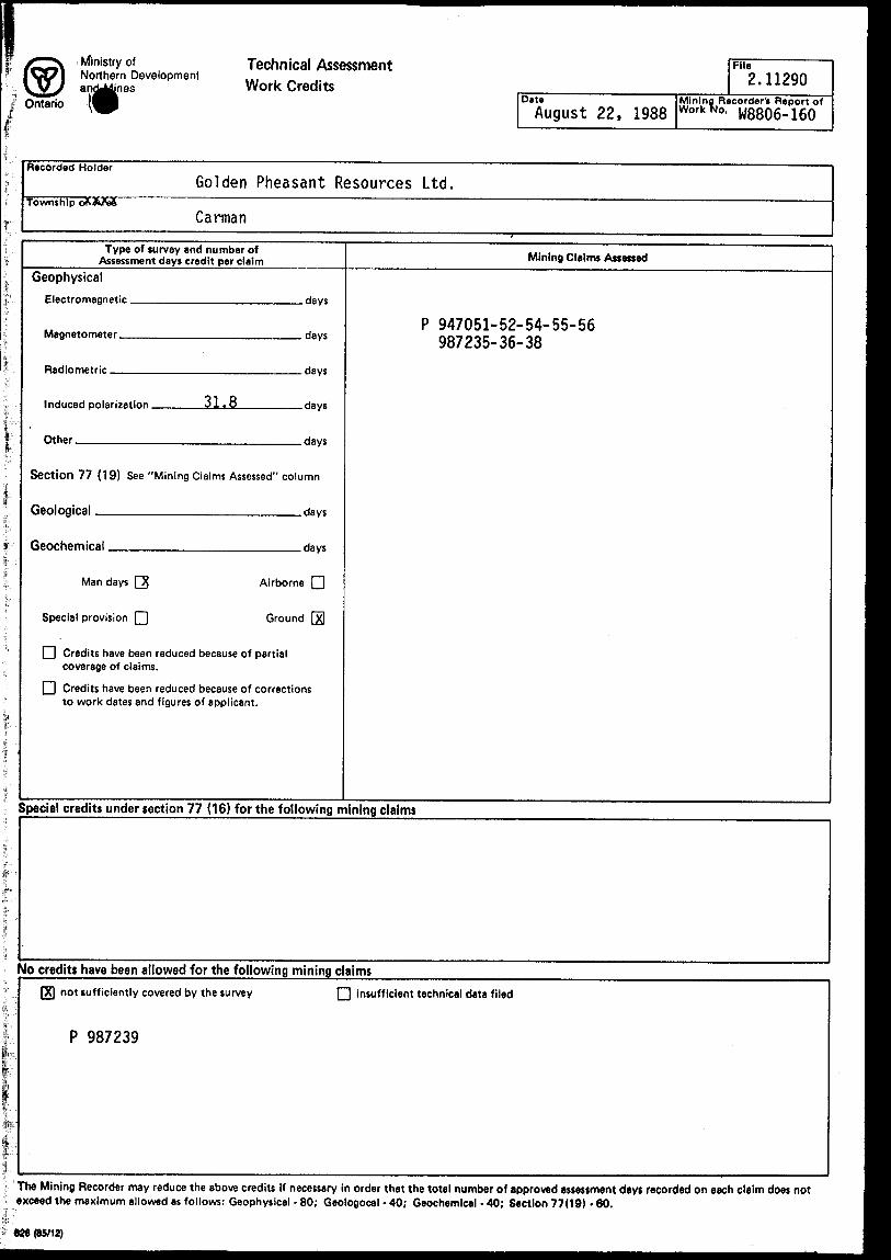
Ontario
Technical Assessment Work Credits
DateAugust 22,
File2.11290
Mining Recorder'* Report of1988 Work *Jo- W8806-160
Recorded HolderGolden Pheasant Resources Ltd.
Township oX&JtaSCarman
Type of survey and number of Assessment days credit per claim Mining Claims Assessed
GeophysicalElectromagnetic .
Magnetometer —
Radiometric ——
Induced polarization.
Other ^——————
31.8
.days
.days
.days
.days
.days
P 947051-52-54-55-56 987235-36-38
Section 77 (19) See "Mining Claims Assessed" column
Geological _________________days
Geochemical _________________ days
Man days
Special provision
Airborne l l
Ground fxl
l l Credits have been reduced because of partial coverage of claims.
[ l Credits have been reduced because of corrections to work dates and figures of applicant.
Special credits under section 77 (16) for the following mining claims
No credits have been allowed for the following mining claimsnot sufficiently covered by the survey
P 987239
insufficient technical data filed
The Mining Recorder may reduce the above credits if necessary in order that the total number of approved assessment days recorded on each claim does not - exceed the maximum allowed as follows: Geophysical - 80; Geologocal - 40; Geochemical - 40; Section 77(19)-60.
628 (85/12)
Ministry olNorthern Developmentand Mines
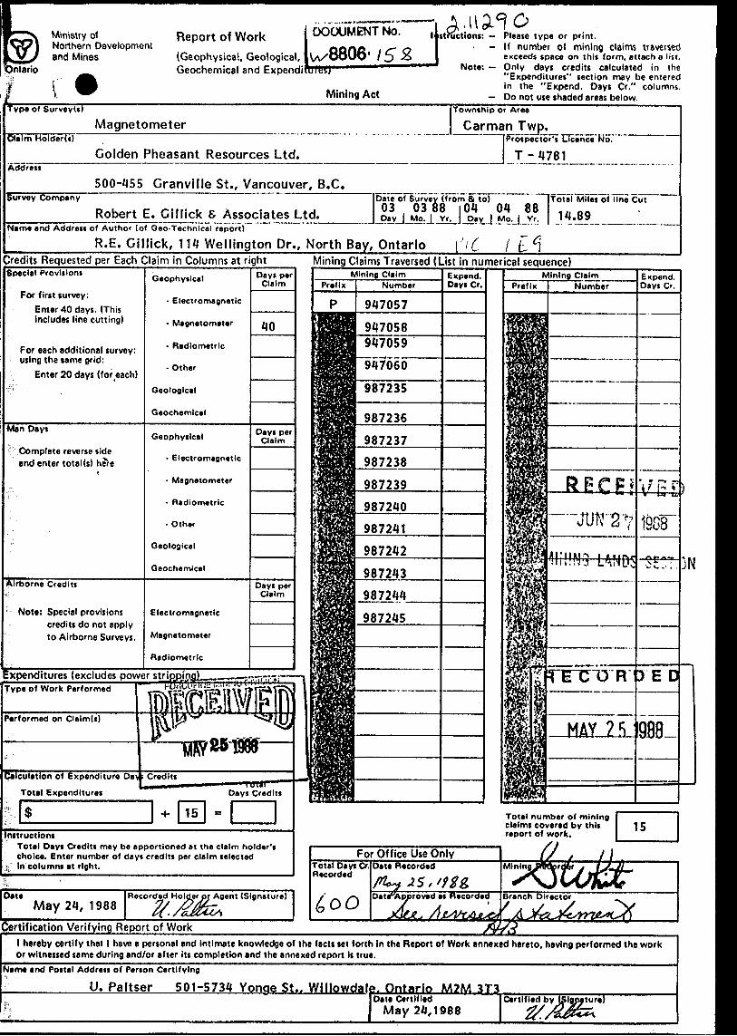
Ontario
Report of Work(Geophysical, Geological, Geochemical and Expend!
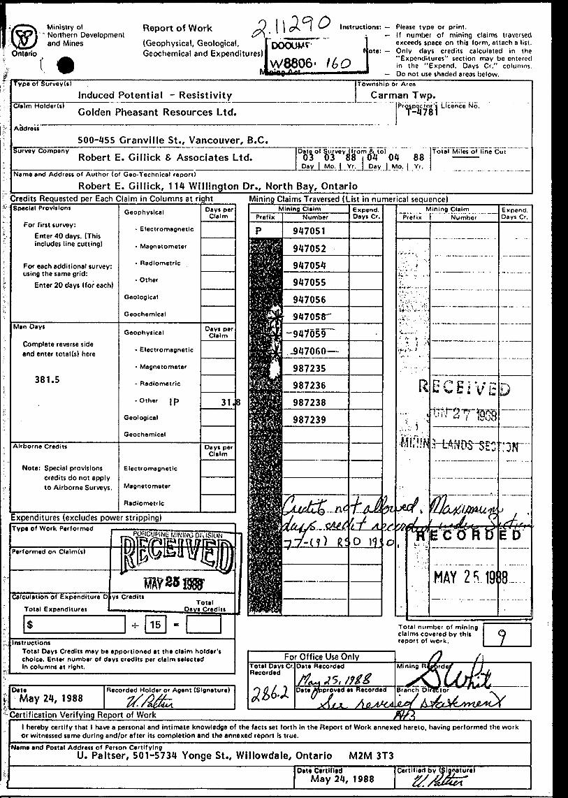
DOCUMENT No.
uiesj
Mining Act
structions: — Please type or print.- If number of mining claims traversed
exceeds space on this form, attach a list. Note: — Only days credits calculated in the
"Expenditures" section may be entered in the "Expend. Days Cr." columns.
- Do not use shaded areas below.vpe of SurvevU)
MagnetometerClaim HolderU)
Township or Araa
man Twp. _ _ -Prospector's Licence No.
Golden Pheasant Resources Ltd.Address
500-455 Granville St., Vancouver, B.C.urvev Company
Robert E. Gillick S Associates Ltd. ]Date of Survey (from fi to) " [Total Miles of lino Cut03 03 88 |04 01 88 ,, 0 0Day j Mo. | Yr.J Day | Mo.J Yr. | J. "'5™.__ —
•Jam* and Address of Author (of Geo-Technical report)
______R.E. Gillick, 114 Wellington Dr., North Bay, Ontario \ '\C l t- C\redits Requested per Each Claim in Columns at right Mining Claims Traversed (List in numerical sequence)pedal Provisions
For first survey:Enter 40 days. (This includes line cutting)
For each additional survey: using the same grid:
Enter 20 days (for each)
Mn Days
Complete reverse side and enter total(s) here
Airborne Credits
Note: Special provisions credits do not apply to Airborne Surveys.
:xpenditures (excludes power stripping!Type of Work Performed
'erformed on Clalm(s)
Calculation of Expenditure Day : Credits
Total Expenditures
Oat*May 24, 1988
Certification Verifying Report of Work
Electromagnetic
947058947059
Geophysical
- Electromagnetic
- Magnetometer
- Radiometric
- Other
Geological
Geochemical
987238
987239
Electromagnetic
Magnetometer
Radiometric
.TUT) R J'E
Total number of mining claims covered by this report of work.
For Office Use OnlyTotal Days Cr Recorded
Recorded Holder or Agent (Signature) Date-Approved as Hecoraea
iG/f ,
Branch Director
instructionsTotal Days Credits may be apportioned at the claim holder's choice. Enter number of days credits per claim selected
- In columns at right.
l hereby certify that l have a personal and intimate knowledge of the facts set forth in the Report of Work annexed hereto, having performed the work or witnessed same during and/or after its completion and the annexed report is true.
Jame and Postal Address of Person Certifying
_______U. Paltser 501-5734 Yonge St.. Willowdaie. Ontario M2M 3T3l Date Certified
May 24,1988Certified by (Signature)
Ministry o('* Northern Development
and Mines
. \ \ cA l
Ontario
Report of Work(Geophysical, Geological, f Geochemical and Expenditures)!
Jyffl806' H* Q..
Instructions: — Please type or prim.If number of mining claims traversed exceeds space on this form, attach a list. Only days credits calculated in the "Expenditures" section may be entered in the "Expend. Days Cr." columns. Do not use shaded areas below.
Note: -
Type of SurveyU)
Claim Holder(s)
Address
Survey Company
Name and Address
Township or Area
Induced Potential - Resistivity Carman Twp.Prospector's Licence No.
Golden Pheasant Resources Ltd. T-4781
500-455 Cranville St., Vancouver, B.C.Date of Survey (from ft lo) .. Total Miles of line Cut
Robert E. Cillick S Associates Ltd. 03 03 88 i OH OH 8 8 ———Day | Mo. | Yr. j Day | Mo. | Yr,
of Author (of Geo-Technical report)
Robert E. Gillick, 114 WIMington Dr., North Bay, OntarioCredits Requested per Each Claim in Columns at rightSpecial Provisions
For first survey:Enter 40 days. (This includes line cutting)
For each additional survey: using the same grid:
Enter 20 days (for each)
Man Days
Complete reverse side and enter total (s) here
381.5
Airborne Credits
Note: Special provisions credits do not apply to Airborne Surveys.
Geophysical
- Electromagnetic
- Magnetometer
- Radiometric
- Other
Geological
Geochemical
Geophysical
- Electromagnetic
- Magnetometer
- Radiometric
•Other jp
Geological
Geochemical
Electromagnetic
Magnetometer
Radiometric
Days per Claim
Days per Claim
31.
Days per Claim
Expenditures (excludes power stripping)Type Of Work Performed
InstructionsTotal Days Credits may be apportioned at the claim holder's choice. Enter number of days credits per claim selected In columns at right.
DateMay 2/1, 1988
Recorded Holder or Agent (Signature)
Mining Claims Traversed (List in numerical sequence)
Certification Verifying Report of Work Wlhereby certify that 1 have a personal and intimate knowledge of the facts set forth in the Report of Work annexed hereto, having performed the work
or witnessed same during and/or after its completion and the annexed report is true.Name and Postal Address of Person Certifying
U. Paltser, 501-5734 Yonge St., Willowdale, Ontario M2M 3T3Du* Certified
May 21, 1988Certified by
Ontario
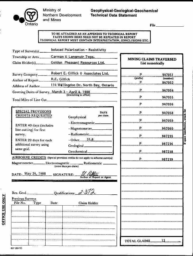
Ministry ofNorthern Developmentand Mines
Geophysical-Geological-Geochemical Technical Data Statement
File_
TO BE ATTACHED AS AN APPENDIX TO TECHNICAL REPORTFACTS SHOWN HERE NEED NOT BE REPEATED IN REPORT
TECHNICAL REPORT MUST CONTAIN INTERPRETATION, CONCLUSIONS ETC.
Type of Survey (s). Township or Area. Claim Holder(s)—
Induced Polarization - Resistivity
Carman S Langmuir Twps.——^— Golden Pheasant Resources Ltd.
Survey Company — Author of Report - Address of Author.
Robert E. Cillick 6 Associates Ltd. R.E. Gillick_________________ 114 Willingdon Dr. North Bay, Ontario
Covering Dates of Survey March 3 -April 4. 1988(linecutting to office)
Total Miles of Line Cut——————^^———^
SPECIAL PROVISIONS CREDITS REQUESTED
ENTER 40 days (includes line cutting) for first survey.ENTER 20 days for each additional survey using same grid.
DAYSGeophysical —Electromagnetic.
-Otr^r 31.8
AIRBORNE CREDITS (Special provision credits do not apply to airborne surveys)
Magnetometer. .Electromagnetic. . Radiometric(enter days per claim)
HATR. May 24, 1988 STHNATIIRR. ^/^fc~Author of Reporteport or Agent
Res. Geol. .Qualifications. c* '3 f 0\.
Previous Surveys File No. Type Date Claim Holder
MINING CLAIMS TRAVERSED List numerically
'(p'r'e'fix)'
......JR.,
947051•••••••••i (T* c* l *T*T* l*****t***
(number)
.J?............
P
947054•i* •*4****rfl*7 •**Trrt*** *
947055
947056
947058
947059
.mm..
.887235..P.....................88723S..........P......................887238..........P.......................887238.........
i
l
TOTAL CLAIMS. 12
837 (85/12)
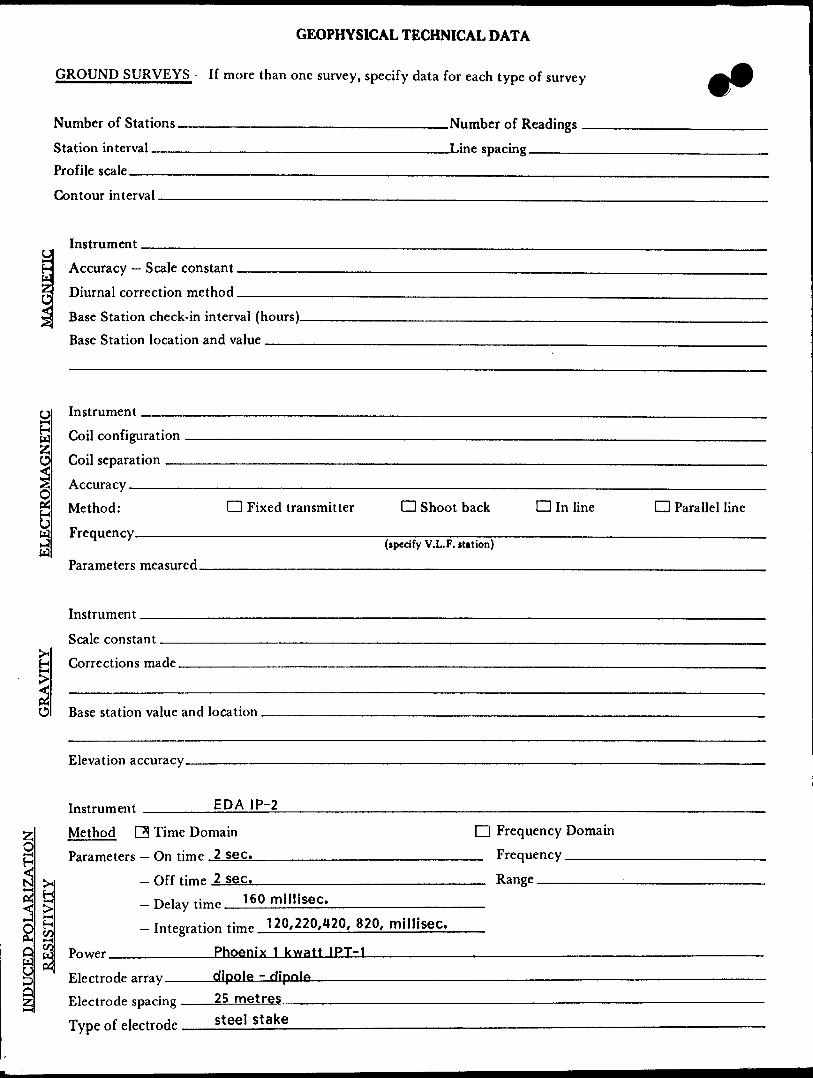
GEOPHYSICAL TECHNICAL DATA
GROUND SURVEYS — If more than one survey, specify data for each type of survey
Number of Stations ————————————————————————Number of Readings — Station interval___________________________ I.in p spacing^-—-^— Profile scale————-^^^—————.—.————...————-—.——-—.—————-Contour interval.
Accuracy — Scale constant. Wl
Nerf
p—^
Sa z
H
00tL
erf
Instrument.
Diurnal correction method.Base Station check-in interval (hours). Base Station location and value ———.
Instrument
ECTROMAGNETK Tr.il rnnfigiiratinn
Toil spparatinn
Arrnrary
Method: O Fixed transmitter O Shoot back D In lineFrprmpnry
CD Parallel line
Parameters measured.
Instrument.Scale constantCorrections made.
O Base station value and location.
Elevation accuracy.
Instrument _______EDA \ P~2Method Q Time Domain D Frequency Domain Parameters - On time 2 sec. ______________________ Frequency —————
- Qff timp 2 sec.______________________ Range.- Delay tim,. 160 millisec._____________- Integration tim^ 120,220,420, 820, millisec.
Power__________Phoenix 1 kwatt IPT-1
Electrode array ____dipole - dipoleElectrode spacing 25 metresType of electrode steel stake
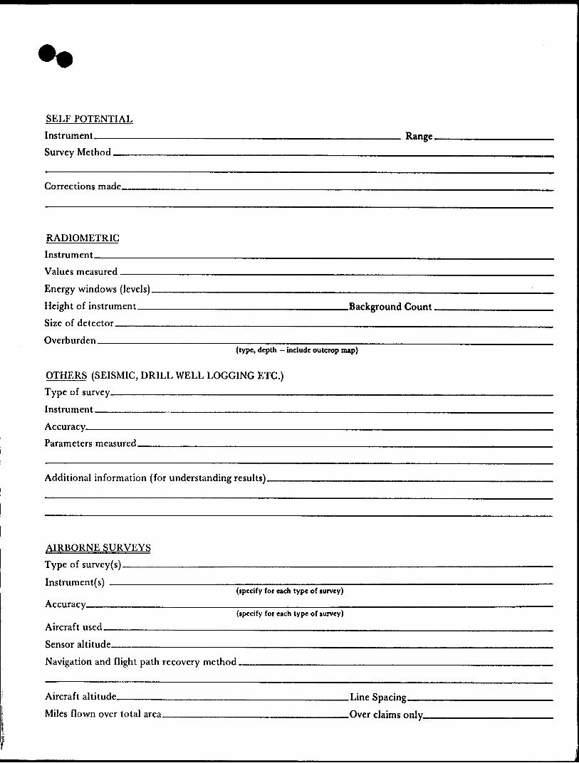
SELF POTENTIALInstrument.——-——————————.^^^—————————————^———^—^— Range.Survey Method ————^————-————————-^—^———^—-—-———-————
Corrections made.
RADIOMETRICInstrument.
Values measured.Energy windows (levels)^^———————^^^^——————-—^-^———..^—^—...—...—— Height of instrument—-——^—————-—^.^——————.———Background Count.Size of detector——-——-————-^^^^———————-^———.-—.^^-—.....^^—Overburden ——-——————^-———-——.^^-——————.——^——.-—.—————
(type, depth — include outcrop map)
OTHERS {SEISMIC, DRILL WELL LOGGING ETC.)Type of survey———^^^^——————————————Instrument ——^—^—-——————————.^^^—Accuracy——————————————————————^-^^—Parameters measured.
Additional information {for understanding results).
AIRBORNE SURVEYS Type of survey(s) ———
Instrument(s) —————(specify for each type of survey)
Accuracy^^——————————^.———(specify for each type of survey)
Aircraft used———————-———...^——..-——^-——————...—-Sensor altitude-Navigation and flight path recovery method.
Aircraft altitude______________________________Line Sparing Miles flown over total area-——-———^^^————^-^^————.—.—^Over claims only.
GEOCHEMICAL SURVEY - PROCEDURE RECORD
Numbers of claims from which samples taken.
Total Number of Samples. Type of Sample.
(Nature of Material)Average Sample Weight——————— Method of Collection————————
Soil Horizon Sampled. Horizon Development- Sample Depth———— Terrain————————
Drainage Development———————————— Estimated Range of Overburden Thickness.
ANALYTICAL METHODSValues expressed in: per cent
p. p. m. p. p. b.
D D D
Cu, Pb, Zn, Ni, Co, Ag, Mo, As,-(circle)
Others __________________________Field Analysis (-
Extraction Method. Analytical Method- Reagents Used ——
Field Laboratory AnalysisNo. __________
SAMPLE PREPARATION(Includes drying, screening, crushing, ashing)
Mesh size of fraction used for analysis-———
Extraction Method. Analytical Method. Reagents Used.——
Commercial Laboratory (- Name of Laboratory— Extraction Method——. Analytical Method —— Reagents Used -———
.tests)
.tests)
.tests)
General General.
Ministry ofNorthern Developmentand Mines
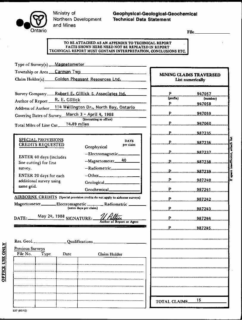
Ontario
Geophysical-Geological-Geochemical Technical Data Statement
File.
Type of Survey(s
Township or Area
Claim Holder(s)
Survey Company
Author of Report Address of Autho
Covering Dates ol
Total Miles of Lin
TO BE ATTACHED AS AN APPENDIX TO TECHNICAL REPORT FACTS SHOWN HERE NEED NOT BE REPEATED IN REPORT
TECHNICAL REPORT MUST CONTAIN INTERPRETATION, CONCLUSIONS ETC.
MagnetometerCarman TwpGolden Pheasant Resources Ltd.
Robert E. Gillick S Associates ltd.R. E. Gillick
r 114 Wellington Dr., North Bay, OntarioSurvey March 3 - April 4, 1988
e r,,t 14.89
SPECIAL PROVISIONS CREDITS REQUESTED
ENTER 40 days (includes line cutting) for first survey.
ENTER 20 days for each additional survey using same grid.
((incoming to office)miles
DAYS- i-i per claim Geophysical— Rlprtrnmagnptir
— Mngnetnm^trr 40
—Radiometric-Cttbrr
Opnlnpiral
fjporripmiral
AIRBORNE CREDITS (Special provision credits do not apply to airborne turveyi)
Magnetometer.-™ V.lfrtmmaonf.tir RaHinmptrir
DATF, MaY
Res. Geol.
Previous Surveys
(enter days per claim)
24, 1988 sinNATITRF . J^2fcAuthor of Report or Agent
Qualifications
File No. Type Date Claim Holder
MINING CLAIMS TRAVERSED List numerically
P(prefix) P
••*tt*******)*****t********i***
• •••••••••••••••^••••••••(•••••*
..............P..............
............P...............
..............P...............
..............P.............
..............P..............
...............P..............
..............P..............
..............J?..............
..............P..............
..............J?.....,.......
f
917057(number)
........9.4.7.0.5.8..............947059* i * * * * i *T* * *l *T*TtT* •••••••••••••t
t * * * * t * •T*V*I •V*V*V* ••••••••••••i*
.......J&AmS...............
.......JMI1723U6...............
.......A&7.237...............
.......3-8.72.i8..............
007070
987240• ••••i* i M? ufA *T* * * T * •••••••••••••*
987241• **tit**X*T*f •T*7*lti**i*****t ****
887:242********C *T *\ JT. /^t •••••••••••••*
987243
557244987245
TOTAL CLAIMS 15
i
d
{S3
837 (85/12)

GEOPHYSICAL TECHNICAL DATA
GROUND SURVEYS — If more than one survey, specify data for each type of survey
Number of Stations ——1^8__________________ Nnmhpr of Readings — Station interval———25 metres______________Lme spacjng______100 metres Profile scale_____________________________—^——-—^--————,..—— Contour interval _____100 gammas—.————..————..—-————.—-————___
Instrument______EDA OMNI IVUHH
ZDiurnal correction method recording base station
Ogg**H
Si-)
O
Base Station check-in interval (Hours) N/ABase Station location and value _____N/A
Instrument
Coil configuration ________________________________________________———— Coil separation ———————————————————————————————————————————————————__^_ Accuracy __________________________________________________________. Method: O Fixed transmitter CD Shoot back CD In line D Parallel lineFrequency
(specify V.L.F. itation)
Parameters measured.
Instrument.Scale constantCorrections made.
Base station value and location.
Elevation accuracy.
Instrument ———————————————————————————————————————————— Method D Time Domain CD Frequency Domain
QP Parameters - On time ._________________________ Frequency —————
2C pq Power.
Electrode array.
—Off time__________________________ Range.— Delay time —-——————————————————————— Integration time ————————————————————
Electrode spacing . Type of electrode .
SELF POTENTIALInstrument———————————————————————————————————————— Range.Survey Method —————-———^^—^——.^—————.^—-———-^——————.-———
Corrections made.
RADIOMETRICInstrument.Values measured.
Energy windows (levels)—.—.-————.^^^—^————^—...————^^^—^——.....—-Height of instrument____________________________Background Count, Size of detector-—————-——-—-—————-^^^^—————————————^^————Overburden ———————^^-————-^—^^————..——.^^.^————————.————
(type, depth — include outcrop map)
OTHERS (SEISMIC, DRILL WELL LOGGING ETC.) Type of survey———^——————————^^^^^^^^— Instrument ———-—————————————.———
Accuracy__________________________Parameters measured.
Additional information (for understanding results).
AIRBORNE SURVEYS Type of survey(s)———
Instrument(s) —————(specify for each type of survey)
Accuracy——————————-^—-^—(specify for each type of survey)
Aircraft used.____________________________———Sensor altitude—————————^^———— Navigation and flight path recovery method.
Aircraft altitude______________________________Line Sparing Miles flown over total area————————————————————..-—Over claims only.
GEOCHEMICAL SURVEY - PROCEDURE RECORD
Numbers of claims from which samples taken.
Total Number of Samples. Type of Sample.
(Nature of Material)Average Sample Weight——————, Method of Collection————————
Soil Horizon Sampled. Horizon Development- Sample Depth———-— Terrain————————
ANALYTICAL METHODS Values expressed in: per cent
p. p. m. p. p. b.
D Dn
Cu, Pb,
Others_
Zn, Ni, Co, Ag, Mo, As,-(circle)
Field Analysis (~
Drainage Development——————————— Estimated Range of Overburden Thickness.
Extraction Method. Analytical Method- Reagents Used ——
Field Laboratory AnalysisNo. ——-———.^—
SAMPLE PREPARATION(Includes drying, screening, crushing, ashing)
Mesh size of fraction used for analysis ————
Extraction Method. Analytical Method . Reagents Used .——
Commercial Laboratory (. Name of Laboratory— Extraction Method—— Analytical Method ——Reagents Used ————
.tests)
.tests)
.tests)
GeneraL General.

Ministry oiNorthern Development
MinesOntario
AssessmentWorkBreakdown
1. Type of Survey ..
2. Township or Area
3. Numbers of Mining Claims Traversed by Survey
...................MI^J....^?.0.5.6._.......?5Z?5?...-??Z95?
947054947059
..
4. Number of Miles of Line Cut .....................j. Flown . .......................
*5. Number of Stations Established . ...........................................^.^.........
*6. Make and type of Instrument Used ......................................................
*7. Scale Constant or Sensitivity .....................................^...............^...
*8, Frequency Used and Power Output ...........................................*...........
9. Summary of Assessment Credits (details on reverse side)
Total 8 hour Technical Days (Include Consultants, Draughting etc.) .,.................
Total 8 hour Line-Cutting Days...................
Calculation
54.4 x 7 - 381.5 H- _________ - 381.5 -i. JjJ_____ - 31.8^^^^^^ Technical Line-cutting Number Assessment 'credits
This is the fraction of the survey applicable to claims listed. o f clalms Per claim
The dates listed on this form represent working time spent entirely within the' limits of the above listed claims {1 Check If otherwise, please explain .....^.^
Dated-. ....My.34^X0-.-.-.-..-.. S igned:
Note: (A) * Complete only if applicable.(B) Complete list of names, addresses and dates on reverse side.(C) Submit separate breakdown for each type of survey.(D) Submit in duplicate.
827 (8BH2)
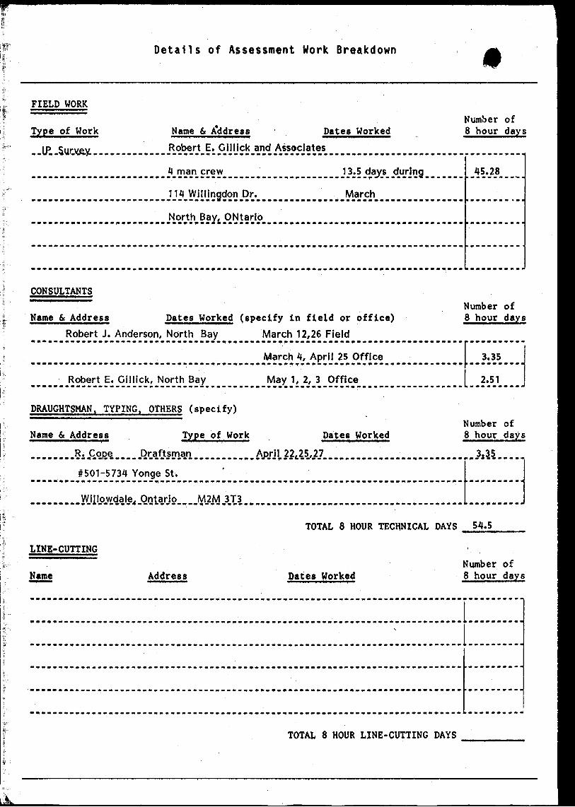
Details of Assessment Work Breakdown
FIELD WORK
Type of Work Name 6 A*ddress Dates WorkedNumber of 8 hour days
45.28*m . *M*WM.Wv*l.**M* .
March• ••••^•^•••••^•••••••••••••••^•^•••••••••^•••••^••••••••••••i
CONSULTANTSNumber of
Name 6c Address Dates Worked (specify in field or office) S hour daysRobert J. Anderson, North Bay March 12,26 Field
___....,.._... _,. ,._ , .J^ar^^APriI .25.P-ffI^
____ Robert E. Gillick, North Bay May 1, 2 , 3 Office 2.51
DRAUGHTSMAN. TYPING. OTHERS (specify)Number of
Name 6 Address Type of Work Dates Worked 8 hour days
n
#501-5734 Yonge St.
TOTAL 8 HOUR TECHNICAL DAYS 54.5
LINE-CUTTINGNumber of
Name Address Dates Worked 8 hour days
TOTAL 8 HOUR LINE-CUTTING DAYS
MAP' SYMBOLOGY' V CODY TWP.' '^ | h - -*T
Avrrol CoblBwoi' .--i^-—!
"B -^ Bridg*
Con ir o rPo i ut t **i|j. J.'JU1
i J^' 1 ''l*jj' '•F*OO-WK '
. Culv4ffV*i:,'-V'f itV
Faiu.^/^^.;^.^^:^;^
. Ftatyrt Ovtlin* 1' --(t*n*tr*tt!*t (****r**, M*.* f - A, i:-1 ' , y Ctt-r. . - - ^ \i,s! -- 1
FlowHd LqndM r-' ' —— '
Marsh•^- ; A *" -**
:V,vast '. f. /-:7v^srO"5MU* Htud From* *a*u:ty(. Outcrop:-;'; 'j" ' r'ti^tS 1.- -'
*-"- i**9t'bl* F?S*p||-r ;--
-V
i Pip*liB*
Rood.
fftinMot ^TT**nH j, ^
-•It* M*tt*4*
RiHrvoir
River, Sliw. AtpTMHM**- :
*******l- "s. '^trMfttv* ** •*** -
.Spot El*v*1ton
. Tran4iBiuiOT
- - ^
"Altilfll Pol** ^ ' Wrmrf-.Dock. Pi*r
Woodtd ATM! .. .
AREAS WITHDRAWN FROM DISPOSITION
M.R.O. - MINING RIGHTS ONLY
S.R.O. -SURFACE RIGHTS ONLY
M.+ S. - MINING AND SURFACE RIGHTS
, OtfvrNo. Dmtm DbpovtM Fi**
\
42A06NE0280 2.11290 CARMAN
MOOSE ISLAND
CROW ISLAND
l X 969946 ' . X l 969947
- -L "/-J—
ir——— - — — -*\— ——
P~* \ ' P
NIGHT HAWK LAKE.
r
LANGMUIR TWP.
LEGENDHIGHWAY AND ROUTE No.OTHER RCJADSTRAILS ~SURVEYED LINES:
TOWNSHIPS, BASE LINES, ETC. — LOTS, MINING CLAIMS, PARCELS. ETC.
UNSURVEYED LINES:LOT LINES — PARCEL BOUNDARY - MINING CLAIMS ETC- -
RAILWAY AND RIGHT OF WAY -*-
UTILITY-LINES -* NON-PERENNIAL STREAM - FLOODING OR FLOODING RIGHTS SUBDIVISION OR COMPOSITE PLAN RESERVATIONS ORIGINAL SHORELINE MARSH OR MUSKEG MINES TRAVERSE MONUMENT
DISPOSITION OF CROWN LANDS
TYPE OF DOCUMENT SYMBOL
PATENT, SURF ACE 81 MINING RIGHTS ___________ 9" .SURF ACE RIGHTS ONLY ___________ —— O" .MINING RIGHTS ONLY ____ . __________ O
LEASE, SURFACE 4 MINING RIGHTS- ———— ______ H" .SURFACE RIGHTS ONLY ______________ H" .MINING RIGHTS ONLY. _______________ B
LICENCE OF OCCUPATION . ___ . _____________ TORDER-IN-COUNCIL . ____________________ OCRESERVATION ____________ L ____________ ©
CANCELLED ______________________ . __ 9SAND ft GRAVEL __ . ___ . _ . ______________
MOTE: MINING RIGHTS IN PARCELS PATENTED PRIOR TO MAY C, 1913, VESTED IN ORIGINAL PATENTEE BY THE PUBLIC LANDS ACT. R -S -O. 1VTO, CHAP. 3*O. SEC. A3. SUB* EC 1.
MChain*
20W
t ^.,'
SCALE 1:20 000
GRID Z ONE: 17
g————
TOWNSHIP
CARMANM.N.R. ADMINISTRATIVE DISTRICT
TIMMINSMINING DIVISION
PORCUPINELAND TITLES/ REGISTRY DIVISION
COCHRANE
Ontario
Ministryof LandNatural Management
Resources Branch
SORIGINAL COMPILATION JULY'1964
REVISED:
•••bar
G-4000
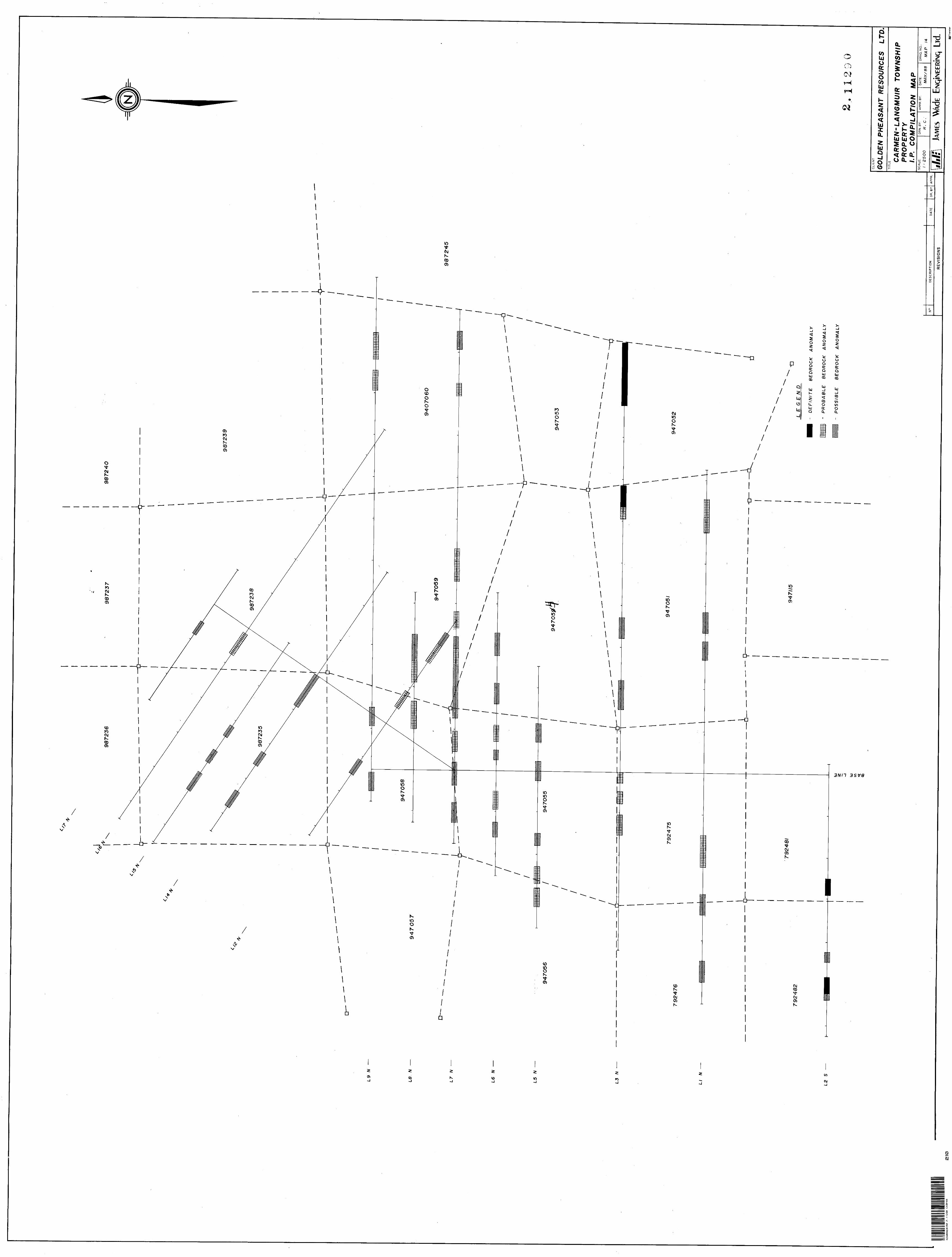
9872
4O
L9
/V
—
L8
N
—947057
L7
W
L6
W
——
L5
N
L3
N
LI
N
L2
S
n_ _
_ _
. _ —
9872
^45
DE
FIN
ITE
B
ED
RO
CK
A
NO
MA
LY
- P
RO
BA
BLE
B
ED
RO
CK
A
NO
MA
LY
- P
OS
SIB
LE
B
ED
RO
CK
A
NO
MA
LY
1! 1
.* JL
A
NO-
DE
SC
RIP
TIO
ND
ATE
DR
. B
YA
PPR
.
RE
VIS
ION
S
CLIE
NT
GOLDEN PHEASANT RESOURCES
LTD.
TIT
LE
CA
RM
EN
'LA
NG
MU
IR
TO
WN
SH
IPP
RO
PE
RT
Yl.P
. C
OM
PIL
AT
ION
M
AP
SCA
LE:
; -- 25
ooD
RN
. B
Y:
R.
C ,
AP
PR
. BY
:D
ATE
:
MA
Y/8
8D
RN
G.
NO
.:
MA
P
14
ilil;
JAME
S W
\de
Lid.
42A06NE0280 2.11290 CARMAN
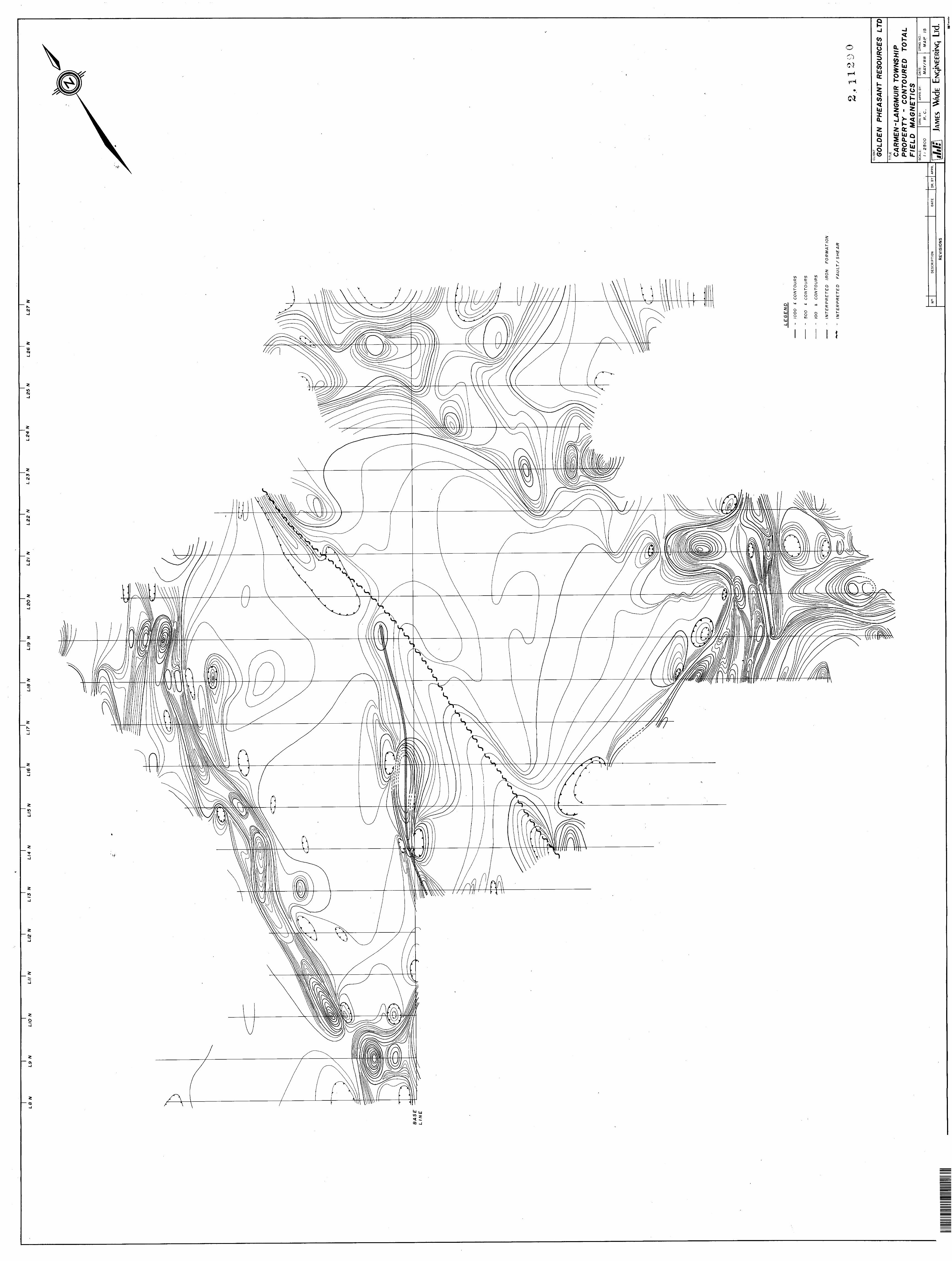
L8
NL
9 N
UO
NL
il N
LI2
NL
13
NLI4
N
LI5
NLIB
NLIT
NLI8
NLIB
N
L20 N
LS
I N
L22
NL
23 N
L 2
4 N
L25 N
L2
6 N
L27 N
BA
SE
L
INE
LE
GE
ND
- 10
00
* C
ON
TO
UR
S
- 5
00
*
CO
NT
OU
RS
- IO
O
5 C
ON
TO
UR
S
- IN
TE
RP
RE
TE
D
IRO
N
FO
RM
AT
ION
~ IN
TE
RP
RE
TE
D
FA
UL
T/S
HE
AR
O
13 l
9 Q
O
JL
** ^
~
DE
SC
RIP
TIO
ND
ATE
DR
. B
YA
PPR
.
RE
VIS
ION
S
CLI
EN
T
GO
LDE
N
PH
EA
SA
NT
RES
OU
RC
ES
LTD
TITL
E CA
RM
EN
-LA
NG
MU
IR T
OW
NS
HIP
P
RO
PE
RT
Y
- C
ON
TOU
RE
D
TOTA
L F
IEL
D
MA
GN
ET
ICS
SC
ALE
:
l ' 2
500
DR
M.
BY
:
R.
C.
AP
PR
. BY
:D
ATE
:
MA
Y/8
8D
RN
G.
NO
.:
MA
P
15
ilil:
\ JA
MES
W\c
kLi
d. (UJT
rins
lir
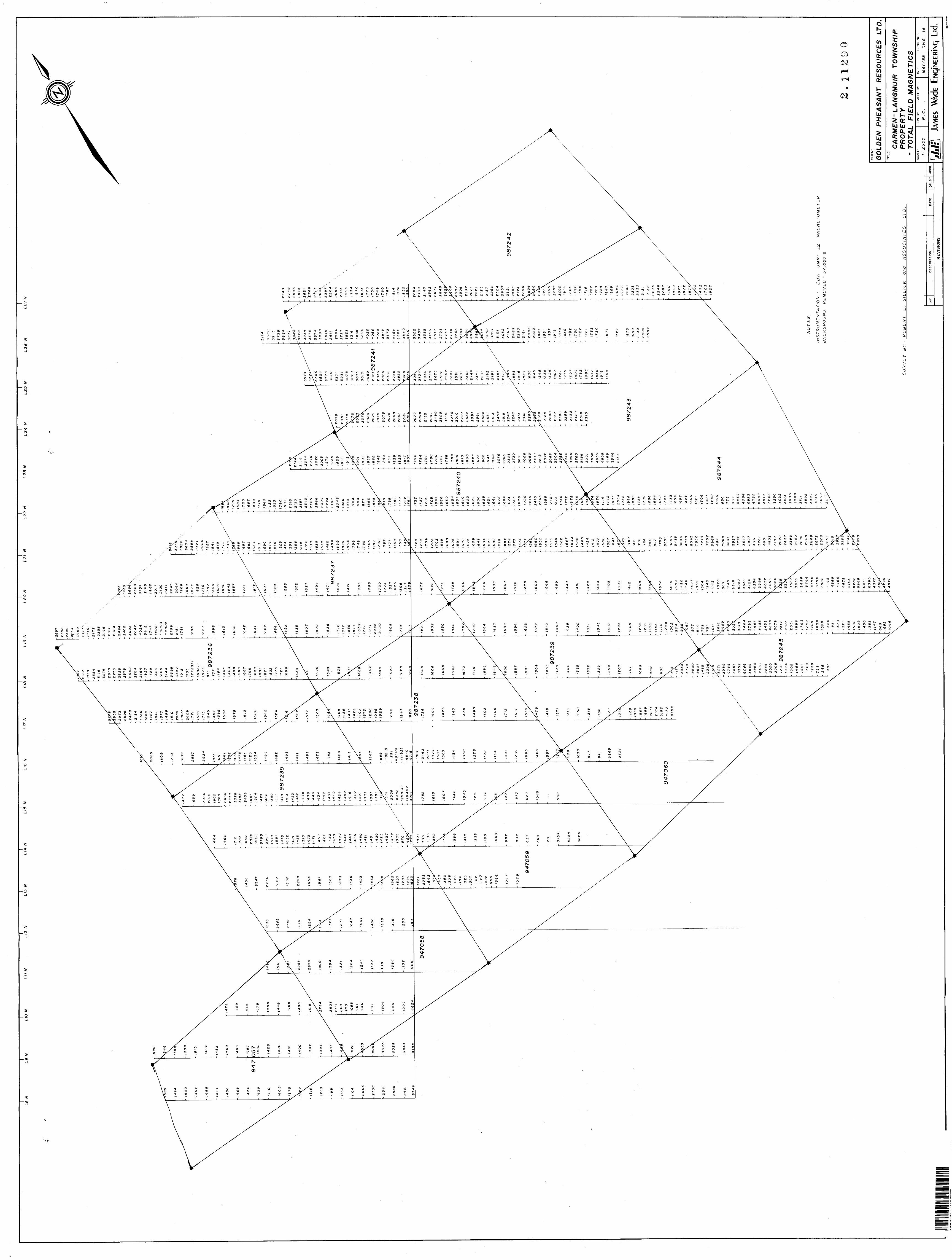
LS N
L9
NLI
O N
Lil N
\LI2
N
\L1
3 N
LI4
N\
LI5
N
L16
NL
IT N
LI8
N
\LI9
NL
2O N
L2I
NL
22
NL
23
NL
24
N
L2
5
NL
26
NL27 N
h '7
9, 9
87
24
5
NO
TE
S
INS
TR
UM
EN
TA
TIO
N
- E
DA
O
MN
I JZ
M
AG
NE
TO
ME
TE
R
BA
CK
GR
OU
ND
R
EM
OV
ED
-
57,0
00
X
O
SU
RV
EY
B
Y -
- R
OB
ER
T
E.
GIL
LIC
K
and
AS
SO
CIA
TE
S
LT
D.
No.
DE
SC
RIP
TIO
ND
ATE
DR
. B
YA
PPR
.
RE
VIS
ION
S
CLI
EN
T
GO
LDE
N
PH
EA
SA
NT
RE
SO
UR
CE
S
LTD
.T
ITLE
CA
RM
EN
" LA
NG
MU
IR
TOW
NS
HIP
P
RO
PE
RT
Y
- TO
TAL
FIE
LD
MA
GN
ET
ICS
SC
ALE
:
t -- 2500
DR
N.B
Y:
R.
C.
AP
PR
. BY
:D
ATE
:
MA
Y/6
8
DR
NG
. N
O.;
DW
G.
16
ilil:
JAME
S W
\dE
Lid. fll
JTra
nsla
r