Embed Size (px)
Citation preview
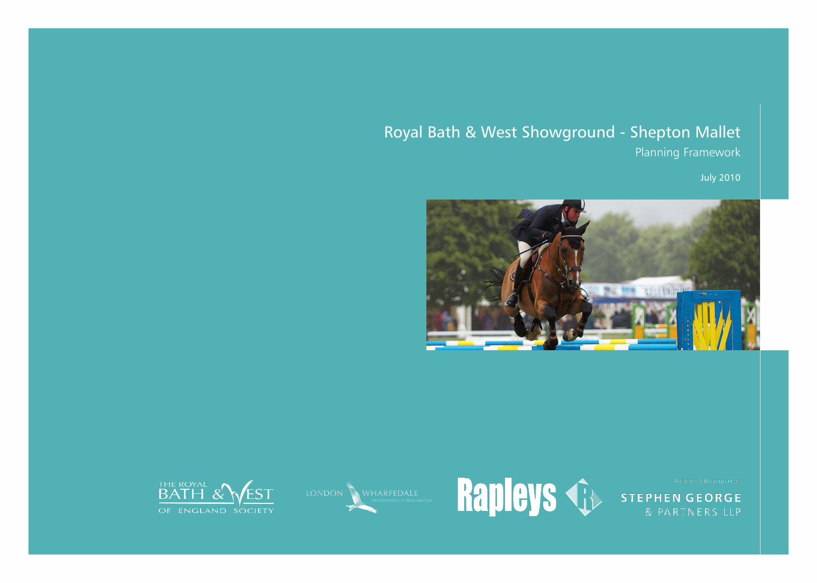
Royal Bath & West Showground - Shepton MalletPlanning Framework
July 2010
2 �
Contents
12. Infrastructure Services 12.1 Introduction
12.2 Details of survey
12.3 Impacts and Mitigation
12.4 site Capacity to Accommodate Additional services
1�. Archaeology13.1 Introduction
13.2 summary of Desktop Assessment Findings
13.3 Mitigation
14. Sustainability 14.1 Renewable energy Policy
14.2 Renewable energy at the showground
14.3 sustainability Measure
15. The Masterplan15.1 objectives
15.2 summary of opportunities and Constraints
15.3 the Concept Proposals
15.4 Design and Built Form
16. Phasing 16.1 Phasing Considerations
16.2 Indicative timescales
17. References
Appendices
1. statement of Consultation prepared by Rapleys dated July 2010
2. List of events at the showground during 2009
3. economic Impact Assessment executive summary prepared by Roger tym
2005
4. tree survey prepared by J Lang-Brown, dated April 2010
5. Baseline Habitat Assessment, April 2010
6. Accessibility and Car Parking Assessment by Mayer Brown Ltd, dated May
2010
7. Flood Risk Assessment prepared by eWe Associates Ltd, dated May 2010
8. environmental Desk top study prepared by Rodgers Leask environmental Ltd,
dated 13 April 2010
9. Report on Flood Risk and Drainage strategy prepared by Rodgers Leask Ltd,
dated April 2010
10. Report on Infrastructure services prepared by Rodgers Leask, dated April
2010
11. An Archaeological Desktop Assessment by R.A. Broomhead
12. solar Photovoltaic Feasibility Brief prepared by ecofirst, dated 8 April 2010
RoyAL BAtH & West sHoWgRounD - sHePton MALLet | STePhen GeoRGe & PARTneRS llP
1. Introduction1.1 Purpose of the Planning Framework
1.2 the society
1.3 London & Wharfedale
1.4 the society’s Vision & Future objectives
1.5 Improvement Proposals
1.6 Masterplan
1.7 the Consultant team
1.8 structure of the Report
2. The Showground 2.1 the event
2.2 other events and uses
2.3 Range of existing uses
�. The Site and Surroundings3.1 site Location
3.2 Description of the showground
3.3 Rights of Way and Way Leaves
3.4 ownership
3.5 shepton Mallet
4. Planning history 4.1 Introduction
4.2 Buildings and Restrictions
4.3 existing Lawful use
5. Planning Policy Context5.1 Introduction
5.2 the Development Plan
5.3 national Policy
5.4 other Material Considerations
5.5 Policy Discussion
5.6 Conclusion
6. economic Appraisal6.1 Introduction
6.2 the economic Context
6.3 economic Impact of the showground
6.4 summary of economic Impact of Improvement Proposals
7. ecology 7.1 Introduction
7.2 tree survey
7.3 Baseline Habitat Assessment
8. landscape and Visual Impact 8.1 Relevant Policy Designations
8.2 Key Views
8.3 Mitigation
9. Accessibility and Transport 9.1 Introduction
9.2 Accessibility of the showground
9.3 site Accesses
9.4 Internal Circulation and Parking
10. Flood Risk and Drainage 10.1 Introduction
10.2 Baseline Conditions
10.3 Flood Risk and Mitigation
10.4 surface Water Drainage
10.5 Foul Water Drainage
11. Ground Conditions and Contamination 11.1 Introduction
11.2 summary of Findings
ContentsSTePhen GeoRGe & PARTneRS llP | RoyAL BAtH & West sHoWgRounD - sHePton MALLet
4 5
RoyAL BAtH & West sHoWgRounD - sHePton MALLett | STePhen GeoRGe & PARTneRS llP
1. IntRoDuCtIon1. IntRoDuCtIon
1 InTRoDUCTIon
1.1 PURPoSe oF The PlAnnInG FRAMeWoRK
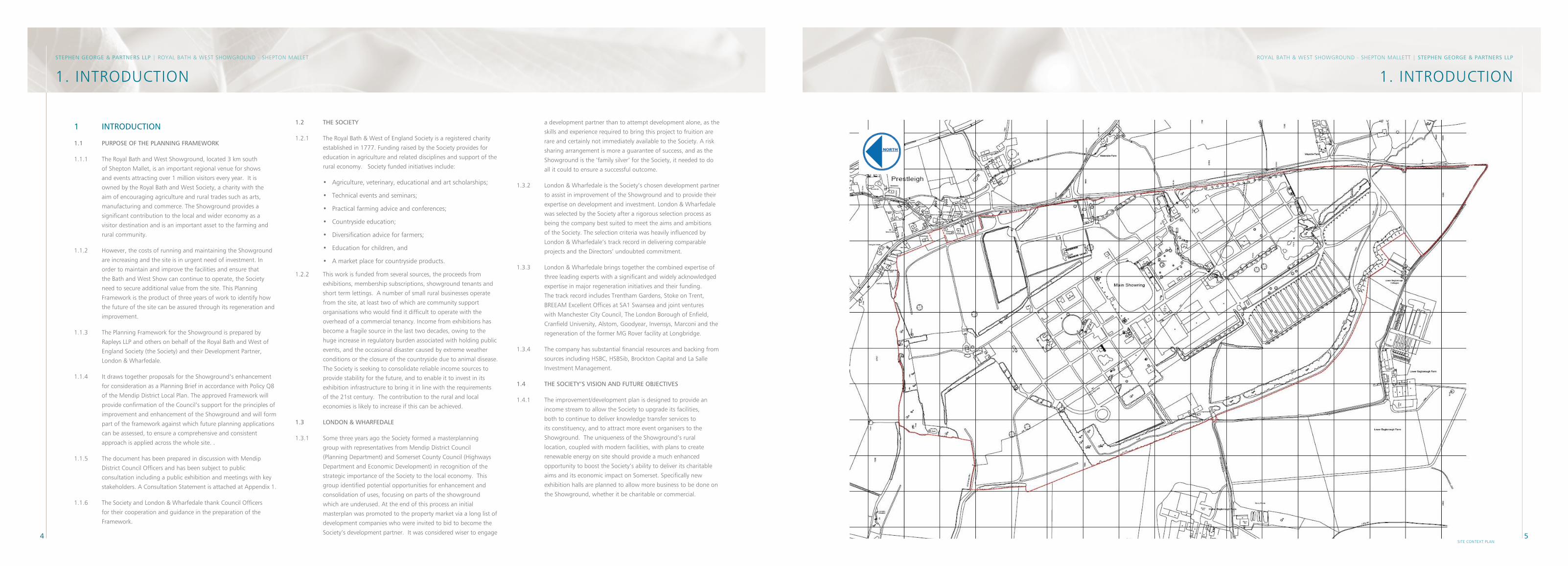
1.1.1 the Royal Bath and West showground, located 3 km south
of shepton Mallet, is an important regional venue for shows
and events attracting over 1 million visitors every year. It is
owned by the Royal Bath and West society, a charity with the
aim of encouraging agriculture and rural trades such as arts,
manufacturing and commerce. the showground provides a
significant contribution to the local and wider economy as a
visitor destination and is an important asset to the farming and
rural community.
1.1.2 However, the costs of running and maintaining the showground
are increasing and the site is in urgent need of investment. In
order to maintain and improve the facilities and ensure that
the Bath and West show can continue to operate, the society
need to secure additional value from the site. this Planning
Framework is the product of three years of work to identify how
the future of the site can be assured through its regeneration and
improvement.
1.1.3 the Planning Framework for the showground is prepared by
Rapleys LLP and others on behalf of the Royal Bath and West of
england society (the society) and their Development Partner,
London & Wharfedale.
1.1.4 It draws together proposals for the showground’s enhancement
for consideration as a Planning Brief in accordance with Policy Q8
of the Mendip District Local Plan. the approved Framework will
provide confirmation of the Council’s support for the principles of
improvement and enhancement of the showground and will form
part of the framework against which future planning applications
can be assessed, to ensure a comprehensive and consistent
approach is applied across the whole site. .
1.1.5 the document has been prepared in discussion with Mendip
District Council officers and has been subject to public
consultation including a public exhibition and meetings with key
stakeholders. A Consultation statement is attached at Appendix 1.
1.1.6 the society and London & Wharfedale thank Council officers
for their cooperation and guidance in the preparation of the
Framework.
1.2 The SoCIeTY
1.2.1 the Royal Bath & West of england society is a registered charity
established in 1777. Funding raised by the society provides for
education in agriculture and related disciplines and support of the
rural economy. society funded initiatives include:
• Agriculture, veterinary, educational and art scholarships;
• technical events and seminars;
• Practical farming advice and conferences;
• Countryside education;
• Diversification advice for farmers;
• education for children, and
• A market place for countryside products.
1.2.2 this work is funded from several sources, the proceeds from
exhibitions, membership subscriptions, showground tenants and
short term lettings. A number of small rural businesses operate
from the site, at least two of which are community support
organisations who would find it difficult to operate with the
overhead of a commercial tenancy. Income from exhibitions has
become a fragile source in the last two decades, owing to the
huge increase in regulatory burden associated with holding public
events, and the occasional disaster caused by extreme weather
conditions or the closure of the countryside due to animal disease.
the society is seeking to consolidate reliable income sources to
provide stability for the future, and to enable it to invest in its
exhibition infrastructure to bring it in line with the requirements
of the 21st century. the contribution to the rural and local
economies is likely to increase if this can be achieved.
1.� lonDon & WhARFeDAle
1.3.1 some three years ago the society formed a masterplanning
group with representatives from Mendip District Council
(Planning Department) and somerset County Council (Highways
Department and economic Development) in recognition of the
strategic importance of the society to the local economy. this
group identified potential opportunities for enhancement and
consolidation of uses, focusing on parts of the showground
which are underused. At the end of this process an initial
masterplan was promoted to the property market via a long list of
development companies who were invited to bid to become the
society’s development partner. It was considered wiser to engage
a development partner than to attempt development alone, as the
skills and experience required to bring this project to fruition are
rare and certainly not immediately available to the society. A risk
sharing arrangement is more a guarantee of success, and as the
showground is the ‘family silver’ for the society, it needed to do
all it could to ensure a successful outcome.
1.3.2 London & Wharfedale is the society’s chosen development partner
to assist in improvement of the showground and to provide their
expertise on development and investment. London & Wharfedale
was selected by the society after a rigorous selection process as
being the company best suited to meet the aims and ambitions
of the society. the selection criteria was heavily influenced by
London & Wharfedale’s track record in delivering comparable
projects and the Directors’ undoubted commitment.
1.3.3 London & Wharfedale brings together the combined expertise of
three leading experts with a significant and widely acknowledged
expertise in major regeneration initiatives and their funding.
the track record includes trentham gardens, stoke on trent,
BReeAM excellent offices at sA1 swansea and joint ventures
with Manchester City Council, the London Borough of enfield,
Cranfield university, Alstom, goodyear, Invensys, Marconi and the
regeneration of the former Mg Rover facility at Longbridge.
1.3.4 the company has substantial financial resources and backing from
sources including HsBC, HsBsib, Brockton Capital and La salle
Investment Management.
1.4 The SoCIeTY’S VISIon AnD FUTURe oBJeCTIVeS
1.4.1 the improvement/development plan is designed to provide an
income stream to allow the society to upgrade its facilities,
both to continue to deliver knowledge transfer services to
its constituency, and to attract more event organisers to the
showground. the uniqueness of the showground’s rural
location, coupled with modern facilities, with plans to create
renewable energy on site should provide a much enhanced
opportunity to boost the society’s ability to deliver its charitable
aims and its economic impact on somerset. specifically new
exhibition halls are planned to allow more business to be done on
the showground, whether it be charitable or commercial.
STePhen GeoRGe & PARTneRS llP | RoyAL BAtH & West sHoWgRounD - sHePton MALLet
sIte Context PLAn
6 7
RoyAL BAtH & West sHoWgRounD - sHePton MALLett | STePhen GeoRGe & PARTneRS llP
1.5 IMPRoVeMenT PRoPoSAlS
1.5.1 the Planning Framework sets out justification for a programme of
improvement at the showground and aims to develop the quality
of the facilities available to support and improve the showground
function. In order to ensure the show’s future, there is a need to
increase year-round business and visitor facilities to enable the
more productive and efficient utilisation of the showground.
1.5.2 Having regards to the nature and purpose of the site’s current
use, and the potential for the showground to deliver further
benefits to the local economy, it is suggested that the proposed
improvements at the site could comprise:
• Improvement of existing buildings including replacement, upgrading or removal;
• A new centrally located exhibition/conference centre;
• Additional employment/commercial premises to provide permanent on-site premises for existing and new rural businesses;
• Rural and outdoor-living specialist retail;
• Hotel space providing on-site hospitality facilities for showground visitors, and
• A new eco and Renewable energy Zone including a solar energy generation facility, visitor centre and wetland habitat.
1.5.3 these potential improvement options have been devised to meet
the aspirations of the society and showground users, whilst also
having regard to the environmental and functional restrictions of
the site, and relevant planning policy.
1.6 MASTeRPlAn
1.6.1 this Planning Framework draws together an assessment of
planning policy and site specific research, to identify key issues,
opportunities and constraints. this information has been used
to inform the preparation of an indicative Masterplan, which is
outlined in Chapter 12. As an indication of how the enhancement
of the site can be achieved, the indicative Masterplan identifies
the potential to deliver the following development:
1.6.2 At this stage the Masterplan can only provide an indication of
the amount and mix of development which could come forward.
this is because the society is a charity with limited funds for
investment. It can only bring forward the preparation of specific
proposals with the support of occupiers or developments of
new development. the development will be market-led, with
this Framework facilitating the next stage of advancing detailed
proposals.
1.6.3 the showground’s regeneration plans have been subject to
publicity and limited marketing efforts over the last two years.
However, it is difficult to undertake meaningful marketing without
clarification of the Planning Authority’s support for the proposals.
the approval of this Planning Framework will enable the society
and London & Wharfedale to progress their marketing efforts to
in order to secure interest to allow detailed proposals to come
forward, through planning applications to the Council as soon as
possible.
1.7 ConSUlTAnT TeAM
1.7.1 the Planning Framework was scoped and coordinated by Rapleys
LLP who are appointed as town planning consultants. other
consultants have contributed as follows:
• stephen george & Partners – Masterplanning and design;
2. tHe sHoWgRounDSTePhen GeoRGe & PARTneRS llP | RoyAL BAtH & West sHoWgRounD - sHePton MALLet
1. IntRoDuCtIon
• Rodgers Leask – Flooding and drainage, ground conditions and contamination, and infrastructure and services;
• Mayer Brown – Accessibility and Car Parking;
• James Lang- Brown – tree survey;
• John Hemsley – Baseline Habitat Assessment; and
• R Broomhead – Archaeological Assessment.
1.8 STRUCTURe oF The RePoRT
1.8.1 the next section of the Planning Framework provides information
about the showground’s varied functions, including the annual
Royal Bath and West show, the many other temporary events
throughout the year and its permanent uses. It also identifies the
society’s vision and future objectives for the site, which provides
important justification for the site’s improvement.
1.8.2 section 3 provides a description of the showground and the
surrounding area and identifies ownership and access issues.
1.8.3 section 4 sets out the planning history of the site and clarifies the
extent of its existing lawful planning use.
1.8.4 section 5 sets out the national, regional and local planning policy
context and identifies the policy justification for the showground’s
improvement.
1.8.5 section 6 provides a summary of the economic significance of
the showground through a synopsis and update of the economic
Impact Assessment prepared by Roger tym and Partners.
1.8.6 section 7 considers the ecological potential of the site and
summarises the findings of the recently completed Baseline
Habitat Assessment and tree survey.
1.8.7 section 8 provides consideration of landscape value and a visual
impact assessment to identify key views and where mitigation
could be needed to offset the impact of existing or new
development.
1.8.8 section 9 considers issues of transport accessibility and the site’s
accesses and parking facilities.
1.8.9 section 10 considers the issues of flood risk and drainage,
including proposals for a sustainable urban drainage system to
maximise environmental benefits.
1.8.10 section 11 reviews investigations in relation to ground conditions
and contamination.
1.8.11 section 12 reviews the provision of infrastructure and servicing to
ensure that future uses can be accommodated.
1.8.12 section 13 provides a summary of the findings of a desk-based
archaeology study to identify any existing or potential features on
the site which merit further investigation.
1.8.13 section 14 considers sustainability issues, including the potential
for renewable energy generation on the site, sustainable
construction measures.
1.8.14 section 15 sets out the Masterplan proposals informed by, and
based on, the information from the sections above. It summarises
the opportunities and constraints of the site and, guided by
this, sets out an indicative Masterplan for the showground’s
improvement.
1.8.15 Lastly, section 16 considers the phasing of improvement works.
2 The ShoWGRoUnD
2.1 The eVenT
2.1.1 the Royal Bath and West show has been held at the showground
since 1965, when the society purchased the site. Prior to this
it had been a travelling show, operating from sites as far flung
as nottingham, Wimbledon and Cardiff. At the heart of the
show are competitions for excellence in all aspects of rural
life, including farm animals, cheese making, sheep shearing,
sugarcraft, beekeeping, equestrianism, cider making, and country
pursuits such as flyfishing. In all there are over 8000 entrants
and winning a prize at the show results in enhanced value of
the products displayed. Prize winning cheeses are to be found
in all the major retailers proudly displaying their awards, and the
supermarket buyers are all present at the show, looking for new
and exciting foods to offer in their stores. Among the various
competitive sections there are 1000 or more trade stands selling
an eclectic range of products mostly from the countryside, with
a special emphasis on local artisan food products. In the region
of 160,000 people visit the show each year, with a 70/30 split
between urban and rural folk. For many visitors the show is
a complete exhibition of all that goes on in the countryside.
Although it was originally designed to encourage excellence in
agriculture, its role as a consumer event helping to bridge the gap
between town and country has evolved to be at least as important
as its original purpose.
2.2 oTheR eVenTS AnD PeRMAnenT USeS
2.2.1 the society organises a number of technical events for farmers,
including a Dairy show (6000 visitors), grassland show (8000
visitors), and an Agricultural Machinery show (3000 visitors).
A winter programme of conferences and seminars, keeping
people up to date on a wide range of topics of interest to
landowners and farmers, attracts a further 2000 visitors. A
specialist horticultural event is also held in september, bringing
a further 25,000 visitors over three days. When the society is
not occupying its own facilities they are let to third parties, as
the venue is unique in the West Country for being able to host
very large gatherings of people (more than 10,000). Customers
range from Christian rallies to music events and motor shows.
the showground is let or part let every weekend throughout the
year (a full list of events from 2009 can be found in Appendix
2). this part of the society’s business comprises 100 event days
throughout the year, and employs an inestimable number of
people engaged in all aspects of event management and servicing,
both in the local area and nationally.
2.2.2 As well as the temporary events there are a number of permanent
business premises/offices on the site, which are occupied
throughout the year. these premises are used by local companies
and organisations who consider there to be real benefits to
working within the functioning showground. Current occupiers
are:
• the Royal Bath and West of england society (offices);
• Woodcraft Homes (designers and builders of timber houses) (offices and display);
• the stable equine Veterinary Practice;
• next steps Childcare Centre (nursery);
• Mendip Community transport (offices);
• Farmhouse Cheese Makers (manufacturing);
• Ritestaff (offices);
• DeFRA (offices);
• Fosters Catering (food preparation);
• somerset Community Foundation (offices); and
• several small companies have workshops and storage on the western edge of the site.
2.2.3 In addition, there are several companies such as the Western
Daily Press, old Mill Financial services and nat West Bank, which
maintain permanent offices that are usually only occupied during
larger events.
2.2.4 these other events and uses are essential to the financial
sustainability of the showground facilities, making their
maintenance and management viable.
2.� RAnGe oF eXISTInG USeS
2.3.1 the primary use of the Framework site is as an agricultural
showground, comprising exhibition halls and buildings, and
external display and competition areas. this includes both
permanent and temporary structures and uses. the primary
use is supported by a range of ancillary and associated uses,
with the core showground being physically and functionally
dominant within the Framework area. the primary showground
use is considered to be sui generis, reflecting its composition of
a wide range of subsidiary functions, which vary through time
and seasonally in terms of their proportional contribution to the
overall use.
2.3.2 the main ancillary uses comprise B1 offices occupied by a number
of parties including the society’s office, visitor facilities (including
food and drink, catering and retail uses), and such facilities as
car parking, admission gatehouses, circulation and services.
A children’s nursery functions as both an ancillary use to the
society’s and other offices, as well as an independent nursery use.
2.3.3 the associated uses comprise two main categories:
(i) the functionally related business uses related to the showground’s role in the rural economy – these are listed in paragraph 2.2.2 above, and
(ii) use of the showground buildings and other facilities for other events – as listed in paragraph 2.2.1 and Appendix 1.
8 9
RoyAL BAtH & West sHoWgRounD - sHePton MALLett | STePhen GeoRGe & PARTneRS llP
3. tHe sIte AnD suRRounDIngs
� The SITe AnD SURRoUnDInGS
�.1 SITe loCATIon
3.1.1 the Royal Bath and West showground is located within the
predominantly rural District of Mendip in somerset. It is around
3km to the south of the nearest market town of shepton Mallet
and 1.5 km west of the large village of evercreech. the site is
mainly surrounded by open agricultural land, although it borders
the small village of Prestleigh to the north east.
3.1.2 Primary access is via the A371 which runs to the east of the site
and connects it to Castle Cary train station approximately 6 km
to the south. there is a secondary site access from the A37 to the
west.
3.1.3 the site is accessible from Bristol or Bath, which are both around
35 km north of the showground. Junction 23 of the M5 lies
approximately 35km to the west.
�.2 SITe DeSCRIPTIon
3.2.1 the showground covers a site area of 91 hectares. It comprises a
core showground area with related buildings, structures and open
space. Land outside of the core showground, to the north west
and south, is used for parking and camping during large events,
as well as some permanent uses, including a Land Rover off-road
course to the north, and a works compound with workshops and
hardstanding for outdoor storage to the west.
3.2.2 the topography of the southern two thirds of the site is largely
flat. the northern part of the site slopes up towards the northern
boundary, rising approximately 50m over a distance of 1600m.
3.2.3 the showground has been the subject of sporadic development
since the 1960s. the existing site plan shows the existing buildings
and features of the site and broadly indicates the function of the
areas. the majority of the permanent buildings are concentrated
within the central ‘core’ area, where there are a number of
large multi-use buildings, as well as a theatre, a grandstand, the
show-ring, and the society’s offices. these buildings were mainly
developed between the 1960s and 1980s and are of varying
quality. Close to the main entrance there is a children’s nursery
in a single storey prefabricated building and a number of small
wooden cabins.
3.2.4 Circulation within the site is by a grid system of roadways. outside
of the central area, the land between the access roads is mostly
laid to grass and used for tents and temporary trade stands and
other structures during events. to the north of the main ring,
permanent buildings are limited to toilet blocks and scattered
trade stand buildings. there is a watercourse running through the
central and southern part of the site feeding a lake in the south
west part of the showground.
�.� RIGhTS oF WAY AnD WAY leAVeS
3.3.1 there are two public foot paths crossing the site from east to
west, which can be accessed from the A371. the route of the
existing footpaths is marked on the Constraints Plan in section 15.
3.3.2 the Constraints Plan also identifies a variety of infrastructure
services (pipes and cables) which cross the site and have
associated wayleaves. In addition, there are two wayleaves across
the south west of the site from Bagborough Lane, which are also
identified on the Constraints Plan.
�.4 oWneRShIP
3.4.1 All of the land within the red line on the ownership plan on page
5 is owned by the Royal Bath and West of england society and
operated as the showground.
�.5 ShePTon MAlleT
3.5.1 Whilst the showground is ‘out of town’, it is functionally related
to the nearby market town of shepton Mallet, which is only a 3
km to the north of the site.
3.5.2 shepton Mallet is one of the five market towns within the
District of Mendip, all of which have an equal standing in the
settlement hierarchy. It is a relatively vibrant town with a growing
population of approximately 9,700 people. the town offers range
of manufacturing and other employment opportunities with a
net inflow of workers (source: A Portrait of shepton Mallet, MDC,
2008). It provides a good range of shops and services and other
‘town centre uses’ to meet the needs of residents, workers and
visitors. Its catchment includes the surrounding rural area and
the town centre attracts visitors and tourists from further afield.
events held at the showground are an important attraction for
the town.
exIstIng sIte PLAn
STePhen GeoRGe & PARTneRS llP | RoyAL BAtH & West sHoWgRounD - sHePton MALLet
3. tHe sIte AnD suRRounDIngs
10 11
RoyAL BAtH & West sHoWgRounD - sHePton MALLett | STePhen GeoRGe & PARTneRS llP
4. PLAnnIng HIstoRySTePhen GeoRGe & PARTneRS llP | RoyAL BAtH & West sHoWgRounD - sHePton MALLet
3. tHe sIte AnD suRRounDIngs
4 PlAnnInG hISToRY
4.1 InTRoDUCTIon
4.1.1 the showground has been the subject of incremental growth
and evolution of the showground operation since the late 1960s.
this has resulted in the current distribution of buildings and uses,
which do not meet the requirements of the society and the site’s
other users and visitors. this section identifies the showground’s
current lawful planning position, which sets the background for
consideration of the Planning Framework.
4.2 BUIlDInGS AnD ReSTRICTIonS
4.2.1 the planning register shows a stream of applications for
development of buildings specifically associated with the
showground use from 1967 onwards.
4.2.2 Prior to 1974, all planning permissions for the site were issued
on a temporary basis for up to 10 years. In 1978 planning
permission was granted to allow the indefinite retention of all of
the structures on the site permitted under temporary applications
‘so long as the land continues to be used as an agricultural
showground by the Royal Bath and West show society’. In
addition, in 1978, a planning consent was granted to authorise
all buildings on the site which had been erected prior to this date
without planning consent.
4.2.3 During the 1970s and 1980s, development on the showground
increased and planning permission was granted for most of the
large buildings now existing on the site, including the grandstand
and the large pavilions/exhibition halls. For some buildings,
the use intended was stipulated in the planning consent, e.g.
‘erection of stock house for stock, exhibitions, general storage and
winter storage of caravans’, but for other buildings the use was
undefined. the occupation of the major buildings outside of the
main show period is not restricted by planning condition, whereby
the majority of the buildings can be utilised throughout the year.
4.� eXISTInG lAWFUl USe
4.3.1 Whilst the Royal Bath and West show is the primary function
of the site, the showground is used as a venue for a range of
other events throughout the year. Having regards to the lack
of an overall planning consent for the use of the showground,
the society sought to clarify the lawful planning use of the
land in 2004. evidence was provided on the activity on the site
for the previous decade. on the grounds that the uses on the
showground had been in operation for more than 10 years,
a Certificate of Lawfulness of an existing use or Development
(CLeuD) was secured for ‘use of the land for country, agricultural,
homewares and leisure events, such events not covering more
than 100 days in every calendar year’.
4.3.2 Within this, there is no limitation on the retail area that can be
used during events or on the types of products that can be sold.
4.3.3 the CLeuD applies to the entire site and relates to the temporary
events hosted at the showground. It does not limit the permanent
occupation of buildings on the site for ancillary functions such as
the offices and the nursery.
3.5.7 In relation to employment, the proposals include a rural economy
business zone which will be designed to create an environment
to meet the needs of the rural economy, particularly agriculture
and farming, food production, research, agricultural and farming
services. this commercial offer would be complementary to
existing and future employment development in the shepton
Mallet.
3.5.7 Full detailed consideration of the impact of all proposals on
shepton Mallet will be required as part of planning applications
for detailed proposals, informed by occupier interest. the
economic impact of the showground is considered further in
section 6.
3.5.4 shepton Mallet has the smallest town centre of the Mendip
market towns. However it has benefited from substantial
investment in recent years with the development of the townsend
shopping Park on its southern edge, including the relocation
of tesco. the Haskins store has also been overhauled and the
adjoining somerfield has been replaced with an Aldi. this has
improved the overall retail offer of the town, increasing its
attraction as a shopping destination and reducing the local retail
expenditure lost to other centres. the heart of the town centre
further to the north remains a priority for ongoing regeneration
initiatives including physical improvements to the public realm.
3.5.4 By virtue of its rich archaeological history as a roman settlement
and its strategic location for access to the Mendip Hills, the town
is considered to have substantial tourism potential which is not
yet fully realised.
3.5.5 there is a strong relationship between shepton Mallet and the
showground. the town is the nearest and most convenient centre
for event visitors, many of whom would not be in the area but for
the showground and its events. the proposed enhancement of
the showground facilities will significantly increase its year-round
visitor attraction and will provide an important opportunity for
shepton Mallet to further capitalise on the potential for raised
perception and increased trade.
3.5.6 enhancement of the showground will have a positive impact on
the vitality and viability of shepton Mallet, but to ensure that
there are not negative impacts, retail provision on the site will
be limited to rural and outdoor living specialist retail. the types
of products which will be permitted to be sold will be limited by
planning condition or legal agreement and will include items such
as specialist food products, rural and local crafts, and specialist
outdoor pursuits equipment. these types of retailing would not
seek to locate in shepton Mallet. such retailers will be attracted
by the benefits of a specialist retail destination founded on the
showground and its events. the showground provides an ideal
opportunity for this and the complementary year round retail
operation will provide valuable income to allow regeneration and
improvement of the existing site facilities.
12 1�
RoyAL BAtH & West sHoWgRounD - sHePton MALLett | STePhen GeoRGe & PARTneRS llP
(iii) It will not lead to increased visitor pressures on such a scale that it would harm the natural environment, heritage or distinctiveness of the locality;
(iv) Proposed buildings and structures respect the scenic quality and distinctive character of the local landscape;
(v) the development would not harm the amenity of nearby users, and
(vi) Proposals for development giving rise to a significant number of employee or visitor travel movements are in a location accessible by public transport.
5.2.16 turning to accessibility, Policy sn23 states that major travel
generating development may be permitted, if accessibility can
be improved to ensure that the development would be highly
accessible by public transport, on foot and by bicycle, and the
development is designed to demonstrably restrict potential use of
the motor car.
5.2.17 In terms of sustainable energy use, Policy eR1 of the Local Plan
requires all practicable measures for the conservation of energy to
be included in the design, layout and siting of proposals.
5.2.18 on-site renewable energy is supported. Policy eR2 relates to
wind turbines, which will be permitted where they are sited to
minimise visual impact, will not detrimentally affect the amenity
of occupiers of nearby properties and will not damage identified
sites of archaeological or ecological value. Policy eR4 relates to
proposals for solar energy and states that photovoltaic cells will
be permitted on buildings where they will not have detrimental
impact on a listed building or conservation area and can be
satisfactorily incorporated into an existing or new building.
5.2.19 the Local Plan does not consider freestanding solar panels, but
states:
‘Itisimportanttouseallviableopportunitiestogeneratepower
withoutproducingharmfulemissionstotheenvironment.In
somecases,therefore,renewableenergydevelopmentsmay
exceptionallybepermittedinareaswhereotherformsof
developmentwouldnot,becauseofthebenefitsofthistypeof
powergeneration’(para8.7).
5.� nATIonAl PolICY
PPS1
5.3.1 Planning Policy statement 1 (PPs1) ‘Delivering sustainable
Development’ indicates the underpinning principles of
sustainability, which should inform every planning decision. this
includes not only protecting the environment from development
which could damage its special character, but also supporting the
economy and providing for the needs of the community.
5.3.2 In terms of sustainable development features, paragraph 22 of
PPs1 identifies that Local Authorities should promote rather than
restrict proposals for renewable energy generation. they should
also promote resource and energy efficient buildings, community
heating schemes, the use of combined heat and power, small
scale renewable and low carbon energy schemes in developments,
the sustainable use of water resources, and the use of sustainable
drainage systems in the management of run-off.
PPS4
5.3.3 Planning Policy statement 4 (PPs4) ‘Planning for sustainable
economic growth’ (December 2009) has recently been published
to update the government’s approach to planning for economic
development, responding to difficult economic conditions. the
new PPs4 has replaced the guidance in the former PPs4 ‘Industrial
commercial development and small firms’ and PPs6 ‘Planning for
town Centres’. It also replaces the majority of PPs7 ‘sustainable
Development in Rural Areas’.
5.3.4 PPs4 sets out plan-making policies to guide the formation of
the emerging regional and local guidance, and development
management policies to guide development proposals and
decisions.
5.3.5 Policy eC7 is the most relevant. It states that Local Planning
Authorities should support the provision and expansion of tourist
and visitor facilities in appropriate locations, where identified
needs are not met by existing facilities. the policy recognises
that facilities requiring new buildings in the countryside may
be justified in locations outside of settlements, where they are
required in conjunction with a particular countryside attraction,
and there are not suitable existing buildings or developed sites
available for reuse.
5.3.6 In the development management policies, there are a number
of relevance to the proposed improvement of the showground.
Policy eC10 relates to the determination of planning applications
for economic development. It indicates that Local Planning
Authorities should take a positive and constructive approach
towards planning applications for economic development. In
considering proposals, Councils should assess:
(i) the impact of the development in relation to whether climate change considerations have formed part of the design;
(ii) If the accessibility of the site would be acceptable once public transport and traffic management measures have been secured:
(iii) the quality of design;
(iv) the impact of the proposals on economic and physical regeneration of the area, and
(v) the impact on local employment.
5.3.7 Policy eC11 indicates that it is relevant to consider market and
economic information alongside environmental and social
information. Account should also be taken of the long-term
benefits of the development such as job creation, improved
productivity and wider benefits to the national, regional and local
economies, and how the proposals would contribute to meeting
the wider objectives of the Development Plan.
5.3.8 In considering proposals for economic development in rural
areas, Policy eC12 states development should be supported if
it enhances the vitality and viability of market towns and other
rural centres. Planning applications for conversion and re-use of
existing buildings should be approved where the benefits of the
proposals outweigh any environmental or other harm.
5.3.9 Policy eC14 relates specifically to applications for main town
centre uses which include retail, leisure and entertainment
facilities, offices and tourism development, such as hotels and
conference facilities. this policy generally seeks to direct town
centre uses to town centre locations, and where this is not
possible, to ensure a sequential approach to site selection has
been followed. However, there is a notable exception to this rule
identified policy eC14, which states that where such uses are
ancillary to another use (such as the showground), the restrictions
of town centre use policies may not apply.
5 PlAnnInG PolICY ConTeXT
5.1 InTRoDUCTIon
5.1.1 this section provides the policy context for the Planning
Framework and the policy basis for improvement and
enhancement of the showground.
5.1.2 the Development Plan comprises the saved policies of the
somerset and exmoor national Park structure Plan (2000) and the
adopted Mendip District Local Plan (December 2002). the Local
Development Framework is under preparation and is progressing
towards publication of the Core strategy Preferred options
version. national planning guidance in the form of the Planning
Policy statements (PPss) and Planning Policy guidance notes
(PPgs) is also a material consideration.
5.1.3 In considering the planning policies of relevance, it is important
to note that the primary use of the site is as a showground. As
identified in section 2, the showground provides a necessary
combination of functions including tourism, employment and
retail; related uses, within an overall sui-generis use.
5.2 The DeVeloPMenT PlAn
Somerset and Exmoor National Park Structure Plan Review
(April 2000)
5.2.1 the showground is not specifically mentioned in the structure
Plan.
5.2.2 the general principles for development within the county are
set out in stR1, which states that development should be of
good design and maintain local distinctiveness. It also states
development should deliver a pattern of land use which minimises
the need to travel, is accessible to houses, jobs and services and
encourages the use of walking, cycling and public transport.
the policy states that development should conserve ecological
assets, make best use of previously developed land and minimise
consumption of non-renewable energy.
5.2.3 the Development strategy of the plan set out in Policies stR4
and stR6 seek to locate development within the existing towns
and strictly control development in the countryside outside of
settlement boundaries. However, the supporting text to stR6
states that development within the Countryside can be allowed
‘whentheselectionofanalternativelocationrelatedtoan
appropriatetypeofsettlementisnotpossible…wheresuch
developmentisproposedLocalPlanningAuthoritieswillneedto
assesswhether,theneedforitinanopencountrysidelocationis
essential,itwillbeofbenefittothelocalareaand,itsimpact,in
termsofcosttotheenvironmentandsustainability,isminimise’
(paragraph 3.45).
5.2.4 Policy stR6 states that development outside of settlements will
be considered where it would benefit economic activity, would
maintain or enhance the environment and would not foster
growth in the need to travel.
5.2.5 In terms of employment, the structure Plan requires the allocation
of 60 ha of employment land within Mendip by 2011. Policy
19 states that in rural areas provision should be made for
development which creates or enhances local employment,
shopping or community facilities. the supporting text states that
this should be strictly controlled, but that reuse of previously
developed land in the countryside could be acceptable where
it can be demonstrated that the use proposed is appropriate,
needed in that location and cannot be accommodated in a
settlement.
5.2.6 In planning for retail, Policy 20 of the structure Plan states that
retail development should be well related to settlements and of
an appropriate scale. Where retail development has the potential
to alter the current pattern of shopping centres, the vitality and
viability of existing town centres will be a prime consideration.
5.2.7 tourism development in the countryside is addressed in Policy
23, which states that outside of the settlements, tourism
development should focus on improving existing attractions and
accommodation, and mitigating the environmental impact of
existing development. extensions to existing tourism facilities
should be allowed where it will provide net environmental
improvement by way of improved layout or landscaping.
5.2.8 Policy 38 relates to sport and recreation in the Countryside and
states that provision of new facilities will be allowed where they
are compatible with the amenity, landscape and ecology of
the site. new development which would generate substantial
transport movements should be accessible by public transport.
5.2.9 Policy 41 identifies the A371 and the A37 as transport Corridors
of strategic Importance, where there is an objective to increase
sustainable transport modes.
5.2.10 Policy 64 states that provision should be made, where
environmentally acceptable, for the development of renewable
energy resources.
The Adopted Mendip District Local Plan (2002)
5.2.11 the Local Plan does not identify the showground on the proposals
map, but it includes a number of general policies of relevance.
5.2.12 Policy Q8 states that proposals for significant development
on sites which are not allocated in the Local Plan, will only be
permitted where they comply with a Planning Brief agreed by the
Local Authority following public consultation. this Framework is
prepared in line with this policy.
5.2.13 Policy s1 states that outside of settlements, development will
be strictly controlled, but will be permitted where it benefits
economic activity, maintains or enhances the environment and
does not foster growth in the need to travel.
5.2.14 Policy tC1 relates to development of town centre uses such as
retail, professional and financial services and commercial leisure.
It states that such uses should be primarily directed to the town
centres or allocated development sites unless:
• there is identified need for the development proposed;
• It would not have an adverse impact on the town centre;
• there is no reasonable prospect of accommodating the development within a more sequentially preferable location;
• the development would not prejudice development elsewhere, and
• the site can be made as accessible as a town centre location.
5.2.15 Proposals for rural tourism development are addressed in Policy
e14, which states that development will be permitted where:
(i) the scale and type of proposal is compatible with the contryside location;
(ii) the extension of existing tourism development will result in improved layouts or landscaping or other environmental improvements;
5. PLAnnIng PoLICy ContextSTePhen GeoRGe & PARTneRS llP | RoyAL BAtH & West sHoWgRounD - sHePton MALLet
5. PLAnnIng PoLICy Context
14 15
RoyAL BAtH & West sHoWgRounD - sHePton MALLett | STePhen GeoRGe & PARTneRS llP
5. PLAnnIng PoLICy Context
5.5.2 this Planning Framework will form a basis for detailed applications
coming forward in due course but does not remove the need for
any planning application to be fully justified in accordance with
the relevant planning policies.
out of settlement Development
5.5.3 the most up to date policy guidance is that set out in PPs4
Planning for sustainable economic growth. Plan making policy
eC7 of the PPs supports ‘sustainable rural tourism and leisure
developments that benefit rural businesses, communities and
visitors and which utilise and enrich rather than harm, the
character of the countryside, its towns, villages buildings and
other features’.
5.5.4 In accordance with this policy, it is considered that the
showground is a clear example of an established and valued
‘countryside attraction’ where the guidance provides for the
improvement of visitor facilities, including new buildings, where
these are justified and of suitable design. ensuring the long-
term viability of the showground, along with enhancement of
the facilities and improvements to the sustainability of the site’s
operation is an appropriate basis on which to plan for new
development under this policy.
5.5.5 In terms of the development management policies of PPs4, policy
eC10 places weight on the impact of proposals on economic
and physical regeneration, and on local employment, along with
energy efficiency, accessibility and design quality. the plans for
improvement and enhancement of the showground set out in this
Framework are focused on delivering such benefits in accordance
with these principles.
5.5.6 Policy eC12 states that in rural areas the re-use of buildings
for economic redevelopment will be preferable. the proposals
for enhancement of the showground will be wholly enclosed
within the showground site where there is a long-established
mix permanent and temporary structures throughout the year.
Whilst the proposals will result in an increased level of permanent
development, buildings will be carefully scaled, sited and
landscaped to address potential visual impacts and maintain the
open feel of the site.
5.5.7 Policy eC12 also supports development in Rural Areas which will
enhance the vitality and viability of market towns. It is expected
that the increase in visitor numbers that will result from the
showground improvements will provide a significant boost to the
economy of nearby shepton Mallet through linked trips.
5.5.8 In considering the appropriateness of the proposals for
development in this out of settlement location, it is recognised
that:
• the showground is a unique facility within the region and, by
reason of its function and purpose, has to be located in its existing
out of settlement location, at the heart of the rural communities
which it serves;
• Improvements to the showground including supporting ancillary
permanent uses cannot be located elsewhere to generate the
benefits required;
• the site is located relatively close to several settlements,
particularly shepton Mallet, and is accessed off the A371 and
the A37, which are identified in the structure Plan as strategic
transport Corridors;
• the site is already widely accessed by permanent staff and over
1 million visitors a year and the development associated with
improvement can provide funding and the opportunity to improve
the site’s accessibility;
• Increased permanent, year-round uses on the site in particular
provide the opportunity to improve regular sustainable transport
modes; and
• Improvement proposals will strengthen the rural economy,
provide increased levels of employment and community benefits,
whilst also increasing accessibility of the site, delivering renewable
energy and maintaining/improving landscape impact.
5.5.9 on this basis, subject to detailed consideration at the planning
application stage of issues such as design, visual impact and
accessibility, the principle of out of settlement development to
secure the improvement and enhancement of the showground is
acceptable in accordance with relevant planning policies including
PPs4 Policies eC7, eC10 and eC12, structure Plan Policy stR6 and
Local Plan Policies s1 and sn23.
employment
5.5.10 existing commercial occupiers already operate from permanent
premises on the site all year round. the Framework includes
proposals for a consolidated and improved employment area
which will provide premises for specifically rurally-focused
enterprises. It is expected that this will comprise a range of B
class employment uses, although office space would be limited
and predominantly ancillary. this area will provide an important
year-round income supply for the society and help to fund the
upgrading and maintenance of existing facilities. Furthermore,
it will provide a centre of rural excellence, facilitated by the
showground’s location and function, supporting innovation in
the rural and local economy.
5.5.11 Policy eC11 of PPs4 is of particular relevance to this element of
the proposals, emphasising the importance of weighing market
and economic information alongside environmental and social
benefits and the long term benefits of employment and improved
productivity.
5.5.12 the proposed rural economy business zone offers employment
benefits and will positively contribute to the local economy, which
merits support in its own right, where other issues such as visual
impact and accessibility are comprehensively addressed.
tourism
5.5.13 the showground is a well-established visitor facility, which
provides an important destination for visitors throughout the
year, including the spring and winter ‘low season’. the proposed
improvements to the site will enhance the showground’s
attraction as a year round visitor destination, through improving
and increasing the event facilities and by providing permanent
leisure, educational and specialist rural retail attractions.
the adopted and emerging Development Plan supports the
improvement of tourism facilities within the District. PPs4 provides
for the improvement and enhancement of established countryside
attractions. therefore, subject to detailed considerations at
application stage, including environmental impact, accessibility
and justification retail and hotel uses the provision of improved
facilities at the site accords with PPs4, structure Plan Policy 23
and Local Plan e14.
town centre uses
5.5.14 As identified in section 2, the established sui generis use of the
site includes some ‘town centre uses’ such as retail and offices.
the proposals for improvement and enhancement seek to
maintain the overall character of the showground use, with the
introduction of some permanent facilities to improve the site’s
5.3.10 PPs4 is also accompanied by a Practice guidance note on need,
Impact and the sequential Approach. this document provides
more extensive advice on the application of the sequential test,
where this is required under policy eC14. It recognises that
there are some situations where the qualitative need for the
development proposed is necessarily tied to that location to
facilitate its regeneration. In this circumstance the guidance states:
‘Iftheapplicantassertsthattheproposalis,byitsnature,
locationallyspecific,andcannotbeaccommodatedinamore
centrallocation,orthatitisnotpossibletoadoptaflexible
approachtoaccommodateanyneed/demandmorecentrally,it
willbenecessarytoclearlyjustifythisposition.’ (paragraph 6.54)
5.3.11 Policy eC16 of PPs4 identifies a range of impacts resulting from
proposed development that will need to be assessed in relation
to main town centre uses outside of an identified town centre.
this will set out how the proposals will impact on the vitality
and viability of the relevant town centre(s), which in this case
would be shepton Mallet. Policy eC17 provides guidance on
how applications should be determined having assessed the
impact of the proposals and states that applications should be
positively determined where the sequential approach has been
complied with and no significant negative impacts have been
demonstrated.
PPG13
5.3.12 Planning Policy guidance 13 (PPg13) on transportation seeks to
direct development to the most accessible locations available. It
also and recognises that in order to reduce long-distance out-
commuting to jobs in urban areas, it may be appropriate to allow
development to deliver rural employment.
PPS22
5.3.12 Planning Policy statement 22 (PPs22) on Renewable energy sets
out the government’s targets for increased renewable energy
generation as identified in the energy White Paper in 2003. It
promotes positive planning for renewable energy which can
contribute to all four elements of the sustainable development
strategy being:
• social progress which recognises the needs of everyone – by contributing to the nation’s energy needs, ensuring all homes are adequately and affordably heated, and providing new sources of energy in remote areas;
• effective protection of the environment – by reductions in emissions of greenhouse gases and thereby reducing the potential for the environment to be affected by climate change;
• Prudent use of natural resources – by reducing the nation’s reliance on ever diminishing supplies of fossil fuels; and,
• Maintenance of high and stable levels of economic growth and employment through the creation of jobs directly related to renewable energy developments, but also in the development of new technologies. In rural areas, renewable energy projects have the potential to play an increasingly important role in the diversification of rural economies.
5.3.13 PPs22 states that ‘the wider environmental and economic benefits
of all proposals for renewable energy projects, whatever their
scale, are material considerations that should be given significant
weight in determining whether proposals should be granted
planning permission’ (paragraph 1(iv)).
5.3.14 the government has recently published a consultation on a new
Planning Policy statement ‘Planning For a Low Carbon Future in
a Changing Climate’. this document is published for consultation
until June 2010 and is proposed to replace the supplement to
PPs1 ‘ Planning and Climate Change’ and PPs22. It is strongly
supportive of a positive planning approach to delivering
renewable energy.
5.4 oTheR MATeRIAl ConSIDeRATIonS
the emerging Local Development Framework
5.4.1 Mendip District Council is currently preparing its Core strategy.
It is anticipated that the Preferred options consultation will be
published in December 2010 with adoption of the Core strategy
in mid 2012.
5.4.2 the most recent consultation document is the Core strategy
Further Issues and options, published in December 2008. there is
no specific reference to Royal Bath and West showground in this
document.
5.4.3 In terms of employment development, the Issues and options
document notes that there is a need to diversify from declining
established sectors, such as manufacturing. It notes, in section
2.1, that there has been a loss of employment sites in recent
years and that an employment land shortfall has been identified
in shepton Mallet. the strategy sets out a requirement for in
increase an employment land at shepton Mallet to meet projected
demand (section 3.2.5).
5.4.4 With regard to tourism, the emerging Core strategy identifies a
need to improve leisure/tourism provision within Mendip, which is
identified as one of the district-wide key issues.
5.4.5 In relation to renewable energy, the document recognises that
the government has set targets for increased renewable energy
generation over the period to 2050 and that the emerging
Regional spatial strategy also identifies specific targets for
somerset. It is stated that the Council will plan positively for
renewable energy development, whilst giving due consideration
to the wider environmental, social and economic implications of
such proposals.
5.4.6 In recognition of the emergence of the improvement proposals for
the showground, the Council intends to include a statement of
support within the next version of the Core strategy. this will note
the showground’s importance to the local economy and confirm
support for proposals that maintain and develop its role in the
economy.
5.5 PolICY DISCUSSIon
5.5.1 this Planning Framework is prepared as a Planning Brief
under Local Plan Policy Q8. Whilst the showground has never
been formally designated in the adopted Development Plan,
its longstanding function and local economic importance is
recognised and this will be confirmed in the emerging Core
strategy. In the meantime, it is proposed to progress proposals
to bring forward improvement and enhancement of the
showground facilities by approving the Planning Framework
which sets out a coordinated and comprehensive approach
to improvement of the showground. the Framework has
been prepared in consultation with local communities and
interested parties in accordance with Policy Q8, as set out in the
Consultation statement in Appendix 1.
STePhen GeoRGe & PARTneRS llP | RoyAL BAtH & West sHoWgRounD - sHePton MALLet
5. PLAnnIng PoLICy Context
16 17
RoyAL BAtH & West sHoWgRounD - sHePton MALLett | STePhen GeoRGe & PARTneRS llP
6. eConoMIC APPRAIsAL
6 eConoMIC APPRAISAl
6.1 InTRoDUCTIon
6.1.1 the primary purpose the improvement and enhancement of the
showground is to secure its ongoing and increased contribution
to the local and wider economy and, in doing so, to achieve a
viable future for the society and the show.
6.1.2 this chapter of the Framework summarises the regional and local
economic background to the improvement proposals. It then
identifies the specific economic impact of the showground, and
considers the potential to increase its economic impact through
the proposed site improvements.
6.2 The eConoMIC ConTeXT
6.2.1 Mendip is a district of somerset, within the south West Region of
england. the south West has the highest rural population of all of
the english regions. Despite this, long-term decline in agriculture
has been experienced and in 2007 agriculture contributed just
1.3% to regional gross Value Added (gVA), which is a key
measure of productivity. In comparison, the three main generators
of wealth in the region are real estate, renting and business
activities (22.6% of gVA 2007), manufacturing (14% of gVA
2007) wholesale/ retail (11.8% of gVA 2007).
6.2.2 tourism is an increasingly important industry for the south West
contributing an estimated £4.6bn to the regional economy in
2007(around 5% of gVA). In the year to June 2009, the south
West attracted 20% of england’s domestic tourist trips, the
highest share of any region, and 7% of overseas visits to england.
(Figures from the ons and government office for the south West,
2010).
6.2.3 In terms of economic performance with the region, 53% of
the region’s gVA is generated in the northern Counties of
north somerset, Wiltshire and gloucestershire, where there is a
concentration of larger settlements and the best transport links.
the economy of somerset and Dorset combined generates around
22% of the region’s gVA, which compares favourably to Devon
and Cornwall at 18% and 7% of gVA respectively. (south West
RDA, 2009)
6.2.4 Mendip is one of the more rural districts of the region. there are
no dominent cities or large towns. As such, in Mendip there is a
reliance on the economic success of the rural economy and the
small market towns. In addition, approximately one third of the
working population commute outside of the District for work
(Census, 2001).
6.2.5 In terms of employment sources, the local economy has been
affected in recent years by a decline in traditional manufacturing
and there has been a shift to a service led economy with a high
occurrence of small businesses employing less than 10 people.
unemployment in Mendip has risen during the recent economic
downturn to 4.4%, although unemployment levels for the District
remain slightly below the regional average and 2% less than the
national average. (Mendip Interim economic strategy update
2010)
6.2.6 Mendip District Council has recently published an Interim
economic strategy update 2010. this strategy recognises that,
given the rural nature of the district, ‘in terms of the economy,
the rural areas are regarded as integral to the fabric of the rural
economy and not seen in isolation’(para 6.31).
6.2.7 the updated economic strategy identifies a number of Key
Delivery themes and these include:
• stimulating the local economy by supporting local businesses
and residents to prosper, building on existing and potential
strengths of the area;
• Focusing on key sectors which are appropriate for the region,
which are food and drink, advanced engineering
and aerospace, creative industries, business services, energy
and environmental technologies. Also to reflect tourism, land
-based activities and rural businesses which are important to
the local economy.
6.2.8 these themes support the principle of the showground’s
improvement.
6.� eConoMIC IMPACT oF The ShoWGRoUnD
6.3.1 In anticipation of the proposals to improve the showground, in
2005, the society commissioned Roger tym Associates to prepare
the ‘Bath and West showground economic Impact Assessment’.
this report was funded by south West Regional Development
Agency in recognition of the showground’s regional importance.
the purpose of the report was to understand the economic
impact of the showground and to consider the potential for the
improvement and enhancement of the showground to deliver
additional economic benefits. the report specifically considered
upgrading the existing facilities to include a new conference
centre and permanent business premises.
6.3.2 the report quantified the economic impact of the activities that
took place at the showground during 2005. It was informed
by information gathered using a range of methods including
desk-based research, postal surveys, and telephone and personal
interviews with stakeholders. the report identified that the
showground generates direct economic impact from the
following sources:
• the in-situ employment associated with occupiers of premises on site;
• Jobs generated by the Royal Bath & West show and other events at the showground;
• the number of bed-nights occupied in local hotels and other accommodation establishments by users of the showground;
• the revenue generated by the society, showground tenants, exhibitors, event organisers and attendees at the showground events; and
• expenditure of the society and other users of the showground.
6.3.3 on the basis of these sources, the Assessment found the direct
annual economic impact from the showground could be
summarised as follows:
STePhen GeoRGe & PARTneRS llP | RoyAL BAtH & West sHoWgRounD - sHePton MALLet
5. PLAnnIng PoLICy Context
attraction and viability. A retail destination zone, with specialist
rural and outdoor living retail and onsite hotel accommodation
are two important elements of this.
5.5.15 the retail area will provide important support for the
showground’s future and will be key to achieving the funding
required for the new conference facilities. In terms of the retail
floorspace, the area proposed (up to 13,000 sq m) is less than
the retail floorspace that is permitted on the site for a third of
the year under the existing planning consent. In contrast with
the unrestricted range of goods sold regularly at temporary
showground events, the product range in the permanent retail
area will be limited to a complementary range of agricultural and
countryside products. this will ensure that it does not compete
with local town centres. However, in preparing the detailed
retail proposals, full assessment of impact will be undertaken
in accordance with PPs4 (Policies eC16 and eC17). In addition
the proposals will be the subject if a sequential assessment
(under Policy eC15). Planning applications for retail use at the
showground will only be permitted if the issues of impact and
sequential assessment have been satisfactorily addressed within
the application submissions.
5.5.16 the Planning Framework also identifies the potential for two
hotels. It is anticipated that these hotels will largely serve
showground visitors. In particular, they will support the proposed
conference centre. Initial market research indicates that on-site
good quality accommodation is essential to support modern
conference centres and will help to secure its viable future. the
level of accommodation proposed (up to 100 rooms per hotel)
would only provide accommodation for a fraction of the total
site visitors and would not detract from positive impacts resulting
from increased demand for hotel and B&B accommodation in the
surrounding area. overall the number of overnight stays is likely to
increase in line with visitor numbers. As a ‘town centre’ use, the
proposals for on-site hotel space will also need to be considered
against the sequential and impact tests in PPs4. this will be fully
addressed in any planning applications for hotels.
Renewable energy
5.5.17 the relevant Planning Policy at local and national level is
supportive of renewable energy development informed by
national and county targets for delivery. Local Planning Authorities
are advised to take a positive approach in planning to deliver
renewable energy where environmental, social and economic
implications are acceptable. Provided that issues including visual
impact and amenity can be addressed, appropriate renewable
energy development at the showground would be supported
accordingly.
5.6 ConClUSIon
5.6.1 the planning policy framework identified above, provides
‘in principle’ support for proposals for the improvement and
enhancement of the showground. Whilst the site is located
in the Countryside where development would not normally
be encouraged, the economic and social importance of the
established showground is a material consideration in favour of
development to support its future and expand its role in the local
and regional economy.
5.6.2 Moving forward, specific proposals stemming from those outlined
in this Framework will need to be fully justified through detailed
planning application submissions. these submissions will identify
the acceptability of the proposals within the wider showground
use and demonstrate due regard to the requirements of planning
policy, including the tests of PPs4.
5.6.3 In particular, the detailed development proposals will need to
identify how issues of accessibility would be addressed and
incorporate sustainable transport modes. suitable, sensitive
design, minimising landscape impact, will also be important in
order to protect the rural landscape.
Element of Impact
Royal Bath& WestShow
Other showground
Events
ShowgroundOccupants Total
Mendip economy £4.048m £8.803m £2.256m £15.107m
Rest of somerseteconomy £8.389m £12.935m £4.247m £25.571m
Rest of southWest Regioneconomy
£9.331m £13.726m £3.848m £26.905m
Rest of uKeconomy £15.884m £29.947m £2.919m £48.750m
total estimatedeconomic Impact
£37.625m £65.411m £13.270m £116.333m
(source: Roger tym & Partners 2005)
18 19
RoyAL BAtH & West sHoWgRounD - sHePton MALLett | STePhen GeoRGe & PARTneRS llP
6.3.4 these figures do not include economic multipliers relating to the
wider indirect effects of the jobs and monetary spend arrising
from activities at the showground. If this is included, the impact
of the showground on the Mendip economy would raise to
18.9m, the regional economy to £40.36m and the national
economy to 73.1m. the total annual economic impact of the
showground would therefore be £164.3m (as at 2005).
6.3.5 In terms of the site’s future, the economic Impact Assessment
demonstrated strong occupier support for improved and
expanded facilities at the showground from existing site uses. For
example, 83% of the showground’s permanent tenants wanted
to expand their businesses on site, increasing employee levels. In
addition, 40% of traders who attended events at the showground
expected trade levels to increase if the showground improvements
went ahead and 28% stated they would attend more events.
6.3.6 the economic Impact Assessment also identified a shortage of
conference facilities within the region and scope for this part of
the south West to attract a larger share of the events market
if better facilities were available. If suitable improvements were
achieved in relation to the showground faculties, the economic
Impact Assessment estimated an additional economic impact of
£13 to £20 million may result.
6.4 SUMMARY oF eConoMIC IMPACT oF IMPRoVeMenT
PRoPoSAlS
6.4.1 the 2005 economic Impact Assessment provides a useful
assessment of the financial importance of the showground
within the District and beyond. It identifies that annually the
showground generates around £19 million in total for the
Mendip economy, over £40 million for the regional economy and
a total national economic contribution of nearly £165 million.
6.4.2 Clearly the showground is a valuable asset to the Mendip
and regional economy. However, without urgent investment,
the future of the showground is uncertain and its economic
contribution may be seriously reduced or lost altogether. this
would be a serious blow to the local and regional economy.
6.4.3 the proposals for improvement of the showground will secure
its continued significant contribution to the south West
economy and will increase the site’s potential economic output.
until the specific improvement proposals are identified, it is
difficult to precisely quantify the level of increased economic
output which could be expected, albeit the economic Impact
Assessment suggests up to £20 million. notwithstanding this,
the showground’s improvement should result in the following
outcomes, leading to tangible economic benefits in the short to
medium term:
• Increase the number of visitors to the site throughout the year, which will increase on and off site expenditure within the District and the wider Region;
• support and improve the economic output of the site from existing events;
• Increase the economic output of the showground outside of the main show period; and
• Increase the actual and equivalent number of full time jobs on the site and within the District.
7 eColoGY
7.1 InTRoDUCTIon
7.1.1 As a substantial site within a rural setting, ecological matters
are an important consideration in preparing proposals for the
intensification of uses at the showground. In order to guide
preparation of the Planning Framework, initial investigations have
been undertaken with the preparation of an up-to-date tree
survey and Baseline Habitat Assessment. the findings of these
reports are attached at Appendix 3 and 4 and summarised below.
7.2 TRee SURVeY
7.2.1 the showground contains a number of trees of varying species,
age and quality. the majority of trees are located in clumps
around the site boundaries and within hedgerows, but there are
also some free standing specimens across the showground. trees
and hedgerows were removed in the 1960s and as a result most
of the trees and hedges on site are less than 50 years old.
7.2.2 none of the trees on the site are subject to tree Preservation
orders. nevertheless, the trees and hedgerows are considered
to be an important feature of the showground, which should
be maintained and enhanced where possible. existing trees and
hedgerows are plotted on the Constraints Plan in section 15 and
have been duly considered in the preparation of the indicative
Masterplan. A full tree Report and detailed landscaping proposals
will be submitted in support of detailed planning submissions in
due course.
7.� BASelIne hABITAT ASSeSSMenT
7.3.1 the assessment was carried out during March and April 2010. the
methodology included a desktop review of records held by the
somerset environmental Records Centre as well as other sources,
including a number of reports and surveys relating to onsite flora
and forna previously commissioned by the society. the assessment
also utilised three field surveys during which a methodical
assessment of observed and potential species on the site was
undertaken.
7.3.2 the keys aims of the assessment were:
• to identify habitat areas on the site;
• to verify the occurrence of, or potential for protected
species within those habitats, and
• to identify areas for possible future investigation.
7.3.3 the desk-top study revealed that there are no protected
environmental designations within or close to the site and no
protected species have been recorded in the somerset records.
7.3.4 the site has been subject to relatively intensive use over the
past 50 years, prior to which it was open agricultural land. this
has resulted in a limited range of habitats on the site, which is
considered to be relatively insignificant in ecological value – i.e.
mowed short grassland and hardstanding areas. the trees and
hedgerows provide some habitat value, particularly for birds. the
quieter areas, away form the showground Core, are considered to
have better ecology potential. In particular the lake and the small
ponds on the site have ecological potential. the Darling Pond
in the north west corner of the site provides the most secluded
habitat.
7.3.5 the site survey did not identify any rare flora on the site. In terms
of forna the key findings can be summarised as follows:
Badgers – A secondary badger sett was identified on top of
Prestleigh Ridge just to the north of the showground. no
setts were identified on the site.
Birds – no protected birds were observed or are known to be
resident on the site. A pair of Buzzards are identified to be
nesting on top of the ridge.
Bats – no signs of bat roosts were identified on the site visits.
newts – the smooth, great Crested and Palmate newt have
all been identified in the Darling Pond but not elswhere on
site.
Reptiles and Amphibians – there are no recorded signs of any
reptiles on the site although frogs and toads are thought likely to
exist in the Darling Pond and the Lake. there are no recent reports
of snakes and it is considered unlikely in view of the high levels of
human activity and generally unsuitable habitat.
7.3.6 the Baseline Habitat Assessment is an initial study and more
detailed studies will be undertaken to support detailed planning
submissions in due course. Having regard to the findings in
•
•
•
•
the Baseline Habitat Assessment and the nature of the site, it
is expected that additional survey work required in relation to
detailed development proposals may include a detailed badger
survey and a newt survey. Proposals for the alteration or removal
of existing buildings and trees on the site may require a Bat
survey. the requirement for additional surveys and supporting
information will be formally scoped with the Council in relation to
future planning applications.
7. eCoLogySTePhen GeoRGe & PARTneRS llP | RoyAL BAtH & West sHoWgRounD - sHePton MALLet
6. eConoMIC APPRAIsAL
20 21
RoyAL BAtH & West sHoWgRounD - sHePton MALLett | STePhen GeoRGe & PARTneRS llP
9. ACCessIBILIty AnD CAR PARKIng
8 lAnDSCAPe AnD VISUAl ASSeSSMenT
8.1 ReleVAnT PolICY DeSIGnATIonS
8.1.1 Mendip District Local Plan Policy Q1 states that development
proposals should relate satisfactorily to site surroundings in terms
of, interalia, landscape.
8.1.2 neither the showground nor the surrounding land is subject to
any nationally or regionally significant landscape designations.
Locally, the Landscape Assessment of the Mendip Hills (1997)
identifies the site as within the Lias Lowlands and Ridges
Landscape Character Area, within which the site is in the
Whitelake Lowlands area. this part of the district is described as
follows:
‘Muchoftheareaisquiteflatandopen,withlowhedges,few
hedgerowtreesandlargeirregularfields.Onthelowestground
theseopenareasarepasture,butintheeast,particularlyeastof
theA37FosseWay,thereisextensivearable.HeretheBathand
WestShowground,andthevillagesofEvercreechandStoney
Strattonarequiteprominent’(para12.2.6).
8.1.3 the Mendip Landscape Assessment does not set out any
requirements for new development within the context of these
landscape areas. In accordance with Local Plan Policy Q1,
improvement proposals for the site would need to be sensitive
to the character of the Whitelake Lowlands area, but would be
considered within the context of the existing development at the
showground.
8.2 KeY VIeWS
8.2.1 the southern half of the site is largely flat. the northern half
slopes upwards from 80m AoD to a highpoint of approximately
125m AoD in the north. Along the north eastern boundary,
where the site adjoins Prestleigh, there are a number of houses
and a public house with gardens that adjoin the showground.
Views from some of these properties extend to the west and
south west across the north half of the site, where existing built
development is limited. this boundary is identified as ‘sensitive’ on
the Constraints Plan in section 15.
8.2.2 on the southern edge, the showground borders Lower
Bagborough Cottages, representing another potentially sensitive
boundary. However, this part of the site is flat and views are
more limited. In addition, bunding with planting on top has been
installed along this boundary to limit the visual impact of the
adjacent car parking area for residents.
8.2.3 the A371 runs along the eastern boundary of the site and
presents the showground’s most commonly viewed aspect.
Although views into the site along this frontage are broken by
trees and fencing, it is possible to see glimpsed views into the
centre of the site. there are no views beyond the showground
across the site, other than distant views of Pennard Ridge which
lies to the south.
8.2.4 From within the site, views out of, or across the showground
are limited by the existing buildings, trees and hedgerows. even
from the northern tip of the site, which is the highest point, there
are not clear views of the southern fields predominantly used for
parking. the main views within the site are along the existing
internal road network and particularly north to south along
Avenues A and D.
8.2.5 turning to views of the showground from the wider area, the
1997 Landscape Assessment identifies the showground as
being quite prominent. the exhibition halls and the surrounding
hardstanding within the core area of the showground to have
the greatest landscape impact. that said, the showground is not
highly visible from the majority of viewpoints in the largely flat
sounding area. the northern half of the showground is visible
from the top of Prestleigh Hill, although public viewpoints in this
area, other than from the directly adjacent properties, are limited.
the showground is visible as a distant landscape feature from two
hills – Pennard Ridge approximately 2.5km to the south west of
the site and Lamyatt Beacon approximately 4km to the south east.
8.� MITIGATIon
8.3.1 the showground is in a rural location, which is central to its
purpose and function. As such, a key consideration will be to
ensure that its visual impact on the landscape is minimised.
8.3.2 the showground’s improvement provides the opportunity to
manage and reduce the site’s visual impact through measures
including:
• Retention of existing mature landscaping wherever possible and new, additional tree planting and landscaping as appropriate;
• Identification of sensitive boundaries close to adjacent residential properties, which will be subject of careful design consideration and additional landscaping;
• Maintenance of substantial open showground areas, which will continue to be used for open showground functions and temporary structures;
• Replacement of existing less attractive buildings;
• new and improved buildings of appropriate scale and high quality design, with a suitable ‘rural’ appearance, incorporating local vernacular features; and
• Improvements to the frontage with the A371 including boundary landscaping and visually and functionally improved access arrangements.
9 ACCeSSIBIlITY AnD CAR PARKInG
9.1 InTRoDUCTIon
9.1.1 Due to the large number of visitors to the showground, and its
out of settlement location, issues of accessibility and car parking
are clearly important in assessing proposals to increase visitation.
9.1.2 In recognition of this, an Accessibility and Car Parking Assessment
has been prepared by transport consultants Mayer Brown Ltd.
the assessment considers the existing and future accessibility
and parking arrangements for the site and identifies further
information which should be provided in support of planning
applications for the showground’s improvement. the assessment
was prepared in April 2010 and is attached at Appendix 5.
9.2 ACCeSSIBIlITY oF The ShoWGRoUnD
9.2.1 the showground’s location and function mean that for the
majority of visitors walking and cycling would not be a viable
option, although cycling is possible from evercreech and shepton
Mallet.
9.2.2 there is bus service that runs along the A371 past the site linking
shepton Mallet with yeovil via Castle Cary train station. this is a
‘hail and ride’ service in the vicinity of the site and the frequency
of buses is fairly low at around one per hour.
9.2.3 the assessment identifies that there is clear potential to improve
the accessibility of the showground through a number of
measures including:
• the provision of new pedestrian access points;
• Improved bus stop arrangement/services.
• A potential shuttle bus service to Castle Cary rail station during major shows and events, and
• Improved, dedicated coach parking.
9.3 specific measures to improve accessibility will be identified in a
transport Assessment and a travel Plan in support of planning
applications in due course.
9.4 SITe ACCeSSeS
9.4.1 the assessment identifies that there are some deficiencies in
relation to the existing access arrangements. the proposals for the
showground’s improvement will include physical improvement
to the access arrangements including a roundabout on the A371
to upgrade the existing main access. Details of the proposed new
site access arrangements will be prepared in conjunction with the
detailed showground improvement proposals. It is intended that
the access alterations will improve capacity of the site and will also
deliver highway safety benefits by providing adequate visibility
and calming traffic passing the site.
9.5 InTeRnAl CIRCUlATIon & PARKInG
9.6 Proposals for the showground improvements will require
alterations to the internal circulation of the site and some
alteration to the existing car parking strategy. the proposals
should seek to ensure that there is separation of event traffic and
that related to permanent uses on the site. they should consider
issues of pedestrian and cycle permeability, vehicular circulation
and segregation, possible internal visitor transit and car parking
arrangements during shows and events. these issues would be
addressed by an Access & Movement strategy and a Car Park
Management Plan to be submitted in support of detailed planning
proposals.
STePhen GeoRGe & PARTneRS LLP | RoyAL BAtH & West sHoWgRounD - sHePton MALLet
8. LAnDsCAPe AnD VIsuAL AssessMent
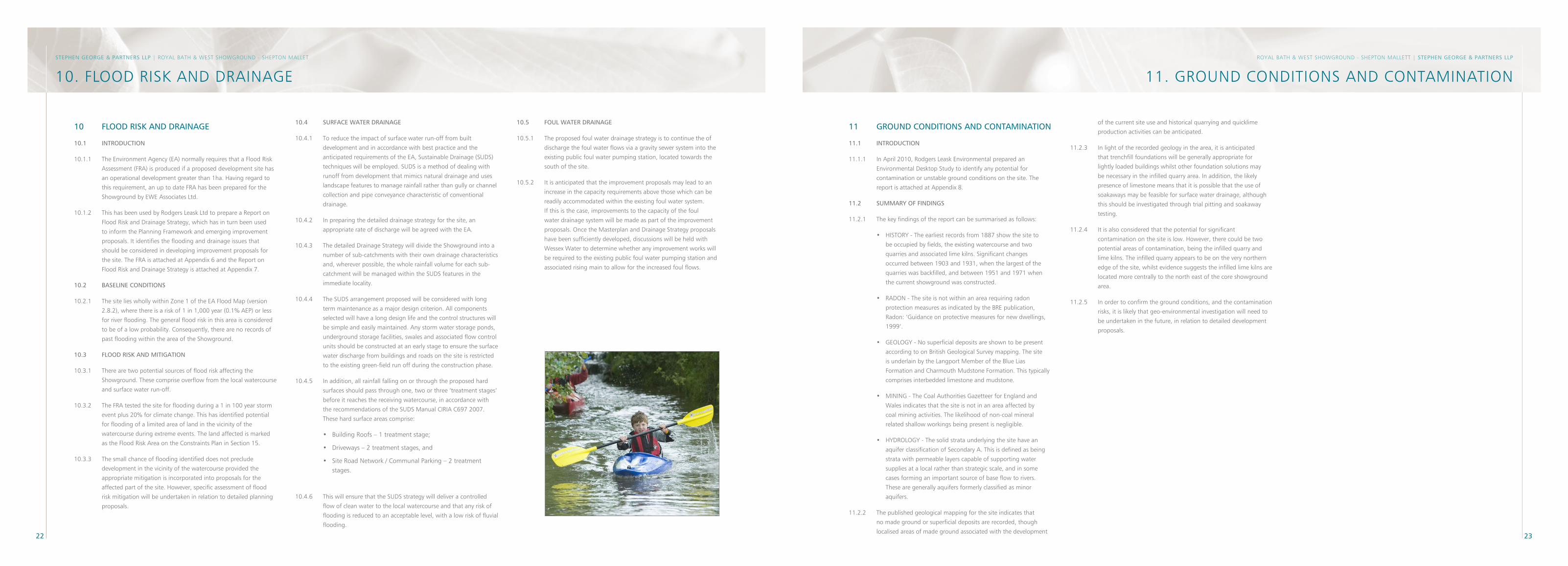
22 2�
RoyAL BAtH & West sHoWgRounD - sHePton MALLett | STePhen GeoRGe & PARTneRS llP
11. gRounD ConDItIons AnD ContAMInAtIon
10 FlooD RISK AnD DRAInAGe
10.1 InTRoDUCTIon
10.1.1 the environment Agency (eA) normally requires that a Flood Risk
Assessment (FRA) is produced if a proposed development site has
an operational development greater than 1ha. Having regard to
this requirement, an up to date FRA has been prepared for the
showground by eWe Associates Ltd.
10.1.2 this has been used by Rodgers Leask Ltd to prepare a Report on
Flood Risk and Drainage strategy, which has in turn been used
to inform the Planning Framework and emerging improvement
proposals. It identifies the flooding and drainage issues that
should be considered in developing improvement proposals for
the site. the FRA is attached at Appendix 6 and the Report on
Flood Risk and Drainage strategy is attached at Appendix 7.
10.2 BASelIne ConDITIonS
10.2.1 the site lies wholly within Zone 1 of the eA Flood Map (version
2.8.2), where there is a risk of 1 in 1,000 year (0.1% AeP) or less
for river flooding. the general flood risk in this area is considered
to be of a low probability. Consequently, there are no records of
past flooding within the area of the showground.
10.� FlooD RISK AnD MITIGATIon
10.3.1 there are two potential sources of flood risk affecting the
showground. these comprise overflow from the local watercourse
and surface water run-off.
10.3.2 the FRA tested the site for flooding during a 1 in 100 year storm
event plus 20% for climate change. this has identified potential
for flooding of a limited area of land in the vicinity of the
watercourse during extreme events. the land affected is marked
as the Flood Risk Area on the Constraints Plan in section 15.
10.3.3 the small chance of flooding identified does not preclude
development in the vicinity of the watercourse provided the
appropriate mitigation is incorporated into proposals for the
affected part of the site. However, specific assessment of flood
risk mitigation will be undertaken in relation to detailed planning
proposals.
10.4 SURFACe WATeR DRAInAGe
10.4.1 to reduce the impact of surface water run-off from built
development and in accordance with best practice and the
anticipated requirements of the eA, sustainable Drainage (suDs)
techniques will be employed. suDs is a method of dealing with
runoff from development that mimics natural drainage and uses
landscape features to manage rainfall rather than gully or channel
collection and pipe conveyance characteristic of conventional
drainage.
10.4.2 In preparing the detailed drainage strategy for the site, an
appropriate rate of discharge will be agreed with the eA.
10.4.3 the detailed Drainage strategy will divide the showground into a
number of sub-catchments with their own drainage characteristics
and, wherever possible, the whole rainfall volume for each sub-
catchment will be managed within the suDs features in the
immediate locality.
10.4.4 the suDs arrangement proposed will be considered with long
term maintenance as a major design criterion. All components
selected will have a long design life and the control structures will
be simple and easily maintained. Any storm water storage ponds,
underground storage facilities, swales and associated flow control
units should be constructed at an early stage to ensure the surface
water discharge from buildings and roads on the site is restricted
to the existing green-field run off during the construction phase.
10.4.5 In addition, all rainfall falling on or through the proposed hard
surfaces should pass through one, two or three ‘treatment stages’
before it reaches the receiving watercourse, in accordance with
the recommendations of the suDs Manual CIRIA C697 2007.
these hard surface areas comprise:
• Building Roofs – 1 treatment stage;
• Driveways – 2 treatment stages, and
• site Road network / Communal Parking – 2 treatment stages.
10.4.6 this will ensure that the suDs strategy will deliver a controlled
flow of clean water to the local watercourse and that any risk of
flooding is reduced to an acceptable level, with a low risk of fluvial
flooding.
10.5 FoUl WATeR DRAInAGe
10.5.1 the proposed foul water drainage strategy is to continue the of
discharge the foul water flows via a gravity sewer system into the
existing public foul water pumping station, located towards the
south of the site.
10.5.2 It is anticipated that the improvement proposals may lead to an
increase in the capacity requirements above those which can be
readily accommodated within the existing foul water system.
If this is the case, improvements to the capacity of the foul
water drainage system will be made as part of the improvement
proposals. once the Masterplan and Drainage strategy proposals
have been sufficiently developed, discussions will be held with
Wessex Water to determine whether any improvement works will
be required to the existing public foul water pumping station and
associated rising main to allow for the increased foul flows.
11 GRoUnD ConDITIonS AnD ConTAMInATIon
11.1 InTRoDUCTIon
11.1.1 In April 2010, Rodgers Leask environmental prepared an
environmental Desktop study to identify any potential for
contamination or unstable ground conditions on the site. the
report is attached at Appendix 8.
11.2 SUMMARY oF FInDInGS
11.2.1 the key findings of the report can be summarised as follows:
• HIstoRy - the earliest records from 1887 show the site to
be occupied by fields, the existing watercourse and two
quarries and associated lime kilns. significant changes
occurred between 1903 and 1931, when the largest of the
quarries was backfilled, and between 1951 and 1971 when
the current showground was constructed.
• RADon - the site is not within an area requiring radon
protection measures as indicated by the BRe publication,
Radon: ‘guidance on protective measures for new dwellings,
1999’.
• geoLogy - no superficial deposits are shown to be present
according to on British geological survey mapping. the site
is underlain by the Langport Member of the Blue Lias
Formation and Charmouth Mudstone Formation. this typically
comprises interbedded limestone and mudstone.
• MInIng - the Coal Authorities gazetteer for england and
Wales indicates that the site is not in an area affected by
coal mining activities. the likelihood of non-coal mineral
related shallow workings being present is negligible.
• HyDRoLogy - the solid strata underlying the site have an
aquifer classification of secondary A. this is defined as being
strata with permeable layers capable of supporting water
supplies at a local rather than strategic scale, and in some
cases forming an important source of base flow to rivers.
these are generally aquifers formerly classified as minor
aquifers.
11.2.2 the published geological mapping for the site indicates that
no made ground or superficial deposits are recorded, though
localised areas of made ground associated with the development
of the current site use and historical quarrying and quicklime
production activities can be anticipated.
11.2.3 In light of the recorded geology in the area, it is anticipated
that trenchfill foundations will be generally appropriate for
lightly loaded buildings whilst other foundation solutions may
be necessary in the infilled quarry area. In addition, the likely
presence of limestone means that it is possible that the use of
soakaways may be feasible for surface water drainage, although
this should be investigated through trial pitting and soakaway
testing.
11.2.4 It is also considered that the potential for significant
contamination on the site is low. However, there could be two
potential areas of contamination, being the infilled quarry and
lime kilns. the infilled quarry appears to be on the very northern
edge of the site, whilst evidence suggests the infilled lime kilns are
located more centrally to the north east of the core showground
area.
11.2.5 In order to confirm the ground conditions, and the contamination
risks, it is likely that geo-environmental investigation will need to
be undertaken in the future, in relation to detailed development
proposals.
STePhen GeoRGe & PARTneRS llP | RoyAL BAtH & West sHoWgRounD - sHePton MALLet
10. FLooD RIsK AnD DRAInAge
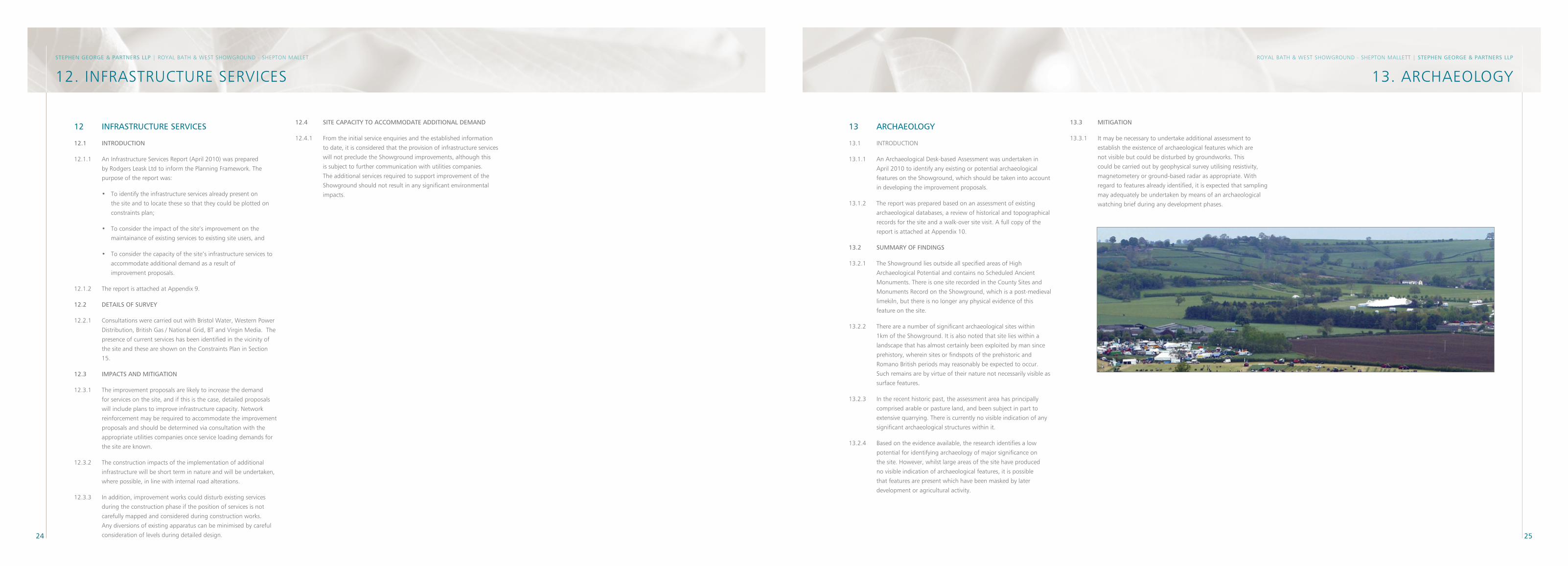
24 25
RoyAL BAtH & West sHoWgRounD - sHePton MALLett | STePhen GeoRGe & PARTneRS llP
12 InFRASTRUCTURe SeRVICeS
12.1 InTRoDUCTIon
12.1.1 An Infrastructure services Report (April 2010) was prepared
by Rodgers Leask Ltd to inform the Planning Framework. the
purpose of the report was:
• to identify the infrastructure services already present on
the site and to locate these so that they could be plotted on
constraints plan;
• to consider the impact of the site’s improvement on the
maintainance of existing services to existing site users, and
• to consider the capacity of the site’s infrastructure services to
accommodate additional demand as a result of
improvement proposals.
12.1.2 the report is attached at Appendix 9.
12.2 DeTAIlS oF SURVeY
12.2.1 Consultations were carried out with Bristol Water, Western Power
Distribution, British gas / national grid, Bt and Virgin Media. the
presence of current services has been identified in the vicinity of
the site and these are shown on the Constraints Plan in section
15.
12.� IMPACTS AnD MITIGATIon
12.3.1 the improvement proposals are likely to increase the demand
for services on the site, and if this is the case, detailed proposals
will include plans to improve infrastructure capacity. network
reinforcement may be required to accommodate the improvement
proposals and should be determined via consultation with the
appropriate utilities companies once service loading demands for
the site are known.
12.3.2 the construction impacts of the implementation of additional
infrastructure will be short term in nature and will be undertaken,
where possible, in line with internal road alterations.
12.3.3 In addition, improvement works could disturb existing services
during the construction phase if the position of services is not
carefully mapped and considered during construction works.
Any diversions of existing apparatus can be minimised by careful
consideration of levels during detailed design.
13. ARCHAeoLogySTePhen GeoRGe & PARTneRS llP | RoyAL BAtH & West sHoWgRounD - sHePton MALLet
12. InFRAstRuCtuRe seRVICes
12.4 SITe CAPACITY To ACCoMMoDATe ADDITIonAl DeMAnD
12.4.1 From the initial service enquiries and the established information
to date, it is considered that the provision of infrastructure services
will not preclude the showground improvements, although this
is subject to further communication with utilities companies.
the additional services required to support improvement of the
showground should not result in any significant environmental
impacts.
1� ARChAeoloGY
13.1 IntRoDuCtIon
13.1.1 An Archaeological Desk-based Assessment was undertaken in
April 2010 to identify any existing or potential archaeological
features on the showground, which should be taken into account
in developing the improvement proposals.
13.1.2 the report was prepared based on an assessment of existing
archaeological databases, a review of historical and topographical
records for the site and a walk-over site visit. A full copy of the
report is attached at Appendix 10.
1�.2 SUMMARY oF FInDInGS
13.2.1 the showground lies outside all specified areas of High
Archaeological Potential and contains no scheduled Ancient
Monuments. there is one site recorded in the County sites and
Monuments Record on the showground, which is a post-medieval
limekiln, but there is no longer any physical evidence of this
feature on the site.
13.2.2 there are a number of significant archaeological sites within
1km of the showground. It is also noted that site lies within a
landscape that has almost certainly been exploited by man since
prehistory, wherein sites or findspots of the prehistoric and
Romano British periods may reasonably be expected to occur.
such remains are by virtue of their nature not necessarily visible as
surface features.
13.2.3 In the recent historic past, the assessment area has principally
comprised arable or pasture land, and been subject in part to
extensive quarrying. there is currently no visible indication of any
significant archaeological structures within it.
13.2.4 Based on the evidence available, the research identifies a low
potential for identifying archaeology of major significance on
the site. However, whilst large areas of the site have produced
no visible indication of archaeological features, it is possible
that features are present which have been masked by later
development or agricultural activity.
1�.� MITIGATIon
13.3.1 It may be necessary to undertake additional assessment to
establish the existence of archaeological features which are
not visible but could be disturbed by groundworks. this
could be carried out by geophysical survey utilising resistivity,
magnetometery or ground-based radar as appropriate. With
regard to features already identified, it is expected that sampling
may adequately be undertaken by means of an archaeological
watching brief during any development phases.
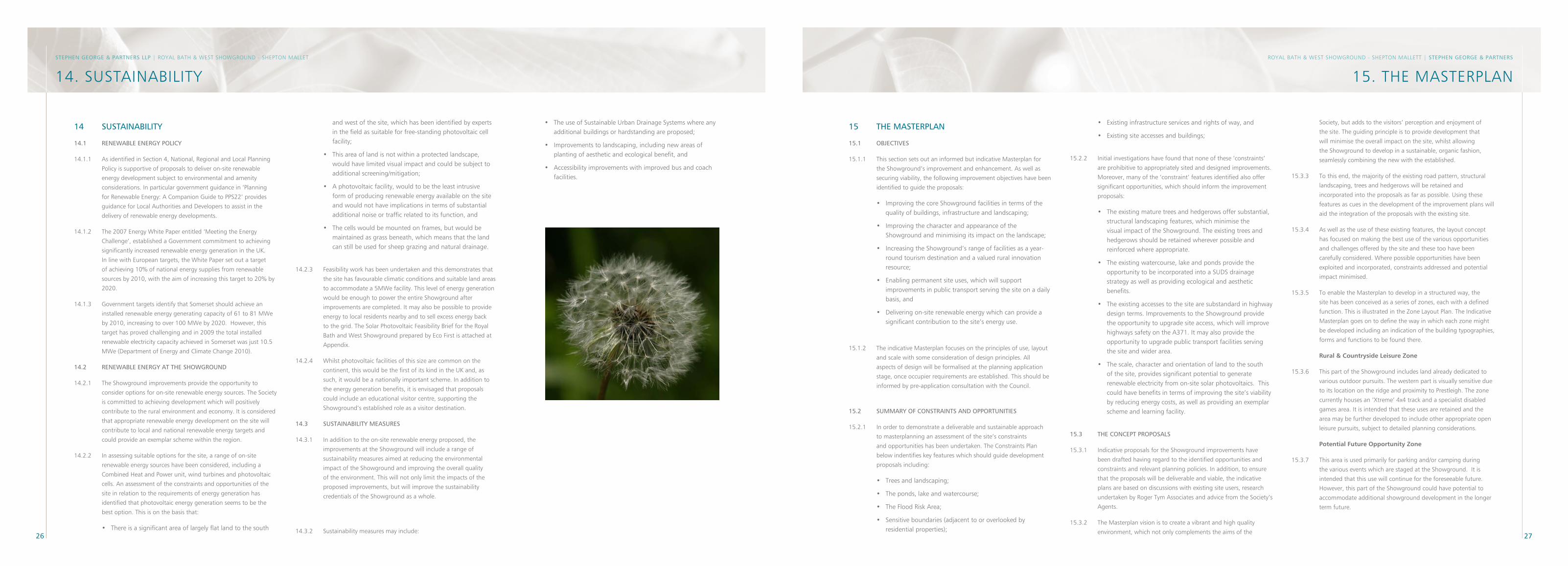
26 27
15. tHe MAsteRPLAn14. sustAInABILItyRoyAL BAtH & West sHoWgRounD - sHePton MALLett | STePhen GeoRGe & PARTneRSSTePhen GeoRGe & PARTneRS llP | RoyAL BAtH & West sHoWgRounD - sHePton MALLet
14 SUSTAInABIlITY
14.1 ReneWABle eneRGY PolICY
14.1.1 As identified in section 4, national, Regional and Local Planning
Policy is supportive of proposals to deliver on-site renewable
energy development subject to environmental and amenity
considerations. In particular government guidance in ‘Planning
for Renewable energy: A Companion guide to PPs22’ provides
guidance for Local Authorities and Developers to assist in the
delivery of renewable energy developments.
14.1.2 the 2007 energy White Paper entitled ‘Meeting the energy
Challenge’, established a government commitment to achieving
significantly increased renewable energy generation in the uK.
In line with european targets, the White Paper set out a target
of achieving 10% of national energy supplies from renewable
sources by 2010, with the aim of increasing this target to 20% by
2020.
14.1.3 government targets identify that somerset should achieve an
installed renewable energy generating capacity of 61 to 81 MWe
by 2010, increasing to over 100 MWe by 2020. However, this
target has proved challenging and in 2009 the total installed
renewable electricity capacity achieved in somerset was just 10.5
MWe (Department of energy and Climate Change 2010).
14.2 ReneWABle eneRGY AT The ShoWGRoUnD
14.2.1 the showground improvements provide the opportunity to
consider options for on-site renewable energy sources. the society
is committed to achieving development which will positively
contribute to the rural environment and economy. It is considered
that appropriate renewable energy development on the site will
contribute to local and national renewable energy targets and
could provide an exemplar scheme within the region.
14.2.2 In assessing suitable options for the site, a range of on-site
renewable energy sources have been considered, including a
Combined Heat and Power unit, wind turbines and photovoltaic
cells. An assessment of the constraints and opportunities of the
site in relation to the requirements of energy generation has
identified that photovoltaic energy generation seems to be the
best option. this is on the basis that:
• there is a significant area of largely flat land to the south
and west of the site, which has been identified by experts in the field as suitable for free-standing photovoltaic cell facility;
• this area of land is not within a protected landscape, would have limited visual impact and could be subject to additional screening/mitigation;
• A photovoltaic facility, would to be the least intrusive form of producing renewable energy available on the site and would not have implications in terms of substantial additional noise or traffic related to its function, and
• the cells would be mounted on frames, but would be maintained as grass beneath, which means that the land can still be used for sheep grazing and natural drainage.
14.2.3 Feasibility work has been undertaken and this demonstrates that
the site has favourable climatic conditions and suitable land areas
to accommodate a 5MWe facility. this level of energy generation
would be enough to power the entire showground after
improvements are completed. It may also be possible to provide
energy to local residents nearby and to sell excess energy back
to the grid. the solar Photovoltaic Feasibility Brief for the Royal
Bath and West showground prepared by eco First is attached at
Appendix.
14.2.4 Whilst photovoltaic facilities of this size are common on the
continent, this would be the first of its kind in the uK and, as
such, it would be a nationally important scheme. In addition to
the energy generation benefits, it is envisaged that proposals
could include an educational visitor centre, supporting the
showground’s established role as a visitor destination.
14.� SUSTAInABIlITY MeASUReS
14.3.1 In addition to the on-site renewable energy proposed, the
improvements at the showground will include a range of
sustainability measures aimed at reducing the environmental
impact of the showground and improving the overall quality
of the environment. this will not only limit the impacts of the
proposed improvements, but will improve the sustainability
credentials of the showground as a whole.
14.3.2 sustainability measures may include:
• the use of sustainable urban Drainage systems where any additional buildings or hardstanding are proposed;
• Improvements to landscaping, including new areas of planting of aesthetic and ecological benefit, and
• Accessibility improvements with improved bus and coach facilities.
• existing infrastructure services and rights of way, and
• existing site accesses and buildings;
15.2.2 Initial investigations have found that none of these ‘constraints’
are prohibitive to appropriately sited and designed improvements.
Moreover, many of the ‘constraint’ features identified also offer
significant opportunities, which should inform the improvement
proposals:
• the existing mature trees and hedgerows offer substantial, structural landscaping features, which minimise the visual impact of the showground. the existing trees and hedgerows should be retained wherever possible and reinforced where appropriate.
• the existing watercourse, lake and ponds provide the opportunity to be incorporated into a suDs drainage strategy as well as providing ecological and aesthetic benefits.
• the existing accesses to the site are substandard in highway design terms. Improvements to the showground provide the opportunity to upgrade site access, which will improve highways safety on the A371. It may also provide the opportunity to upgrade public transport facilities serving the site and wider area.
• the scale, character and orientation of land to the south of the site, provides significant potential to generate renewable electricity from on-site solar photovoltaics. this could have benefits in terms of improving the site’s viability by reducing energy costs, as well as providing an exemplar scheme and learning facility.
15.� The ConCePT PRoPoSAlS
15.3.1 Indicative proposals for the showground improvements have
been drafted having regard to the identified opportunities and
constraints and relevant planning policies. In addition, to ensure
that the proposals will be deliverable and viable, the indicative
plans are based on discussions with existing site users, research
undertaken by Roger tym Associates and advice from the society’s
Agents.
15.3.2 the Masterplan vision is to create a vibrant and high quality
environment, which not only complements the aims of the
15 The MASTeRPlAn
15.1 oBJeCTIVeS
15.1.1 this section sets out an informed but indicative Masterplan for
the showground’s improvement and enhancement. As well as
securing viability, the following improvement objectives have been
identified to guide the proposals:
• Improving the core showground facilities in terms of the quality of buildings, infrastructure and landscaping;
• Improving the character and appearance of the showground and minimising its impact on the landscape;
• Increasing the showground’s range of facilities as a year-round tourism destination and a valued rural innovation resource;
• enabling permanent site uses, which will support improvements in public transport serving the site on a daily basis, and
• Delivering on-site renewable energy which can provide a significant contribution to the site’s energy use.
15.1.2 the indicative Masterplan focuses on the principles of use, layout
and scale with some consideration of design principles. All
aspects of design will be formalised at the planning application
stage, once occupier requirements are established. this should be
informed by pre-application consultation with the Council.
15.2 SUMMARY oF ConSTRAInTS AnD oPPoRTUnITIeS
15.2.1 In order to demonstrate a deliverable and sustainable approach
to masterplanning an assessment of the site’s constraints
and opportunities has been undertaken. the Constraints Plan
below indentifies key features which should guide development
proposals including:
• trees and landscaping;
• the ponds, lake and watercourse;
• the Flood Risk Area;
• sensitive boundaries (adjacent to or overlooked by residential properties);
society, but adds to the visitors’ perception and enjoyment of
the site. the guiding principle is to provide development that
will minimise the overall impact on the site, whilst allowing
the showground to develop in a sustainable, organic fashion,
seamlessly combining the new with the established.
15.3.3 to this end, the majority of the existing road pattern, structural
landscaping, trees and hedgerows will be retained and
incorporated into the proposals as far as possible. using these
features as cues in the development of the improvement plans will
aid the integration of the proposals with the existing site.
15.3.4 As well as the use of these existing features, the layout concept
has focused on making the best use of the various opportunities
and challenges offered by the site and these too have been
carefully considered. Where possible opportunities have been
exploited and incorporated, constraints addressed and potential
impact minimised.
15.3.5 to enable the Masterplan to develop in a structured way, the
site has been conceived as a series of zones, each with a defined
function. this is illustrated in the Zone Layout Plan. the Indicative
Masterplan goes on to define the way in which each zone might
be developed including an indication of the building typographies,
forms and functions to be found there.
Rural & Countryside Leisure Zone
15.3.6 this part of the showground includes land already dedicated to
various outdoor pursuits. the western part is visually sensitive due
to its location on the ridge and proximity to Prestleigh. the zone
currently houses an ‘xtreme’ 4x4 track and a specialist disabled
games area. It is intended that these uses are retained and the
area may be further developed to include other appropriate open
leisure pursuits, subject to detailed planning considerations.
Potential Future Opportunity Zone
15.3.7 this area is used primarily for parking and/or camping during
the various events which are staged at the showground. It is
intended that this use will continue for the foreseeable future.
However, this part of the showground could have potential to
accommodate additional showground development in the longer
term future.
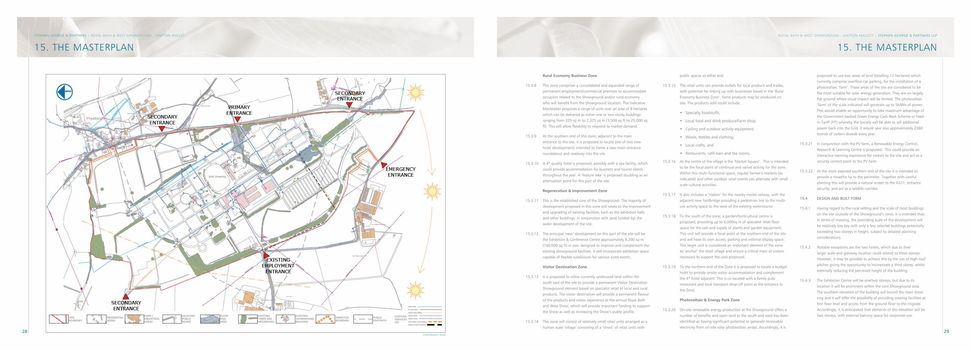
28 29
RoyAL BAtH & West sHoWgRounD - sHePton MALLett | STePhen GeoRGe & PARTneRS llP
15. tHe MAsteRPLAn
ConstRAInts PLAn
STePhen GeoRGe & PARTneRS | RoyAL BAtH & West sHoWgRounD - sHePton MALLet
15. tHe MAsteRPLAn
Rural Economy Business Zone
15.3.8 this zone comprises a consolidated and expanded range of
permanent employment/commercial premises to accommodate
occupiers related to the showground and/or rural economy
who will benefit from the showground location. the Indicative
Masterplan proposes a range of units over an area of 8 hectares
which can be delivered as either one or two storey buildings
ranging from 325 sq m to 2,325 sq m (3,500 sq ft to 25,000 sq
ft). this will allow flexibility to respond to market demand.
15.3.9 At the southern end of this zone, adjacent to the main
entrance to the site, it is proposed to locate one of two new
hotel developments intended to frame a new main entrance
roundabout and roadway into the site.
15.3.10 A 4* quality hotel is proposed, possibly with a spa facility, which
could provide accommodation for business and tourist clients
throughout the year. A ‘feature lake’ is proposed doubling as an
attenuation pond for this part of the site.
Regeneration & Improvement Zone
15.3.11 this is the established core of the showground. the majority of
development proposed in this zone will relate to the improvement
and upgrading of existing facilities, such as the exhibition halls
and other buildings, in conjunction with (and funded by) the
wider development of the site.
15.3.12 the principal ‘new’ development on this part of the site will be
the exhibition & Conference Centre approximately 9,290 sq m
(100,000 sq ft) in size, designed to improve and complement the
existing showground facilities. It will incorporate exhibition space
capable of flexible subdivision for various sized events.
Visitor Destination Zone
15.3.13 It is proposed to utilise currently underused land within the
south east of the site to provide a permanent Visitor Destination
showground element based on specialist retail of local and rural
products. the visitor destination will provide a permanent flavour
of the products and visitor experience at the annual Royal Bath
and West show, which will provide important funding to support
the show as well as increasing the show’s public profile.
15.3.14 this zone will consist of relatively small retail units arranged as a
human scale ‘village’ consisting of a ‘street’ of retail units with
public spaces at either end.
15.3.15 the retail units can provide outlets for local produce and trades,
with potential for linking up with businesses based in the ‘Rural
economy Business Zone’. some products may be produced on
site. the products sold could include:
• specialty foodstuffs;
• Local food and drink produce/Farm shop;
• Cycling and outdoor activity equipment;
• Wools, textiles and clothing;
• Local crafts, and
• Restaurants, café-bars and tea rooms.
15.3.16 At the centre of the village is the ‘Market square’. this is intended
to be the focal point of continual and varied activity for the zone.
Within this multi-functional space, regular farmer’s markets (as
indicated) and other outdoor retail events can alternate with small
scale cultural activities.
15.3.17 It also includes a ‘station’ for the nearby model railway, with the
adjacent new footbridge providing a pedestrian link to the multi-
use activity space to the west of the existing watercourse.
15.3.18 to the south of the zone, a garden/horticultural centre is
proposed, providing up to 6,000sq m of specialist retail floor
space for the sale and supply of plants and garden equipment.
this unit will provide a focal point at the southern end of the site
and will have its own access, parking and external display space.
this larger unit is considered an important element of the zone
to ‘anchor’ the retail village and ensure a critical mass of visitors
necessary to support the uses proposed.
15.3.19 to the northern end of the Zone it is proposed to locate a budget
hotel to provide onsite visitor accommodation and complement
the 4* hotel adjacent. this is co-located with a family pub/
restaurant and local transport drop-off point at the entrance to
the Zone.
Photovoltaic & Energy Park Zone
15.3.20 on-site renewable energy production at the showground offers a
number of benefits and open land to the south and west has been
identified as having significant potential to generate renewable
electricity from on-site solar photovoltaic arrays. Accordingly, it is
proposed to use two areas of land (totalling 12 hectares) which
currently comprise overflow car parking, for the installation of a
photovoltaic ‘farm’. these areas of the site are considered to be
the most suitable for solar energy generation. they are on largely
flat ground where visual impact will be limited. the photovoltaic
‘farm’ of the scale indicated will generate up to 5MWe of power.
this would enable an opportunity to take maximum advantage of
the government backed green energy Cash-Back scheme or Feed-
in-tariff (FIt) whereby the society will be able to sell additional
power back into the grid. It would save also approximately 2360
tonnes of carbon dioxide every year.
15.3.21 In conjunction with the PV farm, a Renewable energy Control,
Research & Learning Centre is proposed. this could provide an
interactive learning experience for visitors to the site and act as a
security control point to the PV farm.
15.3.22 At the more exposed southern end of the site it is intended to
provide a moat/ha ha to the perimeter. together with careful
planting this will provide a natural screen to the A371, enhance
security, and act as a wildlife corridor.
15.4 DeSIGn AnD BUIlT FoRM
15.4.1 Having regard to the rural setting and the scale of most buildings
on the site (outside of the showground’s core), it is intended that,
in terms of massing, the overriding scale of the development will
be relatively low key with only a few selected buildings potentially
exceeding two storeys in height, subject to detailed planning
considerations.
15.4.2 notable exceptions are the two hotels, which due to their
larger scale and gateway location could extend to three storeys.
However, it may be possible to achieve this by the use of high roof
pitches giving the opportunity to incorporate a third storey, whilst
externally reducing the perceived height of the building.
15.4.3 the exhibition Centre will be one/two storeys, but due to its
location it will be prominent within the core showground area.
the southern elevation of the building will bound the main show
ring and it will offer the possibility of providing viewing facilities at
first floor level and access from the ground floor to the ringside.
Accordingly, it is anticipated that elements of this elevation will be
two storeys, with external balcony space for corporate use.
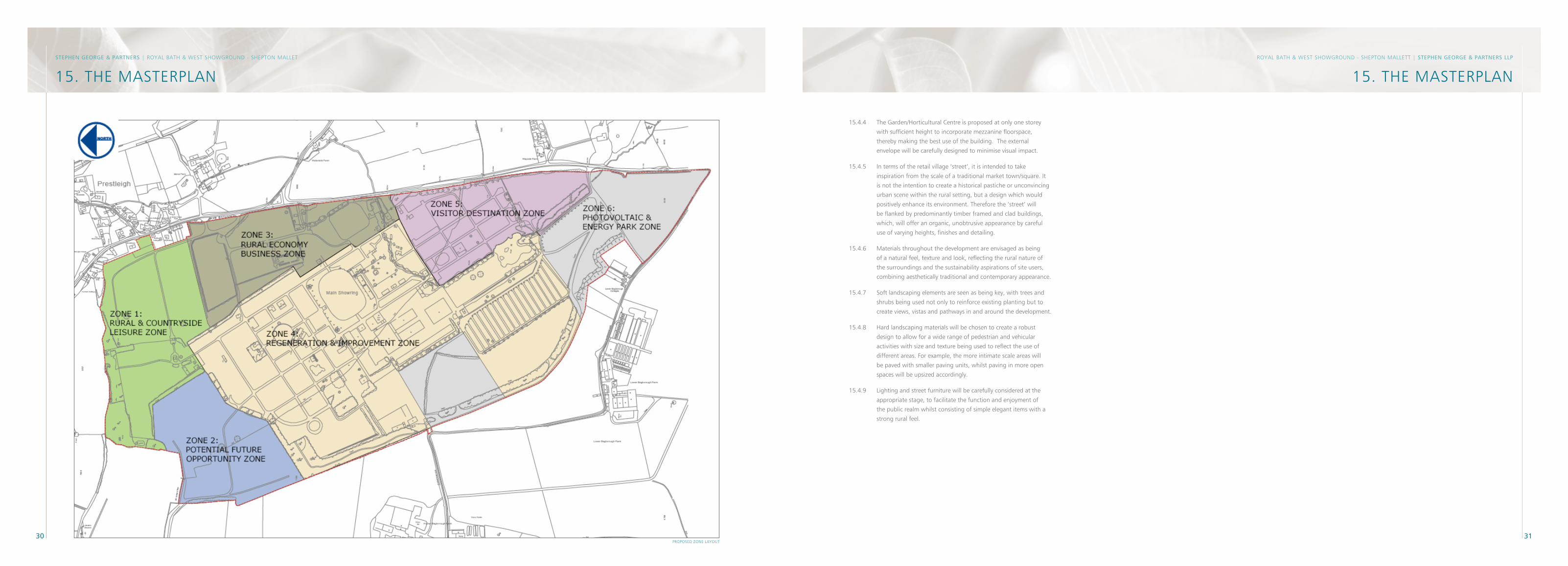
�0 �1
RoyAL BAtH & West sHoWgRounD - sHePton MALLett | STePhen GeoRGe & PARTneRS llP
15. tHe MAsteRPLAnSTePhen GeoRGe & PARTneRS | RoyAL BAtH & West sHoWgRounD - sHePton MALLet
15. tHe MAsteRPLAn
PRoPoseD Zone LAyout
15.4.4 the garden/Horticultural Centre is proposed at only one storey
with sufficient height to incorporate mezzanine floorspace,
thereby making the best use of the building. the external
envelope will be carefully designed to minimise visual impact.
15.4.5 In terms of the retail village ‘street’, it is intended to take
inspiration from the scale of a traditional market town/square. It
is not the intention to create a historical pastiche or unconvincing
urban scene within the rural setting, but a design which would
positively enhance its environment. therefore the ‘street’ will
be flanked by predominantly timber framed and clad buildings,
which, will offer an organic, unobtrusive appearance by careful
use of varying heights, finishes and detailing.
15.4.6 Materials throughout the development are envisaged as being
of a natural feel, texture and look, reflecting the rural nature of
the surroundings and the sustainability aspirations of site users,
combining aesthetically traditional and contemporary appearance.
15.4.7 soft landscaping elements are seen as being key, with trees and
shrubs being used not only to reinforce existing planting but to
create views, vistas and pathways in and around the development.
15.4.8 Hard landscaping materials will be chosen to create a robust
design to allow for a wide range of pedestrian and vehicular
activities with size and texture being used to reflect the use of
different areas. For example, the more intimate scale areas will
be paved with smaller paving units, whilst paving in more open
spaces will be upsized accordingly.
15.4.9 Lighting and street furniture will be carefully considered at the
appropriate stage, to facilitate the function and enjoyment of
the public realm whilst consisting of simple elegant items with a
strong rural feel.
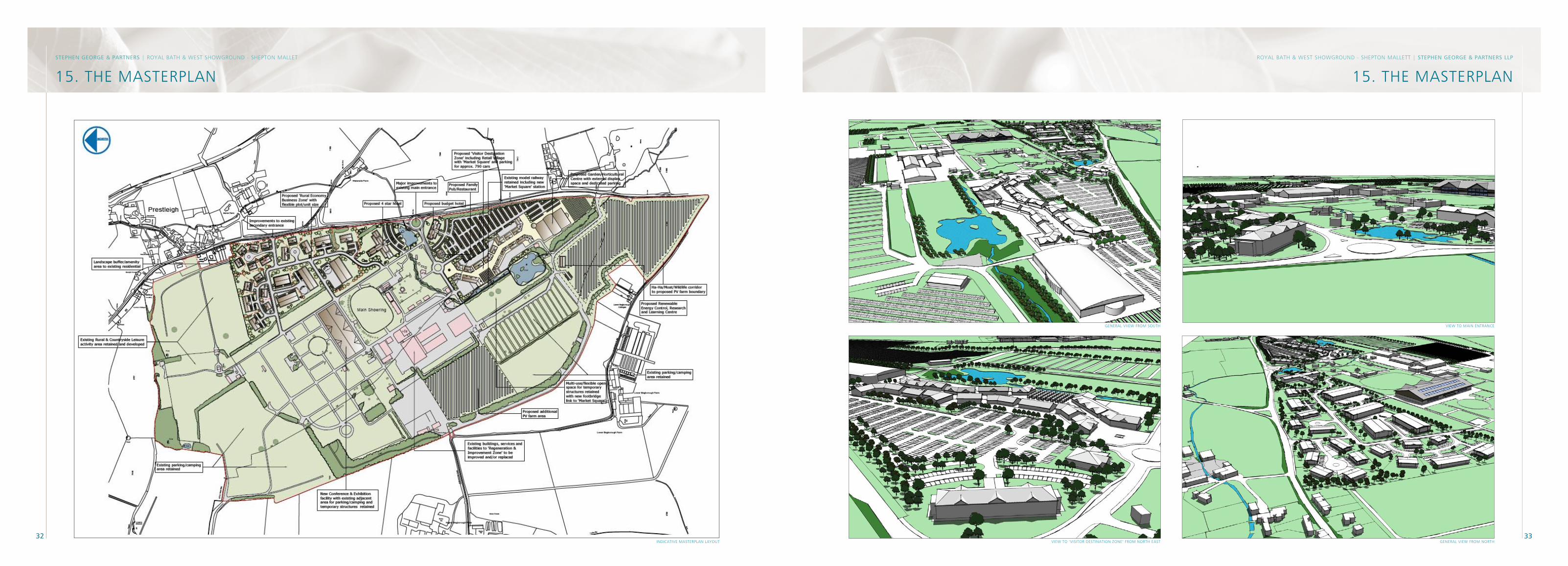
�2 ��
RoyAL BAtH & West sHoWgRounD - sHePton MALLett | STePhen GeoRGe & PARTneRS llP
15. tHe MAsteRPLAnSTePhen GeoRGe & PARTneRS | RoyAL BAtH & West sHoWgRounD - sHePton MALLet
15. tHe MAsteRPLAn
geneRAL VIeW FRoM noRtHVIeW to ‘VIsItoR DestInAtIon Zone’ FRoM noRtH eAst
geneRAL VIIeW FRoM soutH VIeW to MAIn entRAnCe
InDICAtIVe MAsteRPLAn LAyout
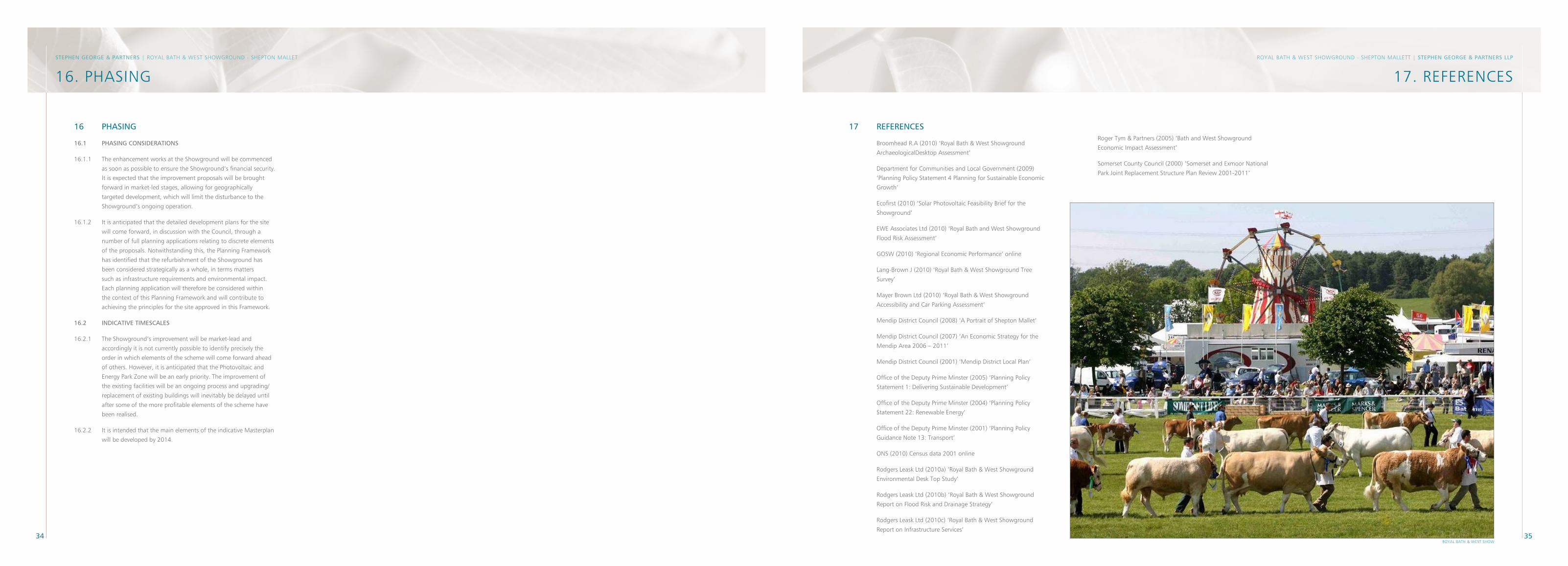
�4 �5
RoyAL BAtH & West sHoWgRounD - sHePton MALLett | STePhen GeoRGe & PARTneRS llP
17. ReFeRenCes
16 PhASInG
16.1 PhASInG ConSIDeRATIonS
16.1.1 the enhancement works at the showground will be commenced
as soon as possible to ensure the showground’s financial security.
It is expected that the improvement proposals will be brought
forward in market-led stages, allowing for geographically
targeted development, which will limit the disturbance to the
showground’s ongoing operation.
16.1.2 It is anticipated that the detailed development plans for the site
will come forward, in discussion with the Council, through a
number of full planning applications relating to discrete elements
of the proposals. notwithstanding this, the Planning Framework
has identified that the refurbishment of the showground has
been considered strategically as a whole, in terms matters
such as infrastructure requirements and environmental impact.
each planning application will therefore be considered within
the context of this Planning Framework and will contribute to
achieving the principles for the site approved in this Framework.
16.2 InDICATIVe TIMeSCAleS
16.2.1 the showground’s improvement will be market-lead and
accordingly it is not currently possible to identify precisely the
order in which elements of the scheme will come forward ahead
of others. However, it is anticipated that the Photovoltaic and
energy Park Zone will be an early priority. the improvement of
the existing facilities will be an ongoing process and upgrading/
replacement of existing buildings will inevitably be delayed until
after some of the more profitable elements of the scheme have
been realised.
16.2.2 It is intended that the main elements of the indicative Masterplan
will be developed by 2014.
STePhen GeoRGe & PARTneRS | RoyAL BAtH & West sHoWgRounD - sHePton MALLet
16. PHAsIng
RoyAL BAtH & West sHoW
17 ReFeRenCeS
Broomhead R.A (2010) ‘Royal Bath & West showground
ArchaeologicalDesktop Assessment’
Department for Communities and Local government (2009)
‘Planning Policy statement 4 Planning for sustainable economic
growth’
ecofirst (2010) ‘solar Photovoltaic Feasibility Brief for the
showground’
eWe Associates Ltd (2010) ‘Royal Bath and West showground
Flood Risk Assessment’
gosW (2010) ‘Regional economic Performance’ online
Lang-Brown J (2010) ‘Royal Bath & West showground tree
survey’
Mayer Brown Ltd (2010) ‘Royal Bath & West showground
Accessibility and Car Parking Assessment’
Mendip District Council (2008) ‘A Portrait of shepton Mallet’
Mendip District Council (2007) ‘An economic strategy for the
Mendip Area 2006 – 2011’
Mendip District Council (2001) ‘Mendip District Local Plan’
office of the Deputy Prime Minster (2005) ‘Planning Policy
statement 1: Delivering sustainable Development’
office of the Deputy Prime Minster (2004) ‘Planning Policy
statement 22: Renewable energy’
office of the Deputy Prime Minster (2001) ‘Planning Policy
guidance note 13: transport’
ons (2010) Census data 2001 online
Rodgers Leask Ltd (2010a) ‘Royal Bath & West showground
environmental Desk top study’
Rodgers Leask Ltd (2010b) ‘Royal Bath & West showground
Report on Flood Risk and Drainage strategy’
Rodgers Leask Ltd (2010c) ‘Royal Bath & West showground
Report on Infrastructure services’
Roger tym & Partners (2005) ‘Bath and West showground
economic Impact Assessment’
somerset County Council (2000) ‘somerset and exmoor national
Park Joint Replacement structure Plan Review 2001-2011’

stephen george & Partners LLP
Contact/s: stephen Armitage
33 Park Place
Leeds
Ls1 2Ry
t: 0113 246 7969
www.stephengeorge.co.uk