Embed Size (px)
Citation preview
TS01D - GeoSpatial Applications - 6555
Chigbu, Njike& Onukaogu Daniel (Nigeria)
Role of Geospatial technology in Environmental Sustainability in Nigeria-an overview
FIG Working Week 2013
Environment For Sustainability
Abuja, Nigeria, 6-10 May, 2013
1/12
Role of Geospatial Technology in Environmental Sustainability
in Nigeria-An Overview
Njike CHIGBU and Daniel ONUKAOGU, Nigeria
KEYWORDS: Geospatial Technology, EnvironmentalSustainability, Poverty Eradication and
climate change
SUMMARY
The world as a whole is becoming highly geospatially-enabled and there is the need to study
trends and patterns and also communicate these phenomena with the evolving spatial
technologies such that end users would benefit from this advancement in technological
development. Since climatic changes and human activities could amount to the degradation of
our natural environment, there is the need for us to acquaint ourselves more and embrace the vast
emerging geospatial technologies in solving a number of environmental challenges to humanity
today.Nigeria and other developing countries have a long way to go in this pursuit due to dearth
of expertise to drive home the technological development of the country. Climatic change and
anthropogenic factors can lead to environmental resource depletion with a drastic impact on the
human population and other endangered species. In 2000, over 189 developing countries adopted
the Millennium Declaration that re-affirmed their commitment to strengthening global efforts for
peace, human rights, Democracy, good governance, environmental sustainability and poverty
eradication. Today, we live in a fast changing world where every event or occurrence needs to be
properly studied, integrated and analyzed for the benefit of all. The capabilities of geospatial
technology are such that decision makers will be exposed to different options to handle different
environmental challenges. By addressing the environmental issues through efficient use of
geospatial technologies it is possible for developing countries like Nigeria to ensure a sustainable
path to poverty reduction and human development. This paper focuses on discussing (an
overview) the importance of geospatial technology, GIS and its tools for good decision making
in sustaining the environment.
TS01D - GeoSpatial Applications - 6555
Chigbu, Njike& Onukaogu Daniel (Nigeria)
Role of Geospatial technology in Environmental Sustainability in Nigeria-an overview
FIG Working Week 2013
Environment For Sustainability
Abuja, Nigeria, 6-10 May, 2013
2/12
Role of Geospatial Technology in Environmental Sustainability
in Nigeria-An Overview
Njike CHIGBU and Daniel ONUKAOGU, Nigeria
1. INTRODUCTION
Geospatial technology offers a wide range of innovative and cost effective solutions for
environmental sustainability; hence, many countries now appreciate the relevance of geospatial
technology in the sustenance of our environment. The relevance of environmental information is
based on the degree of its availability to the end users and to what extent such information can be
shared effectively with external organizations largely over the internet and other available global
information infrastructure (SDI) platform. In this regard, the emphasis should be on accessibility
and distribution of available information over wide range of networks and environmental
information market-place (Matambanadzo,1999).
Fig 1.0 showing the administrative map of Nigeria (source: Chigbu, 2013)
The use of Geospatial technology in mitigating environmental problems and challenges is thus
on the increase the use information driven tools such as GIS, Earth imaging systems/Satellites,
TS01D - GeoSpatial Applications - 6555
Chigbu, Njike& Onukaogu Daniel (Nigeria)
Role of Geospatial technology in Environmental Sustainability in Nigeria-an overview
FIG Working Week 2013
Environment For Sustainability
Abuja, Nigeria, 6-10 May, 2013
3/12
Global Positioning System (GPS) and Remote sensing techniques to mitigate environmental
problems has find global application and acceptance.
2. RELEVANCE OF GEOSPATIAL TECHNOLOGY TO ENVIRONMENTAL
SUSTAINABILITY
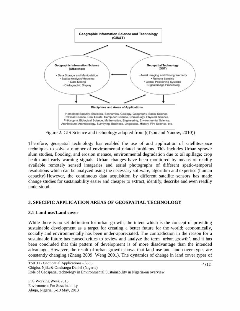
Geospatial Technology is the specialized set of information technologies that include Aerial
Photography, Remote Sensing, Surveying, and Global Positioning Systems that support a wide
variety of uses. This stretches from data acquisition to data storage, manipulation, image
analysis, geo-visualization /display and data output (Tsou and Yanow, 2010). These disciplines if
properly harnessed and given its rightful place by the appropriate authorities in Nigeria and
globally would play enviable roles in the sustainability of our environment and good governance.
Some of the identified applications of geospatial technology in Nigeria and globally includes the
following:
- Flooding, environmental degradation and climate studies.
- Agriculture and Precision Farming.
- In the Health Sector and Paramedics.
- In the Mining and Extractive Industry
- City planning, Transportation, Communication Network designs and in Aviation
Industry.
- Traffic and Accident control and prevention.
- Planning and Re-Planning program (Slum Re-settlement).
- Crime Mapping and hot-spots delineations.
- Land use and Land cover Studies for sustainability.
- General Developmental control and resource inventory and allocations.
- Emergency planning and alternative route development.
- Development of agronomical data and early warning data for food security issues.
- Deforestation and A forestation studies and preservation of wild life and biodiversity.
This applications and different areas of usage of geospatial technology is vividly captured in the
figure 2.0 below.
TS01D - GeoSpatial Applications - 6555
Chigbu, Njike& Onukaogu Daniel (Nigeria)
Role of Geospatial technology in Environmental Sustainability in Nigeria-an overview
FIG Working Week 2013
Environment For Sustainability
Abuja, Nigeria, 6-10 May, 2013
4/12
Figure 2: GIS Science and technology adopted from ((Tsou and Yanow, 2010))
Therefore, geospatial technology has enabled the use of and application of satellite/space
techniques to solve a number of environmental related problems. This includes Urban sprawl/
slum studies, flooding, and erosion menace, environmental degradation due to oil spillage; crop
health and early warning signals. Urban changes have been monitored by means of readily
available remotely sensed imageries and aerial photographs of different spatio-temporal
resolutions which can be analyzed using the necessary software, algorithm and expertise (human
capacity).However, the continuous data acquisition by different satellite sensors has made
change studies for sustainability easier and cheaper to extract, identify, describe and even readily
understood.
3. SPECIFIC APPLICATION AREAS OF GEOSPATIAL TECHNOLOGY
3.1 Land-use/Land cover
While there is no set definition for urban growth, the intent which is the concept of providing
sustainable development as a target for creating a better future for the world; economically,
socially and environmentally has been under-appreciated. The contradiction in the reason for a
sustainable future has caused critics to review and analyze the term ‘urban growth’, and it has
been concluded that this pattern of development is of more disadvantage than the intended
advantage. However, the result of urban growth shows that land use and land cover types are
constantly changing (Zhang 2009, Weng 2001). The dynamics of change in land cover types of
TS01D - GeoSpatial Applications - 6555
Chigbu, Njike& Onukaogu Daniel (Nigeria)
Role of Geospatial technology in Environmental Sustainability in Nigeria-an overview
FIG Working Week 2013
Environment For Sustainability
Abuja, Nigeria, 6-10 May, 2013
5/12
urban regions can be attributed to the expansion of residential and commercial/industrial
facilities, which has resulted to structural challenges such as inadequate facilities, inefficient
street layouts & transportation networks, less space for conservation and parks, low agricultural
farm lands and resultant high use of energy (environmental pollution), land degradation and even
water pollution. Hence, monitoring the spatial- temporal changes is significant for advanced
urban planning and development (Deng et al., 2008, Lu et al., 2004).
Spatial Changes and monitoring can be accomplished using satellite imagery or Aerial
photography, advance image processing techniques and GIS analysis to highlight land cover
changes (Zhang 2009, Weng 2001). Remotely sensed images have changed the way scientists
study the atmosphere, oceans, vegetation, and the environments of the earth. Different studies
from various related literature reveals that the use of Remote Sensing Techniques are significant
for studying land use and land cover changes and other environmental issues as a result of
natural and anthropogenic factors. With the rapid advancement in RS techniques, new and
improved change detection techniques are being developed and categorized by many researchers,
thus making remote sensing a vibrant study (Igbokwe, 2010).
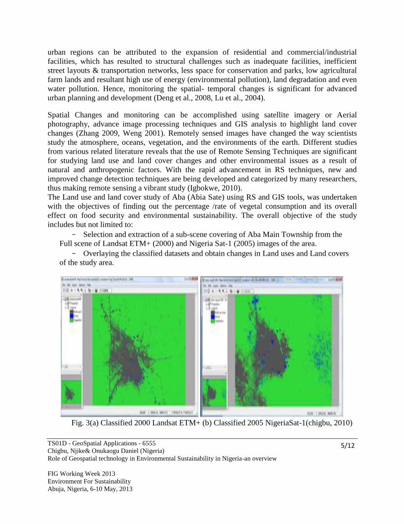
The Land use and land cover study of Aba (Abia Sate) using RS and GIS tools, was undertaken
with the objectives of finding out the percentage /rate of vegetal consumption and its overall
effect on food security and environmental sustainability. The overall objective of the study
includes but not limited to:
- Selection and extraction of a sub-scene covering of Aba Main Township from the
Full scene of Landsat ETM+ (2000) and Nigeria Sat-1 (2005) images of the area.
- Overlaying the classified datasets and obtain changes in Land uses and Land covers
of the study area.
Fig. 3(a) Classified 2000 Landsat ETM+ (b) Classified 2005 NigeriaSat-1(chigbu, 2010)
TS01D - GeoSpatial Applications - 6555
Chigbu, Njike& Onukaogu Daniel (Nigeria)
Role of Geospatial technology in Environmental Sustainability in Nigeria-an overview
FIG Working Week 2013
Environment For Sustainability
Abuja, Nigeria, 6-10 May, 2013
6/12
Table 1.0 Analysis of the land use and land cover of Aba main Town for sustainability
Land use
River
1991 2000 2005
Built-up Area
1991 2000 2005
Vegetation
1991 2000 2005
Area (Ha)
Covered
(%)
62 91 92 89 110 150 260 210 169
15.1 22.1 22.4 21.7 26.8 36.5 63.2 51.1 41.1
% diff. 0 +7.0 +0.3 0 +5.1 +9.7 0 -12.1 -10.0
(Source: Chigbu, 2010).
Based on the results and the analysis done in the study shown on table 1.0 above, it was
concluded that Remote Sensing and Geographic Information System can be used as effective
tool to analyze land use and detecting changes over the years of study. Land use pattern and
dynamics in Aba (Abia State) showed phenomenal increase in the Built-up areas and the River
body while the vegetation decreased tremendously. If this scenario is left unabated, this will
impact negatively on the environment and have adverse effect on sustainable environmental
development (Chigbu, 2010).A number of studies relating to this have also been carried out over
the Eastern region of Nigeria and some other parts of NIGERIA which have also contributed to
meaningful development and sustainability.
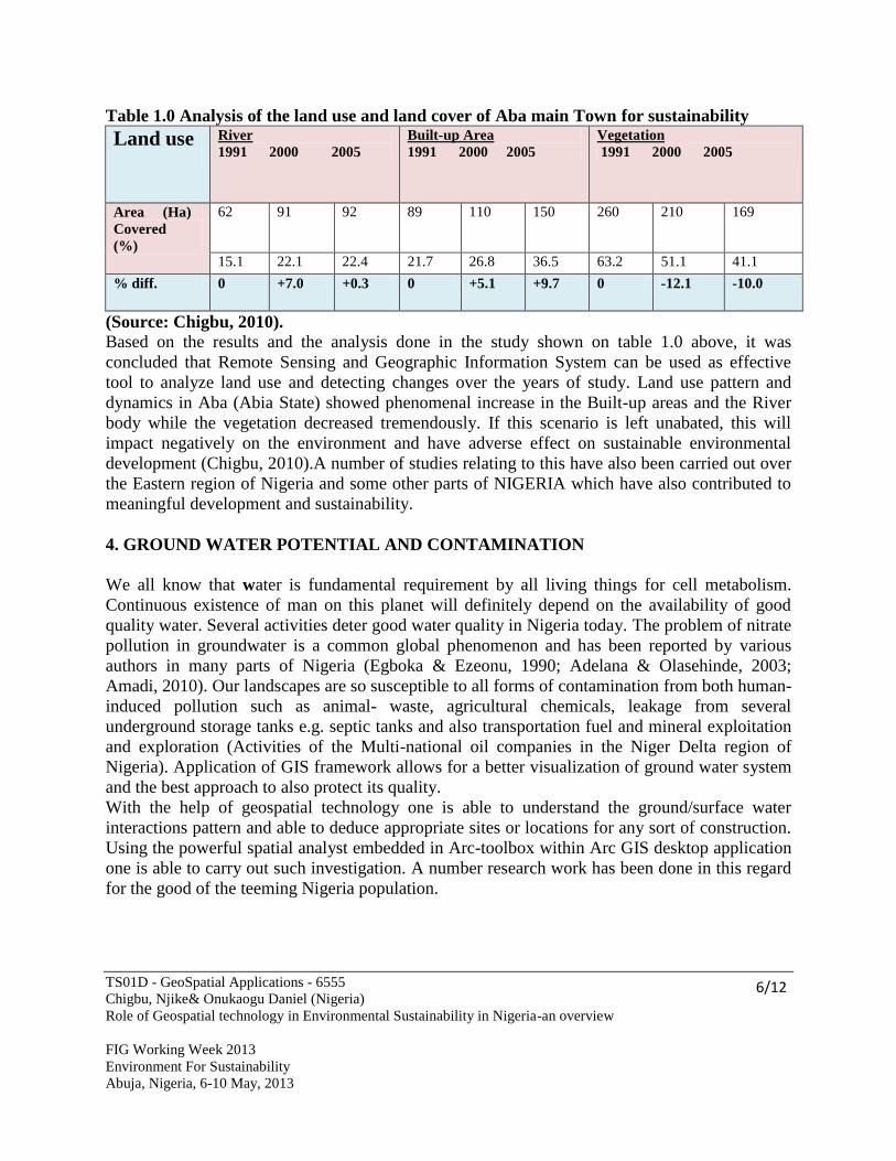
4. GROUND WATER POTENTIAL AND CONTAMINATION
We all know that water is fundamental requirement by all living things for cell metabolism.
Continuous existence of man on this planet will definitely depend on the availability of good
quality water. Several activities deter good water quality in Nigeria today. The problem of nitrate
pollution in groundwater is a common global phenomenon and has been reported by various
authors in many parts of Nigeria (Egboka & Ezeonu, 1990; Adelana & Olasehinde, 2003;
Amadi, 2010). Our landscapes are so susceptible to all forms of contamination from both human-
induced pollution such as animal- waste, agricultural chemicals, leakage from several
underground storage tanks e.g. septic tanks and also transportation fuel and mineral exploitation
and exploration (Activities of the Multi-national oil companies in the Niger Delta region of
Nigeria). Application of GIS framework allows for a better visualization of ground water system
and the best approach to also protect its quality.
With the help of geospatial technology one is able to understand the ground/surface water
interactions pattern and able to deduce appropriate sites or locations for any sort of construction.
Using the powerful spatial analyst embedded in Arc-toolbox within Arc GIS desktop application
one is able to carry out such investigation. A number research work has been done in this regard
for the good of the teeming Nigeria population.
TS01D - GeoSpatial Applications - 6555
Chigbu, Njike& Onukaogu Daniel (Nigeria)
Role of Geospatial technology in Environmental Sustainability in Nigeria-an overview
FIG Working Week 2013
Environment For Sustainability
Abuja, Nigeria, 6-10 May, 2013
7/12
Fig, 4.0 Nigeria’s Groundwater nitrate pollution status(Source: Adelana, 2006)
5. ADOPTION OF GIS METHODS IN ENVIRONEMTAL SUSTAINABILITY
5.1 Spatial Planning and Route Optimization
GIS as a tool and technology has helped a lot in advancing the pursuit of environmental
sustainability on a global scale and narrowly in Nigerian context. Its usefulness is not only
limited to natural resource assessment, environmental impact assessment, operational efficiency
in power utilities but also it plays enviable roles in sustainable development of our environment.
GIS has been used in several studies around the globe for land use planning which cuts across all
aspects of urban planning and Industrial Township planning etc. GIS aids in the mapping and
visualizations of route optimization which play a significant role in identifying potential deprived
areas that don’t have equal accessibility to these route network system. One of the strength of
GIS is that it allows for real time visualization and interactions which brings the realization of
your geospatial data to a more unique expression. Over the past few years, we’ve seen water and
waste-water utilities increasingly recognized that GIS techniques can be used to (plan for optimal
route in transportation business) or reduce fuel consumption in their fleet vehicles and more
TS01D - GeoSpatial Applications - 6555
Chigbu, Njike& Onukaogu Daniel (Nigeria)
Role of Geospatial technology in Environmental Sustainability in Nigeria-an overview
FIG Working Week 2013
Environment For Sustainability
Abuja, Nigeria, 6-10 May, 2013
8/12
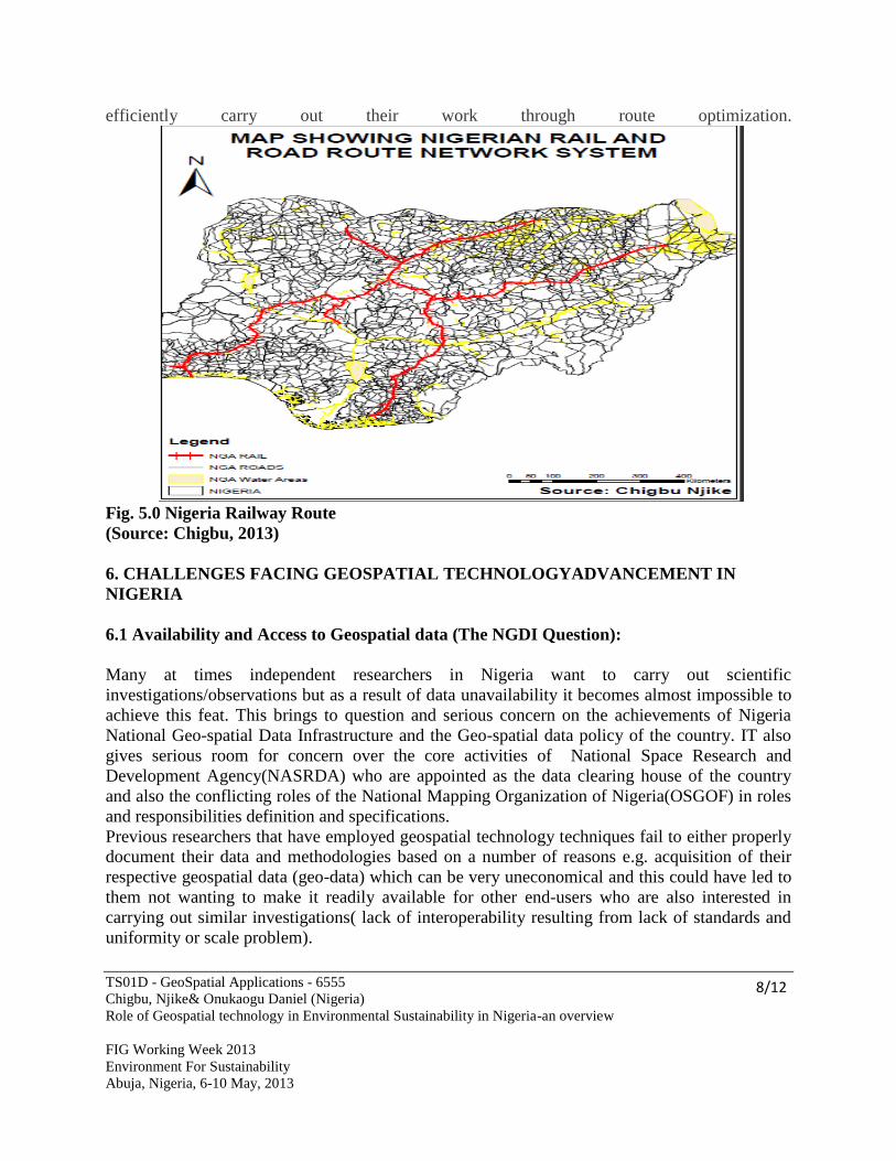
efficiently carry out their work through route optimization.
Fig. 5.0 Nigeria Railway Route
(Source: Chigbu, 2013)
6. CHALLENGES FACING GEOSPATIAL TECHNOLOGYADVANCEMENT IN
NIGERIA
6.1 Availability and Access to Geospatial data (The NGDI Question):
Many at times independent researchers in Nigeria want to carry out scientific
investigations/observations but as a result of data unavailability it becomes almost impossible to
achieve this feat. This brings to question and serious concern on the achievements of Nigeria
National Geo-spatial Data Infrastructure and the Geo-spatial data policy of the country. IT also
gives serious room for concern over the core activities of National Space Research and
Development Agency(NASRDA) who are appointed as the data clearing house of the country
and also the conflicting roles of the National Mapping Organization of Nigeria(OSGOF) in roles
and responsibilities definition and specifications.
Previous researchers that have employed geospatial technology techniques fail to either properly
document their data and methodologies based on a number of reasons e.g. acquisition of their
respective geospatial data (geo-data) which can be very uneconomical and this could have led to
them not wanting to make it readily available for other end-users who are also interested in
carrying out similar investigations( lack of interoperability resulting from lack of standards and
uniformity or scale problem).
TS01D - GeoSpatial Applications - 6555
Chigbu, Njike& Onukaogu Daniel (Nigeria)
Role of Geospatial technology in Environmental Sustainability in Nigeria-an overview
FIG Working Week 2013
Environment For Sustainability
Abuja, Nigeria, 6-10 May, 2013
9/12
Embedding geospatial capabilities on the Web and making these resources readily available and
as useful as possible for as many purposes inclusive of environmental sustainability is what
defines a good SDI (Jackson et al 1999). A National Spatial Date Infrastructure is now a fixture
in the vocabulary of geospatial technology users and policy-makers around the world. Shedding
more light on the usage of Web-based GIS which is also under the umbrella of geospatial
technology helps to provide a better dissemination of geodata for optimum utilization in
investigating environmental trends and seeking solutions to these problems in order to achieve
sustainable environmental developments.
Considering our Web-based GIS infrastructure in Nigeria, it can be more or less said to be
lagging behind. The architecture is such that it needs a lot of reformation, the ability to discover
spatial relations using the web is either slow or not functional. Both retrospective and
prospective researchers need to surf the web for data in order to discover relevant information
patterns about the environment and also be curious on how to proffer better remedies to this
problems. Robust data descriptions and quick access to the data will enable more rapid
exploration of hypothetical relationships which will help in better environmental sustainability.
Other critical factors to poor geospatial development in Nigeria include the following:
- Poor capacity built and lack of necessary expertise.
- Poor Funding by Government on research work.
- Administrative Bottlenecks, corruption and lack of transparency in the discharge of
set goals.
- Lack zeal on the part of Nigerian researchers and trainers.
- Brain drain due to the above.
- Poor educational system and inability to pursue technological development of the
country holistically and gender disparity and poverty.
- Problem of unstable power supply and communication pit-falls.
- Problems inherent in development economies like that of Nigeria and other third worl
countries.
7. ROLES OF GEOSPATIAL TECHNOLOGY IN ENVIRONMENTAL
SUSTAINABILITY
- Geospatial technology serves as a good decision support system in environmental
issues and sustainability. It has been proved as an appropriate tool for managing
decisions relating to environmental concerns and challenges. With the help of these
modern geospatial technologies/innovations one gets prepared for an increasingly
global challenges as a result of increasing population with its attendant environment
problems.
- The use of geospatial technology enhances a better means or techniques of data
capture and the distribution. This could be done in ‘real time’ and thus will reduce
the time and energy needed in data acquisition for solving environmental problems.
- Geospatial technology also promotes participatory visualizations using the powerful
tools embedded in its user interface.This tools help in the overall assessment of
TS01D - GeoSpatial Applications - 6555
Chigbu, Njike& Onukaogu Daniel (Nigeria)
Role of Geospatial technology in Environmental Sustainability in Nigeria-an overview
FIG Working Week 2013
Environment For Sustainability
Abuja, Nigeria, 6-10 May, 2013
10/12
environmental impacts and will also play important roles in physical planning of the
environment in Nigeria.However, with the emerging trend in 3D and 4D geospatial
information, this will enhance proper visualization techniques. These visualizations
would help create avenues where humans can handle complicated issues and also give
them the ability to garner better understanding and knowledge more efficiently and
provide insights on the environment that may not be easily notable in traditional
formats. Lol et al (1999) points out that communication via visualizations is very
important in natural resource management.
8. CONCLUSION AND RECOMMENDATION
8.1 CONCLUSION
In order for Nigerians to have the capability to predict the effects, positive or otherwise, of
economic developments on our environment, there is the need for us to embrace and emphasize
the compulsory adoption of geospatial technology and also not to limit it to private practice or
government. There should be an awareness creation on public participatory GIS as well in the
decision making process which involves the citizens and their environment. Adoption of
geospatial technology in all national endeavor such environmental monitoring, Agriculture,
Climate change studies, land use and land cover studies will help foster environmental
sustainability. Efforts of the National Space Research and Development Agency (NASRDA)
Abuja, the National agency responsible for all space applications in Nigeria is highly
commendable in terms of the recent strides in making available the Nigerian Sat-x image data
sets for good environmental inventory, monitoring and mitigation and early detection of
environmental challenges and treats. If the government of the day employs and uses the
avalanche of opportunities readily provided by geospatial science, most environmental
challenges will be overcome OR BE MITIGATED ON THE AVERAGE. This will lead to a
sustained growth and development in Nigeria.
8.2 RECOMMENDATION
For Nigeria to harness the gains of geospatial science in solving most environmental problems,
the following recommendations are necessary:
- There must be a well-developed surveying and mapping policy for the country
- There is urgent need to increase the capacity of expertise (CAPACITY
DEVELOPMENT) especially in Surveying and Geoinformatics and other Built
professional disciplines.
- There need for all stakeholders to support the Federal Government strive to ensure that
the Geoinformation policy on the establishment of National Geospatial Data
infrastructure stands.
- The space agency of Nigeria NARSDA must live up to her bidding as the national
clearing house or hub of geospatial data in the country.
TS01D - GeoSpatial Applications - 6555
Chigbu, Njike& Onukaogu Daniel (Nigeria)
Role of Geospatial technology in Environmental Sustainability in Nigeria-an overview
FIG Working Week 2013
Environment For Sustainability
Abuja, Nigeria, 6-10 May, 2013
11/12
- The Federal Government agency responsible for Surveying,Mapping and co-ordination of
all Surveying activities-The office of the surveyor General(OSGOF) must live up to the
challenges of the age.
- Equally, the Surveyors’ Council of Nigeria (SURCON) must continue to play her
oversight functions in training and in practice throughout the control.
- More tertiary institution, Universities and Polytechnic running Geoinformatics and
surveying must be encouraged to continue to exist by providing them with necessary
funding and interventions.
- The Nigerian Institution of Surveying (NIS) must remain proactive politically and should
be ready to initiate and influence bills at the National Assembly. That will enhance the
practice of the profession nationally.
- Efforts of FIG and her commissions are commendable in advocating global best practices
in the profession.
REFERENCES
Adelana, O. (2006). Nigeria’s New Environmental Laws: What Implications for Groundwater
(www.iucnael.org/en/component/docman/doc.../1009-adebola.html).
Chigbu, Njike (2010).Analysis of Land Use and Land Cover Changes of Aba Main Township
Using Medium Resolution Satellite Imageries. Unpublished M.sc Thesis, Dept. of Surveying and
Geo-Informatics,Nnamdi Azikiwe University,Awka,Anambra state,Nigeria.
Deng, J. S., Wang, K., Deng, Y. H. and Qis, G. J (2008). ‘PCA-based land use change detection
and analysis using Multi-temporal and multisensory satellite data’, International Journal of
Remote Sensing, 29(16), pp. 4823-4838
Lu, D., Mausel, P., Brondízio, E. and Moran, E. (2004) ‘Change detection techniques’,
International Journal of Remote Sensing, 25 (12), pp. 2365 — 2401
Ming-Hsiang Tsou and Ken Yanow (2010) Enhancing General Education with Geographic
Information Science and Spatial Literacy. URISA Journal • Vol. 22, No. 2 • 2010
Weng, Y. (2001) ‘A remote sensing–GIS evaluation of urban expansion and its impact on
surface temperature in the Zhujiang Delta, China’, International Journal of Remote Sensing, 22
(10), pp. 1999–2014
Zhang, Q. (2009) ‘Spatial-temporal patterns of urban growth In Shanghai, china: Monitoring,
analysis, and simulation’, Royal Institute of Technology (KTH), Sweden [Online]. Available at:
kth.diva-portal.org/
TS01D - GeoSpatial Applications - 6555
Chigbu, Njike& Onukaogu Daniel (Nigeria)
Role of Geospatial technology in Environmental Sustainability in Nigeria-an overview
FIG Working Week 2013
Environment For Sustainability
Abuja, Nigeria, 6-10 May, 2013
12/12
Matambanadzo(1999) Strategic Space and Geoinformation Management: The National Spatial
Data Infrastructure (NSDI) Concept. In Adeniyi P.O (EDS) Geoinformation Technology
Applications for Resource and Environmental Management in Africa. University of Lagos.
ESRI (2009).Route optimization to increase efficiency and reduce fuel consumption at water
utilities. Available from [online]:(http://blogs.esri.com/esri/arcgis/2009/12/11/route-
optimization-to-increase-efficiency-and-reduce-fuel-consumption-at-water-utilities)
BIBLIOGRAPHICAL NOTES
Chigbu, Njike (M.Sc. Mnis)
Dept. of Surveying and Geoinformatics
Abia State Polytechnic, Aba.
P.M.B 7166, Aba, AbiaState, Nigeria.
Email:[email protected]
Onukaogu, Daniel, Chukwuemeka
Dept. of Surveying and Geoinformatics
Abia State Polytechnic, Aba.
P.M.B 7166, Aba, Abia State, Nigeria.
Email:[email protected]