Embed Size (px)
Citation preview

ROCKS
“THE MIXTURE OF MINERALS”
Chapter 4

THE ROCK CYCLE
Rock – a naturally occurring solid mixture of
crystals of one or more minerals.
Rock Cycle – the continual process by which
new rock forms from old rock material.
Rocks are always changing.

WEATHERING, EROSION, AND DEPOSITION
Weathering – the process in which water, wind,
ice, and heat break down rock.
Weathering is very important:
Breaks down rock into fragments called sediment.
The fragments are the materials that are used to make
sedimentary rocks.
TYPES OF WEATHERING
Physical Weathering – Any process in which
rocks are broken down by contact with the
Earth’s atmosphere and water.
Chemical Weathering – Occurs when chemical
reactions break down the bonds holding the
rocks together.
Most common in areas that contain large amount
of water.

WEATHERING, EROSION, AND DEPOSITION
Erosion – the process by which sediment is
removed from its source.
Different types of erosion:
Wind
Ice
Water
Gravity

WEATHERING, EROSION, AND DEPOSITION
Deposition – the process in which sediment
moved by erosion is dropped and comes to
rest.
Once deposited, sediments may be compressed
and cemented to form a sedimentary rock.

HEAT AND PRESSURE
Heat and pressure may cause a rock to
chemical change into a metamorphic rock.
If the rock gets too hot it will melt which
eventually cools to form igneous rocks.

FOLIATION
Foliation – The set of layers visible in many
metamorphic rocks as a result of flattening and
stretching of mineral grains during
metamorphism.

BEDDING
Bedding – layers of sedimentary rock.
This can also be referred to as strata.

HEAT AND PRESSURE
The relationship of heat and pressure:
^Pressure ^ Heat
^ Heat ^ Pressure

MECHANICAL ENERGY
Gravitational Potential Energy – is the potential
energy associated with gravitational forces, as
work is required to elevate objects against
Earth’s gravity.

HOW THE CYCLE CONTINUES
Rock is exposed at the Earth’s surface by a
combination of uplift and erosion.
Uplift – is the movement within the Earth that
causes rocks inside the Earth to be moved to the
Earth’s surface.
After uplift, the rock reaches the surface, and the
cycle continues.

ROUND AND ROUND IT GOES
A TRIP AROUND THE ROCK CYCLE
1. You are going to need your notebook for this
activity.
2. In the output section record 10 rolls of the
dice. (Write down what the dice said.)
3. You may never move from a station but
continue to roll the dice at that station and
write down what the dice said.
4. Once you have finished return to your seat.

ROCK CLASSIFICATION
Three main classes of rock:
Igneous
Sedimentary
Metamorphic
In order to identify rocks scientist break the rocks up
into two categories:
Composition and Texture

COMPOSITION
Composition – the chemical makeup of a rock;
describes either the minerals or other materials
in the rock.
Determined by the minerals contained in the rock.
Ex. A rock made of mostly the mineral quartz will
have a composition very similar to that of quartz.

TEXTURE
Texture – is the quality of a rock that is based
on the sizes, shapes, and positions of the
rock’s grains.
There are three different grains of texture:
Fine-grained
Medium-grained
Coarse-grained
TEXTURE
The amount of time that a igneous rock is
allowed to cool determines the texture of the
rock.
If the rock cools quickly then it will be fine grained.
If the rock cools slowly then it would be coarse
grained.
The texture of a rock can reveal the processes that
formed it.

FINE GRAINED “SILKSTONE”

MEDIUM GRAINED “GRANITE”

COARSE GRAINED - CONGLOMERATE

INDIVIDUAL PRACTICE
ROGER THE ROCK
Your assignment: Create a children’s story, comic strip, or some other creative story about Roger the Rock.
Roger is a rock that has been a part of the rock cycle for millions of years. Your job is to tell Roger’s story. You must describe how Roger was “born” and at least three transitions that occurred during Roger’s life. (For example, changing from igneous to sedimentary, sedimentary to metamorphic, and metamorphic to igneous.)
Your grade will be based on in-class work, the accuracy of your information, creativity, and neatness/effort. This should be a story appropriate for a children’s story (think back to 2nd grade here!), including pictures.
To earn an “A”, you need to include many details-the names of specific rock types, descriptions about what causes the changes to occur, etc.
This project will be due on the day of Chapter 4 Test. These projects will be presented by you and your partner.

END OF SECTION 4.1

WARM UP
1. If all the continents were once joined as
Pangaea, what did the rest of Earth look like?
2. The following image is a picture of a
Cynognathus. Fossil remains can be found in
South America and Africa, this animal died
160 million years before the first boat was
used. What does this tell you about these land
masses?

ADD PHOTO OF EARTH’S LAYERS
Activity (Layers of the Earth)

ACTIVITY
At your table complete the foldable with your group.
There shouldn’t be any movement around the classroom. Use your classmates to help you complete the foldable.
Place your foldable in your notebook with tape.
Keep conversations within your group.
You will be given 20 minutes to complete the activity.
Information starts on page 233.

MECHANISMS THAT DRIVE LITHOSPHERIC
PLATES
Mantle Convection and Convection Currents

MECHANISMS THAT DRIVE LITHOSPHERIC
PLATES
Draw the diagram in your notebook.

Wegener’s Continental Drift Hypothesis
Continental drift – the hypothesis that states that the
continents once formed a single landmass, broke up,
and drifted to their present locations.
Alfred Wegener proposed the theory in the early
1900’s.

Group Activity
Round Robin – In this activity brainstorm with your
group what are some of the evidences that tectonic
plates move.
1 person will write down what your group discusses,
and 1 person will talk at a time.
Other group members will take turns sharing what
they think are possible signs of tectonic plates
moving.
If you become stuck utilize your book as a resource.

Wegener’s Continental Drift Hypothesis
Supporting Evidence
Plates Fit together like a puzzle.
Fossil Evidence across continents.
Rocks matched across seas.
Glacial striations on rocks matched on Africa and South
America proving a once super continent.
Coal on Antarctica proves that it was once warm.

Wegener’s Continental Drift Hypothesis

Wegener’s Continental Drift Hypothesis
Wegener’s Continental Drift Hypothesis
Inconclusive Evidence
No credible evidence that explained why the continents
moved.

The Drifting Continents

The Drifting Continents

The Drifting Continents
65 million years ago.
Dinosaurs became extinct and Laurasia and
Gondwana split into two smaller pieces.

Seafloor Spreading
Activity on seafloor spreading.
You will have 10 minutes to complete the drawing
of your model and 20 minutes to answer the
questions.
You may work with your table partners; but you
must complete your own as part of your notes.

Group Discussion

Mid-Ocean Ridges and Sea-Floor
Spreading
A chain of submerged mountains runs through the center
of the Atlantic Ocean.
Also known as Mid-ocean Ridges

Mid-ocean Ridges and Sea-Floor
Spreading (Draw the Diagram)

Evidence for Sea-Floor Spreading:
Magnetic reversals Draw Diagram

Warm up
You will have the first 10 minutes of class to finish
up the questions from 10/1/14’s activity on sea
floor spreading.
Quiz-Quiz Trade Review
You will be moving around the room for this activity.
In order to indicate that you need a partner you will raise your hand and find someone who also has their hand raised.
Ask your question, if your partner doesn’t know the answer give them a hint. If they are completely stuck give them the answer.
You will then be asked a question by your partner in the same process mentioned above.
After you have both answered each others questions trade your questions and raise your hand to find a new partner.

The Theory of Plate Tectonics
Plate Tectonics – the theory that explains how large
pieces of the Earth’s outermost layer called tectonic
plates, move and change shape.
Tectonic Plate Boundaries
Boundary – a place where tectonic plates touch.
There are three different types of boundaries:
Convergent
Divergent
Transform

Activity
Read the article provided about Convergent
Boundaries.
Discuss this article with your group and fill in the
guided notes.
Lastly paste this into your science notebook.

Convergent Boundaries
Convergent Boundary – the boundary formed by
the collision of two lithospheric plates.
There are three different types of convergent
boundaries:
Oceanic – Oceanic
Oceanic – Continental
Continental - Continental

Oceanic – Oceanic Plate Boundaries
http://geology.com/nsta/convergent-boundary-
oceanic-oceanic.gif

Oceanic – Oceanic Plate Boundary

Continental – Oceanic Plate
Boundaries “Mt. Adams”
http://geology.com/nsta/convergent-boundary-
oceanic-continental.gif
Eruption of Mt. Redoubt Alaska

Continental – Oceanic Plate
Boundaries

Continental – Continental Plate
Boundaries
http://geology.com/nsta/convergent-boundary.gif
Activity
Read the article provided about Divergent
Boundaries.
Discuss this article with your group and fill in the
guided notes.
Lastly paste this into your science notebook.

Divergent Plate Boundaries
Divergent Boundary – the boundary between two
tectonic plates that are moving away from each
other.
New Sea floor forms at divergent boundaries.
Mid-ocean ridges is the most common type of divergent
boundary.

Activity
Read the article provided about Transform
Boundaries.
Discuss this article with your group and fill in the
guided notes.
Lastly paste this into your science notebook.

Warm-Up
Record the following vocabulary instructions and begin working on the assignment. (Due 10/09/14)
On a separate sheet of paper:
1. Rewrite the word and definition into your science notebook in your own words
2. Draw a picture or diagram to represent your vocabulary word.
3. Write a sentence that properly uses the word and describes the word. Example: Volcanoes are large mountains that form from repeated eruptions that allow them to continue to grow every time they erupt.

Transform Boundaries
Transform Boundary – The Boundary between
tectonic plates that are sliding past each other.
Ex. San Andreas Fault in California.
One of the few faults that can be visibly seen.
One of the major causes of Earthquakes.

Transform Plate Boundaries

Plate Summary

Tracking Tectonic Plate Motion
Tectonic plates move roughly 5cm per year.
The rate is so slow that it cannot be seen nor felt except
during an Earthquake.
Plate movement is tracked by GPS.

Fall Zone
The fall zone marks the geologic boundary of hard metamorphosed terrain and the sandy, relatively flat outwash plain of the upper continental shelf.
◦ The transition from the harder metamorphosed rock to the softer sediment creates water falls.
Formed from the erosion of the mountain regions of NC to help form the Sandy coastal plain regions.

Review/Quiz
Turn to Page 275 and answer questions 1-
10.
You must write the letter and the answer.

Activity
Plate Tectonic posters.
YOU HAVE 15 MINUTES TO
COMPLETE THIS ASSIGNMENT.

Volcanic Eruptions
Volcanoes – are areas of Earth’s surface through which magma and volcanic gases pass.
Explosion of a volcanic eruption can turn an entire mountain into a billowing cloud of ash and rock in a matter of seconds causing global climate temperatures to drop.
Help form fertile land.
Create some of the largest mountains on earth.

Volcanic Eruptions
Magma – melted rock below the Earth’s surface.
Lava – Melted rock above the Earth’s surface.

Mt. Cleveland- Aleutian Islands, Alaska

Stromboli Volcano - Sicily

Mount Redoubt - Alaska

Types of Lava Flows
Pahoehoe lava flows – sheet like lava flows that result in continuous surfaces.
Flow smoothly
Move forwards in tongues or lobes and are characterized by a glassy, plastic skin.

Types of Lava Flows
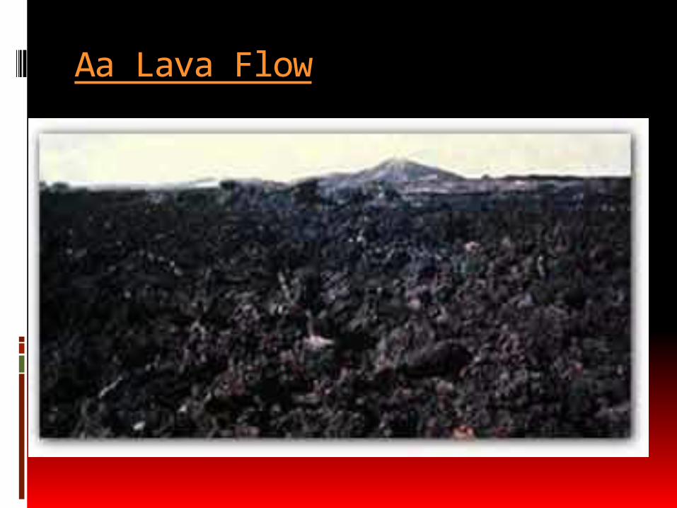
Aa – lava pours out quickly and forms a brittle crust.
The crust is torn into jagged pieces as molten lava continues to flow underneath.
Got its name because of the painful experience of walking barefoot across the jagged surfaces.
Associated with lava fountaining.

Lava Fountaining
Lava Fountaining – spraying of lava into the air pulsing with the pressure of escaping gases.

Types of Lava Flows
Pillow lava – forms when lava erupts underwater.
Lava forms rounded lumps that are the shape of pillows.

What erupts from a Volcano?
Lava – liquid magma that flows from a volcanic vent.
Pyroclastic material - forms when magma is blasted into the air and hardens.
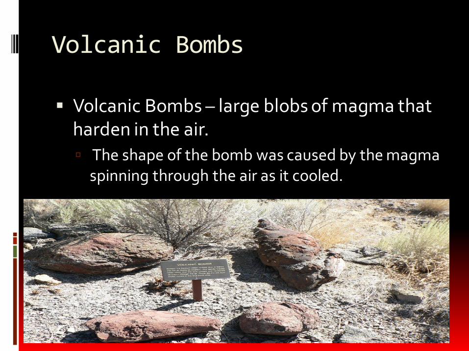
Volcanic Bombs
Volcanic Bombs – large blobs of magma that harden in the air.
The shape of the bomb was caused by the magma spinning through the air as it cooled.

Lapilli
Lapilli – pebblelike bits of magma that hardened before they hit the ground.
Means “little stones”

Volcanic Ash
Volcanic Ash – forms when the gases in stiff magma expand rapidly and the walls of the gas bubbles explode into tiny, glasslike slivers.
Makes up most of the pyroclastic material in an eruption.
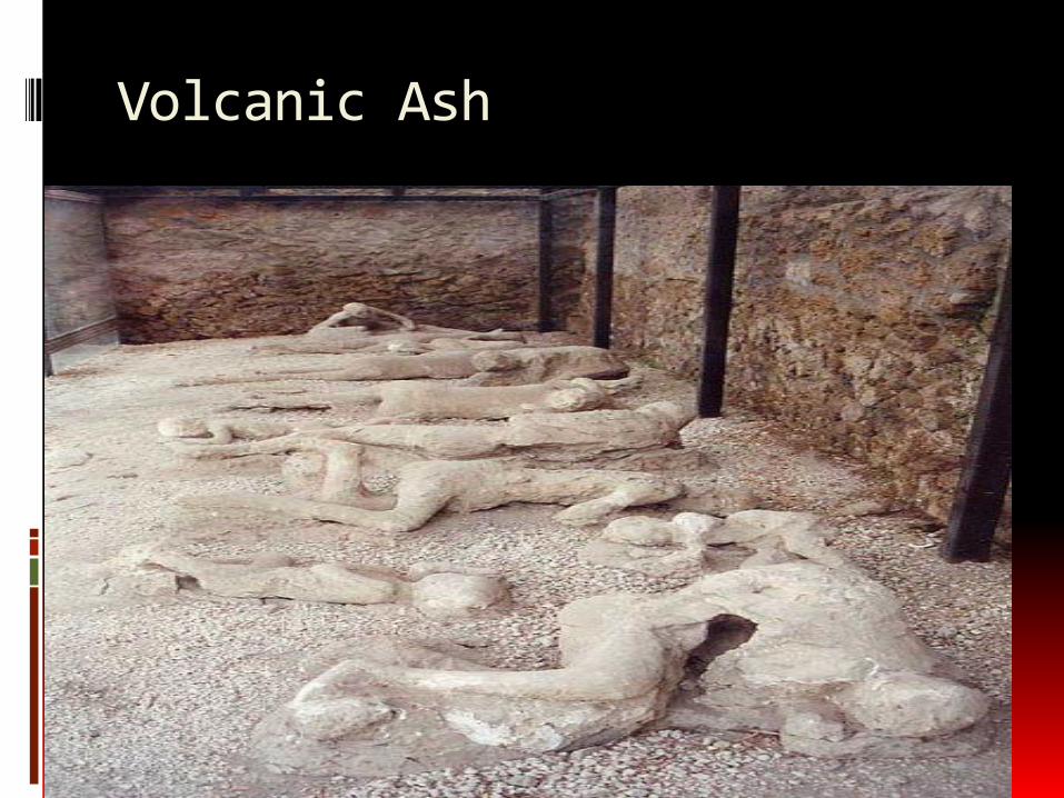
Volcanic Ash

Pyroclastic Flows
Pyroclastic Flow – produced when enormous amounts of hot ash, dust, and gases are ejected from a volcano.
Can move downhill at 200km/h.
Center of the flow can exceed 700 C.
Effects

End of Section 9.1

Types of Volcanoes:
Type of Volcanoe How does it form?
Describe what it looks like.
Draw a picture of the Volcano.
Cinder Cone
Stratovolcano (Composite)
Shield Volcano
What is the difference between a crater and a caldera?

Mauna Kea - Shield Volcano

Cinder Cone Volcanoes

Mt. St. Helens

Mt. St Helens

Mt. Fuji

Craters
Crater – funnel-shaped pit found around the central vent at the top of many volcanoes.
When eruption stops, lava drains back underground making a larger collapsed crater.
Next eruption may blast it away creating a larger and deeper crater.

Kamchatka, Russia

Calderas
Caldera – a large, semicircular depression that forms when the magma chamber below a volcano partially empties and causes the ground above to sink.
Much larger than a crater.

Crater Lake, Washington
Lava Plateaus
Lava Plateau – a wide, flat landform that results from repeated nonexplosive eruptions of lava that spread over a larger area.
Formed from seepage of magma from long cracks or rifts.
Lava can pour out for millions of years and spread over huge areas.

Lahar (mud) Flows
A type of mudflow or debris flow composed of a slurry of pyroclastic material, rocky debris, and water.
Typically occurs along a river.
Has the density and consistency of concrete.
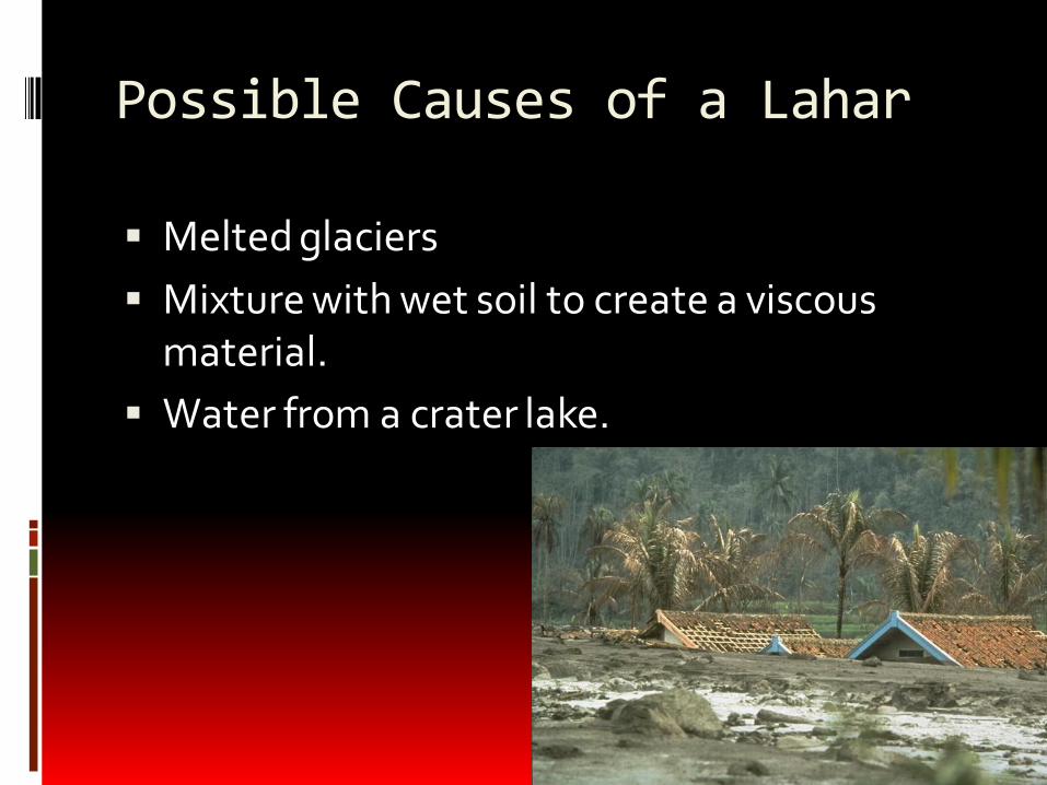
Possible Causes of a Lahar
Melted glaciers
Mixture with wet soil to create a viscous material.
Water from a crater lake.

Columbia River Plateau

Activity
Earthquake and Volcano Patterns

Where Volcanoes Form
Most volcanoes are found directly on tectonic plate boundaries.
80% of active volcanoes on land form where plates collide.
15% form where plates separate.
Other rare and few volcanoes form far away from plate boundaries known as hotspots.

Ring of Fire
The location of the worlds most active volcanoes.
The ring is entirely located along plate boundaries in which many earthquakes occur as well.

Hotspots
Hotspot – is a location on the Earth’s surface that has experienced active volcanism for a long period of time.
Often located in the middle of oceanic plates.
Hawaii is an example of an active hotspot.
End of Volcanoes

Warm Up – 5 Minutes
1. When two tectonic plates collide they form a ________ boundary.
2. Which convergent crustal interaction forms a mountain?
3. Describe how the great rift valley in Africa was formed.
4. Draw a picture illustrating how a hot spot forms island chains.

EarthquakesActivity: Complete the first diagram with your group
partners.

What Are Earthquakes?
Seismology – the study of earthquakes.
Seismologist – scientist who study
Earthquakes.
Earthquake – the shaking of the Earth’s
surface due to the movement of tectonic
plates.

Where Do Earthquakes Occur?
Most if not close to all Earthquakes occur
near the edges of tectonic plates.
◦ Due to the movement of tectonic plates,
numerous features called faults exist in the
Earth’s crust.
Fault – is a break in the Earth’s crust
along which blocks of the crust slide
relative to one another.

Where Do Earthquakes Occur?
What Causes Earthquakes?
Deformation – the bending, tilting, and
breaking of the Earth’s crust; the change
in the shape of rock in response to stress.
This process occurs in two ways:
◦ Plastic deformation.
◦ Elastic deformation.
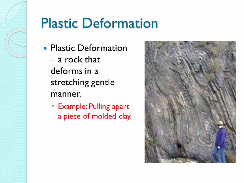
Plastic Deformation
Plastic Deformation
– a rock that
deforms in a
stretching gentle
manner.
◦ Example: Pulling apart
a piece of molded clay.

Elastic Deformation
Elastic Deformation –
rock is stretched until
it can no longer stand
the force in which the
rock springs back to
its original location.
◦ Rock can stretch farther
than steel without
breaking.
Example: Stretched
rubber band.

Elastic Rebound
Elastic Rebound – the sudden return of
elastically deformed rock to its
undeformed shape.
◦ Occurs when more stress is applied to the
rock than the rock can stand.
Energy is released during the rebound.
◦ Energy is released as seismic waves.

Visualizing Elastic Rebound
http://projects.crustal.ucsb.edu/understan
ding/elastic/rebound.html
1906 Earthquake
EARTHQUAKE!

Activity
With your group partners fill in the
diagram describing the different types of
waves.

How Do Earthquake Waves Travel?
Seismic Wave – a wave of energy that
travels through the Earth, away from an
earthquake in all directions.
Body Waves – seismic waves that travel
through the Earth’s interior.
Surface waves – seismic waves that travel
along the Earth’s surface.

Types of Waves
P-waves or Primary Waves – Types of
seismic waves that move in a compression
manner.
◦ Ex. A slinky moving back and forth from end
to end.
◦ Has the ability to move through all materials.
◦ Fastest moving wave.

Types of Waves
P-waves are always the first waves of an
earthquake to be detected.

Types of Waves
S-Waves or Secondary waves – are waves
that move up and down.
◦ Ex. Stretching a slinky outward and then
pulling down on the center so that it would
bounce up and down.
◦ Cannot move through a liquid.
◦ Waves are very damaging to surface objects.

Types of Waves
S-waves are also known as shear waves
because of the damage they cause to the
Earth’s rocks at the surface.
S-waves cannot travel through parts of
the Earth that are completely liquid.
S-waves are slower than P-waves and
always arrive later than P-waves.
S&P Waves

Surface Waves
Surface Waves – are waves that move along the Earth’s surface and produce motion mostly in the upper few kilometers of Earth’s crust.
Two types:
1. Rayleigh Wave - Produces up, down, and around motion.
2. Love Waves - Back and forth motion much like S-waves.
These waves are more destructive than body waves and move more slowly

Surface Waves


Locating Earthquakes
Seismographs – instruments located at or
near the surface of the Earth that record
seismic waves.
Seismogram – tracing of earthquake
motion recorded by a seismograph.

Determining Time and Location of
Earthquakes Epicenter – the point on the Earth’s
surface directly above an earthquake’s
starting point
Focus – the point inside the Earth where
an earthquake begins.

Activity
S-P Time Method Lab
“Locating the Epicenter”

The S-P Time Method
S-P time method – the way in which
seismologists find an earthquake’s
epicenter.
◦ Collect several seismograms of the same
earthquake from different locations.
◦ Seismograms are placed on a time-distance
graph.
◦ By reading the horizontal axis the distance
from the earthquake can be determined.

The S-P Time Method

The Richter Magnitude Scale
Richter scale – a scale used to measure
the strength of an earthquake.

Earthquake Ground Motion
Magnitude – the strength of an
earthquake.
Every time that the Richter scale
increases by one it will produce 10x as
much ground motion.
◦ Ex. 5 on the scale will be 10x stronger than an
earthquake that is a 4.

Modified Mercalli Intensity Scale
Intensity – a measure of how much
damage caused by the earthquake.
◦ The Scale uses roman numerals I-XII
◦ Shows the type of damage caused by an
earthquake.


Strength and Frequency
Earthquakes vary in strength.
Earthquakes don’t occur on a set
schedule.
◦ But, the strength of an earthquake is related
to how often they occur.

Strength and Frequency

The Gap Hypothesis
Gap hypothesis – a hypothesis that states
that sections of active faults that have had
relatively few earthquakes are likely to be
the sites of strong earthquakes in the
future.
Seismic Gap – areas along a fault where
relatively few earthquakes have occurred.

What causes change in sea-level?